a303/a30/a358 corridor feasibility study...the a303/a30/a358 corridor is approximately 195km long,...
TRANSCRIPT
S tage 3 Summary Repo r t
A303/A30/A358 Corridor Feasibility Study
Prepared for
The Highways Agency
Date: February 2015
43 Brook Green London, W6 7EF
GB
A303 A30 A358 STAGE 3 REPORT.DOCX
CONTENTS, CONTINUED
Contents Introduction ............................................................................................................................ 1-1
1.1 Introduction ................................................................................................................ 1-1 1.2 Study Purpose and Objectives ..................................................................................... 1-2 1.3 Study Stages ................................................................................................................ 1-2 1.4 Stage 3 Objectives ....................................................................................................... 1-3 1.5 Structure of Stage 3 Report ......................................................................................... 1-3
Potential Scheme Options ....................................................................................................... 2-4 2.1 Introduction ................................................................................................................ 2-4 2.2 Scheme Option Descriptions ........................................................................................ 2-5
2.2.1 Amesbury to Berwick Down ............................................................................ 2-5 2.2.2 Chicklade Bottom to Mere .............................................................................. 2-6 2.2.3 Sparkford to Ilchester...................................................................................... 2-6 2.2.4 South Petherton to Southfields ....................................................................... 2-6 2.2.5 Southfields to Honiton .................................................................................... 2-6 2.2.6 The Whole Route Corridor (Amesbury to M5 J25) ........................................... 2-7
SOBCs – Transport Business Case ............................................................................................ 3-8 3.1 Strategic Case .............................................................................................................. 3-9
3.1.1 Introduction .................................................................................................... 3-9 3.1.2 Business Strategy ............................................................................................ 3-9 3.1.3 Problem Identification .................................................................................. 3-11 3.1.4 The Impact of Not Changing .......................................................................... 3-13 3.1.5 Study /Corridor Objectives ............................................................................ 3-14 3.1.6 Measures for Success .................................................................................... 3-14 3.1.7 Study Constraints .......................................................................................... 3-15 3.1.8 Inter-dependencies ....................................................................................... 3-15
3.2 Economic Case .......................................................................................................... 3-15 3.2.1 Appraisal Methodology ................................................................................. 3-15 3.2.2 Appraisal Results........................................................................................... 3-18 3.2.3 Additional Zero Growth Sensitivity Test ........................................................ 3-31
3.3 Financial Case ............................................................................................................ 3-31 3.3.1 Estimated Costs ............................................................................................ 3-31
3.4 Commercial Case ....................................................................................................... 3-33 3.4.1 Output Based Specification ........................................................................... 3-33 3.4.2 Procurement Strategy ................................................................................... 3-33
3.5 Management Case..................................................................................................... 3-34 3.5.1 Evidence of Similar Projects .......................................................................... 3-35 3.5.2 Programme/Project Dependencies ............................................................... 3-35 3.5.3 Governance, Organisational Structure and Key Roles .................................... 3-35 3.5.4 Programme / Project Plan ............................................................................. 3-36 3.5.5 Assurance and Approvals Plan....................................................................... 3-36 3.5.6 Communications and Stakeholder Management ........................................... 3-37 3.5.7 Programme / Project Reporting .................................................................... 3-37 3.5.8 Risk Management Strategy ........................................................................... 3-37 3.5.9 Options ......................................................................................................... 3-37 3.5.10 A358 Dualling................................................................................................ 3-37
Conclusions and Next Steps................................................................................................... 4-38 4.1 Conclusions ............................................................................................................... 4-38 4.2 Next Steps ................................................................................................................. 4-39
CONTENTS, CONTINUED
Tables
Table 2-1 A303/A30/A358 Sections ...................................................................................................... 2-4 Table 3-1: PIA Data for Sections of the Corridor Covered by Proposed Improvement Options ............. 3-12 Table 3-2 A303/A30/A358 Strategic and Operational Objectives......................................................... 3-14 Table 3-3 Committed Transport Infrastructure Schemes ..................................................................... 3-16 Table 3-4: Annualisation Factors ......................................................................................................... 3-17 Table 3-5: Summary of Appraisal Methodology Applied - Monetised .................................................. 3-18 Table 3-6: Summary of Appraisal Methodology Applied – Qualitative ................................................ 3-18 Table 3-7: 2021 PIA per mvkm Rate Table (Derived from COBA-LT) ..................................................... 3-19 Table 3-8 Amesbury to Berwick Down part on-line part off-line dual carriageway with tunnel scheme evaluation against objectives .............................................................................................................. 3-20 Table 3-9 Amesbury to Berwick Down off-line dualling to the north scheme evaluation against objectives........................................................................................................................................................... 3-21 Table 3-10 Chicklade Bottom to Mere scheme evaluation against objectives ...................................... 3-21 Table 3-11 Sparkford to Ilchester Option Evaluation scheme evaluation against objectives................. 3-22 Table 3-12: South Petherton to Southfields option scheme evaluation against objectives ................... 3-22 Table 3-13: Southfields to Honiton A303 Blackdown Hills scheme evaluation against objectives ......... 3-23 Table 3-14: Southfields to Honiton A358 scheme evaluation against objectives .................................. 3-23 Table 3-15 Amesbury to Berwick Down Appraisal Results ................................................................... 3-24 Table 3-16 Chicklade Bottom to Mere Appraisal Results ..................................................................... 3-24 Table 3-17 Sparkford to Ilchester Appraisal Results............................................................................. 3-24 Table 3-18 South Petherton to Southfields Appraisal Results ............................................................. 3-25 Table 3-19 Southfields to Honiton Appraisal Results ........................................................................... 3-25 Table 3-20 Whole Route Corridor (Amesbury to M5 J25) Appraisal Results ......................................... 3-25 Table 3-21. Summary of non-Monetised Impacts Appraisal ................................................................ 3-30 Table 3-22. Summary Zero Growth Economic Appraisal Results .......................................................... 3-31 Table 3-23 Estimated cost ranges for Potential Schemes .................................................................... 3-32 Table 3-24 Indicative Project Programme ........................................................................................... 3-36
Figures
Figure 1-1 Geographical Extent of A303/A30/A358 Corridor Feasibility Study ....................................... 1-1 Figure 1-2 Steps in the Option development process ............................................................................ 1-3 Figure 3-1 Highways Agency Procurement Diagram ........................................................................... 3-34 Figure 3-2 Organisational Structure .................................................................................................... 3-35
A303 A30 A358 STAGE 3 REPORT.DOCX

Introduction
1.1 Introduction The HM Treasury document, Investing in Britain's Future (July 2013), set out details of the programmes of infrastructure investment, which included the tripling of annual investment on Highways Agency (HA) major roads enhancements from today's levels to over £3bn by 2020/21. As part of that investment programme, the Government announced that it would identify and fund solutions, initially through feasibility studies to look at problems and identify potential solutions to tackle some of the most notorious and long-standing road hot spots in the country. The A303/A30/A358 Corridor Feasibility study is one of the studies.
This document provides an overview of the activities undertaken throughout the feasibility study to date. Specifically, it provides a brief history of the work carried out by the Project Team and others, liaison and details of the methodologies used culminating with the production of a series of Strategic Outline Business Cases (SOBC) for consideration by Government prior to the Autumn Statement in 2014.
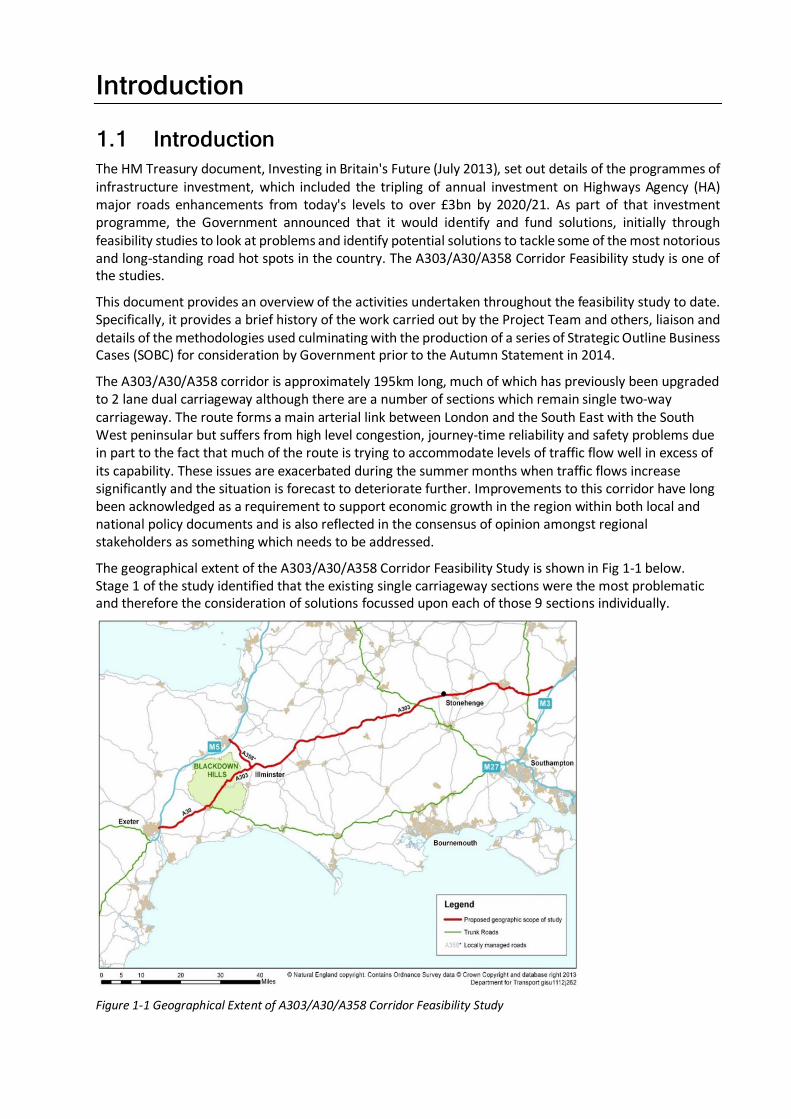
The A303/A30/A358 corridor is approximately 195km long, much of which has previously been upgraded to 2 lane dual carriageway although there are a number of sections which remain single two-way carriageway. The route forms a main arterial link between London and the South East with the South West peninsular but suffers from high level congestion, journey-time reliability and safety problems due in part to the fact that much of the route is trying to accommodate levels of traffic flow well in excess of its capability. These issues are exacerbated during the summer months when traffic flows increase significantly and the situation is forecast to deteriorate further. Improvements to this corridor have long been acknowledged as a requirement to support economic growth in the region within both local and national policy documents and is also reflected in the consensus of opinion amongst regional stakeholders as something which needs to be addressed.
The geographical extent of the A303/A30/A358 Corridor Feasibility Study is shown in Fig 1-1 below. Stage 1 of the study identified that the existing single carriageway sections were the most problematic and therefore the consideration of solutions focussed upon each of those 9 sections individually.
Figure 1-1 Geographical Extent of A303/A30/A358 Corridor Feasibility Study
Throughout the study, the HA and DfT engaged with key organisations. The main focus of that engagement was through the A303/A30/A358 Corridor Reference Group which was established to keep stakeholders informed of study progress and developments. This liaison also ensured that stakeholders’ views, both positive and negative, have been captured and considered, particularly at key stages and when key outputs have been produced.
The stakeholders represented within the Reference Group were:
• Dorset County Council • National Trust
• Wiltshire Council • Travelwatch South West
• Devon County Council • International Council on Monuments and Sites
• Somerset County Council • Solent LEP
• Heart of the South West LEP • Blackdown Hills AONB
• CPRE Somerset
• CPRE Wiltshire
• Stonehenge and Avebury World Heritage Partnership Group
• Natural England • Torbay Council
• English Heritage • Plymouth City Council
• MP for Salisbury
• Hampshire County Council
• Somerset Chamber of Commerce
• Cornwall and Isles of Scilly LEP
• MP for Somerton and Frome • Devon & Cornwall Business Council
• The Wildlife Trusts • Swindon and Wiltshire LEP
• Campaign for Better Transport • Dorset LEP
• West of England LEP
1.2 Study Purpose and Objectives The aim of the Study is to identify the opportunities and understand the case for future investment solutions on the A303/A30/A358 corridor that are deliverable, affordable and offer value for money.
More specifically, the objectives of the Study, as contained in the scope document, are to:
• identify and assess the benefits, deliverability and timing of specific infrastructure investments that address the existing problems along the A303 corridor;
• understand the balance of benefits and impacts from potential individual investment proposals and any additional benefits or impacts from an investment on a corridor basis;
• evidence where possible, the wider economic benefits from the transport investment in the corridor;
• understand the balance and impacts from potential investment in the A303 corridor compared to the performance and investment in other road transport corridors to the South West region; and
• understand the impacts on the resilience of the road transport network from the proposed investment in the A303 corridor.
1.3 Study Stages The study is split into three stages, the third of which is reported here. These are:
• Stage 1: Review of evidence and identification o fproblems and issues; • Stage 2: Finalise the range of proposals that could address the problems; and,
1-2
• Stage 3: Assess the affordability, value for money and deliverability of the proposals.
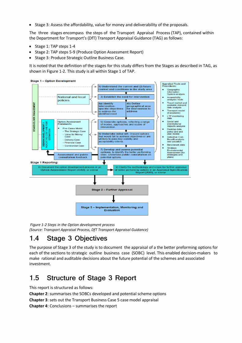
The three stages encompass the steps of the Transport Appraisal Process (TAP), contained within the Department for Transport's (DfT) Transport Appraisal Guidance (TAG) as follows:
• Stage 1: TAP steps 1-4 • Stage 2: TAP steps 5-9 (Produce Option Assessment Report) • Stage 3: Produce Strategic Outline Business Case.
It is noted that the definition of the stages for this study differs from the Stages as described in TAG, as shown in Figure 1-2. This study is all within Stage 1 of TAP.
Figure 1-2 Steps in the Option development process (Source: Transport Appraisal Process, DfT Transport Appraisal Guidance)
1.4 Stage 3 Objectives The purpose of Stage 3 of the study is to document the appraisal of a the better preforming options for each of the sections to strategic outline business case (SOBC) level. This enabled decision-makers to make rational and auditable decisions about the future potential of the schemes and associated investment.
1.5 Structure of Stage 3 Report This report is structured as follows: Chapter 2: summarises the SOBCs developed and potential scheme options Chapter 3: sets out the Transport Business Case 5 case model appraisal Chapter 4: Conclusions – summarises the report
Potential Scheme Options
2.1 Introduction This Chapter of the report looks specifically at the options developed for each section for this Feasibility Study. Overall, the study is concerned with the A303/A30/A358 corridor which comprises:
• The A303 between the M3 and the A30
• The A30 between the A303 and the M5; and
• The A358 between the A303 and the M5.
As set out in the Stage 1 report a considerable amount of work has previously been undertaken on this corridor and as such it was determined that this would be the starting point for this study. The previous work can broadly be divided into nine sections as summarised in Table 2-1.
No. Location Description
1 A303 Amesbury to Berwick Down (Stonehenge)
12km of dual carriageway & intersection improvements
2 A303 Wylye to Stockton Wood 3.9km mainly ‘on-line’ dual carriageway
3 A303 Chicklade Bottom to Mere 12km of part ‘on-line’, part ‘off- line’ dual carriageway and associated junction improvements
4 A303 Sparkford to Ilchester 5.5km of part ‘on-line’, part ‘off- line’ dual carriageway and associated junction improvements
5 A303 Podimore Roundabout Junction Improvement (grade separated)
6 A303 Cartgate Roundabout Junction Improvement (grade separated)
7 A303 South Petherton to Southfields
10km of ‘on-line’ dual carriageway
8 A358 Southfields to M5 (Junction 25)
14km of part ‘on-line’, part ‘off-line’ dual carriageway and a series of improvements at intersections
9 A303 Southfields to Honiton Combination of various (relatively small) sections of improvement over the 23km length
Table 2-1 A303/A30/A358 Sections
Of the 9 sections originally identified with problems, 5 were taken forward for further investigation and a series of solutions were developed for each following the stage 1 analysis. Those solution options were subsequently subjected to an initial sift using the DfTs Early Assessment and Sifting Tool (EAST). This is a decision support tool developed to quickly summarise and present evidence on options in a clear and consistent format using a spreadsheet and allows a view to be taken based upon the best evidence available whilst remaining consistent with Transport Business Case principles.
These sections were:
• Amesbury to Berwick Down;
• Chicklade Bottom to Mere;
• Sparkford to Ilchester;
• South Petherton to Southfields;
• Southfields to Honiton.
However, during the option generation for schemes to resolve the issues, it became apparent that an option for addressing the problems on the A303/A30 in the Blackdown Hills between Southfields and Honiton is to upgrade the A358 to a modern dual carriageway. Consequently, it was also decided that assessments in Stage 2 would include that option. Additionally, it was agreed that a cumulative assessment of all nine sections in Table 2-1 would be made.
2-4
Following the initial sifting assessment, a decision was taken to carry out further appraisal for 6 options. It should be noted that more than one solution was appraised for the Amesbury to Berwick down and Southfields to Honiton sections of the route.
Further appraisal was carried out for the following:
• Amesbury to Berwick Down (Stonehenge) – 3 potential solutions considered (each included a bypass of Winterbourne Stoke): o Part on-line/part off-line dual carriageway with tunnel (2.5km) o Part on-line/part off-line dual carriageway with tunnel (2.9km) o Off-line dual carriageway to the North
• Chicklade Bottom to Mere – Combination of on-line and off-line widening • Sparkford to Ilchester: Combination of on-line and off-line widening • South Petherton to Southfields: Online Dualling; • Southfields to Honiton – 3 potential scheme options considered:
o Southfields to M5 Jct 25 (the A358): Online and Offline dualling o Combination of Online and Offline widening (A303/A30): A30 Honiton Bypass to Rawridge
Hill, A303/A30 Rawridge Hill to Stopgate Cross Junction and A303 Eagle Tavern to Broadway
o A combination of both the above options • Whole Route: Combination of preferred options (from above) as well as the addition of the
remaining single carriageway sections i.e. Wylye to Stockton wood, Podimore Roundabout and Cartgate Roundabout.
2.2 Scheme Option Descriptions The following sub-sections identify each of the scheme solution options generated for the various locations along the route and are those which were the subject of further, more detailed, appraisal.
2.2.1 Amesbury to Berwick Down Previous studies considered a range of many options to address the issues through this very environmentally sensitive section. Three options were taken forward from the EAST sifting into the development of the SOBCs.
The 3 Options developed were:
Options 1 & 2: Part on-line, part off-line dual carriageway with tunnel
This option incorporates an off-line bypass to the north of Winterbourne Stoke and new grade separated junctions with the A360 and A345 at Countess Roundabout. Through the WHS the proposed route would closely follow the line of the existing alignment but would be in tunnel for a distance near Stonehenge and the immediate surrounding area.
• Option 1 - a 2.5km tunnel. • Option 2 – a 2.9km tunnel.
Option 3: Offline Dualling to the North This option is a 14.9km long route incorporating an off-line bypass to the north of Winterbourne Stoke and Stonehenge and the grade separation of Countess Roundabout. To the north east of Winterbourne Stoke, the route would deviate further to the north and form a grade separated junction with the A360 heading in an easterly direction and to the south of Larkhill village; it would tie back into the existing A303 dualled section to the west of Countess Roundabout.
2.2.2 Chicklade Bottom to Mere Online and Offline widening
This option includes a combination of on-line and off-line widening to create a dual carriageway throughout the section and includes a bypass around Chicklade. Grade–separated interchanges would be introduced between the A350 and the road leading to Fonthill Bishop. Access to and from Chicklade would be primarily via the junction with the A350 and an ‘access only’ eastbound onto the A303. Direct access to the A303 from all other remaining side roads would also be removed or restricted.
2.2.3 Sparkford to Ilchester Online and Offline Widening to dual carriageway
A new dual carriageway would be created through a combination of on-line and off-line widening. It would also close the westbound slip road (Podimore) and the junctions with the B3151 and Plowage Lane at Camel Cross/Plowage which would be combined and grade-separated. This proposal would also reduce the number of junctions directly abutting the A303.
2.2.4 South Petherton to Southfields Online Dualling between Southfields and Hayes End roundabouts
The existing Ilminster Bypass is wide and of a high standard. It is therefore proposed to provide the majority of a new dual-carriageway on-line thus minimising land-acquisition and direct environmental impact.
2.2.5 Southfields to Honiton Three smaller scale improvements were developed for the A303/A30 section which passes through the Blackdown Hills Area of Outstanding Natural Beauty. They provide a partial solution to the problems that exist along that section of the route and for the purposes of the SOBC the following three schemes are considered as a single improvement. A30 Honiton Bypass to Rawridge Hill
This scheme option is for the improvement of the existing single carriageway between the dual carriageway at Honiton and Rawridge Hill. It provides for three traffic lanes in total with flows split to allow two lanes eastbound over a length of 1.8km switching to two lanes westbound for 1.0km. The proposed road would also provide an off-line bypass to Monkton village and a consistent speed limit of 60mph.
A303/A30 Rawridge Hill to Stopgate Cross Junction
This scheme is for the improvement of the route between Rawridge and the junction with the B3170 known as Stopgate Cross. Three lanes would be provided with two sections configured for eastbound overtaking and one section for westbound overtaking and a consistent speed limit of 60mph throughout. The scheme also includes for improved side road junctions and accesses to adjacent private properties. There will be a new connection to the severed section of the existing A303 at Newcott where the new road would be offline.
A303 Eagle Tavern to Broadway
This improvement is located between the Eagle Cross Junction and Forest Mill Lane to the west of Broadway. It provides for a three lane carriageway with 2 lanes in a westbound direction and a 60mph speed limit throughout. The scheme also includes improved side road junctions and accesses to adjacent private properties.
2-6
Another option to reduce the problems along the A303/A30 through the Blackdown Hills is to provide a dual carriageway linking the A303 at Ilminster with the M5 at Junction 25 (Taunton). The following option considers that scheme.
A358 Southfields to M5 Junction 25
As an alternative to upgrading the A303 corridor across the Blackdown Hills, one other option to address the traffic problems between Ilminster and Honiton is to remove much of the traffic from that section by upgrading the A358 corridor between Ilminster and the M5 at Taunton.
This option includes a combination of on-line and off-line dualling along the entire length and includes a bypass of Henlade. There would also be a series of new grade-separated junctions and new access arrangements to the M5 motorway in the vicinity of junction 25.
In addition to the individual options (minor scheme improvements and dualling of the A358) we also prepared an SOBC for the combination of both proposals
2.2.6 The Whole Route Corridor (Amesbury to M5 J25) This SOBC looked at the route as a whole and included the part on-line, part off-line dual carriageway with a 2.9km tunnel and bypass of Winterbourne Stoke for the Amesbury to Berwick Down section and the dualling of the A358 (Southfields to Honiton section).
In addition to those sections, there is the addition of the remaining single carriageway sections i.e. Wylye to Stockton Wood, Podimore Roundabout and Cartgate Roundabout
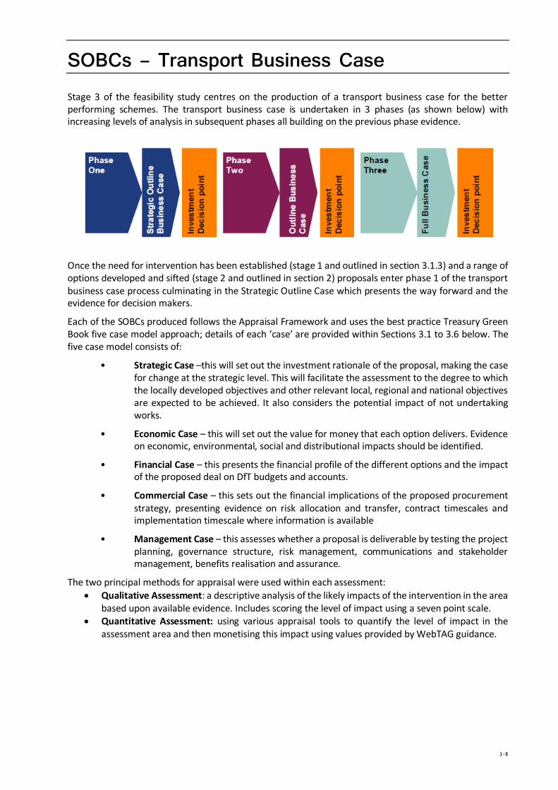
SOBCs – Transport Business Case Stage 3 of the feasibility study centres on the production of a transport business case for the better performing schemes. The transport business case is undertaken in 3 phases (as shown below) with increasing levels of analysis in subsequent phases all building on the previous phase evidence.
Once the need for intervention has been established (stage 1 and outlined in section 3.1.3) and a range of options developed and sifted (stage 2 and outlined in section 2) proposals enter phase 1 of the transport business case process culminating in the Strategic Outline Case which presents the way forward and the evidence for decision makers.
Each of the SOBCs produced follows the Appraisal Framework and uses the best practice Treasury Green Book five case model approach; details of each ‘case’ are provided within Sections 3.1 to 3.6 below. The five case model consists of:
• Strategic Case –this will set out the investment rationale of the proposal, making the case for change at the strategic level. This will facilitate the assessment to the degree to which the locally developed objectives and other relevant local, regional and national objectives are expected to be achieved. It also considers the potential impact of not undertaking works.
• Economic Case – this will set out the value for money that each option delivers. Evidence on economic, environmental, social and distributional impacts should be identified.
• Financial Case – this presents the financial profile of the different options and the impact of the proposed deal on DfT budgets and accounts.
• Commercial Case – this sets out the financial implications of the proposed procurement strategy, presenting evidence on risk allocation and transfer, contract timescales and implementation timescale where information is available
• Management Case – this assesses whether a proposal is deliverable by testing the project planning, governance structure, risk management, communications and stakeholder management, benefits realisation and assurance.
The two principal methods for appraisal were used within each assessment: • Qualitative Assessment: a descriptive analysis of the likely impacts of the intervention in the area
based upon available evidence. Includes scoring the level of impact using a seven point scale. • Quantitative Assessment: using various appraisal tools to quantify the level of impact in the
assessment area and then monetising this impact using values provided by WebTAG guidance.
3-8
3.1 Strategic Case 3.1.1 Introduction The Strategic Case sets out the “case for change” by explaining the rationale for investment based on the presentation of evidence of current problems and the fit with local, regional and national policies at the strategic level.
In particular the Strategic Case:-
• Provides the context for the business case, outlining the aims and responsibilities of the HA and DfT
• Establishes and identifies the transport related problems to justify the need for intervention and the implications of not changing
• Identifies specific objectives aligned with national, regional and local policies
• Establishes measure for success and scheme scope identifying what the scheme will and will not deliver
• Determines high level internal and external constraints and inter dependencies on which successful delivery may depend
• Outlines the main stakeholder groups and contributions
• Evaluates all of the options considered.
The information provided in the subsequent sections on related problems and issues forms a summary of what was presented in detail in both the Stage 1 Evidence Report and Stage 2 Option Assessment Report delivered at previous stages of this Feasibility Study and as presented to the A303/A30/A358 Corridor Reference Group identified in section 1.1.
Finally, the Strategic Case concludes that the proposed scheme(s) fit closely with policy and that a robust and compelling case for change is present.
3.1.2 Business Strategy The Feasibility Study was commissioned by the DfT and it is anticipated that any scheme commissioned for future construction would be funded by Central Government and as such the scheme should be consistent with the main objectives of the DfT. In addition, the route will be maintained and managed by the HA whose objectives should also be considered. Finally the route improvements occur within a number of Local Authority areas and Local Enterprise Partnership (LEP) regions and as such the local objectives and “Visions” of the various councils and LEPs also need to be taken into consideration.
Government/DfT/Local Authority and Local Enterprise Partnerships Objectives
The Coalition Agreement1 sets out the government priorities for the UK. It includes a commitment to promote a competitive economy, sustain the recovery, promote green spaces and wildlife corridors in order to halt the loss of habitats and restore biodiversity and support sustainable travel. These objectives are reflected by the Department for Transport who have a strategic priority to invest in the road network to promote growth, address congestion and improve road safety.
The Department’s Command Paper Action for Roads sets out the Department’s vision for the future of the road network and explains that Government is making a transformational investment in the road network to support the economy and the environment, and to build a network that is fit for the future.
The Department has also recently consulted on the National Policy Statement for National Networks which sets out Government’s vision and policy for the future development of nationally significant
1 https://www.gov.uk/government/uploads/system/uploads/attachment_data/file/78977/coalition_programme_for_government.pdf accessed 10 October 2014
infrastructure projects on the national road and rail networks. The National Policy Statement sets out the following strategic objectives for the national networks:
• Networks with the capacity and connectivity to support national and local economic activity and facilitate growth and create jobs.
• Networks which support and improve journey quality, reliability and safety. • Networks which support the delivery of environmental goals and the move to a low carbon
economy. • Networks which join up our communities and link effectively to each other.
Building on Action for Roads and the National Policy Statement for National Networks , the Department also developed a Road Investment Strategy which sets out the Government’s vision for the strategic road network by 2040.
In addition to government national objectives and policies, the study also considered the policies and visions of other organisations which have an interest in the A303/A30A358 corridor. The Local Enterprise Partnerships (LEP) (Hearth of the South West, Dorset and Cornwall and the Isles of Scilly) all have similar views and aspirations. They recognise that the area is underperforming and highlight the fact that the GVA per capita is lower in the south west that England as a whole. The Heart of the South West LEP specifically indicates in its view that the transport infrastructure is a barrier to growth.
When considering the Amesbury to Berwick Down section, the study examined the combined vision of English Heritage and National Trust which includes a preference to remove the A303 from the landscape within the World Heritage Site by the construction of a tunnel.
In addition, the A303/A30/A358 corridor passes through the counties of Wiltshire and Somerset.
Wiltshire Council’s LTP identifies a series of policies including:
• SO1 – to support and help improve the vitality, viability and resilience of Wiltshire’s economy and market towns:
• SO4 – to minimise traffic delays and disruption and improve journey time reliability on key routes;
• SO6 – to make the best use of the existing infrastructure through effective design, management and maintenance
• SO10 – to encourage the efficient and sustainable distribution of freight in Wiltshire
• SO12 - to support planned growth in Wiltshire and ensure that new developments adequately provide for their sustainable transport requirements and mitigate their traffic impacts.
• SO16 To improve the resilience of the transport system to impacts such as adverse weather, climate change and peak oil
Somerset County Council’s LTP (LTP2 2006 – 2011) identifies the following objectives:
• Improve safety for all who travel
• Reduce social exclusion and improve access to everyday facilities
• Reduce growth in congestion and pollution
• Support sustainable economic growth in appropriate locations
• Protect and enhance the built and natural environment.
In addition Somerset County Council’s County Plan 2013 – 2017 identifies a Vision in that:
• Somerset is a safer and healthier place;
• Somerset is a place where people from all backgrounds have an equal opportunity to learn, work and enjoy themselves and to achieve their ambitions and full potential;
• Somerset is a thriving local economy which attracts jobs and investment, and;
3-10
• Somerset is a place where people and communities have good quality services
Many of the documents examined indicate an ‘aspiration for the A303 to act as a second strategic route’.
3.1.3 Problem Identification The A303 corridor has been extensively studied previously given its importance in providing the second strategic link to the south west. The Stage 1 report summarised detail of the existing operation of each section of the route corridor.
Along its length, there are a number of common issues that result in the poor level of operation often experienced by motorists, businesses and residents. These can be broadly summarised as:
• Mixed road typology – the corridor is comprised of a mix of Dual 2, Single 3 and Single 2 carriageway which leads to localised congestion where the standard drops, impacting on journey times and journey time reliability.
• Accidents – several sections of the corridor suffer from accidents partly as a result of substandard alignment, poor junction visibility and changes in road type.
• Environment and Historical Environment – the route passes through a number of sensitive environmental and historic environmental areas which result in challenges in improving the network on these sections.
• High traffic flows – many sections of the route experience traffic demand above that for which they were designed. This is exacerbated in summer as a result of higher traffic flows, which typically result in 30% additional traffic.
In addition to these existing issues, the corridor is subject to the pressures brought about through traffic growth. This is forecast to increase as local authorities along the length of the route seek to deliver economic growth and new development, especially as the economic outlook improves.
AADT
The Annual Average Daily Traffic (AADT) flows on the single carriageway sections of the route experienced for neutral month flows (typically between 22,000 and 26,000) are significantly in excess of the theoretical design standard flow for that type of road which is 13,000 as stated in TA 46/972. In addition, evidence is also available (in the Stage 1 report) which indicates that the traffic flow has barely changed on these sections since 2008 which may in part be due to the economic recession but also due to them having little additional capacity to cater for any growth.
Stress
Network stress is a measure of actual traffic flow against the maximum achievable hourly throughput expressed in terms of AADT. The result of the problems experienced and high traffic flows indicated above is that most sections operate with flows close to or in excess of 100% and suffer from operational issues and congestion, including flow breakdown and queuing. It should also be noted that at times when the stress factor lies between 85% (0.85) and 100% (1.00) turbulent traffic conditions will also be experienced during peak periods.
The possible knock on effect of this is for traffic to reroute and try to find alternative, more reliable routes. This results in ‘rat running’ on unsuitable roads and routes with additional traffic being experienced within the small settlements near the main route, thus increasing the stress on those routes.
On Time Reliability
The On Time Reliability Measure (OTRM) monitors the percentage of ‘journeys’ on the SRN that are ‘on time’. For this measure:
• a ‘journey’ represents travel between adjacent junctions on the network. • an ‘on time journey’ is defined as one which is completed within a set reference time.
2 Traffic flow Ranges for use in the assessment of new rural roads”, DMRB Volume 5, Section 1 Part 3
Reference times are based on historic data reflecting the typical ‘journey’ time for that time and day, on that part of the network. As a result, reference times will not always relate to free-flow conditions as they will reflect the impact of historical levels of congestion at different times of the day.
Results for the study corridor indicate that the A30 between Honiton and the M5 and the A303 in the vicinities of Andover and Sparkford are below the 70% reliability level during the majority of the day. In addition, the worst reliability is on the A303 between the A360 and A344 at Stonehenge in a westbound direction. Even during the interpeak reliability reduces to around 55% on this section of road westbound.
Looking at the overall performance of the route, the majority of the sections are either below the 70% reliability level or between 70-80%.
Resilience
Resilience can be described as the ability to absorb adverse or unforeseen events. At the present time, many such events on the single carriageway sections of the A303/A30/A358 cause congestion and delays and even predictable events such as increased seasonal traffic have a profound effect.
Similarly, the impacts of accidents on these sections often result in road closure leading to congestion and delays even though the frequency of accidents is not unduly different to comparable sections of road elsewhere. Those delays and the consequential effect upon travellers and industry can be significant due to the route characteristics and the absence of suitable re-routing alternatives.
It is important therefore that the proposed solutions will improve the resilience of the route such that the number and the effect of accidents and incidents is reduced.
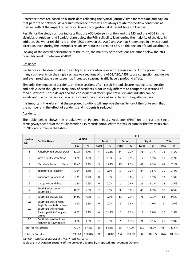
Accidents
The table below shows the breakdown of Personal Injury Accidents (PIAs) on the current single carriageway sections of the study corridor. PIA records compiled from Stats 19 data for the five years 2008 to 2012 are shown in the tables.
Section No. Section Name
Length PIA
Fatal Serious Slight Total
km % Total % Total % Total % Total %
1 Amesbury to Berwick Down 11.24 5.7% 4 11.1% 14 9.1% 53 7.7% 71 8.1%
2 Wylye to Stockton Wood 3.70 1.9% 1 2.8% 6 3.9% 12 1.7% 19 2.2%
3 Chicklade Bottom to Mere 13.46 6.9% 5 13.9% 15 9.7% 43 6.3% 63 7.2%
4 Sparkford to Ilchester 5.14 2.6% 1 2.8% 5 3.2% 24 3.5% 30 3.4%
5 Podimore Roundabout 1.31 0.7% 0 0.0% 1 0.6% 12 1.7% 13 1.5%
6 Cartgate Roundabout 1.20 0.6% 0 0.0% 1 0.6% 21 3.1% 22 2.5%
7 South Petherton to Southfields 10.79 5.5% 2 5.6% 9 5.8% 46 6.7% 57 6.5%
8 Southfields to M5 J25 14.00 7.2% 1 2.8% 11 7.1% 71 10.3% 83 9.5%
9.1 Southfields to Honiton - Eagle Tavern to Broadway 3.10 1.6% 0 0.0% 2 1.3% 7 1.0% 9 1.0%
9.2 Southfields to Honiton - Rawridge Hil to Stopgate Circus
4.67 2.4% 4 11.1% 2 1.3% 19 2.8% 25 2.9%
9.3 Southfields to Honiton - Honiton to Rawridge Hill 3.76 1.9% 2 5.6% 2 1.3% 21 3.1% 25 2.9%
Total for All Sections 72.37 37.0% 20 55.6% 68 44.2% 329 48.0% 417 47.6%
Total for Corridor 195.80 100.0% 36 100.0% 154 100.0% 686 100.0% 876 100.0%
NB 2008 – 2012 for A30 and A303, 2009 to 2013 for A358 Table 3-1: PIA Data for Sections of the Corridor Covered by Proposed Improvement Options
3-12
Of particular note is that whilst the single carriageway sections of the corridor comprise only 37% of the route length they contribute to nearly 48% of all injury accidents and more significantly nearly 56% of fatal accidents.
The following paragraphs summarise the main environmental issues experienced along the corridor.
Flooding Risk– This study identified the main rivers from east to west as the River Test; the River Avon and the River Stour. All of the proposed improvement sections fall within flood zones 1 and 2 with all schemes except 2 and 3 also including some flood zone 3 areas where there are main rivers and tributaries that cross the scheme corridors
The South West Peninsula Route Strategy report identifies a number of sections of the A303 in this vicinity where there is a known flood risk:
• either side of the B3170, near the River Yartley. • An area to the west of Yeovil where the A303 meets the River Parrett • Section of road through Podimore and West Camel to the north of Yeovil where the road runs
next to Park Brook and various streams which feed into the River Yeo • North of Mere as it runs close to Shreen Water • To the east of the junction with the A350 • To the south of Sherrington Wood and to north of Fonthill Lake • Where road passes by Thruxton and crosses over the Pillhill Brook • In vicinity of junction with A3093 to the east of Andover • Large stretch of the A303 to the east of the junction with the A34, which is just to the north of the
River Dever
Heritage- there are many listed buildings located along the route, some located immediately adjacent to the exiting road and others that may be affected by any deviation from the current line. In addition, there are the unique historical stones and other artefacts which are sited within the landscape of the World Heritage Site at Stonehenge. Noise- There are 23 First Priority Locations (FPLs), as defined by the Department for Environment, Food and Rural Affairs (Defra) Noise Action Plan, proposed for action planning work along the highway corridors. Of these 23, there are 18 FPLs from the M3 Junction 8 to the A303/A30 Honiton and 5 FPLs from the A358 Southfields to M5. Landscape- in particular will be affected by any works to widen existing roads and even more so if the proposals include an off-line (or part offline) route. This includes flora and fauna and wildlife habitats. The A303/A30/A358 corridor passes directly through 2 Areas of Outstanding Natural Beauty (Blackdown Hills and the Cranborne Chase and West Wiltshire Downs in addition to a series of Sites of Special Scientific Interest – add SACs if there. All these environmental aspects can have an influence on the development of any scheme and need to be fully considered. It is imperative that scheme designs mitigate against any potential negative affect upon the environment in any form. Development of those mitigation measures should begin as early in the design process as possible to ensure that the views or stakeholders and potential mitigation avenues can be thoroughly investigated and addressed.
3.1.4 The Impact of Not Changing As detailed above, much of the corridor operates under stressed conditions, more so in summer when flows increase with consequential poor journey time reliability. This is the result of the volume of traffic using the corridor and also because of inconsistent and old design standards, numerous direct and local accesses and historical and environmental constraints. Resultant PIA occurrence is also predominantly on the single carriageway sections.
The corridor provides one of the main conduits for access to the south west and as the economy grows and development occurs pressures on the corridor will be exacerbated. Currently economic growth plans for the South West identify some 242,000 residential units and 150,000 new jobs with the main concentrations both adjacent to and distant from the corridor but in both cases requiring access from it.
Increasing congestion will impact on every peak period road user whether commuting, for business or for the movement of freight. In addition it will impact on the surrounding road network as traffic uses other routes to avoid the congestion with consequential worsening of conditions on adjacent routes with associated environmental and social disbenefits.
Without improvement, the performance of the corridor will deteriorate further and have an increased effect on residents, employers, tourists and more widely the environment and historical capital of the region. The level of congestion and journey time reliability will also exacerbate the regions lower economic output and provide an ever increasing hindrance and barrier to growth and prosperity.
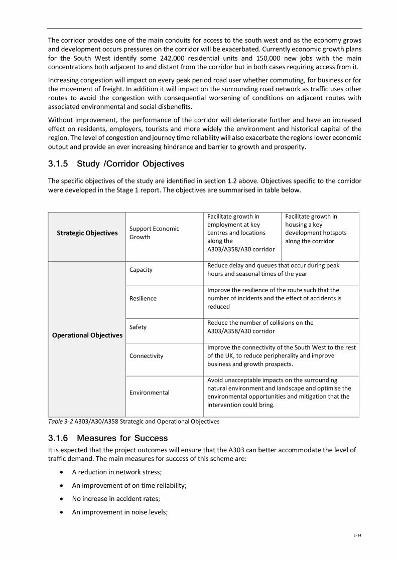
3.1.5 Study /Corridor Objectives
The specific objectives of the study are identified in section 1.2 above. Objectives specific to the corridor were developed in the Stage 1 report. The objectives are summarised in table below.
Strategic Objectives Support Economic Growth
Facilitate growth in employment at key centres and locations along the A303/A358/A30 corridor
Facilitate growth in housing a key development hotspots along the corridor
Operational Objectives
Capacity Reduce delay and queues that occur during peak hours and seasonal times of the year
Resilience Improve the resilience of the route such that the number of incidents and the effect of accidents is reduced
Safety Reduce the number of collisions on the A303/A358/A30 corridor
Connectivity Improve the connectivity of the South West to the rest of the UK, to reduce peripherality and improve business and growth prospects.
Environmental
Avoid unacceptable impacts on the surrounding natural environment and landscape and optimise the environmental opportunities and mitigation that the intervention could bring.
Table 3-2 A303/A30/A358 Strategic and Operational Objectives
3.1.6 Measures for Success It is expected that the project outcomes will ensure that the A303 can better accommodate the level of traffic demand. The main measures for success of this scheme are:
• A reduction in network stress;
• An improvement of on time reliability;
• No increase in accident rates;
• An improvement in noise levels;
3-14
• No harm to the historical environment;
• No harm to ecologically designated sites.
3.1.7 Study Constraints The main constraints to the successful delivery of this scheme are as follows:
• Working close to live highway;
• Working within a World Heritage Site;
• Working within an AONB;
• Working close to or through other environmentally sensitive sites;
• Scheduling construction.
3.1.8 Inter-dependencies The study considered schemes are standalone (because the inclusion of each in future programmes was unknown) and as such each scheme requires no other works to be in place in order to be completed. However, because there are a number of schemes being proposed along the A303/A30/A358 corridor, if a number of them are taken forward then there is likely to be an increase in the level of benefit realised as a result.
The improvements on each section are, as said, independent of each other and can, to some extent be constructed without affecting other sections. However, this would be impractical without a major effect on the journey time reliability for the corridor. Any construction programme needs to fully consider these implications which will extend the duration of construction.
3.2 Economic Case 3.2.1 Appraisal Methodology
Introduction This Section of the report provides a summary of the appraisal methodology followed by the results presented for each section of the corridor for which SOBCs were produced as indicated in Section 2.1.
The economic case for the schemes is demonstrated by an analysis of all the impacts and their associated value for money. DfT guidance on undertaking a SOBC requires that only initial findings on the associated value for money of a scheme are provided at this stage. With this in mind, and following the agreed approach and recommendations identified during previous stages, some of the assessment areas are further forward than others. Where appropriate and available, detailed assessment information is provided. Where it is not available, an initial assessment is presented along with recommendations for further work.
The following sections firstly provide more detail on the derivation of the do minimum schemes and matrices and subsequently describe the main methodology adopted to assess the economic performance of the options, summarise the approach to the non-monetised elements and finally report on the appraisal findings.
Do Minimum The Do Minimum scenario needs to reflect infrastructure and land use changes of a strategic nature which are committed. Table 3-3 below shows those transport infrastructure schemes identified during the initial analysis. Within the main corridor area there are a number of isolated junction improvements which, although providing benefits, are unlikely to be strategic in nature. Of the proposals only the Smart
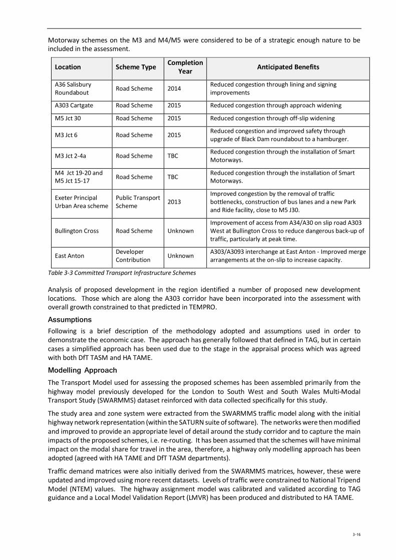
Motorway schemes on the M3 and M4/M5 were considered to be of a strategic enough nature to be included in the assessment.
Location Scheme Type Completion Year Anticipated Benefits
A36 Salisbury Roundabout Road Scheme 2014 Reduced congestion through lining and signing
improvements
A303 Cartgate Road Scheme 2015 Reduced congestion through approach widening
M5 Jct 30 Road Scheme 2015 Reduced congestion through off-slip widening
M3 Jct 6 Road Scheme 2015 Reduced congestion and improved safety through upgrade of Black Dam roundabout to a hamburger.
M3 Jct 2-4a Road Scheme TBC Reduced congestion through the installation of Smart Motorways.
M4 Jct 19-20 and M5 Jct 15-17 Road Scheme TBC Reduced congestion through the installation of Smart
Motorways.
Exeter Principal Urban Area scheme
Public Transport Scheme 2013
Improved congestion by the removal of traffic bottlenecks, construction of bus lanes and a new Park and Ride facility, close to M5 J30.
Bullington Cross Road Scheme Unknown Improvement of access from A34/A30 on slip road A303 West at Bullington Cross to reduce dangerous back-up of traffic, particularly at peak time.
East Anton Developer Contribution Unknown A303/A3093 interchange at East Anton - Improved merge
arrangements at the on-slip to increase capacity.
Table 3-3 Committed Transport Infrastructure Schemes
Analysis of proposed development in the region identified a number of proposed new development locations. Those which are along the A303 corridor have been incorporated into the assessment with overall growth constrained to that predicted in TEMPRO.
Assumptions Following is a brief description of the methodology adopted and assumptions used in order to demonstrate the economic case. The approach has generally followed that defined in TAG, but in certain cases a simplified approach has been used due to the stage in the appraisal process which was agreed with both DfT TASM and HA TAME.
Modelling Approach The Transport Model used for assessing the proposed schemes has been assembled primarily from the highway model previously developed for the London to South West and South Wales Multi-Modal Transport Study (SWARMMS) dataset reinforced with data collected specifically for this study.
The study area and zone system were extracted from the SWARMMS traffic model along with the initial highway network representation (within the SATURN suite of software). The networks were then modified and improved to provide an appropriate level of detail around the study corridor and to capture the main impacts of the proposed schemes, i.e. re-routing. It has been assumed that the schemes will have minimal impact on the modal share for travel in the area, therefore, a highway only modelling approach has been adopted (agreed with HA TAME and DfT TASM departments).
Traffic demand matrices were also initially derived from the SWARMMS matrices, however, these were updated and improved using more recent datasets. Levels of traffic were constrained to National Tripend Model (NTEM) values. The highway assignment model was calibrated and validated according to TAG guidance and a Local Model Validation Report (LMVR) has been produced and distributed to HA TAME.
3-16
Forecast year models were created for 2021 and 2041 (the NTEM forecast horizon). Reference Case demand matrices were produced using NTEM6.2 and NTM growth factors for the two forecast years. At this stage in the appraisal process a fixed matrix approach was adopted which was used in combination with an equilibrium highway assignment approach. This has been agreed with HA TAME as acceptable for the current stage of the study.
In accordance with WebTAG Unit M4 (The Treatment of Uncertainty in Model Forecasting) high and low growth uncertainty tests were undertaken. These consist of the application of a factor of 2.5% to the base matrix multiplied by the square root of the number of years between the base year and the forecast year being tested. Applying the resultant factor to the base year matrices results in an uncertainty matrix which is then either added (for high growth) or subtracted (for low growth) to the core scenario reference case matrices.
The traffic model was used to provide forecasts for demand, traffic flow, journey time and distance which were used in subsequent stages of the appraisal process. Model outputs provided include:
• Demand matrices by purpose and time period • Journey time skims by purpose and time period • Distance skims by journey and time period
Assessment Methodology A key component of the economic case is the quantification of transport user benefits. This process was undertaken using the Transport Users Benefits Appraisal (TUBA v1.9.4) program, with inputs provided by the traffic model summarised above. Key assumptions of the economic assessment are:
• Appraisal over 60 years with a scheme opening year of 2021; • Appraisal based on model forecast years of 2021 and 2041; • Three modelled hours: AM, PM, average Interpeak • Annualisation factors derived to enable modelled peaks to represent whole year; • With and without scheme scenarios are modelled for the 2021 and 2041 scenarios; • Value of Time (VOT) and Vehicle Operating Costs (VOC) are as defined in TAG Data Book; • Distributional Impacts have currently been assessed in a qualitative way; • The TUBA assessment is undertaken with the following user classes):
• Car/light vehicles – Home based work; • Car/light vehicles – Employers business; • Car/light vehicles – Other journey purposes; • HGVs;
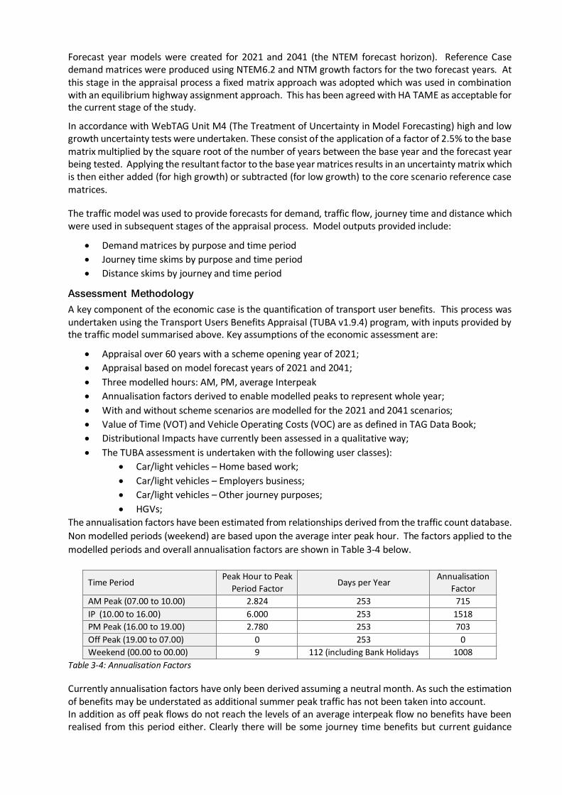
The annualisation factors have been estimated from relationships derived from the traffic count database. Non modelled periods (weekend) are based upon the average inter peak hour. The factors applied to the modelled periods and overall annualisation factors are shown in Table 3-4 below.
Time Period Peak Hour to Peak
Period Factor Days per Year
Annualisation Factor
AM Peak (07.00 to 10.00) 2.824 253 715 IP (10.00 to 16.00) 6.000 253 1518 PM Peak (16.00 to 19.00) 2.780 253 703 Off Peak (19.00 to 07.00) 0 253 0 Weekend (00.00 to 00.00) 9 112 (including Bank Holidays 1008
Table 3-4: Annualisation Factors
Currently annualisation factors have only been derived assuming a neutral month. As such the estimation of benefits may be understated as additional summer peak traffic has not been taken into account. In addition as off peak flows do not reach the levels of an average interpeak flow no benefits have been realised from this period either. Clearly there will be some journey time benefits but current guidance
(TAME) is not to assess these where the flows are lower than the average IP period flows. In both cases, therefore, benefits could be construed as conservative.
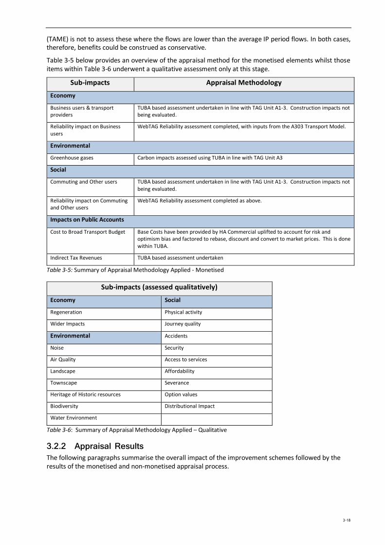
Table 3-5 below provides an overview of the appraisal method for the monetised elements whilst those items within Table 3-6 underwent a qualitative assessment only at this stage.
Sub-impacts Appraisal Methodology
Economy
Business users & transport providers
TUBA based assessment undertaken in line with TAG Unit A1-3. Construction impacts not being evaluated.
Reliability impact on Business users
WebTAG Reliability assessment completed, with inputs from the A303 Transport Model.
Environmental
Greenhouse gases Carbon impacts assessed using TUBA in line with TAG Unit A3
Social
Commuting and Other users TUBA based assessment undertaken in line with TAG Unit A1-3. Construction impacts not being evaluated.
Reliability impact on Commuting and Other users
WebTAG Reliability assessment completed as above.
Impacts on Public Accounts
Cost to Broad Transport Budget Base Costs have been provided by HA Commercial uplifted to account for risk and optimism bias and factored to rebase, discount and convert to market prices. This is done within TUBA.
Indirect Tax Revenues TUBA based assessment undertaken
Table 3-5: Summary of Appraisal Methodology Applied - Monetised
Sub-impacts (assessed qualitatively)
Economy Social
Regeneration Physical activity
Wider Impacts Journey quality
Environmental Accidents
Noise Security
Air Quality Access to services
Landscape Affordability
Townscape Severance
Heritage of Historic resources Option values
Biodiversity Distributional Impact
Water Environment
Table 3-6: Summary of Appraisal Methodology Applied – Qualitative
3.2.2 Appraisal Results The following paragraphs summarise the overall impact of the improvement schemes followed by the results of the monetised and non-monetised appraisal process.
3-18
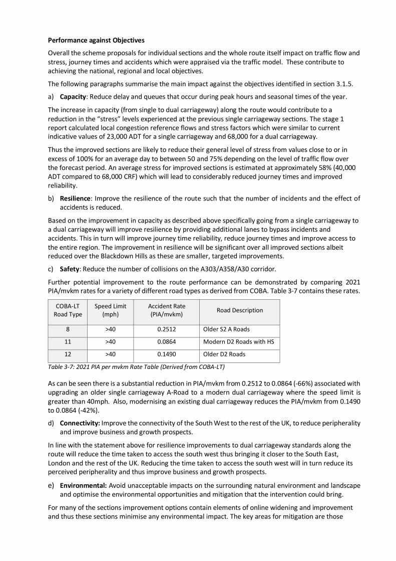
Performance against Objectives
Overall the scheme proposals for individual sections and the whole route itself impact on traffic flow and stress, journey times and accidents which were appraised via the traffic model. These contribute to achieving the national, regional and local objectives.
The following paragraphs summarise the main impact against the objectives identified in section 3.1.5.
a) Capacity: Reduce delay and queues that occur during peak hours and seasonal times of the year.
The increase in capacity (from single to dual carriageway) along the route would contribute to a reduction in the “stress” levels experienced at the previous single carriageway sections. The stage 1 report calculated local congestion reference flows and stress factors which were similar to current indicative values of 23,000 ADT for a single carriageway and 68,000 for a dual carriageway.
Thus the improved sections are likely to reduce their general level of stress from values close to or in excess of 100% for an average day to between 50 and 75% depending on the level of traffic flow over the forecast period. An average stress for improved sections is estimated at approximately 58% (40,000 ADT compared to 68,000 CRF) which will lead to considerably reduced journey times and improved reliability.
b) Resilience: Improve the resilience of the route such that the number of incidents and the effect of accidents is reduced.
Based on the improvement in capacity as described above specifically going from a single carriageway to a dual carriageway will improve resilience by providing additional lanes to bypass incidents and accidents. This in turn will improve journey time reliability, reduce journey times and improve access to the entire region. The improvement in resilience will be significant over all improved sections albeit reduced over the Blackdown Hills as these are smaller, targeted improvements.
c) Safety: Reduce the number of collisions on the A303/A358/A30 corridor.
Further potential improvement to the route performance can be demonstrated by comparing 2021 PIA/mvkm rates for a variety of different road types as derived from COBA. Table 3-7 contains these rates.
COBA-LT Road Type
Speed Limit (mph)
Accident Rate (PIA/mvkm) Road Description
8 >40 0.2512 Older S2 A Roads
11 >40 0.0864 Modern D2 Roads with HS
12 >40 0.1490 Older D2 Roads
Table 3-7: 2021 PIA per mvkm Rate Table (Derived from COBA-LT)
As can be seen there is a substantial reduction in PIA/mvkm from 0.2512 to 0.0864 (-66%) associated with upgrading an older single carriageway A-Road to a modern dual carriageway where the speed limit is greater than 40mph. Also, modernising an existing dual carriageway reduces the PIA/mvkm from 0.1490 to 0.0864 (-42%).
d) Connectivity: Improve the connectivity of the South West to the rest of the UK, to reduce peripherality and improve business and growth prospects.
In line with the statement above for resilience improvements to dual carriageway standards along the route will reduce the time taken to access the south west thus bringing it closer to the South East, London and the rest of the UK. Reducing the time taken to access the south west will in turn reduce its perceived peripherality and thus improve business and growth prospects.
e) Environmental: Avoid unacceptable impacts on the surrounding natural environment and landscape and optimise the environmental opportunities and mitigation that the intervention could bring.
For many of the sections improvement options contain elements of online widening and improvement and thus these sections minimise any environmental impact. The key areas for mitigation are those
running through AONB’s or other sensitive area. Of key critical importance is the WHS of Stonehenge. Significant work and liaison with NT and EH has identified a preferred option which substantially reduces environmental impact via removing the route into a tunnel allowing the linking of historic sites, improving biodiversity. Further details are in subsequent paragraphs.
The achievement of improving the route to either in part or in full will assist in the overarching objectives of supporting and facilitating economic growth and growth in employment and housing at key development hotspots along the corridor.
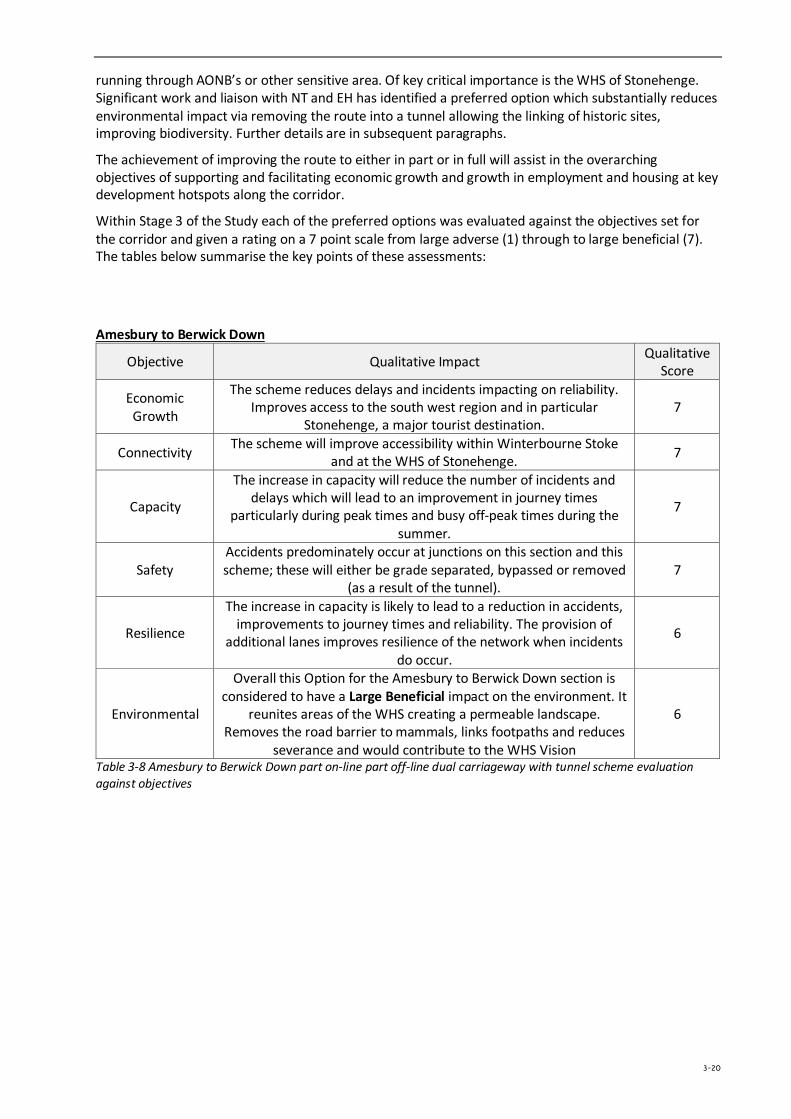
Within Stage 3 of the Study each of the preferred options was evaluated against the objectives set for the corridor and given a rating on a 7 point scale from large adverse (1) through to large beneficial (7). The tables below summarise the key points of these assessments:
Amesbury to Berwick Down
Objective Qualitative Impact Qualitative Score
Economic Growth
The scheme reduces delays and incidents impacting on reliability. Improves access to the south west region and in particular
Stonehenge, a major tourist destination. 7
Connectivity The scheme will improve accessibility within Winterbourne Stoke and at the WHS of Stonehenge. 7
Capacity
The increase in capacity will reduce the number of incidents and delays which will lead to an improvement in journey times
particularly during peak times and busy off-peak times during the summer.
7
Safety Accidents predominately occur at junctions on this section and this scheme; these will either be grade separated, bypassed or removed
(as a result of the tunnel). 7
Resilience
The increase in capacity is likely to lead to a reduction in accidents, improvements to journey times and reliability. The provision of
additional lanes improves resilience of the network when incidents do occur.
6
Environmental
Overall this Option for the Amesbury to Berwick Down section is considered to have a Large Beneficial impact on the environment. It
reunites areas of the WHS creating a permeable landscape. Removes the road barrier to mammals, links footpaths and reduces
severance and would contribute to the WHS Vision
6
Table 3-8 Amesbury to Berwick Down part on-line part off-line dual carriageway with tunnel scheme evaluation against objectives
3-20
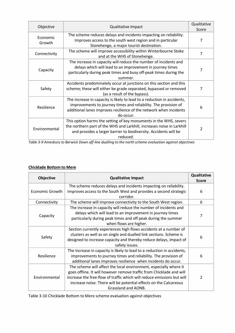
Objective Qualitative Impact Qualitative Score
Economic Growth
The scheme reduces delays and incidents impacting on reliability. Improves access to the south west region and in particular
Stonehenge, a major tourist destination. 7
Connectivity The scheme will improve accessibility within Winterbourne Stoke and at the WHS of Stonehenge. 7
Capacity
The increase in capacity will reduce the number of incidents and delays which will lead to an improvement in journey times
particularly during peak times and busy off-peak times during the summer.
7
Safety Accidents predominately occur at junctions on this section and this scheme; these will either be grade separated, bypassed or removed
(as a result of the bypass). 7
Resilience
The increase in capacity is likely to lead to a reduction in accidents, improvements to journey times and reliability. The provision of
additional lanes improves resilience of the network when incidents do occur.
6
Environmental
This option harms the setting of key monuments in the WHS, severs the northern part of the WHS and Larkhill, increases noise in Larkhill
and provides a larger barrier to biodiversity. Accidents will be reduced.
2
Table 3-9 Amesbury to Berwick Down off-line dualling to the north scheme evaluation against objectives
Chicklade Bottom to Mere
Objective Qualitative Impact Qualitative Score
Economic Growth The scheme reduces delays and incidents impacting on reliability.
Improves access to the South West and provides a second strategic corridor.
6
Connectivity The scheme will improve connectivity to the South West region. 6
Capacity
The increase in capacity will reduce the number of incidents and delays which will lead to an improvement in journey times
particularly during peak times and off peak during the summer when flows are higher.
7
Safety
Section currently experiences high flows accidents at a number of clusters as well as on single and dualled link sections. Scheme is
designed to increase capacity and thereby reduce delays, impact of safety issues.
6
Resilience The increase in capacity is likely to lead to a reduction in accidents,
improvements to journey times and reliability. The provision of additional lanes improves resilience when incidents do occur.
6
Environmental
The scheme will affect the local environment, especially where it goes offline. It will however remove traffic from Chicklade and will increase the free-flow of traffic which will reduce emissions but will
increase noise. There will be potential effects on the Calcareous Grassland and AONB.
2
Table 3-10 Chicklade Bottom to Mere scheme evaluation against objectives
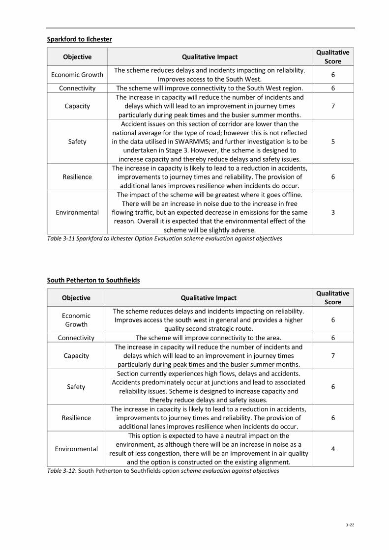
Sparkford to Ilchester
Objective Qualitative Impact Qualitative Score
Economic Growth The scheme reduces delays and incidents impacting on reliability. Improves access to the South West. 6
Connectivity The scheme will improve connectivity to the South West region. 6
Capacity The increase in capacity will reduce the number of incidents and
delays which will lead to an improvement in journey times particularly during peak times and the busier summer months.
7
Safety
Accident issues on this section of corridor are lower than the national average for the type of road; however this is not reflected in the data utilised in SWARMMS; and further investigation is to be
undertaken in Stage 3. However, the scheme is designed to increase capacity and thereby reduce delays and safety issues.
5
Resilience The increase in capacity is likely to lead to a reduction in accidents,
improvements to journey times and reliability. The provision of additional lanes improves resilience when incidents do occur.
6
Environmental
The impact of the scheme will be greatest where it goes offline. There will be an increase in noise due to the increase in free
flowing traffic, but an expected decrease in emissions for the same reason. Overall it is expected that the environmental effect of the
scheme will be slightly adverse.
3
Table 3-11 Sparkford to Ilchester Option Evaluation scheme evaluation against objectives
South Petherton to Southfields
Objective Qualitative Impact Qualitative Score
Economic Growth
The scheme reduces delays and incidents impacting on reliability. Improves access the south west in general and provides a higher
quality second strategic route. 6
Connectivity The scheme will improve connectivity to the area. 6
Capacity The increase in capacity will reduce the number of incidents and
delays which will lead to an improvement in journey times particularly during peak times and the busier summer months.
7
Safety
Section currently experiences high flows, delays and accidents. Accidents predominately occur at junctions and lead to associated
reliability issues. Scheme is designed to increase capacity and thereby reduce delays and safety issues.
6
Resilience The increase in capacity is likely to lead to a reduction in accidents,
improvements to journey times and reliability. The provision of additional lanes improves resilience when incidents do occur.
6
Environmental
This option is expected to have a neutral impact on the environment, as although there will be an increase in noise as a
result of less congestion, there will be an improvement in air quality and the option is constructed on the existing alignment.
4
Table 3-12: South Petherton to Southfields option scheme evaluation against objectives
3-22
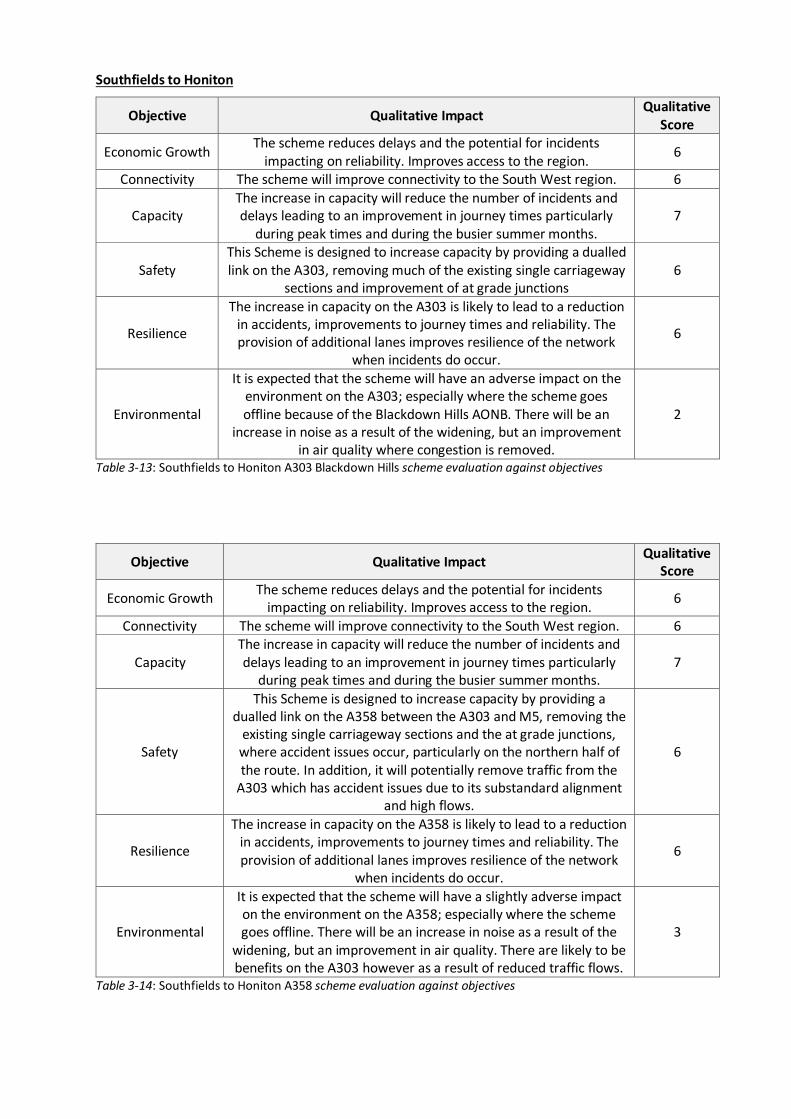
Southfields to Honiton
Objective Qualitative Impact Qualitative Score
Economic Growth The scheme reduces delays and the potential for incidents impacting on reliability. Improves access to the region. 6
Connectivity The scheme will improve connectivity to the South West region. 6
Capacity The increase in capacity will reduce the number of incidents and delays leading to an improvement in journey times particularly
during peak times and during the busier summer months. 7
Safety This Scheme is designed to increase capacity by providing a dualled link on the A303, removing much of the existing single carriageway
sections and improvement of at grade junctions 6
Resilience
The increase in capacity on the A303 is likely to lead to a reduction in accidents, improvements to journey times and reliability. The provision of additional lanes improves resilience of the network
when incidents do occur.
6
Environmental
It is expected that the scheme will have an adverse impact on the environment on the A303; especially where the scheme goes offline because of the Blackdown Hills AONB. There will be an
increase in noise as a result of the widening, but an improvement in air quality where congestion is removed.
2
Table 3-13: Southfields to Honiton A303 Blackdown Hills scheme evaluation against objectives
Objective Qualitative Impact Qualitative Score
Economic Growth The scheme reduces delays and the potential for incidents impacting on reliability. Improves access to the region. 6
Connectivity The scheme will improve connectivity to the South West region. 6
Capacity The increase in capacity will reduce the number of incidents and delays leading to an improvement in journey times particularly
during peak times and during the busier summer months. 7
Safety
This Scheme is designed to increase capacity by providing a dualled link on the A358 between the A303 and M5, removing the
existing single carriageway sections and the at grade junctions, where accident issues occur, particularly on the northern half of the route. In addition, it will potentially remove traffic from the
A303 which has accident issues due to its substandard alignment and high flows.
6
Resilience
The increase in capacity on the A358 is likely to lead to a reduction in accidents, improvements to journey times and reliability. The provision of additional lanes improves resilience of the network
when incidents do occur.
6
Environmental
It is expected that the scheme will have a slightly adverse impact on the environment on the A358; especially where the scheme goes offline. There will be an increase in noise as a result of the
widening, but an improvement in air quality. There are likely to be benefits on the A303 however as a result of reduced traffic flows.
3
Table 3-14: Southfields to Honiton A358 scheme evaluation against objectives
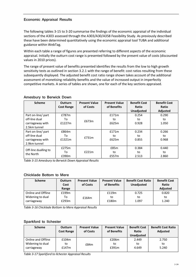
Economic Appraisal Results
The following tables 3-15 to 3-20 summarise the findings of the economic appraisal of the individual sections of the A303 assessed through the A303/A30/A358 Feasibility Study. As previously described these have been determined quantitatively using the economic appraisal tool TUBA and additional guidance within WebTag.
Within each table a range of figures are presented referring to different aspects of the economic appraisal. Initially the outturn cost range is presented followed by the present value of costs (discounted values in 2010 prices).
The range of present value of benefits presented identifies the results from the low to high growth sensitivity tests as outlined in section 3.2.1 with the range of benefit: cost ratios resulting from these subsequently displayed. The adjusted benefit cost ratio range shown takes account of the additional assessment of monetising reliability benefits and the value of increased output in imperfectly competitive markets. A series of tables are shown, one for each of the key sections appraised.
Amesbury to Berwick Down Scheme Outturn
Cost Range Present Value
of Costs Present Value
of Benefits
Benefit Cost Ratio
Unadjusted
Benefit Cost Ratio
Adjusted Part on-line/ part off-line dual carriageway with 2.5km tunnel
£787m To
£1227m £673m
£171m to
£625m
0.254 to
0.928
0.290 to
1.050
Part on-line/ part off-line dual carriageway with 2.9km tunnel
£864m To
£1321m £731m
£171m to
£625m
0.234 to
0.855
0.266 to
0.968
Off-line dualling to the North
£275m To
£390m £221m
£85m to
£557m
0.384 to
2.513
0.440 to
2.860 Table 3-15 Amesbury to Berwick Down Appraisal Results
Chicklade Bottom to Mere Scheme Outturn
Cost Range
Present Value of Costs
Present Value of Benefits
Benefit Cost Ratio Unadjusted
Benefit Cost Ratio
Adjusted Online and Offline Widening to dual carriageway
£199m To
£293m £164m
£119m to
£180m
0.725 to
1.097
0.820 to
1.240
Table 3-16 Chicklade Bottom to Mere Appraisal Results
Sparkford to Ilchester Scheme Outturn
Cost Range Present Value
of Costs Present Value
of Benefits Benefit Cost
Ratio Unadjusted
Benefit Cost Ratio Adjusted
Online and Offline Widening to dual carriageway
£104m to
£147m £84m
£206m to
£391m
2.449 to
4.649
2.750 to
5.240
Table 3-17 Sparkford to Ilchester Appraisal Results
3-24
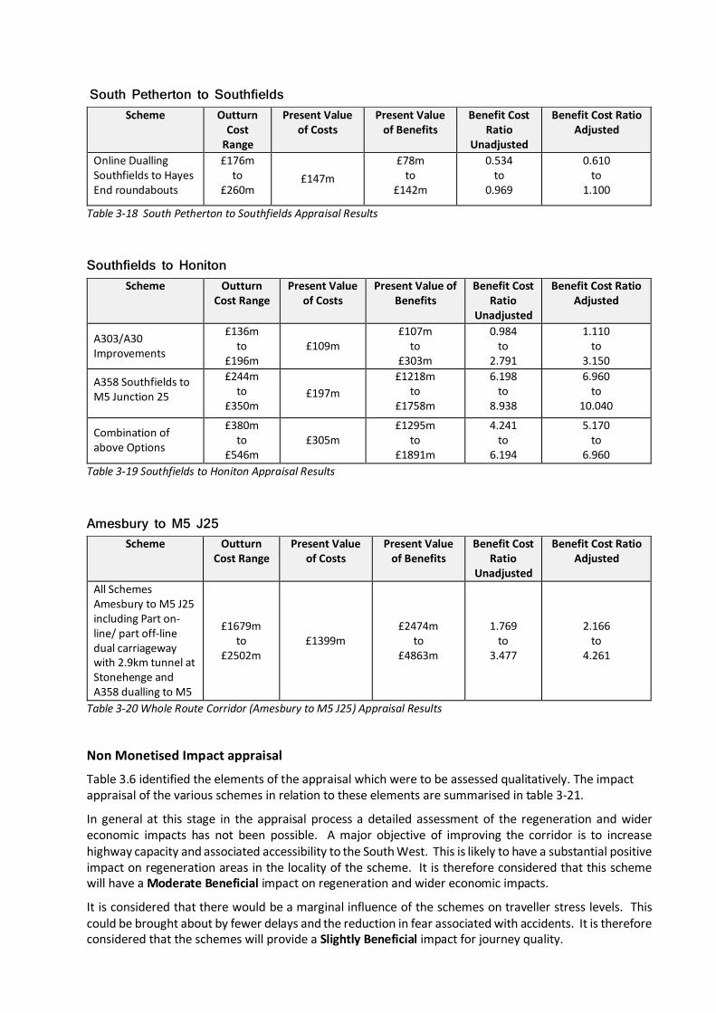
South Petherton to Southfields Scheme Outturn
Cost Range
Present Value of Costs
Present Value of Benefits
Benefit Cost Ratio
Unadjusted
Benefit Cost Ratio Adjusted
Online Dualling Southfields to Hayes End roundabouts
£176m to
£260m £147m
£78m to
£142m
0.534 to
0.969
0.610 to
1.100
Table 3-18 South Petherton to Southfields Appraisal Results
Southfields to Honiton Scheme Outturn
Cost Range Present Value
of Costs Present Value of
Benefits Benefit Cost
Ratio Unadjusted
Benefit Cost Ratio Adjusted
A303/A30 Improvements
£136m to
£196m £109m
£107m to
£303m
0.984 to
2.791
1.110 to
3.150
A358 Southfields to M5 Junction 25
£244m to
£350m £197m
£1218m to
£1758m
6.198 to
8.938
6.960 to
10.040
Combination of above Options
£380m to
£546m £305m
£1295m to
£1891m
4.241 to
6.194
5.170 to
6.960 Table 3-19 Southfields to Honiton Appraisal Results
Amesbury to M5 J25 Scheme Outturn
Cost Range Present Value
of Costs Present Value
of Benefits Benefit Cost
Ratio Unadjusted
Benefit Cost Ratio Adjusted
All Schemes Amesbury to M5 J25 including Part on-line/ part off-line dual carriageway with 2.9km tunnel at Stonehenge and A358 dualling to M5
£1679m to
£2502m £1399m
£2474m to
£4863m
1.769 to
3.477
2.166 to
4.261
Table 3-20 Whole Route Corridor (Amesbury to M5 J25) Appraisal Results
Non Monetised Impact appraisal
Table 3.6 identified the elements of the appraisal which were to be assessed qualitatively. The impact appraisal of the various schemes in relation to these elements are summarised in table 3-21.
In general at this stage in the appraisal process a detailed assessment of the regeneration and wider economic impacts has not been possible. A major objective of improving the corridor is to increase highway capacity and associated accessibility to the South West. This is likely to have a substantial positive impact on regeneration areas in the locality of the scheme. It is therefore considered that this scheme will have a Moderate Beneficial impact on regeneration and wider economic impacts.
It is considered that there would be a marginal influence of the schemes on traveller stress levels. This could be brought about by fewer delays and the reduction in fear associated with accidents. It is therefore considered that the schemes will provide a Slightly Beneficial impact for journey quality.
For many of the schemes there is likely to be an increase in overall noise emissions due to decreasing congestion (free flowing traffic generally produces more noise), and likely increase in road users on the corridor. The spatial effects of widening (i.e. carriageway approaches closer to receptors) are likely to be negligible, except for properties located very close to the existing carriageway (i.e. within 7-8m). In these instances the options have an anticipated Slightly Adverse impact on Noise.
The following paragraphs deal with the key points of the non-monetised appraisal impacts on a section by section basis.
Amesbury to Berwick Down
In order to understand more fully the appraisal impacts on this section it is important to review the current nature of the iconic nature of the Stonehenge World Heritage Site which sits within its length.
To assist with the appraisal on this section a Technical Group was established to fully determine the views and aspirations of primary stakeholders in the Stonehenge World Heritage Site with particular regard to potential highway improvements to the A303. Specifically English Heritage and the National Trust commissioned a piece of work to consider the impact of a range of potential options (including tunnels and online or offline dual carriageways) on the Outstanding Universal Value (OUV) of the Stonehenge World Heritage Site.
They also provided an articulation of the future vision for the World Heritage Site and of the impact of the current A303 on the WHS itself and on achievement of the future vision for the WHS
The current A303 has (using the ICOMOS HIA terminology) a major adverse impact of very large significance on the World Heritage property. There are major visual and aural impacts on Stonehenge itself and on a large number of other sites which are attributes of Outstanding Universal Value. Because of its high visibility in the landscape, it has a major adverse impact of very high significance on the various visual linkages between monuments and between the monuments and the landscape. Because of its traffic load, it also acts as an effective divider of the World Heritage property which is a major adverse impact on the property’s integrity, as are the aural and visual effects.
This iconic view has long been adversely impacted by the roads close to it. Heavy traffic in particular mars the view and distracts visitors from it. Since 2013, the closure of the A344 next to the monument has lessened the visual and aural impact of traffic. The adverse impacts of heavy traffic on the A303 remain, particularly in views to the east up King Barrow Ridge. This affects both views of the monument itself, and also views from the monument of its place in the landscape, as well as causing an adverse aural impact. The reduction of traffic noise resulting from the closure of the A344 is notable away from the A303.
In many ways the greatest adverse impact of the A303 on the integrity of the property is its role as a barrier between the whole north and south of the World Heritage property and it thus acts as an effective divider of the WHS so access across it is very dangerous. There are no controlled crossing points of the A303 within the World Heritage property. While the A303 is crossed by Byway 12, actually crossing the road is very dangerous in most traffic conditions. Access to the World Heritage property for most visitors is de facto confined to its northern part. Most visitors, indeed, are probably unaware that around half of the World Heritage property is south of the A303
Overall the impact of the A303 on the integrity of the World Heritage property is major adverse of very large significance. Any of the road alternatives under consideration would improve the integrity of the property. All will greatly improve the ability to access all parts of the World Heritage property by removing significant lengths of the A303. They would also reduce aural and visual impact where the road would be in a tunnel.
The two options appraised for this section comprised a tunnel (of different lengths) and an offline dual carriageway to the north. The impacts of both are summarised below.
Part on-line, part off-line dual carriageway with tunnel
Overall this Option for the Amesbury to Berwick Down section is considered to have a Large Beneficial impact on the environment. Although there will be negative effects where the scheme goes offline,
3-26
potentially as a result of the tunnelling and in an increase in greenhouse gas emissions, these will be balanced and outweighed by the positive impacts on air quality, landscape and the historic environment. This is described further below.
The tunnel option will reunite large parts of the WHS enabling the creation of a permeable landscape for exploration of the archaeological and natural features. It will enable the reconnection of 24km of footpaths and enable enhanced access between the southern section of the WHS and Salisbury Plain. This Option is therefore anticipated to have a Large Benefit impact on Landscape.
The removal of significant volumes of traffic from a bypassed Winterborne Stoke would improve the townscape for residents, improve the character and appearance of the village conservation area and the setting of the grade II* C17 Manor House and thus have a Moderate Beneficial impact on townscape.
The tunnel options remove the A303 from its existing close proximity to the site. Other heritage impacts upon assets which are not attributes of OUV will be incurred such as the scheduled linear boundary earthwork (SM10489) would be impacted by the 2.9km tunnel for which appropriate mitigation responses would be required. The tunnel option is anticipated to have a Large Beneficial impact upon the setting and future vision of the WHS.
A tunnel option would remove the barrier for mammals, invertebrates and flora to move across the landscape. Bat migration patterns maybe enhanced as they would be undeterred by vehicles and lights. The tunnel option would have a positive impact on ecology as habitats would be re connected and the existing corridor reverted to high value chalk downland and a positive gain for wildlife. But as this section of the A303 runs through an AONB, and also contains a National Nature Reserve, Special Area of Conservation, Special Area of Conservation for Bats and a Special Protection Area this option is expected to have an overall Neutral impact on biodiversity.
The tunnel options provide the ability to link up footpaths and bridleways and opening the countryside to visitors thus this would provide a positive Slight Benefit to physical activity
It is assumed that all of the scheme options will improve access to the WHS at Stonehenge. The scheme options are therefore anticipated to provide a Slight Beneficial impact in terms of access to services.
Offline Dualling to the North
The offline dualling to the North option would cause considerable harm to the setting of key scheduled monuments including the King Barrow Ridge, The Cursus, Amesbury 42 Long Barrow and the Lesser Cursus. It would also cause harm to several barrows as it passes south of Larkhill, across Durrington Down, through Greenland Farm and across Winterborne Stoke Down. It will directly impact on a series of Bronze Age Barrow sites with attributes of OUV and WHS and would therefore have a large detrimental impact on the OUV of the WHS.
It would sever the northern part of Stonehenge WHS from the rest of the WHS and sever the connectivity between Durrington Walls/Woodhenge and Stonehenge itself having a major adverse impact on the OUV. It would isolate Larkhill garrison from the WHS with which it currently enjoys good connectivity.
This option would hinder the potential growth of the WHS Vision and have negative impacts on visitor experience, restricting accessibility and impacting on views from Stonehenge itself. This Option is therefore anticipated to have a Large Adverse impact on Landscape.
It would also have a detrimental impact on Larkhill and its relationship with the WHS and would be visually intrusive to properties and views from the garrison housing.
The removal of significant volumes of traffic from Winterborne Stoke would improve the townscape for residents, improve the character and appearance of the village conservation area and the setting of the grade II* C17 Manor House and will thus have a Slight Beneficial impact on townscape.
This offline option removes the A303 from its existing close proximity to the WHS; although the realigned road will split Stonehenge from other monuments and in addition the road will still be visible from the WHS. This option is anticipated to have a Large Adverse impact upon the setting of the WHS.
The offline option would prevent communities at Larkhilll and Durrington from accessing the majority of the WHS on foot or by bike thus limiting the amenity value of the WHS. This option wold have a Slight Adverse impact on physical activity.
The creation of an offline route to the north route would dissect the WHS and provide a larger obstacle for wildlife to cross. Bats are also deterred by lights and this would be exacerbated with this option. Habitats would also be lost due to the construction of the route on what is currently open grassland and it would cut through areas of moderate and high ecological value. This option is expected to have a Large Adverse impact on biodiversity
The ‘offline dualling to the north’ option would increase severance at Larkhill but reduce it at Winterbourne Stoke and is thus forecast as a Neutral Impact
Overall the work provided by the National Trust and English Heritage provided two main conclusions, being:
• An offline route to the north was found to have very large adverse impacts on OUV
• A bored tunnel between 2.5km and 2.9km, if designed sensitively, may have beneficial impacts on OUV
Chicklade Bottom to Mere
Overall this scheme is considered to have a Moderate Adverse impact on environmental issues, especially where the proposed schemes goes offline. It will however remove traffic from Chicklade and will increase the free-flow of traffic which will reduce emissions but will increase noise. There will be potential effects on the Calcareous Grassland and AONB.
The Chicklade Bottom to Mere section runs through two AONBs and four SSSIs lie either within or adjacent to this section. There is also a nationally important area of Calcareous Grassland which will be affected by the scheme meaning a Moderate Adverse impact on Landscape. It is also a Special Area of Conservation for Bats and as a result a Moderate Adverse impact on biodiversity.
This section of the route is in a predominantly rural area with a limited number of dwellings in Chicklade although a larger number exist at the village of Mere. This scheme is considered to have a Slight Adverse impact on townscape.
There are a number of scheduled monuments in this section including a medieval field system and the Ox Drove track. Offline works within this section are likely to cause harm to this section. This scheme is anticipated to have a Moderate Adverse impact on heritage and historic resources.
Sparkford to Ilchester
Overall this scheme is considered to have a Slight Adverse impact on environmental issues. The impact of the scheme will be greatest where it goes offline. There will be an increase in noise due to the increase in free flowing traffic, but an expected decrease in emissions for the same reason. Overall it is expected that the environmental effect of the scheme will be Slight Adverse.
The online widening through this section may have a short to medium term moderate potential impact on the rural character due to vegetation removal. This scheme is therefore anticipated to have a Slight Adverse impact on Landscape.
The Sparkford to Ilchester section has 2 Sites of Special Scientific Interest (SSSI) within it and it is also designated as a Special Area of Conservation for Bats. This scheme is expected to have a Slight Adverse impact on biodiversity.
South Petherton to Southfields
Overall this scheme is considered to have a Neutral impact on environmental issues . It is anticipated that the scheme will lead to an increase in noise as a result of less congestion and therefore higher average vehicle speeds, and an improvement in air quality. The option is constructed on the existing alignment so other impacts will be minimal.
3-28
Southfields to Honiton
Overall these schemes are expected to have a Moderate Adverse impact on the environment on the A303/A30; especially where the scheme proposals are offline due to its location within the Blackdown Hills AONB. There will be an increase in noise as a result of the widening, but an improvement in air quality where congestion is removed.
The online widening through this section may have a short to medium term moderate potential impact on the rural character due to vegetation removal. This Option is therefore anticipated to have a Moderate Adverse impact on Landscape.
Southfields to M5 J25
Overall this scheme is expected to have a Slight Adverse impact on the environment on the A358; especially where the scheme proposals are offline. There will be an increase in noise as a result of the widening, but an improvement in air quality. There are likely to be benefits on the A30 however as a result of reduced traffic flows as traffic re-routes to the improve A358.
The A358 dualing option would provide beneficial impacts to the community of Henlade in terms of noise, air quality and severance although the offline nature of part of the scheme would produce Slight Adverse impacts on landscape.
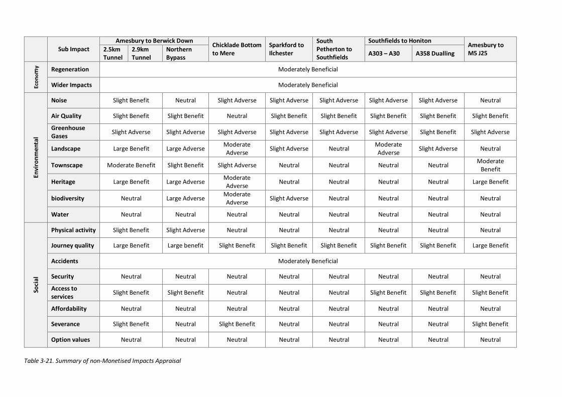
Sub Impact Amesbury to Berwick Down
Chicklade Bottom to Mere
Sparkford to Ilchester
South Petherton to Southfields
Southfields to Honiton Amesbury to M5 J25 2.5km
Tunnel 2.9km Tunnel
Northern Bypass A303 – A30 A358 Dualling
Econ
omy Regeneration Moderately Beneficial
Wider Impacts Moderately Beneficial
Envi
ronm
enta
l
Noise Slight Benefit Neutral Slight Adverse Slight Adverse Slight Adverse Slight Adverse Slight Adverse Neutral
Air Quality Slight Benefit Slight Benefit Neutral Slight Benefit Slight Benefit Slight Benefit Slight Benefit Slight Benefit
Greenhouse Gases Slight Adverse Slight Adverse Slight Adverse Slight Adverse Slight Adverse Slight Adverse Slight Benefit Slight Adverse
Landscape Large Benefit Large Adverse Moderate Adverse Slight Adverse Neutral Moderate
Adverse Slight Adverse Neutral
Townscape Moderate Benefit Slight Benefit Slight Adverse Neutral Neutral Neutral Neutral Moderate Benefit
Heritage Large Benefit Large Adverse Moderate Adverse Neutral Neutral Neutral Neutral Large Benefit
biodiversity Neutral Large Adverse Moderate Adverse Slight Adverse Neutral Neutral Neutral Neutral
Water Neutral Neutral Neutral Neutral Neutral Neutral Neutral Neutral
Soci
al
Physical activity Slight Benefit Slight Adverse Neutral Neutral Neutral Neutral Neutral Neutral
Journey quality Large Benefit Large benefit Slight Benefit Slight Benefit Slight Benefit Slight Benefit Slight Benefit Large Benefit
Accidents Moderately Beneficial
Security Neutral Neutral Neutral Neutral Neutral Neutral Neutral Neutral
Access to services Slight Benefit Slight Benefit Neutral Neutral Neutral Slight Benefit Slight Benefit Slight Benefit
Affordability Neutral Neutral Neutral Neutral Neutral Neutral Neutral Neutral
Severance Slight Benefit Neutral Slight Benefit Neutral Neutral Neutral Neutral Slight Benefit
Option values Neutral Neutral Neutral Neutral Neutral Neutral Neutral Neutral
Table 3-21. Summary of non-Monetised Impacts Appraisal
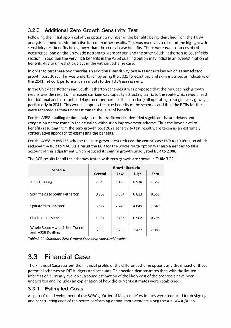
3.2.3 Additional Zero Growth Sensitivity Test Following the initial appraisal of the options a number of the benefits being identified from the TUBA analysis seemed counter intuitive based on other results. This was mainly as a result of the high growth sensitivity test benefits being lower than the central case benefits. There were two instances of this occurrence, one on the Chicklade Bottom to Mere section and the other South Petherton to Southfields section. In addition the very high benefits in the A358 dualling option may indicate an overestimation of benefits due to unrealistic delays in the without scheme case.
In order to test these two theories an additional sensitivity test was undertaken which assumed zero growth post 2021. This was undertaken by using the 2021 forecast trip and skim matrices as indicative of the 2041 network performance as inputs to the TUBA assessment.
In the Chicklade Bottom and South Petherton schemes it was proposed that the reduced high growth results was the result of increased carriageway capacity attracting traffic to the route which would lead to additional and substantial delays on other parts of the corridor (still operating as single carriageways) particularly in 2041. This would suppress the true benefits of the schemes and thus the BCRs for these were accepted as they underestimated the level of benefits.
For the A358 dualling option analysis of the traffic model identified significant future delays and congestion on the route in the situation without an improvement scheme. Thus the lower level of benefits resulting from the zero growth post 2021 sensitivity test result were taken as an extremely conservative approach to estimating the benefits.
For the A358 to M5 J25 scheme the zero growth test reduced the central case PVB to £916milion which reduced the BCR to 4.66. As a result the BCR for the whole route option was also amended to take account of this adjustment which reduced its central growth unadjusted BCR to 2.086.
The BCR results for all the schemes tested with zero growth are shown in Table 3.22.
Scheme Growth Scenario
Central Low High Zero
A358 Dualling 7.645 6.198 8.938 4.659
Southfields to South Petherton 0.969 0.534 0.813 0.555
Sparkford to Ilchester 3.627 2.449 4.649 1.649
Chicklade to Mere 1.097 0.725 0.902 0.795
Whole Route – with 2.9km Tunnel and A358 Dualling 2.38 1.769 3.477 2.086
Table 3-22. Summary Zero Growth Economic Appraisal Results
3.3 Financial Case The Financial Case sets out the financial profile of the different scheme options and the impact of those potential schemes on DfT budgets and accounts. This section demonstrates that, with the limited information currently available, a sound estimation of the likely cost of the proposals have been undertaken and includes an explanation of how the current estimates were established.
3.3.1 Estimated Costs As part of the development of the SOBCs, ‘Order of Magnitude’ estimates were produced for designing and constructing each of the better performing option improvements along the A303/A30/A358
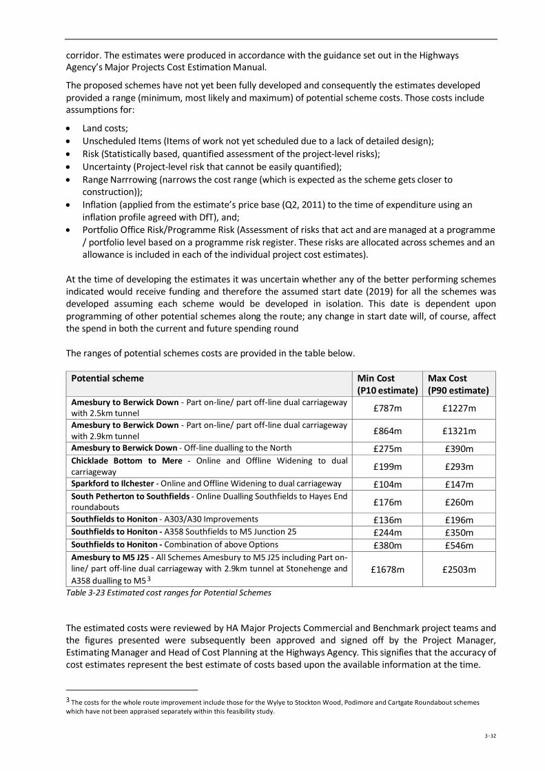
corridor. The estimates were produced in accordance with the guidance set out in the Highways Agency’s Major Projects Cost Estimation Manual.
The proposed schemes have not yet been fully developed and consequently the estimates developed provided a range (minimum, most likely and maximum) of potential scheme costs. Those costs include assumptions for:
• Land costs; • Unscheduled Items (Items of work not yet scheduled due to a lack of detailed design); • Risk (Statistically based, quantified assessment of the project-level risks); • Uncertainty (Project-level risk that cannot be easily quantified); • Range Narrrowing (narrows the cost range (which is expected as the scheme gets closer to
construction)); • Inflation (applied from the estimate’s price base (Q2, 2011) to the time of expenditure using an
inflation profile agreed with DfT), and; • Portfolio Office Risk/Programme Risk (Assessment of risks that act and are managed at a programme
/ portfolio level based on a programme risk register. These risks are allocated across schemes and an allowance is included in each of the individual project cost estimates).
At the time of developing the estimates it was uncertain whether any of the better performing schemes indicated would receive funding and therefore the assumed start date (2019) for all the schemes was developed assuming each scheme would be developed in isolation. This date is dependent upon programming of other potential schemes along the route; any change in start date will, of course, affect the spend in both the current and future spending round The ranges of potential schemes costs are provided in the table below.
Potential scheme Min Cost (P10 estimate)
Max Cost (P90 estimate)
Amesbury to Berwick Down - Part on-line/ part off-line dual carriageway with 2.5km tunnel £787m £1227m
Amesbury to Berwick Down - Part on-line/ part off-line dual carriageway with 2.9km tunnel £864m £1321m
Amesbury to Berwick Down - Off-line dualling to the North £275m £390m Chicklade Bottom to Mere - Online and Offline Widening to dual carriageway £199m £293m
Sparkford to Ilchester - Online and Offline Widening to dual carriageway £104m £147m South Petherton to Southfields - Online Dualling Southfields to Hayes End roundabouts £176m £260m
Southfields to Honiton - A303/A30 Improvements £136m £196m Southfields to Honiton - A358 Southfields to M5 Junction 25 £244m £350m Southfields to Honiton - Combination of above Options £380m £546m Amesbury to M5 J25 - All Schemes Amesbury to M5 J25 including Part on-line/ part off-line dual carriageway with 2.9km tunnel at Stonehenge and A358 dualling to M5 3
£1678m £2503m
Table 3-23 Estimated cost ranges for Potential Schemes
The estimated costs were reviewed by HA Major Projects Commercial and Benchmark project teams and the figures presented were subsequently been approved and signed off by the Project Manager, Estimating Manager and Head of Cost Planning at the Highways Agency. This signifies that the accuracy of cost estimates represent the best estimate of costs based upon the available information at the time.
3 The costs for the whole route improvement include those for the Wylye to Stockton Wood, Podimore and Cartgate Roundabout schemes which have not been appraised separately within this feasibility study.
3-32
3.4 Commercial Case This section sets out the commercial viability of the schemes together with details of the proposed procurement strategy.
3.4.1 Output Based Specification The Highways Agency will use very experienced consultants, who have been involved in other recent highways projects, to develop the specifications. Liaison with the supplier market has informed this process and has helped to identify the best format and content, which will facilitate the tendering process.
The commercial case is based on a number of strategic objectives and outcomes, against which alternative procurement options / scenarios are assessed:
• Achieve cost certainty, or certainty that the scheme can be delivered within the available funding constraints;
• Minimise further preparation costs with respect to scheme design;
• Obtain contractor experience and input to the design and construction programme to ensure the implementation programme is robust and achievable, and;
• Obtain contractor input to risk management and appraisals, including mitigation measures, to capitalise at an early stage on opportunities to reduce construction risk and improve out-turn certainty.
The objectives have been split into those where the procurement strategy must deliver (‘primary objectives’) and those that it would be beneficial for the chosen procurement strategy to deliver (‘secondary objectives’).
The primary objectives underpinning the Commercial Case and which the preferred procurement strategy must deliver are to:
• Deliver the scheme within the available funding;
• Ensure all scheme promoters commit to the project in full;
• Ensure Best Value is delivered;
• Ensure that appropriate quality is delivered;
• Offer an affordable whole life cost solution, and;
• Reduce risks to a level that is As Low as Reasonably Practicable (ALARP).
The secondary objectives underpinning The Commercial Case and which it would be beneficial for the preferred procurement strategy to deliver are to:
• Engage the contractor in early-stage planning and development of the scheme;
• Provide contractor input to the design, risk assessment and delivery programme;
• Engage the contractor in the planning public inquiry in respect of construction techniques, disruption and subsequent mitigation measures during the works, and;
• Provide the scheme promoter(s) with affordable opportunities for change throughout the project life-cycle.
3.4.2 Procurement Strategy The Highways Agency has recently awarded a new procurement framework for the delivery of major highway schemes known as the Collaborative Delivery Framework (CDF). The CDF will provide a procurement route for projects over £15m. The principles of the CDF are to achieve continuous improvement in health and safety, sustainability, quality, time and cost. Due to the size and nature of
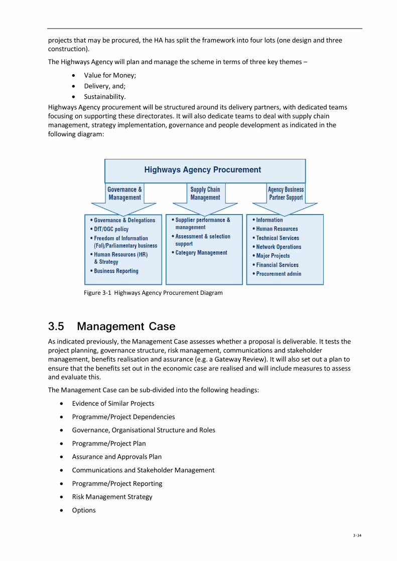
projects that may be procured, the HA has split the framework into four lots (one design and three construction).
The Highways Agency will plan and manage the scheme in terms of three key themes –
• Value for Money; • Delivery, and; • Sustainability.
Highways Agency procurement will be structured around its delivery partners, with dedicated teams focusing on supporting these directorates. It will also dedicate teams to deal with supply chain management, strategy implementation, governance and people development as indicated in the following diagram:
Figure 3-1 Highways Agency Procurement Diagram
3.5 Management Case As indicated previously, the Management Case assesses whether a proposal is deliverable. It tests the project planning, governance structure, risk management, communications and stakeholder management, benefits realisation and assurance (e.g. a Gateway Review). It will also set out a plan to ensure that the benefits set out in the economic case are realised and will include measures to assess and evaluate this.
The Management Case can be sub-divided into the following headings:
• Evidence of Similar Projects
• Programme/Project Dependencies
• Governance, Organisational Structure and Roles
• Programme/Project Plan
• Assurance and Approvals Plan
• Communications and Stakeholder Management
• Programme/Project Reporting
• Risk Management Strategy
• Options
3-34
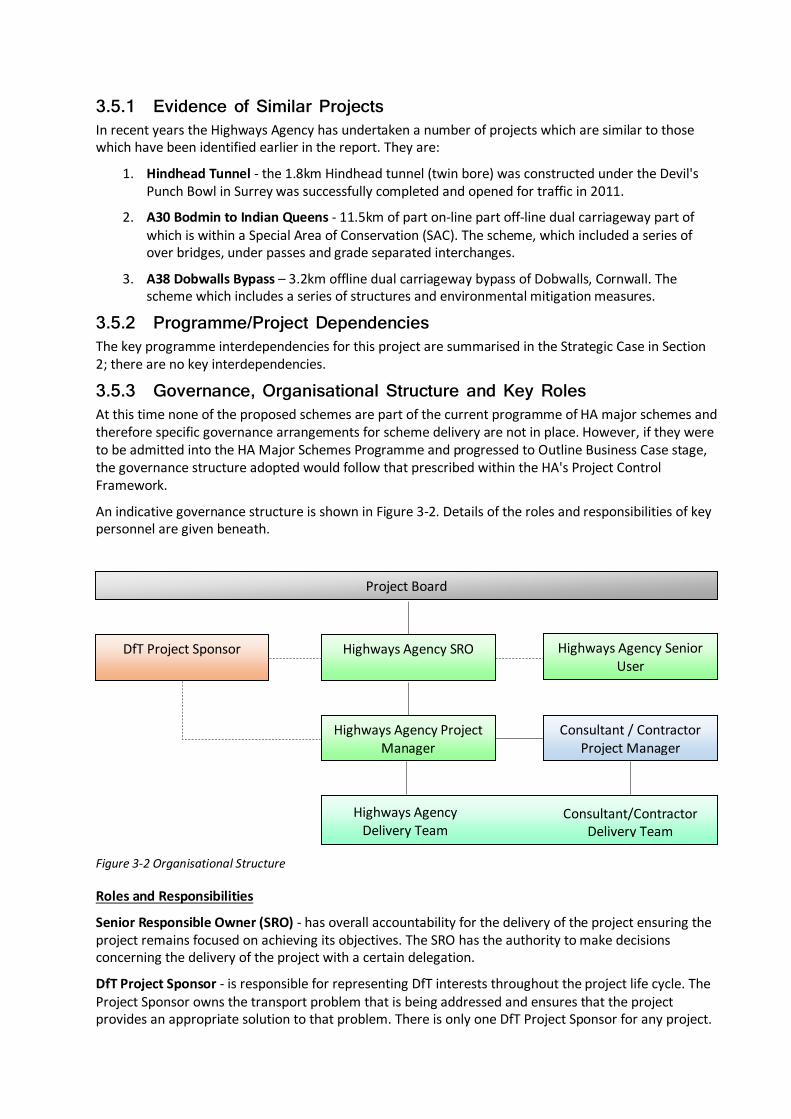
3.5.1 Evidence of Similar Projects In recent years the Highways Agency has undertaken a number of projects which are similar to those which have been identified earlier in the report. They are:
1. Hindhead Tunnel - the 1.8km Hindhead tunnel (twin bore) was constructed under the Devil's Punch Bowl in Surrey was successfully completed and opened for traffic in 2011.
2. A30 Bodmin to Indian Queens - 11.5km of part on-line part off-line dual carriageway part of which is within a Special Area of Conservation (SAC). The scheme, which included a series of over bridges, under passes and grade separated interchanges.
3. A38 Dobwalls Bypass – 3.2km offline dual carriageway bypass of Dobwalls, Cornwall. The scheme which includes a series of structures and environmental mitigation measures.
3.5.2 Programme/Project Dependencies The key programme interdependencies for this project are summarised in the Strategic Case in Section 2; there are no key interdependencies.
3.5.3 Governance, Organisational Structure and Key Roles At this time none of the proposed schemes are part of the current programme of HA major schemes and therefore specific governance arrangements for scheme delivery are not in place. However, if they were to be admitted into the HA Major Schemes Programme and progressed to Outline Business Case stage, the governance structure adopted would follow that prescribed within the HA's Project Control Framework.
An indicative governance structure is shown in Figure 3-2. Details of the roles and responsibilities of key personnel are given beneath.
Figure 3-2 Organisational Structure
Roles and Responsibilities
Senior Responsible Owner (SRO) - has overall accountability for the delivery of the project ensuring the project remains focused on achieving its objectives. The SRO has the authority to make decisions concerning the delivery of the project with a certain delegation.
DfT Project Sponsor - is responsible for representing DfT interests throughout the project life cycle. The Project Sponsor owns the transport problem that is being addressed and ensures that the project provides an appropriate solution to that problem. There is only one DfT Project Sponsor for any project.
Highways Agency SRO Highways Agency Senior User
DfT Project Sponsor
Project Board
Highways Agency Project Manager
Consultant / Contractor Project Manager
Consultant/Contractor Delivery Team
Highways Agency Delivery Team
Project Manager - is responsible for managing the development and the delivery of a project on behalf of the Highways Agency, under remit from the DfT Project Sponsor and on behalf of the SRO. The Project Manager leads and manages the project team with the authority and responsibility to run the project on a day-to-day basis.
Senior User - role is undertaken by the Network Delivery and Development Directorate (NDD) Regional Divisional Director (or their delegated representative), representing the interests of NDD and the Traffic Management Directorate (TMD). The primary purpose of the role is to act as the client for major project schemes under development and delivery in their region.
Project Board - SRO and takes an overview of the project. The Project Board’s role is very much management by exception. The composition of the Project Board and the timing of meetings is determined by the SRO.
3.5.4 Programme / Project Plan An indicative programme for the construction of the improvement options is shown in Table 3-17.
Scheme SGAR1 SGAR2 SGAR3 SGAR4 SGAR5 SGAR6 Open to Traffic
On-line/Off-line Widening Oct ‘15 Oct’16 Apr’18 Oct’18 Oct’19 Oct’21 Oct’21
Table 3-24 Indicative Project Programme
The potential project programme indicated above is indicative and is that which has been used in the preparation of the Order of Magnitude scheme estimates. At the time of developing the programmes it was uncertain whether any of the better performing schemes indicated would receive funding and therefore the dates indicated assume that each scheme would be promoted in isolation. However, should a decision be made to promote more than one scheme, or all potential schemes, along the route corridor then it will be imperative to carefully plan the construction phases for each of the individual schemes to ensure the minimum of disruption to road users along this already problematic route. Consequently, there is a potential the dates indicated in the above table to change.
3.5.5 Assurance and Approvals Plan Given that the scheme would be a publically funded major project it would be subject to the OCG Gateway Review process. It would also follow the HA's own assurance framework utilising Stage Gate Assessment Reviews (SGAR). OGC Gateway Reviews are 'peer reviews' in which independent project managers from outside the project use their experience and expertise to examine the progress and likelihood / confidence of its successful delivery.
A Gateway Review provides assurance and support to the SRO that:
• Suitable skills and experience are deployed on the project;
• All stakeholders understand the project status and issues;
• There is assurance that the project can progress to the next phase;
• Time and cost targets have a realistic basis;
• Lessons are learned, and;
• The project team are gaining input from appropriate stakeholders.
The HA's SGAR process will be followed to ensure quality assurance and provide basic assurance that:
• The stage is complete and is within tolerance;
• The Collaborative Delivery Framework (or PCF) has been followed, and;
• The project is ready to proceed to the next stage, subject to investment authorisation.
3-36
3.5.6 Communications and Stakeholder Management A detailed communications and stakeholder management strategy has not been developed at this stage as the scheme is not currently within the HA's Major Scheme Programme. Should the scheme be admitted into the HA Major Scheme Programme a detailed communications and stakeholder management strategy will be developed.
3.5.7 Programme / Project Reporting The progress of the project will be reported in line with the Highways Agency’s Major Projects reporting protocols.
3.5.8 Risk Management Strategy The HA's Project Manager would be primarily responsible for risk management and the dissemination of information at regular intervals to the SRO and Project Board.
Risk management will be treated as a live task throughout scheme development and delivery. It will begin with the development of a comprehensive risk register at project inception. This will be informed by group discussions with discipline leads and key personnel involved in the delivery of major highway schemes. In line with best practice, a systematic approach to risk management will be adopted.
The basic methodology is illustrated below:
Risk Identification
Risk identification can be split into a simple six step process:
1. Identify key delivery risk items
2. Identify key cost risk items
3. Agree severity and likelihood/probability
4. Determine risk
5. Discuss/agree potential mitigation
6. Determine post mitigation risk (probability, severity and risk).
This six step process will form the basis of a simple table which will remain a live document.
3.5.9 Options Successful project management will be achieved through the key roles as identified in Figure 3-2. Section 3.5.3 sets out the processes and procedures that shall be followed in order to govern and control the scheme.
3.5.10 A358 Dualling The creation of a dual carriageway along the A358 between Southfields and M5J25 is considered within the preferred options and scores highly in terms of the benefits it will bring. However, the A358 currently forms part of the local road network which is managed and maintained by Somerset County Council.
Full consideration should be given to determine whether, upon completion of the construction works, the A358 remains part of the local road network or whether it would be more appropriate to create a new section of trunk road with the responsibility for its management and maintenance passing to the Highways Agency instead of Somerset County Council.
Conclusions and Next Steps
4.1 Conclusions The overall conclusions that are drawn from the feasibility study are that the route currently experiences issues of congestion and journey time reliability, the majority of which is caused by the reduction in the number of carriageway lanes between 2 lane dual carriageway and single two way carriageway. Moreover, the safety record on the single carriageway sections is shown to be poor and despite those sections of the corridor comprising only 37% of the route length they contribute to nearly 48% of all injury accidents and more significantly nearly 56% of fatal accidents. When incidents, such as severe weather or road traffic accident occur on these sections, the problems of congestion and journey time reliability are exacerbated.
The proposals to address the problems on each of the section of the corridor are to introduce a number of new dual carriageways. These roads may be totally off-line, a combination of off-line and on-line works or simply a widening of the existing road to create 2 running lanes in each direction; part of the Amesbury to Berwick Down section may even be in tunnel (better performing option determined by the study). The A358 between Southfields and M5 J25 forms part of the local road network and as such consideration should be given to determine whether it remains part of the local road network or whether it becomes part of the trunk road network; this will affect the responsibility for its future maintenance and management.
A series of monetised and non-monetised appraisals were undertaken across the range of schemes presented using an updated highway traffic model, economic appraisal tools and guidance available from WebTag. Additional work and appraisal was undertaken by the National Trust and English Heritage into the impact of proposals for Stonehenge, its World Heritage Site status and Outstanding Universal Value.
The outcome of the appraisals has been to identify three key schemes to be taken forwards for further development and appraisal. These are:
• Amesbury to Berwick Down, • Sparkford to Ilchester ; and, • A358 Southfields to M5 J25
Results within section 3 indicate that whilst the Amesbury to Berwick Down section has a low BCR value (primarily due to the high investment cost of constructing a tunnel) the overarching large beneficial impact from the non-monetised elements of landscape and heritage together with its contribution to achieving the wider vision for the Stonehenge WHS and in maintaining its Outstanding Universal Value make this a worthwhile option for further development.
The economic results for the Sparkford to Ilchester and Southfields to M5 J25 sections showed high BCR values. These two schemes provide considerable value for money in alleviating congestion and reducing delay at key points along the corridor. The A358 duelling option provided considerable benefits in alleviating congestion even with a zero growth sensitivity test for the post 2021 situation indicating that a proposed new junction with the M5 will alleviate considerable congestion at J25 and provide conditions suitable for economic growth in the area.
The other schemes appraised (Chicklade Bottom to Mere and South Petherton to Southfields) did not produce as good benefit cost ratios but would still contribute to reducing journey times and accidents on the corridor whilst improving reliability and resilience overall. They will also contribute to improving air quality for those living near the currently congested road and reduce severance where the A303 passes through existing settlements.
The combined effect of all schemes together (which includes some which were not appraised) can be gauged by the overall benefit provided by improving the whole corridor to dual carriageway standard. Despite the significant investment costs and lower benefits accruing to some individual sections the
4-38
overall BCR for the route is high. This indicates improving the route provides additional benefits over and above a purely additive approach. The combined reduction in journey times and accidents together with improved resilience could provide the catalyst for renewed economic growth into and from the region.
A major objective of improving the corridor is to increase highway capacity and associated journey time reliability to the South West. These benefits will support the economic prosperity of the south west region by increasing the accessibility to the region through minimising traffic delays and disruption and improving safety. In turn this will lead to the efficient distribution of freight in the region and lead to improved confidence of businesses. With this increase in business will come the growth in the housing to support new jobs along with the work generated in the construction industry.
This is likely to have a substantial positive impact on regeneration and wider economic impacts. Improving to dual carriageway standard would remove the barrier to growth and mean the A303/A30/A358 corridor is no longer a long standing congestion hotspot in the country.
The challenge for design teams going forwards will be to ensure, so far as reasonably possible, that there are no adverse effects for residents and travellers and also for the natural and built environment. The Stonehenge World Heritage Site, AONBs, SSSIs and SACs are all located along the corridor and the effects on wildlife habitats, flora and fauna as well as listed buildings and heritage all need to be mitigated against.
4.2 Next Steps The next steps in the development of any of the schemes which are promoted is to further examine the options identified in this report and to take the solution through detailed design and construction, eventually opening for traffic.
In developing a scheme the Highways Agency will closely follow its well established governance framework for evaluating improvement schemes. The Project Control Framework (PCF) sets out how major improvement projects (>£10m) are managed and delivered. The roles and responsibilities within the PCF are identified within Section 3.5.3.
It is designed to ensure the delivery of projects is cost effective, delivered in a timely manner and which meet customer aspirations.
The PCF contains 3 phases:
• Options phase (identifies the preferred solution and includes extensive public consultation) o Stage 1 – Options identification (this will examine all potential solutions to resolve the problems experienced (not just the better performing option from the Feasibility Study) which is required to satisfy the Development Consent Order Process – see Development Stage. o Stage 2 – Option selection
• Development Phase (focussing upon design and statutory procedures including the Development Consent Order process) o Stage 3 – Preliminary design o Stage 4 – Statutory procedures and powers o Stage 5 – Construction preparation
• Construction phase (building and hand over of the completed solution) o Stage 6 – Construction, commissioning and handover o Stage 7 – Closeout
In order to meet the requirements above and timescale for delivery it is usual for the Highways Agency to acquire consultancy support and, later in the process, contractor input to construct the scheme.
As indicated within this report Phase One of the transport business case established the strategic case and performance of the schemes appraised in order to secures initial approval to proceed to the next phase. Having concluded on three main schemes as the outcome of this study these now pass into Phase 2 of the process. In Phase Two an Outline Business Case will be developed which aims to reconfirm these

conclusions but also concentrates on detailed economic and financial appraisals to select preferred options and, where relevant, preparations made for the potential contract through the development of the commercial case. The arrangements required to ensure successful delivery will be set out in the management case.
4-40