a47-a11 thickthorn - highways englandassets.highways.gov.uk/roads/road-projects/a47+corridor... ·...
TRANSCRIPT
Date: 15 March 2017 Version: 2.0
Road Investment Strategy East Area 6 A47/A11 Thickthorn Junction Improvement Non-Technical Summary Report
A47/A11 Thickthorn Junction Improvement Non-Technical Summary Report
1
Revision History
Version Date Description Author
1.0 08 March 2017 Draft Template Kurtis Napp
1.1 08 March 2017 Final Template Tony Wallis
1.2 09 March 2017 Paul Carey Review Paul Carey
1.3 13 March 2017 Richard Quantick Update Richard Quantick
2.0 14 March 2017 Final Aaron Douglas
Reviewer List
Name Role
Tony Davis Senior Responsible Owner
Dave Masters Senior Project Manager
Aaron Douglas Highways England Project Manager
Romeu Rosa Highways England Project Manager
Paul Carey Amey Programme Manager
Nicholas Coombes Highways England DCO Manager
Approvals
Name Signature Title Date of Issue
Version
Tony Davis
Senior Responsible Owner 15/03/17 2.0
Document Control
Document Title A47/A11 Thickthorn Junction – Non-Technical Summary Report
Author Aaron Douglas
Owner Tony Davis
Distribution Non-statutory consultation website / SHARE
Document Status Final
A47/A11 Thickthorn Junction Improvement Non-Technical Summary Report
2
Contents
Contents 2
Introduction 3
Liaising with Local Authorities 4 Project Control Framework 5 Timeline to date 6
Traffic and Safety Problem 7 Traffic and Safety Solution 7
Existing Layout 8 Existing Conditions and Constraints 9 Potential Route Options 11
Qualitative Assessment of Potential Junction Options and Sifting 15
Options progressed to PCF Stage 2 19 Early PCF Stage 2 Affordability and Value Management Sifting 20 Non Statutory Consultation 21 Further and Ongoing Assessment 22
Preferred Route Announcement 22

A47/A11 Thickthorn Junction Improvement Non-Technical Summary Report
3
Introduction During 2014 a feasibility study was undertaken to look at the A47 corridor. The study identified where further work was required and this informed the Government’s Road Investment Strategy (RIS) which was issued in December 2014. A total of twenty-two locations were shown to demonstrate traffic and safety problems either now or in the immediate future. Sifting of these options was completed, and six specific locations were to become the main focus along the A47. The six improvement schemes were identified as:
A47 Wansford to Sutton Dualling
A47 Guyhirn Junction Improvement
A47 North Tuddenham to Easton Dualling
A47/A11 Thickthorn junction improvement
A47 Blofield to North Burlingham Dualling
A12 Junction Improvements (now called Great Yarmouth Junctions)
The DfT’s A47 and A12 corridor feasibility study (published in February 2015) can be located at: https://www.gov.uk/government/publications/a47-and-a12-corridor-feasibility-study-technical-report The DfT’s Roads Investment Strategy (2015-2020) can be located at: https://www.gov.uk/government/collections/road-investment-strategy-post-2020
A47/A11 Thickthorn Junction Improvement Non-Technical Summary Report
4
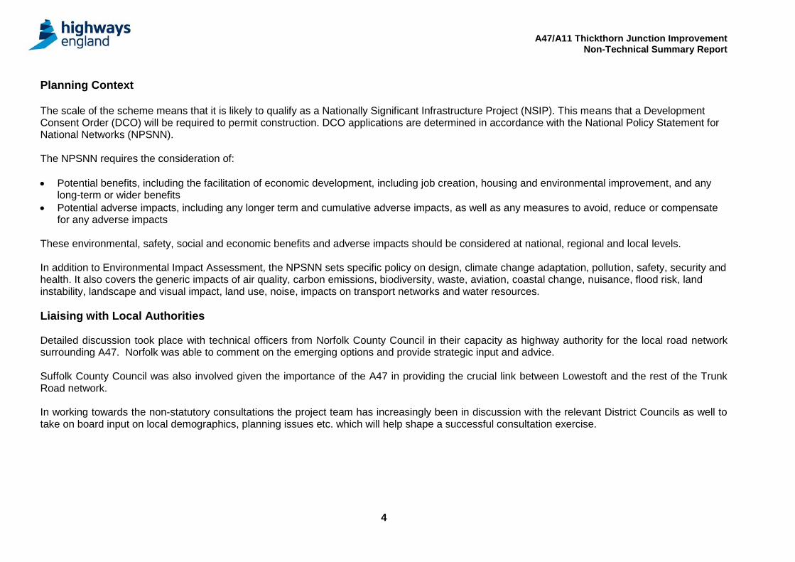
Planning Context The scale of the scheme means that it is likely to qualify as a Nationally Significant Infrastructure Project (NSIP). This means that a Development Consent Order (DCO) will be required to permit construction. DCO applications are determined in accordance with the National Policy Statement for National Networks (NPSNN). The NPSNN requires the consideration of:
Potential benefits, including the facilitation of economic development, including job creation, housing and environmental improvement, and any long-term or wider benefits
Potential adverse impacts, including any longer term and cumulative adverse impacts, as well as any measures to avoid, reduce or compensate for any adverse impacts
These environmental, safety, social and economic benefits and adverse impacts should be considered at national, regional and local levels. In addition to Environmental Impact Assessment, the NPSNN sets specific policy on design, climate change adaptation, pollution, safety, security and health. It also covers the generic impacts of air quality, carbon emissions, biodiversity, waste, aviation, coastal change, nuisance, flood risk, land instability, landscape and visual impact, land use, noise, impacts on transport networks and water resources.
Liaising with Local Authorities Detailed discussion took place with technical officers from Norfolk County Council in their capacity as highway authority for the local road network surrounding A47. Norfolk was able to comment on the emerging options and provide strategic input and advice. Suffolk County Council was also involved given the importance of the A47 in providing the crucial link between Lowestoft and the rest of the Trunk Road network. In working towards the non-statutory consultations the project team has increasingly been in discussion with the relevant District Councils as well to take on board input on local demographics, planning issues etc. which will help shape a successful consultation exercise.
A47/A11 Thickthorn Junction Improvement Non-Technical Summary Report
5
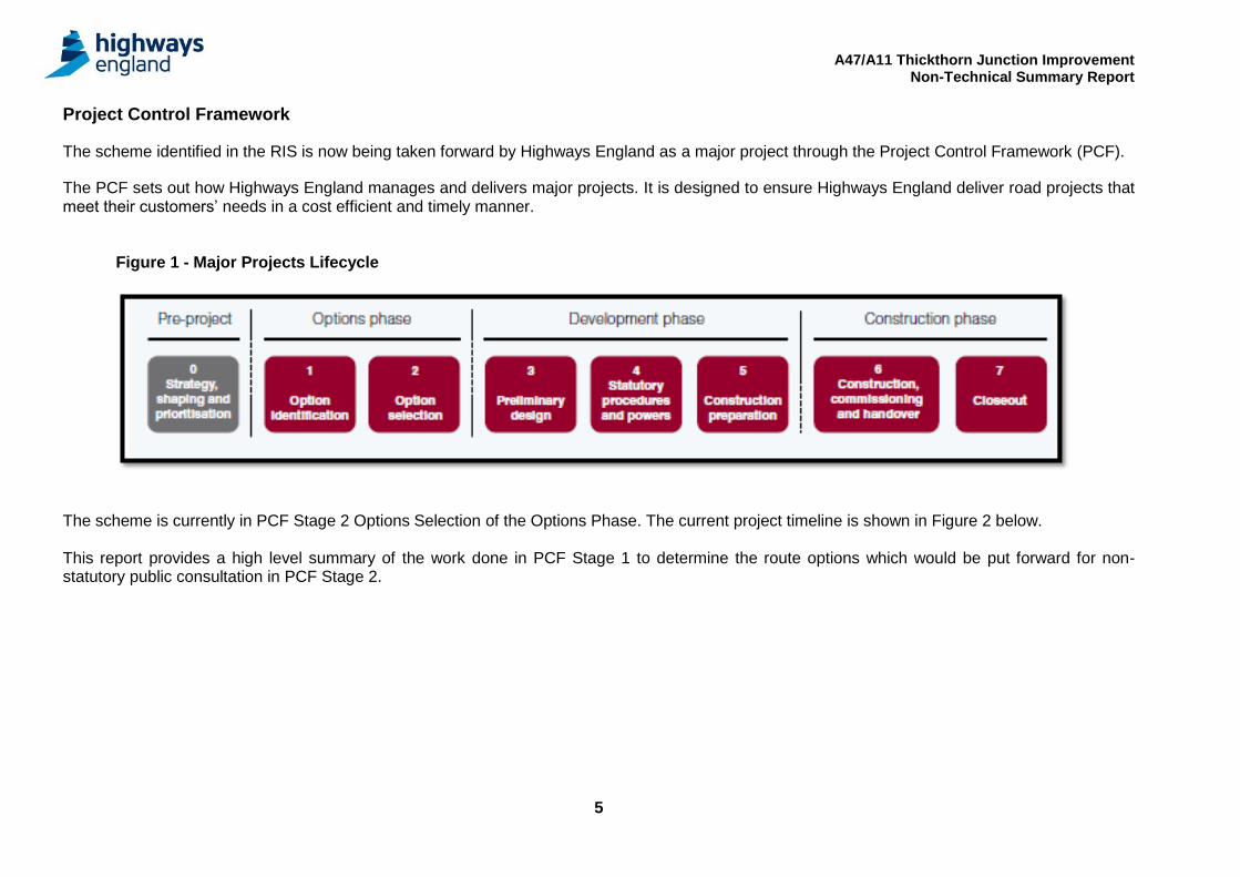
Project Control Framework
The scheme identified in the RIS is now being taken forward by Highways England as a major project through the Project Control Framework (PCF).
The PCF sets out how Highways England manages and delivers major projects. It is designed to ensure Highways England deliver road projects that meet their customers’ needs in a cost efficient and timely manner.
Figure 1 - Major Projects Lifecycle
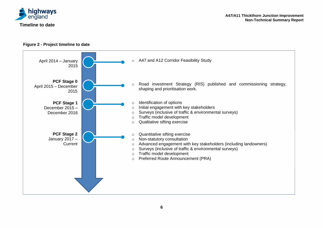
The scheme is currently in PCF Stage 2 Options Selection of the Options Phase. The current project timeline is shown in Figure 2 below. This report provides a high level summary of the work done in PCF Stage 1 to determine the route options which would be put forward for non-statutory public consultation in PCF Stage 2.
A47/A11 Thickthorn Junction Improvement Non-Technical Summary Report
6
Timeline to date Figure 2 - Project timeline to date
o A47 and A12 Corridor Feasibility Study
o Road investment Strategy (RIS) published and commissioning strategy, shaping and prioritisation work.
o Identification of options o Initial engagement with key stakeholders o Surveys (inclusive of traffic & environmental surveys) o Traffic model development o Qualitative sifting exercise
o Quantitative sifting exercise o Non-statutory consultation o Advanced engagement with key stakeholders (including landowners) o Surveys (inclusive of traffic & environmental surveys) o Traffic model development o Preferred Route Announcement (PRA)
April 2014 – January 2015
PCF Stage 0 April 2015 – December
2015
PCF Stage 1 December 2015 –
December 2016
PCF Stage 2 January 2017 –
Current
A47/A11 Thickthorn Junction Improvement Non-Technical Summary Report
7
Traffic and Safety Problem A47 Corridor The A47 is ranked 2nd nationally for fatalities on A roads and the accident severity ratio is above average. The A47 is a mix of dual carriageway (47%) and single carriageway (53%) and the current traffic flows generally exceed capacity. Rapid growth is planned in the area. Norwich, Cambridge and Peterborough are amongst the fastest growing cities in the country. A47/A11 Thickthorn Junction Improvement The transport problem identified in the PCF Stage 0 Solutions Assessment Report was ‘the unsuitability of the current junction layout to accommodate both a strong tidal movement straight ahead on the A11, and a strong movement between the A11 South and A47 East in both directions during both peak hours’. Current flows approaching the junction from the A47 Westbound and A11 Northbound in the AM peak hour are already exceeding the capacity at which
the junction can operate without congestion, resulting in extensive queuing. This queuing will continue to be exacerbated up to the 2036 design year
and beyond without direct intervention.
Traffic and Safety Solution The objective of the scheme identified within the RIS is the;
‘improvement of the interchange between the A47 and A11, improving access into Norwich’
The provision of free flowing links between the A11 and A47 in both directions will remove large numbers of conflicting traffic movements from the junction increasing capacity for all other movements. This will improve journey times and will allow economic growth in the area.
A47/A11 Thickthorn Junction Improvement Non-Technical Summary Report
8
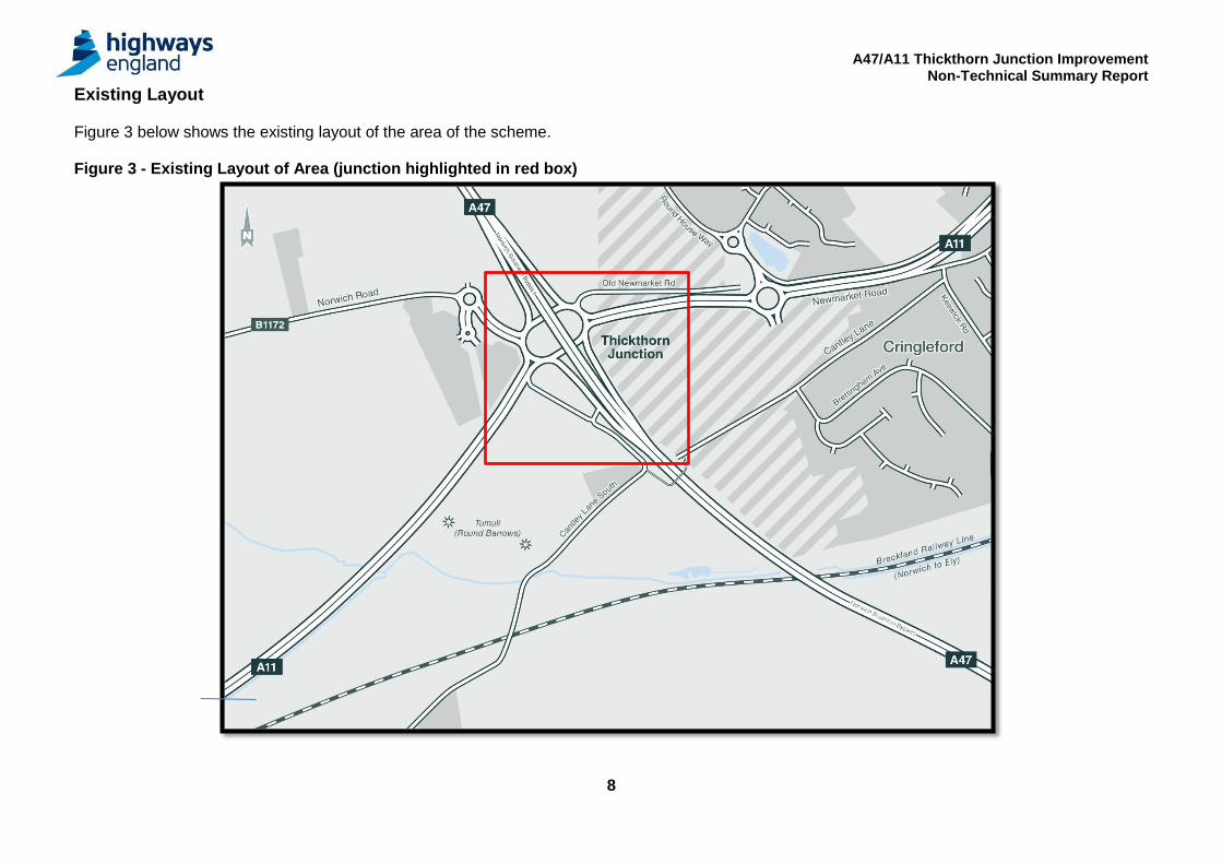
Existing Layout Figure 3 below shows the existing layout of the area of the scheme. Figure 3 - Existing Layout of Area (junction highlighted in red box)
A47/A11 Thickthorn Junction Improvement Non-Technical Summary Report
9
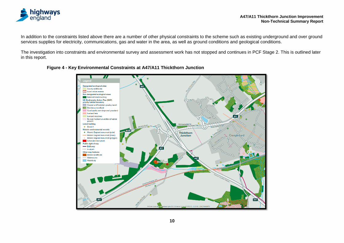
Existing Conditions and Constraints There are a number of constraints which were identified in PCF Stage 0 within the corridor. The key environmental constraints close to the existing A47 are shown on Figure 4 below:
Existing properties and buildings: There are a number of residential properties south of the existing junction on Cantley Lane South. There is further committed development between the existing junction and Cringleford. A Park and Ride and highway services is located to the west of the existing junction. The city of Norwich is located to the North East of the existing junction.
Existing local access roads and property access: Cantley Lane South currently accesses directly onto the A47 north-bound off slip. This access is sub-standard. The Park and Ride and highway services currently access the junction via the B1172.
Historic and listed buildings: There are 16 listed buildings within the study area, all but one of which are Grade II listed and date to the post-medieval period. There is one Grade II* listed building within the study area. This is the Church of All Saints, a parish church with medieval origins, restored in 1852-3. The Cambridge Historic Environment Record (CHER) includes a railway viaduct and five structures dating to the Second World War within the study area.
Historic Landscapes: There is one entry on the Register of Historic Parks and Gardens within the study area, Intwood Hall. It is designated as a Grade II* landscape. The manor house was originally built on this site in the medieval period and there have been subsequent phases of rebuilding and development through to the 20th century. The grounds of Intwood Hall comprise walled gardens, a terrace walk, an orangery and parkland. The Norfolk Historic Environment Records (HER) Character Area Analysis has identified five land use types within the study area.
18th to 19th century enclosure; 20th century agriculture; Inland – managed wetland; Parks, gardens and recreation; Woodland.
Areas of nature conservation: Cringleford Conservation Area (c. 800m east of Thickthorn Roundabout Junction, adjoining Newmarket Road) and Eaton Conservation Area (c. 1km east of Round House Roundabout) are located within the study area.
River and water bodies: The existing Thickthorn Junction is situated within a complex surface water regime. The study area contains two catchment areas, the roundabout and southern study area drains to Intwood Stream (a tributary of the River Yare) and the northern study area drains to the River Yare (Tiffy to Wensum reach). The whole of the study area is underlain by a principal aquifer overlain with soils of intermediate leaching potential. There are no groundwater abstractions within the study area. The area of the current Thickthorn Junction is classified as Flood Zone 1, with a low risk of flooding.
A47/A11 Thickthorn Junction Improvement Non-Technical Summary Report
10
In addition to the constraints listed above there are a number of other physical constraints to the scheme such as existing underground and over ground services supplies for electricity, communications, gas and water in the area, as well as ground conditions and geological conditions. The investigation into constraints and environmental survey and assessment work has not stopped and continues in PCF Stage 2. This is outlined later in this report.
Figure 4 - Key Environmental Constraints at A47/A11 Thickthorn Junction
A47/A11 Thickthorn Junction Improvement Non-Technical Summary Report
11
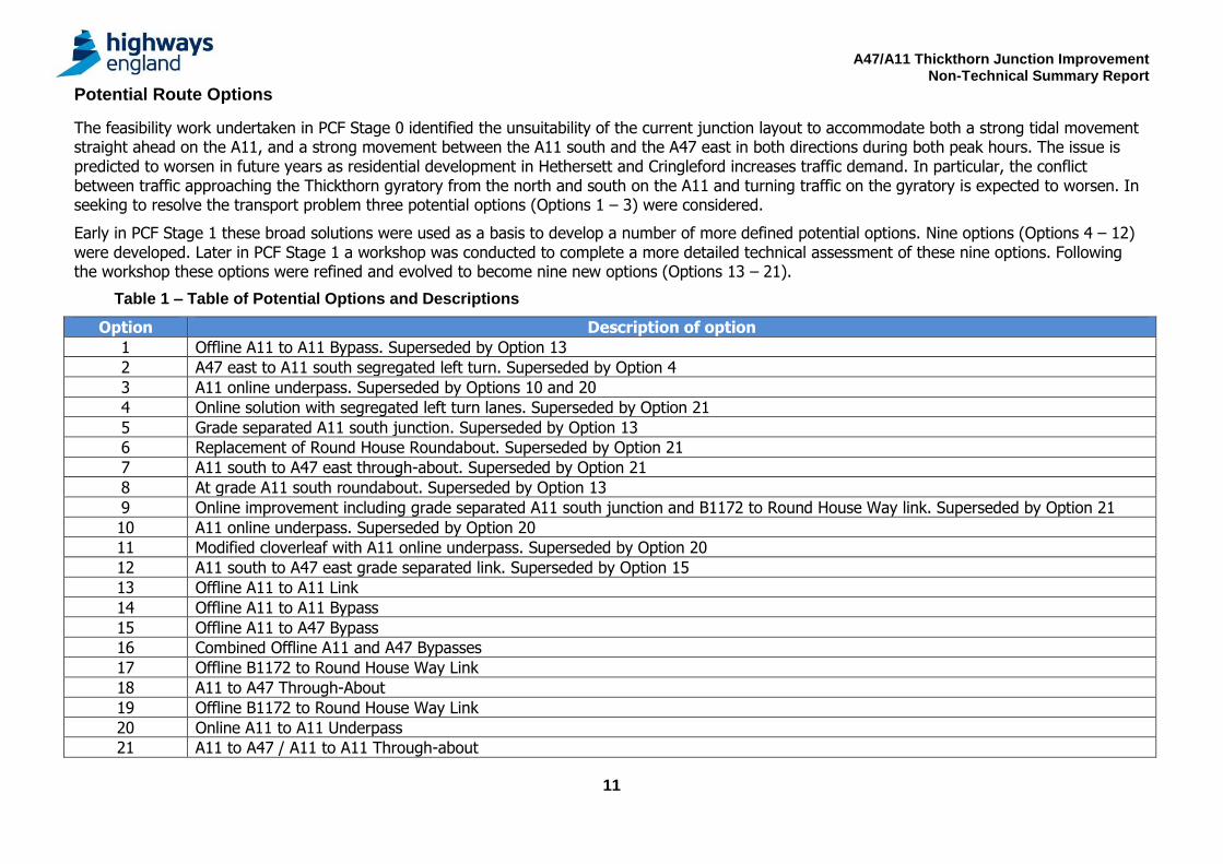
Potential Route Options
The feasibility work undertaken in PCF Stage 0 identified the unsuitability of the current junction layout to accommodate both a strong tidal movement straight ahead on the A11, and a strong movement between the A11 south and the A47 east in both directions during both peak hours. The issue is predicted to worsen in future years as residential development in Hethersett and Cringleford increases traffic demand. In particular, the conflict between traffic approaching the Thickthorn gyratory from the north and south on the A11 and turning traffic on the gyratory is expected to worsen. In seeking to resolve the transport problem three potential options (Options 1 – 3) were considered.
Early in PCF Stage 1 these broad solutions were used as a basis to develop a number of more defined potential options. Nine options (Options 4 – 12) were developed. Later in PCF Stage 1 a workshop was conducted to complete a more detailed technical assessment of these nine options. Following the workshop these options were refined and evolved to become nine new options (Options 13 – 21).
Table 1 – Table of Potential Options and Descriptions
Option Description of option
1 Offline A11 to A11 Bypass. Superseded by Option 13
2 A47 east to A11 south segregated left turn. Superseded by Option 4
3 A11 online underpass. Superseded by Options 10 and 20
4 Online solution with segregated left turn lanes. Superseded by Option 21
5 Grade separated A11 south junction. Superseded by Option 13
6 Replacement of Round House Roundabout. Superseded by Option 21
7 A11 south to A47 east through-about. Superseded by Option 21
8 At grade A11 south roundabout. Superseded by Option 13
9 Online improvement including grade separated A11 south junction and B1172 to Round House Way link. Superseded by Option 21
10 A11 online underpass. Superseded by Option 20
11 Modified cloverleaf with A11 online underpass. Superseded by Option 20
12 A11 south to A47 east grade separated link. Superseded by Option 15
13 Offline A11 to A11 Link
14 Offline A11 to A11 Bypass
15 Offline A11 to A47 Bypass
16 Combined Offline A11 and A47 Bypasses
17 Offline B1172 to Round House Way Link
18 A11 to A47 Through-About
19 Offline B1172 to Round House Way Link
20 Online A11 to A11 Underpass
21 A11 to A47 / A11 to A11 Through-about
A47/A11 Thickthorn Junction Improvement Non-Technical Summary Report
12
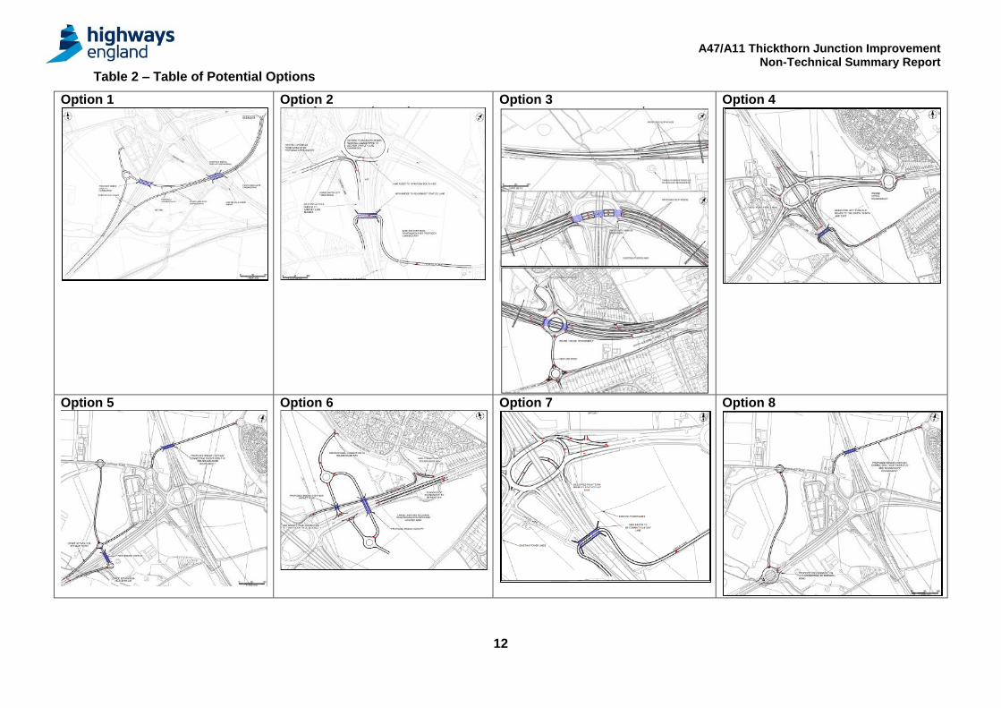
Table 2 – Table of Potential Options
Option 1
Option 2
Option 3
Option 4
Option 5
Option 6
Option 7
Option 8
A47/A11 Thickthorn Junction Improvement Non-Technical Summary Report
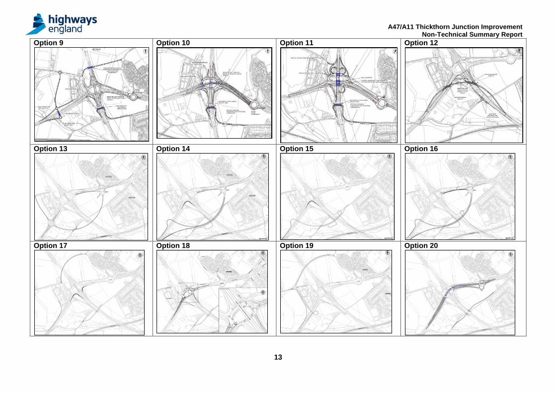
13
Option 9
Option 10
Option 11
Option 12
Option 13
Option 14
Option 15
Option 16
Option 17
Option 18
Option 19
Option 20
A47/A11 Thickthorn Junction Improvement Non-Technical Summary Report
14
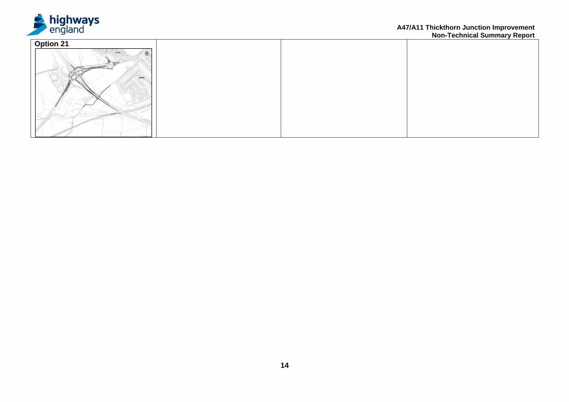
Option 21
A47/A11 Thickthorn Junction Improvement Non-Technical Summary Report
15
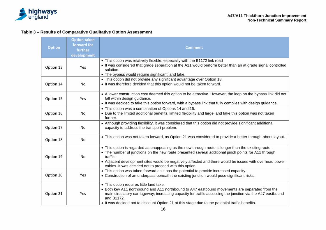
Qualitative Assessment of Potential Junction Options and Sifting
Each of the options shown in Table 2 were assessed using Highway England’s objectives and KPIs to ensure that they all represented solutions which would solve the identified transportation problem and meet the commitments of the RIS.
The options were initially assessed comparatively in terms of their engineering, environmental, transportation and economic suitability. These assessments were undertaken based on data gathered from desk based information supplemented by initial walk over environmental surveys undertaken in 2016.
Environmental Assessment: A qualitative environmental assessment, based on available environmental data, was undertaken to provide a comparative assessment. The following environmental topics were reviewed:
Noise Air Quality Greenhouse gases
Landscape Townscape Historic Environment
Biodiversity Water Environment
Transportation Assessment: Each of the options was assessed against the projected opening year (2021) and modelled design year (2036) taking into consideration local growth factors and future year traffic flows. Only some of the proposed options delivered improved traffic conditions in the modelled years which can be seen in the results in the table below. The best performing options showed journey time improvements, increased capacity and allowed for safer, swifter movement of traffic through the junction.
Engineering: A qualitative engineering assessment, based on the data available, was made taking the following engineering criteria into consideration;
Buildability Landtake required Design Standards
Drainage Geotechnical
Structures Impact on Statutory Undertakers
Economic Assessment: A comparative economic assessment of each option was made based on high level comparative estimates of scheme costs and potential benefits.
Assessment Results: The results from the above assessments are presented in Table 3. These results were reviewed and used to determine a reduced number of potential options to take forward for further assessment and analysis in PCF Stage 2.
A47/A11 Thickthorn Junction Improvement Non-Technical Summary Report
16
Table 3 – Results of Comparative Qualitative Option Assessment
Option
Option taken forward for
further development
Comment
Option 13 Yes
This option was relatively flexible, especially with the B1172 link road
It was considered that grade separation at the A11 would perform better than an at grade signal controlled solution.
The bypass would require significant land take.
Option 14 No This option did not provide any significant advantage over Option 13.
It was therefore decided that this option would not be taken forward.
Option 15 Yes A lower construction cost deemed this option to be attractive. However, the loop on the bypass link did not
fall within design guidance.
It was decided to take this option forward, with a bypass link that fully complies with design guidance.
Option 16 No This option was a combination of Options 14 and 15.
Due to the limited additional benefits, limited flexibility and large land take this option was not taken further.
Option 17 No Although providing flexibility, it was considered that this option did not provide significant additional
capacity to address the transport problem.
Option 18 No This option was not taken forward, as Option 21 was considered to provide a better through-about layout.
Option 19 No
This option is regarded as unappealing as the new through route is longer than the existing route.
The number of junctions on the new route presented several additional pinch points for A11 through traffic.
Adjacent development sites would be negatively affected and there would be issues with overhead power cables. It was decided not to proceed with this option
Option 20 Yes This option was taken forward as it has the potential to provide increased capacity.
Construction of an underpass beneath the existing junction would pose significant risks.
Option 21 Yes
This option requires little land take.
Both key A11 northbound and A11 northbound to A47 eastbound movements are separated from the main circulatory carriageway, increasing capacity for traffic accessing the junction via the A47 eastbound and B1172.
It was decided not to discount Option 21 at this stage due to the potential traffic benefits.
A47/A11 Thickthorn Junction Improvement Non-Technical Summary Report
17
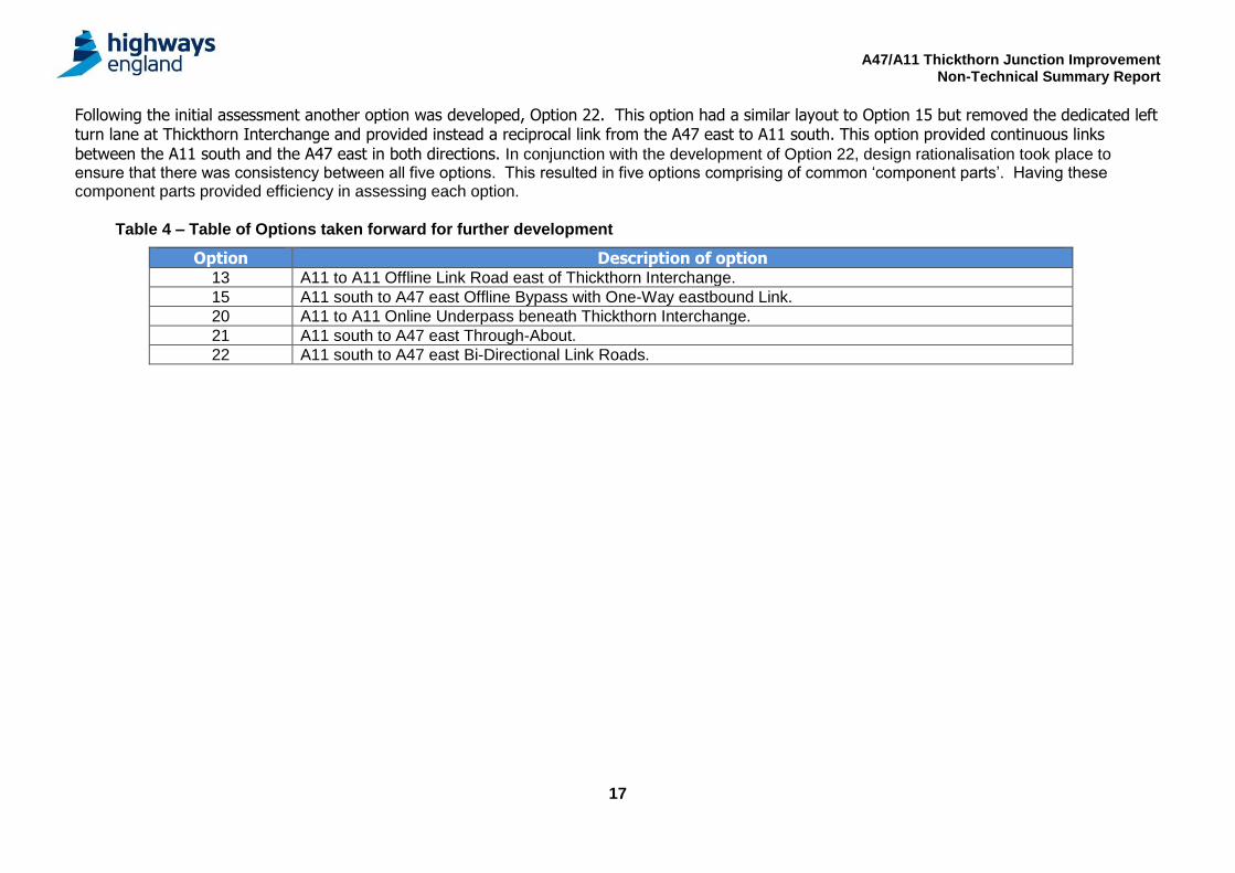
Following the initial assessment another option was developed, Option 22. This option had a similar layout to Option 15 but removed the dedicated left turn lane at Thickthorn Interchange and provided instead a reciprocal link from the A47 east to A11 south. This option provided continuous links between the A11 south and the A47 east in both directions. In conjunction with the development of Option 22, design rationalisation took place to ensure that there was consistency between all five options. This resulted in five options comprising of common ‘component parts’. Having these component parts provided efficiency in assessing each option.
Table 4 – Table of Options taken forward for further development
Option Description of option 13 A11 to A11 Offline Link Road east of Thickthorn Interchange.
15 A11 south to A47 east Offline Bypass with One-Way eastbound Link.
20 A11 to A11 Online Underpass beneath Thickthorn Interchange.
21 A11 south to A47 east Through-About.
22 A11 south to A47 east Bi-Directional Link Roads.
A47/A11 Thickthorn Junction Improvement Non-Technical Summary Report
18
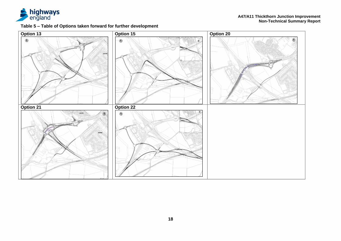
Table 5 – Table of Options taken forward for further development
Option 13
Option 15
Option 20
Option 21
Option 22
A47/A11 Thickthorn Junction Improvement Non-Technical Summary Report
19
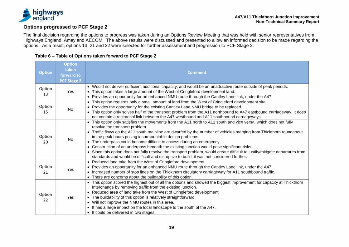
Options progressed to PCF Stage 2
The final decision regarding the options to progress was taken during an Options Review Meeting that was held with senior representatives from Highways England, Amey and AECOM. The above results were discussed and presented to allow an informed decision to be made regarding the options. As a result, options 13, 21 and 22 were selected for further assessment and progression to PCF Stage 2. Table 6 – Table of Options taken forward to PCF Stage 2
Option
Option taken
forward to PCF Stage 2
Comment
Option 13
Yes Would not deliver sufficient additional capacity, and would be an unattractive route outside of peak periods.
This option takes a large amount of the West of Cringleford development land.
Provides an opportunity for an enhanced NMU route through the Cantley Lane link, under the A47.
Option 15
No
This option requires only a small amount of land from the West of Cringleford development site.
Provides the opportunity for the existing Cantley Lane NMU bridge to be replaced.
This option only solves half of the transport problem from the A11 northbound to A47 eastbound carriageway. It does not contain a reciprocal link between the A47 westbound and A11 southbound carriageways.
Option 20
No
This option only satisfies the movements from the A11 north to A11 south and vice versa, which does not fully resolve the transport problem.
Traffic flows on the A11 south mainline are dwarfed by the number of vehicles merging from Thickthorn roundabout in the peak hours posing insurmountable design problems.
The underpass could become difficult to access during an emergency.
Construction of an underpass beneath the existing junction would pose significant risks.
Since this option does not fully resolve the transport problem, would create difficult to justify/mitigate departures from standards and would be difficult and disruptive to build, it was not considered further.
Option 21
Yes
Reduced land take from the West of Cringleford development.
Provides an opportunity for an enhanced NMU route through the Cantley Lane link, under the A47.
Increased number of stop lines on the Thickthorn circulatory carriageway for A11 southbound traffic.
There are concerns about the buildability of this option.
Option 22
Yes
This option scored the highest out of all the options and showed the biggest improvement for capacity at Thickthorn Interchange by removing traffic from the existing junction.
Reduced area of land take from the West of Cringleford development.
The buildability of this option is relatively straightforward.
Will not improve the NMU routes in this area.
It has a large impact on the local landscape to the south of the A47.
It could be delivered in two stages.
A47/A11 Thickthorn Junction Improvement Non-Technical Summary Report
20
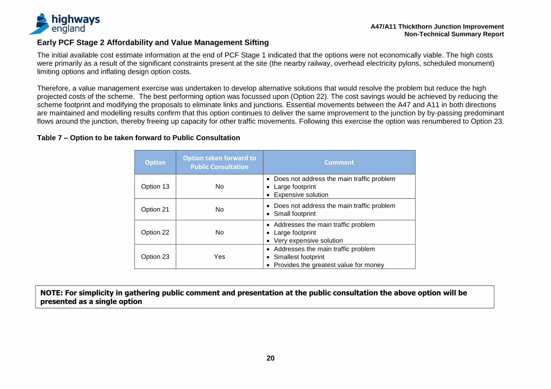
Early PCF Stage 2 Affordability and Value Management Sifting
The initial available cost estimate information at the end of PCF Stage 1 indicated that the options were not economically viable. The high costs were primarily as a result of the significant constraints present at the site (the nearby railway, overhead electricity pylons, scheduled monument) limiting options and inflating design option costs. Therefore, a value management exercise was undertaken to develop alternative solutions that would resolve the problem but reduce the high projected costs of the scheme. The best performing option was focussed upon (Option 22). The cost savings would be achieved by reducing the scheme footprint and modifying the proposals to eliminate links and junctions. Essential movements between the A47 and A11 in both directions are maintained and modelling results confirm that this option continues to deliver the same improvement to the junction by by-passing predominant flows around the junction, thereby freeing up capacity for other traffic movements. Following this exercise the option was renumbered to Option 23. Table 7 – Option to be taken forward to Public Consultation
Option Option taken forward to
Public Consultation Comment
Option 13 No
Does not address the main traffic problem
Large footprint
Expensive solution
Option 21 No Does not address the main traffic problem
Small footprint
Option 22 No
Addresses the main traffic problem
Large footprint
Very expensive solution
Option 23 Yes
Addresses the main traffic problem
Smallest footprint
Provides the greatest value for money
NOTE: For simplicity in gathering public comment and presentation at the public consultation the above option will be presented as a single option
A47/A11 Thickthorn Junction Improvement Non-Technical Summary Report
21
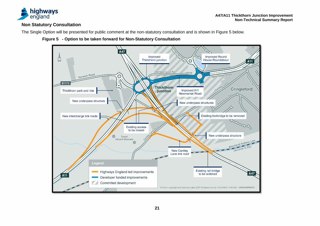
Non Statutory Consultation
The Single Option will be presented for public comment at the non-statutory consultation and is shown in Figure 5 below.
Figure 5 - Option to be taken forward for Non-Statutory Consultation
A47/A11 Thickthorn Junction Improvement Non-Technical Summary Report
22
Further and Ongoing Assessment The following work is ongoing in PCF Stage 2 alongside the non-statutory public consultation.
Commercial Estimates: Preliminary estimates confirm the viability of this option. A more detailed estimate for the option is currently being prepared by Highways England Commercial Team.
Value Management: The initial available cost estimate information from Highways England Commercial Team has been reviewed in detail by the Project Team and a range of value management opportunities have been identified which will be incorporated in the designs as they are developed through PCF Stage 2. Traffic Modelling: The VISSIM traffic modelling completed in Stage 1 will be developed further as the scheme development progresses. A strategic transportation model is currently being developed for this scheme which will be used to predict future strategic flow patterns. Following detailed discussion with Norfolk County Council with regard to the detail and status of the Norwich Area Transport Strategy (NATS) model and discussion with Highways England Traffic Appraisal, Modelling and Economics (TAME) department with regards to transportation modelling approach, a detailed update to the NATS transportation model is currently in progress. When completed, this model will be used to further assess the scheme. Environmental Surveys and Assessment: Further environmental assessment will be required for the option to ensure that the A47/A11 Thickthorn Junction Improvement scheme does not adversely affect the environment. These include: • Nature Conservation and Biodiversity – detailed ecological surveys including amphibians, badger, bat, birds, invertebrates, white-clawed
crayfish, otter, reptiles, water vole and invasive species etc. to inform the Ecological Impact Assessment and the Habitats Regulations Assessment;
• Air Quality – air quality monitoring at specific locations within the study area; • Landscape and Visual – summer and winter site walkover and viewpoint photography along with characterisation of the Zone of Visual
Influence (ZVI); • Noise and Vibration – noise baseline surveys and modelling; • People and Communities – Non Motorised User (NMU) surveys and information on land take, land ownership and land use; • Road drainage and water – flood risk assessment; • Geology and Soils – phase II contaminated land assessment to be combined with preliminary geotechnical ground investigation to include
associated sampling and monitoring; and • Cultural Heritage – assessment of potential archaeological effects and impacts on listed buildings. Required Statutory Process: Given the potential for significant environmental effects on the sensitive designated sites in the area of the scheme it is considered likely that improvements to this junction will meet the criteria for a Nationally Significant Infrastructure Project and will therefore be subject to the Development Consent Order process.
Preferred Route Announcement When all the assessment work is complete and subject to the findings of the consultation, a preferred route announcement will be made in late 2017 and the pre-application stage of the development consent process will begin.