aatsr abi acc ace-fts acrim ii acrim iii a-dcs - ceos eo
TRANSCRIPT

158
Instrument & agency(& any partners)
Missions Type Measurements &applications
Technical characteristics
AATSRAdvanced Along-TrackScanning Radiometer
BNSC
Envisat Imaging multi-spectralradiometers(vis/IR) &Multiple direction/polarisationradiometers
Status
Operational Measurements of sea surfacetemperature, land surfacetemperature, cloud toptemperature, cloud cover,aerosols, vegetation,atmospheric water vapour andliquid water content
Waveband: VIS - NIR: 0.555, 0.659,0.865µm,SWIR: 1.6µm,MWIR: 3.7µm, TIR: 10.85,12µm
Spatial resolution: IR ocean channels: 1km x1km, Visible land channels:1km x 1km
Swath width: 500 kmAccuracy: Sea surface temperature:
<0.5K over 0.5 deg x 0.5 deg(lat/long) area with 80%cloud cover Land surfacetemperature: 0.1K (relative)
ABIAdvanced BaselineImager
NOAA
GOES-R Imaging multi-spectralradiometers(vis/IR)
Approved Measures cloud cover,atmospheric radiance, winds,atmospheric stability, rainfallestimates. Used to providesevere storm warnings/monitoring day and night(type, amount, storm features)
The GOES-R Project is in the formulation phase.The satellite will comprise improved spacecraftand instrument technologies, which will result inmore timely and accurate weather forecasts, andimprove support for the detection andobservations of meteorological phenomena thatdirectly affect public safety, protection ofproperty, and ultimately, economic health anddevelopment.
ACCAccelerometer
ESA
Swarm Gravity &Spaceenvironment
Operational Measures the non-gravitationalaccelerations, caused forexample by air-drag, winds,Earth albedo and solarradiation pressure acting onthe satellites. In-situ air densitymeasurements together withmagnetic data can be used toobtain new insights on thegeomagnetic forcing of theupper atmosphere.
Waveband: N/ASpatial resolution: 0.1nm/s2Swath width: N/AAccuracy: 0.1nm/s2
ACE-FTSAtmospheric ChemistryExperiment (ACE)mission
CSA
SCISAT-1 Atmosphericchemistry
Operational Objective is to measure andunderstand the chemicalprocesses that control thedistribution of ozone in theEarth's atmosphere, especiallyat high altitudes.
Waveband: SWIR - TIR: 2 - 5.5 µm, 5.5 - 13 µm (0.02cm-1 resolution)
Spatial resolution: Swath width: Accuracy:
ACRIM IIActive CavityRadiometer IrradianceMonitor
NASA
UARS Earth radiationbudgetradiometer
Notoperational
Measurements of solarluminosity and solar constant.Data used as record of imevariation of total solarirradiance, from extreme UVthrough to infra-red
Waveband: UV-FIR:1nm-50µmSpatial resolution: Not applicableSwath width: Not applicableAccuracy: Measures integrated flux of
solar radiation to <0.1%
ACRIM IIIActive CavityRadiometer IrradianceMonitor
NASA
ACRIMSAT Earth radiationbudgetradiometer
Operational Measurements of solarluminosity and solar constant.Data used as record of timevariation of total solarirradiance, from extreme UVthrough to infra-red
Waveband: UV - MWIR: 0.15 - 5 µmSpatial resolution: 5 deg FOVSwath width: 55 mins per orbit of full solar
disk dataAccuracy: 0.1% of full scale
A-DCSARGOS-Data CollectionSystem
NOAA
NPOESS-1,NPOESS-2,NPOESS-3,NPOESS-4,NPOESS-5,NPOESS-6
Data collectionBeingdeveloped
Data collection andcommunication system forreceiving and retransmittingdata from ocean and land-based remote observingplatforms/transponders
The Argos DCS is a data collection relay systemand not an Earth observing instrument.

159
AMI/SAR/waveActive MicrowaveInstrumentation. Wavemode
ESA
ERS-2 Imagingmicrowave radars
Operational Provides measurements ofocean wave spectra
Waveband: Microwave: 5.3GHz (C-band),VV polarisation
Spatial resolution: 30mSwath width: Accuracy: Sea surface wind speed: 3m/s,
Significant wave height: 0.2m
Instrument & agency(& any partners)
Missions Type Measurements &applications
Technical characteristicsStatus
AIRSAtmospheric Infra-redSounder
NASA
Aqua Atmospherictemperature andhumiditysounders
Operational High spectral resolutionmeasurement of temperatureand humidty profiles in theatmosphere. Long-wave Earthsurface emissivity. Clouddiagnostics. Trace gas profiles.Surface temperatures.
Waveband: VIS - TIR: 0.4 - 1.7µm, 3.4 -15.4µm, Has approximately2382 bands from VIS to TIR
Spatial resolution: 1.1 degree (13X13 Km atnadir)
Swath width: +/-48.95 degreesAccuracy: Humidity: 20%,
Temperature: 1K
ALADINAtmospheric LaserDoppler Instrument
ESA
ADM-Aeolus LidarsPrototype Primary objective is to providewind profile measurements foran improved analysis of global3-D wind fields. MeasuresDoppler shift information frommolecules and particlesadvected by the wind
Waveband: UV: 355nmSpatial resolution: 50km (footprint: 70m)Swath width: Accuracy: 0.5ms-1(0 to 2km),
1ms-1(2 to 16km), 2ms-1
(above 16km)
ALTAltimeter
NOAA
NPOESS-3,NPOESS-6
Radar altimetersBeingdeveloped
Obtains precise altimeterheight measurements overworld's oceans
Waveband: 13.6 and 5.3 GHZSpatial resolution: Along track 15kmSwath width: 15kmAccuracy: SST height 4cm
AMI/SAR/ImageActive MicrowaveInstrumentation. ImageMode
ESA
ERS-2 Imagingmicrowave radars
Operational All-weather images of ocean,ice and land surfaces.Monitoring of coastal zones,polar ice, sea state, geologicalfeatures, vegetation (includingforests), land surfaceprocesses, hydrology.
Waveband: Microwave: 5.3 GHz, C band,VV polarisation, bandwidth15.5 ± 0.06 MHz
Spatial resolution: 30mSwath width: 100kmAccuracy: Landscape topography: 3m,
Bathymetry: 0.3m, Sea icetype: 3 classes
ALIAdvanced Land Imager
NASA
NMP EO-1 High resolutionoptical imagers
Operational Measurement of Earth surfacereflectance. Will validate newtechnologies contributing tocost reduction and increasedcapabilities for futuremissions. ALI comprises awide field telescope andmultispectral andpanchromatic instrument
Waveband: 10 bands: VIS&NIR: 0.480-0.690µm, 0.433-0.453µm,0.450-0.515µm, 0.525-0.605µm, 0.630-0.690µm, 0.775-0.805µm, 0.845-0.890µm, 1.200-1.300µm, SWIR: 1.550-1.750µm, 2.080-2.350µm
Spatial resolution: PAN: 10m, VNIR&SWIR: 30mSwath width: 37kmAccuracy: SNR @ 5% surf refl Pan:220,
Multi 1: 215, Multi 2: 280, Multi 3: 290, Multi 4:240, Multi 4':190, Multi 5':130, Multi 5:175, Multi 7:170(prototype instrument exceedsETM+ SNR by a factor of 4 - 8)
160
Instrument & agency(& any partners)
Missions Type Measurements &applications
Technical characteristicsStatus
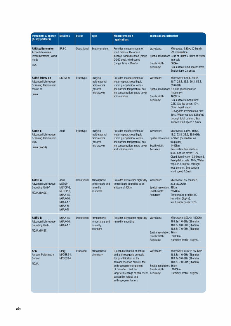
AMI/scatterometerActive MicrowaveInstrumentation. Windmode
ESA
ERS-2 ScatterometersOperational Provides measurements ofwind fields at the oceansurface, wind direction (range0-360 deg), wind speed(range 1m/s - 30m/s)
Waveband: Microwave: 5.3GHz (C-band),VV polarisation
Spatial resolution: Cells of 50km x 50km at 25kmintervals
Swath width: 500kmAccuracy: Sea surface wind speed: 3m/s,
Sea ice type: 2 classes
AMSR follow-onAdvanced MicrowaveScanning Radiometerfollow-on
JAXA
GCOM-W Imaging multi-spectralradiometers(passivemicrowave)
Prototype Provides measurements ofwater vapour, cloud liquidwater, precipitation, winds,sea surface temperature, seaice concentration, snow cover,soil moisture
Waveband: Microwave: 6.925, 10.65,18.7, 23.8, 36.5, 50.3, 52.8,89.0 GHz
Spatial resolution: 5-50km (dependent onfrequency)
Swath width: 1600kmAccuracy: Sea surface temparature:
0.5K, Sea ice cover: 10%,Cloud liquid water:0.05kg/m2, Precipitation rate:10%, Water vapour: 3.5kg/m2through total column, Seasurface wind speed 1.5m/s
AMSR-EAdvanced MicrowaveScanning Radiometer-EOS
JAXA (NASA)
Aqua Imaging multi-spectralradiometers(passivemicrowave)
Prototype Provides measurements ofwater vapour, cloud liquidwater, precipitation, winds,sea surface temperature, seaice concentration, snow coverand soil moisture
Waveband: Microwave: 6.925, 10.65,18.7, 23.8, 36.5, 89.0 GHz
Spatial resolution: 5-50km (dependent onfrequency)
Swath width: 1445kmAccuracy: Sea surface temparature:
0.5K, Sea ice cover: 10%,Cloud liquid water: 0.05kg/m2,Precipitation rate: 10%, Watervapour: 3.5kg/m2 throughtotal column, Sea surfacewind speed 1.5m/s
AMSU-AAdvanced MicrowaveSounding Unit-A
NOAA (BNSC)
Aqua,METOP-1,METOP-2,METOP-3,NOAA-15,NOAA-16,NOAA-17,NOAA-N,NOAA-N'
Atmospherictemperature andhumiditysounders
Operational Provides all weather night-daytemperature sounding to analtitude of 45km
Waveband: Microwave: 15 channels,23.8-89.0GHz
Spatial resolution: 48kmSwath width: 2054kmAccuracy: Temperature profile: 2K,
Humidity: 3kg/m2,Ice & snow cover: 10%
AMSU-BAdvanced MicrowaveSounding Unit-B
NOAA (BNSC)
NOAA-15,NOAA-16,NOAA-17
Atmospherictemperature andhumiditysounders
Operational Provides all weather night-dayhumidity sounding
Waveband: Microwave: 89GHz, 150GHz,183.3± 1.0 GHz (2bands),183.3± 3.0 GHz (2bands),183.3± 7.0 GHz (2bands)
Spatial resolution: 16kmSwath width: 2200kmAccuracy: Humidity profile: 1kg/m2,
APSAerosol PolarimetrySensor
NOAA
Glory, NPOESS-1,NPOESS-4
Atmosphericchemistry
Proposed Global distribution of naturaland anthropogenic aerosolsfor quantification of theaerosol effect on climate, theanthropogenic component of this effect, and the long-term change of this effectcaused by natural andanthropogenic factors
Waveband: Microwave: 89GHz, 150GHz,183.3± 1.0 GHz (2bands),183.3± 3.0 GHz (2bands),183.3± 7.0 GHz (2bands)
Spatial resolution: 16kmSwath width: 2200kmAccuracy: Humidity profile: 1kg/m2,

161
Instrument & agency(& any partners)
Missions Type Measurements &applications
Technical characteristicsStatus
AquariusNASA (CONAE)
SAC-D/Aquarius
Imaging multi-spectralradiometers(passivemicrowave) &Scatterometers
Proposed The Aquarius mission willmeasure global sea surfacesalinity with unprecedentedresolution. The instrumentsinclude a set of threeradiometers that are sensitiveto salinity (1.413 GHz; L-band). The scatterometercorrects for the ocean'ssurface roughness.
Waveband: L Band (1.413-1.260 GHzSpatial resolution: 100kmSwath width: 300kmAccuracy: . 2 psu
ARGOSCNES (NASA)
METOP-1,METOP-2,NOAA-12,NOAA-14,NOAA-15,NOAA-16,NOAA-17,NOAA-N,NOAA-N'
Data collection &Precision orbit
Operational Provides location data byDoppler measurements
The Argos DCS is a data collection relay systemand not an Earth observing instrument.
ArinaROSKOSMOS
Resurs DK SpaceEnvironment
Space particle detectionexperiment
Arina is an instrument for observation of solarmagnetosphere variations of charged particlefluxes.
ASARAdvanced Synthetic-Aperture Radar
ESA
Envisat Imagingmicrowave radars
Operational Provides all weather images ofocean, land and ice formonitoring of land surfaceprocesses, sea and polar ice,sea state, and geological andhydrological applications. Has 2stripmap modes (Image andWave (for ocean wave spectra))and 3 ScanSAR modes
Waveband: Microwave: C-band, withchoice of 5 polarisation modes(VV, HH, VV/HH, HV/HH, orVH/VV)
Spatial resolution: Image, wave and alternatingpolarisation modes: approx30m x 30m,Wide swath mode: 150m x 150m,Global monitoring mode:950mm x 950m
Swath width: Image and alternatingpolarisation modes:up to 100km,Wave mode: 5km,Wide swath and globalmonitoring modes: 400km or more
Accuracy: Radiometric resolution inrange: 1.5-3.5 dB,Radiometric accuracy: 0.65 dB
ASAR (image mode)Advanced SyntheticAperture Radar (Imagemode)
ESA
Envisat Imagingmicrowave radars
Operational Provides all weather imagesof ocean, land and ice formonitoring of land surfaceprocesses, sea and polar ice,sea state, and geological andhydrological applications
See above.
ASAR (wave mode)Advanced SyntheticAperture Radar (Wavemode)
ESA
Envisat ASAR (wavemode)AdvancedSyntheticAperture Radar(Wave mode)ESA
Operational Provides measurements ofocean wave spectra
See above.

162
Instrument & agency(& any partners)
Missions Type Measurements &applications
Technical characteristicsStatus
ASCATAdvancedScatterometer
EUMETSAT (ESA)
METOP-1,METOP-2,METOP-3
ScatterometersBeingdeveloped
Provides sea ice cover, sea icetype and wind speed over seasurface measurements. Airpressure over ocean, Polar icecontours, Ice/snow imagery,Soil moisture
Waveband: Microwave: C Band,5.256Ghz
Spatial resolution: Hi-res mode: 25-37km,Nominal mode: 50kmSwath width: ContinuousAccuracy: Wind speeds in range
4-24m/s: 2m/s anddirection accuracy of 20deg
ASMAbsolute ScalarMagnetometer
ESA (CNES)
Swarm Magnetic fieldBeingdeveloped
The objective of the AbsoluteScalar Magnetometer (ASM)is to calibrate the vector fieldmagnetometer (VFM) tomaintain the absoluteaccuracy in the multi-yeargeomagnetic field mission
Waveband: N/ASpatial resolution: 0.016pTSwath width: N/AAccuracy: 0.3nT
ASTERAdvanced SpaceborneThermal Emission andReflection Radiometer
METI (Japan) (NASA)
Terra High resolutionoptical imagers
Operational Surface and cloud imagingwith high spatial resolution,stereoscopic observation oflocal topography, cloudheights, volcanic plumes, andgeneration of local surfacedigital elevation maps.Surface temperature andemissivity
Waveband: VIS&NIR: 3 bands in 0.52-0.86µm, SWIR: 6 bands in1.6-2.43µm, TIR: 5 bands in8.125-11.65µm
Spatial resolution: VNIR: 15m, stereo: 15mhorizontally and 25m vertical,SWIR: 30m, TIR: 90m
Swath width: 60kmAccuracy: VNIR and SWIR: 4%
(absolute), TIR: 4K,Geolocation: 7m
ATLIDATmospheric LIDar
ESA
ESA FutureMissions
LidarsPrototype Provides measurements ofcloud top heights, aerosolproperties, troposphereheight, vertical distribution ofcloud, boundary layer height
Waveband: UV: 355nmSpatial resolution: footprint: 30mSwath width: NadirAccuracy: Detection of cirrus cloud with
optical thickness 1 with 15%error
ATMSAdvanced TechnologyMicrowave Sounder
NOAA (NASA)
NPOESS-2,NPOESS-5,NPP
Atmospherictemperature andhumiditysounders
Approved Collects microwave radiancedata that when combined withthe CrIS data will permitcalculation of atmospherictemperature and water vaporprofiles
Waveband: Microwave: 22 bands, 23-184 GHz
Spatial resolution: 5.2 deg - 1.1 degSwath width: 2300 kmAccuracy: 0.75 K - 3.60 K
ATSR/M
CNES
ERS-2 Imaging multi-spectralradiometers(passivemicrowave)
Operational Part of the ATSR payload onboard ERS1 and ERS2
See ATSR-2.
ATSR-2Along Track ScanningRadiometer - 2
BNSC (CSIRO)
ERS-2 Imaging multi-spectralradiometers(vis/IR) &Multipledirection/polarisationradiometers
Operational Provides measurements ofsea surface temperature, landsurface temperature, cloudtop temperature and cloudcover, aerosols, vegetation,atmospheric water vapour andliquid water content
Waveband: VIS-SWIR: 0.65, 0.85, 1.27,and 1.6µm, SWIR-TIR: 1.6,3.7, 11 and 12µm, Microwave:23.8, 36.5GHz (bandwidth of400MHz)
Spatial resolution: IR ocean channels: 1km x1km, Microwave near-nadirviewing: 20km instantaneousfield of view
Swath width: 500kmAccuracy: Sea surface temperature to
<0.5K over 0.5 deg x 0.5 deg(lat/long) area with 80% cloudcover, Land surfacetemperature: 0.1K

163
Instrument & agency(& any partners)
Missions Type Measurements &applications
Technical characteristicsStatus
AVHRR/2Advanced Very HighResolutionRadiometer/2
NOAA
NOAA-12,NOAA-14
Imaging multi-spectralradiometers(vis/IR)
Operational Provides measurements ofland and sea surfacetemperature, cloud cover,snow and ice cover, soilmoisture and vegetationindices. Data also used forvolcanic eruption monitoring
Waveband: VIS: 0.58-0.68µm,NIR: 0.725-1.1µm,MWIR: 3.55-3.93µm,TIR: 10.3-11.3µm, 11.5-12.5µm
Spatial resolution: 1.1kmSwath width: 3000km approxAccuracy:
AVHRR/3Advanced Very HighResolutionRadiometer/3
NOAA
METOP-1,METOP-2,METOP-3,NOAA-15,NOAA-16,NOAA-17,NOAA-N,NOAA-N'
Imaging multi-spectralradiometers(vis/IR)
Operational Provides measurements ofland and sea surfacetemperature, cloud cover,snow and ice cover, soilmoisture and vegetationindices. Data also used forvolcanic eruption monitoring
Waveband: VIS: 0.58-0.68µm, NIR: 0.725-1.1µm, SWIR: 1.58-1.64µm,MWIR: 3.55-3.93µm, TIR:10.3-11.3µm, 11.5-12.5µm
Spatial resolution: 1.1kmSwath width: 3000km approx, Ensures full
global coverage twice dailyAccuracy:
AVNIR-2Advanced Visible andNear Infra-redRadiometer type 2
JAXA
ALOS High resolutionoptical imagers
Beingdeveloped
High resolution multi-spectralimager for land applicationswhich include environmentalmonitoring, agriculture andforestry, disaster monitoring
Waveband: VIS: 0.42-0.50µm, 0.52-0.60µm, 0.61-0.69µm,NIR: 0.76-0.89µm
Spatial resolution: 10mSwath width: 70kmAccuracy:
AWiFSAdvanced Wide FieldSensor
ISRO
RESOURCE-SAT-1,RESOURCE-SAT-2
High resolutionoptical imagers
Operational Vegetation and cropmonitoring, resourceassessment (regional scale),forest mapping, land cover/land use mapping, andchange detection
Waveband: VIS: 0.52-0.59 & 0.62-0.68µm, NIR:0.77-0.86µm,SWIR: 1.55-1.7µm
Spatial resolution: 55mSwath width: 730kmAccuracy: 10 bit data
BISSATBissat Passive Radar
ASI
BISSAT Imagingmicrowave radars
TBD Evaluation of bistatic radarcross section of natural andman-made targets, imageclassification, land surface.Passive instrument flown withmain SAR mission
Waveband: Microwave: X-band(passive)
Spatial resolution: Swath width: Accuracy:
CALIOPCloud-Aerosol Lidarwith OrthogonalPolarization
NASA
CALIPSO LidarsApproved Two-wavelength, polarizationlidar capable of providingaerosol and cloud profiles andproperties
Waveband: 532 nm (polarization-sensitive), 1064 nm, VIS - NIR
Spatial resolution: Vertical sampling: 30 m, 0 – 40 km
Swath width: 333 m along-trackAccuracy: 5% (532 nm)
CCD (CBERS)High Resolution CCDCamera
CAST (INPE)
CBERS-2,CBERS-2B
High resolutionoptical imagers
Operational Provides measurements ofcloud type and extent andland surface reflectance, andused for global land surfaceapplications
Waveband: VIS: 0.45-0.52µm, 0.52-0.59µm, 0.63-0.69µm,NIR: 0.77-0.89µm,PAN: 0.51-0.71µm
Spatial resolution: 20mSwath width: 113kmAccuracy:
CCD (HJ, HY)CCD camera
CAST
HJ-1A, HJ-1B
High resolutionoptical imagers
Land surface applications Waveband: 0.43-0.90µmSpatial resolution: 30mSwath width: 360km (per set)700km
(two sets)Accuracy:

164
Instrument & agency(& any partners)
Missions Type Measurements &applications
Technical characteristicsStatus
CCD camera
ISRO
INSAT-2E,INSAT-3A
Imaging multi-spectralradiometers(vis/IR)
Operational Cloud and Vegetationmonitoring
Waveband: VIS: 0.62-0.68µm, NIR: 0.77-0.86µm, SWIR: 1.55-1.69µm
Spatial resolution: 1X1kmSwath width: Normal: 6000km (N-S) X
6000km (E-W) anywhere onearth disc, Program: 6000km(N-S) X (n X 300) km (E-W) :n and number of framesprogrammable
Accuracy:
CERESCloud and the Earth'sRadiant Energy System
NASA
Aqua, NPOESS-2,NPOESS-5,Terra
Earth radiationbudgetradiometer
Operational Long term measurement ofthe Earth's radiation budgetand atmospheric radiationfrom the top of theatmosphere to the surface;provision of an accurate andself-consistent cloud andradiation database
Waveband: 3 channels: 0.3-5 µm, 0.3 -100 µm, 8-12 µm, UV-FIR
Spatial resolution: 20kmSwath width: Accuracy: 0.5%, 1%, 1% (respectively
for the 3 channels)
CHAMP GPS SounderGPS TurboRogueSpace Receiver (TRSR)
NASA (DLR)
CHAMP Atmospherictemperature andhumiditysounders &Precision orbit
Operational Temperature and water vapourprofiles
Uses GPS frequencies for sounding oftemperature and water profiles of theatmosphere. CHAMP provides temperatureprofiles in the troposphere up to the middlestratosphere, and water vapour profiles in thetroposphere only.
CHAMPgravity package(Accelerometer+GPS)STAR Accelerometer
CNES (DLR)
CHAMP GravityOperational Earth gravity fieldmeasurements
Since the advent of CHAMP, the first in a series oflow-altitude satellites being almost continuouslyand precisely tracked by GPS, a new generation oflong-wavelength gravitational geopotential modelshave been derived.
CIAAdvancedHyperspectral camera
ASI
HyperspectralMission
Imaging multi-spectralradiometers(vis/IR)
Pancromatic andHyperspectral data forcomplex land ecosystemstudies
Waveband: HYC spectral range + MIRand TIR channels
Spatial resolution: Improved (wrt HYC)resolution PAN 2-3m
Swath width: Greater swathAccuracy:
CHAMPmagnetometrypackage (1 Scalar + 2VectorMagnetometer)OverhauserMagnetometer andFluxgate Magnetometer
DLR
CHAMP Magnetic fieldOperational Earth gravity fieldmeasurements
A high performance Fluxgate magnetometer setmeasuring the three components of the ambientmagnetic field in the instrument frame combinedwith a star camera determining the attitude of theassembly with respect to a stellar frame and aOverhauser scalar magnetometer serving asmagnetic reference.
CLAESCryogenic Limb ArrayEtalon Spectrometerinstrument
NASA
UARS Earth radiationbudgetradiometer
Notoperational
Measures many of thechemical species which areinvolved in stratosphericchemistry as well as globaldistribution of statosphericaerosols
Waveband: SWIR: 3.5µm, 6µm,TIR: 8µm, 12.7µm
Spatial resolution: Vert 2.8km, Horiz 480kmSwath width: 50.7km vert limbAccuracy: 20%, 3K
Cloud SensorCloud and aerosolsensor
JAXA
GOSAT Cloud profile andrain radars
Will contribute to GOSAT mainmission of CO2 profilemeasurement - which requiresdetection and removal ofcontaminating signals fromclouds and aerosols
No data yet available.

165
Instrument & agency(& any partners)
Missions Type Measurements &applications
Technical characteristicsStatus
CMISConical-scanningMicrowaveImager/Sounder
NOAA
NPOESS-1,NPOESS-2,NPOESS-3,NPOESS-4,NPOESS-5,NPOESS-6
Imaging multi-spectralradiometers(passivemicrowave) &Atmospherictemperature andhumiditysounders
Beingdeveloped
Collects microwave radiometryand sounding data. Data typesinclude atmospherictemperature and moistureprofiles, clouds, sea surfacewinds, and all-weatherland/water surfaces.
Waveband: Microwave: 190GhzSpatial resolution: 15-50km depending on
frequencySwath width: 1700kmAccuracy: Temperature Profiles to 1.6K,
water vapor 20%
COCTSOcean colour scanner
CAST
HY-1B Ocean colourinstruments
Beingdeveloped
Ocean chlorophyll, Oceanyellow substance absorbance,Sea-ice surface temperature
Waveband: B1: 0.402-0.422, B2: 0.433-0.453, B3: 0.480-0.500, B4:0.510-0.530, B5: 0.555-0.575,B6: 0.660-0.680, B7: 0.740-0.760, B8: 0.845-0.885, B9:10.30-11.40, B10: 11.40-12.50µm
Spatial resolution: 1.1kmSwath width: 3083kmAccuracy:
Communicationspayload (Ka and UHFband)
CSIRO
FedSat CommunicationsOperational Waveband: up 313.55MHz, down 400.4MHz
CPRCloud Profiling Radar
ESA
ESA FutureMissions
Cloud profile andrain radars
Prototype Measures cloudcharacteristics including baseheight
Waveband: Microwave: 94GHzSpatial resolution: 750mSwath width: nadir onlyAccuracy: 98% detection of radiatively
significant ice cloud
CPR (Cloudsat)Cloud Profiling Radar
NASA
CloudSat Cloud profile andrain radars
Approved Primary goal is to provideddata needed to evaluate andimprove the way clouds arerepresented in global climatemodels. Measures verticalprofile of clouds
Waveband: Microwave: 94GhzSpatial resolution: Vertical: 500m, Cross-track:
1.4km, Along-track: 2.5kmSwath width: Instantaneous Footprint < 2kmAccuracy: Cloud liquid water
content<=50%; ice watercontent within +100%, -50%;detect all single layer cloudswith optical depth>=1.0
CrISCross-track InfraredSounder
NOAA (NASA)
NPOESS-2,NPOESS-5NPP
Atmospherictemperature andhumiditysounders
Prototype Daily measurements of verticalatmospheric distribution oftemperature, moisture, andpressure
Waveband: MWIR-TIR: 3.92-4.4µm, 5.7-8.62µm, 9.1-14.7µm, 1300spectral channels
Spatial resolution: IFOV 14km diameter, 1km vertical layer resolution
Swath width: 2200kmAccuracy: Temperature profiles: to 0.9K,
Moisture profiles: 20-35%,Pressure profiles: 1%
CZICoast region imager
CAST
HY-1B Imaging multi-spectralradiometers(vis/IR)
Beingdeveloped
Coastal Zone monitoring andenvironmental applications
Waveband: B1: 0.433-0.453, B2: 0.555-0.575, B3: 0.655-0.675, B4:0.675-0.695_m
Spatial resolution: 250mSwath width: 500kmAccuracy:
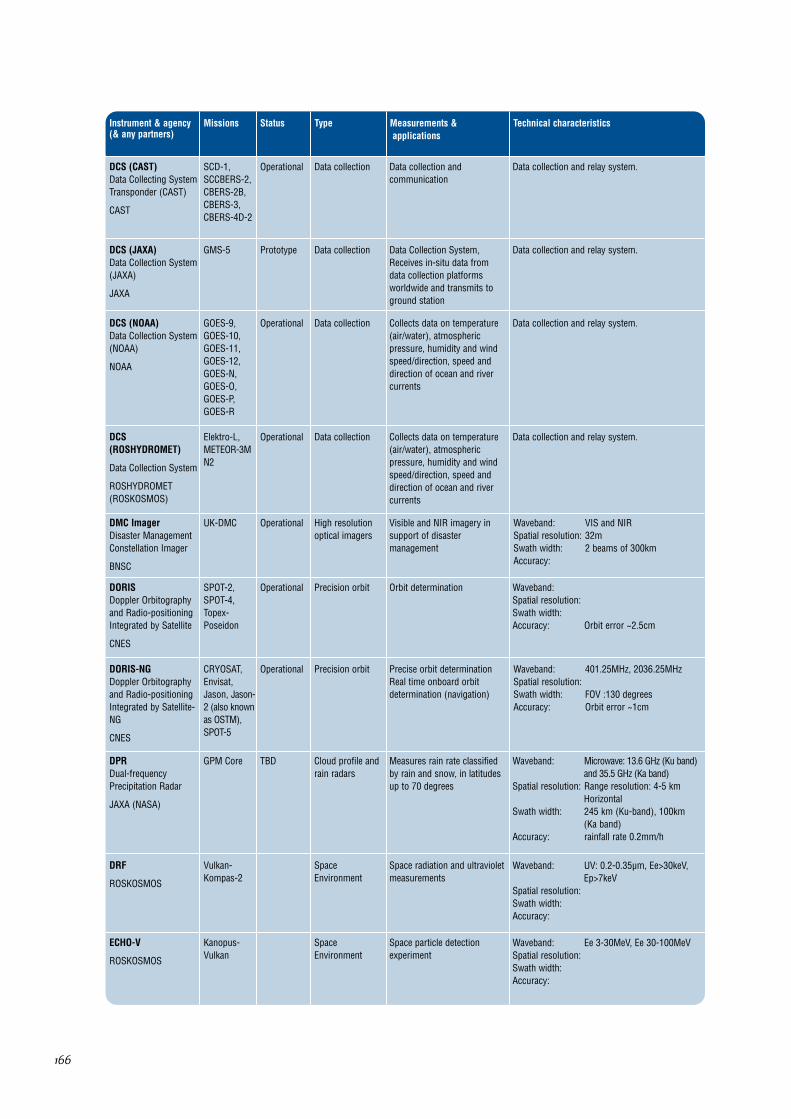
DCP (SCD)Data CollectingPlatform Transponder
INPE
SCD-1,SCD-2
Data collectionOperational Environmental data collectionfrom ground based datacollecting platforms
Data collection and relay system.
166
Instrument & agency(& any partners)
Missions Type Measurements &applications
Technical characteristicsStatus
DCS (CAST)Data Collecting SystemTransponder (CAST)
CAST
SCD-1,SCCBERS-2,CBERS-2B,CBERS-3,CBERS-4D-2
Data collectionOperational Data collection andcommunication
Data collection and relay system.
DCS (JAXA)Data Collection System(JAXA)
JAXA
GMS-5 Data collectionPrototype Data Collection System,Receives in-situ data fromdata collection platformsworldwide and transmits toground station
Data collection and relay system.
DCS (NOAA)Data Collection System(NOAA)
NOAA
GOES-9,GOES-10,GOES-11,GOES-12,GOES-N,GOES-O,GOES-P,GOES-R
Data collectionOperational Collects data on temperature(air/water), atmosphericpressure, humidity and windspeed/direction, speed anddirection of ocean and rivercurrents
Data collection and relay system.
DCS(ROSHYDROMET)
Data Collection System
ROSHYDROMET(ROSKOSMOS)
Elektro-L,METEOR-3MN2
Data collectionOperational Collects data on temperature(air/water), atmosphericpressure, humidity and windspeed/direction, speed anddirection of ocean and rivercurrents
Data collection and relay system.
DMC ImagerDisaster ManagementConstellation Imager
BNSC
UK-DMC High resolutionoptical imagers
Operational Visible and NIR imagery insupport of disastermanagement
Waveband: VIS and NIRSpatial resolution: 32mSwath width: 2 beams of 300kmAccuracy:
DORISDoppler Orbitographyand Radio-positioningIntegrated by Satellite
CNES
SPOT-2,SPOT-4,Topex-Poseidon
Precision orbitOperational Orbit determination Waveband: Spatial resolution: Swath width: Accuracy: Orbit error ~2.5cm
DORIS-NGDoppler Orbitographyand Radio-positioningIntegrated by Satellite-NG
CNES
CRYOSAT,Envisat,Jason, Jason-2 (also knownas OSTM),SPOT-5
Precision orbitOperational Precise orbit determinationReal time onboard orbitdetermination (navigation)
Waveband: 401.25MHz, 2036.25MHzSpatial resolution: Swath width: FOV :130 degreesAccuracy: Orbit error ~1cm
DPRDual-frequencyPrecipitation Radar
JAXA (NASA)
GPM Core Cloud profile andrain radars
TBD Measures rain rate classifiedby rain and snow, in latitudesup to 70 degrees
Waveband: Microwave: 13.6 GHz (Ku band)and 35.5 GHz (Ka band)
Spatial resolution: Range resolution: 4-5 kmHorizontal
Swath width: 245 km (Ku-band), 100km (Ka band)
Accuracy: rainfall rate 0.2mm/h
DRF
ROSKOSMOS
Vulkan-Kompas-2
SpaceEnvironment
Space radiation and ultravioletmeasurements
Waveband: UV: 0.2-0.35µm, Ee>30keV,Ep>7keV
Spatial resolution: Swath width: Accuracy:
ECHO-V
ROSKOSMOS
Kanopus-Vulkan
SpaceEnvironment
Space particle detectionexperiment
Waveband: Ee 3-30MeV, Ee 30-100MeVSpatial resolution: Swath width: Accuracy:

167
Instrument & agency(& any partners)
Missions Type Measurements &applications
Technical characteristicsStatus
EFIElectric FieldInstrument
ESA (CSA)
Swarm Gravity &Spaceenvironment
Beingdeveloped
Measures ion density, driftvelocity and electric field
Waveband: N/ASpatial resolution: 0.3mV/mSwath width: N/AAccuracy: <3mV/m
EGG3-Axis ElectrostaticGravity Gradiometer
ESA
GOCE Gravity &Precision orbit
Beingdeveloped
The main objective of EGG isto measure the 3 componentsof the gravity-gradient tensor(ie gradiometer data)
Designed specifically for determining thestationary gravity field. The measured signal isthe difference in gravitational acceleration atthe test-mass location inside the spacecraftcaused by gravity anomalies from attractingmasses of the Earth.
EHISEnergetic Heavy IonSensor
NOAA
GOES-R SpaceEnvironment
Approved Space particle detection The GOES-R Project is in the formulation phase.The satellite will comprise improved spacecraftand instrument technologies, which will result inmore timely and accurate weather forecasts, andimprove support for the detection andobservations of meteorological phenomena thatdirectly affect public safety, protection of property,and ultimately, economic health and development.
ENVISAT CommsCommunicationspackage on ENVISAT
ESA
Envisat CommunicationsOperational Communication packageonboard ENVISAT seriessatellites
Data communication only.
EOCElectro-Optical Camera
KARI
KOMPSAT-1 High resolutionoptical imagers
Operational High resolution stereo imagerfor land applications ofcartography and disastermonitoring
Waveband: Panchromatic VIS: 0.51-0.73µm
Spatial resolution: 6.6mSwath width: 17kmAccuracy:
EPICEarth PolyChromaticImaging Camera
NASA
DSCOVR Atmosphericchemistry
Proposed Measures ozone amounts,aerosol amounts, cloud heightand phase, hotspot landproperties, and UV radiationestimates at the Earth's surface
Waveband: UV-NIR: 0.317-0.905µm 10 bands
Spatial resolution: 8kmSwath width: Accuracy:
ERBEEarth Radiation BudgetExperiment (non-scanner)
NASA
ERBS Earth radiationbudgetradiometer
Operational Radiation budgetmeasurements - Total energyof Sun's radiant heat and light,Reflected solar radiation, Earthemitted radiation
Waveband: UV-FIRSpatial resolution: Narrow: 250km;
Wide: 1000kmSwath width: Medium and wide
earth viewsAccuracy: Shortwave- 15%,
Longwave- 5%
ERBSEarth Radiation BudgetSensor
NOAA
NPOESS-3,NPOESS-6
Earth radiationbudgetradiometer
TBD Measures Earth radiation gainsand losses on regional, zonaland global scales
Waveband: 0.3-50µmSpatial resolution: 25kmSwath width: 2200KmAccuracy: DLR/DSR10 watts/m2
net solar 3w/m2OLR 5w/m2
ERS CommsCommunicationpackage for ERS
ESA
ERS-2 CommunicationsOperational Communication packageonboard ERS series satellites
Data communication only.

168
Instrument & agency(& any partners)
Missions Type Measurements &applications
Technical characteristicsStatus
EUVSExtreme UltravioletSensor
NOAA
GOES-R OtherApproved Solar EUV radiation is adominant energy source forthe upper atmosphere and theionizing radiation producesthe ionosphere. Solarvariability at thesewavelengths is one of theprimary drivers ofthermospheric/ ionosphericvariability. EUVS will measurethis radiation
The GOES-R Project is in the formulation phase.The satellite will comprise improved spacecraftand instrument technologies, which will result inmore timely and accurate weather forecasts, andimprove support for the detection andobservations of meteorological phenomena thatdirectly affect public safety, protection ofproperty, and ultimately, economic health anddevelopment.
Fluxgatemagnetometer
CRCSS
FedSat Magnetic fieldApproved Measures electrical currentsand perturbations in theEarth's magnetic field in therange 0.1Hz to 1kHz
A high precision instrument designed to measuremagnetic fields at all latitudes at an 800 kmaltitude over a range of ±65,000 nT.
GALS-MGalactic space raysdetector
ROSHYDROMET
Meteor-MNo1,Meteor-MNo2
SpaceEnvironment
TBD Space environmentmonitoring
Waveband: protons fluxes density >600 MeV
Spatial resolution: Swath width: Accuracy:
Geomicrowavesounder
NOAA
GOES-R Atmospherictemperature andhumiditysounders
Approved For geo oribit, will providesatmospheric soundings anddata on atmospheric stabilityand thermal gradient winds
The GOES-R Project is in the formulation phase.The satellite will comprise improved spacecraftand instrument technologies, which will result inmore timely and accurate weather forecasts, andimprove support for the detection andobservations of meteorological phenomena thatdirectly affect public safety, protection ofproperty, and ultimately, economic health anddevelopment.
GERBGeostationary EarthRadiation Budget
EUMETSAT (ASI)
METEOSAT-8,METEOSAT-9,METEOSAT-10,METEOSAT-11
Earth radiationbudgetradiometer
Operational Measures long and shortwave radiation emitted andreflected from the Earth'ssurface, clouds and top ofatmosphere. Full Earth disk,all channels in 5 mins
Waveband: UV-MWIR: 0.32-4.0µm, UV-FIR: 0.32-30µm
Spatial resolution: 44.6km x 39.3kmSwath width: Full Earth diskAccuracy: Emitted radiation:
0.12-1.3 W/m2,Reflectance: 1%
Geoton-L1
ROSKOSMOS
Resurs DK Imaging multi-spectralradiometers(vis/IR)
Natural resource surveying,environmental monitoring
Waveband: 0.5-0.8µmSpatial resolution: 1-3mSwath width: 28.3-42kmAccuracy:
GGAK-EHeliogeophysicalhardware complex
ROSKOSMOS
Elektro-L Magnetic field &Spaceenvironment
Electromagnetic fieldmeasurements
Electro-L carries an array of solar and magneticsensors providing data on solar activity andradiation levels needed for near-earthenvironment forecasts.
ETM+Enhanced ThematicMapper Plus
USGS
Landsat-7 Imaging multi-spectralradiometers(vis/IR)
Operational Measures surface radianceand emittance, land coverstate and change (egvegetation type). Used asmulti-purpose imagery forland applications
Waveband: VIS-TIR: 8 channels:0.45-12.5µm, Panchromatic channel: VIS 0.5-0.9µm
Spatial resolution: Pan: 15m, Vis-SWIR: 30m,TIR: 60m
Swath width: 185kmAccuracy: 50-250m systematically
corrected geodetic accuracy
GGAK-MHeliogeophysicalhardware complex
ROSKOSMOS
Meteor-M No1,Meteor-M No2
Magnetic field &Spaceenvironment
Electromagnetic fieldmeasurements
A complex of heliogeophysical instruments
169
Instrument & agency(& any partners)
Missions Type Measurements &applications
Technical characteristicsStatus
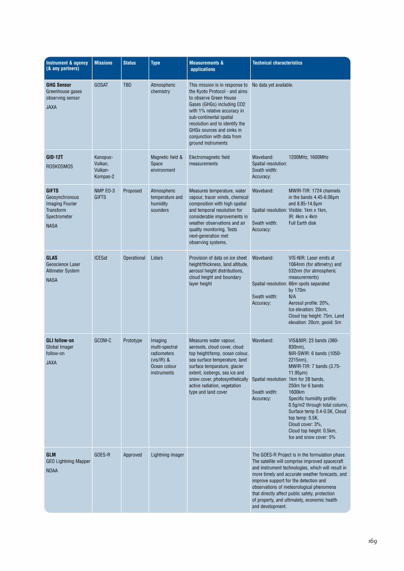
GHG SensorGreenhouse gasesobserving sensor
JAXA
GOSAT Atmosphericchemistry
TBD This mission is in response tothe Kyoto Protocol - and aimsto observe Green HouseGases (GHGs) including CO2with 1% relative accuracy insub-continental spatialresolution and to identify theGHGs sources and sinks inconjunction with data fromground instruments
No data yet available.
GID-12T
ROSKOSMOS
Kanopus-Vulkan, Vulkan-Kompas-2
Magnetic field &Spaceenvironment
Electromagnetic fieldmeasurements
Waveband: 1200MHz, 1600MHzSpatial resolution: Swath width: Accuracy:
GIFTSGeosynchronousImaging FourierTransformSpectrometer
NASA
NMP EO-3GIFTS
Atmospherictemperature andhumiditysounders
Proposed Measures temperature, watervapour, tracer winds, chemicalcomposition with high spatialand temporal resolution forconsiderable improvements inweather observations and airquality monitoring. Tests next-generation metobserving systems.
Waveband: MWIR-TIR: 1724 channelsin the bands 4.45-6.06µmand 8.85-14.6µm
Spatial resolution: Visible: 1km x 1km,IR: 4km x 4km
Swath width: Full Earth diskAccuracy:
GLASGeoscience LaserAltimeter System
NASA
ICESat LidarsOperational Provision of data on ice sheetheight/thickness, land altitude,aerosol height distributions,cloud height and boundarylayer height
Waveband: VIS-NIR: Laser emits at1064nm (for altimetry) and532nm (for atmosphericmeasurements)
Spatial resolution: 66m spots separated by 170m
Swath width: N/AAccuracy: Aerosol profile: 20%,
Ice elevation: 20cm,Cloud top height: 75m, Landelevation: 20cm, geoid: 5m
GLI follow-onGlobal Imager follow-on
JAXA
GCOM-C Imaging multi-spectralradiometers(vis/IR) &Ocean colourinstruments
Prototype Measures water vapour,aerosols, cloud cover, cloudtop height/temp, ocean colour,sea surface temperature, landsurface temparature, glacierextent, icebergs, sea ice andsnow cover, photosyntheticallyactive radiation, vegetationtype and land cover
Waveband: VIS&NIR: 23 bands (380-830nm), NIR-SWIR: 6 bands (1050-2215nm), MWIR-TIR: 7 bands (3.75-11.95µm)
Spatial resolution: 1km for 28 bands,250m for 6 bands
Swath width: 1600kmAccuracy: Specific humidity profile:
0.5g/m2 through total column,Surface temp 0.4-0.5K, Cloudtop temp: 0.5K,Cloud cover: 3%,Cloud top height: 0.5km,Ice and snow cover: 5%
GLMGEO Lightning Mapper
NOAA
GOES-R Lightning imagerApproved The GOES-R Project is in the formulation phase.The satellite will comprise improved spacecraftand instrument technologies, which will result inmore timely and accurate weather forecasts, andimprove support for the detection andobservations of meteorological phenomena that directly affect public safety, protection of property, and ultimately, economic health and development.

170
Instrument & agency(& any partners)
Missions Type Measurements &applications
Technical characteristicsStatus
GMIGPM MicrowaveImager
NASA
GPMConstellation,GPM Core
Imaging multi-spectralradiometers(passivemicrowave)
Proposed Measures rainfall rates overoceans and land, combinedrainfall structure and surfacerainfall rates with associatedlatent heating. Used toproduce three hour, daily, andmonthly total rainfall mapsover oceans and land
Waveband: Microwave: 10.65, 19.4, 21.3,37, and 85.5 GHz
Spatial resolution: Horizontal: 36 km cross-trackat 10.65 GHz (required -Primary Spacecraft, goal -Constellation Spacecraft); 10 km along-track and cross-track (goal - Primary Spacecraft)
Swath width: 800km (Primary Spacecraft)1300 km (ConstellationSpacecraft)
Accuracy: NEDT 0.5 K - 1.0 K
GMS CommsCommunicationspackage on GMS
JAXA (JMA)
GMS-5 CommunicationsPrototype Communication packageonboard GMS series satellites
Data communication only.
GOES CommsCommunicationspackage on GOES
NOAA
GOES-9,GOES-10,GOES-11,GOES-12,GOES-N,GOES-O,GOES-P,GOES-R
CommunicationsPrototype Data communication only.
GOLPEGPS Occultation andPassive reflectionExperiment
NASA
SAC-C Precision orbit &Atmospherictemperature andhumiditysounders
Operational Measurements of atmosphericeffects on GPS signals, andprecise positioninginformation to assistgravitational measurements
Waveband: Uses GPS frequencies.Spatial resolution: Swath width: Accuracy: 0.05 K or better appears
attainable
GOMEGlobal OzoneMonitoring Experiment
ESA
ERS-2 Atmosphericchemistry
Prototype Measures concentration ofO3, NO, NO2, BrO, H2O,O2/O4, plus aerosols andpolar stratospheric clouds,and other gases in specialconditions
Waveband: UV-NIR: 0.24-0.79µm(resolution 0.2-0.4nm)
Spatial resolution: Vertical: 5km (for O3),Horizontal: 40 x 40 km to40 x 320 km
Swath width: 120-960kmAccuracy:
GOME-2Global OzoneMonitoring Experiment- 2
EUMETSAT (ESA)
METOP-1,METOP-2,METOP-3
Atmosphericchemistry
Prototype Measurement of total columnamounts and stratosphericand tropospheric profiles ofozone. Also amounts of H20,NO2, OClO, BrO, SO2 andHCHO
Waveband: UV-NIR: 0.24-0.79µm(resolution 0.2-0.4nm)
Spatial resolution: Horizontal: 40 x 40 km(960km swath) to 40 x 5 km(for polarization monitoring)
Swath width: 120-960kmAccuracy: Cloud top height: 1km (rms),
Outgoing short wave radiationand solar irradiance: 5W/m2,Trace gas profile: 10-20%,Specific humidity profile: 10-50g/kg
GOMOSGlobal OzoneMonitoring byOccultation of Stars
ESA (CNES)
Envisat Atmosphericchemistry
Operational Provides stratospheric profilesof temparature and of ozone,NO2, H20, aerosols and othertrace species
Waveband: Spectrometers: UV-Vis: 248-371nm & 387-693nm,NIR:750-776nm & 915-956nm,Photometers: 644-705nm &466-528nm
Spatial resolution: 1.7km verticalSwath width: Not applicableAccuracy:

171
Instrument & agency(& any partners)
Missions Type Measurements &applications
Technical characteristicsStatus
GPS (ESA)GPS receiver
ESA
GOCE,Swarm
Precision orbitTBD Satellite positioning Used for precision satellite positioning only –not an Earth observing instrument.
GPS (GRACE)Global PositioningSystem Receiver
NASA
GRACE Microwave: 1227.60MHz,1575.42MHz
Used for precision satellite positioning only –not an Earth observing instrument.
GPS receiver
CRCSS
FedSat Precision orbit &Atmospherictemperature andhumiditysounders
Operational Sounding data for study ofphysics of upper atmosphere,and water vapour, temparatureand refractivity profiles
Waveband: Spatial resolution: 1 sample every 30 secsSwath width: Accuracy:
GPSDRGPS DemonstrationReceiver
CONAE (NASA)
Topex-Poseidon
Precision orbit &Atmospherictemperature andhumiditysounders
Operational Provides precise continuoustracking data of satellite todecimeter accuracy
Used for precision satellite positioning only –not an Earth observing instrument.
GRASGNSS Receiver forAtmospheric Sounding
EUMETSAT (ESA)
METOP-1,METOP-2,METOP-3
Atmospherictemperature andhumiditysounders &Precision orbit
Prototype GNSS receiver foratmospheric temperature andhumidty profile sounding
Waveband: Spatial resolution: Vertical: 150m
(trophosphere) and 1.5km(stratosphere), Horizontal: 100km approx(troposphere), 300kmapprox (stratosphere)
Swath width: Altitude range of 5-30kmAccuracy: Temperature sounding to
1K rms
HAIRSHigh Accuracy Inter-satellite RangingSystem
NASA
GRACE GravityOperational Ranging instrument betweenthe 2 GRACE spacecraft - toderive Earth gravity fieldmeasurements
Waveband: Microwave: K Band, Ka BandSpatial resolution: Swath width: Accuracy: 10 microns total at twice
per revolution
HALOEHalogen OccultationExperiment
NASA
UARS Atmosphericchemistry
Operational Provides data on verticaldistributions of hydrofluoricand hydrochloric acids,methane, water vapour andmembers of the nitrogenfamily. It also providesatmospheric temperatureversus pressure profiles fromobservations of carbon dioxide
Waveband: channels between 2.4µm -10µm, SWIR - TIR
Spatial resolution: 2km-4kmSwath width: Accuracy: HCL: 12-24%, HF: 15-27%,
CH4: 6-27%, NO: 14-30%,H2O: 14-30%, O3: 9-25%,NO2: 9-21%: Temperature: 3-5K,Aerosol Extinction: < 30%
HESHyperspectralEnvironmental Suite
NOAA
GOES-R Imaging multi-spectralradiometers(vis/IR)
Approved Will sense emitted thermalenergy and reflected solarenergy from sampled areas ofthe Earth's surface andatmosphere. These data areused to compute verticalprofiles of temperature andmoisture, surface and cloud-top temperatures, and winds,and provide information aboutthe Earth surface and oceans
The GOES-R Project is in the formulation phase.The satellite will comprise improved spacecraftand instrument technologies, which will result inmore timely and accurate weather forecasts, andimprove support for the detection andobservations of meteorological phenomena thatdirectly affect public safety, protection ofproperty, and ultimately, economic health anddevelopment.
172
Instrument & agency(& any partners)
Missions Type Measurements &applications
Technical characteristicsStatus
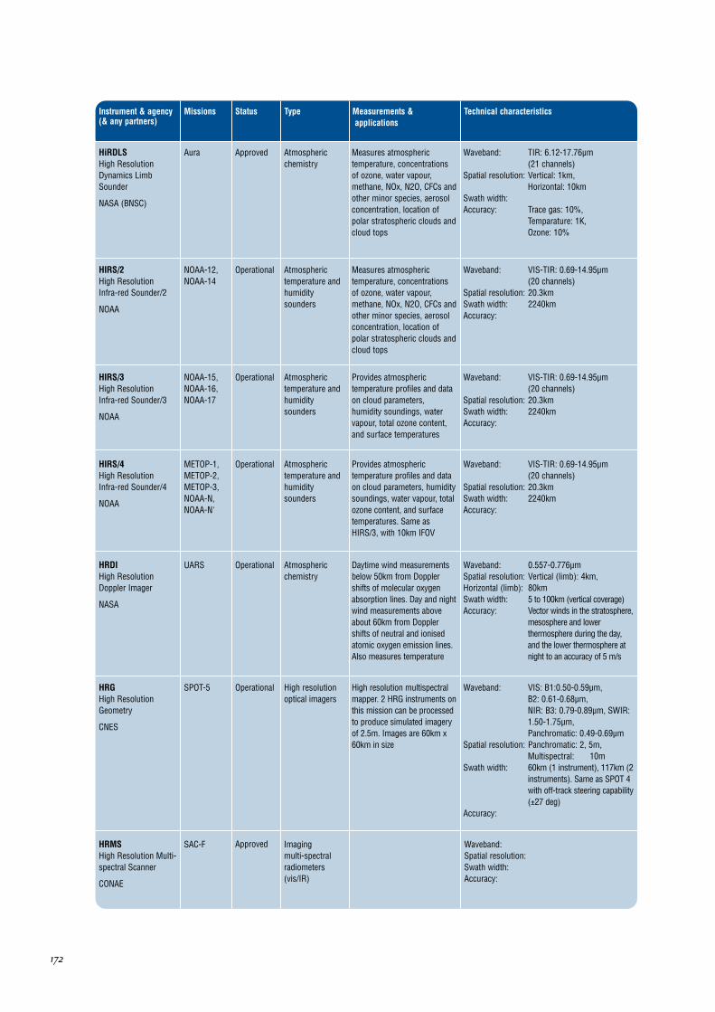
HiRDLSHigh ResolutionDynamics LimbSounder
NASA (BNSC)
Aura Atmosphericchemistry
Approved Measures atmospherictemperature, concentrationsof ozone, water vapour,methane, NOx, N2O, CFCs andother minor species, aerosolconcentration, location ofpolar stratospheric clouds andcloud tops
Waveband: TIR: 6.12-17.76µm (21 channels)
Spatial resolution: Vertical: 1km,Horizontal: 10km
Swath width: Accuracy: Trace gas: 10%,
Temparature: 1K,Ozone: 10%
HIRS/2High ResolutionInfra-red Sounder/2
NOAA
NOAA-12,NOAA-14
Atmospherictemperature andhumiditysounders
Operational Measures atmospherictemperature, concentrationsof ozone, water vapour,methane, NOx, N2O, CFCs andother minor species, aerosolconcentration, location ofpolar stratospheric clouds andcloud tops
Waveband: VIS-TIR: 0.69-14.95µm(20 channels)
Spatial resolution: 20.3kmSwath width: 2240kmAccuracy:
HIRS/3High ResolutionInfra-red Sounder/3
NOAA
NOAA-15,NOAA-16,NOAA-17
Atmospherictemperature andhumiditysounders
Operational Provides atmospherictemperature profiles and dataon cloud parameters,humidity soundings, watervapour, total ozone content,and surface temperatures
Waveband: VIS-TIR: 0.69-14.95µm (20 channels)
Spatial resolution: 20.3kmSwath width: 2240kmAccuracy:
HIRS/4High Resolution Infra-red Sounder/4
NOAA
METOP-1,METOP-2,METOP-3,NOAA-N,NOAA-N'
Atmospherictemperature andhumiditysounders
Operational Provides atmospherictemperature profiles and dataon cloud parameters, humiditysoundings, water vapour, totalozone content, and surfacetemperatures. Same asHIRS/3, with 10km IFOV
Waveband: VIS-TIR: 0.69-14.95µm (20 channels)
Spatial resolution: 20.3kmSwath width: 2240kmAccuracy:
HRDIHigh ResolutionDoppler Imager
NASA
UARS Atmosphericchemistry
Operational Daytime wind measurementsbelow 50km from Dopplershifts of molecular oxygenabsorption lines. Day and nightwind measurements aboveabout 60km from Dopplershifts of neutral and ionisedatomic oxygen emission lines.Also measures temperature
Waveband: 0.557-0.776µmSpatial resolution: Vertical (limb): 4km,Horizontal (limb): 80kmSwath width: 5 to 100km (vertical coverage)Accuracy: Vector winds in the stratosphere,
mesosphere and lowerthermosphere during the day,and the lower thermosphere atnight to an accuracy of 5 m/s
HRGHigh ResolutionGeometry
CNES
SPOT-5 High resolutionoptical imagers
Operational High resolution multispectralmapper. 2 HRG instruments onthis mission can be processedto produce simulated imageryof 2.5m. Images are 60km x60km in size
Waveband: VIS: B1:0.50-0.59µm, B2: 0.61-0.68µm,NIR: B3: 0.79-0.89µm, SWIR:1.50-1.75µm,Panchromatic: 0.49-0.69µm
Spatial resolution: Panchromatic: 2, 5m,Multispectral: 10m
Swath width: 60km (1 instrument), 117km (2instruments). Same as SPOT 4with off-track steering capability(±27 deg)
Accuracy:
HRMSHigh Resolution Multi-spectral Scanner
CONAE
SAC-F Imaging multi-spectralradiometers(vis/IR)
Approved Waveband: Spatial resolution: Swath width: Accuracy:
173
Instrument & agency(& any partners)
Missions Type Measurements &applications
Technical characteristicsStatus
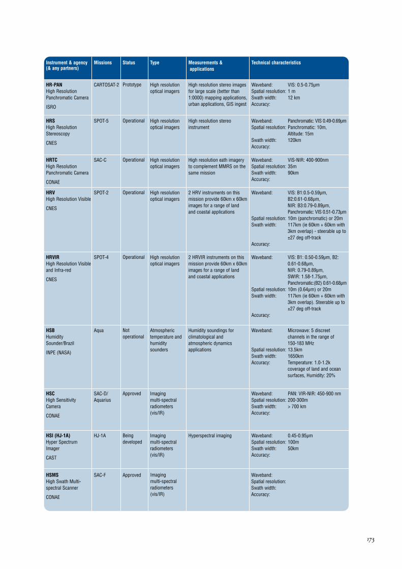
HR-PANHigh ResolutionPanchromatic Camera
ISRO
CARTOSAT-2 High resolutionoptical imagers
Prototype High resolution stereo imagesfor large scale (better than1:0000) mapping applications,urban applications, GIS ingest
Waveband: VIS: 0.5-0.75µmSpatial resolution: 1 mSwath width: 12 kmAccuracy:
HRSHigh ResolutionStereoscopy
CNES
SPOT-5 High resolutionoptical imagers
Operational High resolution stereoinstrument
Waveband: Panchromatic: VIS 0.49-0.69µmSpatial resolution: Panchromatic: 10m,
Altitude: 15mSwath width: 120kmAccuracy:
HRTCHigh ResolutionPanchromatic Camera
CONAE
SAC-C High resolutionoptical imagers
Operational High resolution eath imageryto complement MMRS on thesame mission
Waveband: VIS-NIR: 400-900nmSpatial resolution: 35mSwath width: 90kmAccuracy:
HRVHigh Resolution Visible
CNES
SPOT-2 High resolutionoptical imagers
Operational 2 HRV instruments on thismission provide 60km x 60kmimages for a range of landand coastal applications
Waveband: VIS: B1:0.5-0.59µm,B2:0.61-0.68µm,NIR: B3:0.79-0.89µm,Panchromatic: VIS 0.51-0.73µm
Spatial resolution: 10m (panchromatic) or 20mSwath width: 117km (ie 60km + 60km with
3km overlap) - steerable up to±27 deg off-track
Accuracy:
HRVIRHigh Resolution Visibleand Infra-red
CNES
SPOT-4 High resolutionoptical imagers
Operational 2 HRVIR instruments on thismission provide 60km x 60kmimages for a range of landand coastal applications
Waveband: VIS: B1: 0.50-0.59µm, B2:0.61-0.68µm,NIR: 0.79-0.89µm,SWIR: 1.58-1.75µm,Panchromatic:(B2) 0.61-0.68µm
Spatial resolution: 10m (0.64µm) or 20mSwath width: 117km (ie 60km + 60km with
3km overlap). Steerable up to±27 deg off-track
Accuracy:
HSBHumiditySounder/Brazil
INPE (NASA)
Aqua Atmospherictemperature andhumiditysounders
Notoperational
Humidity soundings forclimatological andatmospheric dynamicsapplications
Waveband: Microwave: 5 discreetchannels in the range of 150-183 MHz
Spatial resolution: 13.5kmSwath width: 1650kmAccuracy: Temperature: 1.0-1.2k
coverage of land and oceansurfaces, Humidity: 20%
HSCHigh SensitivityCamera
CONAE
SAC-D/Aquarius
Imaging multi-spectralradiometers(vis/IR)
Approved Waveband: PAN: VIR-NIR: 450-900 nmSpatial resolution: 200-300mSwath width: > 700 kmAccuracy:
HSI (HJ-1A)Hyper SpectrumImager
CAST
HJ-1A Imaging multi-spectralradiometers(vis/IR)
Beingdeveloped
Hyperspectral imaging Waveband: 0.45-0.95µmSpatial resolution: 100mSwath width: 50kmAccuracy:
HSMSHigh Swath Multi-spectral Scanner
CONAE
SAC-F Imaging multi-spectralradiometers(vis/IR)
Approved Waveband: Spatial resolution: Swath width: Accuracy:

174
Instrument & agency(& any partners)
Missions Type Measurements &applications
Technical characteristicsStatus
HSRSHot Spot RecognitionSystem
DLR
BIRD Imaging multi-spectralradiometers(vis/IR)
Operational Hot spot Detection (vegetationfires, volcanic activities,burning oil wells or coal seams
Waveband: MWIR: 3.4-4.2µm, TIR: 8.4-9.3µm
Spatial resolution: 370mSwath width: 190kmAccuracy:
HSSHyper-spectral Scanner
CONAE
SAC-F Imaging multi-spectralradiometers(vis/IR)
Approved Hyperspectral imaging Waveband: Spatial resolution: Swath width: Accuracy:
HSTCHigh SensitivityTechnological Camera
CONAE
SAC-C Imaging multi-spectralradiometers(vis/IR)
Operational Provides data to Monitorforest fires, electrical stormsand geophysical studies ofaurora borealis
Waveband: PAN: VIS-NIR: 450-850nmSpatial resolution: 250mSwath width: 900kmAccuracy:
HYCHYperspectral Camera
ASI
HyperspectralMission
Imaging multi-spectralradiometers(vis/IR)
TBD Pancromatic andHyperspectral data for complexland ecosystem studies
Waveband: VIS-NIR:400-900 nm, 400-1000nm;SWIR: 900-2500nm;Spectral resolution 10 nm,220 bands
Spatial resolution: PAN: 5m ; VNIR-SWIR:20m;Swath width: 20 KmAccuracy:
HYDROS
NASA
HYDROS Multipledirection/polarisationradiometers
Proposed Microwave measurement ofsoil moisture and freeze/thawtimeline
Waveband: 1.26 GHz for the radar and1.41 GHz for the radiometerand will be capable of bothhorizontal and verticalpolarizations
Spatial resolution: Radar 3km&10km,Radiometer 40km
Swath width: 1000kmAccuracy:
HyperionHyperspectral Imager
NASA
NMP EO-1 Imaging multi-spectralradiometers(vis/IR)
Operational Hyperspectral imaging of landsurfaces
Waveband: VIS-NIR: 400-1000nm;NIR-SWIR: 900-2500nm;10nm spectral resolution for220 bands
Spatial resolution: 30mSwath width: 7.5kmAccuracy: SNR @ 10% refl target:
vis 10-40 swir 10-20
IASIInfra-red AtmosphericSoundingInterferometer
CNES (EUMETSAT)
METOP-1,METOP-2,METOP-3
Atmospherictemperature andhumiditysounders &Atmosphericchemistryinstruments
Beingdeveloped
Measures troposphericmoisture and temperature,column integrated contents ofozone, carbon monoxide,methane, dinitrogen oxide andother minor gases whichaffect tropospheric chemistry.Also measures sea surfaceand land temperature
Waveband: MWIR-TIR: 3.4-15.5µm withgaps at 5µm and 9µm
Spatial resolution: Vertical: 1-30km,Horizontal: 25km
Swath width: 2052kmAccuracy: Temperature: 0.5-2K,
Specific humidity: 0.1-0.3g/kg,Ozone, trace gas profile: 10%
IAPInstrument for plasmaanalysis
CNES
DEMETER SpaceEnvironment
Operational Density, temperatures, speedsof major ions
Waveband: Spatial resolution: Swath width: Accuracy: Ion density: +5%,
Temperature +5%, Speed +5%

175
Instrument & agency(& any partners)
Missions Type Measurements &applications
Technical characteristics
ICAREInfluence of SpaceRadiation on AdvancedComponents
CNES
SAC-C, SAC-D/Aquarius
SpaceEnvironment
Status
Operational Improvement of riskestimation models on latestgeneration of integratedcircuits technology
Will measure high energy radiation environment,trapped particle intensities and energydistribution and correlate them with advancedelectronic components degradation. ICARE will beable to conduct regular environmentcharacterization campaigns for ten days every sixmonths and exceptional ones during solar events.
ICEInstrument for ElectricField
CNES
DEMETER SpaceEnvironment
Operational Electric field Waveband: DC to 3MHzSpatial resolution: Swath width: Accuracy: DC field +3mV/m
IDPInstrument For PlasmaDetection
CNES
DEMETER SpaceEnvironment
Operational Energy spectrum of electrons Waveband: Spatial resolution: Swath width: Accuracy:
IGPM radiometerIGPM microwaveradiometer
ASI
IGPM Imaging multi-spectralradiometers(passivemicrowave)
TBD Global water and energy cycle No data available yet.
IIRImaging infraredradiometer
CNES
CALIPSO Imaging multi-spectralradiometers(vis/IR)
TBD Radiometer optimized forcombined IIR/lidar retrievalsof cirrus particle size
Waveband: TIR: 8.7, 10.5, and 12.0 µm(08.µm resolution)
Spatial resolution: 1kmSwath width: 64kmAccuracy: 1K
IKFS-2Fourier spectrometer
ROSHYDROMET
METEOR-3MN2, Meteor-M No1,Meteor-M No2
Atmospherictemperature andhumiditysounders
TBD Atmospheric temperature andhumidity sounding andradiation budget assessment
Waveband: 5-15µm, 1300 spectral channelsSpatial resolution: Swath width: 2500kmAccuracy: 1K
IKOR-MThe modernizedmeasuring instrumentof short-wave reflectedradiation
ROSKOSMOS
Meteor-M No1,Meteor-M No2
Earth radiationbudgetradiometer
Waveband: Spatial resolution: Swath width: Accuracy:
Imager
NOAA
GOES-9,GOES-10,GOES-11,GOES-12,GOES-N,GOES-O,GOES-P,GOES-R
Imaging multi-spectralradiometers(vis/IR)
Operational Measures cloud cover,atmospheric radiance, winds,atmospheric stability, rainfallestimates. Used to providesevere storm warnings/monitoring day and night(type, amount, storm features)
Waveband: GOES 8-12; N,O,P: VIS: 1channel (8 detectors), IR: 4channels: 3.9, 6.7, 10.7 and12µm, GOES 12-Q: VIS: 1channel (8 detectors), IR: 4channels: 3.9, 6.7, 10.7 and13.3µm
Spatial resolution: 1km in visible 4km in IR (8kmfor 13.3µm band (water vapour))
Swath width: Full Earth diskAccuracy:
IGPM rain radar
ASI
IGPM Cloud profile andrain radars
TBD Global water and energy cycle No data available yet.

176
Instrument & agency(& any partners)
Missions Type Measurements &applications
Technical characteristics
Imager (INSAT)
ISRO
INSAT-3D Imaging multi-spectralradiometers(vis/IR)
Status
TBD Cloud cover, severe stormwarnings/monitoring day andnight (type, amount, stormfeatures), atmosphericradiance winds, atmosphericstability rainfall
Waveband: VIS: 0.55-0.75µm,SWIR: 1.55-1.7µm,MWIR: 3.80-4.00µm,6.50-7.00µm,TIR: 10.2-11.3µm, 11.5-12.5µm
Spatial resolution: 1x1km (VIS & SWIR), 4x4km(MWIR, TIR), 8x8km (in 6.50-7.00µm)
Swath width: Full Earth disc and spacearound, Normal Frame (50deg. N to 40 deg. S and full E-W coverage), Program Frame(Programmable, E-W Fullcoverage)
Accuracy:
IMAGER/MTSAT-1RImager/MTSAT
JMA
MTSAT-1R Imaging multi-spectralradiometers(vis/IR)
Prototype Measures cloud cover, cloudmotion, cloud height, watervapour, rainfall, sea surfacetemparature and Earth radiation
Waveband: VIS-SWIR: 0.55-0.90µm,MWIR-TIR: 3.5-4µm, 6.5-7µm,10.5-11.3µm, 11.5-12.5µm
Spatial resolution: Visible: 1km, TIR: 4kmSwath width: Full Earth disk every hourAccuracy:
IMAGER/MTSAT-2Imager/MTSAT
JMA
MTSAT-2 Imaging multi-spectralradiometers(vis/IR)
Prototype Measures cloud cover, cloudmotion, cloud height, watervapour, rainfall, sea surfacetemparature and Earth radiation
Waveband: VIS-SWIR: 0.55-0.90µm,MWIR-TIR: 3.5-4µm, 6.5-7µm, 10.5-11.3µm, 11.5-12.5µm
Spatial resolution: Visible: 1km, TIR: 4kmSwath width: Full Earth disk every hourAccuracy:
IMSCInstrument Search CoilMagnetometer
CNES
DEMETER Magnetic fieldOperational Magnetic field Waveband: 10Hz - 17.4kHzSpatial resolution: Swath width: Accuracy:
IMWTSImproved MicroWaveTemperature Sounder
NRSCC (CAST)
FY-3C,FY-3D,FY-3E,FY-3F,FY-3G
Atmospherictemperature andhumiditysounders
Approved Atmospheric temperaturesoundings for meteorologicalapplications
Waveband: Microwave: 50-57GHz(4channels)
Spatial resolution: 50kmSwath width: ±48ºAccuracy:
INESItalian NavigationExperiment
ASI
SAC-C Precision orbitOperational Composed of GPS Tensor andGNSS Lagrange Receiver toperform navigation experimenton precise orbit determination
Precision positioning only – not an Earthobserving instrument.
IR (HJ-1B)Infrared Camera
CAST
HJ-1B Imaging multi-spectralradiometers(vis/IR)
Beingdeveloped
Global environmentalapplications
Waveband: 0.75~1.10, 1.55~1.75, 3.50~3.90, 10.5 ~12.5µm
Spatial resolution: 300m (10.5~12.5_m), 150m (the other bands)
Swath width: 720kmAccuracy:
IR Camera (SAOCOM)
CONAE
SAOCOM 1A,SAOCOM 1B,SAOCOM-2B(1),SAOCOM-2B(2)
Imaging multi-spectralradiometers(vis/IR)
Beingdeveloped
Fires monitoring Waveband: NIR-TIRSpatial resolution: 200mSwath width: Accuracy:
177
Instrument & agency(& any partners)
Missions Type Measurements &applications
Technical characteristics
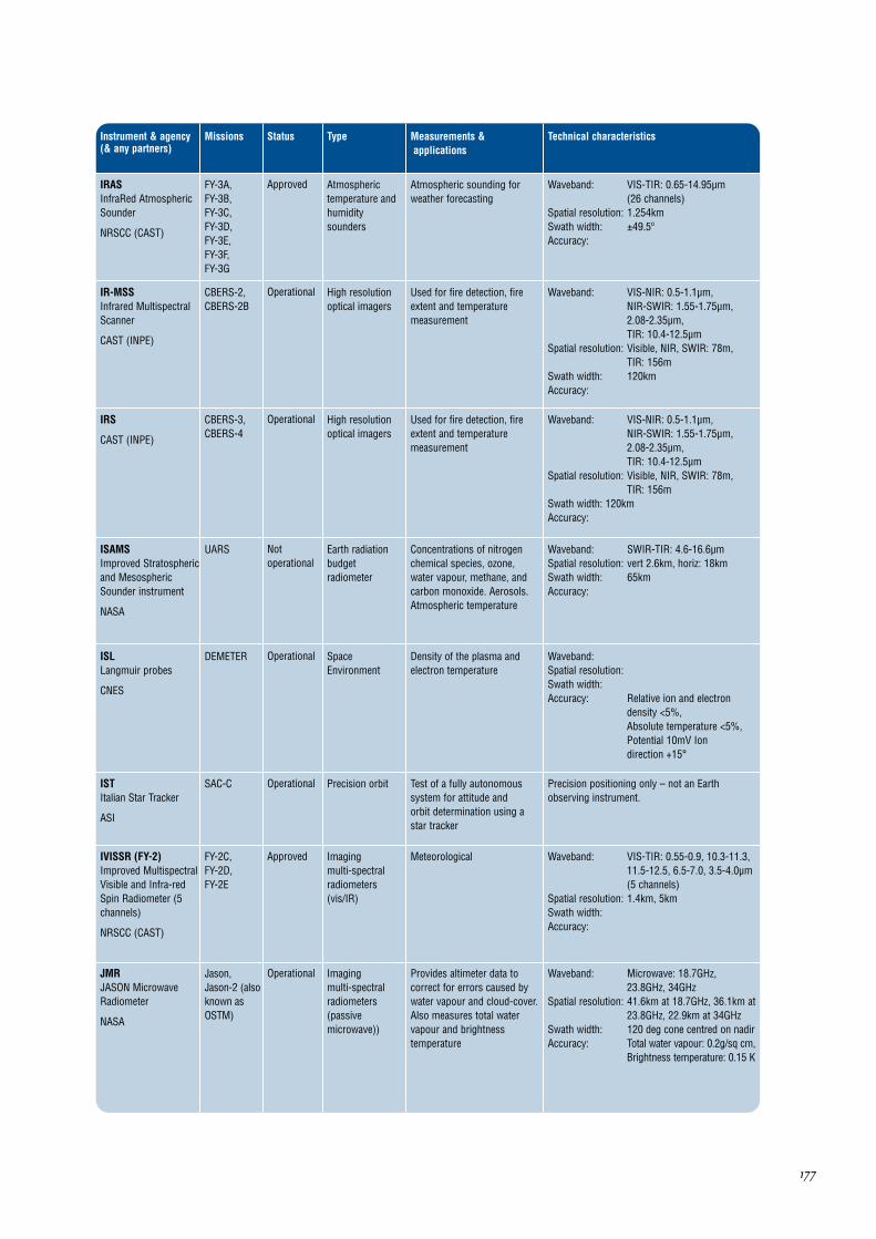
IRASInfraRed AtmosphericSounder
NRSCC (CAST)
FY-3A,FY-3B,FY-3C,FY-3D,FY-3E,FY-3F,FY-3G
Atmospherictemperature andhumiditysounders
Status
Approved Atmospheric sounding forweather forecasting
Waveband: VIS-TIR: 0.65-14.95µm (26 channels)
Spatial resolution: 1.254kmSwath width: ±49.5ºAccuracy:
IR-MSSInfrared MultispectralScanner
CAST (INPE)
CBERS-2,CBERS-2B
High resolutionoptical imagers
Operational Used for fire detection, fireextent and temperaturemeasurement
Waveband: VIS-NIR: 0.5-1.1µm,NIR-SWIR: 1.55-1.75µm,2.08-2.35µm,TIR: 10.4-12.5µm
Spatial resolution: Visible, NIR, SWIR: 78m,TIR: 156m
Swath width: 120kmAccuracy:
IRS
CAST (INPE)
CBERS-3,CBERS-4
High resolutionoptical imagers
Operational Used for fire detection, fireextent and temperaturemeasurement
Waveband: VIS-NIR: 0.5-1.1µm,NIR-SWIR: 1.55-1.75µm,2.08-2.35µm,TIR: 10.4-12.5µm
Spatial resolution: Visible, NIR, SWIR: 78m,TIR: 156m
Swath width: 120kmAccuracy:
ISAMSImproved Stratosphericand MesosphericSounder instrument
NASA
UARS Earth radiationbudgetradiometer
Notoperational
Concentrations of nitrogenchemical species, ozone,water vapour, methane, andcarbon monoxide. Aerosols.Atmospheric temperature
Waveband: SWIR-TIR: 4.6-16.6µmSpatial resolution: vert 2.6km, horiz: 18kmSwath width: 65kmAccuracy:
ISLLangmuir probes
CNES
DEMETER SpaceEnvironment
Operational Density of the plasma andelectron temperature
Waveband: Spatial resolution: Swath width: Accuracy: Relative ion and electron
density <5%,Absolute temperature <5%,Potential 10mV Ion direction +15°
ISTItalian Star Tracker
ASI
SAC-C Precision orbitOperational Test of a fully autonomoussystem for attitude and orbit determination using astar tracker
Precision positioning only – not an Earthobserving instrument.
IVISSR (FY-2)Improved MultispectralVisible and Infra-redSpin Radiometer (5channels)
NRSCC (CAST)
FY-2C,FY-2D,FY-2E
Imaging multi-spectralradiometers(vis/IR)
Approved Meteorological Waveband: VIS-TIR: 0.55-0.9, 10.3-11.3,11.5-12.5, 6.5-7.0, 3.5-4.0µm(5 channels)
Spatial resolution: 1.4km, 5kmSwath width: Accuracy:
JMRJASON MicrowaveRadiometer
NASA
Jason,Jason-2 (alsoknown asOSTM)
Imaging multi-spectralradiometers(passivemicrowave))
Operational Provides altimeter data tocorrect for errors caused bywater vapour and cloud-cover.Also measures total watervapour and brightnesstemperature
Waveband: Microwave: 18.7GHz,23.8GHz, 34GHz
Spatial resolution: 41.6km at 18.7GHz, 36.1km at23.8GHz, 22.9km at 34GHz
Swath width: 120 deg cone centred on nadirAccuracy: Total water vapour: 0.2g/sq cm,
Brightness temperature: 0.15 K
178
Instrument & agency(& any partners)
Missions Type Measurements &applications
Technical characteristics
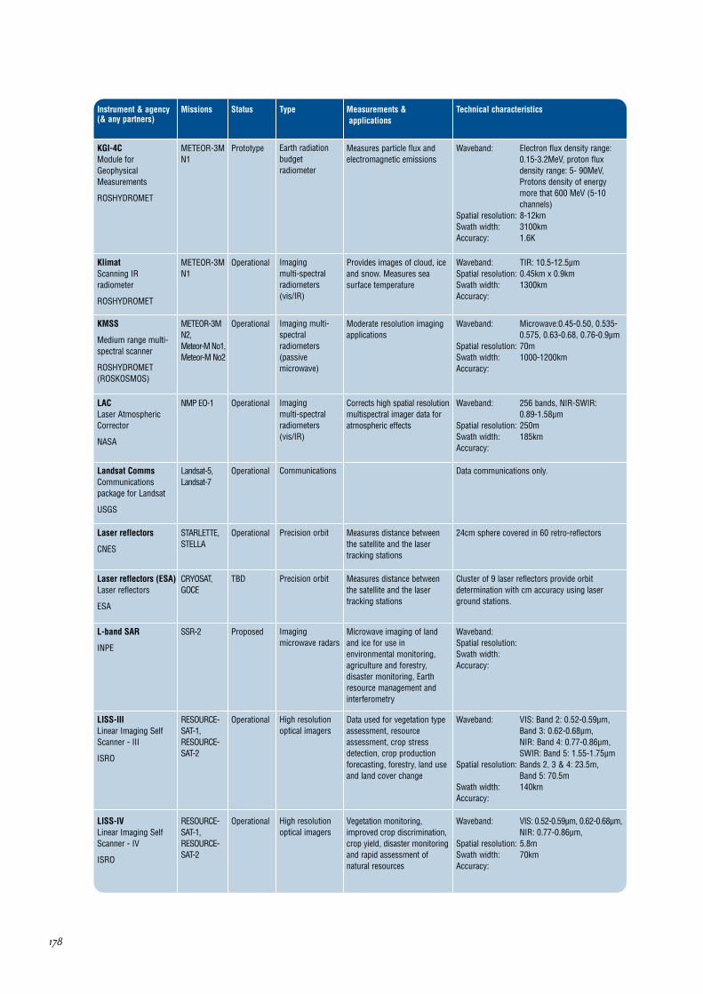
KGI-4CModule forGeophysicalMeasurements
ROSHYDROMET
METEOR-3MN1
Earth radiationbudgetradiometer
Status
Prototype Measures particle flux andelectromagnetic emissions
Waveband: Electron flux density range:0.15-3.2MeV, proton fluxdensity range: 5- 90MeV,Protons density of energymore that 600 MeV (5-10channels)
Spatial resolution: 8-12kmSwath width: 3100kmAccuracy: 1.6K
KlimatScanning IRradiometer
ROSHYDROMET
METEOR-3MN1
Imaging multi-spectralradiometers(vis/IR)
Operational Provides images of cloud, iceand snow. Measures seasurface temperature
Waveband: TIR: 10.5-12.5µmSpatial resolution: 0.45km x 0.9kmSwath width: 1300kmAccuracy:
KMSS
Medium range multi-spectral scanner
ROSHYDROMET(ROSKOSMOS)
METEOR-3MN2,Meteor-M No1,Meteor-M No2
Imaging multi-spectralradiometers(passivemicrowave)
Operational Moderate resolution imagingapplications
Waveband: Microwave:0.45-0.50, 0.535-0.575, 0.63-0.68, 0.76-0.9µm
Spatial resolution: 70mSwath width: 1000-1200kmAccuracy:
LACLaser AtmosphericCorrector
NASA
NMP EO-1 Imaging multi-spectralradiometers(vis/IR)
Operational Corrects high spatial resolutionmultispectral imager data foratmospheric effects
Waveband: 256 bands, NIR-SWIR:0.89-1.58µm
Spatial resolution: 250mSwath width: 185kmAccuracy:
Landsat CommsCommunicationspackage for Landsat
USGS
Landsat-5,Landsat-7
CommunicationsOperational Data communications only.
Laser reflectors
CNES
STARLETTE,STELLA
Precision orbitOperational Measures distance betweenthe satellite and the lasertracking stations
24cm sphere covered in 60 retro-reflectors
Laser reflectors (ESA)Laser reflectors
ESA
CRYOSAT,GOCE
Precision orbitTBD Measures distance betweenthe satellite and the lasertracking stations
Cluster of 9 laser reflectors provide orbitdetermination with cm accuracy using laserground stations.
L-band SAR
INPE
SSR-2 Imagingmicrowave radars
Proposed Microwave imaging of landand ice for use inenvironmental monitoring,agriculture and forestry,disaster monitoring, Earthresource management andinterferometry
Waveband: Spatial resolution: Swath width: Accuracy:
LISS-IVLinear Imaging SelfScanner - IV
ISRO
RESOURCE-SAT-1,RESOURCE-SAT-2
High resolutionoptical imagers
Operational Vegetation monitoring,improved crop discrimination,crop yield, disaster monitoringand rapid assessment ofnatural resources
Waveband: VIS: 0.52-0.59µm, 0.62-0.68µm,NIR: 0.77-0.86µm,
Spatial resolution: 5.8mSwath width: 70kmAccuracy:
LISS-IIILinear Imaging SelfScanner - III
ISRO
RESOURCE-SAT-1,RESOURCE-SAT-2
High resolutionoptical imagers
Operational Data used for vegetation typeassessment, resourceassessment, crop stressdetection, crop productionforecasting, forestry, land useand land cover change
Waveband: VIS: Band 2: 0.52-0.59µm,Band 3: 0.62-0.68µm, NIR: Band 4: 0.77-0.86µm,SWIR: Band 5: 1.55-1.75µm
Spatial resolution: Bands 2, 3 & 4: 23.5m, Band 5: 70.5m
Swath width: 140kmAccuracy:

179
Instrument & agency(& any partners)
Missions Type Measurements &applications
Technical characteristics
LRALaser RetroreflectorArray
NASA (ASI)
Jason,Jason-2 (alsoknown asOSTM),Topex-Poseidon
Precision orbit
Status
Operational Provides baseline trackingdata for precision orbitdetermination and/or geodesy.Also for calibration of radaraltimeter bias. Several typesused on various missions.(ASI involved in LAGEOS 2development)
The LRA is an array of mirrors that provide atarget for laser tracking measurements from theground. By analyzing the round-trip time of thelaser beam, we can locate very precisely wherethe satellite is on its orbit.
LRA (LAGEOS)Laser RetroreflectorArray
NASA (ASI)
LAGEOS-1,LAGEOS-2,LAGEOS-3
Precision orbitBeingdeveloped
Provides baseline trackingdata for precision geodesy.Also for calibration of radaraltimeter bias. Several typesused on various missions.(ASI involved in LAGEOS 2development)
The LAGEOS satellites are passive vehiclescovered with retro-reflectors designed to reflectlaser beams transmitted from ground stations.Accuracy: 2cm overhead ranging
L-SARL-Band SAR
BNSC
TerraSAR-L Imagingmicrowave radars
Prototype L-Band Sar for agriculture andforestry
Waveband: Microwave: L-band (2GHz)Spatial resolution: 5mSwath width: 10-200km depending on modeAccuracy:
MADRAS
CNES
MEGHA-TROPIQUES
Imaging multi-spectralradiometers(passivemicrowave)
Operational Studies precipitation andclouds properties
Data not yet available.
MAESTROMeasurements ofAerosol Extinction inthe Stratosphere andTroposphere Retrievedby Occultation
CSA
SCISAT-1 Atmosphericchemistry
Operational Will aid in the SCISAT-1 overallmission of increasing ourunderstanding of the chemicalprocesses involved in thedepletion of the ozone layer
Waveband: UV-NIR: 0.285 to 1.03um (1-2nm spectral resolution)
Spatial resolution: Approx 1km verticalSwath width: Accuracy:
Magnetometer(NOAA)
NOAA
GOES-R Magnetic fieldApproved Measures magnitude anddirection of Earth's ambientmagnetic field in threeorthogonal directions in anEarth referenced coordinatesystem. Will provide a map ofthe space environment thatcontrols charged particledynamics in the outer regionof the magnetosphere
The GOES-R Project is in the formulation phase.The satellite will comprise improved spacecraftand instrument technologies, which will result inmore timely and accurate weather forecasts, andimprove support for the detection andobservations of meteorological phenomena thatdirectly affect public safety, protection of property,and ultimately, economic health and development.
MASTER
ESA
ESA FutureMissions
Atmospherictemperature andhumiditysounders &Atmosphericchemistryinstruments
TBD Data for study of exchangemechanisms betweenstratosphere/troposphere, andinformation for studies onglobal change. Measuresupper troposphere/ lowerstratosphere profiles of O3,H2O, CO, HNO3, SO2, N2O,pressure and temperature
Waveband: Microwave: 199-207, 296-306,318-326, 342-348GHz
Spatial resolution: 3kmSwath width: Accuracy: 199-207GHz channel: 1K,
Other channels: 1.5K, 50MHzresolution, 0.3 secs integrationtime
MBEIMulti-band EarthImager
NSAU
SICH-2 High resolutionoptical imagers
Approved Multispectral scanner imagesof land surface
Waveband: VIS-NIR: 0.50-0.885µm, VIS: 0.50-0.59, 0.605-0.68µm,NIR: 0.785-0.885µm
Spatial resolution: 7.8mSwath width: 46.6km pointable ±35° from
nadirAccuracy:

180
Instrument & agency(& any partners)
Missions Type Measurements &applications
Technical characteristics
MCPMeteorologicalCommunicationsPackage (MCP)
EUMETSAT
METOP-1,METOP-2,METOP-3
Communications
Status
TBD MeteorologicalCommunications Package(MCP) onboard METOP seriessatellites
Data communication only.
MERSIModerate ResolutionSpectral Imager
NRSCC (CAST)
FY-3A,FY-3B,FY-3C,FY-3D,FY-3E,FY-3F,FY-3G
Imaging multi-spectralradiometers(vis/IR)
Approved Measures surface temperatureand cloud and ice cover. Usedfor snow and floodmonitoring and surfacetemperature
Waveband: VIS-TIR: 0.47-12.5µm (20channels)
Spatial resolution: 250m-1.1kmSwath width: 3200kmAccuracy:
METEOSAT CommsCommunicationspackage forMETEOSAT
EUMETSAT
METEOSAT-5,METEOSAT-6,METEOSAT-7
CommunicationsPrototype Communication packageonboard METEOSAT seriessatellites
Data communication only.
MHSMicrowave HumiditySounder
EUMETSAT
METOP-1,METOP-2,METOP-3,NOAA-N,NOAA-N'
Atmospherictemperature andhumiditysounders
Prototype Provides atmospherichumidity profiles, cloud cover,cloud liquid, water content,ice boundaries andprecipitation data
Waveband: Microwave: 89, 166GHz and 3channels near 183Ghz
Spatial resolution: Vertical: 3-7km, Horizontal: 30-50km
Swath width: 1650kmAccuracy: Cloud water profile: 10g/m2,
Specific humidity profile: 10-20%
MIPASMichelsonInterferometric PassiveAtmosphere Sounder
ESA
Envisat Atmosphericchemistryinstruments &Atmospherictemperature andhumiditysounders
Operational Provides data on stratospherechemistry (global/polarozone), climate research(trace gases/clouds),transport dynamics,tropospheric chemistry.Primary/secondary species:O3, NO, NO2, HNO3, N2O5,ClONO2, CH4
Waveband: MWIR-TIR: between 4.15 and14.6µm
Spatial resolution: Vertical resolution: 3km,vertical scan range 5-150km,Horizontal: 3km x 30km,Spectral resolution: 0.035 lines/cm
Swath width: Accuracy: Radiometric precision: 685-
970cm-1: 1%, 2410 cm-1: 3%
MIRAS (SMOS)2-D Passive L-BandMicrowaveInterferometer
ESA
SMOS Multipledirection/polarisation radiometers &Imaging multi-spectralradiometers(passivemicrowave)
Proposed Objective is to demonstrateobservations of sea surfacesalinity and soil moisture insuport of climate,meteorology, hydrology, andoceanography applications.
Waveband: Microwave: L-Band 1.41GHz(based on MIRAS concept)
Spatial resolution: Requirements: Soil moisture:30km (desired), Sea surfacesalinity: 200km (desired)
Swath width: 934km (at 756km altitude),allowing a 3 day revisit time atthe equator
Accuracy: Radiometric accuracy: 3.5Kfor land, 2.5K for sea
MIRASMultichannel InfraredAtmospheric Sounder
NRSCC (CAST)
FY-3C,FY-3D,FY-3E,FY-3F, FY-3G
Imaging multi-spectralradiometers(passivemicrowave)
Prototype Atmospheric sounding forweather forecasting
No data available
MERISMedium-ResolutionImaging Spectrometer
ESA
Envisat Imaging multi-spectralradiometers(vis/IR)
Operational Main objective is monitoringmarine biophysical andbiochemical parameters.Secondary objectives arerelated to atmosphericproperties such as cloud andwater vapour and to vegetationconditions on land surfaces
Waveband: VIS-NIR: 15 bands selectableacross range: 0.4-1.05µm(bandwidth programmablebetween 0.0025 and 0.03µm)
Spatial resolution: Ocean: 1040m x 1200 m,Land & coast: 260m x 300m
Swath width: 1150km, global coverageevery 3 days
Accuracy: Ocean colour bands typicalS:N = 1700

181
Instrument & agency(& any partners)
Missions Type Measurements &applications
Technical characteristics
MIREIMiddle IR Earth Imager
NSAU
SICH-2 High resolutionoptical imagers
Status
Approved Scanner images of land surface Waveband: NIR: 1.55-1.7µmSpatial resolution: 39.5mSwath width: 55.3 km pointable ±35° from
nadirAccuracy:
MISRMulti-angle ImagingSpectroRadiometer
NASA
Terra Multipledirection/polarisationradiometers
Operational Provides measurements ofglobal surface albedo, aerosoland vegetation properties. Alsoprovides multi-anglebidirectional data (1% angle-to-angle accuracy) for cloud coverand reflectances at the surfaceand aerosol opacities. Globaland local modes
Waveband: VIS: 0.44, 0.56, 0.67µm, NIR: 0.86µm
Spatial resolution: 275m, 550m or 1.1km,Summation modes availableon selected cameras/bands:1x1, 2x2, 4x4, 1x4. 1 pixel =275m x 275m
Swath width: 360km common overlap of all9 cameras
Accuracy: 0.03% hemispherical albedo,10% aerosol opacity, 1-2%angle to angle accuracy inbidirectional reflectance
MIVZAMicrowave scanningradiometer
ROSHYDROMET
METEOR-3MN1
Atmospherictemperature andhumiditysounders
Prototype Microwave radiometer forhumidity sounding ofatmosphere
Waveband: Microwave:22-94 GHz, 5 channels
Spatial resolution: 25-100kmSwath width: 1500mAccuracy:
MLSMicrowave LimbSounder
NASA
Aura Atmospherictemperature andhumiditysounders &Atmosphericchemistryinstruments
Operational Provides data on emissions ofchlorine monoxide, watervapour and ozone. Data alsoused for determination ofatmospheric pressure andtemperatures as a function ofaltitude from observations ofmolecular oxygen emissions
Waveband: 118GHz, 190GHz, 240GHz,640GHz, 2.5THz
Spatial resolution: Measurements are performedalong the sub-orbital track,and resolution varies fordifferent parameters; 5 kmcross-track x 500 km along-track x 3 km vertical aretypical values.
Swath width: 1.5 km vertical x 3 km cross-track x 300 km along-track atthe limb tangent point
Accuracy: Depends on measurement
MMPMagnetic MappingPayload
CONAE (DSRI(Denmark))
SAC-C Magnetic fieldOperational Measurement of the Earth’smagnetic field with a vectorand a scalar magnetometer
Waveband: Scalar (SHM) 1nTeslaVectorial3-5 nT
Spatial resolution: Res angular 20 sec arcSwath width: Vector 0.5 nTAccuracy:
MMRSMultispectral MediumResolution Scanner
CONAE
SAC-C Imaging multi-spectralradiometers(vis/IR)
Operational Applications related toagriculture, environment,forestry, hydrology,oceanography, mineralogy andgeology, desertification,contamination and protectionof ecosystems.
Waveband: VIS-NIR: 480 - 500nm,540-560nm, 630-690nm,795-835nm, SWIR: 1550-1700nm
Spatial resolution: 175mSwath width: 360kmAccuracy:
MOCMulti-spectral OpticalCamera
CONAE
SAC-E/SABIA Imaging multi-spectralradiometers(vis/IR)
Approved Waveband: Spatial resolution: Swath width: Accuracy:

182
Instrument & agency(& any partners)
Missions Type Measurements &applications
Technical characteristics
MODerate-ResolutionImagingSpectroradiometer
NASA
Aqua, Terra Imaging multi-spectralradiometers(vis/IR) &Ocean colourinstruments
Status
Operational Data on biological andphysical processes on thesurface of the Earth and in thelower atmosphere, and onglobal dynamics. Surfacetemperatures of land andocean, chlorophyllfluorescence, land covermeasurements, cloud cover(day and night)
Waveband: VIS-TIR: 36 bands in range0.4-14.4µm
Spatial resolution: Cloud cover: 250m (day) and1000m (night), Surfacetemperature: 1000m
Swath width: 2330kmAccuracy: Long wave radiance:
100nW/m2, Short waveradiance: 5%, Surfacetemperature of land: <1K,Surface temperature of ocean:<0.2K, Snow and ice cover: 10%
MOPITTMeasurements OfPollution In TheTroposphere
CSA
Terra Atmosphericchemistry
Prototype Measurements of greenhousegases (CO, methane) in thetroposhere
Waveband: SWIR-MWIR: 2.3, 2.4 and 4.7µmSpatial resolution: CO profile: 4km vertical, 22 x
22km horizontal, CO,CH4 column: 22x22kmhorizontal
Swath width: 616kmAccuracy: Carbon monoxide (4km layers):
10%, Methane column: 1%
MPSMagnetosphericParticle Sensor
NOAA
GOES-R SpaceEnvironment
Approved Studies of natural radiationhazard to humans at highaltitudes and in space, as wellas risk assessment andwarning of episodes of surfacecharging, deep dielectriccharging, and single eventupset of satellite systems
The GOES-R Project is in the formulation phase.The satellite will comprise improved spacecraftand instrument technologies, which will result inmore timely and accurate weather forecasts, andimprove support for the detection andobservations of meteorological phenomena thatdirectly affect public safety, protection of property,and ultimately, economic health and development.
MSGI-MKASpectrometer
ROSHYDROMET
METEOR-3MN2,Meteor-M No1,Meteor-M No2
OtherTBD Geoactive corpuscularemissions measurements
The MSGI-MKA instrument features four channelsfor the measurement of the following parameters:Electron fluxes in the energy range of 0.1-15 keV(high-sensitivity channel); Ion (proton) fluxes in theenergy range of 0.1-15 keV (high-sensitivitychannel); Electron fluxes in the energy range of 0.1-15 keV (low-sensitivity channel); Monitoring ofintegral electron fluxes with a threshold energy of 40keV. The Field of View is 10º x 10º for each channel(3) and 20º x 20º for the integral electron flux.
MR-2000M1Scanning visibleradiometer
ROSHYDROMET
METEOR-3MN1
Imaging multi-spectralradiometers(vis/IR)
Prototype TV camera images of cloud,snow and ice
Waveband: VIS-NIR: 0.5-0.8µmSpatial resolution: 1.5kmSwath width: 3100kmAccuracy:
MS (GISTDA)Multi spectral imager
GISTDA
THEOS Imaging multi-spectralradiometers(vis/IR)
Approved Land surface applications Waveband: 0.45-0.52, 0.53-0.60, 0.62-0.69,0.77-0.90µm
Spatial resolution: 15mSwath width: 90kmAccuracy:
MSCMulti-Spectral Camera
KARI
KOMPSAT-2 High resolutionoptical imagers
Beingdeveloped
High resolution imager forland applications ofcartography and disastermonitoring
Waveband: VIS-NIR: 0.50-0.92µm, VIS: 0.45-0.52µm, 0.52-0.60µm, 0.63-0.69µm,NIR: 0.76-0.90µm
Spatial resolution: Pan: 1m, VNIR: 4mSwath width: 15kmAccuracy:
MSG CommsCommunicationspackage for MSG
EUMETSAT
METEOSAT-8,METEOSAT-9,METEOSAT-10,METEOSAT-11
CommunicationsBeingdeveloped
Communication packageonboard MSG series satellites
Data communication only.

183
Instrument & agency(& any partners)
Missions Type Measurements &applications
Technical characteristics
MSIMulti Spectral Imager
DLR
RapidEye High resolutionoptical imagers
Status
Approved High resolution images withshort observing cycle forcommercial and scientificapplications
Waveband: 4 VIS + 1 NIR band: 440-510nm,520-590nm, 630-685nm, 690-730nm, 760-850nm
Spatial resolution: 6.5mSwath width: 78kmAccuracy: 2-3%
MSMRMultifrequencyScanning MicrowaveRadiometer
ISRO
IRS-P4 Imaging multi-spectralradiometers(passivemicrowave)
Operational Sea state and meteorologicalparameter monitoring (seasurface temperature, surfacewind speed, water vapourover ocean and liquid watercontent of the cloud)
Waveband: Microwave: 6.6, 10.6, 18 and21GHz
Spatial resolution: 40m at 21GHz to 120m at6.6GHz, Wind speed: 75 x 75km,Sea surface temperature: 146x 150km
Swath width: 1360kmAccuracy: Sea surface temparature:
1.5K, Sea surface wind speed:1.5 m/s
MSSMultispectral Scanner
USGS
Landsat-5 Imaging multi-spectralradiometers(vis/IR)
Operational Measures surface radiance.Data mostly used for landapplications
Waveband: 0.5-1.1µmSpatial resolution: 82mSwath width: 185kmAccuracy:
MSS-BIOPolyzonal scanningsystem of bioefficiencyof sea water areas
ROSKOSMOS
Meteor-M No1, Meteor-M No2
Ocean colourinstruments
Ocean biology applications Waveband: 0.43-0.48, 0.5-0.58, 0.6-0.68,0.7-0.9, 2.0-2.3µm
Spatial resolution: 60-100mSwath width: 520kmAccuracy:
MSTE-5EMultichannel system ofgeoactivemeasurements
ROSHYDROMET
METEOR-3MN1
OtherTBD Geoactive EmissionMeasurements
Waveband: Ions energetic spectrum: 0.1 – 15 keV, 3 channels,Energy of electrons: 0.05 – 20keV and more than 40 keV, 4 channels
Spatial resolution: Swath width: Accuracy:
MSUMicrowave SoundingUnit
NOAA
NOAA-12,NOAA-14
Atmospherictemperature andhumiditysounders
Operational Provides temperaturesounding through cloud up to20km in altitude
Waveband: 4 channels: 50.3 to 57.95 GHzSpatial resolution: 109.3 kmSwath width: 2348 kmAccuracy:
MSU-EMultispectral highresolution electronicscanner
ROSHYDROMET
METEOR-3MN1
Imaging multi-spectralradiometers(vis/IR)
Operational Multispectral scanner imagesof land surface and ice cover
Waveband: VIS: 0.5-0.6, 0.6-0.7µm,NIR: 0.8-0.9µm
Spatial resolution: 35-45mSwath width: 45km for one scanner, 80km
for two scanners (pointable±30 deg from nadir)
Accuracy:
MSS (Roskosmos)Multispectral film-making system
ROSKOSMOS
BelKA Imaging multi-spectralradiometers(vis/IR)
Land surface applications Waveband: VIS-NIR: 0.54-0.6, 0.63-0.69,0.69-0.72, 0.75-0.86µm
Spatial resolution: 12mSwath width: 20kmAccuracy:

184
Instrument & agency(& any partners)
Missions Type Measurements &applications
Technical characteristics
MSU-GSMultispectral scanningimager-radiometer
ROSHYDROMET
Elektro-L Imaging multi-spectralradiometers(vis/IR)
Status
TBD Measurements of cloud cover,cloud top height, precipitation,cloud motion, vegetation,radiation fluxes, convection,air mass analysis, cirrus clouddiscrimination, tropopausemonitoring, stabilitymonitoring, total ozone andsea surface temparature
Waveband: VIS: 0.5-0.65, 0.65-0.8µm,NIR: 0.9µm, SWIR: 1.5µm,MWIR: 3.5-4.01µm, TIR: 5.7-7.0, 8-8.7, 9.7, 10.2-11.2,11.2-12.5µm
Spatial resolution: 1km (at SSP) for visible and 4km for IR channels
Swath width: Full Earth diskAccuracy:
MSU-MMulti-Spectral LowResolution ScanningSystem
NSAU
SICH-1M Imaging multi-spectralradiometers(vis/IR)
Prototype Provide images of oceansurface and ice sheets
Waveband: VIS: 0.5-0.6, 0.6-0.7µm, NIR: 0.7-0.8, 0.8-1.1µm
Spatial resolution: 1.7km x 1.8kmSwath width: 1930kmAccuracy:
MSU-MRImages of clouds,snow, ice and landcover
ROSHYDROMET
METEOR-3MN2,Meteor-M No1,Meteor-M No2
Imaging multi-spectralradiometers(vis/IR)
TBD Images of clouds, snow, iceand land cover
Waveband: Visible: 0.5-0.7µm,NIR: 0.7-1.1µm,SWIR: 1.6-1.8µm, MWIR: 3.5-4.1µm, TIR: 10.5-11.5µm,11.5-12.5µm
Spatial resolution: 1kmSwath width: 3000kmAccuracy: VIS: 0.5%, IR: 0.1K
MSU-SMMulti-Spectral MediumResolution ScanningSystem
ROSHYDROMET
METEOR-3MN1
Imaging multi-spectralradiometers(vis/IR)
TBD Images of clouds, snow, iceand land cover
Waveband: VIS: 0.5-0.7µm, NIR: 0.7-1.1µmSpatial resolution: 225mSwath width: 2250kmAccuracy:
MTSAT CommsCommunicationspackage for MTSAT
JMA (JAXA)
MTSAT-1R,MTSAT-2
CommunicationsPrototype Data communication only
MTVZAScanning microwaveradiometer
ROSHYDROMET
METEOR-3MN1,METEOR-3MN2,Meteor-M No1,Meteor-M No2
Atmospherictemperature andhumiditysounders
Prototype Provision of atmospherictemparature and humidityprofiles
Waveband: Microwave:18.7-183 GHz,52-55 GHz, 19 channels
Spatial resolution: 12x22km to 75x136kmSwath width: 2200kmAccuracy:
MTVZA-OKScanning microwaveradiometer
ROSHYDROMET
Kanopus-Vulkan,SICH-1M
Atmospherictemperature andhumiditysounders
Approved Multi-Spectral ScannerImages of Earth Surface
Waveband: MW: 6.9, 10.6, 18.7, 23.8,31.5, 36.7, 42, 48, 52.3-57.0,89, 183.32 GHz,VIS: 0.37-0.45, 0.45-0.51,0.58-0.68, 0.68-0.78µm,MWIR:3.55-3.93µm
Spatial resolution: MW: 12-260km,VIS: 0.96km,MWIR:1.1km
Swath width: MW: 2000kmVIS: 1280km,MWIR: 1850km
Accuracy:
MSU-EUMulti-SpectralRadiometer with HighResolution
NSAU
SICH-1M High resolutionoptical imagers
Beingdeveloped
Multispectral scanner imagesof land surface
Waveband: VIS: 0.5-0.6, 0.6-0.7µm, NIR: 0.8-0.9µm
Spatial resolution: Visible: 24x34mSwath width: 48km or 105km; pointable
±30° from nadirAccuracy:

185
Instrument & agency(& any partners)
Missions Type Measurements &applications
Technical characteristics
MVIRIMETEOSAT Visible andInfra-Red Imager
EUMETSAT (ESA)
METEOSAT-5,METEOSAT-6,METEOSAT-7
Imaging multi-spectralradiometers(vis/IR)
Status
Operational Measures cloud cover,motion, height, uppertropospheric humidity and seasurface temperature
Waveband: VIS-NIR: 0.5-0.9µm,TIR: 5.7-7.1µm (watervapour), 10.5-12.5µm
Spatial resolution: Visible: 2.5km, Water vapour:5km (after processing), TIR: 5 km
Swath width: Full Earth disk in all threechannels, every 30 minutes
Accuracy: Cloud top height: 0.5km,Cloud top/ sea surfacetemperature: 0.7K, Cloudcover 15%
MWHSMicroWave HumiditySounder
NRSCC (CAST)
FY-3C,FY-3D,FY-3E,FY-3F,FY-3G
Atmospherictemperature andhumiditysounders
Approved Meteorological applications Waveband: Microwave: 150-183GHz(5channels)
Spatial resolution: 15kmSwath width: ±48ºAccuracy:
MWR (BNSC)Microwave Radiometer
BNSC
Envisat, ERS-2
Imaging multi-spectralradiometers(passivemicrowave) &Atmospherictemperature andhumiditysounders
Operational To provide multispectralanalysis of hydrological,oceanographic, land use and meteorologicalparameters. Global imager &SST. Ocean colour
Waveband: Microwave: 23.8 and 36.5GHzSpatial resolution: 20kmSwath width: 20kmAccuracy: Temparature: 2.6K
MWR (CONAE)Microwave radiometer
CONAE
SAC-D/Aquarius
Imaging multi-spectralradiometers(passivemicrowave)
Approved The Aquarius mission willmeasure global sea surfacesalinity with unprecedentedresolution. The instrumentsinclude a set of threeradiometers that are sensitiveto salinity (1.413 GHz; L-band). The scatterometercorrects for the ocean'ssurface roughness
Waveband: Ka Band (23.8 and 36.56 GHz)Spatial resolution: 400kmSwath width: 300kmAccuracy: 5K
MWRIMicroWave RadiationImager
NRSCC (CAST)
FY-3A,FY-3B,FY-3C,FY-3D,FY-3E,FY-3F,FY-3G
Imaging multi-spectralradiometers(passivemicrowave)
Approved Meteorological applications Waveband: 10.65-89GHz (10channels)Spatial resolution: 15-80kmSwath width: 1400kmAccuracy:
MWTSMicroWaveTemperature Sounder
NRSCC (CAST)
FY-3A,FY-3B
Atmospherictemperature andhumiditysounders
Approved Meteorological applications Waveband: Microwave: 50-57GHz(4channels)
Spatial resolution: 50kmSwath width: ±48ºAccuracy:
MUXMultispectral CCDCamera
CAST (INPE)
CBERS-3,CBERS-4
Imaging multi-spectralradiometers(vis/IR)
Beingdeveloped
Earth resources,environmental monitoring,land use
Waveband: Spatial resolution: 20mSwath width: Accuracy:

186
Instrument & agency(& any partners)
Missions Type Measurements &applications
Technical characteristics
NISTARNIST AdvancedRadiometer
NASA
DSCOVR Earth radiationbudgetradiometer
Status
Approved Measures radiance outputfrom the sunlit Earth over abroad spectrum (UV and VISreflected and IR emitted) todetect energy balance changesin support of climate studies
Waveband: UV-FIR: 0.2-100µm, 0.2-4µm,0.7-4µm, 0.3-1µm
Spatial resolution: Swath width: Full Earth diskAccuracy: Total Earth reflected and
emitted power to within 0.1%
NOAA CommsCommunicationspackage for NOAA
NOAA
NOAA-12,NOAA-14,NOAA-15,NOAA-16,NOAA-17,NOAA-N,NOAA-N'
CommunicationsPrototype Data communication only.
NVKLow-frequency wavecomplex
ROSKOSMOS
Kanopus-Vulkan,Vulkan-Kompas-2
Other Geomagnetic applicationsrelated to volcanoes andearthquakes
Waveband: 1Hz - 25kHzSpatial resolution: Swath width: Accuracy:
OBAObservador Brasileiroda Amazonia
INPE
SSR-1,SSR-2
Imaging multi-spectralradiometers(vis/IR)
Approved Used for fire extent detectionand temperaturemeasurement, coastal andvegetation monitoring, landcover and land use mapping
Waveband: VIS: 0.45-0.50µm, 0.52-0.57µm,0.63-0.69µm,NIR: 0.76-0.90µm,MWIR: 3.4-4.2µm
Spatial resolution: VIS-NIR: 100m,MIR: 300m
Swath width: 2200km (equatorial belt fromlatitude 5N to 15S)
Accuracy:
OCMOcean Colour Monitor
ISRO
IRS-P4,OCEANSAT-2
Ocean colourinstruments
Operational Ocean colour information,coastal zone monitoring, landresources monitoring
Waveband: VIS-NIR: 0.40-0.88µm (8 channels)
Spatial resolution: 236m x 360mSwath width: 1440kmAccuracy:
OCOOrbiting CarbonObservatory
NASA
OCO Atmosphericchemistry
Precise global maps of carbondioxide (CO2) in the Earth'satmosphere. Scientists willanalyse OCO data to improveour understanding of the naturalprocesses and human activitiesthat regulate the distribution ofCO2 in the atmosphere
The Orbiting Carbon Observatory (OCO) is asingle instrument consisting of three highresolution grating spectrometers that flies on adedicated spacecraft. Each spectrometer detectsthe intensity of radiation within a very specificnarrow band at Near Infrared (NIR) wavelengths.
OEAOptical-electronicequipment
ROSKOSMOS
Baumanets Imaging multi-spectralradiometers(vis/IR)
Waveband: 0.5-0.9µmSpatial resolution: 50mSwath width: 100kmAccuracy:
NIRSTNew Infrared SensorTechnology
CONAE
SAC-D/Aquarius
Imagingmulti-spectralradiometers(vis/IR)
Approved Fire area, Fire Temperature,Volcanic ash
Waveband: 3.5-4.5µm, 10.5-11.5µ, 11.5-12.5µm
Spatial resolution: 150mSwath width: Normal mode: 75km,
Accessible swath width: 700kmAccuracy:

187
Instrument & agency(& any partners)
Missions Type Measurements &applications
Technical characteristicsStatus
OMIOzone MeasuringInstrument
NASA (NIVR(Netherland))
Aura Atmosphericchemistry
Operational Mapping of ozone columns,key air quality components(NO2, SO2, BrO, OClO andaerosols), measurements ofcloud pressure and coverage,global distribution and trendsin UV-B radiation
Waveband: UV: 270-314nm & 306-380nm,VIS: 350-500nm
Spatial resolution: 13km x 24km or 36km x 48kmdepending on the product.Also has zoom modes (13kmx 13km) for example for urbanpollution detection
Swath width: 2600kmAccuracy:
OMPSOzone Mapping andProfiler Suite
NOAA
NPOESS-2,NPOESS-5,NPP
Atmosphericchemistry
Beingdeveloped
Measures total amount ofozone in the atmosphere andthe ozone concentrationvariation with altitude
Waveband: Nadir Mapper: UV 0.3-0.38µm,Nadir profiler: UV 0.25-0.31µm,Limb soundings: UV-TIR 0.29-10µm
Spatial resolution: Mapper: 50km, Profiler:250km, Limb: 1km vertical
Swath width: Mapper: 2800km, Profiler:250km, Limb: 3 vertical slitsalong track +/- 250km
Accuracy: Total Ozone: 15 Dobson units.Profile Ozone: 10% between15 and 60km, 20% betweenTropopause and 15km
OPOzone Profiler
NRSCC (CAST)
FY-3A,FY-3B,FY-3C,FY-3D,FY-3E,FY-3F,FY-3G
Atmosphericchemistry
Beingdeveloped
Ozone chemistrymeasurements
Waveband: UVSpatial resolution: 200kmSwath width: Accuracy:
OSIRISOptical Spectrographand Infra-Red ImagingSystem
CSA
Odin Atmosphericchemistry
Prototype Detects aerosol layers andabundance of species such asO3, NO2, OClO, and NO.Consists of spectrograph andIR imager. Measurestemperature for altitudesabove 30km
Waveband: Spectrograph: UV-NIR: 0.28-0.80µm, IR Imager, NIR:1.26µm, 1.27µm, 1.52µm
Spatial resolution: Spectrograph 1km at limb,Imager 1km in vertical
Swath width: N/A, but measures in thealtitude range 5-100 km
Accuracy: Depends on species
OSMIOcean ScanningMultispectral Imager
KARI
KOMPSAT-1 Imaging multi-spectralradiometers(vis/IR) &Ocean colourinstruments
Operational Ocean color measurementsfor biological oceanography
Waveband: VIS: 0.412µm, 0.443µm,0.490µm, 0.555µm, NIR: 0.765µm, 0.865µm
Spatial resolution: 1kmSwath width: 800kmAccuracy:
PALSARPhased Array type L-band SyntheticAperture Radar
JAXA (METI (Japan))
ALOS Imagingmicrowave radars
Beingdeveloped
High resolution microwaveimaging of land and ice foruse in environmentalmonitoring, agriculture andforestry, disaster monitoring,Earth resource managementand interferometry
Waveband: Microwave: L-Band 1270MHzSpatial resolution: Hi-res: 7-44m or 14-88m
(depends on polarisation andlooks), ScanSAR mode:<100m, Polarimetry 24-88m
Swath width: High resolution mode: 70km,Scan SAR mode: 250-360km,Polarimetry: 30km
Accuracy: Radiometric: ±1dB
OLSOperational LinescanSystem
NOAA (US DoD)
DMSP F-13,DMSP F-15,DMSP F-16,DMSP F-17,DMSP F-18,DMSP F-19
Imaging multi-spectralradiometers(vis/IR)
Operational Day and night cloud coverimagery
Waveband: VIS-NIR: 0.4-1.1µm,TIR: 10.0-13.4µm, and 0.47-0.95µm
Spatial resolution: 0.56km (fine), 5.4km (stereo products)
Swath width: 3000kmAccuracy:

188
Instrument & agency(& any partners)
Missions Type Measurements &applications
Technical characteristics
PANPanchromatic andmultispectral imager
CAST
CBERS-3,CBERS-4
High resolutionoptical imagers
Status
Beingdeveloped
Provides measurements ofcloud type and extent andland surface reflectance, andused for global land surfaceapplications
Waveband: VIS: 0.52-0.59µm, 0.63-0.69µm,NIR: 0.77-0.89µm, PAN: 0.51-0.85µm
Spatial resolution: 5m panchromatic and 10mmultispectral
Swath width: 60 kmAccuracy:
PAN (Cartosat-1)Panchromatic sensor
ISRO
CARTOSAT-1 High resolutionoptical imagers
Operational High resolution stereo imagesfor study of topography, urbanareas, development of DTM,run-off models etc. Urbansprawl, forest cover/timbervolume, land use change
Waveband: Panchromatic VIS: 0.5-0.75µmSpatial resolution: 2.5mSwath width: Accuracy:
PAN (GISTDA)Panchromatic imager
GISTDA
THEOS High resolutionoptical imagers
Approved Land surface applications Waveband: 0.45-0.90µmSpatial resolution: 2mSwath width: 22kmAccuracy:
PEMParticle EnvironmentMonitor
NASA
UARS Magnetic fieldOperational PEM measures UV andcharged particle energy inputs:determines type, amount,energy and distribution ofcharged particles injected intoEarth's thermosphere,mesosphere and stratosphere
There are four PEM ‘instruments’, AXIS, HEPS,MEPS, and VMAG. Their purpose is to providequantitative measurements of both local andglobal energy inputs into the Earth's atmosphereby charged particles and Joule dissipation – viameasurements of x-rays, charged particles, andthe magnetic field.
Plasma-Mag
NASA
DSCOVR Magnetic field &Spaceenvironment
Proposed Sun-viewing instrument tomeasure the solar wind andmagnetic field parameters.Also serves as early-warningfor solar-event storms thatcould damage satellites andequipment on Earth
Plasma-Mag contains a triaxal fluxgatemagnetometer that will investigate solar- windmagnetic fields with a sensitivity level of betterthan 0.1nT.
Pleiades HRHigh Resolution OpticalImaging
CNES
Pleiades 1,Pleiades 2
High resolutionoptical imagers
Cartography, land use,risk,agriculture and forestry,civil planning and mapping,digital terrain models, defense
Waveband: 4 bands:Near IR, Red, Green,Blue
Spatial resolution: <1mSwath width: in vertical: 20kmAccuracy:
POLDER-PPOLarization andDirectionality of theEarth's Reflectances(PARASOL version)
CNES
PARASOL Multipledirection/polarisation radiometers
Approved Measures polarization, anddirectional and spectralcharacteristics of the solar lightreflected by aerosols, clouds,oceans and land surfaces
Waveband: VIS-NIR: 0.490, 0.670 and0.865µm at 3 polarisations,and 0.49, 0.565, 0.763, 0.765,0.91µm, and 1.02µm with nopolarisation
Spatial resolution: 5.5km x 5.5kmSwath width: 1600kmAccuracy: Radiation budget, land surface,
Reflectance: 2%
Pamela
ROSKOSMOS
Resurs DK SpaceEnvironment
Measures the energy spectrumof antiprotons and positrons inthe cosmic radiation. Will allowsignificant comparisonsbetween competing models ofantimatter production in ourgalaxy
PAMELA consists of a time-of-flight / triggersystem, transition radiation detector, a magneticspectrometer with silicon tracking, ananticoincidence system, a silicon-tungstenimaging electromagnetic calorimeter, a shower-tail catcher and a neutron counter.

189
Instrument & agency(& any partners)
Missions Type Measurements &applications
Technical characteristics
POSEIDON-2 (SSALT-2)Positioning OceanSolid Earth IceDynamics OrbitingNavigator (Singlefrequency solid stateradar altimeter)
CNES
Jason Radar altimeters
Status
Operational Nadir viewing sounding radarfor provision of real-time highprecision sea surfacetopography, ocean circulationand wave height data
Waveband: Microwave: Ku-band(13.575GHz), C-band (5.3GHz)
Spatial resolution: Basic measurement: 1/sec(6km along track), Rawmeasurement: 10/sec (600malong track)
Swath width: On baselineTOPEX/POSEIDON orbit (10day cycle): 300km betweentracks at equator
Accuracy: Sea level: 3.9cm, Significantwaveheight: 0.5m, Horizontalsea surface wind speed: 2m/s
POSEIDON-3Positioning Ocean SolidEarth Ice DynamicsOrbiting Navigator(Single frequency solidstate radar altimeter)
CNES
Jason-2 (alsoknown asOSTM)
Radar altimetersOperational Nadir viewing sounding radarfor provision of real-time highprecision sea surfacetopography, ocean circulationand wave height data
Waveband: Microwave: Ku-band(13.575GHz), C-band (5.3GHz)
Spatial resolution: Basic measurement: 1/sec(6km along track), Rawmeasurement: 10/sec (600malong track)
Swath width: On baselineTOPEX/POSEIDON orbit (10day cycle): 300km betweentracks at equator
Accuracy: Sea level: 3.9cm, Significantwaveheight: 0.5m, Horizontalsea surface wind speed: 2m/s
PREMOSPREcision Monitoringof Solar variability
CNES
PICARD Earth radiationbudgetradiometer
TBD Solar UV and visible flux inselected wavelength bands
Waveband: UV: 230nm, 311nm, 402nm;VIS: 548 nm
Spatial resolution: Swath width: Accuracy:
PRISMPanchromatic Remote-sensing Instrument forStereo Mapping
JAXA
ALOS High resolutionoptical imagers
Beingdeveloped
High resolution panchromaticstereo imager for landapplications which includecartography, digital terrainmodels, civil planning,agriculture and forestry
Waveband: VIS-NIR: 0.52-0.77µm(panchromatic)
Spatial resolution: 2.5mSwath width: 35km (triplet stereo
observations), 70km (nadir observations)
Accuracy:
PSAPanchromatic film-making equipment
ROSKOSMOS
Monitor-E Imaging multi-spectralradiometers(vis/IR)
High resolution thematicmapping, agriculture andforestry
Waveband: VIS-NIR: 0.51-0.85µmSpatial resolution: 8mSwath width: 90/730kmAccuracy:
PSSPanchromatic film-making system
ROSKOSMOS
BelKA Imaging multi-spectralradiometers(vis/IR)
High resolution mapping,environmental, and resourcesurvey applications
Waveband: VIS-NIR: 0.52-0.85µmSpatial resolution: 3.2mSwath width: 23kmAccuracy:
POSEIDON-1 (SSALT-1)Positioning OceanSolid Earth IceDynamics OrbitingNavigator (Singlefrequency solid stateradar altimeter)
CNES
Topex-Poseidon
Radar altimetersOperational Nadir viewing sounding radarfor provision of real-time highprecision sea surfacetopography, ocean circulationand wave height data
Waveband: Microwave: Ku-band (13.575GHz)Spatial resolution: Swath width: Accuracy:

190
Instrument & agency(& any partners)
Missions Type Measurements &applications
Technical characteristicsStatus
RARadar Altimeter
ESA
ERS-2 Radar altimetersOperational Measures wind speed,significant wave height, seasurface elevation, ice profile,land and ice topography, andsea ice boundaries
Waveband: Microwave: Ku-band: 13.8GHzSpatial resolution: Footprint is 16-20kmSwath width: Accuracy: Wave height: 0.5m or 10%
(whichever is smaller) Sea surface elevation: betterthan 10cm
RA-2Radar Altimeter - 2
ESA
ERS-2 Radar altimetersOperational Measures wind speed,significant wave height, seasurface elevation, ice profile,land and ice topography, andsea ice boundaries
Waveband: Microwave: 13.575Ghz (Ku-Band) & 3.2GHz (S-Band)
Spatial resolution: Swath width: Accuracy: Altitude: better than 4.5cm,
Wave height: better than 5%or 0.25m
RADARSAT DTTX band (downlink ofpayload)
CSA
RADARSAT-1 CommunicationsOperational Data communication only.
RADARSAT TTCS band (Tracking,Telemetry andCommand)
CSA
RADARSAT-1 CommunicationsOperational Data communication only.
Radiomet
ROSKOSMOS
Meteor-M No1,Meteor-M No2
Atmospherictemperature andhumiditysounders
Atmospheric sounding forweather forecasting
Waveband: 3cm, 32cmSpatial resolution: Swath width: Accuracy:
RBE
ROSKOSMOS
Kanopus-Vulkan,Vulkan-Kompas-2
Magnetic field &Spaceenvironment
Geomagnetic applicationsrelated to volcanoes andearthquakes
Waveband: 150MHz, 400MHzSpatial resolution: Swath width: Accuracy:
RCHA
ROSKOSMOS
Kanopus-Vulkan,Vulkan-Kompas-2
Other Geomagnetic applicationsrelated to volcanoes andearthquakes
Waveband: 50kHz -15MHzSpatial resolution: Swath width: Accuracy:
RDSA
ROSKOSMOS
Monitor-E Imaging multi-spectralradiometers(vis/IR)
Thematic mapping, agricultureand forestry
Waveband: VIS-NIR: 0.54-0.59, 0.63-0.68, 0.79-0.9µm
Spatial resolution: 20/40mSwath width: 160/890kmAccuracy:
RIMS-MMass-spectrometer
ROSHYDROMET
Meteor-M No1,Meteor-M No2
OtherTBD Ion composition in upperatmosphere
Waveband: 1-4 a.e.m., 5-20 a.e.mSpatial resolution: Swath width: Accuracy:
RLSBOSide looking microwaveradar
ROSKOSMOS (NIIRI)
SICH-1M Imagingmicrowave radars
Prototype Provides images of oceansurface and ice sheets
Waveband: Microwave: 0.8cmSpatial resolution: 25x25kmSwath width: 550kmAccuracy: 3K temperature sensitivity"

191
Instrument & agency(& any partners)
Missions Type Measurements &applications
Technical characteristics
RRARetroreflector Array
CNES
Diademe 1&2 Precision orbit
Status
Satellite laser ranging forgeodynamic measurements
The RRA consist of 2 flattened truncated coneswith 77 cube corners per cone for a total of 144cube corners.
S&R (GOES)Search and Rescue
NOAA
GOES-9,GOES-10,GOES-11,GOES-12,GOES-N,GOES-O,GOES-P,GOES-R
OtherPrototype Satellite and ground basedsystem to detect and locateaviators, mariners, and land-based users in distress
Communications payload.
S&R (NOAA)Search and RescueSatellite Aided Tracking
NOAA
METOP-1,METOP-2,NOAA-14,NOAA-15,NOAA-16,NOAA-17,NOAA-N,NOAA-N'
OtherOperational Satellite and ground basedsystem to detect and locateaviators, mariners, and land-based users in distress
Communications payload.
SABERSounding of theAtmosphereusingBroadbandEmission Radiometry
NASA
TIMED Atmospherictemperature andhumiditysounders &Atmosphericchemistryinstruments
Operational SABER providesmeasurements of themesosphere and lowerthermosphere globally tosupport investigations into thefundamental processesgoverning the energetics,chemistry, dynamics, andtransport of the atmosphericregion extending from 60 kmto 180 km
Waveband: NIR-FIR: 1.27µm - 17µm (10 channels)
Spatial resolution: 2km vertical resolutionSwath width: Accuracy:
SAGE IIStratospheric Aerosoland Gas Experiment-II
NASA
ERBS Atmosphericchemistry
Operational Profiles of ozone, aerosols,NO2, and water vapor. Datasuitable for atmosphericchemistry, ozone trend, andclimate studies
Waveband: 7 channels, UV-NIR: 0.385 - 1.02 µm
Spatial resolution: 0.75 kmSwath width: N/AAccuracy: O3- 4%, Aerosol – 1%,
NO2 – 15%, H2O- 20% inlower stratosphere
RM-08Scanning MicrowaveRadiometer
ROSHYDROMET(NSAU)
SICH-1M Imaging multi-spectralradiometers(passivemicrowave)
Prototype Passive microwave images ofocean surface and ice sheets
Waveband: Microwave: 0.8cmSpatial resolution: 25x25kmSwath width: 550kmAccuracy: 3K temperature sensitivity
ROSAformerly calledLagrange
ASI
SAC-D/Aquarius
Precision orbit &Atmospherictemperature andhumiditysounders
TBD GPS Receiver. Includingspecialized version equippedwith limb sounding antennaand dedicated signal trackingcapability for metereological,climate and space weatherapplications
Uses observations of GPS satellite occultationsin order to supply information about theatmosphere temperature, pressure and watervapour content.

192
Instrument & agency(& any partners)
Missions Type Measurements &applications
Technical characteristics
SAR (RADARSAT)Synthetic ApertureRadar (CSA) C band
CSA
RADARSAT-1 Imagingmicrowave radars
Status
Operational Provides all-weather imagesof ocean, ice and landsurfaces. Used for monitoringof coastal zones, polar ice,sea ice, sea state, geologicalfeatures, vegetation and landsurface processes
Waveband: Microwave: C band: 5.3GHz,HH polarisation
Spatial resolution: Standard: 25 x28 m (4 looks),Wide beam (1/2):48-30 x28m/ 32-25 x 28m (4 looks),Fine resolution: 11-9 x 9m (1look), ScanSAR (N/W): 50 x50m/ 100 x 100m (2-4/4-8looks), Extended (H/L): 22-19x28m/ 63-28 x 28m (4 looks)
Swath width: Standard: 100km Wide:150km Fine: 45km ScanSARNarrow: 300km ScanSARWide: 500km Extended (H):75km Extended (L):170kmWide: 150kmFine: 45kmScanSAR Narrow: 300kmScanSAR Wide: 500kmExtended (H): 75kmExtended (L): 170km
Accuracy: Geometric distortion: < 40m,Radiometric: 1.0dB
SAR (RADARSAT-2)Synthetic ApertureRadar (CSA) C band
CSA
RADARSAT-2 Imagingmicrowave radars
Beingdeveloped
Provides all-weather imagesof ocean, ice and landsurfaces. Used for monitoringof coastal zones, polar ice,sea ice, sea state, geologicalfeatures, vegetation and landsurface processes
Waveband: Microwave: C band 5.405GHz: HH, VV, HV, VHpolarisation - includes fullypolarimetric imaging modes,and left- and right-lookingcapability
Spatial resolution: Standard: 25 x28 m (4 looks),Wide beam (1/2):48-30 x28m/ 32-25 x 28m (4 looks),Fine resolution: 11-9 x 9m (1look), ScanSAR (N/W): 50 x50m/ 100 x 100m (2-4/4-8looks), Extended (H/L): 22-19x28m/ 63-28 x 28m (4looks), Ultrafine: 3m
Swath width: Standard: 100km (20-49deg),Wide beam (1/2): 165km/150km (20-31/ 31-39deg),Fine resolution: 45km (37-48deg), ScanSAR (W): 510km(20-49deg), Extended (H/L):75km/170km (50-60/ 10-23deg), Ultrafine: 10-20km
Accuracy: Geometric distortion: < 40m,Radiometric: 1.0dB
SAGE IIIStratospheric Aerosoland Gas Experiment-III
NASA (ROSKOSMOS)
METEOR-3MN1
Atmosphericchemistry
Operational Profiles of ozone, water vapor,NO2, NO3, OCIO, aerosols,temperature and pressure foratmospheric chemistry andclimate studies using a 809element CCD-based gratingspectrometer and discretephotodiode channel at 1550 nm
Waveband: UV-NIR: 0.29-1.55µmSpatial resolution: 1-2km vertical resolutionSwath width: N/AAccuracy: Temperature: 2K, Ozone: 6%,
Humidity: 3-10%, Aerosol andtrace gases: 5-10%
SAPHIR
CNES (ISRO)
MEGHA-TROPIQUES
Atmospherictemperature andhumiditysounders
Approved Cross-track sounder with theobjective of measuring watervapour profiles in thetroposphere in six layers from2-12km altitudes
Waveband: Microwave: 183.3GHz (6 channels)
Spatial resolution: 10kmSwath width: Accuracy:
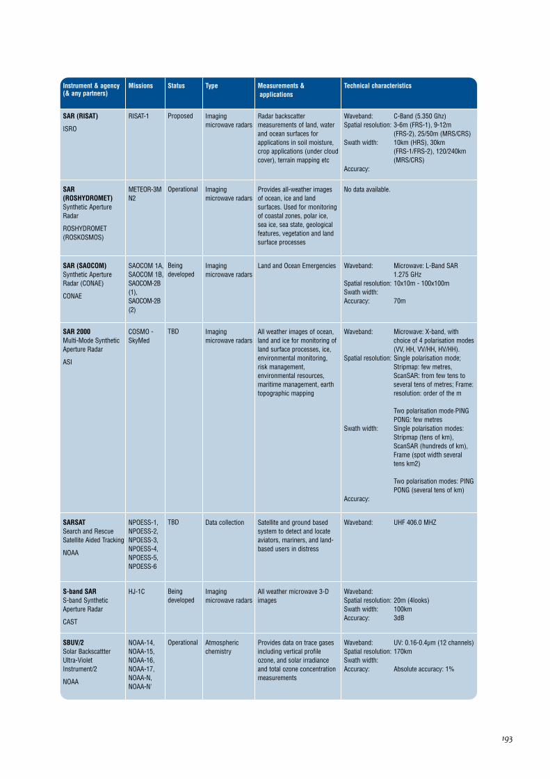
193
Instrument & agency(& any partners)
Missions Type Measurements &applications
Technical characteristics
SAR (SAOCOM)Synthetic ApertureRadar (CONAE)
CONAE
SAOCOM 1A,SAOCOM 1B,SAOCOM-2B(1),SAOCOM-2B(2)
Imagingmicrowave radars
Status
Beingdeveloped
Land and Ocean Emergencies Waveband: Microwave: L-Band SAR1.275 GHz
Spatial resolution: 10x10m - 100x100mSwath width: Accuracy: 70m
SARSATSearch and RescueSatellite Aided Tracking
NOAA
NPOESS-1,NPOESS-2,NPOESS-3,NPOESS-4,NPOESS-5,NPOESS-6
Data collectionTBD Satellite and ground basedsystem to detect and locateaviators, mariners, and land-based users in distress
Waveband: UHF 406.0 MHZ
S-band SARS-band SyntheticAperture Radar
CAST
HJ-1C Imagingmicrowave radars
Beingdeveloped
All weather microwave 3-Dimages
Waveband: Spatial resolution: 20m (4looks)Swath width: 100kmAccuracy: 3dB
SBUV/2Solar BackscattterUltra-VioletInstrument/2
NOAA
NOAA-14,NOAA-15,NOAA-16,NOAA-17,NOAA-N,NOAA-N'
Atmosphericchemistry
Operational Provides data on trace gasesincluding vertical profileozone, and solar irradianceand total ozone concentrationmeasurements
Waveband: UV: 0.16-0.4µm (12 channels)Spatial resolution: 170kmSwath width: Accuracy: Absolute accuracy: 1%
SAR 2000Multi-Mode SyntheticAperture Radar
ASI
COSMO -SkyMed
Imagingmicrowave radars
TBD All weather images of ocean,land and ice for monitoring ofland surface processes, ice,environmental monitoring,risk management,environmental resources,maritime management, earthtopographic mapping
Waveband: Microwave: X-band, withchoice of 4 polarisation modes(VV, HH, VV/HH, HV/HH).
Spatial resolution: Single polarisation mode;Stripmap: few metres,ScanSAR: from few tens toseveral tens of metres; Frame:resolution: order of the m
Two polarisation mode·PINGPONG: few metres
Swath width: Single polarisation modes:Stripmap (tens of km),ScanSAR (hundreds of km),Frame (spot width severaltens km2)
Two polarisation modes: PINGPONG (several tens of km)
Accuracy:
SAR (RISAT)
ISRO
RISAT-1 Imagingmicrowave radars
Proposed Radar backscattermeasurements of land, waterand ocean surfaces forapplications in soil moisture,crop applications (under cloudcover), terrain mapping etc
Waveband: C-Band (5.350 Ghz)Spatial resolution: 3-6m (FRS-1), 9-12m
(FRS-2), 25/50m (MRS/CRS)Swath width: 10km (HRS), 30km
(FRS-1/FRS-2), 120/240km(MRS/CRS)
Accuracy:
SAR(ROSHYDROMET)Synthetic ApertureRadar
ROSHYDROMET(ROSKOSMOS)
METEOR-3MN2
Imagingmicrowave radars
Operational Provides all-weather imagesof ocean, ice and landsurfaces. Used for monitoringof coastal zones, polar ice,sea ice, sea state, geologicalfeatures, vegetation and landsurface processes
No data available.

194
Instrument & agency(& any partners)
Missions Type Measurements &applications
Technical characteristics
SCIAMACHYScanning ImagingAbsorptionSpectrometer forAtmosphericChartography
ESA
Envisat Atmosphericchemistry
Status
Operational Measures middle atmospheretemperature. Providestropospheric andstratospheric profiles of O2,O3, O4, CO, N2O, NO2, CO2,CH4, H2O, and troposphericand stratospheric profiles ofaerosols and cloud altitude
Waveband: UV-SWIR: 240-314, 309-3405,394-620, 604-805, 785-1050,1000-1750, 1940-2040 and2265-2380nm
Spatial resolution: Limb vertical 3 x 132km,Nadir horizontal 32 x 215km
Swath width: Limb and nadir mode:1000km (max)
Accuracy: Radiometric: <4%
SeaWinds
NASA (JAXA)
QuikSCAT ScatterometersOperational Measurement of surface windspeed and direction; lostpower on-orbit in October 2003
Waveband: Microwave: 13.402 GHzSpatial resolution: 25 kmSwath width: 1600 kmAccuracy: Speed: 2-3.5 m/s Direction:
20 deg
SEM (GOES)Space EnvironmentMonitor
NOAA
GOES-9,GOES-10,GOES-11,GOES-12,GOES-N,GOES-O,GOES-P,GOES-R
SpaceEnvironment
Operational Used for equipment failureanalysis, solar fluxmeasurement, solar stormwarning, and magnetic andelectric field measurement atsatellite
The SEM System consists of a three-axis vectormagnetometer, an Energetic Particle Sensor(EPS) and associated High-Energy Proton andAlpha Detector (HEPAD), and an X-Ray Sensor(XRS). This set of instruments is designed toprovide real-time measurement of solar activity,the charged particle environment, and the Earth'smagnetic field at synchronous orbit.
SEM (POES)Space EnvironmentMonitor
NOAA
METOP-2,NOAA-12,NOAA-14,NOAA-15,NOAA-16,NOAA-17,NOAA-N,NOAA-N'
SpaceEnvironment
Operational Used for equipment failureanalysis, solar fluxmeasurement, solar stormwarning, and magnetic andelectric field measurement atsatellite
The SEM consists of two separate sensor units:the Total Energy Detector (TED) and the MediumEnergy Proton and Electron Detector (MEPED).The TED senses and quantifies the intensity inthe sequentially selected energy bands. Theparticles of interest have energies ranging from0.05 keV to 20 keV. The MEPED senses protons,electrons, and ions with energies from 30 keV tolevels exceeding 6.9 MeV.
SESSSpace EnvironmentalSensor Suite
NOAA
NPOESS-2,NPOESS-3,NPOESS-4,NPOESS-5,NPOESS-6
Spaceenvironment &Magnetic field
Beingdeveloped
Measures characteristics ofauroral boundary, auroralenergy deposition, auroralimagery, electric field, electrondensity profile, geomagneticfield, in-situ plasmafluctuations, ionospherescintillation. Data aids futurespace system design
Multiple sensors to measure auroralcharacteristics, geomagnetic field, electrondensity profile, and total electron content, 10-kmvertical resolution from 60 km to 3000 km.
Scatterometer (ISRO)
ISRO
OCEANSAT-2 ScatterometersTBD Mainly for windmeasurements
Under definition.
Scatterometer (JAXA)Scatterometer
JAXA
GCOM-W ScatterometersTBD Ocean surface windmeasurements
Under definition.
ScaRaBScanner for Earth'sRadiation Budget
CNES (NPO"PLANETA")
MEGHA-TROPIQUES
Earth radiationbudgetradiometer
Operational Measures top-of-atmosphereshortwave radiation (0.2-4.0µm) and total radiation(0.2-50µm). Two additionalnarrow-band channels (0.5-0.7µm and 11-12µm) allowcloud detection and sceneidentification
Waveband: VIS window channel: 0.5-0.7µm,Solar channel UV-SWIR: 0.2-4µm, Total channel UV-FIR:0.2-50µm, Thermal windowchannel: 10.5-12.5µm
Spatial resolution: 60kmSwath width: 2200kmAccuracy: Absolute: ± 2.5W/m2/sr,
Relative: ± 0.7W/m2/sr

195
Instrument & agency(& any partners)
Missions Type Measurements &applications
Technical characteristics
SFM-2UV limb spectrometer
ROSHYDROMET
METEOR-3MN1
Atmosphericchemistry
Status
Operational Global ozone monitoring Waveband: UV-VIS: 0.2-0.51µm (4 channels)Spatial resolution: Swath width: Accuracy:
SGPSSolar and GalacticProton Sensor
NOAA
GOES-R SpaceEnvironment
Approved Studies natural radiationhazard to humans at highaltitudes and in space, as wellas risk assessment andwarning of episodes of surfacecharging, deep dielectriccharging, and single eventupset of satellite systems
The GOES-R Project is in the formulation phase.The satellite will comprise improved spacecraftand instrument technologies, which will result inmore timely and accurate weather forecasts, andimprove support for the detection andobservations of meteorological phenomena thatdirectly affect public safety, protection of property,and ultimately, economic health and development.
SIMSpectral IrradianceMonitor
NASA
SORCE Earth radiationbudgetradiometer
Operational Measures solar spectralirradiance in the 200-2000nmrange
Waveband: UV-SWIR: 200-2000nmSpatial resolution: Swath width: Accuracy:
SIRALSAR InterferometerRadar Altimeter
ESA
CRYOSAT Radar altimetersBeingdeveloped
Objective is to observe icesheet interiors, the ice sheetmargins, for sea ice and othertopography
Waveband: Microwave: 13.575GHz (Ku-Band)
Spatial resolution: Range resolution 45cm, along-track resolution 250m
Swath width: Footprint 15kmAccuracy: Arctic sea-ice: 1.6cm/year for
300kmx300km cells, Land ice(small scale): 3.3cm/year for100km x 100km cells, Land ice(large scale): 0.17cm/year forAntarctica size area
SKL-MSolar ray spectrometer
ROSHYDROMET
Meteor-M No1,Meteor-M No2
TBD Proton flux density Waveband: 2, 4, 6 and > 6 MeV, 30, 50,100, 300 and > 300 MeV
Spatial resolution: Swath width: Accuracy:
SEVIRISpinning EnhancedVisible and Infra-RedImager
EUMETSAT (ESA)
METEOSAT-8,METEOSAT-9,METEOSAT-10,METEOSAT-11
Imaging multi-spectralradiometers(vis/IR)
Prototype Measurements of cloud cover,cloud top height, precipitation,cloud motion, vegetation,radiation fluxes, convection,air mass analysis, cirrus clouddiscrimination, tropopausemonitoring, stabilitymonitoring, total ozone andsea surface temparature
Waveband: VIS: 0.56-0.71µm, 0.5-0.9µm(broadband),NIR: 0.74-0.88µm,SWIR 1.5-1.78µm,SWIR: 3.48-4.36µm, TIR:5.35-7.15µm, 6.85-7.85µm,8.3-9.1µm, 9.38-9.94µm, 9.8-11.8µm, 11-13µm, 12.4-14.46µm
Spatial resolution: 1km (at SSP) for onebroadband visible channelHRV, 5km (at SSP) for allother channels
Swath width: Full Earth diskAccuracy: Cloud cover: 10%, Cloud top
height: 1km, Cloud toptemparature: 1K, Cloud type: 8classes, Surface temparature:0.7-2.0K, Specific humidityprofile: 10%, Wind profile(horizontal component): 2-10m/s, Long wave Earthsurface radiation: 5W/m2

196
Instrument & agency(& any partners)
Missions Type Measurements &applications
Technical characteristics
SOLSTICESOLar STellarIrradiance ComparisonExperiment
NASA
SORCE,UARS
Earth radiationbudgetradiometer
Status
Operational Provides data on UV andcharged particle energy inputs,and on time variation of full-disk solar UV spectrum.Measures solar UV radiation(115 to 430nm) with resolutionof 0.12nm. Compares solar UVoutput with UV radiation ofstable bright blue stars
Waveband: UV: 115-180nm & 170-320nmSpatial resolution: Swath width: Accuracy: 1%
Sounder
NOAA
GOES-9,GOES-10,GOES-11,GOES-12,GOES-N,GOES-O,GOES-P,GOES-R
Atmospherictemperature andhumiditysounders
Operational Provides atmosphericsoundings and data onatmospheric stability andthermal gradient winds
Waveband: GOES 8-12; N,O,P: VIS-TIR:19 channels
Spatial resolution: 10kmSwath width: Horizon to horizonAccuracy:
Sounder (INSAT)
ISRO
INSAT-3D Atmospherictemperature andhumiditysounders
TBD Atmospheric soundings,atmospheric stability, thermalgradient winds
Waveband: SWIR: 3.74-4.74µm,MWIR: 6.51-11.03µm,TIR: 12.02-14.71µm,VIS: 0.55-0.75µm
Spatial resolution: 10x10 kmSwath width: Full (Full Earth disc sounding),
Program (Options providedfor for Sector Scans)
Accuracy:
SOVAPSOlar Variability Picardradiometer
CNES
PICARD Earth radiationbudgetradiometer
Beingdeveloped
Total solar irradiancemeasurements
Waveband: Total irradianceSpatial resolution: Swath width: Accuracy:
SMRSubmillimetreRadiometer
SNSB
Odin Atmosphericchemistryinstruments &Atmospherictemperature andhumiditysounders
Operational Measures global distributionsof ozone and species ofimportance for ozonechemisty, ClO, HNO3, H2O,N2O, (HO2, H2O2). Measurestemperature in the heightrange 15-100km
Waveband: Microwave: 118.7GHz + 4bands in the region 480-580GHz: Tunable measures 2-3x 1GHz regions at a time
Spatial resolution: Vertical resolution 1.5-3km,along track 600km
Swath width: Altitudes of 5-100kmAccuracy: 2-40% depending on species
and altitude
SODADOrbital System for anActive Detection ofDebris
CNES
SAC-D/Aquarius
TBDApproved Space Debris Instrument for the measurement of the propertiesof micrometeorites and space debris.
SODISMSOlar Diameter Imagerand Surface Mapper
CNES
PICARD Earth radiationbudgetradiometer
TBD Measures diameter anddifferential rotation of the sun- a whole Sun imager
Waveband: UV: 230nm, VIS: 548nm,Active regions: 160nm plusLyman alpha detector
Spatial resolution: Swath width: Accuracy:

197
Instrument & agency(& any partners)
Missions Type Measurements &applications
Technical characteristics
SSJ/4Special SensorPrecipitating PlasmaMonitor
NOAA (US DoD)
DMSP F-13,DMSP F-15,DMSP F-16
Magnetic field
Status
Operational Measurement of transferenergy, mass, and momentumof charged particles throughthe magnetosphere-ionosphere in the Earth'smagnetic field
Consists of four electrostatic analyzers that recordelectrons and ions between 30 eV and 30 KeV asthey flow past the spacecraft toward the Earth.The instruments "look" toward the satellite zenith.
SSJ/5Special SensorPrecipitating PlasmaMonitor
NOAA (US DoD)
DMSP F-16,DMSP F-17,DMSP F-18,DMSP F-19,DMSP F-20
Magnetic fieldTBD Measurement of transferenergy, mass, and momentumof charged particles throughthe magnetosphere-ionosphere in the Earth'smagnetic field
Consists of four electrostatic analyzers that recordelectrons and ions between 30 eV and 30 KeV asthey flow past the spacecraft toward the Earth.The instruments "look" toward the satellite zenith.
SSMSpecial SensorMagnetometer
NOAA (US DoD)
DMSP F-13,DMSP F-15,DMSP F-16,DMSP F-17,DMSP F-18,DMSP F-19,DMSP F-20
Magnetic fieldOperational Measures geomagneticfluctuations associatedwithMeasures geomagneticfluctuations associated withsolar geophysical phenomena.With SSIES and SSJ providesheating and electron densityprofiles in the ionosphere
A triaxial fluxgate magnetometer
SSM/ISpecial SensorMicrowave Imager
NOAA (US DoD)
DMSP F-13,DMSP F-15,DMSP F-16
Imaging multi-spectralradiometers(passivemicrowave)
Operational Measures atmospheric, oceanand terrain microwavebrightness temperatures toprovide: sea surface winds,rain rates, cloud water,precipitation, soil moisture,ice edge, ice age
Waveband: Microwave: 19.35, 22.235, 37,85 GHz
Spatial resolution: 15.7km x 13.9km to 68.9 x44.3km (depends onfrequency)
Swath width: 1400kmAccuracy:
SPECTRASurface Processes andEcosystem ChangesThrough ResponseAnalysis
ESA
ESA FutureMissions
Imaging multi-spectralradiometers(vis/IR) &Multipledirection/polarisationradiometers
Prototype Data for study of land surfaceprocesses
Waveband: VIS-SWIR: 450-2350 nm andTIR: 10.3-12.3 micron
Spatial resolution: Spatial sampling intervalapprox 50m, along trackpointing ±30 deg
Swath width: 50kmAccuracy:
SSB/X-2Special Sensor GammaRay Particle Detector
NOAA (US DoD)
DMSP F-13,DMSP F-15,DMSP F-16
SpaceEnvironment
Operational Detects the location, intensity,and spectrum of X-raysemitted from the Earth'satmosphere
Array-based system.
SSIES-2Special SensorIonospheric PlasmaDrift/Scintillation Meter
NOAA (US DoD)
DMSP F-13,DMSP F-15,DMSP F-16
SpaceEnvironment
Operational Measurement of the ambientelectron density andtemperatures, the ambient iondensity, and ion temperatureand molecular weight
Consists of an electron sensor (Langmuir probe)and an ion sensor mounted on a 2.5 meterboom. The ion sensor is a planar aperture, planarcollector sensor oriented to face the spacecraftvelocity vector at all times. In addition to theLangmuir probe and planar collector, has aplasma drift meter and a scintillation meter.
SSIES-3Special SensorIonospheric PlasmaDrift/Scintillation Meter
NOAA (US DoD)
DMSP F-16,DMSP F-17,DMSP F-18,DMSP F-19,DMSP F-20
SpaceEnvironment
TBD Measurement of the ambientelectron density andtemperatures, the ambient iondensity, and ion temperatureand molecular weight
Consists of an electron sensor (Langmuir probe)and an ion sensor mounted on a 2.5 meterboom. The ion sensor is a planar aperture, planarcollector sensor oriented to face the spacecraftvelocity vector at all times. In addition to theLangmuir probe and planar collector, has aplasma drift meter and a scintillation meter.

198
Instrument & agency(& any partners)
Missions Type Measurements &applications
Technical characteristics
SSULISpecial SensorUltraviolet Limb Imager
NOAA
DMSP F-16,DMSP F-17,DMSP F-18,DMSP F-19,DMSP F-20
SpaceEnvironment
Status
TBD Measures vertical profiles ofthe natural airglow radiationfrom atoms, molecules andions in the upper atmosphereand ionosphere
SSULI makes measurements from the extremeultraviolet (EUV) to the far ultraviolet (FUV)(80nm-170nm with 1.5 nm resolution). Uses aspectrograph fed by a mirror capable of scanningbelow the satellite horizon from 10-27 deg, every90 seconds (which gives a vertical slice ofEarth's atmosphere from 750-50km in altitude).
SSUSISpecial SensorUltravioletSpectrographic Imager
NOAA
DMSP F-16,DMSP F-17,DMSP F-18,DMSP F-19,DMSP F-20
SpaceEnvironment
TBD Monitors the composition andstructure of the upperatmosphere and ionosphere,as well as auroral energeticparticle inputs, withspectrographic imaging andphotometry
A scanning imaging spectrograph whose field-of-view is scanned from horizon to horizon and anadir-looking photometer system. The SISproduces simultaneous multispectral imagesover the spectral range 115-180nm.
SSZ
NOAA (US DoD)
DMSP F-13,DMSP F-15,DMSP F-16
SpaceEnvironment
Operational Laser threat detector The SSZ is a static Earth viewing sensor,monitoring electro magnetic radiation.
STRStar Tracker
ESA
Swarm Precision orbitOperational Precise satellite orbit andattitude determination
Waveband: N/ASpatial resolution: <1arcsecSwath width: N/AAccuracy: <0.7arcsec
SUSIM (UARS)Solar UltravioletIrradiance Monitor
NASA
UARS Earth radiationbudgetradiometer
Operational Provides data on UV andcharged particle energyinputs, and on time variationof full-disk solar UV spectrum
Waveband: UV: 0.12-0.4µm Spatial resolution: Not applicable Spectral resolution: 0.15nm Accuracy: 1% Swath width: Looks at sun
SSM/T-1Special SensorMicrowaveTemperature Sounder
NOAA (US DoD)
DMSP F-13,DMSP F-15,DMSP F-16,DMSP F-18,DMSP F-19,DMSP F-20
Atmospherictemperature andhumiditysounders
Operational Measures Earth's surface andatmospheric emission in the50-60GHz oxygen band
Waveband: Microwave: 7 channels in the50-60GHz range
Spatial resolution: 174km diameter beamSwath width: 1500kmAccuracy:
SSM/T-2Special SensorMicrowave WaterVapor Sounder
NOAA (US DoD)
DMSP F-13,DMSP F-15,DMSP F-16
Atmospherictemperature andhumiditysounders
Operational Water Vapour profiler Waveband: Microwave: 91.6, 150, 183.31(3 channels) (Total 5 channels)
Spatial resolution: approx 48kmSwath width: 1500kmAccuracy:
SSUStratospheric SoundingUnit
NOAA
NOAA-12,NOAA-14
Atmospherictemperature andhumiditysounders
Operational Provides temperature profilesin stratosphere, top-of-atmosphere radiation from25km to 50km altitude
Waveband: 669.99, 669.63 and 669.36/cm(carbon dioxide)
Spatial resolution: 147.3km at nadirSwath width: ±40 deg scanAccuracy:
SSMISSpecial SensorMicrowave ImagerSounder
NOAA (US DoD)
DMSP F-16,DMSP F-17,DMSP F-18,DMSP F-19,DMSP F-20
Atmospherictemperature andhumiditysounders
Operational Measures thermal microwaveradiation. Globalmeasurements of air tempprofile, humidity profile, oceansurface winds, rainoverland/ocean, iceconcentration/age, ice/snowedge, water vapour/clouds overocean, snow water content,land surface temperature
Waveband: Microwave: 19 - 183GHz (24 frequencies)
Spatial resolution: Varies with frequency:25x17km to 70X42km
Swath width: 1700kmAccuracy:

199
Instrument & agency(& any partners)
Missions Type Measurements &applications
Technical characteristics
TESTropospheric EmissionSpectrometer
NASA
Aura Atmosphericchemistry
Status
Operational 3-D profiles on a global scaleof all infra-red active speciesfrom surface to lowerstratosphere. Measuresgreenhouse gasconcentrations, troposphericozone, acid rain precursors,gas exchange leading tostratospheric ozone depletion
Waveband: SWIR-TIR: 3.2-15.4µmSpatial resolution: In limb mode: 2.3km vertical
resolution. In down-lookingmode: 50km x 5km (global),5km x 0.5km (local)
Swath width: Limb mode: global: 50km x180km, local: 5km x 18km
Accuracy: Ozone: 20ppb, Trace gases: 3-500ppb
TIMTotal IrradianceMonitor
NASA
Glory,SORCE
Earth radiationbudgetradiometer
Operational Measurement of total solarirradiance directly traceable toSI units with an absoluteaccuracy of 0.03% abdrelative accuracy of 0.001%per year
Waveband: Spatial resolution: Swath width: Looks at the sun every orbit,
providing 15 measurementsper day
Accuracy:
TIS (CONAE)Thermal IR Scanner
CONAE
SAC-F Imaging multi-spectralradiometers(vis/IR)
Approved Data not available
TMThematic Mapper
USGS
Landsat-5 Imaging multi-spectralradiometers(vis/IR)
Operational Measures surface radianceand emittance, lands coverstate and change (egvegetation type). Used asmultipurpose imagery for landapplications
Waveband: 0.45-12.50µmSpatial resolution: VIS-SWIR, 30m; TIR: 120mSwath width: 185kmAccuracy:
SXISolar X-ray Imager
NOAA (USAF)
GOES-12,GOES-N,GOES-P,GOES-R
SpaceEnvironment
Prototype Obtains data on structure ofsolar corona. Full diskimagery also provideswarnings of geomagneticstorms, solar flares, andinformation on active regionsof sun and filaments
Waveband: GOES 12,N,P: X-Ray 0.6-6.0nm bandpass
Spatial resolution: Swath width: FWHM of ~10 arcsecAccuracy:
SXSSolar X-Ray Sensor
NOAA
GOES-R SpaceEnvironment
Approved Studies of natural radiationhazard to humans at highaltitudes and in space, as wellas risk assessment andwarning of episodes of surfacecharging, deep dielectriccharging, and single eventupset of satellite systems.
The GOES-R Project is in the formulation phase.The satellite will comprise improved spacecraftand instrument technologies, which will result inmore timely and accurate weather forecasts, andimprove support for the detection andobservations of meteorological phenomena thatdirectly affect public safety, protection of property,and ultimately, economic health and development.
TerraSAR-XX-Band SyntheticAperture Radar
DLR
TerraSAR-X Imagingmicrowave radars
Approved High resolution images formonitoring of land surface andcoastal processes and foragricultural, geological andhydrological applications
Waveband: 9.65GHz, 300MHz bandwidth,all 4 polarisation modes
Spatial resolution: Spotlight: 1,2m x 1-4mStripmap: 3m x 3-6mScanSAR: 16m x 16m
Swath width: Spotlight: 5-10km x 10 km,Stripmap: 30 km, ScanSAR:100 km
Accuracy:

200
Instrument & agency(& any partners)
Missions Type Measurements &applications
Technical characteristics
TSISTotal Solar IrradianceSensor
NOAA
NPOESS-3,NPOESS-6
Earth radiationbudgetradiometer
Status
Beingdeveloped
0.2- 2 micron solar spectralirradiance monitor
Waveband: UV-SWIR: 0.2-2µmSpatial resolution: Swath width: Accuracy: 1.5w/m2
Variant
ROSKOSMOS
SICH-1M Magnetic field Studies of the ionosphere Payload package which includes: an electricprobe, a wave probe, a Rogovsky coil, a Faradaycup, a fluxgate magnetometer, and a dataacquisition unit.
VEGETATION
CNES (EEC)
SPOT-4,SPOT-5
Imaging multi-spectralradiometers(vis/IR)
Operational Data of use for crop forecastand monitoring, vegetationmonitoring, and biosphere/geosphere interaction studies
Waveband: Operational mode: VIS: 0.61-0.68µm, NIR: 0.78-0.89µm, SWIR: 1.58-1.75µm,Experimental mode: VIS: 0.43-0.47µm
Spatial resolution: 1.15km at nadir - minimalvariation for off-nadir viewing
Swath width: 2200kmAccuracy:
VFMVector Magnetometer
ESA
Swarm Magnetic fieldOperational The VFM is the primeinstrument of the Swarmmission. It will provide ultralinear and low-noisemeasurements of the Earth'smagnetic field vectorcomponents
Waveband: N/ASpatial resolution: <0.1nTSwath width: N/AAccuracy: <0.5nT/15days
TMRTOPEX MicrowaveRadiometer
NASA
Topex-Poseidon
Imaging multi-spectralradiometers(vis/IR)
Operational Provides altimeter data tocorrect for errors caused bywater vapour and cloud-cover.Also measures total watervapour and brightnesstemperature
Waveband: Microwave: 18GHz, 21GHz,37GHz
Spatial resolution: 44.7km at 18GHz, 37.4km at21GHz, 23.6km at 37GHz
Swath width: 120 deg cone centred on nadirAccuracy: Total water vapour: 0.2g/sq cm,
Brightness temperature: 0.3 K
TOMTotal Ozone Mapper
NRSCC (CAST)
FY-3A,FY-3B,FY-3C,FY-3D,FY-3E,FY-3F,FY-3G
Atmosphericchemistry
Beingdeveloped
Ozone chemistrymeasurements
Waveband: UVSpatial resolution: 50kmSwath width: Accuracy:
TOPEXTOPEX NASA RadarAltimeter
NASA
Topex-Poseidon
Radar altimetersOperational Measurement of global oceansurface topography
Waveband: Microwave: 126 GHz and5.3 GHz
Spatial resolution: Swath width: 6kmAccuracy: 2.4cm
TOPSAT telescope
BNSC
TopSat High resolutionoptical imagers
Prototype Experimental medium-resolution imaging satellitesupporting a range of possibleland applications
Waveband: Panchromatic VIS: 0.5-0.75µm.3-band multi-spectral.
Spatial resolution: 2.5m pan. 5m multi-spectral.Swath width: 10km-MS, 15km-PanAccuracy:
TRSRTurbo-Rogue SpaceReceiver
NASA
Jason,Jason-2 (alsoknown asOSTM)
Precision orbit &Atmospherictemperature andhumiditysounders
TBD Provides precise continuoustracking data of satellite todecimeter accuracy
Waveband: L-band:1228 and 1575MHz Spatial resolution: Not applicable Swath width: Not applicable Accuracy:

201
Instrument & agency(& any partners)
Missions Type Measurements &applications
Technical characteristics
WAOSS-BWide-AngleOptoelectronic StereoScanner
DLR
BIRD Imaging multi-spectralradiometers(vis/IR)
Status
Operational Vegetation and Cloud coverage Waveband: VIS: 600-670nm, NIR: 840-900nm
Spatial resolution: 185mSwath width: 533kmAccuracy:
WEFAXWeather Facsimile
NOAA
GOES-9,GOES-10,GOES-11,GOES-12,GOES-N,GOES-O,GOES-P,GOES-R
CommunicationsOperational Weather Facsimile Data communications
WFCWide Field Camera
NASA
CALIPSO Imaging multi-spectralradiometers(vis/IR)
Approved Acquires high spatialresolution imagery formeteorological context
Waveband: VIS: 620 to 670 nmSpatial resolution: 125mSwath width: 60kmAccuracy:
WFIWide Field Imager
CAST (INPE)
CBERS-2,CBERS-2B
Imaging multi-spectralradiometers(vis/IR)
Operational Earth resources, environmentalmonitoring, land use
Waveband: VIS: 0.63-0.69µm, NIR: 0.77-0.89µm
Spatial resolution: 258mSwath width: 890kmAccuracy: 0.3pixels
VHRRVery High ResolutionRadiometer
ISRO
INSAT-2E,INSAT-3A,KALAPANA
Imaging multi-spectralradiometers(vis/IR)
Operational Cloud cover, rainfall, windvelocity, sea surfacetemperature, outgoinglongwave radiation, reflectedsolar radiation in spectral band0.55-0.75µm, emitted radiationin 10.5-12.5µm range
Waveband: VIS: 0.55-0.75µm, NIR: 5.7-7.1µm, TIR: 10.5-12.5µm
Spatial resolution: 2km in visible, 8km in IRSwath width: Full Earth disk every 30 minutesAccuracy:
VIIRSVisible/Infrared ImagerRadiometer Suite
NOAA (NASA)
NPOESS-1,NPOESS-2,NPOESS-3,NPOESS-4,NPOESS-5,NPOESS-6,NPP
Imaging multi-spectralradiometers(vis/IR)
Approved Global observations of land,ocean, and atmosphereparameters: cloud/weatherimagery, sea-surfacetemperature, ocean colour,land surface vegetation indices
Waveband: VIS - TIR: 0.4-12.5µm (22 channels)
Spatial resolution: 400m-1.6kmSwath width: 3000kmAccuracy: SST 0.35K
VIRRMultispectral Visibleand Infra-red ScanRadiometer (10channels)
NRSCC (CAST)
FY-3A,FY-3B,FY-3C,FY-3D,FY-3E,FY-3F,FY-3G
Imaging multi-spectralradiometers(vis/IR)
Beingdeveloped
Multispectral Visible and Infra-red Scan Radiometer
Waveband: Spatial resolution: 1.1kmSwath width: 3200kmAccuracy:
VISSR (GMS-5)Visible and Infra-redSpin Scan Radiometer(GMS-5)
JAXA (JMA)
GMS-5 Imaging multi-spectralradiometers(vis/IR)
Operational Data used for cloud type andmotion detection wind. Alsomeasures sea surfacetemperature and atmosphericwater vapour
Waveband: VIS: 0.55-0.9µm, TIR: 6.5-7,10.5-11.5, 11.5-12.5µm
Spatial resolution: Visible: 1.25km, TIR: 5kmSwath width: Full Earth disk in all channels,
every 1 hourAccuracy:
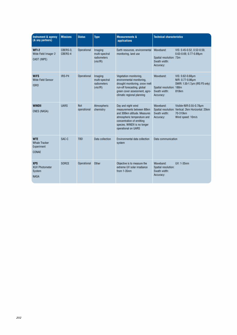
202
Instrument & agency(& any partners)
Missions Type Measurements &applications
Technical characteristicsStatus
WFI-2Wide Field Imager 2
CAST (INPE)
CBERS-3,CBERS-4
Imaging multi-spectralradiometers(vis/IR)
Operational Earth resources, environmentalmonitoring, land use
Waveband: VIS: 0.45-0.52, 0.52-0.59,0.63-0.69, 0.77-0.89µm
Spatial resolution: 73mSwath width: Accuracy:
WiFSWide Field Sensor
ISRO
IRS-P4 Imaging multi-spectralradiometers(vis/IR)
Operational Vegetation monitoring,environmental monitoring,drought monitoring, snow meltrun-off forecasting, globalgreen cover assessment, agro-climatic regional planning
Waveband: VIS: 0.62-0.68µm NIR: 0.77-0.86µm SWIR: 1.55-1.7µm (IRS P3 only)
Spatial resolution: 188mSwath width: 810kmAccuracy:
WINDII
CNES (NASA)
UARS Atmosphericchemistry
Notoperational
Day and night windmeasurements between 80kmand 300km altitude. Measuresatmospheric temperature andconcentration of emittingspecies. WINDII is no longeroperational on UARS
Waveband: Visible-NIR:0.55-0.78µm Spatial resolution: Vertical: 2km Horizontal: 25kmSwath width: 70-310km Accuracy: Wind speed: 10m/s
XPSXUV PhotometerSystem
NASA
SORCE OtherOperational Objective is to measure theextreme UV solar irradiancefrom 1-35nm
Waveband: UV: 1-35nmSpatial resolution: Swath width: Accuracy:
WTEWhale TrackerExperiment
CONAE
SAC-C Data collectionTBD Environmental data collectionsystem
Data communication