access control policy to the state highway...
TRANSCRIPT

Access Control Policy
to the
State Highway System
March 2006

NEBRASKA DEPARTMENT OF ROADS
ACCESS CONTROL POLICY Access control is the regulation of access, through the limitation of public access rights to and from properties abutting the highway facility. It is the condition where the right of property owners' use and enjoyment of access is controlled by the department. The principal advantages of control of access are the preservation of a high quality of traffic service and improved safety. Access control is an important consideration in highway planning, design, and operation. Some degree of access control should be included in the development of any major highway, particularly where mobility is important. The degree of access control should be balanced among three essential public functions: (1) access to property, (2) travel mobility, and (3) safety of the motorist.
This policy may be revised without notice and the conditions of the current revised issue as determined by the Nebraska Department of Roads (NDOR) will apply and supersede previous issues.
Revised and Reissued February 2006
TABLE OF CONTENTS
001 STATUTORY AUTHORITY FOR CONTROL OF ACCESS........................................... 1
002 TYPES OF CONTROL OF ACCESS............................................................................. 2
003 STATEMENT OF POLICY............................................................................................. 2
004 ACQUISITION OF ACCESS RIGHTS ........................................................................... 3
005 INTERSTATE AND FREEWAY ..................................................................................... 5
006 EXPRESSWAYS AND OTHER MULTI-LANE DIVIDED HIGHWAYS ........................... 5
007 ALL OTHER HIGHWAYS .............................................................................................. 5
008 ACCESS CONTROL ON SIDE STREETS AND ROADS .............................................. 5
009 LOCATION OF ACCESS............................................................................................... 6
010 SPACING ON THE INTERSTATE................................................................................. 7
011 SPACING ON THE EXPRESSWAY AND OTHER MULTI-LANE DIVIDED HIGHWAYS – Including non multi-lane highways with future ADT over 6,000 (See Table I) ....................... 7
012 SPACING ON ALL OTHER ACCESS CONTROLLED HIGHWAYS.............................. 7
013 PROJECT REVIEW....................................................................................................... 8
014 ADDITIONAL ACCESS ENTRANCE............................................................................. 9
015 APPLICATION............................................................................................................. 10
016 APPLICATION REVIEW IN THE DISTRICT................................................................ 10
017 APPLICATION REVIEW IN RIGHT OF WAY (ROW) .................................................. 12
018 APPLICATION DENIED BY THE ACCESS CONTROL TEAM.................................... 12
019 APPLICATION APPROVED BY THE ACCESS CONTROL TEAM ............................. 13
020 APPLICATION DENIED BY PLANNING & PROJECT DEVELOPMENT..................... 13
021 APPLICATION APPROVED BY PLANNING & PROJECT DEVELOPMENT .............. 13
022 RECORDS................................................................................................................... 15

1
001 STATUTORY AUTHORITY FOR CONTROL OF ACCESS A controlled access facility as defined in Section 39-1302, Paragraph (9) Revised Statutes of Nebraska, reissue of 1993 "shall mean a highway or street especially designed for through traffic, and over, from, or to which owners or occupants of abutting land or other persons have no right or easement or only a controlled right or easement of access, light, air, or view by reason of the fact that their property abuts upon such controlled access facility or for any other reason. Such highways or streets may be freeways or they may be parkways." Section 39-1320 gives the Department authority to acquire property for State highway purposes..." by gift, agreement, purchase, exchange, condemnation, or otherwise"... State highway purposes, as referred to in Section 39-1320 or otherwise in Sections 39-1301 to 39-1392 shall include provision for, but shall not be limited to, the following: "Controlled access facilities, including air, light, view, and frontage and service roads to highways." Through the provisions of Section 39-1327, Nebraska Statutes, the Department designates and establishes controlled access facilities. Under such provisions, the Department (1) is authorized to designate and establish controlled access facilities; (2) may design, construct, maintain, improve, alter, and vacate such facilities, and (3) may regulate, restrict, or prohibit access to such facilities so as to best serve the traffic for which such facilities are intended... In order to carry out the purposes of this section, the Department may acquire, in public or private property, such rights of access as are deemed necessary, including but not necessarily limited to air, light, view, egress and ingress. Such acquisitions may be by gift, devise, purchase, agreement, adverse possession, prescription, condemnation, or otherwise and may be in fee simple absolute or in any lesser estate or interest.... Sections 39-1328 through 30-1336 make further reference to control of access and its acquisition, and in outline provide the following:
A. The Department may determine where frontage roads may be connected with a controlled access facility and provide for ingress and egress to the frontage road at such places as will afford reasonable access;
B. The right of reasonable ingress and egress to property abutting an existing
highway or street may not be denied except by the acquisition of controlled access rights by the Department. If construction or reconstruction of any highway results in the abutment of property that did not theretofore have direct egress and ingress to such highway, no rights of direct access accrue because of such abutment;
C. Private property from which right of way is acquired for construction, relocation,
or reconstruction shall not be left without a reasonable means of egress and

2
ingress to a road; however, the Department is granted the authority to define the location, width, nature and extent of access that may be permitted;
D. ”The Department and the governing bodies of any political or governmental
subdivision or any public corporation of this State may enter into agreements with each other respecting the planning, designation, financing, establishing, constructing, improving, maintaining, using, altering, relocating, regulating, or vacating of controlled access roads, except any toll facilities." This provision affords additional protection to critical intersections beyond the limits of control, which would ordinarily be under jurisdiction of this Department alone.
002 TYPES OF CONTROL OF ACCESS The method of controlling access may be through police power, to a limited degree, or by acquisition of access rights in full or in part. Police power regulation has universally been held valid as a proper exercise of governmental function. The universal test has required that such controls be reasonable. Therefore, any exercise of the police power, as in matters of access control, where no payment of compensation is required, may not ordinarily limit, restrict, or otherwise reduce access below a point where such access is deemed reasonably necessary and adaptable to serve the owners' lands. Beyond this point, police power controls may not be used. When police power no longer provides the degree of control considered necessary for safe and efficient operation, it is then necessary to acquire private property, in the form of access rights, for public use by payment of just compensation. The department will use this policy and pertinent information on the particular project to determine the extent of the control. One of the methods outlined in the foregoing; police power or purchase of access rights will then implement the control.
003 STATEMENT OF POLICY
A. General. The efficiency and safety of a highway depends to a large extent upon the amount and character of interruptions to the movement of traffic. The primary cause of these interruptions is vehicular movements to and from businesses, residences, and other developments along the highway. Regulation and overall control of highway access is necessary to provide efficient and safe highway operation and to utilize the full potential of the highway investment.
Accordingly, the department hereby establishes rules for control of access to primary roads.

3
B. Considerations. When applying these rules to a particular access situation, the department shall consider the following:
1. Safety to the traveling public.
2. Perpetuation of the traffic-carrying capacity of the highway.
3. The impact upon the economy of the state.
4. Protection of the rights of the traveling public and of property owners,
including the rights of abutting property owners.
C. Exceptions. The department reserves the right to make exceptions to these rules where the exercise of sound and reasonable judgment indicates that the literal enforcement of the rules would cause an undue hardship to any interested party, the community or the state.
004 ACQUISITION OF ACCESS RIGHTS
A. General. It is necessary that every effort be made to preserve the public investment in the highway system. Where efficiency of traffic movement is desired, acquiring the adjacent property’s access rights and regulating the number of access points to the highway preserve this investment. This provides a safer environment for the highway user, increases the free and efficient movement of through traffic, and reduces highway accidents by minimizing the number of conflict points or entrances located along the highway.
B. Project Development. During the initial stages of project development for a
highway improvement project, the department shall determine if access rights to the highway will be acquired.
The department shall consider average daily traffic, proposed design and traffic control features of the facility, terrain, the function of the particular section in relation to the total highway system, the commercial/industrial network of highways, highway safety, service level, continuity of the system and sound engineering judgment, along with the guidelines noted in this policy.
C. Definitions. The following terms when used in this policy shall have the
following meanings (unless the context otherwise requires):
1. Access. A means of ingress or egress between a highway and abutting property or an intersecting local public road or street.

4
2. ADT. The average daily traffic (ADT) for the future year (generally 20 year forecast).
3. Controlled Access Facility. A controlled access facility shall mean a
highway or street especially designed for through traffic, and over, from, or to which owners or occupants of abutting land or other persons have no right or easement or only a controlled right or easement of access, light, air, or view by reason of the fact that their property abuts upon such controlled access facility or for any other reason.
4. DHV. The design hourly volume in number of vehicles during the thirtieth
highest hour for the future used as a target in design.
5. Expressway. Expressway shall mean a divided highway for through traffic with full or partial control of access, which may have grade separations at intersections. See Neb. Rev. Stat. 39-1302(13).
On the Nebraska system, an expressway highway is or will ultimately be a multi-lane divided highway with interchanges at major intersections and at-grade intersections at designated minor public road intersections.
6. Freeway. Freeway shall mean an expressway with full control of access.
See Neb. Rev. Stat. 39-1302(17).
7. Future Access. A future means of ingress or egress between a highway and abutting property or an intersecting local public road or street. A future access will be noted on the plans and will also be described in the deed. It will not be built by the department but will be built by the owner at some future date when the development of the property requires construction of the access.
8. Interstate Highway. Any highway or urban extension thereof which is
part of the National System of Interstate and Defense Highways as defined in the Federal Aid Highway Act of 1956, or any highway or urban extension thereof subsequently so designated by the Congress of the United States.
Interstate shall mean a divided highway for through traffic with full control of access and no at-grade intersections. See Neb. Rev. Stat. 39.1302(13) and (17).
9. Rural Area. A rural area is where the abutting property is predominately
used for agricultural purposes and lies outside the municipal zoning boundaries. It may include isolated tracts devoted to light industrial purposes.
5
10. Sight Distance. The distance of clear vision along a highway in each direction from any given point of access where a vehicle must stop before entering the highway. Where access control already exists, a new access request shall not be authorized in a location providing less than minimum sight distance, as contained in the current AASHTO Policy.
11. Spacing. The number of access locations per mile means the number of
locations between each mile road or county road. Spacing between predetermined access locations shall take the county roads into consideration.
12. Urban Area. An urban area is located within the municipal zoning
boundaries.
005 INTERSTATE AND FREEWAY
The interstate system and freeways will be constructed as fully controlled access facilities. Access to the facility is allowed only via interchanges. Access control should be acquired a minimum of 660 feet beyond interchange terminals.
006 EXPRESSWAYS AND OTHER MULTI-LANE DIVIDED HIGHWAYS
Access rights will be acquired on expressways and other multi-lane divided highways. However, selected public road intersections will be permitted at-grade and at-grade access from abutting property to the highway at approved points will also be considered and allowed as noted elsewhere in this chapter.
007 ALL OTHER HIGHWAYS
The department will consider acquiring access rights on all other highways when:
A. The 20 year forecast traffic (ADT) is 3,001 or greater, as shown on the department's current 20 Year Forecast Traffic Map; or
B. The route is within the present or projected two mile zoning limits of first class
cities (population 5,000 to 99,999) and within the present or projected three mile zoning limits of primary (population 100,000 to 299,999) and metropolitan class cities (population more than 300,000); or
C. There are three miles or less between the interstate and the connecting or
parallel highway.
D. At other locations deemed appropriate.

6
008 ACCESS CONTROL ON SIDE STREETS AND ROADS
When access rights to any highway are acquired, the department may also acquire access rights along intersecting highways and public roads. Access along intercepting public roads and highways should be placed a sufficient distance from the intersection in order to avoid conflicts and improve the efficiency of the highway intersection. Access Control should be extended along these intercepting roads, to ensure the proper distance from the intersection remains clear of all drives and field entrances. See figures 008.1, 008.2 and 008.3. Access control should be purchased for a minimum distance of 220 feet along intercepting county roads, and for 660 feet along intercepting highways. To account for multiple through lanes, turning lanes, and variable median widths, this distance shall be measured from the closest edge of the nearest through lane of the mainline. Roadway design will calculate these distances in relation to the project centerline and provide the necessary information to the Right of Way Division for design of the access control.
Skewed intersections will have the access control measured along the centerline of the intersecting roadway from the closest edge of the nearest through lane of the mainline. The access control limits will be offset to left and/or right of the intercepting road at this station. Intersections greater than 15 degree skews should be evaluated on a case-by-case basis to determine if the minimum distances should be increased to maintain the integrity of the intersection.
As a minimum, drives and field entrances along the intercepting roadway shall be placed so that the drive “throat” is beyond the access control limits. Exceptions to this must have approval of the access control team. Specific or unusual intersections shall be evaluated on a case-by-case basis, with recommendations brought before the Access Control Team for approval.
009 LOCATION OF ACCESS
A. At the time access rights are acquired, existing entrances may be removed or relocated to connect to predetermined access locations established as a part of the highway project. The department shall be responsible for constructing the entrances at these access locations as a part of the project, except the department will not construct access locations referred to as a future access.
B. The department, when reviewing the preliminary design plans for a proposed
project shall designate access locations. This shall be completed by reviewing the zoning, existing and future land use, conducting a field examination, giving consideration to intersection sight distance, natural barriers, property lines, the development of future frontage roads, and traffic signal spacing requirements.
7
C. Access locations not constructed as part of the project shall be designated as future access.
010 SPACING ON THE INTERSTATE
Access is allowed only via interchanges.
011 SPACING ON THE EXPRESSWAY AND OTHER MULTI-LANE DIVIDED HIGHWAYS – Including non multi-lane highways with future ADT over 6,000 (See Table I)
A. Rural and Undeveloped Urban: Desirable spacing is no more than one access
per mile with 2,000 feet as the minimum distance between access locations.
Minimum spacing is no more than three access locations per mile with 1,000 feet as the minimum distance between access locations. Minimum spacing should only be used for access to developed properties, such as, occupied farmsteads, residences, businesses, and to land-locked parcels.
B. Developed Urban: Desirable spacing will consist of an effort to consolidate
access locations and these access locations should be no closer than two blocks.
Minimum spacing should also consider consolidating access locations and may be as prescribed by existing street system and/or development.
C. As much as possible, the access locations on one side of the highway should
be located opposite the access locations on the other side of the highway.
012 SPACING ON ALL OTHER ACCESS CONTROLLED HIGHWAYS (See Table II)
A. Rural: Spacing of pre-determined access locations shall take into consideration all access of the property involved, including that from adjacent county roads or streets. Those access locations required to provide reasonable access shall be provided by the department.
Desirable spacing is no more than three access locations per mile with 1,000 feet as the minimum distance between access locations.
Minimum spacing will provide access to all properties. However, an effort will be made to consolidate access locations.
When consolidating access locations, driveways on one side of the highway should be located opposite the driveway on the other side of the highway.

8
Future access openings should be provided for each property, where warranted, to provide for possible future development.
B. Undeveloped Urban: Desirable spacing is no more than seven accesses per
mile (1/8 mile) with 600 feet as the minimum distance between access locations.
Minimum spacing should also consider consolidating access locations and may be as prescribed by the existing street system and/or development.
C. Urban: In developed areas, an effort will be made to consolidate access locations.
Future access openings should be provided for each property, where warranted, to provide for possible future development.
D. If the 20 year forecast traffic (ADT), as indicated on the map, is 6,000 or greater, Section 011 and Table 1 should apply.
013 PROJECT REVIEW The Roadway Design Division will determine if access rights to the highway will be acquired. An interdisciplinary team will review and concur in the location and type of access to be purchased by the NODR. The team members consist of the Roadway Design Engineer, Right of way Manager, Planning & Project Development Engineer, and Traffic Engineer or their delegated representatives. Staff members from each of these Divisions/Districts, may also attend the meetings.
A. Projects with Existing Access Control
1. ROW Design will label each existing access break on the Ownership Plans with the specific language that describes the distinguishing characteristics taken from the instrument (deed or condemnation plat) in which the control of access (CA) was acquired from the property owner. The project number(s) on which the existing CA was acquired shall also be on the label.
2. Labeling the plans in this way ensures that the existing type of access is
perpetuated. For example, if a landowner has a “Field Entrance (Type ‘A’)” and the new project has an “Access” labeled, the new access would be considered to have no restrictions and is therefore an upgrade in access. Special care must be taken to ensure that this does not happen. The only time an upgrade is allowed is if the owner desires to purchase the upgraded access rights from the NDOR.

9
3. ROW Design will also supply the roadway designer with a listing of the existing conditions that will include the station and type of existing breaks and illegal drives that can be noted off of the surveyed topography. If the alignment changes roadway design will supply ROW Design with updated stationing.
4. A determination of changes to the CA shall be made by Roadway Design
and concurred upon by the Access Control Team. One of the following decisions needs to be made about each existing access break location:
a. Use in Place existing (type of access break) at Station __; or, b. Close existing (type of access break) at Station __; or, c. Move existing (type of access break) from Station __ to Station ___.
(4 c-Note 1: If this is the decision and there is more than one type of access break on the tract, the least restrictive type of access shall be moved.) (4 c-Note 2: There may be instances where one physical drive serves several properties and/or types of existing accesses.)
5. A record (CA Letter) of each CA decision shall be made by Roadway Design
& distributed.
6. ROW Design will label each decision noted in the CA letter on the Appraisal Plans.
B. Projects without existing access control – New access control being acquired:
1. A determination of access locations shall be made by Roadway Design and
concurred upon by the Access Control Team.
2. A record (CA Letter) of each access location shall be made by Roadway Design and distributed.
3. ROW Design will label each decision noted in the CA letter on the Appraisal
Plans as “Access.”
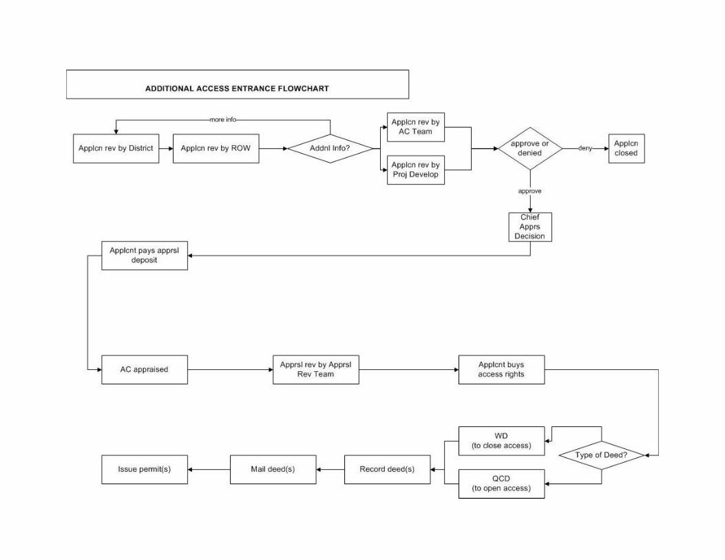
014 ADDITIONAL ACCESS ENTRANCE Once the control of access has been acquired and the project constructed, an additional entrance to a property may be permitted if the access meets the desirable spacing criteria described in paragraph 011 and 012. The applicant for an additional access entrance should be aware that the State of Nebraska has previously acquired the rights of direct access to the highway from the applicant's

10
highway frontage and, therefore, the applicant has no remaining right of additional direct access to the highway. The acquisition of access rights is recorded in the local county courthouse and is a restriction placed on the property.
015 APPLICATION The department realizes there may be locations where granting an access within an area where access rights were previously acquired may be consistent with our current policies. In these cases, the property owner shall submit a request for the establishment of a new access to the district engineer. The property owner may request to purchase any type of access (from full unrestricted access rights to some lesser restricted access right) from the NDOR, and the department should follow the procedure that follows.
016 APPLICATION REVIEW IN THE DISTRICT
A. This procedure will be followed on all projects on which the District Engineer has given tentative acceptance of the project in behalf of the State. Access requests, which occur prior to acceptance of project, will be handled in accordance with normal Right of Way Division procedures.
B. All requests for a break in controlled access or a change in the conditions or
classifications of existing accesses in controlled access areas shall first be submitted to the District Engineer in whose District such access or access change lies. See map at the end for addresses and district boundaries.
C. Requests may be submitted on standard access permit application forms
available from the department or by letter. The request shall include a property map or plat indicating the boundaries of the property, other accesses, and abutting public roads and streets. The request shall also include the name(s) of the owner as they appear on the deed of record and the legal description of the property. The department may require any of the following items or others when relevant to the evaluation of an access application or the construction of an access.
1. Highway and driveway plan and profile.
2. Complete drainage plan of the site showing impact to the highway
right of way and related drainage infrastructure.
3. Map and letters detailing the utility locations before and after development in and along the Highway.
11
4. Subdivision zoning or development plan, if appropriate. These should be coordinated with the local officials and their comments should be included with the application.
5. Proposed access design.
6. A traffic Impact Study.
D. At this phase of the request, the district should not accept a performance guarantee with the application. The reason is that the department does not approve many access requests and there is no reason to have these funds on hand.
E. Each District Engineer should make appropriate comments and forward the
application together with the information noted above in paragraph C and, if available in the District office, a copy of the Right of Way plans which denote the location of the new access to the Property Management Section in Lincoln. Access to the state highway system is based on many factors. Among those to be considered by the District and the central office include:
1. Preservation of the safety of the persons using the highway.
2. Preservation of the public's investment in the existing highway.
3. The effect of the proposed access point on the traffic carrying capability
of the highway, the potential for accidents, and the impact on traffic signals.
4. The existing sight distance.
5. Highway alignment and configuration.
6. The volume and speed of the traffic on the highway at the proposed
access point.
7. The volume of traffic generated by the development served by the access and to what extent improvement to the highway facilities by persons requesting access will mitigate adverse effects caused by the access point to the highway facility.
8. Closure or relocation of existing access points, or relocating access
points to provide better traffic turning movements.
9. Moving the new access point to a property line to allow for a joint-use drive to serve two properties, or to allow access points to be directly across the highway from each other (to eliminate offset access points.)
12
10. Input from the local governmental authority.
11. Dedication of right of way for future public streets to provide for orderly development of the property abutting the highway.
017 APPLICATION REVIEW IN RIGHT OF WAY (ROW)
A. The Property Management Section in the Right of Way Division shall receive access requests for changes and conditions of access in controlled access areas on behalf of the department. This office shall prepare the necessary files, research deeds and plans, and coordinate the review of the access requests within the department.
B. An interdisciplinary team reviews all applications.
1. The members of the Access Control Team consist of the Right of way
Manager, Planning & Project Development Engineer, Roadway Design Engineer, Traffic Engineer and District Engineer or their delegated representatives. Staff members from each of these Divisions/Districts, as well as the Realty Officer of the Federal Highway Administration, may also attend the work sessions.
2. The team works cooperatively with the applicant and attempts to resolve
all difficulties prior to taking final action on the application. If additional information is required, the Property Management Section shall secure the required additional information.
3. The team, at a minimum, considers the following factors:
a. All the items considered by the District Engineer noted in 016 E.
b. The department may require consolidation of existing accesses
whenever separate parcels of land abutting the highway are consolidated or assembled under one purpose, plan, entity, or usage. The owner of the abutting property shall remove any existing access or accesses that are replaced by consolidated accesses.
4. The Property Management Section will make a written record of the
decision of the team.
018 APPLICATION DENIED BY THE ACCESS CONTROL TEAM
A. If the Access Control Team denies the request, such request shall be considered "closed" unless the applicant supplies additional information to

13
justify a request for reconsideration. In this situation, the department can again consider a request at a later date; however, denial of access upon reconsideration should close additional reconsideration of access for a period of at least one year.
B. The Property Management Section shall advise the applicant of the decision of
the department. A copy of the correspondence shall be sent to the District Engineer and other appropriate parties.
019 APPLICATION APPROVED BY THE ACCESS CONTROL TEAM
A. The Property Management Section shall, if necessary, obtain commitments from the property owner for the dedication of public streets and acceptance of such dedication from the county or municipality under whose jurisdiction these public streets will fall if access is granted. In addition, acceptance of design features of the access, and if necessary, any required highway improvements considered necessary by the department shall be secured from the applicant. Definite information must be received concerning the official legal owner of the property so a proper deed can be written.
B. The Property Management Section shall prepare a formal submittal to the
Planning & Project Development Division to determine that the change in access control will result in little or no adverse environmental effect and that the approval to change access control meets the programmatic categorical exclusion approved by the Federal Highway Administration.
020 APPLICATION DENIED BY PLANNING & PROJECT DEVELOPMENT
A. After receipt of Planning & Project Developments reply, the Property Management Section will advise applicant of the denial.
B. The applicant will have opportunity to request reconsideration if appropriate
environmental studies determine if the programmatic categorical exclusion classification is proper.
021 APPLICATION APPROVED BY PLANNING & PROJECT DEVELOPMENT
A. The Chief Appraiser will determine the format and level of documentation for the appraisal. The department has developed minimum standards for appraisals consistent with established and commonly accepted appraisal practice. The following appraisal formats are listed from the simplest to the most complex: 1) Compensation Estimate, 2) Short Form Appraisal, 3) Narrative Appraisal Report

14
1. If the Chief Appraiser determines the changes in access to the property will result in no value or nominal value (insignificant) the value of the access right shall be $250.00.
2. If any of the other types of appraisals are required, the value of the
access right shall be determined by the completed and reviewed appraisal report.
B. Appraisal deposits will be required from the applicant for all appraisal types.
The deposit will be $1,000.00 for the Appraisal Report.
1. The Property Management Section will consult with the Chief Appraiser about the complexity of the appraisal process and a decision will be reached about the amount of the deposit.
2. The deposit will be fully refundable to the applicant if the applicant
follows through on the access request and actually purchases the access rights from the department at the appraised fair market value.
3. If the applicant desires to do so, the deposit may be applied to the
appraised value.
4. If the applicant does not purchase the access rights, an accounting will be made of the department's appraisal cost. Any deposit surplus will be refunded to the applicant. The applicant will be required to pay for any appraisal costs over and beyond the deposit.
C. Upon receipt of the deposit from the property owner, the Chief Appraiser will be
requested to complete an appraisal. The appraisal may be completed by staff appraisers or by hiring a consultant from the department’s approved Fee Appraiser Roster. Fee appraisers may be utilized when it is necessary to expedite the appraisal process. The completed and reviewed appraisal will be forwarded to the Access Control Appraisal Review Team, which consists of the Chief Appraiser, Property Management Supervisor, Assistant ROW Manager, and ROW Manager, by the Property Management Section for review and approval of the appraised value.
D. The Property Management Section notifies the applicant of the fair market value
of the access rights being sold and requests that the applicant forward that amount to close the sale of the access rights.
E. The Property Management Section shall prepare driveway easements and/or
deeds to grant the change in the condition of the access. Warranty Deeds are for the owner to sign if existing access must be closed. Quitclaim Deeds are for the Director and the Governor to sign to open the new access.

15
F. At the same time as the deeds are prepared, the Property Management Section shall contact the applicant and secure written confirmation that all public streets which were a part of the approved scheme have been dedicated and likewise received written verification from the local political subdivision that they have accepted such dedication. The performance guarantee from the applicant should be requested at this time.
G. After receipt of this verification of the dedication of public streets and their
acceptance by the local political subdivisions, the Property Management Section can send the Warranty Deed and/or driveway easement to the applicant for execution.
H. At such time that the signed Warranty Deed, relinquishing the existing
driveway(s), is received by the Property Management Section, the Quitclaim Deed and/or easement granting the new access is submitted to the Director and Governor for signatures. After all signatures have been obtained, the deeds are sent to the respective counties for recording. The Property Management Section will make the distribution of the original deed and the copies.
I. The permit will be issued to the applicant after a performance guarantee for the
permit has been received. The permit will be in accordance with the agreed upon plans, specifications, and conditions as approved by the department.
J. Refer to the end of this policy booklet for a flowchart that identifies the actual
flow or sequence of tasks in the process described from paragraph 014 to 020.
022 RECORDS
The Property Management Section is responsible for distribution of the following information and maintaining certain records: A. The Property Management Section will record all highway improvement projects
reviewed by the department. The record shall indicate if controlled access is required.
B. The Property Management Section shall maintain a permanent record of all
access control decisions.
C. The Property Management Section shall maintain a complete record of all roads on which access control has been obtained for use by the public and employees of the Department of Roads.

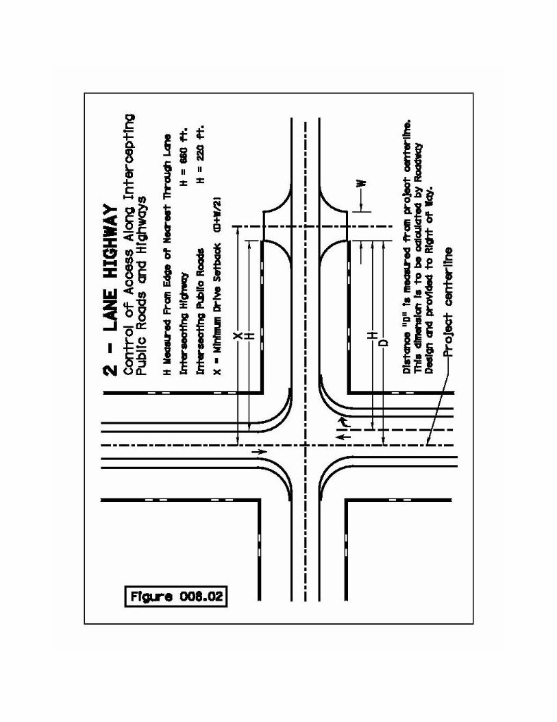


Table I Expressway and Other Multi-lane Divided Highways
Including Non Multi-lane Highways with future ADT over 6,000 Desirable Minimum Type Number of
access locations per
mile
Spacing Number of access
locations per mile
Spacing
Rural and Undeveloped Urban
1 2,000 feet 3 1,000 feet*
Developed Urban
Consider consolidation of
drives
2 blocks Consider consolidation of
drives
Consider street system and/or development
* Minimum spacing is no more than three access locations per mile with 1,000 feet as the
minimum distance between access locations. Minimum spacing should only be used for access to developed properties, such as, occupied farmsteads, residences, businesses, and to land-locked parcels.
Table II All Other Controlled Highways
Desirable Minimum Type Number of
access locations per
mile
Spacing Number of access
locations per mile
Spacing
Rural 3** 1,000 feet Provide access to all
properties**
Consider consolidation of
drives Undeveloped Urban
7** 600 feet Provide access to all
properties**
Consider consolidation of
drives Urban Provide access
to all properties**
Consider consolidation of
drives
Provide access to all
properties**
Consider consolidation of
drives ** Future access openings should be provided for each property, where warranted, to
provide for possible future development.