access near - stewardship centre for...
TRANSCRIPT

Access NearAquatic Areas
The Stewardship Series
Access NearAquatic Areas
AGuidetoSensitivePlanning,DesignandManagement

ForewordAccess Near Aquatic Areas was producedby the Fraser River Action Plan (Fisheriesand Oceans Canada) and the Ministry ofEnvironment, Lands, and Parks.
Access Near Aquatic Areas is part of theStewardship Series, which has beendeveloped to provide guidelines for planningand management of access near sensitiveaquatic areas.
Companion documents to Access NearAquatic Areas include:
� Community Greenways: LinkingCommunities to Country, and People toNature (1996)
� Community Stewardship: A Guide toEstablishing Your Own Group (1995)
� Naturescape British Columbia, Caring forWildlife Habitat at Home (1995)
� Stewardship Options: A Guide forPrivate Landowners in British Columbia(1996)
� Stream Stewardship: A Guide forPlanners and Developers (1994)
Access Near Aquatic Areas, as well as theabove documents, are available from:
Habitat and Enhancement BranchFisheries and Oceans Canada555 W. Hastings St.Vancouver, BCV6B 5G3
Ministry of EnvironmentHabitat Protection Branch10334 - 152A St.Surrey, BCV3R 7P8
Cover photo credits: Otto Langer

Access Near AquaticAreasA Guide to Sensitive Planning, Design and Management


Table of Contents
1.0 Introduction . . . . . . . . . . . . . . . . . . . . . . . . . . . . . . . . . . . . . . . . . . . . . . . . . . . . . . . . . . 1
2.0 The Ecological Context for Managing Aquatic ESAs . . . . . . . . . . . . . . . . . . . . . . . . . 22.1 What is an Aquatic ESA? . . . . . . . . . . . . . . . . . . . . . . . . . . . . . . . . . . . . . . . . . . . . . . . 22.2 The Importance of Watershed Planning. . . . . . . . . . . . . . . . . . . . . . . . . . . . . . . . . . . . . 22.3 Ecological Principles for Access Planning . . . . . . . . . . . . . . . . . . . . . . . . . . . . . . . . . . . 32.4 Establishing Management Objectives . . . . . . . . . . . . . . . . . . . . . . . . . . . . . . . . . . . . . . 42.5 Determining Compatible Uses . . . . . . . . . . . . . . . . . . . . . . . . . . . . . . . . . . . . . . . . . . . . . 4
3.0 Access Planning, Design and Management Principles . . . . . . . . . . . . . . . . . . . . . . . 53.1 Planning Principles . . . . . . . . . . . . . . . . . . . . . . . . . . . . . . . . . . . . . . . . . . . . . . . . . . . . . . 53.2 Design Principles . . . . . . . . . . . . . . . . . . . . . . . . . . . . . . . . . . . . . . . . . . . . . . . . . . . . . . . . 53.3 Management Principles . . . . . . . . . . . . . . . . . . . . . . . . . . . . . . . . . . . . . . . . . . . . . . . . . . 6
4.0 Access Routing Near Sensitive Aquatic Areas . . . . . . . . . . . . . . . . . . . . . . . . . . . . . . 74.1 Site Assessment . . . . . . . . . . . . . . . . . . . . . . . . . . . . . . . . . . . . . . . . . . . . . . . . . . . . . . . 7
4.1.1 Environmental Sensitivity Assessment . . . . . . . . . . . . . . . . . . . . . . . . . . . . . 74.1.2 Safety and Risk Assessment . . . . . . . . . . . . . . . . . . . . . . . . . . . . . . . . . . . . . . . 8
4.2 Principles for Planning Public Trails and Access Points . . . . . . . . . . . . . . . . . . . . . 84.2.1 Trail System . . . . . . . . . . . . . . . . . . . . . . . . . . . . . . . . . . . . . . . . . . . . . . . . . . . . 84.2.2 Trail Use . . . . . . . . . . . . . . . . . . . . . . . . . . . . . . . . . . . . . . . . . . . . . . . . . . . . . . . 94.2.3 Location of Limited Access Trails . . . . . . . . . . . . . . . . . . . . . . . . . . . . . . . . . . 94.2.4 Site Planning Process . . . . . . . . . . . . . . . . . . . . . . . . . . . . . . . . . . . . . . . . . . . . . 9
5.0 Design and Construction Standards for Public Access . . . . . . . . . . . . . . . . . . . . . . 105.1 Trail and Structure Construction . . . . . . . . . . . . . . . . . . . . . . . . . . . . . . . . . . . . . . . . 10
5.1.1 Trail Construction Materials . . . . . . . . . . . . . . . . . . . . . . . . . . . . . . . . . . . . . 105.1.2 Specific Trail Widths . . . . . . . . . . . . . . . . . . . . . . . . . . . . . . . . . . . . . . . . . . . . 115.1.3 Trail Alignment . . . . . . . . . . . . . . . . . . . . . . . . . . . . . . . . . . . . . . . . . . . . . . . . 115.1.4 Trail Entrance Baffles . . . . . . . . . . . . . . . . . . . . . . . . . . . . . . . . . . . . . . . . . . . 115.1.5 Signage . . . . . . . . . . . . . . . . . . . . . . . . . . . . . . . . . . . . . . . . . . . . . . . . . . . . . . . 135.1.6 Viewpoints . . . . . . . . . . . . . . . . . . . . . . . . . . . . . . . . . . . . . . . . . . . . . . . . . . . . 135.1.7 Trail Staging Areas . . . . . . . . . . . . . . . . . . . . . . . . . . . . . . . . . . . . . . . . . . . . . 13
5.2 Decks, Boardwalks and Footbridges . . . . . . . . . . . . . . . . . . . . . . . . . . . . . . . . . . . . . . . 135.3 Access from Adjacent Property . . . . . . . . . . . . . . . . . . . . . . . . . . . . . . . . . . . . . . . . . 185.4 Gated Utility Service Points . . . . . . . . . . . . . . . . . . . . . . . . . . . . . . . . . . . . . . . . . . . . 185.5 Designing for Public Safety . . . . . . . . . . . . . . . . . . . . . . . . . . . . . . . . . . . . . . . . . . . . 185.6 Costs . . . . . . . . . . . . . . . . . . . . . . . . . . . . . . . . . . . . . . . . . . . . . . . . . . . . . . . . . . . . . . . 18
6.0 Trail Management and Maintenance in Aquatic ESAs . . . . . . . . . . . . . . . . . . . . . . . 196.1 Trail Maintenance Standards . . . . . . . . . . . . . . . . . . . . . . . . . . . . . . . . . . . . . . . . . . . . . 196.2 Guidelines for Preventing Trail Proliferation . . . . . . . . . . . . . . . . . . . . . . . . . . . . . . 20
7.0 Using Barriers to Protect Aquatic ESAs . . . . . . . . . . . . . . . . . . . . . . . . . . . . . . . . . . 217.1 When is a Barrier Required? . . . . . . . . . . . . . . . . . . . . . . . . . . . . . . . . . . . . . . . . . . . 217.2 Regulations Affecting Barriers . . . . . . . . . . . . . . . . . . . . . . . . . . . . . . . . . . . . . . . . . . 25
i
7.3 Barrier Selection and Implementation . . . . . . . . . . . . . . . . . . . . . . . . . . . . . . . . . . . 257.3.1 Contexts for Barriers . . . . . . . . . . . . . . . . . . . . . . . . . . . . . . . . . . . . . . . . . . . 257.3.2 Barrier Categories . . . . . . . . . . . . . . . . . . . . . . . . . . . . . . . . . . . . . . . . . . . . . . 257.3.3 Location of Barriers . . . . . . . . . . . . . . . . . . . . . . . . . . . . . . . . . . . . . . . . . . . . . 25
7.4 Recommended Barriers . . . . . . . . . . . . . . . . . . . . . . . . . . . . . . . . . . . . . . . . . . . . . . . . 28A. Live Barriers . . . . . . . . . . . . . . . . . . . . . . . . . . . . . . . . . . . . . . . . . . . . . . . . . . . 28B. Hard (Fencing) Barriers. . . . . . . . . . . . . . . . . . . . . . . . . . . . . . . . . . . . . . . . . . 32C. Live Barriers in Conjunction with Fencing . . . . . . . . . . . . . . . . . . . . . . . . . 39D. Terrain Barriers . . . . . . . . . . . . . . . . . . . . . . . . . . . . . . . . . . . . . . . . . . . . . . . . 40
7.5 Case Examples: Using Barriers to Protect Aquatic ESAs . . . . . . . . . . . . . . . . . . . 43A. Rural Agricultural Site . . . . . . . . . . . . . . . . . . . . . . . . . . . . . . . . . . . . . . . . . . 43B. Single Family Housing . . . . . . . . . . . . . . . . . . . . . . . . . . . . . . . . . . . . . . . . . . 44C. Multi-Family Housing . . . . . . . . . . . . . . . . . . . . . . . . . . . . . . . . . . . . . . . . . . . 45D. Suburban High School Site . . . . . . . . . . . . . . . . . . . . . . . . . . . . . . . . . . . . . . 45E. Industrial/Commercial Setting . . . . . . . . . . . . . . . . . . . . . . . . . . . . . . . . . . . 46F. Urban Park . . . . . . . . . . . . . . . . . . . . . . . . . . . . . . . . . . . . . . . . . . . . . . . . . . . . 47
8.0 Tools for Protecting Aquatic ESAs . . . . . . . . . . . . . . . . . . . . . . . . . . . . . . . . . . . . . . . 488.1 Greenways . . . . . . . . . . . . . . . . . . . . . . . . . . . . . . . . . . . . . . . . . . . . . . . . . . . . . . . . . . 488.2 Legislation, Guidelines and Resources . . . . . . . . . . . . . . . . . . . . . . . . . . . . . . . . . . . 498.3 Covenants . . . . . . . . . . . . . . . . . . . . . . . . . . . . . . . . . . . . . . . . . . . . . . . . . . . . . . . . . . . 498.4 Voluntary Stewardship . . . . . . . . . . . . . . . . . . . . . . . . . . . . . . . . . . . . . . . . . . . . . . . . 508.5 Cooperative Management . . . . . . . . . . . . . . . . . . . . . . . . . . . . . . . . . . . . . . . . . . . . . 518.6 Funding . . . . . . . . . . . . . . . . . . . . . . . . . . . . . . . . . . . . . . . . . . . . . . . . . . . . . . . . . . . . . 51
9.0 Case Example . . . . . . . . . . . . . . . . . . . . . . . . . . . . . . . . . . . . . . . . . . . . . . . . . . . . . . . . 52
Appendices . . . . . . . . . . . . . . . . . . . . . . . . . . . . . . . . . . . . . . . . . . . . . . . . . . . . . . . . . . . . . . . 59Appendix 1: Case Studies in Access Planning . . . . . . . . . . . . . . . . . . . . . . . . . . . . . . . . . . 59
A. Oregon Coastal Zone Management and Shorefront Access . . . . . . . . . . . 59B. Columbia River Gorge National Scenic Area Management Plan . . . . . . . 62C. Lake Ontario Greenway Strategy . . . . . . . . . . . . . . . . . . . . . . . . . . . . . . . . . 64D. Swan Lake/Christmas Hill Nature Sanctuary . . . . . . . . . . . . . . . . . . . . . . . 66E. Galloping Goose Trail . . . . . . . . . . . . . . . . . . . . . . . . . . . . . . . . . . . . . . . . . . . 66F. South Dyke Trail, London�s Landing . . . . . . . . . . . . . . . . . . . . . . . . . . . . . . 67G. Boundary Bay Regional Park . . . . . . . . . . . . . . . . . . . . . . . . . . . . . . . . . . . . 68
Appendix 2: Sample Unit Costs for Construction Materials . . . . . . . . . . . . . . . . . . . . . . . 70Appendix 3: Suggested Live Barrier Species for Coastal British Columbia . . . . . . . . . . . 71Appendix 4: Legislation, Guidelines and Resource Materials . . . . . . . . . . . . . . . . . . . . . . 74
Glossary . . . . . . . . . . . . . . . . . . . . . . . . . . . . . . . . . . . . . . . . . . . . . . . . . . . . . . . . . . . . . . . . . . 76
Resources . . . . . . . . . . . . . . . . . . . . . . . . . . . . . . . . . . . . . . . . . . . . . . . . . . . . . . . . . . . . . . . . 79Aquatic ESA Planning and Management . . . . . . . . . . . . . . . . . . . . . . . . . . . . . . . . . . . . . . . 79Riparian Vegetation . . . . . . . . . . . . . . . . . . . . . . . . . . . . . . . . . . . . . . . . . . . . . . . . . . . . . . . . . 80Trail Planning and Building . . . . . . . . . . . . . . . . . . . . . . . . . . . . . . . . . . . . . . . . . . . . . . . . . . 81Barriers . . . . . . . . . . . . . . . . . . . . . . . . . . . . . . . . . . . . . . . . . . . . . . . . . . . . . . . . . . . . . . . . . . . . 81Private Stewardship and Covenants . . . . . . . . . . . . . . . . . . . . . . . . . . . . . . . . . . . . . . . . . . . 81Stewardship Series . . . . . . . . . . . . . . . . . . . . . . . . . . . . . . . . . . . . . . . . . . . . . . . . . . . . . . . . . . 81Urban Initiative Series . . . . . . . . . . . . . . . . . . . . . . . . . . . . . . . . . . . . . . . . . . . . . . . . . . . . . . . 82Aquatic ESA Planning and Management Contacts . . . . . . . . . . . . . . . . . . . . . . . . . . . . . . . 82
ii

List of Figures
1. Aquatic ESAs are Products of Watershed Processes . . . . . . . . . . . . . . . . . . . . . . . . . . . . . . . 3
2. Illustration of Leave Area, Buffer and Proper Trail Alignment . . . . . . . . . . . . . . . . . . . . . . 5
3. Section Through Crushed Aggregate Path . . . . . . . . . . . . . . . . . . . . . . . . . . . . . . . . . . . . . . 10
4. Section and Plan of Post and Rail Trail Baffle . . . . . . . . . . . . . . . . . . . . . . . . . . . . . . . . . . . . 12
5. Section Through Viewing Deck . . . . . . . . . . . . . . . . . . . . . . . . . . . . . . . . . . . . . . . . . . . . . . . . 15
6. Section Through Pedestrian Bridge . . . . . . . . . . . . . . . . . . . . . . . . . . . . . . . . . . . . . . . . . . . . 16
7. Section Through Boardwalk . . . . . . . . . . . . . . . . . . . . . . . . . . . . . . . . . . . . . . . . . . . . . . . . . . 17
8. Decision Matrix to Determine Barrier Requirements . . . . . . . . . . . . . . . . . . . . . . . . . . . . . . 24
9. Barrier Types, Implications and Suitability . . . . . . . . . . . . . . . . . . . . . . . . . . . . . . . . . . . . . . 26
10. Barrier Costs and Effectiveness Comparison Chart . . . . . . . . . . . . . . . . . . . . . . . . . . . . . . . 27
11. Methods of Transplanting Plant Material . . . . . . . . . . . . . . . . . . . . . . . . . . . . . . . . . . . . . . . 30
12. Sketches of Thorny Double Hedge Barriers . . . . . . . . . . . . . . . . . . . . . . . . . . . . . . . . . . . . . . 31
13. Detail of Metal Rail Fence . . . . . . . . . . . . . . . . . . . . . . . . . . . . . . . . . . . . . . . . . . . . . . . . . . . . . 32
14. Detail of Timber Rail and Mesh Fence (Page Wire) . . . . . . . . . . . . . . . . . . . . . . . . . . . . . . . 33
15. Detail of PVC Fence . . . . . . . . . . . . . . . . . . . . . . . . . . . . . . . . . . . . . . . . . . . . . . . . . . . . . . . . . . 34
16. Detail of Barbed Wire Fence and Log Fence Adapted for Wildlife . . . . . . . . . . . . . . . . . . 35
17. Detail of Chain Link Fence . . . . . . . . . . . . . . . . . . . . . . . . . . . . . . . . . . . . . . . . . . . . . . . . . . . . 36
18. Detail of Timber Fence . . . . . . . . . . . . . . . . . . . . . . . . . . . . . . . . . . . . . . . . . . . . . . . . . . . . . . . 37
19. Detail of Timber Marking Posts . . . . . . . . . . . . . . . . . . . . . . . . . . . . . . . . . . . . . . . . . . . . . . . . 38
20. Detail of Combination Live and Hard Barrier . . . . . . . . . . . . . . . . . . . . . . . . . . . . . . . . . . . . 39
21. Sketch of Live Barrier in Combination with Fencing and Retaining Walls . . . . . . . . . . . . 40
22. Sketch of Constructed Berm . . . . . . . . . . . . . . . . . . . . . . . . . . . . . . . . . . . . . . . . . . . . . . . . . . . 41
23. Sketch of Depression in Combination with Fencing . . . . . . . . . . . . . . . . . . . . . . . . . . . . . . . 41
24. Sketch of Channel and Ditch in Combination with Fence/Plant Material . . . . . . . . . . . . 42
25. Access Planning Case Example . . . . . . . . . . . . . . . . . . . . . . . . . . . . . . . . . . . . . . . . . . . . . . . . 53
26. Section Through Aquatic ESA with Main Trail in Buffer . . . . . . . . . . . . . . . . . . . . . . . . . . 57
27. Viewing Deck Overlooks Tailwater/Outlet Pond . . . . . . . . . . . . . . . . . . . . . . . . . . . . . . . . 57
28. Limited Access Trails Lead to Footbridge Overlooking Wetland . . . . . . . . . . . . . . . . . . . . 58
29. Limited Access Trail Leads from Main Trail to Pedestrian Bridge . . . . . . . . . . . . . . . . . . . 58
iii


British Columbia has many lakes, rivers,streams, wetlands and estuaries. Theseareas, along with their vegetated
valleys and floodplains, are critical fish andwildlife habitats as well as being importantto our communities and our well being. Theyprovide community water supplies, andvaluable fish and wildlife habitat. They alsoprotect adjacent lands from natural flood anddrought events, and preserve the unique andscenic character of this region. Many of thesefeatures are fragile and easily disturbed andare therefore considered environmentallysensitive areas (ESAs).
As our population increases, conflict betweendemands for greater access to these sensitiveareas and adequate protection of them isincreasing. In rural regions conflicts oftenarise where these fertile and productive areasare logged or used for grazing, or intensivecrop production. In urban areas the problemis becoming more pronounced as these areasare being developed or encroached upon forresidential, commercial or industrial use (e.g.sewer and water alignments, roads, masstransit and linear parks). A recentlyconducted survey shows that natural areasare very important for community recreation.It has been estimated that 1 - 2% of thepopulation in a community regularly useskating rinks, while 5 - 7% routinely use aswimming pool. However, over 50%regularly hike or use foot paths throughnatural �greenways� where they exist. (EdMcMahon, Director of American Greenways).
The challenge - protectingaquatic ESAs whileaccommodating access
Where environmental values are high andencroachment would be particularlydamaging, access may have to be controlled,limited or even restricted. Where access toaquatic areas is appropriate, it demandscareful planning, design and management.
With increased pressure on these areas, astewardship approach to public access isneeded in order to sustain these fragileecosystems. Stewardship of these areasrequires that all users and managers shareresponsibility and cooperate in managementand conservation of these areas.
This document, another in the StewardshipSeries, provides a guide to balancingconservation with planning, design andmanagement of access near aquatic areas. Itfocuses on settlement lands and is intendedfor use by municipal and regional parksplanners and staff, landscape architects,consultants, field staff of environmentalagencies, and community conservationgroups. It will also be of interest to individualland owners with environmentally sensitivelands who need to manage access issues onprivate property.
1.0 Introduction
Introduction 1
Sensitively designed public access protectsecological features and functions

2.0 The Ecological Context forManaging Aquatic ESAs
2.1 What is an AquaticESA?
Rivers, lakes, streams, wetlands andestuaries are commonly referred to asaquatic environmentally sensitive
areas (ESAs). An aquatic ESA may beperennially wetted or may be an ephemeralwetland; it can be a floodplain, headwaterdrainage, or ditch. An aquatic ESA could alsobe a subsurface feature such as an aquifer.
Aquatic ESAs also include the riparian zone.The riparian zone, which is a transitionbetween the aquatic feature and the adjacentupland, is characterized by moist soils and acomplex of herbaceous and woody vegetationthat is adapted to moist conditions.
Streams and riparian areas are examples of aquaticESAs
Sandhill Crane in a wetland
2.2 The Importance ofWatershed Planning
Watersheds range in size,but all have the samefeatures. They arecatchment areas that drainan area defined by heightsof land such as mountainsand ridges. Watershedscollect and retain waterwhich is received asprecipitation, and slowlyrelease it via seepages ordirect discharge into anetwork of small drainagefeatures. These coalesce toform small first order
streams which merge to form second orderstreams and ultimately rivers. (Diagram fromThe Watershed Works).
Watersheds, like the aquatic ESAs they create,are dynamic systems. They evolve inresponse to a host of biological, hydrologicaland geological processes and cycles, all ofwhich can be irrevocably altered by humanactivities.
Fish and Wildlife Values of Riparian Zones:
� support the aquatic and terrestrial food websfor fish and wildlife
� provide shelter, cover and temperatureregulation for fish and wildlife
� create habitat diversity for songbirds,raptors, small mammals and other wildlifespecies
� provide wildlife migration corridors andlinkages between critical habitats
� buffer aquatic features from pollution� recharge ground water and aquifers� stabilize banks and reduce erosion� dissipate energy of floods� retain water in soil during droughts
2 The Ecological Context for Managing Aquatic ESAs

Watershed Cross Section Stream System in a Watershed
Figure 1 Aquatic ESAs are Products of Watershed Processes(from The Streamkeepers Handbook)
Modification of landscape features andinterruption of natural drainage processeshave occurred in many watersheds. Theresult has been a reduction or disappearanceof fish and wildlife, increased contaminationof surface and groundwater supplies,increased periodicity and magnitude offloods, and a decrease in our quality of life.It has also led to a loss of open space, and afragmentation of habitats. Over time, it hasbecome clear that the cost of redressingwatershed scale impacts significantly exceedsthe cost of preventing them in the first place.
Protection of aquatic ESAs requires basicknowledge of watershed processes and anunderstanding of the consequences ofaltering these processes.
Watersheds are natural landscape units thatintegrate many natural processes. As such,they provide a basis for land use and accessplanning that is sensitive to aquaticprotection.
2.3 Ecological Principles forAccess Planning
Access plans near sensitive aquatic areasshould be based on the following ecologicalprinciples:
Ecological Principles:
� Aquatic and riparian areas are criticalhabitats for fish and wildlife and need to beprotected from disturbance.
� Intact wetlands and floodplains are essentialfor maintaining natural channelmorphology, water quality, streamhydrology and natural flood protection.
� Streams, wetlands and other aquatic featuresare the product of hydrologic, geologic andother processes which often occur in areaswell removed from the aquatic feature itself.
� Rivers, streams and riparian areas integrate,express, and accumulate impactsthroughout a watershed.
The Ecological Context for Managing Aquatic ESAs 3
Aquatic ESAs should be principally managed forconservation, protection and restoration
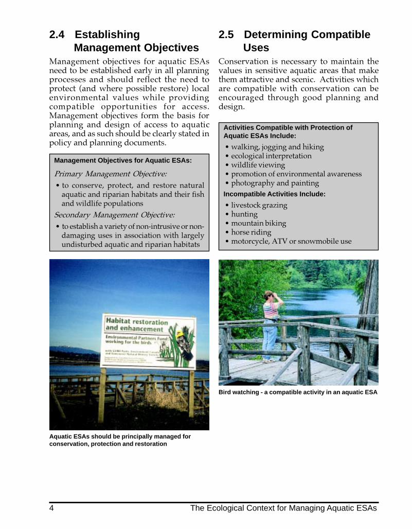
2.5 Determining CompatibleUses
Conservation is necessary to maintain thevalues in sensitive aquatic areas that makethem attractive and scenic. Activities whichare compatible with conservation can beencouraged through good planning anddesign.
Bird watching - a compatible activity in an aquatic ESA
Activities Compatible with Protection ofAquatic ESAs Include:
� walking, jogging and hiking� ecological interpretation� wildlife viewing� promotion of environmental awareness� photography and paintingIncompatible Activities Include:
� livestock grazing� hunting� mountain biking� horse riding� motorcycle, ATV or snowmobile use
2.4 EstablishingManagement Objectives
Management objectives for aquatic ESAsneed to be established early in all planningprocesses and should reflect the need toprotect (and where possible restore) localenvironmental values while providingcompatible opportunities for access.Management objectives form the basis forplanning and design of access to aquaticareas, and as such should be clearly stated inpolicy and planning documents.
Management Objectives for Aquatic ESAs:
Primary Management Objective:
� to conserve, protect, and restore naturalaquatic and riparian habitats and their fishand wildlife populations
Secondary Management Objective:
� to establish a variety of non-intrusive or non-damaging uses in association with largelyundisturbed aquatic and riparian habitats
4 The Ecological Context for Managing Aquatic ESAs

Many examples exist in NorthAmerica where access has beensensitively designed to protect
critical habitats. The following planning,design, and management principles havebeen extracted from several Canadian andAmerican case studies (see Appendix 1), fieldreconnaissance in the Lower Mainland ofB.C., and discussions with governmentagency and private sector representatives.
3.0 Access Planning, Design andManagement Principles
3.1 Planning Principles� Aquatic ESAs need to be isolated from
disturbance. This can be accomplished byestablishing leave areas (reserve zones)around them1 .
� A buffer adjacent to the leave area isrequired to:- protect the leave area;- accommodate recreational trail
corridors;- prevent conflicting uses next to each
other;- provide a transition between
adjacent land uses.� The combination of a leave area and a
buffer (management zone) permitsmanagement for multiple uses (e.g.protection and recreation).
� Impacts must be limited in time and spaceto very specific locations which are mosttolerant to disturbance.
� Where recreational use is proposed, ahierarchy of trails, footpaths, andstructures should be planned. These mustconsider site sensitivities, and should onlysupport compatible uses.
� Nearby residents should be buffered fromtrail users.
� Interpretive opportunities and publicstewardship should be encouraged.
� Penetration into leave areas (e.g. trails,footpaths, livestock crossings, etc.) shouldbe kept to a minimum.
� As site sensitivity and hazards mayincrease seasonally, access plans mustaddress these issues.
1 Guidelines for establishing leave areas along streams toprotect fish habitat are contained in the Land DevelopmentGuidelines for the Protection of Aquatic Habitat, published byFisheries and Oceans Canada and the Ministry ofEnvironment, Lands, and Parks (1992).
Figure 2 Illustration of Leave Area, Buffer and ProperTrail Alignment
3.2 Design Principles� Leave areas (reserve zones) should be
clearly delineated and protected from anydisturbance prior to and duringconstruction.
� Main access should be concentrated in onemajor corridor located in the buffer area.
Access Planning, Design and Management Principles 5

� Access should be designed to encouragefoot traffic and discourage other forms oftraffic.
� Barriers should be used as necessary. Forexample, install:- fences to prevent livestock access
into leave areas;- combination of fences and vegetative
barriers to buffer residents fromadjacent land uses or trail users;
- baffles or turnstiles to preventunauthorized vehicle access ontotrails or private property;
- live barrier blinds along trailboundaries to minimize disturbanceto waterfowl.
Fencing is often necessary for human safety
� Structures in leave areas should bedesigned to separate approaches andtraffic either vertically orhorizontally from sensitive habitats(e.g. through use of boardwalks,bridges, and railed pathways).
A board walk separates traffic vertically from sensitivehabitat
� Soil disturbance, erosion and vegetationremoval should be minimized by designand during construction.
� Interpretive signage, kiosks or bulletinboards should be installed at strategiclocations (e.g. road crossings, viewpoints,trail heads, etc.) to provide information onenvironmental values, stewardshipinitiatives, or to post trail use rules.
3.3 Management PrinciplesA management plan2 needs to be developedfor these areas which specifies:
� maintenance standards for all structuresand trails;
� a schedule for maintenance work;� trail use rules and guidelines;� closures of seasonally sensitive or hazard
areas (with informational signage andtemporary barriers);
� schedule for garbage collection;� pet management (prohibited/on leash,
etc.).
The principle of the least impact shouldalways apply when managing or maintainingstructures or trails near aquatic ESAs.
2 For additional information on trail planning, design andconstruction, and maintenance standards, as well as signageand barrier design, refer to the B.C. Parks’ Park Facility StandardsManual, Volumes 1 and 2, 1992.
Trail use guidelines, barriers and litter control are allpart of access management
6 Access Planning, Design and Management Principles

4.0 Access Routing Near SensitiveAquatic Areas
When considering whether publicaccess near aquatic ESAs isappropriate, the following
questions must be addressed:
� Is the secured land base large enough toprotect leave areas (reserve zones) aroundsensitive aquatic habitats and provide abuffer for access alignment?
� Can liability, land use conflicts, hazardsand potential conflicts with criticalenvironmental features be minimizedthrough skillful site planning and design,and good site management?
Where the answer to both of these questionsis yes, detailed site assessments and accessplanning need to be done in order determinethe exact location of trails and access points,and to develop a site plan.
4.1 Site AssessmentAccess near an aquatic ESA must be sited ina manner that:
� preserves sensitive features such asriparian and marsh vegetation, uniqueplants, wetlands, or fish habitat,waterfowl nesting areas, or habitats ofendangered or threatened species;
� protects users from hazards;� minimizes alteration of drainage and
disturbance of slopes.
To determine the best location for access,detailed site assessments are needed.4.1.1Environmental Sensitivity
AssessmentEnvironmental sensitivity can vary from siteto site. The sensitivity of a site is based on:Biological values:� fish and wildlife use� location and extent of riparian vegetation
� unique, endangered or threatened plantand animal species3
Physical features:� unstable slopes� erodable soils� topography (e.g. escarpments or ravines)� shallow rooted trees with high windthrow
potential� drainage features (e.g. seeps, springs,
ephemeral channels, etc.)� streams, wetlands, and floodplains
All of the above, as well as local precipitationpatterns and adjacent land uses, willinfluence decisions regarding location andappropriateness of trails, access points orother potential uses near aquatic ESAs.
As all upstream activities in a watershedinfluence downstream habitats, linkages andcumulative impacts must be considered whenassessing sensitivity of a site to furtherdisturbance.
3 The provincial listing of rare and endangered species isavailable from the Provincial Conservation Data Centre inVictoria, or via the CDC Web site at www.env.gov.bc.ca/wld/cdc
Mapping physical features and biological functions arepart of site assessments for access planning(from Community Greenways)
Access Routing Near Sensitive Aquatic Areas 7

Existing site specific information should becompiled and where necessary supplementedby site surveys and geotechnical assessmentsto accurately delineate and map sensitivehabitat features, hazard areas, top of bank,leave area boundaries, buffer boundaries,livestock access points, and specific trailroutes and alignments.
4.1.2 Safety and Risk AssessmentConsideration of liability and human safetyissues at the site assessment stage isimportant. The location of hazard areas,adjacent land uses and the proximity ofproposed access points and alignments toprivate property must be determined whenestablishing the management zone aroundaquatic ESAs and evaluating trail alignmentoptions. Fencing or other types of barriersmay be necessary where potential conflictsexist.
Fencing is often necessary for human safety
If an easement has been dedicated by a landowner to a local government, agreementsshould be developed that indicateresponsibilities assumed by each party.
The health and wind firmness of trees, andrisks to trail users associated with falling treesneed to be assessed. Adequately sized buffersbetween leave areas and developed areas notonly provide a corridor for trail alignment butthey also enhance natural successional forestprocesses. These increase the integrity of thebuffer edge and have the added benefit ofprotecting adjacent property owners�buildings and structures. Dead trees that donot pose a direct hazard should be retainedas habitat for wildlife.
4.2 Principles for PlanningPublic Trails and AccessPoints
Once suitable sites are identified for publicaccess, an appropriate trail and access systemcan be developed. Following are principlesfor planning and design of trails and accesspoints near aquatic ESAs.
4.2.1 Trail SystemA hierarchy of trails should be established,reflecting the conditions and intended usesnear the aquatic ESA:
� Main or multi-use trails should belocated outside the leave area in a bufferarea. These may be multi-use pathwaysthat accommodate pedestrians, cyclistsand wheelchairs. These trails can haveviewpoints and interpretive signage alongtheir length.
� Connecting trails link road ends andresidential neighbourhoods to the maintrail and to other parts of a greenway.
� Limited access trails which penetrate theleave area are used for special purposes.An elevated boardwalk may be used toskirt a wetland; a small footpath may beused to access a particular point of interestsuch as a salmon spawning area. Theseminor paths are designed for low volumeuse.
Fencing is often necessary for human safety
8 Access Routing Near Sensitive Aquatic Areas
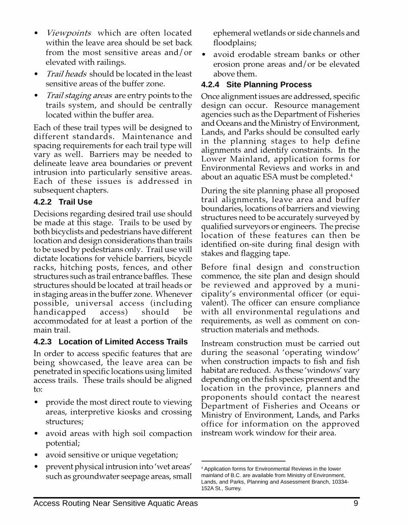
� Viewpoints which are often locatedwithin the leave area should be set backfrom the most sensitive areas and/orelevated with railings.
� Trail heads should be located in the leastsensitive areas of the buffer zone.
� Trail staging areas are entry points to thetrails system, and should be centrallylocated within the buffer area.
Each of these trail types will be designed todifferent standards. Maintenance andspacing requirements for each trail type willvary as well. Barriers may be needed todelineate leave area boundaries or preventintrusion into particularly sensitive areas.Each of these issues is addressed insubsequent chapters.4.2.2 Trail UseDecisions regarding desired trail use shouldbe made at this stage. Trails to be used byboth bicyclists and pedestrians have differentlocation and design considerations than trailsto be used by pedestrians only. Trail use willdictate locations for vehicle barriers, bicycleracks, hitching posts, fences, and otherstructures such as trail entrance baffles. Thesestructures should be located at trail heads orin staging areas in the buffer zone. Wheneverpossible, universal access (includinghandicapped access) should beaccommodated for at least a portion of themain trail.4.2.3 Location of Limited Access TrailsIn order to access specific features that arebeing showcased, the leave area can bepenetrated in specific locations using limitedaccess trails. These trails should be alignedto:
� provide the most direct route to viewingareas, interpretive kiosks and crossingstructures;
� avoid areas with high soil compactionpotential;
� avoid sensitive or unique vegetation;� prevent physical intrusion into �wet areas�
such as groundwater seepage areas, small
ephemeral wetlands or side channels andfloodplains;
� avoid erodable stream banks or othererosion prone areas and/or be elevatedabove them.
4.2.4 Site Planning ProcessOnce alignment issues are addressed, specificdesign can occur. Resource managementagencies such as the Department of Fisheriesand Oceans and the Ministry of Environment,Lands, and Parks should be consulted earlyin the planning stages to help definealignments and identify constraints. In theLower Mainland, application forms forEnvironmental Reviews and works in andabout an aquatic ESA must be completed.4
During the site planning phase all proposedtrail alignments, leave area and bufferboundaries, locations of barriers and viewingstructures need to be accurately surveyed byqualified surveyors or engineers. The preciselocation of these features can then beidentified on-site during final design withstakes and flagging tape.
Before final design and constructioncommence, the site plan and design shouldbe reviewed and approved by a muni-cipality�s environmental officer (or equi-valent). The officer can ensure compliancewith all environmental regulations andrequirements, as well as comment on con-struction materials and methods.
Instream construction must be carried outduring the seasonal �operating window�when construction impacts to fish and fishhabitat are reduced. As these �windows� varydepending on the fish species present and thelocation in the province, planners andproponents should contact the nearestDepartment of Fisheries and Oceans orMinistry of Environment, Lands, and Parksoffice for information on the approvedinstream work window for their area.
4 Application forms for Environmental Reviews in the lowermainland of B.C. are available from Ministry of Environment,Lands, and Parks, Planning and Assessment Branch, 10334-152A St., Surrey.
Access Routing Near Sensitive Aquatic Areas 9

5.0 Design and ConstructionStandards for Public Access
This section provides guidelines for thedesign and construction of public accesscorridors near sensitive aquatic areas.
Design components of a public access plannear aquatic ESAs generally include:
� trails and viewpoints� boardwalks and footbridges� viewing decks and raised platforms� pedestrian bridges and boardwalks� barriers (e.g. fences, gated utility service
points, hitching posts, bicycle turnstiles orbaffles)
5.1 Trail and StructureConstruction
In all cases where trails are aligned near anaquatic area, care must be taken to limitvegetation removal and soil disturbanceduring trail construction. Surface grubbingshould be kept to a minimum and trail widthsminimized to reduce vegetation removal.Wooden edging or risers can be used toestablish trail widths and avoid trailwidening over time.
The use of heavy equipment in these areasshould be discouraged. Low impactconstruction techniques should be employedsuch as small underinflated, rubber tiredvehicles, and construction pads, platforms orcranes. Wherever possible prefabricatedstructures that can be manually assembled onsite should be used.
Limited access trails which penetrate theleave area should be constructed manuallywith materials and equipment that can beeasily transported by small work crews.5.1.1 Trail Construction MaterialsTrail surfaces should consist of permeable,non-toxic material. Crushed aggregate witha lightly compacted aggregate sub base is thepreferred trail surface for high use or maintrails (Figure 3). Bark mulch or hog fuelshould not be used on trail surfaces nearwater as they produce leachate which causesserious water quality problems. Asphalt isnot desirable as it is impermeable andaccelerates run-off.
Figure 3 Section Through Crushed Aggregate Path
100m
m
Crushed Aggregate Path
100mm DEPTH CRUSHED AGGREGATECOMPACTED TO 95% S.P.D.ON FILTER FABRIC ON SUBGRADE 60
0mm
SLOPE TO DRAIN
50 x 50mm WOOD STAKE NAILED TO2 - 25 x 100mm CEDAR EDGERS
OVERLAPPED TO FOLLOW ON SUBGRADE
WIDTH VARIES ACCORDING TO SITUATION
10 Design and Construction Standards for Public Access

Example of a crushed aggregate path surface
Aggregate trail mix surfaces usually arecomprised of crushed rock and fines. Theymust be lightly compacted over a sub base toresist erosion, provide drainage, and to besafe. Though satisfactory for more accessiblepathways, such surfaces may be impracticalfor remote trail areas. Compacted granularsoil has also been used successfully asfootpath surface material. The resulting mixis reasonably permeable, resists flooding anderosion, withstands foot traffic, and requireslittle maintenance.
Small (limited access trails) should not beover designed. Where possible naturalsurfaces should be retained and notcompacted.5.1.2 Specific Trail WidthsMain trailsMain trails are typically 2.0 to 3.0 metres inwidth, and are located in the buffer area.
Connecting trailsThese trails should be kept to a maximumwidth of 1.0 metre and should be designed tolink road ends, sidewalks or other accessroutes to a main trail.
Limited access trailsLimited access trails, used to penetrate orcross leave areas, should be designed as smallfootpaths and, when necessary, elevatedabove ground, using boardwalks to avoidintrusion into �wet� areas or reducedisturbance to sensitive vegetation. Thefootpaths are narrow: 0.75 - 1.0 metres wide,and may be closed off during sensitivenesting or spawning periods or whenseasonal hazards (e.g. high flows) warrant.
In order to limit access into the leave area,portions of the leave area boundary may needto be separated from the trail with a barrier.5.1.3 Trail AlignmentDesign for existing terrainTypically, trails should be narrow (e.g. 1.0 mor less) over sloping terrain. They can bewider (1.5 - 3.0 m) over flat terrain,particularly if they are multi-use main trailsthat are located in the buffer. A positive cross-slope should always be maintained to ensureadequate drainage.
Protect existing vegetationTrails should be routed to protect major treeand shrub groupings.
Recognize safety issuesTrail placement should avoid hazard areassuch as steep ravines and bluffs, cliffs andembankments, hazardous trees and snags,undercut stream banks, etc. Conditions suchas swift currents, seasonally high waters, ortidal fluctuations should be posted on acurrent basis, and barriers erected.5.1.4 Trail Entrance BafflesTrail baffles or other barriers can be used todiscourage access by vehicles, bicycles andhorses, or prevent unauthorized use (Figure4). They can be located at public accessstaging areas and trail heads leading tosensitive aquatic areas, which may need to beclosed at certain times of the year.
Trail Baffle
Design and Construction Standards for Public Access 11

Figure 4 Section and Plan of Post and Rail Baffle
1800mm O.C.
COMPACTED DRAIN ROCK
450mm DIA. CONCRETE COLLAR OR COMPACTED BACKFILL
600m
m M
IN.
300m
m
CL POST
1200m
m T
YP
.150 x 150 POST50 x 100 RAIL
Post & Rail Baffle
PUBLIC ACCESS TRAIL TO ESA
POSSIBLE GATE FOR CLOSING OFF TRAIL IF REQUIRED
CL POST
12 Design and Construction Standards for Public Access

5.1.5 SignageWell-designed, strategically located signageis an effective way to raise awareness andenhance protection of aquatic ESAs. Signagecan be used in conjunction with barriers andshould be located in areas where informationon critical habitats, maps of public access trailsystems, trail use rules, and location ofviewpoints, is required.
Example of stewardship signage
5.1.6 ViewpointsViewpoints can simply be widened lobes ona connecting trail with durable seating andinterpretive signs, or they can be structuresthat are located at the terminus of a limitedaccess trail. Viewpoints are constructed toseparate people from critical fish and wildlifehabitat, or areas that are particularly sensitiveto disturbance while permitting views intothe area of interest.
5.1.7 Trail Staging AreasTrail staging areas are orientation points,where gates and signs are located and therules of trail use are clearly posted. Parkingspaces, bicycle racks, trash receptacles andwashroom facilities are typically situated instaging areas.
Trail staging areas include barriers, signage and otherorientation features
5.2 Decks, Boardwalks andFootbridges
These elevated structures (Figures 5, 6 & 7)provide an excellent means of involving thepublic in ecological viewing andinterpretation while preventing physicalintrusion into sensitive habitats. Anuninterrupted view of a sensitive spawningarea or a large wetland can be provided by abridge if the structure is skillfully sited.Where topography permits, platforms suchas viewing towers can be placed at highpoints in the buffer with views into featuresin the leave area that are being highlighted.Interpretive signs can be incorporated into thedesign of viewing platforms or footbridges.
Viewing towers reduce foot traffic in sensitivehabitats
LocationDecks and bridges need to be located andconstructed with due regard for hydraulicconcerns (refer to provincial floodplainrequirements). Factors including seasonalfluctuations in water velocity and volume,and debris flow patterns must be considered.Decks and bridges should have enoughfreeboard to pass debris and high water.
To protect habitat and minimize scour andassociated maintenance, deck or bridgefootings should be placed outside the wettedperimeter of the aquatic ESA. Whereconstruction creates a footprint within thewetted area, compensation will typically berequired.
Design and Construction Standards for Public Access 13

MaterialsWhere structures are located in shady or wetlocations, use galvanized mesh fastened to thedecking with galvanized nails or brackets toprevent slipping. Permit drainage off decksurfaces through 1.5" spacing between planksand a raised bull rail so water does not gettrapped.
Pile supported structures are preferred overslabs or floats in aquatic ESAs, except wherewater is sufficiently deep that floats will notrest on or scour the substrate. The advantageof pile supports is that they have a minimalfootprint on the sub-surface and permitcurrents or tidal movement to occurunimpeded. As well, getting people up andaway from the water surface or wetlandreduces the potential for trespass and permitsbetter viewing. Piled structures withboardwalks are preferred structures forcrossing dunes or other sensitive vegetationzones. Precast concrete pilings or footingsshould be used where concrete structures areproposed to avoid water quality problemsassociated with concrete run-off, and tominimize on site construction impacts.Structures in Contact with WaterTreated wood is often used in structures thatare in contact with water since they can bedetailed and are generally aestheticallypleasing, less expensive to construct andrequire limited maintenance. Depending onthe treatment however, treated woods canhave significant environmental impacts.
To the maximum extent possible, structuresin direct contact with water should be inert(e.g. natural untreated cedar, precast concreteor steel) to avoid water quality impactsassociated with chemical leaching fromtreated wood. Steel and concrete have higherinitial costs but they are more durable. Thelow maintenance associated with concrete orsteel alternatives can often make them cost-effective over the lifetime of the structure.(Note: These features relate to structures in afresh water environment. In brackish ormarine environments, steel can corrode.)Steel or concrete structures are most suitablewhere:
� piles must be driven into dense fill orinstalled in bedrock;
� water depths exceed 15 m and there isconsiderable tension on the structure;
� applied loads are high;� maintenance costs and structural integrity
are issues.
The selection of preservatives for in-waterstructures can have significant environmentalimplications. Many wood preservatives aretoxic to attaching or boring aquaticorganisms, and do not readily break down.
All treated wood structures should beconstructed with material that has beenpressure treated off-site at specialized woodpreservation facilities (in accordance withbest management practices). Wood treatedwith metallic salts (e.g. Chromated CopperArsenate (CCA) or Ammoniacal CopperArsenate (ACA)) using accelerated fixationprocedures is preferred for fresh waterapplications.
Creosote timbers are often used in marineapplications because they are particularlyresistant to marine borers and attachinginvertebrates. However creosote, a complexmixture of polycyclic aromatic hydrocarbons,is very toxic, can bioaccumulate, and persistsin sediment for a long period of time. Forthis reason creosote treated lumber is notpreferred for structures that are in directcontact with water. Creosote treatedstructures are particularly inappropriate infresh water environments where boringmollusks and other attaching organisms arenot a concern.Construction PracticesAll construction debris and materials must bekept away from sensitive habitat areas duringconstruction. Crews must be fullysupervised, and the site cleared of debrisfollowing construction. Construction shouldcomply with provincial and other buildingcodes. Proposed instream works should bereferred to either the Department of Fisheriesand Oceans or the Ministry of Environment,Lands, and Parks well in advance of theproposed construction window.
14 Design and Construction Standards for Public Access

Viewing Decks and Raised PlatformsRaised platforms have an advantage overother viewing decks as they minimize surfacedisturbance. They also encourage views overstreams and wetlands, giving a greater senseof the landscape. Decks need railings forsafety reasons as well as to prevent trespass.Larger viewing decks over water should bedesigned to permit sunlight penetration sothat aquatic vegetation is not shaded. In
general, timber decks are preferred overconcrete as they can be configured to permitadditional light penetration between planks.
Methods of reducing shading includeorienting platforms and approaches in north-south alignments, elevating structures tomaximize distance from the water surface,and reducing the width of approach trestlesto a minimum.
Figure 5 Section Through Viewing Deck
1250mm O.C.305mm
GALVANIZED U BRACKET ANCHORED TO PILING & FASTENED TO POST W/ GALVANIZED FASTENERS
CONCRETE PILING
CL POST
1066m
m H
T.
TY
P.
150mm x 150mm WOOD POST50 x 100mm WOOD RAIL
Viewing Deck
GALVANIZED NAILS
50mm x 150mm WOOD DECKING
GALVANIZED NAILS
GALVANIZED CARRIAGE BOLTS
DEPTH OF 50mm BEAM VARIES
CL POST
PIL
ING
DE
PT
H V
AR
IES
12
50
mm
MIN
.
Design and Construction Standards for Public Access 15

Pedestrian BridgesPedestrian bridges can be aligned andconstructed in conjunction with proposedutility crossings of watercourses or simply aspart of the trail network. Bridges can permitviewing of streams or environmentallysensitive areas with minimal physicaldisturbance of both stream beds and banks.
Clear span bridges are strongly preferred asthey eliminate footprints within the wettedarea. These structures also reduce debrisaccumulation thereby reducing flooding andmaintenance concerns that are oftenassociated with culverts and other instreamstructures. Railings or other barriers shouldextend beyond the bridge to enhance safety
and discourage trampling of the streambank.
Clear span bridge: footings are located outside thewetted perimeter
Figure 6 Section Through Pedestrian Bridge
GALVANIZED CARRIAGE BOLTS
1500mm O.C.
COMPACTED DRAIN ROCK
COMPACTED SOIL
60
0m
m M
IN.
DE
PT
H3
00
mm
CLPOST
10
66
mm
HT
. T
YP
.
Pedestrian Bridge
150mm x 150mm WOOD POST
50 x 100mm WOOD RAIL
GALVANIZED NAILS
50mm x 150mm WOOD DECKING
GALVANIZED NAILS
DEPTH OF 50mm BEAM VARIES
305mmPOSTCL
TO
BE
D
ET
ER
MIN
ED
16 Design and Construction Standards for Public Access

Pedestrian BoardwalksBoardwalks should be used in damp areas,where the objective is to keep pedestrians ona designated course and lessen compactionof the riparian forest floor or wetland.Boardwalks can be designed with siderailings to limit wandering and enhancepublic safety.
Boardwalk through wetland
Figure 7 Section Through Boardwalk
1500mm O.C.
600m
m M
IN. D
EP
TH
300m
m
CLCLPOSTPOST
1066m
m H
T. T
YP
.
Pedestrian Boardwalk
150mm x 150mm WOOD POST W/ OR W/OUT HANDRAIL OPTIONAL
50 x 100mm WOOD RAIL 0PTIONAL
GALVANIZED NAILS
50mm x 150mm WOOD DECKING
GALVANIZED NAILS
DEPTH OF 50mm BEAM VARIES
DE
PT
H T
O B
ED
ET
ER
MIN
ED
GALVANIZED CARRIAGE BOLTS
COMPACTED SOIL
COMPACTED DRAIN ROCK
Design and Construction Standards for Public Access 17

5.3 Access from AdjacentProperty
Controlling access from large developmentsbacking onto an aquatic ESA can be difficult,but is very important. In many residentialsubdivisions, including those where the leavearea is the subject of a covenant, there arenumerous instances where the covenant areahas been compromised. Occupants have usedthese areas as unauthorized dumpinggrounds for refuse or compost materials, haveremoved native vegetation to plant lawns,constructed gazebos and other structures, orhave built unauthorized trails through theleave area.
In new subdivisions or multi-family housing,barriers are often required between thedevelopment and the covenant area. Thesebarriers are now provided with a commonaccess point to the covenanted area, ratherthan individual gates from private lots. Thisaccess point is situated at one or, at most, twopoints along a fence line or at a street end, tolessen the potential for habitat disruption.
A common easement allows access to a grassedfootpath above the ravine
Where gates are installed, they should benarrow (.6 m to .75 m) to discouragewheelbarrow access to the aquatic area andavoid refuse dumping or unauthorizedconstruction in the covenant area.
5.4 Gated Utility ServicePoints
In some cases historic utility alignments existwithin the management zone for aquaticESAs. In such cases, a municipality or a
public utility (e.g. B.C. Hydro, B.C.Telephone) may require access to serviceexisting utility lines, easements or servers.Where the right-of-way is fenced, theentrance to access roads should be securelygated. Surface materials for access roadsshould be aggregate or grass, not hog fuel orasphalt. Where emergency vehicle access isrequired, hammerhead designs at access roadends should be used rather than conventionalcircular turnarounds to minimize surface areadisturbance.
5.5 Designing for PublicSafety
Natural areas, including aquatic ESAs, are notnecessarily any more dangerous than otherlandscapes, such as parks, commercial sitesor residential areas; however, there may be aperception of heightened risk.
Public safety can be incorporated into accessdesign by taking into consideration featuressuch as strategically placed, well marked trailexits and entrances, surveillance site lines,blind spots, lighting and traffic circulationpatterns. Surrounding land uses, site layouts,and proximity of parking lots, stores, schools,playgrounds, transit stops, residences, andindustrial areas, need to be considered indeveloping a design that ensures personalsafety.
5.6 CostsThe cost of installing trails, decks, viewpointsand other structures is dependent uponspecific site conditions, availability ofmaterials and labour.
General cost estimates based on 1995 dollarsare noted in Appendix 2. In addition toconstruction costs, maintenance andmanagement costs must also be considered.For example, edge trees in buffer areas needto be monitored for safety and liabilityreasons. Signage and barriers need occasionalreplacement, and structures need to bemaintained.
18 Design and Construction Standards for Public Access

6.0 Trail Management and Maintenancein Aquatic ESAs
6.1 Trail MaintenanceStandards
Trail maintenance should reflect theprimary management objective ofconserving and protecting the natural
aquatic environment, including the riparianarea. Maintenance activities can have asmuch impact as original construction unlessthis management objective is reinforced aspart of any maintenance plan and schedule.Following are guidelines for trailmanagement and maintenance in aquaticESAs.
� Trees and large organic debris falling intostreams or onto access trails should be leftwhere they fall unless they are creating asignificant erosion concern. In streamsthis material provides critical habitat forsalmon and trout. On access trails itprovides a barrier to cyclists or othervehicles and enhances the naturalexperience for hikers.
Trees should be left where they fall
� Debris removal should be limited to trashand garbage.
� Repairs to trails should not result inadditional vegetation removal, infilling of�wetted� areas or constraining the activechannel or floodplain.
� Heavy equipment use should be restrictedto main trailhead areas and prohibited inleave areas. Wherever possible hand-heldpruning equipment, shovels andwheelbarrows, rather than heavyequipment such as bobcats, backhoes andpower mowers, should be used.
Restrict heavy equipment use on trails
� Trails which impinge upon or penetratethe leave area should only be maintainedas single file hiking trails, spur trails orfootpaths (1.0 m or less in width).
� Where there is a risk of significantproperty damage or risk to human life, useof heavy equipment is often necessary. Inolder neighbourhoods where aquaticESAs are �multi-use� corridors, acontingency plan for emergency access tosewer and water mains, natural gaspipelines, or power lines which areadjacent to public trails should bedeveloped. The most direct and leastdamaging approaches to the problem areashould be identified. Revegetation andreinstallation of barriers should beundertaken following such works.
Trail Management and Maintenance in Aquatic ESAs 19

� Trail surface edges should be definedwith wooden risers or other edgingstructures which prevent well used trailsfrom widening with foot traffic (trail�creep�). Edging also delineates the areain which repair work should occur.
Well defined trail edge minimizes trail creep
� Management in the leave area should bepassive and restricted to pruning hazardtrees and repairing dangerous parts offootpaths or viewing structures.
� Natural drainage and cross drainage onfootpaths must be maintained to avoiderosion, ponding, and accelerated trailsurface wear.
Poor cross drainage has led to erosion and hasaccelerated trail wear
6.2 Guidelines for PreventingTrail Proliferation
Over time, where barriers have not beenerected or public education programs havefailed to prevent inappropriate and damaginguse, the number and size of trails near streamshave tended to increase. This has resulted inincreased vegetation removal, bank damageand erosion. In order to avoid trailproliferation the following guidelines shouldbe adopted:
� Trails should be limited to only one sideof an aquatic ESA, and barriers should beerected to direct traffic to designatedareas.
� Where trails have increased in numberand size over time, consideration shouldbe given to decommissioning a numberof the most damaging trails by creatingeither physical or psychological barriers.These could include:- roughening and revegetating trail
surfaces;- placing boulder clusters or obstacles
at strategic locations;- providing signage to improve
voluntary public compliance; or- not maintaining unauthorized trails.
� Structures should be designed for longwear and low maintenance.
Maintenance activities in or about a streamcan require approval under the provincialWater Act and federal Fisheries Act. Anyonecontemplating such works is advised tocontact the nearest Department of Fisheriesand Oceans or Ministry of Environment,Lands, and Parks office for assessment formsand for information on construction windowsfor your location.
20 Trail Management and Maintenance in Aquatic ESAs

7.0 Using Barriers to Protect AquaticESAs
As mentioned in previous sections,there are times when barriers areneeded in order to adequately protect
aquatic ESAs. Simply setting aside a leavearea (reserve zone), even if it is placed undercovenant and intrusion is restricted by law,does not guarantee that it will be protected.Where damage is occurring, intensity of useis high, or there is considerable risk due toadjacent or associated land use, a barrier maybe needed.
Barriers are beneficial because they :
� separate incompatible land uses� protect fish and wildlife habitat from
humans and livestock� promote physical safety� improve privacy� delineate setbacks and covenants� reduce trespass on private property
Barriers can enhance public safety as well as protectsensitive habitats
7.1 When Is a BarrierRequired?
In order to determine the need for a barrier, arisk analysis should be conducted. Amongthe factors to be considered are ESA values,adequacy of existing protection measures,
potential for (and nature of) disturbance,sensitivity to disturbance, existence of viablealternatives, and security and liability issues.
These factors are discussed in greater detailbelow and are presented in the followingdecision matrix (Figure 8).Decision making criteria
Is the ESA high value?
If the aquatic ESA is of high value a barriermay be required.
All ESAs are special areas that require specialprotection. However, certain aquatic ESAsmay be classified as being of particularly highvalue.
Some factors to consider when ranking anaquatic ESA as high in value include whetherthe ESA:
� provides on site spawning, incubation orrearing habitat for fish;
� moderates flows, transports water orprovides food and nutrients to criticaldownstream habitats;
� provides critical nesting or forage areasfor waterfowl or other wildlife;
� supports rare or endangered fish, wildlifeor vegetation species;
� provides corridors or linkages betweencritical habitats for wildlife;
� includes unique ecological or heritagefeatures.
Is the ESA protected?
If an adequately sized management zonecannot be provided and protected in thelong term, a barrier to access will berequired.
The leave area or reserve zone alongwatercourses must be left undisturbed.
Using Barriers to Protect Aquatic ESAs 21

The width of this zone should be based on anenvironmental assessment; however, wherethis is not practical, the minimum standardsprescribed by the Land DevelopmentGuidelines for the Protection of AquaticHabitat (1992) should apply. These guidelinespresently require leave areas be set back aminimum of 15 - 30 m from top of bankadjacent to low density and high densitydevelopments respectively.
Where an adequately sized leave area andbuffer cannot be provided, trails should notbe entertained. Where �minimum� standardsare met but there are no long term measuresin place (e.g. return to crown ownership byconservation organizations) to protect theseareas, barriers are required. This often occurs,for example, in redevelopment and infillsituations, where lot sizes during subdivisionbecome too small or houses become too largeto set aside appropriately sized leave areasand buffers. It may also occur when thedeveloper will not dedicate the managementzone.
Is the ESA vulnerable?
A barrier will be required where there isevidence of persistent historic impacts, orcurrent land use activities represent asignificant potential for disturbance.
Many urban/suburban streamside areas havehistorically been impacted either during thedevelopment phase or as a result ofoccupancy. These impacts include bankerosion and vegetation trampling due topedestrian traffic or livestock use; removal ofnatural riparian vegetation and soils;dumping of trash/debris; building ofstructures within the leave area; constraining,dredging, dyking, damming of, orencroachment into, channels. Where suchimpacts are evident, restoration orrehabilitation efforts and barriers are required.
A high potential for disturbance also occurswhere there are high intensity recreationaluses or incompatible land uses immediatelyadjacent to an aquatic ESA, such as heavyindustry, high density residentialdevelopments, major transportation corridors,livestock grazing areas, or public parks.
Natural riparian vegetation has been removed and thechannel suffers from numerous encroachments
Is the ESA particularly sensitive todisturbance?
Where an aquatic ESA is particularlysensitive to disturbance, a barrier will berequired.
All aquatic areas are sensitive. However, localconditions can increase sensitivity todisturbance. Site factors such as complexsurface drainage patterns, highly erodablesoils and steep terrain will influence the levelof disturbance the area can withstand beforehabitat is significantly altered or destroyed.
The sensitivity of any given area must alsobe viewed in the context of the overallwatershed as previous activities in thewatershed (such as deforestation, paving andwater withdrawals) may have cumulativelyreduced biological productivity to a statewhere further disturbance or disruptioncould not be tolerated without irreversibleimpacts.
Where restoration works (riparian planting,vegetative bank revetment, channel and bankcleanups, etc.) have been undertaken, theseareas are considered particularly sensitiveand will require immediate protection.
If there is uncertainty about the sensitivity ofan aquatic ESA to disturbance, refer to thelocal ESA study, development permitconditions, or contact the environmentalcoordinator or planner at City Hall.Environmental consultants, and municipalplanning and engineering staff, may also havelocal information regarding soil types, slopestability and surface or ground water in thearea. If additional information is still
22 Using Barriers to Protect Aquatic ESAs

required, an environmental impactassessment must be conducted.
Lack of riparian area and highly erodable soils: anextremely sensitive aquatic area
Are there effective alternatives toconstructed barriers?
A physical barrier may not be requiredwhere effective alternatives exist. Theeffectiveness of alternatives is dependentupon the nature, frequency, and severity ofdisturbance.
Alternatives to erected barriers could include:
� incorporating dense vegetative edges intobuffer design;
� using natural and abrupt changes intopography in design;
� enhancing perceptions of riparian areas asdark, wet and uninviting places;
� community stewardship initiatives suchas signage or land owner contact.
Such alternatives may be effective whereimpacts are minor (e.g. restricted to tramplingor littering), and problems are isolated in timeor space. Conversely where the problems arechronic/significant (e.g. construction ofpermanent structures), an impenetrablebarrier is required.
In many cases a combination of approachesis necessary. For example, minor impactssuch as littering can be addressed by design(e.g. strategically placed trash receptacles),maintenance (e.g. regularly scheduledgarbage collection), monitoring (adopt astream or adopt-a-wetland programs), andenforcement (rangers to enforce trail userules, government enforcement of covenantconditions, etc.).
Where design or voluntary measures arebeing relied upon, the effectiveness of thesemeasures needs to be regularly evaluated. Arecent audit has indicated that whererestricted access is simply a condition of acovenant, voluntary compliance is often verypoor, with an average non-compliance rateof 75% (Protection of Aquatic and RiparianHabitat on Private Land, 1995). When thesecovenant conditions are accompanied by aphysical barrier, protection is improved.
Are there security or liability issues?
Barriers may be necessary where protection ofprivate property and personal safety issues area concern.
Personal safety and liability concerns mayalso influence decisions concerning barriers.For example, if trespass onto private propertyfrom an adjacent trail is an issue, a barrier maybe required. Similarly, where there arevandalism or liability issues associated withexisting public utilities within an ESA, abarrier is appropriate. Risks to human safetyand security from wildlife or humanpredators are also a concern, and where otherforms of security are considered inadequate,a physical barrier may be necessary. Ensuringpublic safety often dictates that barriers mustbe accompanied by good access design andplanning, education, community policing andsurveillance.
A barrier ensures safety along a trail on steep terrain
Using Barriers to Protect Aquatic ESAs 23

Figure 8 Decision Matrix to Determine Barrier Requirements
24 Using Barriers to Protect Aquatic ESAs
Barrier Required
Barrier Not Required
Employ AlternativesAs Required
YES
NO YES
NO
YES
NO
YESNO
YES
NO
NO
YES
Issues Criteria Decision
)S�THE�%3!HIGH�VALUE�
)S�THE�%3!PROTECTED�
)S�THE�%3!VULNERABLE�
)S�THE�%3!PARTICULARLY�SENSITIVE
TO�DISTURBANCE�
!RE�THERE�EFFECTIVEALTERNATIVES�TO
CONSTRUCTED�BARRIERS�
!RE�THERE�SECURITYOR�LIABILITY�ISSUES�

7.2 Regulations AffectingBarriers
Governments may require barriers where:
� the site is the subject of a Department ofFisheries and Oceans authorization or acompensation agreement respecting theprotection of fish habitat;
� Ministry of Environment, Lands, andParks holds the covenant, requiringboundaries be clearly delineated;
Fence (with signage) on covenant boundary protectssensitive habitat
� local government requires a permanentbarrier to protect landscaping, preventerosion, or to protect riparian vegetationduring development.
7.3 Barrier Selection andImplementation
Once it has been determined that a barrier isrequired, there are a number of factors thatwill influence the type of barrier that isappropriate. These factors include:
� current and proposed land uses (both onsite and adjacent);
� long term site management options;� area available for barrier construction;� maintenance requirements;� safety, security and level of site
surveillance available;� cost.7.3.1 Contexts for BarriersAdjacent land use provides a context fordetermining whether one barrier may bemore appropriate than another. For example,in a rural residential site, the use of timber
posts or a live barrier, such as a hedgerow, tosimply delineate the leave area boundarymay be adequate. However, in the samesituation, with livestock, a fence would benecessary. For institutional or commercial/industrial sites, where intrusion and litteringis likely and aesthetics are not a concern, a 6ft. high chain link fence is appropriate. Insingle family urban residential areas whereunmanaged foot traffic is the greatest concern,a 4 ft. high timber fence may be sufficient.Where aesthetic concerns are paramount, acombination of live and hard barriers can beused to maximize both the effectiveness andthe visual appeal of the barrier.7.3.2 Barrier CategoriesBarriers can be divided into four categories:Live (planted), Hard (fencing), aCombination of live and hard (planting andfencing) and Terrain barriers (channels,berms, depressions, and retaining walls). Acombination of any of these four barrier typescan be used depending on the site. As well, adistinction can be made between physicaland psychological barriers. While a physicalbarrier such as a fence may prevent access byobstructing passage, a psychological barriersimply provides a deterrence to access. Apsychological barrier can be created througha change in terrain (berm), or by usingvegetative screening or lighting. Apsychological barrier may be preferred foraesthetic reasons where risks are low, and canbe designed to enhance desired habitatfeatures.7.3.3 Location of BarriersAll barriers must be located outside leaveareas. Where live barriers or combinationhard and live barriers are used, the vegetatedlive barriers can be designed to increaseecotonal edge habitat for wildlife adjacent tobut outside the leave area boundary.
Figures 9 and 10 have been developed toassist in selecting appropriate barriers.
Using Barriers to Protect Aquatic ESAs 25

Figure 9 Barrier Types, Implications and Suitability
Barrier Types
Live(planted)Barriers
Hard(fenced)Barriers
CombinationPlanting &
Fencing Barriers
TerrainBarriers
Barrier Implications
á�REQUIRES�LONG���TERM���MANAGEMENTá�MUST�BE�OUTSIDE���THE�LEAVE�AREAá�EFFECTIVENESS���INCREASES�WITH���INCREASED�DEPTHá�EASILY���REMOVEABLE
á�REQUIRES���PERIODIC���MAINTENANCEá�HIGH���EFFECTIVENESSá�NO�SPACE���CONSTRAINTSá�DIFFICULT�TO���REMOVE
á�REQUIRES�PERIODIC���MAINTENANCE�AS���WELL�AS�LONG�TERM���MANAGEMENTá�HIGH���EFFECTIVENESSá�HIGHER�MATERIAL����AND�INSTALLATION����COSTS�THAN�EITHER����LIVE�OR�HARD����BARRIERS�ALONEá�VERY�DIFFICULT�TO����REMOVE
á�REQUIRES�LONG���TERM���MAINTENANCEá�HIGHER���CONSTRUCTION���COSTSá�SOME���MAINTENANCE���AND�SAFETY���CONCERNSá�CAN�IMPACT���HYDROLOGY�OF���AREA
,ONG�TERM�MAINTENANCE�OR�MANAGEMENT�ISSUES�SHOULD�BE�IDENTIFIED�AND�ADDRESSED�INPLANNING�STAGES�AND�BUDGETED�FOR�OVER�THE�REQUIRED�LIFE�OF�THE�BARIER�
3UITABLE�FOR�MOSTHIGH�RISK�IMPACTSITUATIONS�á URBAN�SUBURBAN����RESIDENTIALá�INSTITUTIONALá�COMMERCIALá INTENSIVE���AGRICULTURALá�INDUSTRIAL
3UITABLE�FOR�ANYAREA�WHERE�A�HARDBARRIER�IS�REQUIREDBUT�PLANTING�WOULDIMPROVE�AESTHETICS�á�URBAN���INSTITUTIONALá�RESIDENTIALá�COMMERCIAL���SITES
Barrier Suitability
-OST�SUITABLE�FORLOW�RISK�IMPACTSITUATIONS�WHEREREGULAR�INSPECTIONSAND�MAINTENANCEWILL�OCCUR�á PUBLIC���PARKSá�GOLF���COURSESá�RURAL�RESIDENTIAL
3UITABLE�FOR�LOWRISK�SITES�WHERE�APSYCHOLOGICALBARRIER�IS�REQUIRED�NATURAL�CHANGESIN�GRADE�EXIST�VIEWS�ARE�AN�ISSUEAND�SPACE�ISUNLIMITED�á�GOLF�COURSESá�LOW�RISE���INSTITUTIONAL���FACILITIESá�BUSINESS�PARKS
26 Using Barriers to Protect Aquatic ESAs

Figure 10 Barrier Cost and Effectiveness Comparison Chart
Various barrier types have been evaluated on a range of criteria. This chart provides asummary for comparison purposes. Costs are estimates only. Costs vary depending on thescope, location, and timing of the project and are therefore subject to change.
%DUULHU7\SH�
%DUULHU�0HWKRG (VWLPDWHG&RVW���O�P�
/RQJHYLW\ (DVH�RI,QVWDOODWLRQ
(IIHFWLYHQHVV�RI%DUULHU
0DLQWHQDQFH
/LYH Live Barrier (6’ High) $30.- MODERATE MODERATE LOW/MOD. MOD./HIGH
&RPEL�
QDWLRQ
Live Barrier with LowMesh Fence (4’)
$45.- MODERATE MOD./LOW MOD./HIGH MODERATE
Timber Rail & MeshFence 6’ High
$20.- MOD./HIGH MODERATE MOD./HIGH MODERATE
Low Metal Pipe RailFence 4’ High
$30.- HIGH MOD./LOW MODERATE LOW
PVC Livestock Fence 4’High
$30.- HIGH MOD./HIGH MOD./HIGH LOW
+DUG PVC Livestock Fence 6’High
$35.- HIGH MOD./HIGH HIGH LOW
Timber Fence 4’ High $25.- MOD./HIGH MODERATE MOD./HIGH MODERATE
Timber Fence 6’ High $35.- MOD./HIGH MODERATE HIGH MODERATE
Timber Posts 4’ High (6’on center)
$8.- MOD./HIGH HIGH LOW LOW/MOD.
Timber Posts 6’ High (6’on center)
$10.- MOD./HIGH HIGH LOW LOW/MOD.
Retaining Walls $60.- HIGH LOW MODERATE LOW
7HUUDLQ Depressions $50.- HIGH LOW LOW/MOD. LOW
Canals $70.- MOD./HIGH LOW MODERATE MOD./HIGH
Fence and DitchCombination
$75.- MOD./HIGH LOW MOD./HIGH LOW/MOD.
Using Barriers to Protect Aquatic ESAs 27
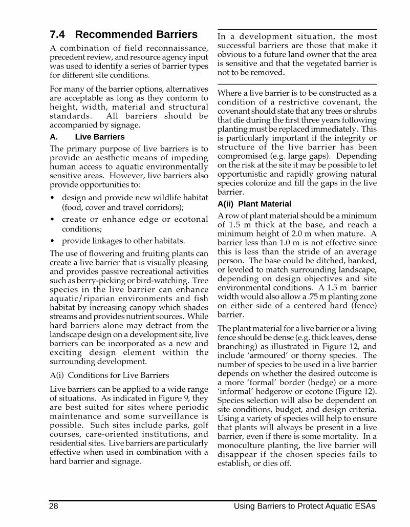
7.4 Recommended BarriersA combination of field reconnaissance,precedent review, and resource agency inputwas used to identify a series of barrier typesfor different site conditions.
For many of the barrier options, alternativesare acceptable as long as they conform toheight, width, material and structuralstandards. All barriers should beaccompanied by signage.A. Live BarriersThe primary purpose of live barriers is toprovide an aesthetic means of impedinghuman access to aquatic environmentallysensitive areas. However, live barriers alsoprovide opportunities to:
� design and provide new wildlife habitat(food, cover and travel corridors);
� create or enhance edge or ecotonalconditions;
� provide linkages to other habitats.
The use of flowering and fruiting plants cancreate a live barrier that is visually pleasingand provides passive recreational activitiessuch as berry-picking or bird-watching. Treespecies in the live barrier can enhanceaquatic/riparian environments and fishhabitat by increasing canopy which shadesstreams and provides nutrient sources. Whilehard barriers alone may detract from thelandscape design on a development site, livebarriers can be incorporated as a new andexciting design element within thesurrounding development.
A(i) Conditions for Live Barriers
Live barriers can be applied to a wide rangeof situations. As indicated in Figure 9, theyare best suited for sites where periodicmaintenance and some surveillance ispossible. Such sites include parks, golfcourses, care-oriented institutions, andresidential sites. Live barriers are particularlyeffective when used in combination with ahard barrier and signage.
In a development situation, the mostsuccessful barriers are those that make itobvious to a future land owner that the areais sensitive and that the vegetated barrier isnot to be removed.
Where a live barrier is to be constructed as acondition of a restrictive covenant, thecovenant should state that any trees or shrubsthat die during the first three years followingplanting must be replaced immediately. Thisis particularly important if the integrity orstructure of the live barrier has beencompromised (e.g. large gaps). Dependingon the risk at the site it may be possible to letopportunistic and rapidly growing naturalspecies colonize and fill the gaps in the livebarrier.A(ii) Plant MaterialA row of plant material should be a minimumof 1.5 m thick at the base, and reach aminimum height of 2.0 m when mature. Abarrier less than 1.0 m is not effective sincethis is less than the stride of an averageperson. The base could be ditched, banked,or leveled to match surrounding landscape,depending on design objectives and siteenvironmental conditions. A 1.5 m barrierwidth would also allow a .75 m planting zoneon either side of a centered hard (fence)barrier.
The plant material for a live barrier or a livingfence should be dense (e.g. thick leaves, densebranching) as illustrated in Figure 12, andinclude �armoured� or thorny species. Thenumber of species to be used in a live barrierdepends on whether the desired outcome isa more �formal� border (hedge) or a more�informal� hedgerow or ecotone (Figure 12).Species selection will also be dependent onsite conditions, budget, and design criteria.Using a variety of species will help to ensurethat plants will always be present in a livebarrier, even if there is some mortality. In amonoculture planting, the live barrier willdisappear if the chosen species fails toestablish, or dies off.
28 Using Barriers to Protect Aquatic ESAs

The plant material should be of a height atthe time of planting and spaced at a distancesuch that an immediate barrier is created.When a live barrier is used in conjunctionwith a hard barrier, smaller and/or youngerplant material may be used. The plantmaterial that is used should have a tendencyto spread horizontally as well as verticallyover time. The plantings should requirelimited maintenance (pruning, etc.) toperform their intended function as a barrier.
The plants used should be native species.Non-native species may be used where theyhave the appropriate dense or armouredbranching attributes. Other desirablecharacteristics such as hardiness, droughttolerance, and wind firmness should beconsidered in order to increase the survivaland longevity of the live barrier.
Selection of species for a live barrier willdepend upon site environmental conditions,and any design/aesthetic objectives.Suggested species include those listed inAppendix 3. Most of these species are nativeto coastal British Columbia, and are availablethrough nurseries. When planted incombination, these species will develop intoan impenetrable barrier.
Fast growing species can be woven togetheror used in combination with chain link ormesh fencing to form an attractiveimpenetrable barrier. Adding vines andtrailing shrubs to the live barrier will help toclose any gaps left between trees and shrubs.
Existing vegetation on the edge of the riparianarea contributes to a live barrier; however,riparian vegetation must not be removedin order to install a live, landscaped barrier.
In most instances, the live barrier should beplanted immediately outside the leave area.This will effectively increase the depth of theleave area when there is existing vegetationwithin the leave strip, or at a minimum,provide the physical/ psychologicalseparation required.
In other cases, where the lot size is substantial,a live barrier may be placed further from theleave area boundary in order to increase the
distance between the aquatic ESA and thedevelopment. This may be appropriate ifpublic safety or liability is a concern�forexample, where a steep/deep ravine may bea potential hazard to small children, or wherewindthrow onto houses or other buildings isan issue.A(iii) Planting Criteria and
SpecificationsGeneral Requirements� It is preferable that there be a mix of
deciduous trees (which grow rapidly,stabilize banks, provide shade, andproduce leaf litter), and large coniferoustrees (which are an ideal source of largeorganic debris required for fish habitat).
� The soil should be prepared along theintended barrier line by tilling to a depthof 30 cm.
� Material planted during the autumn(September - October) and spring (March- April) has the greatest likelihood ofsurviving. When necessary, regularwatering is advised until the plants areestablished. Additional advice onplanting procedures should be obtainedfrom the nursery supplying the stock.
� Any trees or shrubs that die during thefirst three years after planting must bereplaced immediately if more than a 20%mortality occurs, or if the integrity orstructure has been compromised by thecreation of gaps in the live barrier.Protection from deer or livestockbrowsing may be necessary for the firstthree years of growth.
� Include enough fruit bearing shrubs toprovide attractive habitat features to birdsand wildlife (up to 25%). The barriereffect is also enhanced through fruitbearing shrubs since they tend to bethorny and dense.
Using Barriers to Protect Aquatic ESAs 29

Nursery Grown Stock� Tree/shrub species should be of
guaranteed nursery stock.� Botanical names should be used when
ordering nursery stock to ensure that thecorrect species are being purchased. Eachplant should be tagged with its botanicalname, and the tag left on at the time ofplanting.
� Tree stock must be at least 1.2 m in heightwhen purchased and spaced 2 to 4.5 mapart depending on individual speciesrequirements, the combination of speciesused, and the overall length of the livebarrier.
� Shrub stock must be at least #1 containersize or greater. A dense hedge can beestablished by planting at 25-50 cmintervals.
Salvaged and Transplanted Stock� During site development, there may be
opportunities to rescue or salvage plantmaterials. Depending on the time of year,these plants may have a lower chance ofsurviving the shock of transplanting, andthus require a great deal of care to makethe effort worthwhile.
� Very small seedlings can be completelydug up with their entire root systemsintact. These plants can be potted andreadily transplanted to the live barrier sitefor planting. Regular watering is requiredif the plants will be kept in containers forany length of time before planting.
� Saplings and trees survive transplantingbetter if they have been root pruned a yearprior to moving. When there is time toroot prune, the following steps should befollowed:- Project a line from the canopy drip line to the
ground and dig a narrow trench around thetree, following the line.
- Sever the roots in the trench with a spade,and back-fill. The severed root ends will puton new growth.
- When the tree is ready to be transplanted, takea root ball as large in diameter as the rootpruning trench, or as large as can be feasiblymoved.
Figure 11 Methods of Transplanting Plant Material
Slit planting
Wedge planting
A rooted, planted cutting
30 Using Barriers to Protect Aquatic ESAs

Figure 12 Sketches of Dense Thorny Double Hedge Barriers
Using Barriers to Protect Aquatic ESAs 31

B. Hard (Fencing) Barriers
Although hard barriers may not be apreferred option in some cases due toaesthetic considerations, they are effectiveand necessary in a number of circumstancesto protect aquatic ESAs. Recommended hardbarriers are described in the following pages.
B(i) Low Metal Pipe Rail Fence
Open rail fences are suitable along paths and
walkways where use is low intensity, risk ofdamage is limited and an impenetrablebarrier is not required. They are not suitablefor school sites, shopping malls or highdensity residential developments.Recommended height for such a barrier is 4ft. (1.2 m). Metal pipe rail fencing can becoated or painted to match the surroundinglandscape. Aside from periodic repainting,this fencing alternative requires littlemaintenance, can be aesthetically pleasing, isdurable and has a long life span.
Figure 13 Detail of Metal Rail Fence
3" DIAMETER METAL POST PAINTED DARK GREEN
CONCRETE FOOTING (12" x 18" DEEP)
COMPACTED SUBBASE
COMPACTED PEA GRAVEL (3" MIN.)
4’-0"
Metal Rail Fence
32 Using Barriers to Protect Aquatic ESAs
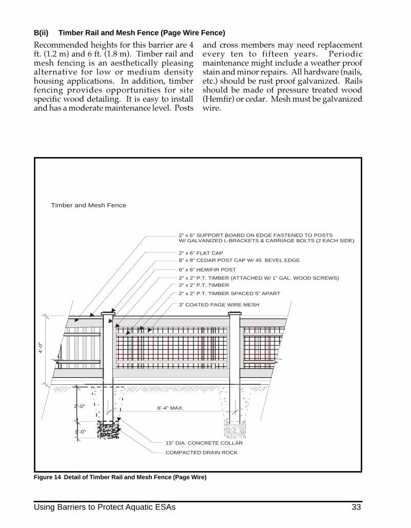
6’-4" MAX.
4’-0"
2’-0"
1’-0"
2" x 6" FLAT CAP
2" x 2" P.T. TIMBER (ATTACHED W/ 1" GAL. WOOD SCREWS)
6" x 6" HEM/FIR POST
2" x 6" SUPPORT BOARD ON EDGE FASTENED TO POSTS W/ GALVANIZED L-BRACKETS & CARRIAGE BOLTS (2 EACH SIDE)
8" x 8" CEDAR POST CAP W/ 45 BEVEL EDGE
2" x 2" P.T. TIMBER SPACED 5" APART
2" x 2" P.T. TIMBER
3" COATED PAGE WIRE MESH
COMPACTED DRAIN ROCK
15" DIA. CONCRETE COLLAR
Timber and Mesh Fence
Recommended heights for this barrier are 4ft. (1.2 m) and 6 ft. (1.8 m). Timber rail andmesh fencing is an aesthetically pleasingalternative for low or medium densityhousing applications. In addition, timberfencing provides opportunities for sitespecific wood detailing. It is easy to installand has a moderate maintenance level. Posts
and cross members may need replacementevery ten to fifteen years. Periodicmaintenance might include a weather proofstain and minor repairs. All hardware (nails,etc.) should be rust proof galvanized. Railsshould be made of pressure treated wood(Hemfir) or cedar. Mesh must be galvanizedwire.
B(ii) Timber Rail and Mesh Fence (Page Wire Fence)
Figure 14 Detail of Timber Rail and Mesh Fence (Page Wire)
Using Barriers to Protect Aquatic ESAs 33

B(iii) Plastic PVC Pipe Fencing
This is a new fencing alternative composedof plastic PVC pipe. It is strong, durable,requires little maintenance and is easy toinstall. It is effective for urban, suburban orrural residential applications where a durablephysical barrier is required. This form of
fencing is also aesthetically pleasing in ruralor �hobby farm� applications or otherapplications where a �ranch� effect isdesirable. Presently, colours are limited tothe colour of the plastic and the plastic cannotbe painted. PVC fencing is recyclable wherefacilities exist.
Figure 15 Detail of PVC Fence
4’ or 5’ HIGH PVC FENCE AS PER MANUFACTURER’S SPECIFICATIONS
CONCRETE FOOTING (12" x 18" DEEP)
COMPACTED PEA GRAVEL (3" MIN.)
6’-0" O.C.
PVC Fence
4’-0
" T
O 6
’-0
"
34 Using Barriers to Protect Aquatic ESAs

For ranching or farming applications wherepreventing livestock access into an aquaticESA is key, galvanized smooth, barbed orPVC wire fence can be used. Page wirefencing can be used to confine small animalssuch as sheep, calves, and foals. Log fences,made from pressure treated wood (Hemfir)or cedar, may be more practical in somesituations.
Where barbed wire is used, a top rail orwildlife visibility tape is recommended toprevent injury to wildlife. Where log fencesare used, wildlife passage can be ensured byproviding adequate clearance at the bottomof the fence, and by developing game jumps,where the fence height is lowered at regularintervals to permit unimpeded wildlifemigration.
B(iv) Smooth or Barbed Wire Fence and Log Fence
Figure 16 Sketch of Barbed Wire Fence and Log Fence Adapted for Wildlife
Barbed Wire Fence
Log Fence
Using Barriers to Protect Aquatic ESAs 35

B(v) Coated Chain Link Fencing
Chain link fencing forms a very effectivebarrier. It is most appropriate for locationswhere there are significant risks of damagefrom high volume pedestrian use or heavyequipment, or where littering exists.Examples include school yards, high densityresidential sites, commercial or industrial
sites. Vinyl coating in a natural colour suchas green or black can blend the chain linkfencing into the surrounding landscape. Itcan also be combined with plantings, such asshrubs and vines, to improve aesthetics. Ifproperly installed, chain link fencing can havelow maintenance and a long life span.
Figure 17 Detail of Chain Link Fence
3’ - 8" HIGH METAL POST WITH METAL CAP PAINTED DARK GREEN
4’-0
" /
6’-0
"
3"
CONCRETE FOOTING ON 6" PEA GRAVEL ON COMPACTED SUBBASE
PAINTED RAIL
DARK GREEN VINYL COVERED CHAIN LINK MESH
6’-0" / 8’-0"
Chain Link Fence
36 Using Barriers to Protect Aquatic ESAs

2" x 6" FLAT CAP
1" x 2" FINISH BOARD
6" x 6" HEM/FIR POST
4 - 1" x 6" SLATS PLACED FLUSH AT POSTS (TWO EACH SIDE)
1" x 6" SLATS SPACED 1/2" APART
2" x 6" SUPPORT BOARD ON EDGE FASTENED TO POSTS W/ GALVANIZED L-BRACKETS & CARRIAGE BOLTS
4’-0"
/ 6’-0"
3"
15" DIA. CONCRETE COLLAR
COMPACTED DRAIN ROCK
2’-0"
1’-0"
6’-0" / 8’-0"
CEDAR POST CAP
Timber Fence
B(vi) Timber Fencing
Timber fencing can be very aestheticallypleasing and lends itself to many variationsin the detailing. It is most appropriate in aresidential context. It is easy to install andwith periodic maintenance can last manyyears.
In the dry and cold north and interior, the lifespan of wooden structures will be longer.Maintenance includes periodic weather proofstain and minor repairs. All hardware (nails,etc.) should be galvanized (rust proof).Timber should be pressure treated wood(Hemfir) or cedar.
Figure 18 Detail of Timber Fence
Using Barriers to Protect Aquatic ESAs 37

B(vii) Timber Marking Posts
Timber marking posts are appropriate wherean impenetrable barrier is not necessary or asimple means of delineating a covenantboundary is all that is required. Timbermarking posts may be used in conjunctionwith a vegetative barrier in some cases toproduce an aesthetically pleasing barrier toseparate land uses or create wildlife habitat.Some examples of appropriate uses are ruralresidential (non-hobby farm) or rural/suburban properties near wildlife migrationcorridors. This barrier type will demarcate a
covenanted area and provides a mountingpost for signage. It is possible to install atemporary electric wire for seasonal livestockcontainment if required. Periodicmaintenance might include a weather proofstain and minor repairs. All hardware (nails,etc.) should be galvanized (rust proof).Timber should be pressure treated wood(Hemfir) or cedar. Post spacing can varydepending on the length of the boundary andthe number of properties involved.
Figure 19 Detail of Timber Marking Posts
6’-0" O.C. MIN.
4’-0
" / 6
’-0"
6" x 6" HEM/FIR POST. ROUND OR BEVEL TOP OF POST TO PREVENT ROTTING.
COMPACTED DRAIN ROCK
15" DIA. CONCRETE COLLAR
2’-0
"1’
-0"
Timber Marking Posts
38 Using Barriers to Protect Aquatic ESAs
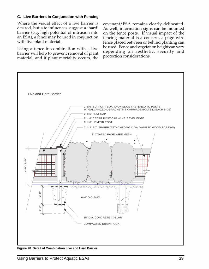
Where the visual effect of a live barrier isdesired, but site influences suggest a �hard�barrier (e.g. high potential of intrusion intoan ESA), a fence may be used in conjunctionwith live plant material.
Using a fence in combination with a livebarrier will help to prevent removal of plantmaterial, and if plant mortality occurs, the
C. Live Barriers in Conjunction with Fencing
covenant/ESA remains clearly delineated.As well, information signs can be mountedon the fence posts. If visual impact of thefencing material is a concern, a page wirefence placed between or behind planting canbe used. Fence and vegetation height can varydepending on aesthetic, security andprotection considerations.
Figure 20 Detail of Combination Live and Hard Barrier
2" x 6" FLAT CAP
2" x 2" P.T. TIMBER (ATTACHED W/ 1" GALVANIZED WOOD SCREWS)
6" x 6" HEM/FIR POST
2" x 6" SUPPORT BOARD ON EDGE FASTENED TO POSTS W/ GALVANIZED L-BRACKETS & CARRIAGE BOLTS (2 EACH SIDE)
8" x 8" CEDAR POST CAP W/ 45 BEVEL EDGE
15" DIA. CONCRETE COLLAR
2’-0"
6’-4" O.C. MAX.
4’-0"
/ 6’-0"
1"-
0"
3" COATED PAGE WIRE MESH
COMPACTED DRAIN ROCK
Live and Hard Barrier
Using Barriers to Protect Aquatic ESAs 39

D. Terrain Barriers
A terrain barrier is a change in grade orelevation that discourages pedestrian,livestock, and vehicular trespass. Thiscategory includes channels, depressions,berms and retaining walls. When installingterrain barriers, existing topography and run-off patterns need to be taken into account �natural drainage patterns should not beinterrupted. Terrain barriers are effective onflat land where there are natural changes ofgrade, or where ditches or drainage structures
exist that could be enhanced. As terrainbarriers may require more space and can bemore costly to construct, particularly whererequired changes in elevation are significant,they are most suitable for large institutionalcare facilities, golf courses, within a large parkand locations where there are existingchanges in grade. Terrain barriers can alsobe used in combination with planting orfences. The following are a list of terrainbarrier alternatives.
D(i) Retaining Walls
These barriers are most effective when thegrade difference between top of bank and theleave area is greater than 4 ft. (1.2 m).Retaining walls are only useful for sites witha natural and abrupt change in elevation.Retaining walls are most useful for inhibitingtrespass; however they do not preventlittering, unless they are used in combinationwith a fence. They are very effectivepsychological barriers and do not obstructviews into the ESA.
As most retaining walls also serve a bankstabilization function, they must bestructurally designed and approved by a
registered professional engineer. Retainingwalls adjacent to public areas generallyrequire a railing. Pressure treated timber orlock-block walls are preferred. Allconstruction materials should be pretreated.Use of concrete on site must be managed verycarefully to prevent runoff as concrete runoffand wash water is toxic to fish and aquaticinvertebrates. Retaining structures should beset back a minimum of 1.0 m from the leavearea boundary to prevent disturbance of theleave area vegetation during construction andmaintenance of the retaining wall.
Figure 21 Sketch of Live Barrier in Combination with Fencing and Retaining Walls
Retaining Wall Barrier
40 Using Barriers to Protect Aquatic ESAs

D(ii) Berms
A berm is a raised mound of land, usuallycreated by filling a portion of a site. Wherethe surrounding terrain is level, a berm canprovide both visual and physical separationbetween an aquatic area and an adjacent landuse. The berm must be constructed withinthe development site. The toe of the slopeshould be located outside of the boundary of
the leave strip or covenanted area. Plantingscan be used on the berm to augment itseffectiveness as a barrier and to enhance birdand wildlife habitat. As one possibledrawback of berms is that they can blockviews, they are most appropriate in areaswhere viewscapes or aesthetics are not issues.
Figure 22 Sketch of Constructed Berm
Figure 23 Sketch of Depression in Combination with Fencing (‘ha ha’)
D(iii) Depressions
Depressions can be effective for large natureparks, golf courses and rural residential areas.However, unless the natural topography issuitable, the construction costs might notmake this a feasible alternative. When usingonly a depression as a barrier, the width anddepth should be sufficient to deterpedestrians, bicycles, and motor vehicles.Depressions should be a minimum of 2 ft.
deep and 3 ft. wide in order to be most effective.Excavation for depressions could also be to adepth appropriate for establishment of naturalaquatic vegetation such as sedges and rushes.Where foot traffic is expected, signage shouldbe provided. A depression in conjunction witha fence (known as a �ha ha�) is very effectiveand if seen from a distance provides no breakin the view.
Using Barriers to Protect Aquatic ESAs 41

D(iv) Channels
A channel is a depression containing flowingwater, and includes drainage ditches. Whilechannels can be effective for inhibitingtrespass, they can be expensive to constructand may require routine maintenance. Wherechannels or ditches are an existing site feature,they should be incorporated into the site planor designed as natural barriers. As there maybe some liability concerns associated with
channels, their use is most appropriate forvery specialized applications - to separate, forexample, public parks, intensive agricultureand golf courses from ESAs. Fencing inconjunction with a channel may be requiredas well to enhance safety. To be effective as abarrier, channels should be greater than 4 ft.(1.2 m) wide.
Figure 24 Sketch of Channel and Ditch in Combination with Fence/Plant Material
Ditch
Channel
42 Using Barriers to Protect Aquatic ESAs

7.5 Case Examples: UsingBarriers to ProtectAquatic ESAs
This section presents a series of exampleswhere barriers have been used to protectsensitive aquatic areas. The settings rangefrom rural to urban. The success orshortcomings of each example is reviewed,including potential improvements andpossible alternatives. Many of theseexamples illustrate the importance ofadequate planning to prevent conflicts. Inmany of these cases, restoration andrehabilitation is also required.
A. Rural Agricultural Site
A feasible solution is found to curtail habitatdestruction by cattle
Farming is the mainstay of a rural townshipclose to the Vancouver metropolitan area.The farmer on this site runs forty to fifty headof cattle that he sells each spring. A salmonbearing stream traverses the property. Priorto the installation of a livestock barrier, theriparian vegetation and the streambankswere being destroyed by trampling andgrazing. The streambanks became severelyeroded, causing increased sedimentation ofthe stream. Manure from an upland slopewas also leaching into the creek.
The solution included the installation of agalvanized barbed wire fence to restrict cattleaccess to the creek. This fence has circularpressure treated timber posts, rugged strandsof barbed wire and a galvanized access gatefor maintenance. An important feature of thisproject is a stream crossing/watering area forcattle composed of an aggregate sub base andgravel surface. The material selected for thiscrossing is of a size which does not pose atripping hazard to livestock. A lowgalvanized barrier across the stream permitscattle access to the stream at the preferredcrossing/watering site, without inhibitingfish passage and waterflow in the stream. Ariparian shrub and tree replanting programhas also been implemented. This will providestream bank stabilization and improve cover
for fish as well as reduce summer streamtemperatures, all of which were identified asconcerns. The manure on the slope has beenremoved and the corral has been relocated sothat livestock wastes do not enter the stream.
A galvanized barrier prevents livestock from enteringthe stream
This rugged galvanized wire fence also protectsvegetation that has been planted
A gravel surfaced crossing allows livestock direct butmanaged access to stream
Using Barriers to Protect Aquatic ESAs 43

B. Single Family Housing
B(i) Timber walls and fences help toprotect a stream corridor
A recent development on sloping terrainfeatures large single family homes of 300square metres. Views of the stream and ravineare an important marketing amenity. Skillfulsiting and grading has helped to maintainmany native trees and shrubs on site. In allinstances, leave areas were established;however, few were adequately set back fromtop of bank. As a result the stream corridor(which is fish bearing) required greaterprotection from disturbance.
Timber crib walls in combination with timberfences have been used to accomplish thisobjective. In most locations, where elevationdifferences were slight, curb walls wereconstructed without any fencing. Whereelevation differences were significant, wallswere combined with either timber or railfencing. Thus far the combination of retainingwalls and fencing has been successful inlimiting intrusion into the stream andremnant leave area while allowing generousviews.
Timber retaining walls with rail fencing can beeffective barriers
Timber fencing atop a timber retaining wall preventsdisturbance of leave area
B(ii) In single family housing, barriershave varied results
Several attempts at stream protection usingprimarily ornamental plantings haveoccurred in an older single family subdivisionnear Vancouver.
One resident has planted rows of pyramidalcedar to create a barrier adjacent to the streambank. The choice of vegetation, the density,and scale are too small to be effective. As well,large gaps in the planting invite trespass.
Upstream, a double row of dense shrubs ismore effective. At the top of the bank, onerow of flowering shrubs is planted in front ofanother row of dense, thorny vegetation. Thishas been effective in reducing foot traffic intothe small ravine and stream. However, theseplantings occurred in the leave area, andnecessitated natural vegetation removal. Useof native plant species could havecompensated for lost fish and wildliferiparian habitat.
This row of cedars is not effective in preventingstream disturbances
B(iii) Timber fencing in residential settingsoffers choices
Timber fencing can be adapted to a variety ofsettings. If well built and maintained, timberfencing is aesthetically pleasing and effectiveagainst intrusion into sensitive areas such asstreams and wetlands.
44 Using Barriers to Protect Aquatic ESAs

A rugged 6 ft. timber fence with vertical slats isaesthetically pleasing and has been successful inpreventing trespass into a ravine and stream corridor
In a large hobby farm setting, open rail fences arecompatible with the image of the semi rural landscapeand equestrian activity
C. Multi-Family Housing
Chain link fencing and natural landscapingcombine to protect a small tributary
A rapidly developing Lower Mainlandcommunity faces the challenge of protectingfish bearing streams and other ESAs fromdegradation. As it grows, the conflictbetween accommodating people andprotecting natural areas has become critical.
This site includes a mixture of condominiumsand rental town housing. A small stream thatis a tributary to the Fraser River runs throughthe property. The stream is important forcoho salmon production despite upstreamportions having been culverted. The streamhad historically been a dump site for trashand derelict shopping carts.
A chain link fence has been constructed alongthe top of bank. Since the fence was installednative vegetation has re-established itself,vigorously growing through and over thefence. As a barrier the fence has been veryeffective in precluding intrusion and littering.The vegetation partially conceals the fenceand improves the aesthetics.
Unfortunately, however, the fence wasconstructed within the leave area. On theopposite bank, natural riparian vegetationwas removed and replaced with sod toaccommodate maintenance access to a utilitycorridor. Clearing of vegetation and utilitycorridor alignment within the leave area mustbe discouraged.
Chain link fencing and natural vegetation combine toform an effective barrier
D. Suburban High School Site
The need for a fenced barrier becomesurgent
A large secondary school is located adjacentto a steep wooded ravine and a fish bearingstream. Students use the ravine slope to sitand have lunch and people traverse the ravineregularly to reach the stream. As well as beingunsafe, serious erosion has been triggered.The slope is also extensively littered withrubbish.
This situation warrants a strong, durablebarrier. A live barrier would not be sufficientto curtail trespass. A low fence would beeasily vaulted. Therefore, a vinyl coated chainlink fence, with supports set in concrete, 6 ft.high, is the preferred choice. If desired, vinescould be planted to reduce its visual impact.Trash receptacles should be installed and a
Using Barriers to Protect Aquatic ESAs 45

designated outdoor sitting/eating areaestablished with tables and/or benches.
The eroded portions of the ravine should bereplanted with native vegetation.Cooperation between the school board andthe municipality is required. Volunteers,service clubs, environmental or studentgroups could assist in constructing the fenceand replanting the slope.
This large high school lacks barriers and invitesstudents to congregate in a ravine adjacent to an ESA
The results are litter, safety problems and habitatdisturbance
E. Industrial/Commercial SettingIndustrial / commercial site beside an ESAcreates problems
This light manufacturing and commercial sitehas an inadequate setback from a fish bearingstream. Building uses include warehousing,fast food restaurants, discount retail outletsand automobile dealerships. The site islittered and there is ongoing trespass into theESA. As well, pre-load sand is sloughing intothe ESA. Riparian vegetation has beenremoved and the small tributary is infilling.
At a minimum, a silt fence should be installedat the base of preload fill slopes to curtailsediment migration. Additional measurescould include placing lock-blocks or hay balesalong the outside of the silt fence to retainpreload material on site and to increasestability of the fence. A fence along the top ofbank is needed to discourage trespass andreduce litter. A combination barrier wouldoffer visual relief to this predominantly pavedarea.
Fencing options include a 4 ft. chain link ortimber fence with plantings. The fencingshould be continuous since it is at roadcrossings and other openings that most of theimpacts occur. Riparian vegetation should bere-established along the banks.
Previously disturbed habitat and a compromisedsetback warrants a durable fence or a combinationbarrier
This open fence design is not effective in preventingtrespass and litter into the stream
46 Using Barriers to Protect Aquatic ESAs

A properly installed silt fence is needed on this site toprevent migration of preload sand into the leave areaand permanent fencing needs to be maintained
F. Urban Park
An important stream is protected and ac-cess is accommodated
A history of severe erosion, accidents andintrusion into a stream corridor has resulted ina program of barrier installation and trailrealignment in a heavily used urban park. Priorto this, some park visitors were scrambling oversteep slopes to reach viewpoints or to enter thestream at dangerous locations. As well, trailswere aligned within rather than outside of thedesired leave area.
The municipality�s parks department hasembarked on an education program and hasinstalled vinyl coated chain link fencing alongthe most vulnerable and hazardous sections ofthe setback to discourage intrusion at theselocations. In addition, trails that were routedalong the bank or ravine edge have been re-aligned beyond the leave area. Boardwalkswere installed across sensitive and periodicallyflooded lands and stairs were used to replaceeroding trails.In specific locations, seasonal access is permit-ted to the stream edge.
A fence, railing and timber stairs are designated tokeep pedestrians on the path
A vinyl coated chain link fence separates an ESA froma heavily used aggregate surface trail
Using Barriers to Protect Aquatic ESAs 47
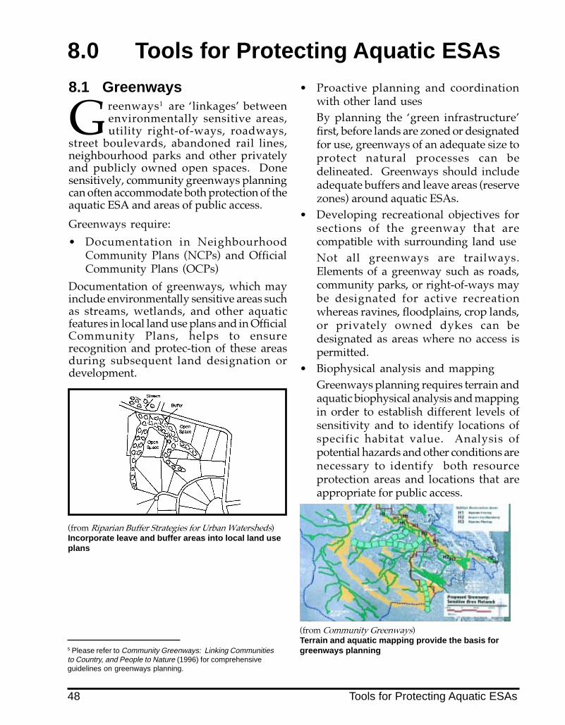
8.0 Tools for Protecting Aquatic ESAs
8.1 Greenways
Greenways1 are �linkages� betweenenvironmentally sensitive areas,utility right-of-ways, roadways,
street boulevards, abandoned rail lines,neighbourhood parks and other privatelyand publicly owned open spaces. Donesensitively, community greenways planningcan often accommodate both protection of theaquatic ESA and areas of public access.
Greenways require:
� Documentation in NeighbourhoodCommunity Plans (NCPs) and OfficialCommunity Plans (OCPs)
Documentation of greenways, which mayinclude environmentally sensitive areas suchas streams, wetlands, and other aquaticfeatures in local land use plans and in OfficialCommunity Plans, helps to ensurerecognition and protec-tion of these areasduring subsequent land designation ordevelopment.
5 Please refer to Community Greenways: Linking Communitiesto Country, and People to Nature (1996) for comprehensiveguidelines on greenways planning.
(from Riparian Buffer Strategies for Urban Watersheds)Incorporate leave and buffer areas into local land useplans
� Proactive planning and coordinationwith other land usesBy planning the �green infrastructure�first, before lands are zoned or designatedfor use, greenways of an adequate size toprotect natural processes can bedelineated. Greenways should includeadequate buffers and leave areas (reservezones) around aquatic ESAs.
� Developing recreational objectives forsections of the greenway that arecompatible with surrounding land useNot all greenways are trailways.Elements of a greenway such as roads,community parks, or right-of-ways maybe designated for active recreationwhereas ravines, floodplains, crop lands,or privately owned dykes can bedesignated as areas where no access ispermitted.
� Biophysical analysis and mappingGreenways planning requires terrain andaquatic biophysical analysis and mappingin order to establish different levels ofsensitivity and to identify locations ofspecific habitat value. Analysis ofpotential hazards and other conditions arenecessary to identify both resourceprotection areas and locations that areappropriate for public access.
(from Community Greenways)Terrain and aquatic mapping provide the basis forgreenways planning
48 Tools for Protecting Aquatic ESAs

Example of a greenway that protects aquaticESAs - North Vancouver
An example of an approach to greenwaydesignation and protection can be found inthe District of North Vancouver�s uplandplanning. Stream corridors and other ESAshave been mapped as part of the District�sdata base, accompanied by stringent controlsfor soil handling, vegetation protection,erosion control and water qualitymaintenance. Stream corridors have beenestablished and vegetation retained. Trailsare sited outside these corridors, in a zonethat buffers the ESA from development.Pedestrian bridge crossings affordopportunities for viewing streams whileminimizing intervention with aquatichabitats. District staff, agency andenvironmental consultants are engaged toreview and monitor all developmentsincluding community parks to assurecompliance with aquatic ESA protectionrequirements. Remedial measures arerequired in the form of restoration plantingand other mitigation procedures for anydisruption such as a utility crossing withinthe greenway.
8.2 Legislation, Guidelinesand Resource Materials
Legislation is another tool used to protectESAs. Access plans, trails and structures needto be designed in a way that protects fish andwildlife habitat, and may need to be referredto senior agencies.
In some cases, regulations have beenpromulgated, or guidelines have beenproduced, which interpret the legislation forspecific land use activities.
Statutes, regulations, guidelines and resourcematerials relevant to aquatic resourceprotection and public access are listed andsummarized in Appendix 4.
8.3 CovenantsRestrictive Covenants5
The Ministry of the Environment, Lands, andParks currently requests that a restrictivecovenant be placed on that portion ofprivately owned property that is consideredfish habitat according to the federal FisheriesAct. In many instances, these boundaries aresurveyed to comply with leave areas asdefined in the Land Development Guidelinesfor the Protection of Aquatic Habitat. TheMinistry of the Environment�s WaterManagement Branch also requires restrictivecovenants in floodplain areas under sections82 and 215 of the Land Title Act.
In redevelopment situations, covenants areoften the only means of protecting aquaticriparian areas. When large tracts of land arebeing rezoned or subdivided, proactiveplanning approaches should be encouragedto secure and protect �leave areas�.
Conservation CovenantsA new legal option for protection ofecologically sensitive areas has been createdunder recent amendments to section 215 ofthe Land Title Act which allows conservationgroups to hold covenants. These�conservation covenants� are now beingestablished throughout B.C. by several non-government organizations (NGOs).However, due to logistics and NGOresources, conservation covenants aregenerally used where environmentallysensitive areas are contained in large privateproperty holdings.
For further information on conservationcovenants the reader is referred to Leaving aLiving Legacy: Using ConservationCovenants in B.C. (West Coast EnvironmentalLaw Association, 1996).
6 Covenants are a written agreement between a landowner andgovernment, whereby the owner agrees to specified limits on the useof the land. This agreement is registered on title under s.215 of theLand Title Act, and is commonly referred to as a restrictive covenant.
Tools for Protecting Aquatic ESAs 49

8.4 Voluntary StewardshipIn addition to the planning and regulatorytools that can be used by government, ESAscan also be protected through voluntarystewardship initiatives undertaken by thepublic. There are many examples ofvoluntary stewardship for aquatic habitat andwatershed protection in the Lower Mainland.
Community stewardship initiatives can include:� participating in local land and water use
planning processes (NCP, OCP andzoning reviews);
� identifying sensitive aquatic featuresthrough aquatic ESA inventories;
� voluntary conservation of aquatic ESAs onprivate property;
� land owner contact to encourage streamstewardship or compliance withcovenants;
� education programs to address specificissues (e.g. human access, littering,vegetation removal);
� restoration and enhancement programsfor degraded areas;
Volunteers clear wood debris from an estuarinemarsh
� stream stewardship programs (signagefor habitat, storm-drain marking;Streamkeepers training; �adopt-a-trail�/�adopt -a-stream� programs);
� helping develop �sensitive� access plansand assisting with trail construction.
Well designed, well located signage raisesawareness of sensitive aquatic ecosystems
One example of community stewardshipis the Township of Langley�sEnvironmental Partners Society (L.E.P.S.).In conjunction with other groups, such asthe Aldergrove Downtown BusinessAssociation, L.E.P.S. has initiated habitatenhancement programs along both theSalmon River and Bertrand Creek.
In addition, L.E.P.S. has established goodworking relationships with environmentalagencies and the Township of Langley. Ithas been successful in securing funds andequipment donations to enhance streamand riparian habitats throughout Langley.L.E.P.S. has also been involved in trailplanning along sections of Bertrand Creek.
In another setting, naturalist groups andcommunity interests in the Village ofHarrison Hot Springs are playing an activerole in enhancing Miami Creek, whichflows into Harrison Lake. As a part of theplanning process they are involved indetermining locations for boat launching,and nature paths and will be involved intrail construction.
50 Tools for Protecting Aquatic ESAs

8.5 Cooperative ManagementAs aquatic ESAs often cover large areas orflow over long distances, their managementpresents an opportunity for cooperationacross jurisdictional boundaries. Case studies(Appendix 1) illustrate that effective sharingof management and funding responsibilitiesis often accomplished through partnershipsbetween different levels of government aswell as institutions, industry and the public.
Cooperation among different levels ofgovernment as well as between localgovernments can also help to assure thecontinuity of greenways.
A portion of the Sea to Sky trail corridorthat runs through the District of NorthVancouver (and the forest through whichit extends) is included within the District�sLynn Canyon Park as well as the GreaterVancouver Regional District�s LynnHeadwaters Regional Park. Despitelimited financial resources, cooperativeplanning between these governments hasprotected important habitats yet assuredreasonable access to Lynn Creek and theSeymour River. Improvement of visitorsafety, environmental protection andcreation of trails and signs are key parts ofthis program.
8.6 FundingThe cost and responsibility for developingand managing environmentally sensitiveaccess plans can sometimes be shared amongdifferent government levels, surroundingcommunities and the private sector. Land forpark and school dedications (between 5 and10% of the parcel) at the time of subdivision,development cost charges, provincial costsharing programs, land trusts, direct localgovernment investment, and corporatesponsorship can help pay for landacquisitions.
The recent formation of partnerships betweenpublic and private sectors to raise capital forgreenway development involving aquaticESAs and related amenities has considerable
potential. Changes in the federal Income TaxAct in 1995 and 1996 respecting donations ofecologically sensitive land can also play a rolein land dedication with potential tax benefitsto the property owner (Stewardship Optionsfor Private Landowners in B.C., 1996).Contributions in kind, such as equipmentloans or volunteer labour, are equallyimportant elements of many successful costeffective projects. The Township of Langleyand City of Port Coquitlam are twomunicipalities that have benefited fromincluding the private sector in communitygreenway and trail corridor development.
Volunteers will often assist with planting riparianvegetation
Tools for Protecting Aquatic ESAs 51

9.0 Case Example
Planning for Public Access ina Residential Area With Sensi-tive Aquatic Features
The following case example involves asite with several streams and wetlands,and various adjacent land uses in a
suburban community (Figure 25). Itillustrates a wide range of opportunities forproviding public access to sensitive aquaticareas.Community BackgroundThe subject community is located within arural block, which is part of a municipalitycharacterized by primarily suburban andrural land uses. The existing neighbourhoodhas been zoned single family residential, withmost development having occurred in the1960s. There are several viable market farmsadjacent to the stream. On the south westcorner there is a commercial developmentand public market. Streams, tributaries,wetlands, and associated riparian areasborder or flow through almost every farm orresidential area in this suburb. Residentsenjoy the feeling of being in a rural area andbeing surrounded by natural features.Access Issues for Streams and WetlandsA parcel of land has been designated forresidential development in the northwestcorner. Recently, a developer expressedinterest in purchasing the lot, and applyingfor rezoning and subdivision. The lot has twocreeks running through it, both tributaries toa large stream. A number of residents wishto preserve the sensitive natural features onthe proposed development site, particularlythose associated with the streams. Cohosalmon and cutthroat trout are the main fishspecies found in the creeks. Several speciesof raptors and songbirds are found in thebordering riparian areas. Residents areaccustomed to walking along the creeksystem on a small footpath, and would liketo retain access to this amenity. They conduct
a survey of residents and bring their concernsregarding protection and access throughoutthe neighbourhood to the municipal planner,who suggests that an access and managementplan for riparian and aquatic areas bedeveloped for the whole area.
Planning Process for Public Access
A team consisting of community members, amunicipal planner and an engineer, a habitatbiologist, and the developer interested in theundeveloped lot, is formed.
Step 1: Assessing Current Conditions
First, the access planning team develops anoverview of issues affecting streams andriparian zones in the area.
They find that the current OfficialCommunity Plan (OCP) does not contain anydirection on protecting environmentallysensitive areas (ESAs). The NeighbourhoodConcept Plan (NCP) does not have aninventory of ESAs, but the municipalengineering department has a map of thewatercourses in this area.
A review of conditions in the neighbourhoodshows that there are many concerns forstreams and riparian areas. In the existingresidential area, the stream and riparian zonehave been significantly compromised. Thestream has been constrained within a narrowchannel and storm sewers transport highflows away from the stream. The originalforest that covered this area was cut downlong ago, and a two to three metre width ofshrubs and small deciduous trees is now allthat remains of the riparian area. The bankis riddled with many paths down to thewater, causing problems such as bankinstability and sedimentation. Remainingwetlands and floodplain areas, which serveas natural stream flow regulators and waterpurification systems, are being compactedthrough unmanaged human access to thearea.
52 Case Example

Figure 25 Access Planning Case Example
Case Example 53

Flooding has become a common problem inlow lying residential areas and farmers�fields. The capacity for water absorption inthis watershed has been decreased throughan increase in impervious surface area dueto development, wetland compaction andriparian removal.
During the summer, water flows havedecreased or even disappeared in somesections of the watershed. Impervioussurface area in the watershed has reducednatural groundwater recharge, therebyreducing the amount of water available tostreams in dry months. Water withdrawalfor irrigation has also decreased stream flows.
As a result of extremes in water flows, somestreams in this area have lost the ability tosupport fish. Other impacts to fish habitatinclude increased siltation, a decrease inspawning gravel and large organic debris, anincrease in water temperature, and highconcentrations of fecal coliforms andnutrients in small tributaries.
Step 2: Inventory and Mapping of ESAs
The next step taken by the access planningteam is to conduct an ESA inventory. Thenthe aquatic component of the ESA inventoryis used to update the existing watercoursemap, and additional layers of informationincluding adjacent land uses, proposed landuses and lot boundaries are developed andoverlayed.
The biophysical analysis indicates thatseveral of the streams and wetlands in thiscommunity�s �backyard� still supportpopulations of coho salmon and cutthroattrout. The riparian area is found to be hometo the endangered water shrew, as well as tomany species of waterfowl and raptors,including the red-tailed hawk, which hadbeen on the endangered species list, but hasrecently been making a comeback in the area.
Step 3: Developing Public Access Policies
In the next stage of planning, public accesspolicies, various protection measuresrecreational management objectives, and traildesign standards are developed, all of which
have protection of the aquatic ESA as theprimary objective.
Step 4: Establishing Adequate Leave Areas
Recognizing watershed processes, and theneed for watershed planning, managementzones are established along watercourses andaround wetlands throughout the catchment.The management zones are intended to belarge enough to include a leave area (reservezone), as well as a buffer zone within whichcompatible uses such as trails can beaccommodated. Based on topographicinformation and advice from the biologist,management zones are set at 50 m on eitherside of all aquatic features and designated asDevelopment Permit Areas for the protectionof the natural environment.
Detailed field inspections are then conductedto identify critical habitat features,geotechnical concerns, local surface drainagepatterns, etc. Refined leave area (reservezone) boundaries are then determined, basedon site sensitivity, habitat values and risk.The purpose of the leave area is to protect thefunctions required for long-term stream orwetland maintenance. At this scale, leavearea boundaries are established at 50 m oneither side of the main channels andfloodplains; 30 m around wetlands; and 5 - 7m (for geotechnical protection) on the top ofa ridge where a small tributary flows througha high relief and geotechnically stable ravine.
A leave area reclamation policy is alsodeveloped for those properties where thereare historic footprints that are completelyincluded within the recommended leave area.While activities will obviously continuewithin these areas, they are nonethelessmapped for future reference in the event thatduring rezoning or subdivision, there may beopportunities to acquire the property or createa new footprint that is more sensitive to therequired leave area.
54 Case Example

Step 5: Dedication of Leave Areas
In the undeveloped lot where multi-familyresidential housing is proposed, the leavearea along one of the main tributaries will beplaced under strata control and will becomecommon property, subject to strata ruleswhich the local planner will help define. Inaddition, a small area of the subdivision isdedicated by the developer to create parkland. In order to maintain a continuous leavearea along the tributary, an arrangement ismade for a transfer of development rights.The developer is ceded an adjacent parcel ofmunicipal land in exchange for setting asidesufficient land to create a leave area with anadjacent buffer for a trail system.
Areas around wetlands have been dedicatedback to the crown in the past and cannot bedeveloped. These areas are incorporated intothe greenways plan. The municipalitypurchases the area where public access to thewetland has been proposed. Covenants areapplied to privately owned areas around thewetland within the site to protect theremaining habitat features.
The municipality and community recognizethat in the undeveloped area owned by themunicipality, where two tributaries to themain stream flow parallel to each other, anexcellent opportunity exists to preserve alarge area for ecological viewing purposes.This area, which is municipally owned, isscheduled for rezoning to commercial. Thecommunity expresses a strong desire to seethis area remain undeveloped and designatedas a park. A local stewardship group offersto assist by building a boardwalk andviewing tower. Local businesses make acommitment to donate building materials.Senior government agencies will sponsorkiosks and signage. A local serviceorganization offers a financial incentive to themunicipality to compensate for revenues lostas a result of not selling the property forcommercial development. Due to the highdegree of community, corporate, andgovernment support, the municipalitydecides to designate the area as a municipalpark.
Step 6: Recreation Corridor Designation
The next step in the public access plan is todesignate land adjacent to the leave areas(reserve zones) for a buffer zone, where trailswill be located. A 5 m strip adjacent to theleave area is recommended in areas wheregood recreational potential exists along theaquatic ESAs. The 5 m strip includes 3 m fora main trail, and 2 m for vegetative screening.
Step 7: Barrier Implementation
All access planning is done withconsideration of possible barrierrequirements and designs. At sites where theaquatic ESA is especially sensitive and subjectto historic deterioration, barriers are installed.
Where rushes and sedges have been plantedas part of a constructed wetland, a temporarysilt fence is installed along the edge of thewetland to protect the fragile emergentvegetation.
At one section of stream where a spawningarea is regularly disturbed by people walkingup to and through the stream, a combinationhard and planted fence is installed to preventunmanaged access to the stream, and aboardwalk is planned to provide a view ofthe spawning bed.
For the lot that is to be developed, themunicipality sets landscaping requirementsspecifying that the developer retain thenatural vegetation in the leave area along thestream. In addition, the developer is requiredto install a hard barrier on the outer edge ofthe buffer area to prevent trespass ontoprivate property and to provide a screenbetween houses and trail users.
Implementing the Public Access System
Step 8: Trails and Public Access Points
A hierarchy of trails is established. A maintrail is located in the buffer area outside theleave area (Figure 26), and limited accesstrails are identified at certain locations alongthe aquatic ESA. The main trail is designatedfor high intensity use, and can accommodatewalkers and joggers. Portions of the maintrail are wider and barrier free so that they
Case Example 55

are accessible to bicycles, wheelchairs andparents with strollers, particularly alongsections adjacent to neighbourhoods and theprincipal staging area.
Limited access trails are aligned to accessviewing points within the aquatic ESA.Limited access trails and a footbridge runbetween the two residential subdivisions.(Figure 28). Routing is direct and trail widthis limited to less than 1.0 m. Viewing sitesare carefully chosen for their educationalpotential and ecological value. Extremelysensitive sites are not chosen since it wasdetermined they would be very difficult toprotect.
Step 9: Trail Staging Areas
Two staging areas are situated in centrallocations: one in conjunction with the schoolsite, and another in conjunction with thepublic market. The staging areas incorporatethe following amenities:
� Parking is shared with the school site onweekends, when maximum main trail useis experienced and when the school is notin session. Bicycle racks are also installed.
� Portable compost washrooms areprovided. They are maintained andmonitored on a regular basis by themunicipality�s parks department.
� Signs provide information regardingdirection/orientation of the trail system,salmonid enhancement initiatives on thestream, ecological interpretive programsand acceptable recreational uses.
Step 10: Viewing Decks (figures 27 & 29)
Viewing decks are provided at each of thewetlands, and over culverts with fish passagebaffles (providing views to these baffles todemonstrate their function). The viewingdecks are located in areas determined to bethe least sensitive to disturbance, andvegetative barriers are provided inconjunction with fencing at certain locationsalong either side of the trail leading to thedecks. The boardwalk leading to the wetlandviewing platform has handrails for safety and
to protect the public wetland from intrusion.
Step 11: Integrating Access Planning withMunicipal Planning
In order for the municipality to support theimplementation of the access plan,surrounding land use planning needs to bedovetailed with it. Policies for the protectionof aquatic ESAs are adopted into the OfficialCommunity Plan. In addition, the aquaticESA access plan becomes an integral part ofthe Neighbourhood Concept Plan. TheDevelopment Permit Area boundariesaround the aquatic features are indicated onthe land use map in order to alert municipalstaff, landowners and developers to aquaticareas of concern.
In addition, the access planning exercise hasheightened awareness of watershed issuesaffecting the neighbourhood, includingwaterflows in streams, siltation, storm waterdetention, water quality, and impervioussurface area. The municipality begins toaddress these concerns.
In the community, stream stewardshipinitiatives are introduced including a habitatrestoration program (riparian vegetationplanting and bank stabilization); guidedinterpretive walks; a land owner contactprogram; and a �salmonids in the classroom�incubation program.
Step 12: Access and CommunityGreenways Planning
The Aquatic ESA Access and ManagementPlan will become part of the municipality�sGreenway plan. The protected riparian areasand associated buffer zones with trail systemswill become part of a green space network,connecting other parcels of private andpublicly owned green open spacesthroughout the municipality. These protectedareas will also be linked to stormwaterdetention ponds and constructed wetlands aspart of subdivision approval.
56 Case Example

Figure 26 Section Through Aquatic ESA with Main Trail in Buffer
Figure 27 Viewing Deck Overlooks Tailwater/Outlet Pond
Case Example 57
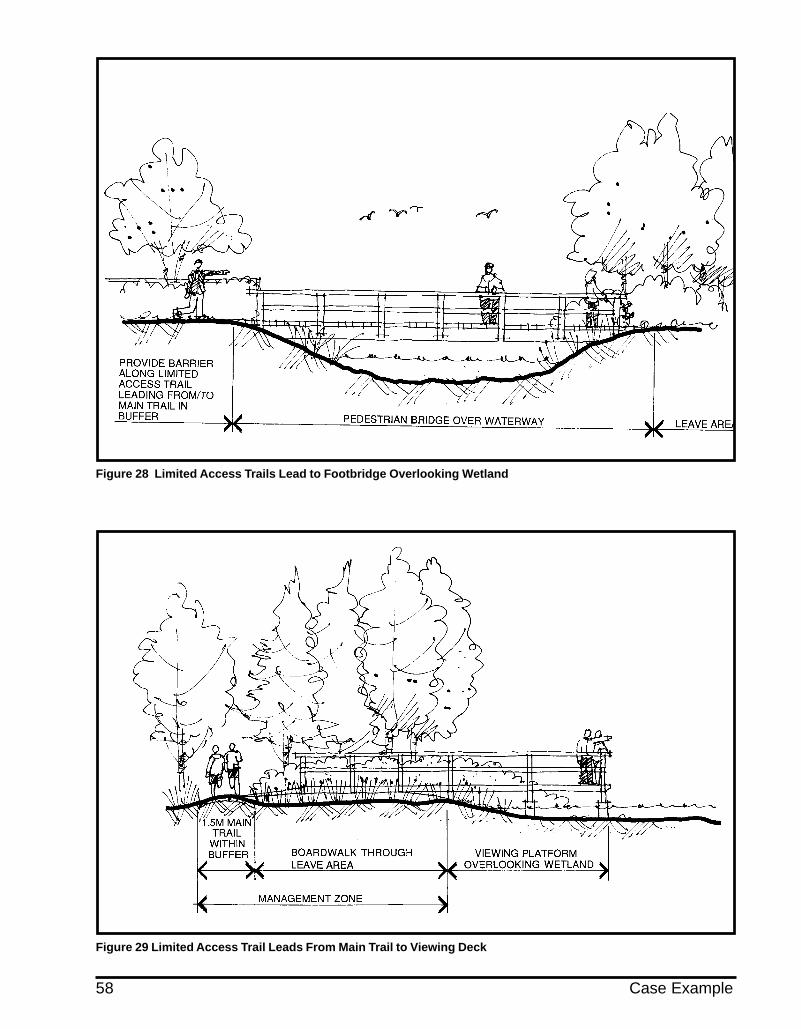
Figure 28 Limited Access Trails Lead to Footbridge Overlooking Wetland
Figure 29 Limited Access Trail Leads From Main Trail to Viewing Deck
58 Case Example

Appendices
Appendix 1: Case Studies in Access PlanningThis appendix summarizes a number of projects in Canada and the U.S. northwest where accessplanning near sensitive aquatic areas is a significant issue.
A. Oregon Coastal Zone Management and Shorefront AccessDepartment of Lands, Conservation and Development; Oregon, U.S.A.
Oregon has defined an extensive Coastal Zone which extends from three miles off shore to thewestern summits of the Coast Range Mountains. Its comprehensive Coastal Management Pro-gram includes regulations for all types of land uses within it. As well as identifying detailedprotection measures for significant habitats (ESAs), the program and its supporting legislation hasa provision requiring that coastal private lands not be sold unless an easement permitting publicaccess to the beach is provided.
Through the use of this permanent easement, the public has access to the dry sand beach as far upto the property as the actual vegetation line. The Oregon Beach Bill (defended successfully againstseveral court challenges) guarantees the unobstructed public use of such beaches, even those thatare privately owned. These rights are managed jointly by the State Parks System and by theLands, Conservation and Development Commission. Public access points must be providedalong the entire coast, usually at one mile intervals for footpaths and at three mile intervals forparking, bicycle racks and portable washrooms.
Oregon has established special measures for protecting sensitive areas such as wetlands, head-lands and dunes. Under State law, special rules are required by county, local governments andother agencies to preserve these resources through devices such as �overlayzoning�. This tech-nique adds a layer of special standards which govern uses permitted within and adjacent to ESAs.Included are conditions for public access. For example, access across dunes except in very limitedcircumstances is permitted only by boardwalk, with strict adherence to the defined path. Empha-sis is placed on establishing view points with interpretive signs for fragile resources such aswetlands or wildlife habitats.
The State Park Land/Conservation Acquisition Program has several specific measures for accessand protection of beaches and coastal resources. It acquires lands which contain unique naturalqualities, scenery, water access or park resources for special recreational or educational activitiesnot available within the current park or natural reserve system. The program also acquires landsadjacent to existing parks for protection/buffer of sensitive areas.
With respect to riparian areas, particularly along coastal streams, removal of vegetation is re-stricted to alleviation of direct hazards only. There are strict setbacks, varying in distance, for anystructures and paths. As well, riparian woodlands on private property can qualify for tax deferralif approved by the state�s Department of Fish and Wildlife. Once approved, they are set aside bylegal agreement as a protected zone.
Despite the State�s progressive role in coastal management, resource protection and assuringpublic access, the beauty of Oregon�s coast is threatened by the tremendous growth in wateroriented recreation. This pressure could outstrip the State�s capacity to successfully continue itslead in planning for human use while preserving its unique natural heritage.
Appendix 1: Case Studies in Access Planning 59

Oregon Coastal Zone Management and Shorefront Access: Resources and Planning Approaches
60 Appendix 1: Case Studies in Access Planning

(from Oregon�s Coastal Management Program: A Citizen�s Guide)
Appendix 1: Case Studies in Access Planning 61

B. Columbia River Gorge National Scenic Area Management PlanColumbia River Gorge Commission, USDA Forest Service; Washington and Oregon, U.S.A.
The Columbia Gorge National Scenic Area Act (1986) contains an innovative system for enhancing andprotecting the Columbia River Gorge. This law recognizes the need for environmental protection,public access and economic development.
The Act establishes a management partnership between a newly created Columbia Gorge Commis-sion, the U.S. Forest Service, state and local governments, Native American tribes and private landowners.
While thirteen urban areas have been exempted (with local planning controls), 90% of the Gorge hasbeen identified for resource protection. The legislation stipulates that a comprehensive manage-ment plan be developed for the Scenic Area, a 140 km stretch of river which harbours wetlands,tributary streams, islands, forests and steep bluffs. As well, there are numerous sites of heritage andcultural value, which have been designated as Special Management Areas within the Gorge.
The overall approach toward providing public access to aquatic ESAs within the corridor is to divertaccess to specific points outside the sensitive areas (for recreational uses such as boat launching) andto emphasize viewing in preference to actual contact or trails through the aquatic ESA.
Substantial buffer zones are required around wetlands and other high value habitats for any perma-nent use. For example, a 60 metre (200 ft.) buffer zone is stipulated for riparian areas around wet-lands and fish bearing perennial streams, while a 15 metre (50 ft.) buffer is required for intermediatestreams.
Loop trails with an emphasis on soil or compacted aggregate surface are being developed in con-junction with scenic viewpoints and to provide access into U.S. Forest hinterlands for hikers. Dayuse areas for activities such as picnicking and boat launching are sited at less sensitive locationsalong the scenic corridor where terrain permits.
An inventory has been conducted of all significant natural areas within the Gorge, noting the un-usual qualities of each one. Many of these offer refuge to endangered or threatened wildlife andfish.
While some of these ESAs are relatively inaccessible to people owing to their location (such as is-lands in the Columbia River), others are highly vulnerable. In response, the public access procedurehas been to:
� provide new viewpoints that highlight the particular ESAs and their features with accompany-ing interpretive signs;
� create or restore view openings along the Historic Columbia River Highway through selectivetree thinning and pruning in a manner consistent with resource protection;
� establish walking and bicycle paths along segments of the Historic Columbia River Highway,giving high priority to links which provide views into or which skirt sensitive areas, scenic vistasand culturally significant sites;
� stipulate through legislation that all such sites must also include assessment of aquatic and othernatural resources as well as a management plan that details their protection during constructionand after they become actively used.
62 Appendix 1: Case Studies in Access Planning

The Columbia River Gorge Management Plan involves historic, scenic and natural attributes. Public accessmust be carefully planned and sited(from Management Plan for the Columbia River Gorge National Scenic Area)
Appendix 1: Case Studies in Access Planning 63
C. Lake Ontario Greenway StrategyLake Ontario Waterfront Regeneration Trust
The Lake Ontario Waterfront Regeneration Trust�s mandate is to help restore and protect sensitiveareas along Lake Ontario�s shoreline. Rapid urbanization, industrial uses and other activities suchas transportation have severely impacted Lake Ontario�s waterfront.
The Waterfront Regeneration Trust is oriented toward developing a sense of community and eco-nomic vitality for a region stretching from Niagara to Kingston. Working with different governmentagencies and the private sector, the Trust is presently in the process of establishing a continuouswaterfront trail, knitting together urban and rural lakefronts and wetlands, extending from Hamiltonto Kingston.
While parts of this public trail system are already in place, others will have to be acquired throughdedication or purchase. The involvement of all government levels, community groups and theprivate sector is considered vital to this effort.
Through the Trust, ESAs along the lake shore corridor have been identified and mapped. The size,condition, surrounding land use patterns and significance of each ESA have been fully documented.Objectives for the enhancement and protection of individual sites, which include marshes, bays andstreams, have been developed. Sites with maximum interpretive potential are highlighted, empha-sizing the unique attributes of each one. This data helps to determine the degree of public accessadvisable and the specific methods which are most appropriate such as interpretive trails, view-points or boardwalks.
A major feature of the plan is enhanced public access through a Greenway Interpretation Masterplan,which emphasizes resource interpretation, including educational paths, signs and viewpoints. Itscentral theme is �Nature of Change�, linking the natural and cultural heritage of the corridor andindividual sites to the regeneration of the waterfront.
Trail routes include sections which expose the public to the value of ESAs. Interpretive paths andboardwalks, viewing platforms, bridges and signs are critical elements of the access managementplan. The responsibility for constructing and managing particular portions of these trails lies withmunicipal and regional governments and with other agencies such as Ontario�s Conservation Au-thorities which oversee watersheds within certain regions of the province.
In conjunction with the Waterfront Regeneration Trust, the Great Lakes Wetlands Conservation ActionPlan, a cooperative effort among government and non-government interests, is active in conservingand restoring wetlands of the Great Lakes. A list of priority ESAs within the corridor has beendeveloped with specific protection or restoration strategies for each one. Many of these sites havebeen identified as having provincial significance and have also been included in local communityplans as protection areas. As well, land owner contact programs have been initiated which encour-age private interests to protect significant habitats within the Lake Ontario Greenway.
To help ensure that the Greenway and Trail Plan receives public support, the Regeneration Trust hasbeen holding a series of on site workshops along the trail corridor. As each section of trail is opened,it is strongly publicized through local events and the media.
Following are two examples where public access to aquatic ESAs has been accommodated withinthe Lake Ontario Greenway Corridor.
64 Appendix 1: Case Studies in Access Planning

C(i) Second Marsh Wildlife AreaOshawa, Ontario
This 121 hectare (303 acre) wetland is one of the few remaining Lake Ontario marshes adjacent to anurban centre. It supports numerous fish, reptile, bird and plant species. Deterioration, however, hasprompted a Management Plan for Second Marsh. One key mandate of the plan is to incorporatepublic involvement and public access. Provisions for access have been coupled with a Rehabilita-tion Program, including clean up and habitat restoration. Public access and education/interpreta-tion components of the plan feature a new hierarchy of trails, notably:
� primary trail with compacted aggregate surface for multi-use (part of the Waterfront Trust TrailLinkage System);
� secondary aggregate surfaced trails, typically 1.5 metres wide, leading to viewpoints and inter-pretive nodes�primarily for use by naturalists and supervised school groups. Portions of thesetrails are raised boardwalks;
� two viewing platforms and four viewing towers capable of accommodating groups to facilitatebird and wildlife interpretation;
� closure of certain sections of trail system during key waterfowl nesting and fish spawning peri-ods.
C(ii) The Duffins Creek ProjectPickering, Ontario
Duffins Creek meanders through a series of marshes near Pickering, a suburb east of Toronto. Acooperative management and joint-funding agreement involving the towns of Ajax and Pickering,Ontario Hydro, the Provincial Government, local service organizations, naturalist clubs, the MetroToronto Conservation Authority and the Waterfront Regeneration Trust strives to reduce environ-mental impacts while encouraging public appreciation of these important wetlands.
A pathway system has been developed that encourages viewing and interpretation of wildlife habi-tat, while at the same time avoiding public intrusion upon it. The trail is innovative in its construc-tion, utilizing raised boardwalks made of prefabricated steel and wood. As well, a recently devel-oped �hardened� soil, using an organic hardener, is being tested. Using this type of soil provides apath surface which resists erosion, while remaining permeable. The trail will serve as a basis for thedesign of public access of other aquatic ESAs along the Lake Ontario Corridor.
Duffin Creek at Lake Ontario
Appendix 1: Case Studies in Access Planning 65

D. Swan Lake/Christmas Hill Nature SanctuaryCapital Regional District; Victoria, B.C.
The Swan Lake Nature Sanctuary contains a hierarchy of trails developed with consideration ofhabitat sensitivity. The trail plan intentionally directs traffic away from sensitive habitats, with trailaccess to viewpoints in selected areas. Main trails are situated away from the lake, while a floatingboardwalk and two docks provide access out onto the lake. At the same time, trails provide continu-ally changing vistas since they are never constructed as a straight line. Where trails do penetrate theriparian area, they are unobtrusive footpaths and do not obstruct riparian functions. Thorny bushesare used as live barriers along the trail to prevent pedestrians from accessing aquatic ESAs. Signagenotifying the public of wildlife activities, such as nesting, is also used to protect sensitive habitatareas.
A boardwalk through the Swan Lake Nature Sanctuary wetland
E. Galloping Goose TrailCapital Regional District; Victoria, B.C.
Part of the Galloping Goose trail lies adjacent to the Swan Lake/Christmas Hill Sanctuary. This trail isbeing developed as part of a larger network of pathways to provide public access to a communitygreenway. Trail alignment adheres to an old railway corridor. Two former railway trestles have beenmade pedestrian friendly with wood planking and handrails. Since these improvements required instreamwork, the Ministry of Environment, Lands, and Parks regional habitat protection office was contactedand provided advice on material handling and timing in order to minimize impact on fish and fishhabitat. The railway trestles provide ideal viewpoints and vertical separation in the trail. Thus, intrusioninto the wetland is discouraged and pedestrians are restricted to the designated trail. Improvements tothe habitat and drainage basin are being undertaken by community volunteers. Included is the removalof non-native plant species and plantings of indigenous species. The Galloping Goose trail will includeurban and non-urban sections. Once complete, the trail will be 60 km long. Where it is not convertedrailway track, much of the trail is a narrow footpath with dense vegetation immediately adjacent to thetrail.
66 Appendix 1: Case Studies in Access Planning

F. South Dyke Trail, London�s LandingRichmond, B.C.
Richmond�s South Dyke affords flood protection from the Fraser River�s South Arm. Significantsections of its shoreline include �red zone� habitat�valuable wetland and intertidal vegetation which isof particular importance to fish and waterfowl.
The recently constructed South Dyke trail is part of the City of Richmond�s overall trail network whichencourages public access along its dykes. At London Farm and London�s Landing, two importantheritage sites, there are also significant habitats. Through skillful design, protection of the aquatic ESAhas been achieved while permitting compatible access and enjoyment.
Along London Farm�s waterfront, there was a serious problem of vehicular intrusion upon the beachand upper wetland. This conflict has been eliminated through grade separation, a stepped wall, ruggedbollards and a galvanized drain. The footpath is set back from the marsh and is situated at top of bank,while motor vehicles are restricted to an access road situated at a higher elevation. Steps lead to thebeach and wetland.
At London�s Landing, the site of an historic ferry landing, an old pier has been renovated to create aplatform for viewing the wetlands and river. As well, a system of paths, signs and picnic tables areprovided. Vertical separation between this system and the aquatic ESA is achieved through elevateddecking. This design has effectively integrated habitat protection with public viewing and appreciationof the area.
The pier and seating area at London�s Landing along the South Dyke Trail in Richmond, B.C.
Appendix 1: Case Studies in Access Planning 67

G. Boundary Bay Regional ParkGreater Vancouver Regional District; Delta, B.C.
Boundary Bay Regional Park, which covers 38 hectares along the western shore of Boundary Bay, wasofficially opened in 1989. The Bay is one of North America�s most significant waterfowl habitats anda major migratory midpoint stopover on the Pacific Flyway. In 1995, as part of the Provincial LowerMainland Nature Legacy Program and the Vancouver International Airport Wildlife HabitatCompensation program, additional lands were acquired to expand the Regional Park to 127 hectares insize. The Park has a variety of natural landscape features, including marine, sand dune, savannah andwetland ecosystems which provide important habitat for shore birds, song birds, blue herons and raptors.Mudflats immediately offshore are a critical resting and feeding stop for migratory birds.
An elevated boardwalk leads to the raised viewing deck at Boundary Bay Regional Park
As one of only three public ocean beaches south of the Fraser River in the Lower Mainland, BoundaryBay Regional Park has become extremely popular as a destination for walking, jogging, cycling, beachoriented activities and nature appreciation, with approximately 396,000 visitors in 1995 alone. A 2 kmdyke running through the Park along the foreshore is part of a 9 km dyke network which protectsDelta�s low-lying farmland and residential areas from flooding. The dyke is popular for walkers, joggers,cyclists, naturalists and equestrians. The potential for conflict between wetland habitat protection andvisitor use is clearly evident.
In 1993 the Greater Vancouver Regional District (GVRD), in partnership with the Friends of BoundaryBay and the Environmental Partnership Fund, initiated an interpretation and trail improvement program.The program included formalizing a trail through sensitive dune habitat to consolidate several informaltrails, a self guided dune interpretive walk complete with signs and an elevated boardwalk around theperimeter of a freshwater wetland. The boardwalk, with controlled access points and strategicallyplaced signs leads to a viewpoint where visitors can overlook the marshland and Boundary Bay tidalflats. The viewpoint and low level viewing tower were installed in 1995 as a joint project betweenGVRD Parks and B.C. Ministry of Environment, Lands and Parks. Interpretive signs about theenvironmental importance of the Bay are affixed to the structures and at key points around the dyke.
68 Appendix 1: Case Studies in Access Planning
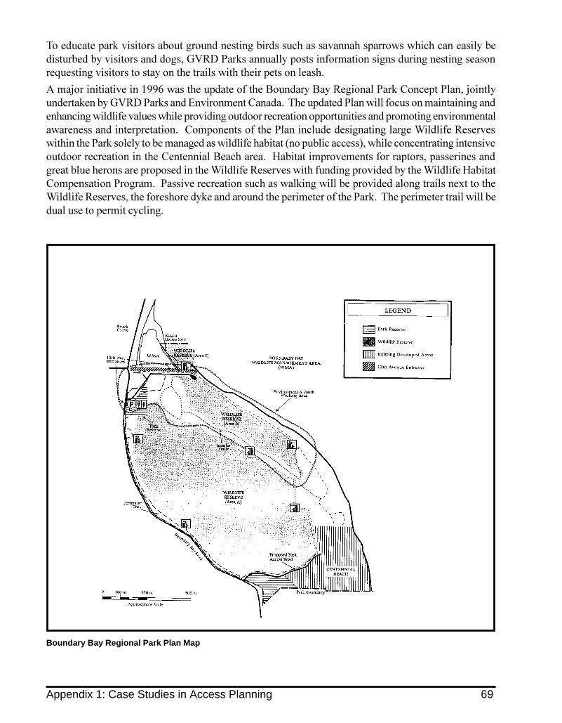
To educate park visitors about ground nesting birds such as savannah sparrows which can easily bedisturbed by visitors and dogs, GVRD Parks annually posts information signs during nesting seasonrequesting visitors to stay on the trails with their pets on leash.
A major initiative in 1996 was the update of the Boundary Bay Regional Park Concept Plan, jointlyundertaken by GVRD Parks and Environment Canada. The updated Plan will focus on maintaining andenhancing wildlife values while providing outdoor recreation opportunities and promoting environmentalawareness and interpretation. Components of the Plan include designating large Wildlife Reserveswithin the Park solely to be managed as wildlife habitat (no public access), while concentrating intensiveoutdoor recreation in the Centennial Beach area. Habitat improvements for raptors, passerines andgreat blue herons are proposed in the Wildlife Reserves with funding provided by the Wildlife HabitatCompensation Program. Passive recreation such as walking will be provided along trails next to theWildlife Reserves, the foreshore dyke and around the perimeter of the Park. The perimeter trail will bedual use to permit cycling.
Boundary Bay Regional Park Plan Map
Appendix 1: Case Studies in Access Planning 69

Appendix 2: Sample Unit Costs for Construction MaterialsExamples of construction costs (labour and material) for typical access structures are summarized in1995 dollars. It should be cautioned that these are estimates only. Costs can vary significantlyaccording to site, location, distance from suppliers, ease of access, labour rates, availability of mate-rials and other considerations. As well, municipalities and other agencies often purchase materialsin bulk, resulting in different costs than to private developers or land owners.
Aggregate Trail, including 15 cm sub-base / 15 cm compacted surface . . . . . . . . . . . . . . . . . . . . $18 /m2
Timber Deck / Boardwalk (pressure treated Hemfir) . . . . . . . . . . . . . . . . . . . . . . . . . . . . . . . . . $200 /m2
Signs (timber or metal) . . . . . . . . . . . . . . . . . . . . . . . . . . . . . . . . . . . . . . . . . . . . . . . . . . . . . . . $300 each
Timber Benches . . . . . . . . . . . . . . . . . . . . . . . . . . . . . . . . . . . . . . . . . . . . . . . . . . . . . . . . . . . . . $800 each
Bicycle Racks (metal) . . . . . . . . . . . . . . . . . . . . . . . . . . . . . . . . . . . . . . . . . . . . . . . . . . . . . . . . $700 each
Timber Gate (1 m width) . . . . . . . . . . . . . . . . . . . . . . . . . . . . . . . . . . . . . . . . . . . . . . . . . . . . . . $200 each
Metal Gate (1 m width) . . . . . . . . . . . . . . . . . . . . . . . . . . . . . . . . . . . . . . . . . . . . . . . . . . . . . . . $400 each
Timber Fence (1.2 m) . . . . . . . . . . . . . . . . . . . . . . . . . . . . . . . . . . . . . . . . . . . . . . . . . . . . . . . . . $25 / l.m.
Timber Fence (1.8 m) . . . . . . . . . . . . . . . . . . . . . . . . . . . . . . . . . . . . . . . . . . . . . . . . . . . . . . . . . $35 / l.m.
Chain Link Fence (1.2 m) . . . . . . . . . . . . . . . . . . . . . . . . . . . . . . . . . . . . . . . . . . . . . . . . . . . . . . $25 / l.m.
Chain Link Fence (1.8 m) . . . . . . . . . . . . . . . . . . . . . . . . . . . . . . . . . . . . . . . . . . . . . . . . . . . . . . $30 / l.m.
Page Wire Timber Fence (1.8 m) . . . . . . . . . . . . . . . . . . . . . . . . . . . . . . . . . . . . . . . . . . . . . . . . $20 / l.m.
Double Row of Thorny Shrubs (1.2 m) . . . . . . . . . . . . . . . . . . . . . . . . . . . . . . . . . . . . . . . . . . . $30 / l.m.
70 Appendix 2: Sample Unit Costs for Construction Materials

Appendix 3: Suggested Live Barrier Species for Coastal BritishColumbia (native plants)
Species Features Height Light/SoilRequire-ments
Comments
TreesAcer macrophyllumBig-leaf maple
large leaves, yellowautumn colour, providesshade
to 30m sun/shade,mesic 7
Large deciduous tree, use with othersmaller species
Alnus rubraRed alder
fast growing, nitrogen fixer to 25m sun, mesic towet- mesic
Large deciduous tree, use with othersmaller species
Betula papyriferaPaper birch
fast growing, yellowautumn colour, peelingwhite bark
to 30m sun, mesic Large deciduous tree, use with othersmaller species, hardy
Populus balsamiferassp.trichocarpaBlack cottonwood
fast growing, fragrantleaves
to 50m sun, mesic towet- mesic
Large deciduous tree, use with othersmaller species, hardy
Populus tremuloidesTrembling aspen
fast growing, silver greybark, trembling leaves,yellow autumn colour
to 20m sun, mesic todry- mesic
Large deciduous tree, use with othersmaller species, hardy
Prunus emarginata var.mollisBitter cherry
rapid growing, whiteflowers, red fruits, attractsbirds
to 15m sun to part-sun,mesic
Large deciduous tree, use with othersmaller species
Pseudotsuga menziesiiDouglas fir
rapid growing evergreen to 75m sun, mesic Large coniferous tree, use with othersmaller species
Thuja plicataWestern red cedar
rapid growing evergreen,drooping foliage
to 60m sun to part-sun,mesic
Large coniferous tree, can be hedgedor use with other smaller species
Tsuga heterophyllaWestern hemlock
rapid growing evergreen,dense twiggy
to 60m sun to part-sun,mesic
Large coniferous tree, can be hedgedor use with other smaller species
Small TreesAcer circinatumVine maple
showy autumn colour to 7m sun/shade,mesic
select multistems or coppice toencourage denser branch system, usewith other species
Acer glabrumDouglas maple
showy autumn colour to 10m sun/part-sun, mesic
select multistems or coppice toencourage denser branch system, usewith other species
Corylus avellanaHazelnut
edible nuts, large leaves,yellow autumn colour
to 6m sun/part-sun,mesic
Introduced species, can be hedged orcoppiced to make a dense branchsystem, suckers, fast growing, can beinterwoven with hard barrier (chainlink)
Corylus cornuta var.californicaBeaked hazelnut
edible nuts, large leaves,yellow autumn colour
1-4m sun, mesic can be hedged or coppiced to make adense branch system, suckers, fastgrowing can be interwoven withhard barrier (chain link)
Crataegus douglasiiBlack hawthorn
thorns , white flowers,purplish-black fruit
to 10m sun, mesic numerous sharp, nasty 3 cm longthorns
Malus fuscaPacific crabapple
thorns , showy fragrantpink-white flowers, smallyellow edible fruits
to 10m sun, mesic sharp, nasty spur shoots
Prunus virginianaWestern chokecherry
white flowers, edible redfruit, attracts birds
to 10m sun, mesic todry- mesic
use with other species
7 Intermediate, i.e. in relation to temperature, moisture, or decomposition.
Appendix 2: Sample Unit Costs for Construction Materials 71

Species Features Height Light/SoilRequire-ments
Comments
Salix lucida ssp. lasiandraPacific Willow
fast growing, new growth isshowy yellow
to 12m sun, mesic towet- mesic
cuttings root readily, can beinterwoven with hard barrier,tolerates flooding
Salix scoulerianaScouler �s willow
fast growing, soft velvetyleaves
2-12m sun to part-sun,mesic to wet-mesic
cuttings root readily, can beinterwoven with hard barrier,tolerates flooding
Salix sitchensisSitka willow
dense, twiggy , fastgrowing, bright greenleaves
1-8m sun, mesic towet- mesic
cuttings root readily, can beinterwoven with hard barrier,tolerates flooding
Sambucus ceruleaBlue elderberry
showy glossy blue fruitclusters, large compoundleaves, attracts birds
to 6m sun, mesic todry- mesic
can be open in the ground layer, usewith other species, needs gooddrainage
Sambucus racemosaRed-berry elder
white flower clusters,showy red fruit, largecompound leaves, attractsbirds
to 6m sun/part-sun,mesic to wet-mesic
can be open in the ground layer, usewith other species, aggressive onceestablished
ShrubsAmelanchier alnifoliaServiceberry
showy white flowers,edible purple-black fruit,red-orange autumn colour,attracts birds
to 5m sun, mesic upright, spreading, can be a smalltree.
Cornus sericea (syn.stolonifera)Red-osier dogwood
showy red twigs, whiteflowers and fruit
to 3m sun, mesic spreads by stolons, fast growing,hardy, can be hedged
Holodiscus discolorOceanspray
twiggy , showy creamy-white flowers
to 4m sun, mesic todry- mesic
drought tolerant, use with otherground covering species to close gaps
Mahonia (syn . Berberis)aquifoliumOregon grape
prickly, evergreen, yellowflowers, edible blue fruit
to 2m sun to part-sun,mesic to dry-mesic
can be spindly in shade, suckering,drought tolerant, use with otherspecies to keep gaps closed
Oplopanax horridusDevil �s club
branches and stems coveredwith numerous 1cm thornyspines, spines on leaves
1-3m shade/part-sun, mesic towet- mesic
needs well-drained soils, particularlynasty and will stop anyone
Philadelphus lewisiiMock orange
fragrant white flowers to 3m sun to part-shade, mesic
spreading, fast growing
Physocarpus capitatusPacific ninebark
twiggy , white flowerclusters
to 4m sun/part-sun,mesic to dry-mesic
use with other species, can be hedged
Potentilla fruticosaShrubby cinquefoil
dense and twiggy , showyyellow flowers
to 1m sun, mesic todry- mesic
good for formal live barrier, can beused as ground layer with other treesand shrubs
Ribes lacustreBlack gooseberry
thorns, reddish-maroonflowers, edible fruits
to 2m sun to part-sun,mesic to dry-mesic
erect to spreading, branches coveredwith numerous prickles and largerspikes at leaf nodes
Ribes sanguineumRed-flowering currant
dense and twiggy , showyred flowers, attractshummingbirds
1-3m sun/part-sun,mesic
can be hedged
Rosa acicularisPrickly rose
thorns, pink flowers, redhips
to 1.2m sun, mesic hardy, fast growing, suckering
Rosa gymnocarpaBaldhip rose
thorns, pink flowers, redhips
to 1.2m sun, mesic hardy, fast growing, spreading
Rosa nutkanaNootka rose
thorns, pink flowers, redhips
to 3m sun to part-sun,mesic
hardy, fast growing, spreading
Rosa pisocarpaClustered wild rose
thorns, clustered pinkflowers, red hips
to 2.5m sun to part-sun,mesic
wetland margin plant, hardy,tolerates flooding, fast growing,suckering
72 Appendix 3: Suggested Live Barrier Species for Coastal British Columbia

Species Features Height Light/SoilRequire-ments
Comments
Rubus discolorHimalayan blackberry
thorns, white flowers,edible blackberries,attracts birds
to 10m sun, mesic erect to sprawling and trailing.Introduced and naturalizedspecies.
Rubus idaeusRed raspberry
thorns, red edibleberries, attracts birds
to 1.2m sun, mesic rapid growing, suckering
Rubus leucodermisBlack raspberry
thorns, red-blackberries, attracts birds
to 2m sun, mesic rapid growing, suckering
Sorbus sitchensisSitka mountain ash
twiggy, white flowerclusters, showy redfruit, red autumncolour, attracts birds
1-4m sun, mesic use with other species, can behedged
Spiraea douglasiiHardhack
dense, twiggy , showypink flowers
1-2m sun, mesic can be hedged
Vaccinium ovatumEvergreen huckleberry
glossy evergreen leaves,white flowers, edibleblack fruit
to 2m shade to part-shade, mesic
use with other species
Vaccinium parvifoliumRed huckleberry
edible red fruit, attractsbirds
to 2m part-shade,mesic
use with other species
Viburnum eduleHighbush cranberry
white flower, edibleorange-red fruit, redautumn colour, attractsbirds
to 3.5m sun/part-sun, mesic
twiggy, can be hedged
Vines and Climbing SpeciesClematis columbianaColumbia clematis
blue flowers, climbingand twining vine,showy seed clusters inautumn
to 12m sun, dry-mesic tomesic
can climb along live barrierplants, or along top of hardbarrier fences
Clematis ligusticifoliaWestern clematis
white flowers, climbingand twining vine,showy seed clusters inautumn
to 12 m can climb along live barrierplants, or along top of hardbarrier fences
LoniceraciliosaWestern trumpethoneysuckle
orange-yellow flowers,climbing vine,hummingbird plant
to 10m sun, mesic can climb along live barrierplants, or along top of hardbarrier fences
Ground Layer SpeciesJuniperus communisCommon juniper
very prickly leaves(needles)
to 2m sun, dry-mesic
Low spreading
Mahonia (syn . Berberis)nervosaCascade Oregon grape
evergreen, pricklyleaves, yellow flowers,blue fruit
to 1m shade to part-shade, moist
Low spreading
Rubus ursinusTrailing blackberry
thorns, white flowers,purple-black berries,attracts birds
to .5m sun/part-sun, mesic
creeping and mounding, rapidgrowing
Appendix 3: Suggested Live Barrier Species for Coastal British Columbia 73

Appendix 4: Legislation, Guidelines and Resource MaterialsThe following tables list key legislation, guidelines and resources that assist managers of publicland and private landowners to maintain the important functional roles of aquatic features atboth the local and regional level.
A. Legislation
Legislation AdministeringBody
Applicability of Act to Access Planning
Fisheries Act Fisheries andOceans Canada;EnvironmentCanada; Ministryof Environment,Lands and Parks
This Act contains enforceable measures to prevent the disruption, alteration ordestruction of fish habitat, or the deposit of deleterious substances into fish habitat.The Land Development Guidelines for the Protection of Aquatic Habitat, described in thenext section, interprets this legislation for proponents. Proposals for work in areasadjacent to aquatic ESAs should be compliant with these guidelines.
Policy onWetlandConservation
EnvironmentCanada
This Policy seeks to preserve wetland functions in Canada. Projects on federal land, orsupported by federal money must achieve no net loss of wetland function. For otherprojects, the federal government encourages proponents to maintain wetlandfunction.
Canada WildlifeAct
EnvironmentCanada
This Act and its regulations enable the federal government to participate in wildlifeconservation, research and interpretation. It permits the establishment of NationalWildlife Areas to preserve wildlife habitat areas of national significance.
Migratory BirdsConvention Act
EnvironmentCanada
This Act and its regulations empower the federal government to manage migratorybird populations. The Act and regulations contain provisions that regulate huntingof migratory birds, and prohibit the deposition of oil, grease and other deleterioussubstances into waters frequented by migratory birds.
National ParksAct
Heritage Canada Parks Canada, under Heritage Canada, can, through the National Parks Act,designate an area as a National Marine Conservation Area, which includes theseabed, water column and upland area. Zoning and management plans areimplemented in agreement with DFO/DOE and/or the province. Type of publicaccess depends on designated use.
(B.C.) WildlifeAct
Ministry ofEnvironment,Lands and Parks
Among other things, this Act requires the identification and protection of the nestsites of herons and certain raptors.
Municipal Act Municipalities &Regional Districts
Under this Act, municipalities can develop OCPs which contain policies forenvironmentally sensitive areas, parks and greenway systems, erosion control, treecutting, stormwater management, and cooperation with other agencies andgovernment. Municipalities can also use zoning and subdivision bylaws and otherprovisions such as Development Permits to protect aquatic features.
Water Act Ministry ofEnvironment,Lands, and Parks
The Water Act and the Section 7 Regulations (1995) deal with the administration ofwater licenses and define provincial requirements for conducting works in andaround watercourses.
WasteManagement Act
Ministry ofEnvironment,Lands, and Parks
The Waste Management Act requires permits be issued for litter, effluent, refuse andspecial wastes, and includes provisions for permit enforcement.
B.C. Parks Act Ministry ofEnvironment,Lands, and Parks
This Act gives MELP the mandate to establish and maintain parks in B.C.Responsibilities of MELP under this Act include the property, rights, interests of theCrown on or in park and recreation areas, the natural resources within those areas,and the presentation, development, use and maintenance of parks. Regulations maybe established to govern the human use of these areas as well as for theadministration, protection and development of the land.
EcologicalReserves Act
Ministry ofEnvironment,Lands, and Parks
Sites are chosen to protect ecologically significant examples of ecosystems, wildlifehabitat, and special features for the purposes of conservation, scientific study andresearch. Level of access depends on the purpose of the reserve.
74 Appendix 4: Legislation, Guidelines and Resource Materials

AgriculturalWaste ControlRegulation
Ministry ofEnvironment,Lands andParks (underthe WasteManagementAct)
This regulation and the Code of Agricultural Practice for Waste Management outlinehow agricultural waste must be managed to reduce impacts to groundwater andsurface waters. They can be used to require the relocation of manure to minimizetoxic or nutrient rich leachate from being discharged into streams and watercourses,and to require fencing to exclude livestock from aquatic habitats.
Farm PracticesProtection Act
Ministry ofAgriculture,Fisheries andFood
This Act amends the Municipal Act and Land Title Act to encourage improvedplanning for agriculture by local governments. In conjunction with the new act,specific farm management standards are being developed which will address amongother things setbacks for farm buildings and farm activities from watercourses.
B. Guidelines and Resource Materials8
Guidelines and Resources Developed for: Application to Access PlanningLand Development Guidelines forthe Protection of Aquatic Habitat(current edition: 1992)
municipal or privatedevelopers, landowners
These guidelines protect fish populations and theirhabitats by outlining approaches to erosion control, stormwater management, and leave strip designation andmaintenance. These guidelines are designed to achieve�no net loss� of productive capacity of fish habitat.
Stream Stewardship: A Guide forPlanners and Developers
municipal staff, privatedevelopers
This planning guide illustrates land planning principlesand tools available to local government to protectstreams, streamside vegetation and water quality.
Stewardship of the AquaticEnvironment: A Guide forAgriculture
farmers, ranchers and farmcommunities
This guide presents recommendations and guidelines forgood stewardship of streams, lakes, and wetlandsassociated with agricultural activities.
Stewardship Options : A Guide forPrivate Landowners in B.C.
property owners This book helps landowners identify natural features ontheir property and provides both practical and legaloptions for private stewardship, in order to protect andrestore wildlife and fish habitat.
Streamkeepers Handbook volunteers committed toprotecting and restoringstream habitats
The Streamkeepers Handbook provides specificsuggestions for the protection and restoration of streams,wetlands and associated habitats. Includes trainingmodules.
Wetlandkeepers Handbook property owners,restoration and protectionvolunteers, municipal staff
This handbook provides background information onwetland ecology, law, and instructions on wetlandactivities. Includes training modules.
Protecting British Columbia'sWetlands - A Citizen's Guide
volunteers committed toprotecting and restoringwetlands
This handbook provides specific suggestions andresources for the protection and restoration of wetlandsand associated habitats.
Community Greenways: LinkingCommunities to Country, and Peopleto Nature
municipal staff developers,property owners
This document integrates land management tools tocreate networks of green spaces linking humandevelopment with natural areas. Protection ofenvironmentally sensitive areas and access planning arefundamental aspects of greenways planning.
Lake Care (BC Environment) property owners This manual provides a guide to conserving fish habitat inlakes.
Naturescape Series (1, 2, 3) property owners This series is a landowner �s resource for landscaping andwildlife habitat enhancement in the Georgia Basin; it alsocontains an overview for the whole of B.C.
8 Sources of these materials are identified in the Resources section.
Appendix 4: Legislation, Guidelines and Resource Materials 75

Glossary
Aquatic Habitat: Areas associated with water which provide food and shelter and other elementscritical to completion of an organism�s life cycle. Aquatic habitats include streams, wetlands,marshes, bogs, estuaries, and riparian areas, as well as large fresh and salt water bodies
Aquifer: Underground water bodies. There are two types of aquifers. Open aquifers have perme-able materials overlying them, e.g. soil with underlying loose gravel. Closed aquifers are cappedwith an impervious layer of material, such as clay, which prevents water from penetrating fromthe soils directly above. The water level in aquifers rises and falls in response to water removaland infiltration.
Barrier: A structure installed to protect an environmentally sensitive area. A barrier can be hard (i.e.fence); live (i.e. planted); a combination of hard and live; or a terrain feature (i.e. berm). A barriercan be physical (obstructing passage) or psychological (deterring access).
Buffer: The portion of a management zone that is adjacent to the leave area. The buffer area protectsthe leave area. It is within the buffer that recreational trail corridors are accommodated. Buffersalso provide a transition between adjacent land uses.
Deleterious Substance: Substance harmful to fish or fish habitat (Canada Fisheries Act, sec. 36.3)
Development Permit Area: An identified area that is �designated� on an OCP map. Developmentin these areas requires a permit before construction can proceed. Typically, development mustmeet special requirements due to the unique nature of the site.
Ecosystem: The terms used for the sum total of vegetation, animals and the physical environmentin which they interact. Ecosystem is derived from the Greek term oikos, which means home.
Environmentally Sensitive Area (ESA): Areas requiring special management attention to protectfish and wildlife resources and other implicit natural systems or processes. ESAs have also beenbroadly defined to include other scenic, historic or cultural values.
Estuary: A partially enclosed body of water freely connected to the ocean, within which the seawa-ter is diluted by mixing with freshwater and where tidal fluctuations affect river water levels.The estuary is a dynamic system typified by brackish water, variable and often high nutrientlevels and by shallow water conditions often associated with marsh plants in upper tidal zonesand eelgrass in lower tidal zones.
Fish: Fish are defined as: shellfish, crustaceans, marine animals, the eggs, spawn, spat and juvenilestages of fish, shellfish, crustaceans, and marine animals. (Canada Fisheries Act, sec.31.5)
Fish Habitat: Spawning grounds and nursery, rearing, food supply and migration areas on whichfish depend directly or indirectly in order to carry out their life processes. (Canada Fisheries Act,sec. 31.5)
Fishery Operating Window: The time periods of reduced risk for important commercial, sport, andresident fish species, based on life histories. The fishery operating window is the time of yearduring which there are no fish eggs or alevins present in the substrates of the local rivers. This isthe preferred period for instream work or development. Prior to commencement of any instreamwork and with sufficient lead time, proponents should contact DFO/MELP for information re-garding species timing windows for their area.
76 Glossary

Floodplains: Relatively flat, low-lying areas adjacent to watercourses. Floodplains are formed offluvial sediments and are periodically flooded and modified when streams flow over the tops ofbanks. Stream channels meander within unconfined floodplains, alternately creating and isolat-ing habitats.
Groundwater: Water that infiltrates through the ground surface and accumulates in undergroundwater bodies in porous rock or gravels.
Headwater: The area in the upper reaches of a watershed typified by unconfined surface waterflows. Headwaters can coalesce to form rivulets or first order streams with distinct channels.Headwaters can often be ephemeral (wetted only part of the year). Hydrologic processes such asthose that occur in headwaters affect the entire downstream structure of the watercourse.
Hydrology: The study of the occurrence, circulation, and distribution of the waters of the earth.Local hydrologic regimes and processes need to be taken into account in water and land useplanning. These processes include precipitation, interception, run-off, infiltration, percolation,storage, evaporation, and transpiration.
Impervious: The inability of a material (usually a substance used in road, parking lot and drivewaysurfacing) to permit the relatively rapid passage of water through into the ground.
Leave Area (reserve zone): The area of land and vegetation adjacent to an aquatic area that is toremain in an undisturbed state, throughout and after the development process. Leave areas arerequired around all aquatic features that flow into or contain fish or fish habitat. This mayinclude wetlands, ponds, swamps or other intermittently wetted areas, as well as small streamsside channels and ditches which may not flow throughout the entire year (ephemeral). The leavearea (reserve zone) together with the buffer comprise the management zone.
Management Zone: The area around sensitive aquatic features that includes the leave area (reservezone), and a buffer. The dimensions of the management zone are ideally dictated by topography,vegetative communities, hydrologic, and geomorphic features and processes.
Marsh: A mineral wetland that is permanently or seasonally inundated up to a depth of two metresby standing or slow moving water. The waters are nutrient rich and the substrate is usuallymineral soil. Marshes are characterized by communities of emergent rushes, grasses and reeds,and submerged or floating aquatic plants in areas of open water.
Mitigation: Actions taken during the planning, design, construction and operation of works andundertakings to alleviate potential adverse effects on the productive capacity of fish habitats.(DFO Policy for the Management of Fish Habitat, 1986)
No Net Loss: A working principle which strives to balance unavoidable habitat losses throughavoidance, mitigation and habitat replacement on a project-by-project basis so that further re-ductions to Canada�s fisheries resources due to habitat loss or damage may be prevented. (DFOPolicy for the Management of Fish Habitat, 1986)
Productive Capacity: The maximum natural capability of habitats to produce healthy fish, safe forhuman consumption, or to support or produce aquatic organisms upon which fish depend.(DFO Policy for the Management of Fish Habitat, 1986)
Riparian Area: The land adjacent to the normal high water level in a stream, river, lake or pond andextending to the portion of land that is directly influenced by the presence of adjacent ponded orchanneled water. Riparian areas typically exemplify a rich and diverse vegetative mosaic reflect-ing the influence of available surface water.
Run-Off: That portion of rain fall or snow melt which flows off the surface.
Glossary 77

Salmonid: Fish belonging to the family salmonidae, including Pacific salmon, trout, char, whitefish,and related species.
Sedimentation: Deposition of material carried in water; usually the result of a reduction in watervelocity below the point at which it can transport the material.
Spawn (verb): To produce or deposit eggs - usually used in reference to aquatic organisms such asfish, crustaceans and oysters. (noun) eggs of fish or invertebrates.
Stormwater Detention: The collection and containment of run-off from impervious surfaces. De-tention is intended to maintain, as closely as possible, the natural predevelopment flow patternand water quality of development sites in the watershed. Increases in impervious surfaces re-duce detention and retention, causing significantly higher peak flows and reduced base flows instreams.
Top of Bank: The point at which the bank shows a significant or abrupt change in slope. In flatlandscapes it could be the normal high water mark, but more typically, it is the top of the slopeleading down to the water.
Water Quality: The chemical, physical and biological characteristics of water.
Watershed: The total region defined by height of land draining into a given waterway, lake orreservoir; a drainage basin.
Wetlands: Areas of permanent or temporary standing water, characterized by the absence ofchannel flow and the presence of vegetation which is distinct from that in neighboring, freelydrained areas. The most common types of wetlands are swamps, marshes and bogs, fens andshallow water.
78 Glossary

Resources
Aquatic ESA Planning and Management
Adopt-A-Stream Video. Available from Fisheries and Oceans� Community Advisors.
Best Management Practices for the Use of Treated Woods in Aquatic Environments. July 1994. Preparedby the Western Wood Preservers Institute (USA) and the Canadian Institute of Treated Wood.
Bolling, D.M. 1994. How To Save A River: A Handbook For Citizen Action. Washington D.C.: Is-lands Press.
B.C. Ministry of Environment, Lands and Parks. 1995. Water Stewardship: A Guide for Teachers,Students, and Community Groups. Victoria, B.C.
B.C. Ministry of Forests and B.C. Ministry of Environment, Lands and Parks. 1995. Forest Prac-tices Code Guidebooks. Victoria, B.C.
Brown, L. 1994. Innovative Livestock Watering Options. Province of B.C. Min. of Agriculture,Fisheries and Food. Engineering Factsheet #716/725.
Columbia River George Commssion, USDA Forest Service. September 1992. Managerment Plan forthe Columbia River Gorge National Scenic Area.
Chilibeck, B., G. Chislett, and G. Norris. May 1992. Land Development Guidelines for the Protectionof Aquatic Habitat. Fisheries and Oceans Canada, Vancouver, B.C. Ministry of the Environ-ment, Lands and Parks, Victoria, B.C. This edition will be undergoing revisions and updates inthe near future.
Developing Fish Habitat Signage: A guide for community groups and concerned citizens (brochure).Fraser River Action Plan, Fisheries and Oceans Canada.
Dunster, J. and K. Dunster. Dictionary of Natural Resource Management. Vancouver: UBC Press,1996.
Fisheries and Oceans Canada. March 1995. Marina Development Guidelines for the Protection of Fishand Fish Habitat. Available from Fisheries and Oceans Canada, Habitat and EnhancementBranch (555 W. Hastings St., Vancouver, B.C.).
Fisheries and Oceans Canada. November 1990. Fish Habitat Enhancement: A Manual for Freshwa-ter, Estuarine and Marine Habitats. Prepared by Envirowest Consultants. Fisheries and OceansCanada, Vancouver, B.C.
Fisheries and Oceans Canada. 1986. The Department of Fisheries and Oceans� Policy for the Manage-ment of Fish Habitat. Ottawa, Ontario. Available from Fisheries and Oceans Canada, Habitatand Enhancement Branch (555 W. Hastings St., Vancouver, B.C.).
Fraser River Estuary: A Guide to Interpretive Themes and Recreation Access. 1996. Prepared for andavailable from: Fraser River Estuary Management Program, Metrotown Place III, Burnaby,B.C.
Lashmar, M. A. and K. H. Morgan. eds. Riparian Habitat Management and Research. Proceedingsof a workshop by Environment Canada and the British Columbia Forestry Continuing StudiesNetwork; Kamloops, B.C., 4-5 May, 1993. Fisheries and Oceans Canada, Vancouver, B.C.
McMahon, Ed (Director of American Greenways). October 1995. California Greenways Confer-ence (Audio tape). Available through the Fraser River Action Plan, Fisheries and OceansCanada.
Resources 79

Metropolitan Washington Council of Governments, Centre for Watershed Protection. 1995. Clear-ing and Grading Strategies for Urban Watersheds; Riparian Buffer Strategies for Urban Watersheds;Site Planning for Urban Stream Protection. Washington, D.C.
National Parks Service. 1992. How Greenways Work: A Handbook on Ecology. Seattle, Washington.
National Parks Service. 1995. Economic Impacts of Protecting Rivers, Trails and Greenway Corridors.Seattle, Washington.
Nowlan, Linda, and B. Jefferies. Protecting British Columbia�s Wetlands - A Citizen�s Guide. 1996.Vancouver, B.C.: West Coast Environmental Law Association.
Ontario Ministry of Environment and Energy, and Ministry of Natural Resources. June 1993.Water Management on a Watershed Basis: Implementing an Ecosystem Approach.
Oregon Department of Land Conservation and Development. Oregon�s Coastal ManagementProgram: A Citizen�s Guide. Salem, Oregon.
Rood, K. M. and R. E. Hamilton. 1994. Hydrology and Water Use for Salmon Streams in the FraserDelta Habitat Management Area, British Columbia. Canadian Manuscript Report of Fisheries andAquatic Sciences No. 2038. Available from Fisheries and Oceans Canada, Habitat and En-hancement Branch, 555 W. Hastings St., Vancouver, B.C..
Schwartz, L. 1993. Greenways, A Guide to Planning, Design and Development. Washington, D.C.Conservation Fund: Islands Press.
Scott, B. 1990. Why Keep Livestock out of Watercourses? Province of B.C. Min. of Agriculture,Fisheries and Food, Engineering Factsheet #386.000-1.
Waterfront Regeneration Trust. May 1995. Lake Ontario Greenway Strategy. Toronto, Ontario:Waterfront Regeneration Trust.
Riparian Vegetation
B.C. Nursery Trades Association. 1995. Identification of British Columbia�s Optimum OrnamentalNative Plants and Their Production Strategies. Surrey, B.C.: BCNTA
Cowlitz Conservation District. Streamside Planting Guide for Western Washington. Cowlitz CountySoil and Water Conservation District, Kelso, WA.
Guard, J. 1995. Wetland Plants of Oregon, Washington, and Southern British Columbia. Vancouver,B.C.: Lone Pine Publishing.
King County Department of Public Works - Surface Water Management Division. NorthwestNative Plants, Identification and Propagation for Revegetation and Restoration Projects. Availablefrom: King County Surface Water Management Division, 700 Fifth Ave., Suite 2200, Seattle,WA 98104
MacKinnon, A., J. Pojar, and R. Coupe. 1992. Plants of Northern British Columbia. Vancouver, B.C.:Lone Pine Publishing.
Ministry of Environment, Lands and Parks, and Fisheries and Oceans Canada. A Guide to RiparianRevegetation (2 pages).
Parish, R., D. Lloyd, and R. Coupe. 1995. Plants of Southern British Columbia. Vancouver, B.C.:Lone Pine Publishing.
Pojar, J. and A. MacKinnon. 1994. Plants of Coastal British Columbia. Vancouver, B.C.: Lone PinePublishing.
80 Resources
Trail Planning and Building
B.C. Ministry of Environment, Lands and Parks. 1992. Park Facility Standards Manual. Volume 1 &2 (Trails). Victoria, B.C.
Greater Vancouver Regional District. Parkland Access for the Disabled. Burnaby, B.C.
Langley, Township of. 1994. Thru Community Connections: Planning Document for a Municipal TrailNetwork.
North Shore Technical Trails and Committee. 1996. Baden Powell Trail Guidelines. Volume 1 & 2.DRAFT. District of North Vancouver, B.C.
Webb, J. 1996. �Trail Design: All the Traffic Will Bear.� Erosion Control. May/June 19-21.
Barriers
B.C. Ministry of Environment, Lands and Parks. 1992. Park Facility Standards Manual. Volume 1 &2 (Barriers). Victoria, B.C.
Brown, L. 1995. B.C. Agricultural Fencing Handbook. Province of B.C. Min. of Agriculture, Fisher-ies and Food.
Quinton, D. A. 1990. Wire Fences for Livestock Management. Agriculture Canada Publication No.1848/E.
Private Stewardship and Covenants
Findlay, Barbara and Ann Hillyer. 1994. Here Today, Here Tomorrow: Legal Tools for the VoluntaryProtection of Private Lands in British Columbia. Vancouver, B.C.: West Coast Environmental LawResearch Foundation.
Fringe Benefits: A Landowner�s Guide to the Value and Stewardship of Riparian Habitat. Available fromEnvironment Canada, North Vancouver, B.C.
Harrington, S. Ed. 1995. Giving the Land a Voice - Mapping our Home Places. (Community map-ping on Saltspring Island.)
Lind, B. 1991. The Conservation Easement Stewardship Guide: Designing, Monitoring, and EnforcingEasements. Washington, D.C.: Land Trust Alliance.
Loukidelis, David. 1992. Using Conservation Covenants to Preserve Private Land in British Columbia.Vancouver, B.C.: West Coast Environmental Law Research Foundation.
Sandborn, Calvin. March 1996. Green Space and Growth: Conserving Natural Areas in B.C. Commu-nities. Prepared for Commission on Resources and Environment; Wildlife Habitat Canada;Fisheries and Oceans Canada; Ministry of Municipal Affairs and Housing. Vancouver, B.C.
Turtle Island Group. March 1995. Private Conservancy Options: Riparian Zone Protection. Preparedfor Fisheries and Oceans Canada (Fraser River Action Plan), Vancouver, B.C.
Stewardship Series
Community Greenways: Linking Communities to Country, and People to Nature. 1996.
Community Stewardship: A Guide to Establishing Your Own Group. 1995. Available from the FraserBasin Management Program, 700 W. Georgia.
Naturescape British Columbia: Caring for Wildlife Habitat at Home. Available from B.C. Environment,ph: 1-800-387-9853.
Stewardship of the Aquatic Environment: A Guide for Agriculture. In press.
Resources 81

Stewardship Options: A Guide for Private Landowners in British Columbia. 1996. Available fromCanadian Wildlife Service, Robertson Road, Delta, B.C.
Stream Stewardship Guide for Planners and Developers. 1994.
The Streamkeepers Handbook: A Practical Guide to Stream and Wetland Care. 1995. Handbook avail-able through Pacific Streamkeepers Federation, Z. Morten (ph: 604-986-5059).
Stewardship Bylaws: A Guide for Local Government. In press.
The Watershed Works: A Learning Resource for the Study of the Fraser River and its Basin.
The Wetlandkeepers Handbook - A practical guide to wetland care. 1996. Available from the B.C.Wildlife Federation.
Urban Initiative Series
Partners in Protecting Aquatic and Riparian Resources (PPARR) in the Lower Mainland and UrbanAreas, 1994.
Protection of Aquatic and Riparian Habitat by Local Governments: An Inventory of Measures Adopted inthe Lower Fraser Valley, 1995.
Protection of Aquatic and Riparian Habitat on Private Land: Evaluating the Effectiveness of Covenants inthe City of Surrey, 1995.
Environmental Stewardship in the Municipal Act: A Synopsis of Local Governments� Powers, 1996.
Urban Stream Stewardship: From Bylaws to Partnerships - An Assessment of Mechanisms for the Protec-tion of Aquatic and Riparian Resources in the Lower Mainland, 1996.
Urban Stream Protection, Restoration and Stewardship in the Pacific Northwest - Are We AchievingDesired Results? Workshop Proceedings, March 10 - 12, 1997
Stream Stewardship and Fish Habitat Advocacy, 1997.
The Stream Stewardship and Urban Initiative Series are available from Fisheries and OceansCanada�s Fraser River Action Plan, or Habitat and Enhancement Branch (both at 555 W.Hastings St., Vancouver, B.C.), or B.C. Ministry of Environment, Lands and Parks, exceptwhere noted.
Aquatic ESA Planning and Management Contacts
� B.C. Heritage Rivers Board (Victoria). Fax: (604) 387-5757� B.C. Ministry of Environment, Lands and Parks, South Coast Planning (North Vancouver).
Tel: (604) 924-2200� Capital Regional District Parks (Victoria). Tel: (604) 478-3344� Greater Vancouver Regional District, Parks Department. Tel. (604) 432-6350� Federation of Mountain Clubs of British Columbia. Tel: (604) 737-3053� Marine Trail Association. Tel: (604) 266-6715� North Shore Trails Committee (District of North Vancouver). Tel: (604) 986-9141� Pacific Streamkeepers Federation (North Vancouver). Tel: (604) 986-5059� Trails Society of British Columbia. Tel: (604) 940-1803� Outdoor Recreation Council of B.C. (Vancouver). Tel: (604) 737-3058� Western Canada Wilderness Committee. Tel: (604) 683-8220
82 Resources

Credits
Steering Committee:Glen Carlson, Ministry of Environment, Lands &
ParksMelody Farrell, Fraser River Action Plan, Fisheries
and Oceans CanadaBruce Reid, Fraser River Division, Fisheries and
Oceans Canada
Project Coordinators and Editors:Melody Farrell, Fraser River Action Plan, Fisheries
and Oceans CanadaFern Hietkamp, Fraser River Action Plan, Fisheries
and Oceans Canada
Initial Research and Writing:Sharp & Diamond Landscape Architecture
Final Layout:Sharp & Diamond Landscape Architecture
Additional Technical Information:Kathy Dunster, Axys Environmental Consulting
Photographs:Melody FarrellGVRDFern HietkampMarkus KellerhalsOtto LangerMichael MascarenhasBruce ReidSharp & Diamond Landscape Architecture
Printing:Mitchell Press Limited
Acknowledgments: Special thanks for reviewsand editorial comments to:K. Brock, Canadian Wildlife ServiceM. Byrne, Fraser River Division, Fisheries and
Oceans CanadaE. Child, Federation of B.C. Naturalists, Land for
NatureR. Epp, City of SurreyB. Farquhar, GVRD ParksJ. Glover, Agricultural Land CommissionO. Langer, Fraser River Action Plan, Fisheries and
Oceans CanadaJ. LeMaistre, City of DeltaW. McGillavry, Swan Lank/Christmas Hill Nature
SanctuaryR. McKelvey, Canadian Wildlife ServiceB. McLeod, District of Maple Ridge
B. Naito, Fraser River Division, Fisheries andOceans Canada
D. Nanson, Fraser River Division, Fisheries andOceans Canada
J. Pattle, Floodplain Section, Ministry of Environ-ment, Lands and Parks
K. Payette, Urban Salmon Habitat Program,Ministry of Environment, Lands and Parks
S. Rogers, District of North VancouverE. Stoddard, Urban Salmon Habitat Program,
Ministry of Environment, Lands and ParksJ. Ussery, CRD ParksD. Watmough, GVRD Parks
Funded by:Fraser River Action Plan,
Fisheries and Oceans CanadaEnvironment Canada
Real Estate Foundation
Technical Support from:Ministry of Environment, Lands, and Parks
Copyright©HER MAJESTY THE QUEEN IN RIGHT OFCANADA (1996/1997)as represented by the Minister of Fisheries andOceans
Canadian Cataloguing in Publication DataMain entry under title:Access Near Aquatic Areas: A Guide to SensitivePlanning, Design and Management
(Stewardship series)
Produced by the Fraser River Action Plan(Fisheries and Oceans Canada) and the B.C.Ministry of Environment, Lands and Parks.
Includes bibliographical references: p. ISBN0-7726-3115-8
1. Watershed management - British Colum-bia - Planning. 2. Aquatic resources - BritishColumbia - Management - Planning. 3. Recre-ation areas - Access - British Columbia -Planning. I. Fraser River Action Plan (Canada)II. British Columbia. Ministry of Environment,Lands and Parks. III. Series.
GV191.67.W3G84 1996 333.91�16�09711 C96-960406-8

�This document can provide avaluable reference for localgovernment in planning,builing, and renovating trailsand other forms of publicaccess in and aroundenvironmentally sensitiveareas. Details on siting,surfacing and constructionmaterials are particularlyvaluable.�
Harriet RuggeburgEnvironmental PlannerCity of Nanaimo
�The challenge everywhere nowis to enjoy - not destroy -natural places and sensitivehabitat, essential to fish andwildlife but extremely attractiveto humans. The planning anddesign principles given in theAccess Planning Guide arereally clear and practical firststeps towards a balance thatworks.�
Richard HankinManager, Regional ParksGreater Vancouver RegionalDistrict
�Public access to ESAs isimportant in achieving longterm appreciation, protectionand stewardship of such areas.This guide provides an easy-to-follow, detailed approach totrail building in sensitive areas.It will be a useful tool to TrailsBC as well as to other localgroups, landowners, plannersand developers.�
Janine Robinson,Chair, Southwest RegionalCouncilThe Trails Society of BritishColumbia
�This guide, another important addition to theexcellent Steward Series, tackles thechallenging issue of harmonizing habitat protectionwith public use of the natural landscape. It is auser-friendly compendium documenting a range ofaccess problems and solutions, well-illustrated withlocal and national cas studies to assist in makinggood planning, design and management decisions.�
Moura QuayleProfessor and Director,UBC Landscape ARchitect ProgramChair, City of Vancouver Urban Landscape Task Force�greenways advocate�
�The Pacific Streamkeepers Federationheartily endorses the access-within-limited-interference philosophy that ispromoted in this manual. We see theplanning and management of access nearaquatic areas as an extremely importantaspect of protecting and ecosystem withina watershed. Hopefully the documentcan be put into �active use� by a widerange of people as soon as possible.�
Zo Ann MortenDr. Jutta Rickers-HaunerlandThe Pacific Streamkeepers Federation
Environment CanadaFisheriesand OceansFraser RiverAction Plan
Environment CanadaPêcheset OcéansPlan D’actiondu Fraser
with Technical Support from:
Ministry of Environment, Lands and Parks