acheron accommodation house
TRANSCRIPT

Molesworth Acheron Accommodation House Page 1
Molesworth StationAcheron Accommodation HouseInterpretation Panel 1
From an early era of tussock-burning, over-grazing of fragile pastures, and the release of stoats, ferrets, weasels and cats in a futile attempt to control rabbits, Molesworth today is a financially successful, 180,476 hectare high-country cattle station managed by the Department of Conservation also for public recreation and the protection of native species and historic heritage.
1911 1933 1938
Bush Gully.Horse team and wagon on Molesworth.
Crossing the Awatere River.
MAori TrAils
The Molesworth country was one link in the Mäori trails developed throughout the high country of Te Waipounamu (the South Island). The trails, resting places, mahinga kai (food gathering resources), burial sites and stories relating to the trails are recorded in Ngai Tahu traditions and are of immense significance to Ngai Tahu today. William Travers, who owned the Lake Guyon Run at the headwaters of the Waiau River, described his men finding stone tools, paua shells, remains of eel baskets and other articles along the line of a route to the west coast.
Bush Gully outstation.
Tarndale cob homestead.

Molesworth Acheron Accommodation House Page 2
FroM A six Week expediTion To A six dAy Journey
In the 1850s, driven by the desire for more pastoral lands and a practical overland route to the new Canterbury settlement, the first European explorers probed the mountains for rivers and passes to the south of the Wairau River and beyond the head of the Awatere River.
Captain W.M. Mitchell and runholder Edwin Dashwood, with a whaler named Harris, travelled to the head of the Waihopai River, over into the Acheron (which they named) and followed it to the Clarence River. They then picked up the Hossack River which lead them to the Hanmer Plain. The trip from north-east to south-west took them six weeks and was fraught with dense matagouri, loss of their compass, storms of sleet, hail and snow and numerous river crossings. Mitchell’s memorandum noted that in the future their route could easily be accomplished in ten days.
In December of the same year Frederick Weld, with Lovegrove, found Barefell Pass at the head of the Awatere River and followed the Guide River down to the Acheron, but mistakenly thought he was in a different place and that he could see the Waiau River in the distance. This proved costly when he ordered 700 sheep through his route to Canterbury and the flock had to be abandoned when his shepherds could find no way out of the Clarence, despite Mitchell’s party having managed it through the Hossack River. In 1852 Edward Jollie and Edward Lee drove sheep through Frederick Weld’s Barefell Pass route and successfully took them through to Hanmer via a new route (Jollies Pass). A viable stock route from Marlborough to Canterbury had been found.
In 1855 Frederick Weld and Alphonso Clifford followed the Upper Wairau River and found the expansive grassland Tarndale Basin. Weld then joined McCabe and travelled up the Clarence to Lake Tennyson and over Island Pass. They then retraced their steps and walked out to Canterbury. Thanks to these men, by 1855 travellers and stock drovers could now travel via Tophouse and Tarndale, or via Tophouse and Island Pass, from Nelson to Christchurch in six days while stock drovers took three to four weeks with flocks of up to 4000 sheep. In 1857–1858 over 24,000 sheep were driven from Nelson to Canterbury.
The direcTor or his younger broTher?
Molesworth was possibly named after a director of the New Zealand Company, Sir William Molesworth; or perhaps his younger brother Francis Alexander Molesworth. The names Molesworth Moor and Molesworth Creek appear on the first topographical map of the Acheron Valley, made by Joseph Ward and Cyrus Goulter in 1852, but it was most likely the pioneer of New Zealand pastoral farming Frederick Weld who named these features. Weld explored the upper Awatere in 1850 and discovered Barefell Pass. Francis Molesworth was his friend.
A young Francis Molesworth.
Sir William Molesworth.
1930
Acheron Accommodation House.

Molesworth Acheron Accommodation House Page 3
1854Dr James Robertson first took up the land that was to become Molesworth and called it the Barefell Run. Upon his death the land was transferred to Charles Elliott in 1863. By 1860 the burning of tussock was a widespread farming technique. It was usually done in spring to promote new grass which was more palatable to sheep than tussock. Soils were left exposed and vulnerable to erosion. Burning had ceased to be a major management practice on Molesworth by 1919.
1864The southern portion of Charles Elliott’s land was purchased by Thomas Carter who held the Clarence Run. The Clarence Run was later incorporated into the St Helens Run.
1865John Henry Caton purchased the remaining 73,000 acre (29,5000 hectare) lease of Elliott’s Barefell Run and named it Molesworth Station. He engaged Cornelius Murphy as manager. Murphy built the first room of the cob cottage you now stand in.
1870William Atkinson took over from Caton and added land around Lake McRae. The 1870s saw the arrival of rabbits. The more open grassland following burn-offs suited rabbits and their numbers increased rapidly.
MolesWorTh runholders
Following the stocking of the easier front-country, the less accessible land of the upper Awatere, Clarence and Wairau was taken up around the mid to late 1850s. Many names are associated with the runs that were formed, amalgamated, developed or lost as fates and fortunes waxed and waned.
Mustering at Tarndale .
Old branding irons.
Old knife sheath.
Molesworth Acheron Accommodation House Page 4
MolesWorTh runholders conT…
1878Herman Fuhrmann and Charles Willis became Molesworth Station owners and engaged Thomas Fowler as manager. Fowler made roads, built the first woolshed, introduced rabbit poisoning and planted trees for firewood. He planted a waggon load of willows from Altimarloch Station and later made a plantation of cork elms. In a few years there was an abundance of firewood around the home station.
1884New owner W. S. Taylor, with manager James MacNaughton, built the present Molesworth Homestead in 1885. They left the run in 1890 with substantial losses.
1890William Acton-Adams, owner of Rainbow and Tarndale Runs, amalgamated those properties with Molesworth Station to create a pastoral giant of 320,000 acres (129,500 hectares). Acton-Adams sowed English grasses, particularly cocksfoot. At their peak his properties were stocked with approximately 50,000 sheep. By 1900 there were approximately 95,000 sheep on the combined properties, including St Helens, that make up Molesworth today.
1911The Rainbow and Tarndale Runs were transferred to Duncan Rutherford while Molesworth Station transferred to his wife Eva Lydia Rutherford; this enabled the couple to circumvent the Land Act 1908 (which limited the number of runs one person could own). Long-serving Robert Boddington was their most capable manager. Duncan’s death in 1917 forced the family to sell.
1918William Nicholls and son William H. Nicholls enjoyed a short ownership before the father died. The properties were taken over by Robert Lochhead and son John who operated them on behalf of the New Zealand Farmers Co-operative Association. 1921–1938Thomas Leighton was appointed manager for the NZ Farmers Co-operative Association. The Great Depression, an increasing rabbit problem, the long history of firing the land to promote pasture growth (but which encouraged soil erosion), saw deterioration of the runs and an increase in mortgages.
1938The NZ Farmers Co-operative Association auctioned off all stock and surrendered their license and properties to the NZ Government. The Department of Lands and Survey took over Molesworth Station and Tarndale Run and leased out the Rainbow Run. They decided to stock only cattle. Mervyn Mackie (Bill) Chisholm was appointed manager. Burning-off was stopped on the station.
1948Initial ground control of rabbits was followed by aerial poisoning that commenced in 1948.
1949The neighbouring St Helens Run and Dillon Run reverted to the Crown and were added to Molesworth. By 1952, aerial poisoning was the principal means of rabbit control.
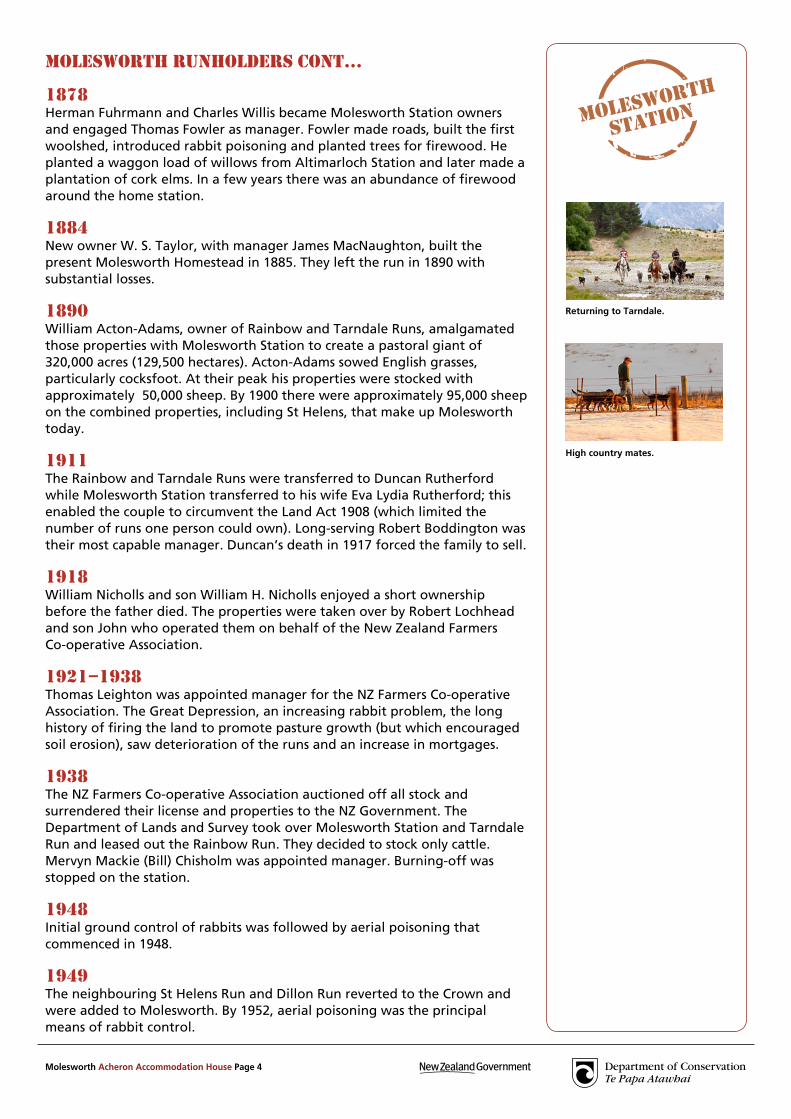
Returning to Tarndale.
High country mates.

Molesworth Acheron Accommodation House Page 5
Historical information obtained from many sources including Molesworth, L. W. McCaskill, 1969; Remembered Trails, J. E. Tomlinson, 1968 and Musterer on Molesworth, Bruce Stronach, 1953. Photographs – Alexander Turnbull Library, Wellington, NZ; Marlborough Museum and Historical Society; Don and Ann Reid Collection; National Archives; Rob Suisted www.naturespic.com
MolesWorTh runholders conT…
1953Aerial oversowing with cocksfoot and clovers commenced.
1963–1966Some 37,000 hectares of land were seeded.
1978Don Reid, Bill and Rachel Chisholm’s son-in-law, took over as manager of Molesworth. Current levels were reached of about 10,000 head of cattle wintered. Sheep were grazed for home kill only.
1987Department of Lands and Survey and then Land Information New Zealand controlled Molesworth Station.The Crown leased Molesworth Station to Landcorp Farming Limited. Covering 180,476 hectares the station was and remains today New Zealand’s largest farm. Around 30% is ungrazed.
2001Jim Ward was appointed manager. The annual muster of cattle continues to be a major job and relies on horses; in summer about 50 horses are used on Molesworth and up to 40 working dogs.
2005The Department of Conservation was given responsibility for overall management of Molesworth with Landcorp managing the farm as leaseholders.
Drafting cattle.
A crisp winter morning.

Molesworth Acheron Accommodation House Page 6
At one time considered for demolition, the Acheron Accommodation House stands today as a legacy to cob builder Ned James, to members of the Canterbury Branch of the Historic Places Trust who alongside the Lands and Survey Department saved and restored the house. It is maintained by the Department of Conservation.
ned JAMes (1835–1916)
Edward (Ned) James was one of the ‘characters’ of the Nelson and Marlborough high country. He was a versatile, resourceful all-rounder with a wide suite of technical skills. He was hardworking in the back country but inclined to go on the ‘spree’ when he came out to civilisation.
Ned was born in Shropshire in 1835 and emigrated to Nelson with his parents on the Fifeshire when he was seven years old. His father died on the voyage. After an elementary education Ned ran away to sea and is believed to have served as carpenter and boatswain in the whaling fleet based in Port Underwood. By 1856 he had come ashore and after working for his brother John who was farming near Rockville, Ned made his way to the back country.
In 1862 Thomas Carter engaged Ned James to design and build the Acheron Accommodation House. It was completed in 1863. It is not known where Ned learned his cob building skills but it is testament to the quality of his work that so many of his houses have survived.
In 1874 Ned built the Tarndale Homestead for John Kerr at Cat Creek on the western side of the Tarndale Basin. It served as both a farmhouse and an accommodation house, although at 1000m above sea level it was usually vacated during the winter. Ned also built the present Molesworth Homestead for W.S. Taylor and J. MacNaughton in 1885. In 1887 Ned was engaged by Nat Longney to build a new Tophouse. He also built the present Rainbow homestead about 1894, assisted by Arch Hopgood. Ned ‘put up dozens of other huts and other buildings in the Wairau’.
People who knew Ned described him as passionately fond of beer, clean and tidy, full of tricks to get money and an endless teller of yarns. He was also a good gardener and cook and skilled at first aid. He worked in the back country until over 70 years old and died in Nelson in 1916 aged 81 leaving an enduring legacy of fine cob buildings including the three on Molesworth.
1888
Stables.
Bread oven.
Molesworth StationAcheron Accommodation HouseInterpretation Panel 2

Molesworth Acheron Accommodation House Page 7
cob consTrucTion
“ A cob house must have a good hat and dry feet.”
Cob was popular in inland Marlborough because it utilised local materials and provided good insulation in more extreme climates. Cob is a mixture of clay (soil), straw (tussock) and dung and sets hard when dry. To last, it needs to remain dry. A coat of limewash helps keep the walls weatherproof and an overhanging thatch roof of snow tussock helps keeps the rain off the walls. A stone-filled foundation trench keeps the house up off wet ground. If you walk around to the back of the house you will see the original black beech rafters protruding from the building; these were cut fromBush Gully.
Acheron Accommodation House.
1909
Kitchen.
Stables.
Beech rafters and tussock thatching.

Molesworth Acheron Accommodation House Page 8
ThoMAs cArTer (1827–1900)
Thomas Carter was to become one of Marlborough’s largest individual landholders gaining the title of ‘wool king’. He was also a significant public figure. He and his brothers formed the 200,000 acre (81,000 hectare) Clarence Run in 1859 which included the land between the Clarence and the Acheron rivers almost to Saxton Pass and Lake Tennyson but excluding Tarndale. This run was later sold to W.A. Low (1877) who amalgamated it into the St Helens Run.
Thomas Carter.
Thomas Carter was born in 1827 in Winterton, Lincolnshire, England. He went first to the Californian and Australian goldfields before coming to New Zealand in 1855 with his brothers Joseph and James. Prior to taking up the Clarence Run the Carter Brothers had purchased land in the Wairau Valley which was to become the nucleus of their Hillersden Run. Throughout the 1860s they continued to add to their land holdings in the Wairau. In 1867 Joseph Carter returned to England and died intestate. James and his wife built a house at the mouth of the Acheron River opposite the Acheron Accommodation House. Thomas and James also took up the lease for the Acheron Accommodation Reserve and had the present accommodation house built by Ned James in 1862-63.
Thomas Carter was prominent in Marlborough politics and served on the Marlborough Provincial Council, of which he was Superintendent in 1863–1864. He also served on a large number of other organisations including the Marlborough County Council, the Education Board and the Wairau Road Board. He gifted land and funds to help establish Marlborough High School. He was respected as a man of strong and upright character. He was also very determined and sufficiently shrewd to quit the Clarence before the crippling difficulties of scab and rabbits, and to consolidate his interests in the Wairau, continuing to accumulate runs after his brother James died in 1881. In the 1890s he and Catherine moved to a property ‘Burleigh’ on the south-west side of Blenheim. Thomas died there aged 73 on 28 February 1900.
Ashburton Guardian 01 August 1912.

Molesworth Acheron Accommodation House Page 9
house oF AccoMModATion
1862 Thomas Carter was paid £300 by the Nelson Provincial Council to provide and run an Accommodation House. The licence stipulated that it be kept open between September and April each year. The licence also granted grazing rights over an Accommodation Reserve of 2650 acres (1072 hectares) that was surrounded by Carter’s Clarence Run (later St Helens Run).
1863Ned James completed construction of an eight-room cob house a year after being employed by Thomas Carter as designer and builder.
1864The charge for a meal, a bed and stabling for horses was 2/- 6d (two shillings and sixpence) per night. Hot bread, baked in the brick oven sited under a lean-to at the back of the house, was a popular feature of staying at the Acheron. Wood was used for heating; it required packing in from Bush Gully. Candles and kerosene lamps were used for lighting.
1880John and Mary Lun in charge of the house.
1899Gilbert Gordon and family running the house.
1902Ernie Tozer (employee of F. J. Savill, leaseholder of St Helens Station) was the housekeeper.
1932Licence lapsed with the death of Ernie Tozer.
1930s–1940sHouse used by St Helens Station musterers; there was a head shepherd’s quarters and a bunk room with a radio/telephone, a pantry, a kitchen where meals were eaten and a bulk-food store room.
1945
2000
2001
2003
2003

Molesworth Acheron Accommodation House Page 10
Historical information obtained from many sources including Molesworth, L. W. McCaskill, 1969; Remembered Trails, J. E. Tomlinson, 1968; Musterer on Molesworth, Bruce Stronach, 1953; and Footprints J. N. W. Newport. Photographs – Nelson Provincial Museum; Department of Conservation; Marlborough Museum and Historical Society; Canterbury Museum; Department of Conservation; Rob Suisted www.naturespic.com
house oF AccoMModATion conT...
1945–1951The house was used as a rabbiters hut. Skins were stretched and hung to dry on the fences. 1949 F. J. Savill surrended the St Helens Station lease along with freehold land. St Helens Station was incorporated into Molesworth Station and the Acheron House was under the care of Bill Chisholm. Earthquake repair work was undertaken, a hot water copper installed and water pipes upgraded. A bath superseded washing in the creek. A generator was installed to maintain the radio/telphone batteries and to provide lighting.
1949–1952The house provided accommodation for married couples working on Molesworth. Itbecame the base for aerial rabbit poisoning work, with an airstrip on the other side of the Clarence River.
1960sThe house was no longer used by Molesworth staff and fell into disrepair. Furniture and fittings were stolen and intruders often moved in for long periods. Bill Chisholm considered demolishing it.
1966Dedicated members of the Canterbury Regional Committee of the New Zealand Historic Places Trust started a move to save and restore the building, assisted by the Lands and Survey Department. Today the house is maintained by the Department of Conservation.
2005
2005
2005
Molesworth Acheron Accommodation House Page 11
Following the exploration by various parties in the 1850s to establish overland droving routes between Nelson and Canterbury, the next step was to provide accommodation for travellers along the way. A total of seven accommodation house licences were created between Tophouse and the Hurunui River during the 1860s.
locATion locATion locATion
Early travellers through the Amuri had relied upon the hospitality of runholders but when gold was discovered first in Nelson, then Marlborough, then West Coast and Otago, the flow of people to the diggings increased track use dramatically. The Nelson Provincial Council decided to adopt a system whereby the licence granted to operate an accommodation house would be accompanied by a large tract of reserve land to ensure the publican had an alternative income and to encourage long-term occupation.
The Acheron Accommodation House was also known as the Clarence Accommodation House. It was situated on a reserve within the Clarence Run (later St Helens Station) at the junction of the Acheron and the Clarence Rivers, strategically placed at a crucial river crossing within a day’s horse travel of the next house. Newspaper reports illustrate the often tough travelling conditions and the level of hospitality offered by the houses.
The cAnTerbury TrAckNelson to Christchurch took approximately six days via Tarndale and Acheron Accommodation Houses.A bridge was built over the Waiau as early as 1864 to replace the ferry service. It was an elegant, arching skeletal structure that was blown down in 1874. Ferry services resumed until a second bridge was built in 1887 – the bridge that stands today.
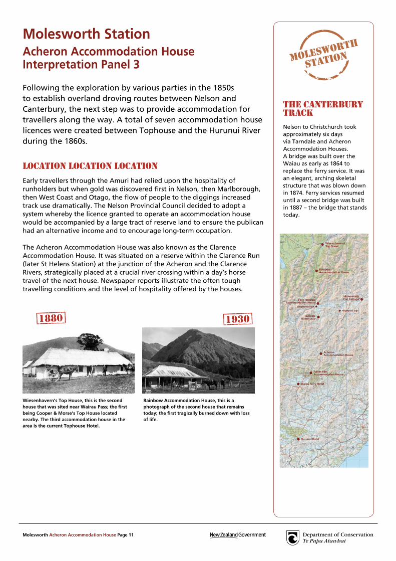
Wiesenhavern’s Top House, this is the second house that was sited near Wairau Pass; the first being Cooper & Morse’s Top House located nearby. The third accommodation house in the area is the current Tophouse Hotel.
Rainbow Accommodation House, this is a photograph of the second house that remains today; the first tragically burned down with loss of life.
1880 1930
Molesworth StationAcheron Accommodation HouseInterpretation Panel 3
Molesworth Acheron Accommodation House Page 12
A high-counTry chrisTMAs
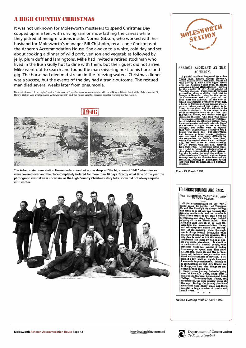
It was not unknown for Molesworth musterers to spend Christmas Day cooped up in a tent with driving rain or snow lashing the canvas while they picked at meagre rations inside. Norma Gibson, who worked with her husband for Molesworth’s manager Bill Chisholm, recalls one Christmas at the Acheron Accommodation House. She awoke to a white, cold day and set about cooking a dinner of wild pork, venison and vegetables followed by jelly, plum duff and lamingtons. Mike had invited a retired stockman who lived in the Bush Gully hut to dine with them, but their guest did not arrive. Mike went out to search and found the man shivering next to his horse and gig. The horse had died mid-stream in the freezing waters. Christmas dinner was a success, but the events of the day had a tragic outcome. The rescued man died several weeks later from pneumonia.
Material obtained from High Country Christmas , a Tony Orman newpaper article. Mike and Norma Gibson lived at the Acheron after St Helens Station was amalgamated with Molesworth and the house used for married couples working on the station.
Press 23 March 1891.
Nelson Evening Mail 07 April 1899.
The Acheron Accommodation House under snow but not as deep as “the big snow of 1942” when fences were covered over and the place completely isolated for more than 10 days. Exactly what time of the year the photograph was taken is uncertain; as the High Country Christmas story tells, snow did not always equate with winter.
1946

Molesworth Acheron Accommodation House Page 13
St Helens StationThe Government amalgamated St Helens Station with Molesworth in 1949. Until that time St Helens had been a large, independent station at its peak in the 1880s comprising over 231,000 acres (93,500 hectares) and carrying over 73,000 sheep.
The Station grew from a fairly compact holding on the Hanmer Plain taken up by J. W. A. Watts in 1858. In 1860 he transferred the eastern part of this run to Count Gerard de la Pasteur who with his brother Henri also acquired the Glynn Wye Run. In 1866 the Count transferred the lease to Henri who later transferred to F. W. Delamain. W. A. Low bought the run from Delamain in 1877 and amalgamated it with other properties.
WilliAM Anderson loW (1835–1906)
William Low had already had much experience in sheep farming by the time he came to the Amuri. In 1875 following the dissolution of a partnership in Central Otago properties, Low purchased the Clarence Run, which included the Dillon Run, from the Carter Brothers before also buying St Helens Station and Glynn Wye from Delamain. Thus Low through amalgamation built St Helens Station to one of the largest Amuri runs.
Low (usually referred to as W. A. Low) played an active part in the Hanmer community, served on the Rabbit Board and two terms on the Amuri County Council and was, like his neighbour Acton-Adams, a fierce opponent of the rabbit. He was generally liked as a manager but did get into one dispute with his neighbours that has gone down in local legend as ‘the Battle of the Acheron’. A stand-off between a group of St Helens Station men and some from Molesworth and Tarndale developed after Low refused access along parts of the Acheron Road that crossed his land. He believed he was owed more support from the Roads Board for upkeep. A court case was brought against Low for damages and was settled after a courtroom battle of words which lasted longer than the relatively minor confrontation on the road itself.
Low was heavily mortgaged to the NZ Loan and Mercantile Agency (NZLMA) and a combination of the adverse effects of high stocking rates, rabbits and severe stock losses through heavy snow in the 1890s eventually forced him to relinquish the Station to the NZLMA in 1899. He and his wife Fanny subsequently retired to Thanet, England where he died in November 1906.
The NZLMA renewed its lease over the property (which also included the Dillon Run) in 1908. In 1901 the Government purchased 6000 acres (2430 hectares) of St Helens freehold in Hanmer to form State Forest. In 1916 the Lands Department leased the rest of St Helens Station to Fredrick James Savill who engaged the highly respected sheepman Donald Manson as manager. Manson prohibited burning-off on the property and began a more conservative management of the grasslands. However he could not mitigate against a series of heavy snow years. In 1942 they lost 21,000 sheep, over 50% of their flock. In 1949 Savill surrendered his leases and 9000 acres (3640 hectares) of freehold to the Crown and the property was amalgamated with Molesworth.
Hurunui Hotel, the first hotel on this site was established by John Hastie in 1860; the licence required that he assist at the river ford as well as provide accommodation, refreshments and stabling. The present hotel, now a landmark on State Highway 7, was commissioned by Hastie’s widow in 1869 and is constructed of locally quarried limestone.
Waiau Ferry Hotel was built to serve coach passengers using the ferry crossing and survived for many years after the river was bridged. It was also patronised by visitors to the thermal pools, a well-established tourist attraction by 1900.
Press 05 January 1906.
1940
1887
Tarndale Accommodation House, this is an illustration of the first house, sited at Horse Gully and no longer standing. The current Tarndale cob homestead is sited at Cat Creek and also served as an accommodation house.
1864
Molesworth Acheron Accommodation House Page 14
Historical information obtained from many sources including Molesworth, L. W. McCaskill, 1969; Remembered Trails, J. E. Tomlinson, 1968 and Musterer on Molesworth, Bruce Stronach, 1953; the Amuri Historical Society and John Harper, Culverden.Photographs – DOC; National Archives; Alexander Turnbull Library, Wellington, NZ; A. D. R. Russell Collection; Amuri Historical Society; Marlborough Museum and Historical Society; Papers Past; Rob Suisted www.naturespic.com
Acheron Accommodation House is the only one of the seven original houses to survive.
Jollies Pass Accommodation House soon became Amuri’s social centre and by the 1900s a hotel on the original site was serving patrons of Hanmer’s thermal pools. Over the years the hotel has housed a general store and unofficial postal office in addition to holding race meetings, dog trials and a rifle club.
1920
1915
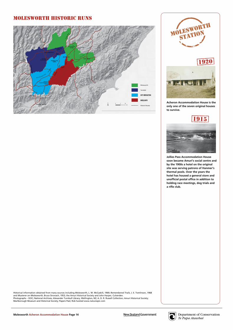
MolesWorTh hisToric runs
Molesworth Acheron Accommodation House Page 15
Molesworth StationAcheron Accommodation HouseInterpretation Panel 4
Photographs – Department of Conservation; Malcolm Brennan; Jan Clayton-Greene. Ngai Tahu drawing Donald Buglass.
MolesWorTh ModiFicATionThe land immediately surrounding the Acheron Accommodation House – full of willow, fruit trees, gooseberry and currants – reflects the planting of trees for firewood and shrubs for food in the early settlement days.
Firewood was relied upon for heating and cooking and was in short supply all over the high-country stations around here. Having a home supply saved hours of cartage time. Gooseberries and currants, two species able to survive the freezing winters, were a treasured delicacy in summer to add spice to a pie or preserve as jams and jellies for the winter. The exotic species are spreading from the house site. Rowan is currently subject to weed control, as are other species such as broom and wilding pines which now spread from forestry plantations near Hanmer.
The clArence riverBefore you snakes the Clarence River, with its source above Lake Tennyson. Downstream the river winds through rugged and geologically interesting mountain country before emptying into the Tasman Sea. The Clarence River can look benign on a crisp autumn afternoon but can present a potentially deadly rage during a spring storm. The mountain-fed water is always cold, especially in winter and it was the cold just as much as the current that often killed pioneer travellers, who having been soaked to the skin crossing the river, succumbed to pneumonia several days later.
MoisTure grAdienTA huge moisture gradient occurs along the Clarence Valley. The source of the Clarence River near the main divide has high rainfall but as it travels eastwards towards the coast the river passes through Ka Whata Tu o Rakihouia Conservation Park, which is one of the driest areas of New Zealand.
Once covered in forest, the land around here has experienced fires over the past few hundred years; some natural, some the burning by Maori with others the result of trail blazing by pioneer European explorers who used fire to clear the way before them of thick barriers of vegetation. When Frederick Weld and party retraced their steps down the Clarence from Lake Tennyson they recorded “burning as they went” to open the land for other travellers and to ease the journey for stock drovers.
Ngai Tahu stayed close to coastal settlements in winter, tending to travel their mountain routes only in the summer months. One pounamu trail from the West Coast passed before you, following the Clarence River from Lake Tennyson to the sea.
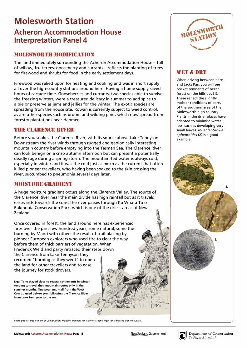
WeT & dryWhen driving between here and Jacks Pass you will see pocket remnants of beech forest on the hillsides (1). These reflect the slightly moister conditions of parts of the southern area of the Molesworth high country.Plants in the drier places have adapted to minimise water loss, such as developing very small leaves. Muehlenbeckia ephedroides (2) is a good example.
1.
2.
2.