acid gold mine
TRANSCRIPT

MINE WATER MANAGEMENT IN THE WITWATERSRAND GOLD FIELDS WITH SPECIAL EMPHASIS ON ACID MINE DRAINAGE
REPORT TO THE INTER-MINISTERIAL COMMITTEE ON ACID MINE DRAINAGE
DECEMBER 2010

REPORT TO THE INTER-MINISTERIAL COMMITTEE ON ACID MINE DRAINAGE
MINE WATER MANAGEMENT IN THE WITWATERSRAND GOLD FIELDS
WITH SPECIAL EMPHASIS ON ACID MINE DRAINAGE
Prepared by the Expert Team of the Inter-Ministerial Committee under the Coordination
of the Council for Geoscience
Team of Experts drawn from:
The Council for Geoscience
Department of Water Affairs
Department of Mineral Resources
Council for Scientific and Industrial Research
Mintek
Water Research Commission
and
Advisors:
Prof. TS McCarthy – University of the Witwatersrand
Prof G Steyl – University of the Free State
Prof. J Maree – Tshwane University of Technology
Prof. B Zhao – University of Fort Hare
December 2010

ii
TEAM OF EXPERTS — RESEARCHERS
Chairperson
Dr T Ramontja Chief Executive Officer – Council for Geoscience
Compilers and contributing authors:
Dr H Coetzee Specialist Scientist: Environmental Geoscience – Council
for Geoscience
Mr PJ Hobbs Senior Research Hydrogeologist – Council for Scientific and
Industrial Research
Dr JE Burgess Research Manager – Water Research Commission
Prof. A Thomas Unit Manager: Central Regions – Council for Geoscience
Mr M Keet Acting Director: Gauteng Regional Office – Department of
Water Affairs
Contributing authors:
Dr B Yibas Geochemist/Geologist – Council for Geoscience
Ms D van Tonder Geologist – Council for Geoscience
Mr F Netili Hydrogeologist – Council for Geoscience
Ms U Rust Sustainability Scientist – Council for Geoscience
Dr P Wade Geochemist – Council for Geoscience
Prof. J Maree Professor of Water Utilisation – Tshwane University of
Technology
Additional contributions by:
Council for Geoscience (CGS):
Mr F Ramagwede Executive Manager: Applied Geosciences
Dr H Mengistu Hydrogeologist
Ms T Phajane Unit Manager: Environmental Geoscience
Dr L Lin Geohydrologist
Dr A Cichowicz Seismologist
Dr V Midzi Seismologist
Water Research Commission:
Mr M du Plessis

iii
Department of Water Affairs:
Mr JJ van Wyk Scientific Manager: Water Resources Planning Systems:
Water Quality Planning (Central)
Mr M Morokane Control Environment Officer: Resource Protection and
Waste: Mines
Dr E van Wyk Scientific Manager: Hydrological Services: Groundwater
Resource Assessment and Monitoring
Mr B Govender Assistant Director: Gauteng Regional Office
Mr S Rademeyer Chief Engineer: National Water Resource Planning: Central
Department of Mineral Resources:
Ms P Ugwu Environmentalist
Mintek:
Mr H Cornelissen Researcher
Advisors
Prof. TS McCarthy Professor of Geology, University of the Witwatersrand
Prof. J Maree Professor of Water Utilisation, Tshwane University of
Technology
Prof. G Steyl Professor of Chemistry, Hydrogeology, University of the
Free State (Institute for Groundwater Studies)
Prof. B Zhao Professor of Geology, University of the Fort Hare

iv
EXECUTIVE SUMMARY
A Team of Experts has been instructed by a Task Team, chaired by the Directors
General of Mineral Resources and Water Affairs to advise the Inter-Ministerial
Committee (IMC) on acid mine drainage (AMD), comprising the Ministers of Mineral
Resources, Water Affairs and Science and Technology and the Minister in the
Presidency: National Planning Commission. The Team of Experts is reporting on its
assessment and reappraisal of the situation with respect to acid mine drainage, focusing
on the Witwatersrand Gold Fields.
Examination of international and local literature on all aspects of AMD (e.g. its formation,
control, management, treatment and impacts) indicates that the subject has been
extensively researched and studied globally and in South Africa. This has resulted in a
sound but generic understanding of the process and the various components of the AMD
problem in South Africa. This examination has also, however, highlighted the complexity
of the host and receiving environments that militates against a single or ‘one size fits all’
solution to address the problems associated with AMD. However, with regard to the
Witwatersrand Gold Fields, sufficient information does exist to be able to make informed
decisions regarding the origins of the mine water, potential impacts, management
strategies, treatment technologies, etc.
AMD has been reported from a number of areas within South Africa, including the
Witwatersrand Gold Fields, Mpumalanga and KwaZulu-Natal Coal Fields and the O’Kiep
Copper District. The Western, Central and Eastern Basins are identified as priority areas
requiring immediate action because of the lack of adequate measures to manage and
control the problems related to AMD, the urgency of implementing intervention measures
before problems become more critical and their proximity to densely populated areas.
The situation in other mining regions of the country requires additional information,
monitoring and assessments of risk, particularly in vulnerable areas such as the
Mpumalanga Coal Fields, where the impact of mining on the freshwater sources in the
upper reaches of the Vaal and Olifants River Systems is of serious concern.
The following risks have been identified with respect to the flooding of the mines in the
priority areas and the subsequent decant of AMD to the environment:
• Risks owing to flooding of the mines
o Contamination of shallow groundwater resources required for agricultural
use and human consumption
o Geotechnical impacts, such as the flooding of underground infrastructure
in areas where water rises close to urban areas
o Increased seismic activity which could have a moderate localised effect
on property and infrastructure
• Risks owing to the decant of AMD to the environment

v
o Serious negative ecological impacts
o Regional impacts on major river systems
o Localised flooding in low-lying areas.
A generic approach to the management of these risks has been proposed for
implementation in the three priority areas:
• Decant prevention and management: Experience in the Western Basin has
shown the severe impacts that can be expected if the mine void is allowed to
flood completely and decant. For this reason it is recommended that the water
levels in the basins be held at or below the relevant Environmental Critical
Levels1 (ECLs) by pumping of water. In the Western Basin this will require
pumping to lower the water level that is already at surface.
• Ingress control — reduction of the rate of flooding and the eventual decant
volume: Pumping and treating water into the future will be a costly exercise. It is
therefore necessary to reduce the volume of water to be pumped and treated.
The water flooding the mine void comes from several sources, including direct
recharge by rainfall, groundwater seeping into the workings, surface streams that
lose water to shallow mine workings, open surface workings, seepage from mine
residue deposits and losses from water, sewage and stormwater reticulation
systems. Ingress control can be achieved by preventing the recharge of the
shallow groundwater above the mine void by the canalisation of surface streams,
the sealing of surface cracks and mine openings and a number other measures.
In some areas it may prove feasible to abstract clean groundwater from aquifers
that feed water into the mine voids, thereby reducing the volume of water that
becomes polluted. This will also provide an additional clean water resource for
use in the area. The possible losses from water, sewage and stormwater systems
must also be addressed.
• Water quality management: Even if the above measures are implemented, AMD
will still be produced and require treatment to a quality that is fit for a
predetermined use, or for discharge to surface streams. Various treatment
options and technologies, including active, passive and in situ treatment
technologies, have been identified and reviewed. Given the variability in water
quality between the different basins and the possibility that the water quality in the
mine voids will improve over time, it is likely that a suite of different technologies
will be required.
Flooding of the underground mine workings, representing more than 120 years of mining
in the Witwatersrand Gold Field, culminated in the decant of AMD from the smallest
basin, the Western Basin, in late-August 2002. Flooding commenced when the last mine
1 The environmental critical level is defined as the highest water level within the mine void where no AMD
flows out of the mine workings into the surrounding groundwater or surface water systems.

vi
to shut down in this basin ceased pumping. The volume of decant has peaked at ~60
megalitres per day (Ml/d) in response to recharge during exceptionally wet summer
rainfall seasons. More typical, however, is a decant rate of ~15–20 Ml/d. Basic treatment
of this water currently permits the release of ~12 Ml/d into the Crocodile (West) and
Marico drainage system. The existing pumping and treatment capacity is inadequate to
effectively manage the impact of AMD, with the excess volume flowing untreated into the
receiving aquatic environment.
In the largest basin, the Central Basin, the water level has been rising at an average rate
of 0.59 metres per day (m/d) since July 2009, varying seasonally between 0.3 and
0.9 m/d. By end-November 2010, the mine water level reached an elevation of ~1155
metres above mean sea level (mamsl), measured in Catlin Shaft at Simmer & Jack Mine.
This is ~510 m below surface (mbs) at this location. Linear extrapolation of the longer
water level graph for South West Vertical Shaft at East Rand Proprietary Mines (ERPM)
predicts that the rising water level will reach the surface by March 2013. This will be
updated as more monitoring data is collected. By this time, however, it will have sterilised
still exploitable gold reserves located at a depth of less than 400 mbs. Of even greater
consequence is that it will not only have flooded the shallower underground tourist
facilities at Gold Reef City, but also compromised the shallow groundwater resource
associated with the dolomitic strata located to the southeast of Johannesburg.
The flooding of the Central Basin has also been associated with an increase in seismic
activity. A seismic monitoring programme has confirmed an increased frequency of earth
tremors in the Central Basin following the cessation of pumping by ERPM in October
2008. This has established a clear cause and effect relationship between seismic activity
and mine flooding. Although the magnitude of these events is unlikely to exceed those
that characterised the Witwatersrand during the phase of active and extensive mining,
risk analysis suggests that the probability of slightly larger magnitude events occurring
cannot be ignored. Whilst the monitoring of seismicity associated with the flooding of the
Central Basin cannot prevent the events from occurring, it is important to continue with
this activity in the short to medium term in order to gather information and data on the
frequency of occurrence and size and location of the events. This is especially important
for identifying whether the events are restricted to the immediate surroundings of the
mining areas, or whether they are propagating away from the flooding mine, implying
that geological structures at some distance from the mining areas are at risk of being
activated. The information gathered over time would also be useful for microzonation
studies. This would highlight the changes in seismic risk that the infrastructure within
urban areas surrounding the Central Basin would be exposed to.
The situation in the third basin, the Eastern Basin, is currently complicated owing to
uncertainty regarding continuation of pumping at Grootvlei Mine. This mine has
historically maintained the mine water level in this basin at a depth of ~700 mbs in its
Number 3 Shaft. This has been achieved at a long-term pumping rate of 75–108 Ml/d.
Whilst continuation of this pumping regimen is at risk of failure owing to financial
constraints, an early casualty of the situation was the treatment of the raw mine water
prior to its release into the Blesbok Spruit and a Ramsar-listed wetland. Treatment of the

vii
mine water has not occurred for some time. The cessation of pumping will result in
flooding of the pump station within 30 days, after which the mine water will rise to its
decant level and decant in or close to the CBD of Nigel on the East Rand.
In light of the above, it is recommended that AMD intervention and management
measures are undertaken in the Western, Central and Eastern Basins as a matter of
urgency. In the Western Basin, this requires the establishment of a neutralisation plant
with a capacity of 20 Ml/d. This is required to supplement the existing treatment capacity
operated by mines in the area and the upgrade of mine water pumping facilities
accordingly. In the Central Basin, it is required that a pumping facility with a capacity of
~60 Ml/d be installed in one or more existing mine shafts, and a neutralisation plant or
plants of matching capacity be established in close proximity. In the Eastern Basin, the
pumping capability in Number 3 Shaft of Grootvlei Mine must be secured. It is also
required that the existing treatment plant at this locality be returned to service as soon as
possible. The volumes of water to be managed may be reduced by the timely
implementation of ingress management measures, with a resultant reduction in operating
costs. The design of the pump and treat systems will need to take this into account.
Neutralisation of mine water and discharge to the environment will produce conditions
similar to the status quo during periods of active mining. In the medium to long term this
may not be sustainable as it could result in excessive salt loads on the receiving water
bodies, which will require the release of clean water for dilution, particularly in the Vaal
River System. The options of direct consumptive use of neutralised mine water or
desalination and sale of the water to local users must be investigated. In the very long
term, it is expected that water quality could improve significantly. This will be confirmed
by ongoing monitoring and will create a situation where the mines could be allowed to
flood completely or to levels closer to the surface, reducing the costs of water
management.
The immediate expansion of a programme to monitor mine water level, mine water
quality, surface flow and quality, groundwater level and quality and seismic activity is
required for the three priority basins.
The recommendations of the Team of Experts are summarised as follows:
1. Water must be pumped from the three priority basins to maintain water levels at
least below the relevant Environmental Critical Levels or, by agreement with
stakeholders, the lowest level of underground activity within the basin.
2. Steps must be implemented to reduce the ingress of water into the underground
workings as far as is possible. This will reduce the volumes of water which need
to be pumped and treated to more acceptable levels and consequently reduce
the operational costs of AMD management.
3. The water that will be pumped will not be of a suitable quality for productive use
or discharge to river systems and will therefore need to be treated. In the short
term it is proposed that water be neutralised in a process that will address the low
pH, high acidity and high iron and other metal content. In the medium to long-

viii
term consideration should be given to steps that will reduce the mine water
contribution to the salinity of major river systems.
4. Improved monitoring of mine water, groundwater, surface water, seismicity,
subsidence and other geotechnical impacts of mine flooding and related targeted
research is required. It is recommended that a multi-institution monitoring
committee be established to facilitate the implementation of the required
monitoring and the necessary assessment programmes. Monitoring will show
whether there are significant changes in the quality of mine water that may have
an impact on future management strategies. Monitoring results may also identify
additional remedial measures required in the future.
5. The flooded mine voids are not the only sources of AMD in the Witwatersrand.
Other sources, particularly mine residues, need to be monitored and
appropriately remediated to reduce AMD impacts on the environment.
6. The feasibility needs to be investigated of implementing an environmental levy to
be paid by operating mines in order to cover the costs of the legacies of past
mining.
7. The recommendations in this report represent the start of a process. The aim of
these recommendations is to avert impending crises and stabilise the situation,
as well as addressing current gaps in the understanding of AMD problems in the
priority areas and their potential impacts on the environment. It is therefore
recommended that the process of assessment, risk appraisal and the
recommendation of remedial measures be continued with ongoing assessments.
8. The problems posed by AMD will have implications far into the future, with
impacts likely to continue for many years. The process of management of these
impacts will therefore need to continue, with ongoing assessments and
adaptation as conditions change.

ix
TABLE OF CONTENTS
EXECUTIVE SUMMARY .....................................................................................IV
TABLE OF CONTENTS ......................................................................................IX
CHAPTER 1. INTRODUCTION AND BACKGROUND...................................... 1
CHAPTER 2. INTERNATIONAL EXPERIENCE IN THE MANAGEMENT OF
AMD PROBLEMS........................................................................ 4
2.1 ACID MINE DRAINAGE IN AUSTRALIA ............................................................. 4
2.2 ACID MINE DRAINAGE IN CANADA .................................................................. 4
2.3 AMD IN THE USA ................................................................................................ 5
2.4 MANAGING URANIUM MINING LEGACIES IN GERMANY................................ 5
2.5 COMPARISON OF INTERNATIONAL EXAMPLES WITH THE SOUTH
AFRICAN SITUATION ......................................................................................... 6
CHAPTER 3. ASSESSMENT AND COLLATION OF WORK DONE BY
VARIOUS INSTITUTIONS........................................................... 7
3.1 WORK/STUDIES UNDERTAKEN BY VARIOUS INSTITUTIONS........................ 7
3.2 KNOWLEDGE GAPS AND RECOMMENDATIONS .......................................... 11
3.3 SUMMARY AND CONCLUSIONS ..................................................................... 13
CHAPTER 4. THE CURRENT SITUATION ..................................................... 19
4.1 FLOODING OF THE WITWATERSRAND GOLD MINES .................................. 19
4.1.1 Flooding of mines ...................................................................................... 19
4.1.2 Sources of water entering the underground workings ........................... 19
4.1.3 Acidification and contamination of water in the flooded mine voids..... 20
4.2 THE SITUATION IN THE MAJOR WITWATERSRAND GOLD FIELDS ............ 23
4.2.1 Western Basin............................................................................................ 23
4.2.2 Central Basin.............................................................................................. 24
4.2.3 Eastern Basin............................................................................................. 25
4.2.4 Far Western Basin ..................................................................................... 30
4.2.5 Klerksdorp, Orkney, Stilfontein and Hartbeesfontein (KOSH) Basin ..... 30
4.2.6 Free State Gold Field ................................................................................. 30
4.2.7 Evander Basin............................................................................................ 31

x
CHAPTER 5. PRIORITISATION OF GEOGRAPHIC AREAS AFFECTED BY
AMD WITHIN SOUTH AFRICA ................................................. 32
5.1 HIGHEST PRIORITY AREAS ............................................................................ 33
5.2 VULNERABLE AREAS WHERE ADDITIONAL INFORMATION IS REQUIRED33
5.2.1 Lower priority areas requiring assessment and monitoring................... 34
CHAPTER 6. REAPPRAISAL OF THE RISKS ATTRIBUTABLE TO ACID
MINE DRAINAGE ...................................................................... 35
6.1 INTRODUCTION ................................................................................................ 35
6.2 DEWATERING AND REWATERING OF THE MINING BASINS OF THE
WITWATERSRAND ........................................................................................... 35
6.3 APPRAISAL OF RISKS ..................................................................................... 37
6.3.1 Risks owing to the flooding of the mine voids ........................................ 37
6.3.1.1 Increased seismic activity ..................................................................... 37
6.3.1.2 Contamination of shallow groundwater resources................................. 39
6.3.1.3 Geotechnical impacts if the water reaches the near-surface environment
............................................................................................................. 40
6.3.2 Risks owing to decant of water to the surface......................................... 41
6.3.2.1 Ecological impacts................................................................................ 41
6.3.2.2 Regional impacts on major river systems.............................................. 42
6.4 RISK MANAGEMENT MEASURES ................................................................... 48
6.4.1 Decant prevention and management........................................................ 49
6.4.2 Ingress control — reduction of the rate of flooding and the eventual
decant volume ........................................................................................... 49
6.4.2.1 Ingress reduction measures.................................................................. 49
6.4.2.2 Groundwater abstraction ...................................................................... 50
6.4.3 Water quality management........................................................................ 50
6.4.3.1 Pollution prevention — keeping clean water clean................................ 50
6.4.3.2 Water treatment.................................................................................... 51
6.4.3.3 Natural attenuation ............................................................................... 51
6.4.4 Monitoring .................................................................................................. 51
CHAPTER 7. OPTIONS FOR THE MANAGEMENT OF ACID MINE
DRAINAGE IN THE WESTERN, CENTRAL AND EASTERN
BASINS ..................................................................................... 52
7.1 KEY PRINCIPLES.............................................................................................. 52
7.2 OBJECTIVES OF AMD MANAGEMENT ........................................................... 52

xi
7.3 A GENERIC APPROACH TO AMD MANAGEMENT IN THE WITWATERSRAND
........................................................................................................................... 52
7.4 OTHER AMD SOURCES IN THESE AREAS..................................................... 62
7.5 OPTION SELECTION AND RECOMMENDATIONS .......................................... 62
7.5.1 Control of mine flooding/decanting.......................................................... 62
7.5.1.1 Status and options................................................................................ 62
7.5.1.2 Pumping as a means of balancing seasonal variations in water ingress65
7.5.1.3 Recommendations................................................................................ 65
7.5.2 Water quality management........................................................................ 66
7.5.2.1 Status and options................................................................................ 66
7.5.2.2 Recommendations................................................................................ 69
7.5.3 Reduction of water ingress into the mine voids ...................................... 69
7.5.4 Monitoring .................................................................................................. 70
CHAPTER 8. ASSESSMENT OF TECHNOLOGIES FOR THE TREATMENT
OF AMD IN THE WITWATERSRAND AREA............................ 71
8.1 BACKGROUND ................................................................................................. 71
8.2 AVAILABLE TECHNOLOGIES FOR THE TREATMENT OF AMD.................... 71
8.2.1 Active treatment technologies .................................................................. 73
8.2.1.1 Pre-treatment/Partial treatment for neutralisation and metal removal.... 73
8.2.1.2 Desalination.......................................................................................... 74
8.2.2 Passive treatment technologies ............................................................... 76
8.2.3 In situ treatment technologies .................................................................. 77
8.3 CONCLUSIONS ................................................................................................. 78
CHAPTER 9. EXPLORING POSSIBLE INVOLVEMENT OF THE PRIVATE
SECTOR .................................................................................... 79
9.1 GOVERNANCE OPTIONS FOR AMD MANAGEMENT..................................... 79
9.2 INTERNATIONAL EXPERIENCE....................................................................... 79
9.2.1 United States.............................................................................................. 79
9.2.2 Canada........................................................................................................ 79
9.2.3 Zambia ........................................................................................................ 80
9.3 CONCLUSIONS AND RECOMMENDATIONS REGARDING PARTNERSHIP
WITH THE PRIVATE SECTOR .......................................................................... 80
CHAPTER 10. CONCLUSIONS AND RECOMMENDATIONS........................ 85
10.1 CONCLUSIONS.............................................................................................. 85
10.1.1 Occurrence of acid mine drainage in South Africa.................................. 85

xii
10.1.2 Assessment of work done by various institutions .................................. 85
10.1.3 The current situation in the Witwatersrand Gold Fields.......................... 85
10.1.4 Prioritisation of areas for attention........................................................... 87
10.1.5 Re-appraisal of risks in the priority areas ................................................ 87
10.1.6 Exploring models for cooperation with the private sector...................... 87
10.2 RECOMMENDATIONS................................................................................... 88
10.2.1 Prevention of decant — pumping to ensure that water levels are
maintained at or below the Environmental Critical Levels ..................... 88
10.2.2 Ingress control — reduction in the rate of mine flooding and the
volumes required to be managed............................................................. 90
10.2.3 Water quality management........................................................................ 90
10.2.4 Monitoring .................................................................................................. 91
10.2.5 Addressing other AMD sources................................................................ 91
10.2.6 Further research to identify and optimise sustainable solutions in the
medium to long term ................................................................................. 92
10.2.7 Investigation of the feasibility of an environmental levy on operating
mines .......................................................................................................... 92
10.2.8 On going assessment and future actions ................................................ 92
CHAPTER 11. ACTION PLAN......................................................................... 93
11.1 ACTION PLAN: SHORT TERM ...................................................................... 93
11.1.1 Short-term interventions ........................................................................... 93
11.1.1.1 Western Basin ...................................................................................... 93
11.1.1.2 Central Basin........................................................................................ 94
11.1.1.3 Eastern Basin ....................................................................................... 95
11.2 ACTION PLAN: MEDIUM TO LONG TERM ................................................... 96
11.2.1 Medium- to long-term interventions ......................................................... 96
CHAPTER 12. BUDGET.................................................................................. 97
12.1 BUDGET: PUMPING COSTS TO MAINTAIN WATER LEVELS .................... 97
12.1.1 Capital costs .............................................................................................. 97
12.1.2 Operating costs.......................................................................................... 97
12.2 BUDGET: TREATMENT COSTS FOR NEUTRALISATION PLANTS ............ 97
12.2.1 Capital costs .............................................................................................. 97
12.2.2 Operating costs.......................................................................................... 98
12.3 BUDGET: MAINTENANCE OF THE PUMPING AND TREATMENT
INFRASTRUCTURE IN THE EASTERN BASIN............................................. 98

xiii
12.4 IMPACT OF THE REDUCTION OF WATER INGRESS ON THE COSTS OF
PUMPING AND TREATMENT........................................................................ 99
12.5 BUDGET: RECOMMENDED INGRESS PREVENTION MEASURES .......... 100
12.6 BUDGET: MONITORING.............................................................................. 105
CHAPTER 13. REFERENCES....................................................................... 106
APPENDIX A: DETAILED RISK ASSESSMENT............................................. 113

xiv
LIST OF FIGURES
Figure 1.1. Locations of the Western, Central and Eastern mining basins of the
Witwatersrand. ................................................................................................................ 3
Figure 4.1. Acid mine drainage in the West Rand.......................................................... 22
Figure 4.2. Decant of AMD from 18 Winze — a shaft in the Western Basin................... 23
Figure 4.3. Rising water levels in the Central Basin, extrapolated to the points where they
will reach various critical levels, including the decant forecast for March 2013 (CRG
Central Rand Gold) ....................................................................................................... 24
Figure 4.4. Water pumped from the Eastern Basin to the treatment plant at Grootvlei
Mine. ............................................................................................................................. 26
Figure 4.5. Locations of mines of the Western Basin..................................................... 27
Figure 4.6. Locations of mines of the Central Basin....................................................... 28
Figure 4.7. Locations of mines of the Eastern Basin...................................................... 29
Figure 5.1. Identified areas of AMD generation and potential AMD generation in South
Africa............................................................................................................................. 32
Figure 5.2. Decant of AMD from the abandoned Transvaal and Delagoa Bay Colliery
close to eMalahleni in Mpumalanga .............................................................................. 33
Figure 5.3. Decant of copper-rich AMD in the town of O’Kiep, Northern Cape............... 34
Figure 6.1. AMD formed owing to interaction between water and mine residues on the
surface, exposed in a surface tailings reclamation operation in the Western Basin. Note
that this site drains into open pit operations which are directly connected to the mine void
...................................................................................................................................... 36
Figure 6.2. Number of seismic events measured by the Council for Geoscience in the
Central and East Rand area before and after pumping at ERPM stopped ..................... 38
Figure 6.3. Seismic events recorded and located by the Council for Geoscience in the
Central and East Rand between March and July 2010 .................................................. 39
Figure 6.4. Relationship between the Witwatersrand mining basins and the outcrop of the
Malmani Dolomite ......................................................................................................... 40
Figure 6.5. Salt crusts precipitating on vegetation downstream of the decant from the
Western Basin............................................................................................................... 42
Figure 6.6. Long-term monthly TDS load pattern at station A2H049, Bloubank Spruit
System (from Hobbs (ed.), in press).............................................................................. 43

xv
Figure 6.7. Comparison of the SO4 concentration in surface water leaving the Bloubank
Spruit System at station A2H049 with that leaving Hartebeespoort Dam since the start of
mine water decant from the Western Basin ................................................................... 44
Figure 6.8. Comparison of monthly TDS and SO4 loads leaving the Bloubank Spruit
System at station A2H049 since the start of mine water decant from the Western Basin.
Arrows denote higher summer (wet season) loads (from Hobbs (ed.), in press)............ 45
Figure 6.9. Time series of sulphate concentration in the Elsburg Spruit downstream of
ERPM mine, showing the effects of the cessation of pumping and discharge by ERPM.
...................................................................................................................................... 46
Figure 6.10. Time series of sulphate concentration in the Klip River, showing the effects
of the cessation of pumping and discharge by ERPM.................................................... 47
Figure 6.11. Time series of sulphate concentration in the Blesbok Spruit, downstream of
Nigel.............................................................................................................................. 48
Figure 7.1. Water management options for the Western, Central and Eastern Basins... 54

xvi
LIST OF TABLES
Table 3.1. Summary of work done on the AMD problem in the Witwatersrand by the
institutions involved in the IMC Team of Experts ........................................................... 14
Table 7.1. Flooding status of the Western, Central and Eastern Basins ........................ 53
Table 7.2. Options for water management in the Witwatersrand mining basins and their
applicability to the different basins (W – Western Basin, C – Central Basin, E – Eastern
Basin)............................................................................................................................ 55
Table 7.3. Analysis of flooding control options for the three priority areas (unfeasible
options highlighted in grey)............................................................................................ 63
Table 7.4. Environmental Critcial Levels (ECLs) for the Western, Central and Eastern
Basins ........................................................................................................................... 65
Table 7.5. Typical water qualities for the Western, Central and Eastern Basins ............ 67
Table 7.6. Analysis of water quality management options for the three priority areas
(unfeasible options highlighted in grey) ......................................................................... 68
Table 8.1 Comparison of Different Categories of AMD Treatment ................................. 72
Table 8.2 Examples of technologies available in South Africa, including indicative
running costs, based on the treatment of AMD of a similar quality to that produced in the
Western Basin, and potential cost recovery................................................................... 76
Table 9.1. Governance options for AMD management .................................................. 81
Table 10.1. Environmental Critical Levels for the priority areas ..................................... 88
Table 11.1. Actions and time frames for the Western Basin .......................................... 93
Table 11.2. Actions and time frames for the Central Basin ............................................ 94
Table 11.3. Actions and time frames for the Eastern Basin ........................................... 95

xvii
LIST OF ABBREVIATIONS
AMD Acid Mine Drainage
ANZMEC Australian and New Zealand Mineral and Energy Council
ARD Acid rock drainage
CGS Council for Geoscience
CSIR Council for Scientific and Industrial Research
DEA Department of Environmental Affairs
DME Department of Minerals and Energy (former name for DMR)
DMR Department of Mineral Resources (formerly DME)
DST Department of Science and Technology
DWA Department of Water Affairs (formerly DWAF)
DWAF Department of Water Affairs and Forestry (former name for DWA)
ECL Environmental Critical Level
ERPM East Rand Proprietary Mines
GARD Global Acid Rock Drainage
HDI Human Development Index
HDS High Density Sludge
IMC Inter-Ministerial Committee
i.r.o. in respect of
KOSH Klerksdorp, Orkney, Stilfontein and Hartebeesfontein
MEM Mine and Environmental Management
MEND Mine Environment Neutral Drainage
MPRDA Mineral and Petroleum Resources Development Act
OSMRE Office of Surface Mining Reclamation and Enforcement
RMCS Regional Mine Closure Strategies
SWM Strategic Water Management
USA United States of America
USEPA United States Environmental Protection Agency
WRC Water Research Commission

1
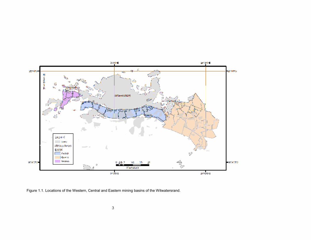
CHAPTER 1. INTRODUCTION AND BACKGROUND
South Africa’s mining history has generated vast economic benefit and still plays an
important role in ensuring the country’s position in the global market. Despite such
benefit, large-scale closure of mining operations since the 1970s within the
Witwatersrand mining regions or basins (Figure 1.1) and the subsequent termination of
the extraction of underground water from mines have become important national
concerns. As elsewhere in the world, the activities of the mining sector have resulted in
serious environmental consequences, notably in respect of poor environmental and
water management and, in the case of the gold mines of the Witwatersrand, acid mine
drainage (AMD). Given the magnitude and dynamics of the South African mining
industry, it must be accepted that the challenges of mine water management cannot be
administered by either government or the mining sector alone.
The cessation of underground mine water extraction leads to the mine voids becoming
flooded. This phenomenon was highlighted in September 2002, when acidic mine water
started flowing from an abandoned shaft in the Mogale City/Randfontein area of the
Western Basin as a result of the flooding of the mines in this basin to a level where water
could flow out onto the surface. This surface flow or decant of mine water is of concern
to the environment as the water, in accordance with well-known and researched
chemical and geochemical reactions between the mine rock strata, wastes and oxygen,
readily becomes acidic, characterised by elevated concentrations of salts, heavy metals
and radionuclides.
A similar situation is developing in the Central Basin (Johannesburg area) and Eastern
Basin (Springs–Nigel area). Efforts to address and manage this problem have therefore
been intensified by the responsible and relevant government departments (the
Department of Mineral Resources (DMR), Department of Water Affairs (DWA),
Department of Environmental Affairs (DEA), and Department of Science and Technology
(DST)). The immediate concern is the threat posed by decanting mine water in the
Witwatersrand area, which poses potentially severe environmental and safety impacts on
the receiving water environment and concomitant surface areas. This report addresses
the current crisis regarding acid mine drainage. In the longer term regional impacts on
larger river systems will also need to be taken into account.
Although AMD problems are also experienced in other gold mining areas, including the
Klerksdorp/Orkney/Stilfontein/Hartebeesfontein (KOSH), Free State, Far West Rand and
Evander gold mining areas, the coal mining areas of Mpumalanga and KwaZulu-Natal
and the O’OKiep Copper District, it is appropriate to address those areas where the risk
demands the most urgent and immediate action first.
The flooding of the mine voids and/or AMD decant gives rise to the following general
concerns:
• AMD extensively contaminates surface streams and could incur devastating
ecological impacts

2
• Rising water levels could flood urban areas and result in geotechnical impacts
that may jeopardise the integrity of urban infrastructure
• Rising water levels in the mine voids may lead to an increase in seismic activity,
presenting serious safety risks to deep underground mining ventures and some
risk to safety and property on the surface in the vicinity of the mines
• Rising mine water levels have the potential to flow towards and pollute adjacent
groundwater resources
• Flooding may result in inter-mine water migration and may threaten neighbouring
operational mines, limiting access to economic reefs.
An Inter-Ministerial Committee (IMC), including the Ministers of Water Affairs, Mineral
Resources, Science and Technology, and Finance, and the Minister in the Presidency
has been convened to deliberate on this matter. A Technical Committee, chaired by the
Directors-General of the DMR and DWA has appointed a Team of Experts, comprising
experts from the departments of Water Affairs and Mineral Resources, the Council for
Geoscience (CGS), the Council for Scientific and Industrial Research (CSIR), the
Council for Mineral Technology (MINTEK), the Water Research Commission (WRC) and
involving professors from the universities of the Witwatersrand and the Free State, and
the Tshwane University of Technology.
The objectives of the IMC are to:
• Be informed by facts and science
• Ensure consistency and calmness in explaining what is happening
• Communicate in order to regain and maintain the trust of the people.
The Team of Experts was tasked to:
• Reappraise the risk attributable to AMD
• Assess what has been done by various institutions
• Assess available solutions and technology
• Interrogate and assess the viability and costs of critical short-term interventions
• Propose integrated lasting and sustainable medium and long-term solutions/
measures, taking into account the requirement for ongoing maintenance
• Explore possible partnerships with the private sector.
This document reflects the deliberations and recommendations of the Team of Experts to
the Directors-General and the IMC.
3
Figure 1.1. Locations of the Western, Central and Eastern mining basins of the Witwatersrand.

4
CHAPTER 2. INTERNATIONAL EXPERIENCE IN THE MANAGEMENT OF
AMD PROBLEMS
Acid mine drainage is a significant and costly environmental impact of the mining
industry worldwide. The legacy of mining continues to affect surface and groundwater
resources long after mining operations have ceased. AMD is a common problem at
abandoned mine sites around the world today. The oxidation of sulphur-rich mine wastes
by interactions with water and oxygen and the consequent release of AMD (also called
acid rock drainage, or ARD) is one of the main environmental challenges facing the
mining industry. Many metallic ores contain significant amounts of sulphide minerals,
particularly pyrite (FeS2). Mining often exposes large amounts of pyrite and other
sulphide minerals to the effects of water and oxygen once waste rock and tailings are
produced on surface. The excavation process also exposes sulphides in the walls of
opencast and underground operations, and disturbs the host rock and hydrological
regime around mined out areas, allowing the ingress of water and oxygen.
It has been estimated that the cost of managing AMD at operating mines in Australia
amounts to US $60 million per year (Harries, 1997). However, the management of
potentially acid generating wastes is an important environmental issue as major costs
may arise late in mine life or after mine closure if proper waste management strategies
are not followed. The Australian Government estimates that when AMD is discovered
after mine closure the cost of remediation can be as much as US $100 0002 per hectare
(Harries, 1997). The estimated cost of remediation in Canadian mine sites is three to four
times (US $2 billion to US $5 billion) greater than for Australian sites (Harries, 1997).
2.1 ACID MINE DRAINAGE IN AUSTRALIA
In 1995, the Australian and New Zealand Mineral and Energy Council (ANZMEC)
published a baseline environmental guideline for operating mines in Australia. As part of
the guideline acid generation should be predicted and incorporated in the mine closure
plan (ANZMEC, 1995). In order to better understand the impact of AMD in Australia and
to provide the basis for assessing long-term management options, the Office of the
Supervising Scientist and the Australian Centre for Minesite Rehabilitation Research
initiated the preparation of a status report on AMD (Harries, 1997).
2.2 ACID MINE DRAINAGE IN CANADA
The Canadian Mine Environment Neutral Drainage (MEND) programme was established
by mines and provincial, territorial and federal government agencies in 1989 in response
to the recognition of AMD being the main environmental problem facing the Canadian
mining industry. Mines in Canada were required to establish trust funds to cover the cost
of the effect of AMD from mine wastes. A survey of metal-mine and industrial-mineral
tailings in 1994 showed that of the 7 billion tons of tailings and 6 billion tons of waste
rock, 1.9 billion tons of tailings and 750 million tons of waste rock were potentially acid
generating (MEND, 1995).
2 All currency conversions have been performed at current rates.

5
2.3 AMD IN THE USA
The main AMD problem identified in the United States of America (USA) was the impact
of acid drainage from coal mines on the streams in the eastern states. An estimated
7 000 km of streams were affected (Ferguson and Erickson, 1988). In total between
8 000 and 16 000 km of streams in the USA are affected by AMD (USEPA, 1995). Owing
to the large potential liability of AMD from abandoned mines, the regulators insist on
payment of performance bonds.
In the USA abandoned mines are rehabilitated under the National Abandoned Mine Land
Programme under the Office of Surface Mining Reclamation and Enforcement (OSMRE)
of the US Department of the Interior. Funds are raised via a levy on active coal mines
and deposited into the Abandoned Mine Lands (AML) fund — a trust administered by the
U.S. Treasury (Office of Surface Mining, 2006) to pay for reclamation of mines
abandoned before the passage of the Surface Mining Control and Reclamation Act of
1977 (Wikipedia, 2007).
In line with most USA environmental legislation and regulation, the principle of
cooperative federalism, whereby the American states take initiatives and the Federal
Government oversees these efforts, is applied (Wikipedia, 2007). The State and tribal
authorities taking responsibility for these efforts agreed in 1993 to form the National
Association of Abandoned Mine Lands Programmes in order to coordinate these efforts,
share knowledge and foster positive cooperation between themselves (National
Association of Abandoned Mine Lands Programmes, undated).
Additional programmes have been instituted by the US Geological Survey, looking at
hard-rock mining sites at a catchment scale in Colorado and Montana (United States
Geological Survey, 2007) and the Bureau of Land Management, which oversees
abandoned mines on public land (Bureau of Land Management, 2008).
2.4 MANAGING URANIUM MINING LEGACIES IN GERMANY
Following the reunification of Germany in 1990, it became clear that huge legacies
existed owing to the mining of uranium in the former East German states of Saxony and
Thuringia, including AMD impacts at some mines. These were addressed by the
formation of a Federal-owned company — Wismut Gmbh. The mining legacy included
1 400 km of open mine workings, 311 million m3 of waste rock, and 160 million m3 of
radioactive sludges (tailings) located in densely populated areas (Wismut, 2008). To this
end a fund of €6.6 billion (later revised to €6.2 billion) was established under the 'Wismut
Act, passed by the Federal Parliament in 1991 (Hagen and Jakubick, 2006).
While this has been extremely costly, the Wismut rehabilitation exercise has stimulated
the economy in a relatively economically depressed area of Germany, creating 2 000
jobs and injecting approximately €100 million per annum into the local economy via
tenders issued. A specific focus has been on the identification and stimulation of local
small and medium contractors (Wismut, 2008).
Other spin-offs have included the development of expertise and technologies in local
research institutions and consulting groups, which can now be transferred to other areas

6
and have been successfully applied in Central and Eastern Europe, Russia and Central
Asia (Hagen and Jakubick, 2006). An important focus of the programme has been the
productive utilisation of reclaimed areas and, while some land-uses obviously must be
restricted, a number of successful projects have been undertaken.
2.5 COMPARISON OF INTERNATIONAL EXAMPLES WITH THE SOUTH
AFRICAN SITUATION
The key factors which differentiate the developing problem in South Africa from the
international examples cited and identified is the degree of interconnection of large voids,
the sheer scale of the Witwatersrand operations and the fact that many of the problem
areas are located in or close to major urban centres. This necessitates large-scale
programmes to address the problem of acid mine drainage. In other countries, mine
flooding was planned to minimise impacts, while in South Africa this has not been done
and, in many cases, this would not have been possible owing to closure of older mines
within a basin long before flooding was contemplated. The matter is exacerbated by the
untimely closure of most of the mines within each of the basins.
International experience reveals a number of factors that leads to the successful
implementation of programmes dealing with mining legacies, including AMD:
• Acceptance that there is a problem that needs to be addressed in a coordinated
programme between government and the mining industry
• High-level coordination between a range of stakeholders, with government
playing the leading role
• Decisive action by the State to secure and provide funding
• Ongoing research to provide optimal and sustainable short-, medium- and long-
term solutions.

7
CHAPTER 3. ASSESSMENT AND COLLATION OF WORK DONE BY VARIOUS
INSTITUTIONS
3.1 WORK/STUDIES UNDERTAKEN BY VARIOUS INSTITUTIONS
Several studies have been conducted in the main gold-mining basins to determine the
nature of the water ingress and the resulting AMD problems. Conclusions indicate that
serious environmental challenges exist, which, if not adequately addressed, could lead to
crises such as have already occurred with the decant of acid mine drainage in the
Western Basin in 2002 and the premature closure of Stilfontein Gold Mine in the KOSH
area in 2005. This work includes specialist studies performed on behalf of the various
government departments, science councils (CGS, CSIR and MINTEK), and other
organisations, such as the Water Research Commission (WRC), universities, the
National Nuclear Regulator (NNR), town councils and others.
This chapter summarises the body of South African knowledge available, emanating
from:
• State or publicly funded organisations, including knowledge produced on behalf
of government departments that are not necessarily available in the public
domain
• Tertiary academic institutions that have undertaken numerous studies as:
o Research projects, producing publications for conferences and in refereed
technical and scientific journals
o Post-graduate studies that are published in the form of theses and
dissertations
o Private work done for commercial clients
• The private sector. This information could be accessed by the government in
future through interaction with mining companies
• Reports produced for private clients by consulting companies (these reports are
generally not in the public domain but could also be consulted by interacting with
the concerned institutions/companies). Inclusion of information from these
privileged and confidential documents in this report was precluded by the
timeframe.
Although approximately 38 WRC-funded projects have been completed on mine water,
plus another 16 continuing at present, these projects are focussed on specific research
questions, ranging from the development of treatment technologies to the characteristics
of mine dumps. Only in a few instances has the flooding of the Witwatersrand mines
been the topic of these research initiatives.
Very few specialist investigations appear to have been done to identify the status of the
geohydrological regime, the extent of contamination, preferential pathways and

8
predictions regarding long-term migration. The main study conducted on the flooding of
the Witwatersrand gold mines was funded by the WRC and conducted by Scott (1995),
who contributed to the understanding of the inflow of water into the mine voids of the
Central and Eastern Basins and proposed rates of rise and possible discharge points.
More-recent WRC-funded studies have focussed on the flooding in the Mpumalanga
Coal Fields (Hodgson et al., 2001).
The Department of Water Affairs (DWA) has recently updated management strategies
pertaining to the integrated Vaal River and Crocodile-Marico Systems. These include
Reconciliation Strategies and Water Quality Management Strategies that, amongst
others, specify measures to curb and manage the anticipated effects of salinisation on
these river systems, noting the contribution of AMD to these salt loadings. The collective
aim of these strategies is to secure continued water security in the medium to long term
(Department of Water Affairs, 2010).
Information with regard to the flooding of the Witwatersrand gold mines was gathered by
the Council for Geoscience (CGS) on behalf of the Department of Mineral Resources
(DMR) in order to propose realistic solutions to manage water ingress and decant of
polluted water or AMD. The work was performed as part of the Witwatersrand Water
Ingress and the Sustainable Development through Mining and Strategic Water
Management Projects. Management solutions are intended to reduce the risk to society
and the country for bearing the costs of pumping into perpetuity when mines close down,
and to manage and control decant on surface of highly polluted water, with its attendant
risks, in particular to health. The main focus of this research work was to:
• Reduce ingress of surface water and groundwater to underground mine voids
• Establish and recommend management solutions to reduce dependency on
pumping in order to manage flooding of mines and spillage of water to the
surface (decant)
• Predict when and where decant will occur, should pumping operations cease
• Monitor the impact of mine flooding, including flooding-induced seismicity
• Analyse the impact on the environment and the health risks associated with
polluted mine water decanting to surface
• Arrive at management options to avoid uncontrolled decant of polluted mine
water onto the surface.
Through these projects the existing body of research information, as well as a GIS
database, has grown substantially. The information cuts across the Witwatersrand Basin
(including the three gold fields identified as priorities and the KOSH, Free State and
Evander Gold Fields) and includes data related to the flooding of the mine voids, as well
as potential problems with respect to AMD in the Witwatersrand. The information has
been applied to quantify and propose remedial actions and strategies.
The public-funded research studies, as well as some important international work on
water ingress, decant and AMD can be summarised into the following categories:

9
• Understanding the problem
o Acid mine drainage impact
� Quantification of water use and wastewater/AMD production in
mining
� Predicting and quantifying the effects of mining activity on the
environment
o Flooding of mines and mine closure
o Seismic hazard
• Regulatory mechanisms
o Regulatory and other management mechanisms to improve management
of water in the mining sector
• Solution development
o Minimising the impact of waste (including AMD) from mining on the water
environment
o Minimising AMD and other waste production in the mining sector
o Treatment of mining effluents and AMD
o Water ingress prevention
o Decant management.
This summary focuses on South African work, and work that is funded and/or
immediately available to State organisations only. The wider academic literature
(scientific journals) has not been included, although it is recognised that considerable
international experience and knowledge of AMD is available.
Studies by the CSIR (Durrheim et al., 2006; Goldbach, 2009) and the CGS have found
that rising water levels in the mine voids lead to an increase in seismic activity, similar to
that experienced during active mining. The risk of seismic events related to natural
seismicity and seismicity induced by mine flooding are currently being monitored by the
CGS through a small dense network of monitoring sites installed in and around the
Central Basin. This network has been collecting data since the first quarter of 2010.
Most studies have focussed on the surface water pollution associated with mine tailings,
with less attention given to the possible decant of AMD and the effects that it will have on
the environment. Several WRC projects concentrated mainly on the development of
solutions to contamination derived from the generation of AMD from surface waste
disposal facilities. More-recent WRC projects focussed on the treatment of AMD, as well
as the disposal or use of the associated brine. Eleven WRC projects concerned with the
quantification of AMD production have been completed. Several of these are generic,
hence, in this case, the knowledge gap that exists refers to specific areas of the country.
The mining industry is involved in major initiatives to reclaim defunct tailings facilities
containing recoverable gold resources. However, access to much of the work performed
on behalf of the mining companies is restricted.
The available guidance documents relating to regulatory and institutional arrangements
for managing AMD are limited to the Global Acid Rock Drainage Guide (GARD),

10
demonstrating that this is a subject area largely neglected by the South African State or
State-funded work.
Several regulatory guidelines have been developed by government departments. These
include the Best Practice Guidelines for Water Resource Protection in the SA Mining
Industry, developed by DWA.
As part of the Sustainable Development through Mining Project of the DMR the following
documents have been developed:
• The Regional Mine Closure Strategies (RMCS), developed by the CGS, aimed at
addressing the problems, particularly in the Witwatersrand Basin, associated with
interconnected underground mines
• The National Strategy for the Management of Derelict and Ownerless Mines,
developed by CGS, aimed at addressing the liability of government for the
thousands of derelict and ownerless mines
• Mine and Environmental Management (MEM) guidelines, developed by MINTEK,
aimed at addressing the management and closure of mines in an environmentally
friendly and sustainable manner.
Management solutions are two-fold, i.e. those associated with the management of the
flooding of the mine void and those associated with the treatment of the polluted mine
water. Most studies, however, focussed mainly on the latter.
Much attention has been devoted to understanding and predicting the impact of mining
on the environment. Thirty-one reports dating back to 1989, of which most are of an
applied nature, have been prepared utilising mainly government funding. An international
best practice guideline exists in the form of the Global Acid Rock Drainage (GARD)
Guide, to which South African organisations have contributed significantly. Furthermore,
the DWA Best Practice Guidelines for Water Resource Protection in the SA Mining
Industry and Impact Prediction are available.
Research through WRC-funded projects showed that AMD prediction, prevention and
remediation depend on the understanding of the development and characteristics of
oxidation zones in gold tailings and the identification of the key parameters and
characteristics of oxidation zones. Thirty-seven reports or guides exist regarding the
minimising of the impact of waste from mining on water resources and the environment.
The majority of the theoretical and experimental work done in understanding the
generation of AMD in tailings facilities was funded by the WRC. This demonstrates that
there is a good understanding in the scientific and consulting communities of the
requirements for technologically feasible measures that may be taken to reduce the
effects of AMD and other mining-related wastes on the environment.
A substantial number of WRC-funded projects have focussed on the minimisation of the
generation of AMD at mine sites. One of the most widely used methods is the provision
of some kind of cover to limit the infiltration of water and to ensure the optimal slope to

11
enhance run-off. The development of various natural covers for mine residues and other
contaminated sites has been researched (Wates and Rykaart, 1999; Vermaak et al.,
2004). Other reports relate to the minimisation of waste production in mining and refining
of mined products. A growing interest in greener production, life cycle analysis and waste
minimisation, as occurs in other industrial sectors, has not yet taken a firm hold in the
mining sector.
The treatment of AMD and the potential to generate valuable by-products from it has
received the most attention of all WRC subject areas. Around 40 reports on this matter
have been produced. A major benefit of by-product recovery is a reduction in the overall
volume of sludge, as well as a reduction in the hazard rating of the sludge produced.
Several WRC projects focussed on the treatment technologies available and the
development of new technologies. Both international and national best practice
guidelines exist for AMD treatment methods, and South African inventions and
developments abound within those guidelines.
3.2 KNOWLEDGE GAPS AND RECOMMENDATIONS
Many risks in the Central Basin have been identified, because of its proximity to central
Johannesburg. However, in some cases, these risks are based on various assumptions
which are yet to be confirmed. It is therefore recommended:
• That the identified risks be investigated
• That monitoring programmes be put in place to refine assumptions made and to
improve future management of the situation
• That the precautionary principle be adopted in areas where significant uncertainty
exists in order that prudent action can be taken to minimise latent hazards.
Uncertainty exists around the risk that rising water levels could lead to the reactivation of
solution features in dolomite, resulting in subsidence and possibly even the formation of
sinkholes. This is a particular concern in the dolomitic areas associated with the Far
Western, Western and Eastern Basins. Although a study currently being undertaken for
the Management Authority of the Cradle of Humankind World Heritage Site (Hobbs (ed.),
in press) includes a cursory assessment of concerns in this regard, it is recommended
that this subject be further investigated.
The body of knowledge about the volumes of water used and wastewater (volumes and
quality) generated in the mining industry that is freely available is limited. However, it is
likely that mining companies and/or individual mines own much more accurate and
detailed knowledge of the volumes. It is imperative that all relevant information be
assimilated from all available sources and utilised in the development of management
solutions.
There is a need for an investigation into the legal and regulatory framework, as well as
policy arrangements that will economically and administratively facilitate beneficiation of
AMD and other mining effluents. A case study detailing the institutional arrangements at

12
the successful eMalahleni Water Reclamation Plant (Hutton et al., 2009) should be done
to establish best practice in the national context.
The body of work available on minimising the impact of mining wastes on the
environment and on treatment of such wastes indicates that the technological solutions
are already available to the country. Many of these are South African developments, and
could be applied relatively quickly given an enabling regulatory/policy framework. It is
recommended that these studies be utilised and compared and used when treatment
technologies have to be selected.
Apportionment studies, performed by the CGS on behalf of the DMR, have found that
while a number of the mines in the area are derelict and abandoned, they cannot
necessarily be classified as ‘ownerless’. Liability for the impacts of these mines, in terms
of Section 46 of the MPRDA, can therefore not be automatically assigned to the State.
The apportionment procedure for all basins needs to be verified. Further, an approach to
dealing with mining legacies needs to be formulated that will not result in ongoing legal
wrangling which could seriously delay the implementation of solutions.
Although localised studies have been done by various government departments, science
councils and universities on the impact of AMD on the environment these studies are
highly focussed. There is a need for a birds-eye-view environmental risk assessment of
the entire Witwatersrand gold-mining basin, focussing on the impacts of mining on the
environment and the health and safety of communities. A similar study must also be
conducted for the Mpumalanga Coal Fields.
Many recommendations for ingress prevention have been proposed through the work
done by the CGS on behalf of DMR — these recommendations need to be implemented
as part of the management of the current situation.
Monitoring of seismicity associated with the rising water level in the Central and East
Rand by the CGS must be continued, using the infrastructure already in place. Studies
and reporting of the seismicity and the potential safety risks must be conducted, using
the CGS data and expertise in cooperation with local and international experts, including
practitioners from the mining industry.
Other proposed investigations through continuous improvement of the knowledge base
include:
• Baseline studies
o Identifying mines, surface and underground infrastructure and mine
interconnection
� Quantification of water use and wastewater/AMD production in
mining
� Predicting and quantifying the effects of mining activity on the
environment
o Identify ingress and decant areas
� Verification of predicted ingress and decant (where possible)
� Site characterisation (geology, hydrology and geohydrology)

13
o Source identification, quantification and characterisation of mine related
pollutants
o Recipient identification and characterisation
o Assessment of environmental risks (seismic, subsidence, radiation, dust,
noise, aesthetics, risky openings)
• Regulatory mechanisms
o Regulations to address the problem
o Development of management tools
• Solutions
o Design ingress prevention and decant management schemes
o Suggest improved mine waste and water management.
3.3 SUMMARY AND CONCLUSIONS
Work done to date on the AMD problems in the Witwatersrand by the institutions
involved in the Team of Experts of the IMC is summarised in Table 3.1.
Based on this information, and given the urgency of the situation, sufficient information
exists to be able to make informed decisions regarding the origins of the mine water,
potential impacts, management strategies, treatment technologies, etc. The large body
of research conducted on the Witwatersrand Gold Fields provides sufficient background
information to be able to predict impacts and direct the data collection and monitoring
necessary to minimise any uncertainties that exist in the current predictive models.
Additional research is required to reduce the current areas of uncertainty and to identify
and investigate long-term solutions that would reduce the requirement for pumping and
treating of AMD. This research will need to continue in parallel with a concerted
programme of action for the solution of identified problems, and should not be allowed to
delay the commencement of the necessary actions to manage and avert the current
crisis.

14
Table 3.1. Summary of work done on the AMD problem in the Witwatersrand by the institutions involved in the IMC Team of Experts
Organisation What has been done on the problem Solutions
CGS Ingress identification and management Baseline studies A lengthy process of investigations across the basins was necessary to establish the baseline data. Investigations included the following studies:
• Field survey of all mining areas • Underground water sampling • Water levels and quality at shafts across the basins • Isotopic and chemical analysis for fingerprinting • Influence of slimes dams on the hydrogeology and water balance • Hydrogeology and water balance • Monitoring of water flow and quality • Investigation of remediation techniques • Detailed geophysical survey • Hydrogeological census
Data and map compilation: • Monthly dewatering flow/pumping volumes for all the mines in the study area. • The depths at which these volumes are abstracted must also be recorded • Coordinates of dewatering zones • Borehole logs where available • Water levels • Spring locations • Monthly rainfall data from all the rainfall stations in the study area • Digital topographic terrain model (DTM) of the study area • Monthly surface water and groundwater quality data from all the mines in the study area
• The volume of mined out material or void volume at each of the mines • The number of and surface area of tailings dams, waste rock dumps, return- water dams per dam/dump per mine
Ingress prevention Preliminary suggested solutions Decant management Preliminary suggested solutions Environmental management Preliminary suggested solutions

15
Organisation What has been done on the problem Solutions
• Mining depths • A description of the regional, local and structural geology at each of the mines • Previous publications • The location of geological exploration boreholes (xyz) • All previous geohydrological reports • Surface geological GIS map for each of the mines in shape file format • GIS maps that show:
o The mineshafts, tailings dams, return-water dams, waste rock dumps and plants
o The surface geology o The structural geology with regional faults, dykes and contact zones o The locations of existing boreholes from NGDB data o Surface water flow volumes (rivers and streams)
• Geological cross-sections • Surface water storage volumes (dams, lakes, pans) • A project technical report that describes the data, analyses and interprets the information with conclusions.
Site investigations per basin Extraneous water derived from rainfall enters the mines via unprotected outcrops, holings and infiltration from storm water drains and culverts. Other possible sources include:
• Rivers and streams crossing the outcrops • Municipal storm water discharge • Fissure water • Aquifers • Fractures or features connecting surface water to underground workings.
GIS-Ingress areas with volumes are shown on a map and GIS database Hydrological modelling

16
Organisation What has been done on the problem Solutions
Underground water sampling Remote sensing was used for direct and indirect visual identification of holings and ingress areas. Decant management The investigation of potential areas where decant of water from the mine void might occur was also divided across the basins. Potential decant areas and volumes are shown on a map and GIS database. Environmental protection Remote sensing and geophysics Multi-spectral remote sensing and airborne geophysics have revealed the general distribution of various hazardous chemical elements. Ground geophysical surveys have been used to map the subsurface flow of water in ingress zones. Seismology The risk related to seismic events related to natural and mine flooding induced seismicity needs to be assessed as part of the overall study of the Witwatersrand gold- mining area. The seismology unit of the Council for Geoscience (CGS) has been given the task to set up seismic monitoring networks to assist in assessing seismic risk.
WRC Quantification of water use and wastewater/AMD production in mining Regulatory and other management mechanisms to improve management of water in the mining sector Minimising the impact of waste (including AMD) from mining on the water environment Minimising AMD and other waste production in the mining sector
Management of AMD through treatment and minimisation Understanding of mine flooding
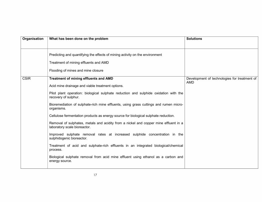
17
Organisation What has been done on the problem Solutions
Predicting and quantifying the effects of mining activity on the environment Treatment of mining effluents and AMD Flooding of mines and mine closure
CSIR Treatment of mining effluents and AMD
Acid mine drainage and viable treatment options.
Pilot plant operation: biological sulphate reduction and sulphide oxidation with the recovery of sulphur.
Bioremediation of sulphate-rich mine effluents, using grass cuttings and rumen micro-organisms.
Cellulose fermentation products as energy source for biological sulphate reduction.
Removal of sulphates, metals and acidity from a nickel and copper mine effluent in a laboratory scale bioreactor.
Improved sulphate removal rates at increased sulphide concentration in the sulphidogenic bioreactor.
Treatment of acid and sulphate-rich effluents in an integrated biological/chemical process.
Biological sulphate removal from acid mine effluent using ethanol as a carbon and energy source.
Development of technologies for treatment of AMD

18
Organisation What has been done on the problem Solutions
Groundwater assessment of AMD impacts
Hydrogeological assessment of acid mine drainage impacts in the West Rand Basin, Gauteng Province
Hydrogeological assessment for an improved understanding of impacts
MINTEK Treatment of mining effluents and AMD Development of technologies for treatment of AMD
DWA Integrated water management strategies to utilise the allocatable water quality to the benefit of the water users, and identify intervention measures to ensure adequate water supply and protect water quality.
Remove significant salt streams from a range of sources including underground mine water return-flows as part of a larger medium- to long-term strategy

19
CHAPTER 4. THE CURRENT SITUATION*
4.1 FLOODING OF THE WITWATERSRAND GOLD MINES
4.1.1 Flooding of mines
The nature of the gold deposits in the Witwatersrand has led to the development of large
complexes of interconnected mines, which have been referred to as 'basins' (Scott,
1995). Since the earliest days of mining, the inflow of water into the mines has been a
problem and water was pumped from the mines to allow access to the gold reserves.
When individual mines ceased operations they stopped pumping, allowing their
operations to flood. Owing to the interconnections, this water will have flooded until it
reached an opening into a neighbouring mine, after which it will have flowed into that
mine, increasing the volume of water to be pumped from the neighbouring mine. Over
time, as more mines closed, the burden of pumping water was carried by fewer and
fewer mines, until the last operating mine stopped pumping (Scott, 1995; Department of
Minerals and Energy, 2008a, 2008b).
In the case of two of the three oldest basins — the Western and Central Basins — no
underground mines are operating and no water is pumped from the underground
workings. In the Western Basin this water has already risen to surface and is decanting
— flowing from old shafts and other structures — into the surface environment, while in
the Central Basin no water is pumped from the underground workings and the water
level is rising at an average rate of 0.59 m per day, with the water level measured at
around 500 m below surface at Catlin Shaft on Simmer & Jack Mine in early December
2010. This level is monitored continuously by the CGS, using automated instrumentation
providing real-time measurements. In the Eastern Basin the water level is controlled by
pumping by a single mine — Grootvlei Mine — hat pumps water from their No. 3 Shaft to
maintain the water level around 700 m below the surface. Recent financial problems at
Grootvlei Mine have created a situation that could result in the termination of this
pumping.
4.1.2 Sources of water entering the underground workings
A number of sources have been identified for the water entering the underground
workings (Scott, 1995; Krige, 1999; Horstmann et al., 2004a 2004b). These include:
• Direct recharge by rainfall falling onto open mine workings, stopes and old
surface workings.
• Groundwater, recharged by rainfall, which seeps into the workings owing to the
disturbance of natural groundwater conditions by mining (Scott, 1995;
Department of Minerals and Energy, 2008b).
• Surface streams that lose water directly to mine openings and to the shallow
groundwater systems above zones of shallow undermining and historical surface
operations. This process is compounded in urbanised areas as the paved

20
surfaces tend to produce surface run-off, rather than allowing water to seep
naturally into the ground.
• Where open surface workings exist, these often connect directly to the
underground workings and provide a pathway for water to flow from the surface
to the mine void. In the Western Basin the problem is exacerbated where mining
companies allow acid drainage from their surface tailings reclamation operations
to flow into abandoned open pits.
• Mine residues, in particular tailings, are seen as areas of enhanced seepage
where the volume of water entering the mine void is relatively high. The
interactions between water and tailings can lead to contamination of the water
and AMD production, resulting in the flow of contaminated water into the mine
voids (Scott, 1995; Rosner et al., 2001).
• Losses from the water, sewage and stormwater reticulation systems are also a
possible source of water in the zone, where these cross old shallow mine
workings. These will need to be investigated in cooperation with the relevant local
government entities.
• Isotopic studies undertaken by the Council for Geoscience have indicated that a
significant component of the water is groundwater that infiltrated rapidly after
recharge by rainfall (Horstmann et al., 2004a, 2004b)
4.1.3 Acidification and contamination of water in the flooded mine voids
Acid mine drainage forms in mining environments when ore and waste materials,
containing sulphide minerals such as pyrite, are exposed to water and oxygen. A
detailed study of AMD formation, transport and impacts in the Witwatersrand has been
performed by the Council for Geoscience, on behalf of the Department of Mineral
Resources (Coetzee et al., 2007). The disturbance of ore bodies and the transport of
large volumes of pyritic material to the surface create conditions highly conducive to the
generation of acid mine drainage, both owing to the exposure of ore in the underground
environment and owing to the transport of blasted and/or crushed waste rock and tailings
to the surface.
In order for pyrite to oxidise, both oxygen and water must be present. Water serves not
only as a reactant, but also as a reaction medium and a product transport solvent
(Forstner and Salomans, 1988). The rate of AMD generation, in an environment where
sulphidic material is exposed to oxygen and water, will be determined by a number of
factors. The reactions will proceed rapidly in warm humid environments, while other
environmental factors, such as the specific sulphide mineralogy and grain size, and the
presence or absence of acid neutralising minerals, such as carbonates will also influence
the rate of AMD production and its eventual environmental impact. Unfortunately, these
parameters can only be evaluated on a site-specific basis, via investigations that will
include field, laboratory and modelling studies.

21
The oxidation of sulphide-bearing minerals consists of several reactions. Each sulphide
mineral has a different oxidation rate. For example, marcasite and framboidal pyrite will
oxidise quickly, while crystalline pyrite will oxidise more slowly.
For discussion purposes, the oxidation of pyrite (FeS2) will be examined.
Pyrite oxidises to form an acidic solution of ferrous iron and sulphate:
4FeS2(s) + 14O2(g) + 4H2O → 4Fe2+(aq) + 8SO4
2-(aq) + 8H+(aq)
Oxidation of the ferrous ion to ferric ion occurs more slowly at lower pH values:
4Fe2+(aq) + O2(g) + 4H+(aq) → 4Fe3+(aq) + 2H2O (l)
Ferric iron precipitates as ferric hydroxide, producing further acid:
4Fe3+(aq) +12H2O(l) → 4Fe(OH)3(s) +12H+(aq)
(From Coetzee et al., 2007)
Fe(OH)3 is identifiable as the deposit of amorphous, yellow, orange or red deposits on
streambeds ('yellow boy') (Figure 4.1).
When either of the processes represented by the equations are slowed or stopped, AMD
generation is slowed down or ceases.
Acid mine drainage can impact on the environment in a number of ways:
• Lowering of the pH of water to a point where it is unsuitable for domestic or other
uses (Department of Water Affairs and Forestry, 2006). The pH of the acid mine
drainage entering streams in the Western Basin is often around or slightly lower
than 3 (Tutu et al., 2008). This is similar to the pH of lemon juice, i.e. while not as
corrosive as concentrated acids, it will have long-term effects on materials with
which it comes into contact and will not support normal aquatic life.
• The reactions which produce acid mine drainage result in a high sulphate content
in the resultant water that will remain high even after the acidity is neutralised.
This renders the water unfit for domestic use, may make it unfit for agricultural
and some industrial uses and will increase the salinity of the receiving aquatic
environment.
• The acidity of the water liberates metals, including toxic metals and radionuclides
from the rocks with which it interacts. This may result in acute and chronic toxicity
to both human users and the environment, and will generally render water unfit
for most uses (Coetzee et al., 2006; Wade et al., 2002).
It is therefore desirable that acid mine drainage not be allowed to discharge to surface
streams or aquifers without adequate control and treatment.

22
Figure 4.1. Acid mine drainage in the West Rand
In the flooding Witwatersrand mine voids, two processes leading to the acidification of
water have been identified:
• Interaction between the inflowing water and the sulphides in the ore and host
rocks, leading to the generation of AMD. This will be particularly important in the
unsaturated zone at the top of the void where water and air mixes with the rock
material, providing the combination of water, oxygen and sulphides required to
produce AMD. Owing to the topography of the Witwatersrand, if the mine voids
are allowed to flood completely there will always be an unsaturated zone above
the final water level within the mine voids, covering most of the geographic extent
of the basins. This will result in an environment where new AMD is continually
produced owing to the interactions between water, air and sulphide minerals
(Rosner et al., 2001).
• Ingress of AMD into the mine void after interactions between water and waste
rock and tailings stored on the surface. This may take the form of contaminated
surface water entering the mine workings via surface features, as has been
observed in the Western Basin or seepage to the underground water which then
recharges the mine void (Hobbs and Cobbing, 2007).

23
4.2 THE SITUATION IN THE MAJOR WITWATERSRAND GOLD FIELDS
4.2.1 Western Basin
Although there is mine water pumping and treatment of infrastructure in the Western
Basin (Figure 4.5), the technology applied is unable to produce the desired final water
quality for release into the environment. Further, the pumping capacity is inadequate to
effectively control the rate of decant by managing the water. Water has decanted (Figure
4.2) continuously since late August 2002 (Coetzee et al., 2005a; Council for Geoscience,
2004c), on occasion exceeding the capacity of the infrastructure established to manage
it, resulting in untreated mine water entering the downstream environment via the
Tweelopie Spruit, an upper tributary of the Crocodile River System (Council for
Geoscience, 2004; Hobbs and Cobbing, 2007; Department of Minerals and Energy,
2008a). Such circumstances are typically associated with the wet summer months. The
seriousness of the situation and concerns regarding the impacts on the receiving
environment (Hobbs and Cobbing, 2007), notably the Cradle of Humankind World
Heritage Site, resulted in an intervention by the DWA who granted a subsidy of
R6.9 million over a three-month period in early 2010. This measure was aimed at
reducing acidity and removing some heavy metals in the water through in-stream lime
dosing. Although peaking at some 60 Ml/d, the decant volume has more recently
averaged 20 Ml/d of which around 12 Ml is partially treated. The remainder is diluted with
the daily output of partially treated mine water before discharging into the Tweelopie
Spruit.
Figure 4.2. Decant of AMD from 18 Winze — a shaft in the Western Basin

24
The Western Basin is a close geological analogue to the Central Basin, although it is
considerably smaller. The likely course of events related to the flooding and eventual
decant of the Central Basin are therefore likely to be similar and to have similar
consequences to those seen in the Western Basin.
4.2.2 Central Basin
Pumping from this basin (Figure 4.6) was stopped in October 2008 owing to fatalities,
apparently attributable to inadequate ventilation at the pump station in East Rand
Proprietary Mines (ERPM) (pers comm. P Kelly, DMR). The rate of rise measured by
ERPM Mine varies between 0.35 and 0.900 m/d (Figure 4.3), depending on rainfall.
Previously, an average volume of approximately 60 Ml/d was neutralised and discharged
into the Klip River (Scott, 1995; Council for Geoscience, 2004a; Council for Geoscience,
2004b; Council for Geoscience, 2005a; Department of Minerals and Energy, 2008c). Lin
and Hansen (2010) have identified the Environmental Critical Level (ECL) for the Central
Basin (Figure 4.3) at 150 m below surface, measured at South West Vertical Shaft at
ERPM. The recent water level measurement at South West Vertical shaft is equal to
levels within the Central Basin, and is taken as representative value for the whole basin.
Furthermore, they have also identified possible decant points and studied the
acidification of water related to the flooding of the Central Basin.
Figure 4.3. Rising water levels in the Central Basin, extrapolated to the points where they will reach various critical levels, including the decant forecast for March 2013 (CRG — Central Rand Gold, compiled by L Lin, 2010)
If this water is allowed to continue to rise, it will:
• Make mining of the remaining gold in the Central Basin uneconomic. Central
Rand Gold (CRG), a new entrant to the mining industry, has recently commenced
underground operations in the Central Basin to extract remaining gold (Central
Rand Gold, 2008). Central Rand Gold have already ordered the pumps
necessary to prevent the rising water from reaching the levels where they intend
to mine.

25
• Flood the underground mine operated as a tourist attraction at Gold Reef City.
This site is visited by up to 3 000 tourists daily and showcases an important piece
of the heritage of Johannesburg and, indeed, South Africa.
• Rise to an environmentally critical level where local groundwater systems could
be influenced, particularly the dolomitic aquifers to the south, ERPM in Boksburg
and Durban Deep in Roodepoort.
• Rise to the surface, decanting in low-lying areas in the vicinity of the ERPM Mine
in Boksburg and possibly elsewhere across the Witwatersrand.
• The hydraulic regime in the underground workings is not well understood, and it
cannot be proven that the water level will stabilise at this lowest decant level
(beneath central Boksburg). Further rise in water level would impact on higher-
lying areas across the Central Basin — from Roodepoort, through Johannesburg
to Boksburg (Figure 4.6).
The similar mining methods practised and similar geology of the Central and Western
basins suggest that the likely consequence of flooding within the Central Basin could
be similar to that experienced in the Western Basin. However, flooding within the
Central Basin would occur within a highly urbanised area, while the impact of flooding
in the Western Basin has largely been on the peri-urban areas to the north of
Krugersdorp and Randfontein.
4.2.3 Eastern Basin
In the Eastern Basin (Figure 4.7), a single-pump station is currently pumping mine water
at Grootvlei Mine at a rate of 75–108 Ml/d (Council for Geoscience, 2008b; Scott, 1995;
Department of Minerals and Energy, 2008c) (Figure 4.4). A number of factors, including
the inflow of large volumes of dolomitic water with high alkalinity and the removal of a
large number of surface residue deposits in this basin, contribute to the production of a
better quality of water with higher pH and lower sulphate levels than has been observed
in the other basins. However, the water is not fit for uncontrolled discharge to the
environment, as it contains significant sulphate and iron concentrations. Recent financial
limitations have resulted in the Grootvlei Mine discharging untreated water, thereby
failing to meet the discharge standards as per their water use license. The substandard
effluent is being discharged into the Blesbok Spruit, which flows through a Ramsar-listed
wetland. The DWA was forced to institute legal action following this contravention, and
the matter remains under investigation. Given Grootvlei Mine’s financial position, the
pump station will be flooded within 30 days, should their pumping operations cease,
whereupon the water level will continue to rise until it decants into the surrounding
dolomitic aquifers and, eventually, to the surface, with the predicted decant point being
within the town of Nigel (Scott, 1995; Council for Geoscience, 2005b; Esterhuyse et al.,
2008). This is likely to happen as early as five years after the cessation of pumping
(Scott, 1995).

26
Figure 4.4. Water pumped from the Eastern Basin to the treatment plant at Grootvlei Mine

27
Figure 4.5. Locations of mines of the Western Basin

28
Figure 4.6. Locations of mines of the Central Basin

29
Figure 4.7. Locations of mines of the Eastern Basin

30
4.2.4 Far Western Basin
Most of the mines in this basin are still operational and AMD problems owing to flooding
are not regarded as urgent at this stage (Department of Minerals and Energy, 2008d).
There is, however, uncertainty with regard to the quality of water filling the mine voids
after mining has ceased, indicating that attention must be paid to potential impacts on
the overlying dolomitic aquifers (Department of Minerals and Energy, 2008d; Van Tonder
et al., 2008; Van Tonder et al., 2009). This poor quality water is believed, at least in part,
to originate from tailings facilities that were historically located over cavernous dolomite
to encourage the drainage of the tailings, without regard for the underlying groundwater
quality. A contributory factor is the historical practice of filling sinkholes in the dolomite
with mine tailings (Dill and James, 2003).
4.2.5 Klerksdorp, Orkney, Stilfontein and Hartbeesfontein (KOSH) Basin
Continued mining operations in the KOSH Gold Field depend on the pumping
infrastructure at Margaret Shaft (Stilfontein Gold Mine) (Department of Minerals and
Energy, 2008e) for the dewatering of the mine void in the down-dip underground
workings of the other mines in the area. Stilfontein Gold Mine was declared insolvent in
2005, resulting in the temporary abandonment of all the mine workings, including the
pumping station at Margaret Shaft. In order to prevent the flooding of all of these
workings, the other active mining companies in the area took over the pumping
operations at Margaret Shaft and have been operating the pump station under
transitional arrangements with the DMR and the DWA. A water utility company has been
formed to operate the pumping station and it has been proposed that revenue can be
generated from the water pumped.
4.2.6 Free State Gold Field
Most mines in the Free State are still operating and pumping is active. Studies
conducted by the mines suggest that there is no immediate serious threat of decant,
even if mining were to cease because of the geological features of the area, including
the topography. However, a number of challenges result from the closure of some shafts
and the need to increase pumping capacity at the remaining shafts. It is also necessary
to isolate the remaining mining areas by installing plugs between them and the closed
areas. In the latter case, seismicity and the rate of the water level rise will have to be
monitored.
The current main concern pertains to the large number of evaporation and return-water
dams in which the partially treated mine water has a high concentration of heavy metals
and salts, impacting surface water bodies in the area.
The possibility of treating mine water and selling it to the local bulk water supplier has
been raised, but has not been undertaken yet as water demand is not high enough in the
area.

31
Some tailings facilities have been shown to be responsible for contaminating borehole
water in the area. Most of the reclaimed tailings facilities have not been rehabilitated yet,
and they are sources of both groundwater and surface water contamination.
4.2.7 Evander Basin
The Evander Gold Field is currently operating through a single shaft. However, the
pumping facilities at two other shafts are still in use, extracting some 4 Ml/d. About 90 %
of this water is stored in evaporation dams, while the remainder is reused in the mining
processes. There have been no reports of AMD problems and sinkholes related to gold
mining in the area. Nevertheless, there is evidence that the evaporation dams and
tailings facilities contaminate the local shallow aquifers hosted in alluvial and/or Karoo
sediments. Water management in the area is further complicated by the presence of
underground coal mines located directly above the gold mines.

32
CHAPTER 5. PRIORITISATION OF GEOGRAPHIC AREAS AFFECTED BY
AMD WITHIN SOUTH AFRICA
An analysis of currently known AMD sources in South Africa has identified the following
mining areas (Figure 5.1):
• Western Basin
• Central Basin
• Eastern Basin
• Free State Gold Field
• KOSH Gold Field
• Far Western Basin
• Evander Gold Field
• South Rand Gold Field
• Mpumalanga Coal Fields
• KwaZulu-Natal Coal Fields
• O’Kiep Copper District
Figure 5.1. Identified areas of AMD generation and potential AMD generation in South Africa

33
5.1 HIGHEST PRIORITY AREAS
Of the above listed problematic areas with respect to AMD, critical problems are known
to exist in the Western and Central Basins where, respectively, limited and no pumping is
taking place. Decant has already occurred in the Western Basin, while the Central Basin
is currently flooding and will decant within two to three years unless decisive action is
taken immediately to prevent it. In the Eastern Basin, one mine that is not producing
revenue is currently pumping water. These areas are prioritised owing to the lack of
adequate measures to manage and control the problems related to AMD, the urgency of
implementing intervention measures before problems become more critical, and the
proximity of these problem areas to densely populated areas. The situation in these
areas can be regarded as in need of critical intervention in the short term.
5.2 VULNERABLE AREAS WHERE ADDITIONAL INFORMATION IS REQUIRED
Severe water related problems, including numerous AMD decants (Figure 5.2), have
been reported in the Mpumalanga Coal Fields. These must be regarded as serious and
in need of follow-up action and assessment, particularly in view of the expansion of coal
mines in the area and the regional-scale impacts already reported.
Figure 5.2. Decant of AMD from the abandoned Transvaal and Delagoa Bay Colliery close to eMalahleni in Mpumalanga
The other large gold-mining areas listed, namely the Free State, KOSH, Far West Rand
and Evander Gold Fields, are currently being mined actively and water is pumped from
these basins. It is recommended that a risk assessment of these areas be carried out to
determine their vulnerability to the premature closure of specific mines and shafts.

34
5.2.1 Lower priority areas requiring assessment and monitoring
Considering the commodities mined, AMD impacts can also be expected in the
Waterberg, Molteno and Limpopo Coal Fields and the South Rand Gold Field. As no
serious problems are known to have developed yet in these areas, they cannot be
regarded as high priorities, but the individual circumstances need to be assessed and
monitored n order to provide timely information on possible future problems.
A number of AMD impacts have been identified in the O’Kiep Copper District (Figure 5.3)
in the Northern Cape by the CGS during the investigation of derelict and ownerless
mines and other research activities (Coetzee et al., 2008). These appear to have a
localised impact, although potential long-term impacts have also been identified.
Figure 5.3. Decant of copper-rich AMD in the town of O’Kiep, Northern Cape
35
CHAPTER 6. REAPPRAISAL OF THE RISKS ATTRIBUTABLE TO ACID MINE
DRAINAGE
6.1 INTRODUCTION
This reappraisal of the risks attributable to AMD in South Africa has become necessary
in order to assist government in the management of a perceived national crisis with
respect to acid mine drainage, particularly in the gold and uranium mining areas of the
Witwatersrand (Figure 1.1 on page 3). In recent months, media reports have highlighted
the problems related to the flooding of the mining basins of the Witwatersrand, often
sensationalising the risks faced in these mining areas. It is therefore necessary that the
risks identified be assessed, based on concrete information and reliable scientific input,
in order to establish a management plan that will minimise risk to the public and the
environment.
6.2 DEWATERING AND REWATERING OF THE MINING BASINS OF THE
WITWATERSRAND
In order to comprehend the issues related to the flooding of the Witwatersrand mines, it
is necessary to understand how they developed over time, the geometry of the mine
voids and their relationship to the surface and surface infrastructure.
Gold was discovered on the farm Langlaagte — now in the Western suburbs of
Johannesburg — in 1886 (Antrobus, 1986). This initial discovery was of a surface
deposit of weathered conglomerate with an east–west strike. Opencast mining
developed rapidly to the east and the west of the discovery site, eventually extending
across most of the Central and Western Basins. In a relatively short time, the near-
surface weathered zone had been mined out completely and it became necessary to
mine the harder rock below. This required underground workings to be developed, first
via incline shafts on the reef horizons and later via deep vertical shafts sunk to the south
of the outcrop zones, accessing the reefs via a network of underground tunnels. As
these deeper workings were developed it became necessary to pump out the water
which seeped into the underground workings in order to prevent them from flooding. The
gold ore was extracted from narrow stopes dipping to the south, with underground
workings extending from as shallow as less than 10 m below surface down to great
depths, in some cases more than 3 000 m below surface. The gold reefs extend more or
less continuously for many kilometres and, as a result, large networks of interconnected
shafts, tunnels and stopes have developed across the Witwatersrand, with each basin
representing a zone of near-continuous gold reefs, bounded by geological
discontinuities. In the peak of mining on the Witwatersrand, multiple mines extracted ore
from underground workings, each having to pump water from their own workings.
Over time the easily accessible and higher grade ore was depleted, leading to the
closure of such mines. This placed a greater burden on the remaining mines to pump
water flowing in from neighbouring mines, as well as water from their own workings.
Where this happened, the State instituted a system of subsidies for mines to assist with
the pumping of extraneous water from their workings. Eventually the last mine in a basin
would stop mining, stop pumping and the basin would flood. This has occurred in two of

36
the three priority areas — the Western and Central Basins — while a single mine,
Grootvlei, still pumps water from the Eastern Basin, maintaining the water level 700 m
below surface.
The inflowing water comes from a number of sources, including surface water directly
entering old mine workings, surface water that recharges the shallow groundwater
directly above the mine workings, groundwater recharged by rainfall directly above the
shallow workings, and water seeping from the numerous large mine residue deposits
that overlie the mine workings. In addition to these natural water sources, some leakage
from the infrastructure carrying potable water, sewage and stormwater across the zone
of shallow undermining occurs and will require pumping.
Figure 6.1. AMD formed owing to interaction between water and mine residues on the surface, exposed in a surface tailings reclamation operation in the Western Basin. Note that this site drains into open pit operations that are directly connected to the mine void
Unfortunately this water is of poor quality. Some is already contaminated owing to
interaction with mining residues and other materials on the surface before it enters the
mine void (Figure 6.1). Acid mine drainage is formed when sulphide minerals —
particularly pyrite — interact with oxygen and water, forming a dilute solution of sulphuric
acid and iron that leaches other metals from the material in which it forms. Acid mine
drainage in the Witwatersrand typically has a pH value around 3 — the pH of lemon juice
or vinegar, not battery acid or swimming pool acid as has been reported in the media —
and is enriched in a number of toxic metals, often including uranium. This is typically 3 to
5 pH units below what would normally occur in an unimpacted environment. The

37
associated high concentrations of sulphate and iron also pose serious water quality
problems if they enter the surface environment.
Flooding of the mine voids will create an oxygen-poor environment where acid forming
reactions will slow down significantly. Unfortunately, the topography of the mining areas,
in the three prioritised basins, will not allow complete flooding, as decant will tend to
control the water level at the lowest topographic level within each basin. Above this level
a significant unsaturated zone exists in the shallower portion of the underground
workings. The mixing of air, water and exposed sulphides in this zone will continue to
form new acid mine drainage.
After the cessation of mining the inflowing water slowly fills the mine voids and the water
rises as the interconnected voids become flooded. The Central Basin is currently
flooding after the last operating mine — ERPM — ceased pumping in 2008, with the
water level measured at 545 m below surface on the 22nd of September 2010, with an
average daily rate of rise over the past year of 0.59 m. If unchecked, this will rise to the
surface and decant, flowing out of one or more low-lying shafts or other water conduits,
such as boreholes or water-bearing geological structures. This happened in the Western
Basin following the cessation of pumping in the late 1990s. Acid water surfaced in 2002,
contaminating a local stream and having a serious impact on the ecology of the
Krugersdorp Game Reserve immediately downstream, which has continued since this
time, although some efforts have been made by local mining companies and the DWA to
contain this water and minimise its impacts on the environment.
6.3 APPRAISAL OF RISKS
A full appraisal of risks has been performed using the software package RiskMatrix
(Engert and Landsdowne, 1999). The detailed results are presented in Appendix A.
6.3.1 Risks owing to the flooding of the mine voids
The risks owing to the flooding of the mine voids are listed below. The sequence in which
they are listed does not imply any prioritisation of the risks.
6.3.1.1 Increased seismic activity
Mine flooding related seismicity was identified as a problem more than 500 years ago
(Klose, 2007). The closest comparable phenomenon would be seismic activity related to
the filling of large reservoirs, fluid injection into oil field wells and in hydrothermal fields.
The flooding of mines is assumed to trigger seismicity in a similar manner as water fills
mining voids from the deepest parts of the mines to the surface. The high water
pressures owing to the flooding can affect the stability of artificial and natural fractures
causing them to slip, generating seismic events. High pore pressures, coupled with
lubrication of faults reduce clamping forces on the fractures/faults, which can cause even
previously non-seismic fractures to slip (Durrheim et al., 2006; Goldbach, 2010). In such
cases, the frequency of seismic events is likely to increase during and shortly after the
period of flooding, after which it will likely stabilise and decrease over a period of several
years after flooding has been completed or a stable water level is maintained. Seismic

38
events triggered by mine flooding have previously been observed in Canada, India,
Japan and Poland.
The closure of mines in the Central Basin resulted in the shutting down of the pumping
stations that previously maintained the underground water level. As a direct
consequence, the water level has been rising within the abandoned mines. The South
African National Seismograph Network (SANSN), operated by the CGS, has observed a
dramatic increase in seismicity coinciding with the closure of the pumping stations
(Figure 6.2). The average number of events per month increased from 5.9 before
pumping stopped to 11.7 afterwards. With the installation of 12 seismic stations in the
Central and East Rand under the Strategic Water Management Project, the average
frequency of observed events has increased to 24 per month. However, the increase
observed in April 2010 may only be an apparent increase in seismicity, since the denser
network of stations is capable of recording smaller events than the SANSN. Continued
monitoring and interpretation will track the observed change in the rate of seismicity and
provide further insight into the risk posed by these events.
0
5
10
15
20
25
30
35
Jan-08
Feb-08
Mar-08
Apr-08
May-08
Jun-08
Jul-08
Aug-08
Sep-08
Oct-08
Nov-08
Dec-08
Jan-09
Feb-09
Mar-09
Apr-09
May-09
Jun-09
Jul-09
Aug-09
Sep-09
Oct-09
Nov-09
Dec-09
Jan-10
Feb-10
Mar-10
Apr-10
May-10
Jun-10
Jul-10
Month - Year
No
. o
f E
ve
nts
ERPM pumps stopped in
NOVEMBER 2008
SWMP seismic stations commissioned
Figure 6.2. Number of seismic events measured by the CGS in the Central and East Rand area before and after pumping at ERPM stopped
Figure 6.3 shows the located seismic events in relation to the city of Johannesburg and
the old mining districts. It is clearly seen from the map that most of the recorded seismic
events are confined to the area of flooding of the old mines. The fact that the
metropolitan city of Johannesburg is situated directly adjacent to this basin represents a
situation of concern. However, international and local case studies reveal that the
magnitude of seismic events that can occur owing to mine flooding is expected to fall
within the range of magnitudes observed during mining operations; which have reached
magnitudes of up to ML (local magnitude) 5.3 in the Witwatersrand Basin. Such events
have in the past caused structural damage and disruption throughout the Witwatersrand

39
region, including the Johannesburg urban area. The occurrence of an event of similar
magnitude owing to mine flooding, which could lead to serious consequences if it struck
a densely populated urban area or a key business interest, can at present not be
excluded. Therefore, the nature of seismic events triggered by mine flooding, as well as
the damage potential of surface ground motions associated with such events, needs to
be monitored and investigated.
Figure 6.3. Seismic events recorded and located by the Council for Geoscience in the Central and East Rand between March and July 2010
6.3.1.2 Contamination of shallow groundwater resources
Rising AMD within the mine voids will not only come into contact with surface water
resources, but will also tend to flow into down-gradient areas via groundwater conduits.
This will be most pronounced in the dolomitic aquifers adjacent to and overlying the mine
workings (Figure 6.4) in the Eastern and Western Basins. In the Western Basin this is an
area of specific concern as the dolomitic aquifers located down-gradient of the mining
area provide clean water to the Cradle of Humankind World Heritage Site (Hobbs and
Cobbing, 2007, Hobbs (ed.), in prep.). In the Central Basin, dolomitic aquifers to the
south of Boksburg could be affected by rising water levels (Lin and Hansen, 2010).

40
Figure 6.4. Relationship between the Witwatersrand mining basins and the outcrop of the Malmani Dolomite
6.3.1.3 Geotechnical impacts if the water reaches the near-surface environment
The geotechnical impacts of rising water levels on ground stability have been raised by
Coetzee et al., (2008b):
• Subsidences at the outcrops could occur owing to the mobilisation of poorly
compacted fills within steeply dipping stopes
• Acid mine water could result in the chemical corrosion of building foundations, but
this aspect has not been well studied and site-specific studies are necessary
• Foundations, basements and municipal services could be flooded as a result of
rising groundwater levels driven by the flooding mine void, if water levels are
allowed to rise high enough to impact on these structures. These effects may be
localised to low-lying areas.
The area where severe negative impacts are of greatest concern is the Central Basin,
because of to its proximity to Central Johannesburg and, particularly, in the presence of
abandoned near-surface workings in the city centre. However, most of the Johannesburg
CBD is located up to 100 m higher than the lowest-lying parts of the basin where water is
likely to decant. The Western Basin has little urban development in close proximity to the
old mine void, and therefore is less at risk from this type of impact. The same is true for
large parts of the Eastern Basin, although impacts are possible in Nigel if pumping stops
and the water level rises to its decant level.
While many of these impacts are relatively unlikely in the Central Basin, because of the
elevation differences between the decant level and the CBD of Johannesburg, they may

41
occur in lower-lying areas, such as parts of Boksburg and areas to the south of the CBD.
Regular monitoring of water levels across the mine voids, as well as monitoring of
possible impacts, will provide early warning of these impacts, allowing preventative
action to be taken if required.
6.3.2 Risks owing to decant of water to the surface
6.3.2.1 Ecological impacts
The decant of water in the Western Basin provides an example of the ecological impacts
that could be expected downstream of a decant of AMD into a surface stream. In 2002
water decanted from the Western Basin mine void into the Tweelopie Spruit, a surface
stream draining into the Krugersdorp Game Reserve (Figure 6.5). The downstream
impacts of this water were assessed by Coetzee et al. (2005a), who reported a number
of parameters far exceeding the DWA guidelines for stock watering and aquatic
ecosystems (Department of Water Affairs and Forestry, 1996b), while aquatic
biomonitoring results collected in 2000 and 2004 showed the deterioration of the system
from one classified as Class C (in a good ecological condition) to a Class F
(unsustainable and unable to support normal aquatic life). The operators of the Game
Reserve have subsequently reported a number of animal deaths which they believe are
attributable to the poor water quality, as well as a dramatic decrease in the reproductive
rates of animals in the Game Reserve. These effects are likely to be experienced
downstream of any decant of AMD to the surface water environment, and will persist
downstream until sufficient additional water is added to the stream to have a significant
dilution effect.

42
Figure 6.5. Salt crusts precipitating on vegetation downstream of the decant from the Western Basin
6.3.2.2 Regional impacts on major river systems
One of the pervasive messages regarding AMD from the Witwatersrand Gold Fields is
that it has a major impact on South Africa’s major river systems and that the water
pumped from the Witwatersrand mine voids, i.e. the water that is currently decanting
from the Western Basin, the water that will decant from the Central Basin if action is not
taken to prevent it, and the water that is pumped from the Eastern Basin by Grootvlei
Mine is an important contributor to the salinity of the Crocodile and Vaal River Systems.
This has far reaching implications, as the DWA currently manages water quality in the
Vaal System via the discharge of clean water from upstream sources, including the
Lesotho Highlands Water Project. The addition of saline water to the system requires
large volumes of clean water to be discharged to maintain water quality at acceptable
levels. The Vaal River Reconciliation Strategy of the DWA (Department of Water Affairs
and Forestry, 2009) identifies the point sources of mine water as sources that can be
removed from the system by desalination. The pollution from the mine discharges form
the most concentrated salt stream entering the Vaal System and therefore represent one
of the areas where desalination of a waste stream could be achieved efficiently. Other
discharges to the Vaal System, including diffuse pollution from mining sites, pollution
from coal mines, and discharges from sewage works and industries will also need to be
addressed to ensure water security in the Vaal System.

43
Impact of the Western Basin decant on downstream surface water
The bulk of the mine water from the Western Basin does not currently enter the Vaal
System, discharging to the Tweelopie Spruit, an upper tributary in the Bloubank Spruit
System of the Crocodile (West) River catchment. A small volume of seepage has been
observed to enter the Wonderfontein Spruit, which drains to the Vaal System via the
Mooi River (Coetzee et al., 2005b). The decant of AMD and the discharge of partially
treated mine water have had severe negative impacts on the aquatic ecology and the
large mammal population in the Krugersdorp Game Reserve immediately downstream of
the decant and discharge points. Impacts have also been experienced in streams further
downstream, notably the Riet Spruit. However, the Bloubank Spruit as main stem in this
drainage system itself has not exhibited any significant impact from AMD in the past 8
years since the start of decant in late-August 2002. This is shown in Figure 6.6, which
does not reflect a notable change in total dissolved salts (TDS) load at the downstream
monitoring station A2H049 in the post-decant record. For example, the post-decant
median and 95th percentile values are not significantly different from the whole record
values.
0
500
1000
1500
2000
2500
3000
3500
TOTAL DISSOLVED SALTS LOAD (t/m)
MONTH-YEAR
Whole record 50 %ile = 720 t/mWhole record 95 %ile = 1376 t/mRecent record 50 %ile = 847 t/mRecent record 95 %ile = 1596 t/mEarly record 50 %ile = 627 t/mEarly record 95 %ile = 1059 t/m
Post-decant record 50 %ile = 737 t/mPost-decant record 95 %ile = 1208 t/m
Recent recordEarly record
Post-decant record
Figure 6.6. Long-term monthly TDS load pattern at station A2H049, Bloubank Spruit System (from Hobbs (ed.), in press).
Figure 6.7 shows the sulphate concentrations leaving the Bloubank Spruit System and
Hartebeespoort Dam in the post-decant period. It would appear that the AMD decant
phenomenon has had little discernible impact on the water quality (as represented by the
sulphate concentration — Figure 6.7) at either of the monitoring stations. This
observation is explored further in Figure 6.8 on the basis of the TDS and sulphate loads
leaving the Bloubank Spruit System in the post-decant period. Although a linear
regression analysis of the data sets indicates a rising trend in both instances, the poor

44
correlation coefficients (R2 of 0.08 for TDS and 0.12 for SO4) suggest that not too much
value can be attached to the trends. A visual fit through the summer (wet season) peak
loads as represented by the pecked lines in Figure 6.8 suggests a more definitive, but
still admittedly tenuous, trend.
20
30
40
50
60
70
80
90
100
110
120
SULPHATE CONCENTRATION (mg/L)
MONTH-YEAR
SO4 leaving the Bloubank Spruit system SO4 leaving Hartebeespoort Dam
Start of minewater decant
from the Western Basin on
28 August 2002
Figure 6.7. Comparison of the SO4 concentration in surface water leaving the Bloubank Spruit System at station A2H049 with that leaving Hartebeespoort Dam since the start of mine water decant from the Western Basin

45
0
200
400
600
800
1000
1200
1400
1600
1800
SALT LOAD (t/m)
MONTH-YEAR
TDS SO4
Start of minewater decant
from the Western Basin on
28 August 2002
Figure 6.8. Comparison of monthly TDS and SO4 loads leaving the Bloubank Spruit System at station A2H049 since the start of mine water decant from the Western Basin. Arrows denote higher summer (wet season) loads (from Hobbs (ed.), in press)
The above observations are likely attributable to a combination of dilution, precipitation of
sulphate as sulphide in the aquatic environment (particularly wetland environments),
and, specifically in the Bloubank Spruit System, surface water losses to groundwater.
The latter phenomenon is an intrinsic characteristic of dolomitic environments, and raises
concern for the impact of poor quality surface water on the receiving groundwater
resources. Whilst groundwater samples collected from boreholes in close proximity to
the losing stream reaches do show higher salinity, calcium and sulphate values, this is
not widespread. Similarly, the presence of heavy/trace metals in the dolomitic
groundwater, if at all detectable, remains low to very low. Finally, the pH of the dolomitic
groundwater even in proximity to the losing stream reaches remains greater than 6.4,
which reflects the continued neutralising capacity of the carbonate dolomitic strata.
Because of the ongoing input of contaminated water, the dolomitic aquifer will require
monitoring. Should poor water quality be detected, remedial action will be required to
improve the quality of water in the system.
Impact of the Central Basin on downstream surface water
In the Central Basin, it is possible to gauge the effects of the mine water discharges on
the downstream environment by examining water quality before and after the cessation
of pumping by ERPM in October 2008. If the impact on downstream water quality is
significant, a decrease in the sulphate concentration of the downstream river water
should be noticed at around this time.
Data from two sampling sites — the Elsburg Spruit upstream of its confluence with the
Natal Spruit (Figure 6.9) and a site in the Klip River upstream of Henley on Klip (Figure

46
6.10) — have been extracted from the DWA database. In both cases the downstream
effect of the mine water discharge can be clearly seen. Unfortunately, very little flow data
for the relevant periods are available so that total salt loadings cannot be calculated.
It is evident that at the Klip River sampling site the sulphate concentration decreased by
approximately one half after the cessation of pumping by ERPM, suggesting that other
sources of sulphate in the water are approximately as significant as the water which was
pumped and discharged from the Central Basin.
The impact of the salt load from the underground mine water in the Central Basin is
therefore an important source of salts entering the Klip River System and subsequently
the Vaal Barrage, but is by no means the only source. The fact that it is not possible to
calculate a salt load for the mine water source or the salt load in the Klip River
underscores the need for monitoring of flow in the affected river systems.
0
200
400
600
800
1000
1200
1400
1600
1800
01-Jan-08 10-Apr-08 19-Jul-08 27-Oct-08 04-Feb-09 15-May-09 23-Aug-09 01-Dec-09
Date
Su
lph
ate
Co
nce
ntr
ati
on
(m
g/l)
Cessation of pumping and discharge by ERPM
Figure 6.9. Time series of sulphate concentration in the Elsburg Spruit downstream of ERPM mine, showing the effects of the cessation of pumping and discharge by ERPM

47
0
50
100
150
200
250
300
350
01-Aug-04 17-Feb-05 05-Sep-05 24-Mar-06 10-Oct-06 28-Apr-07 14-Nov-07 01-Jun-08 18-Dec-08 06-Jul-09
Date
Su
lph
ate
mg
/l
Cessation of
pumping and discharge by ERPM
Figure 6.10. Time series of sulphate concentration in the Klip River, showing the effects of the cessation of pumping and discharge by ERPM
Impact of the Eastern Basin on downstream surface water
Water quality data from a DWA sampling point on the Blesbok Spruit downstream of
Nigel (C2H184) are presented on Figure 6.11. The high sulphate concentrations suggest
that water contaminated by mining is entering the system, but, as in the case of the
Central Basin, the lack of flow data prevents the identification of the exact contribution of
the discharge of pumped water to this stream. The overall decrease in sulphate
concentration during the period from 2001 to 2009 could occur as a result of the
measured decrease in the sulphate concentration of water pumped from Grootvlei Mine
(pers. comm. I Lea — Grootvlei Mine), or from increased dilution because of greater
return-flows from the Ekhurhuleni Metro.

48
0
200
400
600
800
1000
1200
1400
06-Dec-99 19-Apr-01 01-Sep-02 14-Jan-04 28-May-05 10-Oct-06 22-Feb-08 06-Jul-09 18-Nov-10
Date
Su
lph
ate
(m
g/l
)
Figure 6.11. Time series of sulphate concentration in the Blesbok Spruit, downstream of Nigel
Impacts on surface water, with respect to the development of solutions
Perusal of DWA water quality data suggests that although the impacts of mine
discharges have only a localised impact on surface water in the Western Basin,
groundwater pollution is likely to increase in the future. In the Central and Eastern Basins
measurable impacts occur in the downstream rivers. In the Eastern Basin it is not
possible to distinguish the effect of the discharge of water pumped from the mine void by
Grootvlei Mine, while in the Central Basin, the water pumped by ERPM accounts for
approximately half of the sulphate concentration measured downstream. Unfortunately,
the lack of available flow data precludes the calculation of salt loads, which would be
more indicative of the total input of pollution to the Vaal River System.
Solutions to the problem should be approached from the point of view that in the short
term, conditions should be no worse than those which were experienced during periods
of active mining. Treatment during mining was limited to neutralisation and metal
removal. This should be seen as a minimum requirement for any water that is
discharged. As some impacts on groundwater have been identified as resulting from the
Western Basin decant, the situation must be closely monitored and remedial action taken
if it is shown to be necessary. In the longer term it will be desirable to reduce the salt
load emanating from these discharges into the already stressed Vaal River System.
Where impacts are limited to localised areas, alternatives that address these localised
impacts should be sought.
6.4 RISK MANAGEMENT MEASURES
The final component of risk assessment is the introduction of risk management
measures that will allow identified risks to be eliminated or their severity reduced.

49
6.4.1 Decant prevention and management
In all three basins uncontrolled decant to the surface and shallow groundwater will need
to be prevented. Decant to surface has already started in the Western Basin, with decant
from three shafts (Black Reef Incline, 18 Winze and 17 Winze) and seepage from low-
lying areas along the Tweelopie Spruit and Wonderfontein Spruit. The decant from the
Central Basin is predicted to occur from low-lying shafts at ERPM and/or via the low-
lying areas along the Elsburg Spruit. In the Eastern Basin decant is likely to occur from a
low-lying shaft and low-lying areas in Nigel. This will require maintaining the water level
at or below the Environmental Critical Level (ECL) for the basin. Pumping of water from
the mine void is likely to be necessary.
Within the Central Basin the possibility of constructing an artificial decant tunnel to carry
water from the underground workings at ERPM has been identified in studies undertaken
by the CGS. This should be revisited to establish whether it will still be feasible and
whether it will provide a more cost-effective long-term solution than pumping. However,
this solution would not protect the underground workings preserved for tourism at Gold
Reef City and would not allow the control of the water level at the ECL, 150 m below the
surface, measured at the South West Vertical Shaft of ERPM.
The topography of the Eastern and Western Basins is not conducive to the location of an
artificial decant point at the ECL, and will require water to be pumped from the mine void
to maintain the water level below the ECL.
6.4.2 Ingress control — reduction of the rate of flooding and the eventual decant
volume
6.4.2.1 Ingress reduction measures
In accordance with the hierarchy of water management actions of the DWA, as
contained in the Best Practice Guidelines (Department of Water Affairs and Forestry,
2008), actions that prevent water pollution and reduce the inflow of water into the mine
voids must be given a high priority. These actions will reduce the need to pump and to
treat water in the long term, slow the flooding of the mine voids and reducing decant
volumes or the volumes that need to be pumped. It is recommended that a proactive and
precautionary basin-wide approach be taken to limit water ingress into the underground
mine voids. The measures required are relatively site specific:
• Water ingress into the Western Basin is believed to be largely via open pits and
from a shallow perched aquifer. Control of the water ingress from the shallow
perched aquifer is probably impracticable, while the filling of the open pits with
mine tailings is currently being undertaken by the mining industry in the area.
Filled pits will need to be shaped and capped to limit the infiltration of water into
the underlying mine void. Lowering of the water level in the mine void to below
the ECL will open up new pathways for water ingress from areas that lie below
the current water level. The Wonderfontein Spruit and Tweelopie Spruit will
require water ingress management measures, such as drainage of pumped water

50
via canals, to be investigated and implemented, if necessary, to limit ingress and
to ‘keep clean water clean’.
• Netili et al. (2010) and Krige (1999) have identified a number of areas of water
ingress into the Central Basin, particularly those areas where surface streams
cross areas of shallow undermining. Canalisation of these streams, as well as
grouting within these areas could also reduce the ingress of water into the zone
of shallow undermining. Krige (1999) estimates that as much as 32.5 Ml/d of
ingress could be stopped. This accounts for 54% of the total volume of water
entering the mine void; although this figure still needs to be verified by flow
measurements and monitoring. The construction of a canal to the south of Florida
Lake is currently underway, and additional sites for canal construction have been
identified. The loss/leakage of water from the municipal water supply networks
(attributable to decaying infrastructure), as well as tree root growth into municipal
systems, sewerage and storm-water reticulation systems are suspected to
contribute to ingress into the Central Basin. These possible sources will need to
be investigated in collaboration with the Johannesburg and Ekhurhuleni
metropolitan councils.
• In the Eastern Basin this can commence immediately with the opening up of
culverts under roads in the Blesbok Spruit to prevent ponding of water and the
consequent ingress to the underground mine void. Other ingress prevention
actions have been identified by Netili et al. (2010) and will require focussed study
and urgent implementation, noting that stream flows are greatly increased above
their historical levels owing to other discharges, in particular treated sewage
discharges (Scott, 1995).
6.4.2.2 Groundwater abstraction
In some areas in the Eastern Basin the mine void is in contact with a dolomitic aquifer
located immediately above the Black Reef workings. At this interface clean dolomitic
groundwater has been observed flowing into the mine void. In its passage through the
mine void to the pumping station, this water becomes contaminated and acidified.
Interception of this water before it becomes polluted via a well field or in-mine
infrastructure would make a source of clean water available for use and also reduce the
volume of water from the basin that needs to be pumped and treated. This pumping will
need to be approached with caution to prevent subsidence effects that could be triggered
by dewatering of the dolomites.
6.4.3 Water quality management
6.4.3.1 Pollution prevention — 'keeping clean water clean'
A primary objective of water management must be pollution prevention. In the context of
AMD generation, this will largely be achieved in two areas:
• Ingress prevention as described above that will isolate surface water from the
underground pollution sources
51
• Proper management of mine residue deposits that have been identified as
sources of both water and pollution in the mine voids.
6.4.3.2 Water treatment
Even if all the measures described to limit water ingress and prevent pollution are taken,
some water will be polluted and some AMD will be generated. This will need to be
treated to a quality suitable for discharge or use. The options available are discussed in
Appendix B.
6.4.3.3 Natural attenuation
It may be found that natural systems will effectively attenuate pollution in the
environment in a limited number of cases. This is unlikely in the case of the large
volumes of extremely poor quality water encountered in the priority areas. Wetlands
which have been shown to attenuate pollution do so by concentrating large amounts of
waste material in the environment, creating problems of sediment contamination
(Coetzee et al., 2002).
6.4.4 Monitoring
The implementation of these management programmes needs to be informed by
sufficient data of high certainty to establish what needs to be achieved and, once
implementation begins, whether or not the measures implemented are having and
continue to have the desired effect. This will entail the monitoring of water levels in the
mine void, water quality and water flow volumes in the affected streams. Monitoring will
need to be coordinated between the different entities involved in the development and
implementation of solutions.

52
CHAPTER 7. OPTIONS FOR THE MANAGEMENT OF ACID MINE DRAINAGE
IN THE WESTERN, CENTRAL AND EASTERN BASINS
7.1 KEY PRINCIPLES
Principles and a hierarchy of actions for mine water management are defined in the
DWA Best Practice Guidelines for Mine Water Management (Department of Water
Affairs and Forestry, 2008).
It is proposed that this approach be adopted for the management of AMD from the
Witwatersrand gold mines.
7.2 OBJECTIVES OF AMD MANAGEMENT
The objectives of AMD management for the Witwatersrand stem from the DWA Best
Practice Guidelines, in particular the highest priority issues in terms of the hierarchy
defined above, i.e. the prevention of pollution and the minimisation of impacts. The
implementation of the principle of water reuse and reclamation is essential and must be
applied, either via direct reuse of water or via discharge and indirect reuse by
downstream water users. In either case, water would need to be treated to a quality
suitable for the intended use or point of discharge.
7.3 A GENERIC APPROACH TO AMD MANAGEMENT IN THE
WITWATERSRAND
In order to develop a management strategy, the problems faced can be split into two
components based on an assessment of available information:
1. Management of Flooding: Water flows into the mine voids on a continuous basis.
Unless water is pumped from the mines, it will eventually fill the voids to a point
Step 1: Pollution prevention
Step 2: Minimisation of
impacts
Water reuse and reclamation
Water treatment
Step 3: Discharge or disposal
of waste
and/or wastewater
Site-specific risk based approach

53
where water decants to the surface. The current status of each of the priority Basins
is presented in Table 7.1.
Table 7.1. Flooding status of the Western, Central and Eastern Basins
Basin Status
Western Flooded and decanting to surface
Central Pumping has ceased. The water level in
the basin is currently rising.
Eastern Pumping is undertaken at Grootvlei Mine,
maintaining the water level at around 700
m below surface.
2. Management of water quality: The water that accumulates in the mine void is of poor
quality, with relatively low pH, high acidity and elevated concentrations of sulphate,
iron and other metals.
A number of options exists for the management of each of these aspects. These are
summarised in Figure 7.1 and presented, together with an assessment of their
advantages and disadvantages and applicability in each of the priority areas, in Table
7.2. This table also includes options for the reduction of ingress and the monitoring of
conditions affected by the water management system. Note that all of the objectives
listed need to be fulfilled in order to implement a holistic AMD management strategy.

54
Figure 7.1. Water management options for the Western, Central and Eastern Basins
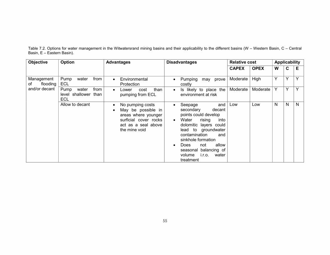
55
Table 7.2. Options for water management in the Witwatersrand mining basins and their applicability to the different basins (W – Western Basin, C – Central Basin, E – Eastern Basin).
Relative cost Applicability Objective Option Advantages Disadvantages
CAPEX OPEX W C E
Pump water from ECL
• Environmental Protection
• Pumping may prove costly
Moderate High Y Y Y
Pump water from level shallower than ECL
• Lower cost than pumping from ECL
• Is likely to place the environment at risk
Moderate Moderate Y Y Y
Management of flooding and/or decant
Allow to decant • No pumping costs • May be possible in areas where younger surficial cover rocks act as a seal above the mine void
• Seepage and secondary decant points could develop
• Water rising into dolomitic layers could lead to groundwater contamination and sinkhole formation
• Does not allow seasonal balancing of volume i.r.o. water treatment
Low Low N N N

56
Relative cost Applicability Objective Option Advantages Disadvantages
CAPEX OPEX W C E
Tunnel3 to create an artificial decant
• No pumping costs • Will ensure that decant occurs in a controlled fashion
• High capital costs • Does not fully protect the environment unless the tunnel can be constructed at the ECL
• Does not allow seasonal balancing of volumes i.r.o. water treatment
• Long-term maintenance costs of tunnel
• Risk of tunnel failure
Very high Low N Y N
Tunnel to a remote pumping station to reduce pumping costs
• Allows the location of the abstraction point for water according to the optimal location for a treatment plant
• Limited access to the underground workings will complicate construction
• Does not remove the requirement to pump water
High Moderate Needs further investigation
3 The idea of tunneling to create a preferred pathway for mine water to flow out of the void was proposed by the Council for Geoscience several years ago and detailed design
studies have been undertaken. This will allow the mine void to drain by gravity feeding water through a tunnel to a low-lying point.

57
Relative cost Applicability Objective Option Advantages Disadvantages
CAPEX OPEX W C E
Seal areas of surface ingress (riverbeds, old mine workings, etc.)
• Long-term reduction in water management costs
• Lower water volumes may result in more options for management
• Some projects may be implemented by mines (W Basin)
• Some projects involve high capital costs
High Low Y Y Y Ingress management
Abstract clean water from overlying aquifers before it enters the mine void
• 'Keeps clean water clean'
• Reduces ingress • Provides a source of clean water to local users
• Will need to be properly managed in dolomitic areas to prevent subsidence
Moderate Moderate N N Y
Water treatment
Neutralisation and iron removal
• Lowest cost option • Removes most heavy metals
• Can be implemented in a relatively short time
• Pre-treatment stage necessary for most more-advanced treatment methods
• Returns conditions to those that existed during active mining
• Does not fully address salinity problems
• Water produced has limited uses
• Requires facilities for sludge disposal
Moderate Moderate Y Y Y

58
Relative cost Applicability Objective Option Advantages Disadvantages
CAPEX OPEX W C E
Desalination
(may be one of a range of several treatment methods based on chemical precipitation, membrane treatment, ion exchange or biological sulphate removal)
• Proven, with a limited
number of commercial
biological sulphate
removal, membrane
treatment and
chemical precipitation
plants
• Produces clean water that can be used for any purpose, including drinking
• Can remove salts from river systems completely
• May produce saleable by-products that could offset some or all costs.
• High capital and operating costs
• Not all technologies
have been tested at full
scale
• Membrane processes at very high cost
• Need for management of wastes
Very high Very high Y Y Y
Discharge water without treatment
• No costs • Will seriously affect downstream environments.
• Will increase salinity of downstream river systems
Low Low N N N

59
Relative cost Applicability Objective Option Advantages Disadvantages
CAPEX OPEX W C E
In-situ treatment • No fixed plant required
• Creates options as
relatively clean water
can be abstracted
from the mine void
• Active and ongoing
operational personnel
required, but
permanent presence
on site not required
• Requires chemicals,
operations staff,
intermittent field
maintenance,
electrical power and
low frequency
monitoring
• Requires a system with good mixing characteristics and sufficient points of access to the void water, which is not the case in the Witwatersrand mines
• Relatively inefficient mixing requires large inputs of reagents.
Low High N N N

60
Relative cost Applicability Objective Option Advantages Disadvantages
CAPEX OPEX W C E
Passive treatment • Perceived to be a low
cost option: moderate
capital investment
with periodic
reinvestment to
replace depleted
wetlands media
• Self-sustaining
processes, periodic
maintenance,
intermittent
monitoring. May
require replacement
or supplement of
materials at low
frequency
• Natural energy
sources of gravity
flow, solar energy
and bio-chemical
energy
• Requires little intervention
• Creates contaminated areas in treatment systems
• Generally regarded to be unsuitable for the large volumes and poor qualities expected from the Witwatersrand
• Requires extensive monitoring to evaluate success
• Requires an additional
energy (carbon) source
for bacterial processes
• Treated water quality poorer and more variable than other options
Moderate Moderate N N N

61
Relative cost Applicability Objective Option Advantages Disadvantages
CAPEX OPEX W C E
No monitoring • Low cost • No way to evaluate improving/deteriorating conditions
• No early warning of problems
Low Low N N N
Maintains current monitoring regime
• No additional costs • Current regime has proven inadequate to assess the extent and degree of problems
• No early warning capacity
Low Low N N N
Monitoring
Improved monitoring systems
• Will allow the assessment of problems and solutions
• Will provide early warning capabilities
• Higher costs • Will place additional strain on resources unless monitoring activities are well resourced.
Moderate Moderate Y Y Y

62
7.4 OTHER AMD SOURCES IN THESE AREAS
The water emanating from flooded mine voids in the Witwatersrand is not the sole
source of AMD that requires management. The tailings and waste rock generated by
mining are significant sources of AMD owing to their interactions with rainwater and
surface streams. Research into their impact has identified them as an important source
of AMD (Steffen, Robertson and Kirsten, 1989), but the total proportion of the pollution
load which they contribute to the streams is not fully quantified. Unfortunately, the lack of
current flow monitoring in most of the surface streams draining the Witwatersrand
prevents the determination of a more accurate water and salt balance at the degree of
detail required to fully quantify these inputs into the system.
7.5 OPTION SELECTION AND RECOMMENDATIONS
A summary of the options available is presented in Figure 7.1. Two critical components
are required: the control of flooding to maintain an acceptable water level within the mine
voids, and action to manage the poor quality of water that will need to be discharged or
reused. In parallel with these actions, steps need to be taken to reduce the volume of
water entering the mine void and to monitor the impacts of the management actions
taken.
7.5.1 Control of mine flooding/decanting
7.5.1.1 Status and options
The status of the three priority areas with respect to the water levels varies greatly,
presenting different priorities:
• In the Western Basin, water is already decanting to the surface via a number of
shafts and other conduits. The decant volume has been observed to vary widely
on a seasonal basis
• In the Central Basin, the water level is still approximately 500 m below surface,
but as no pumping is taking place, the water level is rising continuously.
Calculation of the rate of rise of the water also shows a strong seasonal variation
in the volume of water entering the mine void
• The water level in the Eastern Basin is currently controlled at 700 m below
surface by pumping at Grootvlei Mine.
An analysis of the options in each basin is presented in Table 7.3.

63
Table 7.3 Analysis of flooding control options for the three priority areas (unfeasible options highlighted in grey)
Option Western Basin Central Basin Eastern Basin
Flood and allow to decant
This has already happened with serious negative consequences
Undesirable as this could cause unpredictable decants and negative effects on urban areas, as well as flooding the underground mine of Gold Reef City and sterilising underground gold reserves
Will negatively impact on dolomitic groundwater resources and could lead to sinkhole/subsidence formation. Uncontrolled decant could negatively affect infrastructure in Nigel
Tunnel to create an artificial decant point
Not feasible owing to topography and lack of access to the underground workings
Difficult (but possible) as there is currently no access to the underground workings at ERPM. Will not allow the water level to be maintained at the ECL, or allow for seasonal balancing of volumes for treatment
Not feasible owing to topography
Transfer water from one basin to another
The transfer of water pumped from the Western Basin to the Central Basin has been proposed as a means to centralise the management of water, but is likely to lead to an accelerated flooding of the Central Basin, mixing of waters of different qualities, greater uncertainty with respect to flow, and flooding of the Central Basin and enhanced AMD generation and is therefore not recommended.
No practicable and cost-effective option exists for the transfer of Central Basin water to another basin
No practicable and cost-effective option exists for the transfer of Eastern Basin water to another basin
Pump from deeper than ECL
Unnecessary as there are no underground operations
Desirable but more costly option to maintain the tourist operation at Gold Reef City and preserve resources for
Current status quo to maintain underground workings at Grootvlei Mine

64
Option Western Basin Central Basin Eastern Basin
new entrants to the mining industry
Pump from ECL
Desirable option Desirable option Desirable option after final closure of underground mines
Pump from above ECL
Unacceptable environmental risk Unacceptable environmental risk Unacceptable environmental risk

65
It will be necessary to lower the water level in the Western Basin to a point where it can
be demonstrated by monitoring that mine water is not impacting on the local and regional
drainage network, or on local and regional aquifers. This could require lowering the water
level to as low as 1 530 m above mean sea level, but the optimum level may be higher,
requiring lower pumping costs, if monitoring results are favourable. The pumping system
will require a capacity of up to 40 Ml/d to control current ingress and lower the water level
in a reasonable time.
In the Central Basin, pumping infrastructure needs to be established before the rising
water inundates the underground workings at a level above the underground tourist
attractions of Gold Reef City, or the proposed underground workings of Central Rand
Gold, depending on an equitable arrangement where private mine operators assist with
the costs of pumping water to protect their underground workings. This agreement will
need to take the additional pumping depth, as well as the inflow of extraneous water into
account. In this regard it should be noted that Central Rand Gold has already ordered
pumps necessary to maintain the water level. The approach to address the problem
should therefore aim to identify the best option for both government and the mining
industry. Failing such an arrangement being accepted, the water should be allowed to
flood up to the Environmental Critical Level (150 m below surface, measured at the
South West Vertical Shaft of ERPM). A pumping capacity of 70 Ml/d is recommended to
allow for the estimated average daily inflow of 60 Ml of water, as well as providing a
safety margin in case of extremely high rainfall. The Environmental Critical Levels, taking
possible groundwater contamination into account for the three basins, are presented in
Table 7.4.
Table 7.4. Environmental Critical Levels (ECLs) for the Western, Central and Eastern Basins
Basin ECL (m above mean sea level)
Western Basin 1 530 Central Basin 1 503 Eastern Basin 1 150
7.5.1.2 Pumping as a means of balancing seasonal variations in water ingress
The experience of the decant in the Western Basin and the water level monitoring data
collected in the Central Basin have shown that the inflow of water into the basins varies
widely from season to season. In the Western Basin this can vary from 10–15 Ml/d in the
dry season to as much as 60 Ml/d in the wet season. A similar pattern has been
observed with the calculated rate of rise of water in the Central Basin, which varies
between 0.3 and 0.9 m/d. Maintaining some freeboard above the water level in the mine
void will allow space for periods of high inflow. This can be created by pumping a volume
greater than the total inflow during periods of low ingress. The pumping of a constant
volume of water will allow the optimal design of the necessary treatment facilities.
7.5.1.3 Recommendations
It is recommended that pumping infrastructure be established in the Western and Central
Basins as a matter of urgency in order to manage the flooding of these basins and
eliminate the risks associated with the uncontrolled decant of AMD.

66
Current pumping infrastructure needs to be maintained in the Eastern Basin to allow
access to the underground workings. If necessary, State assistance to Grootvlei Mine
should be continued to allow pumping to continue and the infrastructure to be
maintained.
7.5.2 Water quality management
7.5.2.1 Status and options
Four options have been identified:
• Untreated discharge of water
• Neutralisation and metal removal
• Desalination
• In-situ treatment
• Passive treatment.
Current water qualities in all three priority areas are not fit for untreated discharge to the
environment or direct use. Some degree of treatment will be required. An analysis of the
above options is presented in Table 7.6.
The expected water qualities from the three basins are presented in Table 7.5.

67
Table 7.5. Typical water qualities for the Western, Central and Eastern Basins
Parameter Western Basin Central
Basin
Eastern Basin Guideline for
Category 4
Industrial
Processes4
pH 3.5 2.8 6.65 5–10 Electrical conductivity (mS/m)
510 467(a) 246 250
Total dissolved solids (mg/l)
6 580 4 936(b) 2 041 1 600
Sulphate (mg/l)
4 010 3 700 1 037 500
Iron (mg/l) 697 112 38 10 Information source
Median value of >200 samples collected by Harmony Gold/Rand Uranium
Modelled inflow water chemistry (after Scott, 1995)
Median of data collected since 2008, provided to CGS by Grootvlei Mine
(Department of Water Affairs and Forestry, 1996a)
(a) Derived from TDS/EC ratio of 10.6
(b) Derived by summation of reported salts
4 This is the least strict of the DWA Guidelines for industrial water use, prescribing the water quality for
processes such as ash quenching, use as a transport agent, dust suppression, fire fighting, irrigation and
rough washing.

68
Table 7.6. Analysis of water quality management options for the three priority areas (unfeasible options highlighted in grey)
Option Western Basin Central Basin Eastern Basin
Untreated discharge
Environmentally unacceptable option Environmentally unacceptable option Environmentally unacceptable option
In-situ treatment
Technically unfeasible owing to the geometry and complexity of the mine void
Technically unfeasible owing to the geometry and complexity of the mine void
Technically unfeasible owing to the geometry and complexity of the mine void
Neutralisation and metal removal
Short-term option that will return conditions to those during active mining. Practicable option provided that monitoring data are favourable
Short-term option that will return conditions to those during active mining. Practicable option provided that monitoring data are favourable
Current status quo, as long as the treatment plant at Grootvlei continues to operate. This will maintain current conditions. Practicable option provided that monitoring data are favourable
Passive treatment
Could provide an acceptable quality of water for direct discharge to streams; however, the large flow and poor quality of the water pose challenges regarding space needed and a suitable energy source for biological processes
Could provide an acceptable quality of water for direct discharge to streams; however, the large flow and poor quality of the water pose challenges regarding space needed and a suitable energy source for biological processes
Could provide an acceptable quality of water for direct discharge to streams; however, the large flow and poor quality of the water pose challenges regarding space needed and a suitable energy source for biological processes
Desalination Desirable medium- to long-term option that will reduce downstream salt loads and consequent environmental risks
Desirable medium- to long-term option that will reduce downstream salt loads, leading to an improvement of water quality
Desirable medium- to long-term option that will reduce downstream salt loads, leading to an improvement of water quality

69
7.5.2.2 Recommendations
It is recommended that neutralisation plants be established in the Western and Central
Basins to treat the volumes of water required to be pumped.
Construction of the plant for the Western Basin must commence as soon as possible,
with the aim of supplementing the existing treatment capacity of the plant currently
operated by Rand Uranium. A plant with a capacity of 20 Ml/d will be required to
supplement the existing treatment capacity in the basin. Ultimately a plant will be
required to treat the full volume of AMD pumped.
Construction of a plant in the Central Basin to treat 60 Ml/d (Scott, 1995) must
commence as soon as is necessary to treat the water that will be pumped (this volume
could be reduced in the medium to long term if ingress prevention measures are put in
place). If the pumping site is at ERPM mine, the refurbishment of the existing HDS
treatment plant can be considered if this is a cost-effective option and if ERPM is
identified as the ideal point for water abstraction.
In the Eastern Basin, the current treatment infrastructure at Grootvlei Mine must be
maintained.
The proposed steps of neutralisation and metal removal will still result in the discharge of
saline water. While this will maintain the status quo that prevailed during active mining, it
may prove necessary to complement this with steps to reduce the salinity of the
discharges in the medium to long term. This could be achieved via desalination or direct
consumptive use of the water that does not result in a discharge of saline water to the
Vaal River System.
Remaining issues must be more fully researched so that a detailed medium- to long-term
action plan can be developed in parallel with the implementation of the short-term plan.
7.5.3 Reduction of water ingress into the mine voids
Ingress points and areas have been identified in all three priority areas and preliminary
estimates of the volumes of water entering the mine voids have been made. Measures
have been recommended to control water ingress, since this is recognised as a key
intervention in the management of the flooding of the mines. These estimates and
proposed interventions, generated by the CGS, are discussed in more detail in Table
3.1.
A key measure to minimise the costs associated with pumping and treatment of mine
water is the reduction of the rate of ingress of water into the mine voids. This can be
achieved via (a) the prevention of recharge of the voids directly from surface water
flowing or ponding above or directly adjacent to zones of old surface operations and
shallow undermining, and (b) the abstraction of groundwater from aquifers that directly
feed the underground mine workings with clean groundwater. Krige (1999) estimated
that water ingress in the Central Basin could be significantly reduced by constructing
canals to prevent the loss of water from surface streams that cross the mined-out reef

70
outcrops. These actions will have the dual effect of reducing the volumes of water
flooding the mine voids and 'keeping clean water clean' so that it can be utilised for other
purposes. This is expected to reduce the operating costs of mine water management in
the medium to long term. The benefits of implementing these measures will also result in
savings in the recapitalisation of pumping and treating infrastructure in the long term.
7.5.4 Monitoring
The success of the proposed programme can only be verified by detailed monitoring of
the water in the mine voids and the affected environments.
The investigations undertaken in the identification of treatment options have identified
serious shortcomings in the current monitoring of water quality and, in particular, flow in
the areas downstream of mining activities. These shortcomings need to be identified and
remedied so that the required medium- to long-term strategies can be optimised for AMD
management, particularly where this impacts on the Vaal River System.
It is recommended that a multi-institution monitoring committee be established to
facilitate the implementation of the required monitoring programmes.

71
CHAPTER 8. ASSESSMENT OF TECHNOLOGIES FOR THE TREATMENT OF
AMD IN THE WITWATERSRAND AREA
8.1 BACKGROUND
Acid mine drainage has significant economic and environmental impacts owing to both
the corrosive effects of acid water on infrastructure and equipment, and the severe
environmental impacts related to the low pH and high metal and salt loadings. In most
cases, AMD will not be suitable for direct use or discharge into the environment. These
impacts continue long after mine closure and can have adverse impacts on the ecology
of streams, affecting the beneficial use of waterways downstream of mining operations.
In the mining basins of the Witwatersrand two major classes of AMD sources exist:
• The large volumes of AMD that flood the mine voids and will decant unless
suitable steps are taken to reduce the recharge volumes and water is extracted
from the mine voids to maintain an environmentally acceptable water level. These
typically constitute a single large source emanating from one or more shafts and
low-lying conduits in the lowest-lying area(s) of a mining basin.
• The multiple smaller volumes of seepage and run-off from contaminated areas,
largely mine residue deposits. The diffuse nature of this drainage poses specific
challenges for treatment.
8.2 AVAILABLE TECHNOLOGIES FOR THE TREATMENT OF AMD
Extensive information regarding technology choice is available in the Global Acid Rock
Drainage Guide (GARD Guide) (INAP, 2009).
Several technologies have been identified for the treatment of AMD. These include
active, passive and in situ methods (Table 8.1).
Global experience has shown that there will not be one single treatment method that can
be used in every situation and that appropriate treatment methods need to be selected
from the range available for each mine water type encountered. As wide variation in
water quality is recorded from the different basins studied, with, for example, the Eastern
Basin producing a near-neutral water with a sulphate content of around 1 000–1 500
mg/l, and the Western Basin producing a highly acidic water with a sulphate content of
as much as 5 000 mg/l, appropriate technologies will need to be identified for each of the
different waters and will need to take the likely changes in water quality over time into
account.

72
Table 8.1 Comparison of different categories of AMD treatment
Characteristic Active treatment Passive treatment In situ treatment
Application to phase of mining
Exploration and operational phases because it requires active control and management. Closure and post-closure applications mainly associated with large flows
Most attractive to the closure and post-closure phases, because it requires only intermittent supervision, maintenance, and monitoring of self-sustaining processes
Appropriate to the exploration and operational phases because it requires ongoing operation and maintenance
Operational involvement
Active and ongoing plant operations and maintenance systems and personnel
Constant operations not required, but regular maintenance essential
Active and ongoing operational personnel required, but permanent presence on site not required
Operational inputs and materials
Requires chemicals, operations staff, maintenance staff, electrical power, continuous and/or regular monitoring
Self-sustaining processes, periodic maintenance, intermittent monitoring. May require replacement or supplement of materials at low frequency
Requires chemicals, operations staff, intermittent field maintenance, electrical power and low frequency monitoring
Supply of power
Electrical and mechanical energy sources
Natural energy sources of gravity flow, solar energy and bio-chemical energy
Electrical and mechanical energy sources
Management and supervision requirements
Ongoing management engagement, constant facility supervision
Low level management engagement and low frequency intermittent supervision
High frequency supervision, but no permanent site presence required
Range of applications (flow rates and constituents)
Application to all flow rates, especially high flow rates and any constituent of interest
Mainly applied to low flow rates and acidity, metals, and sulphate removal
Large spectrum of volume and flow applications, mainly to deal with acidity and metals removal
Treated water quality
Treatment process can be purpose built to deal with spectrum of treated water requirements
Treated water quality poorer and more variable than other options
Treated water quality lower and more variable than active treatment process
Waste sludge and brine production
Waste sludge and brine are produced, depending on level of treatment, requiring disposal
No brine production, but longer-term liability to deal with accumulated pollutants in wetland sludge
Sludge and waste production accumulated in situ that may pose a long-term environmental liability.
Capital investment cost
High capital investment and periodic capital replacement required
Moderate capital investment, with periodic reinvestment to replace depleted wetlands media
Low capital investment typically to deal with a short-term problem
Operating and maintenance cost
High operating and maintenance cost, with some potential for cost recovery by sale of product water, metals and by-products.
Low operating cost. Moderate operating costs, but chemical usage may be high owing to process inefficiency.

73
8.2.1 Active treatment technologies
Active treatment technologies include aeration, neutralisation, which often includes metal
precipitation, metals removal, chemical precipitation, membrane processes, ion
exchange, and biological sulphate removal (EPA, 2008). Active treatment is
characterised by ongoing high intensity flow of chemicals into and out of a treatment
plant that is continuously maintained by trained personnel.
Active treatment generally requires the construction of a treatment plant with a variety of
reactor systems, such as agitated reactors, precipitators, clarifiers and thickeners. Active
treatment of AMD may include the installation of a water treatment plant, where the acid
is first neutralised by dosing the AMD with lime, or, more recently, limestone or limestone
and lime together, and passing it through settling tanks to remove sediments and
particulate material. The effluent produced by such neutralisation systems often contains
more sulphate than is acceptable for either discharge to the environment or many other
uses. To date, this has been the experience in the Witwatersrand Gold Fields, with poor-
quality water having been discharged from neutralisation plants to streams, resulting in
local impacts on biodiversity and an increase in the salinity of major river systems
downstream of the discharge points. In these cases, a strong case is being made for the
desalination of this water that may afterwards be used for domestic or other purposes.
Examples of sites where this is taking place are the eMalahleni and Optimum Water
Reclamation Plants in Mpumalanga where AMD from coal mines is treated to potable
quality and used to supplement the local municipal water supply.
Active treatment systems can be a very expensive option, where a medium sized mining
operation may spend millions of Rand annually on the cost of lime alone. However, this
expensive option may not be applicable in many cases, particularly where there are
‘orphan discharges’ and/or remote locations. To address this problem alternative
‘passive’ treatment systems have been developed over the last 15–20 years that utilise
natural ameliorative processes.
8.2.1.1 Pre-treatment-Partial treatment for neutralisation and metal removal
Untreated mine water needs to be neutralised and treated to remove metals. The water
quality from the Central and Eastern basins is expected to be better than that from the
Western Basin and therefore needs less pre-treatment; however, none of the water
measured in the different basins is suitable for discharge to river systems. A
neutralisation facility is urgently required to manage uncontrolled decant from the
Western Basin. The following criteria have to be met:
• Partial treatment (neutralisation and metal removal) has to be applied as soon as
possible to address the immediate problem
• Chemical costs need to be kept to a minimum
• Construction costs need to be kept to a minimum

74
• Construction time needs to be kept to a minimum.
Lime or limestone/lime can be used for partial treatment of the decant water from the
Western Basin. This will offer the most cost-effective short-term management option.
8.2.1.2 Desalination
Desalination — the removal of salts from water — is a serious consideration because of
the need to reduce the salt loads entering river systems. In the case of desalination the
following criteria need to be met:
• Minimum running cost
• Minimum capital cost
• Minimum sludge/brine disposal cost
• Maximum value of treated water and by-products.
Tshwane University of Technology has evaluated several technologies that could be
considered for treatment of the mine water in all the mining basins:
1. CSIR ABC (Alkali-Barium-Calcium) Process (CSIR). This is a precipitation
process, using barium to precipitate dissolved sulphate from mine water. The
sludge produced can be processed into raw materials and valuable by-products,
such as sulphur and lime. This process is a strong candidate for cost-effective
treatment of mine water, provided that current pilot-studies on the thermal stage
are completed successfully.
2. SAVMIN (Mintek): Developed by Mintek over nine years to treat polluted mine
water (AMD). It is based on the selective precipitation of insoluble complexes at
different stages during the process and the recycling of some of the reagents
used in the process. The end products of the SAVMIN process are potable water
and a number of potentially saleable by-products.
3. HiPRO (High Pressure Reverse Osmosis) Process (Key Plan). Two 20 Ml/d
plants are in operation at Anglo Coal mines in Mpumalanga. The treated water is
sold as drinking water to eMalahleni Municipality at R3.00/m3. The cost of this
process amounts to R11.00/m3. The shortfall is carried by Anglo Coal. Gypsum
produced as a by-product can be processed to CaCO3, and sulphur by using the
CSIR GypSLiM process. This will solve the problem associated with waste brine
and waste sludge.
4. SPARRO (Slurry Precipitation and Recycle Reverse Osmosis). A variation of the
membrane desalination process, involves the use of tubular reverse osmosis
membranes. The slurry precipitation and recycle reverse osmosis (SPARRO)
process was developed and holds potential. The concept of the SPARRO
process is based on the protection of the membrane surfaces by providing a

75
slurry suspension onto which the precipitation products can form. High water
recoveries were achieved by a demonstration scale plant (Pulles et al., 1992).
5. EARTH (Environmental and Remedial Technology Holdings) Ion Exchange. The
cost of chemicals amounts to R11.00/m3 and the value of the by-product
(ammonium nitrate) amounts to R10.00/m3, although these figures will vary
depending on the quality and composition of the feed water. The feasibility of this
technology is dependent on there being a market for the products and stable
prices. Seasonal fluctuations and droughts may influence the financial viability.
6. ThioPaq (Delkor/Paques). A 3 Ml/d plant was built by Anglo Coal. Owing to an
increase in the price of ethanol and butanol, the energy sources, the
attractiveness of this technology has diminished.
7. The Rhodes BioSURE process, a locally invented biological treatment that has
been used at Grootvlei by ERWAT (the East Rand Water Care Company).
Developed by the Environmental Biotechnology Group (EBRU) of Rhodes
University over the past ten years. The Rhodes BioSURE process removes acidic
sulphate using free waste stock, such as sewage sludge, instead of expensive
carbon and electron donor sources (ethanol and hydrogen). This makes it
significantly cheaper than other similar alternatives. A 10 Ml/d plant was built by
ERWAT to treat Grootvlei Mine water. This technology is restricted by the
availability of sewage sludge or other organic wastes used as carbon and energy
sources; however, it has the advantage of providing an option for the co-disposal
of sewage sludge, reducing the costs of landfilling solid waste.
8. TUT MBA (Magnesium-Barium-Alkali) Process (TUT). This is an improvement on
the CSIR ABC Process. This is a more feasible option than the ABC Process, as
Ba(OH)2 is used for two functions simultaneously: (i) sulphate removal by means
of BaSO4-precipitation, and (ii) magnesium removal by Mg(OH)2-precipitation.
Certain test work has to be completed prior to full-scale implementation.
Table 8.2 shows the running costs and potential income for the various technologies,
based on an assessment performed by the Tshwane University of Technology. Note that
the only technology currently being applied at full scale operation is the KeyPlan HiPRO
technology, used at the eMalahleni Water Reclamation Plant.
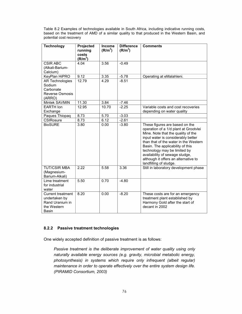
76
Table 8.2 Examples of technologies available in South Africa, including indicative running costs, based on the treatment of AMD of a similar quality to that produced in the Western Basin, and potential cost recovery
Technology Projected running costs (R/m
3)
Income (R/m
3)
Difference (R/m
3)
Comments
CSIR ABC (Alkali-Barium-Calcium)
4.04 3.56 -0.49
KeyPlan HiPRO 9.12 3.35 -5.78 Operating at eMalahleni. AR Technologies Sodium Carbonate Reverse Osmosis (ARRO)
12.79 4.29 -8.51
Mintek SAVMIN 11.30 3.84 -7.46 EARTH Ion Exchange
12.95 10.70 -2.25 Variable costs and cost recoveries depending on water quality
Paques Thiopaq 8.73 5.70 -3.03 CSIRosure 8.73 6.12 -2.61 BioSURE 3.80 0.00 -3.80 These figures are based on the
operation of a 1/d plant at Grootvlei Mine. Note that the quality of the input water is considerably better than that of the water in the Western Basin. The applicability of this technology may be limited by availability of sewage sludge, although it offers an alternative to landfilling of sludge.
TUT/CSIR MBA (Magnesium-Barium-Alkali)
2.22 5.58 3.36 Still in laboratory development phase
Lime treatment for industrial water
5.50 0.70 -4.80
Current treatment undertaken by Rand Uranium in the Western Basin
8.20 0.00 -8.20 These costs are for an emergency treatment plant established by Harmony Gold after the start of decant in 2002
8.2.2 Passive treatment technologies
One widely accepted definition of passive treatment is as follows:
Passive treatment is the deliberate improvement of water quality using only
naturally available energy sources (e.g. gravity, microbial metabolic energy,
photosynthesis) in systems which require only infrequent (albeit regular)
maintenance in order to operate effectively over the entire system design life.
(PIRAMID Consortium, 2003)

77
Many passive systems, especially those treating acidic waters, utilise one or more
materials that would normally be classified as ‘waste products’. These include materials
from industrial processing and farming practises that, in most cases, can be locally
sourced, thereby reducing transport costs.
Although by definition passive treatment systems require little or no input of energy and
only infrequent interventions, it is the opinion of this study that the majority of passive
treatment systems (permeable reactive barriers, constructed wetlands) require
maintenance, where the frequency depends on the system and the environmental
conditions.
The passive treatment method uses a treatment system (such as constructed wetlands,
diversion wells containing crushed limestone, or open ditches filled with limestone) that
employs naturally occurring chemical and biological reactions to minimise AMD with little
maintenance (EPA, 2008). Passive remediation systems, unlike active systems, ideally
require little or no input of energy or reactive materials after initial installation, only
infrequent monitoring. They potentially provide the long-term solution to AMD, although
their success has been limited in cases where excessive volumes, high iron loadings or
excessively low pH values are encountered (pers. comm. P Younger). Passive treatment
on its own is therefore unlikely to offer a sustainable solution to the large volumes of
AMD encountered in the Witwatersrand.
8.2.3 In situ treatment technologies
In situ treatment of mine drainage can be undertaken in many different ways and
configurations. Typically this involves the introduction of alkaline material into the mine
water body, which can be highly effective in open cast mines, as has been demonstrated
in a number of closed brown coal-mining operations in Germany, and the spreading of
alkaline material across impacted mine land and mine water. Neither of these options is
necessarily of relevance to the large underground mine voids of the Witwatersrand,
where the scale of operations, both laterally and vertically, the lack of access points to
the flooded mine voids and the difficulty of ensuring distribution of the alkaline material
throughout the affected water body will probably prevent effective application of these
techniques. The possibility of neutralising water within a pumping shaft before pumping
and the settling of the precipitates formed within the mine void has been suggested and
needs to be investigated further.
Permeable reactive barriers (PRBs) offer an approach for the passive interception and in
situ treatment of AMD-impacted groundwater. The reactive materials, which incorporate
various forms of organic carbon, promote microbially mediated sulphate reduction, the
generation of hydrogen sulphide, and the subsequent precipitation of sparingly soluble
iron and other metals, such as Cd, Ni, Co, Cu, Zn or As sulphide minerals. These
methods may well be used in the management of localised seepage plumes from mine
residues that contaminate shallow groundwater.

78
8.3 CONCLUSIONS
Currently two plants are treating AMD to potable quality in South Africa at full scale.
These are, however, not financially self-sustaining. This is similar to the experience
internationally that has shown that AMD treatment is unlikely to be financially self-
sustaining. The costs of this treatment are estimated at around R11 per cubic metre, with
a capacity of treating 20 Ml/d (20 000 m3/d) at each plant, including amortisation of the
capital costs of the plant (several hundred million Rand) over the projected 20 year
design life of the plant. This is not economically self-sustaining and relies on a subsidy
from the mining companies. Therefore, it is foreseen that there will be a shortfall between
the cost of clean water produced in a plant and the revenue recoverable from the sale of
water. Some of the water treatment methods identified can recover further costs via the
sale of other by-products, such as gypsum, sulphur, sulphuric acid, explosives and
fertilisers. The remaining shortfall may be made up using the Waste Discharge Charge
System and water use charges; however, care needs to be taken to ensure that the
costs of pollution by historical mining activities are not unfairly passed on to other water
users.
Because the recorded water qualities of the different basins vary so much, it is not
possible to recommend one single treatment method suitable for all types of mine water.
Mine water can be acidic or neutral, have high or low metals content, have high or low
sulphate and these characteristics determine which treatment methods are appropriate.
Furthermore, it is possible that water quality in the mine voids will improve over time,
given proper water management. A suite selected from the available technologies may
therefore be needed. The quality of the water to be treated will also strongly influence the
treatment costs.
Historically water discharged by the mines was only treated to neutralise low pH and
remove metals. For the management of the current crisis, this level of treatment should
be considered acceptable, as it will lead to a situation that is no worse than the pre-
existing conditions. However, in the medium to long term the salts associated with mine
water discharges will need to be removed from river systems.

79
CHAPTER 9. EXPLORING POSSIBLE INVOLVEMENT OF THE PRIVATE
SECTOR
9.1 GOVERNANCE OPTIONS FOR AMD MANAGEMENT
Governance options for AMD management may be conceptualised in terms of the table
below. The table also shows indicative advantages and disadvantages with regard to the
respective options.
9.2 INTERNATIONAL EXPERIENCE
The South African mining industry is one of the most developed in the world
(Organisation for Economic Cooperation and Development, 2002) and therefore has an
important role to play in global AMD management. Such a role would be facilitated by an
up-to-date comparative analysis of international experience, taking into consideration
aspects such as the development ranking (United Nations Development Programme,
2009), economic significance of the mining sector, as well as the extent of potential AMD
for the countries involved.
9.2.1 United States
In the United States of America (which has an HDI5 rank of 13), the Comprehensive
Environmental Response Compensation and Liability Act (CERCLA 1980) is used by the
Environmental Protection Agency (EPA) to locate, investigate and clean up abandoned
hazardous waste sites. The policy involves that Potentially Responsible Parties (PRPs)
carry the cost, except where these cannot be located or cannot afford to carry the cost,
when the EPA undertakes the clean-up using a trust fund (the so-called Superfund). The
balance of the trust fund has varied over time, largely depending on the government’s
ability to collect taxes to support the Superfund programme. The changing composition
of the fund over time (United States Government Accountability Office, 2008) might allow
insight into potential funding mechanisms for addressing South African AMD.
Where abandoned mines on government land are determined to need rehabilitation and
reclamation, these are addressed, using a risk-based system, with funding provided by
the coal-mining industry in terms of 1977 legislation (Bureau of Land Management,
undated).
9.2.2 Canada
Canada has an HDI rank of 4. The environmental legacies in respect of orphaned mines
are the responsibility of the State. However, in some cases, partnerships with the private
5 The Human Development Index (HDI) is a composite index reflecting real per capita income, life
expectancy and education. According to the United Nations Development Programme (UNDP) (6), in 2009
Norway was ranked 1, South Africa was ranked 129 and Niger was ranked 182. HDI ranking of countries
would give a sense of competition for State funding in countries.

80
sector (e.g. the Lynn Lake project in Manitoba) were addressed through an agreement
between government and relevant parties.
9.2.3 Zambia
In a 2002 study it was found that Zambia, which has an HDI ranking of 164 (United
Nations Development Programme, 2009) is the most dependent of African countries on
its mining industry, predominantly copper-cobalt mining (Organisation for Economic
Cooperation and Development, 2002). At the time of privatisation of Zambian
Consolidated Copper Mines (ZCCM) in the late 1990s, the mature environmental liability
was passed on to the government as the opinion was that new owners should not be
held responsible for damage they did not cause. This is confirmed in agreements
between the new owners and government, which allow for delayed compliance with
environmental plans, and referral of non-compliance disputes to a nominated expert.
With respect to past environmental legacy, an NGO in a joint effort with government,
ZCCM and the World Bank as financing institution, has drawn up a US $50 million
Copperbelt Environmental Programme.
9.3 CONCLUSIONS AND RECOMMENDATIONS REGARDING PARTNERSHIP
WITH THE PRIVATE SECTOR
National and international practices indicate that private sector initiatives are unlikely to
be economically sustainable without major financial subsidies.
Two options have been identified:
• The State will fund and operate measures to manage AMD in the Western,
Central and Eastern Basins via one or more of its agencies. In the short term, the
mining industry is expected to contribute some of the costs. In the medium to long
term the country should also explore the viability of an environmental levy on all
operating mines to fund the environmental legacies of the mining industry,
including the management of acid mine drainage. Funding could also be sourced
using raw water tariffs and the Waste Discharge Charge System
• Allowing private sector/entrepreneurs to treat acid mine drainage and sell to the
market. This will most likely require a subsidy from the State.

81
Table 9.1. Governance options for AMD management
Option Advantages Disadvantages Selected international examples Viability
State funds and operates
the project through one of
its entities
Control by the State
Cost of capital lower
Funding burden on
State
Lack of State
management capacity
and skills
Germany
Japan
Yes
Individual mining
companies fund the
rehabilitation programme
and are held responsible
to treat the water —
applying ‘polluter pays’
principle
‘Polluter pays’
principle adhered to
Incentive to prevent
future pollution
Proving and enforcing
liability will be costly
and time consuming —
difficult to apportion
liabilities
Difficult to manage
regionally
Practised for currently operating mines
in most mining countries
Unlikely to be
effective as most
mines are not
operative in the
priority areas

82
Option Advantages Disadvantages Selected international examples Viability
Collective responsibility of
the mining industry via a
voluntary fund
Reduced burden on
individual companies
Economies of scale
could protect
vulnerable sectors
Difficult to manage and
coordinate
Governance burden of
collecting and
distributing revenue
Potential for some
mines to be reluctant to
contribute to the fund
Ethics of spreading
burden among all
companies
Possible disincentive to
some companies to
reduce pollution
Not aware of a country employing such
a scheme — further investigations need
to be done
A contribution is
possible in the short
term but this will not
guarantee long-term
sustainability

83
Option Advantages Disadvantages Selected international examples Viability
Collective responsibility of
the mining industry via
taxes and levies
Easier to coordinate
and manage
Lengthy legislative
process
Reduced burden on
individual companies
Economies of scale
could protect
vulnerable sectors
Ethics of spreading
burden among all
companies
Possible disincentive to
some companies to
reduce pollution
United States of America Yes
Entrepreneurs are
engaged to treat AMD and
sell to market and the
water system
Financial risk carried
mostly by private
sector
Leveraging private
sector efficiencies
could shorten
implementation time
Return on investment
measured only in
private sector financial
terms
Low level of State
control
State faces risk in case
of failure
At eMalahleni in South Africa, a private
concern has been appointed to treat
water from a number of coal mines and
sell it to the local metro council. While
this is technically successful, it is not
financially sustainable, requiring
subsidisation by the mining companies
involved
Yes, but will require
subsidies from the
State
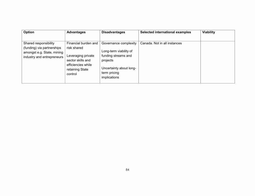
84
Option Advantages Disadvantages Selected international examples Viability
Shared responsibility
(funding) via partnerships
amongst e.g. State, mining
industry and entrepreneurs
Financial burden and
risk shared
Leveraging private
sector skills and
efficiencies while
retaining State
control
Governance complexity
Long-term viability of
funding streams and
projects
Uncertainty about long-
term pricing
implications
Canada. Not in all instances

85
CHAPTER 10. CONCLUSIONS AND RECOMMENDATIONS
10.1 CONCLUSIONS
Recent media reporting has highlighted issues related to acid mine drainage (AMD) in
the gold-mining areas of the Witwatersrand. Government has responded to this by
forming the IMC to address the issue. This committee has, in turn, appointed a team of
experts to assess the situation and make recommendations regarding a prudent course
of action in this regard.
10.1.1 Occurrence of acid mine drainage in South Africa
Acid mine drainage is formed by a series of chemical reactions that occur between
water, sulphide minerals, such as pyrite and oxygen, which combine to form an iron-rich
sulphuric acid solution. This will occur in any area where sulphide minerals are exposed
to air and water in the environment, but is most prevalent in areas where mining has
exposed fresh sulphide minerals to the elements. AMD is known to occur in a number of
areas in South Africa, most notably the Witwatersrand Gold Fields, the country’s various
Coal Fields and the O’Kiep Copper District.
10.1.2 Assessment of work done by various institutions
A number of South Africa’s statutory institutions have done significant research on the
nature and extent of the AMD problem in the country and proposed a number of
measures to mitigate the problem. This research includes measures to better manage
water and prevent AMD formation, as well as technologies to treat AMD. Key institutions
in this regard have been the CGS, CSIR, Mintek, the WRC and the DWA. In the opinion
of the Team of Experts, sufficient information exists to be able to make informed
decisions regarding the origins of the mine water, potential impacts, management
strategies, treatment technologies, etc. The large body of research conducted on the
Witwatersrand Gold Fields provides sufficient background information to be able to
predict impacts and direct the data collection and monitoring necessary to minimise any
uncertainties that exist in the current predictive models, although some research is still
needed to minimise uncertainties and to develop sustainable solutions for the medium to
long term.
10.1.3 The current situation in the Witwatersrand Gold Fields
The nature of the gold deposits in the Witwatersrand has led to the formation of large
complexes of interconnected mines, which are often referred to as 'basins'. As a
consequence, as mines within a basin stop operating and stop pumping water from their
underground workings, this water flows into adjacent mines, increasing the volume of
water which the adjacent mines need to pump. Eventually the last mine in a basin will
cease operations and stop pumping, after which the underground workings will flood and
the water level will continue to rise until it reaches the surface and decants from a low-
lying shaft or other pathway(s) to the surface. Unfortunately the water that floods the

86
basins is of poor quality, largely owing to reactions with sulphide minerals in the surface
and underground environments.
The water entering the underground workings comes from a number of sources:
• Direct recharge by rainfall falling onto open mine workings, stopes and old
surface workings
• Groundwater, recharged by rainfall, which seeps into the workings owing to the
disturbance of natural groundwater conditions by mining
• Surface streams that lose water directly to mine openings and to the shallow
groundwater systems above zones of shallow undermining and historical surface
operations
• Where open surface workings exist, these often connect directly to the
underground workings and provide a pathway for water to flow from the surface
to the mine void
• Mine residues, in particular tailings, are seen as areas of enhanced seepage,
where the volume of water entering the mine void is relatively high and the water
is typically of poor quality
• Losses from the water, sewage and stormwater reticulation systems are also a
possible source of water in the zone where these cross old shallow mine
workings.
On entering the mine voids, water comes into contact with sulphide minerals, reacting to
produce AMD. This interaction will be particularly prevalent in the unsaturated zone
between the surface of the water in the mine void and the surface where air flows freely
through the mine void.
Decant has already taken place in the Western Basin, where the decant of AMD to the
surface has had a devastating effect on the ecology in the areas immediately
downstream of the decant and has degraded streams and groundwater which feed the
Cradle of Humankind World Heritage Site.
In the Central Basin no pumping has taken place since 2008 and the water level in the
underground workings is rising steadily at an average daily rate of 0.59 m per day. The
water level is monitored continuously by the CGS and was measured at 516m below
surface on 18 November 2010.
In the Eastern Basin, one mine, Grootvlei Mine, is still operating and controls the water
level by pumping from 700 m below surface. Unfortunately, Grootvlei Mine’s financial
position is not secure, placing the pumping of this water and its subsequent treatment at
risk.

87
Other areas in the Witwatersrand Gold Fields — The Free State, KOSH, Far West Rand
and Evander Gold Fields — still have significant numbers of mines active, which
continue to pump and treat water and prevent the development of immediate problems.
10.1.4 Prioritisation of areas for attention
The Western, Central and Eastern Basins are regarded as priority areas owing to the
lack of adequate measures to manage and control the problems related to AMD, the
urgency of finding solutions before problems become more critical and the proximity of
these problem areas to densely populated areas. The situation in these areas can be
regarded as in need of critical intervention in the short term.
10.1.5 Re-appraisal of risks in the priority areas
Risks have been appraised looking at those attributable to the flooding of the mine voids
and those attributable to the poor quality of water in the flooded voids.
Risks identified related to mine flooding are:
• Contamination of shallow groundwater resources
• Geotechnical impacts, which are most likely to be experienced in low-lying areas
directly affected by rising water levels
• Increased seismic activity.
Risks identified owing to decant are:
• Serious negative ecological impacts on the receiving environments
• Local and regional impacts on the Vaal and Crocodile River Systems that could
affect fitness-for-use of the receiving water resources to downstream water users.
AMD will aggravate an already upward trend associated with salinisation of the
receiving river systems, necessitating additional dilution releases to be made and
subsequently risking water supply security within the integrated Vaal River
System.
Risk management measures are proposed that will minimise these impacts. These are
discussed in the recommendations presented below.
10.1.6 Exploring models for cooperation with the private sector
A number of models have been identified for private sector involvement in the
implementation of solutions. These represent a continuum between an entirely State
funded programme operated by a State entity and the implementation and funding of the
entire programme by private entities.

88
Local and international experience suggests that the pumping and treatment of AMD
from the Witwatersrand is unlikely to be financially self-supporting. Various funding and
cost-recovery models exist, including a model where all contributors to salt-loading of the
Vaal River System may contribute towards the funding of such a shortfall through a
system of waste discharge charges in terms of the National Water Act, 1998 (Act No. 36
of 1998). Financial viability may also be realised through the introduction of an additional
tariff component to the tariffs charged on raw water use (comparable to the financing
model applying to the Lesotho Highlands Water Project). Subsidies from the State
treasury is another possibility.
A feature of some of the international examples studied is the use of an environmental
levy imposed on the mining industry to help cover the cost of dealing with the legacies of
historical mining activities where no financial provision has been made for remediation
and long-term environmental management.
10.2 RECOMMENDATIONS
In order to adequately address the risks identified in the priority areas, a number of
options have been identified and assessed and the following short-, medium- and long-
term measures are recommended:
10.2.1 Prevention of decant — pumping to ensure that water levels are maintained
at or below the Environmental Critical Levels
It will be necessary to pump water from the mine voids in all three priority areas.
Environmental Critical Levels (ECL) — defined as the highest level to which the water in
the mine void can be allowed to rise without having negative environmental impacts,
taking both surface and groundwater into account — have been identified in all three
priority areas. These levels are presented in Table 10.1.
Table 10.1. Environmental Critical Levels for the priority areas
Basin ECL Rationale
Western 150 m below decant level Protection of the dolomitic
groundwater resources in
the Cradle of Humankind
World Heritage Site
Central 150 m below surface at the South West Vertical
Shaft of ERPM; however, it is recommended that
a level 50 m below this be selected to protect the
underground operation at Gold Reef City which
receives as many as 3 000 tourists per day.
Pumping from a deeper level would be necessary
to protect the underground resources of interest
to new entrants to the mining industry in the area.
Protection of the dolomitic
aquifer to the south of
Boksburg

89
Basin ECL Rationale
Eastern 400 m below surface, measured from the likely
decant point at Nigel
Prevention of the rise of
mine water into the
overlying dolomitic aquifer
It is therefore recommended that pumping infrastructure is established in the Western
and Central Basins as a matter of urgency to manage the flooding of these basins and
eliminate the risks associated with the uncontrolled decant of AMD.
In the Eastern Basin, current pumping infrastructure must be maintained to allow access
to the underground workings. If necessary, State assistance to Grootvlei Mine must be
continued and possibly increased to allow pumping to continue and the infrastructure to
be maintained.
In the case of the Western Basin, water will need to be pumped from the mine void to
lower the level from the current level where water decants to the surface to the ECL.
In all cases, water will need to be pumped at a rate that balances the ingress of water
into the mine workings. The estimates of the required pumping capacities are based on
records of what was historically pumped from the basins during periods of active mining.
Basin Required pumping
capacity (an additional
safety factor will probably
need to be added)
Information sources
Western 40 Ml/d Compilation of flow
estimates and
measurements, taking into
account the need to lower
the water level in the Basin
from its current level to the
ECL
Central 60 Ml/d Scott (1995) presents an
average volume based on
pumping figures between
1952 and 1959

90
Basin Required pumping
capacity (an additional
safety factor will probably
need to be added)
Information sources
Eastern 108 Ml/d Current maximum pumping
rate required to manage
large inflows triggered by
storm events (pers. comm.
J Botha — Grootvlei Mine,
2010)
10.2.2 Ingress control — reduction in the rate of mine flooding and the volumes
required to be managed
The Best Practice Guidelines of the DWA for Mine Water Management prescribe a
hierarchy of actions in mine water management. The prevention of impacts is at the top
of this hierarchy. Research undertaken by the CGS has identified areas in the Western,
Central and Eastern Basins where measures can be implemented to reduce the ingress
of water into the mine void. This will reduce the volume that needs to be pumped from
the mine void and treated, and consequently will reduce the costs of water management
in the medium to long term. It is therefore recommended that the programme to
implement these measures be undertaken.
In addition to the prevention of ingress, opportunities have been identified in the Eastern
Basin where clean groundwater, which would otherwise have entered the mine void and
become polluted, can be abstracted before it enters the underground workings, providing
a source of clean water. It is recommended that this be fully investigated and
implemented.
Both of these measures will have a positive impact at a regional level, increasing the
supply of clean water and reducing the pollution load on the relevant catchments.
The implementation of some of the ingress prevention measures could take several
years to complete, allowing for the regulatory processes such as EIAs, Water Use
License Applications and concluding agreements with land owners. During this period it
will be necessary to pump and treat a greater volume of water than will be required after
the measures have been implemented. This will be taken into account in the design of
pumping and treatment systems.
10.2.3 Water quality management
The water pumped from the mine voids will initially be of a poor quality and will require
treatment before it can be discharged to river systems or utilised. Initially, treatment can
be limited to neutralisation and the removal of metals from the water prior to discharge

91
into river systems. This will result in conditions which are the same as those prevalent
during the period of active mining. However, this does not represent a sustainable
solution in the long term, as the salt loads in the affected river systems are already high.
In the medium to long term, the removal of the saline mine water discharge streams from
the river systems must be considered, as part of a larger strategy looking at a range of
pollution sources.
In the very long term it can be expected that water quality in the mine void will improve
as oxygen is excluded from the flooded voids and available contaminants are flushed
from the system. In this case, water levels may be allowed to recover to their natural
levels, provided that this does not cause uncontrolled flooding problems or unintended
geotechnical impacts.
10.2.4 Monitoring
The success of the proposed programme can only be verified via detailed monitoring of
the water in the mine voids and the affected environments.
The investigations undertaken in the identification of treatment options have identified
serious shortcomings in the current monitoring of water quality and, in particular, flow in
the areas downstream of mining activities. These shortcomings need to be identified and
remedied so that the required medium- to long-term strategies can be optimised for AMD
management, particularly where this impacts on the Vaal River System.
It is important to continue with seismic monitoring in the short to medium term in order to
gather information and data on the frequency of occurrence and size and location of the
seismic events. This is especially important for identifying whether the events are
restricted to the immediate surroundings of the mining areas or whether they are
propagating away, hence implying that geological structures at some distance from the
mining areas are at risk of being activated. The information gathered over time would
also be useful for microzonation studies. This would highlight the changes in seismic risk
that the infrastructure within urban areas surrounding the Central Basin would be
exposed to.
It is recommended that a multi-institution monitoring committee be established to
facilitate the implementation of the required monitoring and assessment programmes.
Monitoring will show if there are significant changes in the quality of mine water that may
have an impact on future management strategies. Monitoring results may also identify
additional remedial measures required in the future.
10.2.5 Addressing other AMD sources
The flooded mine voids are not the only source of AMD in the Witwatersrand. The
tailings and other waste materials generated by mining are also significant sources of
AMD. Unfortunately, the lack of a comprehensive flow monitoring network in the priority
areas precludes the quantification of these impacts. This highlights the need for

92
improved monitoring. Follow-up studies and remedial measures will also be required to
minimise the impacts of these AMD sources.
10.2.6 Further research to identify and optimise sustainable solutions in the
medium to long term
While immediate measures must be implemented in the short term, some areas of
uncertainty still exist that need to be resolved if sustainable medium- to long-term
solutions are to be implemented. Targeted research is required to address these areas
of uncertainty to ensure sustainability in the longer term. This conforms with international
experience, no country having sustainable solutions to all of its AMD-related problems,
and active research being pursued in a number of other countries.
10.2.7 Investigation of the feasibility of an environmental levy on operating mines
The implementation of an environmental levy to be paid by operating mines to cover the
costs of the legacies of past mining needs to be investigated and implemented, if
feasible.
10.2.8 Ongoing assessment and future actions
The recommendations in this report represent the start of a process. The aim of these
recommendations is to avert impending crises and stabilise the situation, as well as to
address current gaps in the understanding of the AMD problems in the priority areas and
their potential impacts on the environment. It is therefore envisaged that this process will
continue into the future, with the ongoing assessments being reported to the IMC
periodically.
The problems posed by AMD will have implications far into the future, with impacts likely
to continue for many years. The process of management of these impacts will therefore
need to continue, with ongoing assessments and adaptation as conditions change.

93
CHAPTER 11. ACTION PLAN
11.1 ACTION PLAN: SHORT TERM
11.1.1 Short-term interventions
11.1.1.1 Western Basin
Table 11.1. Actions and time frames for the Western Basin
Action Time frame
Construct a 20 Ml/d emergency
neutralisation plant to treat uncontrolled
decant to supplement current treatment
capacity
Commence immediately
Install pumping infrastructure to lower water
level in the mine void to the ECL and
maintain in the long term
2 years
Continuous monitoring of water levels, flow,
quality and profiles
Commence immediately
Continuous prevention of ingress Commence immediately
Continuous monitoring of seismic events Commence immediately and continue until
stability is achieved
Continuous monitoring of subsidences Commence immediately
Stakeholder engagement After meeting of Ministers

94
11.1.1.2 Central Basin
Table 11.2. Actions and time frames for the Central Basin
Action Time frame
Pump and treat the water:
• Assess the viability of refurbishing
the existing treatment plant at
ERPM
• Determine the optimal placement of
pumps
• Negotiate cost sharing with other
stakeholders within the basin, in
particular Central Rand Gold
Commence immediately, to have all
requirements in place before the water
rises above the ECL or deeper level that
will allow new mining to commence
Commence real-time monitoring (levels,
quality and flows) — systems to be
installed for the entire Witwatersrand
Basin
Commence immediately
Prevention of ingress (construction of
canals and other measures)
Commence immediately
Continuous monitoring of seismic events
and production of microzonation risk maps
Commence immediately and continue until
stability is achieved
Commence research to optimise medium-
to long-term solutions, looking at:
• Funding mechanisms
• Institutional models
• Legal issues
• Communications strategies
• Engineering and cost-benefit
studies
Commence immediately

95
Action Time frame
Stakeholder engagement — media
statement after meeting of Ministers and
public awareness
After meeting of Ministers
11.1.1.3 Eastern Basin
Table 11.3. Actions and time frames for the Eastern Basin
Action Time frame
Monitoring of pumping Commence immediately
Due diligence on the integrity of the
pumping infrastructure
Commence immediately
Consider issuing a directive to ensure
compliance with water license conditions
Immediate
Regular inspection of the integrity — mine
inspectors
Ongoing
Prevention of ingress (e.g. construction of
canals)
Commence immediately
Continuous monitoring of seismic events Commence immediately and continue until
stability is achieved
Continuous monitoring of subsidences Commence immediately
Real-time monitoring (levels, quality and
flows) — systems to be installed for the
entire Witwatersrand Basin
Commence immediately
Stakeholder engagement — media
statement after meeting of Ministers and
public awareness
Time frame

96
11.2 ACTION PLAN: MEDIUM TO LONG TERM
11.2.1 Medium- to long-term interventions
This report has identified the short-term actions that are required to address current
crises and to create a situation that is equivalent to the status quo during the period of
active mining of the Witwatersrand Gold Fields. While this situation has been tolerated
for the past century, it is not ideal and the continued salinisation of river systems will
place undue stress on water resources in the future. A holistic approach to water quality
management, taking the impacts of the mine discharges into account in the context of
large salt loads emanating from other point and diffuse sources, will need to be
addressed as a matter of priority, and the necessary feasibility studies will need to be
initiated immediately.

97
CHAPTER 12. BUDGET
12.1 BUDGET: PUMPING COSTS TO MAINTAIN WATER LEVELS
Estimates for the costs of pumping water from the Western and Central Basins have
been obtained by the DWA, as follows:
12.1.1 Capital costs
Item Western Basin Central Basin
Pumps 1 pump with a capacity
to pump 40 Ml/d from
150 m
R 1.8 million 3 pumps with a capacity to
pump 20 Ml/d each from 250
m
R 3 million
Pump
installation
R2 million Dependent on whether water
is pumped from 1, 2 or 3 sites
R 2–6 million
12.1.2 Operating costs
The operating costs assume an electricity price of R1,50 per kW/h and the availability of
a 6.6 kV feed for the pumps.
Item Western Basin Central Basin
Running costs for
pumps
R10 million per
annum
R15 million per
annum
12.2 BUDGET: TREATMENT COSTS FOR NEUTRALISATION PLANTS
Estimated treatment costs for the construction and operation of limestone/lime
neutralisation plants have been provided by Prof. J Maree of Tshwane University of
Technology.
12.2.1 Capital costs
Western Basin Central Basin
Unit Cost
(per Ml/d)
Required
Capacity
(Ml/d)
Cost Required
Capacity
(Ml/d)
Cost
Notes
R 2 million 20 R 40 million 60 R 120 million Assumes that the
existing plant in the
Western Basin will
continue operations
and that the current
infrastructure at
Grootvlei Mine will be
maintained.
Does not include the

98
potential reductions
in volume which
could be brought
about by
implementing ingress
prevention measures
12.2.2 Operating costs
Western Basin Central Basin
Item Unit cost (/Ml) Required capacity (Ml/d)
Cost (per annum)
Required capacity (Ml/d)
Cost (per annum)
Notes
Chemical
cost
R 1 200 20 R 8 760 000 60 R 26 280 000
Electricity R 100 20 R 730 000 60 R 2 190 000
Labour R 100 20 R 730 000 60 R 2 190 000
Total
running
cost
R 1 400 20 R 10 220 000 60 R 30 660 000 Assumes
that the
mining
companies
in the
Western
Basin
continue to
treat water.
Does not
include the
potential
reductions in
volume that
could be
brought
about by im-
plementing
ingress
prevention
measures
12.3 BUDGET: MAINTENANCE OF THE PUMPING AND TREATMENT
INFRASTRUCTURE IN THE EASTERN BASIN
Current costs reported by Grootvlei Mine are R3.7 million per month, including
maintenance. This figure should be taken as a working budget, with additional costs
likely to restore the pumping infrastructure to full functionality. These costs will be
quantified as part of the proposed inspection of the infrastructure at Grootvlei Mine.

99
12.4 IMPACT OF THE REDUCTION OF WATER INGRESS ON THE COSTS OF
PUMPING AND TREATMENT
Reducing water ingress will reduce the eventual pumping and treatment costs owing to
the smaller volumes of water required to be pumped and treated. If water ingress
prevention measures can be implemented before pumping and treatment is required, this
could result in savings on the plant required, in particular the construction costs of
treatment plants. This will only be practicable if the ingress prevention measures are
implemented before the water in the Central Basin reaches the critical level. In the
Western and Eastern Basins, ingress prevention will reduce the current impacts and
make the situation considerably easier to manage.

100
12.5 BUDGET: RECOMMENDED INGRESS PREVENTION MEASURES
Basin Project outcome Proposed solution Critical
immediate
interventions
Longe- term
interventions
Regulatory
requirements
(if applicable)
Cost estimate
– critical
immediate
interventions
Cost estimate
– longer-term
interventions
Assumptions
Western Ingress prevention Feasibility studies for
ingress prevention
measures
Assess identified
ingress
sites/areas,
identify solutions
Implement
ingress
prevention
EIA, Water
License and
requirements of
relevant road
authority
R 1 250 000 TBD Interventions will be relatively limited,
canalisation of portions of the
Wonderfontein Spruit may be
identified as a required measure
Central Ingress prevention Canal construction at
sites where surface
streams cross
undermined ground –
Boksburg canal
Assess ingress
and feasibility of
canal construction
Canal
construction
EIA, WUL,
indemnities,
etc.
R 121 061 582
R 0 Canal length = 7 km
80% of canal with impermeable lining
(HDPE)
20% of canal with permeable lining
(grass)
Central Ingress prevention Canal construction at
sites where surface
streams cross
undermined ground –
City Deep to
Consolidated Mine
canal
Assess ingress
and feasibility of
canal construction
Canal
construction
EIA, WUL,
indemnities,
etc.
R 75 956 438
R 0 Canal length = 4 km
80% of canal with impermeable lining
(HDPE)
20% of canal with permeable lining
(grass)
Eastern Ingress prevention Cowles dam ingress
management
Eastern: Mine
sediments and divert
flow around the dam
Assess
SAPPI/Golder
study, commence
engineering
feasibility
Obtain
authorisations
and divert
flow/drain dam
EIA, Water
License
R 299 683 R 40 653 662 Demolish existing concrete outlet
structure
Drain dam
Construct 2.75 km long temporary
diversion canal through empty dam
Construct 2.75 km long HDPE plastic-
lined canal through empty dam

101
Basin Project outcome Proposed solution Critical
immediate
interventions
Longe- term
interventions
Regulatory
requirements
(if applicable)
Cost estimate
– critical
immediate
interventions
Cost estimate
– longer-term
interventions
Assumptions
Eastern Ingress prevention South: Blesbok Spruit
ingress management
Eastern: Unblock or
enlarge culverts, divert
flow over certain
portions
Unblock culverts,
assess need to
enlarge culverts
Enlarge
culverts if
needed
To be
determined in
cooperation
with relevant
road authority
(municipal,
provincial,
national)
R 343 750 R 0 Immediate:
Clear two bridges.
No long-term solution suggested, as
bridges already exist.
Eastern Ingress prevention Central Blesbok Spruit
ingress management
Eastern: Unblock or
enlarge culverts, divert
flow over certain
portions
Unblock culverts,
assess need to
enlarge culverts
Enlarge
culverts if
needed
To be
determined in
cooperation
with relevant
road authority
(municipal,
provincial,
national)
R 384 766 R 5 449 219 Immediate:
Clear one bridge and one pipe culvert
(10 pipes).
Long term:
Replace pipe culvert with a bridge.
Eastern Ingress prevention North Blesbok Spruit
ingress management
Eastern: Unblock or
enlarge culverts, divert
flow over certain
portions
Unblock culverts,
assess need to
enlarge culverts
Enlarge
culverts if
needed
To be
determined in
cooperation
with relevant
road authority
(municipal,
provincial,
national)
R 183 594 R 5 843 750 Immediate:
Clear three piped culverts (6,4 and 6
pipes respectively).
Long-term solution:
Replace all three pipe culverts with
bridges
Eastern Ingress prevention Van Rhyn (ponding)
ingress management
Eastern: Repair
channel that will
remove the dam to
reduce ponding
significantly
Repair channel Repairs should
not require
authorisation
from regulators
R 34 205 241 R 0

102
Basin Project outcome Proposed solution Critical
immediate
interventions
Longe- term
interventions
Regulatory
requirements
(if applicable)
Cost estimate
– critical
immediate
interventions
Cost estimate
– longer-term
interventions
Assumptions
Eastern Ingress prevention Van Rhyn (direct
runoff) ingress
management
Eastern: Close cracks
and stabilise openings
Confirm ingress
volumes,
feasibility/costing
study
Crack sealing,
grouting, etc.
Should require
no more
authorisation
than hole
closures –
landowner’s
consent
R 68 400 R 6 840 000 Close one large shaft.
Close two small vents
Close 200 m of cracks
Eastern Ingress prevention Largo ingress
management
Eastern: Close
openings
Confirm ingress
volumes,
feasibility/costing
study
Hole sealing,
grouting. etc.
Should require
no more
authorisation
than hole
closures –
landowner’s
consent
R 148 350 R 49 450 000 Use DC to consolidate sinkholes,
then seal with fill over top
Assume 180,000m² of DC
Assume 800,000m³ of earthworks
Eastern Ingress prevention Gravelotte (opencast
mine, open shaft)
ingress management
Eastern: Closing of
shaft, closing costs for
opencast mine too
high to be feasible,
construct upstream
bunds
Confirm ingress
volumes,
feasibility/costing
study
Necessary civil
works
Should require
no more
authorisation
than hole
closures
R 44 700 R 1 788 000 Close three small inclined openings
Close two small vents.
Close 10 small openings into
workings

103
Basin Project outcome Proposed solution Critical
immediate
interventions
Longe- term
interventions
Regulatory
requirements
(if applicable)
Cost estimate
– critical
immediate
interventions
Cost estimate
– longer-term
interventions
Assumptions
Eastern Ingress prevention Leeupan ingress
management
Eastern: Reduce the
grey water entering
the pan by collecting
the water and
discharging the water
to the sewage
reticulation network,
Line pan
Assess ingress
volumes, alert
authorities –
municipality/DWA
of unauthorised
grey water
discharges
Determine the
need for lining
of the
pan/other
engineering
intervention
Lining of pan
will require EIA,
WUL scoping
R 5 682 951 R 44 662 038 Immediate:
Grey water from informal settlement
collected in pump station sump and
pumped via pipeline to municipal
sewage system network, connection
point assumed to be 600 mm away.
Long term:
Pan drained initially by pumping
Pan lined with geosynthetic clay liner
Pumps installed at low point of liner to
pump inflow into pan to nearest
stream, assumed to be 2 km away
Eastern Ingress prevention New-Kleinfontein
canal repair
Repair channel Repairs should
not require
authorisation
from regulators
R 10 297 172 R 0 0.75 km of canal to be repaired
Repairs to be done by demolition of
existing concrete and install HDPE-
lined riprap canal
Central Ingress prevention Canal construction at
sites where surface
streams cross
undermined ground –
DRD Canal
Assess ingress
and feasibility of
canal construction
Canal
construction
EIA, WUL,
indemnities etc.
R 1 039 950 R 274 546 817 Canal across ingress area 1 = 3.5 km
Canal across ingress area 2 = 8.5 km
Central Ingress prevention Canal construction at
sites where surface
streams cross
undermined ground –
Boksburg canal
Assess ingress
and feasibility of
canal construction
Canal
construction
EIA, WUL,
indemnities etc.
R 420 353 R 121 061 582 Canal length = 7 km
80% of canal with impermeable lining
(HDPE)
20% of canal with permeable lining
(grass)

104
Basin Project outcome Proposed solution Critical
immediate
interventions
Longe- term
interventions
Regulatory
requirements
(if applicable)
Cost estimate
– critical
immediate
interventions
Cost estimate
– longer-term
interventions
Assumptions
Central Ingress prevention Canal construction at
sites where surface
streams cross
undermined ground –
City Deep to
Consolidated Mine
canal
Assess ingress
and feasibility of
canal construction
Canal
construction
EIA, WUL,
indemnities,
etc.
R 263 738 R 75 956 438 Canal length = 4 km
80% of canal with impermeable lining
(HDPE)
20% of canal with permeable lining
(grass)

105
12.6 BUDGET: MONITORING
During their deliberations the Team of Experts identified a number of gaps in the current
monitoring regime for the three priority areas. A budget to address these gaps is
presented below.
Western Basin Central Basin Eastern Basin
Groundwater monitoring R 3 700 000.00 R 4 000 000.00 R 2 500 000.00
Shaft level monitoring R 240 000.00 R 400 000.00 R 320 000.00
Surface water quality monitoring R 100 000.00 R 250 000.00 R 125 000.00
Surface water flow monitoring installations R 1 500 000.00 R 6 500 000.00 R 2 250 000.00
Data compilation R 350 000.00 R 350 000.00 R 350 000.00
Seismic monitoring equipment R 750 000.00 R 1 500 000.00 R 1 000 000.00
Seismic monitoring R 500 000.00 R 1 000 000.00 R 500 000.00
Meteorological monitoring R 100 000.00 R 200 000.00 R 100 000.00
Capital costs R 3 940 000.00 R 9 900 000.00 R 4 370 000.00
Operating costs per annum R 3 300 000.00 R 4 300 000.00 R 2 775 000.00
Total R 7 240 000.00 R 14 200 000.00 R 7 145 000.00

106
CHAPTER 13. REFERENCES
Antrobus, E. S. A. (1986) Witwatersrand Gold – 100 years, The Geological Society of
South Africa.
ANZMEC. (1995) Baseline environmental guidelines for new and existing mines.
Australia and New Zealand Minerals and Energy Council (ANZMEC). Report 95.02,
March, Canberra.
Bureau of Land Management (undated) Abandoned Mine Lands Portal [cited 11 October
2010]. Available from http://www.abandonedmines.gov/aa.html.
Bureau of Land Management (2008)."Abandoned Mine Lands." from
http://www.blm.gov/wo/st/en/prog/more/Abandoned_Mine_Lands.2.html.
Canadian Institute for Environmental Law and Policy (2000).Mining’s many faces:
Environmental Mining Law and Policy in Canada. Toronto. Accessed at www.cielap.org.
Central RAND GOLD (2008) Media release – Central Rand Gold: Central Rand Gold
Awarded New Order Mining Right for South Africa’s Central Rand Gold Field Tenements.
Central Rand Gold Limited, 2 pp. Accessed 19 September 2008 at
http://www.centralrandgold.com/documents/press/Award%20of%20Mining%20Right.pdf
Coetzee, H., Wade, P.W. and Winde, F. (2002) Reliance on existing wetlands for
pollution control around the Witwatersrand gold/uranium mines of South Africa. Are they
sufficient? In Uranium in the aquatic environment: Uranium Mining and Hydrogeology III,
edited by B. J. Merkel, B. Planer-Friedrich and C. Wolkersdorfer. Freiberg: Springer
Verlag pp. 59-66.
Coetzee, H., Croukamp, L., Venter, J. and De Wet, L. (2005a) Contamination of the
Tweelopie Spruit and environs by water from the Western Basin decant point on
Harmony Gold’s property: Council for Geoscience, Pretoria, Report No. 2005-0148, pp.
28.
Coetzee, H., Erasmus, E., Van Wyk, N., Kwata, G. and Horstmann, U (2005b)
Preliminary investigation of a suspected ingress point in the Western Basin – Intersection
of the Wonderfonteinspruit with the Witpoortjie Fault: Department of Minerals and
Energy, Pretoria, Council for Geoscience Report No. 2005-0147, pp. 7.
Coetzee, H., Wade, P. and Winde, F. (2006) An assessment of sources, pathways,
mechanisms and risks of current and future pollution of water and sediments in the
Wonderfontein Spruit Catchment, Water Research Commission, WRC Report No.
1214/1/06, Pretoria: 202 p.
Coetzee, H., Van Tonder, D., Wade, P., Esterhuyse, S., Van Wyk, N., Ndengu, S.,
Venter, J. and Kotoane, M. (2007) Acid mine drainage in the Witwatersrand: Department
of Minerals and Energy, Pretoria, Council for Geoscience Report No 2007-0260, pp. 81.

107
Coetzee, H., Nengobela, N.R., Vorster, C., Sebake, D. and Mudau, S. (2008a) South
Africa's strategy for the management of derelict and ownerless mines. In: Mine Closure
2008: Proceedings of the third international seminar on mine closure, (A. Fourie, M.
Tibbett, I. Weiersbye and P. Dye, eds). Johannesburg: Australian Centre for
Geomechanics.
Coetzee, H., Singh, M. and Roux, R. (2008b) Risks related to the flooding of gold mines
in the Central Rand, West Rand and KOSH Gold Fields: Department of Minerals and
Energy, Pretoria, Council for Geoscience, Report No: 2008-0241, 21 pp.
Council for Geoscience (2004a) A strategic water management plan for the prevention
of water ingress into underground workings of the Witwatersrand mining basins. A
Geohydrological Model of the Florida Lake and Canal. Progress Report number 7, vol.
2. Unpublished Report, Council for Geoscience. Pretoria, 26 pp.
Council for Geoscience (2004b) A strategic water management plan for the prevention
of water ingress into underground workings of the Witwatersrand mining basins.
Progress Report number 9, vol. 1. Unpublished Report, Council for Geoscience. Pretoria,
221 pp.
Council for Geoscience (2004c) A strategic water management plan for the prevention of
water ingress into underground workings of the Witwatersrand mining basins: Progress
Report no 10, Volume 1. Witwatersrand Water Ingress Project, Department of Minerals
and Energy, Pretoria: 107 p.
Council for Geoscience (2005a) A strategic water management plan for the prevention
of water ingress into underground workings of the Witwatersrand mining basins.
Progress Report number 15. Unpublished Report, Council for Geoscience. Pretoria, 216
pp.
Council for Geoscience (2005b) A strategic water management plan for the prevention of
water ingress into underground workings of the Witwatersrand mining basins. A progress
report for the period 15 October to 14 December 2005. Volume 1, report No. 16
Council for Geoscience (2008) Strategic Water Management Plan for the Prevention of
Water Ingress into Underground Workings of the East Rand Basin — Witwatersrand
Mining Area: A summary for the work conducted during the period 2004–2006
Department of Minerals and Energy (2008a) Regional gold mining closure strategy for
the Witwatersrand Basin (Report prepared by D M van Tonder, H Coetzee, L K C
Strachan, T Mafanya, P W Wade, N Msezane, M G Kwata, M Roos, D Sebake, H
Mengistu, B Yibas, S Esterhuyse). Sustainable Development through Mining Project
Reports, Department of Minerals and Energy, Council for Geoscience Report No. 2008-
0179, Pretoria: 140 p.
Department of Minerals and Energy (2008b) Strategy for the Management of Mine Water
Ingress and Decant Problems in the Witwatersrand Gold Mining and KOSH Areas, South

108
Africa (report prepared by L K C Strachan), Council for Geoscience, unpublished,
Pretoria
Department of Minerals and Energy (2008c) Regional gold mining closure strategy for
the Witwatersrand Basin (Report prepared by D M van Tonder, H Coetzee, L K C
Strachan, T Mafanya, P W Wade, N Msezane, M G Kwata, M Roos, D Sebake, H
Mengistu, B Yibas, S Esterhuyse). Sustainable Development through Mining Project
Reports, Department of Minerals and Energy, Council for Geoscience Report No. 2008-
0179, Pretoria: 140 p.
Department of Minerals and Energy (2008d) Regional closure strategy for the Far West
Rand Gold Field. Open File Report Council for Geoscience
Department of Minerals and Energy Resources (2008e) Regional Mine Closure Strategy
KOSH (Klerksdorp, Orkney, Stilfontein, Hartbeesfontein) Gold Field. Open File Report
Council for Geoscience
Department of Water Affairs and Forestry (2006) Best Practice Guidelines for Water
Resource Protection in the SA Mining Industry, Series H: Best Practice Guideline H3:
Water Reuse and Reclamation, June 2006
Department of Water Affairs and Forestry (1996a) South African Water Quality
Guidelines (second edition), Volume 3: Industrial Use.
Department of Water Affairs and Forestry (1996b) South African Water Quality
Guidelines (second edition), Volume 5: Agricultural Use: Livestock Watering.
Department of Water Affairs and Forestry (1996c) South African Water Quality
Guidelines (second edition), Volume 4: Agricultural Use: Irrigation.
Department of Water Affairs and Forestry (2008) Integrated Mine Water Management,
Best Practice Guideline H1, Directorate: Resource Protection and Waste, Pretoria, 67
pp.
Department of Water Affairs and Forestry (2009) Vaal River System: Large bulk water
supply reconciliation strategy: second stage reconciliation strategy (March 2009). DWAF
Report Number P RSA C000/00/4406/08, 130 pp.
Department of Water Affairs (2010) Projects/Programmes,
http://www.dwa.gov.za/projects.aspx (accessed 29 November 2010)
Dill, S and James, A (2003) The assessment of the impacts on groundwater quality
associated with the backfilling of dolomitic cavities with gold mine tailings. Report no 3,
final; unpubl., Metago proj 115-002, January 2003
Durrheim, R.J., Anderson, R.L., Cichowicz, A, Ebrahim-Trollope, R, Hubert, G, Kijko, A,
McGarr, A, Ortlepp, W.D. and Van der Merwe, N. (2006) Investigation into the risks to
miners, mines, and the public associated with large seismic events in gold mining
districts (Volume 1): Department of Minerals and Energy, CSIR, Pretoria, pp. 50.

109
Engert, P.A. and Landsdowne, Z.F. (1999) Risk Matrix User's Guide, Version 2.2. The
MITRE Corporation, Bedford, Massachusetts, MP99B0000029, 52 pp.
Esterhuyse, S., Van Tonder, D.M., Coetzee, H. and Mafanya, T. (2008) Draft Regional
Closure Strategy for the East Rand Gold Field, Council for Geoscience Report No. 2008-
0176, Council for Geoscience, Pretoria, 167 pp.
European Commission (2000) White Paper on Environmental Liability. Prepared by the
Director-General for the Environment, European Commission, Luxembourg.
Ferguson, K.D. and Erickson, P.M. (1988) Pre-Mine Prediction of Acid Mine Drainage.
Dredged Material and Mine Tailings. W. Salomons and U. Forstner. Berlin Heidelberg,
Springer Verlag.
Forstner, U. and Salomans, W. (eds) (1988) Environmental Management of Solid Waste.
Berlin, Heidelberg, Springer Verlag.
Goldbach, O.D. (2009) Flooding induced seismicity in mines. 11th SAGA Biannual
Technical Meeting, Swaziland, September 2009, 391–401.
Goldbach, O.D. (2010) What is the seismic risk of mine flooding? In Science real and
relevant conference. CSIR, Pretoria: CSIR.
Hagen, M. and Jakubick, A.T. (2006) Returning the WISMUT legacy to productive use.
Uranium in the Environment. B.J. Merkel and A. Hasche-Berger. Berlin, Heidelberg,
Springer: 11–26.
Hansen R.N. (2010) Grootvlei water sample analysis report. Strategic water
management report Project report. 3 pp.
Harries, J. (1997) Acid mine drainage in Australia: Its extent and potential future liability.
Supervising Scientist Report 125, Supervising Scientist, Canberra.
Hobbs, P (ed.) (in press) Situation assessment of the surface water and groundwater
environments in the Cradle of Humankind World Heritage Site. Report prepared for the
Management Authority. Department of Economic Development. Gauteng Province.
South Africa.
Hobbs, P. and Cobbing, J. (2007) A hydrogeological assessment of acid mine drainage
impacts in the West Rand Basin, Gauteng Province. Report no. CSIR/NRE/WR/ ER/
2007/0097/C. Council for Scientific and Industrial Research. Pretoria.
Hodgson, F.D.I., Usher, B.H., Scott, R., Zeelie, S., Cruywagen, L. and De Necker, E.
(2001) Prediction techniques and preventative measures relating to the post-operational
impact of underground mines on the quality and quantity of groundwater resources.
WRC Report No. 699/1/01, Water Research Commission, Pretoria, South Africa.
Horstmann, U.E. and Coetzee, H. (2004a) A strategic water management plan for
prevention of water ingress into underground workings of the Witwatersrand mining
110
basins – Western Basin Stable Isotope Study – report on project period up to 15
December 2004: Council for Geoscience, Pretoria, Stable Isotope Laboratory Report
2004-06, pp. 16.
Horstmann, U.E., Coetzee, H., Ntsume, G. and Croukamp, L. (2004b) Isotopic
fingerprinting of water entering abandoned and working mines on the Witwatersrand. In
Geoscience Africa. Johannesburg: Geological Society of South Africa.
Hutton, B., Kahan, I., Naidu, T. and Gunther, P. (2009) Operating and maintenance
experience at the eMalahleni Water Reclamation Plant. Proceedings of the International
Mine Water Association/WISA Mine Water Division Conference, 19th–23rd October
2009, Pretoria, South Africa. ISBN Number: 978-0-9802623-5-3.
International Network for Acid Prevention (INAP) (2009) Global Acid Rock Drainage
Guide, http://www.gardguide.com
Krige, W.G. (1999) An investigation into groundwater recharge derived from the upper
Klip River tributaries where these cross the Main, Bird and Kimberley reef outcrops and
associated shallow mine workings: African Environmental Development, 14 pp.
Klose, C.D. (2007) Mine water discharge and flooding: a cause of severe earthquakes.
Mine Water and Environment 2007 (26):172–180.
Lin, L. and Hansen, R.N. (2010) Mine Flooding, Identification of Decant Site and
determination of Environmental Critical Level on the Central Rand Gold Field, Council for
Geoscience Report Number 2010-0199, Council for Geoscience, Pretoria, 75 pp.
MEND (1995) Economic evaluation of acid mine drainage technologies, MEND Report
5.8.1, Energy Mines and Resources Canada, January, Ottawa.
National Association of Abandoned Mine Lands Programmes (undated) "National
Association of Abandoned Mine Lands Programmes." from
http://www.onenet.net/~naamlp/overview.htm.
National Treasury (2004a) PPP Manual Modules 1–9. Pretoria.
National Treasury (2004b) PPP Practice Notes 1–10. Pretoria.
National Treasury (2004c) Standardised PPP Provisions. Pretoria.
Netili, K.F., Van Tonder, D., Coetzee, H., Rust, U. and Yibas, B. (2010) Strategic Water
Management Project: Proposed way forward prepared by CGS. Council for Geoscience,
Pretoria, 21 pp.
Office of Surface Mining (2006) "Surface Mining Law." from
http://www.osmre.gov/smcra.htm.
111
Organisation for Economic Cooperation and Development (OECD) International Forum
on International Investment (2002) Environmental Impacts of Foreign Direct Investment
in the Mining Sector in Sub-Saharan Africa. Paris.
Pulles, W., Juby, G.J.G. and Busby, R.W. 1992. Development of the Slurry Precipitation
and Recycle Reverse Osmosis (SPARRO) Technology for Desalination Scaling Mine
Water. IAWPRC Specialised Conference on Membrane Technology in Wastewater
Management, Cape Town, South Africa.
Pybus, P.J. (1995) Preliminary guidelines for private sector participation in water supply
and sanitation services. Research Report KV81/96, Water Research Commission,
Pretoria.
Richardson and Tanner (2010) Canadian Environmental Law — Some recent
developments. IUCN Academy of Environmental Law. Accessed at www.iucnael.org
Rosner, T., Boer, R., Reyneke, R., Aucamp, P. and Vermaak, J. (2001) A preliminary
assessment of pollution contained in the unsaturated and saturated zone beneath
reclaimed gold-mine residue deposits, Water Research Commission Report No.
797/01/01, Pretoria.
Scott, R. (1995) Flooding of Central and East Rand Gold Mines: An investigation into
controls over the inflow rate, water quality and the predicted impacts of flooded mines.
Institute for Groundwater Studies, University of the Orange Free State, Bloemfontein.
Prepared for: Water Research Commission: Report no. 486/1/95, Water Research
Commission, Pretoria, South Africa, 237 pp.
Steffen, Roberston and Kirsten (1989) Research on the contribution of mine dumps to
the mineral pollution load in the Vaal Barrage, Water Research Commission Report no.
136/1/89, Water Research Commission, Pretoria, South Africa, 199 pp.
Tutu, H., McCarthy, T.S. and Cukrowska, E. (2008) The chemical characteristics of acid
mine drainage with particular reference to sources, distribution and remediation: The
Witwatersrand Basin, South Africa as a case study. Applied Geochemistry, 23, 3666–
3684
United Nations Development Programme (UNDP) 2009. Statistics of the Human
Development Report. Accessed at http://hdr.undp.org
U.S. Environmental Protection Agency (1995) Mining metallic ores and minerals,
Technical Support Document, International Training Workshop, Principles of
Environmental Enforcement
United States’ Geological Survey (2007) "USGS Abandoned Mine Lands Initiative." from
http://amli.usgs.gov/index.html.
United States Government Accountability Office (2008) Superfund: Funding and
Reported Costs of Enforcement and Administration Activities. Washington DC. Accessed
at www.gao.gov

112
Van Tonder, D.M., Coetzee, H., Esterhuyse, S., Msezane, N., Strachan, L., Wade, P.W.,
Mafanya, T. and Mudau, S. (2008) South Africa's challenges pertaining to mine closure
— The concept of regional mine closure strategy. Mine Closure 2008: Proceedings of the
third international seminar on mine closure. A. Fourier, M. Tibbett, I. Weiersbye and P.
Dye. Johannesburg, Australian Centre for Geomechanics: pp. 87–98.
Van Tonder, D.M., Coetzee, H., Esterhuyse, S., Strachan, L., Wade, P.W. and Mudau,
S. (2009) South Africa’s challenges pertaining to mine closure — development and
implementation of regional mining and closure strategies. Mine Closure 2009.
Proceedings of the forth international seminar on mine closure. A. Fourier, M. Tibbett, I.
Weiersbye and P. Dye. Johannesburg, Australian Centre for Geomechanics
Vermaak, J.J.G., Wates, J.A., Bezuidenhout, N. and Kgwale, D. (2004) The evaluation of
soil covers used in the rehabilitation of coal mines. Research Report 1002/1/04, Water
Research Commission, Pretoria.
Wade, P.W., Woodbourne, S., Morris, W., Vos, P. and Jarvis, N. (2002) Tier 1 risk
assessment of radionuclides in selected sediments of the Mooi River, Water Research
Commission, WRC Report 1095/1/02, Pretoria: 93 p.
Wates, J.A. and Rykaart, E.M. (1999) The performance of natural soil covers in
rehabilitating opencast mines and waste dumps in South Africa. Research Report
575/1/99, Water Research Commission, Pretoria.
Wikipedia (2007) "Surface Mining Control and Reclamation Act of 1977." from
http://en.wikipedia.org/wiki/Surface_Mining_Control_and_Reclamation_Act_of_1977.
Wismut (2008) 'Wismut GmbH — a government-financed company in Saxony and
Thuringia.'
Yibas, B., Pulles, W. and Nengovhela, C. (2010) Kinetic Development of Oxidation
Zones in Tailings Dams with specific reference to the Witwatersrand Gold Mine Tailings
Dams. Report to the Water Research Commission, WRC Report No. 1554/1/10, 105 pp.
Younger, P.L. (1997) The longevity of mine water pollution: a basis for decision-making.
The Science of the Total Environment, 194–195: 45–466.

113
APPENDIX A: DETAILED RISK ASSESSMENT
Risk assessment for the Western Basin
Risk
category
Risk
description
and
consequences
Probability
of
occurrence
Risk source Risk
rating
Mitigatory measures Rating after
mitigation
Information
gaps
Decant Contamination
of the surface-
water
environment.
Certain
(already
happening)
Decant/discharge of
untreated/partially
treated water
Very high Lowering of the water
level to the point where all
seepage to surface
ceases. Water needs to
be treated to a quality
suitable for discharge
before it can be allowed to
enter the environment
Risk will be
eliminated if
suitable
measures are
taken
Decant Contamination
of groundwater
Very high Contaminated water
can flow to the local
aquifers,
contaminating
groundwater
Very high Lowering of the water
level to below the ECL (1
530 m a.m.s.l.)
Lowering the
water level to
this elevation
will protect
groundwater

114
Risk
category
Risk
description
and
consequences
Probability
of
occurrence
Risk source Risk
rating
Mitigatory measures Rating after
mitigation
Information
gaps
Decant Subsidence
and sinkhole
formation
Low, except
in areas
where
rewatering
triggers
subsidence
on existing
features
Acidic mine water
flowing from the
mine void to
adjacent dolomitic
aquifers
Moderate
to low
The water level in the
mine void needs to be
lowered to below the ECL
(1 530 m a.m.s.l.).
Discharge of untreated
AMD to the surface, from
where it can recharge
downstream aquifers must
be prevented
Prevention of
the flow of AMD
to the dolomitic
aquifer will
protect the
dolomite
Water
ingress
Water ingress
from mine
residue
deposits to the
mine void
High Mine wastes, if not
properly managed
contribute water
and pollutants to the
mine void and
pollute the
environment
Very high Proper water
management to prevent
infiltration into dumps and
minimising seepage
Removal of wastes to
better managed sites
This risk can be
significantly
reduced
through better
waste
management
practices
Volumes
entering the
mine void
from residue
deposits

115
Risk
category
Risk
description
and
consequences
Probability
of
occurrence
Risk source Risk
rating
Mitigatory measures Rating after
mitigation
Information
gaps
Water
ingress
Ingress of
water to the
mine void
increases the
flow of
contaminated
water,
compounding
problems
High Ground and surface
water entering the
mine void
High Better management of
surface water in potential
ingress areas. The
required lowering of the
water level in the mine
void is likely to expand the
area in which water can
infiltrate the subsurface
and enter the mine
workings. Water control
via canalisation/pipelines
may be required in some
stream courses
Reduction of
inflow volumes
will reduce the
volumes of
water requiring
pumping and
treatment
Inflow
volumes of
surface water
flow and
groundwater
flow
Environment Sediments will
become
contaminated
with heavy
metals and
radionuclides
Moderate to
low, based
on existing
sediment
sampling
data
Contaminated water
flowing into streams
Moderate Contaminated water must
not be discharged to river
systems. Basic treatment
comprising neutralisation
and settling will remove
most of the heavy-metal
and radionuclide load
Prevention of
discharge of
contaminated
water will
eliminate
downstream
risks

116
Risk
category
Risk
description
and
consequences
Probability
of
occurrence
Risk source Risk
rating
Mitigatory measures Rating after
mitigation
Information
gaps
Environment Perceived risk
to the integrity
of the fossil
sites in the
Cradle of
Humankind
Low AMD entering the
Cradle of
Humankind (World
Heritage Site)
Low Most fossil sites will not
be affected because of
their position above the
affected aquifers
This risk will be
eliminated if
downstream
pollution is
prevented.

117
Risk assessment for the Central Basin
Risk
category
Risk description and
consequences
Probability
of
occurrence
Risk source Risk rating Mitigatory
measures
Rating after
mitigation
Information
gaps
Decant Decant of water to
surface in the low-
lying areas around
ERPM Mine
High If pumping ceases
the mine void will
flood, eventually
decanting in the
ERPM area (via
shafts or the
Elsburg Spruit
valley in the
vicinity of
Cinderella Dam)
High Maintain the
water level
below the ECL
by pumping or
other measures
Decant will
occur unless
the water level
is maintained
below the
decant level

118
Risk
category
Risk description and
consequences
Probability
of
occurrence
Risk source Risk rating Mitigatory
measures
Rating after
mitigation
Information
gaps
Decant Decant into urban
areas and damage to
the underground
infrastructure and
building basements
Damage to the
buildings/constructed
sites
Dependent
on the
transmissivity
of the mine
void, i.e. the
ability of the
void to
support
different
water levels
within the
basin. This is
likely to be
exacerbated
by
compartment
-alising dykes
and walls
erected to
direct the
flow of
ventilation air
in the
underground
stopes
Rising water
levels under
Central
Johannesburg
Unknown, as
the exact
transmissivity of
the
underground
workings are
unknown
Monitoring to
pre-empt any
impacts on the
Centre of
Johannesburg
Pumping/artifici
al decant from
the void to
control the level
below the ECL
(below the
areas accessed
by tourists at
Gold Reef City)
Maintenance
of a lower
water level in
the mine void
by pumping at
multiple sites
will prevent
the decant
water from
rising to the
level of the
basements
and streets in
affected areas

119
Risk
category
Risk description and
consequences
Probability
of
occurrence
Risk source Risk rating Mitigatory
measures
Rating after
mitigation
Information
gaps
Decant Dissolution/weatherin
g of rocks and
subsequent instability
Low Rising water
levels under
Central
Johannesburg
Very low
because of the
resistant silicate
chemistry of
rocks
underlying the
city
No mitigation
required,
although
monitoring and
maintenance of
water levels will
eliminate risk
Decant Impact on
groundwater and
surface water in the
vicinity of ERPM
High Rising water
levels
High Pumping/artifici
al decant from
the void to
control the level
below the ECL
(150 m below
the surface at
the South West
Vertical Shaft of
ERPM)
Maintenance
of a lower
water level in
the mine void
will prevent
the decant
water from
rising to the
decant level at
the lowest-
lying part of
the basin

120
Risk
category
Risk description and
consequences
Probability
of
occurrence
Risk source Risk rating Mitigatory
measures
Rating after
mitigation
Information
gaps
Water
ingress
Water leaking from
municipal services
adds to the volume of
water entering the
mine void
High Municipal water,
sewage and storm
water reticulation
systems in
Johannesburg
and Ekhurhuleni
Moderate to
high
Embark on a
programme
together with
the relevant
Metro Councils
to alleviate risk
This risk could
be greatly
reduced if
proactive
maintenance
is undertaken
on these
systems
Location
and
condition of
municipal
services —
will require
intensive
interaction
with Metro
Councils

121
Risk
category
Risk description and
consequences
Probability
of
occurrence
Risk source Risk rating Mitigatory
measures
Rating after
mitigation
Information
gaps
Water ingress Seismic activity/ground
tremors, with potential
loss of property and
injury in densely
populated areas and
areas with high ground
motion amplification
Magnitude 3
events are
occurring
approximately
monthly.
Statistically a
magnitude 4
event, which
can cause
damage in a
zone of 10–25
km2, could
occur annually.
Magnitude 5
events are
unlikely but
cannot be
ignored
Rising water levels
will induce an
increase in seismic
activity
High (M 4 once
per year and to
continue 3 years
after water level
is stabilised, M 5
not measured yet
but cannot be
excluded)
Prevention of rise
of water levels.
Note that this will
require
expensive
pumping from
great depth in
perpetuity
Seismic
monitoring to
continue for at
least 4 years
after the
stabilisation of
the water level
Public
information
regarding the
earthquake
awareness
(safety measures
and process to
follow during a
sudden
occurrence of an
earthquake).
Seismic
monitoring will
provide accurate
locations of
seismic events
and identification
of seismically
active geological
features owing
to water
lubrication
processes. The
seismic risk can
then be routinely
assessed for
probability of
occurrence of
potentially
damaging
ground motion.
Monitoring will
assist in the
management of
potential
damage
claims.
Evaluation of
ground
motion
amplification
owing to site
effects

122
Risk
category
Risk description and
consequences
Probability
of
occurrence
Risk source Risk rating Mitigatory
measures
Rating after
mitigation
Information
gaps
Water ingress Increased volume of
water that needs to be
pumped and treated
Very high Water ingressing to
the basin from the
surface at a number
of identified points,
increasing the rate
of flooding
High Engineering
works to reduce
ingress will
reduce the
volume that
needs to be
pumped and
treated
This will reduce
the risk,
although it will
not entirely
remove it
Uncertainty
still exists on
the total
volume of
ingress,
while
seasonal
variations
also need to
be taken into
account
Water
Ingress
Increased volume of
water that needs to be
pumped and treated
Moderate to
high.
Water discharged to
the Elsburg Spruit
could ingress to the
mine void
High, with a
consequent risk
of round-tripping
of water
Discharge point
should be
downstream of
potential ingress
area, or
discharge should
be via an
impervious canal
Low risk.
provided that
mitigation
measures are
implemented
Water
Ingress
Ingress of water from
mine residue deposits to
the void
High Mine wastes
provide a source of
recharge, which
eventually
contributes to the
flooding of the mine
void
Moderate to high Proper
management of
mine wastes,
including removal
to better
managed sites
Proper waste
management
will reduce the
risks

123
Risk
category
Risk description and
consequences
Probability
of
occurrence
Risk source Risk rating Mitigatory
measures
Rating after
mitigation
Information
gaps
Environment Contamination of
dolomitic aquifer to
the south of ERPM
Moderate to
high
Poor quality water
decanting/dischar
ged to the Elsburg
Spruit will
recharge local
aquifers
High Water
treatment will
mitigate the risk
Low risk,
provided that
water
treatment is
maintained
and quality is
monitored
Environment Contamination of
ground and surface
water
High Mine wastes
produce AMD
which can
contaminate
surface and
groundwater
resources
Moderate to
high
Proper
management of
mine wastes,
including
removal to
better managed
sites Proper
surface run-
off/storm water
management to
avoid contact
with mine
wastes
Proper waste
management
will reduce the
risks
The extent
of
generation
of point
source and
non-point
source
pollution

124
Risk assessment for the Eastern Basin
Risk
category
Risk
description
and
consequences
Probability
of
occurrence
Risk source Risk
rating
Mitigatory measures Rating after
mitigation
Information
gaps
Decant Decant of
water to
surface in Nigel
High If pumping
ceases the mine
void will flood,
eventually
decanting in the
Nigel area
High Maintain the water level
below the ECL by
pumping or other
measures
Decant will occur
unless the water
level is
maintained below
the decant level
Water
ingress
Flooding of the
Eastern Basin
Very high Cessation of
pumping at
Grootvlei
High Ensure that pumping
continues at Grootvlei
until alternative
arrangements are in
place
This risk remains
moderate to high
owing to the
unsure future of
Grootvlei Mine,
which is currently
in provisional
liquidation, and
the need for
maintenance on
the pumps and
columns at 3
Shaft

125
Risk
category
Risk
description
and
consequences
Probability
of
occurrence
Risk source Risk
rating
Mitigatory measures Rating after
mitigation
Information
gaps
Water
ingress
Failure of
pumps at
Grootvlei
High Inadequate
maintenance of
pumping
infrastructure
High Ensure that essential
maintenance tasks at
Grootvlei are
undertaken
This risk remains
moderate to high
owing to the
unsure future of
Grootvlei Mine,
which is currently
in provisional
liquidation, and
the need for
maintenance on
the pumps and
columns at 3
Shaft
Water
ingress
Increase in the
volume of
water
ingressing into
the Eastern
Basin from the
Blesbok Spruit
High Ponding of water
in the Blesbok
Spruit
High Cleaning/enlarging of
culverts to ensure
continuous flow and
prevent ponding will
reduce the volume of
water entering the mine
void
This will reduce
the risk, although
it will not entirely
remove it

126
Risk
category
Risk
description
and
consequences
Probability
of
occurrence
Risk source Risk
rating
Mitigatory measures Rating after
mitigation
Information
gaps
Water
ingress
Ingress of
surface water
into the
underground
workings of the
Eastern Basin
High Water enters the
basin from the
surface at a
number of
identified points,
contributing to the
volumes that
need to be
pumped and
treated.
High Engineering works to
reduce ingress will
reduce the volume that
needs to be pumped
and treated
This will reduce
the risk, although
it will not entirely
remove it.
Water
ingress
Flooding of the
mine void with
AMD
High,
although the
dolomite
tends to
neutralise the
low pH of the
water
entering it
Mine wastes,
particularly on
dolomite, provide
a source of
recharge, which
eventually
contributes to the
flooding of the
mine void
Moderate
to high
Proper management of
mine wastes, including
removal to better
managed sites
Proper waste
management will
reduce the risks
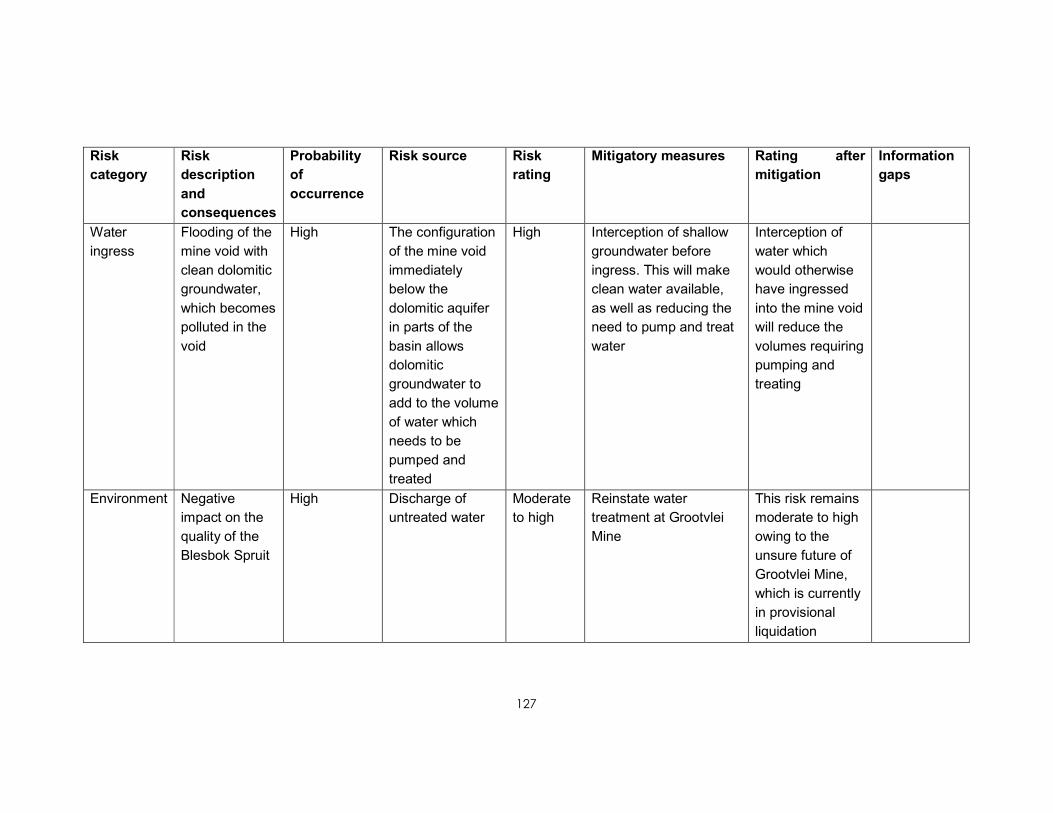
127
Risk
category
Risk
description
and
consequences
Probability
of
occurrence
Risk source Risk
rating
Mitigatory measures Rating after
mitigation
Information
gaps
Water
ingress
Flooding of the
mine void with
clean dolomitic
groundwater,
which becomes
polluted in the
void
High The configuration
of the mine void
immediately
below the
dolomitic aquifer
in parts of the
basin allows
dolomitic
groundwater to
add to the volume
of water which
needs to be
pumped and
treated
High Interception of shallow
groundwater before
ingress. This will make
clean water available,
as well as reducing the
need to pump and treat
water
Interception of
water which
would otherwise
have ingressed
into the mine void
will reduce the
volumes requiring
pumping and
treating
Environment Negative
impact on the
quality of the
Blesbok Spruit
High Discharge of
untreated water
Moderate
to high
Reinstate water
treatment at Grootvlei
Mine
This risk remains
moderate to high
owing to the
unsure future of
Grootvlei Mine,
which is currently
in provisional
liquidation

128
Risk
category
Risk
description
and
consequences
Probability
of
occurrence
Risk source Risk
rating
Mitigatory measures Rating after
mitigation
Information
gaps
Environment AMD impacts
on the surface
environment
High Mine wastes
produce AMD
that can
contaminate
surface and
groundwater
resources
Moderate
to high
Proper management of
mine wastes, including
removal to better
managed sites. Proper
surface run-off/storm
water management to
avoid contact with mine
wastes.
Proper waste
management will
reduce the risks.