active faulting and related tsunamis in eastern sicily and ... · pdf fileactive faulting and...
TRANSCRIPT

163
Active faulting and related tsunamis in eastern Sicily and south-western Calabria
C. MONACO and L. TORTORICI
Dipartimento di Scienze Geologiche, Università di Catania, Italy
(Received: July 31, 2006; accepted: December 22, 2006)
ABSTRACT The Calabrian arc and eastern Sicily are currently affected by large earthquakes andby an intense volcanic activity, related to ESE-WNW trending extensional tectonics.The main regional feature is given by a prominent normal fault belt (the Siculo-Calabrian rift zone) that runs more or less continuously for a total length of about 370km along the inner side of the Calabrian arc, extending through the Messina Straitsalong the Ionian coast of Sicily as far as the Hyblean Plateau. The normal faults arecharacterized by a very young morphology and they control both the major mountainranges of the region (Catena Costiera, Sila, Serre, Aspromonte, Peloritani, HybleanPlateau), and the coastline of southern Calabria and eastern Sicily. The distinct faultsegments are responsible for the large earthquakes (M~7) that have occurred in thisregion as the seismic sequences of 1783 in southern Calabria and of 1693 in easternSicily, and the 1905 (Monteleone) and 1908 (Messina) earthquakes. These events werecaused by slip on 30-40 km long normal fault segments located mainly offshore thatalso generated the largest tsunamis ever in southern Italy.
1. Introduction
The most common cause of a tsunami is the displacement of the crust along active faultsegments during underwater earthquakes which can impart high-potential energy to the overlyingwater column (Bryant, 2001). Earthquake-generated tsunamis are usually associated with seismicevents with surface magnitude greater than 6.5. However, tsunamis can be also generated bysmall earthquakes or by earthquakes centred inland triggering large submarine landslides.
The Calabrian arc and eastern Sicily are currently affected by large earthquakes and by anintense volcanic activity. Active normal faulting contributes to a continuous extensionaldeformation from eastern Sicily to south-western Calabria [Siculo-Calabrian rift zone, Fig. 1;Monaco et al. (1997), Monaco and Tortorici (2000)], responsible for several historical crustalevents (Postpischl, 1985; Boschi et al., 1995, 1997; CMT and RCMT catalogues), the largest ofwhich reached an MCS intensity of X-XI (6<M<7.5). The epicentres of these earthquakes (as the1693 south-eastern Sicily earthquakes, the 1783 southern Calabria sequence, the 1905Monteleone earthquake and the 1908 Messina earthquake) outline a seismic belt that runs mainlyalong the Tyrrhenian coast of Calabria and the Ionian coast of Sicily. Although these coastal areashave been repeatedly struck by large tsunamis in historical times (see Table 1; Tinti et al., 2004),the location of the seismogenic sources is still being debated.
The aim of this study is to describe the major offshore normal fault segments of the Siculo-Calabrian rift zone and to characterize their Late Quaternary activity in order to constrain the
Bollettino di Geofisica Teorica ed Applicata Vol. 48, n. 2, pp. 163-184; June 2007
© 2007 – OGS

164
Boll. Geof. Teor. Appl., 48, 163-184 Monaco and Tortorici
seismogenic and tsunamigenic potential and their long- and short-term effects on the landscape.This study is supported by mapping of the onshore fault segments, interpretation of aerialphotographs and elaboration of satellite SPOT and LANDSAT 5 TM imagery. As regards theoffshore segments, available seismic profiles and bathymetric maps have been interpreted.Structural and morphological data have been compared to historical documents and publishedcatalogues (Postpischl, 1985; Soloviev, 1990; Boschi et al., 1995, 1997; Soloviev et al., 2000;Tinti et al., 2004; CMT and RCMT catalogues) to verify if tsunamigenic events with localsources could be associated to each structure.
2. Geological setting
The Siculo–Calabrian rift zone (Monaco et al., 1997; Monaco and Tortorici, 2000)accommodates an ESE-WNW trending regional extension, as deduced from structural analysis(Lanzafame and Tortorici, 1981; Tortorici et al., 1995; Monaco et al., 1997; Jacques et al., 2001),seismological data (Cello et al., 1982; Gasparini et al., 1982; Anderson and Jackson, 1987;Frepoli and Amato, 2000; Pondrelli et al., 2004; Jenny et al., 2006; CMT and RCMT catalogues)and from VLBI (Ward, 1994) and GPS (D’Agostino e Selvaggi, 2004; Goes et al., 2004) velocityfields. Normal faults extend continuously along the western coast of Calabria and, crossing theMessina Straits, along the eastern coast of Sicily. This regional fault belt is about 370 km longand is made up of fault segments with lengths ranging from 10 to 45 km (Fig. 1) that during the
Id
CodeYear Month Day Subregion Reliability Cause
Earthquake
Intensity
Earthquake
magnitude
Tsunami
Intensity3 1169 2 4 Eastern Sicily 4 ER 10 6.6 4
4 1329 6 28 Eastern Sicily 2 VA 3
10 1638 3 27 Western Calabria 2 EA 11 7 2
12 1649 1 Messina Straits 1 EA 6.5 5 3
14 1693 1 9 Eastern Sicily 2 ER 8.5 6 2
15 1693 1 11 Eastern Sicily 4 ER 11 7.4 5
26 1783 2 5 Western Calabria 4 EA 11 6.9 3
27 1783 2 6 Messina Straits 4 EL 8.5 5.9 6
28 1783 2 7 Western Calabria 1 EA 10.5 6.6 2
29 1783 3 1 Western Calabria 3 EA 9 5.9 2
30 1783 3 28 Western Calabria 3 EA 10 6.9 2
32 1784 1 19 Messina Straits 4 ER 6 4.1 3
38 1818 2 20 Eastern Sicily 4 EA 9 6 2
50 1894 11 16 Western Calabria 4 EA 8.5 6.1 3
51 1905 9 8 Western Calabria 4 EA 11 7.1 3
54 1908 12 28 Messina Straits 4 ER 11 7.2 6
66 1990 12 13 Eastern Sicily 4 ER 7 5.7 2
Table 1 - Tsunamis that occurred in eastern Sicily and western Calabria during the last millennium according to thecatalogue of Tinti et al. (2004). Reliability: 0 very improbable; 1 improbable; 2 questionable; 3 probable; 4 definite.Cause: EA earthquake associated; VA volcano associated; EL: earthquake landslide; ER submarine earthquake.Intensity of tsunami: 1 very light; 2 light; 3 rather strong; 4 strong; 5 very strong; 6 disastrous. Earthquake intensity(MCS scale) and equivalent moment magnitude from Gruppo di lavoro CPTI (2004).

165
Faulting and Tsunamis in E Sicily and SW Calabria Boll. Geof. Teor. Appl., 48, 163-184
Plio-Pleistocene controlled the overall evolution of several sedimentary basins. The distinct faultsegments are characterized by a very young morphology and control both the major mountainranges of the region (Catena Costiera, Sila, Serre, Aspromonte, Peloritani, Hyblean Plateau) andthe coastline of south-western Calabria (Capo Vaticano, Scilla and Messina Straits). In easternSicily, the fault system is mostly located offshore and controls the Ionian coast from Messina toTaormina, bordering the uplifted Peloritani mountain range and joining the system of the MaltaEscarpment from the lower eastern slope of Mt. Etna to the south, where it circles the HybleanPlateau. Morphological observations and stratigraphic data indicate that the different faultsegments are characterized by long-term (since Middle Pleistocene) vertical slip rates rangingbetween 0.5 and 1.2 mm/yr (Westaway, 1993; Tortorici et al., 1995; Stewart et al., 1997). Values
Fig. 1 - Morphotectonic map of southern Calabria and eastern Sicily. Inset: tectonic sketch map of centralMediterranean; lines with triangles indicate the front of the thrust belt, lines with barbs the main Quaternary faults.SCRZ: Siculo-Calabrian rift zone.

166
Boll. Geof. Teor. Appl., 48, 163-184 Monaco and Tortorici
of about 2.0 mm/yr characterize the fault segments located in the volcanic district of the Aeolianarchipelago and at Mt. Etna (Monaco et al., 1997).
The development of the Siculo-Calabrian rift zone was coupled with a strong regional upliftingof the whole Calabrian Arc, which probably represents the isostatic response to the removal of a high-density mantle lithosphere root due to the detachment of the Ionian subducted slab (Westaway, 1993;Wortel and Spakman, 1993; De Jonge et al., 1994; Tortorici et al., 1995; Monaco et al., 1996) or theisostatic response to erosion driven by the Pleistocene climate change (Westaway, 2002). Alternativehypotheses sustain that the upheaval of the Calabrian Arc originates from the overthrusting of theTyrrhenian crust onto the Ionian crust, simultaneously with normal faulting (Ghisetti et al., 1982), orfrom the intrusion of a fluidized mantle from an asthenolith dome into the crust-mantle boundary(Locardi and Nicolich, 1988; Miyauchi et al., 1994; Gvirtzman and Nur, 1999; Doglioni et al., 2001).According to Westaway (1993), 1.67 mm/yr of post-Middle Pleistocene uplift of southern Calabriais partitioned into ~1 mm/yr due to regional processes and the residual to displacement on majorfaults. However, the most evident consequence of the widespread Quaternary raising process is theoccurrence, up to 1200 m a.s.l., of both Plio-Pleistocene marine sequences and spectacular flights ofmarine terraces downslope.
The Siculo-Calabrian rift zone is also one of the most active seismic belts of the centralMediterranean region. The distribution of crustal seismicity shows that most of the earthquakes thatoccurred in this area, including the major events with M>6, are located in the hanging-walls of thedistinct Quaternary normal fault segments. Available structural and seismological data carried out inthe last years on different portions of this region (Shick, 1977; Cello et al., 1982; Gasparini et al.,1982; Ghisetti et al., 1982; Mulargia and Boschi, 1983; Ghisetti, 1984, 1992; Hirn et al., 1997;Anderson and Jackson, 1987; Bottari et al., 1986, 1989; De Natale and Pingue, 1991; Valensise andPantosti, 1992; Westaway, 1992, 1993; Tortorici et al., 1995; Sirovich and Pettenati, 1999; Bianca etal., 1999; Azzaro and Barbano, 2000; Monaco and Tortorici, 2000; Jacques et al., 2001; Galli andBosi, 2002; Catalano and De Guidi, 2003; Catalano et al., 2003; Tortorici et al., 2003; De Guidi etal., 2003; Goes et al., 2004; Argnani and Bonazzi, 2005; Ferranti et al., 2006; Jenny et al., 2006) havegiven constraints to formulate different large scale seismotectonic models. In particular, as regardsthe tsunamigenic sources, different hypotheses have been proposed, sometimes relating tsunamievents to ruptures along faults located inland (Tinti and Armigliato, 2000, 2001, 2003; Piatanesi andTinti, 1998, 2002). The following sections are dedicated to the analysis of historical tsunami eventsand possible local sources identifiable on offshore seismic profiles. In the regions where these arenot available, the occurrence of flights of raised Late Quaternary palaeo-shorelines and marineterraces represents a useful tool to define the short- and long-term vertical deformation which can beassociated with offshore normal faults. These structures mainly border the Capo Vaticano Peninsula,the Palmi-Bagnara-Scilla High, the Messina Straits in south-western Calabria and the Peloritanimountain range, the Mt. Etna-Hyblean region in eastern Sicily.
3. Active faulting and related tsunami
3.1. Capo Vaticano Peninsula
The Capo Vaticano area is a horst structure bound by two antithetic, NE-SW striking, Tropeaand Mileto normal faults (Fig. 2), showing a steep coastal morphology. To the northeast, the

167
Faulting and Tsunamis in E Sicily and SW Calabria Boll. Geof. Teor. Appl., 48, 163-184
Briatico area represents the overlap zone between the en-echelon Tropea and Vibo normal faults.This area, interpreted as a “bridge zone” or “relay ramp” by Tortorici et al. (2003), ischaracterized by a slightly inclined morphological slope and a well developed stream-channelpattern. The occurrence of a NE-SW striking, NW-facing normal fault system in the north-western offshore has been proved by a SSE-NNW striking single-channel seismic profile (Vp3,see inset in Fig. 2) carried out by Trincardi et al. (1987), that illustrates an active normal faultaffecting the sea-bottom and creating a roughly 300 m high scarp located at about 10 km fromthe coastline. The bathymetric map (Fig. 2) constructed by Argnani and Trincardi (1988) showsan ENE-WSW trending scarp, located at about 5 km from the coastline, which can be interpretedas the eastern extension of the system [Capo Vaticano Fault, Monaco and Tortorici (2000)]. Tothe south-west, the promontory is abruptly truncated by two main WNW-ESE striking, SSW-dipping normal faults (Coccorino and Nicotera faults) which separate the Capo Vaticano
Fig. 2 - Structural map of the area of Capo Vaticano peninsula and S. Eufemia Plain, comprising the Tyrrhenianoffshore (see location in Fig. 1). Bathymetry from Argnani and Trincardi (1988, modified). The epicentre of the 1905earthquake [black circle; from Postpischl, (1985)] is also shown. Inset: seismic profile Vp3 (from Trincardi et al., 1987)showing a normal fault scarp in the north-western offshore of the Capo Vaticano peninsula (for the trace of profile seethe figure). Vertical scale is two travel time in seconds.

168
Boll. Geof. Teor. Appl., 48, 163-184 Monaco and Tortorici
structural high from the Gioia Tauro Basin, filled by a thick Upper Pliocene-Quaternarysedimentary succession (Ghisetti, 1981). The isobath pattern of Fig. 2 strongly suggests theoffshore continuation of the Coccorino Fault (see below) which interrupts the continuity of theNE-SW fault system. Landwards, to the south-east, antithetical SE-facing fault segments (Miletofaults) separate the Capo Vaticano horst from the Mesima Graben (Fig. 2), a basin filled by athick Upper Pliocene-Lower Pleistocene marine succession (Ghisetti, 1981), capped by severalmarine and fluvial terraces.
The geological backbone of the Capo Vaticano peninsula is mainly made up of a Palaeozoicbasement, covered by remnants of Miocene and Pliocene carbonate and terrigenous deposits(Burton, 1971), on top of which at least six distinct orders of well preserved Quaternary marineterraces have been recognized (Westaway, 1993; Miyauchi et al., 1994; Tortorici et al., 2003).The marine terraces consist of a Middle-Late Pleistocene flight of wave-cut surfaces and/or thin-depositional platforms, usually bounded landwards by well developed inner edges representingthe palaeo-shorelines related to the main sea level high-stands. They show an overall goodmorphological continuity and extend with a concentric geometry around the structural high beingcharacterized by elevations regularly increasing to the south-west (Tortorici et al., 2003).
The geometry of the palaeo-shorelines indicates that the raising process has beencharacterized by uplift rates increasing toward the south-west. For example, in the Vibo Marinaarea, located at the hanging-wall of the Vibo Fault (Fig. 2), the palaeo-shoreline of the lastinterglacial high stand (125 kyrs) is located at elevations of 75 m a.s.l., indicating an averageuplift rate (corrected for the original sea level of +6 m) of 0.5 mm/yr in the last 125 kyr; to thesouth-west, in the Capo Vaticano area at the foot-wall of the Coccorino Fault, the same palaeo-shoreline is located at an elevation of 300 m a.s.l., indicating an average uplift rate of 2.3 mm/yrin the same period.
On September 8, 1905, at around 01:43 a.m. local time, a large earthquake with an MCSintensity X-XI and M~7.0 (Postpischl, 1985; Boschi et al., 1995) occurred offshore the CapoVaticano Peninsula (Gasparini et al., 1982). This event severely damaged towns and villages allaround the Tyrrhenian coast (557 dead, more than 2000 injured and about 300,000 homeless),from Capo Vaticano to Capo Suvero (Fig. 2), where several ground effects such as cracks,landslides and sand craters were caused, and it was accompanied by a tsunami that flooded thenorthern coast of the Capo Vaticano Peninsula (Piatanesi and Tinti, 2002). The tsunami was notcatastrophic [I=3, Table 1; Tinti et al. (2004)], but it was observed both in the open sea and alongthe coast (Baratta, 1906; Mercalli, 1906; Rizzo, 1907; Platania, 1907; see also Tinti et al., 2004).Along the northern coast of Capo Vaticano a lot of dead fish were found on the beaches andinundation by some tens of meters was reported in several villages with fishing boats carriedinland. The tsunami waves propagated out to the Tyrrhenian Sea to large distances from thesource region, as recorded by the tide-gauges of Milazzo (80 cm), in north-eastern Sicily andNaples (18 cm).
There is no agreement regarding the epicentre of the 1905 earthquake (Fig. 2), as it is reportedoffshore by Postpischl (1985) and onshore by Boschi et al. (1995). According to Piatanesi andTinti (2002), there are two active fault segments intersecting the epicentral area that can beconsidered good candidates for the source of both the earthquake and the tsunami, namely theCapo Vaticano and the Vibo Valentia faults. Also the numerical modeling of Piatanesi and Tinti

169
Faulting and Tsunamis in E Sicily and SW Calabria Boll. Geof. Teor. Appl., 48, 163-184
(2002) cannot discriminate between the two faults. However, the mesoseismic area concentratedalong and near the northern coast of Capo Vaticano (Fig. 2) and all the isoseismals openingseawards suggest an epicentre located offshore along the Capo Vaticano Fault. Moreover, theoverall deformation pattern of palaeo-shorelines in the Capo Vaticano Peninsula, alsoconstraining short-term accelerations and decelerations in the uplift rates [see Tortorici et al.(2003) for a more complete discussion], confirms the occurrence of an important tectoniccomponent in the total amount of uplift, related to the Late Quaternary activity of the normal faultsegments bounding the Capo Vaticano structural high offshore. In particular, seismic profiles (seeinset in Fig. 2) show that the Capo Vaticano fault has been active in very recent times.
3.2. South-western Calabria
To the south, the normal fault belt bounds the Aspromonte mountain range from where, witha right hand en-echelon arrangement, it reaches the Messina Straits area where the southernmostScilla fault occurs (Fig. 1). It was traced mostly offshore, on the basis of coastal findings andbathymetry considerations (Fig. 3). The NW dipping, 30 km long Scilla fault runs along theTyrrhenian shore from Palmi to Bagnara, bordering the Palmi high with a NNE-SSW direction(Figs. 1 and 3). In this sector, the escarpment forms an up to 600 m high cliff, at the top of whicha Middle Pleistocene marine terrace (Ghisetti, 1981; Dumas et al., 1982), tilted towards the
Fig. 3 - Structural map of south-western Calabria (see location in Fig. 1), showing the epicentre of the February 5, 1783earthquake [black circle; from Jacques et al. (2001)]. SF: Scilla Fault; SEF: S. Eufemia Fault; CNF: Cittanova Fault.Bathymetry from Selli et al. (1978-79, modified).
170
Boll. Geof. Teor. Appl., 48, 163-184 Monaco and Tortorici
southeast, overlies the crystalline rocks of the uplifted footwall (Burton, 1971). Southwest ofBagnara the fault turns to a ENE-WSW direction penetrating onshore as far as Scilla. West ofScilla the fault jumps back offshore, through an en-echelon overlap link (Fig. 3), leaving theMiddle-Late Pleistocene terraces in the footwall block. At least four orders of marine terraceshave been found southwest of Scilla (Fig. 3), referring to the OIT stages 11, 9, 7 and 5corresponding to Middle-Upper Pleistocene sea level high-stands (Valensise and Pantosti, 1992;Westaway, 1993; Miyuachi et al., 1994; Tortorici et al., 1995; Jacques et al., 2001). East of VillaSan Giovanni, the OIT 5 stage terraced deposits (125 kyr) have been offset by about 90 m by thesouthwestern portion of the Scilla fault, thus suggesting a vertical slip rate of about 0.7 mm/yr inthe last 125 kyr (Jacques et al., 2001).
The recent activity of the Scilla fault is testified by the occurrence, on its footwall, of aHolocene marine platform and beaches rocks uplifted up to 4 m, whose radiocarbon age rangesfrom 1.9 to 3.9 kyr (Antonioli et al., 2004). According to these authors, the Late Holocene uplift-rate of the Scilla coastline, corrected for eustatic changes and glacio-hydroisostatic adjustments(Lambeck et al., 2004), is ~1.6-2.1 mm/yr almost equally balanced between the steady and thestick-slip components. Abrupt displacements, mostly accommodated by a footwall uplift (1-2 m),have been attributed to two co-seismic events (~1.8 and ~3.5 kyr) constrained in distinct coastalsites (Ferranti et al., 2006). Empirical relationships between fault length and displacement perevent (Wells and Coppersmith, 1994) suggest the occurrence of M~7 earthquakes with a ~1.6-1.7kyr recurrence time.
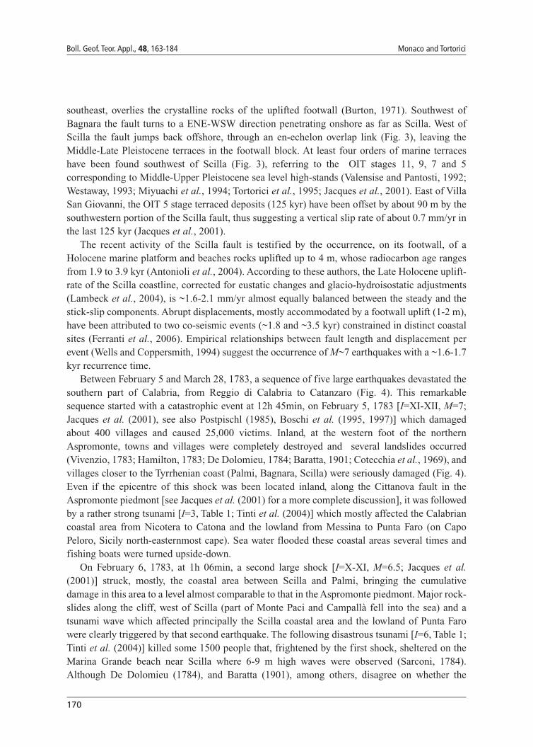
Between February 5 and March 28, 1783, a sequence of five large earthquakes devastated thesouthern part of Calabria, from Reggio di Calabria to Catanzaro (Fig. 4). This remarkablesequence started with a catastrophic event at 12h 45min, on February 5, 1783 [I=XI-XII, M=7;Jacques et al. (2001), see also Postpischl (1985), Boschi et al. (1995, 1997)] which damagedabout 400 villages and caused 25,000 victims. Inland, at the western foot of the northernAspromonte, towns and villages were completely destroyed and several landslides occurred(Vivenzio, 1783; Hamilton, 1783; De Dolomieu, 1784; Baratta, 1901; Cotecchia et al., 1969), andvillages closer to the Tyrrhenian coast (Palmi, Bagnara, Scilla) were seriously damaged (Fig. 4).Even if the epicentre of this shock was been located inland, along the Cittanova fault in theAspromonte piedmont [see Jacques et al. (2001) for a more complete discussion], it was followedby a rather strong tsunami [I=3, Table 1; Tinti et al. (2004)] which mostly affected the Calabriancoastal area from Nicotera to Catona and the lowland from Messina to Punta Faro (on CapoPeloro, Sicily north-easternmost cape). Sea water flooded these coastal areas several times andfishing boats were turned upside-down.
On February 6, 1783, at 1h 06min, a second large shock [I=X-XI, M=6.5; Jacques et al.(2001)] struck, mostly, the coastal area between Scilla and Palmi, bringing the cumulativedamage in this area to a level almost comparable to that in the Aspromonte piedmont. Major rock-slides along the cliff, west of Scilla (part of Monte Paci and Campallà fell into the sea) and atsunami wave which affected principally the Scilla coastal area and the lowland of Punta Farowere clearly triggered by that second earthquake. The following disastrous tsunami [I=6, Table 1;Tinti et al. (2004)] killed some 1500 people that, frightened by the first shock, sheltered on theMarina Grande beach near Scilla where 6-9 m high waves were observed (Sarconi, 1784).Although De Dolomieu (1784), and Baratta (1901), among others, disagree on whether the
171
Faulting and Tsunamis in E Sicily and SW Calabria Boll. Geof. Teor. Appl., 48, 163-184
tsunami was a mere consequence of the rock-slide or generated by the earthquake, mostchroniclers concur in locating the “centre” of this second shock offshore (Figs. 3 and 4), not farfrom Scilla [see also Jacques et al. (2001)]. Recent investigations (Bosman et al., 2006) allow usto infer a submarine landslide in continuity with the Mt. Paci sub-aerial collapse as a possiblecause. Whatever the case, in our opinion, the second shock of the 1783 earthquake sequence maybe correlated to a slip along the Scilla fault segment which could have triggered the largelandslide on the footwall. According to Ferranti et al. (2006), the palaeo-seismological recordsuggests that the last rupture on the Scilla fault during the February 6, 1783 earthquake, notaccompanied by evident coastal uplift, was at the expected time but did not release the entireloaded stress.
The following shocks of the 1783 sequence (February 7, March 1 and 28, see Table 1) werelocated inland at the piedmont of the Serre mountain range (Fig. 4) and locally triggered lighttsunami waves along the Calabrian coasts [I=2 according to Tinti et al. (2004)].
3.3. Messina Straits
In the Messina Straits area, the major normal faults extend along the Calabrian side (Fig. 1).The main segment is represented by the 15 km-long NNE-SSW trending Reggio Calabria faultthat during the Early Pleistocene has controlled the Middle-Late Pleistocene evolution of the
Fig. 4 - Isoseismal and epicentral locations of the five principal shocks of the 1783 earthquake sequence (after Baratta,1901; Jacques et al., 2001).

172
Boll. Geof. Teor. Appl., 48, 163-184 Monaco and Tortorici
Reggio Calabria half graben (Ghisetti, 1981; Barrier, 1987; Tortorici et al., 1995). The fault offset125 kyr old sediments whereas the youngest deposits, cropping out in the downthrown block, aremade up of continental alluvial which, covering the marine sequence unconformably, representthe remnants of large gently sloping alluvial fans of Wurmian age (Dumas et al., 1979). Thesedeposits progressively onlap the fault plane thus suggesting faulting activity during that period.In addition, a flight of marine terraces, ranging in age from 118±13 kyr to 64±8 kyr (Balescu etal., 1997), assigned to the 5.3-3.3 OIT stages (Catalano et al., 2003), occur at different elevationson both upthrown and downthrown blocks. The fault plane dips steeply westwards and deformsboth crystalline rocks and Middle-Upper Pleistocene sediments. The fault trace runs more or lesscontinuously near the coastline as far as Reggio Calabria (Fig. 5) from where it seems to continueoffshore for about 10 km (Ambrosetti et al., 1987). Morphologically it is defined by a 70-100 m-high escarpment which extends discontinuously at the boundary between the mountain front andthe adjacent coastal plain and is characterized by one set of triangular facets showing heightsranging from 50 m to 70 m. All these observations indicate a recent activity of the ReggioCalabria fault with slip-rates of up to 0.6 mm/yr (Ghisetti, 1992; Westaway, 1993; Tortorici et al.,1995).
On December 28, 1908, one of the largest earthquakes of southern Italy struck the Strait ofMessina area (Fig. 5). This event of MCS intensity XI and M=7.1-7.2 (Postpischl, 1985; Boschiet al., 1995, 1997; Gruppo di Lavoro CPTI, 2004) completely destroyed the entire Straits ofMessina area, killing about 70,000 people (Baratta, 1910). The area, devastated by the mainshock, was mostly located on the Calabrian side of the strait extending to the Sicilian coast alonga narrow belt including the town of Messina. In Calabria, the mesoseismal area formed two wideNE-oriented lobes extending to the hanging-walls of the normal fault segments affecting the area(Armo and Reggio Calabria faults, Fig. 5). Towns and villages located within this area (includingthe town of Reggio di Calabria) were completely destroyed suffering damage ascribed to an MCSintensity ≥X (Boschi et al., 1995). In this area, the percentage of ruined buildings was higher than90% as reported from the chronicle of Baratta (1910). Many other villages, located within anarrow belt (3-4 km wide) surrounding the mesoseismal area, were extensively damagedsuffering a percentage of ruined buildings ranging between 45% and 90% (Baratta, 1910)indicating an MCS intensity of IX (Boschi et al., 1995). Several landslides occurred inland inthe surroundings of Reggio di Calabria and along the sea-cliff from Scilla to Bagnara. Togetherwith the occurrence of sand fountains, related to liquefaction reported in the Reggio di Calabriaarea, one of the most impressive coseismic effect was the permanent subsidence, estimated atabout 0.7-1.0 m, of the entire coastline from Lazzaro to Bagnara (Baratta, 1910). In Sicily, themesoseismal area was confined near the coast along a few km wide (1-4 km) belt where the townof Messina and surrounding villages were completely ruined by shacking and subsequent tsunami(Fig. 5). Villages with damage ascribed to an MCS intensity of IX (Boschi et al., 1995) define anarrow belt that envelops the mesoseismal area to the west. Sand fountains spurted water fromlinear fractures and cracks developed on the coastal plain from Messina to Ganzirri (Baratta,1910). Several fractures affected the entire quay of the harbour of Messina depicting an overallarc-shaped geometry (Baratta, 1910). These fractures, that also occurred during the main shockof the 1783 earthquake sequence, may be interpreted as the surface evidence of the re-activationof the main scarp at the crown of a submarine landslide.

173
Faulting and Tsunamis in E Sicily and SW Calabria Boll. Geof. Teor. Appl., 48, 163-184
This event also generated a large tsunami [I=6, Table 1; Tinti et al. (2004)] that devastated bothsides of the Strait of Messina, causing hundreds of victims and severe damage to buildings, shipsand the environment. It was recorded along the Tyrrhenian coast of Sicily as far as TerminiImerese and up north as far as Naples, the entire Ionian coast of eastern Sicily and part of thenorthern and southern coasts of the island, as far as Malta. The tsunami was characterized by aninitial sea withdrawal (up to 200 m) followed by at least three distinct large waves that with amaximum height of 2.9 m inundated the town of Messina and with a height of 6-7 m the town ofReggio Calabria (Platania, 1909). The maximum height reached by the wave in southern Calabriawas 10 m at Lazzaro where the sea water penetrated inland for 250 m and a run-up of about 13m was recorded (Baratta, 1910). The maximum amplitude of the tsunami wave along the Ioniancoast of Sicily was recorded from Furci to Galati Marina with values estimated from 6.4 to 9.2m (Baratta, 1910). To the south, along the coast of the Catania Plain, waves were less than 3 mhigh but penetrated about 700 m inland (Tinti and Armigliato, 2003). The effects of the tsunami
Fig. 5 - Cartoon showing epicentre and damage distribution of the December 1908 earthquake [data from Baratta(1910) and Boschi et al. (1995)] and the main faults (from Ghisetti, 1992; Tortorici et al., 1995; Monaco and Tortorici,2000; Jacques et al., 2001) of the Messina Straits area (see location in Fig. 1). The maximum height (in metres) reachedby the tsunami waves is also indicated [data from Baratta (1910)].

174
Boll. Geof. Teor. Appl., 48, 163-184 Monaco and Tortorici
are still recognizable near Siracusa where boulders up to 182 ton in weight, encrusted bybarnacles dated at about 100 years, were removed and transported inland at a distance of up to 70m (Monaco et al., 2006). It is worth noting that the wave heights estimated for the transport ofthese boulders (2.4-3.0 m) are well constrained by values reported by the Siracusa harbour office(Regia Capitaneria di Porto), which estimated a 2 m high wave (Baratta, 1910).
Different sources have been proposed for the 1908 earthquake but all agree on dominantnormal faulting on planes trending nearly parallel to the Messina Straits (see also Anderson andJackson, 1987; Ghisetti, 1982; Valensise and Pantosti, 1992). The displacement caused acoseismic down-warping of the area which was documented by a levelling survey performed oneyear before and immediately after the earthquake (Loperfido, 1909). Based on inversion of thelevelling data, a low angle, east–dipping normal fault, merging at the surface on the Siciliancoastline, has been proposed (Capuano et al., 1988; De Natale and Pingue, 1991; Boschi et al.,1989; Valensise and Pantosti, 1992; Amoruso et al., 2002). However, the above-mentionedobservations produce a clear macroseismic picture that strongly suggests that this event could berelated to ruptures occurring along the NE trending, west-facing Reggio Calabria fault includingits offshore propagation on the Strait of Messina (see also Schick, 1977; Bottari et al., 1986;Ghisetti, 1984; Westaway, 1992; Tortorici et al., 1995). The area of major damage was in factlocated along the Calabrian side of the Straits where permanent subsidence and ground fractureswere recorded, whereas the damage at the Sicilian side was mostly related to the occurrence ofthe destructive tsunami. This interpretation is supported by the analysis of the focal mechanismthat shows a slip occurring along a NNE trending, west-facing nodal plane (Riuscetti and Schick,1975; Shick, 1977) and is consistent with the regional structure of the Messina Straits area,characterized by master faults on the Calabrian side and associated antithetic faults on theSicilian side (Ghisetti, 1984; Montenat et al., 1991; Tortorici et al., 1995). However, as the sourcemodel of a low-angle blind normal fault merging at the surface on the Sicilian side has to bereconciled with the strong rates of deformation on the high-angle west-dipping morphogenic faultalong the Calabrian coastline, an alternative model can be represented by displacement on twoantithetic structures (see also Mulargia and Boschi, 1983; Bottari et al., 1989). Finally, accordingto the numerical modelling simulations performed by Tinti and Armigliato (2000, 2001, 2003) onthe basis of an east-dipping source, the tsunamigenic earthquake source is certainly placed underthe Messina Straits, where it caused subsidence of the sea floor, and extends under the Ionian Seato the south of the Straits.
3.4. North-eastern Sicily
In eastern Sicily, the Siculo-Calabrian rift is formed by a few fault segments mostly runningalong the Ionian coastline, and striking both NNE and NNW. The major fault segments (Fig. 1)include the Taormina fault located offshore between Messina and Taormina, the Timpe faultsystem along the lower eastern flank of the Mt. Etna volcano and the western fault offshore,between Catania and Siracusa.
The existence of the east-facing, 40 km-long, Taormina Fault at the piedmont of the PeloritaniMts. [“Messina-Fiumefreddo System” of Ghisetti and Vezzani (1982), also reported in Bosi et al.(1983) and Scandone et al. (1991)] has been suggested by the long-term deformation pattern ofthe marine terraces (Catalano and De Guidi, 2003), and its recent activity is documented by a ~5

175
Faulting and Tsunamis in E Sicily and SW Calabria Boll. Geof. Teor. Appl., 48, 163-184
kyr long co-seismic uplift recorded by development of a stepped array of limestone tidal notches(Firth et al., 1996; Stewart et al., 1997; Rust and Kershaw, 2000; De Guidi et al., 2003). TheHolocene coastal morphology in the Taormina region is in fact characterized by three majorelevated notches that suggest the occurrence of three major seismic events that produced 1-2 mof vertical coseismic displacement of the coast at about 5, 3.2 and in <3.2 kya B.P. (De Guidi etal., 2003). Taking into account the Holocene co-seismic displacements of the Taormina coastalarea and empirical relationships between fault length and displacement per event (Wells andCoppersmith, 1994), earthquakes with M~6.5 and M~7 can be inferred for the minor and majorevents, respectively. Nevertheless, seismic historical data for this sector of eastern Sicily (seeBoschi et al., 1995, 1997; Baratta, 1901, 1910; Postpischl, 1985) indicate a very low-level-to-absent seismicity since the ancient Greek times (VIII century B.C.).
3.5. South-eastern Sicily
South of Taormina (Fig. 1), the fault belt penetrates onshore where it is represented by the 25km-long, NNE and NNW trending Timpe fault system (Monaco et al., 1997; Azzaro, 1999).
Fig. 6 - a) Reflection profiles showing the Western Fault along the Malta Escarpment accompanied by minor syntheticfaults. Note the seafloor offset and the syn-rift basin eastwards (for location see Fig. 6b). b) Structural sketch map ofthe Ionian offshore zone of eastern Sicily (see location in Fig. 1) derived from the analysis of seismic reflectionprofiles. Location of seismic profiles (see Scandone et al., 1981; Sartori et al., 1991; Hirn et al., 1997; Bianca et al.,1999) used to draw the map is also showed. Isochronopachs of the seismostratigraphic interval included between thebasal horizon of Middle Pleistocene-Holocene deposits and the seafloor show the overall geometry of the main eye-shaped syn-rift basins developed along the hanging wall of the major normal fault segments (from Bianca et al., 1999).
176
Boll. Geof. Teor. Appl., 48, 163-184 Monaco and Tortorici
From Catania to Siracusa, the fault belt continues offshore, where it includes several segmentsstriking NNW-SSE. These segments, as shown by several seismic profiles carried out on theIonian offshore (Scandone et al., 1981; Sartori et al., 1991; Hirn et al. 1997; Bianca et al., 1999;Argnani and Bonazzi, 2005), are represented by two main east-facing normal faults that affect theentire crust and define, in the hanging-wall, well developed wedge-shaped basins infilled withMiddle-Upper Quaternary syn-rift clastic wedges thickening towards the boundary faults (Fig.6a). The most prominent fault segment of this branch of the Siculo-Calabrian rift is representedby the Western Fault (Fig. 6b), that extends parallel to the coastline for a total length of about 45km. This fault segment cuts the thinned crust of the Ionian domain and, re-activating the Maltaescarpment to the south, offsets the sea-floor creating well-developed steep scarps that reachheights of 80-240 m (Bianca et al., 1999). Its activity caused the slow uplift of the HybleanPlateau as testified by the occurrence of a flight of Quaternary terraces ranging in age from 400to 60 ky (Bianca et al., 1999).
Between January 9 and 11, 1693 the whole of south-eastern Sicily was devastated by two largeearthquakes of MCS intensities VIII-IX and XI, respectively. The first shock occurred at about 9p.m. (GMT) and caused severe damage (Boschi et al., 1995) along a narrow belt (Fig. 7a)extending at the foot of the eastern border of the Hyblean Plateau (Avola and Climiti Mounts).No relevant tsunami was induced by this event (see Tinti and Maramai, 1996; Tinti andArmigliato, 2003). The second and main shock occurred at about 1:30 p.m. (GMT) and wascatastrophic [M between 7 and 7.5, according to Postpischl (1985), Westaway (1992), Bianca etal. (1999), Azzaro and Barbano (2000), Gruppo di Lavoro CPTI (2004)] devastating the entiresouth-eastern part of Sicily and killing about 54,000 people (Boccone 1697; Baratta 1901). Townsand villages located close to the south-eastern coast of Sicily (Fig. 7b), such as Catania, Lentini,Carlentini, Augusta, Melilli, Floridia, Canicattini, Avola Antica and Noto Antica, which hadalready been seriously affected by the event of January 9, were completely destroyed sufferingdamage ascribed to an MCS intensity greater than X (Boschi et al., 1995). Many other towns,located in an area extending from the eastern foot of Mt. Etna to the southern coast of theHyblean Plateau were extensively ruined, defining the area characterized by an MCS intensity ofX (Boschi et al., 1995). The overall distribution of the effects of the main shock shows, however,a few anomalies because of local seismic responses related to both geological and morphologicalconditions (Fig. 7c). The maximum ground-shaking region defines a 90 km long zone which,extending in a NE-SW direction along the coast, roughly corresponds to the area ascribed to theMCS intensity greater than X where large landslides and ground fractures also occurred (Fig.7c). The shock was particularly violent along the coast and it was felt as a roar in the towns ofCatania, Augusta and Siracusa. In these localities (Boccone, 1697; Bottone, 1718; Baratta, 1901)people were thrown up, massive floors and foundation stones were dislodged, walls, togetherwith their foundations, were shifted from their groundings, thus indicating a particularly strongvertical acceleration.
The main shock also generated a large tsunami [I=5, Table 1; Tinti et al. (2004)] recorded alongthe whole coast of eastern Sicily, between Messina and Siracusa (Fig. 7c), and on the Island ofMalta (Anonymous, 1693; Boccone, 1697; Bottone, 1718; Baratta, 1901; Piatanesi and Tinti,1998; Tinti and Armigliato, 2003). In the harbour of Catania the sea retreated several metresleaving boats stranded on the sea-floor. When the sea returned, the wave, like “a furious and rapid

177
Faulting and Tsunamis in E Sicily and SW Calabria Boll. Geof. Teor. Appl., 48, 163-184
Fig. 7 - Cartoon showing the main features characterizing the January 1693 earthquakes (from Bianca et al., 1999): a)mesoseismic areas (MCS scale) related to the January 9 shock [data from Boschi et al. (1995a)]; b) mesoseismic areas(MCS scale) related to the main shock of January 11 [data from Boschi et al. (1995)]; c) effects on the environmentand contour map of equal total damages of the main shock of January 11 [data from Boccone (1697), Bottone (1717),Baratta (1901)]; d) areas struck by 1693-1696 aftershocks [data from Boccone (1697), Bottone (1717), Mongitore(1743), Baratta (1901)].

178
Boll. Geof. Teor. Appl., 48, 163-184 Monaco and Tortorici
stream” (Anonymous, 1693), flung the boats beyond the walls, into the town. At Augusta andSiracusa (Boccone, 1697; Bottone, 1718) the sea retreated 30 (60 m) and 50 (100 m) paces,respectively, then returned in a wave which reached heights of 30 cubits (about 12 meters). Galleyships of the Knights of Malta, anchored in the harbour of Augusta, ran aground on the sea floorbecause of the waves (Baratta, 1901). The tsunami was characterized by the occurrence of at leastthree distinct waves which penetrated inland for about 50 paces (90- 100 metres) at Siracusa, 75metres at Augusta where they lapped the walls of the monastery of San Domenico, about 250metres in Catania where the sea reached Piazza San Filippo (present Piazza Mazzini), and about1 mile (1.5 km) at Mascali [Baratta (1901) and references therein]. Several aftershocks (Fig. 7d),felt in the villages and towns located close to the coastline extending between Catania andSiracusa, occurred up to 1696 (Boccone, 1697; Bottone, 1718; Mongitore, 1743; Baratta, 1901).
Data reported suggest that the two shocks had distinct epicentres. The first shock has beenlocated inland, probably along the Avola fault [Fig. 1; Bianca et al. (1999)] or north of Siracusa(Azzaro and Barbano, 2000). As regards the main shock, it has been located inland, along thenorthern margin of the Hyblean Plateau, by D’Addezio and Valensise (1991) and Boschi et al.(1995), or along the Scicli Line (see inset in Fig. 1) by Sirovich and Pettenati (1999). However,on the basis of macroseismic information and tsunami modelling, it may be reasonably related toa rupture occurring along a normal fault located about 12 km offshore from Catania to Siracusa(Barbano and Cosentino, 1981; Barbano, 1985; Bianca et al., 1999; Azzaro and Barbano, 2000),possibly the Western Fault (Fig. 6b) of Bianca et al. (1999), which is consistent with thenumerical modelling simulations performed by Piatanesi and Tinti (1998) and Tinti et al. (2001).Reactivation of this fault could have triggered also the tsunami that occurred during the February4, 1169 earthquake [I=4, Table 1; Tinti et al. (2004)]. The analogies between the 1169 and thewell known 1693 event suggest, in fact, a similar location and magnitude for both events(Lombardo, 1985; Azzaro and Barbano, 2000).
4. Discussion and conclusions
Integration of instrumental and historical seismological data with seismic profiles andmorphotectonic observations allowed us to define the possible sources of the tsunami wavesoccurring during the last few centuries in eastern Sicily and south-western Calabria. The coastalareas of these regions are controlled by offshore active faults (Capo Vaticano, Scilla, ReggioCalabria, Taormina, Timpe and Western Fault along the Malta Escarpment), some of which (e.g.Capo Vaticano and Malta Escarpment) clearly displayed by seismic profiles and bathymetricmaps. Inland, Holocene palaeo-shorelines and Pleistocene marine surfaces represent naturaltiltmetres which allow the evaluation of the short- and long-term footwall deformation. Inparticular, our data strongly suggest that the largest earthquakes (M > 6) with associated tsunamicould be related to ruptures along the 30-40 km long Late Quaternary fault segments locatedoffshore. The January 11, 1693 earthquake was generated by the slip of a normal fault extendingabout 12 km offshore from Catania to Siracusa and caused a large tsunami that devastated theentire coast from Messina to Siracusa with waves which reached heights of 30 cubits (about 12meters). The February 6, 1783 earthquake has been related to displacement along an offshorefault located along the coast from Villa S. Giovanni to Palmi. The fault displacement probably
179
Faulting and Tsunamis in E Sicily and SW Calabria Boll. Geof. Teor. Appl., 48, 163-184
triggered a huge submarine landslide in continuity with a subaerial collapse which in turn causeda tsunami that, with waves reaching heights of 6-9 meters, destroyed all the villages placed alongthe Messina Straits. The September 8, 1905 Monteleone earthquake has been attributed to a slipoccurring along a fault segment located offshore the Capo Vaticano Peninsula. The main shockwas followed by a large tsunami that hit the northern coast of the peninsula with a few meter highwaves. Finally, the most recent and known tsunami occurred during the 1908 Messina earthquakethat has been related to a rupture along the west facing Reggio Calabria fault that partiallyextends offshore south of Reggio Calabria. This event was characterized by waves that reachedthe maximum heights of 10 meters in the Calabrian side of the Straits of Messina, inundatinglarge portions of the eastern Sicilian coast.
Taking into account the high density of population living on the coastal plains of the areas inquestion, tsunami waves triggered by offshore fault displacement thus represent one of the majorfactors of geological risk. Notwithstanding this, with the exception of a few studies, availableinformation is not enough to define the effective seismic and tsunamigenic potential of activefaulting. Useful data on seismic sources, on maximum expected magnitude, and on recurrencetimes require more detailed knowledge on the geometry, kinematics and mode of deformation ofthe different fault segments of the Siculo-Calabrian rift zone. Analyses capable of defining thosefault segments prone to be re-activated, essentially associated with characteristic earthquakes andseparated by stable areas, are still in their infancy. In fact, considering that the distinct faultsegments of the Siculo-Calabrian rift zone are characterized by comparable lengths anddeformation rates (Monaco and Tortorici, 2000), the possible fault-earthquake relations point tothe occurrence of seismic gaps along the normal fault belt. Seismic quiescence for events withM>6 in the last 1000 yr has been in fact observed along distinct fault segments located both innorthern Calabria and eastern Sicily (Monaco and Tortorici, 2000), especially on offshorestructures, as the Taormina fault, which could originate strong tsunamis. This implies that furtherstudies of these fault segments must be carried out in order to define the possible largestearthquake associated with each fault segment and its recurrence interval.
Acknowledgment: Thanks go to the financial support of the PRIN Project “Analysis of the tsunami risk inCalabrian Arc and Adriatic Sea” by MIUR.
REFERENCESAmbrosetti W., Bosi C., Carraro F., Ciaranfi N., Panizza M., Papani G., Vezzani L. and Zanferrari A.; 1987:
Neotectonic map of Italy. Scale 1:500.000. C.N.R., Rome.
Amoruso A., Crescentini L. and Scarpa R.; 2002: Source parameters of the 1908 Messina Straits, Italy, earthquakefrom geodetic and seismic data. J. Geophys. Res., 107(B4), 10.1029/2001JB000434.
Anderson H. and Jackson J.; 1987: The deep seismicity of the Tyrrhenian Sea. Geophys. J. R. Astron. Soc., 91, 613-637.
Anonymous; 1693: Sincera ed esatta relazione dell’orribile terremoto seguito nell’Isola di Sicilia il dì 11 di Gennaio1693. Colla nota delle Città e Terre sprofondate, de’ morti e luoghi che hanno patito, e con tutte le particolarità piùdegne da essere registrate, Roma.

180
Boll. Geof. Teor. Appl., 48, 163-184 Monaco and Tortorici
Antonioli F., Dai Pra G., Segre A.G. and Sylos-Labini S.; 2004: New data on Late Holocene uplift rates in the MessinaStrait area, Italy. Quaternaria Nova, 8, 45-67.
Argnani A. and Bonazzi C.; 2005: Malta Escarpment fault zone offshore eastern Sicily: Pliocene-Quaternary tectonicevolution based on new multichannel seismic data. Tectonics, 24, TC4009, doi:10.1029/2004TC001656.
Argnani A. and Trincardi F.; 1988: Paola Slope Basin: evidence of regional contraction on the eastern TyrrhenianMargin. Memorie Società Geologica Italiana, 44, 93-105.
Azzaro R.; 1999: Earthquake surface faulting at Mount Etna volcano (Sicily) and implications for active tectonics. J.Geodynamics, 28, 193-213.
Azzaro R. and Barbano M.S.; 2000: Analysis of the seismicity of South-Eastern Sicily: a proposed tectonicinterpretation. Annali di Geofisica, 43, 171-188.
Balescu, S., Dumas B., Guérémy P., Lamothe M., Lhénaff R. and Raffy J.; 1997: Thermoluminescence dating tests ofPleistocene sediments from uplifted marine shorelines along the southwest coastline of the Calabria Peninsula(southern Italy). Palaeo. Palaeo. Palaeo., 130, 25-41.
Baratta M.; 1901: I terremoti d’Italia. Arnoldo Forni Editore, Bologna.
Baratta M., 1906. Il grande terremoto calabro dell’8 settembre 1905. Atti della Società Toscana di Scienze Naturali,Memorie, 22.
Baratta M.; 1910: La catastrofe sismica calabro-messinese (28 Dicembre 1908). Relazione alla Soc. Geogr. Ital.
Barbano M.S.; 1985: The Val di Noto earthquake of January 11, 1693. In: Postpischl D. (ed), Atlas of Isoseismal Mapsof Italian Earthquakes, CNR, Progetto Finalizzato Geodinamica, Roma, Quad. Ric. Sci., 114, pp. 48-49.
Barbano S. and Cosentino M.; 1981: Il terremoto siciliano dell’11 gennaio 1693. Rend. Soc. Geol. It., 4, 517-522.
Barrier P.; 1987: Stratigraphie de dépo ts pliocènes et quaternaires du Détroit de Messine, Doc. Trav. IGAL, Paris, 11,59–81.
Bianca M., Monaco C. Tortorici L. and Cernobori L.; 1999: Quaternary normal faulting in south-eastern Sicily (Italy):a seismic source for the 1693 large earthquake. Geophys. J. Int., 139, 370-394.
Boccone P.; 1697: Intorno al terremoto della Sicilia seguito l’anno 1693. Museo di Fisica, Venezia.
Boschi E., Pantosti D. and Valensise G.; 1989: Modello di sorgente per il terremoto di Messina del 1908 ed evoluzionerecente dell’area dello stretto. In: Atti dell’8° Convegno GNGTS, Esagrafica, Roma, pp. 245-258.
Boschi E., Ferrari G., Gasperini P., Guidoboni E., Smriglio G. and Valensise G.; 1995: Catalogo dei forti terremoti inItalia dal 461 a.D. al 1980, Istituto Nazionale di Geofisica, S.G.A., Roma.
Boschi E., Guidoboni E., Ferrari G., Valensise G. and Gasperini P.; 1997: Catalogo dei forti terremoti in Italia dal 461a.D. al 1990. Istituto Nazionale di Geofisica, S.G.A., Roma.
Bosi C., Ambrosetti P., Carraro F., Ciaranfi N., Panizza M., Papani G., Vezzani L. and Zanferrari A.; 1983: Neotectonicmap of Italy. Progetto Finalizzato Geodinamica CNR, Sheet 6.
Bosman A., Bozzano F., Chiocci F.L. and Mozzanti P.; 2006: The 1783 Scilla tsunami: evidences of a submarinelandslide as a possible (con?)cause. Geophysical Research Abstracts, 8, 10558.
Bottari A., Carapezza E., Carapezza M., Carveni P., Cefali F., Lo Giudice E. and Pandolfo C.; 1986: The 1908 Messinaearthquake in the regional geostructural framework. J. Geodynamics, 5, 275-302.
Bottari A., Capuano P., De Natale G., Gasparini P., Neri G., Pingue F. and Scarpa R.; 1989: Source parameters ofearthquakes in the Straits of Messina, Italy, during this century. Tectonophysics, 166, 221-234.
Bottone D.; 1718: De immani Trinacriae terraemotu. Idea historico-physica, in qua non solum telluris concussionestransactae recensetur, sed novissimae anni 1717, Messina.
Burton A.N.; 1971: Relazione generale, carta geologica della Calabria. Cassa per il Mezzogiorno, Roma, 120 pp.
Bryant E.A.; 2001: Tsunami. The Underrated Hazard. Cambridge University Press, Cambridge, 320 pp.
Capuano P.G., De Natale P., Gasparini P., Pingue F and Scarpa R.; 1988: A model for the 1908 Messina Straits (Italy)earthquake by inversion of levelling data. Bull. Seismol. Soc. Am., 78, 1930-1947.
Catalano S. and De Guidi G.; 2003: Late Quaternary uplift of northeastern Sicily: relation with the active normalfaulting deformation, J. Geodynamics, 36, 445-467.
Catalano S., De Guidi G., Monaco C., Tortorici G. and Tortorici L.; 2003: Long-term behaviour of the Late Quaternary

181
Faulting and Tsunamis in E Sicily and SW Calabria Boll. Geof. Teor. Appl., 48, 163-184
normal faults in the Straits of Messina area (Calabrian Arc): structural and morphological constraints. Quatern.Int., 101-102, 81-91.
Cello G., Guerra I., Tortorici L., Turco E. and Scarpa R.; 1982: Geometry of the neotectonic stress field in southernItaly: geological and seismological evidence. J. of Struct. Geol., 4, 385-393.
Cotecchia V., Travaglini G. and Melidoro G.; 1969: I movimenti franosi e gli sconvolgimenti della rete idrograficaprodotti in Calabria dal terremoto del 1783. Geol. Appl. Idrogeol., 4, 1-24.
D’Addezio G. and Valensise G.; 1991: Metodologie per l’individuazione della struttura sismogenetica responsabile delterremoto del 13 dicembre 1990. In: Boschi E. and Basili A. (eds), Contributi allo studio del terremoto della Siciliaorientale del 13 dicembre 1990, Int. Rep. 537, ING, Rome, pp. 115-125.
D’Agostino N. and Selvaggi G.; 2004: Crustal motion along the Eurasia-Nubia plate boundary in the Calabrian Arcand Sicily and active extension in the Messina Straits from GPS measurements. J. of Geophys. Res., 109, B11402,10.1029/2004JB002998.
De Dolomieu, D.; 1784: Sopra i tremuoti della Calabria nell’anno 1783. Merande e Comp., Librai Francesi, Napoli.
De Guidi G., Catalano S., Monaco C. and Tortorici L.; 2003: Morphological evidence of Holocene coseismicdeformation in the Taormina region (NE Sicily), J. Geodynamics, 36, 193-211.
De Jonge M.R., Wortel M.J.R. and Spakman W.; 1994: Regional scale tectonic evolution and the seismic velocitystructure of the lithosphere and upper mantle: Mediterranean region. J. Geophys. Res., 99, 12091-12108.
De Natale G. and Pingue F.; 1991: A variable slip fault model for the 1908 Messina Straits (Italy) earthquake, byinversion of levelling data. Geophys. J. Int., 104, 73-84.
Doglioni C., Innocenti F. and Mariotti G.; 2001: Why Mt Etna? Terra Nova, 13, 25-31.
Dumas B., Gueremy P., Lhenaff R. and Raffy J.; 1979: Relief et néotectonique de la facade orientale du detroit deMessine (Calabre, Italie). Trav. R.C.P. CNRS, 461, 105-125.
Dumas B., Gueremy P., Lhenaff R. and Raffy J.; 1982: Le soulèvement quaternaire de la Calabre méridionale. RevGéol. Dyn. Géogr. Phys., 23, 27-40.
Ferranti L., Monaco C., Antonioli F., Maschio L. and Kershaw, S.; 2006: Quantificazione dei contributi regionali e co-sismici (faglia di Scilla) al sollevamento costiero tardo-olocenico dello Stretto di Messina: implicazionisismotettoniche e confronto con i sollevamenti di lungo termine. Rend. Soc. Geol. It., 2, 144-145.
Firth C., Stewart I., McGuire W.J., Kershaw, S. and Vita-Finzi C.; 1996: Coastal elevation changes in eastern Sicily:implications for volcano instability at Mount Etna. In: McGuire W.J., Jones A.P. and Neuberg J. (eds), VolcanoInstability on the Earth and Other Planets, Geol. Soc. Lond. Spec. Publ., 110, pp.153–167.
Frepoli A. and Amato A.; 2000; Fault plane solutions of crustal earthquakes in Southern Italy (1988-1995):seismotectonic implications, Annali di Geofisica, 43, 437-466.
Galli P. and Bosi V.; 2002: Paleoseismology along the Cittanova fault: Implications for seismotectonics and earthquakerecurrence in Calabria (southern Italy). J. Geophys. Res., 107(B3), 10.1029/2001JB000234.
Gasparini C., Iannacone G., Scandone P. and Scarpa R.; 1982: Seismotectonics of the Calabrian Arc. Tectonophysics,82, 267-286.
Ghisetti F.; 1981: Upper Pliocene-Pleistocene uplift rates as indicators of neotectonic pattern: an example fromsouthern Calabria (Italy). Zeitschrift fur Geomorphologie, 40, 93-118.
Ghisetti F.; 1984: Recent deformations and the seimogenic source in the Messina Strait (Southern Italy).Tectonophysics, 109, 191-208.
Ghisetti F.; 1992: Fault parameters in the Messina Strait (southern Italy) and relations with the seismogenic source.Tectonophysics, 210, 117-133.
Ghisetti F. and Vezzani L.; 1982: Different styles of deformation in the Calabrian Arc (southern Italy): implications fora seismotectonic zoning. Tectonophysics, 85, 149–165.
Ghisetti F., Scarpa R. and Vezzani L.; 1982: Seismic activity, deep structures and deformation processes in theCalabrian Arc, Southern Italy. Earth Evolution Sciences, 3, 248-260.
Goes S., Giardini D., Jenny S., Hollenstein C., Kahle H.G. and Geiger A.; 2004: A recent reorganization in the south-central Mediterranean. Earth Plan. Sc. Lett., 226, 335-345.
Gruppo di lavoro CPTI; 2004: Catalogo Parametrico dei Terremoti italiani, versione 2004 (CPTI04). INGV, Bologna.

182
Boll. Geof. Teor. Appl., 48, 163-184 Monaco and Tortorici
Gvirtzman Z. and Nur A.; 1999: The formation of Mount Etna as the consequence of slab rollback. Nature, 401, 782-785.
Hamilton W., 1783: An account of earthquakes in Sicily and Calabria. Royal Society, London.
Hirn A., Nicolich R., Gallart J., Laigle M., Cernobori L. and ETNASEIS Scientific Group; 1997: Roots of Etna volcanoin faults of great earthquakes. Earth Plan. Sc. Lett., 148, 171-191.
Jacques E., Monaco C., Tapponnier P., Tortorici L. and Winter T.; 2001: Faulting and earthquake triggering during the1783 Calabria seismic sequence. Geophys. J. Int., 147, 499-516.
Jenny S., Goes S., Giardini D. and Kahle H.G.; 2006: Seismic potential of Southern Italy. Tectonophysics, 415, 81-101.
Lanzafame G. and Tortorici L.; 1981: La tettonica recente della Valle del Fiume Crati (Calabria). Geogr. Fis. Dinam.Quat., 4, 11-21.
Locardi E. and Nicolich R.; 1988: Geodinamica del Tirreno e dell’Appennino centro-meridionale: la nuova carta dellaMoho. Mem. Soc. Geol. It., 41,121-140.
Lombardo G.; 1985: The Catania earthquake of February 4, 1169. In: Postpischl D. (ed), Atlas of Isoseismal Maps ofItalian Earthquakes. CNR, Progetto Finalizzato Geodinamica, Roma, Quad. Ric. Sci., 114, pp. 12-13.
Loperfido A.; 1909: Livellazione geodetica di precisione eseguita dall’Istituto Geografico Militare sulla costaorientale della Sicilia da Messina a Gesso ed a Capo Peloro, e sulla costa occidentale della Calabria da GioiaTauro a Melito di Porto Salvo. In: Relazione Comissione Regia per incarico del Ministero dell’Agricoltura,Industria e Commercio, Accademia Nazionale Lincei, Roma, Italia, pp. 131-169.
Lambeck, K., Antonioli F., Purcell A. and Silenzi S.; 2004: Sea-level change along the Italian coast for the past 10.000yr. Quat. Sci. Rev., 23, 1567-1598.
Mercalli G.; 1906: Alcuni risultati ottenuti dallo studio del terremoto calabrese dell’8 settembre 1905. Attidell’Accademia Pontoniana di Napoli, 36.
Miyauchi T., Dai Pra G. and Labini S.; 1994: Geochronology of Pleistocene marine terraces and regional tectonics inthe Tyrrhenian coast of South Calabria, Italy. Il Quaternario, 7, 17-34.
Monaco C. and Tortorici L.; 2000: Active faulting in the Calabrian arc and eastern Sicily. J. Geodynamics, 29, 407-424.
Monaco C., Tortorici L., Nicolich R., Cernobori L. and Costa M.; 1996: From collisional to rifted basins: an examplefrom the southern Calabrian arc (Italy). Tectonophysics, 266, 233-249.
Monaco C., Tapponier P. Tortorici L. and Gillot P.Y.; 1997: Late Quaternary slip rates on the Acireale-Piedimontenormal faults and tectonic origin of Mt. Etna (Sicily), Earth Planet. Sci. Lett., 147, 125-139.
Monaco C., Scicchitano G. and Tortorici L.; 2006. Large boulder accumulations by tsunami waves along the south-eastern coast of Sicily. Geophysical Research Abstracts, 8, 02643.
Mongitore A.; 1743: Istoria cronologica de’ terremoti in Sicilia. In: Della Sicilia ricercata nelle cose più memorabili,pp. 345-445 tomo 2, Palermo.
Montenat C., Barrier P and Ott d’Estevou, P.; 1991: Some aspects of the recent tectonics in the Straits of Messina, Italy.Tectonophysics, 194, 203-215.
Mulargia F. and Boschi E.; 1983: The 1908 messina earthquake and related seismicity. In: Proc. Int. School Phys. E.Fermi, Earthquakes: observation, theory and interpretation, pp. 493-518.
Piatanesi A. and Tinti S.; 1998: A revision of the eastern Sicily earthquake and tsunami, J. Geophys. Res., 103, 2749-2758.
Piatanesi A. and Tinti S.; 2002: Numerical modelling of the September 8, 1905 Calabrian (southern Italy) tsunami.Geophys. J. Int., 150, 271-284.
Platania G.; 1907: I fenomeni in mare durante il terremoto di Calabria del 1905. Boll. Soc. Sism. It., 12, 43-81.
Platania G.; 1909: I fenomeni marittimi che accompagnarono il terremoto di Messina del 28 Dicembre 1908. RivistaGeografica Italiana, 3, 8 pp.
Pondrelli S., Morelli A. and Ekström G.; 2004: European-Mediterranean Regional Centroid Moment Tensor catalog:solutions for years 2001 and 2002. Phys. Earth Planet. Int., 145, 127– 147 doi:10.1016/j.pepi.2004.03.008.
Postpischl D.; 1985: Catalogo dei terremoti italiani dall’anno 1000 al 1980, CNR, P.F. Geodinamica, Graficoop,Bologna, 239 pp.

183
Faulting and Tsunamis in E Sicily and SW Calabria Boll. Geof. Teor. Appl., 48, 163-184
Riuscetti M. and Shick, R.; 1975: Earthquakes and tectonics in Southern Italy. Boll. Geof. Teor. Appl., 17, 58-78.
Rizzo G.B.; 1907: Contributo allo studio del terremoto della Calabria del giorno 8 settembre 1905. Regia AccademiaPeloritana, 22.
Rust D. and Kershaw, S.; 2000: Holocene tectonic uplift patterns in northeastern Sicily: evidence from marine notchesin coastal outcrops. Mar. Geol., 167, 105–126.
Sarconi M.; 1784: Istoria de’ fenomeni del tremuoto avvenuto nelle Calabrie, e nel Valdemone nell’anno 1783 posta inluce dalla Reale Accademia delle Scienze, e delle Belle Lettere di Napoli, Napoli.
Sartori R., Colalongo M.L., Gabbianelli G., Bonazzi C., Carbone S., Curzi P.V., Evangelisti D., Grasso M., Lentini F.,Rossi S. and Selli L.; 1991: Note stratigrafiche e tettoniche sul rise di Messina (Ionio nord-occidentale), Giorn. diGeol., 53, 49-64.
Scandone P., Patacca E., Radoicic R., Ryan W.B.F., Cita M.B., Rawson M., Chezar H., Miller E., Mckenzie J. and RossiS.; 1981: Mesozoic and Cenozoic rocks from Malta Escarpment (Central Mediterranean), A.A.P.G. Bull., 65, 1299-1319.
Scandone P., Bigi G., Cosentini D., Parotto M. and Sartori R.; 1991: Structural model of Italy. In: Progetto FinalizzatoGeodinamica CNR, Sheet 6.
Selli R., Colantoni P., Fabbri A., Rossi S., Borsetti A.M. and Gallignani P.; 1978-79: Marine geological investigationon the Messina Strait and its approaches. Giornale di Geologia, 42, 1-70.
Shick, R.; 1977: Eine seismotektonische Bearbeitung des Erdbebens von Messina im Jahre 1908. Geol. Jahrb., 11, 3-74.
Sirovich L. and Pettenati F.; 1999: Seismotectonic outline of South-Eastern Sicily: an evaluation of available optionsfor the earthquake fault rupture scenario. J. Seismol., 3, 213-233.
Soloviev S.V.; 1990: Tsunamigenic zones in the Mediterranean Sea. Natural Hazards, 3, 183–202.
Soloviev S. L., Solovieva O. N., Go C. N., Kim K. S. and Shchetnikov N. A.; 2000: Tsunamis in the MediterraneanSea 2000 B.C.–2000 A.D. Kluwer Academic Publishers, Dordrecht, 237 pp.
Stewart I., Cundy A., Kershaw, S. and Firth C.; 1997: Holocene coastal uplift in the Taormina area, northeastern Sicily:implications for the southern prolongation of the Calabrian seismogenic belt. J. Geodynamics, 24, 37-50.
Tinti S. and Armigliato A.; 2000: Tsunamigenic earthquakes. In: Boschi E., Ekstrom G. and Morelli A. (eds), Problemsin Geophysics for the New Millennium, INGV Editrice Compositori, pp. 27-46.
Tinti S. and Armigliato A.; 2001: Impact of large tsunamis in the Messina Straits, Italy: the case of the 28 December1908 tsunami. In: Hebenstreit G.T. (ed), Tsunami Research at the End of a Critical Decade, Kluwer, Dordrecht, pp.139-162.
Tinti S. and Armigliato A.; 2003: The use of scenario to evaluate the tsunami impact in southern Italy. Marine Geology,199, 221-243.
Tinti S. and Maramai A.; 1996: Catalogue of tsunamis generated in Italy and in Côte d’Azur, France: a step towardsa unified catalogue of tsunamis in Europe. Ann. Geofis., 39, 1253–1299 (Errata Corrige, Ann. Geofis., 40, 781).
Tinti S., Maramai A. and Graziani L.; 2004: The new catalogue of Italian Tsunamis. Natural Hazards, 33, 439-465.
Tortorici L., Monaco C., Tansi C. and Cocina O.; 1995: Recent and active tectonics in the Calabrian Arc (SouthernItaly). Tectonophysics, 243, 37-55.
Tortorici G., Bianca M., De Guidi G., Monaco C. and Tortorici L.; 2003: Fault activity and marine terracing in theCapo Vaticano area (southern Calabria) durino the Middle-Late Quaternary. Quatern. Int., 101-102, 269-278.
Trincardi F., Cipolli M., Ferretti, P., La Morgia J., Ligi M., Marozzi G., Palumbo V., Taviani M. and Zitellini N.; 1987:Slope basin evolution on the Eastern Tyrrhenian margin: preliminary report. Giornale di Geologia, 49, 1-9.
Valensise G. and Pantosti D.; 1992: A 125 Kyr-long geological record of seismic source repeatability: the MessinaStraits (southern Italy) and the 1908 earthquake (Ms 71/2). Terra Nova, 4, 472-483.
Vivenzio G.; 1783: Istoria e teoria dei tremuoti in generale ed in particolare di quelli della Calabria e di Messina del1783. Stamperia Regale, Napoli.
Ward N.S.; 1994: Constraints on the seismotectonics of the central Mediterranean from Very Long BaselineInterferometry. Geophys. J. Int., 117, 441-452.
Wells D.L. and Coppersmith K. J.; 1994: New empirical relationships among magnitude, rupture, length, rupture width,

184
Boll. Geof. Teor. Appl., 48, 163-184 Monaco and Tortorici
rupture area and surface displacement. Bull. Seism. Soc. Am., 84, 974-1002.
Westaway R.; 1992: Seismic moment summation for historical earthquakes in Italy: tectonic implications. J. Geophys.Res., 97, 15437-15464.
Westaway R.; 1993: Quaternary uplift of Southern Italy. J. Geophys. Res., 98, 21741-21722.
Westaway R.; 2002: Long-term river terrace sequences: Evidence for global increases in surface uplift rates in the LatePliocene and early Middle Pleistocene caused by flow in the lower continental crust induced by surface processes.Netherlands Journal of Geosciences, 81, 305-328.
Wortel M.J.R. and Spakman W.; 1993: The Dynamic evolution of the Apenninic-Calabrian, Hellenic and Carpathianarcs: a unifying approach. Terra Nova (Abstract Supplement), 1 (Vol. 5), 97.
Corresponding author: Carmelo Monaco Dipartimento di Scienze GeologicheUniversità di CataniaCorso IItalia 55, 95129 Catania, Italye-mail: [email protected]