active faults, seismicity and stresses in an internal ...hera.ugr.es/doi/15781823.pdf · active...
TRANSCRIPT
www.elsevier.com/locate/tecto
Tectonophysics 396
Active faults, seismicity and stresses in an internal boundary
of a tectonic arc (Campo de Dalıas and Nıjar,
southeastern Betic Cordilleras, Spain)
Carlos Marın-Lechadoa, Jesus Galindo-Zaldıvarb,*,
Luis Roberto Rodrıguez-Fernandeza, Inmaculada Serranoc, Antonio Pedrerab
aInstituto Geologico y Minero de Espana, Rıo Rosas 23, 28003 Madrid, SpainbDepartamento de Geodinamica, Universidad de Granada, 18071 Granada, SpaincInstituto Andaluz de Geofısica, Universidad de Granada, 18071 Granada, Spain
Received 9 June 2004; received in revised form 4 October 2004; accepted 2 November 2004
Abstract
The Betic-Rif Cordilleras, formed by the interaction of NW–SE convergence between the Eurasian and African plates and
the westward motion of their Internal Zones, provide a good example of an active tectonic arc. The Campo de Dalıas and
Campo de Nıjar constitute outcropping sectors of Neogene and Quaternary rocks located in the southeastern border of the Betic
Cordilleras and allow us to study the recent deformations developed in the internal border of this tectonic arc.
The main active faults with related seismicity, representing a moderate seismic hazard, associated to the southeastern Betic
Cordilleras boundary, include high-angle NW–SE-oriented normal faults that affect, at least, the upper part of the crust, a main
detachment located at 10 km depth, and probably another detachment at 20 km as well. Seismite structures, recent fault scarps
with associated colluvial wedges that deform the drainage network and the alignment of the coastline, indicate that the high-
angle faults have been active at least since the Quaternary.
Paleostresses determined from microfault analysis in Quaternary deposits generally show an ENE–WSW trend of extension.
Present-day earthquake focal mechanisms include normal, strike-slip and reverse faulting. Normal and strike-slip focal
mechanisms generally indicate ENE–WSW extension, and strike-slip and reverse focal mechanisms are related to NNW–SSE
compression.
The maximum horizontal compression has a consistently NNW–SSE trend. The deep activity of detachments and reverse
faults determines the NNW–SSE crustal shortening related to the Eurasian–African plate convergence. At surface, however, the
predominance of normal faults is probably produced by the increase in the relative weight of the vertical stress axis, which in
turn may be related to relief uplift and subsequent horizontal spreading. The internal mountain front boundary of the Betic
Cordilleras developed through the activity of a set of structures that is more complex than a typical external mountain front,
0040-1951/$ - s
doi:10.1016/j.tec
* Correspon
E-mail addr
(L.R. Rodrıguez
(2005) 81–96
ee front matter D 2004 Elsevier B.V. All rights reserved.
to.2004.11.001
ding author. Tel.: +34 958 24 3349; fax: +34 958 24 8527.
esses: [email protected] (C. Marın-Lechado)8 [email protected] (J. Galindo-Zaldıvar)8 [email protected]
-Fernandez)8 [email protected] (I. Serrano).
C. Marın-Lechado et al. / Tectonophysics 396 (2005) 81–9682
probably as a consequence of a vertical variable stress field that acted on previously deformed rocks belonging to the Internal
Zone of the cordilleras.
D 2004 Elsevier B.V. All rights reserved.
Keywords: Internal mountain front; Active faulting; Seismicity; Betic Cordilleras
1. Introduction
The active structures related to mountain fronts
have been generally studied in the external boundaries
of cordilleras, where they deform sedimentary rocks
and limit the foreland basins as in the Alps (Ricci-
Lucchi, 1986; Linzer et al., 2002) or the Rif
Cordilleras (Bargach et al., 2004). In these sectors,
the main active deformations are compressive struc-
tures such as reverse faults and folds that may be
associated to blind faults (Keller and Pinter, 1996;
Burbank and Anderson, 2001). In most cordilleras,
deformation propagates towards the mountain front,
leading to piggy-back sequences. This setting con-
trasts their internal zones, where extension occurs and,
in some cases, back-arc basins develop (e.g. Aegean
sea, Doutsos and Kokkalas, 2001).
There are also curved cordilleras or tectonic arcs,
characteristic of the alpine Mediterranean chains,
where mountain fronts are formed in the internal
borders. These mountain fronts, less studied up to
date, usually develop upon previously deformed
rocks; as a consequence, the features of the active
structures may be different than in the external fronts.
The previous discontinuities, with variable trends,
generate complex kinematics for the fault system due
to reactivation processes (Bott, 1959).
An example of internal mountain front associated
with an arched orogen can be studied in the Betic and
Rif Cordilleras. The latter are separated by the
Alboran Sea, which constitutes an internal basin
(Fig. 1A). The Alboran Sea has decreased in size
since the Tortonian because of the propagation of
deformation related to the African–Eurasian conver-
gence. Previous studies carried out in the SE Betic
Cordilleras (Fourniguet, 1976; Baena and Ewert,
1983; Goy and Zazo, 1986; Rodrıguez-Fernandez
and Martın-Penela, 1993; Montenat and D’Estevou,
1995; Martınez-Dıaz, 2000; Marın-Lechado et al.,
2003) indicate the presence of several faults with
recent activity, although there is no consensus on the
kinematics and their significance in the regional
context. The geodetical study of Gimenez et al.
(2000) evidences the presence of active tectonic
structures, mainly NW–SE normal faults, that deform
this region with rates that reach up to 1.5 mm/year
near Almerıa. The seismic activity in the Betic-Rif
cordilleras is widely distributed, but the southeastern
boundary of the Betic Cordilleras shows more intense
seismicity, as was evidenced by Mezcua and Marti-
nez-Solares (1983) in the Spanish Earthquake Cata-
logue. The recorded seismicity, including a seismic
series in 1994–1995, indicates a higher seismic hazard
for this region.
The aim of this contribution is to study the
active mountain front located in the boundary
between the SE Betic Cordilleras and the Alboran
Sea. The main features of active faults along this
internal mountain front were studied together with
seismological and geological data in order to
propose a tectonic model that would explain the
great variability of observed structures. In addition,
this paper aims to determine the location and
features of major active faults with the associated
seismic hazard. Paleostress will also be determined
in order to improve our knowledge of the recent
evolution of the mountain front.
2. Geological setting
The studied area is located in the boundary
between the southeastern Betic Cordilleras and the
northern Alboran Sea Basin. These mountain chains,
together with the Rif Cordilleras, constitute the
westernmost end of the Mediterranean Alpine belt,
resulting mainly from the convergence between the
African and European plates during late Mesozoic and
Cenozoic times, including NW–SE convergence since
the late Miocene (De Mets et al., 1990).
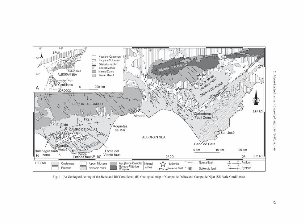
Fig. 1. (A) Geological setting of the Betic and Rif Cordilleras. (B) Geological map of Campo de Dalıas and Campo de Nıjar (SE Betic Cordilleras).
C.Marın
-Lech
adoet
al./Tecto
nophysics
396(2005)81–96
83
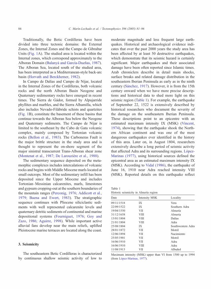
Table 1
Historic seismicity in Almerıa region
Date Intensity MSK Locality
09/11/1518 IX Vera
22/09/1522 IX Southern Adra
19/04/1550 VII Almerıa
31/12/1658 VIII Almerıa
13/01/1804 VIII Dalıas
21/01/1804 VIII Adra
25/08/1804 IX Southwestern Adra
28/01/1872 VII Motril
C. Marın-Lechado et al. / Tectonophysics 396 (2005) 81–9684
Traditionally, the Betic Cordilleras have been
divided into three tectonic domains: the External
Zones, the Internal Zones and the Campo de Gibraltar
Units (Fig. 1A). The studied area is located within the
Internal zones, which correspond approximately to the
Alboran Domain (Balanya and Garcıa-Duenas, 1987).
The Alboran Sea, located south of the studied area,
has been interpreted as a Mediterranean-style back-arc
basin (Horvath and Berckhemer, 1982).
In Campo de Dalıas and Campo de Nıjar, located
in the Internal Zones of the Cordilleras, both volcanic
rocks and the north Alboran Basin Neogene and
Quaternary sedimentary rocks have emerged in recent
times. The Sierra de Gador, formed by Alpujarride
phyllites and marbles, and the Sierra Alhamilla, which
also includes Nevado-Filabride schists and quartzites
(Fig. 1B), constitute the basement of these basins that
continue towards the Alboran Sea below the Neogene
and Quaternary sediments. The Campo de Nıjar is
limited to the southeast by the Cabo de Gata volcanic
complex, mainly composed by Tortonian volcanic
rocks (Bellon et al., 1983). The Carboneras Fault is
the major brittle structure in the study area and is
thought to represent the on-shore segment of the
major sinistral transcurrent Trans-Alboran shear zone
(Montenat et al., 1987; De Larouziere et al., 1988).
The sedimentary sequence deposited on the meta-
morphic complexes includes intercalations of volcanic
rocks and begins with Middle Miocene marls located at
small outcrops. Most of the sedimentary infill has been
deposited since the Upper Miocene and includes
Tortonian–Messinian calcarenites, marls, limestones
and gypsum cropping-out at the southern boundaries of
the mountain ranges (Perconig, 1976; Addicott et al.,
1979; Baena and Ewert, 1983). The stratigraphic
sequence continues with Pliocene siliciclastic sedi-
ments with well represented calcarenite levels and
quaternary detritic sediments of continental and marine
depositional systems (Fourniguet, 1976; Goy and
Zazo, 1986; Aguirre, 1998). While important active
alluvial fans develop near the main reliefs, uplifted
Pleistocene marine terraces are located along the coast.
12/06/1894 VII Nacimiento25/05/1901 VII Motril
16/06/1910 VII Adra
16/06/1910 VIII Adra
11/08/1913 VII Albunol
Maximum intensity (MSK) upper than VI from 1500 up to 1994
(from Lopez-Marinas, 1977).
3. Seismicity
The southeastern Betic Cordilleras is characterized
by continuous shallow seismic activity of low to
moderate magnitude and less frequent large earth-
quakes. Historical and archaeological evidence indi-
cates that over the past 2000 years the study area has
been affected by at least 50 destructive earthquakes,
which demonstrate that its seismic hazard is certainly
significant. Major earthquakes and their associated
damage have been often reported since Islamic times.
Arab chroniclers describe in detail main shocks,
surface breaks and related damage distribution in the
southeastern Iberian Peninsula as early as in the ninth
century (Sanchez, 1917). However, it is from the 15th
century onward when we have more precise descrip-
tions and historical data to shed more light on this
seismic region (Table 1). For example, the earthquake
of September 22, 1522 is extensively described by
historical researchers who document the severity of
the damage on the southeastern Iberian Peninsula.
These descriptions point to an epicentre with an
estimated maximum intensity IX (MSK) (Vincent,
1974), showing that the earthquake shook the North-
ern African continent and was one of the most
dangerous earthquakes ever identified in the history
of this area. Later on, in August 1804, researchers
extensively describe a long period of seismic activity
that affected Adra and its surrounding regions. Lopez-
Marinas (1977), using historical sources defined the
epicentral area as an estimated maximum intensity IX
(MSK). According to Vidal (1986), the earthquake of
June 16, 1910 near Adra reached intensity VIII
(MSK). Reported details on this earthquake reflect
C. Marın-Lechado et al. / Tectonophysics 396 (2005) 81–96 85
the severity of the damage in a wide macroseismic
area, from the middle of Spain to Morocco. The
existence of numerous historical descriptions, the
available archaeoseismic evidence and the daily
seismic activity recorded reveal the relatively high
seismic hazard of the southeastern Iberian Peninsula.
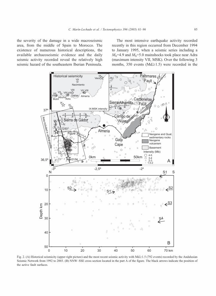
Fig. 2. (A) Historical seismicity (upper right picture) and the most recent se
Seismic Network from 1992 to 2003. (B) NNW–SSE cross section located
the active fault surfaces.
The most intensive earthquake activity recorded
recently in this region occurred from December 1994
to January 1995, when a seismic series including a
Mb=4.9 and Mb=5.0 mainshocks took place near Adra
(maximum intensity VII, MSK). Over the following 3
months, 350 events (Mdz1.5) were recorded in the
ismic activity with Mdz1.5 (792 events) recorded by the Andalusian
in the part A of the figure. The black arrows indicate the position of
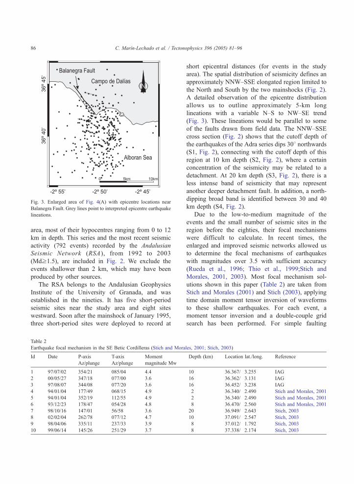
Fig. 3. Enlarged area of Fig. 4(A) with epicentre locations near
Balanegra Fault. Grey lines point to interpreted epicentre earthquake
lineations.
C. Marın-Lechado et al. / Tectonophysics 396 (2005) 81–9686
area, most of their hypocentres ranging from 0 to 12
km in depth. This series and the most recent seismic
activity (792 events) recorded by the Andalusian
Seismic Network (RSA ), from 1992 to 2003
(Mdz1.5), are included in Fig. 2. We exclude the
events shallower than 2 km, which may have been
produced by other sources.
The RSA belongs to the Andalusian Geophysics
Institute of the University of Granada, and was
established in the nineties. It has five short-period
seismic sites near the study area and eight sites
westward. Soon after the mainshock of January 1995,
three short-period sites were deployed to record at
Table 2
Earthquake focal mechanism in the SE Betic Cordilleras (Stich and Mora
Id Date P-axis
Az/plunge
T-axis
Az/plunge
Moment
magnitude Mw
1 97/07/02 354/21 085/04 4.4
2 00/05/27 347/18 077/00 3.6
3 97/08/07 344/08 077/20 3.6
4 94/01/04 177/49 068/15 4.9
5 94/01/04 352/19 112/55 4.9
6 93/12/23 178/47 054/28 4.8
7 98/10/16 147/01 56/58 3.6
8 02/02/04 262/78 077/12 4.7
9 98/04/06 335/11 237/33 3.9
10 99/06/14 145/26 251/29 3.7
short epicentral distances (for events in the study
area). The spatial distribution of seismicity defines an
approximately NNW–SSE elongated region limited to
the North and South by the two mainshocks (Fig. 2).
A detailed observation of the epicentre distribution
allows us to outline approximately 5-km long
lineations with a variable N–S to NW–SE trend
(Fig. 3). These lineations would be parallel to some
of the faults drawn from field data. The NNW–SSE
cross section (Fig. 2) shows that the cutoff depth of
the earthquakes of the Adra series dips 308 northwards(S1, Fig. 2), connecting with the cutoff depth of this
region at 10 km depth (S2, Fig. 2), where a certain
concentration of the seismicity may be related to a
detachment. At 20 km depth (S3, Fig. 2), there is a
less intense band of seismicity that may represent
another deeper detachment fault. In addition, a north-
dipping broad band is identified between 30 and 40
km depth (S4, Fig. 2).
Due to the low-to-medium magnitude of the
events and the small number of seismic sites in the
region before the eighties, their focal mechanisms
were difficult to calculate. In recent times, the
enlarged and improved seismic networks allowed us
to determine the focal mechanisms of earthquakes
with magnitudes over 3.5 with sufficient accuracy
(Rueda et al., 1996; Thio et al., 1999;Stich and
Morales, 2001, 2003). Most focal mechanism sol-
utions shown in this paper (Table 2) are taken from
Stich and Morales (2001) and Stich (2003), applying
time domain moment tensor inversion of waveforms
to these shallow earthquakes. For each event, a
moment tensor inversion and a double-couple grid
search has been performed. For simple faulting
les, 2001; Stich, 2003)
Depth (km) Location lat./long. Reference
10 36.367/�3.255 IAG
16 36.362/�3.131 IAG
16 36.452/�3.238 IAG
2 36.340/�2.490 Stich and Morales, 2001
2 36.340/�2.490 Stich and Morales, 2001
8 36.470/�2.560 Stich and Morales, 2001
20 36.949/�2.643 Stich, 2003
10 37.091/�2.547 Stich, 2003
8 37.012/�1.792 Stich, 2003
8 37.338/�2.174 Stich, 2003
C. Marın-Lechado et al. / Tectonophysics 396 (2005) 81–96 87
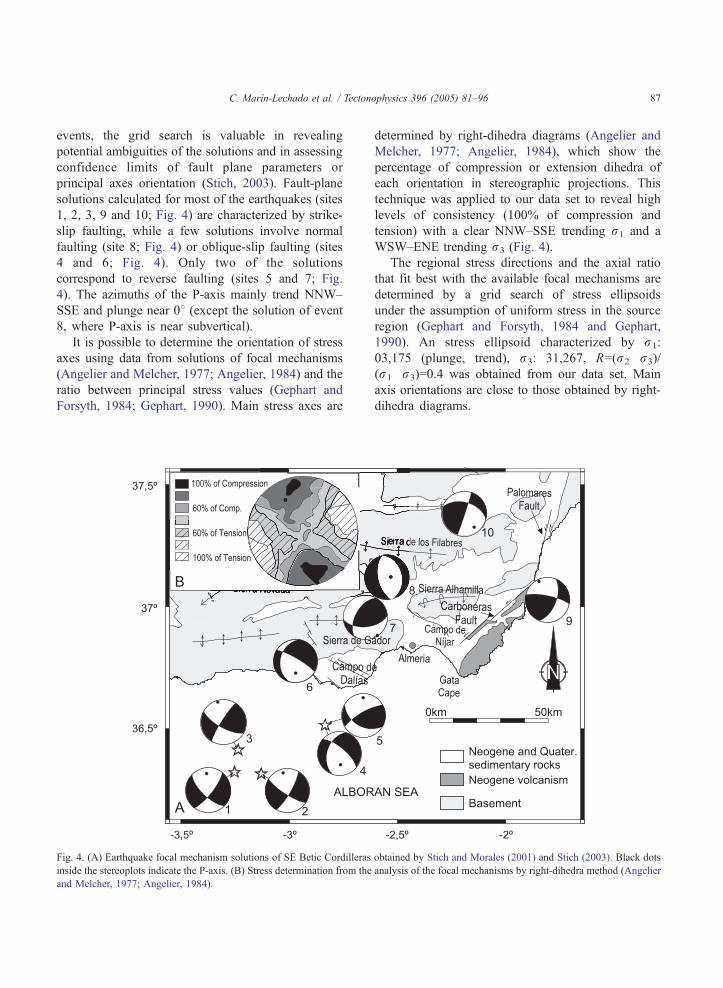
events, the grid search is valuable in revealing
potential ambiguities of the solutions and in assessing
confidence limits of fault plane parameters or
principal axes orientation (Stich, 2003). Fault-plane
solutions calculated for most of the earthquakes (sites
1, 2, 3, 9 and 10; Fig. 4) are characterized by strike-
slip faulting, while a few solutions involve normal
faulting (site 8; Fig. 4) or oblique-slip faulting (sites
4 and 6; Fig. 4). Only two of the solutions
correspond to reverse faulting (sites 5 and 7; Fig.
4). The azimuths of the P-axis mainly trend NNW–
SSE and plunge near 08 (except the solution of event
8, where P-axis is near subvertical).
It is possible to determine the orientation of stress
axes using data from solutions of focal mechanisms
(Angelier and Melcher, 1977; Angelier, 1984) and the
ratio between principal stress values (Gephart and
Forsyth, 1984; Gephart, 1990). Main stress axes are
Fig. 4. (A) Earthquake focal mechanism solutions of SE Betic Cordilleras
inside the stereoplots indicate the P-axis. (B) Stress determination from the
and Melcher, 1977; Angelier, 1984).
determined by right-dihedra diagrams (Angelier and
Melcher, 1977; Angelier, 1984), which show the
percentage of compression or extension dihedra of
each orientation in stereographic projections. This
technique was applied to our data set to reveal high
levels of consistency (100% of compression and
tension) with a clear NNW–SSE trending r1 and a
WSW–ENE trending r3 (Fig. 4).
The regional stress directions and the axial ratio
that fit best with the available focal mechanisms are
determined by a grid search of stress ellipsoids
under the assumption of uniform stress in the source
region (Gephart and Forsyth, 1984 and Gephart,
1990). An stress ellipsoid characterized by r1:
03,175 (plunge, trend), r3: 31,267, R=(r2�r3)/
(r1�r3)=0.4 was obtained from our data set. Main
axis orientations are close to those obtained by right-
dihedra diagrams.
obtained by Stich and Morales (2001) and Stich (2003). Black dots
analysis of the focal mechanisms by right-dihedra method (Angelier
C. Marın-Lechado et al. / Tectonophysics 396 (2005) 81–9688
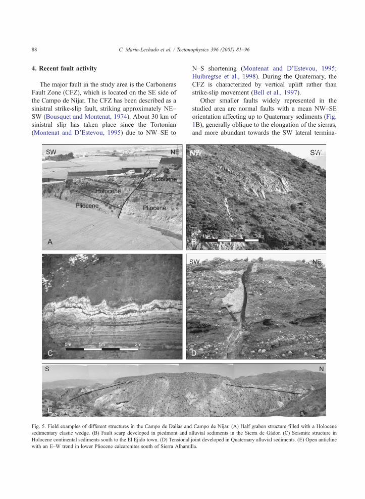
4. Recent fault activity
The major fault in the study area is the Carboneras
Fault Zone (CFZ), which is located on the SE side of
the Campo de Nıjar. The CFZ has been described as a
sinistral strike-slip fault, striking approximately NE–
SW (Bousquet and Montenat, 1974). About 30 km of
sinistral slip has taken place since the Tortonian
(Montenat and D’Estevou, 1995) due to NW–SE to
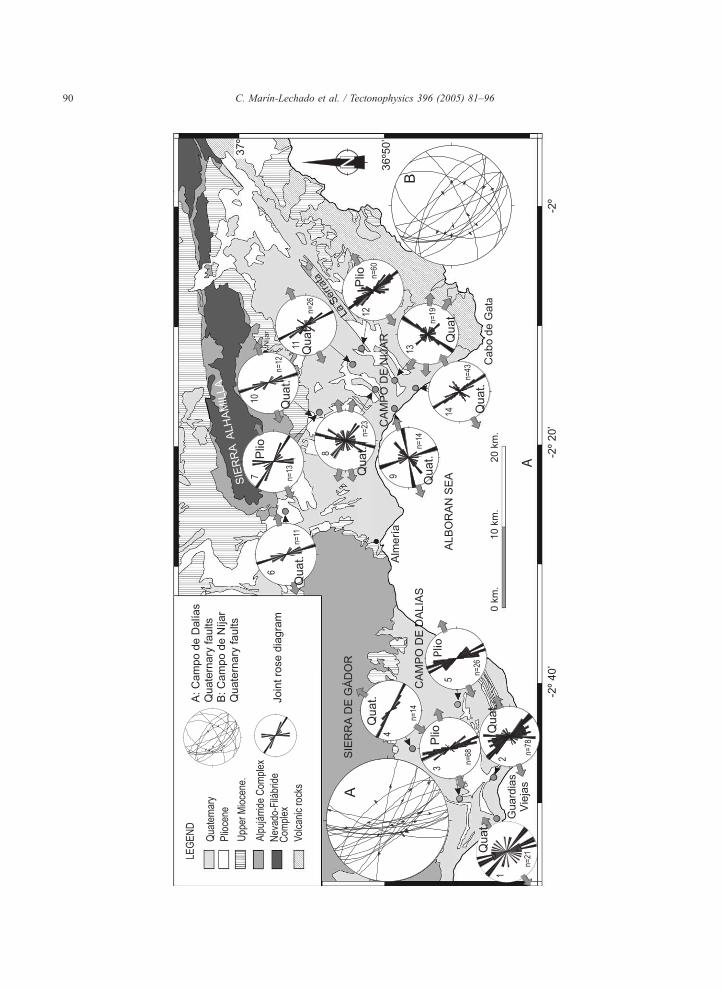
Fig. 5. Field examples of different structures in the Campo de Dalıas and
sedimentary clastic wedge. (B) Fault scarp developed in piedmont and a
Holocene continental sediments south to the El Ejido town. (D) Tensional
with an E–W trend in lower Pliocene calcarenites south of Sierra Alhami
N–S shortening (Montenat and D’Estevou, 1995;
Huibregtse et al., 1998). During the Quaternary, the
CFZ is characterized by vertical uplift rather than
strike-slip movement (Bell et al., 1997).
Other smaller faults widely represented in the
studied area are normal faults with a mean NW–SE
orientation affecting up to Quaternary sediments (Fig.
1B), generally oblique to the elongation of the sierras,
and more abundant towards the SW lateral termina-
Campo de Nıjar. (A) Half graben structure filled with a Holocene
lluvial sediments in the Sierra de Gador. (C) Seismite structure in
joint developed in Quaternary alluvial sediments. (E) Open anticline
lla.
C. Marın-Lechado et al. / Tectonophysics 396 (2005) 81–96 89
tions of antiforms. The Quaternary faults that develop
in the Sierra de Gador generate visible fault scarps and
deform Holocene alluvial sediments giving rise to
clastic wedges (Fig. 5A). These faults are responsible
for high slopes and sharp topography in the western
part of Sierra de Gador and may deform previous low-
angle faults like the Castala Fault (Galindo-Zaldıvar et
al., 2003) that crop-out in this border of the Sierra.
The recent activity of these faults is pointed out by the
development of half graben structures filled by
Holocene sedimentary clastic wedges (Fig. 5A). Half
grabens are up to several hundred meters wide, and
open generally towards the NE, although opposite
senses of opening are also very frequent. In addition,
synsedimentary faults with E–W to NE–SW trend and
reverse regime have been observed in Pliocene
sediments (Fig. 1B).
Most of the Quaternary faults have straight or
slightly curved traces at cartographic and outcrop
scale. Length is also variable, 2 km in average, but
attain in some cases as much as 8 km (for example:
Balanegra Fault, Loma del Viento Fault and Cuevas
de los Ubedas Fault). Some of these faults are
segmented, like the Loma del Viento Fault. The fault
dips are generally high, reaching in some cases up to
708 southwestwards and even approaching 908. Themaximum vertical slips are generally of tens of
meters, although in the most important faults they
can reach up to a hundred of meters (e.g. Loma del
Viento Fault and Balanegra Fault). The fault planes
are generally striated, showing slickensides that
enable kinematic interpretation. The displacement of
subhorizontal bedding and the topographic scarps also
help to interpret the sense of fault movements. The
Quaternary faults are normal, featuring oblique slip
with dextral or sinistral components, depending on
their orientation, and compatible with a single stress
ellipsoid with WSW–ENE extension (Marın-Lechado
et al., 2003). The most recent faults may be
considered faulted joints, developed from previous
hybrid joints formed in Pliocene times (Marın-
Lechado et al., 2003).
The seismicity in this area is also evidenced by the
presence of liquefaction processes in recent sediments
that can give rise to seismites. In the Campo de Dalıas,
south of the town of El Ejido, these structures can be
recognised in continental sediments of the distal parts
of Holocene alluvial fans. The size of these structures
varies from 0.2 to 1 m in wavelength and 0.1 to 0.5 in
height. The load cast morphology is irregular, sagging
or drop type (Alfaro et al., 1997) (Fig. 5C). The
seismites are made up of cemented clayey silt over-
lying fine sands. In Campo de Nıjar a small seismite
develops in Pliocene sediments near the Cueva de los
Ubedas Fault. Other seismites are located in the
southwest end of Carboneras fault in Pleistocene
sands and clays of continental character. Their size
varies from 0.4 to 1 m in wavelength and 0.2 to 0.5 in
height and the morphology is dome-like with an
irregular load cast.
In addition to these structures, the southern part of
the Nıjar Basin holds evidence of recent landslides
that may have developed with very low slope (around
158), possibly induced by the seismic activity of the
region. These landslides deform the sliced block
considerably and produce a complex array of reverse
faults, strike-slip faults and folds.
5. Other active or recent structures
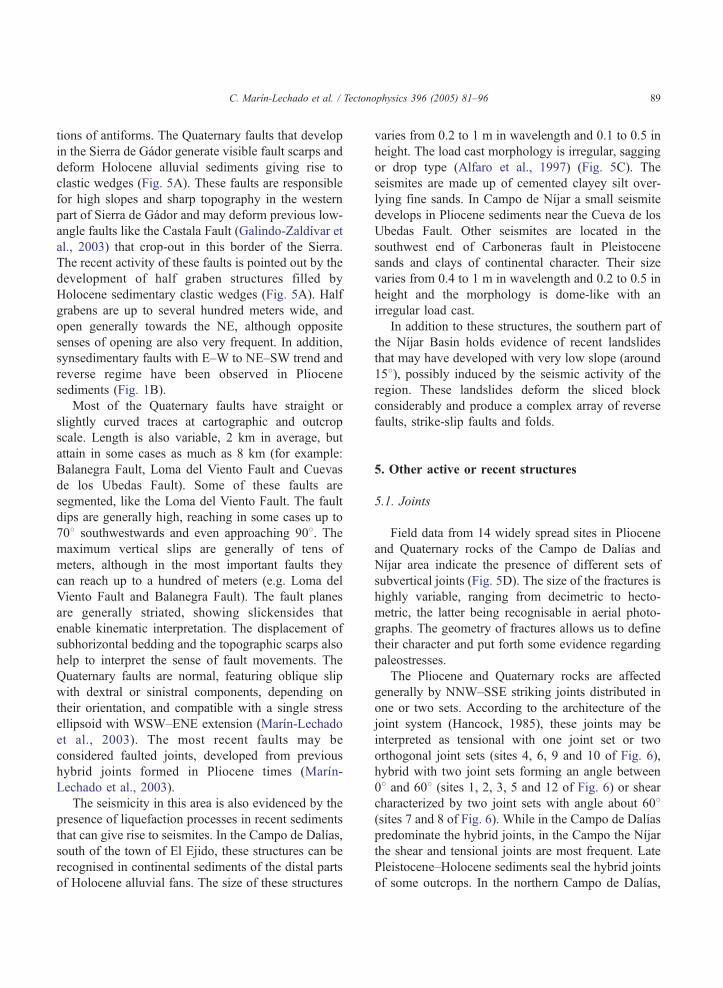
5.1. Joints
Field data from 14 widely spread sites in Pliocene
and Quaternary rocks of the Campo de Dalıas and
Nıjar area indicate the presence of different sets of
subvertical joints (Fig. 5D). The size of the fractures is
highly variable, ranging from decimetric to hecto-
metric, the latter being recognisable in aerial photo-
graphs. The geometry of fractures allows us to define
their character and put forth some evidence regarding
paleostresses.
The Pliocene and Quaternary rocks are affected
generally by NNW–SSE striking joints distributed in
one or two sets. According to the architecture of the
joint system (Hancock, 1985), these joints may be
interpreted as tensional with one joint set or two
orthogonal joint sets (sites 4, 6, 9 and 10 of Fig. 6),
hybrid with two joint sets forming an angle between
08 and 608 (sites 1, 2, 3, 5 and 12 of Fig. 6) or shear
characterized by two joint sets with angle about 608(sites 7 and 8 of Fig. 6). While in the Campo de Dalıas
predominate the hybrid joints, in the Campo the Nıjar
the shear and tensional joints are most frequent. Late
Pleistocene–Holocene sediments seal the hybrid joints
of some outcrops. In the northern Campo de Dalıas,
C. Marın-Lechado et al. / Tectonophysics 396 (2005) 81–9690
C. Marın-Lechado et al. / Tectonophysics 396 (2005) 81–96 91
these sediments are affected by a single tensional joint
set with N1208E strike (site 4; Fig. 6). In the Campo
de Nıjar region, the Quaternary sediments also are
locally deformed by a system of conjugate hybrid
joints.
5.2. Folds
Large open folds with associated uplift determine
the present relief in the central Cordilleras (Weijer-
mars et al., 1985; Johnson, 1997; Galindo-Zaldıvar et
al., 2003). The Sierra de Gador and Sierra Alhamilla,
among others, are roughly E–W elongated high
mountain ranges, corresponding to antiforms where
metamorphic rocks crop out. The Quaternary folding
and present-day activity is less evident from field
observation, but the generalized regional uplift of
Quaternary marine terraces throughout the region
(Zazo et al., 2003) may be due to the development
of these folds (Figs. 1B and 5E).
Fig. 7. (A) Aerial photograph showing a fault affecting Holocene
alluvial fan located in Fig. 2. (B) Sketch of drainage network pattern
influenced by the fault.
6. Tectonic geomorphology
There are several landforms in the study area that
show evidences of neotectonic activity. Most of the
Quaternary faults exhibit scarps near fault surfaces
that are affected by erosion and can reach several tens
of meters. However, this morphology is more frequent
and evident in Campo de Dalıas than in Campo de
Nıjar. The vertical scarps have average heights of
about 1–2 m, although they can reach 15 m, for
instance in the segmented Loma del Viento Fault (Fig.
7). The Balanegra Fault zone is formed by several
parallel faults with associated scarps of 1–10 m
producing an staircase morphology. Some faults affect
the drainage network. Fig. 7 shows a normal fault
with a right-lateral component of slip that deflects the
drainage network and the channels flow parallel to the
fault. The uplift of the southwestern block contributes
to the development of offset and beheaded streams.
On the other hand, the Carboneras fault does not show
evidences for large lateral offset of the Quaternary
Fig. 6. Rose diagrams of joints affecting Pliocene and Quaternary sediments from several measurement sites in the Campo de Dalıas and Nıjar
The number of data (n) and the age of sediments in each site is indicated: Plio., Pliocene; Quat., Quaternary. The grey arrows indicate the trend
of maximum extension direction. Stereoplots of Quaternary fault planes and striae for each region are also included.
marine terraces, at least during the last 100 ka (Bell et
al., 1997).
The coastline of the Campo de Dalıas features
some straight segments several kilometres long and a
NW–SE trend that coincides with some of the
principal faults such us the Balanegra Fault and Punta
Entinas Fault. These straight segments evidence the
recent activity of the faults. Another segment between
Cabo de Gata and El Alquian shows the same
.
C. Marın-Lechado et al. / Tectonophysics 396 (2005) 81–9692
orientation, but no fault is visible upon field observa-
tion. The Carboneras Fault, with a very rectilinear
front, does not displace the present coastline.
The incision of a drainage network in Quaternary
alluvial fans and glacis is very pronounced in the
entire region. The alluvial fans develop high slopes in
the half-proximal section and the related deposits may
reach up to 160 m, as deduced from borehole data.
Usually, the main channel is strongly incised in the
head zone. Near the study area, in the northeastern
boundary of the Sierra de Gador, the drainage network
has incision rates between 0.3 and 0.7 m/ka, similar to
the regional uplift rates in the area (Garcıa et al.,
2003).
Pleistocene marine terraces develop in the Almerıa
littoral, providing information about recent uplift of
the region. Near the Loma del Viento Fault, 16 marine
terraces have been described forming a staircase
profile that goes up to 82 m above actual sea level
(Zazo et al., 2003). The uplift rate in the upthrow
block of the Loma del Viento over the last 130 ka is of
0.046 m/ka (Zazo et al., 2003), but uplift varies
throughout the region because of interaction with
development of the folds and faults.
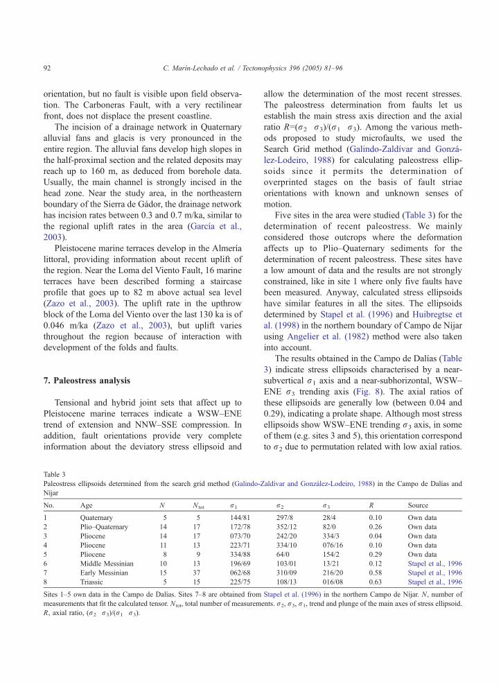
7. Paleostress analysis
Tensional and hybrid joint sets that affect up to
Pleistocene marine terraces indicate a WSW–ENE
trend of extension and NNW–SSE compression. In
addition, fault orientations provide very complete
information about the deviatory stress ellipsoid and
Table 3
Paleostress ellipsoids determined from the search grid method (Galindo-Z
Nıjar
No. Age N N tot r1
1 Quaternary 5 5 144/81
2 Plio–Quaternary 14 17 172/78
3 Pliocene 14 17 073/70
4 Pliocene 11 13 223/71
5 Pliocene 8 9 334/88
6 Middle Messinian 10 13 196/69
7 Early Messinian 15 37 062/68
8 Triassic 5 15 225/75
Sites 1–5 own data in the Campo de Dalıas. Sites 7–8 are obtained from
measurements that fit the calculated tensor. N tot, total number of measurem
R, axial ratio, (r2�r3)/(r1�r3).
allow the determination of the most recent stresses.
The paleostress determination from faults let us
establish the main stress axis direction and the axial
ratio R=(r2�r3)/(r1�r3). Among the various meth-
ods proposed to study microfaults, we used the
Search Grid method (Galindo-Zaldıvar and Gonza-
lez-Lodeiro, 1988) for calculating paleostress ellip-
soids since it permits the determination of
overprinted stages on the basis of fault striae
orientations with known and unknown senses of
motion.
Five sites in the area were studied (Table 3) for the
determination of recent paleostress. We mainly
considered those outcrops where the deformation
affects up to Plio–Quaternary sediments for the
determination of recent paleostress. These sites have
a low amount of data and the results are not strongly
constrained, like in site 1 where only five faults have
been measured. Anyway, calculated stress ellipsoids
have similar features in all the sites. The ellipsoids
determined by Stapel et al. (1996) and Huibregtse et
al. (1998) in the northern boundary of Campo de Nıjar
using Angelier et al. (1982) method were also taken
into account.
The results obtained in the Campo de Dalıas (Table
3) indicate stress ellipsoids characterised by a near-
subvertical r1 axis and a near-subhorizontal, WSW–
ENE r3 trending axis (Fig. 8). The axial ratios of
these ellipsoids are generally low (between 0.04 and
0.29), indicating a prolate shape. Although most stress
ellipsoids show WSW–ENE trending r3 axis, in some
of them (e.g. sites 3 and 5), this orientation correspond
to r2 due to permutation related with low axial ratios.
aldıvar and Gonzalez-Lodeiro, 1988) in the Campo de Dalıas and
r2 r3 R Source
297/8 28/4 0.10 Own data
352/12 82/0 0.26 Own data
242/20 334/3 0.04 Own data
334/10 076/16 0.10 Own data
64/0 154/2 0.29 Own data
103/01 13/21 0.12 Stapel et al., 1996
310/09 216/20 0.58 Stapel et al., 1996
108/13 016/08 0.63 Stapel et al., 1996
Stapel et al. (1996) in the northern Campo de Nıjar. N, number of
ents. r2, r3, r1, trend and plunge of the main axes of stress ellipsoid.
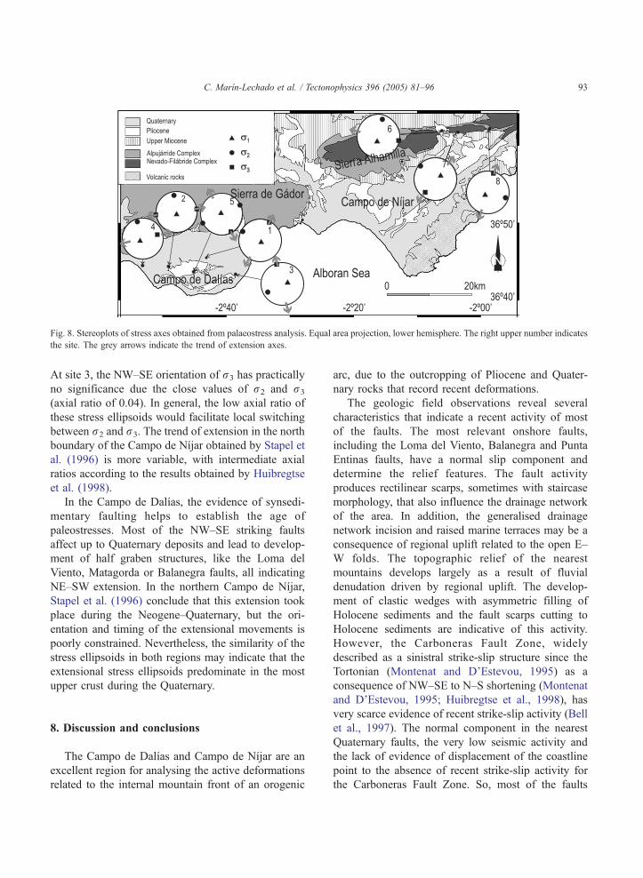
Fig. 8. Stereoplots of stress axes obtained from palaeostress analysis. Equal area projection, lower hemisphere. The right upper number indicates
the site. The grey arrows indicate the trend of extension axes.
C. Marın-Lechado et al. / Tectonophysics 396 (2005) 81–96 93
At site 3, the NW–SE orientation of r3 has practically
no significance due the close values of r2 and r3
(axial ratio of 0.04). In general, the low axial ratio of
these stress ellipsoids would facilitate local switching
between r2 and r3. The trend of extension in the north
boundary of the Campo de Nıjar obtained by Stapel et
al. (1996) is more variable, with intermediate axial
ratios according to the results obtained by Huibregtse
et al. (1998).
In the Campo de Dalıas, the evidence of synsedi-
mentary faulting helps to establish the age of
paleostresses. Most of the NW–SE striking faults
affect up to Quaternary deposits and lead to develop-
ment of half graben structures, like the Loma del
Viento, Matagorda or Balanegra faults, all indicating
NE–SW extension. In the northern Campo de Nıjar,
Stapel et al. (1996) conclude that this extension took
place during the Neogene–Quaternary, but the ori-
entation and timing of the extensional movements is
poorly constrained. Nevertheless, the similarity of the
stress ellipsoids in both regions may indicate that the
extensional stress ellipsoids predominate in the most
upper crust during the Quaternary.
8. Discussion and conclusions
The Campo de Dalıas and Campo de Nıjar are an
excellent region for analysing the active deformations
related to the internal mountain front of an orogenic
arc, due to the outcropping of Pliocene and Quater-
nary rocks that record recent deformations.
The geologic field observations reveal several
characteristics that indicate a recent activity of most
of the faults. The most relevant onshore faults,
including the Loma del Viento, Balanegra and Punta
Entinas faults, have a normal slip component and
determine the relief features. The fault activity
produces rectilinear scarps, sometimes with staircase
morphology, that also influence the drainage network
of the area. In addition, the generalised drainage
network incision and raised marine terraces may be a
consequence of regional uplift related to the open E–
W folds. The topographic relief of the nearest
mountains develops largely as a result of fluvial
denudation driven by regional uplift. The develop-
ment of clastic wedges with asymmetric filling of
Holocene sediments and the fault scarps cutting to
Holocene sediments are indicative of this activity.
However, the Carboneras Fault Zone, widely
described as a sinistral strike-slip structure since the
Tortonian (Montenat and D’Estevou, 1995) as a
consequence of NW–SE to N–S shortening (Montenat
and D’Estevou, 1995; Huibregtse et al., 1998), has
very scarce evidence of recent strike-slip activity (Bell
et al., 1997). The normal component in the nearest
Quaternary faults, the very low seismic activity and
the lack of evidence of displacement of the coastline
point to the absence of recent strike-slip activity for
the Carboneras Fault Zone. So, most of the faults
C. Marın-Lechado et al. / Tectonophysics 396 (2005) 81–9694
active in the uppermost crust have normal slip
component.
The presence of seismites in Pliocene and Quater-
nary sediments of the Campo de Dalıas and Nıjar and
the landslides developed on low slopes in the
southern sector of the Campo de Nıjar are additional
evidences of paleoearthquakes. Ambraseys (1988)
indicates that the minimum magnitude of the earth-
quakes in order to develop liquefaction structures is
M=5 and that liquefaction structures increase largely
with magnitude, being very common when magni-
tudes are above 5.5. The relationship between surface
rupture length versus seismic magnitude (Wells and
Coppersmith, 1994) allow an estimation of the
occurrence of maximum magnitude in the range of
5–5.5, considering that the maximum fault lengths
cropping-out in the region are of 8 km. However, the
projection of hypocenters on a vertical section
evidences the presence of a basal detachment at 10
km depth, which due to its larger surface, may
produce earthquakes of higher magnitude. All these
data suggest that the region has undergone moderate
seismic activity that continues up to present, related
with the development of the mountain front, where
the slip on the outcropping faults may be transferred
to crustal detachments.
The offshore area SW of Campo de Dalıas shows a
higher level of seismic activity (mainly concentrated
in the first 10 km of depth) than other areas of the
cordillera. The shallow seismicity shows NW–SE-
oriented lineations of epicenters that in some cases
coincide with the main Quaternary faults observed in
Campo de Dalıas (Balanegra Fault and Punta Entinas
Fault) (Fig. 3). An analysis of the distribution of
seismic data suggests the presence of a low-angle fault
that intersects the sea bottom south of the Campo de
Dalıas, dipping 308 northwards, and connecting with
the detachment at a depth of 10 km. In the context of
NNW–SSE regional shortening, this low-angle fault
may represent a main reverse fault related to the
frontal part of the mountain front. Its activity is
possibly related to the occurrence of reverse earth-
quake focal mechanisms (5, Fig. 4). The main brittle
deformations and folds are located in the upper block
of the crustal detachment and the low-angle north-
dipping fault. This distribution of seismicity may also
be a consequence of slightly high temperature
gradients in the source region, located near the
Alboran Sea, where high heat flow has been measured
(Basov et al., 1994). A deeper detachment located at
20 km depth (S3, Fig. 2) is less defined. In addition, a
north dipping band of seismicity at 30–40 km depth
(S4, Fig. 2) is also identified, although the hypo-
centers shows more dispersion and the available
geophysical and geological data do not allow to
determine the features of this structure located in the
mantle.
Recent and present-day stresses share many fea-
tures. Reverse low angle faults, hybrid joints and folds
localized in Pliocene sediments are compatible with a
paleostress ellipsoid characterized by a main WSW–
ENE extension and a perpendicular NNW–SSE
compression. During the Holocene, the paleostress
analysis from microfaults and joint sets indicates a
WSW–ENE to radial extension. The earthquake focal
mechanisms in the studied area show different
regimes (strike-slip, normal and reverse solutions).
However, the right-dihedra diagram indicates that a
single stress ellipsoid is compatible with all of the
earthquake focal mechanisms, characterized by a
subhorizontal NNW–SSE compression and a WSW–
ENE extension, with a probable triaxial shape, as
indicated by the Geparth method (Gephart and
Forsyth, 1984 and Gephart, 1990). The paleostress
ellipsoids obtained from shallow faulted Quaternary
sediments, however, show a subvertical r1 and a
subhorizontal WSW–ENE to radial oriented r3. This
variability of stresses may be the consequence of a
relative change of the vertical stresses from depth to
surface. In the deeper part of the crust, the horizontal
NNW–SSE compressive stresses that allow the
development of reverse and strike-slip faults may
predominate, while in the uppermost part of the crust
the relative value of the vertical stress increases and
normal faulting develops. The orientation of main
axes of horizontal stress ellipse remains nearly
constant, in the crust overall, with an ENE–WSW
minimum axis. If the horizontal stress values remain
nearly constant, the relative change of vertical stress
from depth to surface should be the opposite to the
described one: it should decrease as the lithostatic
load does. However, a decrease of horizontal stress
values is necessary, probably induced by horizontal
spreading concomitant to relief uplift.
The active structures described in this internal
mountain front of the Betic Cordilleras and the
C. Marın-Lechado et al. / Tectonophysics 396 (2005) 81–96 95
standard external mountain fronts include common
features, such as the presence of reverse faults in
depth, dipping towards the mountain front, that join
a basal detachment. However, the studied internal
mountain front is more complex, as it includes a
large variety of linked active extensional and
compressional structures related with the same
horizontal stress ellipse, but which vary greatly in
depth. The upper crust has undergone mainly
normal faulting, with local strike-slip regimes, while
at depth reverse and strike slip faults predominate.
The trends of compression and extension are
slightly oblique to the mountain front, since the
latter was probably controlled by the orientation of
previously inherited structures, from earlier stages
of the tectonic arc development. The deformed
rocks are mainly heterogeneous metamorphic rocks
of the Internal Zones, which may behave very
differently than the low deformed rocks of the
External Zones. Another difference is that the
activity on the basal detachment extends beyond
the mountain front, towards the internal basin,
which is also affected by deformation. The basin
size is progressively reduced by the activity of these
structures. Finally, in the case of the Betic
Cordilleras, the activity of the studied internal
mountain front is substantially greater than the
external front of the Cordillera. All these consid-
erations would mean that internal and external
mountain fronts of arched orogens have different
features and types of evolution.
Acknowledgements
This study was supported by a PhD grant to the first
author from the IGME (Instituto Geologico y Minero
de Espana) and CICYT project BTE2003-01699.
References
Addicott, W.O., Snavely, P.D., Poore, R.Z., Bukry, D., 1979. La
secuencia neogena marina de los Campos de Dalıas y de Nıjar
(Almerıa). Estudios Geologicos 35, 609–631.
Aguirre, J., 1998. El plioceno del SE de la penınsula Iberica
(provincia de Almerıa). Sıntesis estratigrafica, sedimentaria,
bioestratigrafica y paleogeografica. Revista de la Sociedad
Geologica de Espana 11, 297–315.
Alfaro, P., Moretti, M., Soria, J., 1997. Soft-sediment deformation
structures induced by earthquakes (seismites) in Pliocene
lacustrine deposits (Guadix-Baza Basin Central Betic Cordil-
lera). Eclogae Geologicae Helveticae 90, 531–540.
Ambraseys, N., 1988. Engineering seismology. Earthquake Engi-
neering and Structural Dynamics 17, 1–105.
Angelier, J., 1984. Tectonic analysis of fault slip data sets. Journal
of Geophysical Research 89, 5835–5848.
Angelier, J., Melcher, P., 1977. Sur une methode graphique de
recherche des contraintes principales egalement utilisable en
tectonique et en seismologie: la methode des diedres droits.
Bulletin de la Societe Geologique de France 19, 1309–1318.
Angelier, J., Tarantola, A., Valette, B., Manousis, S., 1982.
Inversion of field data in fault tectonics to obtain the regional
stress: I. Single phase fault populations: a new method of
computing the stress tensor. Geophysical Journal of the Royal
Astronomical Society G9, 607–621.
Baena, J., Ewert, K., 1983. Mapa y memoria explicativa de la Hoja
1.058 (Roquetas de Mar). IGME Map 1058, scale 1:50,000.
Balanya, J.C., Garcıa-Duenas, V., 1987. Les directions structurales
dans le Domaine d’Alboran de part et d’autre du Detroit de
Gibraltar. Comptes Rendus de l’Academie des Sciences de Paris
304, 929–933.
Bargach, K., Ruano, P., Chabli, A., Galindo-Zaldıvar, J., Chalouan,
A., Jabaloy, A., Akil, M., Ahmamou, M., Sanz de Galdeano, C.,
Benmakhlouf, M., 2004. Recent tectonic deformations and
stresses in the frontal part of the Rif Cordillera and the SaRsBasin (Fes and Rabat regions, Morocco). Pure and Applied
Geophysics 161, 521–540.
Basov, I.A., Bogdanov, N.A., Comas, M.C., Polyak, B.G.,
Fernandez, M., Khain, V.Y., Khutorskoy, M.D., Agapova,
G.V., Alonso, B., Mazurova, I.S., Soto, J.I., 1994. Recent
sediments, heat flow and gravity field in the Alboran Sea
(Western Mediterranean). Comptes Rendus de l’Academie des
Sciences de Moscow 338, 229–234.
Bell, J.W., Amelung, F., Geoffrey, C., King, C.P., 1997. Preliminary
late quaternary slip history of the Carboneras fault, southeastern
Spain. Journal of Geodynamics 24, 51–66.
Bellon, H., Bordet, P., Montenat, C., 1983. Chronologie du
magmatisme neogene des Cordilleres Betiques (Espagne
Meridionel). Bulletin de la Societe Geologique de France 25,
205–218.
Bott, M.H.P., 1959. The mechanics of oblique faulting. Geological
Magazine 2, 109–117.
Bousquet, J.C., Montenat, C., 1974. Presence de decrochements
nord-est sud-ouest plioquaternaires, dans les Cordilleres
betiques orientales (Espagne). Extension et signification gen-
erale. Comptes Rendus de l’Academie des Sciences de Paris
278, 2617–2620.
Burbank, D.W., Anderson, R.S., 2001. Tectonic Geomorphology.
Blackwell Science, Berlin, pp. 274.
De Larouziere, F.D., Bolze, J., Bordet, P., Hernandez, J., Montenat,
C., Ott D3Estevou, P., 1988. The Betic segment of the
lithospheric Trans-Alboran shear zone during the late Miocene.
Tectonophysics 152, 41–52.
De Mets, C., Gordon, R.G., Argus, D.F., Stein, S., 1990. Current
plate motions. Geophysical Journal International 101, 425–478.
C. Marın-Lechado et al. / Tectonophysics 396 (2005) 81–9696
Doutsos, T., Kokkalas, S., 2001. Stress and deformation patterns in
the Aegean region. Journal of Structural Geology 23, 455–472.
Fourniguet, J., 1976. Quaternaire marin et neotectonique sur la cote
andalouse meridionale (Espagne). Comptes Rendus de l’Aca-
demie des Sciences de Paris 282, 1849–1852.
Galindo-Zaldıvar, J., Gonzalez-Lodeiro, F., 1988. Faulting phase
differentiation by means of computer search on grid pattern.
Annales Tectonicae 2, 90–97.
Galindo-Zaldıvar, J., Gil, A.J., Borque, M.J., Gonzalez-Lodeiro, F.,
Jabaloy, A., Marın-Lechado, C., Ruano, P., Sanz de Galdeano,
C., 2003. Active faulting in the internal zones of the central Betic
Cordilleras (SE Spain). Journal of Geodynamics 36, 239–250.
Garcıa, A.F., Zhu, Z., Ku, T.L., Sanz de Galdeano, C., Chadwick,
O.A., Chacon-Montero, J., 2003. Tectonically driven landscape
development within the eastern Alpujarran Corridor Betic
Cordillera, SE Spain (Almeria). Geomorphology 50, 83–110.
Gephart, J.W., 1990. FSMI: a fortran program for inverting fault/
slickenside and earthquake focal mechanism data to obtain the
regional stress tensor. Computer &Geosciences 16 (7), 953–989.
Gephart, J.W., Forsyth, D.W., 1984. An improved method for
determining the regional stress tensor using earthquake focal
mechanism data: application to the San Fernando earthquake
sequence. Journal of Geophysical Research 89, 9305–9320.
Gimenez, J., Surinach, E., Goula, X., 2000. Quantification of
vertical movements in the eastern Betics (Spain) by comparing
levelling data. Tectonophysics 317, 237–258.
Goy, J.L., Zazo, C., 1986. Synthesis of the Quaternary in the
Almerıa littoral neotectonic activity and its morphologic
features, western Betics Spain. Tectonophysics 130, 259–270.
Horvath, F., Berckhemer, H., 1982. Mediterranean backarc basins.
In: Berckhemer, H., Hsu, K. (Eds.), Alpine–Mediterranean,
Geodynamics, vol. 7, pp. 141–173.
Huibregtse, P., Alebeek, H.V., Zaal, M., Biermann, C., 1998.
Paleostress analysis of the northern Nıjar and southern Vera
basins: constraints for the Neogene displacement history of
major strike-slip faults in the Betic Cordilleras, SE Spain.
Tectonophysics 300, 79–101.
Johnson, C., 1997. Resolving denudational histories in orogenic
belts with apatite fission-track thermochronology and structural
data: an example from southern Spain. Geology 25, 623–626.
Keller, E.A., Pinter, N., 1996. Active Tectonics: Earthquakes, Uplift
and Landscape. Prentice Hall.
Linzer, H.G., Decker, K., Peresson, H., Dell, M.R., Frisch, W.,
2002. Balancing lateral orogenic float of the Eastern Alps.
Tectonophysics 354, 211–237.
Lopez-Marinas, J.M., 1977. Estudio del terremoto de 22 Septiembre
1522 en Almerıa. Publicacion Hidroelectrica Espanola. 16 pp.
Marın-Lechado, C., Galindo-Zaldıvar, J., Rodrıguez-Fernandez,
L.R., 2003. Joints, faults and paleostress evolution in the
Campo de Dalıas (Betic Cordilleras, SE Spain). Comptes
Rendus de l’Academie des Sciences 335, 255–264.
Martınez-Dıaz, J.J., 2000. Actividad neotectonica en el sureste de
Almerıa y su incidencia en la morfotectonica de la zona
(Cordilleras Beticas). Revista de la Sociedad Geologica de
Espana 13, 417–429.
Mezcua, J., Martinez-Solares, J.M., 1983. Earthquake catalogs
published recently by the National Geographic Institute.
Comunicaciones y Ponencias-Instituto Geografico Nacional 1,
65–67.
Montenat, V., D’Estevou, O., 1995. Late Neogene basins evolving
in the Eastern Betic transcurrent fault zone: an illustrated
review. In: Friend, P.F., Dabrio, C.J. (Eds.), Tertiary Basins of
Spain, pp. 372–386.
Montenat, C., D’Estevou, O., Masse, P., 1987. Tectonic-sedimen-
tary characters of the Betic Neogene Basins evolving in a crustal
transcurrent shear zone (SE Spain). Bulletin Centres Recherche
Exploration Prod. Elf-Aquitaine 11, 1–22.
Perconig, E., 1976. Estudio de algunos cortes del Neogeno de Sierra
de Gador y del Campo de Dalıas (Almerıa Espana). Revista
Espanola de Micropaleontologia 8, 141–178.
Ricci-Lucchi, F., 1986. The Oligocene to recent foreland basins of
the Northern Apennines. In: Allen, P.A., Homewood, P. (Eds.),
Special Publication of the Int. Ass. Sed., vol. 8, pp. 105–139.
Rodrıguez-Fernandez, J., Martın-Penela, J., 1993. Neogene evolu-
tion of the Campo de Dalıas and surrounding offshore areas
(Northeastern Alboran Sea). Geodinamica Acta 6, 255–270.
Rueda, J., Mezcua, J., Sanchez-Ramos, M., 1996. La serie sısmica de
Adra (Almerıa) de 1993–1994 y sus principales consecuencias
sismotectonicas. Avances en Geofısica y Geodesia 1, 91–98.
Sanchez, M., 1917. Datos referentes a la sismicidad de la porcion
oriental de la Penınsula Iberica. Memorias de la Real Academia
de Ciencias y Artes de Barcelona XIII (N8), 179–188.
Stapel, G., Moeys, R., Biermann, C., 1996. Neogene evolution of
the Sorbas basin (SE Spain) determined by paleostress analysis.
Tectonophysics 255, 291–305.
Stich, A.G., 2003. Inversion del tensor momento sısmico para
terremotos de la region Iberomagrebı. PhD thesis, University of
Granada, Granada.
Stich, A.G., Morales, J., 2001. The relative locations of multiplets in the
vicinity of the Western Almerıa (southern Spain) earthquake series
of 1993–1994. Geophysical Journal International 146, 801–812.
Thio, H.K., Song, X., Saikia, C.K., Helmberger, D.V., Woods, B.B.,
1999. Seismic source and structure estimation in the western
Mediterranean using a sparse broadband network. Journal of
Geophysical Research 104, 845–861.
Vidal, F., 1986. Sismotectonica de la region Beticas-Mar de
Alboran, PhD thesis, University of Granada, Granada.
Vincent, B., 1974. Les tremblements de terre dans la province
d’Almeria (XV–XIX siecle), Paris. Annales 3, 571–586.
Weijermars, R., Roep, T.B., Van den Eeckhout, B., Postma, G.,
Kleverlaan, K., 1985. Uplift history of a Betic fold nappe
inferred from Neogene–Quaternary sedimentation and tectonics
(in the Sierra Alhamilla and Almerıa, Sorbas and Tabernas
Basins of the Betic Cordilleras SE Spain). Geologie en
Mijnbouw 64, 397–411.
Wells, D.L., Coppersmith, K.J., 1994. New empirical relationships
among magnitude, rupture length, rupture width, and surface
displacement. Bulletin of the Seismological Society of America
84, 974–1002.
Zazo, C., Goy, J.L., Dabrio, C.J., Bajardı, T., Hillarie-Marcel, C.,
Ghaleb, B., Gonzalez-Delgado, J.A., Soler, V., 2003. Pleisto-
cene raised marine terraces of the Spanish Mediterranean and
Atlantic coast: records of coastal uplift, sea-level highstands and
climate changes. Marine Geology 194, 103–133.