activity book social science - santillana españa science contents unit topics 1 planet earth 4 the...
TRANSCRIPT

PR
IMA
RY
Richmond
ACTIVITY BOOK
Social Science


Contents
Unit Topics
1 Planet Earth
4
The solar system
The Earth’s movements
Our planet Earth
2 Representing the Earth
8
Globes and maps
Parts of a map
World maps
3 Air
12
Air and the atmosphere
Weather
Air pollution
4 Water
16
Where can we find water?
The water cycle
People and water
5 Landscapes
20
Inland landscapes
Coastal landscapes
People and landscapes
6 Villages, towns and cities
24
Villages
Towns and cities
Local councils and municipal services
7 Jobs in nature
28
Jobs
Jobs in the primary sector I
Jobs in the primary sector II
8 Jobs and services
32
Jobs in the secondary sector
Jobs in the tertiary sector
Transport and commerce
9 The past
36
Time and the past
People through history I
People through history II
three 3

1 the earth
2 Tick (√) the true sentences.
Maps are round like globes.
Cartographers make maps.
1 Label the globe. Then, use the words to complete the sentences.
3 How do artificial satellites help us? Match the sentence to the picture.
North Pole South Pole Northern Hemisphere Southern HemisphereEquator
A globe is the most accurate way to represent the Earth. The divides
the Earth into two halves: the and the
. The point on Earth that is farthest north is
the . The point that is farthest south is the
.
Maps are flat representations of the Earth’s surface.
Artificial satellites take photos of the Earth.
1. They help us to find our way: picture
2. They help us to know about the weather: picture
3. They help us to communicate: picture
A B C
4 four

Roque de losMuchachos
2,428 m
Santa Cruzde La Palma
TaburienteCaldera
Fuencaliente Point
Rabisca Point
Cumbre Vieja1,945 m
Teneguia Volcano439 m
ATLANTICOCEAN
644537_U03_p07_h1_relieve La Palma
LA PALMA
Villa de Mazo
Tijarafe
Tazacorte
Santa Cruzde La Palma
San Andrésy Sauces
PuntallanaPuntagorda
ElPaso
Garafía
Fuencalientede La Palma
Breña Baja
Barlovento
Breña Alta
Los Llanosde Aridane
ATLANTICOCEAN
644537_U03_p007_h2_político La Palma
LA PALMA
1 Label the maps. Then, complete the sentences.
2 What kind of map do I need? Read and match.
a. Is it going to rain tomorrow?
b. Where is Puntagorda? physical map
c. Are there deserts or vegetation? thematic map
d. What is the highest mountain? political map
3 Write the missing points on each compass.
physical – political – thematic
map map map
a. A map shows different areas of a country.
b. A map shows vegetation or weather.
c. A map shows the different heights of the land.
d. The map shows many cities and towns.
A B C
E
S
N
W
5five

1 Maps have four parts. Match each part to the map. Draw a line.
label – key – scale – compass rose
3 Make your own map.
Draw your house in the centre.
Draw your school to the north.
Draw a supermarket to the east.
Draw a lake to the south.
Draw a park to the west.
2 What does each part of a map do? Read and match.
a. This tells us the names of places on the map. compass rose
b. This explains the symbols and the colours. key
c. This shows us four points: N, S, E, W. scale
d. This shows us how many times the distance is reduced. label
es Malgrats
sa Dragonera
Bayof Palma
CapeCala Figuera
Bay of sa Ràpita
Conills/Conejera
Cape ses Salines
n'Amer Point
Bay of son Servera
Cape Ferrutx
Cape des PinarBay of PollençaCape Formentor
Cabod'Artrutx
Torre
ntde
Mur
o
Torr
ent n
aBo
rges
M e d i t e r r a n e a n
S e a
MENORCASierra
deTram
untana
SierrasdeL levant
MALLORCA
Bayof Alcúdia
CapdeperaPoint
Sierrade
Alfàb
ia
Sierra
T. de Sant MiquelPuig Major
1,436 m
el Toro362 m
Ciutadellade Menorca
Puig de Masanella1,365 m
Puig de Randa543 m
Puig deSant Salvador
510 m
Puig de son Morei561 md’ArtàMassif
deCalicant
Puig de Galatzó1,026 m
Calvià
Inca
Llucmajor
ManacorPalma
Sa Pobla
644537_U03_p008_h1_Baleares_�sico
N
S
EW
PLA
0−400400−1,000more than 1,000
Peaks
HEIGHT (metres)
CapitalCities
Scale0 850,000 cm
`
6 six
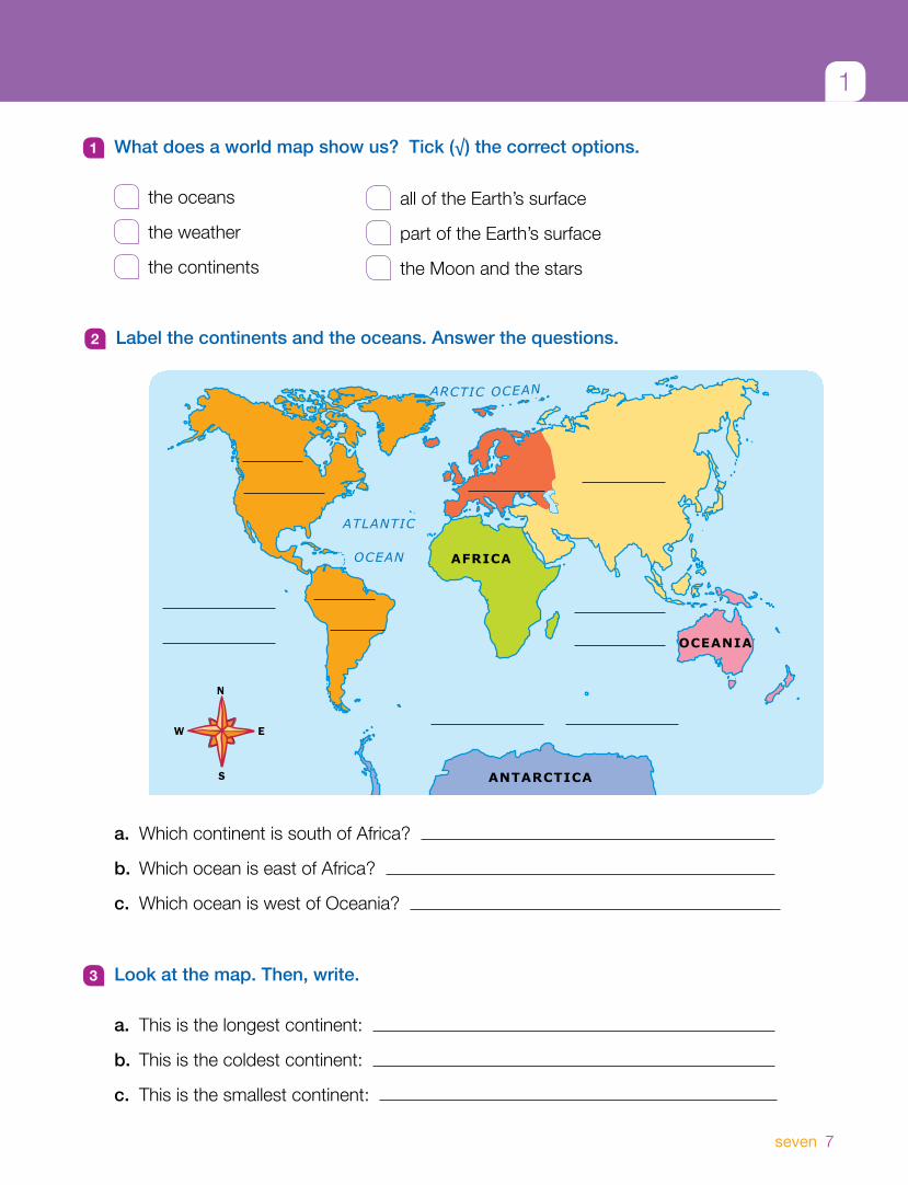
1
3 Look at the map. Then, write.
a. This is the longest continent:
b. This is the coldest continent:
c. This is the smallest continent:
1 What does a world map show us? Tick (√) the correct options.
the oceans
the weather
the continents
all of the Earth’s surface
part of the Earth’s surface
the Moon and the stars
2 Label the continents and the oceans. Answer the questions.
a. Which continent is south of Africa?
b. Which ocean is east of Africa?
c. Which ocean is west of Oceania?
ATLANTIC
OCEAN
ARCTIC OCEAN
289803U7p45_mundi oceanos
N
EW
S
AFRICA
OCEANIA
ANTARCTICA
7seven