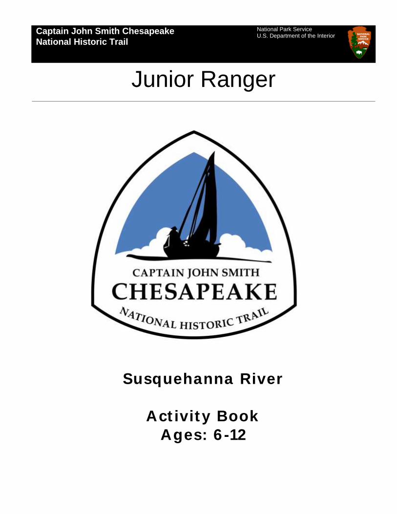
activity book susquehanna river ages: 6 - 12
TRANSCRIPT
Captain John Smith Chesapeake
National Historic Trail
Junior Ranger
National Park Service U.S. Department of the Interior
Susquehanna River
Act ivity Book
Ages: 6 -12

Captain John Smith Chesapeake National Historic Trail - 2
EXPERIENCE YOUR AMERICA
Captain John Smith Chesapeake National Historic Trail
WORKSHEETS INCLUDED
Introduction Welcome to the Captain John Smith
Chesapeake National Historic Trail!
We’re glad you decided to participate
in our Junior Ranger program. These
activities have been designed for kids
ages 6 to 12.
Join Clipper the Crab to learn about
the explorer Captain John Smith and
his voyages of the Chesapeake Bay.
Learn about the history and culture of
the Indians of this region and how
they lived with the Bay. You will
discover what the Chesapeake Bay
was like over 400 years ago and why
you are important to the Bay today.
A Junior Ranger agrees to help Park
Rangers protect and take care of the
National Parks. This is a big job
because there are more than 400
National Parks in the United States!
The National Park Service also helps to
take care of the Chesapeake Bay. As a
Junior Ranger you will learn what you
can do to help the Bay.
If you like our Junior Ranger book,
become a Web Ranger! Log on to:
www.nps.gov/webranger.
Just by logging on, you can become a
member of a growing group of young
people who are interested in the
world around them and involved with
their nation’s heritage…the Web
Rangers!
Our Junior Ranger activities have been
planned to be done alone, with a
group leader, teacher, friend, or with
family members.
Children ages 6 or 7 need to complete
five activities. Children ages 8 or 9
need to complete nine activities.
Children ages 10 to 12 must do all
twelve activities.
Here’s how to get your Junior Ranger
badge: Submit your completed
activities at the Zimmerman Center or
send them to the address below. A
Ranger will go over your answers and
send you your badge. Please allow
four weeks to receive your badge.
Don’t forget to include your name and
address so we know where to send
your badge!
Send to: Captain John Smith
Chesapeake National Historic Trail,
Junior Ranger Program, P.O. Box 210,
Yorktown, VA. 23690
You can also submit a scanned version
electronically by e-mailing:
Good luck and have FUN!!
Clipper!!
Become a Scout Ranger with the Captain John Smith Chesapeake NHT! All Boy or Girl Scout members can earn a certificate or a patch.
Certificate: • Participate for five hours in either an educational program or
volunteer service or action project. Patch:
• Participate for ten hours in either an educational program or volunteer service project.
Both options can be done through completion of the Junior Ranger activity book which earns five hours plus five additional hours in educational activities or volunteer projects at a partner site along the Captain John Smith Chesapeake National Historic Trail.

Captain John Smith Chesapeake National Historic Trail - 3
EXPERIENCE YOUR AMERICA
Captain John Smith Chesapeake National Historic Trail
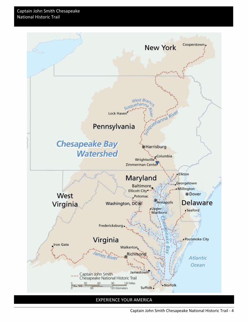
The Captain John Smith Chesapeake National Historic Trail stretches the length of the Chesapeake Bay
and its tributaries and includes Delaware, Maryland, New York, Pennsylvania, Virginia, and Washington
DC. It is the first national water trail in the history of the National Park Service.
Within the massive expanse of the 64,000 miles of the Chesapeake Watershed is the Chesapeake Bay.
This body of water is the largest estuary in the United States. It is over 200 miles long. The Bay is
surprisingly shallow. Its average depth is about 21 feet. That means a person 6 feet tall could wade
through most of the bay and never get their hat wet. The bay begins at the mouth of the Susquehanna
River in Havre de Grace, Maryland and enters the Atlantic Ocean at Virginia Beach in Virginia. The bay
and its tributaries have approximately 11,684 miles of shoreline. This estuary supports more than 3,600
species of plants, fish, and animals. The Bay is home to 29 species of waterfowl, including Canada geese.
Over 1 million waterfowl leave the colder northern states and winter in the Bay.
information below.
The best way to experience history the way John Smith and his crew did - by water!
There are over 3000 miles of rivers and estuaries along the Captain John Smith National Historic Trail
that can be used by boaters, kayakers, and canoeists at all skill levels. All of these rivers and estuaries
flow directly into the Chesapeake Bay, including the Susquehanna River.
The Susquehanna River is the 16th largest river in the United States. This river provides over 50% of the
s freshwater. The source of the Susquehanna River is at Lake Otsego, near Cooperstown,
New York flowing over 400 miles until it empties into the Chesapeake Bay. Other major rivers include
the Potomac, Patuxent, Rappahannock, Nanticoke, James and York.
Look at the map on the next page. Can you find where you live in the Chesapeake Bay Watershed? Draw
a circle where you live. Do you live near the Trail?
Captain John Smith Chesapeake National
Historic Trail
Captain John Smith Chesapeake National Historic Trail - 4
EXPERIENCE YOUR AMERICA
Captain John Smith Chesapeake National Historic Trail
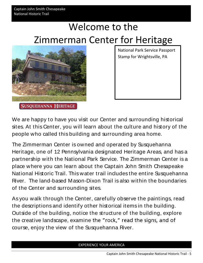
Zimmerman Center
Captain John Smith Chesapeake National Historic Trail - 5
EXPERIENCE YOUR AMERICA
Captain John Smith Chesapeake National Historic Trail
We are happy to have you visit our Center and surrounding historical
sites. At this Center, you will learn about the culture and history of the
people who called this building and surrounding area home.
The Zimmerman Center is owned and operated by Susquehanna
Heritage, one of 12 Pennsylvania designated Heritage Areas, and has a
partnership with the National Park Service. The Zimmerman Center is a
place where you can learn about the Captain John Smith Chesapeake
National Historic Trail. This water trail includes the entire Susquehanna
River. The land-based Mason-Dixon Trail is also within the boundaries
of the Center and surrounding sites.
As you walk through the Center, carefully observe the paintings, read
the descriptions and identify other historical items in the building.
Outside of the building, notice the structure of the building, explore
the creative landscape, examine
course, enjoy the view of the Susquehanna River.
National Park Service Passport
Stamp for Wrightsville, PA
Welcome to the Zimmerman Center for Heritage
Captain John Smith Chesapeake National Historic Trail - 6
EXPERIENCE YOUR AMERICA
Captain John Smith Chesapeake National Historic Trail
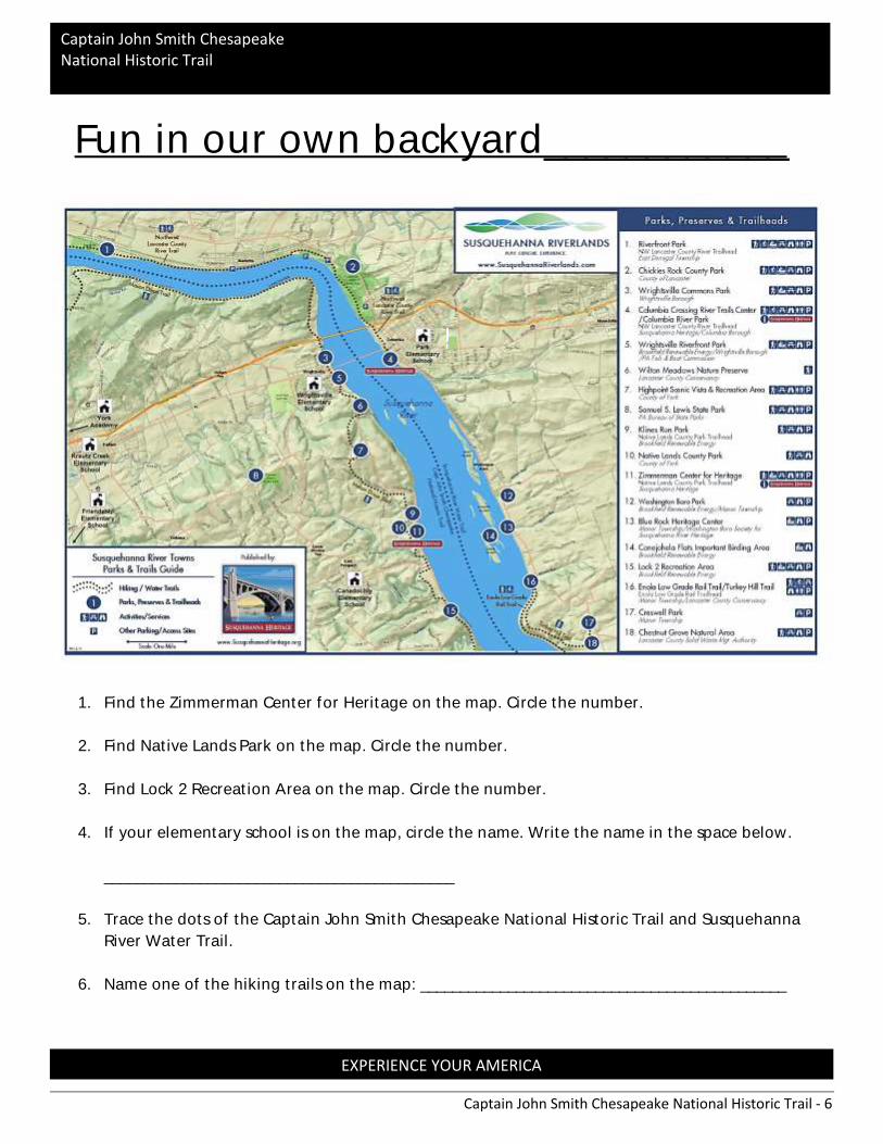
Fun in our own backyard____________
1. Find the Zimmerman Center for Heritage on the map. Circle the number.
2. Find Native Lands Park on the map. Circle the number.
3. Find Lock 2 Recreation Area on the map. Circle the number.
4. If your elementary school is on the map, circle the name. Write the name in the space below.
____________________________________________
5. Trace the dots of the Captain John Smith Chesapeake National Historic Trail and Susquehanna
River Water Trail.
6. Name one of the hiking trails on the map: ______________________________________________

Captain John Smith Chesapeake National Historic Trail - 7
EXPERIENCE YOUR AMERICA
Captain John Smith Chesapeake National Historic Trail
Ready for a Scavenger Hunt?_______________
As you walk through the historical rooms of the Zimmerman Center check off the square box,
answer a question, or draw a picture based on the instructions below.
Find the large fireplace and hearth.
Name two items located inside the fireplace.
____________________________________________
Find the National Park Service symbol
What does the symbol look like? ___________________________
What animal do you see on the symbol? __________________________
All National Parks are staffed by uniformed Park Rangers. These men and women care for our
national treasures, performing all types of jobs. There are many National Park sites in the
Chesapeake Bay Watershed and along the Captain John Smith Chesapeake National Historic
Trail. Here are a few examples: Gettysburg Military Park, Colonial National Historical Park, Fort
McHenry National Monument and Historic Shrine, and C & O Canal National Historical Park. The
most identifiable symbol the rangers wear is the National Park Service arrowhead.
How many bridges can you find in the paintings at the Zimmerman
Center? Write the total number in the last box.
Welcome Room with large fireplace
Susquehannock Room
Room with fireplace and bathroom
Room with large table
Hallway TOTAL
Find the reflection of a mountain in a painting. What is the title of the
painting? _____________________________

Captain John Smith Chesapeake National Historic Trail - 8
EXPERIENCE YOUR AMERICA
Captain John Smith Chesapeake National Historic Trail
Find the Globe. Did you know Captain John Smith came from the country
of England, sailed across the Atlantic Ocean, to discover the Chesapeake Bay
region?
Find the two men on a small boat on one of the paintings.
Find where the would be. Draw a picture of the
stove.
Write the name of an item in the artifact case on the line.
___________________________________________
Draw the item in the box. How was this item used?
Find information about one of the previous owners of the Zimmerman
Center. What was his name?
______________________________________________
____________________________________________
Captain John Smith Chesapeake National Historic Trail - 9
EXPERIENCE YOUR AMERICA
Captain John Smith Chesapeake National Historic Trail
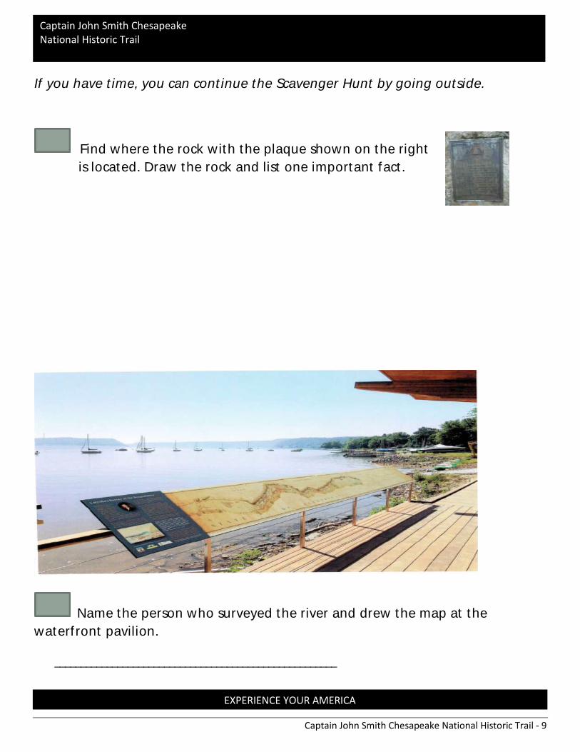
If you have time, you can continue the Scavenger Hunt by going outside.
Find where the rock with the plaque shown on the right
is located. Draw the rock and list one important fact.
Name the person who surveyed the river and drew the map at the
waterfront pavilion.
______________________________________________________

Captain John Smith Chesapeake National Historic Trail - 10
EXPERIENCE YOUR AMERICA
Captain John Smith Chesapeake National Historic Trail
If you were going on an expedition or journey who would you take with you? Would you take family
members, a friend, a guide? What types of skills would they need to have? When Captain John Smith
chose the men for his trip he took people with special skills. There was a doctor, a carpenter, a tailor, a
soldier, a fish merchant, a sailor and a blacksmith.
Draw a line to match the following terms to the correct definition.
A person who knows what fish are edible and how much they can be sold for
A person who sews cloth to make or mend items
A person who works with metal to make useful metal objects
A person who works with wood
A person who understand the human anatomy and how to heal the body
A person who is armed and understands military tactics
A person skilled in seamanship
Doctor
Soldier
Sailor
Tailor
Fish Merchant
Blacksmith
Carpenter
Captain John
Smith
Captain John Smith and His Crew
Captain John Smith Chesapeake National Historic Trail - 11
EXPERIENCE YOUR AMERICA
Captain John Smith Chesapeake National Historic Trail
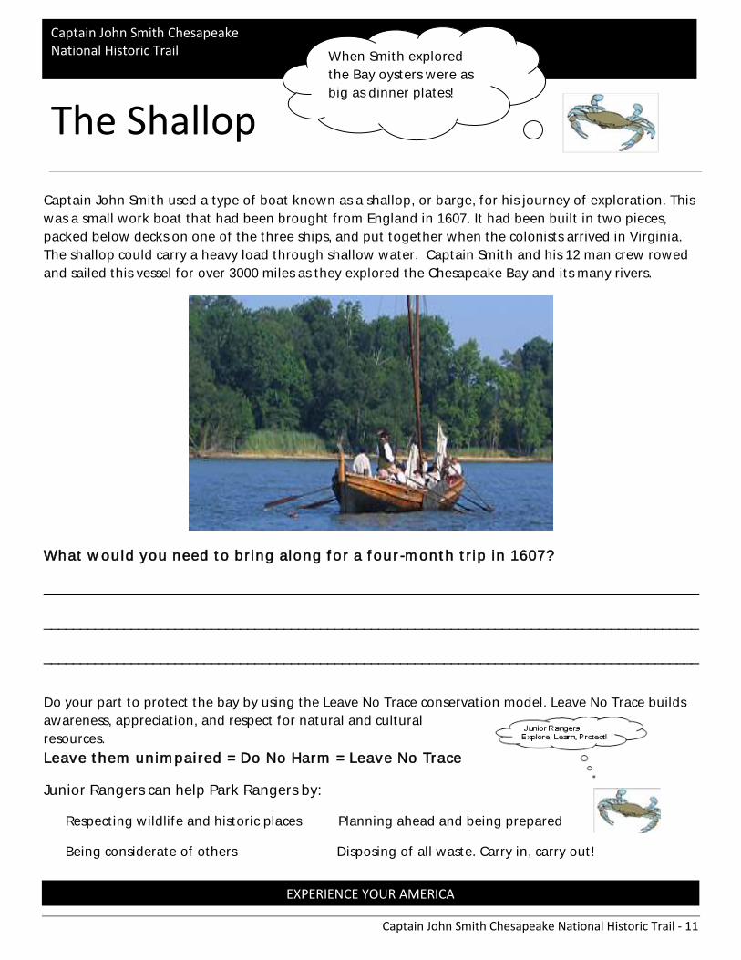
Captain John Smith used a type of boat known as a shallop, or barge, for his journey of exploration. This
was a small work boat that had been brought from England in 1607. It had been built in two pieces,
packed below decks on one of the three ships, and put together when the colonists arrived in Virginia.
The shallop could carry a heavy load through shallow water. Captain Smith and his 12 man crew rowed
and sailed this vessel for over 3000 miles as they explored the Chesapeake Bay and its many rivers.
What would you need to bring along for a four-month trip in 1607?
__________________________________________________________________________________________
__________________________________________________________________________________________
__________________________________________________________________________________________
Do your part to protect the bay by using the Leave No Trace conservation model. Leave No Trace builds
awareness, appreciation, and respect for natural and cultural
resources.
Leave them unimpaired = Do No Harm = Leave No Trace
Junior Rangers can help Park Rangers by:
Respecting wildlife and historic places Planning ahead and being prepared
Being considerate of others Disposing of all waste. Carry in, carry out!
The Shallop
When Smith explored
the Bay oysters were as
big as dinner plates!

Captain John Smith Chesapeake National Historic Trail - 12
EXPERIENCE YOUR AMERICA
Captain John Smith Chesapeake National Historic Trail
Word Scramble Word Scramble
Unscramble the words below
voyage in mapping the bay.
OLLAPSH __ __ __ __ __ __ __
ANIRVIGI __ __ __ __ __ __ __ __
APM __ __ __
ENOCA __ __ __ __ __
WREC __ __ __ ___
EVOYAG __ __ __ __ __ __
SMEJA RRVIE __ __ __ __ __ __ __ __ __ __
KYOR RRIVE __ __ __ __ __ __ __ __ __
TAHWPONA __ __ __ __ __ __ __ __
Captain John Smith
explored most of
the Chesapeake Bay
in three and a half
months.
Word Bank:
Map Virginia
Canoe Shallop
Ship Creek
Crab Crew
Shallop John Smith
York River Powhatan
James River Pocahontas
Voyage
Captain John Smith Chesapeake National Historic Trail - 13
EXPERIENCE YOUR AMERICA
Captain John Smith Chesapeake National Historic Trail
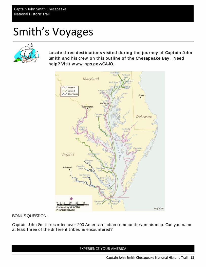
Locate three destinations v is ited during the journey of Captain John
Smith and his crew on this outline of the Chesapeake Bay. Need
help? Vis it www.nps.gov/CAJO.
BONUS QUESTION:
Captain John Smith recorded over 200 American Indian communities on his map. Can you name at least three of the different tribes he encountered?
Smith’s Voyages
Captain John Smith Chesapeake National Historic Trail - 14
EXPERIENCE YOUR AMERICA
Captain John Smith Chesapeake National Historic Trail
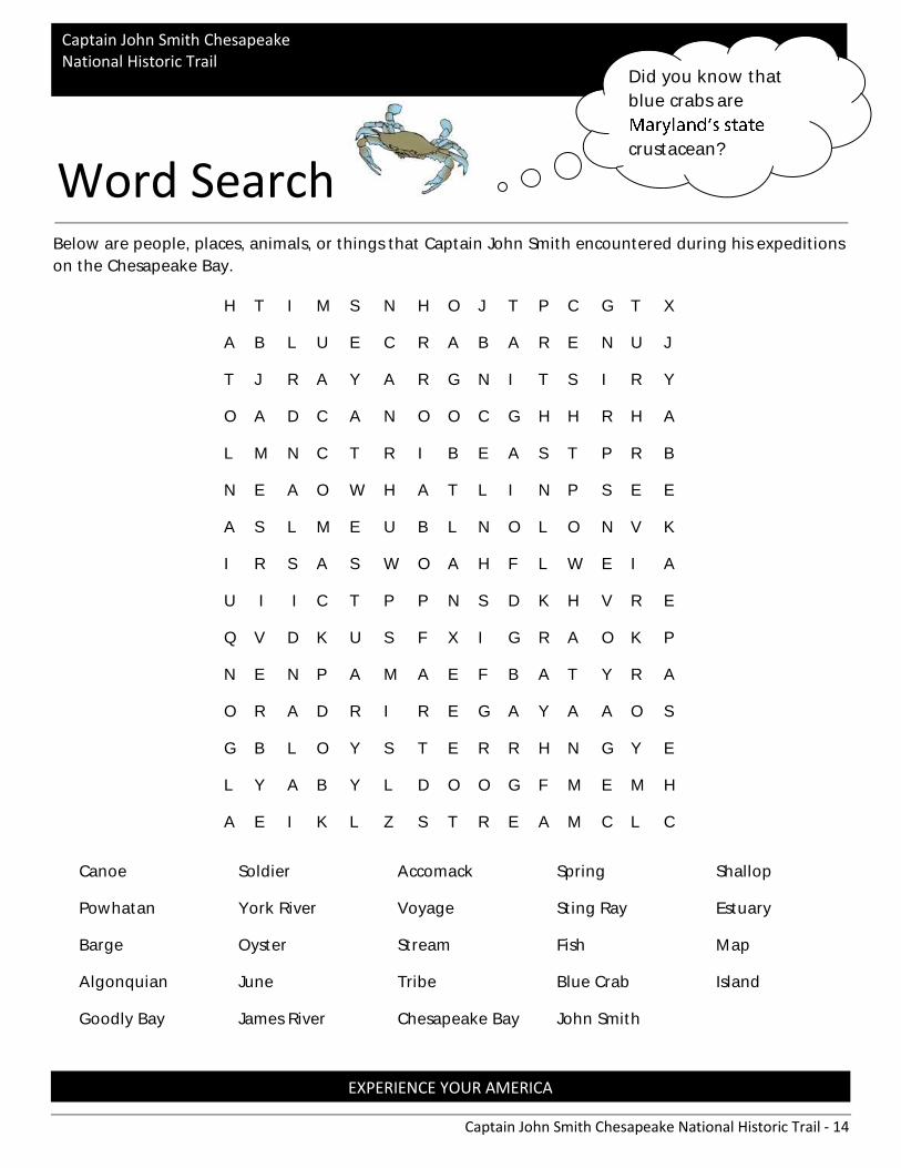
Below are people, places, animals, or things that Captain John Smith encountered during his expeditions
on the Chesapeake Bay.
H T I M S N H O J T P C G T X
A B L U E C R A B A R E N U J
T J R A Y A R G N I T S I R Y
O A D C A N O O C G H H R H A
L M N C T R I B E A S T P R B
N E A O W H A T L I N P S E E
A S L M E U B L N O L O N V K
I R S A S W O A H F L W E I A
U I I C T P P N S D K H V R E
Q V D K U S F X I G R A O K P
N E N P A M A E F B A T Y R A
O R A D R I R E G A Y A A O S
G B L O Y S T E R R H N G Y E
L Y A B Y L D O O G F M E M H
A E I K L Z S T R E A M C L C
Word Search
Canoe Soldier Accomack Spring Shallop
Powhatan York River Voyage Sting Ray Estuary
Barge Oyster Stream Fish Map
Algonquian June Tribe Blue Crab Island
Goodly Bay James River Chesapeake Bay John Smith
Did you know that
blue crabs are
crustacean?
Captain John Smith Chesapeake National Historic Trail - 15
EXPERIENCE YOUR AMERICA
Captain John Smith Chesapeake National Historic Trail
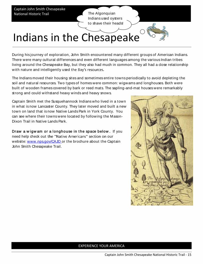
During his journey of exploration, John Smith encountered many different groups of American Indians.
There were many cultural differences and even different languages among the various Indian tribes
living around the Chesapeake Bay, but they also had much in common. They all had a close relationship
with nature and intelligently used
The Indians moved their housing sites and sometimes entire towns periodically to avoid depleting the
soil and natural resources. Two types of homes were common: wigwams and longhouses. Both were
built of wooden frames covered by bark or reed mats. The sapling-and-mat houses were remarkably
strong and could withstand heavy winds and heavy snows.
Captain Smith met the Susquehannock Indians who lived in a town
in what is now Lancaster County. They later moved and built a new
town on land that is now Native Lands Park in York County. You
can see where their towns were located by following the Mason-
Dixon Trail in Native Lands Park.
Draw a wigwam or a longhouse in the space below. If you
need help check out our
website: www.nps.gov/CAJO or the brochure about the Captain
John Smith Chesapeake Trail.
Indians in the Chesapeake
The Algonquian
Indians used oysters
to shave their heads!

Captain John Smith Chesapeake National Historic Trail - 16
EXPERIENCE YOUR AMERICA
Captain John Smith Chesapeake National Historic Trail
What’s for Dinner?
American Indian women and men worked together to
feed their families. Women were responsible for farming
and foraging; men did most of the hunting and fishing.
Foods changed with the seasons.
• Farming: The main crops cultivated were corn, beans, squash, pumpkins, and sunflowers.
• Foraging: Women gathered nuts, seeds, berries, roots, and plants.
• Fishing: An abundance of fish and shellfish were found in the Chesapeake Bay and its tributaries.
• Hunting: Game included turkeys, rabbits, raccoons, bear, and deer.
The Indians of the Chesapeake Bay lived on the rivers and
the Bay, using them for traveling as well as a source of
food. They used nets, spears and traps to catch fish and
gathered oysters from the brackish waters. Captain John
Smith was especially interested in trading for food from
American Indians and learning how to cultivate crops for
the settlers at Jamestown.
What are some key differences in how Susquehannock Indians fed themselves and how most
Americans do in modern times?
(Circa 1585, John White)

Captain John Smith Chesapeake National Historic Trail - 17
EXPERIENCE YOUR AMERICA
Captain John Smith Chesapeake National Historic Trail
Using your Eyes to see the Past,
Present and the Future Looking for one more park to visit close by and see the Susquehanna River?
Drive to Highpoint Scenic Vista and Recreation Area and do these activities.
Wow! I just saw a bald eagle! I
think the bald eagle was flying at
the same height as I am!
This is a response from a young child standing at the summit of a tall hillside near Wrightsville, Pennsylvania. Along with the possibility of seeing the national bird of the United States, a visit to this area will enable the viewer to see historic bridges, a river waterway and rolling hills and valleys.
Situated high above the Susquehanna River is
a historical site called Highpoint Scenic Vista and Recreation Area. To begin your quest to
the top of Highpoint Vista, a grey stone walking trail leads you around the hillside that
will take about a ½ hour walk from the parking lot to the rounded top at the summit.
As you walk along the trail, notice the scent of high grass, colorful wild flowers and small
birds flying above catching one of their favorite foods, bugs a
place to stop and observe the scenic view) are located along the trail, each with a
visionary tale to tell. Strolling up the slight uphill grade, make sure you stop at each
marked waystop, observe your surroundings, note the structures, the green and yellow
plots of farmland and other landmarks. As you reach the summit, a large compass rose
appears, as well as bordering white rocks as a resting place. Slowly scan with your eyes to
see the panoramic view of York and Lancaster Counties.
View of Susquehanna River, Columbia/Wrightsville Bridge and Route 30 Bridge.

Captain John Smith Chesapeake National Historic Trail - 18
EXPERIENCE YOUR AMERICA
Captain John Smith Chesapeake National Historic Trail
Standing on the compass rose, each direction
provides a historic view of the past, present and
future.
As you stand on the N (North), the Susquehanna
River has already meandered through mountains
and valleys from its source at Lake Ostego, New
York, to its mouth, a total of 440 miles near Havre
de Grace, Maryland.
This mighty river flows under two bridges at this
location, one for travelers on Route 30, and
another bridge that connects the river towns of Wrightsville and Columbia. During the
Civil War, the bridge at this site was burned by the townspeople to keep the confederate
troops from crossing the river. Today, you can see the Columbia/Wrightsville Bridge from
the vista, a mile long concrete arch structure, and stone piers from the former bridge, a
reminder of the historic value of both the structure and these two river towns.
As you turn your body to the S (South) and E (East) on the compass rose, you can see the
Susquehanna River making a slow left hand curve on its way to the Chesapeake Bay. The
Zimmerman Center, a historic homestead is located on the land below. The Zimmerman
Center for Heritage is a working partner with the Captain John Smith National Historic
Trail. This trail is a 3,000 mile water trail covering the Chesapeake Bay Watershed. Try to
visualize the American Indian tribe, the Susquehannock, living in Native Lands Park by the
river. They traveled south to meet Captain John Smith. The historic Mason-Dixon Trail
winds North and passes through the vista summit. The present and future is captured by
the large wind turbines on the top of the hillside in Lancaster County.
A turn to the W (west) direction, points you toward Samuel L. Lewis State Park. This park
is known as a great place to fly kites and to sled in the wintertime.
Whether a goose, a butterfly, a bridge or a town, you may be surprised by what can be
seen to represent the past, present and future of a historical landscape.

Captain John Smith Chesapeake National Historic Trail - 19
EXPERIENCE YOUR AMERICA
Captain John Smith Chesapeake National Historic Trail
Answer these Questions using the narrative on pages 17 and 18:
1
a. To persuade
b. To inform
c. To entertain
2. What is the name of the historic landmark? Where is it located?
a. __________________________________________
b. __________________________________________
3. According to the narrative, the Susquehanna River flows into what body of water?
______________________________________________
4. What is a Compass Rose?
________________________________________________________________
________________________________________________________________
5. Read this sentence from the narrative. Slowly scan with your eyes to see the
panoramic view of the York and Lancaster Counties. As used in the narrative, what does
panoramic mean?
a. A limited view of a place
b. A view from all directions
c. An incomplete view
6. Read this sentence from the narrative.
As you stand on the N (North), the Susquehanna River has already meandered through
mountains and valleys from its source at Lake Ostego, New York, to its mouth, a total of 440
miles near Havre de Grace, Maryland.
What does the word meandered mean?
________________________________________________________________
Captain John Smith Chesapeake National Historic Trail - 20
EXPERIENCE YOUR AMERICA
Captain John Smith Chesapeake National Historic Trail
7. What does the narrative teach you about the value of this landmark? Use at least 2
examples from the narrative to support your answer?
_________________________________________________________________
_________________________________________________________________
_________________________________________________________________
_________________________________________________________________
_________________________________________________________________
_________________________________________________________________
_________________________________________________________________
_________________________________________________________________
_________________________________________________________________
_________________________________________________________________
_________________________________________________________________
_________________________________________________________________

Captain John Smith Chesapeake National Historic Trail - 21
EXPERIENCE YOUR AMERICA
Captain John Smith Chesapeake National Historic Trail
What is an estuary? An estuary is a body
of water that is partly enclosed and allows for the freshwater coming from the streams and rivers to mix
with saltwater that is coming from the ocean. The closer you get to the ocean the saltier the water.
What lives in an estuary? This diverse habitat supports a vast ecosystem of plants and animals. The
underwater grasses and wetlands are perfect nesting and hiding places for small fish, crab, and other
creatures. Animals such as oysters and clams thrive here, helping to filter the bay by eating the small
plant and animal particles in the water. In the 1600's colonists reported oysters as large as dinner plates.
There were so many oysters that they could filter all of the water in the Chesapeake Bay in 3 to 4 days.
Today it takes the
Identify what is natural resource is pictured and briefly explain how it relates to the health of
the Chesapeake Bay.
Chesapeake Bay = Estuary
______________________________________
______________________________________
______________________________________
______________________________________
______________________________________
______________________________________
______________________________________
______________________________________
______________________________________
______________________________________
______________________________________
______________________________________
___
Word Bank:
Oyster
Bald Eagle
Osprey
Marsh Grasses
Blue Crab
Scallop
Captain John Smith Chesapeake National Historic Trail - 22
EXPERIENCE YOUR AMERICA
Captain John Smith Chesapeake National Historic Trail
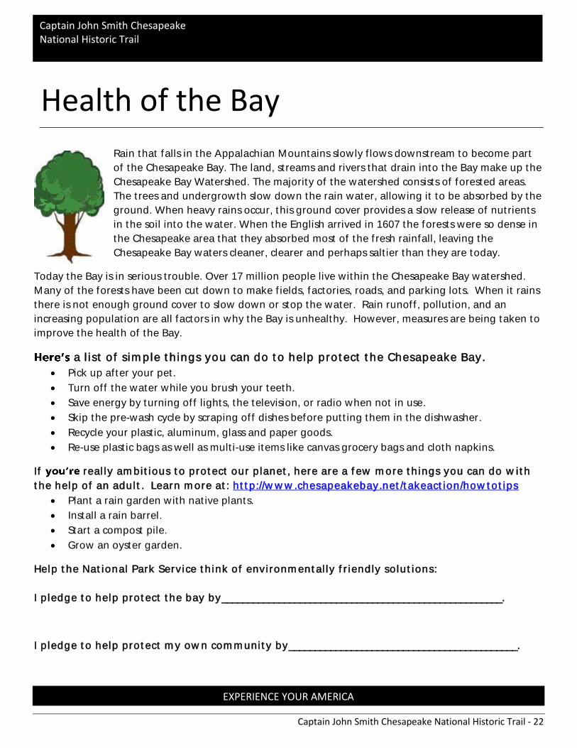
Rain that falls in the Appalachian Mountains slowly flows downstream to become part
of the Chesapeake Bay. The land, streams and rivers that drain into the Bay make up the
Chesapeake Bay Watershed. The majority of the watershed consists of forested areas.
The trees and undergrowth slow down the rain water, allowing it to be absorbed by the
ground. When heavy rains occur, this ground cover provides a slow release of nutrients
in the soil into the water. When the English arrived in 1607 the forests were so dense in
the Chesapeake area that they absorbed most of the fresh rainfall, leaving the
Chesapeake Bay waters cleaner, clearer and perhaps saltier than they are today.
Today the Bay is in serious trouble. Over 17 million people live within the Chesapeake Bay watershed.
Many of the forests have been cut down to make fields, factories, roads, and parking lots. When it rains
there is not enough ground cover to slow down or stop the water. Rain runoff, pollution, and an
increasing population are all factors in why the Bay is unhealthy. However, measures are being taken to
improve the health of the Bay.
a lis t of s imple things you can do to help protect the Chesapeake Bay.
• Pick up after your pet.
• Turn off the water while you brush your teeth.
• Save energy by turning off lights, the television, or radio when not in use.
• Skip the pre-wash cycle by scraping off dishes before putting them in the dishwasher.
• Recycle your plastic, aluminum, glass and paper goods.
• Re-use plastic bags as well as multi-use items like canvas grocery bags and cloth napkins.
If really ambitious to protect our planet, here are a few more things you can do with
the help of an adult. Learn more at: http://www.chesapeakebay.net/takeaction/howtotips
• Plant a rain garden with native plants.
• Install a rain barrel.
• Start a compost pile.
• Grow an oyster garden.
Help the National Park Service think of environmentally friendly solutions:
I pledge to help protect the bay by______________________________________________________.
I pledge to help protect my own community by____________________________________________.
Health of the Bay

Captain John Smith Chesapeake National Historic Trail - 23
EXPERIENCE YOUR AMERICA
Captain John Smith Chesapeake National Historic Trail
Glossary:
Algonquians: Indigenous inhabitants of North America of the Algonquian language and culture within the U.S. and Canada.
Border: line separating two places
Brackish: a mixture of salt and fresh water
Conservation: Sustainable use of natural resources
Crustacean: an animal that lives in the water and has a hard shell
Ecosystem: a system formed by the interaction of a community of organisms with their physical environment
Indigenous: Something or someone who is native to a particular area, descended from pre-colonial inhabitants
Landscape: a large area of land that is visible to the eye
Mouth: Where a river ends
Nutrients : a type of food substance plants and animals need to grow
Partnership: a relationship between people or businesses
Preservation: Protection of natural resources and landscapes from further human use
Settlement: a place where people lived
Source: Where a river begins
Summit: the top of a hill or mountain
Tributary: A smaller waterway (stream or river) that flows into a larger waterway
Watershed: An area of land that drains into a particular river, lake, or other body of water
Photo Credits :
http://www.encyclopediavirginia.org/
http://wikipedia.org
http://s rwt.org/sassafras -river-trail/points /
http://www.powhatanmuseum.com/Opechancanough.html
http://www.vahistorical.org/http://www.firs tnationsmonday.com/ANF/quotes .htm

Captain John Smith Chesapeake National Historic Trail - 24
EXPERIENCE YOUR AMERICA
Captain John Smith Chesapeake National Historic Trail
I, ____________________, am proud to be a
National Park Service Junior Ranger. I promise
to appreciate, respect, and protect all National
Parks . I also promise to continue learning
about the landscape, plants , animals , and
history of these special places . I will share
what I learn with my friends and family .
__________________
Junior Ranger S ignature
__________________ Ranger S ignature
Junior Ranger Pledge
Captain John Smith Chesapeake National Historic Trail - 25
EXPERIENCE YOUR AMERICA
Captain John Smith Chesapeake National Historic Trail
Send my badge to:
Junior Ranger:
Age:
Address :