adapted situation awareness tools and tailored training
TRANSCRIPT

ASSISTANCE
Adapted situation awareneSS tools and taIlored training curricula for increaSing capabiliTie and enhANcing the proteCtion of first respondErs
Project co-funded by the European Union within the Horizon 2020 Programme
Project Ref. N° ASSISTANCE H2020 - 832576
Start Date / Duration May 1, 2019 ( 36 months)
Dissemination Level1 PU (Public)
Author / Organisation Mateusz Maciaś / PIAP
Deliverable D2.1
Desk-Research Analysis and Identification of SA and Training Tools
31/08/2019
1 PU: Public; PP: Restricted to other programme participants (including the EC services); RE: Restricted to a group specified by the Consortium (including the EC services); CO: Confidential, only for members of the Consortium (including the EC services).
Ref. Ares(2019)5513227 - 02/09/2019

ASSISTANCE
Nowadays different FRs organizations cooperate together facing large and complex disasters,
that in some cases can be amplified due to new threats such as, the climate change in case of
natural disasters (e.g. big floods, large wild fires, etc) or the increase of radicalization in case of
man-made disasters (e.g. arsonist that burn European forest, big combined terrorist attacks in
European cities).
The impact of these kinds of large disasters could have disastrous consequences for the
European Member States’ regions and social wellbeing in general. On the other hand, each type
of FRs organizations (e.g. medical emergency services, firefighters’ departments, law
enforcement teams, civil protection professionals, etc.) that work mitigating these kinds of
events are exposed to unexpected dangers or new threats that can severely affect their personal
integrity.
Taking into account these facts, ASSISTANCE proposes a holistic solution that will adapt a well-
tested SA application as a core of a wider SA platform, capable of offering different configuration
modes for providing the tailored information outcome needed by each FR organization, while
they work together mitigating the disaster (e.g. real time video and resources location for
firefighters, evacuation routes status for emergency health services and so on).
With this solution ASSISTANCE will enhance the FRs SA during their mitigation activities through
the integration of new paradigms, tools and technologies (e.g. drones/robots equipped with
different sensors, robust communications capabilities, etc.) with the main objective of increasing
both their protection and their efficiency.
On the other hand, ASSISTANCE also proposes to improve the FRs skills and capabilities through
the establishment of a European advanced training network for FRs that will provide tailored
training based on new learning approaches (e.g. virtual, mixed and/or augmented reality)
adapted to each type of FRs organisations needs and the possibility of sharing virtual training
environments, exchanging experiences and actuation procedures.
ASSISTANCE is funded by the Horizon 2020 Programme of the European Commission, in the topic
of Critical Infrastructure Protection, contract 832576.

D2.1 Desk-Research Analysis and Identification of SA and Training Tools
2 / 136
Disclaimer
This document contains material, which is the copyright of certain ASSISTANCE consortium
parties, and may not be reproduced or copied without permission.
The information contained in this document is the proprietary confidential information of the
ASSISTANCE consortium (including the Commission Services) and may not be disclosed except
in accordance with the consortium agreement.
The commercial use of any information contained in this document may require a license from
the proprietor of that information.
Neither the project consortium as a whole nor a certain party of the consortium warrant that
the information contained in this document is capable of use, nor that use of the information is
free from risk, and accepts no liability for loss or damage suffered by any person using this
information.
The information in this document is subject to change without notice.

D2.1 Desk-Research Analysis and Identification of SA and Training Tools
3 / 136
Executive Summary
This document is summary of the state of the art study done to support the ongoing work in the
ASSISTANCE project. The content consists of a desk research performed by the project
consortium partners experienced in specific areas focusing on technologies that are improved
or developed in ASSISTANCE. The desk research is combined with the results of the
questionnaire response provided by the end users.

D2.1 Desk-Research Analysis and Identification of SA and Training Tools
4 / 136
List of Authors
Organisation Authors
ŁUKASIEWICZ-PIAP Mateusz Maciaś, Jakub Główka, Agnieszka Sprońska, Grzegorz Gawdzik, Jarosław Bajer, Sławomir Kurdziel
UPVLC Federico Carvajal, Manuel Esteve, Israel Pérez, Débora Robles
CATEC Francisco Alarcón Romero
AAHD Zeynep Sofuoglu, Turhan Sofuoğlu, İsmail Ümit Bal
IFV Eric Didderen, Mark Graner
RISE Francine Amon
CNBOP-PIB Maciej Zawistowski, Joanna Sadowska, Mariusz Feltynowski, Radosław Fellner, Grzegorz Zawistowski
ETRA Alejandro Gómez Gil, Jordi Arias Martí
TNO Tina Mioch, Mark A. Neerincx, Johan van Middelaar, Erik Vullings, Reinier Sterkenburg, and Leonor Fermoselle Silva Pereira.

D2.1 Desk-Research Analysis and Identification of SA and Training Tools
5 / 136
Change control datasheet
Version Changes Chapt
ers Pages Date
0.1 Initial table of content All 12 15/5/2019
0.4 Integrated set of inputs All 77 08/07/2019
0.5 First internal review, proper template used
All 103 09/07/2019
0.7 Integrated additional inputs All 161 01/08/2019
0.8 Changes in a few sections All 162 12/08/2019
0.9 Added questionnaire results. All 162 23/08/2019
1.0 Finalised document All 160 23/08/2019

D2.1 Desk-Research Analysis and Identification of SA and Training Tools
6 / 136
Content
Executive Summary ............................................................................................................................... 3
List of Authors ....................................................................................................................................... 4
Change control datasheet ...................................................................................................................... 5
Content .................................................................................................................................................. 6
List of Figures ......................................................................................................................................... 8
List of Tables ........................................................................................................................................ 11
Acronyms ............................................................................................................................................. 12
1. Introduction................................................................................................................................ 14
1.1. Methodology ........................................................................................................................... 14
2. General overview of current trends in research on technologies supporting situational
awareness............................................................................................................................................ 16
3. Available training platforms ....................................................................................................... 22
3.1. VR platforms ............................................................................................................................ 22
UPVLC Virtual, Mixed and Augmented reality platform ..................................................... 22
CNBOP Virtual reality courses for drones’ pilots ................................................................ 26
IFV BA-ADMS virtual training system.................................................................................. 34
3.2. AR platforms ............................................................................................................................ 34
4. Security and safety related best practices................................................................................... 35
4.1. Risk management standards ................................................................................................... 35
General risk management .................................................................................................. 35
Risk management for emergency response ....................................................................... 36
Triage Standards ................................................................................................................. 37
Technology Standards ........................................................................................................ 37
Police Standards ................................................................................................................. 38
ASTM Medical Standards .................................................................................................... 39
4.2. Methodologies ......................................................................................................................... 39
Situated Cognitive Engineering Method ............................................................................. 39
Driver+ Trial Guidance Methodology Handbook ................................................................ 41
4.3. Scenario specific guidelines ..................................................................................................... 41
Specific guidelines for safe use of UAVs ............................................................................. 42
5. SA capabilities and new technologies in FRs environments ........................................................ 47
5.1. Chemical accidents: CBRN Footprint ....................................................................................... 47
SAFER One .......................................................................................................................... 47
EFFECTS ............................................................................................................................... 48
Gas plume tracking ............................................................................................................. 48
Video Cameras, IR Cameras, CBRN Sensors, Temperature Sensors ................................... 51
Solutions on the market ..................................................................................................... 52
Sensors used by first responders possible to integration with unmanned platforms ........ 56
5.2. FRs Wearable Sensors ............................................................................................................. 62
Cameras .............................................................................................................................. 70
Other Detectors .................................................................................................................. 71
5.3. Portable SA Platforms.............................................................................................................. 76
GINA First Response Intervention Systems ........................................................................ 77
DragonForce ....................................................................................................................... 79
FiRST ................................................................................................................................... 79

D2.1 Desk-Research Analysis and Identification of SA and Training Tools
7 / 136
IMPACT ............................................................................................................................... 80
GeoFES ................................................................................................................................ 81
RAIDO ................................................................................................................................. 82
CommandX ......................................................................................................................... 83
ESRI ArcGIS for Emergency Management........................................................................... 83
MOSAIC ............................................................................................................................... 85
5.4. Sensor Abstraction Service (SAS) ............................................................................................. 86
IBM – Intelligent Operations Centre (IOC) Platform ........................................................... 86
Minsait – Onesait ................................................................................................................ 87
TELEFÓNICA – Thinking City................................................................................................ 88
oneM2M architecture ........................................................................................................ 89
Alliance for Internet of Things Innovation (AIOTI) .............................................................. 89
5.5. Methods for malevolent/hostile drones neutralisation ........................................................... 90
Soft kill ................................................................................................................................ 91
Hard kill ............................................................................................................................... 92
Interception ........................................................................................................................ 94
5.6. Ad Hoc network coverage using drones’ swarm equipped with Wi-Fi access points .............. 98
5.7. Damaged Assets Location and Routing ................................................................................... 99
Real-time video editing ..................................................................................................... 100
Rerouting service based on real-time information ........................................................... 101
5.8. Mission Management ............................................................................................................ 102
6. Security and safety related projects in the topic ....................................................................... 103
6.1. ALADDIN ................................................................................................................................ 103
6.2. AUGGMED ............................................................................................................................. 103
6.3. TARGET .................................................................................................................................. 103
6.4. FIREMIND .............................................................................................................................. 103
6.5. CRISIS ..................................................................................................................................... 103
6.6. ICARUS ................................................................................................................................... 104
6.7. EDEN ...................................................................................................................................... 104
6.8. ENCIRCLE ............................................................................................................................... 105
6.9. FIRE-IN ................................................................................................................................... 105
6.10. DRIVER+ ................................................................................................................................. 106
6.11. LETSCROWD ........................................................................................................................... 107
6.12. SAURON ................................................................................................................................. 108
6.13. CRM4EMS .............................................................................................................................. 108
6.14. CASCEFF ................................................................................................................................. 109
6.15. IMPROVER ............................................................................................................................. 109
7. End users feedback on state of the art ...................................................................................... 110
8. Analysis and conclusions .......................................................................................................... 114
9. Annexes .................................................................................................................................... 117
9.1. End user feedback results ...................................................................................................... 117
9.2. Questionnaire (web version).................................................................................................. 128
9.3. Questionnaire (Word document version) .............................................................................. 135

D2.1 Desk-Research Analysis and Identification of SA and Training Tools
8 / 136
List of Figures
Figure 1 Hardware system swarm of drone. .............................................................................................. 18
Figure 2 Schematic view of C-Thru technology .......................................................................................... 20
Figure 3 Comparison of views without C-Thru (left), with C-Thru (right)14 ................................................ 21
Figure 4 Mixed reality training environment .............................................................................................. 23
Figure 5 VTE architecture schema .............................................................................................................. 24
Figure 6 Location of the interconnection gateway. .................................................................................... 25
Figure 7 UPVLC Virtual reality training system ........................................................................................... 26
Figure 8 UPVLC Virtual reality training system ........................................................................................... 26
Figure 9 The panel at the UAV operator station ........................................................................................ 28
Figure 10 Simulation system instructor / system manager station (1) ......... ¡Error! Marcador no definido.
Figure 11 Simulation system instructor / system manager station (2)15 ....... ¡Error! Marcador no definido.
Figure 12 UAV operator station Source: CMGI Ltd. .................................................................................... 31
Figure 13 Commander / function person Source: CMGI Ltd. ..................................................................... 32
Figure 14 Position of the person using the visualization system - view of the vehicle's cabin Source: CMGI
Ltd. .............................................................................................................................................................. 33
Figure 15 Position of the person using the visualization system - view of the inside of vehicle's cabin,
Source: CMGI Ltd. ....................................................................................................................................... 34
Figure 16: SAFER One® [https://www.safersystem.com]........................................................................... 47
Figure 17: EFFECTS [Gexcon AS] ................................................................................................................. 48
Figure 18. Example videos of methane leak detection and the resulting video images (Source: Rebellion
Photonics). .................................................................................................................................................. 49
Figure 19 Methane plume detected from an airborne hyperspectral camera. Source: Hulley et al. 2016.
.................................................................................................................................................................... 50
Figure 20 Handheld Optical Gas Imaging Camera (FLIR GF620). Source: FLIR Industrial. .......................... 50
Figure 21 Photo: Aerones ............................................................................. ¡Error! Marcador no definido.
Figure 22 IBIS® and PIAP Gryf® with sets of CBRNE accesories. Source: PIAP. ........................................... 56
Figure 23 LEADER SEARCH Life Detectors (USAR) ...................................................................................... 56
Figure 24 LEADER SCAN Life Search Equipment (USAR) ............................................................................. 57
Figure 25 Delsar LifeDetector LD3 .............................................................................................................. 58
Figure 26 LEADER Sentry Stability Controller ............................................................................................. 58
Figure 27 Warning Alarm Stability Protection device - Leader WASP ........................................................ 59
Figure 28 FirstLook 360 – The First Live Streaming 360° Technical Rescue Camera .................................. 59
Figure 29 Thermal camera head for search camera TIC head .................................................................... 60
Figure 30 Con-Space Rescue Kit 1 with Power Talk Box ............................................................................. 60
Figure 31 Dräger X-am® 8000 ..................................................................................................................... 61
Figure 32 OxygenTest 100 .......................................................................................................................... 61
Figure 33 Rados RAD60 .............................................................................................................................. 62
Figure 34. Personal Health Monitor System 80 ........................................................................................... 64
Figure 35 Firefighter’s boot with built-in pocket used for enclosing the CO2 sensor and wireless sensing
module (on right)81 ........................................................................................ ¡Error! Marcador no definido.
Figure 36. Conceptual drawing of a fireman's helmet with an integrated infrared camera83 ................... 66
Figure 37 Wrist-wearable vital signs sensor module83 ............................................................................... 67
Figure 38 Example of small camera which can be mounted in rescuers vest ............................................ 69
Figure 39 An example of the distribution of elements and sensors in rescuers vest ................................. 70
Figure 40 CompactPRO - advanced thermal imaging camera designed for smartphone .......................... 71

D2.1 Desk-Research Analysis and Identification of SA and Training Tools
9 / 136
Figure 41 RAE Systems AreaRAE Pro .......................................................................................................... 72
Figure 42 MX908 device ............................................................................................................................. 73
Figure 43 MX908 control ............................................................................................................................ 73
Figure 44 LCD 3.3 from Smiths Detection’s ................................................................................................ 74
Figure 45 First Responder Tracking System hypothetical scenario. ........................................................... 75
Figure 46 3D representation of the I-REACT wearable ............................................................................... 76
Figure 47 Chameleon® Chemical Detection Armband, Morphix Technologies without cassettes. ........... 76
Figure 48 GINA Central ............................................................................................................................... 78
Figure 49 GINA Smart application .............................................................................................................. 78
Figure 50 GINA Tablet.................................................................................... ¡Error! Marcador no definido.
Figure 51 DragonForce Command Center Application ............................................................................... 79
Figure 52 DragonForce Collaborative Whiteboarding tool ........................................................................ 79
Figure 53 FiRST Application ........................................................................................................................ 80
Figure 54 Wild fire monitoring visualization .............................................................................................. 81
Figure 55 Plume model with ALOHA program (NOAA) visualization.......................................................... 81
Figure 56 CBRNe events ............................................................................................................................. 82
Figure 57 RAIDO emergency software ....................................................................................................... 83
Figure 58 Interactive situation display with CommandX ............................................................................ 83
Figure 59 Incident Status Dashboard ......................................................................................................... 85
Figure 60 Situational Awareness Viewer application ................................................................................. 85
Figure 61 MOSAIC shared situational awareness apps .............................................................................. 86
Figure 62 IBM Intelligent Operations Center (IOC) Platform architecture ................................................. 87
Figure 63 Minsait Onsait platform architecture ........................................................................................ 88
Figure 64 Diagram of UAV neutralisation methods .................................................................................... 91
Figure 65 Skywall 100, counter drone device by OpenWorks Engineering ................................................ 93
Figure 66 Skywall 300, counter drone device by OpenWorks Engineering ................................................ 93
Figure 67 MTU drone prototype launches the net toward the target ....................................................... 94
Figure 68 KAIST drone prototype with a net gripper, with already cached drone ..................................... 95
Figure 69 Drone Catcher (Delft Dynamics product) launches net towards the target ............................... 95
Figure 70 Fortem DroneHunter in action (left); radar mounted on the drone (right) ............................... 96
Figure 71 AeroGuard (SCI) in action ........................................................................................................... 96
Figure 72 Drone form the EXCIPIO Aerial Netting System launching the net ............................................ 96
Figure 73 Sentinel Catch (left) and Sentinel Catch&Carry (right) manufactured by Skysec ....................... 97
Figure 74 Skysec product captures the target using the net ...................................................................... 97
Figure 75 Predatory bird intercept a drone ................................................................................................ 98
Figure 76: Reliable communication service scenario. ................................................................................ 99
Figure 77 Open Broadcast Studio ............................................................................................................. 100
Figure 78 Waze mobile App...................................................................................................................... 101
Figure 79 Questionnaire participant organisation type ........................................................................... 110
Figure 80 Command and controll technologies used ............................................................................... 111
Figure 81 Communication technologies used .......................................................................................... 111
Figure 82 Handheld sensors used ............................................................................................................. 112
Figure 83 Wearable sensors used............................................................................................................. 113
Figure 84 Training. .................................................................................................................................... 113
Figure 85 Command and control technologies interesting for end users ................................................ 114
Figure 86 Unmanned platforms that are interesting for end users ......................................................... 115
Figure 87 Interesting sensors for unmanned platforms ........................................................................... 115

D2.1 Desk-Research Analysis and Identification of SA and Training Tools
10 / 136
Figure 88 Interesting training tools .......................................................................................................... 116

D2.1 Desk-Research Analysis and Identification of SA and Training Tools
11 / 136
List of Tables
Table 1 Examples of Human Factors Problems from the “Dirty Dozen” and solutions ............... 44

D2.1 Desk-Research Analysis and Identification of SA and Training Tools
12 / 136
Acronyms
ASSISTANCE Adapted situation awareneSS tools and taIlored training curricula for increaSing capabiliTie and enhANcing the proteCtion of first respondErs
PC Project Coordinator
D#.# Deliverable number #.# (D1.1 deliverable 1 of work package 1)
DoA Description of Action of the project
EC European Commission
EU European Union
GA Grant Agreement
H2020 Horizon 2020 Programme for Research and Innovation
IPR Intellectual Property Rights
M# #th month of the project (M1=May 2017)
WP Work Package
IPR Intellectual Property Rights
PSC Project Steering Committee
PIC Project Implementation Committee
PSB Project Security Board
AB Advisory Board
TL Task Leader
WPL Work Package Leader
VR Virtual Reality
VTE Virtual Training Environment
SA Situation Awareness
TGM Trail Guidance Methodology
FR First Responder
EOD Explosive Ordinance Disposal
CEOD Counter Explosive Ordinance Disposal
CBRNE Chemical Biological Radiological Nuclear Explosive
UGV Unmanned Ground Vehicle
USV Unmanned Surface Vehicle
UUV Unmanned Underwater Vehicle
UAV Unmanned Aerial Vehicle
ISO International Organization for Standardization
HDR High Dynamic Range
EV Exposure Value
GNSS Global Navigation Satellite System
GPS Global Positioning System
RTK Real-Time Kinematic
PPK Post Processing Kinematic
RGB Red Green Blue
FoV/FOV Field of View

D2.1 Desk-Research Analysis and Identification of SA and Training Tools
13 / 136
IoT Internet of Things
C2 Command and Control
GIS Geographic Information System
UWB Ultra Wide Band

D2.1 Desk-Research Analysis and Identification of SA and Training Tools
14 / 136
1. Introduction
This document is a summary of the state of the art study done to support the ongoing work in
the ASSISTANCE project. It describes work performed in Task 2.1. The content consists of a desk
research performed by the project consortium partners experienced in specific areas focusing
on technologies that are improved or developed in ASSISTANCE. The desk research is combined
with the results of the questionnaire response provided by the end users.
1.1. Methodology
This study was performed using the following steps:
1. The project proposal was analysed, focusing on proposed scenarios, technologies, key
performance indicators and initial questionnaire that was used to formulate the proposal
itself. This step produced a list of technologies/problems that ASSISTANCE project is trying
to improve/solve.
2. Based on the list from step 1, a list of chapters was constructed, which was consulted with
the entire consortium (including technical partners involved in this study and the end
users). This way a refined chapters list has been produced. Those chapters were assigned
to partners specialised in the given area.
3. A questionnaire’s draft was prepared based on previous steps. The focus was put on two
questions:
a. Which type of technology do you use currently in your operations?
b. Which type of available technology you know about and would like to test/use in your
operations?
The questions came with the lists of technologies that are interesting for the scope of the
ASSISTANCE project, and some suggestions on the format of answers that can be used for
analysis.
4. The questionnaire draft was consulted within the consortium. Some changes were made
based on that consultations.
It was also decided that this will be a standalone questionnaire (not directly connected to
the similar one prepared in WP6), as the questionnaire used in this study was much more
complex, focusing on details of specific technology.
At this stage it was also decided that there will be two variants of the questionnaire:
document based and web based, to enable more end users to fill it as convenient for them.
The web based version was done using limesurvey2, as it allowed to create a complex
questionnaire and had good terms of service (mostly connected to data retention).
At this stage it was also confirmed that questionnaire will not collect any personal data and
the results will be gathered as anonymous.
The questionnaire was send to end users via the end-user partner organisations.
2 https://www.limesurvey.org/

D2.1 Desk-Research Analysis and Identification of SA and Training Tools
15 / 136
5. The chapters were gathered from project partners and integrated in two integration/review
cycles.
6. The questionnaire results were gathered and analysed.
7. The conclusions to this document were written and discussed with all partners of the
consortium.

D2.1 Desk-Research Analysis and Identification of SA and Training Tools
16 / 136
2. General overview of current trends in research
on technologies supporting situational
awareness
Awareness of the situation prevailing during the rescue operations is of an extraordinary
significance in terms of both protecting the life of rescuers as well as efficiency and effectiveness
of the operation. In order to increase it, one can use technical means, through developed and
constantly improved procedures. Projects concerning the methods of increasing situational
awareness are presented in chapter 6 of this study. The technical elements that raise situational
awareness include the following:
robots and drones,
all kinds of wearable sensors,
cameras,
thermal imaging cameras,
portable devices for communication and / or displaying video.
Each of the above can be used in a variety of ways. A good example of this could be the EU EASeR 3project. Its focus is on limiting the impact of the "barrier effect" on the rescue operation being
carried out. The barrier effect results from poor recognition of the affected area and causes
difficulties in getting to the place of action. The barrier effect usually lasts about one day. As part
of the EASeR project, it was proposed to use drones for the initial recognition of the car's route,
in order to locate the elements of damaged and impassable roads.
Because the commanding officer of the rescue action is responsible for the decisions made and
the people who take part in the operation, he needs a wide range of information on the disposed
rescuers. Communication through the radio stations does not give full information and is
extremely time-consuming, especially with a significant number of rescuers. At this point, it
seems that wearable sensors can greatly help to coordinate the rescue operations in making
informed and adequate decisions. Wearable devices can provide information such as:
location of the rescuer,
registration of the body temperature of the rescuer and the environment,
detection of toxic substances,
registration of sweating,
measurement of the heart rate.
Such devices can give the emergency coordinators information about:
level of fatigue in individual rescuers,
entry of a rescuer into a hazardous area / threatened by harmful substances,
3 https://www.easerproject.eu/

D2.1 Desk-Research Analysis and Identification of SA and Training Tools
17 / 136
the position of an unsafe rescuer.
Information from sensors is very important for commanding rescuers, as it allows to better
organise the rescue operation. The main problem in this solution is to provide communication
between individual sensors / rescuers and the main command point. This problem can be solved
by the group of drones working in the swarm. A group of identical devices with appropriate
transmitters and receivers cooperating together would allow the creation of a network and live
preview of the vital functions of the rescuers. An example of using a drone swarm to provide
communication during a rescue operation was presented in a project called "UAV swarms for
emergency response"4,5. The authors of the project emphasise that in a crisis situation, there is
often no access to a stable and reliable network. Project authors aim to provide the following
functionalities using a drone swarm:
Short-range high-bandwidth network,
Long-range low-bandwidth network,
Network coverage optimisation algorithm,
Collision avoidance and GPS navigation,
Point-cloud sensors (stereo or laser),
HD cameras on gimbal.
The test structure of the above system is shown in the Figure 1 and consists of 5 drones (DJI
Matrice100 and 4 3DR Solos), which have Buzz software for managing the swarm of drones.
4 https://mistlab.ca/projects/ 5 https://github.com/MISTLab

D2.1 Desk-Research Analysis and Identification of SA and Training Tools
18 / 136
Figure 1 Hardware system swarm of drone6.
Another system that raises awareness of the situation is the system proposed and introduced
by the Data-Smart City Solutions7,8. The Situational Awareness Tool built for the City's Office of
Emergency Management merges many disparate pieces of information into a single dashboard,
enhancing OEM’s decision-making abilities. The system allows City's Office of Emergency
Management to quickly and effectively assess the current and potential impacts of an
emergency or special event on the community and the day-to-day operations of the city. The
system integrates and visualises various data combined of all these data sources into a one single
view, providing OEM with the ability to turn various data points into actionable information.
Data sets offered by the system:
Computer-Aided Dispatch (911 calls),
311 calls (non-emergency citizen reports),
Xcel power outages (Denver's energy utility provider),
Special Event Data,
Stream Gauge Levels,
6 https://www.researchgate.net/profile/David_St-Onge/publication/311204206/inline/jsViewer/583f0bc308ae8e63e618237a 7 https://datasmart.ash.harvard.edu/solutions/situational-awareness-tool 8 https://datasmart.ash.harvard.edu/news/article/data-driven-emergency-response-learning-from-hurricanes-harvey-and-irma-113?fbclid=IwAR30SYdkS2NOQnjDxJnApR1qqifsF7LeYK0SXahoYfWtvjv-5zrBDJUucCQ

D2.1 Desk-Research Analysis and Identification of SA and Training Tools
19 / 136
Rain Levels Gauge,
Traffic Weather Critical Facilities,
Basemap Data.
In the case of such a large amount of data, there may be a "data overload" that can be
overwhelming for commanders and it seems necessary to use special algorithms to filter the
information. A description of such information filtering is described in Johnson, D., Zagorecki,
A., Gelman, J.M. and Comfort, L. K. "Improved Situational Awareness in Crisis Management
through Automatic Data Analysis and Modeling"9.
Another interesting solution to the problem of data collection is the use of social media for this
purpose, such as Twitter. The use of social media can help in informing and collecting
information from the civilian population about safe places, drinking water quality, gathering
places for evacuation, places with active access to electricity, water, etc. Such use is described
in Mark A. Cameron, Robert Power, Bella Robinson, Jie Yin "Emergency Situation Awareness
from Twitter for Crisis Management"10. The system described has been configured to search for
relevant Tweets from Australia and New Zealand, sorted them for usability and sent them to the
checking officer. The authors of the publication pointed to the fact that information can’t replace
the existing procedures and sources of information, but can be a new source of data that has
many potential applications in crisis management and crisis coordination.
In addition to the technical possibilities of raising the awareness of rescuers' situation, attention
should also be paid to the procedural aspect. Development and handling of specific procedures
and guidelines can greatly improve the rescue action, preventing chaos and disorganisation.
However, in order to naturally introduce the proper procedures by the rescuers during the
operation, it is necessary for them to carry out numerous field exercises. The organisation of
field exercises, especially for a large number of participants, is logistically complex and
expensive. To address these problems the training methods offered by virtual reality (VR) can
be applied. They allow to carry out many training scenarios allowing to modelling of:
various atmospheric conditions (rain, snow, etc.),
various terrain (mountains, river valleys, etc.),
use of various equipment (e.g. to learn different methods of application).
Currently, there is a lot of interest in VR technologies by emergency services. The main application of VR can be observed especially in medicine11,12, but there are also platforms
9 Johnson, D., Zagorecki, A., Gelman, J. M., & Comfort, L. K. (2011). Improved Situational Awareness in Emergency Management through Automated Data Analysis and Modeling. Journal of Homeland Security and Emergency Management, 8(1). doi:10.2202/1547-7355.1873 10 Mark A. Cameron, Robert Power, Bella Robinson, Jie Yin "Emergency Situation Awareness from Twitter for Crisis Management" WWW 2012 – SWDM'12 Workshop April 16 p.695-698 11 George Koutitas, Kenneth Scott, Smith Grayson, Lawrence Vangelis, Metsis Clayton, Stamper Mark Trahan, Ted Lehr “A virtual and augmented reality platform for the training of first responders of the ambulance bus” PETRA '19 Proceedings of the 12th ACM International Conference on PErvasive Technologies Related to Assistive Environments Pages 299-302 12 Jillian L. McGrath, Jeffrey M. Taekman, Parvati Dev PhD, Douglas R. Danforth, Deepika Mohan, Nicholas Kman, Amanda Crichlow, William F. Bond “Using Virtual Reality Simulation Environments to Assess Competence for Emergency Medicine Learners”

D2.1 Desk-Research Analysis and Identification of SA and Training Tools
20 / 136
dedicated to other emergency services13,14. In addition to the virtual reality adapted to the training of rescuers, there are also augmented reality (AR) technologies that can be used not only in training, but also during the real life operation. Augmented reality, consisting of combining virtual elements with the reality seen by the rescuer, can be helpful by displaying various types of information and messages concerning possible threats. In addition, it can allow to combine several views (eg. from a thermal imaging camera) allowing for easier and faster searching for people. An example of a similar application is presented below by Qwake Tech corporation as C-THRU 15. It presents a system supporting the firefighter's awareness in a highly smoky environment through the use of displays mounted in the helmet, and a thermal camera. Figure below shows schematic view of the system (Figure 2) and example of it performance (Figure 3) :
Figure 2 Schematic view of C-Thru technology
13 Michael N. Louka, Claudio Balducelli „ Virtual reality tools for emergency operation support and training” 14 Li Yang, Yu Liang, Dalei Wu, Jim Gault „Train and Equip Firefighters with Cognitive Virtual and Augmented Reality”, 2018 IEEE 4th International Conference on Collaboration and Internet Computing (CIC) 15 https://www.qwake.tech/#about

D2.1 Desk-Research Analysis and Identification of SA and Training Tools
21 / 136
Figure 3 Comparison of views without C-Thru (left), with C-Thru (right)15
As seen in Figure 3 this system can be of siginificant help for Firefighters as an awareness tool in a smoky environment.
D2.1 Desk-Research Analysis and Identification of SA and Training Tools
22 / 136
3. Available training platforms
This chapter describes state of the art in training platforms that are available or in use currently.
3.1. VR platforms
UPVLC Virtual, Mixed and Augmented reality platform
UPVLC Virtual Training Environment
A Virtual Training Environment (VTE) is a computer-based simulated environment where users
interact through avatars and intelligent agents. The current applications go beyond merely
entertaining purposes as they have become a powerful tool to enhance the capabilities of real
world applications and have been widely used for training and learning in different areas,
including military units; vehicle driving and flight simulators. Trainees can learn and practice how
to perform tasks while working toward animated agents that can collaborate with human
trainees in the virtual worlds. Furthermore, the capabilities of traditional virtual systems can be
enhanced and extended if a hybrid system is implemented including data from real sources. In
the case of crisis management, the use of virtual reality to create immersive training exercises
for human beings allows personnel to operate with modern computer equipment; respond
rapidly to unforeseen events in situations under stress, and to perform joint exercises with a
significant reduction on costs and complexity. However, the interaction of real and virtual worlds
with new standards (i.e., MPEG-V), allowing data streaming between both worlds and using
commercial off-the shelf (COTS) equipment, has not yet been exploited and means going a step
further in the state of the art.
Types of training offered by the UPVLC VTE
This platform currently is used for training the Valencia fire department members for managing
virtual scenarios based on potential real situations suggested by this FRs. The system has also
been used by the Centre of Excellence (COE) Counter Improvised Explosive Device (CIED) for
training on IED detection and deactivation. This platform allows to train different units and
commanders in lab (virtual training), but it also offers the possibility of training real units
deployed in field along with virtual units managed from the lab.
The UPVLC VTE is a composed by a situation awareness tool integrated with a virtual
environment. Through this tool the decision makers could be trained in complex virtual
scenarios in which the coordination of large number of units, the decision-making process, along
with a quick response to events/changes in the situation are critical. This tool will be potentially
capable of using multiple simulation engines to simulate various technical, physical or social
phenomena. The decisions taken by trainees will have impact on the dynamics of events
simulated by simulation engines, but these engines will be also capable to run in no-wait mode,
where results of lack of decision or late decision can be also simulated. This tool is capable to
offer mixed reality training and virtual training depending on the FRs needs.
Mixed-reality training

D2.1 Desk-Research Analysis and Identification of SA and Training Tools
23 / 136
Many times training a large number of FR units deployed in the field in large-scale exercises or
threat management simulations is very expensive in terms of economy and logistics. These kinds
of exercises involve several agencies consisting mainly of first responders (e.g. fire brigades and
police units), including a large deployment of vehicles and equipment. For this reason, these
large and complex training exercises can be performed only once or twice a year as a maximum.
For covering this clear training gap stated by some of the end users participant in the
consortium, ASSISTANCE proposes a mixed-reality training tool. Through this tool a large
number of units (including brigade members and decision makers for agencies from different
countries) will be able to train virtually with a reduced number of real units deployed on the
field playing the same scenario.
Figure 4 Mixed reality training environment
Figure 4 shows a representation of this mixed-reality environment where a large number of
units in lab manages their own avatars and virtual vehicles and/or devices to train together with
a reduced number of real units deployed in the field using their real sensors and devices. In
addition, decision makers will be able to train operation coordination in the same scenario.
On-field units will be seen as avatars by in-lab training units and the avatars managed by the
units in the lab will be represented through augmented reality techniques in the on-field
deployed units Head Mounted Displays (HMD). This way all units will be able to train large scale
disaster scenario(s), coordinated manoeuvres of large number of units and so on several times
over, with a significant reduction of costs.
Virtual training

D2.1 Desk-Research Analysis and Identification of SA and Training Tools
24 / 136
Some of the parts of the training performed during ASSISTANCE will be done in an in-lab virtual
training environment (VTE), where either individuals or cooperative teams will be able to face
the specific game-based assessment and learning scenario(s) generated within this VTE,
depending largely on the specific skill (set) that needs to be trained. An example of in-lab VTE
can be seen in Figure 4, where first responder team along with an aircraft pilot held a joint
virtual training session
This VTE will be based on a single virtual environment composed by different training tools,
which could be used as a stand-alone solution or in an integrated way depending on the training
performed. Its purpose is to train first responder commanders, fire brigades, police units and
sanitary teams members and even aircraft pilots on operational and tactical levels.
UPVLC VTE description
The UPVLC VTE is based on an architecture designed for an interoperable system that allows the
interconnection of real situation awareness systems, operating in the real world, with virtual
world systems. Particularly, the inclusion of real sensors on the virtual side of the system and
the access to virtual sensors from real command posts deployed in the operating field. Thus,
users will be able to train in virtual environments with the same tools they would use during the
real crisis mitigation.
An important consideration is the deployment of equipment on the field in the training area:
Units act as mobile sensors and actuators in the mitigation of the simulated crisis,
feeding the system with real data and responding to the orders of the crisis managers.
In the real world these units are connected to the operative command centre through
some communications system, such as a MESH network, 4G or a satellite terminal.
Sensors deployed in the real world will be accessible from the virtual world and vice
versa: the position and identifier of the units created and spread in the real world will
be accessible from terminals of the command and control system unfolded in the virtual
world.
The proposed architecture has three main components (see Fig. 3):
Figure 5 VTE architecture schema
Tactical Trainer Server (TTS), where the global configuration of the system is set. It includes the virtual world server and the interconnection gateway, the key element to achieve interoperability between real and virtual worlds.

D2.1 Desk-Research Analysis and Identification of SA and Training Tools
25 / 136
Tactical Trainer Client (TTC), client subsystem used by the training nodes; includes both a command and control system of the real world and a virtual world client.
Virtual Video Server (VVS), an innovative system for management, distribution and playback of video generated by the sensors involved in the operations field, from both real and virtual sources.
To achieve interoperability between real and virtual worlds, an interconnection gateway based
in the MPEG-V standard has been developed. The main functionality of this gateway is to
interconnect two systems (whether they are virtual worlds, command and control systems from
the real world, or a combination of both), translate and adapt the relevant information following
MPEG-V guidelines and map the adapted data between them. The gateway must be able to take
the information from the source system, translate it into MPEG-V and then represent it properly
in the target system. Communication is bidirectional. The location of the interconnection
gateway in the C4ISR system for emergency training is shown in Fig. 4.
Figure 6 Location of the interconnection gateway.
The final result is a complete virtual/mixed training environment where different kind of FR can
train together either using only virtual scenarios or adding real units deployed on field working
with synthetic units managed by FR in the lab.
In the following figures different screenshots of the UPVLC VTE are shown:

D2.1 Desk-Research Analysis and Identification of SA and Training Tools
26 / 136
Figure 7 UPVLC Virtual reality training system
Figure 8 UPVLC Virtual reality training system
CNBOP Virtual reality courses for drones’ pilots
CNBOP uses a subcontractor's platform, coming from the "Young scientists" programme. The
platform allows to train different FR unit including their commanders. Scenarios can also include
the usage of unmanned vehicles UV showing FRs’ possible capabilities and threats of using this
device in the field.

D2.1 Desk-Research Analysis and Identification of SA and Training Tools
27 / 136
The "Young scientists" project concerned development of a virtual simulation system supporting
training for leadership in the use of unmanned aerial vehicles. The project was placed in VBS3
application. After its development the system was tested by the CNBOP-PIB team composed of
the fire-fighting as well as civilian specialists in the field of rescue operations, UAV’s, Virtual
Reality and research. The system testing proved that the basic components have been
integrated with the actual requirements for the training of task groups that participate in the
actions of the National Rescue and Firefighting System and showed a great potential for its
further development. The system features are discussed below.
Simulation scenarios
The scenarios are created in the VBS3 software which has a built-in mission editor OME (Offline
Mission Editor) and they consisted of the following elements:
a) Virtual map of the real area of Poland;
b) Virtual character models;
c) Virtual vehicle models;
a) Virtual model of unmanned aircraft;
b) Virtual models of road infrastructure elements;
d) Virtual models of nature elements;
e) Virtual models of building objects (including those specific);
f) Virtual models of other objects;
g) Atmospheric conditions (which during the course of the scenario can be changed using the
editor).
Scenario building involves inserting into the virtual map selected elements available through the
object library and assigning simulated events (tasks) to them. Objects are placed on the map by
selecting the appropriate object from the object insertion menu, and then selecting the
appropriate place on the map. The editor allows creating scenarios in 2D and 3D views. The
preview of elements placed in the scenario and the management of objects is possible through
the menu of scenario objects. Objects placed in the scenario can be combined into groups, which
allows them to automate their behaviour during simulation. The editor allows additional
configuration of the scenario by setting the parameters of the atmospheric conditions (eg.
cloudiness level, rainfall intensity level, wind speed, wind direction) and the current date and
time of the simulated scenario. The next stage of building the scenario is assigning particular
objects (or groups of objects) specific tasks related to the planned course of the scenario.
Examples of task types that are possible to simulate in VBS3 are, among others:
I. MOVE - displacement;
II. DESTROY - destruction (indicated object);
III. GETIN NEAREST - occupying a position in the vehicle;
IV. GETOUT - getting out of the vehicle;
The editor allows setting detailed task parameters, including how to respond to an opponent,
how to behave while moving, formations, how to act during the task, the speed of the task.
D2.1 Desk-Research Analysis and Identification of SA and Training Tools
28 / 136
An additional element used to build the scenarios are so-called triggers - invisible objects placed
in the scenario that allow control of the simulation eg: a person in shock after arrival FR begins
to panic, run away, her condition worsens etc.
The system was tested in a simulation system on 7 out of 18 developed training scenarios - one
training scenario for firefighters (S12), three training scenarios for the army (WP/R/ 1, WP/R/2,
WP/R/3), two training scenarios for border guards (SG/1, SG/2) and one training scenario for the
police (P01). The system has been proven very flexible and, depending on the needs, allowing
to specify any scenario and train it in any required configuration of station.
The scenario tested by the CNBOP-PIB team consisted of, among others, training stages such as:
access to the place of the event (analysis of the most optimal route), its evaluation, disposing of
appropriate measures. The system contained few training positions: UAV’s operator station,
operator of UAV’s camera, a position for a function person, a position of fire truck driver, a
position of an administrator / training instructor. In the scenario UAV plane was used.
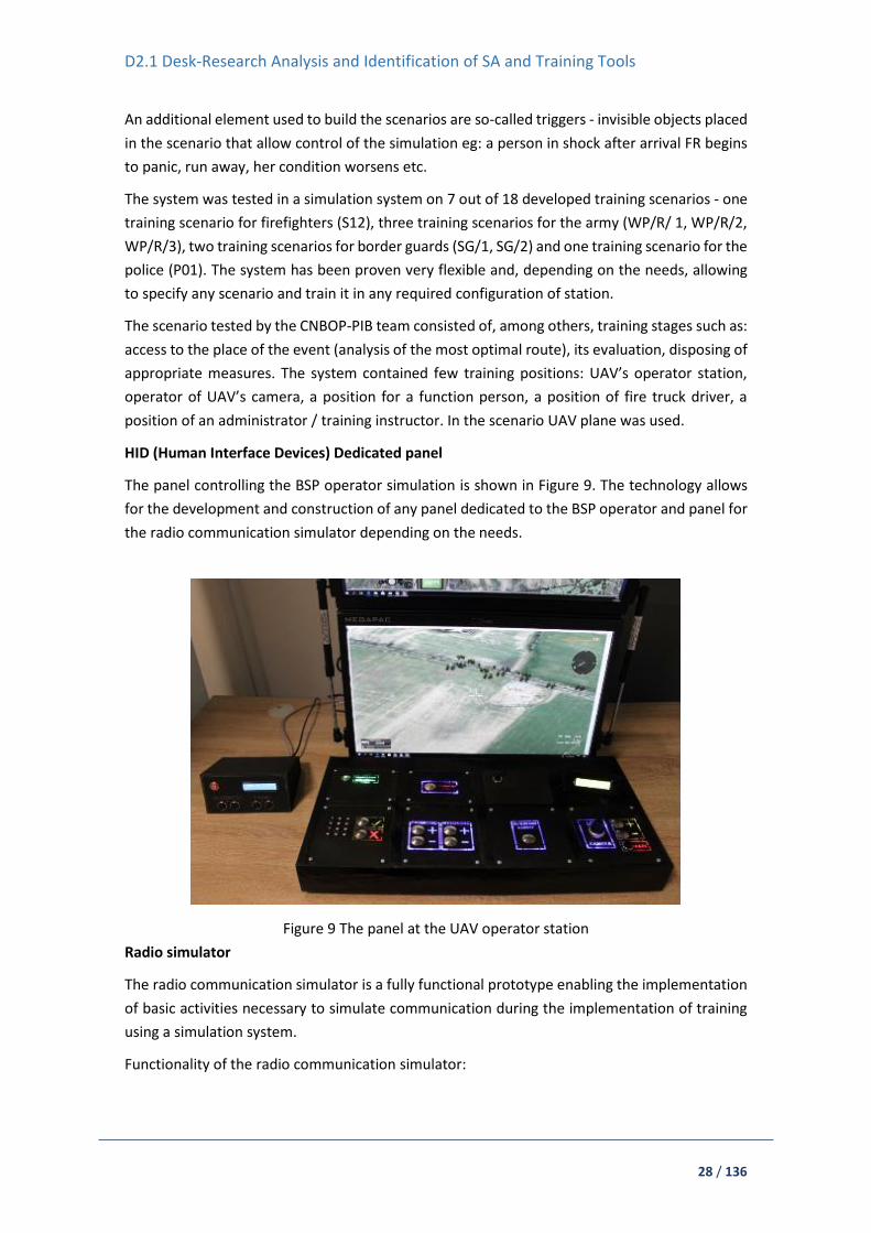
HID (Human Interface Devices) Dedicated panel
The panel controlling the BSP operator simulation is shown in Figure 9. The technology allows
for the development and construction of any panel dedicated to the BSP operator and panel for
the radio communication simulator depending on the needs.
Figure 9 The panel at the UAV operator station
Radio simulator
The radio communication simulator is a fully functional prototype enabling the implementation
of basic activities necessary to simulate communication during the implementation of training
using a simulation system.
Functionality of the radio communication simulator:

D2.1 Desk-Research Analysis and Identification of SA and Training Tools
29 / 136
continuous communication of the VAV simulation system with a radio communication
simulator,
mutual communication between the UAV simulation system and the radio
communication simulator,
possibility of sending messages with the help of a dedicated button,
controlling the volume of the simulator with the help of a dedicated button,
selection of the transmission channel with the help of a dedicated button.
Individual stations of the simulation system
A fully functional prototype of the virtual simulation system is shown in ¡Error! No se encuentra
el origen de la referencia., ¡Error! No se encuentra el origen de la referencia.. It supports the
training of commands from the use of unmanned aerial vehicles.
Figure 10 Simulation system instructor / system manager station (1)16
Figure 11 Simulation system instructor / system manager station (2)¡Error! Marcador no definido.
16 CMGI Ltd

D2.1 Desk-Research Analysis and Identification of SA and Training Tools
30 / 136
The instructor / administrator station in the simulation system consists of the following components:
a. High performance workstation - ELMATIC suitcase computer, model:
FlexPACIII-BTO (MS Windows 10 Professional 64-bit PL OEM).
b. A simulation system based on a virtual VBS3 environment programmed on a mobile
computer unit that enables the user to perform actions related to:
Scenario Editor (OME – offline mission editor), a tool available for use as an instructor
/ training administrator. The functionalities available for use in the editor are mainly:
o construction of training missions / scenarios, inserting individual objects
selected from the library onto the map, assigning them categories, pages, which
should be assigned and places on the virtual map, as well as their limited
modification,
o launching training missions / scenarios,
o possibility of viewing a virtual map in 2D and 3D,
o setting the following parameters such as: cloud level, haze level, the level of rain
and snowfall intensity, wind speed and direction, current date and time, time of
the mission / simulation scenario execution, changing the initially indicated
parameters after a specified time
o modifying the following options:
Simulation display configuration options,
Voice configuration options,
Keyboard and controller configuration options,
Configuration options for the simulation run.
o creating groups - for individual simulation scenarios, individual virtual objects or
groups (eg. several virtual objects of characters or vehicles),
o placing tactical signs on the map (three types: tactical signs compliant with the
NATO standard, icons, area signs),
o setting tasks – eg. assigning tasks to specific units with setting their detailed
parameters and assigning them a suitable graphic character,
o setting "triggers" so-called sensors - these are the elements of the scenario or
areas that allow to control the course of the simulations by activating or
deactivating them, their task is to trigger certain reactions when the selected
object is in their area, will come with them in interaction.
Real-time editor (RTE) / Admin Panel that allows interaction during the course of the
scenario; the editor's functions allow observation of the course of the exercise,
introducing changes and corrections, and triggering the required events. The
functionalities available for use in the editor are mainly:
o editing the mission / training scenario in real time, directly during the activities
undertaken in the simulation system,
o launching a mission / training scenario in local mode - allows simulation for one
practitioner,

D2.1 Desk-Research Analysis and Identification of SA and Training Tools
31 / 136
o launching a mission / training scenario in network mode - allows simulation with
the participation of many practitioners,
o starting registration, recording of the exercise course for AAR (After Action
Review),
A database of scenarios, developed and implemented to the simulation system,
dedicated to all target entities, which can be used in two basic ways:
o Scenarios training - scenarios can be used to independently familiarise oneself
with system properties, navigation methods and options for use in the system, as
well as the functionalities of individual training stations,
o Networking - it is possible to run scenarios in the network mode, enabling
simultaneous training on the same map for many people exercising (the option
recommended for use in the developed simulation system).
An After Action Review (AAR) module that allows the administrator / instructor to
recreate the course of the exercise after its completion (during the implementation
of the mission in RTE mode, the administrator has the option of registration and
recording of the entire exercise and its selected fragments, the status of individual
facilities or units for later analysis).
A virtual map;
Virtual objects necessary to create and implement the developed training scenarios.
c. Radio simulator.
UAV operator station
The unmanned aerial vehicle operator station in the simulation system is shown in Figure 12 and
it consists of the following components:
a. High-performance workstation - ELMATIC suitcase computer, model: MegaPACL2-
BTO (MS Windows 10 Professional 64-bit PL OEM)
Figure 12 UAV operator station Source: CMGI Ltd.

D2.1 Desk-Research Analysis and Identification of SA and Training Tools
32 / 136
b. A simulation system based on a virtual VBS3 environment programmed on a mobile
computer unit that allows the user to perform actions related to playing training scenarios
(run on the instructor / administrator position), including primarily manual and automatic
virtual UAV control. The UAV operator station is devoid of exercise controls, so that the
participant does not have the ability to interrupt, change or stop the exercise. The position
is dedicated to moving within the virtual map and allows the use of actions and interactions
provided by the instructor / administrator of the exercise.
c. Radio simulator.
d. HID control panel.
Commander / function person station
The commander station in the simulation system is shown in Figure 13 and consists of the
following components:
a. High-performance workstation - (MS Windows 10 Professional 64-bit PL OEM)
Figure 13 Commander / function person Source: CMGI Ltd.
b. A simulation system based on a virtual VBS3 environment programmed on a mobile
computer unit that enables the user to perform actions related to playing training
scenarios (run on the instructor / administrator position), primarily providing the
commander with a picture of the actions performed by the practicing unmanned aerial
vehicle operator. The commander station is devoid of exercise controls, so that the
exerciser does not have the ability to disturb, change or stop the training. The station is
dedicated to moving within the virtual map and allows the use of actions and
interactions provided by the instructor / administrator of the exercise.
c. Radio simulator
Additional training station
The visualisation system can be used interchangeably with one additional station provided for
the commander / function person on a high-performance workstation. It means it is either run

D2.1 Desk-Research Analysis and Identification of SA and Training Tools
33 / 136
as a station which elements are a visualisation system, a high-performance workstation and a
radio simulator, or as a stand with only a high-performance workstation and a radio.
The station consists of:
A high-performance workstation (one of the four workstations envisaged for functional
persons, is to be interchangeably used for training at a designated station),
Radio simulator module (one of 4 modules dedicated to a functional person, to be
interchangeably used for training at a designated station),
“Optoma” multimedia projector (the projector displays the element of the simulation
scenario in the form of a route to the event (in the case of scenarios dedicated to fire
brigade, police and border guards) and in the form of passage to a specific point in the case
of scenarios dedicated to military units,
A specially designed projection surface (a special screen made to order, allowing use during
training in a form resembling the use of the sphere),
Specially designed screen frame with truss handles.
For the purpose of carrying out internal tests on a bench with a visualisation system, a vehicle
cabin as shown in Figure 14 and Figure 15 (not a simulator element) is provided, imitating any
police vehicle, fire truck, etc. In the case of training, individual positions imitating vehicles can
be developed in a different, less complicated way (e.g. by placing a workstation in front of the
sphere at an ordinary table), however, the possible development of the system in the future
with such an imitation of the vehicle's cabin adds realism to the training carried out using the
simulation system.
Figure 14 Visualisation system - view of the vehicle's cabin Source: CMGI Ltd.

D2.1 Desk-Research Analysis and Identification of SA and Training Tools
34 / 136
Figure 15 Visualisation system - view of the inside of vehicle's cabin, Source: CMGI Ltd.
IFV BA-ADMS virtual training system
This system makes possible to practice interactively, dynamically and time realistically with
different disciplines, incident types and vehicles. Using a joystick, participants walk through the
virtual practice area and deploy virtual relief workers by issuing commands and assignments.
The actions of the participants determine the course of the incident and thus they constantly
practice the process of image forming and decision making. BA-ADMS can be used for both
individual and team exercises. IFV has around 15 Virtual Reality systems spread over the country.
IFV has a broad experience in conducting large scale incident training with up to 12 VR systems
connected within one network.
3.2. AR platforms
Currently there are no existing AR platforms available for training within the consortium
partners developments.
At TNO, an open source AR application is available, called WorldExplorer, which runs on the
Microsoft HoloLens, and which allows to display a 3D map of the environment, optionally with
additional overlays, e.g. to display a gas cloud. Current ongoing modifications include support
for 3D terrain, and a connection to the EU-project DRIVER+ technical infrastructure. Although
this is not a training platform by itself, it can, however, be used as part of a training, as it provides
a multi-user 3D overview of the incident situation.

D2.1 Desk-Research Analysis and Identification of SA and Training Tools
35 / 136
4. Security and safety related best practices
This chapter focuses on operational guidelines and best practices in defined first response
scenarios.
4.1. Risk management standards
Standards provide a consistent, transparent, and systematic basis for establishing a minimum
level of performance. In the context of first responder operations and technology the required
performance could be related to preparedness, such as specifying a framework for risk
management procedures. For technology, the performance could also be related to technical
issues, such as equipment robustness, for example its ability to operate satisfactorily in adverse
conditions. Standards can also play an important role in ensuring that interoperability is
possible, both with respect to communication and interaction between different FR
organisations and by specifying compatible interfaces between SA technologies.
A summary of the most widely used existing standards relevant to the ASSISTANCE project is
given in the following sections. It is possible that other standards exist that could also useful but
are not readily available to the general public.
General risk management
ISO 31000:2018 Risk management – Guidelines17
This is a very general standard that can be used by organisations of all types and sizes to help
them meet their internal and/or external objectives. This document defines a list of principles
and provides a framework for fitting them together in a coherent manner so that risk
management can be integrated into activities and functions within the organisation. The
essential components of a risk management plan and its implementation process, including
regular reviews to continually update and improve the plan are described in brief terms. The
details of how each piece of the plan applies to an organisation are not included in the standard
and are left for the organisation to determine.
ISO/IEC 31010:2019 Risk management - Risk assessment techniques18
This standard provides guidance on the selection and application of techniques for assessing risk
in a wide range of situations; in this sense it provides more detail for a subset of the ISO
31000:2018 standard. The risk assessment techniques are used to assist in making decisions
where there is uncertainty, to provide information about particular risks and as part of a process
for managing risk. Summaries are given of a range of risk assessment techniques.
COSO 2017 - Enterprise Risk Management - Integrated Framework19
17 https://www.iso.org/standard/65694.html 18 https://www.iso.org/standard/72140.html 19 https://www.coso.org/Documents/2017-COSO-ERM-Integrating-with-Strategy-and-Performance-Executive-Summary.pdf
D2.1 Desk-Research Analysis and Identification of SA and Training Tools
36 / 136
This standard was created by the Committee of Sponsoring Organizations of the Treadway
Commission (COSO) and uses a business-oriented approach to managing risk. The basic
components of the framework are: aligning risk appetite and strategy, enhancing risk response
decisions, reducing operational surprises and losses, identifying and managing multiple and
cross-enterprise risks, seizing opportunities, and improving deployment of capital.
A Risk Management Standard – IRM/Alarm/AIRMIC 200220
This standard was produced by the Institute of Risk Management (IRM) and appears to follow
an approach similar to ISO 31000. It presents information on internal and external risk factors
and the risk management process: assessment, analysis, evaluation, reporting and
communication. It also includes information on the treatment of risk and maintaining the risk
management process.
OCEG “Red Book” 2.0: 2009 - a Governance, Risk and Compliance Capability Model21
This is an extensive document that provides a model, used in practice as a standard, for
businesses to follow ”principled performance” objectives for integrating risk management into
their organisational structure. The model includes information on these steps: establish context,
organise, assess, pro-act, detect, respond, measure, and interact. There is a large amount of
supporting material available.
Risk management for emergency response
NFPA 1600:2019 - Standard on Continuity, Emergency, and Crisis Management22
This standard establishes a common set of criteria for all hazards disaster/emergency
management and business continuity programs. It is focussed on the United States of America
(USA) governmental authority structure at distinct levels (e.g., federal, state/provincial,
territorial, tribal, indigenous, and local levels). Other entities, including those outside the USA,
such as commercial business and industry, not-for-profit and nongovernmental organisations,
and individual citizens may also find this standard useful. Detailed protocols for program
management, planning, implementation, execution, training and education, exercises and tests,
and maintenance and improvements are provided, along with additional supplementary
material. The U.S. Department of Homeland Security adopted this standard as a voluntary
consensus standard for emergency preparedness.
National Occupational Standards (NOS) for Civil Protection in England and Wales23
The NOS for civil contingencies comprises multiple standards related to activities surrounding
integrated emergency management (including risk management) for events or situations that
may threaten human welfare, the environment or national security in England and Wales. These
20 https://www.theirm.org/media/886059/ARMS_2002_IRM.pdf 21 https://thegrcbluebook.com/wp-content/uploads/2013/03/uploads_Red-Book.2.1.optimized_0.pdf 22 https://www.nfpa.org/codes-and-standards/all-codes-and-standards/list-of-codes-and-standards/detail?code=1600 23https://webarchive.nationalarchives.gov.uk/20090412234542/http://www.skillsforjustice.com/websitefiles/SFJ%20Civil%20Leaflet%20Nov%2008%20Stage%201(1).pdf

D2.1 Desk-Research Analysis and Identification of SA and Training Tools
37 / 136
standards are designed to be used by FRs such as police, fire and rescue services, health bodies,
and local authorities, as well as other stakeholders in disaster management.
EU Civil Protection Mechanism
Although it doesn’t exist in a formal standard format, the EU Civil Protection Mechanism24 offers
a central hub for member states to share and develop their risk management activities and
receive guidance for and peer reviews of their plans.
Triage Standards
There are many standards and guidelines for emergency medical care during disasters, some of
which are used on a national or regional level and some that have been developed to correspond
to specific cultural and demographic conditions. A recent analysis of 20 of these standards for
triage systems used in disasters concludes that there is no “best” system and recommends that
triage models should continue to be developed according to native conditions, resources and
relief forces25.
Most of the triage standards use variations of colour coding to classify casualties in terms of
their need for medical attention, where red = immediate, yellow = urgent, green = non-urgent
and black or blue = dead. A principal difference between approaches is whether the most or
least critically injured people are treated first. There are also specialised triage standards, for
example, for use in wars, for burn victims, chemical, biological, radiological and nuclear (CBRN)
victims, elderly people and children.
Technology Standards
ISO Standards
The ISO technical committee TC 29226 covers “Security and resilience” and includes standards
and guidance documents for the use of situational awareness technology as well as managing
the incident, communication, and dealing with the public during an incident. Some of the most
relevant standards are listed below:
ISO 22311:2012 Societal security -- Video-surveillance -- Export interoperability27
Specifies a common output file format that can be extracted from the video-surveillance
contents collection systems (stand-alone machines or large-scale systems) by an
exchangeable data storage media or through a network to allow end-users to access
digital video-surveillance contents and perform their necessary processing.
ISO 22315:2014 Societal security -- Mass evacuation -- Guidelines for planning28 provides
guidelines for mass evacuation planning in terms of establishing, implementing,
24 https://ec.europa.eu/echo/what/civil-protection/mechanism_en 25 Bazyar J, Farrokhi M, Khankeh HR. Triage Systems in Mass Casualty Incidents and Disasters: A Review Study with A Worldwide Approach. Open Access Maced J Med Sci. 2019 Feb 15; 7(3):482-494. https://doi.org/10.3889/oamjms.2019.119 26 https://www.iso.org/committee/5259148.html 27 https://www.iso.org/standard/53467.html?browse=tc 28 https://www.iso.org/standard/50052.html?browse=tc

D2.1 Desk-Research Analysis and Identification of SA and Training Tools
38 / 136
monitoring, evaluating, reviewing, and improving preparedness. It establishes a
framework for each activity in mass evacuation planning for all identified hazards. It will
help organisations to develop plans that are evidence-based and that can be evaluated
for effectiveness.
ISO 22322:2015 Societal security -- Emergency management -- Guidelines for public
warning29 provides guidelines for developing, managing, and implementing public
warning before, during, and after incidents.
ISO 22395:2018 Security and resilience -- Community resilience -- Guidelines for
supporting vulnerable persons in an emergency30 gives guidelines for organisations to
identify, involve, communicate with and support individuals who are the most
vulnerable to natural and human-induced (both intentional and unintentional)
emergencies. It also includes guidelines for continually improving the provision of
support to vulnerable persons in an emergency.
The ISO technical committees TC 2131 and TC 9432 cover “Equipment for fire protection and fire
fighting” and “Personal safety -- Personal protective equipment”, respectively. These two
technical committees produce many standards that affect the safety and well-being of first
responders but do not apply directly to situational awareness.
NFPA Standards
NFPA has minimum performance standards for thermal imaging cameras33 (NFPA 1801), radios34
(NFPA 1802, proposed), and personal alert safety systems35 (NFPA 1982). These standards focus
on fire fighting equipment and address issues such as electromagnetic compatibility, intrinsic
safety, and quality of performance in harsh enviornments.
Police Standards
The goal of the Minimum Standards for Maximal Security Project36, commissioned by the EU, is
to establish minimum standards for European police offices with regard to their uniforms,
equipment and training. This project found a very large discrepancy between EU countries in all
areas. Recommendations were given for a minimum kit of equipment, including two-way radios
for the officers and SA equipment (communication station, camera, global positioning system
(GPS), mobile phone, computor) for the vehicles.
29 https://www.iso.org/standard/53335.html?browse=tc 30 https://www.iso.org/standard/50291.html?browse=tc 31 https://www.iso.org/committee/46628.html 32 https://www.iso.org/committee/50580.html 33 https://www.nfpa.org/codes-and-standards/all-codes-and-standards/list-of-codes-and-standards/detail?code=1801 34 https://www.nfpa.org/codes-and-standards/all-codes-and-standards/list-of-codes-and-standards/detail?code=1802 35 https://www.nfpa.org/codes-and-standards/all-codes-and-standards/list-of-codes-and-standards/detail?code=1982 36 http://www.eurofedop.org/spip.php?article925

D2.1 Desk-Research Analysis and Identification of SA and Training Tools
39 / 136
The National Institute of Justice37 (NIJ) in the USA supports development of equipment
standards to address the needs of law enforcement offices, among others. Among the NIJ
standards there are several that deal with situational awareness technology, for example bomb
detection, handheld metal detectors, and vehicle tracking systems.
ASTM Medical Standards
ASTM International38 provides a range of standards for emergency medical professionals.
Among them are five communication standards: Emergency Medical Services System (EMSS)
Telecommunications, Interagency Information Exchange, Emergency Medical Dispatch,
Emergency Medical Dispatch Management, and Communicating an EMS Patient Report to
Receiving Medical Facilities. Other related ASTM standards deal with emergency medical health
care equipment, organisational management, and personnel, training and education.
4.2. Methodologies
This chapter looks into generic methodologies that are useful in developing first responders
situational awareness tools.
Situated Cognitive Engineering Method
At TNO and Delft University of Technology, researchers have been working on a human-centred
design methodology for complex, intelligent, and interactive technology. This methodology
evolved over the years (a) to address the challenges that technological progress brings forward
(e.g., to establish trustworthy human-AI collaboration, responsible data processing in cloud
computing and explanatory system behaviours; Neerincx et al., 2018) and (b) to incorporate the
lessons learned of its application (e.g. tools to create and re-use the design rationale; Looije et
al., 201739). The methodology focuses on the development of joint (human-machine) cognitive
systems, like robot-assisted disaster response teams (Mioch et al., 2012; De Greef et al.,
2009404142), train traffic control systems (Harbers and Neerincx, 201443) or “blended” health-care
37 https://www.nij.gov/topics/technology/standards-testing/pages/active.aspx 38 https://www.astm.org/Standards/medical-service-standards.html 39 Looije, R., Neerincx, M. A., & Hindriks, K. V. (2017). Specifying and testing the design rationale of social robots for behavior change in children.Cognitive Systems Research,43, 250-265. 40 Neerincx, M. A., van der Waa, J., Kaptein, F., & van Diggelen, J. (2018, July). Using perceptual and cognitive explanations for enhanced human-agent team performance. InInternational Conference on Engineering Psychology and Cognitive Ergonomics(pp. 204-214). Springer, Cham. 41 Mioch, Tina, N. J. J. M. Smets, and Mark A. Neerincx. "Predicting performance and situation awareness of robot operators in complex situations by unit task tests." the fifth international conference on advances in computer-human interactions. 2012. 42 de Greef, Tjerk, Augustinus HJ Oomes, and Mark A. Neerincx. "Distilling support opportunities to improve urban search and rescue missions." International Conference on Human-Computer Interaction. Springer, Berlin, Heidelberg, 2009. 43 Harbers, M., & Neerincx, M. A. (2014, June). Value sensitive design of automated workload distribution support for traffic control teams. InInternational Conference on Engineering Psychology and Cognitive Ergonomics(pp. 12-21). Springer, Cham.

D2.1 Desk-Research Analysis and Identification of SA and Training Tools
40 / 136
support systems (Neerincx et al44). To stress the "situatedness” of cognition, the methodology
was first called ‘situated Cognitive Engineering’(sCE; e.g., Lindenberg and Neerincx, 2018,
Neerincx, 20114546). However, more and more, connectivity and interdependencies needed
attention, leading to the naming “Socio-Cognitive Engineering (see
https://scetool.ewi.tudelft.nl/). The Socio-Cognitive Engineering (SCE) methodology structures
and guides the (1) derivation of human needs and analyses of the technological design space,
(2) the specification of the requirements with their design rationale (i.e., the “claims”), and (3)
the systematic validation and refinement of the first two components (i.e. the “derivation” and
“specification”). As an incremental and iterative process, the social, cognitive, and affective
support functions are implemented in the evolving systems. The methodology combines
different design approaches and techniques in order to establish a sound, theoretically and
empirically grounded design solution. The Socio-Cognitive Engineering Tool (SCET) provides
guidance and structure for capturing, maintaining and refining functional (user) requirements
with the design rationale (including the design patterns). SCET is built and maintained in
Atlassian Confluence, a wiki content tool for teams to collaborate and share knowledge
efficiently.
Human-Machine Work Harmonisation
To establish the desired human-machine work harmonisation, the SCE methodology supports
the construction and implementation of formal models of human factors concepts like shared
situation awareness, workload and work agreements.
Shared situation awareness.
Situation Awareness (SA) is the perception of elements in the environment within a volume of
time and space, the comprehension of their meaning, and the projection of their status in the
near future (Endsley, 1995). Inadequate SA can be a factor in accidents (“human error”). It is
important in domains with high information load (volume, dynamics, uncertainty) and high costs
of errors (e.g., disaster response, aerospace, defence and health care). Team SA is the degree to
which every team member possesses the SA required for his or her responsibilities, whereas
Shared SA is the degree to which team members possess the same SA on shared SA
requirements (Endsley & Jones, 1997, 2001). Team and Shared Situation Awareness are used to
describe, explain and predict team performance based on activated knowledge about the
current situation, focusing on perception, cognition and action in time and space. In socio-
cognitive engineering, human factors concepts, like SA, are formalised into ontological models
that both humans and machines can use to reason about (cf. Kokar et al., 2009 2012; Smets et
al., 2017). It should be noted that such models should include the awareness of own capabilities,
44 Neerincx, M.A., van Vught, W., Blanson Henkemans, O. Oleari, E. Broekens, J., Peters, R., Kaptein, F. Demiris, Y., Kiefer, B,. Fumagalli, M. and Bierman, B. (to appear). Socio-Cognitive Engineering of a Robotic Partner for Child’s Diabetes Self-Management. 45 Neerincx, M.A. & Lindenberg, J. (2008). Situated cognitive engineering for complex task environments. In: Schraagen, J.M.C., Militello, L., Ormerod, T., & Lipshitz, R. (Eds).Naturalistic Decision Making and Macrocognition(pp. 373-390). Aldershot, UK: Ashgate Publishing Limited 46 Neerincx, M.A. (2011). Situated Cognitive Engineering for Crew Support in Space.Personal and Ubiquitous Computing. Volume 15, Issue 5, pp. 445-456
D2.1 Desk-Research Analysis and Identification of SA and Training Tools
41 / 136
the ability to monitor own progress, and activities of teammates. Concerning mates in a good
team: They behave in a predictable way (there is interpredictability), their (cognitive) behaviour
is observable (to establish common ground) and they are directable (e.g., to correct) (Johnson
et al. 201447).
Workload
In SCE, workload is defined by three concepts (e.g., Harbers and Neerincx, 2018). First, cognitive
task load distinguishes the time occupied of the tasks-to-do, the level of information processing
and the number of task-set switches (Neerincx, 2003). Second, affective load distinguishes the
expected cognitive load (“what has to be done”) and the severity level of the current task
(“potential consequences of the performance”). Third, the emotional state of the task performer
distinguishes arousal and valence.
Adjustable work agreements
Human-machine teams for disaster response have to attune their task allocation to the dynamic
operational context, addressing specific performance, safety and health objectives and
standards. So-called work agreements help to establish strategies for adequate considerations
of the dynamic trade-offs (e.g. the balancing of safety and performance). Work agreements
distinguish: Creditor, debtor, antecedent, consequent, lifespan, and acceptance. Recent
research (in the TRADR-project on robot-assisted disaster response) showed that these work
agreements can bring forward the desired adaptive team behaviour of the robots in the team
(Mioch et al., 2018 48).
Driver+ Trial Guidance Methodology Handbook
The Trail Guidance Methodology (TGM) is designed for crisis management practitioners who
have identified one or more gaps or have in mind solutions that can address these gaps. Before
adopting those solutions and investing time and money to figure out what fits best, the TGM
provides step-by-step guidelines on how to assess them in non-operational contexts (such as a
Trial) through a structured approach. The TGM directly addresses the context of crisis
management and deals with investigating and assessing innovation through a broad set of tools
available within Driver+ Test-bed (for the handbook, see 49).
4.3. Scenario specific guidelines
This chapter provides a look into existing guidelines and manuals describing operations of first
responders in specific situations that may influence training platforms and situation awareness
technologies to be developed in project.
47 Johnson, M., Bradshaw, J. M., Feltovich, P. J., Jonker, C. M., Van Riemsdijk, M. B., & Sierhuis, M. (2014). Coactive design: Designing support for interdependence in joint activity. Journal of Human-Robot Interaction,3(1), 43-69. 48 Mioch, T., Peeters, M. M., & Neerincx, M. A. (2018, August). Improving Adaptive Human-Robot Cooperation through Work Agreements. In2018 27th IEEE International Symposium on Robot and Human Interactive Communication (RO-MAN)(pp. 1105-1110). IEEE. 49 www.driver-project.eu/trial-guidance-methodology

D2.1 Desk-Research Analysis and Identification of SA and Training Tools
42 / 136
Specific guidelines for safe use of UAVs
Safety is a state in which risks associated with aviation activities, related to, or in direct support
of the operation of aircraft, are reduced and controlled to an acceptable level 50. In the case of
using aircraft and its associated elements which are operated with no pilot on board, operated
remotely or autonomously, the elimination of accidents (or serious accidents), full safety is not
achievable. Failures and errors will continue to occur, despite all efforts to prevent them. It
cannot be guaranteed that any action taken by man or a system created by man will be
completely safe, i.e. risk-free. Only way is to mitigate and minimise predicted probability and
severity of the consequences or outcomes of a hazard through comprehensive approach to
every aspects of UAS flights. Based on many studies about UAS operations and flight, analysis of
literature, experience gained during real missions, tests, exercises, experiments and training, we
propose an approach called 5xM, which are acronym based on words: men, machine, medium,
mission, management.
Machine (unmanned aircraft and equipment)
UAS of FR must be reliable, with improved operational parameters, with parameters confirmed
by independent units or even certified. It’s also significant IP rating (resistance to weather
conditions) and Electromagnetic Compatibility (immunity to interference emitted by other
devices). Nevertheless, operator must compliance with operational restrictions of UA and adapt
to the manufacturer's recommendations.
Readiness for take-off is also important. The time counted from unloading the UA from the
vehicle to its take-off can be up to 12 minutes. The preparation includes, among others: UA
dispatch, propeller mounting, technical check, equipment switching, including platforms and
cameras, calibration, connection between the apparatus / controller and the platform, GPS
signal acquisition. It is important to choose the right place of calibration (accelerometer,
gyroscope, compass). The proximity of metal objects or electronic devices disturbing the
magnetic field may spoil calibration, and next - spoil control over UA and whole flight.
Moreover, the UA must undergo periodic technical inspections, batteries stored in a safe, fire-
resistant room. The owner of the UA should have several additional batteries and a set of spare
parts for the most vulnerable components for failure or damage (propellers, engines, arms). UA
should be equipped with a failsafe system, propeller protection, additional emergency systems
(obstacle detection, transponders, parachute, air cushion, independent tracker) - especially
during BVLOS (Beyond Visual Line of Sight) operation.
The display should provide the minimum necessary information/parameters and provide
comfort of work (have a built-in sunshade or have high contrast).
Pay attention to the communication between UA and GCS (ground control stations) - what is the
range of the apparatus, whether there are natural and artificial obstacles nearby, whether there
50 Annex 19 to the Convention on International Civil Aviation, Safety Management, 1st edition, ICAO,
Montreal 2013, p. 1-2.
D2.1 Desk-Research Analysis and Identification of SA and Training Tools
43 / 136
are communication masts and antennas directed to the UA flight route (if so, they may cause
temporary loss of communication and transmission of view).
Therefore, the UA should be immune to signal interference caused by command and
communication vehicles.
Advantages of some UAS is that are folding or easy to transport.
In the case of precision of the UA position, it is reasonable to use Global Navigation Satellite
Systems receivers acquiring signals from the satellites of the systems such as: EGNOS (European
Geostationary Navigation Overlay Service) and Galileo, and only then in the sequential order of
GPS or GLONASS.
Man (Human Factor)
The analysis of the causes of aviation accidents indicates that 80% of those responsible for them
are Human Factors (HF). It is a kind of topic which contain principles about design, certification,
training, operations and maintenance and which seek safe interface between the human and
other unmanned system components by proper consideration to human performance51.
Human performances are capabilities and limitations which have an impact on the safety and
efficiency of UAV operations. In a brief, HF is anything that affects a person’s performance, and
are related to such sub-topic as:
Ergonomics – for instance ground control station should be designed to be comfortable to
use, provide comfort of work, does not burden the hands and torso
Human Factors - for instance displays and the number of information on the screen should
be adapted to the human perceptive abilities.
Aviation Psychology – for instance members of UAV team, leadership, orders, procedures,
methods of communication or training must be adequate to the level of knowledge,
personality,
Human error - for instance knowledge of the sources of errors allows to develop preventive
measures
There are a various and huge amount of classifications, models and methods to analyse human
factor and human errors (Fatigue Risk Management System , Generic Error-Modelling System,
Human Factors Analysis and Classification System, model SHELL, Swiss Cheese Model, PEAR
Model, The Dirty Dozen, Crew resource management). We recommend a “The Dirty Dozen”,
which are 12 areas of potential problems in human factors divide on two groups52: „lack of
factors” and „overflow of factors”, which are listed in the table below.
51 Annex 14 to the Convention on International Civil Aviation, Aerodromes, Volume 1, 8th edition, ICAO, Montreal 2018, p. 1-5.
52 CAP 715: An Introduction to Aircraft Maintenance Engineering Human Factors for JAR 66, Civil Aviation Authority, ISBN 0 86039 834 X, 2002, s. 67.

D2.1 Desk-Research Analysis and Identification of SA and Training Tools
44 / 136
Table 1 Examples of Human Factors Problems from the “Dirty Dozen” and solutions
„Lack of factors” Potential Solutions
1. Communication Use logbooks, worksheets, etc. to communicate and remove doubt. Discuss work to be done or what has been completed. Never assume anything.
2.
Knowledge Get training on type. Use up-to-date manuals. Ask a technical representative or someone who knows.
3. Teamwork Discuss what, who and how a job is to be done. Be sure that everyone understands and agrees
4. Parts
Check suspect areas at the beginning of the inspection and AOG the required parts. Order and stock anticipated parts before they are required. Know all available parts sources and arrange for pooling or loaning. Maintain a standard and if in doubt ground the aircraft.
5. Assertiveness If it’s not critical, record it in the journey log book and only sign for what is serviceable. Refuse to compromise your standards
6. Awareness
Think of what may occur in the event of an accident. Check to see if your work will conflict with an existing modification or repair. Ask others if they can see any problem with the work done
„Overflow of factors” Potential Solutions
7. Complacency Train yourself to expect to find a fault. Never sign for anything you didn’t do
8. Distraction
Always finish the job or unfasten the connection. Mark the uncompleted work. Lockwire where possible or use torqueseal. Double inspect by another or self. When you return to the job, always go back three steps. Use a detailed check sheet.
9. Fatigue
Be aware of the symptoms and look for them in yourself and others. Plan to avoid complex tasks at the bottom of your circadian rhythm. Sleep and exercise regularly. Ask others to check your work
10. Pressure Be sure the pressure isn’t self-induced. Communicate your concerns. Ask for extra help. Just say ‘No’

D2.1 Desk-Research Analysis and Identification of SA and Training Tools
45 / 136
11. Stress
Be aware of how stress can affect your work. Stop and look rationally at the problem. Determine a rational course of action and follow it. Take time off or at least have a short break. Discuss it with someone. Ask fellow workers to monitor your work. Exercise your body.
12. Norms Always work as per the instructions or have the instruction changed. Be aware the “norms” don’t make it right
First step is to appropriate selection of candidates for operators (including predispositions,
personality, character - knowledge, experience, professional skills, ability to cooperate). The
better the level of training (using innovative methods e.g. smartphone apps, e-learning, case
studies, podcasts, video blogs) and the preparation of the operators for the task, the greater the
chance of success of the mission. For example, violent movements of the grips and rods during
UA control increase battery consumption. That is why it is important to do regular exercises,
improve skills, analyse and evaluate the work of the operator (by himself, by supervisors and
even team mates).
The training should be conducted at training centres, in accordance with approved training
programs, at the UA with appropriate weight category and the appropriate type (aeroplane,
multirotor, hybrid, helicopter) dedicated to future activities, and end with obtaining a license.
Regardless of the nature of the mission, it is important to organise the work and appropriate
division of roles in the team using UAS. The experiences indicate that at least two people should
create a team - UAS pilot/operator and camera operator. This is due to the fact that
simultaneous piloting the drone and observing the terrain would be too much of a burden for
one man's perceptual abilities. Separating the functions of the remote control and camera
operator allows you to maximise the efficiency of operations. The pilot is then only responsible
for the preparation and safe execution of the flight (control, adjustment of altitude, speed,
separation, operation in an emergency), while the camera operator focuses on camera
movements, area observation, recording / recording material for later processing. It would be
optimal if the above-mentioned duo would be complemented by a technician / service
technician.
Media (natural and artificial environment)
Before proceeding to the action, it is necessary to recognise the situation, and therefore the
place of flights (places for take-off, flight along the route, landing), landform, weather
conditions, proximity to the building that hinders flights and communication with the UA,
availability of airspace, restrictions on flights, information about nearby air traffic, and last but
not least - bird activity/migration (especially in the vicinity of lakes, seas, rivers).
When it comes to weather conditions, it is worth paying attention on air temperature, wind, Kp
index (Kp Index above 3 may cause unstable flight caused by GPS disturbance), weather forecast
and information (METAR, GAMET, TAF).

D2.1 Desk-Research Analysis and Identification of SA and Training Tools
46 / 136
The weather, apart from the fact that it can hinder flying and decrease the comfort of piloting,
also affects the speed of discharging the battery (what is related to the “Machine” aspect). In
the low temperature of the air, the batteries discharge more quickly - here the slowing tool can
be special insulating stickers.
Low temperature, as well as flying with the wind, and then returning to against the wind may
lead to faster battery discharge despite indications of the expected level of charge / discharge
of the battery.
Task (Mission)
Operators must know their scope of responsibility, tactics, the aim of mission, rules of
communications, chain of command, procedures and steps. Superiors and commanders should
clearly specify mission goal, complexity and difficulty level. Important is also previous
segregation of duties between FR (who is UA operator, who is camera operator who is a
technician or commander).
Depending on national regulations, it may be necessary to report flights or to reserve a zone,
marking the place of take-off and landing, putting on a reflective vest.
Management
Management means supervision on preparation to flights, flights, and evaluation after flights,
as well as rest of the crew and keeping documentation (insurances, operational procedures,
operational instructions, orders, checklist), includes updates in air law and regulations.
Checklists are a good way to keep procedures and properly prepare the operator and equipment
for flights.

D2.1 Desk-Research Analysis and Identification of SA and Training Tools
47 / 136
5. SA capabilities and new technologies in FRs
environments
5.1. Chemical accidents: CBRN Footprint
There are many tools on the market that support SA for First Responders in the EM context. In
paragraph (5.4) a number of those tools are presented. Also, in the EU project SAYSO53, a list of
state of the art tools for crisis management is described.
In the context of chemical accidents, an important function of those tools is to provide
information on the location and the impact of the CBRN hazard. This section mentions two tools
and discusses how the location and impact of the hazard can be tracked and presented.
The methodology of the CBRN footprint (i.e. RESPONSE module) is focused on the Emergency
Response phase.
SAFER One
“SAFER One® integrates with multiple chemical gas and meteorological sensors as well as other
data sources to create single monitoring platform with an intuitive graphic user interface for the
facility (Figure 16). The facility layout is superimposed on Google Map® with live-traffic and
internet weather integrated to provide a real-time situational snapshot of the facility. In case of
a chemical release the patented dispersion model is rendered on the map screen allowing for
easier coordination of evacuation or shelter in place tactics for the surrounding community.” 54.
Figure 16: SAFER One® [https://www.safersystem.com].
53 https://www.sayso-project.eu/ 54 https://www.safersystem.com
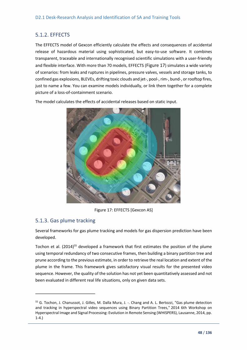
D2.1 Desk-Research Analysis and Identification of SA and Training Tools
48 / 136
EFFECTS
The EFFECTS model of Gexcon efficiently calculate the effects and consequences of accidental
release of hazardous material using sophisticated, but easy-to-use software. It combines
transparent, traceable and internationally recognised scientific simulations with a user-friendly
and flexible interface. With more than 70 models, EFFECTS (Figure 17) simulates a wide variety
of scenarios: from leaks and ruptures in pipelines, pressure valves, vessels and storage tanks, to
confined gas explosions, BLEVEs, drifting toxic clouds and jet-, pool-, rim-, bund-, or rooftop fires,
just to name a few. You can examine models individually, or link them together for a complete
picture of a loss-of-containment scenario.
The model calculates the effects of accidental releases based on static input.
Figure 17: EFFECTS [Gexcon AS]
Gas plume tracking
Several frameworks for gas plume tracking and models for gas dispersion prediction have been
developed.
Tochon et al. (2014)55 developed a framework that first estimates the position of the plume
using temporal redundancy of two consecutive frames, then building a binary partition tree and
prune according to the previous estimate, in order to retrieve the real location and extent of the
plume in the frame. This framework gives satisfactory visual results for the presented video
sequence. However, the quality of the solution has not yet been quantitatively assessed and not
been evaluated in different real life situations, only on given data sets.
55 G. Tochon, J. Chanussot, J. Gilles, M. Dalla Mura, J. -. Chang and A. L. Bertozzi, "Gas plume detection and tracking in hyperspectral video sequences using Binary Partition Trees," 2014 6th Workshop on Hyperspectral Image and Signal Processing: Evolution in Remote Sensing (WHISPERS), Lausanne, 2014, pp. 1-4.)
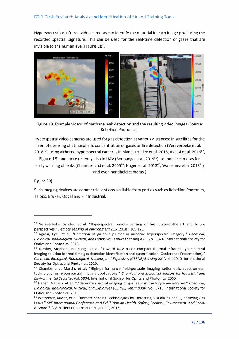
D2.1 Desk-Research Analysis and Identification of SA and Training Tools
49 / 136
Hyperspectral or infrared video cameras can identify the material in each image pixel using the
recorded spectral signature. This can be used for the real-time detection of gases that are
invisible to the human eye (Figure 18).
Figure 18. Example videos of methane leak detection and the resulting video images (Source: Rebellion Photonics).
Hyperspetral video cameras are used for gas detection at various distances: in satellites for the
remote sensing of atmospheric concentration of gases or fire detection (Veraverbeke et al.
201856), using airborne hyperspectral cameras in planes (Hulley et al. 2016, Agassi et al. 201657,
Figure 19) and more recently also in UAV (Boubanga et al. 201958), to mobile cameras for
early warning of leaks (Chamberland et al. 200559, Hagen et al. 201360, Watremez et al 201861)
and even handheld cameras (
Figure 20).
Such imaging devices are commercial options available from parties such as Rebellion Photonics,
Telops, Bruker, Opgal and Flir Industrial.
56 Veraverbeke, Sander, et al. "Hyperspectral remote sensing of fire: State-of-the-art and future perspectives." Remote sensing of environment 216 (2018): 105-121. 57 Agassi, Eyal, et al. "Detection of gaseous plumes in airborne hyperspectral imagery." Chemical, Biological, Radiological, Nuclear, and Explosives (CBRNE) Sensing XVII. Vol. 9824. International Society for Optics and Photonics, 2016. 58 Tombet, Stephane Boubanga, et al. "Toward UAV based compact thermal infrared hyperspectral imaging solution for real-time gas detection identification and quantification (Conference Presentation)." Chemical, Biological, Radiological, Nuclear, and Explosives (CBRNE) Sensing XX. Vol. 11010. International Society for Optics and Photonics, 2019. 59 Chamberland, Martin, et al. "High-performance field-portable imaging radiometric spectrometer technology for hyperspectral imaging applications." Chemical and Biological Sensors for Industrial and Environmental Security. Vol. 5994. International Society for Optics and Photonics, 2005. 60 Hagen, Nathan, et al. "Video-rate spectral imaging of gas leaks in the longwave infrared." Chemical, Biological, Radiological, Nuclear, and Explosives (CBRNE) Sensing XIV. Vol. 8710. International Society for Optics and Photonics, 2013. 61 Watremez, Xavier, et al. "Remote Sensing Technologies for Detecting, Visualizing and Quantifying Gas Leaks." SPE International Conference and Exhibition on Health, Safety, Security, Environment, and Social Responsibility. Society of Petroleum Engineers, 2018.

D2.1 Desk-Research Analysis and Identification of SA and Training Tools
50 / 136
As Veraverbeke et al. (2018) highlights, airborne hyperspectral sensing is extremely relevant in
all phases of fire disturbances. It allows for a detailed assessment of the fuel type and condition,
the fire temperatures and gaseous emissions. In this regard, spaceborne hyperspectral missions
will be of great importance for explaining the linkage between ecosystem properties and fire
disturbances.
In what concerns UAV Thermal Infrared (TIR) Hyperspectral remote sensing, research is still on
early stage but is expected to open many doors for a wide variety of applications. This UAV
sensing technology offers many benefits over traditional gas detection systems, as it allows
safely monitoring and imaging of large areas. Boubanga et al. (2019) reports on the new Thermal
Infrared (TIR) Hyperspectral module from Teleops, which can be fully integrated on a UAV due
to its reduced size and high-level performance.
Literature also shows the possibility of real-time gas detection using these types of sensors. For
instance, in Agassi et al. (2016) a novel detection algorithm using an airborne thermal
hyperspectral sensor is presented for detecting plumes, without the need for clear background
estimation.
Figure 20 Handheld Optical Gas Imaging Camera (FLIR GF620). Source: FLIR Industrial.
Figure 19 Methane plume detected from an airborne hyperspectral camera. Source: Hulley et al. 2016.

D2.1 Desk-Research Analysis and Identification of SA and Training Tools
51 / 136
Hulley et al. (2016) presents a Clutter Matched Filter (CMF) algorithm applied to airborne
Hyperspectral Thermal Emission Spectrometer (HyTES) observations, to efficiently detect and
characterise individual plumes from different gas emitters. The quantitative study demonstrates
successful detection and characterisation with high spatial resolution over large areas (100 km2).
This measurement system complements the sparse coverage offered by satellite observations
with high measurement accuracy. Sensors can be mounted on unmanned platforms.
Video Cameras, IR Cameras, CBRN Sensors, Temperature Sensors
Most of the work on UAV platforms is covered by video cameras (RGB and thermal) with
connection of vision systems and mounted sensors. Typical components include the following:
a frame, a driving system, a power system, and a pilot system. To remotely control it and to
obtain real-time video, a controller, camera gimbal and a monitor are also required. The full
list62:
1. Control & Communication
- Antennas: Receives commands from the ground station (receiver antenna) and sends
telemetry and other data (e.g. video) from the on-board system (transmitter antenna
- Ground Station: Sends operator commands to the UAV and receives real-time flight
data
2. Autopilot
- Flight Controller (computer): Controls the power of each motor and other systems
depending on the data received from the sensors, as well as the commands from the
ground station; can be a commercial standard device with open software or something
developed for a specific solution
- GPS Establishes the geographic position of the RPAS
- Barometer Determines the distance from the sea level
- Inertial measurement unit (IMU): Integrated accelerometers, gyroscopes, and
magnetometers. Determines the current rate of acceleration, changes in rotational
attributes and orientation drift
- Airspeed sensors: Determines the relative speed between the air and the RPAS
- Positioning Camera: Points towards the ground to keep its position over a specific area
over the ground; also records images
- Ultrasonic Sensors: Determines the distance from ground and various obstacles
- Infrared Sensors: Ranges and detects static/moving obstacles
- FPV Camera: Gives a first person view of the flight and can be used to take pictures or
record video
3. Payloads
- HD Camera: Produces photographs; usually stabilised with gimbal device
- Thermography Camera: Produces thermal images
- Laser Sensors: Generates a point cloud of the build and natural geometry
62 https://www.researchgate.net/publication/305453238_State_of_Technology_Review_of_Civilian_UAVs
D2.1 Desk-Research Analysis and Identification of SA and Training Tools
52 / 136
- Gas Sensors: Determines environmental temperature
- Radioactivity Sensors: Measures radioactivity
- Other: Many other systems (physical and electronic) and sensors can be easily
integrated
Solutions on the market
This chapter describes some solution that can be found parameters and some parameters as
examples and starting point for later work in project.
DroneFly matrice 210 RTK63
Although, in special missions where mapping a terrain is crucial photogrammetry cameras are
used64. Some of the mapping drones are fully autonomous and provide high-resolution aerial
photos that can be transformed into orthomosaics, e.g. SenseFly eBee X.
Cameras:
o Thermal Imager: Uncooled VOx Microbolometer
o FPA/Digital Video Display Formats:
o 640 × 512
o 336 × 256
o Analog Video Display Formats:
o 720 × 480 (NTSC);
o 720 × 576 (PAL)
o Pixel Pitch: 17 μm
o Spectral Band: 7.5 - 13.5 μm
o Full Frame Rates:
o 640 × 512:30 Hz (NTSC) 25 Hz (PAL)
o 336 × 256:30 Hz (NTSC) 25 Hz (PAL)
o Exportable Frame Rates: 7.5 Hz NTSC; 8.3 Hz PAL
o Sensitivity (NEdT): <50 mK at f/1.0
o Scene Range (High Gain):
o 640 × 512:-13° to 275°F (-25° to 135°C)
o 336 × 256:-13° to 212°F (-25° to 100°C)
o Scene Range (Low Gain): -40° to 1022°F (-40° to 550°C)
o Spot Meter: Temperatures measured in central 4×4
o File Storage Micro SD Card:
o Photo Format: JPEG, TIFF
o Video Format: MP4
Infrared sensors:
o Obstacle Sensing Range: 0-16.4 feet (0-5 m)
o FOV: ±5°
63 https://www.dronefly.com/police-drone-infographic/ 64 https://www.sensefly.com/drone/ebee-mapping-drone/

D2.1 Desk-Research Analysis and Identification of SA and Training Tools
53 / 136
o Operating Environment: Large, diffuse and reflective obstacles (reflectivity
>10%)
o Gimbal
o Angular Vibration Range: ±0.03°
o Mount Detachable:
o Controllable Range: Tilt +35° to -90°; Pan:±320°; Roll:±15°
o Mechanical Range: Tilt:+45° to -135° Pan:±320° Roll:±45°
o Max Controllable Speed: 120°/s
S.O.D.A. 3D photogrammetry camera.
o RGB lens F/2.8-11, 10.6 mm (35 mm equivalent: 29 mm)
o RGB resolution 5,472 x 3,648 px (3:2)
o Exposure compensation ±2.0 (1/3 increments)
o RGB shutter Global Shutter 1/30 – 1/2000s
o White balance Auto, sunny, cloudy, shady
o ISO range 125-6400
o RGB FOV Total FOV: 154°, 64° optical, 90° mechanical
o Support RTK/PPK
Parrot Anafi-Thermal65
Fire department often have to assess risk and danger e.g. when dealing with wildfires or large
buildings. Drones help firefighters understand, how fire is spreading and where it might go next.
In these cases drones are using thermal and RGB cameras to analyse the environment, e.g..
Parrot Anafi-Thermal:
Sensors:
o GNSS: GPS + GLONASS
o Barometer and magnetometer
o Vertical camera and ultrasound sensor
o 2x6-axis IMU
o 2x3-axes accelerometer
o 2x3-axes gyroscope
Cameras:
o Sensor: CMOS 1/2.4", 21MP
o Video format: MP4 (H264)
o HDR: 4K UHD, 2.7K et 1080p videos, JPEG photos
o Photo formats: JPEG, DNG(RAW)
o Photo modes: single, burst, bracketing, timer and panorama
o Shutter speed: from 1 to 1/10000s
o ISO: from 100 to 3200
o EV compensation: [-3, +3]
o Maximum video sampling rate: 100Mbps
65 https://www.parrot.com/global/drones/anafi-thermal/

D2.1 Desk-Research Analysis and Identification of SA and Training Tools
54 / 136
LD-ASPH LENS :
o f/2.4 aperture
o Depth of focus: 26mm (35mm equivalent)
o Depth of field: 1.5m to infinity
DIGITAL ZOOM :
o Lossless: up to x2.8 (FHD), up to x1.9 (2.7K), up to x1.4 (4K UHD)
o Standard: up to x3 (all resolutions)
THERMAL-IMAGING CAMERA :
o Sensor: FLIR Lepton 3.5 microbolometer (radiometric)
o Sensor resolution: 160x120
o HFOV: 57°
o Pixel pitch: 12µm
o Spectral band: 8-14µm
o Thermal sensitivity: <50mK (0.050°C)
o Photo format: JPEG
o Photo resolution: 3264x2448 (4/3)
o Photo modes: Single / Time-lapse / GPS Lapse
o Video format: MP4 (H264)
o Video recording resolution: 1440x1080, 9fps
o Precision: ±5% max.(High-gain) or ±10% max.(Low-gain)
o Scene Dynamic Range: -10° to +140°C (High-gain) or -10° to +400°C (Low-gain)
o Video: MP4
Aerones
Solutions for firefighting in the city66.
66 https://www.aerones.com/eng/firefighting_drone/

D2.1 Desk-Research Analysis and Identification of SA and Training Tools
55 / 136
Figure 21 Photo: Aerones 67
Rescue UAVs
Ambulance drones are helpful in case of cardiac arrest. “The first minutes after an accident are
critical and essential to provide the right care to prevent escalation. Speeding up emergency
response can prevent deaths and accelerate recovery dramatically. This is notably true for heart
failure, drowning, traumas and respiratory issues. Lifesaving technologies such as an Automated
External Defibrillator (AED), medication, Cardiopulmonary Resuscitation (CPR) aids can be
designed compact enough to be carried by a drone” - (concept)68.
Another good example of a rescue drone is The Little Ripper69, an Australian drone that already
saved a life. It uses:
Payload delivery system
Hi-definition zoom camera
Siren and speaker system with multiple languages
Pod deployment
Shark shield deployment (software)
Sea marker deployment
Underwater vehicles (UUV)
Rov Pegaso70 is a good example of Light Work, Visual and Instrumental inspection, Observation,
Search and Survey robot. Sensors:
Cameras:
o 3 Video channels, feat. Zoom, focus and still camera controls provided as
standard, ROS high resolution Colour & B/W cameras standard mounted on
Pan&Tilt.
Other:
o Optional Cathodic protection(CP) Probe
o Inertial navigation System
o Multi-beam Echosounders
o Panoramic sonar
o Dual head profiler system
o Bathymetric system
o Altimeter
o Pipe tracker
o Current-meter or underwater metal detector
o In addition underwater tools/manipulators
67 https://www.aerones.com/ 68 https://www.tudelft.nl/en/ide/research/research-labs/applied-labs/ambulance-drone/ 69 https://thelittleripper.com.au/ 70 http://it.calzoni.com/products-services/rov-2/

D2.1 Desk-Research Analysis and Identification of SA and Training Tools
56 / 136
Ground vehicles (UGV)
In case of unmanned ground vehicles there are several companies that produce well-packed
machines. Robots have various tasks – from defence to first responder missions. Originally used
for counter explosives operations (CEOD), now gain new markets in counter CBRNE operation
and for general situation awareness (Figure 22).
Figure 22 IBIS® and PIAP Gryf® with sets of CBRNE accesories. Source: PIAP.
Sensors used by first responders possible to integration with
unmanned platforms
LEADER SEARCH Life Detectors (USAR)
USAR is used in rescue operations to detect and then locate the position of victims entombed in
collapsed structures. It will pinpoint and detect the slightest of vibrations by effectively turning
the entire structure into a giant microphone (Figure 23).

D2.1 Desk-Research Analysis and Identification of SA and Training Tools
57 / 136
Figure 23 LEADER SEARCH Life Detectors (USAR)71
LEADER Search detects the presence of buried victims under rubble and identifies their exact
location using Wireless and/or Wired ultra-sensitive seismic sensors.
Furthermore it allows two-way communication with the victim once they are found thanks to its
communication probe waterproof up to 2 meters.
LEADER SCAN Life Search Equipment (USAR)
The LEADER Scan has been designed to detect and locate live victims trapped, buried or
entombed, usually following disasters such as: collapse structures, landslides, avalanches and so
on, LEADER Scan allows to locate victims by detecting movements at a distance of 30m.
Using UWB technology (Ultra Wide Band technology), it interrogates the sub-surface that allows
identifying the victim’s location by detecting movements. Its sensitivity and stability of signal
allows movements’ detection as precise as the chest movement produced from breathing or a
finger movement (Figure 24).
Figure 24 LEADER SCAN Life Search Equipment (USAR)72
Delsar LifeDetector LD3
It is A Seismic and Acoustic Listening Device for Extensive Search. Used by FEMA, USAR, SUSAR
and rescue teams from around the world (Figure 25). The Delsar Life Detector LD3 is
seismic/acoustic listening device to detect and locate live victims trapped in:
Collapsed structures caused by earthquakes
Explosions
Landslides
Mine disasters or cave-ins
71 https://www.leader-group.company/en/usar-victim-search-equipment/usar-life-detectors-search-cameras/life-victim-detector 72 https://www.fireproductsearch.com/leader-scan-life-search-equipment-usar/

D2.1 Desk-Research Analysis and Identification of SA and Training Tools
58 / 136
Figure 25 Delsar LifeDetector LD373
LEADER Sentry Stability Controller
It detect a 5mm movement at a distance of 30m (100 ft). A telescope on the unit, allows the
LEADER-Sentry to precisely focus on the targeted building or unstable structure. LEADER-Sentry
continuously detects and warns of any movement.
Various maximum movement thresholds (stepped from 5mm to 100mm) can be selected. When
any movement monitored exceeds the selected threshold, the audible alarm is activated (Figure
26).
Figure 26 LEADER Sentry Stability Controller74
Warning Alarm Stability Protection device - Leader WASP
Leader WASP detects movement (0 to 2.6 degrees) and vibration (0 to 100 Hz) simultaneously
or not. Alarm is triggered due to rotational failure of the sructure that it has been attached to.
73 https://www.fireproductsearch.com/delsar-lifedetector-ld3/ 74 https://www.fireproductsearch.com/leader-sentry-stability-controller/

D2.1 Desk-Research Analysis and Identification of SA and Training Tools
59 / 136
It was purely designed for risk reduction to personnel working in close proximity to a risk that
had the potential of further movement/collapse of USAR operations (Figure 27).
Figure 27 Warning Alarm Stability Protection device - Leader WASP75
FirstLook 360 – The First Live Streaming 360° Technical Rescue Camera
A rescuer can simply probe the camera in any space, hang by a carabiner or locate at a high point
and view the 360 live by swiping a finger across the screen or by using FL360’s virtual joystick
feature to zero in a particular area of interest (Figure 28).
Figure 28 FirstLook 360 – The First Live Streaming 360° Technical Rescue Camera76
Thermal camera head for search camera TIC head
TIC head (Thermal Imaging Camera) uses infrared sensor to detect and display hottest points of
a confined space. Compared to classic search camera with LED light, TIC head instantly pintpoints
the victim's body heat (Figure 29).
75 https://www.leader-group.company/en/firefighting-equipment/rescue-stability-monitor/warning-alarm-stability-protection-device-leader 76 https://www.fireproductsearch.com/firstlook-360/

D2.1 Desk-Research Analysis and Identification of SA and Training Tools
60 / 136
Figure 29 Thermal camera head for search camera TIC head77
Con-Space Rescue Kit 1 with Power Talk Box
It enables simultaneous, two-way voice communications between the rescuers and the victim.
Rescuers use it where traditional radios fail or when hands-free, secured communications are
required.
Figure 30 Con-Space Rescue Kit 1 with Power Talk Box78
Dräger X-am® 8000
The 1 to 7 gas detector detects toxic and flammable gases as well as vapours and oxygen all at
once – either in pump or diffusion mode (Figure 31).
77 https://www.leader-group.company/en/usar-victim-search-equipment/usar-life-detectors-search-cameras/victim-detector-accessories/thermal-camera-head-search-camera-tic-head

D2.1 Desk-Research Analysis and Identification of SA and Training Tools
61 / 136
Figure 31 Dräger X-am® 800079
OxygenTest 100
Determines the oxygen content of breathing air and oxygen mixtures (Figure 32).
Figure 32 OxygenTest 10080
Rados RAD60
Digital Pocket Alarm Stand Alone Dosimeter designed for use emergency responders who may
be exposed to gamma and X-ray radiation (Figure 33).
78 https://www.fireproductsearch.com/con-space-rescue-kit-1-with-power-talk-box/ 79 https://www.draeger.com/en_uk/Fire-Services/Products/Mobile-Gas-Detection/Multi-Gas-Detection-Devices/X-am-8000 80 https://www.draeger.com/en_uk/Fire-Services/Products/Diving-Equipment-and-Systems/Test-Equipment-for-Diving/OxygenTest-100

D2.1 Desk-Research Analysis and Identification of SA and Training Tools
62 / 136
Figure 33 Rados RAD6081
5.2. FRs Wearable Sensors
In recent years, the technology of wearable sensors has developed, partly as personal gadgets,
but also in the form of technology that can be used in other environments. Handy technology
can also be very useful for responding to emergency situations, helping in gathering information,
organising and managing rescue operations. Obtained in this way, information can be very
valuable for the managers of rescue operations. It should also be noted that in the era of
miniaturisation of all sensors, the package of sensors used by the rescuer does not have to be
large or heavy. In order to build such sensors, MEMS systems (microelectromechanical system)
are usually used. The advantages of using MEMS sensors include:
Very small size, mass, volume,
very low power consumption,
cheap in cost,
easy to integrate into systems or modify,
small thermal constant.
As everything, MEMS technology heave some disadvantages such as:
designing them is a tough task because it includes very much complex procedures,
materials for making the sensors are very fragile (e.g. polysilicon).
Applications of electromechanical micro-devices:
sensors:
o acceleration,
o pressure,
81 https://seintl.com/radiation-alert/first-response-kit/

D2.1 Desk-Research Analysis and Identification of SA and Training Tools
63 / 136
o vibration,
o gyros,
o magnetic field,
o microphones,
o temperature,
electrodes for brain examination,
endoscopy,
chemical microreactors (also known as “lab-on-a-chip”).
Very important for wearable sensors are labs-on-a-chip (LOC), which are a devices that
integrates one or several laboratory functions on a single integrated circuit (commonly called a
"chip") of only millimeters to a few square centimeters to achieve automation and high-
throughput screening.
The information that can be obtained from wearable sensors may include, for example:
carbon monoxide sensors,
position sensors,
heart rate
sweat sensors,
body and ambient temperature sensors,
sensors of dangerous substances.
This information, obtained from the sensors, can provide coordinating rescue operations with
information on the location of individual units, threatened areas, health of the rescuer. The
information from the lifeguard's garment equipment is transferred to the coordinator without
the need for communication between them, which significantly facilitates and speeds up the
work, at the same time increasing the safety of rescuers.
An interesting example of the use of wearable equipment to protect health and life was
presented in the publication "A Self-test to Detect a Heart Attack Using a Mobile Phone and
Wearable Sensors82". The authors propose the use different sensors such as accelerometer,
blood pressure monitor, Electrocardiogram Sensor (ECG) and cell phone applications for the
detection of pre-infants. The proposed application in the event of detection of such a state
would give information about the location of the person at risk and inform other people and the
medical service. A simplified scheme of the discussed system is presented in the figure below
(Figure 34).
82 Peter Leijdekkers, Valérie Gay „A Self-test to Detect a Heart Attack Using a Mobile Phone and Wearable Sensors”, 21st IEEE International Symposium on Computer-Based Medical Systems.

D2.1 Desk-Research Analysis and Identification of SA and Training Tools
64 / 136
Figure 34. Personal Health Monitor System 82
Other use of carrying devices is described in the article "Wearable Sensing Application- Carbon
Dioxide Monitoring for Emergency Personnel Using Wearable Sensors"83. Such use of wearable
device is of particular importance to firefighters. The information about smoke is especially
important for this formation, informing the user about entering the danger zone, and the
coordinator about the occurrence of such a zone. ¡Error! No se encuentra el origen de la
referencia. show possible location of wearable device.
Figure 35 Firefighter’s boot with built-in pocket used for enclosing the CO2 sensor and wireless
sensing module (on right)83
83 Tanja Radu, Cormac Fay, King Tong Lau, Rhys Waite, Dermot Diamond “Wearable Sensing Application- Carbon Dioxide Monitoring for Emergency Personnel Using Wearable Sensors", Proceedings of World Academy of Science, Engineering and Technology. 58. World Academy of Science, Engineering and Technology.

D2.1 Desk-Research Analysis and Identification of SA and Training Tools
65 / 136
In the article, the authors drew attention to the impact of the construction of the pocket, and
more specifically to its waterproof membrane. Its application caused a slower activation of the
sensor, but it did not cause its repeatability. However, to be able to fully use the device,
generating correct indications in all conditions, there is a need to provide the same type of
membrane in different protective outfits.
As can be seen from the previous example, wearable devices can be located in different clothes.
The most obvious choices for placing wearable devices include shoes83, vests84 and helmets85. A
very interesting application of fire-fighting equipment is the integration of a thermal imaging
camera in helmets. There is lots of difficulties using thermal camera, cause there are many
factors influencing the proper operation of a thermal camera 86,87. In order to assess the overall
quality of a particular device, several parameters must be determined and measured, including
sensitivity, non-uniformity of an FPA and noise equivalent temperature difference NETD.
Thermal camera forms an image from infrared radiation originating from observed, visualised
objects. In addition to protecting the firefighter's head, use of set of sensors effectively increases
the effectiveness of fire and rescue actions, for example by providing better vision in smoky or
poorly lit areas thanks to infrared images. Besides that, system measure vital signs using sensor
module is a complementary element of the helmet-mounted system. To achieve this
functionality there is additional wrist part added with ability to measure heart rate and
temperature shown on the Figure 36. Device also transmit data to the main unit inside a helmet
structure via wireless data link.
84 Richard Silberglitt, Andrew Lauland, Michael Watson, Christopher A. Eusebi, Jesse Lastunen, “Wearable Technologies for Law Enforcement”, RR-2012-NIJ, 2017 RAND Corporation 85 Tomasz SOSNOWSKI, Henryk MADURA, Grzegorz BIESZCZAD, Mariusz KASTEK „Thermal camera system integrated into firefighter helmet”, Measurement Automation Monitoring, Feb. 2017, no. 02, vol. 63 86 Perry D. L., Dereniak E. L.: Linear theory of nonuniformity correction in infrared staring sensors, Opt. Eng. 32(8), 1854-1859 (Aug 01,1993). 87 Krupiński M., Bieszczad G., Sosnowski T., Madura H., Gogler S.: Non-uniformity correction in microbolometer array with temperature influence compensation. Metrol. Meas. Syst., Vol. XXI (2014), No. 4, pp. 709–718.
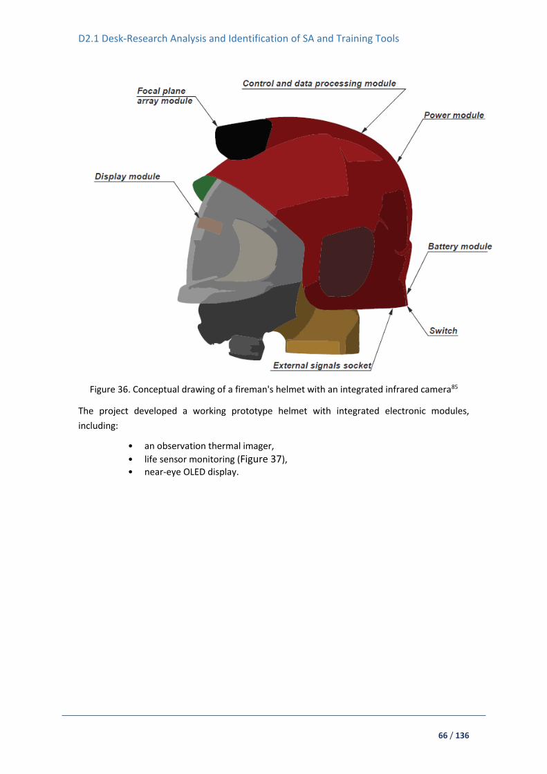
D2.1 Desk-Research Analysis and Identification of SA and Training Tools
66 / 136
Figure 36. Conceptual drawing of a fireman's helmet with an integrated infrared camera85
The project developed a working prototype helmet with integrated electronic modules,
including:
• an observation thermal imager,
• life sensor monitoring (Figure 37), • near-eye OLED display.
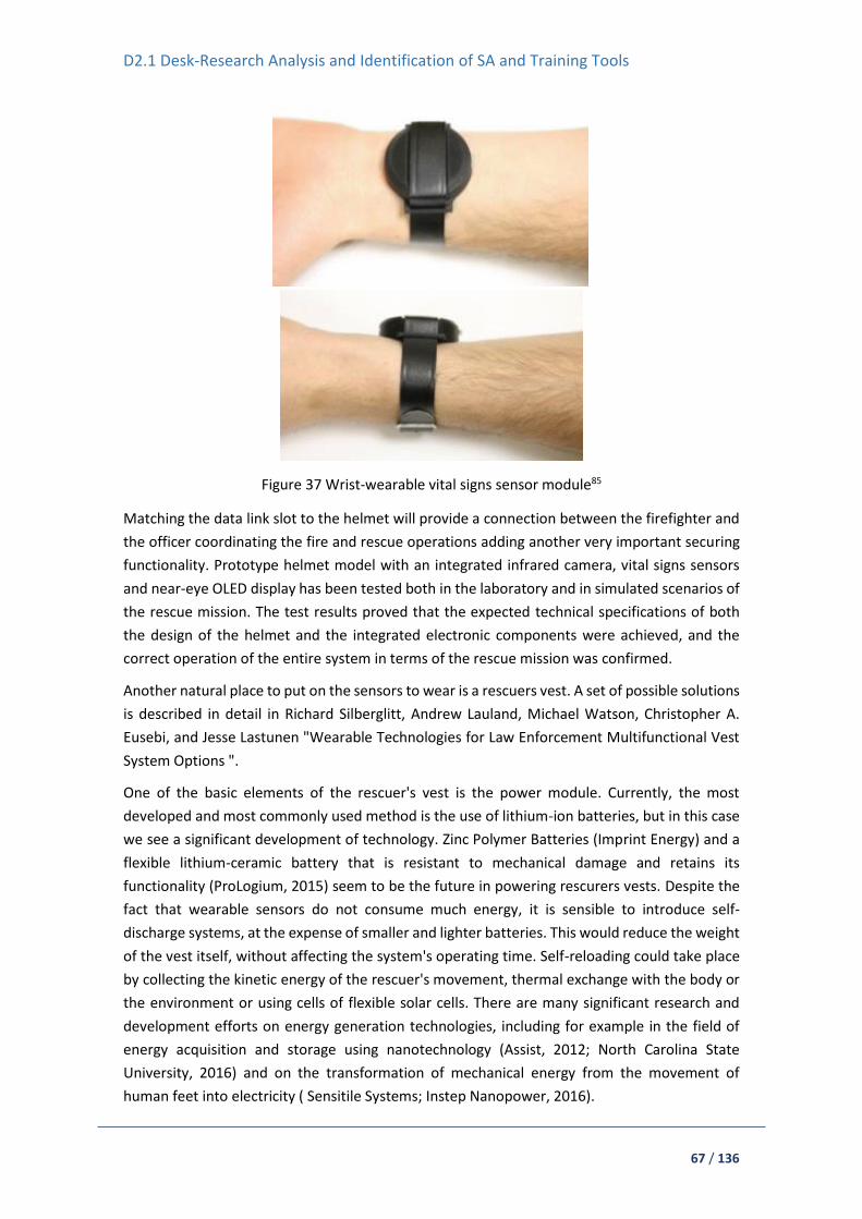
D2.1 Desk-Research Analysis and Identification of SA and Training Tools
67 / 136
Figure 37 Wrist-wearable vital signs sensor module85
Matching the data link slot to the helmet will provide a connection between the firefighter and
the officer coordinating the fire and rescue operations adding another very important securing
functionality. Prototype helmet model with an integrated infrared camera, vital signs sensors
and near-eye OLED display has been tested both in the laboratory and in simulated scenarios of
the rescue mission. The test results proved that the expected technical specifications of both
the design of the helmet and the integrated electronic components were achieved, and the
correct operation of the entire system in terms of the rescue mission was confirmed.
Another natural place to put on the sensors to wear is a rescuers vest. A set of possible solutions
is described in detail in Richard Silberglitt, Andrew Lauland, Michael Watson, Christopher A.
Eusebi, and Jesse Lastunen "Wearable Technologies for Law Enforcement Multifunctional Vest
System Options ".
One of the basic elements of the rescuer's vest is the power module. Currently, the most
developed and most commonly used method is the use of lithium-ion batteries, but in this case
we see a significant development of technology. Zinc Polymer Batteries (Imprint Energy) and a
flexible lithium-ceramic battery that is resistant to mechanical damage and retains its
functionality (ProLogium, 2015) seem to be the future in powering rescurers vests. Despite the
fact that wearable sensors do not consume much energy, it is sensible to introduce self-
discharge systems, at the expense of smaller and lighter batteries. This would reduce the weight
of the vest itself, without affecting the system's operating time. Self-reloading could take place
by collecting the kinetic energy of the rescuer's movement, thermal exchange with the body or
the environment or using cells of flexible solar cells. There are many significant research and
development efforts on energy generation technologies, including for example in the field of
energy acquisition and storage using nanotechnology (Assist, 2012; North Carolina State
University, 2016) and on the transformation of mechanical energy from the movement of
human feet into electricity ( Sensitile Systems; Instep Nanopower, 2016).

D2.1 Desk-Research Analysis and Identification of SA and Training Tools
68 / 136
Another widely used solution that could be used in such a system is wireless charging. Examples
of the benefits of using this solution are as follows:
• no wear and tear to connectors
• no connector port providing entry for contaminants
• no small connectors to attach
• capability to charge devices continuously by building power transmitters into common
objects.
Wireless charging in small devices currently uses inductive or resonant magnetic coupling. The
main standards in the area are Qi (short-range magnetic induction charging) and Alliance for
Wireless Power (A4WP) (longer-range magnetic resonancecharging). Qi-standard technology is
currently used by most leading mobile device manufacturers (e.g., BlackBerry,Samsung, HTC,
and Nokia) and is widely in use. The biggest disadvantage of described system is the need for
permanent placement of sensors. The A4WP system, used in dry companies as Intel, Qualcomm,
and WiTricity, is characterised by greater flexibility, which makes it better suited for use in a
rescuers vest.
Another important functionality that vests should provide is communication. It may be
implemented by various means and methods, such as:
WiFi
Bluetooth
Nonwireless connectivity
In improved and advanced systems they can be WiFi networks that can connect mobile nodes
used to provide coordinating officers with information about their comrades (ie location) and
streaming video and audio from a camera mounted on a vest to nearby officers and emergency
vehicles. The network itself could be based on home WiFi networks that are already used in
commercial applications, or could use the 5.92 Ghz spectrum as defined by the Federal
Communications Commission (FCC) for vehicle-vehicle and vehicle-to-pedestrian safety
systems. Another possibility is to use Bluetooth standard for communication, but it have less
working radius. Besides wireless connectivity there could be also a need to use other methods
to ensure constant information flow and wide-enough bandwidth for any situation. In addition
to wireless connectivity, it may also be necessary to use other methods to ensure a constant
flow of information and a wide bandwidth for each situation. For this purpose, well-known and
developed wired standards can be used. In addition to wireless connectivity, it may also be
necessary to use other methods to ensure a constant flow of information and a wide bandwidth
for each situation. For this purpose, well-known and developed wired standards can be used.
Like the helmet, as well as in the rescuers vest, portable camera can be placed (Figure 38). This
solution is already known and available by, for example, the police. Currently used camera
systems do not weigh much and take up very little space while maintaining high resolution..

D2.1 Desk-Research Analysis and Identification of SA and Training Tools
69 / 136
Figure 38 Example of small camera which can be mounted in rescuers vest88
Although microphones are not so often implemented in wearable rescue devices, they can still
give the coordinator a view of the situation of the rescuer. This is due to the fact that the devices
carried by the rescuer are usually passive (telephone, radio, etc.). Microphones and
accompanying software may enable sound detection and triangulation, source identification
and event sound monitoring by the officer.
It is very important for every wearable device to use it, and thus to disassemble the elements
and sensors. An example of the distribution of individual elements and sensors in the rescuer's
vest is shown in Figure 39.
88 https://it.dhgate.com/product/hd-1080p-mini-wifi-camera-p2p-camera-diy/411195348.html

D2.1 Desk-Research Analysis and Identification of SA and Training Tools
70 / 136
Figure 39 An example of the distribution of elements and sensors in rescuers vest
Cameras
In recent years, wearable devices have been improved, offering new approaches to capturing a
scene, offering the command center a first view of the event.
BodyWorn Smart Scene 360
BodyWorn is and advanced police body camera, with a built-in accelerometer, being able to
detect when an officer is running and start recording. User can capture evidences using a 360º
view option, which can be later used in court. 89
REAL WEAR HMT1
The HMT-1 has a completely hands-free voice-controlled user interface allowing workers to
operate the tools and equipment needed for the job, even while climbing a scaffold or tower.
Allowing the worker to maintain full situational awareness and maximum productivity, HMT-1
is faster, safer and smarter than either a tablet or smart glasses.90 Geotools can be used for
delimiting areas in a map giving a response and start recording when the officer enters that pre-
defined geographical area. All recorded data goes to a secure cloud storage, which can be
reached at any moment, even in real-time situations.
Vimpex CompactPRO
CompactPRO91 is an advanced thermal imaging camera designed for smartphones. Made for
iPhone® and Android™ top models, this highly-portable thermal imaging camera features a
large, 320x240 thermal sensor with high sensitivity and a wide, 32-degree field of view. Offering
adjustable thermal span, level, and emissivity settings, the CompactPRO delivers unprecedented
high-resolution thermal imaging and software capabilities at an affordable price:
89 https://www.bodyworn.com/bodyworn/police-camera/ 90 https://www.realwear.com/products/hmt-1/ 91 http://www.rescuetools.co.uk/ppe-seek-ti.html

D2.1 Desk-Research Analysis and Identification of SA and Training Tools
71 / 136
320 x 240 High-Resolution thermal sensor
Adjustable emissivity and radiometric files
Wide, 32-degree field of view - Easily scan a large area to identify potential hazards in
seconds
Focusable lens for quick identification
Utilises the power and display of your smartphone
Intuitive, free mobile app available on Google Play and iTunes App Store
Waterproof Case
Figure 40 CompactPRO - advanced thermal imaging camera designed for smartphone
Other Detectors
EVIRONICS EnviScreen Operix
Environics Monitoring System92 incorporates sensor integrations, data communications,
databases, system services and user interfaces. In the Monitoring System, sensor measurement
and event data is collected by a data processing unit called Master Module. Master Module
filters and harmonises protocol specific sensor data in real-time for the EnviScreen Operix 2016
user interface running in the Control Station.
The Enviscreen Operix 2016 is complete software solutions for continuous real time operative
CBRN and Environmental situation awareness and guidance. Its technology reaches from single
site to full nation-covering monitoring networks. EnviScreen Operix 2016 system software is the
solution when people safety and system reliability are number one issues.
The EnviScreen Operix offers also emergency instructions and tools for reporting and hazard
area plotting to enable appropriate countermeasures at the time of a suspected threat event.
EnviScreen Operix includes software modules for integration to 3rd party systems and system
training and simulation.
92 https://www.environics.fi/product/enviscreen-operix/

D2.1 Desk-Research Analysis and Identification of SA and Training Tools
72 / 136
AreaRAE
AreaRAE Pro is a wireless multi-gas, multi-threat detector equipped with more sensors, more
versatility, and more insight into threats happening in real-time—arming FR with the
information they need when seconds count (Figure 41).
Figure 41 RAE Systems AreaRAE Pro
Key Features:
Monitors up to seven threats, including Gamma radiation , VOCs, combustibles, Toxics and
Oxygen,
Ppb performance level on VOCs measurement,
Dedicated gamma sensor slot,
Local weather station,
Part of ConneXt Safety Solutions with ISM and Wi-Fi wireless configurations,
Wireless technology sends real-time data to command station up to two miles (3km) away
Secondary radio module (Mesh) act as an communication Hub for other wireless devices,
Ruggedized, portable, and weather-resistant design for harsh environments.
MX908
MX908 is a handheld mass spectrometry™ (HPMS) is a multi-mission tool utilised by first
responders conducting chemical, explosive, priority drug and HazMat in situ. (Figure 42, Figure
43) Trace-level threat detection and discriminating selectivity deliver real-time actionable
intelligence in seconds. Weights 2 kg. MX908 detects compounds at sensitivity levels
comparable to ion mobility spectrometry (IMS).93
93 https://908devices.com/products/mx908/

D2.1 Desk-Research Analysis and Identification of SA and Training Tools
73 / 136
Figure 42 MX908 device
Figure 43 MX908 control
Smiths Detection’s LCD 3.3
Based on leading IMS technology, the LCD 3.3 is a light and versatile chemical warfare agent
(CWA) and toxic industrial chemical (TIC) detector (Figure 44). LCD 3.3 alarms to gas and vapour
threats detected and identified at or below immediately dangerous to life and health (IDLH)
levels, by determining the agent or type, class, concentration and dosage of chemical exposure.
It can also be used as a screening and survey device.94
94https://smithsdetection-scio.com/AssetDownload.aspx?client=1&task=sbPmY%2bDLheyDTviGR7NZDg%3d%3d

D2.1 Desk-Research Analysis and Identification of SA and Training Tools
74 / 136
Figure 44 LCD 3.3 from Smiths Detection’s
Weighing 0,65kg including batteries, it is a light detector which allows multiple flexible mounting
options that can be handheld or clipped to a belt, harness or shoulder trap. It features audible,
visual alarms and liquid crystal display. It can be integrated into vehicle systems or onto robots,
with the Auto Inlet Module (AIM) accessory to provide remote and automatic operation. The
unit can be fitted with a survey nozzle to aid in the detection of residual persistent
contamination while in survey mode. Data logging records up to 72 hours of mission data for
future analysis. Built-in RS232 connectivity for data downloads and post-mission analysis. Data
logging records up to 72 hours of mission data for future analysis. Integrates with Smiths
Detection’s Sensa-LINX wireless communications network.
US DHS POINTER
Precision Outdoor and Indoor Navigation and Tracking for Emergency Responders (POINTER)
has been developed by the Department of Homeland Security Science and Technology of the
United States. As is described in the Project Responder Report95 utilises low frequency magnetic
fields that can transmit though materials and obstructions; the POINTER sensor system enables
accurate track positioning in the most diverse and complex environments. The electrically small
magnetic field that is generated by POINTER does not lose energy as it passes through
obstructions, enabling location to the exact floor in a building. First responders wear a small
tracking device that relays a signal to receivers at a command unit. Functionally, POINTER
administers 3D location and motion tracking and works indoors, outdoors, below ground and
underwater. It can also be applied to long-range situations or where line of sight is severely
blocked, such as when individuals are located in mines or bunkers.
iTrack First Responder Tracking System
The First Responder Tracking System can provide accurate tracking and accountability of a team
of firefighters into indoor environments without GPS input needs. The system continuously
95 https://www.dhs.gov/sites/default/files/publications/Project-Responder-5-Report_170814-508.pdf

D2.1 Desk-Research Analysis and Identification of SA and Training Tools
75 / 136
tracks the first responder’s motion behaviour, whether it be walking, running, or crawling. It
maintains its accuracy by periodically referencing the distance to the fire trucks, first response
vehicles and other ad-hoc beacons. The system consists in a portable vest-worn network radio
module, and a small strap-down foot-mounted module, that increments in 300 g in weight.96
The Fire trucks and other first response vehicles will be deployed with reference beacons Figure
45. The system stores a trace of the first responder’s movement. The trace is useful to find the
injured firefighter.
Figure 45 First Responder Tracking System hypothetical scenario.
iREACT
I-REACT is a current innovation project funded by the European Commission. It is a wrist-device
as shown on Figure 46 applied to disasters with both positioning and sensing capabilities. The
advanced navigation technology provides accurate positions as is using a multi-constellation
receiver which combines raw satellite navigation data from American GPS, European
Galileo/EGNOS and Russian GLONASS, as well as and Inertial Sensors (INS) providing a reliable
positioning system. The functionality of environmental sensing will be used for the detection of
risky scenarios for first responders. 97
96 http://www.itrack-llc.com/download/pts.pdf 97 http://project.i-react.eu/tag/wearables/

D2.1 Desk-Research Analysis and Identification of SA and Training Tools
76 / 136
Figure 46 3D representation of the I-REACT wearable
Chameleon® Chemical Detection Armband Morphix Technologies
Chameleon Chemical Detection Armband is a rugged hand-free device integrating colour-change
chemical detection system for hazardous chemicals98 The Chameleon does not require a liquid
sample; it detects toxic chemicals in air. The armband has room for up to 10 cassettes that can
detect a variety of threats Figure 47. Chameleon chemical detector can be used in arctic,
tropical and desert conditions and it is up to one-hour waterproof. 99
Figure 47 Chameleon® Chemical Detection Armband, Morphix Technologies without cassettes.
5.3. Portable SA Platforms
Having a portable SA Platform as mobile terminals, smartphones and tablet apps will
help to enhance situational awareness, coordinating staff in real-time and being able to have
bidirectional communication. New portable SA Platforms incorporate Geographic Information
98 https://www.morphtec.com/chameleon/ 99 https://youtu.be/BPC4ppKKPmo

D2.1 Desk-Research Analysis and Identification of SA and Training Tools
77 / 136
Systems an essential complement to see the whole picture situation. In this section will analyse
some examples.
GINA First Response Intervention Systems
GINA (Geographic Information Assistant) is a map software technology for computes, tablets
and mobile devices developed in the Czech Republic co-founded by EU. 100 It provides useful
features as dynamic mapping, tactical coordination, communication and information and data
exchange. The system integrates GINA Central, GINA Tablet, GINA Smart and GINA Hems. 101
Consisting of sturdy mobile terminals, smartphone and table apps, GSM or Satellite trackers,
mission control software and the possibility of including sensors or drones to the system. GINA
is used in several countries during emergency and security situations.
GINA software features local maps worldwide, which makes it easy to find and update directly
the status of the emergency in an actualised interactive map. From the sensors data, crisis
managers can see direction of personnel and vehicles in the field, their direction and speed;
being able to draw over the map on tablets, mobile handhelds or PC the terrain situation and
update the personnel about priorities and information.
GINA Central102 is designed to provide modern dispatch and command & control tool. The
platform is based on collaborative map with instant updates. GINA Central allows interactions
with other unit in the terrain and enables operation dispatcher to collect all the mission critical
datasets (Figure 48). Units in the field can use GINA Smart application for communication,
navigation, and incident reporting (Figure 49). It is available for iOS and Android. 103
100 https://www.ginasystem.com/index-en.php 101 https://www.ginasystem.com/first-response-intervention-systems.php 102 https://www.ginasystem.com/gina-central.php 103 https://www.ginasystem.com/gina-smart.php

D2.1 Desk-Research Analysis and Identification of SA and Training Tools
78 / 136
Figure 48 GINA Central
Figure 49 GINA Smart application
GINA Tablet is designed to help first emergency responders in the terrain (¡Error! No se
encuentra el origen de la referencia.). Linking all parts of public security forces together for
faster arrival time to the scene, providing current traffic situation, real time tracking for all
cooperating units, status dispatching with confirmation, communication, possibility to take, edit
and transmit photos, access to external applications (RESCAR, HAZMAT) among other features.
Figure 50 GINA Tablet

D2.1 Desk-Research Analysis and Identification of SA and Training Tools
79 / 136
DragonForce
DragonForce, from DRAKONTAS104 is a mobile team collaboration platform that delivers mission-
critical command and control and incident management capabilities in real time. (Figure 51)
Integrate real-time personnel tracking, instant text messaging among individuals and groups,
online storage and data sharing capabilities, digital forms and situation reports, and a unique
team white boarding capability (Figure 52) that turns any map, picture or floorplan into a shared
whiteboard. DragonForce operates on Android, iPhone, iPad and several standard web browsers
without the need to install any software.
Figure 51 DragonForce Command Center Application
Figure 52 DragonForce Collaborative Whiteboarding tool
FiRST
First Responder Support Tools (FiRST)105 application is a bomb tool that puts key decision making
data, such as safe standoff distances, damage and injury contours, nearby areas of concern, and
suggested roadblocks, directly at responders’ fingertips. FiRST is available to first responders for
a nominal fee, available for iPhones and iPads, Androids, and Windows personal computers.
(Figure 53) Specifically defined DHS bomb standoff data is considered sensitive and is
automatically made available to those that register the application with a .gov, .mil, or .us email
address. The app will be of interest and applicable to anyone who might need to address a
104 https://www.drakontas.com/index.php/dragonforce/ 105 https://www.dhs.gov/publication/first-responder-support-tools-first-application

D2.1 Desk-Research Analysis and Identification of SA and Training Tools
80 / 136
potential bomb or HAZMAT spill response, such as industry, HAZMAT transport, or security
personnel. HAZMAT information is available to all users. It is based on the Emergency Response
Guidebook (ERG) which includes information on over 3,000 hazardous materials. The FiRST app
uses services readily available with current smartphones: email, phone, Google Maps, Google
Search, and weather and road network data. FiRST app relays clear, contextual incident
information on a user-friendly digital map that users can annotate with their own data.106
Figure 53 FiRST Application
IMPACT
Incident management Preparedness and Coordination Toolkit is a free GIS tool easy to use by
non-GIS professionals as first responders, designed to enhance SA, communication,
preparedness and coordination during and for security events. 107108 IMPACT combines
simulation, visualisation, and mapping into an integrated user interface similar to a smart phone
or tablet. First responders can use it for planning, situation awareness, and response to natural
and man-made disasters109 for instance: wildfire monitoring (Figure 54), plume model (Figure
55), evacuation plans, shooter line-of-sight, evacuation simulation among others. IMPACT
collected data uses common open data formats including Google Earth's KML, ESRI's shapefile,
a comma separated value (CSV) text file, or the native OGV archive format in order to easily
exchange data with other map-based tools.
106 https://www.dhs.gov/sites/default/files/publications/FiRST%20Operational%20Field%20Assessment%20Final%20Report.pdf 107 https://geo.ornl.gov/impact/index.html 108 To request a free copy of IMPACT, use the link: https://geo.ornl.gov/impact/downloads.html 109 https://geo.ornl.gov/impact/docs/IMPACT_Examples.pdf

D2.1 Desk-Research Analysis and Identification of SA and Training Tools
81 / 136
Figure 54 Wild fire monitoring visualisation
Figure 55 Plume model with ALOHA program (NOAA) visualisation
IMPACT enables simulation for table-top exercises and operates with a desktop or laptop
(tablets via remote desktop) and is operational with or without a network connection in the
field. Was developed by Oak Ridge National Laboratory110, a Department of Energy facility111,
under sponsorship of the Department of Homeland Security Science and Technology Directorate
(S&T)112 and the Centres for Disease Control and Prevention113. It is in use by over 650 federal,
state, and local government agencies and their partners.
GeoFES
GoeFES is an operational command system for government agencies and organisations with
public safety tasks. Developed in Germany by Eurocommand114, build over ERI ArcGIS software,
which supports unit leaders in standard operations, as well as in large-scale and extensive
110 https://www.ornl.gov/ 111 https://www.energy.gov/ 112 https://www.dhs.gov/science-and-technology 113 https://www.cdc.gov/ 114 http://www.eurocommand.com/en/
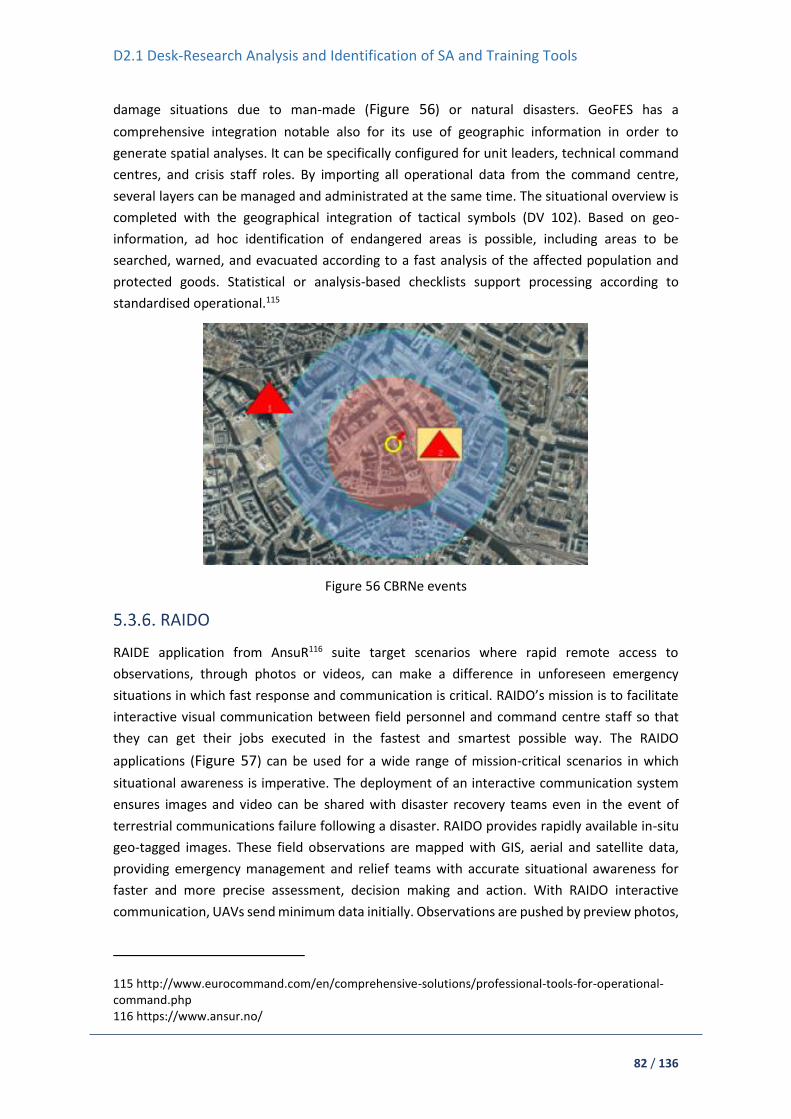
D2.1 Desk-Research Analysis and Identification of SA and Training Tools
82 / 136
damage situations due to man-made (Figure 56) or natural disasters. GeoFES has a
comprehensive integration notable also for its use of geographic information in order to
generate spatial analyses. It can be specifically configured for unit leaders, technical command
centres, and crisis staff roles. By importing all operational data from the command centre,
several layers can be managed and administrated at the same time. The situational overview is
completed with the geographical integration of tactical symbols (DV 102). Based on geo-
information, ad hoc identification of endangered areas is possible, including areas to be
searched, warned, and evacuated according to a fast analysis of the affected population and
protected goods. Statistical or analysis-based checklists support processing according to
standardised operational.115
Figure 56 CBRNe events
RAIDO
RAIDE application from AnsuR116 suite target scenarios where rapid remote access to
observations, through photos or videos, can make a difference in unforeseen emergency
situations in which fast response and communication is critical. RAIDO’s mission is to facilitate
interactive visual communication between field personnel and command centre staff so that
they can get their jobs executed in the fastest and smartest possible way. The RAIDO
applications (Figure 57) can be used for a wide range of mission-critical scenarios in which
situational awareness is imperative. The deployment of an interactive communication system
ensures images and video can be shared with disaster recovery teams even in the event of
terrestrial communications failure following a disaster. RAIDO provides rapidly available in-situ
geo-tagged images. These field observations are mapped with GIS, aerial and satellite data,
providing emergency management and relief teams with accurate situational awareness for
faster and more precise assessment, decision making and action. With RAIDO interactive
communication, UAVs send minimum data initially. Observations are pushed by preview photos,
115 http://www.eurocommand.com/en/comprehensive-solutions/professional-tools-for-operational-command.php 116 https://www.ansur.no/

D2.1 Desk-Research Analysis and Identification of SA and Training Tools
83 / 136
video storyboards or live streaming. Actual data transferred may be reduced by 100X for photos,
and HD video by 1000X/minute.
Figure 57 RAIDO emergency software
CommandX
CommandX is an easy to operate support system for emergency communications in cases of an
incident, available for smartphones and computers. Users do not need to install software on
their clients.117 Additionally, one workplace can communicate with multiple instances locally or
via a network connection. The CommandX user interface is so clearly arranged that no user can
get lost. Situation map is running on the communication server, making possible that multiple
users can access it simultaneously. ArcGIS by Esri is the geodata infrastructure used with access
to municipal geodata and geoanalysis tools. CommandX has the complete palette of DV102
tactical symbols on board. It can be integrated with telematics, GPS and UAVs, providing CM
with direct access to field information (Figure 58), including current weather data and live
videos. With CommandX, this information can be imported immediately, and the sensor data,
photos, and videos quickly give a complete and informative overview of the situation. 118
Figure 58 Interactive situation display with CommandX
ESRI ArcGIS for Emergency Management
ArcGIS Solution for Emergency Management includes a series of focused maps and apps
designed to help emergency management and public safety personnel maintain situational
awareness during an incident or event.119 This solution includes a harmonised suite providing
117 http://www.eurocommand.com/en/comprehensive-solutions/commandx-all-inclusive.php 118 http://www.eurocommand.com/en/comprehensive-solutions/telematics-and-gps.php 119 http://solutions.arcgis.com/emergency-management/situational-awareness-overview/

D2.1 Desk-Research Analysis and Identification of SA and Training Tools
84 / 136
key applications to support CM activities. Maps help visualising physical geography, social
demography, and operations information in a unified view of incident information. The common
operational picture (Figure 59) provides emergency operations centres, incident commanders,
and response personnel accurate and timely information when responding to, and managing,
an incident or event. Situational Awareness Viewer (Figure 60) as well as Operations Response
applications assist in understanding the current status of emergency facilities and response
teams. They are configurations of Web AppBuilder for ArcGIS that can be deployed on desktop
computers, smartphones, and tablet devices.
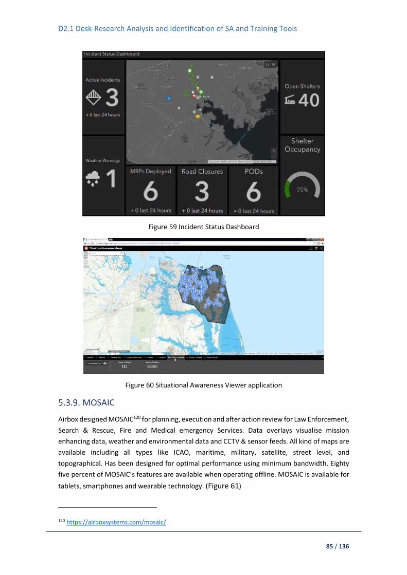
D2.1 Desk-Research Analysis and Identification of SA and Training Tools
85 / 136
Figure 59 Incident Status Dashboard
Figure 60 Situational Awareness Viewer application
MOSAIC
Airbox designed MOSAIC120 for planning, execution and after action review for Law Enforcement,
Search & Rescue, Fire and Medical emergency Services. Data overlays visualise mission
enhancing data, weather and environmental data and CCTV & sensor feeds. All kind of maps are
available including all types like ICAO, maritime, military, satellite, street level, and
topographical. Has been designed for optimal performance using minimum bandwidth. Eighty
five percent of MOSAIC’s features are available when operating offline. MOSAIC is available for
tablets, smartphones and wearable technology. (Figure 61)
120 https://airboxsystems.com/mosaic/

D2.1 Desk-Research Analysis and Identification of SA and Training Tools
86 / 136
Figure 61 MOSAIC shared situational awareness apps
5.4. Sensor Abstraction Service (SAS)
The SAS is a middleware that provides interoperability of data coming from the different
heterogeneous sensing elements of ASSISTANCE, integrating it with the Situational Awareness
platform in an asynchronous, by-subscription and efficient way. It is a platform that serves as
integration layer for the multi-source information being monitored, so it can be later analysed,
correlated and visualised effectively.
Standards, architectural models and existing solutions for integrated platforms have been
collected and analysed. Solutions are mostly focused on IoT ecosystems and smart cities
applications and how deploying interoperable platforms can uncover the maximum potential of
smart sensors and systems.
IBM – Intelligent Operations Centre (IOC) Platform
This Intelligent Operations Centre (IOC)121 platform offers cities integrated visualisation, almost
real-time collaboration and exhaustive analytics to improve operations and planning. The
solution has integrated maps, online dashboards, customisable reports, multiple analytics
algorithms, interactive standard operating procedures, and other tools to improve cities
operations and response to emergencies or incidents. The solution allows:
To supervise operations and respond to events and incidents received through agents.
To involve citizens in the notification and resolution of incidents.
To group and analyse feedback from citizens through social networks.
121 https://www.ibm.com/uk-en/marketplace/city-insights
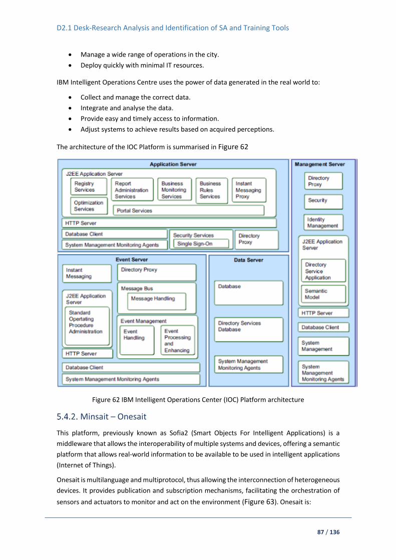
D2.1 Desk-Research Analysis and Identification of SA and Training Tools
87 / 136
Manage a wide range of operations in the city.
Deploy quickly with minimal IT resources.
IBM Intelligent Operations Centre uses the power of data generated in the real world to:
Collect and manage the correct data.
Integrate and analyse the data.
Provide easy and timely access to information.
Adjust systems to achieve results based on acquired perceptions.
The architecture of the IOC Platform is summarised in Figure 62
Figure 62 IBM Intelligent Operations Center (IOC) Platform architecture
Minsait – Onesait
This platform, previously known as Sofia2 (Smart Objects For Intelligent Applications) is a
middleware that allows the interoperability of multiple systems and devices, offering a semantic
platform that allows real-world information to be available to be used in intelligent applications
(Internet of Things).
Onesait is multilanguage and multiprotocol, thus allowing the interconnection of heterogeneous
devices. It provides publication and subscription mechanisms, facilitating the orchestration of
sensors and actuators to monitor and act on the environment (Figure 63). Onesait is:

D2.1 Desk-Research Analysis and Identification of SA and Training Tools
88 / 136
Open-source.
Multiplatform: available for Windows, Android, Linux, iOS...
Multilanguage: portings to Java, Javascript, C ++, Arduino.
Agnostic of communications: with implementations TCP, MQTT, HTTP (REST and
WebServices), Ajax Push...
Multi-device, through its SDK, API's and extension mechanisms that allows its
integration with any type of device.
It is based on the following standards:
JSON (JavaScript Object Notation): Text format for information exchange between
systems, very light and suitable for devices (Arduino, mobile, etc.), used by many Open
DATA platforms.
REST and RESTful services. APIS Web as an evolution of SOA Services.
Hadoop.
Figure 63 Minsait Onsait platform architecture 122
TELEFÓNICA – Thinking City
Thinking City is Telefónica's Smart Cities solution, based on their IoT platform. It is compatible
with FIWARE and is characterised by being a horizontal and open platform, based on
standards123. The solution incorporates:
APIs that provide NGSI open interfaces through which access to the service layer is given
to the data and capabilities of the knowledge layer.
122 https://www.minsait.com/en/products/platform 123 https://iot.telefonica.com/en/

D2.1 Desk-Research Analysis and Identification of SA and Training Tools
89 / 136
Development Kit: Eclipse, TALEND, JBOSS Developer Studio.
Open Data Portal: for access to open data of the city.
Dashboard in Microstrategy for the variety of services that the city can deploy on the
platform: transport (panels, parking, municipal bicycles...), infrastructure management
(irrigation, lighting...), security and emergencies, etc.
oneM2M architecture
The architecture standardised by oneM2M defines an IoT Service Layer, i.e. a software
Middleware, sitting between processing and communication hardware and IoT applications
providing a rich set of functions needed by many IoT applications. It provides functions that IoT
applications across different industry segments commonly need (eg. data transport,
security/encryption, scheduling, event notifications, remote software update, etc.). In addition,
it supports cooperative intelligence in distributed applications i.e. in devices, gateways and back-
end/cloud applications. Besides, oneM2M Service Layer supports a selection of underlying
transport protocols and serialisation formats, being like an Operating System for the Internet of
Things, sitting on field devices and sensors, gateways and in servers. Finally, it is a standard, so
it is not controlled by a single private company 124.
Alliance for Internet of Things Innovation (AIOTI)
The AIOTI has developed a High Level Architecture (HLA) for IoT, which follows the ISO/IEC/IEEE
42010 standard, and whose functional model is composed by three layers:
The Application layer: contains the communications and interface methods used in
process-to-process communications.
The IoT layer: groups IoT specific functions, such as data storage and sharing, and
exposes those to the application layer via interfaces commonly referred to as
Application Programming Interfaces (APIs). The IoT layer makes use of the Network
layer’s services.
The Network layer: the services of the Network layer can be grouped into data plane
services, providing short and long range connectivity and data forwarding between
entities, and control plane services such as location, device triggering, QoS or
determinism.
Besides presenting the Domain Model and Functional Model of an IoT architecture in order to
allow interoperability and maximum integration of intelligent sensors and systems, the AIOTI
HLA also provides deployments considerations related to relevant IoT architectural matters such
as cloud and edge computing, Big Data and virtualisation125.
Software Defined Network-based control system for an efficient traffic management for
emergency situations in smart cities
124 https://www.etsi.org/deliver/etsi_ts/118100_118199/118101/02.10.00_60/ts_118101v021000p.pdf 125 https://aioti.eu/wp-content/uploads/2018/06/AIOTI-HLA-R4.0.7.1-Final.pdf

D2.1 Desk-Research Analysis and Identification of SA and Training Tools
90 / 136
This solution, developed by a team of researchers from the University of Granada and the
Polytechnic University of Valencia (UPV), aims at improving the rapid action of police, firemen
or ambulances in an emergency. It helps to redirect traffic through alternative routes to give
priority to emergency services. This platform, oriented to reorder traffic, uses a Software
Defined Network (SDN) that articulates different sensor networks (IoT) and controls traffic
elements such as traffic lights or information panels126.
5.5. Methods for malevolent/hostile drones neutralisation
At the time of constantly growing usage of UAVs, the threat of their hostile use also increases.
Still small amount of events does not guarantee that future will not bring a change. To limit
further incidents counter-drone technology were introduced into civil sphere of life. Counter-
drone technology also known as counter-UAS, C-UAS, or counter-UAV technology, refers to
systems that are used to detect and/or neutralise unmanned aircraft. This document is focused
on the neutralisation part.
Drone neutralisation topic is in a scope of governmental, academic and private entities interest.
By its crucial role in defensive against hostile UAV actions publicly accessible information about
the state of the art is highly limited. Actual level of knowledge and conducted tests is unknown
due to companies and governmental policy, so that this document presents data gathered by
searching over the Internet and talks with people engaged in antidrone projects, wanted to
share their knowledge.
Drones neutralisation has many aspects. Firstly in terms of platform and therefore a range and
a power because some methods have better efficiency as airborne than as ground placed.
Secondly damage certainty and its strength in terms of UAV neutralisation. Some methods
guarantee none or minimal damages whereas the other lead to total destruction of the target.
Neutralisation approach also determines whether the landing is controllable or not and
therefore may cause collateral damages. Some solutions for drone neutralisation are automatic
in means that they require target position but the device itself do not need to be held by the
operator and manually targeted. Legal issues also play important role because for some
methods authorisation is not required whereas for instance omnidirectional jamming is almost
impossible event to test officially. Last issue and most critical one is efficiency of the approach
and event more important - under what circumstances it can fail. Unfortunately, there is no
accessible studies over this topic nowadays, therefore is very hard to present reliable
information.
Nevertheless neutralisation method shall be adjusted to the level of threat it causes. There is a
clear division between threats given to city or a state and those to public or private space.
Military and civil forces are not equal and therefore their methods are different.
126 https://www.researchgate.net/publication/325584067_Software_Defined_Network-based_control_system_for_an_efficient_traffic_management_for_emergency_situations_in_smart_cities

D2.1 Desk-Research Analysis and Identification of SA and Training Tools
91 / 136
Approaches of drone neutralisation can be divided into two main groups, so called hard and soft
kill. Hard kill concerns physical destruction or instant stoppage of the target whereas soft kill
covers methods mostly related to hacking and jamming. Both groups are usually related to
ground platforms therefore one more group of intercepting methods is sometimes mentioned.
This group concerns a use of an airborne platform however utilise methods from soft and hard
kill (Figure 64).
Figure 64 Diagram of UAV neutralisation methods
Soft kill
Spoofing
Spoofing is about sending fake data to the drone. Spoofing nowadays is limited to GNSS system
and is based on sending fake position with a signal stronger from the one gained from satellites.
Method is limited due to the fact some customised drones in autonomous mode may not use
information from GNSS but visual- or lidar-based SLAM to navigate.
Jamming
Jamming is the most popular and most accessible method in drone neutralisation nowadays.
Number of companies manufactured handheld or automatic ground-based products127. French
company Cerbair offers Medusa product to neutralise hostile drones128, however very small
amount of information is available. DroneShield is a company based in Australia, USA and UK
and provides many antidrones solution. Among other products DroneShiled offers handheld
127 https://zala-aero.com/en/production/means-of-ew/rex-1/ 128 https://www.cerbair.com/solutions/electronic-countermeasure/
D2.1 Desk-Research Analysis and Identification of SA and Training Tools
92 / 136
jammers DroneGun Tactical129 and DroneGun MKIII130. It is said that DroneGun Tactical provides
a safe countermeasure against a wide range of drone models, with effective coverage of 2km
and operating tome of 2hrs. The DroneGun MkIII is a compact, lightweight drone
countermeasure designed for one hand operation with effective coverage of 500m. Israeli
company IAI offers ELI-4030 Drone Guard system which combines detection, tracking,
classification and neutralisation with a jammer. Whole system is stationary and neutralisation is
up to 2km131. British DroneDefence manufactured SkyFence which is also a fixed installation132
but no further data is available.
Hacking
Only a few companies deals with drones hacking. Hacking concerns intervention into
communication protocol and for instance encoding data in pilot-drone communication link. The
outputs of hacking might be disconnection of the drone and a pilot, shutdown of a drone by
stoppage its engines so that drone may fail down or just be unable to start, drone might be also
made to land in safe area. In some cases taking total control of the drone might be possible but
there is no reliable information about it. Another solution is hacking video signal so that operator
will not have information from the cameras. It is believed that hacking was relatively easy and
possible a few years ago but with a development of the UAV technology drones security was
greatly upgraded as well and is much more robust for external tries of interference.
There are research over possibility of controlling drones using 4G and 5G network, what will
enable for instance control a swarm of the drones from another part of the world. This approach
might lead to some new possibilities in drones hacking as well.
In terms of DJI products, the manufacturer developed and sells aeroscope – drone identification
platform that can track all DJI drones in a range of 50 km and gain key information from them in
2 seconds133. Unfortunately the platform does not enable any neutralisation method and needs
to be integrated with users' existing security systems. Nevertheless backdoor system for drone
hacking is also very interesting and straightforward approach, that could be introduced to the
manufactures by governmental authorities.
Hard kill
Ground net launcher
Net launcher is actually most popular civil way of dealing with the drones by their immediate
stoppage. Openworks Engineering - British company manufactured ground based net launcher
offered in manual version SkyWall 100 (Figure 65)134 and automatic version SkyWall 300 (Figure
66)135. Both approaches concern shooting to the target with a missile that before reaching the
129 https://www.droneshield.com/dronegun-tactical 130 https://www.droneshield.com/dronegun-mkiii 131 https://www.iai.co.il/p/eli-4030-drone-guard 132 https://www.dronedefence.co.uk/products/skyfence/ 133 https://www.dji.com/pt/aeroscope 134 https://openworksengineering.com/skywall-100/ 135 https://openworksengineering.com/skywall-300/

D2.1 Desk-Research Analysis and Identification of SA and Training Tools
93 / 136
target falls apart and project a net that cover the target. The net unable rotary motors to
operate, destabilise the target and cause its fall. To prevent uncontrolled fall each net is provided
with a parachute, therefore captured drone is steady and without damages landing on the
ground. This approach also shall not lead to collateral damages. According to the manufacturer,
the range of SkyWall 100 is up to 100m.
Figure 65 Skywall 100, counter drone device by OpenWorks Engineering
Figure 66 Skywall 300, counter drone device by OpenWorks Engineering
Other solutions
Besides net based solutions there are a few other methods for a hard kill from ground, however
their usage in civil space is doubtful. First of them is a usage of a high-power microwave
electromagnetic pulse which is highly effective against electronic equipment. Second is about
using high power laser beam as a directional weapon that is able to melt or burn the target.
Third is based on the opposite element, which is water. Water projector would be able to
destabilise the target or to pump water inside it to damage its electronics. It is believed that this
idea is proposed by Chenega International in a product called DroneSoaker136. Last solution is
based on projecting bullets or missiles to the drones. Good example is military system called
136 https://www.chenegainternational.com/media/1195/counteruav_cic.pdf

D2.1 Desk-Research Analysis and Identification of SA and Training Tools
94 / 136
Phalanx air defence system manufactured by Raytheon which uses 20-mm cannon and is often
mounted on the navy ships137.
Interception
In interception main role plays an interceptor which is usually a drone with a mounted deterrent.
Main idea of using interceptive drones is a to shorten the distance to the target and therefore
use the deterrent with a major power and efficiency. The deterrent in that case might be a net
launcher, net gripper, bullet/missile launcher, electromagnetic pulse emitter or RF jammer.
Net launcher and net gripper
Both approaches where already presented by academic societies138,139. Net launcher was used
by MTU, which prepared a flying robot (Figure 67) able to capture other malicious drone by
chasing the suspect drone to a distance of less than 12 meters, then launching a net, capturing
the drone and carrying it through the air to a safe area. KAIST, the Korean Research Institute has
developed a prototype of a drone with a net gripper, that can be seen in Figure 68. The drone
with a net has to catch up with and place over the target to capture it in the net. After that it
carries the cargo to the selected location.
Figure 67 MTU drone prototype launches the net toward the target
137 https://web.archive.org/web/20060628002308/http://www.raytheon.com/products/stellent/groups/public/documents/content/cms01_055720.pdf 138 https://www.mtu.edu/news/stories/2016/january/drone-catcher-robotic-falcon-can-capture-retrieve-renegade-drones.html 139 https://www.youtube.com/watch?v=tioWbDS5Zm8 / http://unmanned.kaist.ac.kr/

D2.1 Desk-Research Analysis and Identification of SA and Training Tools
95 / 136
Figure 68 KAIST drone prototype with a net gripper, with already cached drone
Commercial use of net launcher mounted on the drone was introduced by i.a. Dutch company
Delft Dynamics140 and American – Fortem Technologies141, SCI142, Theiss UAV Solutions143.
Delft Dynamics has developed a capture system called DroneCatcher (Figure 69) integrated in
a drone as a platform. The company have performed several tests with a capture of Phantom 4
through the launch of a net. Once the intruder drone is inside the range of action, the pilot,
taking references from the images provided by its camera, activates the firing of the net by
means of special cannon, reaching the drone. Then the DroneCatcher carries captured drone
held through a cable, to a safe place.
Figure 69 Drone Catcher (Delft Dynamics product) launches net towards the target
Fortem Technologies have provided a solution called Fortem DroneHunter that works both at
day and night, based on the same solution of net launcher and cargo carriage. It uses radar for
the final approach to the target (Figure 70).
140 https://dronecatcher.nl/ 141 https://fortemtech.com/products/dronehunter/ 142 https://www.sci.com/aeroguard/ 143 http://www.theissuav.com/counter-uas
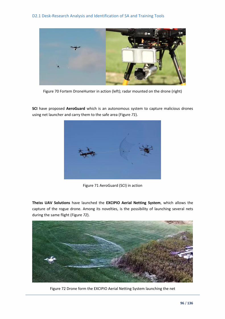
D2.1 Desk-Research Analysis and Identification of SA and Training Tools
96 / 136
Figure 70 Fortem DroneHunter in action (left); radar mounted on the drone (right)
SCI have proposed AeroGuard which is an autonomous system to capture malicious drones
using net launcher and carry them to the safe area (Figure 71).
Figure 71 AeroGuard (SCI) in action
Theiss UAV Solutions have launched the EXCIPIO Aerial Netting System, which allows the
capture of the rogue drone. Among its novelties, is the possibility of launching several nets
during the same flight (Figure 72).
Figure 72 Drone form the EXCIPIO Aerial Netting System launching the net

D2.1 Desk-Research Analysis and Identification of SA and Training Tools
97 / 136
Interesting solution proposed Swiss company Skysec, which developed two products called
Sentinel Catch and Sentinel Catch&Carry (Figure 73). Sentinel Catch is a small UAV which carries
a hanging net and moves towards the target, capturing it (Figure 74). When the target is
captured, the small UAV falls to the ground together with the target, using a parachute to
decrease the impact energy. Sentinel Catch&Carry is bigger and instead of falling together with
a caught target it carries the cargo towards selected area. Maximal weight of the carried
objected is 6 kg.
Figure 73 Sentinel Catch (left) and Sentinel Catch&Carry (right) manufactured by Skysec
Figure 74 Skysec product captures the target using the net
Other solutions and important notes
Three others methods used in interception (bullet/missile launcher, electromagnetic pulse
emitter, RF jammer) are in a phase of tests by private and government organisations but

D2.1 Desk-Research Analysis and Identification of SA and Training Tools
98 / 136
knowledge about them is limited. There are ideas of mounting water cannon that could reach
and damage motor or motors of the UAV.
Crucial for interception methods is efficiency of reaching and following the target in automatic
mode. It means that interceptive drones shall have quick and efficient algorithms for other
drones detection (usually visual) and prediction of their movement. Those features shall enable
constant and stable tracing of the target and therefore use of a deterrent in an effective way.
The other point is a weight and size of a deterrent because the drone has to be able to lift it and
preserve own agility and pace. Deterrent shall be free from recoil effect to not destabilise the
platform and additionally be repeatable.
Some companies like Lockheed, MBDA, WB Electronics, IAI produce suicide drones (loitering
munition)144,145,146, however they are focused on military antipersonnel, antiradar and
antivehicle usage. In drone neutralisation, suicide drones shall reach the target and hit it with
some kinetical power, what would lead to a destabilisation of the target and its fall down. High
risk of collateral damage is here inevitable.
Animal participation
Guard From Above, company from Netherlands, proposed a bird of prey instead of another
drone as an interceptor147. In that case a bird predator usually a falcon or an eagle attacks the
drone and tries to destabilise it or capture. This approach might be effective in terms of small,
rotary, non-customised drones, however legal and humanitarian (possibility of birds injuries)
aspects shall be taken under consideration. Figure 75 shows a predatory bird approaching flying
drone.
Figure 75 Predatory bird intercept a drone
5.6. Ad Hoc network coverage using drones’ swarm equipped
with Wi-Fi access points
144 https://dronecenter.bard.edu/files/2017/02/CSD-Loitering-Munitions.pdf 145 https://www.wbgroup.pl/en/produkt/warmate-loitering-munnitions/ 146 https://www.iai.co.il/p/harpy 147 https://guardfromabove.com/

D2.1 Desk-Research Analysis and Identification of SA and Training Tools
99 / 136
A ground transmitter send signal to a particular drone and then to drones’ swarm which provide
signal in disaster areas. The main problem is power consumption and the number of drones used
for the mission. Here we can see an interesting research in which we can find solutions for the
previously mentioned problems148. Quoted calculations show how to minimise the number of
drones deployed to provide service to ground users and, among the solutions with the same
number of drones, minimise the NICs average power consumption attributable to VoWiFi
(Figure 76).
Figure 76 Reliable communication service scenario149
Similar systems are also used for communicating with beyond line of sight devices, with require
continuous contact with ground control station, like drones and UAVs. One of examples is
project150 designed to extend range interrupted by distance and complicated environment,
based on Mother-Son UAVs which one of them was autonomous controlled and programmed
to keeping the optimal distance to signal receiving and forwarding. Second one was normally
used as guided drone.
Alike idea is offered for military use by Sky-Watch151 with radio communication relaying system.
Also there is many similar ideas and solutions152,153 which are based on similar solutions and
ideas.
5.7. Damaged Assets Location and Routing
Taking advantage of the UAV video streaming, the purpose of this module will be twofold: (i)
firstly to easily locate and take into account damaged assets and/or infrastructure given an area,
and on the other hand (ii) to provide rerouting mechanisms based on damaged assets or
infrastructure in order to better plan intervention or evacuation routes.
148 https://www.researchgate.net/publication/332286131_Deploying_a_Reliable_UAV-Aided_Communication_Service_in_Disaster_Areas 149 Mayor, Vicente & Estepa, Rafael & Estepa, Antonio & Madinabeitia, Germán. (2019) Deploying a Reliable UAV-Aided Communication Service in Disaster Areas. Wireless Communications and Mobile Computing. 201 150 https://www.ncbi.nlm.nih.gov/pmc/articles/PMC5087484/#B1-sensors-16-01696 151 https://sky-watch.com/defense-security/radio-relaying/ 152 http://www.eurecom.fr/en/publication/5492/download/comsys-publi-5492.pdf 153 https://ieeexplore.ieee.org/document/7562472

D2.1 Desk-Research Analysis and Identification of SA and Training Tools
100 / 136
Furthermore, evacuation and intervention times will be provided based on appropriate
optimisation and decision algorithms and real-time computer simulation models (for those areas
or facilities where relevant information is available). These models will be essentially stochastic,
with a high degree of sophistication and with the capabilities of generating and processing
results of thousand simulations, providing additional information to make timely decisions.
Currently, no similar tool or software that provides this complete service has been found in the
market. Because of that, several solutions have been analysed, each one of them covering one
of the individual aspects that the Damaged Assets Location and Routing module of ASSISTANCE
will offer.
Real-time video editing
Open Broadcast Studio
OBS Studio is an open source central control room for live, real time video editing. It features
instant encoding using x264 (an open source h.264 encoder) and AAC. It captures and mixes high
quality real-time sound and video, with unlimited scenes between which you can easily switch
through custom transitions (Figure 77).
Figure 77 Open Broadcast Studio
Besides, OBS Studio is equipped with a powerful API that allows the development of add-ons to
provide greater customisation and functionality specific to your needs. Work with developers in
the streaming community to get the features you need154.
Anvato and Hexaglobe
These two different tools offer real-time editing and clipping functionalities, in this case mainly
targeted to sports events and live news. They both offer a hybrid approach that combines the
ease-of-use of cloud editing with the HD quality of on-premise capture. Moreover, AD insertion
154 https://opensource.com/life/15/12/real-time-linux-video-editing-with-obs-studio

D2.1 Desk-Research Analysis and Identification of SA and Training Tools
101 / 136
functionalities allow to dynamically insert interactive ads targeted for each user. Using
sophisticated video analysis technology, the tools can identify mismatches between ads and
target device capabilities in real-time. Ads are transcoded (converted to the correct video
format) on-the-fly, and seamlessly inserted into the video stream155,156.
Rerouting service based on real-time information
Sygic Professional Navigation
Sygic offers advanced route calculation algorithms tailored to different kinds of vehicles – e.g.
trucks, vans, buses – and different use cases – e.g. deliveries, emergencies, smart cities. Their
Sygic Professional Navigation offers pro level traffic rerouting to make fleet operations more
efficient. By combining real-time and historical traffic data in the route calculation, Sygic can
predict congestion more effectively. Sygic Professional Navigation uses historical data about
traffic to estimate that, if the traffic is further than 2 hours from the driver’s current position,
the traffic will be gone before you get there and does not include this delay in the route. If the
driver is only 15 minutes away from traffic, all calculations are based on real-time data instead
of historical data157.
Waze
Waze is a popular mobile app that provides routing services to users, based on real-time
information on traffic, police, accidents, construction works, etc. Waze (Figure 78) uses live
information reported and located by other users, such as car crashes, traffic jams, hazards or
road closures, and offers it in real-time to the users’ community. This information is used by the
software to automatically redefine the fastest and easiest route in each case.
Figure 78 Waze mobile App
Waze checks real-time speeds for updates on traffic situation every few minutes and sets the
most efficient routes for drivers based on that constantly updated data158.
155 https://www.anvato.com/ 156 https://www.hexaglobe.com/ 157 https://www.sygic.com/es/blog/2018/no-more-irrelevant-routes-with-rerouting-in-sygic-professional-navigation 158 https://www.waze.com/es/

D2.1 Desk-Research Analysis and Identification of SA and Training Tools
102 / 136
5.8. Mission Management
Mission management is very important and complicated task required in every major crisis
handling action. Base goal of mission management is to organise first responders actions and
maximise efficiency. To achieve these goals, good situation awareness, information synthesis
and inter crew communication is necessary. Current methods of situation awareness acquisition
are:
Crew – Leader and inter crew radio communication and data exchange, e.g. goTenna PRO159
Video and audio streams from local sensors e.g. monitoring cameras
Personal first responders and in action distributed specialised sensors
Area topology and vital information from local community and pre-made maps.
In many cases, the leader is responsible for information synthesis. Sometimes a separate person
may be assigned for this purpose. In making this task easier and less time consuming, proper
data visualisation may be helpful. Current data visualisations methods:
Applications that puts all of vital information like emergency plans, evacuation routes or floor plans provided by facility owners on cloud and make it easy accessible with devices like tablet. Good example may be ARC Mobile Facilities Dashboard160.
Applications with digital map of terrain. It may track deployed first responders, casualty or critical emergency positions. It also provide critical information like member tasks or status. Good example Mission Manager161.
Monitors with augmented streams from on location cameras or other data from local sensors162.
Pen and paper with most critical information on it. Last part of in action mission management is communication and order distribution . Popular
ways are:
Leader – crew radio communication
Apps that provide on map first responders selections and order distribution interfaces
Last aspect of a problem is response time. To minimise the response time, many management
task are necessary, like first responders availability tracking, fastest routes to emergency area
planning or administration tasks. Many of those tasks are made by hand, or on specialised
platforms like Mission Management.
159 https://gotennapro.com/ 160 https://www.e-arc.com/services/emergency-life-safety/ 161 https://www.missionmanager.com/ 162 https://edgybees.com/

D2.1 Desk-Research Analysis and Identification of SA and Training Tools
103 / 136
6. Security and safety related projects in the topic
6.1. ALADDIN
H2020 ALADDIN Advanced hoListic Adverse Drone Detection, Identification Neutralization From
2017-09-01 to 2020-08-31, ongoing project. ALADDIN will study, design, develop, and evaluate,
in series of complementary pilots, a counter UAV system as a complete solution to the growing
UAV threat problem, building upon a state-of-the-art system and enhancing it by researching on
various technologies and functionalities.
6.2. AUGGMED
H2020 AUGGMED Automated Serious Game Scenario Generator for Mixed Reality Training From
2015-06-01 to 2018-05-31, closed project The aim of AUGGMED is to develop a serious game
platform to enable single- and team-based training of end-users with different level of expertise
from different organisations responding to terrorist and organised crime threats. The game
scenarios will include advanced simulations of operational environments, agents,
telecommunications and threats, and will be delivered through VR and MR environments with
multimodal interfaces.
6.3. TARGET
H2020 TARGET Training Augmented Reality Generalised Environment Toolkit. From 2015-05-01
to 2018-10-31, ongoing project. TARGET will deliver a Pan-European serious gaming platform
featuring new tools, techniques and content for training and assessing skills and competencies
of SCA (Security Critical Agents - counterterrorism units, border guards, first responders (police,
firefighters, ambulance services civil security agencies, critical infrastructure operators). Mixed-
reality experiences will immerse trainees at task, tactical and strategic command levels with
scenarios such as tactical firearms events, asset protection, mass demonstrations, cyber-attacks
and CBRN incidents.
6.4. FIREMIND
Erasmus+ programme FIREMIND Tool for assessing and training Fireground Situation Awareness
and decision-making
FIREMIND project main aim is to develop an innovative online training tool – the FireMind- that
will support and enhance the decision making of firefighters and fire incident commanders. The
tool will employ digital training scenarios and incidents to enable assessment of knowledge
about a situation (Situation Awareness or SA) and also decision-making “bias” (whether the
available information available is used conservatively or more liberally). Bias can produce errors
of judgment, with too conservative a bias leading to “miss” errors and too liberal to “false alarm”
errors. Self-awareness and monitoring of SA and bias may improve the safety of decision-making
in fire and rescue operations.
6.5. CRISIS

D2.1 Desk-Research Analysis and Identification of SA and Training Tools
104 / 136
FP7 CRISIS CRitical Incident management training System using an Interactive Simulation
environment. From 2010-05-01 to 2013-10-31. CRISIS was conceived as a 3D immersive virtual
world in which major incidents occur. Trainees are presented with a real-time evolving situation
such as a train crash resulting in fires, explosions, increasing casualties and resources distributed
around in a 3D virtual world. The trainee is required to view and assess the situation, formulate
a plan, and organise a response by instructing his team while coordinating with other teams and
higher command. Delays or incorrect actions would result in consequences such as higher death
rates or greater damage.
6.6. ICARUS
FP7 ICARUS Integrated Components for Assisted Rescue and Unmanned Search operations.
From 2012-02-01 to 2016-01-31, closed project. The goal of ICARUS is to decrease the total cost
(both in human lives and in €) of a major crisis. In order to realise this goal, the ICARUS project
proposes to equip first responders with a comprehensive and integrated set of unmanned
search and rescue tools, to increase the situational awareness of human crisis managers and to
assist search and rescue teams for dealing with the difficult and dangerous, but life-saving task
of finding human survivors. As every crisis is different, it is impossible to provide one solution
which fits all needs.
6.7. EDEN
The accidental or deliberate release of CBRNE materials are low probability events that can have
a significant impact on citizens and society. Whenever and wherever they occur, they usually
require a gradual and multi-facetted response as they tend to provoke severe and unexpected
physical, psychological, societal, economic and political effects that cross EU-borders. Successful
CBRNE resilience requires a global System-of-Systems approach. The EDEN project will leverage
the added-value of tools and systems from previous R&D efforts and improve CBRNE resilience
through their adaptation and integration. The concept of the EDEN project is to provide a
“toolbox of toolboxes” EDEN Store to give stakeholders access to interoperable capabilities they
deem important, or affordable, from a certified set of applications. It will share the burden of
development and allows for lessons to be learned and applications to be enhanced. The benefit
of the EDEN concept is that integration will be applied at the application level. This means that
all countries and stakeholders, irrespective of their existing capability levels, will gain immediate
advantages through improved interoperability. EDEN Store will allow capabilities to be shared
among multi-national CBRNE stakeholders, which is paramount in cross-border incident
management, and through time allow for a build-up of common capability across European
boundaries. EDEN will be validated by three themed end-user demonstrations (Food Industry,
Multi Chemical, Radiological) covering multiple hazards (CBRNE), phases of the security cycle,
response tiers, and stakeholders. The EDEN consortium includes CBRNE domain end-users,
major stakeholders, large system integration and solution providers, including SMEs with
innovative solutions, and RTOs. The impact of EDEN is to provide affordable CBRNE resilience
and market sustainability through the better integration of systems in real operations and thus
enhancing the safety of citizens.

D2.1 Desk-Research Analysis and Identification of SA and Training Tools
105 / 136
6.8. ENCIRCLE
To improve its resilience to new CBRN attacks and threats, the EU needs a specialised, efficient
and sustainable industry, competitive on a less fragmented EU market and globally. Capitalising
on its experience in the EDEN Demonstration Project, in other CBRN relevant projects, and in
the CBRN market and supply chain, the ENCIRCLE consortium proposes an innovative approach
to reach this goal in a short to long term perspective so that SMEs and large industries can
propose and invest in the best innovations on the market.
This approach results in 5 objectives aimed at prompting the innovation and business
development, and filling market gaps in the project timeframe:
1. Create an open and neutral EU CBRN cluster,
2. Provide a sustainable and flexible vision and roadmap for the development of the European
CBRN market and innovations,
3. Provide integration with platforms (systems, tools, services, products) by proposing
standardised interfaces and future EU standards to integrate CBRN technologies and innovations
developed from the Part b projects,
4. Support CBRN safety, security and defence commercial and market services,
5. Improve and facilitate European CBRN dissemination and exploitation.
6.9. FIRE-IN
Among 16th countries in Europe there is CNBOP-PIB as a partner. Such a net can spread products
of project and knowledge throughout the UE.
FIRE-IN has been designed to raise the security level of EU citizens by improving the national and
European Fire & Rescue (F&R) capability development process. FIRE-IN addresses the concern
that capability-driven research and innovation in this area needs much stronger guidance from
practitioners and better exploitation of the technology potentially available for the discipline.
We argue that this is to be achieved by practitioners more effectively coordinating on
operational needs, on available research and innovation, on standardisation, and on test &
demonstration and training. Further, we claim the need for the development of a common
research culture that is to be achieved by better cooperation between practitioner and
research/industry organisations. Main objective of project was to improve national and
European fire and rescue capability development process by activities as they are described
below:
FIRE-IN addresses these objectives through four main areas of activity: (i) the identification and
harmonisation of operational capability gaps based on the contribution provided by a significant
and heterogeneous practitioner network, (ii) the identification of promising solutions to address
those gaps through monitoring and screening of research outcomes and the continuous
involvement of research and industry representatives, (iii) the definition of a F&R Strategic
Research and Standardisation Agenda (SRSA) based on the previous elements as well as (iv) the
development of a concept for more efficient use of test & demonstration and training facilities
to support innovation and joint skill development. Project assemble over 500 Experts in 5

D2.1 Desk-Research Analysis and Identification of SA and Training Tools
106 / 136
thematic group which is covering fields of: Search and Rescue (SAR) and emergency Medical
Response, Structure Fires, Vegetation Fires, Natural Disasters and CBRN’s.
The overarching result of the project will be a proven process for organising F&R capability-
driven research based on a wide practitioner and research and innovation network. The network
will be linked at cross-domain and cross-border level and will feed harmonised operational
requirements (or challenges) into national and EU capability development, i.e. research,
innovation, procurement and standardisation programmes.
Benefits of project are moving boldly in directions of saving costs and optimising R&D
investments, reducing implementation time, simplified access to state of the art technologies,
simplifying collaboration between practitioners (EU and worldwide). Main goal to achieve is to
maintain faster and cheaper access to the state-of-the-art fire and rescue technology for the
whole Europe.
Knowledge obtained in the Fire-In and net of expert and practitioners made through the project
could be reliable source of information in the matter of first response behaviour and in other
information needed in the course of project.
6.10. DRIVER+
DRIVER+ starts from the experience that neither successful R&D nor strong end-user demand
always lead to innovation in the Crisis Management (CM) domain. This is a problem since as
societies become more complex, increasing scope and unpredictability of potential crises and
faster dynamics of major incidents put increasingly stringent demands on CM. European CM
capabilities already constitute a mature System of Systems; hence wholesale redesign would
often be too costly and might critically destabilise existing CM capabilities. Therefore DRIVER+
focuses on augmenting rather than replacing existing capabilities. DRIVER+ has three main
objectives: 1) Develop a pan-European Test-bed for crisis management capability development;
2) Develop a well-balanced comprehensive portfolio of crisis management solutions, and 3)
Facilitate a shared understanding of crisis management across Europe.
The DRIVER+ Test-bed will provide the technological infrastructure, the necessary supporting
methodology and adequate support tools. The Portfolio of Solutions (PoS) is a database driven
web site that documents all the available DRIVER+ solutions. The PoS includes information on
the experiences with a solution (i.e. results and outcomes of trials), the needs it addresses, the
type of practitioner organisations that have used it, the regulatory conditions that apply, societal
impact consideration, a glossary, and the design of the trials. Initially, the PoS will contain
information about the solutions that are already available within the consortium; the PoS will
be extended with third-party solutions when required by the trials, and ultimately opened up
for any external organisation to share data and experiences on solutions.
A series of trials will be conducted during which solutions will be operationalised and tested. All
results of the trials will be stored and made available in the PoS. Several I4CM events will be
organised as well as a final conference. In addition to this, a firm link is established and will be
maintained with DG HOME’s “Community of Users on Secure, Safe and Resilient Societies” and
other European stakeholder groups and relevant initiatives, for instance on standardisation.

D2.1 Desk-Research Analysis and Identification of SA and Training Tools
107 / 136
The FP7 project DRIVER+’s (Driving Innovation in Crisis Management for European Resilience,
2014 – 2020) main aim is to cope with current and future challenges due to increasingly severe
consequences of natural disasters and terrorist threats, by the development and uptake of
innovative solutions that are addressing the operational needs of practitioners dealing with
Crisis Management.
For ASSISTANCE, it provides the following useful features:
- An open source technical infrastructure for supporting trials, life or table-top exercises
and trainings (available from GitHub at https://github.com/DRIVER-EU). It includes tools
such as a scenario editor, after-action review and observer support tools (animation). In
addition, it provides a Trial Guidance Methodology and handbook for helping you setup
a new trial or exercise, and online e-learning training modules.
As this technical infrastructure is build upon Apache Kafka, is it also suitable for
supporting life experiments or during operations.
- A community of CM practitioners, CMIME (https://www.cmine.eu), where practitioners
and researchers in the field of crisis management can share information.
- A database of CM solutions and trials, the so-called Portfolio of Solutions (PoS), where
you can find and discuss existing CM solutions, and learn from past experience.
Outcomes of the ASSISTANCE project, such as new solutions, outcomes and lessons
learned of experiments, should be shared there as well.
6.11. LETSCROWD
LETSCROWD is a project led by ETRA that overcomes challenges preventing the effective
implementation of the European Security Model (ESM) with regards to mass gatherings. This is
achieved by providing the following to security policy practitioners and in particular, LEAs:
1. A dynamic risk assessment methodology for the protection of crowds during mass
gatherings centred on human factors in order to effectively produce policies and deploy
adequate solutions.
2. A policy-making toolkit for the long-term and strategic decision making of security policy
makers, including a database of empirical data, statistics and an analytical tool for
security policies modelling.
3. A set of human-centred tools for Law Enforcement Agencies (LEAs), including real time
crowd behaviour forecasting, innovative communication procedures, semantic
intelligence applied to social networks and the internet, and novel computer vision
techniques.
LETS-CROWD is a security practitioner driven project, fostering the communication and
cooperation among LEAs, first responders, civil protection and citizens in the fight against crime
and terrorism during mass gatherings by a set of cooperation actions. The project puts citizens
at the centre of the research and assesses and evaluates how security measures affect them,
and how they perceive them, while respecting EU fundamental rights.
LETS-CROWD impact is measured under practical demonstrations involving seven LEAs and
relevant emergency services units. In order to facilitate the assessment of the performance,

D2.1 Desk-Research Analysis and Identification of SA and Training Tools
108 / 136
transferability, scalability and large-scale deployment of these solutions, the demonstrations are
conducted following eleven use cases.
ETRA, as coordinator of the project, system integrator and responsible of exploitation activities,
will make use of the lessons learned and the solutions developed in the project for handling
multi-source data streams and communication services among LEAs in order to provide them
with advanced Situational Awareness. The experience gained through LETSCROWD will be
especially useful for the definition and development of the Sensor Abstraction Service (SAS) that
will integrate all data and information coming from different sensors, providing interoperability.
6.12. SAURON
SAURON project proposes the holistic situation awareness concept as an integrated, scalable
and yet installation-specific solution for protecting EU ports and its surroundings. This solution
combines the more advanced physical SA features with the newest techniques in prevention,
detection and mitigation of cyber-threats, including the synthetic cyber space understanding
through the use of new visualisation techniques (immersive interfaces, cyber 3D models and so
on).
SAURON faces the coordinated and every time more complex terrorist attacks that target many
critical infrastructures (CI) (e.g. EU ports) and ICT systems. The impact of a coordinated physical
attack, a deliberate disruption of critical automation systems or even a combined scenario
including both kind of attacks, could have disastrous consequences for the European Member
States’ regions and social wellbeing in general.
A Hybrid Situation Awareness (HSA) application capable of determine the potential
consequences of any threat will show the potential cascading effect of a detected threat in the
two different domains (physical and cyber). On the other hand, through SAURON approach the
public in the surroundings and the rescue/security teams will be able to be informed on any
potential event/situation that could put in risk their integrity.
Several partners of SAURON (ETRA, UPVLC and THALES) will use the experience gained through
the project, especially in the development of Situational Awareness services and tools, 3D
models and immersive interfaces. Lessons learned and synergies will be exploited in order to
maximise the effectiveness of the tools developed in ASSISTANCE.
6.13. CRM4EMS
Erasmus+ programme Key Action 2 CRM4EMS Project “Crew Resource Management for
Emergency Medical Services” The principal aim of the CRM4EMS project is to provide Emergency
Medical Services with a resource that they can adapt and utilise within their organisations to
improve system and operational safety and help mitigate against the causes of errors that result
in adverse events for the public who need to use EMS provision and for EMS professionals too.
CRM4EMS Project will enhance to Human Factors perspective of ASSISTANCE Project; because
CRM4EMS Project aims to adapt Crew Resource Management Course that in use in Aviation
Sector to Emergency Medical Services. Topics are Situational Awareness, Teamwork, Decision
Making, Task Management and Communication.

D2.1 Desk-Research Analysis and Identification of SA and Training Tools
109 / 136
6.14. CASCEFF
The aim of the FP7 CASCEFF project was to improve understanding of the cascading effects in
crisis situations and to reduce the consequences of escalating incidents in complex
environments. In order to do this, initiators, dependencies and key decision points were
identified. These were used to develop an Incident Evolution Tool which enables improved
decision support in escalating incidents, contributing to the reduction of collateral damages and
other unfortunate consequences associated with large crises.
6.15. IMPROVER
The overall objective of the H2020 IMPROVER project was to improve European critical
infrastructure resilience to crises and disasters through the implementation of resilience
concepts to real life examples of pan-European significance, including cross-border examples.
The improvement arises through the development of a methodology for implementing
combinations of societal, organisational and technological resilience concepts to critical
infrastructure based on risk evaluation techniques and informed by a review of the positive
impact of different resilience concepts on critical infrastructure.

D2.1 Desk-Research Analysis and Identification of SA and Training Tools
110 / 136
7. End users feedback on state of the art
The questionnaire has been developed in order to enhance the desk research on the state-of
the-art with an overview on the actual state-of-play of the technologies and methods used by
the end-users in real-life operations or the ones they are mostly interested in. The ned user
partners in the consortium have distributed the questionnaire among their networks and 40
responses to the questionnaire have been gathered. The study participants distribution among
the organisation type is shown in Figure 79. The results of the survey are discussed in this
chapter and gathered in Annex 9.1.
Figure 79 Survey participants by organisation type
Command and Control (C2) technologies used by the first responders are mostly digital maps,
emergency vehicles tracking systems and real-time video streaming. Tracking is widely used in
all ground ambulances, fire trucks, motorcycles and helicopter ambulances movements.

D2.1 Desk-Research Analysis and Identification of SA and Training Tools
111 / 136
Figure 80 Command and controll technologies used
Communication is covered by radio (mostly APKO and Motorola), GSM/GPRS and satellite
(National Medical Rescue Teams – UMKE).
Figure 81 Communication technologies used

D2.1 Desk-Research Analysis and Identification of SA and Training Tools
112 / 136
In case of unmanned platforms, only drones are used - as a visual assistance during rescue
operations and social events. Most of UAVs are light and commercial e.g. Phantom 4, DJI Mavic
Pro.
Handheld sensors include CO2 and radioactive detectors, also thermal cameras are a part of
equipment.
Figure 82 Handheld sensors used
Wearable sensors are as follows: GPS localisation is taken from multiple sources (tablets,
phones, radio or a car). Personal video cameras are mainly used by the motorcycle teams. There
are also temperature sensors used by firefighters and CBRN detectors.
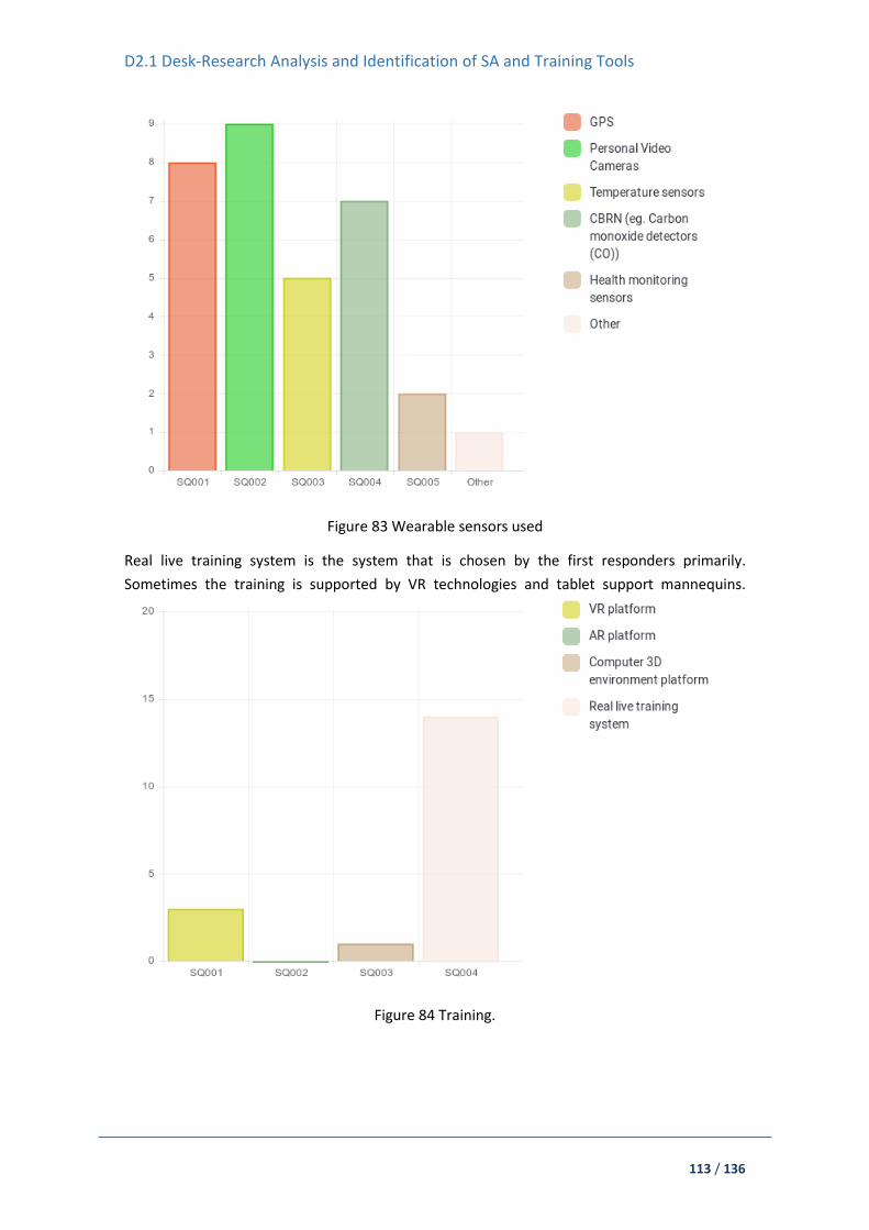
D2.1 Desk-Research Analysis and Identification of SA and Training Tools
113 / 136
Figure 83 Wearable sensors used
Real live training system is the system that is chosen by the first responders primarily.
Sometimes the training is supported by VR technologies and tablet support mannequins.
Figure 84 Training.
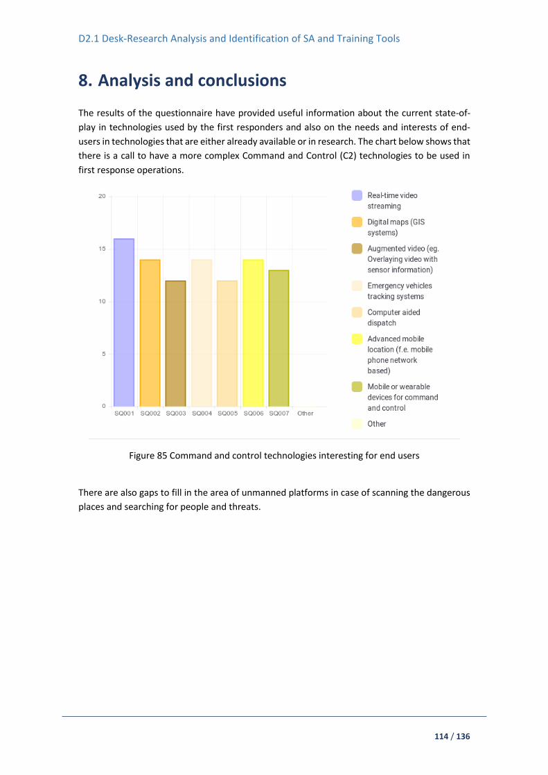
D2.1 Desk-Research Analysis and Identification of SA and Training Tools
114 / 136
8. Analysis and conclusions
The results of the questionnaire have provided useful information about the current state-of-
play in technologies used by the first responders and also on the needs and interests of end-
users in technologies that are either already available or in research. The chart below shows that
there is a call to have a more complex Command and Control (C2) technologies to be used in
first response operations.
Figure 85 Command and control technologies interesting for end users
There are also gaps to fill in the area of unmanned platforms in case of scanning the dangerous
places and searching for people and threats.

D2.1 Desk-Research Analysis and Identification of SA and Training Tools
115 / 136
Figure 86 Unmanned platforms that are interesting for end users
With regards to sensors mounted on the platforms:
Figure 87 Interesting sensors for unmanned platforms
Providing technologies like VR, AR or computer 3D environment should be useful in training and
preparing for operations.
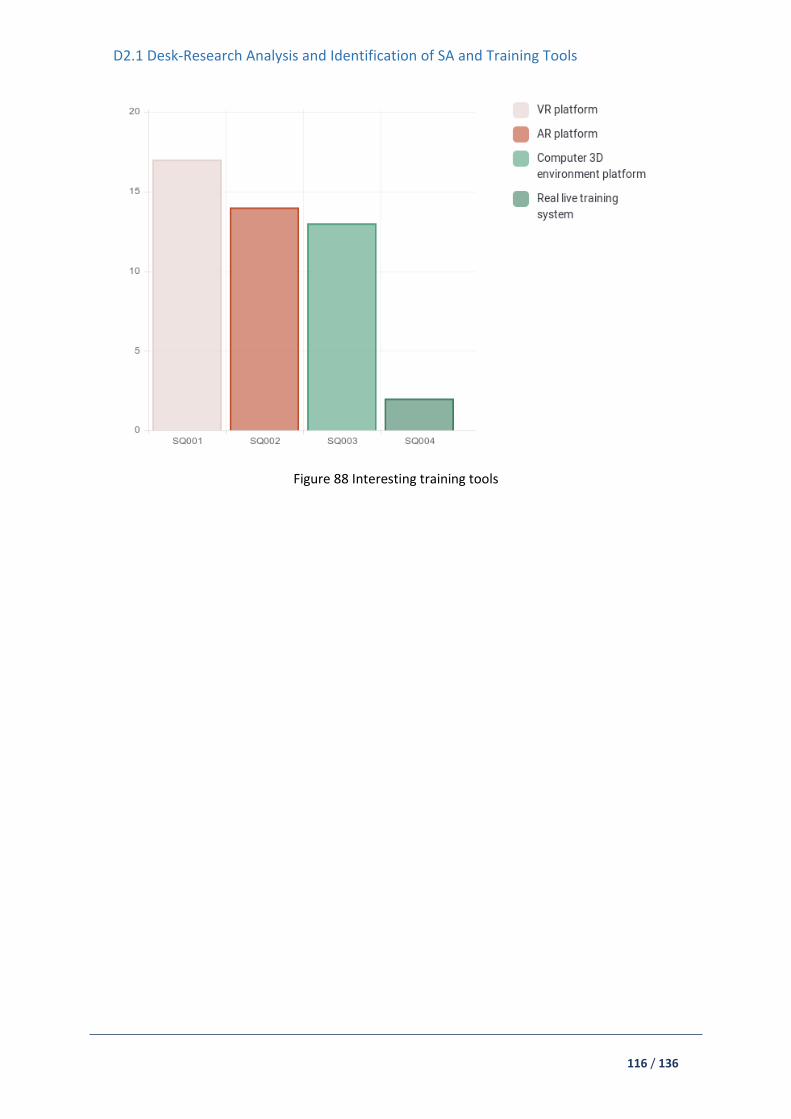
D2.1 Desk-Research Analysis and Identification of SA and Training Tools
116 / 136
Figure 88 Interesting training tools
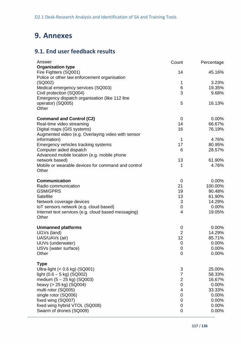
D2.1 Desk-Research Analysis and Identification of SA and Training Tools
117 / 136
9. Annexes
9.1. End user feedback results
Answer Organisation type
Count
Percentage
Fire Fighters (SQ001) 14 45.16% Police or other law enforcement organisation (SQ002) 1 3.23% Medical emergency services (SQ003) 6 19.35% Civil protection (SQ004) 3 9.68% Emergency dispatch organisation (like 112 line operator) (SQ005) 5 16.13% Other Command and Control (C2) 0 0.00% Real-time video streaming 14 66.67% Digital maps (GIS systems) 16 76.19% Augmented video (e.g. Overlaying video with sensor information) 1 4.76% Emergency vehicles tracking systems 17 80.95% Computer aided dispatch 6 28.57% Advanced mobile location (e.g. mobile phone network based) 13 61.90% Mobile or wearable devices for command and control 1 4.76% Other Communication 0 0.00% Radio communication 21 100.00% GSM/GPRS 19 90.48% Satellite 13 61.90% Network coverage devices 3 14.29% IoT sensors network (e.g. cloud based) 0 0.00% Internet text services (e.g. cloud based messaging) 4 19.05% Other Unmanned platforms 0 0.00% UGVs (land) 2 14.29% UAS/UAVs (air) 12 85.71% UUVs (underwater) 0 0.00% USVs (water surface) 0 0.00% Other 0 0.00%
Type
Ultra-light (< 0.6 kg) (SQ001) 3 25.00% light (0.6 – 5 kg) (SQ002) 7 58.33% medium (5 – 25 kg) (SQ003) 2 16.67% heavy (> 25 kg) (SQ004) 0 0.00% multi rotor (SQ005) 4 33.33% single rotor (SQ006) 0 0.00% fixed wing (SQ007) 0 0.00% fixed wing hybrid VTOL (SQ008) 0 0.00% Swarm of drones (SQ009) 0 0.00%

D2.1 Desk-Research Analysis and Identification of SA and Training Tools
118 / 136
Handheld sensors
CBRN 5 38.46% Acoustic 2 15.38% Wearable cameras 6 46.15% Other 1 7.69% Portable situation awareness platform Mobile phones 16 80.00% Tablets 16 80.00% Other 0 0.00% Wearable sensors
GPS 8 47.06% Personal Video Cameras 9 52.94% Temperature sensors 5 29.41% CBRN (e.g. Carbon monoxide detectors (CO)) 7 41.18% Health monitoring sensors 2 11.76% Other 1 5.88% Sensors mounted on unmanned platforms
Optical sensors (Day/IR/Thermal cameras) 4 40.00% CBRN sensors 0 0.00% Temperature sensors 1 10.00% Relays 1 10.00% Other 1 10.00% Stand-off sensors Radar 0 0.00% Laser-based (LIDAR, spectroscopy etc.) 1 10.00% X-Ray 1 10.00% Acoustic 2 20.00% Gunshot detection 0 0.00% Other 0 0.00% CBRN Sensors 3 27.27% Weather stations 2 18.18% Computer simulation (e.g.. hazardous cloud dynamics detection) 1 9.09% Integrated systems 0 0.00% Other 0 0.00% Command and Control – willing to use Real-time video streaming 16 80.00% Digital maps (GIS systems) 14 70.00% Augmented video (e.g.. Overlaying video with sensor information) 12 60.00% Emergency vehicles tracking systems 14 70.00% Computer aided dispatch 12 60.00% Advanced mobile location (e.g. mobile phone network based) 14 70.00% Mobile or wearable devices for command and control 13 65.00%

D2.1 Desk-Research Analysis and Identification of SA and Training Tools
119 / 136
Other 0 0.00% Communication – willing to use Radio communication 14 70.00% GSM/GPRS 15 75.00% Satellite 14 70.00% Network coverage devices 8 40.00% IoT sensors network (e.g.. cloud based) 9 45.00% Internet text services (e.g. cloud based messaging) 10 50.00% Other 0 0.00% Unmanned platforms – willing to use UGVs (land) 12 70.59% UAS/UAVs (air) 12 70.59% UUVs (underwater) 9 52.94% USVs (water surface) 9 52.94% Other 0 0.00% Handheld sensors – willing to use CBRN 11 61.11% Acoustic 5 27.78% Wearable cameras 13 72.22% Other 0 0.00% Wearable sensors – willing to use GPS 11 57.89% Personal Video Cameras 17 89.47% Temperature sensors 11 57.89% CBRN (e.g. Carbon monoxide detectors (CO)) 9 47.37% Health monitoring sensors 13 68.42% Other 0 0.00% Sensors mounted on unmanned platforms – willing to use Optical sensors (Day/IR/Thermal cameras) 10 66.67% CBRN sensors 8 53.33% Temperature sensors 9 60.00% Relays 5 33.33% Other 0 0.00% Stand-off sensors - willing to use Radar 2 16.67% Laser-based (LIDAR, spectroscopy etc.) 3 25.00% X-Ray 4 33.33% Acoustic 3 25.00% Gunshot detection 3 25.00% Other 0 0.00% CBRN – willing to use Sensors 13 68.42% Weather stations 10 52.63% Computer simulation (e.g. hazardous cloud dynamics detection) 12 63.16% Integrated systems 3 15.79% Other 0 0.00%

D2.1 Desk-Research Analysis and Identification of SA and Training Tools
120 / 136
Technology in research – willing to use Integrated situation awareness systems 0 0.00% Command and control 1 9.09% Communication 0 0.00% Unmanned platforms 3 27.27% Sensors and devices 0 0.00% CBRN hazard evolution assessment 0 0.00% Other 1 9.09% Training platform VR platform (SQ001) 3 15.00% AR platform (SQ002) 0 0.00% Computer 3D environment platform (SQ003) 1 5.00% Real live training system (SQ004) 14 70.00% Training platform – willing to use VR platform (SQ001) 17 85.00% AR platform (SQ002) 14 70.00% Computer 3D environment platform (SQ003) 13 65.00% Real live training system (SQ004) 2 10.00% End-users responses: Summary for G2Q00001
ID Response
10 LiveU (https://www.liveu.tv/) 18 from municipal buildings and our fire management vehicles 24 Only to observe the helicopter ambulance take-off movement
32 Securo (https://stream.securo.eu/), airCCTV 3G/4G (https://aeromind.pl/product-pol-2710-airCCTV-3G-4G.html)
41 Only to observe the helicopter ambulance take-off movement 43 Only to observe the helicopter ambulance take-off movement 44 Mobile Command Control Vehicle 24 All land ambulances movements 32 Securo (https://stream.securo.eu/) 43 All land ambulances movements 18 from municipal buildings 10 GPS in the radiosystem RAKEL (Sweden) 14 e-remiza system. 15 fire - fighting application e remiza in the car 18 In the national 112 system 32 4Hawks, Trackimo 38 Ground ambulances, motocycles and air ambulances 39 Arvento Mobile Systems 41 All ground ambulances, motorcycles and helicopter ambulances movements 44 All fire trucks 48 E remiza 18 In the National 112 system 39 Armakom information technologies 14 localisation fireman's and fire truck 15 fire - fighting application e remiza in the car 18 In the national 112 system 24 100 meters-500 meters 38 100 meters-1km.( Determines the number of base stations

D2.1 Desk-Research Analysis and Identification of SA and Training Tools
121 / 136
41 100 meters-500 meters 43 100-500 meters 44 10-500 METERS 46 100-500 METERS 47 100 meters-500 meters 45 100-500 meters
Summary for G2Q00002 ID Response
10 RAKEL (national system of Sweden) and closerange radion for firefighters. 14 motorola system 15 motorola system 18 In the Swedish national safe radio "Rakel" (Tetra) 32 Motorola TLKR T40, 34 Motorola 38 Digital APCO 25/ASELSAN for EMS ; analog system for technical support teams 39 APCO 25 40 ASELSAN APCO 25 41 Digital APCO 25/ASELSAN for EMS ; analog system for technical support teams 48 Motorolla 14 tablet in the car 15 special tablet in the fire truck 18 Public network 34 Garmin 38 TURKCELL 41 TURKCELL 48 E remiza 24 For only National Medical Rescue Teams (UMKE) 32 EGNOS, Galileo, GPS, ASG-EUPOS 34 only during international misssions- Thuraya, B- gan 38 National Medical Rescue Teams (UMKE) 41 For only National Medical Rescue Teams (UMKE) 45 Some special intervention police cars 10 In the cars 18 Public network 10 Ipad and Iphone 14 chat e remiza, 45 Bulk message system over service providers 48 E remiza
Summary for G2Q00003
ID Response
44 Robotic
10 DJI Mavic pro and DJI Mavic 2 enterprise Dual 14 test, DJI Spark, visual assistance during rescue operations 15 DJI Spark drone tested during rescue operations 18 To some extent, agreements with private companies 32 Yuneeec Typhoon H, Yuneec Typhoon H520, DJI Inspire 1, Phantom 4, 34 DJi 44 Drone
45 Using drones some cases in social events.

D2.1 Desk-Research Analysis and Identification of SA and Training Tools
122 / 136
Summary for G2Q00006 ID Response 10 Dräger 18 Find radioactive radiation 44 CO2 dedectors 44 Radio frequency 14 thermovision's camera Flir company 15 three thermovision camera Filr search and rescue 18 Flir systems, Look for glow and fire 34 thermal cameras 48 Kamera termowizyja Flir E5xt 10 FLIR
Summary for G2Q00007
ID Response 10 Iphone 14 private and aplication e remiza 15 and special application e remiza 18 Under all kinds of assignments 32 Samsung Galaxy J2, 10 Ipad 14 samsung solid in the car 15 and special application e remiza. In the fire truck. 18 Under all kinds of assignments, comand and control 32 Lenovo Tab2, Crystal Sky 48 Samsung tablet
Summary for G2Q00008
ID Response
10 In the radio
14 in the car and and phone
15 mobile phones and special application e remiza. All firefighters see on the map where I am
18 All vehicles and boats (100 units) 32 Garmin GPSMAP 62
14 camera on the helmet 38 Motocycle teams ( GoPro) 39 Motocycle teams ( GoPro) 41 GoPro for only motorcycle teams 42 Motocycle Teams ( GoPro) 10 FLIR
18 Flir systems, Look for glow and fire 10 Dräger (only during CBRNE event) 14 personal detector, MSA Auer 18 In case of chemical accidents 48 MSA Altair 4x4
15 watch Garmin Fenix 3 HR, heart rhythm monitoring 18 Flir systems, Look for glow and fire 10 On fire fighters to detekt if they stop moning = Sound
Summary for G2Q00009
ID Response
10 Thermal on our UAV DJI Mavic 2 enterprise dual. 34 3 D cameras

D2.1 Desk-Research Analysis and Identification of SA and Training Tools
123 / 136
32 CGOET (thermal camera for Typhoon H https://aeromind.pl/product-eng-8-Dron-Yuneec-Typhoon-H-with-CGOET-Thermal-camera.html)
10 For longer radio coverage in all cars 15 camera HD Ready in the dron DJI Spark
Summary for G2Q00010
ID Response 34 geophones
Summary for G2Q00011
ID Response 10 Dräger 44 Drager sensor 10 RIB (https://rib.msb.se/)
Summary for G3Q00001
ID Response 15 assisting in the management of the rescue operation 24 1 15 assisting in the management of the rescue operation 24 2 15 assisting in the management of the rescue operation 24 4 18 There are fully automatic systems to find the nearest vehicle faster 24 3 15 assisting in the management of the rescue operation 15 assisting in the management of the rescue operation
Summary for G3Q00002
ID Response
24 1 15 assisting in the management of the rescue operation 24 2 15 a modern way of organizing a rescue operation 24 3 24 4 15 a quick way of notifying a large number of people 24 5
Summary for G3Q00003
ID Response
15 irreplaceable in dangerous places 18 We need different types of robots during fires and accidents 32 https://centauro-project.eu/, 34 for CBRN
15 a quick way to watch the rescue action, in conjunction with a thermal imaging camera a good search device
34 fixed wings- fuselage 15 searching for people and threats 15 searching for people and threats
Summary for G3Q00004
ID Response 34 on uniform/ helmet
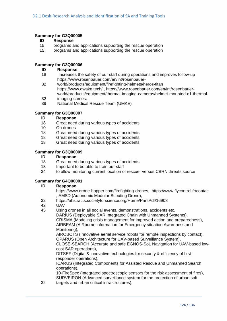
D2.1 Desk-Research Analysis and Identification of SA and Training Tools
124 / 136
Summary for G3Q00005
ID Response 15 programs and applications supporting the rescue operation 15 programs and applications supporting the rescue operation
Summary for G3Q00006
ID Response 18 Increases the safety of our staff during operations and improves follow-up
32 https://www.rosenbauer.com/en/int/rosenbauer-world/products/equipment/firefighting-helmets/heros-titan
32
https://www.qwake.tech/ , https://www.rosenbauer.com/en/int/rosenbauer-world/products/equipment/thermal-imaging-cameras/helmet-mounted-c1-thermal-imaging-camera
39 National Medical Rescue Team (UMKE) Summary for G3Q00007
ID Response
18 Great need during various types of accidents 10 On drones 18 Great need during various types of accidents 18 Great need during various types of accidents 18 Great need during various types of accidents
Summary for G3Q00009
ID Response 18 Great need during various types of accidents 18 Important to be able to train our staff 34 to allow monitoring current location of rescuer versus CBRN threats source
Summary for G4Q00001
ID Response
32
https://www.drone-hopper.com/firefighting-drones, https://www.flycontrol.fr/contac , AMSD (Autonomic Modular Scouting Drone), https://abstracts.societyforscience.org/Home/PrintPdf/16903
42 UAV 45 Using drones in all social events, demonstrations, accidents etc.
32
DARIUS (Deployable SAR Integrated Chain with Unmanned Systems), CRISMA (Modeling crisis management for improved action and preparedness), AIRBEAM (AIRborne information for Emergency situation Awareness and Monitoring), AIROBOTS (Innovative aerial service robots for remote inspections by contact), OPARUS (Open Architecture for UAV-based Surveillance System), CLOSE-SEARCH (Accurate and safe EGNOS-SoL Navigation for UAV-based low-cost SAR operations), DITSEF (Digital & innovative technologies for security & efficiency of first responder operations), ICARUS (Integrated Components for Assisted Rescue and Unmanned Search operations), 10-FireSpec (Integrated spectroscopic sensors for the risk assessment of fires), SURVEIRON (Advanced surveillance system for the protection of urban soft targets and urban critical infrastructures),
D2.1 Desk-Research Analysis and Identification of SA and Training Tools
125 / 136
EC-SAFEMOBIL (Estimation and control for safe wireless high mobility cooperative industrial systems), TIRAMISU, BERISUAS (Better Response and Improved Safety through Unmanned Aircraft Systems), RECONASS (Reconstruction and REcovery Planning: Rapid and Continuously Updated COnstruction Damage, and Related Needs ASSessment), ROLFER (RObotic Lifeguard For Emergency Rescue), SafeShore, MOBNET(MOBile NETwork for people's location in natural and man-made disasters ), SAFEDAM, EENA-DJI Pilot Project, ANCHORS UAV-Assisted Ad Hoc Networks for Crisis Management and Hostile Environment Sensing, FIRE-RS (Wildfire Picosatellite Constellation & UAVs Remote Sensing: Active fire mapping and management), EffFeu (Efficient Operation of Unmanned)
Summary for G5Q00001
ID Response 15 first aid training in the e platform 18 Training is done at our training facilities 32 none 42 Tablet support mannequins
Summary for G6Q00002
ID Response 15 first aid training application
18 There is access to this in Sweden but is under construction 32 VR platform - RealFlight Drone, http://cmgi.eu/pl/produkty/straton-wojsko/straton-
bsp/
34 VR based on VBS3 system- developer CMGI polish company - simulator of UAV operator
Summary for G7Q00001
ID Response 18 We handle a large number of different types of accidents. It can be fires or traffic
accidents, cardiac arrest, environmental damage, race and landslides. There are recommended plans that can be changed depending on the type of event. The accidents are led from our alarm center. The staff there ensures that the correct recipe to manage an accident is used. Our officer in our alarm center is the one who has the main responsibility
32 - JARUS guidelines on Specific Operations Risk Assessment (SORA) - Manual on Remotely Piloted Aircraft Systems (RPAS), Doc 10019, ICAO, Montreal 2015 - Safety Management Manual (SMM) (Doc 9859) ICAO - Unmanned Aircraft Systems (UAS), Cir 328, ICAO, Montreal 2011,
38 Directive of Emergency Call Center Services - 112 Single number call center, Regulation on Emergency Health Services - Provincial level organization, Emergency Call Center Services Directive - Standards of ambulances type, stations and personal, Provincial Health Disaster and Emergency Plans Directive - 112

D2.1 Desk-Research Analysis and Identification of SA and Training Tools
126 / 136
Single number call center, TS- 1295 standard - VHF Radio, EN-1789 standard - Road Ambulance- medical vehicles and their equipment.
39 Regulation of Emergency Medical Services - EMS operation and organization, Directive of Emergency Call Center Services - 112 Single number call center, Provincial Health Disaster and Emergency Plans Directive - Provincial level organization, Regulation of Ambulances and Emergency Medical Vehicles - Standards of ambulances type, stations and personal, TS- 1295 standard - VHF Radio, EN-1789 standard - Road Ambulance- medical vehicles and their equipment
40 Regulation of Emergency Medical Services - EMS operation and organization, Directive of Emergency Call Center Services - 112 Single number call center, TS- 1295 standard - VHF Radio, EN-1789 standard - Road Ambulance- medical vehicles and their equipment
Summary for G7Q00002
ID Response 18 We have hundreds of different plans and it's hard to list all. The sites are in the
national 112 system 32 - wytyczne nr 1 Prezesa Urzędu Lotnictwa Cywilnego z dnia 4 lutego 2019 r. w
sprawie prowadzenia szkolenia lotniczego do uzyskania świadectwa kwalifikacji operatora bezzałogowego statku powietrznego używanego w celach innych niż rekreacyjne lub sportowe (UAVO) oraz uprawnień wpisywanych do tego świadectwa, DZ. URZ. 2019.11, http://edziennik.ulc.gov.pl/#/legalact/2019/11/ - JARUS SORA STS-01 for Aerial Work Operations - JARUS guidelines on Specific Operations Risk Assessment (SORA) - Manual on Remotely Piloted Aircraft Systems (RPAS), Doc 10019, ICAO, Montreal 2015 - Safety Management Manual (SMM) (Doc 9859) ICAO - Unmanned Aircraft Systems (UAS), Cir 328, ICAO, Montreal 2011, - internal operational instruction (INOP) and checklists
38 Notification of Paramedik and EMT working procedures and principles, Radio operation manual of EMS staff
39 Notification of Paramedik and EMT working procedures and principles, Radio operation manual of EMS staff
Summary for G8Q00001
ID Response 15 my organization is comprehensive, we participate in a large number of rescue
operations. (about 400 a year) 18 You ask for specific products in this survey, in some cases we could point out what
we want It is not possible to respond to the level of detail requested. It would take weeks of investigation to do it.
Summary for G2Q00004 Answer Count Percentage Ultra-light (< 5 kg) (SQ001) 1 7.14% light (5 – 40 kg) (SQ002) 3 21.43% medium (40 – 500 kg) (SQ003) 0 0.00% heavy (> 500 kg) (SQ004) 0 0.00% Tracked (SQ005) 2 14.29% Wheeled (SQ006) 0 0.00% “Snake like” (SQ007) 0 0.00% Walking (legged) (SQ008) 0 0.00% Count Percentage

D2.1 Desk-Research Analysis and Identification of SA and Training Tools
127 / 136
Summary for G2Q00005 Answer Ultra-light (< 0.6 kg) (SQ001) 3 25.00% light (0.6 – 5 kg) (SQ002) 7 58.33% medium (5 – 25 kg) (SQ003) 2 16.67% heavy (> 25 kg) (SQ004) 0 0.00% multi rotor (SQ005) 4 33.33% single rotor (SQ006) 0 0.00% fixed wing (SQ007) 0 0.00% fixed wing hybrid VTOL (SQ008) 0 0.00% Swarm of drones (SQ009) 0 0.00%

D2.1 Desk-Research Analysis and Identification of SA and Training Tools
128 / 136
9.2. Questionnaire (web version)
The screenshot above show general look of web version of questionare. Below there is an export
of all questions, those while beeing filled online would look similar to screenshot above.

D2.1 Desk-Research Analysis and Identification of SA and Training Tools
129 / 136

D2.1 Desk-Research Analysis and Identification of SA and Training Tools
130 / 136

D2.1 Desk-Research Analysis and Identification of SA and Training Tools
131 / 136

D2.1 Desk-Research Analysis and Identification of SA and Training Tools
132 / 136

D2.1 Desk-Research Analysis and Identification of SA and Training Tools
133 / 136

D2.1 Desk-Research Analysis and Identification of SA and Training Tools
134 / 136

D2.1 Desk-Research Analysis and Identification of SA and Training Tools
135 / 136
9.3. Questionnaire (Word document version)

D2.1 Desk-Research Analysis and Identification of SA and Training Tools
136 / 136
ASSISTANCE
Adapted situation awareneSS tools and taIlored training curricula for increaSing capabiliTie and enhANcing the proteCtion of first respondErs
Project co-funded by the European Union within the Horizon 2020 Programme
ASSISTANCE SOTA questionnaire for End-Users

D2.1 Desk-Research Analysis and Identification of SA and Training Tools
1 / 23
About ASSISTANCE
Nowadays different FRs organizations cooperate together facing large and complex disasters, that in some cases can be amplified due to new threats such
as, the climate change in case of natural disasters (e.g. big floods, large wild fires, etc) or the increase of radicalization in case of man-made disasters (e.g.
arsonist that burn European forest, big combined terrorist attacks in European cities).
The impact of these kinds of large disasters could have disastrous consequences for the European Member States’ regions and social wellbeing in general.
On the other hand, each type of FRs organizations (e.g. medical emergency services, firefighters’ departments, law enforcement teams, civil protection
professionals, etc.) that work mitigating these kinds of events are exposed to unexpected dangers or new threats that can severely affect their personal
integrity.
Taking into account these facts, ASSISTANCE proposes a holistic solution that will adapt a well-tested SA application as a core of a wider SA platform, capable
of offering different configuration modes for providing the tailored information outcome needed by each FR organization, while they work together mitigating
the disaster (e.g. real time video and resources location for firefighters, evacuation routes status for emergency health services and so on).
With this solution ASSISTANCE will enhance the FRs SA during their mitigation activities through the integration of new paradigms, tools and technologies
(e.g. drones/robots equipped with different sensors, robust communications capabilities, etc.) with the main objective of increasing both their protection
and their efficiency.
On the other hand, ASSISTANCE also proposes to improve the FRs skills and capabilities through the establishment of a European advanced training network
for FRs that will provide tailored training based on new learning approaches (e.g. virtual, mixed and/or augmented reality) adapted to each type of FRs
organizations needs and the possibility of sharing virtual training environments, exchanging experiences and actuation procedures.
ASSISTANCE is funded by the Horizon 2020 Programme of the European Commission, in the topic of Critical Infrastructure Protection, contract 832576.

D2.1 Desk-Research Analysis and Identification of SA and Training Tools
2 / 23
ASSISTANCE SOTA questionnaire for End-Users
Dear End-User,
As our goal is to focus on real needs of yours and to tailor our solutions to your actual preferences and expectations, we kindly ask you to fill in the short
questionnaire concerning the state-of-the-art (SOTA) technologies that we should refer to in our developments.
Please be kind to share with us your practitioners knowledge that is of the best value for good understanding of your operational reality which we can build
upon to provide you with improved tools and systems supporting you in your specialised tasks.
Thank you very much for your contribution!
ASSISTANCE project team
Acronyms
ASSISTANCE Adapted situation awareneSS tools and taIlored training curricula for increaSing capabiliTie and enhANcing the proteCtion of first respondErs
AR Augmented Reality
CBRN Chemical, Biological, Radiological and Nuclear Defense
COTS Commercial off-the-shelf
C2 Command and control
GIS Geographic Information System
GSM Global System for Mobile communications
GPRS General Packet Radio Service
IR Infrared
LEA Law Enforcement Agency
SA Situation Awareness
UAS Unmanned Aerial System
UAV Unmanned Aerial Vehicle
D2.1 Desk-Research Analysis and Identification of SA and Training Tools
3 / 23
UGV Unmanned Ground Vehicle
UUV Unmanned Underwater Vehicle
USV Unmanned Surface Vehicle
VR Virtual Reality
Type of organisation
Please fill mark your organisation type. It should indicate your primary activity as an actor in Emergency Services.
Fire
Fighters
Police
/ LEA
Medical
emergency
services
Civil
protection
Emergency dispatch
organisation (like 112
line operator)
Other
(Please specify)
Situation Awareness technologies
Which type of technology do you use currently in your operations?
Please give us as much information as possible on technologies you are currently using, that are related to ASSISTANCE project, use bullets or numbering
whenever convenient. In case the specific section or table is not applicable for your organisation please leave it blank.
List technologies you use. For the following table please fill (add if necessary) an additional row at the bottom in case you use a technology matching
“command and control” group that is not mentioned in the predefined fields in the table.
D2.1 Desk-Research Analysis and Identification of SA and Training Tools
4 / 23
Command and control Please
tick ‘X’
COTS or
custom made
Please describe the technology (type, producer/developer,
capabilities/characteristics/parameters/web-link etc.)
Please describe briefly the kind of operation
you use it for
Real-time video
streaming
Digital maps (GIS
systems)
Augmented video (eg.
Overlaying video with
sensor information)
Emergency vehicles
tracking systems
Ccomputer aided
dispatch
Advanced mobile location
(f.e. mobile phone
network based)
Mobile or wearable
devices for command and
control

D2.1 Desk-Research Analysis and Identification of SA and Training Tools
5 / 23
List technologies you use. For the following table please fill (add if necessary) an additional row at the bottom in case you have a technology matching
“communication” group that is not mentioned in the predefined fields in the table.
Communication Please
tick ‘X’
COTS or
custom made
Please describe the technology (type, producer/developer,
capabilities/characteristics/parameters/web-link etc.)
Please describe briefly the kind of operation
you use it for
Radio communication
GSM/GPRS
Satellite
Network coverage
devices
IoT sensors network (f.e.
cloud based)
Internet text services (f.e.
cloud based messaging)
List technologies you use. For the following table please fill the information about all the unmanned platforms (robots) that you are using in your emergency
response activities. In case you have more than one platform of specific type please provide the details about all of them in the text fields.
Unmanned platforms
(robots)
Please
tick ‘X’
COTS or
custom made
Please describe the technology (type, producer/developer,
capabilities/characteristics/parameters/web-link etc.)
Please describe briefly the kind of operation
you use it for

D2.1 Desk-Research Analysis and Identification of SA and Training Tools
6 / 23
UGVs (land)
UAS/UAVs (air)
UUVs (underwater)
USVs (water surface)
If you ticked that you use the UGVs please mark below the applicable categories below. For multiple platforms you can provide multiple ticks in the same
table.
UGV (land robots) types Please
tick ‘X’
Ultra-light (< 5 kg)
light (5 – 40 kg)
medium (40 – 500 kg)
heavy (> 500 kg)
Tracked
Wheeled
“Snake like”
Walking (legged)

D2.1 Desk-Research Analysis and Identification of SA and Training Tools
7 / 23
If you ticked that you use the UAVs please mark below the applicable categories below. For multiple platforms you can provide multiple ticks in the same
table. Otherwise please leave the table blank.
UAV (flying drones) types Please
tick ‘X’
Ultra-light (< 0.6 kg)
light (0.6 – 5 kg)
medium (5 – 25 kg)
heavy (> 25 kg)
multi rotor
single rotor
fixed wing
fixed wing hybrid VTOL
Swarm of drones
List technologies you use. In case your technology (sensors and devices) is not listed below please mark a tick next to “Other” category and describe your
systems in the following columns.
D2.1 Desk-Research Analysis and Identification of SA and Training Tools
8 / 23
Sensors and devices Please
tick ‘X’
COTS or
custom made
Please describe the technology (type, producer/developer,
capabilities/characteristics/parameters/web-link etc.)
Please describe briefly the kind of operation
you use it for
Handheld sensors
CBRN
Acoustic
Wearable cameras
Other
Portable SA platforms
Mobile phones
Tablets
Other
Wearable sensors
GPS
Personal Video
Cameras
Temperature sensors
CBRN (eg. Carbon
monoxide detectors
(CO))

D2.1 Desk-Research Analysis and Identification of SA and Training Tools
9 / 23
Health monitoring
sensors
Other
Mounted on unmanned
platforms
Optical sensors
(Day/IR/Thermal
cameras)
CBRN sensors
Temperature sensors
Relays
Other
Stand-off
Radar
Laser-based (LIDAR,
spectroscopy etc.)
X-Ray
Acoustic
Gunshot detection

D2.1 Desk-Research Analysis and Identification of SA and Training Tools
10 / 23
Other
List technologies you use. For the following table please fill (add if necessary) an additional row at the bottom in case you have a technology matching “CBRN
hazard evolution assessment” group that is not mentioned in the predefined fields in the table.
CBRN hazard evolution
assessment
Please
tick
COTS or
custom made
Please describe the technology (type, producer/developer,
capabilities/characteristics/parameters/web-link etc.)
Please describe briefly the kind of operation
you use it for
Sensors
Weather stations
Computer simulation (f.e.
hazardous cloud
dynamics detection)
Integrated systems
Which type of available technology you know about and would like to test/use in your operations?
Please give us as much information as possible on technologies that you are not currently using, but you think that should be useful for your operations,
use bullets or numbering whenever convenient. In case the specific section or table is not applicable for your organisation please leave it blank.

D2.1 Desk-Research Analysis and Identification of SA and Training Tools
11 / 23
List technologies you are not using but you think that should be useful for your operations. For the following table please fill (add if necessary) an additional
row at the bottom in case you want to mention technology matching “command and control” group that is not mentioned in the predefined fields in the
table.

D2.1 Desk-Research Analysis and Identification of SA and Training Tools
12 / 23
Command and control Please
tick ‘X’
COTS or
custom made
Please describe the technology (type, producer/developer,
capabilities/characteristics/parameters/web-link etc.)
Please describe briefly the kind of operation
you use it for
Real-time video
streaming
Digital maps (GIS
systems)
Augmented video (eg.
Overlaying video with
sensor information)
Emergency vehicles
tracking systems
Ccomputer aided
dispatch
Advanced mobile location
(f.e. mobile phone
network based)
Mobile or wearable
devices for command and
control

D2.1 Desk-Research Analysis and Identification of SA and Training Tools
13 / 23
List technologies you are not using but you think that should be useful for your operations. For the following table please fill (add if necessary) an additional
row at the bottom in case you want to mention technology matching “communication” group that is not mentioned in the predefined fields in the table.
Communication Please
tick ‘X’
COTS or
custom made
Please describe the technology (type, producer/developer,
capabilities/characteristics/parameters/web-link etc.)
Please describe briefly the kind of operation
you use it for
Radio communication
GSM/GPRS
Satellite
Network coverage
devices
IoT sensors network (f.e.
cloud based)
Internet text services (f.e.
cloud based messaging)
List technologies you are not using but you think that should be useful for your operations. For the following table please fill the information about all the
unmanned platforms (robots) that you find interesting for you in your emergency response activities. In case you have more than one platform of specific
type please provide the details about all of them in the text fields.

D2.1 Desk-Research Analysis and Identification of SA and Training Tools
14 / 23
Unmanned platforms
(robots)
Please
tick ‘X’
COTS or
custom made
Please describe the technology (type, producer/developer,
capabilities/characteristics/parameters/web-link etc.)
Please describe briefly the kind of operation
you use it for
UGVs (land)
UAS/UAVs (air)
UUVs (underwater)
USVs (water surface)
List technologies you are not using but you think that should be useful for your operations. In case your technology (sensors and devices) is not listed below
please mark a tick next to “Other” category and describe your systems in the following columns.

D2.1 Desk-Research Analysis and Identification of SA and Training Tools
15 / 23
Sensors and devices Please
tick ‘X’
COTS or
custom made
Please describe the technology (type, producer/developer,
capabilities/characteristics/parameters/web-link etc.)
Please describe briefly the kind of operation
you use it for
Handheld sensors
CBRN
Acoustic
Wearable cameras
Other
Portable SA platforms
Mobile phones
Tablets
Other
Wearable sensors
GPS
Personal Video
Cameras
Temperature sensors
CBRN (eg. Carbon
monoxide detectors
(CO))

D2.1 Desk-Research Analysis and Identification of SA and Training Tools
16 / 23
Health monitoring
sensors
Other
Mounted on unmanned
platforms
Optical sensors
(Day/IR/Thermal
cameras)
CBRN sensors
Temperature sensors
Relays
Other
Stand-off
Radar
Laser-based (LIDAR,
spectroscopy etc.)
X-Ray
Acoustic
Gunshot detection
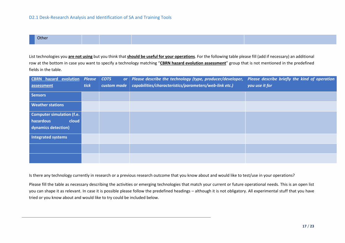
D2.1 Desk-Research Analysis and Identification of SA and Training Tools
17 / 23
Other
List technologies you are not using but you think that should be useful for your operations. For the following table please fill (add if necessary) an additional
row at the bottom in case you want to specify a technology matching “CBRN hazard evolution assessment” group that is not mentioned in the predefined
fields in the table.
CBRN hazard evolution
assessment
Please
tick
COTS or
custom made
Please describe the technology (type, producer/developer,
capabilities/characteristics/parameters/web-link etc.)
Please describe briefly the kind of operation
you use it for
Sensors
Weather stations
Computer simulation (f.e.
hazardous cloud
dynamics detection)
Integrated systems
Is there any technology currently in research or a previous research outcome that you know about and would like to test/use in your operations?
Please fill the table as necessary describing the activities or emerging technologies that match your current or future operational needs. This is an open list
you can shape it as relevant. In case it is possible please follow the predefined headings – although it is not obligatory. All experimental stuff that you have
tried or you know about and would like to try could be included below.
D2.1 Desk-Research Analysis and Identification of SA and Training Tools
18 / 23

D2.1 Desk-Research Analysis and Identification of SA and Training Tools
19 / 23
Please list as many as you know,
adding rows, if needed
Project/research
identifier (title/acronym
etc.)
Please describe the technology (type,
developer/project,
capabilities/characteristics/parameters/web-link etc.)
Please describe briefly the kind of
operation you would use it for
Integrated SA systems
C2
Communication
Unmanned platforms

D2.1 Desk-Research Analysis and Identification of SA and Training Tools
20 / 23
Sensors and devices
CBRN hazard evolution assessment
Other
Training Platforms
What type of training platform is in use in your organisation?
In the following table please mark a tick (‘X’) of a technology that you are using in your training activities. If you are using a mix of technologies in your
trainings please feel free to add more than one tick. Then below please describe details of that training platform.

D2.1 Desk-Research Analysis and Identification of SA and Training Tools
21 / 23
VR platform AR platform Computer 3D environment
platform
Real live training system Other
Please specify below the technology (type, producer/developer, capabilities/characteristics/parameters/web-link etc.)
Which type of training platform (available or in research) you know about and would like to test/use in your operations?
In the following table please mark a tick (‘X’) of a technology that you are not using in your training activities but you feel it matches your needs. If you are
wishing to use a mix of technologies in your trainings please feel free to add more than one tick. Then below please describe details of that training platform.
VR platform AR platform Computer 3D environment
platform
Other
Please specify the technology (type, producer/developer/project, capabilities/characteristics/parameters/web-link etc.)
Security and safety related best practices
Please list the risk management standards applicable to your operations (add rows if necessary)

D2.1 Desk-Research Analysis and Identification of SA and Training Tools
22 / 23
The following table is aimed at obtaining information about the standards or standard operating procedures that your organisation is following in terms of
emergency services. Please provide information as relevant. All the details given below (even the obvious ones) would be useful for creation of adequate
technologies to support you.
No Standard’s identifier (name/title etc.) Please describe briefly the scope
Please list the existing guidelines and manuals describing your operations
The following table is aimed at obtaining information about the manuals or guidelines that your organisation is following in terms of emergency services.
Please provide information as relevant. All the details given below (even the obvious ones) would be useful for creation of adequate technologies to support
you.
No Guideline/manual identifier (name/title etc.) Please describe briefly the scope
Remarks

D2.1 Desk-Research Analysis and Identification of SA and Training Tools
23 / 23
If you have any additional inputs that you think is relevant, please add it here.