addendum to the environmental impact assessment · addendum to the environmental impact assessment...
TRANSCRIPT

Addendum to the Environmental Impact Assessment
September 2017 Project Number: 47381-001
SRI: Mahaweli Water Security Investment Program
Tranche 1 and 2 Upper Elahera Canal Project Main Report
Prepared by Ministry of Mahaweli Development and Environment with the assistance of Program Management, Design and Supervision Consultant (Joint Venture Lahmeyer International GmbH – GeoConsult ZT GmbH) for Democratic Socialist Republic of Sri Lanka and the Asian Development Bank. This environmental impact assessment is a document of the borrower. The views expressed herein do not necessarily represent those of ADB's Board of Directors, Management, or staff, and may be preliminary in nature. Your attention is directed to the “terms of use” section on ADB’s website. In preparing any country program or strategy, financing any project, or by making any
designation of or reference to a particular territory or geographic area in this document, the
Asian Development Bank does not intend to make any judgments as to the legal or other status
of any territory or area.

Democratic Socialist Republic of Sri Lanka
Ministry of Mahaweli Development and Environment
Mahaweli Water Security Investment Program
SUPPLEMENTARY INFORMATION RELATED TO
INFRASTRUCTURE DESIGN CHANGES FOR THE UPPER
ELAHERA CANAL PROJECT
VOLUME 1: EIA UPDATES FOR TRANCHE 1 AND
TRANCHE 2 COMPONENTS
September 2017
Program Management, Design and Supervision Consultant

Ministry of Mahaweli Development and Environment
Mahaweli Water Security Investment Program
SUPPLEMENTARY INFORMATION RELATED TO
INFRASTRUCTURE DESIGN CHANGES FOR THE UEC VOLUME
1 : EIA UPDATED FOR TRANCHE 1 AND TRANCHE 2
COMPONENTS
Program Management, Design and Supervision Consultant Page i
SUPPLEMENTARY INFORMATION RELATED TO
INFRASTRUCTURE DESIGN CHANGES FOR THE UPPER
ELAHERA CANAL PROJECT
VOLUME 1: EIA UPDATES FOR TRANCHE 1 AND
TRANCHE 2 COMPONENTS

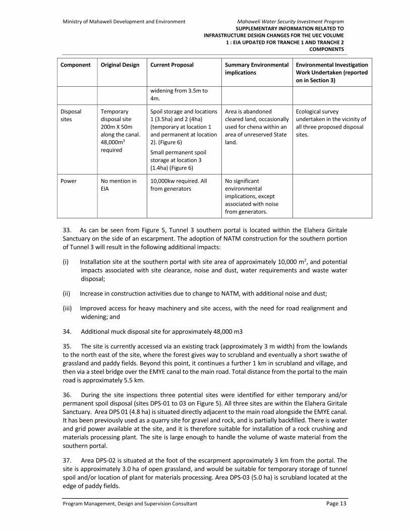
Ministry of Mahaweli Development and Environment
Mahaweli Water Security Investment Program
SUPPLEMENTARY INFORMATION RELATED TO
INFRASTRUCTURE DESIGN CHANGES FOR THE UEC VOLUME
1 : EIA UPDATED FOR TRANCHE 1 AND TRANCHE 2
COMPONENTS
Program Management, Design and Supervision Consultant Page ii
© Joint Venture Lahmeyer International GmbH – GeoConsult ZT GmbH, 2017. The information contained in this
document is solely for the use of the Client identified on the cover sheet for the purpose for which it has been
prepared. The Joint Venture undertakes neither any duty to, nor accepts any responsibility towards, any third
party who may rely upon this document. All rights reserved. No section or element of this document may be
removed from this document, reproduced, electronically stored or transmitted in any form without written
permission of the Joint Venture.

Ministry of Mahaweli Development and Environment
Mahaweli Water Security Investment Program
SUPPLEMENTARY INFORMATION RELATED TO
INFRASTRUCTURE DESIGN CHANGES FOR THE UEC VOLUME
1 : EIA UPDATED FOR TRANCHE 1 AND TRANCHE 2
COMPONENTS
Program Management, Design and Supervision Consultant Page iii
Prepared for:
Ministry of Mahaweli Development and Environment
Mahaweli Water Security Investment Program
Program Management Unit
No. 493 1/1, T.B. Jayah Mawatha
Colombo 10
Sri Lanka
Prepared by:
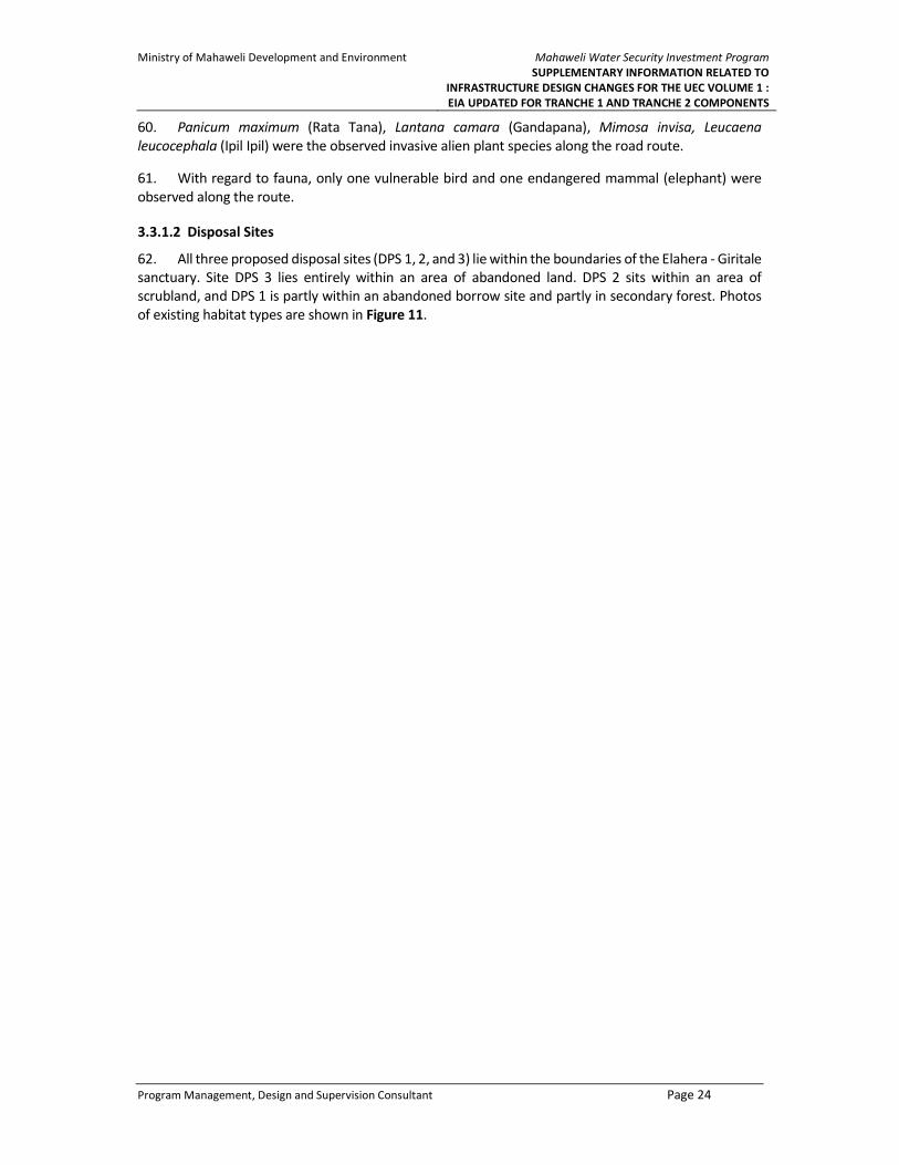
Program Management, Design and Supervision Consultant
Joint Venture Lahmeyer International GmbH – GeoConsult ZT GmbH
in Association with NIRAS (Denmark), Engineering Consultants Ltd. (Sri Lanka), and
Infotechs IDEAS (Pvt.) (Ltd.) (Sri Lanka)
No. 493 T.B. Jayah Mawatha
Colombo 10
Sri Lanka
Lahmeyer International Main Office
Friedberger Str. 173
61118 Bad Vilbel
Germany
Distribution Register:
Distribution List: Date of Issue Number of Copies
MMDE September 2017 4
ADB September 2017 2
Revision History:
Revision Author Approved Description
1 Dr. D. Annandale M. R. Chegwin Updates for design changes
2 Dr. A. Kasige
T. N. Peries
(Consultant
Ecologist)
M. R. Chegwin Attending ADB comments
describing about critical species

Ministry of Mahaweli Development and Environment
Mahaweli Water Security Investment Program
SUPPLEMENTARY INFORMATION RELATED TO
INFRASTRUCTURE DESIGN CHANGES FOR THE UEC VOLUME
1 : EIA UPDATED FOR TRANCHE 1 AND TRANCHE 2
COMPONENTS
Program Management, Design and Supervision Consultant Page iv
ABBREVIATIONS
ADB Asian Development Bank
APs Affected Persons
BOD Biological Oxygen Demand
BoQ Bill of Quantities
CEA Central Environmental Authority
CEMP Contractor’s Environmental Management Plan
DoI Department of Irrigation
DWC Department of Wildlife Conservation
EA Executive Agency
EIA Environment Impact Assessment
EMC Environmental Monitoring Committee
EO Environmental Officer
EPL Environmental Protection License
ERP
FD
Emergency Recovery Plan
Forest Department
FFPO Fauna & Flora Protection Ordinance
FO Forest Ordinance
GoSL Government of Sri Lanka
GRC Grievance Redress Committee
GRM Grievance Redress Mechanism
GSMB Geological Survey & Mines Bureau
H&S Health and Safety
IAS
ID
Invasive Alien Species
Irrigation Department
IEE Initial Environmental Examination
IEER Initial Environmental Examination Report
IMS
KMTC
Information Management System
Kalu Ganga - Moragahakanda Transfer Canal
LB Left Bank
LGA Local Government Authority
MDP Mahaweli Development Program
MFF Multi Tranche Financing Facility
MLBCRP Minipe Left Bank Canal Rehabilitation Project
MLLD Ministry of Land and Land Development
MMDE Ministry of Mahaweli Development and Environment
MOH Medical Officer in Health
MRB Mahaweli River Basin
MWSIP
NATM
Mahaweli Water Security Investment Program
New Austrian Tunnelling Method
NCPCP North Central Province Canal Project
NWPCP North Western Province Canal Project
PD Project Director (of PIU)
PD-PMU Program Director - Program Management Unit
PHI Public Health Inspector
PIU Project Implementation Unit
PMDSC Project Management & Design Supervision Consultant
PMU Project Management Unit
PSC Program Steering Committee
RE Resident Engineer
SEA
TBM
Strategic Environment Assessment
Tunnel Boring Machine
TDS Total Dissolved Oxygen
TSS Total Suspended Solids
UECP Upper Elahera Canal Project

Ministry of Mahaweli Development and Environment
Mahaweli Water Security Investment Program
SUPPLEMENTARY INFORMATION RELATED TO
INFRASTRUCTURE DESIGN CHANGES FOR THE UEC VOLUME
1 : EIA UPDATED FOR TRANCHE 1 AND TRANCHE 2
COMPONENTS
Program Management, Design and Supervision Consultant Page v
Table of Contents
1 OVERVIEW ............................................................................................................. 1
1.1 INTRODUCTION ................................................................................................................................ 1
1.2 PURPOSE OF THE EIA ADDENDUM ....................................................................................................... 1
1.3 STRUCTURE OF THE EIA ADDENDUM ................................................................................................... 1
2 DESCRIPTION OF PROPOSED DESIGN CHANGES ...................................................... 4
2.1 INTRODUCTION ................................................................................................................................ 4
2.2 KALU GANGA – MORAGAHAKANDA TRANSFER CANAL (KMTC): UEC-ICB-2B (TRANCHE 2) ........................ 4
2.2.1 Main Design Components .................................................................................................................... 5
2.3 UPPER ELAHERA CANAL: UEC-ICB-1 (TRANCHE 1) ................................................................................ 8
2.4 UPPER ELAHERA CANAL: UEC-ICB-2A (TRANCHE 2) ............................................................................. 9
3 DESCRIPTION OF NEW ECOLOGICAL SURVEY WORK UNDERTAKEN: EXISTING
ENVIRONMENTAL CONDITIONS ............................................................................ 17
3.1 INTRODUCTION .............................................................................................................................. 17
3.2 KALU GANGA – MORAGAHAKANDA TRANSFER CANAL (KMTC) : UEC-ICB-2B ........................................ 17
3.3 UPPER ELAHERA CANAL: UEC-ICB-2A .............................................................................................. 21
3.3.1 Tunnel 3 Southern Portal ................................................................................................................... 21
3.3.2 Tunnel 3 Northern Portal/Tunnel 4 Southern Portal .......................................................................... 26
3.4 ANALYSIS OF PROJECT IMPACTS ON THE CRITICAL HABITATS AND SPECIES ................................................. 27
3.4.1 Species distribution in Sri Lanka ......................................................................................................... 29
3.4.2 Habitat availability and relative importance in Sri Lanka .................................................................. 37
3.4.3 Additional mitigatory measures to manage possible impacts to the species .................................... 37
4 ANTICIPATED ENVIRONMENTAL IMPACTS AND PROPOSED MITIGATION
MEASURES .......................................................... ERROR! BOOKMARK NOT DEFINED.
4.1 INTRODUCTION ................................................................................. ERROR! BOOKMARK NOT DEFINED.
4.2 KALU GANGA – MORAGAHAKANDA TRANSFER CANAL (KMTC): UEC-ICB-2BERROR! BOOKMARK NOT
DEFINED.
4.3 THE RELEVANT APPROVALS GRANTED BY THE RESPECTIVE STAKEHOLDER AGENCY, FOR THE DESIGN CHANGES ARE
DESCRIBED IN DETAIL UNDER THE SECTION 5 OF THIS REPORT. UPPER ELAHERA CANAL: UEC – ICB – 1 (TRANCHE
1) ................................................................................................... ERROR! BOOKMARK NOT DEFINED.
4.4 UPPER ELAHERA CANAL: UEC-ICB-2A ................................................. ERROR! BOOKMARK NOT DEFINED.
4.4.1 Tunnel 3 Southern Portal ....................................................................... Error! Bookmark not defined.
4.4.2 Tunnel 3 Northern Portal/Tunnel 4 Southern Portal .............................. Error! Bookmark not defined.
4.5 OVERALL .......................................................................................... ERROR! BOOKMARK NOT DEFINED.
5 STAKEHOLDER & PUBLIC CONSULTATION OVER THE DESIGN CHANGES ......... ERROR!
BOOKMARK NOT DEFINED.
6 REFERENCES ........................................................ ERROR! BOOKMARK NOT DEFINED.

Ministry of Mahaweli Development and Environment
Mahaweli Water Security Investment Program
SUPPLEMENTARY INFORMATION RELATED TO
INFRASTRUCTURE DESIGN CHANGES FOR THE UEC VOLUME
1 : EIA UPDATED FOR TRANCHE 1 AND TRANCHE 2
COMPONENTS
Program Management, Design and Supervision Consultant Page vi
List of Tables
Table 1 : Summary of KMTC Design Differences ................................................................................... 5
Table 2 : UEC-ICB-2A Design Differences Tunnel 3 ............................................................................. 11
Table 3 : UEC-ICB-2A Design Differences Tunnel 4 ............................................................................. 15
Table 4 : Conservation Status of Observed Plant Species ................................................................... 19
Table 5 : Conservation Status of Observed Plant Species ................................................................... 23
Table 6 : Conservation Status of Observed Plant Species ................................................................... 26
Table 7 : Conservation Status of Observed Plant Species ................................................................... 27
List Figures
Figure 1 : Overall Layout Plan for Upper Elahera Canal ........................................................................................ 2
Figure 2 : KMTC Layout and Access Roads ............................................................................................................ 4
Figure 3: UEC-ICB-1 Showing Canal Deviation ...................................................................................................... 8
Figure 4: Stream Network Associated with Welankatuwa Stream ....................................................................... 9
Figure 5: Teak Forest and Scrub 9
Figure 6: Layout Plan for UEC-ICB-2A ................................................................................................................. 10
Figure 7: Tunnel 3 Southern Portal Land Use ..................................................................................................... 11
Figure 8: Tunnel 3 Northern Portal and Tunnel 4 - Land Use ............................................................................. 14
Figure 9: Existing Habitat/Vegetation Types. Access Road Section ‘e’ and Section ‘f’ and Disposal .................. 18
Figure 10: Existing Habitat/Vegetation Types; Road Section within the Sanctuary – to SPT3, DPS3 and DPS2 . 22
Figure 11 : Existing Habitat/Vegetation Types; Tunnel 3 Southern Portal Disposal Sites .................................. 25
Figure 12: Existing Habitat/Vegetation Types; Northern Disposal Sites, NSS, Main Camp, ............................... 26
Figure 13: Last 200 m of the proposed access to the Southern Portal of Tunnel 3 (SPT3)Error! Bookmark not
defined.
Figure 14: The photographic evidences available for some of the consultations . Error! Bookmark not defined.
List of Annexes
Annex 1 Environmental Codes of Practice
Annex 2 Invasive Alien Plant Species
Annex 3 Recorded Fauna Species
Annex 4 Maps included in the EIA report
Annex 5 Maps included in the text to improve the readability
Annex 6 Summary of Community Consultation

Ministry of Mahaweli Development and Environment
Mahaweli Water Security Investment Program
SUPPLEMENTARY INFORMATION RELATED TO
INFRASTRUCTURE DESIGN CHANGES FOR THE UEC VOLUME
1 : EIA UPDATED FOR TRANCHE 1 AND TRANCHE 2
COMPONENTS
Program Management, Design and Supervision Consultant Page ii
Annex 7 Reference to NCR locations
Annex 8 Stakeholder Consent letters (8A – 8F)

Ministry of Mahaweli Development and Environment
Mahaweli Water Security Investment Program
SUPPLEMENTARY INFORMATION RELATED TO
INFRASTRUCTURE DESIGN CHANGES FOR THE UEC VOLUME
1 : EIA UPDATED FOR TRANCHE 1 AND TRANCHE 2
COMPONENTS
Program Management, Design and Supervision Consultant Page 1
1 OVERVIEW
1.1 Introduction
1. This document has been prepared by the Project Management & Design Supervision Consultant
(PMDSC) of the Mahaweli Water Security Investment Program (MWSIP), in conjunction with the
Program Management Unit (PMU) established under the Ministry of Mahaweli Development and
Environment, as an addendum to the Environmental Impact Assessment (EIA) for the proposed Upper
Elahera Canal (UEC) project, dated June 20151 and approved by the Central Environmental Authority
(CEA) on 31 March 2016.
2. The project areas covered by the entire three-tranche UEC investment program are shown in
Figure 1.
1.2 Purpose of the EIA Addendum
3. Since the submission of the 2015 EIA study, a number of design changes have been made to the
proposed UEC. This is understandable, given that Phase 1 of the MWSIP is now under construction, and
so fine-level design decisions are being made.
4. This Addendum updates the 2015 EIA for the Tranche 1 and Tranche 2 components of the UEC.
The environmental implications of the design changes to be made to Tranche 3 components will be dealt
with in a separate EIA Addendum, to be completed once designs for the four Tranche 3 components
have been finalized.
1.3 Structure of the EIA Addendum
5. This document consists of three additional sections. Section 2 presents a description of the design
changes that have been made since the EIA was produced in 2015. The section is organized to match the
individual contract “packages” as they are currently known. For each new aspect of design, a brief
assessment of “environmental implication” is made, along with a description of new primary
environmental survey investigations undertaken in May 2017.
6. The third section of the Addendum describes the existing environment in the areas where the
design changes may have an effect.
7. The fourth section outlines anticipated environmental impacts associated with the new design
changes, and proposes mitigatory measures where necessary.
8. Sections 3 and 4 are supported by Environmental Codes of Practice, which can be found in Annex
1. Annex 2 and Annex 3 will include the list of invasive species and fauna species recorded during the
rapid ecological survey carried out by PMDSC. Annex 4 includes the maps included in the EIA report to
make a better comparison of design changes highlighted in this document, and Annex 5 provides
enlarged version of maps included in the text, to improve the readability.
1 Mahaweli Authority of Sri Lanka (2015), Environmental Impact Assessment Report. Modifications to Configu-
rations of Moragahakanda-Kaluganga Projects. Proposed Upper Elehera Canal (UEC) from Mannakkattiya Tank
to Mahakanadarawa Tank and Kaluganga-Moragahakanda Link Canal Project. Prepared by Mahaweli Consul-
tancy Bureau Pvt Ltd. June.

Ministry of Mahaweli Development and Environment
Mahaweli Water Security Investment Program
SUPPLEMENTARY INFORMATION RELATED TO
INFRASTRUCTURE DESIGN CHANGES FOR THE UEC VOLUME
1 : EIA UPDATED FOR TRANCHE 1 AND TRANCHE 2
COMPONENTS
Program Management, Design and Supervision Consultant Page 2
Figure 1 : Overall Layout Plan for Upper Elahera Canal

Ministry of Mahaweli Development and Environment
Mahaweli Water Security Investment Program
SUPPLEMENTARY INFORMATION RELATED TO
INFRASTRUCTURE DESIGN CHANGES FOR THE UEC VOLUME
1 : EIA UPDATED FOR TRANCHE 1 AND TRANCHE 2
COMPONENTS
Program Management, Design and Supervision Consultant Page 3
9. Annex 6 includes a summary of community consultation carried out with respect to UEC-ICB-2A
design changes and the Annex 7 describes the NCR location numbers denoted in the critical flora species
distribution Table 9 under section 3 of the report.
10. Section 5 of the report provides the information related to Stakeholder and Public Consultation
carried out over the design changes.
11. In addition, detailed Environmental Management Plans (EMPs) for the Tranche 1 component and
for the two Tranche 2 components are included in a separate Volume 2.

Ministry of Mahaweli Development and Environment
Mahaweli Water Security Investment Program
SUPPLEMENTARY INFORMATION RELATED TO
INFRASTRUCTURE DESIGN CHANGES FOR THE UEC VOLUME
1 : EIA UPDATED FOR TRANCHE 1 AND TRANCHE 2
COMPONENTS
Program Management, Design and Supervision Consultant Page 4
2 DESCRIPTION OF PROPOSED DESIGN CHANGES
2.1 Introduction
12. This section examines the design changes that have been made to Tranche 1 and Tranche 2
components, from south to north. It also assesses the environmental implications of these changes, and
the consequent need for new primary environmental survey work. It should be noted that comparison
with the 2015 EIA (Pls refer Annex 4 for the relevant maps included in the EIA) has been challenging, as
specific contract packages were not in existence when the EIA was produced.
2.2 Kalu Ganga – Moragahakanda Transfer Canal (KMTC): UEC-ICB-2B
(Tranche 2)
13. The package (UEC-ICB-2B) is for the construction of the Kalu Ganga – Moragahakanda Transfer
Canal (KMTC). The KMTC will transfer water from the Kalu Ganga Reservoir to the Moragahakanda
Reservoir in Phase 1, and in Phase 22 also provide the means to convey the additional water from the
Randenigala-Kalu Ganga Transfer Canal (RKTC). General layout for the KMTC, along with proposed access
roads and site works, is shown in Figure 2.
Figure 2 : KMTC Layout and Access Roads
2 Phase 2 will include 6 investment projects: Randenigala-Kalu Ganga Transfer Canal (subject to approval of the
route); Lower Uma Oya Reservoir project; Hasalaka Oya Reservoir Project; Heen Ganga Reservoir project; Ka-
linga Nuwara Pumping project; and, North Central Province Canal.

Ministry of Mahaweli Development and Environment
Mahaweli Water Security Investment Program
SUPPLEMENTARY INFORMATION RELATED TO
INFRASTRUCTURE DESIGN CHANGES FOR THE UEC VOLUME
1 : EIA UPDATED FOR TRANCHE 1 AND TRANCHE 2
COMPONENTS
Program Management, Design and Supervision Consultant Page 5
2.2.1 Main Design Components
14. Apart from a short stretch of open canal, and two short aqueducts, KMTC will consist entirely of
tunnels. Details of the tunnel design are presented in the Design Report of September 20163. The
general alignment of the KMTC is from the southeast to the northwest, with the following features:
(i) KMTC Tunnel 1 is 1,940 m in length (chainage 0+557.77 to 2+467.77 km), with overburden varying
between 5 to 80 m.
15. KMTC Tunnel 2 is 6,040 m in length (chainage 2+732.77 to 8+772.77 km), with overburden varying
between 6 to 378 m.
16. Both tunnels will be constructed according to the principles of the New Austrian Tunneling
Method (NATM), which is a sequential tunnel excavation method successfully applied in a wide range of
ground conditions. Excavation will be by drill and blast or by mechanical means in unfavorable rock
conditions (e.g., excavator or hydraulic hammer). Support consists of shotcrete reinforced with wire
mesh, rock bolts, lattice girders and advance support (e.g. forepoling) where required. For both tunnels,
excavation will proceed from both portals at the same time.
17. Design Differences
18. The main design changes since the 2015 EIA consist of: (i) Tunnels 1 and 2 being constructed by
NATM rather than TBM; (ii) more certainty about the route and design of access roads to the outlet
(northern portal) of Tunnel 2; and, (iii) more certainty about the locations and capacities of required
disposal sites.
19. Table 1 summarizes these design changes. The final two columns introduce the environmental
implications of the proposed changes, and the investigation work that has been undertaken to enable
environmental implications to be properly assessed and mitigation planned.
Table 1 : Summary of KMTC Design Differences
Component Original Design Current Proposal Summary Environmental
Implications
Environmental
Investigation
Work
Undertaken
(reported on
in Section 3)
Tunnel
construction
method
TBM NATM drill and blast
(Note: Tunnel design for NATM
has recently been changed to a
D-shaped waterway. This
produces a smaller volume of
muck than the D-shaped
tunnel). See discussion in:
Technical Note 5 Rev. A (7
December 2016): Tunnel Design
Parameters and Optimizations
of Drill and Blast Tunnels
NATM requires removing
muck at both ends of the
tunnel (as against one end
for the original TBM
proposal). This will
therefore entail the
development of a new
permanent waste disposal
site (see below).
See “dumping
sites” below:
3 KMTC Tunnel 1 and 2 Draft Design Report, PMDSC, September 2016.

Ministry of Mahaweli Development and Environment
Mahaweli Water Security Investment Program
SUPPLEMENTARY INFORMATION RELATED TO
INFRASTRUCTURE DESIGN CHANGES FOR THE UEC VOLUME
1 : EIA UPDATED FOR TRANCHE 1 AND TRANCHE 2
COMPONENTS
Program Management, Design and Supervision Consultant Page 6
Component Original Design Current Proposal Summary Environmental
Implications
Environmental
Investigation
Work
Undertaken
(reported on
in Section 3)
Tunnel
lengths
Tunnel 1: 1.84km
Tunnel 2: 6.0km
Tunnel 1: 1.91km
Tunnel 2: 6.04 km
No environmental
implications
Access roads New road to provide
access to north portal
of Tunnel 2 (section f
in Figure 2)
Existing road from
Haththota to Lel Oya
(to be improved)
Extent of work required to
sections a, c, d, e, and f (ref. fig.
2) was given preliminary
consideration during site visit
on 7 February 2017.
All road sections apart from ‘f’
were included in the 2015 EIA.
Some minor upgrades may be
required for sections a, c, and d.
These upgrades will not result
in widening, except where
there is a need for passing bays.
These will be identified at a
later date.
The stretch between Location A
and Location B (section ‘e’) is
currently not readily usable by
road vehicles, and needs
regrading.
A new road required for section
‘f’.
Section b to be moved
northwest and away from the
footprint of the Kalu Ganga
Reservoir (Relocation of section
b is the responsibility of the
proponent working on the Kalu
Ganga Reservoir).
Construction of section ‘f’
will require clearing of
vegetation for the 1.8 kms
of required new road.
Rapid
Ecological
survey
undertaken for
access road
stretches ‘e’
and ‘f’ (Figure
2).
Dumping
sites
Three dumping sites
proposed.
Site no. 1 at lat:
7.562181. long:
80.824840 (2 ha
dumping site at
southern end of
Tunnel 1)
Site no.2 at lat:
7.579162 and long:
80.815520 (2 ha
dumping site at the
southern end of
Tunnel 2)
Site DP1 (at lat: 7.56538226.
long: 80.831186677), already in
use by Kalu Ganga Reservoir
contractor.
Site DP2 (at lat: 7.576726648
and long: 80.814987804) was
approved as part of the 2015
EIA.
Site DP3 (at lat: 7.616385759
and long: 80.778980874) is
new.
All dumping sites will be
permanent.
Possible environmental
implications associated
with the siting of DP3
(4.5ha), which is in the
Moragahakanda reservoir
reservation (within HFL)
under Mahaweli Authority
owned land area.
Present land use is
abandoned paddy and
home gardens (leftover of
relocated families under
Moragahakanda project)
Rapid
Ecological
surveys
undertaken in
vicinity of
proposed DP3.

Ministry of Mahaweli Development and Environment
Mahaweli Water Security Investment Program
SUPPLEMENTARY INFORMATION RELATED TO
INFRASTRUCTURE DESIGN CHANGES FOR THE UEC VOLUME
1 : EIA UPDATED FOR TRANCHE 1 AND TRANCHE 2
COMPONENTS
Program Management, Design and Supervision Consultant Page 7
Component Original Design Current Proposal Summary Environmental
Implications
Environmental
Investigation
Work
Undertaken
(reported on
in Section 3)
Third site at lat:
7.614251 and long:
80.775171 (2 ha
dumping site at north
portal of Tunnel 2)
Power to
sites
No discussion. EIA
indicates that
electricity supply is
“being discussed with
CEB”.
Power requirements for
tunneling at portals will be met
by generators. Requirements
for worker camp sites will be
met from existing CEB
transmission lines.
No new environmental
implications.
20. The aspect of new design that may have the most potential impact is access roads. It should be
noted that the original EIA document foresaw the need for a new “temporary access road” for the final
stretch of access to the north portal of Tunnel 24. Given the NATM’s need for tunnel construction access
at both ends, the final stretch of access road (section ‘f’) will now be required on a permanent basis. As
a result of this design change, this section was the subject of a new ecological survey in May 2017.
21. Access to the south portal of Tunnel 1 is via the existing crusher and materials processing plant
location occupied by the Kalu Ganga Dam Contractor and along the wayleave of the proposed cut and
cover section. Access to the northern portal of Tunnel 1 and the southern portal of Tunnel 2 is via an
existing gravel track at less than 2 km distance from the main road. The trackway may be widened and
minor realignments made to access both portals.
22. Following first stage flooding of the Moragahakanda Reservoir in January 2016, access to the
north portal of Tunnel 2 is only possible from a single roadway to the south, as shown in Figure 2. The
roadway connects with the main road near the main working site at the south portal of Tunnel 2 and
runs a circuitous route to the north portal, a distance of some 29 km. The roadway currently terminates
at Location A, some 7 km short of the portal location. There is an existing forestry track beyond
Location A, which is unpassable to road vehicles (section ‘e’). The access ceases completely beyond
Location B, approximately 1.8 km from the portal. Considerable work will be required at the outset of
the contract to enable the Contractor to both reinstate the existing track between Locations A and B and
construct a completely new roadway from Location B to the portal location (section ‘f’).
23. The width, condition and usability of the existing road, (Sections a, b, c & d), varies considerably
and is not obvious from the existing plan of the area.
(i) Section ‘a’, from the stretches from the main work site to the limit of the future flooded area of
Kalu Ganga Reservoir. Its approximately 5 km is a recently improved roadway up to 7 m in width,
part asphalt and part compacted clay surfacing.
(ii) Section ‘b’ comprises 2 km of good quality 5 m wide road which will require rerouting prior to the
flooding of Kalu Ganga Reservoir. This will be done by the Contractor of Kalu Ganga Dam.
(iii) Section ‘c’ comprises a 4 m wide single track mountain road with numerous hair pin bends. Road
surfacing is asphalt and in good condition throughout its 8 km distance. There is little scope for
4 Reference footnote 3, Table 2.8, page 65.

Ministry of Mahaweli Development and Environment
Mahaweli Water Security Investment Program
SUPPLEMENTARY INFORMATION RELATED TO
INFRASTRUCTURE DESIGN CHANGES FOR THE UEC VOLUME
1 : EIA UPDATED FOR TRANCHE 1 AND TRANCHE 2
COMPONENTS
Program Management, Design and Supervision Consultant Page 8
increasing the width of the road due to the terrain, other than increasing the turning area at some
of the hairpin bends and installing occasional passing bays.
(iv) Section ‘d’ is a 4 m wide single-track roadway of variable quality and surfacing. It is less demanding
with respect to hairpin bends and general topography than the previous Section ‘c’. Potholes and
worn road surfaces are present at numerous locations along the 10 km distance. Considerable
improvement work will be required although there is little scope for increasing the general width
of the roadway.
24. Removal of tunnel spoil along this access road is considered both extremely impractical and also
unsafe. It is therefore considered essential to ensure that all spoil from the tunneling activities through
the northern portal can be permanently stored in the area close to the portal, shown as site DP3 in Figure
2. This is presently abandoned paddy land.
25. DP3 is part of the new design, and its development presently belongs to the Mahaweli Authority
as it is already acquired for Moragahakanda reservoir development project. Approval from the Forest
Department is granted for access road rehabilitation (Refer Table 12 for consultation summary).
2.3 Upper Elahera Canal: UEC-ICB-1 (Tranche 1)
26. The canal starting from Moragahakanda reservoir from 0+100 km to 3+860 km is covered by the
UEC ICB 1 contract package. It was subject to a deviation of the alignment between 2+820 km and 3+860
km after the contract award (see Figure 3). The reason for this design change lies in the fact that UEC-
ICB-1 was one of PMDSC’s “advance packages”. For this package, it was not possible to consider a precise
canal strip survey and it had to be solely based on the 1:10,000 scale topographic map, which is known
to be imprecise in the vertical direction.
Figure 3: UEC-ICB-1 Showing Canal Deviation

Ministry of Mahaweli Development and Environment
Mahaweli Water Security Investment Program
SUPPLEMENTARY INFORMATION RELATED TO
INFRASTRUCTURE DESIGN CHANGES FOR THE UEC VOLUME
1 : EIA UPDATED FOR TRANCHE 1 AND TRANCHE 2
COMPONENTS
Program Management, Design and Supervision Consultant Page 9
27. The cut-and-cover canal on the original alignment was designed to have a maximum overburden
of 10 to 15 m. After a detailed site survey, this amount increased locally to 25 to 30 m, which would have
led to a very substantial increase of excavation, backfill, concrete and reinforcement quantities.
Moreover, maintaining the previous alignment would have substantially increased the area of
temporary land use for the canal trench, and it would have consequently required a far higher number
of trees to be felled than with the new, deviated canal alignment.
28. The land use is noted as scrub forest and planted Teak forest including some stream crossings and
the Welankatuwa anicut (Figure 4 and Figure 5).
Figure 4: Stream Network Associated with Welankatuwa Stream
Figure 5: Teak Forest and Scrub
2.4 Upper Elahera Canal: UEC-ICB-2A (Tranche 2)
29. The package covers the tunnel sections (27.7 km) of the UEC, between chainages 27+700 km and
55+400 km, and cut-and-cover sections between chainages 27+509 and 27+700, and 55+400 and
55+600. Tunnels 3 will be 26.6km in length, and Tunnel 4 will be 1.1km. It is the most technically
Canal direction 3+860 km

Ministry of Mahaweli Development and Environment
Mahaweli Water Security Investment Program
SUPPLEMENTARY INFORMATION RELATED TO
INFRASTRUCTURE DESIGN CHANGES FOR THE UEC VOLUME
1 : EIA UPDATED FOR TRANCHE 1 AND TRANCHE 2
COMPONENTS
Program Management, Design and Supervision Consultant Page 10
challenging element of the MWSIP, and the biggest single investment of the program. The general layout
of the package is shown in Figure 6.
Figure 6: Layout Plan for UEC-ICB-2A
30. Design Differences
31. Quite significant changes in design have been made to this stretch of the UEC since the approval
of the original EIA study. These are shown in summary form in Table 2 and Table 3, and explained in
more detail in the text that follows each table. The main design changes are to Tunnels 3 and 4. They are
as follows:
(i) confirmation of Option B for Tunnel 3 as described in Special Report 35. This design has a TBM
drive from the north and NATM drill-and-blast drive from the south;
(ii) power, site, and access to southern portal of Tunnel 3;
(iii) access shaft (diameter 4 m) around 39+400 (30 m x 40 m spoil pile);
(iv) fine-level details of works required at the Tunnel 3 northern portal;
(v) start shaft (diameter 26 m) required at 55+290; and,
(vi) Tunnel 4 replaces the original proposed section of deep cut and cover canal to the north of Tunnel
3 and will be constructed by NATM.
5 Special Report 3. UEC Tunnel 3: Selection of Construction Method and Comparison of Construction Options. June 2016.

Ministry of Mahaweli Development and Environment
Mahaweli Water Security Investment Program
SUPPLEMENTARY INFORMATION RELATED TO
INFRASTRUCTURE DESIGN CHANGES FOR THE UEC VOLUME
1 : EIA UPDATED FOR TRANCHE 1 AND TRANCHE 2
COMPONENTS
Program Management, Design and Supervision Consultant Page 11
2.4.1.1 Tunnel 3
32. Site investigations were undertaken in December 2016, and updated with visits in January and
February 2017. The findings and recommendations of the main site investigations from December relate
to the location of the Tunnel 3 portals, and are presented in full in Technical Note No. 12. The main
working locations for the southern portal are shown in Figure 7, and the design differences and
environmental implications are presented in Table 2.
Figure 7: Tunnel 3 Southern Portal Land Use
Table 2 : UEC-ICB-2A Design Differences Tunnel 3
Component Original Design Current Proposal Summary Environmental
implications
Environmental Investigation
Work Undertaken (reported
on in Section 3)
Tunnel
construction
method
(Tunnel 3)
Single TBM
starting from the
northern portal
(as proposed in
MMDE feasibility
study and PPTA).
Single TBM for
construction of 20.2 km
from the northern portal
and New Austrian
Tunneling Method (NATM)
drill-and-blast from the
southern portal (6.4 km).
Increase in construction
activities due to change
to NATM, with additional
noise and dust.
See below
Southern Portal
Access roads 4.5 km access
road from
Diyabeduma to
27 + 500km
General road route is the
same as in original design.
Some realignment and
road improvement may
require widening, and
with possible impact on
vegetation.
Longitudinal ecological
survey undertaken. Annex 6
provides the summary note
on the community
consultation conducted

Ministry of Mahaweli Development and Environment
Mahaweli Water Security Investment Program
SUPPLEMENTARY INFORMATION RELATED TO
INFRASTRUCTURE DESIGN CHANGES FOR THE UEC VOLUME
1 : EIA UPDATED FOR TRANCHE 1 AND TRANCHE 2
COMPONENTS
Program Management, Design and Supervision Consultant Page 12
Component Original Design Current Proposal Summary Environmental
implications
Environmental Investigation
Work Undertaken (reported
on in Section 3)
relevant to the design
changes.
Installation
site
Location for
dismantling/exit
of TBM near 27
+ 500km.
Required site
area: 2ha
Installation site at the
southern portal with area
of approximately 1ha
Potential impacts
associated with site
clearance, noise and
dust, water requirements
and wastewater disposal.
No new environmental work
required. Installation area
assessed in 2015 EIA.
Disposal
sites
One disposal site
at Dibayema.
Lat: 7.9300438
Long:
80.8620003
Abandoned
borrow area
Disposal sites required for
additional muck of
48,000m3
Temporary disposal areas
at locations DPS-02 (3ha of
open grassland) and DPS-
03 (5ha of scrubland).
Permanent disposal area
at Location DPS-01 (4.8ha
of old rock quarry adjacent
to main road alongside
EMYE Canal). This location
would also have a crushing
plant.
All three proposed
disposal sites are in the
Elahera Giritale
Sanctuary.
Site DPS-01 would need
to be bunded (if not
already) to ensure that
there is no escape of
material to the EMYE.
Ecological survey
undertaken in the vicinity of
all three proposed disposal
sites.
Power No mention in
EIA
Generator at the portal.
Power for the crushing
plant at disposal site DPS-
01 would be from CEB
mains.
No significant
environmental
implications, except
associated with noise
from generators.
No new environmental work
required.
Northern Portal
Installation
site
Location for
assembly of TBM
near 54 + 000km
2ha required
More detail on specifics of
site installation.
In Figure 6, site
installations (A) (8.2 ha),
main site (B) (5.0 ha), and
stilling pond (C) (1.0ha). A
total of 14.2ha.
Potential impacts
associated with site
clearance, noise and
dust, water requirements
and wastewater disposal
Rapid ecological survey work
undertaken in vicinity of
proposed installation site.
Groundwater monitoring at
regular intervals from
chainages 54+165km
through to 55+085km has
been undertaken on a 2-
weekly basis since February
2017.
Access roads 1.6 km widening
of Ganewalpola
– Palugaswewa
Rd to 55 +
900”km
1.5 km widening
of Ganewalpola
– Palugaswewa
Rd to 57 + 30km
Road route to 55 +900km
is the same as in original
design. The first half of
the road needs
resurfacing, and extending
from 4m to 5m. The
second half needs new
asphalt surface and
No significant
environmental
implications
No new environmental work
required. Road widening
approved in 2015 EIA.
Ministry of Mahaweli Development and Environment
Mahaweli Water Security Investment Program
SUPPLEMENTARY INFORMATION RELATED TO
INFRASTRUCTURE DESIGN CHANGES FOR THE UEC VOLUME
1 : EIA UPDATED FOR TRANCHE 1 AND TRANCHE 2
COMPONENTS
Program Management, Design and Supervision Consultant Page 13
Component Original Design Current Proposal Summary Environmental
implications
Environmental Investigation
Work Undertaken (reported
on in Section 3)
widening from 3.5m to
4m.
Disposal
sites
Temporary
disposal site
200m X 50m
along the canal.
48,000m3
required
Spoil storage and locations
1 (3.5ha) and 2 (4ha)
(temporary at location 1
and permanent at location
2). (Figure 6)
Small permanent spoil
storage at location 3
(1.4ha) (Figure 6)
Area is abandoned
cleared land, occasionally
used for chena within an
area of unreserved State
land.
Ecological survey
undertaken in the vicinity of
all three proposed disposal
sites.
Power No mention in
EIA
10,000kw required. All
from generators
No significant
environmental
implications, except
associated with noise
from generators.
33. As can be seen from Figure 5, Tunnel 3 southern portal is located within the Elahera Giritale
Sanctuary on the side of an escarpment. The adoption of NATM construction for the southern portion
of Tunnel 3 will result in the following additional impacts:
(i) Installation site at the southern portal with site area of approximately 10,000 m2, and potential
impacts associated with site clearance, noise and dust, water requirements and waste water
disposal;
(ii) Increase in construction activities due to change to NATM, with additional noise and dust;
(iii) Improved access for heavy machinery and site access, with the need for road realignment and
widening; and
34. Additional muck disposal site for approximately 48,000 m3
35. The site is currently accessed via an existing track (approximately 3 m width) from the lowlands
to the north east of the site, where the forest gives way to scrubland and eventually a short swathe of
grassland and paddy fields. Beyond this point, it continues a further 1 km in scrubland and village, and
then via a steel bridge over the EMYE canal to the main road. Total distance from the portal to the main
road is approximately 5.5 km.
36. During the site inspections three potential sites were identified for either temporary and/or
permanent spoil disposal (sites DPS-01 to 03 on Figure 5). All three sites are within the Elahera Giritale
Sanctuary. Area DPS 01 (4.8 ha) is situated directly adjacent to the main road alongside the EMYE canal.
It has been previously used as a quarry site for gravel and rock, and is partially backfilled. There is water
and grid power available at the site, and it is therefore suitable for installation of a rock crushing and
materials processing plant. The site is large enough to handle the volume of waste material from the
southern portal.
37. Area DPS-02 is situated at the foot of the escarpment approximately 3 km from the portal. The
site is approximately 3.0 ha of open grassland, and would be suitable for temporary storage of tunnel
spoil and/or location of plant for materials processing. Area DPS-03 (5.0 ha) is scrubland located at the
edge of paddy fields.

Ministry of Mahaweli Development and Environment
Mahaweli Water Security Investment Program
SUPPLEMENTARY INFORMATION RELATED TO
INFRASTRUCTURE DESIGN CHANGES FOR THE UEC VOLUME
1 : EIA UPDATED FOR TRANCHE 1 AND TRANCHE 2
COMPONENTS
Program Management, Design and Supervision Consultant Page 14
38. The existing access road, in its current state, is unsuitable to support the transport of plant and
mucking material to and from the planned construction site. The section of existing track between the
portal to Area DPS-03 is the only viable route, and it passes through the Elahera Giritale Sanctuary.
39. Proposed land uses around Tunnel 3 northern portal are show in Figure 8.
40. Figure 8: Tunnel 3 Northern Portal and Tunnel 4 - Land Use
41. The working shaft for both the TBM (T3) and Tunnel 4 (NATM) is located within this area. The area
will be used for all immediate surface support facilities for driving both tunnels, and will, for some period
of time, be concurrent for both tunnels. The figure shows the location of site installations (A) (8.2 ha),
main site (B) (5.0 ha), stilling pond (C) (1.0 ha), and three proposed disposal sites (site DPN-1: 3.5 ha, site
DPN-2: 4.0 ha and site DPN-3: 1.4 ha).
42. The site installation at the northern temporary access shaft comprises the following: segment
factory and storage area, tunnel ventilation facilities, processing plant for excavation material, aggregate
and cement storage, temporary storage of excavation materials, concrete mixing plants, train workshop,
emergency supply generators, water treatment plant and retention pool, material testing laboratory,
office space, workers building and canteen. The installations will require an estimated area of 54,000 m2
and power requirement of 10,000 kW, which includes the power needed by the TBM.
43. Site visits have confirmed that spoil storage is possible at either location DPN-1 or DPN-2, and that
both areas are currently uncultivated scrubland. It is envisaged that they will be used initially as
temporary disposal sites, and with area DPN-2 possibly suitable for future permanent storage. A small
permanent spoil disposal area (Area DPN-3) has been identified approximately 2 km to the south of the
main site. It is currently abandoned cleared land, occasionally used for chena within an area of
unreserved State land, and immediately adjacent to the main road. It should be noted that all three

Ministry of Mahaweli Development and Environment
Mahaweli Water Security Investment Program
SUPPLEMENTARY INFORMATION RELATED TO
INFRASTRUCTURE DESIGN CHANGES FOR THE UEC VOLUME
1 : EIA UPDATED FOR TRANCHE 1 AND TRANCHE 2
COMPONENTS
Program Management, Design and Supervision Consultant Page 15
disposal sites may not be needed. A decision on the required number of disposal sites will not be possible
until construction starts and the amount of muck generated is better understood.
44. The northern portal site is 10 km from the main road at Palugaswewa. The first 4 km of roadway
was recently asphalted and is in good condition, with a width of 4.5 m and no sharp bends and flat
gradient. The road could be widened to 6 m, with the proviso that a culvert at the main road junction be
lowered. The balance of the length of the access road is 3.5 m wide and of variable state of repair. It
requires widening and repairs, including replacement of a bridge at chainage 8+300 km.
45. Tunnel 4
46. In general, the change from cut and cover canal to a tunnel yields a number of environmental,
social and resettlement benefits. They largely stem from a substantial reduction of earthmoving volumes
(excavation and backfill) and from the fact that the tunnel represents a containment without direct
connection to the surface. Proposed land uses around Tunnel 4 are shown in Figure 8. The design
differences and possible environmental implications are presented in Table 3.
Table 3 : UEC-ICB-2A Design Differences Tunnel 4
Component Original Design Current Proposal Summary Environmental
Implications
Environmental
Investigation Work
Undertaken (reported on
in Section 3)
Tunnel
construction
method
Cut and cover New Austrian Tunneling
Method (drill and blast)
Substantial reduction of
earthmoving volumes
(excavation and backfill).
Benefits include lower
impact on groundwater
levels, virtual elimination of
the need for a land use
corridor during construction
(from 55 ha to zero), and
lower levels of dust, noise
and vibration.
Access
roads
1.6 km widening
of Ganewalpola
– Palugaswewa
Rd to 55 +
900km
1.5 km widening
of Ganewalpola
– Palugaswewa
Rd to 57 +
300km
Road route to 55
+900km is the same as
in original design. The
first half of the road
needs resurfacing, and
extending from 4m to
5m. The second half
needs new asphalt
surface and widening
from 3.5m to 4m.
No significant environmental
implications
No new environmental
work required. Road
widening approved in
2015 EIA.
Installation
site
Location for
assembly of TBM
near 54 + 000km
2ha required
Same as for northern
portal of Tunnel 3
Same as for northern portal
of Tunnel 3
Same as for northern
portal of Tunnel 3
Disposal
sites
Temporary
disposal site
200m X 50m
Same as for northern
portal of Tunnel 3
Same as for northern portal
of Tunnel 3
Same as for northern
portal of Tunnel 3

Ministry of Mahaweli Development and Environment
Mahaweli Water Security Investment Program
SUPPLEMENTARY INFORMATION RELATED TO
INFRASTRUCTURE DESIGN CHANGES FOR THE UEC VOLUME
1 : EIA UPDATED FOR TRANCHE 1 AND TRANCHE 2
COMPONENTS
Program Management, Design and Supervision Consultant Page 16
along the canal.
48,000m3
required
Power No mention in
EIA
Generators. No significant environmental
implications, except
associated with noise from
generators.
47. The benefits include lower impact on groundwater levels, virtual elimination of the need for a
land use corridor during construction (from 55 ha to zero), and lower levels of dust, noise and vibration.
48. Road access to the north portal of Tunnel 4 will be along an existing road. This road may need
widening at points, but no new road construction will be required.
49. Removal of tunnel spoil back to the main working site (T3/T4) is envisaged unless re-landscaping
of an area near the portal is allowable.

Ministry of Mahaweli Development and Environment
Mahaweli Water Security Investment Program
SUPPLEMENTARY INFORMATION RELATED TO
INFRASTRUCTURE DESIGN CHANGES FOR THE UEC VOLUME
1 : EIA UPDATED FOR TRANCHE 1 AND TRANCHE 2
COMPONENTS
Program Management, Design and Supervision Consultant Page 17
3 DESCRIPTION OF NEW ECOLOGICAL SURVEY WORK
UNDERTAKEN: EXISTING ENVIRONMENTAL CONDITIONS
3.1 Introduction
51. The tables presented in Section 2 outline the rapid ecological survey work that was required as a
result of the design changes made to UEC Tranche 2 components since the submission of the original
EIA in 2015. This section presents the outcomes of the survey work.
3.2 Kalu Ganga – Moragahakanda Transfer Canal (KMTC) : UEC-ICB-2B
52. As indicated in Table 1, the two areas where new ecological survey work needed to be undertaken
are the proposed disposal site DP3, and the stretches of road between Location A and the northern
portal of Tunnel 2 (sections ‘e’ and ‘f’ in Figure 2). Figure 9 presents the existing land use of DP3 and
road section “f”, where DP3 area consist of abandoned agricultural lands, scrublands, home gardens
which were used by the former community in that village, those who resettled under Moragahakanda
project and the lands are acquired by Mahaweli Authority. Streams and streamside vegetation make up
the major habitat/vegetation types in the vicinity of Disposal Site 3. Forests, streams and streamside
vegetation are the major habitat/vegetation types in both road sections (section ‘e’ and section ‘f’), and
the new road section “f” is located within the Moragahakanda reservoir reservation, which is under the
FD under the category of “Other state forest”6. However, under Moragahakanda EIA, the reservation of
the reservoir is proposed for a protected area, but not yet implemented.
53. Seventeen endemic plant species, 4 nationally endangered plant species, 9 nationally vulnerable
plant species, and 13 nationally near-threatened plant species were observed during a field visit
undertaken in May 2017, and presented in Table 4. In addition, 8 species are considered to have a
Global Conservation Status as “vulnerable”.
DP 3 Location (abandoned paddy and home gardens )
6 The State Forest or the Village Forest categories are no more available, and hence this kind of forest areas are
named as Proposed Conservation Forest.

Ministry of Mahaweli Development and Environment
Mahaweli Water Security Investment Program
SUPPLEMENTARY INFORMATION RELATED TO
INFRASTRUCTURE DESIGN CHANGES FOR THE UEC VOLUME
1 : EIA UPDATED FOR TRANCHE 1 AND TRANCHE 2
COMPONENTS
Program Management, Design and Supervision Consultant Page 18
Forests along Road Section F
Figure 9: Existing Habitat/Vegetation Types. Access Road Section ‘e’ and Section ‘f’ and Disposal
Site 3 of UEC-ICB-2B

Ministry of Mahaweli Development and Environment
Mahaweli Water Security Investment Program
SUPPLEMENTARY INFORMATION RELATED TO INFRASTRUCTURE DESIGN CHANGES FOR THE UEC
VOLUME 1 : EIA UPDATED FOR TRANCHE 1 AND TRANCHE 2 COMPONENTS
Program Management, Design and Supervision Consultant Page 19
Table 4 : Conservation Status of Observed Plant Species
Family Name Scientific Name Common Name HA TS NCS GCS Road DP
RF RE 3
Achariaceae Hydnocarpus venenata Makulu T E + +
Anacardiaceae Mangifera zeylanica Etamba T E VU + +
Anacardiaceae Semecarpus nigro-viridis Badulla T E VU + +
Annonaceae Uvaria sphenocarpa C E + +
Annonaceae Xylopia nigricans Heen Kenda T E NT + +
Apocynaceae Anodendron paniculatum As Wel C N VU + +
Apocynaceae Carissa inermis Maha Karamba C N VU + +
Calophyllaceae Calophyllum tomentosum Tel Keena T E VU VU + +
Celastraceae Salacia oblonga Gal Himbutu C N EN VU + +
Celastraceae Salacia reticulata Kotala Himbutu C N EN + +
Clusiaceae Garcinia morella Gokatu T N NT + +
Clusiaceae Garcinia quaesita Rat Goraka T E VU + +
Clusiaceae Garcinia spicata Ela Gokatu T N NT + +
Clusiaceae Garcinia terpnophylla T E EN + +
Combretaceae Combretum albidum Kaduru Ketiya Wel C N NT + +
Cornaceae Alangium salviifolium S N NT + +
Cycadaceae Cycas nathorstii Madu T N VU VU + +
Ebenaceae Diospyros oocarpa Ela Thimbiri T N NT + +
Erythroxylaceae Erythroxylum zeylanicum S E + +
Euphorbiaceae Homonoia riparia S N NT +
Euphorbiaceae Mallotus resinosus Ma Endaru T E + +

Ministry of Mahaweli Development and Environment
Mahaweli Water Security Investment Program
SUPPLEMENTARY INFORMATION RELATED TO INFRASTRUCTURE DESIGN CHANGES FOR THE UEC
VOLUME 1 : EIA UPDATED FOR TRANCHE 1 AND TRANCHE 2 COMPONENTS
Program Management, Design and Supervision Consultant Page 20
Family Name Scientific Name Common Name HA TS NCS GCS Road DP
RF RE 3
Fabaceae Derris parviflora Kala Wel C E + +
Lamiaceae Vitex altissima Milla T N NT + + +
Lauraceae Alseodaphne semecarpifolia Wewarana T N VU + +
Malvaceae Pterygota thwaitesii Galnawa T E VU + +
Meliaceae Dysoxylum ficiforme T N NT VU + +
Myrtaceae Eugenia willdenowii T E + +
Pandanaceae Pandanus ceylanicus O Keyiya S E VU +
Phyllanthaceae Cleistanthus pallidus T E + +
Phyllanthaceae Margaritaria indicus Karawu T N VU + +
Primulaceae Ardisia pauciflora S N NT + +
Putranjivaceae Drypetes gardneri Gal Wira T E NT + +
Rutaceae Chloroxylon swietenia Buruta T N VU VU + + +
Rutaceae Zanthoxylum rhetsa Katu Keena T N EN +
Salicaceae Scolopia pusilla Katu Kenda T E + +
Sapotaceae Madhuca longifolia Mi T N NT + +
Ulmaceae Holoptelea integrifolia Goda Kirilla T N NT + + +
Abbreviations: HA – Habitat, T – Tree, S – Shrub, C – Climber or Creeper, TS – Taxonomic Status, E – Endemic, N – Native, NCS – National Conservation Status, GCS – Global Conservation Starus, EN
– Endangered, VU – Vulnerable, NT – Near Threatened, RF – New Access Road (section ‘f’), RE – Existing Access Road (section ‘e’), DP3 – Disposal Site 3

Ministry of Mahaweli Development and Environment
Mahaweli Water Security Investment Program
SUPPLEMENTARY INFORMATION RELATED TO
INFRASTRUCTURE DESIGN CHANGES FOR THE UEC VOLUME
1 : EIA UPDATED FOR TRANCHE 1 AND TRANCHE 2
COMPONENTS
Program Management, Design and Supervision Consultant Page 21
54. Two invasive alien plant species were found in the general area of road sections ‘e’ and ‘f’, and
near DP3. These were Panicum maximum (Rata Tana), Lantana camara (Gandapana). They are listed,
along with other invasive plants found along the UEC during this ecological survey work, in Annex 2.
55. Fauna species identified during the May 2017 survey are recorded in Annex 3. This shows that: 4
birds are either near-threatened or vulnerable (Black Eagle, Great Racket-Tailed Drongo, Sri Lanka
Junglefowl, Crimson-Fronted Barblet); 4 dragonflies are either near-threatened or vulnerable (Adam’s
Gem, Shining Gossamerwing, Aggressive Riverhawk, Indigo Dropwing); 3 fish are either critically-
endangered or vulnerable (Blotched Filamented Barb, Stone Sucker, Martenstyni’s Barb); 2 mammals
are endangered (Purple-faced Leaf Monkey, Elephant); and, 2 mammals are near-threatened (Barking
deer, Pangolin). Four species are also considered to be endangered according to their Global
Conservation Status. Almost all of these ‘species of concern’ are evident in the forest habitat surrounding
road section ‘f’.
3.3 Upper Elahera Canal: UEC-ICB-2A
56. The extent of new design for ICB-2A was shown in Figure 4, Figure 5, and Figure 6. The ecological
survey work undertaken in May 2017 focused on the design changes made to access roads and disposal
sites at the southern portal of Tunnel 3 and the combined site of the northern portal of Tunnel
3/southern portal of Tunnel 4.
3.3.1 Tunnel 3 Southern Portal
3.3.1.1 Access Roads
57. Figure 7 shows the current alignment of the 4.5km access road to the southern portal of Tunnel
3. The general route is the same as in the original design, but with some realignment and road
improvement that may require widening. A portion of the road traverses Elahera – Giritale sanctuary.
58. Photos of the existing habitat types along the access road are shown in Figure 10. Habitats consist
of forests, abandoned lands, streams and streamside vegetation, waterlogged areas, paddy lands, and
scrublands. Seven endemic species of plants; two endangered species (Kotala Himbutu and Kaluwara);
four nationally-vulnerable species; and ten nationally near-threatened plant species were observed
during the May 2017 field visit. In addition, one plant species is considered to have a Global Conservation
Status as “vulnerable”.
59. The flora survey results are shown in Table 5.

Ministry of Mahaweli Development and Environment
Mahaweli Water Security Investment Program
SUPPLEMENTARY INFORMATION RELATED TO
INFRASTRUCTURE DESIGN CHANGES FOR THE UEC VOLUME
1 : EIA UPDATED FOR TRANCHE 1 AND TRANCHE 2
COMPONENTS
Program Management, Design and Supervision Consultant Page 22
Existing Track within the Forest
Existing Track within the Abandoned Land section
Stream and Streamside Vegetation
Existing Track within the area of Scrublands
Figure 10: Existing Habitat/Vegetation Types; Road Section within the Sanctuary – to SPT3, DPS3
and DPS2

Ministry of Mahaweli Development and Environment
Mahaweli Water Security Investment Program
SUPPLEMENTARY INFORMATION RELATED TO INFRASTRUCTURE DESIGN CHANGES FOR THE UEC
VOLUME 1 : EIA UPDATED FOR TRANCHE 1 AND TRANCHE 2 COMPONENTS
Program Management, Design and Supervision Consultant Page 23
Table 5 : Conservation Status of Observed Plant Species
Family Scientific Name Common Name HA TS NCS GCS RDS
FO AB RR WA PD SC
Achariaceae Hydnocarpus venenata Makulu T E + +
Annonaceae Xylopia nigricans Heen Kenda T E NT +
Asteraceae Vernonia zeylanica Pupula C E + +
Celastraceae Salacia reticulate Kotala Himbutu C N EN +
Clusiaceae Garcinia spicata Ela Gokatu T N NT + +
Combretaceae Combretum albidum Kaduru Ketiya Wel C N NT + + + +
Cornaceae Alangium salviifolium S N NT +
Ebenaceae Diospyros affinis Eta Thimbiri T N NT +
Ebenaceae Diospyros ebenum Kaluwara T N EN +
Fabaceae Derris parviflora Kala Wel C E + + + +
Lamiaceae Vitex altissima Milla T N NT + + +
Lauraceae Alseodaphne semecarpifolia Wewarana T N VU + +
Loganiaceae Strychnos nux-vomica Godakaduru T N VU + +
Malvaceae Diplodiscus verrucosus Dik Wenna T E + +
Malvaceae Helicteres isora Lihiniya T N NT +
Myrtaceae Eugenia willdenowii T E + +
Putranjivaceae Drypetes gardneri Gal Wira T E NT +
Rutaceae Chloroxylon swietenia Buruta T N VU VU + +
Sapotaceae Madhuca longifolia Mi T N NT + +
Sapotaceae Manilkara hexandra Palu T N VU + +
Ulmaceae Holoptelea integrifolia Goda Kirilla T N NT + +
Abbreviations: HA – Habitat, T – Tree, S – Shrub, C – Climber or Creeper, TS – Taxonomic Status, E – Endemic, N – Native, NCS – National Conservation Status, GCS – Global Conservation Status, EN –
Endangered, VU – Vulnerable, NT – Near Threatened, RDS – Road Section within the Sanctuary, FO – Forests, AB – Abandoned Lands, RR – Streams and Streamside Vegetation, WA – Waterlogged Areas,
PD – Paddy Lands, SC – Scrublands
Ministry of Mahaweli Development and Environment
Mahaweli Water Security Investment Program
SUPPLEMENTARY INFORMATION RELATED TO
INFRASTRUCTURE DESIGN CHANGES FOR THE UEC VOLUME 1 :
EIA UPDATED FOR TRANCHE 1 AND TRANCHE 2 COMPONENTS
Program Management, Design and Supervision Consultant Page 24
60. Panicum maximum (Rata Tana), Lantana camara (Gandapana), Mimosa invisa, Leucaena
leucocephala (Ipil Ipil) were the observed invasive alien plant species along the road route.
61. With regard to fauna, only one vulnerable bird and one endangered mammal (elephant) were
observed along the route.
3.3.1.2 Disposal Sites
62. All three proposed disposal sites (DPS 1, 2, and 3) lie within the boundaries of the Elahera - Giritale
sanctuary. Site DPS 3 lies entirely within an area of abandoned land. DPS 2 sits within an area of
scrubland, and DPS 1 is partly within an abandoned borrow site and partly in secondary forest. Photos
of existing habitat types are shown in Figure 11.

Ministry of Mahaweli Development and Environment
Mahaweli Water Security Investment Program
SUPPLEMENTARY INFORMATION RELATED TO
INFRASTRUCTURE DESIGN CHANGES FOR THE UEC VOLUME 1 :
EIA UPDATED FOR TRANCHE 1 AND TRANCHE 2 COMPONENTS
Program Management, Design and Supervision Consultant Page 25
DPS 3
DPS 2
DPS 1
Figure 11 : Existing Habitat/Vegetation Types; Tunnel 3 Southern Portal Disposal Sites
63. Four endemic plant species, two nationally-vulnerable plant species, and two nationally near-
threatened plant species were observed during the field visit (see Table 6). In addition, one plant species
is considered to have a Global Conservation Status as “vulnerable”.

Ministry of Mahaweli Development and Environment
Mahaweli Water Security Investment Program
SUPPLEMENTARY INFORMATION RELATED TO
INFRASTRUCTURE DESIGN CHANGES FOR THE UEC VOLUME 1 :
EIA UPDATED FOR TRANCHE 1 AND TRANCHE 2 COMPONENTS
Program Management, Design and Supervision Consultant Page 26
Table 6 : Conservation Status of Observed Plant Species
Family Scientific Name Common Name HA TS NCS GCS DPS
1 2 3
Asteraceae Vernonia zeylanica Pupula C E + +
Fabaceae Derris parviflora Kala Wel C E + +
Lamiaceae Vitex altissima Milla T N NT + +
Loganiaceae Strychnos nux-vomica Godakaduru T N VU + +
Malvaceae Diplodiscus verrucosus Dik Wenna T E + +
Myrtaceae Eugenia willdenowii T E +
Rutaceae Chloroxylon swietenia Buruta T N VU VU + +
Ulmaceae Holoptelea integrifolia Goda Kirilla T N NT + +
Abbreviations: HA – Habit, T – Tree, S – Shrub, C – Climber or Creeper, TS – Taxonomic Status, E – Endemic, N – Native, NCS –
National Conservation Status, EN – Endangered, VU – Vulnerable, NT – Near Threatened, DPS – Disposal Sites 1, 2, 3
64. Panicum maximum (Rata Tana), Lantana camara (Gandapana), and Mimosa invisa were observed
invasive alien plant species in the area.
3.3.2 Tunnel 3 Northern Portal/Tunnel 4 Southern Portal
65. The design changes proposed around the combined northern portal of Tunnel 3 and southern
portal of Tunnel 4 are shown in Figure 6. Ecological survey work was undertaken in the vicinity of the
main camp, northern start shaft (for Tunnel 4), the disposal sites (DPN 1, and 2) and the road section
that links these. Separate ecological survey work was undertaken on disposal site DPN 3.
66. Of the three proposed disposal sites, DPN 1 and DPN 2, together with northern start shaft, are
connected to each other. As the photos in Figure 12 indicate, the main habitat/vegetation type in this
area is scrubland. The main camp is situated within seasonal agricultural land and DPN 3 is within
abandoned land. Scrublands and seasonal agricultural lands are the main habitats/vegetation types
beside the existing track.
DPN 1, 2 and Northern Start Shaft Area DPN 3 Area
Road Section to DPN 1, DPN 2, Northern Start Shaft, and Main Camp
Figure 12: Existing Habitat/Vegetation Types; Northern Disposal Sites, NSS, Main Camp,
and Access Road Section

Ministry of Mahaweli Development and Environment
Mahaweli Water Security Investment Program
SUPPLEMENTARY INFORMATION RELATED TO
INFRASTRUCTURE DESIGN CHANGES FOR THE UEC VOLUME 1 :
EIA UPDATED FOR TRANCHE 1 AND TRANCHE 2 COMPONENTS
Program Management, Design and Supervision Consultant Page 27
67. Five endemic plant species, five nationally-vulnerable plant species, and two nationally near-
threatened plant species were observed during the field visit. In addition, one plant species is considered
to be endangered according to its Global Conservation Status (see Table 7).
Table 7 : Conservation Status of Observed Plant Species
Family Scientific Name Common
Name
H
A
T
S
NC
S
G
C
S
R
S
DPN M
C
NS
S
VT
S 1 2 3
Asteraceae Vernonia zeylanica Pupula C E + + + + +
Ebenaceae
Diospyros
nummulariifolia T E
E
N +
Fabaceae Derris parviflora Kala Wel C E + + + + + +
Lamiaceae Vitex altissima Milla T N NT + + + +
Lauraceae
Alseodaphne
semecarpifolia Wewarana T N VU
+
Loganiaceae Strychnos nux-vomica Godakaduru T N VU + + + +
Loganiaceae Strychnos potatorum Ingini T N VU +
Malvaceae Diplodiscus verrucosus Dik Wenna T E + + + + +
Malvaceae Helicteres isora Lihiniya T N NT +
Myrtaceae Eugenia willdenowii T E + + + + +
Rubiaceae Psilanthus wightianus S N VU +
Rutaceae Chloroxylon swietenia Buruta T N VU + + + +
Abbreviations: HA – Habit, T – Tree, S – Shrub, C – Climber or Creeper, TS – Taxonomic Status, E – Endemic, N – Native,
NCS – National Conservation Status, EN – Endangered, VU – Vulnerable, NT – Near Threatened, RS – Access Road to DPN1,
DPN2, NSS, MC, DPN – Disposal Sites, MC – Main Camp, NSS – Northern Start Shaft , VTS –
68. Panicum maximum (Rata Tana), Lantana camara (Gandapana), and Leucaena leucocephala (Ipil
Ipil) were observed invasive alien plant species in the area.
69. Only one vulnerable bird was observed in the study area.
3.4 Analysis of Project Impacts on the Critical Habitats and Species
70. The EIA carried out for the UEC including KMTC has done a further analysis of the project impacts
on the nationally and globally threatened or the listed species, and this is a supplementary assessment
for the project areas where the design changes are proposed and are not covered in the EIA study.
71. The rapid environmental screening carried out in the project area subjected to the design changes
with respect to Tranche 1 and 2, described in the previous sections of this chapter identified that the
project activities would cause some impacts on the “Natural habitats”7 and “Critical habitats”8 associated
7 Land and water areas where the biological communities are formed largely by native plant and animal species, and where
human activity has not essentially modified the area’s primary ecological functions (ADB SPS – 2009) 8 Critical habitat includes areas with high biodiversity value, including habitat required for the survival of critically endan-
gered or endangered species; areas having special significance for endemic or restricted-range species; sites that are criti-
cal for the survival of migratory species; Critical habitats include those areas either legally protected or officially proposed
for protection.

Ministry of Mahaweli Development and Environment
Mahaweli Water Security Investment Program
SUPPLEMENTARY INFORMATION RELATED TO
INFRASTRUCTURE DESIGN CHANGES FOR THE UEC VOLUME 1 :
EIA UPDATED FOR TRANCHE 1 AND TRANCHE 2 COMPONENTS
Program Management, Design and Supervision Consultant Page 28
with the proposed access road (section “f”) under the KMTC (UEC ICB 2B) describe under the section 3.2
and the area identified for the southern portal of Tunnel 3 proposed under UEC ICB 2A package.
72. Southern portal of Tunnel 3 proposed under UEC ICB 2A is within the protected areas under the
Department of Wildlife Conservation (DWC) and proposed access road (section “f”) under the KMTC
(UEC ICB 2B) is in an area belongs to the Forest Department. Further, the trace identified for the road
section “f” is within the Moragahakanda reservoir reservation area, which is proposed for a protected
area9 under DWC and FD, as per the Moragahakanda EIA conditional approval made by the former
Ministry of Agriculture, forestry, food and cooperative development (Ref. 3/1/1/950 dated as
26.10.2001).
73. Considering ecological significance of the area, both the areas encountered some critical species
(Endemic, Nationally Threatened, Nationally Near Threatened and Globally Threatened Fauna/Flora
Species) which triggers the ADB safeguard requirements 1 (Environment) related to natural and critical
habitats. However, this road section “f” is the only option to reach the tunnel portal, and considered by
the project subjected to relevant approvals and stakeholder consultation. As per the CEA conditional
approval issued for the EIA stated that any changes to the proposed UECP would follow concurrence
from the relevant approving agency, and hence, the stakeholder consultation is done by the PIU-UECP
for the new access and approval is granted by FD (Annex 7-A).
74. The areas identified in the Elahera Girithale sanctuary and the forest habitat associated with the
Moragahakanda reservoir reservation (proposed protected area under Moragahakanda EIA) for the new
access road section “f” are the key concern for the impacts on the natural and critical habitats due to
the project activities. Moreover, the access road area located in the Moragahakanda reservation has
become a vulnerable habitat for the elephants and other small mammals those who isolated due to
Moragahakanda inundation. Hence, it is suggested to carry out a detail ecological survey prior to land
clearance for the proposed access road, and implement the management measures combined with the
Wildlife Management Plan prepared by IUCN for the project affected area. It is recommended that out
of the identified 9 critical fauna species (5 Endangered, 3 Critically Endangered and 1 Near Threatened
as explained in Table 9), the less mobile species of 2 Fish species, 3 land snail species to be translocated
under a proper translocation and monitoring plan to a suitable habitat. The identified Flora species are
not point endemic or restricted range species, and hence the reforestation using similar species would
be the most realistic mitigation measure to compensate the loss of species.
75. The list of recorded fauna and flora species in the respective sites based on their conservation and
taxonomic status are given in the previous sections of this chapter 3, and the recorded threatened
/critical flora and fauna species that are identified as endangered (EN), critically endangered (CR), near
threatened (NT) or vulnerable (VU) are summarized in the Table 8 and Table 9 identified as per the
National Red List (2012) and IUCN Global Red list.
Table 8: Critical Flora Species Recorded in the Project Area of Concern
Family Scientific Name Common Name HA TS NCS GCS
Ebenaceae Diospyros ebenum Kaluwara T N EN DD
Ebenaceae Diospyros nummulariifolia T E EN
9 It is mentioned in the Moragahakanda EIA conditional approval issued by former Ministry of Agriculture, Forestry, Food and Cooperative
Development, Section 5.2 : Necessary steps should be taken to declare Moragahakanda catchment and area surrounding the reservoir as
protected area to preserve habitat, taking into consideration the area lost due to dam construction become a new protected area.
And in the JICA Moragahakanda Preparatory Study (2010), the status of above condition is updated as Agreed by the MASL. Details being
developed in concert with the Department of Wildlife Conservation. Expected to be Nature Reserve initially and then a National Park
(Southern part is a Forest Reserve.)

Ministry of Mahaweli Development and Environment
Mahaweli Water Security Investment Program
SUPPLEMENTARY INFORMATION RELATED TO
INFRASTRUCTURE DESIGN CHANGES FOR THE UEC VOLUME 1 :
EIA UPDATED FOR TRANCHE 1 AND TRANCHE 2 COMPONENTS
Program Management, Design and Supervision Consultant Page 29
Clusiaceae Garcinia terpnophylla T E EN
Celastraceae Salacia oblonga Gal Himbutu C N EN VU
Celastraceae Salacia reticulata Kotala Himbutu C N EN
Rutaceae Zanthoxylum rhetsa Katu Keena T N EN
Abbreviations: HA – Habit, T – Tree, C – Climber or Creeper, TS – Taxonomic Status, E – Endemic, N – Native, NCS – National
Conservation Status, GCS – Global Conservation Status, EN – Endangered, VU – Vulnerable, DD – Data Deficient
Table 9: Critical Fauna Species Recorded in the Project Area of Concern
Family Scientific Name English Name TA NCS GCS
Dragonflies
Libellulidae Onychothemis tonkinensis Aggressive riverhawk N EN
Fishes
Cyprinidae Dawkinsia srilankensis Blotched filamented barb E CR
Cyprinidae Systomus martenstyni Martenstyni's barb E CR EN
Mammals
Cercopithecidae Macaca sinica Sri Lanka toque monkey E EN
Cercopithecidae Semnopithecus vetulus Purple-faced leaf monkey E EN
Elephantidae Elephas maximus Elephant N EN EN
Manidae Manis crassicaudata Pangolin N NT EN
Land Snail
Ariophantidae Euplecta layardi E EN
Cyclophoridae Micraulax coeloconus N CR
Glessulidae Glessula lankana E EN
Abbreviations: TS – Taxonomic Status, E – Endemic, N – Indigenous, NCS – National Conservation Status, GCS – Global
Conservation Status, CR – Critically Endangered, EN – Endangered
3.4.1 Species distribution in Sri Lanka
76. Distribution of critical flora: The distribution of critical flora species10 were analysed based on the
available literature and considering the personnel observations of the consultant Ecologist, and found
that none of the species are either point endemic or restricted range species, but forest species that are
considered as threatened species due to the increased both legal and illegal deforestation activities
taking place throughout the country. Table 10 summarize the distribution of recorded flora species in
Sri Lanka and the relevant location denoted by National Conservation Review (NCR) location numbers
are explained in the Annex 7.
10 The distribution of critical Flora species is described as per the National Conservation Review (NCR) (cited as IUCN &
WCMC (1997), Designing an Optimum Protected Areas System for Sri Lanka’s Natural Forests, Vol. 1 & 2. Forest Depart-
ment, Ministry of Forestry and Environment, Battaramulla) and based on the personnel observation of the consultant Ecol-
ogist (T. N. Peries) during his ecological studies carried out for the past 15 years.
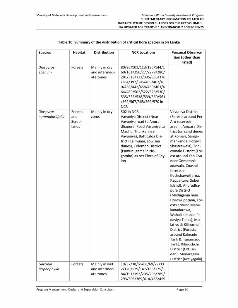
Ministry of Mahaweli Development and Environment
Mahaweli Water Security Investment Program
SUPPLEMENTARY INFORMATION RELATED TO
INFRASTRUCTURE DESIGN CHANGES FOR THE UEC VOLUME 1 :
EIA UPDATED FOR TRANCHE 1 AND TRANCHE 2 COMPONENTS
Program Management, Design and Supervision Consultant Page 30
Table 10: Summary of the distribution of critical flora species in Sri Lanka
Species Habitat Distribution NCR Locations Personal Observa-
tion (other than
listed)
Diospyros
ebenum
Forests Mainly in dry
and intermedi-
ate zones
80/96/101/113/136/144/1
60/161/256/277/279/280/
281/318/333/335/336/376
/384/392/395/400/407/41
0/438/442/458/460/463/4
64/489/502/522/526/530/
535/536/538/539/560/561
/562/567/568/569/570 in
NCR
Diospyros
nummulariifolia
Forests
and
Scrub-
lands
Mainly in dry
zone.
502 in NCR,
Vavuniya District (Near
Vavuniya road to Anura-
dhapura, Road Vavuniya to
Madhu, Thunkai near
Vavuniya), Batticaloa Dis-
trict (Kalmunai, Low sea
dunes), Colombo District
(Pamunugama in Ne-
gombo) as per Flora of Cey-
lon
Vavuniya District
(Forests around Per
Aru reservoir
area, ), Ampara Dis-
trict (on sand dunes
at Komari, Sanga-
mankanda, Potuvil,
Shastrawela), Trin-
comale District (For-
est around Yan Oya
near Gomarank-
adawala, Coastal
forests in
Kuchchaweli area,
Kappalture, Sober
Island), Anuradha-
pura District
(Medagama near
Horowupotana, For-
ests around Maha-
kanadarawa,
Wahalkada and Pa-
daviya Tanks), Mu-
lativu & Kilinochchi
District (Forests
around Kalmadu
Tank & Iranamadu
Tank), Kilinochchi
District (Ottusu-
dan), Monaragala
District (Kotiyagala)
Garcinia
terpnophylla
Forests Mainly in wet
and intermedi-
ate zones
19/37/38/65/68/69/77/11
2/120/129/147/166/175/1
84/191/192/205/208/289/
293/303/369/414/456/459

Ministry of Mahaweli Development and Environment
Mahaweli Water Security Investment Program
SUPPLEMENTARY INFORMATION RELATED TO
INFRASTRUCTURE DESIGN CHANGES FOR THE UEC VOLUME 1 :
EIA UPDATED FOR TRANCHE 1 AND TRANCHE 2 COMPONENTS
Program Management, Design and Supervision Consultant Page 31
Species Habitat Distribution NCR Locations Personal Observa-
tion (other than
listed)
/486/505/506/509/547/54
9/551 in NCR
Salacia
oblonga
Forests Mainly in dry
and intermedi-
ate zone
82/96/144/280/281/318/3
35/336/376/395/400/401/
407/410/442/458/460/463
/464/489/522/536/537/56
0/562/567/568/569/570 in
NCR
Salacia
reticulata
Forests All zones 19/24/28/37/38/39/62/65/
66/69/70/71/77/78/79/10
1/112/120/129/138/147/1
60/161/166/173/175/178/
184/186/187/201/205/208
/217/237/253/256/263/26
9/274/280/281/288/289/2
93/298/303/315/329/336/
343/369/384/388/390/395
/398/407/414/432/438/44
2/453/455/456/458/459/4
63/471/476/486/487/489/
497/498/499/500/501/504
/505/506/507/508/509/51
1/512/522/528/530/531/5
32/533/534/535/538/541/
545/547/549/550/569/570
in NCR
Zanthoxylum
rhetsa
Forests Mainly in inter-
mediate zone
335/336/522/534 in NCR,
Nalanda in Matale District,
Wellawaya in Monaragala
District as per Flora of Cey-
lon
Matale District (For-
ests around Kalu
Ganga reservoir
area, Forest around
new Laggala-
Pallegama city area,
Knuckles Forest)
Note: The relevant location denoted by NCR location numbers are explained in the Annex 7
77. Distribution of critical fauna: The most recent publications on the key faunal taxonomic groups
were referred to describe distribution of the recorded critical fauna species in the project area, and
personnel observations also mentioned to validate the locations of some fauna groups to fill the data
gaps.
78. The two critically endangered (02) fish species (Figure 13), Dawkinsia srilankensis (Blotched
filamented barb) and Systomus martenstyni (Martenstyni’s barb), recorded in the Kambarawa oya
stream at the Northern portal of Tunnel 2 of KMTC are point endemic and restricted to the Knuckles
forest range and Mahaweli basin. However, the many of the prime habitats of these two species is
already disturbed by the Kaluganga and Moragahakanda projects, and the part of the stream is already
within the Kaluganga inundation area. Hence the impact due to KMTC is less significant. However, prior
to disturbance of the habitat during the construction of KMTC, it is recommended to translocate the
species to another area to conserve the species.

Ministry of Mahaweli Development and Environment
Mahaweli Water Security Investment Program
SUPPLEMENTARY INFORMATION RELATED TO
INFRASTRUCTURE DESIGN CHANGES FOR THE UEC VOLUME 1 :
EIA UPDATED FOR TRANCHE 1 AND TRANCHE 2 COMPONENTS
Program Management, Design and Supervision Consultant Page 32
Systomus martenstyni (Martenstyni’s barb) Dawkinsia srilankensis (Blotched filamented
barb)
Figure 13: Plates of two critically endangered (02) fish species
79. Among the other critical faunal species, land snail Micraulax coeloconus is the other critically
endangered species recorded in the Elahera – Girithale sanctuary area at the site southern portal of
Tunnel 3 proposed under UEC ICB 2A package. This species is mainly found in the dry zone forest area,
but there are very limited research publications available about the distribution of this land snail species.
80. The summary of the distribution of recorded critical fauna species identified in addition to the
EIA stage are given in the Table 11. The species distribution and the relevant details related to the 2
mammal species Macaca sinica (Sri Lanka toque monkey) and Elephas maximus (Elephant), is
described under the section 3.2.6 (Para 339 and 340) of the EIA report prepared in June 2015.
81. The design changes are done almost within the study area subjected to EIA of UECP, and
mitigatory measures proposed under EIA for this particular area shall be implemented. It indicates that
the area identified for new access road section “f” supports a rich faunal diversity. There was evidence
to indicate frequent animal movements within the project area, and hence detail study on to understand
the species population density and number of trees to be fell shall be assessed prior to habitat
disturbance by the contractor and species translocation programs shall be carried out for the
threatened/Red list species.
82. As explained in the EIA report, the main risk of construction activities in this area is increased
access to forested areas by humans during construction, and opening of formerly relatively undisturbed
areas to humans leads to increased poaching, clearance of forest patches, setting fires, removal of
timber, non-timber forest products such as medicinal plants, ornamental plants, stones, sand and gravel
from stream beds, and introduction of alien invasive species etc. Therefore, strict monitoring is required
over the above impacts and the area need to be restricted only for the construction and supervision
staff.

Ministry of Mahaweli Development and Environment
Mahaweli Water Security Investment Program
SUPPLEMENTARY INFORMATION RELATED TO INFRASTRUCTURE DESIGN CHANGES FOR THE UEC
VOLUME 1 : EIA UPDATED FOR TRANCHE 1 AND TRANCHE 2 COMPONENTS
Program Management, Design and Supervision Consultant Page 33
Table 11: Summary of the distribution of critical fauna species
Species Habitat Distribution Locations Personal Observation
(other than listed)
Note
Dragonflies
Onychothemis
tonkinensis
Moderately slow
running, partly
shaded streams and
rivers with rich sur-
rounding vegetation
from the lowlands
to the mid-hills.
Mainly in wet and in-
termediate zone.
- -
Fishes
Dawkinsia
srilankensis
Prefers fast flowing
streams and rivers
with sandy sub-
strate. Recently rec-
orded from irriga-
tion canals con-
nected to the upper
Restricted to the
Knuckles area.
Pallegama, Meemure, Reverston,
Gammaduwa, Raththota (De Silva
et al., 2015).
Also sighted in Elahera, Ba-
kamuna, Hasalaka area (De Silva
et al., 2015).
Angamedilla Many prime habitats of
Dawkinsia srilankensis de-
stroyed due to ongoing
Moragahakanda and Kalu
Ganga reservoir projects.
Although they have been
recently sighted in the

Ministry of Mahaweli Development and Environment
Mahaweli Water Security Investment Program
SUPPLEMENTARY INFORMATION RELATED TO INFRASTRUCTURE DESIGN CHANGES FOR THE UEC
VOLUME 1 : EIA UPDATED FOR TRANCHE 1 AND TRANCHE 2 COMPONENTS
Program Management, Design and Supervision Consultant Page 34
Species Habitat Distribution Locations Personal Observation
(other than listed)
Note
reaches of Kalu
River.
outside of the Knuckles
area (Elahera, Bakamuna,
Hasalaka, Angamedilla) its
prime habitats found in
the Knuckles area.
Systomus
martenstyni
Clear, well oxygen-
ated mountain
streams with sandy
or rocky substrata in
both shaded and
open areas. Prefers
areas with deep
rock pools.
Restricted to the
Knuckles area.
Sudugune, Pallegama, Puwak-
pitiya, Meemure area (De Silva et
al., 2015).
Many prime habitats of
Systomus martenstyni de-
stroyed due to ongoing
Moragahakanda and Kalu
Ganga reservoir projects.
Mammals
Macaca
sinica
Forests All zones. Species found in many areas in
the country.
Refer section 3.2.6 (Para 339) of
the EIA for UECP report prepared
in June 2015
They also associated with
human habitations, visitor
gathering (cultural sites)
and roadsides.
Sub species Macaca
sinica sinica mainly found
in the dry lowlands.
Semnopithecus
vetulus
Forests All zones. Species found in many areas in
the country.
Sub species Semno-
pithecus
vetulus philbricki found in
the northern dry and in-
termediate zone.
Although they have pre-
ferred forests, they also
found in home gardens

Ministry of Mahaweli Development and Environment
Mahaweli Water Security Investment Program
SUPPLEMENTARY INFORMATION RELATED TO INFRASTRUCTURE DESIGN CHANGES FOR THE UEC
VOLUME 1 : EIA UPDATED FOR TRANCHE 1 AND TRANCHE 2 COMPONENTS
Program Management, Design and Supervision Consultant Page 35
Species Habitat Distribution Locations Personal Observation
(other than listed)
Note
and tall plantations (Rub-
ber).
Elephas
maximus
Forests, Scrublands,
Grasslands
Mainly in dry and in-
termediate zone.
Species found in many areas in
the country.
Refer section 3.2.6 (Para
340) of the EIA for UECP
report prepared in June
2015
Manis
crassicaudata
Mix of forest habi-
tats from dry thorn
scrub to wet zone
forests, where its
main food termites
and ants is found
Distributed upto the
mid hills to about
1,050 m and distribu-
tion co9incides with
its main pray
They are of variable abundance
in Sri Lanka, with few known lo-
cations in both wet and dry zones
of the country where Pangolins
are rather frequently encoun-
tered or regularly caught by lo-
cals. However, no records of the
abundance and population num-
bers are available, and the spe-
cies is rarely observed due to its
secretive, solitary, and nocturnal
habits.11
No reliable site, and can
be observed during night
safaris on roads through
forests
Manis crassicaudata is the
least studied species of all
Asiatic pangolin species
and, is the solitary pango-
lin species recorded in Sri
Lanka. Growing concerns
over their population de-
cline due to poaching and
trading has triggered con-
servation status.
Land Snail
Euplecta
layardi
Forests Mainly in dry zone. Vavuniya District (Forests
around Per Aru reservoir
area), Puttalam District
(Forests in Aruwakkalu
limestone quarry area),
11 Perera et al. Pangolins (Manis crassicaudata) in Sri Lanka: A Review of Current Knowledge, Threats and Research Priorities Journal of Tropical Forestry and Environment Vol. 07, No. 01 (2017)
1-14

Ministry of Mahaweli Development and Environment
Mahaweli Water Security Investment Program
SUPPLEMENTARY INFORMATION RELATED TO INFRASTRUCTURE DESIGN CHANGES FOR THE UEC
VOLUME 1 : EIA UPDATED FOR TRANCHE 1 AND TRANCHE 2 COMPONENTS
Program Management, Design and Supervision Consultant Page 36
Species Habitat Distribution Locations Personal Observation
(other than listed)
Note
Batticaloa District (Forests
in Thoppigala area)
Micraulax
coeloconus
Forests Mainly in dry zone. Vavuniya District (Forests
around Per Aru reservoir
area), Puttalam District
(Forests in Aruwakkalu
limestone quarry area),
Batticaloa District (Forests
in Thoppigala area)
Glessula
lankana
Forests Mainly in dry zone. Vavuniya District (Forests
around Per Aru reservoir
area), Batticaloa District
(Forests in Thoppigala
area)

Ministry of Mahaweli Development and Environment
Mahaweli Water Security Investment Program
SUPPLEMENTARY INFORMATION RELATED TO
INFRASTRUCTURE DESIGN CHANGES FOR THE UEC VOLUME 1 :
EIA UPDATED FOR TRANCHE 1 AND TRANCHE 2 COMPONENTS
Program Management, Design and Supervision Consultant Page 37
3.4.2 Habitat availability and relative importance in Sri Lanka
83. With the development boost, many forest lands are being cleared and the habitat availability for
the faunal species has become an alarming status. Considering the identified critical species, the two-
fish species and land snail species is critically endangered with respect to their conservation status a of
National Red listing (2012).
84. The endemic species recorded among critical species are important as such species can be seen
only in Sri Lanka. Fish species, Dawkinsia srilankensis (Blotched filamented barb), Systomus martenstyni
(Martenstyni's barb) which is a point endemic to the Knuckles region and it is in imminent danger of
going extinct due to loss of their prime habitats of shallow and clear streams affected by
Moragahakanda reservoir development.
85. The loss and conversion of forest lands and other vegetative areas would affect the population
and distribution of endemic and critical mammal species and other land snail species recorded in the
project area.
3.4.3 Additional mitigatory measures to manage possible impacts to the species
86. As recommended in the original EIA and stipulates by the CEA approval (Ref. No. 2.1 of EIA
approval No. 08/EIA/Water/04/2012 dated 31/03/2016), the task of preparing a “Wildlife Management
Plan including Human Elephant Conflict Management Plan (WMP)” was given to IUCN as a one-year
assignment from August 2016 following the National Procurement Procedure.
87. The draft WMP was submitted to PMU in August 2017 and is now being reviewed by the PMU in
consultation with the following four stakeholder parties;
• Design consultants of the Project (i.e. PMDSC) together with the PIU officials,
• Key individual experts on wildlife management in the Country and Senior officials of relevant
key government authorities (i.e. DWC, FD, CEA, ID, MASL, NLUPLD, NPPD etc.),
• Relevant officials of regional level offices of key government authorities (i.e. DS, AGD, DWC,
FD, CEA, ID, MASL),
• The appointed Technical Review Committee (TRC), which comprises of nationally
recognized subject specialists and Decision-making level officers from relevant Ministries
and Authorities.
88. The draft WMP proposes mitigations under the following major sectors both on long term and
short-term perspectives during construction as well as operational phases of the project;
• Improving the overall habitat availability for Wildlife,
• Mitigating direct negative impacts,
• Mitigation of human Elephant Conflict.
89. It is scheduled that the revised WMP incorporating TRC comments (which compiles all comment
raised at other review consultations as well) to be submitted in mid-September 2017 and PMU accepted
final WMP to be submitted to CEA for the formal approval at the last week of September 2017.
90. Nevertheless, the timely needed, prioritized mitigations (like critical species translocation/
transplanting ahead of canal trace clearing) will be implemented by PMU/ PIU with specific approval and
guidance of Wildlife or Forest Department as relevant. This was practiced for construction of the UEC-
Ministry of Mahaweli Development and Environment
Mahaweli Water Security Investment Program
SUPPLEMENTARY INFORMATION RELATED TO
INFRASTRUCTURE DESIGN CHANGES FOR THE UEC VOLUME 1 :
EIA UPDATED FOR TRANCHE 1 AND TRANCHE 2 COMPONENTS
Program Management, Design and Supervision Consultant Page 38
ICB-1 package for which the separate approval was obtained from DWC (Annex 8-A) to implement the
proposal made by IUCN for priority species translocation from UEC ICB 1 area prior to habitat clearing
Some funding has been allocated under Tranche 2 under environmental mitigation costs to undertake
some of the recommendations of the WMP once approved. Remainder of actions will be funded by
government and under Tranche 3 of the project.
91. The road section “f” requires clearing of forest area in the Moragahakanda reservation (proposed
protected area under Moragahaknada EIA), which can lose a considerable amount of primary forest
habitat, as well as the additional clearance of forest habitats and enabling access to the vehicles, workers
would negatively affect the isolated animals (elephants and small mammals). Hence it is considering an
alternative option or to manage with existing access by constructing bridges where necessary to access
over the Kaluganga inundation area is the first priority.
92. In the design perspective, the proposed road section “f” seems to be the most possible access
path, due to the inundation of proposed access during the EIA stage. Similarly, the consideration of
alternative sites is not possible for the identified areas for tunnel portal under UEC ICB 2A, which is in
the Elahera Girithale sanctuary area, and hence as guided in the Safe guard regulation 1 (Environment)
of SPS (2009), para 30, it is required to consider these impacts in the preparation of Wildlife Management
Plan (WMP) by MMED and implementing the propose mitigations simultaneously with the project
activities.
93. Carrying out a detail biotic resource survey in the project impact area is required due to the lack
of detailed ecological baseline data. Hence, a detail ecological survey to be carried out in the impacted
and surrounding area including a population density study, and then to decide whether there is a
significant impact on the distribution and population of the identified critical species due to project
activities.
94. Identifying suitable alternative habitats for the critical species and habitat enrichment using native
forest species, increase protected areas by combining such alternative habitats would be ideal to
manage the population and distribution of threatened species.
95. For the less mobile species, depending on their population density and presence of alternative
habitats, species translocation program to be done through a group of expertise including a long-term
monitoring program to ensure its effectiveness.

Ministry of Mahaweli Development and Environment
Mahaweli Water Security Investment Program
SUPPLEMENTARY INFORMATION RELATED TO
INFRASTRUCTURE DESIGN CHANGES FOR THE UEC VOLUME 1 :
EIA UPDATED FOR TRANCHE 1 AND TRANCHE 2 COMPONENTS
Program Management, Design and Supervision Consultant Page 39
4 ANTICIPATED ENVIRONMENTAL IMPACTS AND PROPOSED
MITIGATION MEASURES
4.1 Introduction
96. In keeping with the approach taken so far in this EIA Addendum, this section points to the antic-
ipated environmental impacts associated with the design changes outlined in Section 2, for each of the
proposed Tranche 1 and Tranche 2 contract packages. As such, it draws on the ecological survey work
presented in Section 3. Where impacts have been identified, and these have not been dealt with in the
2015 EIA, this section discusses appropriate mitigation measures.
97. Mitigation measures are presented for each construction package, and this section concludes
with mitigation recommendations that are generally relevant for all components.
98. Detailed environmental management plans for each component dealt with in this Addendum
(ICB-1, ICB-2A, and ICB-2B) are presented in the separate Volume 2, titled: “Addendum to the EIA for
Upper Elahera Canal Project. Volume 2: Updated EMPs for Tranche 1 and Tranche 2 Components”.
4.2 Kalu Ganga – Moragahakanda Transfer Canal (KMTC): UEC-ICB-2B
99. Table 1 makes it clear that the main possible environmental concerns with design changes to ICB-
2B are associated with access road section ‘f’, and with a new disposal site DP 3 (see Figure 2), where
road section “f” is situated within Forests Department land comes under the category of “other state
forest” and DP3 site is located within an already acquired land by Mahaweli Authority under
Moragahakanda Project. Considering existing land use of the proposed disposal site of DP3 which is an
abandoned paddy and home garden, the environmental impact is very low. Proposed disposal site DP 3
was not included in the CEA approval of the 2015 EIA. This will be a 4.5ha permanent site, needed
because it is not feasible to transport spoil from the northern tunnel portal along the winding access
road. The site is currently mostly cleared, and is surrounded by habitat of less value than is the case for
access road section “e” and ‘f’.
100. Clearing of approximately 1.6 ha will be required to enable the road to be constructed under
section “f” of the access road. The forest quality is good through most of this section, and Section 3.2
indicates that there are a number of endangered, vulnerable, and near-threatened species of flora and
fauna that use this forest as habitat.
101. The approval for clearing forest area to construct access road section “f” is granted by the
Conservator Forest of Forest Department (Annex 8C) stating that Forest Department has no objection
for the construction of road section shown as “f” on the given map subject to obtaining approval for
“addendum to Environmental Impact Assessment” by CEA, since the proposed road section, which
slightly deviate from the access road given in the original EIA due to practical reasons, is located within
the same forest reserve that was studied and included in the approved EIA. The final designs for section
‘f’ requires to be finalized with consultation of Forest Department and CEA, and it would be intimately
involved with the construction .
4.3 The relevant approvals granted by the respective stakeholder agency, for
the design changes are described in detail under the Section 5 of this
report. Upper Elahera Canal: UEC – ICB – 1 (Tranche 1)
102. The Central Environmental Authority’s approval letter for the 2015 EIA required the proponent to
obtain fresh approval if the project was to be altered. Given that the deviation is still within the EIA study

Ministry of Mahaweli Development and Environment
Mahaweli Water Security Investment Program
SUPPLEMENTARY INFORMATION RELATED TO
INFRASTRUCTURE DESIGN CHANGES FOR THE UEC VOLUME 1 :
EIA UPDATED FOR TRANCHE 1 AND TRANCHE 2 COMPONENTS
Program Management, Design and Supervision Consultant Page 40
area of 500m from the center line of the canal trance, there is no requirement to undertake a separate
environmental assessment. However, construction work in this area is on temporary hold until the CEA
approves the deviation.
103. The deviated trace falls mainly within an area of Forest Department reserve, and a separate
approval has already been provided by the Department in a letter dated April 20, 2017. Furthermore,
IUCN has undertaken an ecological significance study along the deviated trace1. IUCN’s work has
included translocation of significant species, as part of a wider study to prepare a Wildlife Management
Plan that complies with one of the CEA’s EIA approval conditions.
104. The significance of possible environmental impact along the deviated section is comparatively
low. The deviation will result in reduced blasting activities. Anticipated impacts are common to the entire
UEC-ICB-1 area, as the alignment is located within an ecologically sensitive area associated with the
stream network of Welankatuwa stream. The revised updated EMP for UEC-ICB-1 addresses the general
impacts and proposed mitigation measures. The EMP is presented in a separate Volume 2.
4.4 Upper Elahera Canal: UEC-ICB-2A
105. As indicated in Section 2.4, the design changes proposed for ICB-2A are relatively significant. The
most significant is the decision for Tunnel 3 to change from entirely TBM (driven from the north), to a
combination of TBM from the north and NATM drill-and-blast from the south. Another alteration has
Tunnel 4 changing from cut-and-cover to NATM.
4.4.1 Tunnel 3 Southern Portal
106. The significance of the design change on Tunnel 3 is that an additional 48,000 m3 of muck will now
need to be removed and disposed of. This has resulted in the need for three new disposal sites. As
indicated in Figure 5, sites DPS 2 (5 ha) and DPS 3 (3 ha) will be temporary, and site DPS 1 (4.8 ha) will be
permanent.
107. All three of the proposed new disposal sites, and almost the entire length of the proposed access
road, are within the boundaries of the Elahera Giritale Sanctuary. This sanctuary is one of 61 managed
by the Department of Wildlife Conservation. As defined by regulation, sanctuaries exist to ensure the
protection of wildlife which is outside State land. They may therefore include private lands. Human
activities are allowed within sanctuaries, and permits are not required for entry.
4.4.1.1 Access Road
108. In general, the route for the access road to the southern portal was approved as part of the 2015
EIA. However, a more detailed survey of the proposed route has since been undertaken, and this has
included the ecological survey undertaken in May 2017.
109. The only stretches of the access road where widening and road improvement may require the
removal of vegetation are length SA2/SA3, and length SA5/SA6 (Figure 7). SA2/3 runs through scrubland
for approximately 1 km. Only minor localized realignments are required to avoid the worst stretches of
track, and in some cases, there are two or more tracks running about potholes. It is unlikely that these
realignments will result in anything other than minor clearing of scrubland.
110. Sections SA5/6 pass through approximately 2 km of forests and scrubland, all within the
sanctuary. Habitats include a small number of species which are either endangered, vulnerable, or near-
1 IUCN (2017), Priority Species Translocation from Package 01 Areas of UECP: Activity Completion Report. May
15th.

Ministry of Mahaweli Development and Environment
Mahaweli Water Security Investment Program
SUPPLEMENTARY INFORMATION RELATED TO
INFRASTRUCTURE DESIGN CHANGES FOR THE UEC VOLUME 1 :
EIA UPDATED FOR TRANCHE 1 AND TRANCHE 2 COMPONENTS
Program Management, Design and Supervision Consultant Page 41
threatened. The road needs upgrading along this stretch, and can be realigned to avoid a number of
large trees.
111. As part of mitigation and management, all work required on the 4.5 km of access road, and
particularly on the 2 km of SA5/6 will be approved by the Department of Wildlife Conservation prior to
the start of work. The Department will also be invited to review contractor environmental management
plans.
112. The last part of the proposed access road traverses through a good forest patch that will require
felling a considerable number of trees. If the road can be turned from the point marked in the Figure 14
(GPS N 070 54.244; E 0800 49.492) and thus traversing a degraded area, mostly scrubland, it is possible
to save some trees and wildlife habitat.
Figure 1: Last 200 m of the proposed access to the Southern Portal of Tunnel 3 (SPT3)
4.4.1.2 Disposal Sites
113. Figure 7 shows the proposed positioning of the three new disposal sites (DPS 1, 2, 3). Collectively,
these sites will sterilize 12.8 ha of land, although DPS 1 and DPS 2 will be temporary. DPS 1 will be a
permanent disposal area, and will host a crusher plant. It sits on the southern edge of the Elahera
Minneriya Yoda Ela. It is abandoned land, and was the site of an old quarry. On its northern edge, it is
already naturally banded, although this aspect of the containment will need to be made completely
secure, given its proximity to the river.
114. DPS 2 is a proposed 5 ha disposal site, immediately inside an eastern boundary of the sanctuary,
and consisting mostly of scrubland. No significant flora species are evident, and the site will be returned
to its existing state after completion of Tunnel 3 construction. Mitigatory measures need to be followed
as per the updated EMP in Volume 2, and conditional approvals from DEA and DWC.
115. DPS 3 is a smaller temporary disposal site, sitting on the western edge of an area of paddy fields.
It sits totally within an area of abandoned land, and does not contain flora of any special significance.
116. The area is associated with a good stream network and the bank of the main stream and water-
logged area is close to the access to DPS3. Since the batching plant is to be installed here, precautions
need to be taken to avoid waste water discharges to the natural stream network. Further, dust and
sedimentation impacts could be significant during the construction stage, hence appropriate mitigation
actions will need to be taken. These are outlined in the updated EMP presented in Volume 2.
Ministry of Mahaweli Development and Environment
Mahaweli Water Security Investment Program
SUPPLEMENTARY INFORMATION RELATED TO
INFRASTRUCTURE DESIGN CHANGES FOR THE UEC VOLUME 1 :
EIA UPDATED FOR TRANCHE 1 AND TRANCHE 2 COMPONENTS
Program Management, Design and Supervision Consultant Page 42
4.4.2 Tunnel 3 Northern Portal/Tunnel 4 Southern Portal
117. The only aspect of the Tunnel 3 northern portal/Tunnel 4 southern portal design that was
approved as part of the 2015 EIA is the office/construction camp at site A (see Figure 8). All other
components, such as the northern start shaft main site; and the three disposal sites (DPN 1, 2, 3) are all
part of the new design. Apart from site A and site D (accommodation and offices), the remaining
components would be sited within Forest Department reserved land.
118. DPN 1 (3.54 ha) and DPN 2 (3.98 ha) currently consist of uncultivated scrubland. These disposal
sites would be temporary. The smaller site DPN 3 (1.39 ha) is abandoned cleared land, occasionally used
chena within an area of unreserved State land. It should be noted that at least some of the area currently
proposed for disposal sites would not be required. It is probably that either of DPN 1, 2, or 3 could be
considered to be backup. Given that all three disposal sites are within Forest Department land; the
agency’s approval would be required before construction begins.
119. There will be a need to constantly monitor groundwater levels during construction. As shown in
the relevant Environmental Code of Practice in Annex 1, groundwater level monitoring has taken place
on a 2-weekly basis since February 2017. At present, there are four boreholes and four dug wells near
the northern portal of Tunnel 3 (between chainages 54+165 km and 55+085 km). Closer to the start of
construction, extensive monitoring of groundwater levels will take place in a 500 m band along the
center line, under an inventory sub-contract. An additional 14 boreholes with depths varying from 20 m
to 53 m have been specified under the contract. Monitoring of water levels in these boreholes will
commence early after the contract award.
4.5 Overall
120. Overall, the environmental implications of the proposed design changes since the 2015 EIA would
appear to ‘net negative’, but with only minor significance.
121. As previously discussed, two of the design changes (lack of need for a spillway from Bogahawewa,
and the change from cut-and-cover for Tunnel 4 to NATM) will result in positive environmental
outcomes.
122. Where the environmental implications of design changes are negative, this is primarily because
of the taking of extra land for construction, access, and spoil disposal. The 2015 EIA estimated that 160
ha of land would be ‘sterilized’ by UEC construction and operation. The new design changes outlined in
this Addendum will require an extra 37.82 ha of land, although it should be stressed that not all of this
will be vegetated, and a considerable portion will be returned to original or better condition after
construction activities have ceased.
123.
124. Commitments made in the 2015 EIA to ‘no net loss of biodiversity’, resulted in a recommendation
to reforest 500ha of land on the eastern side of the UEC, from chainage 60+700 to 65+200. Even when
the extra land ‘take’ of 37.82 ha is added, and the total area of land sterilized by UEC raises from 160 ha
to 197.82, the offset ratio is still high at 2.53.
125. Although the environmental implications of the design changes will likely not be significant, they
will add incrementally to the overall cumulative impact of new water supply schemes in the Mahaweli.
The issue of cumulative impact is dealt with at length in the Strategic Environmental Assessment for the
North Central Province Canal Project.

Ministry of Mahaweli Development and Environment
Mahaweli Water Security Investment Program
SUPPLEMENTARY INFORMATION RELATED TO
INFRASTRUCTURE DESIGN CHANGES FOR THE UEC VOLUME 1 :
EIA UPDATED FOR TRANCHE 1 AND TRANCHE 2 COMPONENTS
Program Management, Design and Supervision Consultant Page 43
5 STAKEHOLDER & PUBLIC CONSULTATION OVER THE DESIGN
CHANGES
126. The stakeholder consultation is being made in national, regional and site level, over the design
changes related to UECP Tranche 1 and Tranche 2 packages. The key government stakeholder agencies
of CEA, DWC and FD have been consulted about the changes during the discussions held at the Head
office of agencies, with the Divisional Directors of concern, and the national level awareness made about
the key project components and design changes during the ADB Fact finding mission, Stakeholder
meeting held on 7th June 2017. The agencies participated for key consultative sessions with the specific
purpose and the conclusion arrived / outcome is given in the Table 12.
127. A separate national level stakeholder consultation session has been scheduled by MMDE for 29th
September 2017, chaired by Secretary of MMDE with the participation of MMDE, FD, DWC, CEA, GSMB,
NBRO, RDA, DS, CS, PMU, PIU and PMDSC.
128. In addition, the stakeholder consultation sessions and meetings with DWC and FD carried out by
IUCN for the preparation of WMP for UECP, also addressed these design changes and management
options over the anticipated impacts.
129. Table 12 summarize the consultative sessions undertaken related to the design changes discussed
in this addendum for Tranche 1 and Tranche 2 packages of UECP. The photographic evidences available
for some of the consultations are given in the Figure 14 and relevant consent letters already obtained
from the regional level stakeholder agencies are given in the Annex 7.
Figure 14-1: Archeological Dept visit to UEC ICB 1 area
(2017.01.26)
Figure 14-2: Field inspection by FD Kaluganga Tunnel
area (2017.02.28)

Ministry of Mahaweli Development and Environment
Mahaweli Water Security Investment Program
SUPPLEMENTARY INFORMATION RELATED TO
INFRASTRUCTURE DESIGN CHANGES FOR THE UEC VOLUME 1 :
EIA UPDATED FOR TRANCHE 1 AND TRANCHE 2 COMPONENTS
Program Management, Design and Supervision Consultant Page 44
Figure 14-3: Species Translocation program in UEC ICB
1 (2017.03.05-07)
Figure 14-4: FD official Visit to proposed access to
KMTC (2017.03.28)
Figure 14-4: FD official Visit to proposed access to
KMTC (Section “f”) (2017.03.28)
Figure 14-5: Field visit with DWC and FD to identify
the locations for tree planting (2017.07.18)
Figure 14-6: Field visit with DWC to the disposal area
Kongketiyawa (2017.07.14)
Figure 14-8: Field visit with STC to the deviated canal
trace (UEC ICB 1) (2017.07.19)
Figure 2: The photographic evidences available for some of the consultations

Ministry of Mahaweli Development and Environment
Mahaweli Water Security Investment Program
SUPPLEMENTARY INFORMATION RELATED TO INFRASTRUCTURE DESIGN CHANGES FOR THE UEC
VOLUME 1 : EIA UPDATED FOR TRANCHE 1 AND TRANCHE 2 COMPONENTS
Program Management, Design and Supervision Consultant Page 45
Table 12: Summary of Consultative Sessions Undertaken on the Design Changes of UECP that Appeared in the Addendum to EIA
Date Location/ Purpose Participants Outcome/ Remarks
2017.01.26 Field inspection/ survey along the canal
trace of ICB -1 including the deviated sec-
tion
Department of Archaeology (Pol-
onnaruwa District Office), PIU
Approval of Archaeological Dept. granted to
commence the construction – ICB -1
2017.02.28 Field inspection/ survey at proposed tun-
nel infrastructure facility areas of KMTC
FD (Naula & Laggala Pallegama range of-
fices), PIU
Recommendation was granted to the DFO
of Matale for releasing of lands as to the
Project.
2017.03.05, 06 & 07 Ecological survey along deviated canal
trace
DWC (Elehera, Bakamuna offices), IUCN,
PIU
Priority fauna and flora species were identi-
fied & collected from canal trace fauna spe-
cies release to similar habitats and flora
species transferred to temporary plant
nursery established at DWC, Elehera
2017.03.28 Poththatawela, Kaluganga; Field inspec-
tion/ discussion along new Access Road
trace (c &f)
FD (Naula & Laggala Pallegama range of-
fices), PIU
Approval for rehabilitation of access road to
tunnel No. T2 granted by FD (Near
Moragahakanda Reservoir)
2017.04.26 Moragahakanda-Kaluganga Link tunnel
trace observation
FD (DFO office Matale, Naula & Laggala
Pallegama range offices), PIU
Components related to construction of
KMTC Tunnel (Tunnel portal areas, Disposal
sites, Accommodation sites etc.) observed
by officials of FD. Recommendation of FD,
Matale already sent to Head Office of FD.
2017.06.01 Konduruwawa; Field visit FD (Polonnaruwa DFO office, Elahera
range office), DWC (Elehera, Bakamuna
offices), PIU
Attendance sheet attached.
Officials of FD and DWC visited to observe
the areas of tunnel components of the Tun-
nel 3 (T3) and Tunnel 4 (T4) to observe the
trace including changes.
2017.07.14 Kongetiyawewa; Proposed disposal area
inspection
DWC (Elehera, Bakamuna offices), PIU Field visit with DWC who agreed to allocate
this site as disposal site and recommended
to DWC head office for releasing to Project.

Ministry of Mahaweli Development and Environment
Mahaweli Water Security Investment Program
SUPPLEMENTARY INFORMATION RELATED TO INFRASTRUCTURE DESIGN CHANGES FOR THE UEC
VOLUME 1 : EIA UPDATED FOR TRANCHE 1 AND TRANCHE 2 COMPONENTS
Program Management, Design and Supervision Consultant Page 46
Date Location/ Purpose Participants Outcome/ Remarks
2017.07.18 Identification of locations for reforesta-
tion/ enrichment tree planting-ICB-1
(within the Elahera-Girithale sanctuary
along the canal trance including deviated
sections)
DWC (Elehera, Bakamuna offices), FD
(Polonaruwa DFO office), PIU
Attendance sheet attached.
Proposal for tree planting activities were
prepared considering the outcomes of dis-
cussion of DWC and FD.
2017.07.19 Field visit along the deviated canal trace
STC (Minneriya Office), PIU Field visit were carried out with officials of
STC, Minneriya in order to observe the
trees which area situated deviated canal
trace of ICB-1.
2017.08.09 Head Office of Forest Department; Pre-
sented overall design changes to key staff
FD (Divisional Heads in Colombo Office),
PMU, PIU, PMDSC
FD officers agreed in principal for proposed
revised trace and construction methodol-
ogy.
2017.08.21 Head Office of DWC; Presented overall de-
sign changes & proposed mitigations in
Wildlife Management Plan to key staff
DWC (Divisional Heads in Colombo Of-
fice), PMU, PIU, PMDSC
All parties agreed upon adoptable environ-
mental/ wildlife impact mitigations in rela-
tion to the proposed deviations in trace
with construction designs & methodology
as well as
2017.09.07 MMDE; Present the design changes & cur-
rent progress to key stakeholders
MMDE, FD, DWC, CEA, GSMB, NBRO,
RDA, DS, CS, PMU, PIU, PMDSC
Scheduled to be held to obtain views/ con-
cerns in relation to the current progress and
future implementation of UECP in order to
ensure smooth execution.
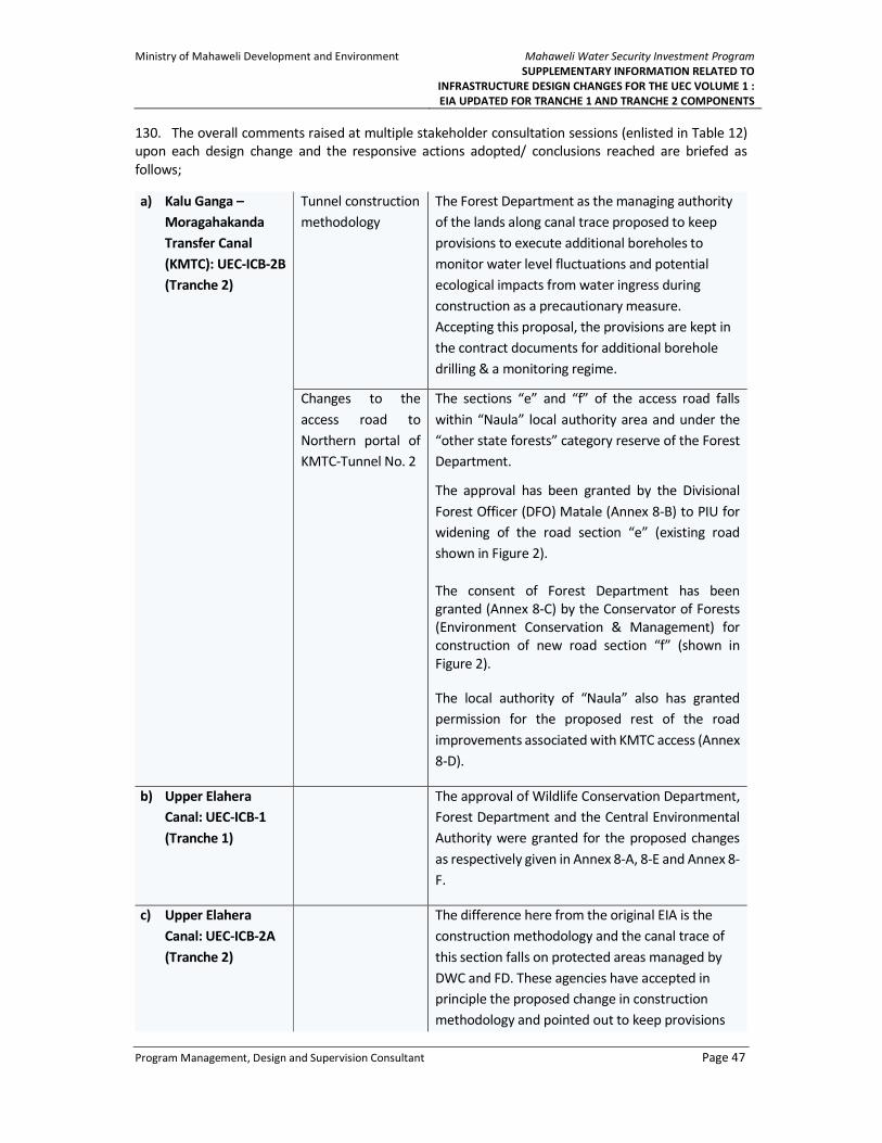
Ministry of Mahaweli Development and Environment
Mahaweli Water Security Investment Program
SUPPLEMENTARY INFORMATION RELATED TO
INFRASTRUCTURE DESIGN CHANGES FOR THE UEC VOLUME 1 :
EIA UPDATED FOR TRANCHE 1 AND TRANCHE 2 COMPONENTS
Program Management, Design and Supervision Consultant Page 47
130. The overall comments raised at multiple stakeholder consultation sessions (enlisted in Table 12)
upon each design change and the responsive actions adopted/ conclusions reached are briefed as
follows;
a) Kalu Ganga –
Moragahakanda
Transfer Canal
(KMTC): UEC-ICB-2B
(Tranche 2)
Tunnel construction
methodology
The Forest Department as the managing authority
of the lands along canal trace proposed to keep
provisions to execute additional boreholes to
monitor water level fluctuations and potential
ecological impacts from water ingress during
construction as a precautionary measure.
Accepting this proposal, the provisions are kept in
the contract documents for additional borehole
drilling & a monitoring regime.
Changes to the
access road to
Northern portal of
KMTC-Tunnel No. 2
The sections “e” and “f” of the access road falls
within “Naula” local authority area and under the
“other state forests” category reserve of the Forest
Department.
The approval has been granted by the Divisional
Forest Officer (DFO) Matale (Annex 8-B) to PIU for
widening of the road section “e” (existing road
shown in Figure 2).
The consent of Forest Department has been
granted (Annex 8-C) by the Conservator of Forests
(Environment Conservation & Management) for
construction of new road section “f” (shown in
Figure 2).
The local authority of “Naula” also has granted
permission for the proposed rest of the road
improvements associated with KMTC access (Annex
8-D).
b) Upper Elahera
Canal: UEC-ICB-1
(Tranche 1)
The approval of Wildlife Conservation Department,
Forest Department and the Central Environmental
Authority were granted for the proposed changes
as respectively given in Annex 8-A, 8-E and Annex 8-
F.
c) Upper Elahera
Canal: UEC-ICB-2A
(Tranche 2)
The difference here from the original EIA is the
construction methodology and the canal trace of
this section falls on protected areas managed by
DWC and FD. These agencies have accepted in
principle the proposed change in construction
methodology and pointed out to keep provisions

Ministry of Mahaweli Development and Environment
Mahaweli Water Security Investment Program
SUPPLEMENTARY INFORMATION RELATED TO
INFRASTRUCTURE DESIGN CHANGES FOR THE UEC VOLUME 1 :
EIA UPDATED FOR TRANCHE 1 AND TRANCHE 2 COMPONENTS
Program Management, Design and Supervision Consultant Page 48
to execute additional boreholes to monitor water
level fluctuations and potential ecological impacts
from water ingress during construction as a
precautionary measure. Accepting this proposal,
the provisions are kept in the contract documents
for additional borehole drilling & a monitoring
regime.

Ministry of Mahaweli Development and Environment
Mahaweli Water Security Investment Program
SUPPLEMENTARY INFORMATION RELATED TO
INFRASTRUCTURE DESIGN CHANGES FOR THE UEC VOLUME 1 :
EIA UPDATED FOR TRANCHE 1 AND TRANCHE 2 COMPONENTS
Program Management, Design and Supervision Consultant Page 49
6 REFERENCES
Dragonfles
Bedjanic, M., Conniff, K., van der Poorten, N. (2014). Dragonfly Fauna of Sri Lanka: Distribution and
Biology, with Threat Status of its Endemics. Pensoft Publishers, Sofia, Bulgaria.
Bedjanic, M., Conniff, K. and G. de S. Wejeyratne (2007). Gehan’s photo guide; Dragonflies of Sri
Lanka. Jetwing Eco Holidays, Sri Lanka.
Mammals
Kotagama, S. and Goonatilake, S. de A. (2013). Pictorial Pocket Guide to the Mammals of Sri Lanka.
Field Ornithology Group of Sri Lanka.
Yapa, A. and Ratnavira, G. (2013). The Mammals of Sri Lanka. Field Ornithology Group of Sri Lanka.
Phillips, W.W.A. (1935). Manual of the Mammals of Ceylon. Ceylon Journal of Science, Dulau and
Company, London.
Kotagama, S. (2004). Mammals in Sri Lanka. Pictorial Pocket Guide – 3. Field Ornithology Group of Sri
Lanka. Colombo.
Gehan De Silva Wijeratne (2008) Mammals of Sri Lanka – A photographic Guide, New Holand Publish-
ers (UK) Ltd.
Perera et al. Pangolins (Manis crassicaudata) in Sri Lanka: A Review of Current Knowledge, Threats and
Research Priorities Journal of Tropical Forestry and Environment Vol. 07, No. 01 (2017) 1-14
Fishes
De Silva, M. A., Hapuarachchi, N. and Jayaratne T. (2015). Sri Lankan Freshwater Fishes. Wildlife
Conservation Society, Galle, Sri Lanka.
Goonatilake, W. L. D. P. T. S. (2007) Freshwater Fishers of Sri Lanka (text in Sinhala). Biodiversity Sec-
retariat, Ministry of Environment and Natural Resources, Sri Lanka.
Land Snails
Naggs, F. and Raheem, D. (2000). Land Snail Diversity in Sri Lanka. The Natural History Museum, Lon-
don, UK.
Naggs, F. and Raheem, D. (2002). Sri Lankan Snails. The Natural History Museum, London.
Raheem, D. and Naggs, F. (2006). An Illustrated Guide to the Land Snails of Sri Lankan Natural Forest
and Cultivated Habitats. Natural History Museum, London.
Flora

Ministry of Mahaweli Development and Environment
Mahaweli Water Security Investment Program
SUPPLEMENTARY INFORMATION RELATED TO
INFRASTRUCTURE DESIGN CHANGES FOR THE UEC VOLUME 1 :
EIA UPDATED FOR TRANCHE 1 AND TRANCHE 2 COMPONENTS
Program Management, Design and Supervision Consultant Page 50
Dassanayake, M. D. and Fosberg, F. R. (eds.) (1980). A Revised Handbook to the Flora of Ceylon, Vol.
I, Amerind Publishing, New Delhi.
Dassanayake, M. D. and Fosberg, F. R. (eds.) (1981 - 1991). A Revised Handbook to the Flora of Ceylon,
Vols. II - VII, Oxford & IBH Publishing, New Delhi.
Dassanayake, M. D., Fosberg, F. R. and Clayton, W. D. (eds.) (1994 - 1995). A Revised Handbook to the
Flora of Ceylon, Vols. VIII - IX, Oxford & IBH Publishing, New Delhi.
Dassanayake, M. D. and Clayton, W. D. (eds.) (1996 - 2000). A Revised Handbook to the Flora of Ceylon,
Vols. X – XIV, Oxford & IBH Publishing, New Delhi.
Dassanayake, M. D., Clayton, W. D. and Shaffer-Fehre, M. (eds.) (2006). A Revised Handbook to the
Flora of Ceylon, Vols. XV Part A & Part B, Science Publishers, USA.
IUCN & WCMC (1997). Designing an Optimum Protected Areas System for Sri Lanka’s Natural For-
ests, Vol. 1 & 2. Forest Department, Ministry of Forestry and
Environment, Battaramulla.
Other Publications
Conditional Approval Letter for Moragahakanda EIA and approval extension letters (2001 /2006 /
2007) Ministry of Agriculture, forestry, food and Cooperative Development
Preparatory Survey on Moragahakanda Development Project- Volume I (2010) JICA and Nippon Koi