additional geographical and geolog ical data from …
TRANSCRIPT

RYSZARD GRADZINSKI & TOMASZ JERZYKI EWICZ
AD DIT IONAL GE OG RAPH ICAL AND GEOL OG ICAL DATA FROMTHE POLI SH-MONGO LIAN PALAEONTOLOGICAL EXPED ITION S
(Plate Il l)
Abstract. - The local ities. at which the field work of the Polish-M ong o lian Palae ont ological Expeditions was ca rriedout in 1970 and 1971 a re described. Th e posit ion and morphology of the localiti es a nd geo logical profiles are given.On sehematic map s and gene ral ized profiles. the main foss iliferous sites are show n.
INTRODU CTIO N
The Polish-Mongol ian Palaeontological Expedition s o rga nized in 1970 a nd 1971 carriedout field -work at Bayn-D za k, Toogreeg, Khermeen T sa v and in the Nemegt Basin (K IELANJAWOROWSKA & BARsBo LD, 1972) . In the Nemegt Basin fo ssils were prosp ected and excavatedin Upper Cretaceous deposit s (in the Upper and Lower Nemegt Beds). In 1970 th e investigationswere concentrated in the region of the locality Nemegt and their geological description is dueto the first a uthor.
In 1971 the excavatory work wa s continued in th e Nemegt Basin in the loca lities ofKhulsan, Nemegt, Altan U la 11 , III and IV. In the locality of Toogreeg sit ua ted north-eastfrom the Ne megt Ba sin the excavatory work ha s been a lso performed . The locality of K hermeen Tsav sit uated so ut h-westward from the Nemegt Basin ha s been only visited. T he geological description of the localities prospected in 197 1 is due to tire seco nd author.
The present de scription forms a continuation of a paper by GRADZINSK I et al. ( 1968/69)and should be read in conj unction with that paper. It contains data concerning the po sitionof the excavation sites worked in 1970 a nd 1971. Only so me geological data a re presented,and to some extent supplement th e earlier publicati ons (G RA DZINSKI et al.. 1968/69; GRADZINSKI , 1970) . The results of sed imentologica l in vestigations of the Lower Nemegt Beds carried out during the 1970 and 1971 exped itio ns will be published sepa ra tely.
The geological profiles were drawn on the ba sis of detailed profiles, but th ey a re generalizedin most cases, and present an overall picture of th e lithology of the beds in part icular o utcro ps .Different resistance to weathering of particular beds is reflected in the morphology of slopes .The maps of the localities were made with the use of the mea suring instrument .T eletop"of Zei ss Co. a nd of a geological co mpass "Meridian". The locations of th e individual specimensand a reas of detai led prospecti on are marked by numbers on the maps a nd o n the profiles.2 - Palaeon tologia Poloniea N o. 2i

AlJ Dl TlONAL GE OG RA PHICAL AN D G EOLOG ICAL DATA
o
o
::0
o!
1kmI
If\ f\ /\ I ISOLATED H I LLS
~ LA RGER CLI FFS
ca CLIFF S
1 ~,,/\./1 SLOPE
lllll\~ INTERCONNECTING GORGES
~ SAYR
CAIRN
00 FAUNA EXCAVATED
~ CAMP
L- ._ . ------ - - - - - - - ---- - - - -
Fig. I- - - - -- - -- " - -i>
Map of northe rn par t of local ity Nemegt. Excavated fauna indicated by numbers : 12 - incomplete skeleto n with partof the skull of Tarbosaurus bataar (part of the skeleton was excav ated in 1965, see GRADZlr:,;SKl er al., 1968/69, Te xt-fig. 2) ;

RYSZARD GRADZINSK I & TOMASZ JERZYKI EWI CZ 19
ACKNOWLEDGEM ENTS
Thanks are due to Dr. R. BARSBOLD (Laboratory of Stratigraphy and Paleontology,Acade my of Sciences of the Mongolian People's Repub lic, Ulan Bator), to Dr. V. ZHEGALLOand Dr. V. J. RESHETOV (Palaeontological Institute of the Academy of Sciences of USSR)for supplying information concerning the locality of Khermeen Tsav and for friendly cooperation.
LOCALIT Y NE MEGT
This locality name was introduced previously (GRADZINSKI et al., 1968/69) to denotea large group of exposures situated on the northern pediment of the Nemegt Basin, SSE ofthe Kh obo or Mt. (2768 m). The exposures are situated 12-1 8 km south of the margin of theNemegt Massif, and are concentra ted around several large sayrs, viz. the Western , Centra l,Northern and Eastern Sayr. All these join into one Broad Sayr which is a tributa ry of themain sayr of the Nemegt Basin extendi ng in the E-W direction. The excavations carried outby the 1964 and 1965 expeditions were concentra ted in the centra l part of the exposures ofth is locality. During the 1970 expedition the nor thern part of the Nemegt locality was worked,while pros pection for fossil mammals was carried out in 1970 and 1971 in its south-easternpart. For practical reasons these two regions are described below separately.
Northern part of Nemegt locality
The area of excavations carried out in 1970 is shown in Text-fig. I. This area adjo insdirectly from N and NW the area of works of the 1964 and 1965 expeditions, the plan of whichwas published earlier (GRADZINSK I et al., 1968/69, Text-fig, 2). The area described here liesbetween 10Ic02'-101 003'30" longitude E' and 43°30'30 "-43°32'30 " latitude N, at altit ude1550- 1600 m above sea level.
In the area shown on the plan , the older pediment is dissected by two large sayrs, namedprevio usly the Northern Sayr and the Western Sayr. The floor of the first one lies ea. 45 mbelow the older pediment surface. The sayr bed is 10- 40 m wide and accessible for field motorvehicles on the whole area shown on the plan. Rock terraces bordering the sayr bed on bothsides are up to 25 m high and dissected by numerous smaller gorges . The latt er are usuallynarrow and mostly inaccessible for motor vehicles. The lower part of the valley of the NorthernSayr (beginning with the Red Field) is relatively narrow and bordered by high. genera llyvert ical walls. Farther north it widens into a large depress ion. then agai n it narrows (nea rthe Isolated Hill), and then widens agai n. The Isolated Hill lies approxi mately in the centre
13 - fragment of the postcranial ske leto n of the coe luro id dinosaur ; I4 - complete postcrani a l skeleto n of or nithomimi d din osaur ; 15 - to rtoise ; 16 - tortoise ; / 7 - sk ull of a tort o ise ; /8 - fish remains ; 19 - skull and fragmentsof the postcrani al skeleton of pachyceph alosaurid dinosaur ; 20 - pelvis of orn ithomimid dinosaur ; 2/ - fragmentsof the limbs of orni thomimid din osaur ; 22 - torto ise; 23 - inco mplete backbone, fragm ent s o f the pelvis and tar susof Saurolophus angustirostris: 24 - incomplete ske leton with the fragmentary skull of Tarbosaurus bataar; 25 - pelvisof o rn ithomimid dinosaur ; 26 - fragment s of the postcrani al ske leto n of coeluroid din osaur ; 27 - fra gments of theta il a nd hind limbs of Sau rolophus angustirostris; 28 - fragmenta ry sk ull and postcrani al ske leton of Su urolophus all
gustirostris; 29 - incomplete skull a nd frag ments of the backbone of Tarbosaurus bataar: 30 - seven vertebrae andfragment s of the metat araus of Tarbosaurus batuar; 3/ - fragmentary tail , pelvis and hind limb of Tarbosaurus bataar ;
32 - mud stone with ost racods , cha racean s and pelecypods.
20 RYSZA RD GRADZINSKI & TOMASZ JERZ YKI EWICZ
of thi s wide sect ion of th e say r va lley . A depression in the surface of th e olde r pediment issitua ted immed iately to th e so uth . From th at place th e Western Sayr exte nds so uthwa rd .
The large Viper Sayr is situa ted immed iat ely east of th e Northern Sayr . These two say rsjoin at the Red F ield. The sho rt but deep G oat Sayr is situa ted bet ween th e two say rs de scribeda bove in the so uthe rn part of th e a rea.
The expos ures situa ted within th e Wes te rn Sayr form th e wes tern periphery of theNemegt locality. Farther west extends the surface of th e o lde r ped iment covered by very shallowsayr bed s. The Western Sayr join s th e Central Sayr near th e ca mp site of th e 1964 expedit io n(see T ext-fi g. 2 in GRADZINSKI et al.. 1968/69). Thi s say r is access ible fo r field mot o r vehicleson its entire length . Numerous and fairl y exte ns ive exposures a re gr ouped in th e northernpart of the We stern Sayr (i. e. in th e a rea shown o n th e plan , Text-fig. I ). The floor of th esayr is lying 25-30 m below th e surface of th e olde r pediment.
Researches in 1970
The 1970 expedition worked a t the loc ality Nem egt in the area sho wn on the plan (Textfig. I; see a lso Text-fig. 2). Moreover , prospect ion for skeleto ns wa s carried o ut in the northernpart of the Viper Sayr and in th e northern part of th e Ce ntra l Sayr , west of the Great Pyramid(see GRADZINSKI et al., 1968/69, Text-fig. 2).
u z
a::: a::: lQm
w w
0- 0-
0- 0-
::J ::J
w~(/)4W(/)-(/)ffiet(/)
SAN DS WIT H SILTINTE RCALATIONS
SA ND
SI LT. SILTSTONE
CLAYSTONEIMUDSTONE )
GRAVE LS
SAND STONE
INTRAF ORMAlIONALCONGLOMERATE
~
~
~~
............
~
~
[2J
~. ...~-----;--; ----;-. . :=-;-" .. . , ..
'~_. _ . . r-®--@.:: .. '<.' :'-: ':<':: . ----@@~~ :--':--':---+-:-!--:"
7-.:.:.. ...~:~:.:: :~ .
W
W
W
CD
o
W
a:::
W
o
u
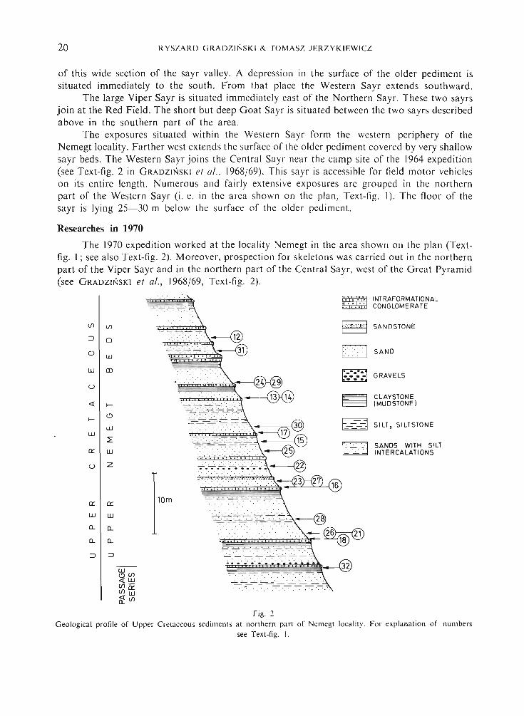
Fig . :2
Geological profile of Uppcr Cre taceous sediments at northern part of ernegt loca lity. For expla na tion of numberssee Text-fig. I.

Geology
ADDITIO NA L GEOG RA PHICA L AND GEOLOGICA L DATA 21
The exca vations in the northern part of the locality Nemegt were carried out only inthe Upper Nemegt Beds. These bed s were described elsewhere (GRADZINSKI et al. , 1968/69,pp. 40-42; GRADZINSKI , 1970). The deposits of the Passage Serie s and of the overlying bedsa re exposed in th e region of the Northern Sayr in the are a sho wn on the plan (Text-fig. I).Thei r total exposed th ickness amounts to ea. 40 m. Only the bed s overlying the Pa ssage seriesare exposed in the Western Sayr ; their visibl e thickness amounts to ea . 30 m.
All of the 15 fragments of dinosaur skeletons excavated in thi s locality a t sites shownon the plan were found , with one exception, in sa ndy deposits. In four ca ses the bones occurredin fine-grained sa nd s with inclined strat ificat ion. In the remaining cases the dinosaur boneswere found in fine- and medium-grained sa nds, containing sigle silts tone fragments or thinlenses of intraformational conglom erates. Onl y the specimen of Sa uroloplius angustirostris(No. 28) occurred partly in a sandy deposit and partly (a min or part of the skeleto n only)in siltstone. This part of the skeleton was in a distinctly poorer sta te of pre ser vation.
Observat ion s carried out during th e 1970 expedit ion suggest that in the region of theViper Sayr within the Passage Series th e deposits of the lithological type of the U pper NemegtBed s pa ss lat erally into deposits of th e Lower Nemegt Bed s type . In th e region of the NorthernSayr and in the northern part of the Central Sayr fairl y numerous small gastropod shell sand fish remain s were found in sandy siltstones.
Detailed ob servations led to the conclusion that trace fossils pre sent in the U pper NemegtBeds are in fact more diversified th an it was described by GRADZINSKI (1970 , p. 222).
SO UTH-EASTERN PART OF TH E LOCALITY NEMEGT
Location and morphology
Prospection for fauna was carried o ut in th is part of th e locality Nemegt in two areas(Text-fig. 3). The first on e comprises the southern slopes of the Red Wall s and the isolatedhills situa ted immediately south-east a nd called Red M onadnocks. This area is shown byGRADZINSKI et al . (1968 /69, Text-fig. 2). Appro ximate geog ra phic coordinate s of thi s areaare : 101°4 ' longitude E and 43°30'20" latitude N, and the altitude is c. 1500 m above sea level.The described hills are situated in th e northern part of the Sak saool Field extending NW-SE.Their height amounts to 10-20 m and the slopes arc st ro ngly di ssected by sma ll eros iona lform s.
Th e second prospected area comprises the iso lated hills call ed Southern Monadnocks,situated 3-4 km SSE of the Red Walls, near th e conjunction of the Western , Northern andEastern Sayrs into one Broad Sayr. Th e majority of the se hills lie eas t of thi s say r. The approximate geographic coordinates of thi s area are 10I05' longitude E and 43°29' latitude N,and the altitude is ea . 1450 m above sea level. Th e height of the hill s above the floor of thesayrs ranges from 10 to 35 m. The slopes of the hills are dissected by numerous erosionalform s : furrows, sho rt ravines and recesses.

22
Geology
R YSZA RD G RA DZINS K I & TOMASZ J ERZYK IEWICZ
Fig. 3Map o f so uth-eas tern part of locality N crncgt . For mo rpho logica l explanat ion sec Text-fig . I.
Fi rst prospect ion for fa una was carried out in th ese area s in 1965 (see GRAD ZI NSKI et al.,1968/69 , p. 40), work was continued 1970 and 1971 . In Southern a nd Red Monaanocks mammalskulls, lizards, d inosau r eggs and tortoise remains ( MLY NARS KI , 1972) were found .

A DD ITIONAL GEOG RA PH ICAL AND GE OL OG ICAL DAT A 23
Lower Nemegt Bed s a re exposed in the so uth-eastern part of the locality Nemegt (GRA
DZI NSKI et al.. 1968/69: GRADZI NSKI, 1970). They co nsist of fine-grained poorly cementedsa nds to nes with rare int ercalati on s of sandy mud ston es. The sandsto nes have usually a br ick-redco lour, while th e mudston es a re o f a somewhat darker reddish-brown colour.
A fairl y d istinct thi ck hor izontal bedding is visible in th e Lower Nerncgt Bed s nearth e Red Wall s. Large-scale tabular cro ss-bedded units (lim its fo r size cla sses o f cro ss-beddingunits afte r GR UMBT 1969) a re pre sent in o utc ro ps situated farther so uth (So uthern Monadnock s), beside thick hori zontally layered or ma ssive sa nds to ne bed s. Numerous beds orred-brown siltsto nes a lte rna ting with sa nds to ne bed s a re present in the bluffs in th e easternpart of the Southern Mon adnock s. Th e upper surfaces of th ese silts to ne bed s are often loaddeformed, and sometimes a total disruption of sa ndstone bed s separat ing the siltsto nes hasled to the formation of isolat ed o blong sands to ne bodies and ball s inside th e silts to nes (seeANKETELL et al., 1970).
LOCALITY KH ULSAN
Location and morphology
The exposures a t thi s local ity a re situa ted c. 6 km ESE of th e locality Nemegt. Someof them have been design at ed as "E Nernegt " by GRADZI NSKI (1970, Text-fig. I). Presentlythese expos ures a rc give n a separa te name der ived fro m a near-byclosed depression . The majorpart of the exposures is concentrated in th e a rea with coordinates 10I°07'- 10I°09' longitude Eand 43°28'-43°30' lat itude N, at an a lt itude of 1400-1450 m above sea level. The exposuresar e situated on th e slopes of Broad Sayr va lley. Th is broad sayr design ated as the Main Sayr(see Text-fig. 4) run s approxi ma te ly North-South , is jo ined by severa l smaller ones, and turnsto ESE in the southern part of the discu ssed area . The va lley of the Main Sayr is asymmetric.East of the Main Sayr the slopes are gentle a nd co vered by an almos t continuous blanketof recent desert sed iment. Outcrops of Cretaceous rock s in thi s part of th e locality are smalland rare.
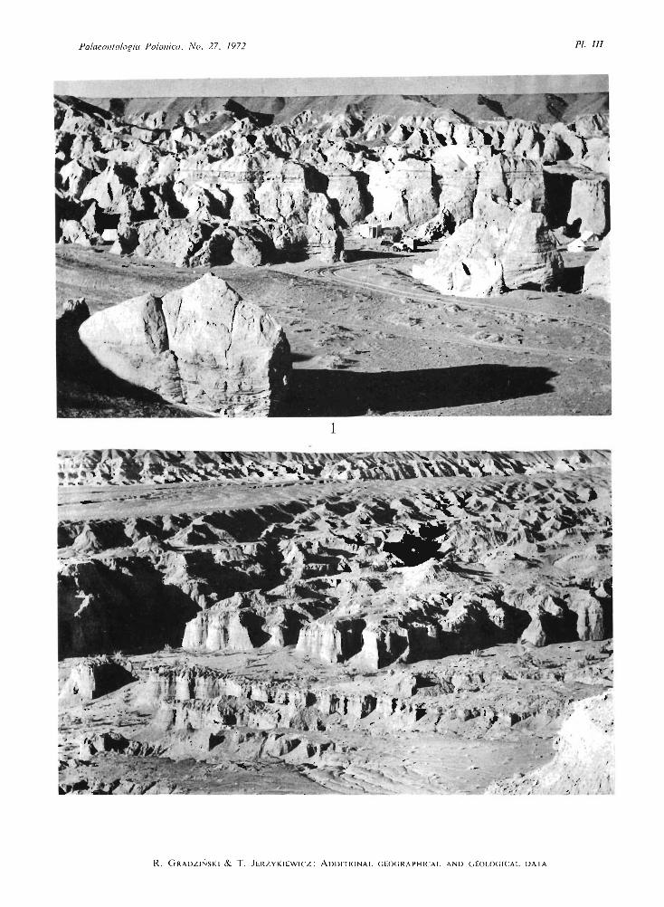
The western slo pes of the Khulsan Valley have a more div ersified morphology. Theolder pediment ha s been dis sected by numerous sma ller sayrs which join the Main Sayr fromthe North-West. A part of the western slope of the Khulsan Valle y is separated from the olderpediment by a continuous escarpment up to 25 m high. Differentiated erosional retreat of thisescarpment to the North-West ha s led to the formation of numerou s ravin es with wall formedof Cretaceous sands to nes . Small tabl e mountain s p reserv ed in front of the esca rpment havethe top surfaces co vered by desert pavement whil e smaller mound-shaped isolated hill s withsteep walls are entirely co mposed of Cretaceous sa nds to nes. They form a ch aracteristic morphologic element of the Khulsan locality (P I. Ill , F ig. I).
Geology
At the Khulsan local ity occur the Lower Nemegt beds developed as pale- red, fine-grainedsandstones with ra re interca lations of red-brown siltstones (Te xt-fig . 5). Conglomerates arerare, and consist chi efly of intrabasinal pebbles of redeposited siltstones. Cherts and effusiverock s predominate among exo tic pebbles, The pebbl es a re dispersed within the sandstone

24
o1
R YSZA RD G RA DZ I SKI & TO MA SZ JERZY KI EWICZ
::,\ I~
/ / ,'
, \ f.,.. --;
'" ~%;:~;;\ I~
' I'-
l kmI
Fig. 4Map of locality Khu lsan. For mor phological explana tion see Text-fig. I. Excava ted fauna indicated by numbers : 1 lower jaw of Protocerutops sp. : 2 - fragm entary skeleton of a sma ll theropo d dinosaur ; 3 - skeleton of a lizard :4 and 5 - two skulls of sma ll ind ividua ls of Prot ocerat ops sp. : 6 - part ia l skull of an ankylosau rid dinosaur ; 7 tortoi se : 8 - par tial skeleton of a small theropod dinosaur : 9 - severa l sku lls and par tia l postcranial skeletons ofamphislaenid lizard s : 10 - skull of a pach ycephalosaurid dinosaur ; 11 - a skeleton with skull of an ankylosaurid
din osaur ; 12 - skeleton of a lizard .

ADDITIONAL GEOGRAPHICAL AND GEOLOGICAL DATA 25
bed s or form agglomerations with indistinct boundaries. Occasionally the pebbles are con centrated within erosional channels.
The sandstone bed s are ma ssive, horizontally st ratified or cross-stratified. Tabular crossstratification is present in thick bed s, while through cross-stratification (see McKEE & W EIR,
1953) occurs in thinner one s.
A
GRAVEL OR CONGLOMERATE
B
V.:·<·.:·'] SAND OR SANDSTONE (MASSIVE OR HORIZONTAL BEDDED)
p·t::::<.:l SAND OR SANDSTONE (CROSS - BEDDED)
rill SILTSTONE OR CLAYSTONE
!Ill SILTSTONE OR CLAYSTONE WITH LOAD STRUCTURE:'
Fig. 5Geol ogical profile s of Upper Cretaceous scd irncnts of Khul san localit y. For exp lana tion of numbers see Text-fig. 4.
The siItstone beds are ranging in thickness from severa l cm up to ea. 50 cm. Usuallythe y are wedging out on the length of several ten s of metres, and sometimes the upper surfacesof bed s display distinct wash-outs. Besides the deformational st ructures mentioned in thedescription of the siItstones from the Southern Monadnocks locality, desiccation cracks arelocally present on the upper surfaces of siltstone beds. Numerous examples of these structuresoccur in the vicinity of Northern Cliffs.
The Lower Nemegt Beds exposed in the Khulsan locality are usually po orl y cemented.Zones of calcareous cementation are rare and occur in the form of tough sa ndstone beds,or as oval-shaped bodies of tough sandstone reaching a few m in diameter distinctly standingout in semi-loose sands tone. Small white calcareous concretions are much more commom.
One short reconnaissance of the area with no posit ive results was carried out in 1965.During 1970 and 197I expeditions the skull of pachycephalosaurid dinosaur, the skull withthe anterior part of the trunk of an ankylosaurid dinosaur, numerous lizards, tortoises skullsof mammals, diplopodes and dinosaur eggs were found in thi s locality.

26 R YSZARD G RADZ lN SKl & TOMASZ J ER Z YKl EWlCZ
LO CALITY KHERMEEN TSAV
Location and morphology
The Khermecn Tsav Valley forms one of the largest areas of exposure of Cretaceousrocks known in Mongolia. It lies South-West of the Nemegt Basin. The coordinates of thecentral part of the valley are approximately 99°45' longitude E and 43°15' latitude N. Thealtitude is ea . [200 m above sea level.
The pedim ent is dissected here by very numerou s sayrs coalescing into a large valleyextending WNW-ESE (Text-fig. 6). Th e width of the valley between the Northern Outcropsand the Southern Outcrops is ea. 5 km. Th e length of the largest say r designated as the CentralSayr exceeds 15 km. Th e depth of the Khermeen Tsav valley measured along the profile A(see designation on Text-fig. 7) amo unts to ca . 100 m.
Th e morphology of the Kherm een Tsav Valley is diversified (PI. Ill , Fig. 2). The mainvalley branches into num erous ravines with steep wall s and minor- valleys with step-shapedslopes. Mon adnocks of various sizes and usually steep slopes are common . The top sur facesof the monadnocks lying at var ious altitudes. and the co rresponding flat zones on the valleyslopes clearl y indi cate severa l phases of eros ion.
®
PEDIMENT
2kmI
Fig. 6Ske tch-map of localities Kh ermeen Tsav I a nd [I. Designat ions: A, B, C correspond to geo logica l p rofiles in
Text-fig. 7. For morpho logica l explana tion sce Text-fig. I.
History of research
Kh ermeen Tsav valley has been discovered by D r. R. B ARSBOLD and Dr. V. S. Z HE
GALLO in 1969 during the work of the Soviet-Mongolian Palaeontological Expedition. Themembers of the Polish-M ongolian Expedition visited thi s locality in 1971 at three occasio ns.

ADDITIONAL G EOGRAPHICAL AND GEOLOGICAL DATA 27
During these excursions Cretaceous sed iments exposed some 10 km North-East of the CentralSayr of Khermeen Tsav I were discovered and prospected. We de signated these o utc ro psKhermeen Tsav 11 (see Text-fig, 6).
Geology
The slopes of the Khermeen T sav Valle y are built of three lithologic complexes : th eLower White Beds, which form the ba se of the exposed seq uence, and cropp o ut in the CentralSayr on a st retch of ea . 1.5 km ; the Red Beds, forming the middle part of the slopes alongthe entire va lley, and the Upper White bed s, forming the upper part of the slopes in the centraland eastern part of the valley (see Text-fig, 7). All these complexes are lying nearly horizontally.
The Lower White Beds are ea . 30 m thick and consist of alternating sa nds tones , siltsto nes and conglomerates . The bed thickness ranges from severa l ten s of cm to 2 m. The sa ndstones are usually trough-cross st rat ified. The dimen sions of the cross-stratification rangefrom ripple to medium scale . As a rule, the sandstone bed s are wedge-shaped . Set s of sandston ebed s are alternating with thinner beds of siltstones and of intraformational conglomerates.The top and ba se surfaces of the silt stone bed s are sha rply marked . Wa sh-outs and loaddeformations are common and the bed s a re rapidly wedging out. Layers and len ses of con glomerates with undi stinct outlines occur either within , or at the ba se of sa nds tone bed s. Theconglomerates consist of intrabasinal pebbles. The largest pebbles up to 30 cm in diameterare composed of red-brown silts to nes, while pebbles of sa ndstone, and of light-coloured siltstone are smaller, Various deformational st ruct ures similar to those de scribed by GRADZINSKI
(1970) from the U pper Nemegt Beds are present in the Lower White Bed s. Recumbent fold sin cross-statified sa ndsto nes and convolute lamination in siltsto nes a re the most common .
The Red Bed s are ca. 50 m thick . They differ from the underlying Lower White Bedsby the following sed imenta ry features: I) the sandstones predominat e markedly oversiltstones and conglomerates, 2) the thickness of the sa ndstone bed s is greater, ranging upto severa l m , 3) individual sandstone and silt stone beds can be traced on distances of severa lhundred m, 4) the bedding planes are indistinct, 5) cross-stratification , predominantly of th elarge-scale planar type, occurs rarely; horizontally layered and ma ssive bed s are common,6) the conglomerates a re fine-grained and composed of pebbles of exotic rocks, intraformationalconglomerates are rare , 7) deformational st ru ctures are rare, 8) trace fossils in the form ofsed iment-filled tubes are common.
The Red Beds show a certain degree of facial differentiation within the Khermeen Tsavlocality. In the profile Khermeen T sav 11 the thick-bedded sa nds to nes are orange-col ouredand numerous intercalations of light-coloured (white, yellow, pale-red and bluish-green)thin-bedded silt stones and claystones are present (see Text-fig. 7, ProfileB-).
The Upper White Beds are 10-20 m thick. A bed of variegated , fine-grainedconglomerate, 0.5 m thick forms the ba se of these bed s (see Text-fig. 7 - profile C) . Th econglomerate is composed principally of poorly rounded pebbles of exotic rocks. The conglomerate is overlain by pale-yellow, thin-bedded fine-grained sands to nes showing smalland medium-scale cross-stratification. Rare layers and len ses of intraformational conglomeratespresent within the sa ndsto nes are composed of pebbles of light-coloured silts tones.
The Polish-Mongolian Expedition in 1971 collected fo ssils onl y in Red Bed s withoutconducting the excavatory work . From these beds in both Khermeen Tsav I and KhermeenT sav Jl numer ou s fragmentary skeletons of Prot oceratops sp., fragmentary ske letons of sma ll

2X RYSZARD GRADZ INSK I & TOM A SZ JERZYKI EWICZ
owo-c
w
a:
o
A:r:3~0:: W - - - -- -wCDQ.Q.::>
oui
CD
o
w
0::
B c
a:w0-
lfl0ui
0- CD IOrr
::J UJ>-:r:3
0::w30-'
O O OQ " o ~o
f') Q " o .
: <,:.:':'::",-:. .- ---
Fig. 7Geological profiles of Upper Cretaceous sed iments of localities Khermeen Tsav I and 11. For lithological explanationsee Text-f ig. 5. The position o r the profiles A. B. C is shown on Text -fig. 6. The a rro ws on profiles A and B indicate the
horizons in which mamm als were rou nd.
ADDITIONAL GEOGRAPHICAL AND G EOLOGICAL DATA 29
carnivorous dinosaur, numerous dinosaur eggs, lizards and skull of mammals were collected.The majority of fossils was collected from the orange sa ndsto ne in Khermeen Tsa v 11. Thepreliminary investigation of mammals found in Khermeen Tsav I and I [ led Prof. Z. KIELA NJAWOROWSKA (in KIELAN-JAwOROWSKA & BARSBOLD, [972) to the conclusion that Red Sandstone of Khermeen Tsav I and 11 is contemporaneous with the Lower Nemegt Beds of Nemegtand Khulsan, being probably of Campanian age .
LOCALITY TOOGREEG
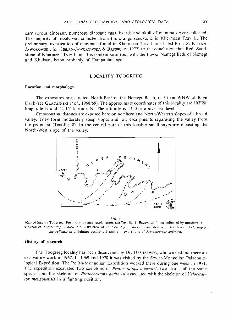
Location and morphology
The exposures are situated North-East of the Nemegt Basin, c. 30 km WNW of BaynDzak (see GRADZINSKI et al., 1968/69). The approximate coordinates of this locality are 103°20'longitude E and 44°15' latitude N. The altitude is 1150 m above sea level.
Cretaeous sandstones are exposed here on northern and North-Western slopes of a broadvalley. They form moderately steep slopes and low escarpments separating the valley fromthe pediment (Text-fig. 8). In the central part of thi s locality small sayrs are dissecting theNorth-West slope of the valley.
CAMP.&
19716)
~ND ~DUNE ~
Fig. 8Map of localit y Toogreeg, Fo r morphological explanation. see Text-fig. I. Excava ted fauna indicat ed by numbers : 1 skelet on of Protoceratops andrewsi : 2 - skeleton of Protoceratops andrewsi associated with skeleton of Velociraptor
mongoliensis in a fighting position : 3 and 4 - two skulls of Protoceratops andrewsi.
History of research
The Toogreeg locality ha s been disco vered by Dr. DASHZEWEG, who carried out there anexcavatory work in 1967. In 1969 and 1970 it was visited by the Soviet-Mongolian Palaeontological Expedition . The Poli sh-Mongolian Expedition worked there during one week in 1971.The expedition exca vated two skeleto ns of Protoceratops andrewsi, two skulls of the samespecies and the skeleton of Proto eerat ops andrewsi associated with th e skeleton of Velociraptor mongoliensis in a fighting position.

30
Geology
R YSZARD G RAD Z IN S K I & TOMASZ J ERZYKI EWI CZ
The slopes of the Toogreeg Valle y are built of poorly cemented white , fine-grained sandstones. Megascopic sed imenta ry st ructures are usually absen t , and only rarely medium- orlarge-scale cross-bedded units of tabular type can be seen. The sa ndstones contain very numerous oval or flat bodies of tough sa ndsto ne co vered by ferrugineous de sert varnish andregular horizons of ferrugineou s cementation developed within sa nds to ne bed s. These horizonsfollow sometimes the planes of cross-stratification . but in mo st ca ses are developedindependently and cross the stra t ificat io n planes.
Polish Aca demy of S cienceslnstitut e of Geologica l Sciences
Geological Lab orat oryKrakow, September 1971
R EF ER E NC ES
Polish Academy of Sc iencesInstitute of Geological Sc iences
Geological Lab orat oryWroc/a ll', September 1971
A NKETELL, J . M .. C reilA . J . & DZULyNSKI. S. 1970. O n th e defo rmat ional st ruc tures in sys te ms wi th reverse d density
gra die nt. - Rocz nik Pol . Toll'. Gcol., 40 , 3-30 . Kr ak ow.
GRADZINSKI, R. 1970. Sedimen tatio n of d inosau r-bearing Uppe r C re ta ceous dep o sit s o f the Ne rnegt Basin , G obi Dese rt.
Results Poli sh -M ongol. Pal aeont. Ex ped .. 11 . - Palaeont . Pol.. 2 1. 147-229, Warsza wa . -
G RA DZINS KI. R. , K AZMI ERCZAK, J . & LErEU J. J. 1968/69. Geog ra p hica l a nd geo logica l data from the Poli sh -Mongolian
Pal aeontol ogical Ex ped it io ns. Result s ... , I. - Ibidem 19, 33-82.
GR UMIlT, E. 1969. Beziehungen zwisc hcn Korngro ssc, Sch ichtung. Mate r ialbestand und a nderen sed irncntologischcnMcrk mal en in fein kla stisch en Sedimenten. - Geologic, 18. 75-99, Berl in .
KI ELAN-JAWOROWSKA, Z . & DOVCHlN. N . 1968/69. Na r ra t ive o f th e Poli sh -M ongoli an Pal ae ontol ogi cal Ex ped itio ns
1963-1965. Results .. ., I. - Palueont . Po!. , 19, 7-30, W arsza wa .
KI ELAN-J AWOROWSKA. Z . & BARSIlOLD, R . 1972 . Na rra t ive o f th e Pol ish -M ongoli an Pal ae ontol og ical Exped it io ns 1967
1971. Results .. .. IV. - Ibidem , 27, 5- 13.
McK EI'. E. D . & W EIR, G . W . 1953. Te rm ino logy for st ra t ifica t io n a n d cro ss-stratification in sed imen ta ry ro ck s.
Bull , Geol, So c. A mer ., 64, 381- 390 , New Yo rk.
M I. y:--:A RSKI. M . 1972. Za nge riia test ud in im o rpha n . gc n ., n . s p., a primitive land to rtoise fro m th e U p per Cretaceous
o f Mo ngo lia . - Result s .. ., IV. - Pa laeont. Pol. , 27, 85-92 . Warszawa .

PLATES

Palaeontologia Polonica, No. 27, 1972
R . GRADZINSKI & T. JERZYKIEWICZ : ADDITIONAL GEOGRAPHICAL AND GEOLOGICAL DATA
PLATE III
Page
Fig. I. Locality Khu lsan - fragment of the western slope of the valley in the vicinity of the camp. Lower NernegtBeds . . . . . . . . . . . . . . . . . . . . . . . . . . . . . . . . . . . . . . . . . . 23
Fig . 2. Localit y Khermeen Tsav I - eastern part of the valley. Nor thern outcrops in the background . . .. 26
Photo: T. Jerzykiew icz
Palaeontologia Polonica, No , 27, 1972 PI, /1/
1
..,.. ..•"-:!..'.
.. ' -. , / . . / ,
." I~ , J
R. GRADZINSK I & T. J ERZ Y KIEWI CZ : ADD ITIONAL G EOG RA PH ICA L A ND G EOLOG ICA L D A TA