adopted by mayor and council – june 7, 2005 - resolution 20101 · adopted by mayor and council...
TRANSCRIPT

Houghton Area Master Plan DRAFT February 1, 2005
Page 0 of 64
Adopted by Mayor and Council – June 7, 2005 - Resolution 20101
HEARINGS Mayor and Council – June 7, 2005
Planning Commission – March 30, 2005 and April 6, 2005
Questions about this document can be directed to: Department of Urban Planning and Design
345 East Toole Avenue Tucson, Arizona 85701
www.ci.tucson.az.us/planning (520) 791-4505
Este documento se publica en inglés solamente. Las personas de habla hispana pueden llamar al Departamento de Planeación y Diseño Urbano del gobierno de la Ciudad de Tucson para solicitar asistencia en la traducción de este documento. Favor de llamar al número de teléfono (520)791-4505, o visite nuestras oficinas ubicadas en 345 East Toole Avenue, Tucson, Arizona, 85726
Houghton Area Master Plan DRAFT February 1, 2005
Page 1 of 64
Houghton Area Master Plan
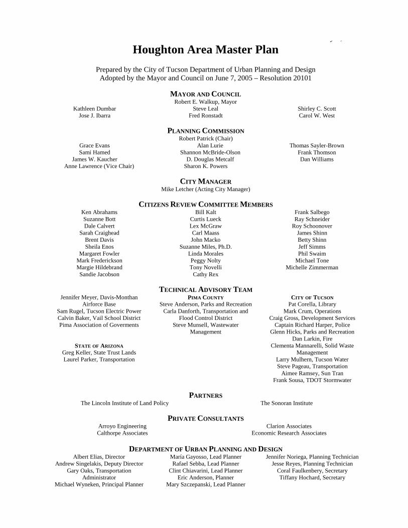
Prepared by the City of Tucson Department of Urban Planning and Design Adopted by the Mayor and Council on June 7, 2005 – Resolution 20101
MAYOR AND COUNCIL
Robert E. Walkup, Mayor Kathleen Dumbar
Jose J. Ibarra Steve Leal
Fred Ronstadt Shirley C. Scott Carol W. West
PLANNING COMMISSION
Robert Patrick (Chair) Grace Evans Sami Hamed
James W. Kaucher Anne Lawrence (Vice Chair)
Alan Lurie Shannon McBride-Olson
D. Douglas Metcalf Sharon K. Powers
Thomas Sayler-Brown Frank Thomson Dan Williams
CITY MANAGER
Mike Letcher (Acting City Manager)
CITIZENS REVIEW COMMITTEE MEMBERS Ken Abrahams Suzanne Bott Dale Calvert
Sarah Craighead Brent Davis Sheila Enos
Margaret Fowler Mark Frederickson Margie Hildebrand Sandie Jacobson
Bill Kalt Curtis Lueck Lex McGraw Carl Maass John Macko
Suzanne Miles, Ph.D. Linda Morales Peggy Nolty Tony Novelli
Cathy Rex
Frank Salbego Ray Schneider
Roy Schoonover James Shinn Betty Shinn Jeff Simms Phil Swaim
Michael Tone Michelle Zimmerman
TECHNICAL ADVISORY TEAM
Jennifer Meyer, Davis-Monthan Airforce Base
Sam Rugel, Tucson Electric Power Calvin Baker, Vail School District Pima Association of Goverments
STATE OF ARIZONA Greg Keller, State Trust Lands Laurel Parker, Transportation
PIMA COUNTY Steve Anderson, Parks and Recreation
Carla Danforth, Transportation and Flood Control District
Steve Munsell, Wastewater Management
CITY OF TUCSON Pat Corella, Library
Mark Crum, Operations Craig Gross, Development Services
Captain Richard Harper, Police Glenn Hicks, Parks and Recreation
Dan Larkin, Fire Clementa Mannarelli, Solid Waste
Management Larry Mulhern, Tucson Water Steve Pageau, Transportation
Aimee Ramsey, Sun Tran Frank Sousa, TDOT Stormwater
PARTNERS
The Lincoln Institute of Land Policy The Sonoran Institute
PRIVATE CONSULTANTS Arroyo Engineering Calthorpe Associates
Clarion Associates Economic Research Associates
DEPARTMENT OF URBAN PLANNING AND DESIGN
Albert Elias, Director Andrew Singelakis, Deputy Director
Gary Oaks, Transportation Administrator
Michael Wyneken, Principal Planner
María Gayosso, Lead Planner Rafael Sebba, Lead Planner
Clint Chiavarini, Lead Planner Eric Anderson, Planner
Mary Szczepanski, Lead Planner
Jennifer Noriega, Planning Technician Jesse Reyes, Planning Technician
Coral Faulkenbery, Secretary Tiffany Hochard, Secretary
Houghton Area Master Plan June 7, 2005
Page 1 of 64
Contents I. INTRODUCTION .............................................................................................................................................3
A. HOUGHTON AREA MASTER PLAN (HAMP) AREA .......................................................................................5 B. THE PURPOSE OF THE HAMP .......................................................................................................................7 C. EXECUTIVE SUMMARY ..................................................................................................................................8
II. EXISTING CONDITIONS ............................................................................................................................. 10
III. PLANNED COMMUNITIES – COMPREHENSIVE LAND PLANNING FOR URBAN DEVELOPMENT ........................................................................................................................................... 12
A. THE CHALLENGE ......................................................................................................................................... 12 B. A NEW ALTERNATIVE: PLANNED COMMUNITIES ...................................................................................... 13 C. PLANNED COMMUNITIES IN THE HAMP AREA.......................................................................................... 14
IV. STRATEGY FOR FUTURE DEVELOPMENT OF THE HAMP AREA ................................................ 16
A. FUNDAMENTAL THEMES OF THE HAMP .................................................................................................... 16 B. LAND USE .................................................................................................................................................... 17
1. Planned Community ................................................................................................................................ 17 2. Town Center ............................................................................................................................................ 21 3. Village...................................................................................................................................................... 23 4. Village Center .......................................................................................................................................... 24 5. Neighborhood .......................................................................................................................................... 25 6. Neighborhood Center .............................................................................................................................. 26
C. CIRCULATION AND MOBILITY .................................................................................................................... 28 1. Major Streets ........................................................................................................................................... 29 2. Collector and Local Streets ..................................................................................................................... 31 3. Transit Opportunities .............................................................................................................................. 33 4. Pedestrian-Friendly Environment ........................................................................................................... 33 5. Bicycle-Friendly Environment ................................................................................................................. 34
D. ENVIRONMENTAL AND CULTURAL RESOURCES ......................................................................................... 36 1. Open Space .............................................................................................................................................. 37 2. Basin Management Plan .......................................................................................................................... 38 3. Water Resources ...................................................................................................................................... 40 4. Energy Resources .................................................................................................................................... 40 5. Cultural Resources .................................................................................................................................. 41
E. PUBLIC SERVICES, FACILITIES, AND UTILITIES ......................................................................................... 42 1. Parks, Trails and Recreation ................................................................................................................... 43 2. Schools ..................................................................................................................................................... 47 3. Tucson Fire Department .......................................................................................................................... 48 4. Tucson Police Department ...................................................................................................................... 48 5. Libraries .................................................................................................................................................. 49 6. Public Administration Facilities .............................................................................................................. 49 7. City of Tucson General Services .............................................................................................................. 49 8. City of Tucson Utility Services................................................................................................................. 49 9. Public Communication Facilities ............................................................................................................ 50 10. Public Utilities ....................................................................................................................................... 52
F. COST OF SERVICE ........................................................................................................................................ 53 G. IMPLEMENTATION ....................................................................................................................................... 55
GLOSSARY ............................................................................................................................................................. 57

Houghton Area Master Plan June 7, 2005
Page 2 of 64
List of Exhibits Exhibit 1 – Location Map .............................................................................................................. 4 Exhibit 2 – Project Area and Surrounding Elements..................................................................... 6 Exhibit 3 – Constraints Map ........................................................................................................ 11 Exhibit 4 – Components of a Planned Community ..................................................................... 15 Exhibit 5 – Conceptual Land Use and Circulation Map .............................................................. 19 Exhibit 6 – Cross-Section for Major Streets................................................................................ 32 Exhibit 7 – Parks and Trails Map ................................................................................................ 35 Exhibit 8 – 100-Year Floodplain and Riparian Habitat Map ...................................................... 39 Exhibit 9 – Parameters of Park Size, Service Area Radius and Operational Difference ............ 46 Exhibit 10 – Potential Public Facilities Location Map ................................................................ 51 Exhibit 11 – General Implementation Process ............................................................................ 56
List of Appendices Appendix A – Analysis of Existing Conditions Appendix B – Growing Smarter at the Edge Report Appendix C – Market Conditions Report
Houghton Area Master Plan June 7, 2005
Page 3 of 64
I. Introduction Within the next decades, significant urban growth is expected along the Houghton Road corridor in southeast Tucson. The Houghton Area Master Plan (HAMP) area (see Exhibit 1 –Location Map), which is largely undeveloped south of Irvington Road, offers an opportunity to plan and develop a place where people can enjoy a comfortable environment in which to work, raise children, retire, enjoy being with friends, be close to nature, and pursue a healthy lifestyle. In 1998 and 2000, the Arizona State Legislature adopted the first significant planning legislation to be enacted in the state in over 20 years: the Growing Smarter and Growing Smarter Plus Acts. These laws require communities to identify growth areas, and to establish strategies and policies so that new growth will pay its fair share of the public facilities needed to serve it. The City of Tucson’s General Plan, approved by voters in 2001, identifies the HAMP area as one of four distinct growth areas in the City, where the Desert Village model (further explained in Chapter III) has been established as the future land use pattern. The City of Tucson, through its Department of Urban Planning and Design, spent over two years preparing this document to guide growth and development in the HAMP area. This process involved close collaboration with the State of Arizona, Pima County, the Sonoran Institute, a Citizens Review Committee, a Technical Advisory Team, and private consultants. The continued cooperation between agencies and citizens will permit the HAMP to serve the near and long-term values and visions of Tucson’s residents. The Citizens Review Committee (CRC) was comprised of individuals who represent a broad spectrum of issues and interests from across the city. These interests included registered neighborhood associations surrounding the HAMP area, Saguaro National Park, area business owners, the development industry, finance and banking interests, architects and development consultants, the environmental community, and others. The CRC reviewed the information presented to them by the City of Tucson, and provided comments that were taken under advisement by the City and analyzed within the context of the General Plan and the overall purpose of the HAMP. The Technical Advisory Team (TAT) was comprised of representatives of various City of Tucson and Pima County Departments, by the Arizona State Transportation and Land Departments, the Vail School District and by private utility companies. The role of the TAT was to address the technical and operational issues associated with providing future service to the HAMP area.
Citizens Review Committee Meeting
The General Plan identifies the HAMP area for future growth to be master planned, where the Desert Village model has been established as the future land use pattern.

Houghton Area Master Plan June 7, 2005
Page 4 of 64
Exhibit 1
Location Map

Houghton Area Master Plan June 7, 2005
Page 5 of 64
The Sonoran Institute, with support from the Lincoln Institute of Land Policy, and in partnership with the City of Tucson, brought the consulting firms of Clarion Associates and Economics Research Associates to assist in the planning process:
• community case studies were researched to serve as lessons for successful development (see Appendix B – Growing Smarter at the Edge);
• a market assessment of the HAMP was produced, which includes assessment of the economic advantages of the Desert Village model, infrastructure and services cost assessment, revenue stream estimate and an assessment of economic advantage (see Appendix C – Market Conditions Report);
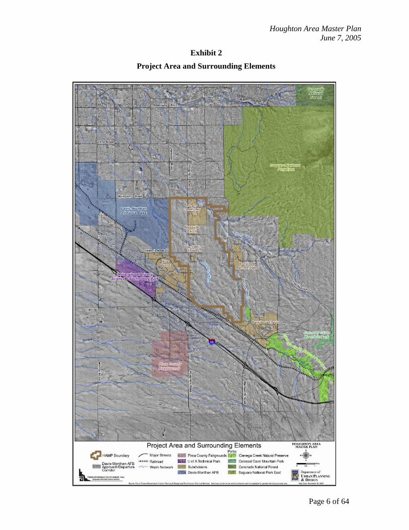
• assistance to City staff was provided in developing new tools for implementation. The Arizona State Land Department is drafting the Houghton Corridor Infrastructure and Environmental Assessment, a detailed analysis of the sizing and cost of infrastructure that will be needed if land within the HAMP area is to be developed. The HAMP is an Area Plan that represents the very first step for the master planning process of the area, as required by the General Plan. Within the HAMP boundaries, this document supercedes the land use policies provided by the South Pantano Area Plan (1984), the Esmond Station Area Plan (1986), and the Rincon Southeast Subregional Plan (1995-1998). Also, the Major Streets and Routes Plan will be amended to reflect the new major route alignments and cross-section, as defined in this document. A. Houghton Area Master Plan (HAMP) Area The HAMP area encompasses approximately 10,800 acres (16.9 square miles) of land along Houghton Road (see Exhibit 2 – Project Area and Surrounding Elements), representing seven and one-half percent (7.5 %) of the City of Tucson’s jurisdictional land area. It is bounded by Irvington Road on the north, the City of Tucson corporate boundary on the south – about one mile north of Interstate Highway 10 (I-10), the City of Tucson corporate boundary on the east – approximately three miles east of Houghton Road, and extends about one mile to the west. The largest single land owner is the Arizona State Land Trust, which owns 76% of the HAMP area (7,944 acres). All State Trust land is undeveloped and is not currently served by adequate public facilities. Pima County owns property (222 acres) clustered along the Pantano Wash near the Rincon Creek confluence. City of Tucson’s property (546 acres) is located in the northwest and southeast portions of the HAMP area. Though many of the private properties (1,846 acres) are developed, there are significantly sized undeveloped properties east and south of Civano (future Neighborhoods 2 and 3, currently in the process of being rezoned as Planned Area Developments), and in the southern portion of the HAMP area.
The Arizona State Land Trust is the largest single land owner in the HAMP area, and all of its land is undeveloped and inadequately served by public facilities.
Houghton Area Master Plan June 7, 2005
Page 6 of 64
Exhibit 2
Project Area and Surrounding Elements

Houghton Area Master Plan June 7, 2005
Page 7 of 64
B. The Purpose of the HAMP The HAMP is an Area Plan that establishes the policy and procedural frameworks necessary to guide growth and development within the area, in accordance with the City of Tucson General Plan. The Desert Village model promotes: land use patterns that include mixed-use centers to provide goods and services in proximity to residential areas; a variety of housing types that span a range of types and prices; mobility options including walking, bicycling, and riding transit; and sensitivity to the natural features of the desert environment. Policy guidance is provided in six elements:
• Land Use: provides the basic land use pattern envisioned for the area; • Circulation and Mobility: includes characteristics of street networks, expected features
of bicycle and pedestrian environments, and objectives for creating a transit-ready community;
• Environmental and Cultural Resources: considers the treatment of natural and cultural resources, stressing preservation and protection, as well as integration of natural features into the built environment;
• Public Services, Utilities and Facilities: addresses the consideration and provision of public facilities during the development process;
• Cost of Service: requires all development to provide 100% of the Capital Facilities sites, dedication, improvements and construction; and
• Implementation: establishes the general procedure to develop a given parcel within HAMP.
To achieve the purpose of developing the HAMP area using the Desert Village model, master planning should occur at larger scales. The Arizona State Land Department (ASLD) is both a stakeholder and partner in this process of balancing the fiduciary responsibilities of the ASLD (which is to realize the maximum return on the sale or lease of State Trust Land) with the long-range community values and fiscal responsibilities of the City. The ASLD is strongly encouraged to pursue large dispositions of Trust land of at least five hundred contiguous acres and provide
guidance to the purchasers of those tracts to engage in comprehensive master planning prior to the sales of smaller parcels for development. Owners of existing smaller parcels in the HAMP area are similarly encouraged to assemble additional land, or collaborate with adjacent property owners to ensure compatibility with the HAMP plan.
A minimum of 500 contiguous acres should be master planned at one time to achieve the purpose of the Desert Village model.
Houghton Area Master Plan June 7, 2005
Page 8 of 64
C. Executive Summary The Houghton Area Master Plan (HAMP) is an Area Plan. Policy direction for the HAMP study area is currently provided by the adopted Esmond Station Area Plan and the Pantano South Area Plan. Upon adoption of the HAMP the existing area plan boundaries will be amended to reflect the new Area Plan. The HAMP area consists of approximately 10,800 acres, of which approximately 7,740 acres are State Trust Lands, managed by the Arizona State Land Department (ASLD). Three different plans for the HAMP area have been developed since the adoption of the existing plans. Then Houghton Road Plan Associates presented a plan as a part of a disposition petition to the ASLD in 1999. In 2001, the State adopted its own plan for its land within the area. In 2001 the City of Tucson amended its General Plan, as required by Growing Smarter and Growing Smarter Plus, which called for master planning large tracts of land at the City’s edge. The Houghton Road Plan Associates plan, the ASLD plan and the City’s General Plan all shared similar concepts for the future development of the HAMP area. These plans also departed significantly in land use planning approaches from the adopted area plans. The HAMP contains many planning ideas originally proposed in the Houghton Road Plan Associates’ plan, the ASLD plan and the General Plan. The HAMP builds on these ideas to ensure adequate public facilities are planned to serve future populations. The HAMP, along with the Planned Community Development Zone (found in the Land Use Code), create the policy and regulatory basis for future development in the area. The plan goals support these fundamental values:
1. A variety of housing types and densities, which offer both affordability and livability.
2. A mix of uses within a compact development pattern, which integrates places for people to live, work, shop, and play within a cohesive system of Neighborhoods and Village and Town Centers.
3. A transportation and circulation system that offers residents alternatives for mobility, giving high priority to pedestrian, bicycle, and transit modes.
4. A regional open space system that preserves washes and environmentally sensitive areas as passive open space amenities, and offers active recreational opportunities such as trails and developed parks.
5. A long-term, phased approach to development, in order to provide for increased efficiency of infrastructure and services for residents.
The HAMP is a product of over two years of work by three significant groups working with the staff. The Citizen Review Committee (CRC) represented area property owners and a wide array of interests across the community and was instrumental in key policy decisions. The Technical Advisory Team (TAT) was composed of individuals representing City of Tucson departments

Houghton Area Master Plan June 7, 2005
Page 9 of 64
and other local jurisdictions and utilities, which have a future service and/or facilities interest in the HAMP. The Sonoran Institute, through a grant from the Lincoln Institute for Land Policy, brought together Clarion Associates and Economics Research Associates to provide extensive research and analysis for the planning process. The Sonoran Institute also played a significant role in the review of the HAMP, and the provision of maps and graphics for the document. Many of the products produced by these firms are included in the HAMP as appendices.
Houghton Area Master Plan June 7, 2005
Page 10 of 64
II. Existing Conditions The purpose of this chapter is to identify development constraints and opportunities in the HAMP area. Exhibit 3– Constraints Map, reflects a variety of significant natural and man-made features that may limit development in certain portions of the HAMP area, and identifies the most optimal land for development. The constraints considered are: areas subject to 100-year flooding (Arroyo Engineering assisted the City in the delineation of the 100-year floodplain and riparian habitat areas), riparian habitats, erosion control easement along the Pantano Wash, 138kV electrical transmission line easement, slopes over 15%, already-developed land, sand and gravel operations, and the Airport Environs Zone, as defined by the Tucson Land Use Code. For a more detail description of the existing conditions, see Appendix A – Analysis of Existing Conditions. For a more detailed discussion of the regional economic context, including population and employment trends, see Appendix C – Market Conditions Report, prepared by Economics Research Associates in July 2004.

Houghton Area Master Plan June 7, 2005
Page 11 of 64
Exhibit 3 Constraints Map

Houghton Area Master Plan June 7, 2005
Page 12 of 64
III. Planned Communities – Comprehensive Land Planning for Urban Development
The purpose of this chapter is to discuss the role of planned community development in the implementation of the HAMP. The HAMP area is unique as it contains large tracts of undeveloped land, which can be planned in a comprehensive manner. Examples of how master planned communities have been implemented throughout the west is documented in Appendix B – Growing Smarter at the Edge, which was prepared by Clarion Associates and Economics Research Associates in 2004 for the HAMP process. Examples of this strategy are the developments of Otay Ranch (San Diego, California), DC Ranch (Scottsdale, Arizona), and Verrado (Buckeye, Arizona). Two local examples are Rancho Vistoso (Oro Valley, Arizona) and Rancho Sahuarita (Sahuarita, Arizona). A. The Challenge Over the past 20 years, development within the City of Tucson has generally been conducted at the project level. New development does not necessarily integrate well with the city, other land uses, or surrounding neighborhoods. Infrastructure and community service planning is often reactive and incremental, with each individual project contributing to impacts with worsening problems occurring over a period of time.
Typical retail stores on Broadway Blvd. backing onto single-family homes
60% of Tucsonans rate land use planning and zoning as fair or poor in the city.
2001 International City/County Management
Association Resident Survey

Houghton Area Master Plan June 7, 2005
Page 13 of 64
The results of incremental development have included the following problems:
• Poorly managed access and extensive commercial development along arterial roadways, which has created significant congestion and safety issues on the city’s roads.
• Low density of development in the city, combined with strip development and decentralized destinations, has made mass transit difficult to maintain at successful levels.
• Homogeneity in residential development has resulted in a lack of housing options, which do not reflect the needs of a diverse community.
The ever-growing demand for public services and facilities, combined with the costs for public facilities maintenance and rehabilitation requires future developments to be designed with an emphasis on a more efficient urban form. B. A New Alternative: Planned Communities The planned community approach allows for the comprehensive planning of critical community elements, including circulation, drainage, and open space and recreation amenities. This context also allows for a more thoughtful integration of residential areas and business districts. It will also ensure that property values are maximized and balanced with developing costs. Planned communities have long build-out periods (10 or more years) and are a varied and evolving type of land development. As a result, they require flexible planning approaches. Planned communities typically require the following characteristics:
1. Large land holdings, usually under a single ownership, with a master developer establishing and controlling the master plan, which guides the integrated development of specific parcels by other developers and builders.
2. Location on the urban fringe where there is little existing development or infrastructure.
3. Wide range of activities, mix of land uses, housing types, and price ranges. 4. Community open space and preservation areas. 5. Consistent urban design and landscape standards. 6. Integrated circulation network which promotes mobility and transit use.
Residential street at Rita Ranch
Typical subdivision in Tucson

Houghton Area Master Plan June 7, 2005
Page 14 of 64
7. The systematic and financially responsible provision of services and facilities through phased, integrated, and timely construction of infrastructure.
The City of Tucson General Plan mandates a planned community approach to development, using the Desert Village model for large-scale master planning areas (see Exhibit 4 - Components of a Planned Community). This basic pattern of development is seen as a way to encourage transit use, reduce air pollution, improve delivery of public and private services, and create inviting places to live, work,
and play. The grouping and integration of commercial uses in mixed-use centers is a way to create a more livable, pedestrian-friendly community by making access to goods and services more convenient for residents. Increasing residential uses and density in and around mixed-use centers will establish a local market for commercial activity, in addition to providing housing opportunities for employees. C. Planned Communities in the HAMP Area In conformance with the Tucson General Plan, land uses in the HAMP area are structured in the following manner (see Exhibit 4 - Components of a Planned Community):
• A hierarchy of planning areas ranging in size and scale: Planned Communities, which are comprised of villages, which in turn are comprised of neighborhoods.
• A hierarchy of mixed-use centers ranging in size and scale: a town center that serves as a central organizing feature for a number of villages; village centers that serve as focuses for clusters of neighborhoods; and neighborhood centers that serve residents in the immediate area.
This basic pattern of development will encourage transit use, reduce air pollution, improve delivery of public and private services, and create inviting places. The grouping and integration of commercial uses in mixed-use centers is a way to create a more livable, pedestrian-friendly
People taking the bus at Laos Center
Bicyclists on a trail
Planned communities integrate commercial and higher-density residential uses in mixed-use centers.

Houghton Area Master Plan June 7, 2005
Page 15 of 64
community by making access to goods and services more convenient for residents. Increasing residential uses and density in and around mixed-use centers will establish a local market for commercial activity, in addition to providing a range of housing opportunities for employees.
Exhibit 4 Components of a Planned Community

Houghton Area Master Plan June 7, 2005
Page 16 of 64
IV. Strategy for Future Development of the HAMP Area
A. Fundamental Themes of the HAMP The HAMP provides guidance to developers for preparing master plans for Planned Communities, and a framework for review of these plans by the City. Due to the long-term nature of the development of Planned Communities, this criteria has been established to allow flexibility and phasing of development. The determination of the size and configuration of the villages, neighborhoods and mixed-use centers will be the responsibility of the master developer, based on projected population, land use, public facilities requirements, and other factors. Specific densities within planned communities will be established in the master plan, in accordance with the HAMP criteria. The following constitute the foundational values upon which the HAMP is structured:
1. A variety of housing types and densities, which offer both affordability and livability.
2. A mix of uses within a compact development pattern, which integrates places for people to live, work, shop, and play within a cohesive system of neighborhoods and village and town centers.
3. A transportation and circulation system that offers residents alternatives for mobility, giving high priority to pedestrian, bicycle, and transit modes.
4. A regional open space system that preserves washes and environmentally sensitive areas as passive open space amenities, and offers active recreational opportunities such as trails and developed parks.
5. A long-term, phased approach to development, in order to provide for increased efficiency of infrastructure and services for residents.
Houghton Area Master Plan June 7, 2005
Page 17 of 64
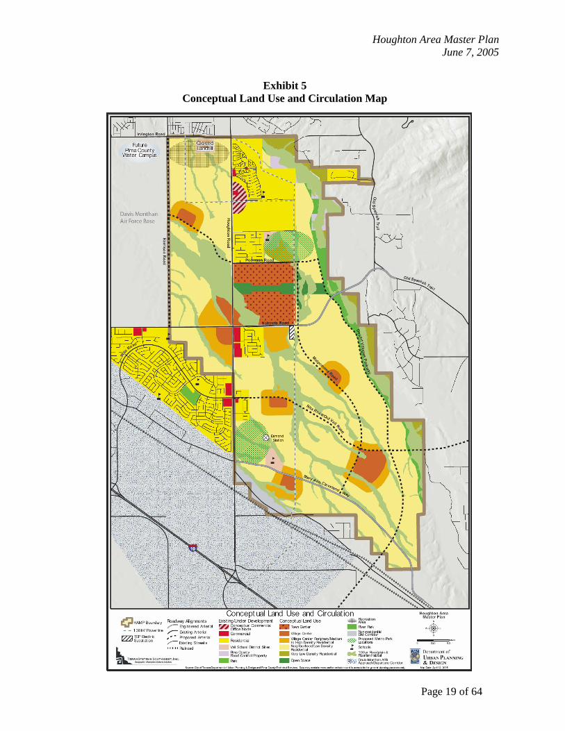
B. Land Use Land uses in the HAMP area should be organized and developed according to all policies of this document, following the land use distribution recommended in the Conceptual Land Use and Circulation Map (Exhibit 5). The Land Use element is organized according to the hierarchical planning areas and their respective mixed-use centers, and include introductory statements and guidelines organized according to the reoccurring fundamental themes mentioned in Section IV.A – Fundamental Themes of the HAMP. The following framework is intended to insure the basic structure and key attributes of the Desert Village model, in accordance with the General Plan, while providing enough flexibility to respond to evolving conditions and new information.
1. Planned Community A planned community typically consists of a cluster of villages with a sufficient population base to support community-scale civic and commercial services located within a town center. Each planned community should have a discreet identity defined by its context, a system of continuous open space, architectural design themes, or other distinguishing features. The land use mix within the overall planned community should promote a high degree of self-sufficiency. The fundamental themes of a planned community are: a) Variety of Housing: Housing diversity and pricing are important features of a planned
community, although the specific mix will be provided at the village and neighborhood scales. Providing residents of all ages and incomes with housing alternatives and choices will potentially strengthen communities by creating opportunities for residents to remain in an area despite their changing housing needs, and allowing local employees to live in closer proximity to their jobs.
The General Plan provides for a community-goal that ten percent of the City’s housing stock be affordable to families, and discusses the need for housing variety and affordability, including the recommendation that developers are encouraged to develop at least fifteen percent of all new units specifically as affordable housing. There is a unique opportunity in the HAMP to address issues of housing variety and affordability. There are several means by which to achieve General Plan goals through the development of master planned communities in the HAMP,
GOAL: To establish a framework for development of Planned Communities in the
HAMP area, while providing flexibility to accommodate demographic and economic changes that may occur over time.
Houghton Area Master Plan June 7, 2005
Page 18 of 64
including the use of incentives, such as expedited rezoning and development reviews and the provision of affordable housing as an important element and consideration when approving zoning changes in the HAMP area.
Residential densities should be high enough to support mass transit usage and commercial activities. Higher residential densities should be located within the town and village centers. Medium to high residential densities should be oriented around both the town center and village centers. Lower densities may be located further from the town, village and neighborhood centers. Very low densities may be appropriate in areas severely constrained by drainageways and/or environmental conditions.
b) Mix of Uses: A mix of uses should occur throughout a planned community.
Specific features include villages clustered around a town center, regional and metropolitan parks, and multiple high school sites. The mixing of uses is a consistent theme throughout the HAMP, and will occur at different scales and intensities. Anticipating the eventual needs of residents and reserving consolidated areas for commercial and non-residential uses will help to ensure that residents will have direct and convenient access to goods and services.
c) Mobility Options: Balancing regional and sub-regional travel patterns with safe and
efficient mobility alternatives for local residents is a critical issue. Transit opportunities, pedestrian and bicycle friendly environments, and interconnected street networks are all components of mobility, which should function cohesively while minimizing conflicts between automobiles and other modes of travel. An interconnected street network, in addition to a finer-grained mix of uses, will shift new development away from isolated, automobile dependent subdivisions, toward more cohesive and dynamic communities.
Houghton Area Master Plan June 7, 2005
Page 19 of 64
Exhibit 5
Conceptual Land Use and Circulation Map
Houghton Area Master Plan June 7, 2005
Page 20 of 64
d) Open Space: At the planned community scale, a continuous system of open space, provided at a large scale, can incorporate and preserve extensive riparian systems and environmentally sensitive lands, and implement regional and sub-regional basin management strategies. Metropolitan and possibly regional parks will be identified and incorporated at this scale. Ensuring consistency with regional trail systems and providing connections between elements such as the town center and regional and metro parks are also important.
e) Phased Development: Phasing is a significant consideration in the development of a
planned community. At this broadest scale, it is critical to establish a rational pattern of land use that preserves the vision for long-term build-out, while providing the flexibility to deal with changing near-term market realities throughout the development process. This requires establishing a strategic sequence for the release and development of land that maintains basic land use patterns, protects the integrity of existing and future planning areas (such as villages and neighborhoods), and promotes the efficient extension of utility and road infrastructure.
f) Urban design: Urban design strategies and specific techniques will be utilized to
enhance the land use compatibility and physical design of all components of a planned community. This is essential in creating a positive image and functional environment for the HAMP area that will aid in the attraction of new investment for residential and non-residential uses, and provide a visual identity and a sense of pride and well-being for current and future residents. To establish uniform design criteria throughout the HAMP area, all development will include:
i) Site and building designed in context with both the natural and
built environments. The size, scale, and orientation of a site and buildings will relate to surrounding conditions.
ii) Connectivity designed in a way that provides physical and visual connections between individual sites and surrounding areas.
iii) Pedestrian amenities that conveniently and safely accommodate pedestrians and foster social contact.
iv) Usable common areas such as plazas, parks, recreation areas and other outdoor spaces that help to build a sense of civic and community identity.
v) Safe by Design approach to create safer environments and improve quality of life.
vi) Visual quality and aesthetics that create attractive and coherent places.
Houghton Area Master Plan June 7, 2005
Page 21 of 64
vii) Proposed new development, which is of greater density, intensity, or scale, than the adjacent, existing development, should be made compatible with the existing development, through the use of design tools such as physical separation of structures, building heights, clustering, and buffering. Developers are to use these and other tools to achieve compatibility with existing development.
2. Town Center The town center is anticipated to function as a regional center, offering a broad range of goods and services, employment opportunities, and civic uses to the planned community. Diverse economic activity within the town center will lessen its susceptibility to fluctuations in the economy, and reinforce the town center’s role as a regional activity node. The town center should be planned and designed to be cohesive and interconnected, so different uses are easily accessible from each other. The town center should incorporate creative designs that include a consistent design theme and a strong pedestrian orientation that breaks down the scale and mass of larger buildings and parking areas. The town center should be oriented around a central organizing element such as a regional mall, galleria, a retail main street, or a pedestrian district. It may include a plaza, green, or square. Key components should be positioned around appropriately scaled public spaces. Higher density residential development is appropriate in and near the town center. Fundamental themes of a town center are: a) Variety of Housing: Housing within the town center should consist primarily of high
residential densities (multi-story apartments, lofts, with a minimum of 16 residential units per acre). Medium densities (multi-story apartments, lofts, townhomes, condominiums, residential care services, with a minimum of 8 residential units per acre) may also be appropriate in and around the town center.
b) Mix of Uses: The town center is envisioned to be the focus for regional scale
activities, including commercial, office, entertainment, and civic uses. To optimize economic viability, the town center should consist of three or more significant revenue producing uses. These uses should be complimentary and mutually supportive. Different uses may be located in close proximity, and within individual buildings.
The range of appropriate land uses within the town center may include: i) Core Area
Regional-scale retail
Houghton Area Master Plan June 7, 2005
Page 22 of 64
Commercial services Corporate and professional offices Hospital and medical facilities Entertainment (theaters, restaurants, clubs, etc.) Health clubs and gyms Hotel and travelers’ accommodations Civic and cultural uses (Library, Police, government offices, museums, etc.) Convention facilities High density residential uses (minimum of 16 residences per acre)
ii) In or adjacent to Core Area Recreation and open space (metro park, trails, amphitheaters, etc.) High school, college campus Large religious institutions (over 5 acres) Neighborhood-scale commercial uses Civic uses (Fire) Medium to high density residential uses (minimum of 8 residences per acre)
c) Mobility Options: The town center should be accessible by automobile from the
surrounding villages and the entire region. This should include direct access to major streets and strategic positioning between parkways. The town center should provide the main hub for regional transit, and should be accessible from the community-wide trail network. The interior of the town center should be very accommodating to pedestrians, especially along internal streets and within the off-street parking areas. Elements within the town center should be connected with uninterrupted pedestrian-friendly pathways, providing for direct pedestrian connections to all areas of the town center without requiring that a pedestrian walks directly through parking areas.
d) Phased Development: Though individual components of the town center will develop
over time, each component should, however, contribute to the broader vision of a consolidated regional mixed-use center. Each phase should maintain an interconnected relationship to existing and future phases, to create an integrated mixed-use center.

Houghton Area Master Plan June 7, 2005
Page 23 of 64
3. Village Villages may vary in size, but typically consist of several neighborhoods contained within a physically cohesive unit, defined by such elements as arterial streets, major landforms, or open space, with a sufficient population base to sustain basic civic and neighborhood-scale commercial services located within a village center. As a general guideline, a village should accommodate between 8,000 and 12,000 people. Fundamental themes of a village are: a) Variety of Housing: Providing a variety of housing types and densities, such as starter,
move up, and luxury housing, as well as multi-family and senior housing, is an integral part of a village. The overall character of individual villages may differ, providing a variety of housing options and densities within each village will help foster economic and social diversity, as well as accommodate changing demographics, housing markets, and lifestyles within a given area.
b) Mix of Uses: Villages consist of several predominantly residential
neighborhoods clustered around a conveniently located village center. Villages will also include middle and elementary schools, as well as community and neighborhood parks.
c) Mobility Options: Direct and convenient routes to shopping, schools, and parks, and
multiple routes between neighborhoods will provide residents with alternatives to sole reliance on automobiles. Circulation systems that create safe and pleasant pedestrian and bicycle environments, and include trail as well as sidewalk systems, will help to encourage alternative modes of transportation for village residents.
d) Open Space: The broader system of open space will be identified at the planned
community scale, while villages will provide more direct opportunities for residents. The amount and configuration of open space will help to define the character of individual villages. Community parks and village centers should be positioned in a way that offers natural areas as amenities to residents. Trail systems will be developed to provide access throughout open space networks and connect features such as village centers, community parks, schools, and neighborhoods.
e) Phased Development: The character of neighborhoods, and of the housing in and around
the village center may evolve over time; however, the basic circulation and open space systems, as well as the location of the village center, should establish the fabric of the village at the outset.
Houghton Area Master Plan June 7, 2005
Page 24 of 64
4. Village Center The purpose of village centers is to satisfy the daily service needs and act as a focal point for residents and employees within the village’s neighborhoods. The core of the village center is a consolidated node, a single cohesive area for commercial activity, rather than four corner shopping centers or strip commercial found at arterial intersections. Village centers should be oriented around a public space or feature such as a main street, plaza, green, or square and reinforce a sense of place and identity. Residential components within village centers should be designed to preserve safety for residents, while maintaining convenient access. Fundamental themes of a village center are: a) Variety of Housing: Housing within the village centers should consist primarily of
high residential densities (apartments, lofts, with a minimum of 16 residential units per acre). Medium densities (apartments, townhomes, condominiums, patio homes, and residential care services, with a minimum of 8 residential units per acre) are appropriate around village centers.
b) Mix of Uses: Village centers are organized around a central public feature.
These centers should accommodate commercial, office, and civic uses, and multifamily housing. A community park and a middle or K-8 school should be located adjacent to, or in close proximity to the village center.
The range of appropriate land uses within village centers may include: i) Core Area (25 to 50 acres)
Neighborhood-scale commercial (grocery stores, drugstores, financial institutions, etc.) Professional and medical offices Entertainment (theaters, restaurants, clubs, etc.) Civic and cultural uses (branch library, post office, police, etc.) Recreation, community, or senior center Health clubs and gyms High density residential uses (with a minimum of 16 residences per acre)
ii) In or adjacent to Core Area (Periphery) Middle, K-8, or elementary school (depending on character of village) Day-care and preschools Community Park (15 to 40 acres, recreation facilities, fields, neighborhood pool) Convenience commercial uses Live/work accommodations

Houghton Area Master Plan June 7, 2005
Page 25 of 64
Medium sized religious institutions (up to 5 acres) Civic uses (Fire) Park and Ride facilities Medium density residential uses (with a minimum of 8 residences per acre) adjacent to the core area
c) Mobility Options: Pedestrian and bicycle connections to all adjacent neighborhoods
via local streets and trails will give people another option for mobility, other than the automobile. Trail links to nearby open space and parks should be included in and around the village center. The village center should also act as a transit node, including attractive, visible, and conveniently located transit facilities, provided in conjunction with community-wide and regional transit services. On-street parking is permitted. Off-street parking is encouraged in strategically located lots that can serve multiple uses throughout the day.
d) Phased Development: Though the demand for commercial and non-residential uses may
not exist during the initial phases of a village’s development, it is critical to establish, reserve, and protect the location of the village center at the front end of the process. Early consideration should be given to the village center’s configuration so that components developed in the beginning, such as parks or schools, do not jeopardize the viability of components developed later in the process.
5. Neighborhood A neighborhood is a social/physical unit based on an optimal walking radius of a quarter of a mile to half a mile. Neighborhoods include a neighborhood center, which acts as a social and recreational focal point that is accessible from all surrounding residential developments. Fundamental themes of a neighborhood: a) Variety of Housing: Housing within neighborhoods will consist of a range of densities.
The minimum average density for the entire Neighborhood, including the neighborhood center, should be four residential units per acre. Medium densities (apartments, duplexes, townhomes, condominiums, patio homes, and attached single family, with a minimum of 8 residential units per acre) may be found in and around neighborhood centers, and in areas near village centers. Very low densities (lower than 4 residences per acre) may be appropriate in areas severely constrained by drainageways and/or environmental conditions.

Houghton Area Master Plan June 7, 2005
Page 26 of 64
b) Mix of Uses: Though neighborhoods are to be primarily residential, they will include a neighborhood center that incorporates a neighborhood park and a transit stop, and may include non-residential uses such as a recreation or senior center, a daycare, preschool, or elementary school, and convenience commercial uses.
c) Mobility Options: Circulation within neighborhoods will be provided primarily by
local streets and internal trail systems that lead to the neighborhood center and connect with larger trail networks. Collector streets provide direct access between adjacent neighborhood centers and respective village centers; yet, neighborhood circulation systems should create pedestrian and bicycle friendly environments. Residents should have multiple routes for shorter trips within and between neighborhoods, and to village centers. On-street parking is permitted.
d) Open Space: At the neighborhood scale, natural open space should serve to
define the edges of neighborhoods, rather than bisect them. Each neighborhood will incorporate a neighborhood park into its center. Neighborhood trails should facilitate internal pedestrian and bicycle travel, while providing connections to larger trail networks.
e) Phased Development: Neighborhoods and their respective centers should be designed as
cohesive units. Care should be given to ensure that components, such as schools and parks, are integrated with the surrounding neighborhood and function effectively throughout the build-out period.
6. Neighborhood Center Neighborhood centers are to be highly accessible social and recreational focal points for the surrounding neighborhood. Although demand may not exist initially, provisions should be established to secure potential retail/non-residential space within neighborhood centers. Fundamental themes of a neighborhood center: a) Variety of Housing: A range of low to medium residential densities may be found
within neighborhood centers (attached and detached single family).
b) Mix of uses: A neighborhood park is the critical component of neighborhood
centers, which may include small-scale recreation or community facilities, and local services. The mix of uses within individual

Houghton Area Master Plan June 7, 2005
Page 27 of 64
neighborhood centers will largely depend on the context, character, and target market segment of the neighborhood.
The range of appropriate land uses within neighborhood centers may include: i) Core Area (5 to 15 acres)
Neighborhood Park Recreation or senior center Day care and preschool Neighborhood scale religious institutions (up to 1 acre) Convenience commercial uses (no drive-through or auto fuelling facilities)
ii) In or adjacent to Core Area Elementary school; parking shared with park Medium to low density residential uses (townhomes, condominiums, patio homes, detached single family)
c) Mobility Options: Active pedestrian areas should be provided at neighborhood
centers in conjunction with schools, parks, and adjoining residential development. Local access will include pedestrian and bicycle-friendly routes along local streets and internal trails. Direct access to the respective village center, as well as nearby neighborhood centers should be provided via collector streets. On-street parking is permitted. A transit stop should be integrated into the neighborhood center, and collocated with neighborhood park facilities wherever possible.
d) Phased Development: The location of the neighborhood center should be established
and preserved throughout the build-out period.
Houghton Area Master Plan June 7, 2005
Page 28 of 64
C. Circulation and Mobility Providing residents with mobility options is a fundamental theme for the HAMP. These options include walking, bicycling (and other non-motorized modes), public transit, and driving. The design of circulation systems needs to give equal consideration to all modes of travel. Creating a safe and pleasant environment for pedestrians and bicycles, as well as providing opportunities for convenient transit service, is essential in developing travel alternatives for residents. Creating an interconnected street network enhances travel options. Multiple routes between areas that are in close spatial proximity establish a more fluid urban environment that facilitates movement. This can ease the burden on larger, more heavily traveled streets for otherwise local trips, and increase opportunities for walking and bicycling to nearby destinations. The HAMP establishes an interconnected network of roads, bicycle and pedestrian routes, and future public transportation opportunities that will serve the area and will integrate it with regional circulation and transportation systems. Parkways will accommodate regional and sub-regional travel patterns that extend beyond the boundaries of the HAMP area, and will incorporate access management standards that facilitate vehicular traffic flow. Arterial streets will generally facilitate internal travel within the area, will connect the town center with village centers, and will provide, in conjunction with collector streets, primary vehicular access for village centers. Local streets will connect villages and neighborhoods with a dense network of streets and blocks to facilitate ease of movement, and provide direct and convenient routes. It is also important to recognize the regional context of the HAMP area as an inherent part of the broader metropolitan area. It is surrounded on the west, north, and east by existing development, and is adjacent to the I-10/Southern Pacific Railroad corridor to the south. In anticipation of future demand, access management standards have been recommended by the Arizona Department of Transportation (ADOT) for Houghton Road, which serves as a major north-south corridor for eastern and southeastern Tucson, and will also be established for the Desert Village Parkway. Desert Village Parkway will also serve as a regional north-south roadway. Having Harrison Road, Houghton Road and Desert Village Parkway spaced approximately one mile apart through HAMP will allow for the orderly flow of traffic in the area and permits a fairly even distribution of traffic volumes throughout the general roadway system. The location of Desert Village Parkway along the alignment of the Pantano Wash creates an opportunity for a signature parkway along an enhanced riverpark experience. The planned eastward extension of Valencia Road to Old Spanish Trail, in addition to the eventual construction of Mary Ann Cleveland Way, will form a loop through Vail Valley that will draw traffic through the HAMP. The Regional Transportation Authority (RTA) is developing a 20-year funding plan to address regional mobility issues to serve both existing travel demand as well as anticipated future demand. Houghton Road, Valencia Road and Desert Village Parkway should be considered by the RTA as key transportation corridors that serve both HAMP and regional mobility for Southeast Tucson.
Houghton Area Master Plan June 7, 2005
Page 29 of 64
As development occurs, both within and to the east of the HAMP, it is critical to ensure safe and efficient mobility alternatives for local residents, while accommodating regional and sub-regional travel through the area. The transportation system should be adequate to serve both the near and long-term needs of the area, through the phasing and staging of transportation system improvements. Establishing the future, ultimate alignments and right-of-ways of all new roads will be a significant, and separate, process. Topography, drainage and other site issues, safety, connections to existing roadways, and the need to acquire private property are some of the many issues to be addressed in the roadway development process, as established under the Mayor and Council Roadway Development Policies, adopted April 6, 1998, as amended.
1. Major Streets The major street system for the HAMP should be organized and developed according the Conceptual Land Use and Circulation Map (see Exhibit 5) and the Cross-Section for Major Streets (see Exhibit 6). a) Objectives: i) Access to major streets will generally be limited to other public
streets and consolidated access points for the town and village centers.
ii) Residential driveways will not be given direct access to major streets.
iii) Major streets should not bisect neighborhoods. iv) Dedicate the ultimate rights-of-way during the original
platting process. v) Construct roadways from the edge of the ultimate right-of-
way toward the center of the roadway. vi) Provide a 24-foot (minimum width) paved and landscaped
multi-use pathway on both sides of the street.
b) Access management: i) Houghton Road and Valencia Road (see Section IV.C.1.c.i of this document for Valencia Road exception): (1) Space new roadway intersections no closer than one half
mile.
GOAL: To create an interconnected urban environment that avoids segregated and
isolated land uses, and in doing so, provide mobility alternatives for residents in the area, including opportunities to walk, bicycle, or ride transit. Attractive design of the HAMP’s travel ways and assurance of recreation and scenic linkages will be characteristic of the area's circulation and transportation system.

Houghton Area Master Plan June 7, 2005
Page 30 of 64
(2) Space signalized intersections no closer than one mile. (3) Allow no new direct driveway access onto Houghton Road. (4) Space median island breaks at a minimum of one-quarter
mile. (5) Provide a 50-foot (minimum width) divided urban pathway
along the east side of Houghton Road and along the north side of Valencia Road.
ii) Desert Village Parkway: (1) Limit access to arterial and collector street intersections. (2) Allow no new direct driveway access onto Desert Village
Parkway. (3) Space median island breaks at a minimum of 660 feet. (4) Provide a 100-foot (minimum width) river park along the
east side of the Desert Village Parkway, adjacent to the Pantano Wash.
iii) Access management for the remaining arterial streets should be modified to accommodate the denser network of streets and blocks around village centers, as well as multiple local and collector street connections between neighborhoods: (1) Space new roadway intersections at a minimum of 660
feet. (2) Space traffic signals at a minimum of one half mile. (3) Space private driveways at a minimum of 250 feet. (4) Space median island breaks at a minimum of 660 feet. (5) One-way couples or other circulation design may be
provided to feed traffic into village centers, aiding traffic flow and safety to pedestrians.
c) Alignment specifications: i) Valencia Road: will have to accommodate traffic associated
with the town center located along its north side, just east of Houghton Road. Signalized intersections, median breaks, and new roadway intersections should be jointly planned with the town center to insure adequate access is provided while also facilitating through-travel.
ii) Poorman Road: will serve as the northern east-west connection between Desert Village Parkway and Harrison Road. Should the Desert Village Parkway not connect to Irvington Road, Poorman Road will transition the Parkway to an arterial street connection at Harrison Road. Within this transition area, Poorman Road will also have to accommodate traffic associated with the town center located along its south side, just east of Houghton Road. Signalized intersections, median breaks, and new roadway intersections should be jointly planned with the town center.
iii) Mary Ann Cleveland Way: southern east-west connection between Houghton Road and Colossal Cave Road.

Houghton Area Master Plan June 7, 2005
Page 31 of 64
iv) Harrison Road: extension from Irvington to Valencia. Special design considerations will be given within the Formerly Used Defense Site (FUDS) and the Atterbury Wash.
v) Melpomene Way: conceptual internal north-south connection. The northern segment should be jointly planned and/or integrated with the town center.
vi) Rita Road: conceptual internal east-west connection between Houghton Road and Desert Village Parkway. The potential extension across the Pantano Wash will connect to Old Vail Road, as depicted in Pima County’s Major Streets and Scenic Routes Plan.
vii) The alignments depicted on the Conceptual Land Use and Circulation Map (see Exhibit 5) for Desert Village Parkway, Melpomene Way, Rita Road and Harrison Road are all conceptual. A special effort will be made to avoid privately held parcels when the alignment of Poorman Road to Irvington Road segment of the Desert Village Parkway is determined. The ultimate alignments and rights-of-way for these future roads will be established under the Mayor and Council Roadway Development Policies, adopted April 6, 1998, as amended.
2. Collector and Local Streets Together, collector streets and local streets will create an interconnected circulation system that facilitates local travel throughout villages, and within and between neighborhoods. Collector streets are to provide direct access from village centers to neighborhood centers, and between adjacent neighborhood centers. Local streets are to provide access throughout neighborhoods, including multiple routes to neighborhood centers and individual residences. Local streets, in conjunction with trails, will augment collector streets by providing additional routes to village centers and to adjacent neighborhoods. a) Objectives: i) An interconnected street network that provides multiple routes
within and between neighborhoods. ii) A fine-grained network of streets and blocks in and around
centers that offers multiple routes and provides direct and convenient access.
iii) Traffic calming devices within neighborhoods and in and around centers, such as on-street parking, curvilinear streets, traffic circles, islands, medians, landscape bump-outs.
iv) Generous sidewalk widths, street trees and landscaping, and enhanced pedestrian crossings.

Houghton Area Master Plan June 7, 2005
Page 32 of 64
Exhibit 6 Cross-Section for Major Streets

Houghton Area Master Plan June 7, 2005
Page 33 of 64
3. Transit Opportunities Transit in the HAMP is to consist of local circulator routes that connect transit facilities in neighborhood and village centers with a transit hub in the town center. Regional connections and express services will be provided via the transit hub within the town center. Consolidating trip origins and destinations around activity centers and in pedestrian-oriented neighborhoods will concentrate a potential ridership base that could ultimately support transit services and Park and Ride facilities in or around village centers. a) Objectives: i) A regional transit hub in the town center.
ii) Conveniently-located transit facilities in village and neighborhood centers.
iii) Transit facilities that include pullouts, shade structures, seating, and accessible concrete pads.
iv) Transit-ready roadways that incorporate bus pullouts and bus lanes where appropriate, and that can accommodate the turning radii required by vehicles.
v) Collocated transit facilities and park facilities, such as restrooms, ramadas, and tables, in order to maximize Federal funding opportunities.
vi) Shared parking facilities in and around centers and parks that can accommodate Park and Ride and RideShare programs.
vii) Coordinate with Sun Tran to establish specific facility needs, locational criteria and collocation opportunities.
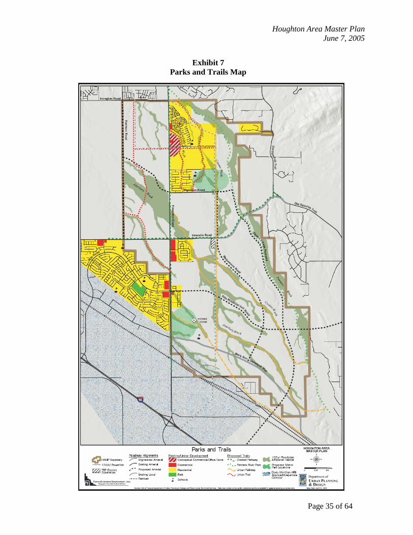
4. Pedestrian-Friendly Environment In general, pedestrian travel will consist of short trips within and between neighborhoods, to and from neighborhood and village centers, and along the open space system, according the Parks and Trails Map (see Exhibit 7). Short distance travel, such as between residences and parks, open space, or neighborhood centers, should be facilitated via local streets and trails. Travel between residences and adjacent neighborhoods or village centers should be primarily facilitated via local streets and trails, but may include travel via collector streets. Long distance pedestrian travel, such as between neighborhoods and the town center or along the open space system, should be facilitated by the pedestrian facilities located along major streets, urban trails, and the open space system.
a) Objectives: i) Multiple connections between neighborhoods and mixed-use
centers, which provide pedestrians with alternative routes that do not require travel via major streets.
ii) Multiple connections between neighborhoods, including pedestrian access where street connections cannot be provided.
iii) Generous sidewalk widths along local and collector streets, and in and around centers.

Houghton Area Master Plan June 7, 2005
Page 34 of 64
iv) Urban trails (Per Parks & Recreation Standards) between neighborhood centers, village centers, parks, and the open space system.
v) Shade trees, landscaping, and lighting along sidewalks and trails, and covered walkways and awnings in mixed-use centers.
vi) Enhanced pedestrian crossings on major streets and collector streets, and in and around mixed-use centers, which incorporate a variety of materials, textures, colors, speed bumps, speed tables, landscaped bump-outs, and/or grade separation.
5. Bicycle-Friendly Environment Bicycle trips may vary greatly in distance depending on their commuter or recreational nature. Commuter trips typically warrant direct and convenient access between origins and destinations, and may be accommodated by dedicated bicycle facilities along streets. Recreational trips may rely more on convenient access to and from recreational facilities such as trails and parks. Multiple routes between neighborhoods, centers, parks, and trails will foster a bicycle-friendly environment. a) Objectives: i) Dedicated bicycle facilities along major and collector streets,
especially along routes that connect centers; ii) Trails that can accommodate both pedestrians and bicycles; iii) Multiple connections between neighborhoods, and to and from
trail systems, including bicycle access where street connections cannot be provided;
iv) Bicycle parking facilities in centers and parks; and v) Signage along bicycle routes and at trail crossings to increase
motorist awareness.
Houghton Area Master Plan June 7, 2005
Page 35 of 64
Exhibit 7
Parks and Trails Map

Houghton Area Master Plan June 7, 2005
Page 36 of 64
D. Environmental and Cultural Resources The HAMP area rests at the edge of Saguaro National Park East and the Cienega Creek Natural Preserve, and is situated close to Colossal Cave Mountain Park and the Coronado National Forest. There are rich cultural resources, including prehistoric and historic sites. These resources define the character of southeastern Tucson, and establish a fundamental ecological ethic in the HAMP area. The Pima County Comprehensive Plan identifies the City of Tucson as a Growth Area. This designation is part of the Sonoran Desert Conservation Plan and the regional conservation strategy, which promotes urban development in the City, where urban services and facilities can be efficiently provided. Urban development within the City will relieve some of the development pressure from unincorporated areas, where the higher value habitat for multiple species exists. The HAMP has been drafted with consideration of regional environmental planning, and is compatible with the Sonoran Desert Conservation Plan. The negative impacts of urbanization on the natural environment are well documented. The impacts of the thousands of future residents on the surrounding parks and preserves are of significant concern. The wholesale blading of the land results in: a nearly total loss of natural vegetation; the replacement of natural drainage systems with engineered systems which are expensive to construct and maintain; loss of wildlife habitat and corridors; a general loss of open space; and the destruction of cultural resources. Overall environmental degradation from the burning of fossil fuels, an increase in the heat island affect, increased water usage, noise and light pollution, and dust from construction activities are also concerns. Currently regulations are in place to control noise, light and dust pollution. Policies are needed to provide guidance to address the other environmental issues. The HAMP area contains sand and gravel resources that could be used for development purposes. Any such excavation should be accompanied by a plan for the reclamation of disturbed sites. The natural beauty of the area is highly valued, inspiring both ecological preservation and recreational exploration. Additionally, wash and open space preservation is a strong theme for the undeveloped lands within the areas for future growth of Tucson, as identified in the Tucson General Plan. Increased public awareness and actions regarding conservation, preservation, and stewardship of the region's natural and cultural resources will strengthen the identity of the area. As development occurs, natural and cultural resources, wildlife habitats, and drainageways will be preserved and integrated into development in a manner that not only employs their natural flood control properties, but also embraces these features as amenities, and creates opportunities for recreation.
Houghton Area Master Plan June 7, 2005
Page 37 of 64
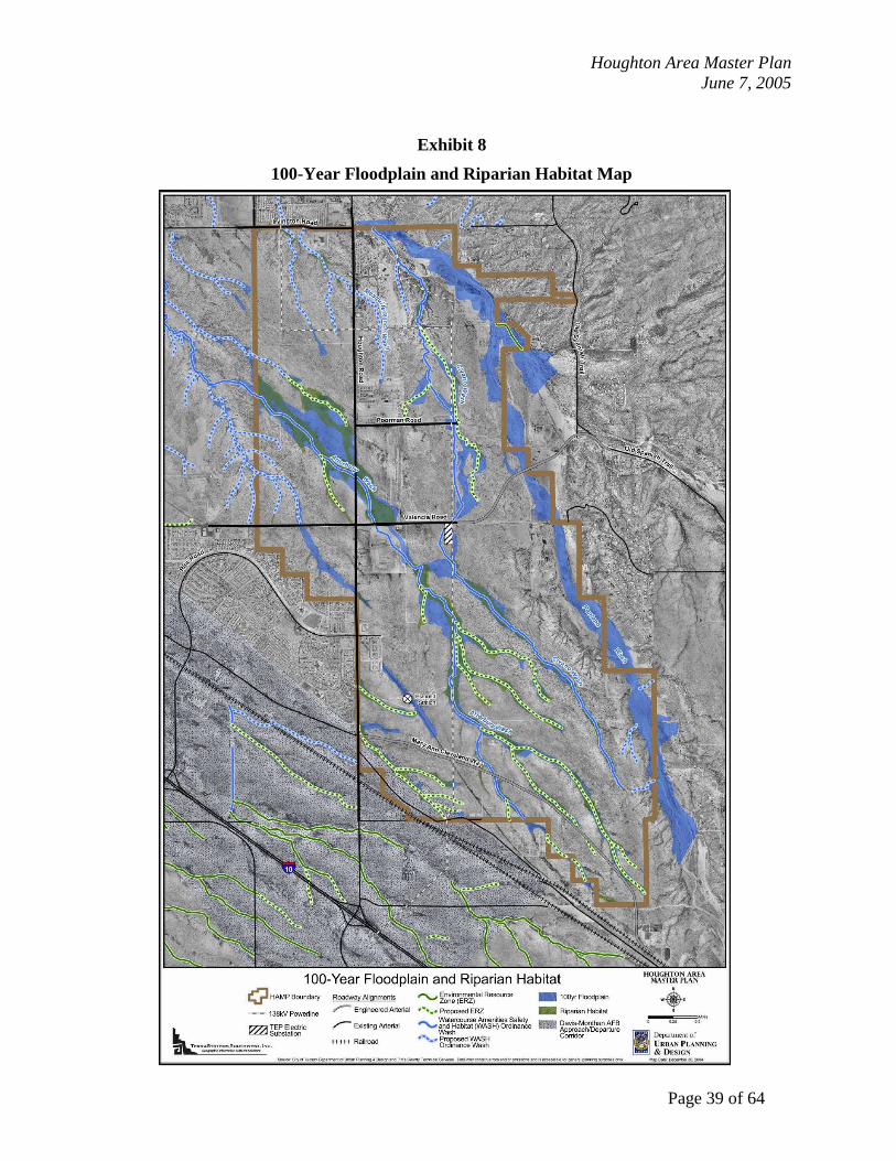
1. Open Space
Preserving the existing wash system is an excellent opportunity to maintain the natural drainage functions of the washes and preserve wildlife and habitat corridors within an integrated system of open space. This will provide residents with an immediate connection to nature, while respecting the ecological context of southeastern Tucson. Generally, the wash areas that contain 100-year floodplains are not easily developed, and are often set aside from development. Therefore, preserving the wash system and integrating it into the built environment is a relatively inexpensive way to create a sustainable and valuable amenity, and to establish the basis of a cost-effective means of flood control. As part of the overall goal, a minimum of 30% of open space needs to be provided for the entire HAMP area, which includes 100-year floodplain/riparian habitat areas, regional and sub-regional detention/retention basins, parks, and Fantasy Island. Objectives: a) Establish a continuous system of open space, according to the
100-Year Floodplain and Riparian Habitat Map (see Exhibit 8).
b) Protect and preserve the habitat and 100-year floodplain envelopes shown on the Conceptual Land Use and Circulation Map (Exhibit 5) as continuous habitat corridor and passive open space amenity to the fullest extent possible.
c) Treat proposed WASH and ERZ watercourses as if they are designated.
d) Identify and preserve communities of medium and high viability Protected Native Plants.
e) Pursue open space preservation as a low cost/low maintenance component for flood control and flood protection.
f) Identify degraded watercourses and disturbed areas within the habitat and 100-year floodplain envelopes, where opportunities may exist for restoration, re-vegetation, or incorporation into detention/retention facilities.
g) Treat open space as an amenity and community asset. h) Preserve open space as part of the public realm, rather than
incorporating it into private lots. i) Orient development around open space in a way that
maximizes visibility and accessibility. This could be achieved by fronting open space with streets, trails, parks, and/or other public places, rather than isolating it behind walls.
j) Identify other environmental features such as hilltops, bluffs, ridges, and other natural landforms, which can be incorporated into development as amenities.
GOAL 1: Establish a continuous and integrated system of open space.

Houghton Area Master Plan June 7, 2005
Page 38 of 64
k) Urban trails can be developed throughout open space areas (per the Department of Parks and Recreation standards).
2. Basin Management Plan
The current stormwater management practice for development in the City of Tucson is to provide on-site detention basins within each development. Regulations require that the post-development discharge rate of runoff from the site is not to exceed the pre-development discharge rate. This approach has resulted in construction of numerous small detention basins across the city, which is inefficient and more expensive to construct and problematic to maintain. The use of multiple small basins is also an inefficient use of land. For example, the small basins typically found in residential subdivisions are usually too small for recreational use. Due to the expectation of larger dispositions by the Arizona State Land Department, as discussed in Section I - Introduction, a more system-wide and comprehensive approach to stormwater management is possible in the HAMP. A series of larger regional and sub-regional detention/retention basins will greatly reduce the number of smaller basins associated with individual developments. The potential exists to collocate large basins with parks, and design the basins to create recreational areas for area residents. The regional and sub-regional basins will be dedicated to the City, and the City will maintain the basins and any associated recreational facilities. Implementing a basin management plan will be an important component of preserving the washes and habitat areas. Proper location and construction of the basins will maintain adequate flows through the washes to preserve the habitats found today. Stormwater management will be based upon the adopted Basin Management Plan for the HAMP. Objectives: a) Utilize regional and sub-regional detention/retention basins as
a best management practice alternative to individual development detention/retention basins.
b) Design detention/retention basins as multi-use facilities that provide additional passive and/or active recreation opportunities for residents, and to protect existing washes, native vegetation, and riparian habitat, as appropriate.
c) Explore opportunities to create detention/retention basins in locations where the habitat and 100-year floodplain envelopes have been significantly disturbed. The City of Tucson should explore funding mechanisms for the implementation and maintenance of a Stormwater Management Program for the HAMP area to ensure there is adequate funding to properly maintain the basins and collocated recreational facilities.
GOAL 2: Establish a Basin Management Plan.
Houghton Area Master Plan June 7, 2005
Page 39 of 64
Exhibit 8 100-Year Floodplain and Riparian Habitat Map

Houghton Area Master Plan June 7, 2005
Page 40 of 64
3. Water Resources
The conservation of water resources is critical to the long-term sustainability of the greater Tucson area. Currently, Tucson uses nearly one-half of the water per capita than the City of Phoenix. The City, through Tucson Water, the major metropolitan water supplier, has very effective educational and service programs to promote water conservation and to educate property owners how they can reduce their water usage.
Objectives: a) Establish drought-tolerant landscape pallets for master
planning areas. Preference will be given to native species. b) Landscape plans for all common areas, including parks,
plazas, etc., should be developed. c) Establish comprehensive stormwater harvesting programs, for
all residential and non-residential development, to supplement irrigation and reduce runoff.
d) Plan for the use of reclaimed water for landscaping as a strategy for reducing demand for potable water (see Section IV.E - Public Services, Facilities, and Utilities).
4. Energy Resources
As a largely undeveloped area, the HAMP offers an opportunity to employ innovative approaches to energy conservation at a scale that could have long-term positive impacts on environmental quality. Employing aggressive building standards and supporting the broad use of renewable energy sources (such as solar power) would reduce overall energy consumption of the built environment. Facilitating the use of clean fuels and alternative modes of transportation through adequate infrastructure and facilities can improve air quality in the region. The impacts of recent events in southern Arizona, such as a petroleum pipeline rupture and electrical sub-station fire have shown the vulnerabilities of communities that rely on centralized distribution of critical resources. Decentralized approaches to energy generation and distribution may offer more reliable alternatives to centralized distribution system. Providing residents and businesses with choices and options that include energy efficiency, and encouraging and supporting energy saving strategies where demand exists, will help reinforce awareness and foster more sustainable systems of energy consumption and distribution.
GOAL 3: Develop strategies to improve water resources conservation.
GOAL 4: Reduce the energy requirements for buildings and transportation throughout the HAMP area, and identify opportunities for renewable and alternative energy resources.

Houghton Area Master Plan June 7, 2005
Page 41 of 64
Objectives: a) Reduce the use of energy in all new construction beyond what is required by the City of Tucson Energy Code.
b) Adopt for Planned Communities the Sustainable Energy Standard, as revised.
c) Facilitate the development of clean fuel infrastructure in order to foster the use of clean fuels that are proven and available now. i) Include electric vehicle charging stations in mixed-use
centers and at park facilities. ii) Explore public/private partnerships with the providers of
clean fuels to develop local clean fuel infrastructure. iii) Encourage the use of carpools and alternative fuel vehicles
through dedicated parking spaces. d) Encourage the use of renewable energy.
i) Offer renewable energy systems available as options in all new construction.
ii) Identify and/or propose incentives and other support mechanisms for financing renewable energy systems. Example: The Town of Marana offers a $1,000 reduction in building permit fees if solar energy systems are utilized.
iii) Explore the possibility of developing decentralized power generation and distribution as an alternative to conventional centralized energy generation and distribution.
5. Cultural Resources
In addition to the rich environmental resources in greater southeastern Tucson, there are also rich cultural resources within the HAMP. To date, 79 sites including 70 prehistoric sites, eight historic sites, and one mixed prehistoric/historic site have been identified in the HAMP area. Fourteen of the prehistoric sites are National Register-eligible, and 54 sites are potentially eligible for the National Register. Objectives: a) Preserve all cultural resources through the appropriate
mitigation protocols and procedures. b) The City will investigate and determine whether an official
listing of Esmond Station on the National Register of Historic Places will be pursued.
c) Incorporate the Esmond Station site as an archeological/cultural resource element within a public park. An interpretive feature highlighting the historic context of transcontinental railroading and stage coaching of the nineteenth century in Arizona may be established.
GOAL 5: Protection of Cultural Resources.
Houghton Area Master Plan June 7, 2005
Page 42 of 64
E. Public Services, Facilities, and Utilities The HAMP presents a challenge for local public-sector agencies to engage in advanced planning in order to proactively anticipate future facility needs. The HAMP and future coordinated master planning processes will identify needs at the front end of the development, and will ensure that public facilities and services are included as a part of the fabric of the community, rather than as reactionary afterthoughts. Advanced planning should identify opportunities for collocation, an important strategy for maximizing limited land resources by providing opportunities for joint-use facilities. Examples of collocated facilities include: the police and fire facilities, General Services and Solid Waste facilities, parks and schools, parks and multi-use detention/retention basins. Because there is uncertainty regarding disposition of land within the HAMP, it is difficult to precisely determine the timing and location of public facility needs in advance of master plan submittals. The HAMP offers a significant opportunity for the City and Arizona State Lands Department to continue to partner in the joint development of future capital improvement programs (CIP) for critical infrastructure. Future CIPs will reflect the funding and construction of public facilities to reflect ASLD phasing and disposition proposals. A combination of funding sources will be needed to construct facilities in the HAMP. Among them are impact fees, community facilities districts, bonds, highway user revenue funds (HURF), Regional Transportation Authority, developer contributions and state and federal funds. The provision of public infrastructure identified for HAMP will be coordinated with ongoing studies by other agencies including roadway corridor studies, stormwater basin management plans, and wastewater facility analyses. The identification of funding sources of infrastructure will be a critical component of the review process for new development.
GOAL: Ensure that adequate public facilities and services such as sewer, water, schools,
roads, parks, fire and police protection are currently available or will be available concurrently in the future with any planned development. Identify opportunities for the efficient use of land through the identification of opportunities for shared-use and collocated facilities.

Houghton Area Master Plan June 7, 2005
Page 43 of 64
1. Parks, Trails and Recreation As stated in Element 3, the HAMP planning area is in close proximity to Saguaro National Park East, Colossal Cave Mountain Park, the Cienega Creek Natural Preserve, and the Coronado National Forest. In addition to defining the ecological character of the area, these parks and preserves also provide significant recreation opportunities. There are a number of existing and planned regional trails in the vicinity, including the multi-use trails along Old Spanish Trail and Houghton Road, and the Pantano River Park. The HAMP area is situated so that it will be a recreational gateway for southeastern Tucson, with both passive and active recreation. It is important to provide critical linkages to the surrounding regional trail systems around the HAMP area. The Pantano River Park is a prominent feature in the HAMP, and will bolster the aesthetic experience of the Desert Village Parkway. The future divided urban pathway along Houghton Road will have a similar impact. It is also important to establish a continuous trail system within the HAMP area, according to the Parks and Trails Map (see Exhibit 7). An interconnected trail system throughout the HAMP will provide area-wide mobility and recreation alternatives for residents. The extensive drainage networks create a basic framework for this system. Continuous trails along the edges of preserved habitat and floodway areas provide opportunities to experience the natural world. Links to parks and mixed-use centers will augment other circulation systems and provide additional pedestrian and bicycle routes between residential and mixed-use areas. Developed parks are another key recreation component in the HAMP area. Parks provide essential facilities for active recreation, including ball fields, pools, and playgrounds. Public parks also provide places for outdoor events and gatherings. Though there are different types of parks, ranging in size and function, they similarly act as social focal points for residents. Just as the town center serves a broader market, metro parks may include facilities that cater to residents beyond the HAMP boundaries. Community parks, in conjunction with village centers, are intended to satisfy needs at the village scale. Smaller neighborhood and mini parks serve residents in their immediate areas, at the neighborhood and block scales respectively. Because parks have a social component, they should be conveniently located in a way that minimizes their distance from the greatest number of residents as possible. a) Trail system: Per the City of Tucson Department of Parks and Recreation
standards: i) Divided urban pathways along:
(1) The east side of Houghton Road (2) The north side of Valencia Road (3) Incorporated into the Pantano River Park
ii) Urban pathways along: (1) The Esmond Station railroad bed (2) The Atterbury Wash and its tributaries (3) Tucson Electric Power Transmission Lines
iii) Urban trails between:

Houghton Area Master Plan June 7, 2005
Page 44 of 64
(1) And within neighborhoods (2) Neighborhood parks, community parks, and metro parks
not otherwise connected (3) As cross-access between Urban Pathways throughout the
open space system d) Shade trees, landscaping along trails e) Trails integrated into the broader transportation system f) Connections between local and regional trail networks
b) Parks: i) The Pantano River Park will be developed along the Pantano
Wash as a key component in the broader regional trail system. Provide equestrian staging areas and access to the Pantano Wash from the Pantano River Park.
ii) Metro parks will be provided in the general areas identified on the Trails and Metro Parks Map, and consistent with Parks and Recreation service standards. These parks accommodate the needs of the broader community and their service areas may extend beyond the boundaries of the HAMP area. (1) Locate each Metro Park with direct access to at least one
arterial street. (2) The southern Metro Park may include Esmond Station as
an archeological/cultural resource element within the park. (3) A Sports Park may be integrated with the southern Metro
Park and collocated with the Vail School District Empire High School located on Mary Ann Cleveland Way.
iii) Community parks will be provided consistent with Parks and Recreation service standards. Community parks should be located in close proximity to each village center and should very accessible from surrounding neighborhoods. Collocate community parks with middle schools or K-8 schools whenever possible.
iv) Neighborhood parks will be provided consistent with Parks and Recreation service standards. A neighborhood park should be incorporated into each neighborhood center and be highly accessible from the residences in the neighborhood. These parks may be collocated with elementary schools to provide opportunities for joint-use facilities.
v) Mini parks may be developed for passive recreation within each neighborhood. These “pocket” parks serve a variety of purposes, including enhanced streetscape, neighborhood gathering plaza, children’s small playground and open green space.
vi) Natural resource parks may be integrated with the park and trail system. These parks may vary in size, and may be located in any part of the community where land remains relatively undisturbed.

Houghton Area Master Plan June 7, 2005
Page 45 of 64
vii) All parks should be easily accessible from surrounding residential areas. Multiple routes should be provided via local streets and trails.
viii) Front parks with streets, trails, parks, and/or other public places, rather than isolating them behind walls.
ix) Integrate park sites with multi-use detention/retention basins, where feasible.
x) Establish clearly defined joint-use agreements between the participants.
xi) Support a mountain bike trail facility as an open space/recreation use, which includes active and passive recreational uses, and may also include municipal park facilities. The site should be designed in context with both the natural and built environments. “Fantasy Island” exists on StateTrust land – in the area southwest of the intersection of Harrison and Irvington Roads. To resolve the issue of the preservation of “Fantasy Island” the City of Tucson, Pima County, the ASLD and the mountain biking community, which supports Fantasy Island, should work cooperatively to answer the following questions: (1) Which entity will be the “responsible party” that will
assume ownership, operations and maintenance responsibilities for the facility?
(2) What size and configuration of Fantasy Island, at its current location, can be supported by all parties?
(3) What funding mechanisms are available from the County and/or the City to acquire Fantasy Island at its current location?
(4) What arrangement can be established to provide for the operation and maintenance of such a facility?
(5) What are the liability issues surrounding government ownership, management or maintenance of such a facility? Are these issues acceptable to the local governments?
xii) Coordinate with City of Tucson Parks and Recreation, Pima County Natural Resources Parks and Recreation, Vail School District, City of Tucson Transportation Stormwater Management Section, and City of Tucson/Pima County Library to establish specific facility needs, locational criteria and collocation opportunities.
xiii) The different types of parks in the HAMP area shall be designed and developed based on parameters of park size, service area radius and operational difference specified in Exhibit 9.

Houghton Area Master Plan June 7, 2005
Page 46 of 64
Exhibit 9
Parameters of Park Size, Service Area Radius and Operational Difference
Facility Type Standard Park Size
(acres)
Service Radius of Park (miles)
Facility/ Total Population Ratio, unless otherwise noted
ALL PARKS
Mini 1 max. 0.25 1 acres / 1,000 people Neighborhood 1-15 0.5 2.5 acres / 1,000 people Community 15-40 1 3 acres / 1,000 people
Metro 40-200 2.5 3.5 acres / 1,000 people Regional >200 7 2 acres / 1,000 people
FIELD SPORTS
Adult Baseball 1 field / 12,000 people
Youth Baseball 1 field / 10,000 people
Soccer / Football
1 field / 12,000 people (total and youth population)
Softball Fields 1 field / 10,000 people
(total and youth population)
ACTIVE RECREATION
Multi-Use Paths within parks
1 mile / 15,000 people (total and senior population)
Playgrounds 1 playground / 2,500 people
Centers 1 sqft / person
(total and senior population)
Swimming Pools
Neighborhood: 1 pool / 5,000 people Community: 1 pool / 15,000 people
amily Aquatic Center: 1 pool / 30,000 people Heated year round: 1 pool / 50,000 people

Houghton Area Master Plan June 7, 2005
Page 47 of 64
2. Schools Schools are to compliment village and neighborhood centers as social focal points for residents. While school planning is not under the jurisdiction of the City of Tucson, opportunities exist for the Vail School District, the City of Tucson, and other public entities to share and/or collocate facilities. Clearly defined joint-use agreements between the participants should be established to make the school/park/library relationship workable. While opportunities will vary depending on the character of the community and the needs of school district, the inclusion of schools near village and neighborhood centers will strengthen ties between different uses and reinforce the importance of education for the community. a) Objectives: i) High school sites range in size from 50 acres for the largest
schools, 40 acres for medium sized schools, to 5 or 10 acres for the smallest schools. Large and medium sized schools may be appropriate near metro parks locations; small high schools may be appropriate in office-oriented areas of the town or village centers.
ii) Middle school sites are typically between 20 and 25 acres in size, though this may vary depending on the extent of shared facilities. Middle and K-8 schools are appropriate in close proximity to village centers and community parks.
iii) Elementary school sites are approximately 15 acres in size, though this may vary depending on the extent of shared facilities. Elementary schools are appropriate within neighborhoods, preferably in close proximity to neighborhood centers.
iv) Schools should be sited in easily accessible locations that include: (1) At least two points of vehicular access for each school. (2) Pedestrian and bicycle-friendly environments in and
around schools, which provide direct and convenient access to and from nearby neighborhoods.
(3) Trails that provide direct connections to and from nearby neighborhoods.
v) Explore and encourage opportunities for collocation and shared-use facilities, provided students’ safety and well-being can be ensured, including: (1) High schools, library facilities, and college campuses. (2) Middle and K-8 schools, community parks, and youth-
oriented organizations. (3) Elementary schools and neighborhood parks.
vi) Coordinate with City of Tucson Parks and Recreation, Vail School District, City of Tucson Transportation Stormwater Management Section, and City of Tucson/Pima County Library to establish specific facility needs, locational criteria and collocation opportunities.
Houghton Area Master Plan June 7, 2005
Page 48 of 64
3. Tucson Fire Department Tucson Fire Department anticipates the need for three new multi-company fire stations in the HAMP area. Proximate locations are shown on the Potential Public Facilities Location Map (see Exhibit 10). These stations include a battalion headquarters station, approximately 3 acres in size, and two stations, approximately 2 ½ acres in size. a) Locational criteria: i) Locations of fire stations should be away from high-density
residential development, preferably near non-residential areas. ii) Direct access limited to non-arterial streets. iii) Collocation with police facility if possible. iv) If the location of the southeast side Service Complex cannot
accommodate the Fire Department’s fuelling and maintenance needs, consider collocating a fuelling site and maintenance facility at one of the fire stations within the HAMP.
v) Coordinate with City of Tucson Fire, Police and General Services to establish specific facility needs, locational criteria and collocation opportunities.
4. Tucson Police Department The Tucson Police Department has indicated a preference for a substation that will serve the southeast side to be located outside of the boundaries of the HAMP. It may be located near, or collocated with, the future General Services complex near Houghton Road and I-10. Should TPD determine additional facilities are required to serve the HAMP area, a satellite facility, approximately 7 acres in size, may be sited at either of the locations shown in the Potential Public Facilities Location Map (see Exhibit 10). a) Locational criteria: i) Locations within one half-mile of an arterial street.
ii) Locations at least one mile away from the railroad tracks and the freeway.
iii) Locations where the impacts of emergency vehicles and activities on surrounding areas can be minimized.
iv) Coordinate with City of Tucson Police, Fire and General Services to establish specific facility needs, locational criteria and collocation opportunities.

Houghton Area Master Plan June 7, 2005
Page 49 of 64
5. Libraries The Tucson-Pima Public Library anticipates the need for facilities in the HAMP area. Opportunities exist to integrate library sites with high school sites. The town center may be an appropriate location for a larger library facility collocated with a smaller high school site, although village centers may also accommodate library facilities. a) Coordinate with City/County Library, City of Tucson Parks and Recreation and Vail School
District to establish specific facility needs, locational criteria and collocation opportunities. 6. Public Administration Facilities Appropriate locations for public administration offices would be within the town center or village centers. These locations will provide a high level of accessibility for citizens, and would establish a civic presence within a mixed-use environment. a) Coordinate with City of Tucson General Services to establish specific facility needs,
locational criteria and collocation opportunities. 7. City of Tucson General Services General Services anticipates the need for a future Service Complex on the southeast side that will include opportunities for collocation with police, fire, and environmental services. Preliminary evaluation suggests a location in the vicinity of Houghton Road and I-10. Should this facility not be able to accommodate these departments, individual departmental location criteria should be considered. Regarding Tucson Fire Department’s fuelling and maintenance requirements, consider collocating a fuelling site and maintenance facility at one of the fire stations within the HAMP, if the southeast side Service Complex cannot accommodate these needs. a) Coordinate with City of Tucson Police, Fire and Environmental Services to establish
specific facility needs, locational criteria and collocation opportunities. 8. City of Tucson Utility Services a) Tucson Water
The Tucson Water 2000-2050 Plan projects a need for additional water resources to serve the Tucson Water service area by the year 2050. The projected service area includes the HAMP. The 2050 Plan established the timeline for community decisions regarding future water resources. Specific to the HAMP, Tucson Water anticipates the need for additional resevoir capacity and for additional wells within the area. The 2050 Plan envisions an I-Zone reservoir will be

Houghton Area Master Plan June 7, 2005
Page 50 of 64
necessary to serve this area in the future. This reservoir is not planned within the current 10 year Capital Improvement Program. If significant development is planned to occur within the next 10 years, the developer will be expected to provide adequate reservoir capacity to serve this development. Tucson Water also anticipates the need for new well sites at a density of one per square mile, to be deeded to Tucson Water by the developer. By the time the area is developed Tucson Water will have a policy stating that any developers must provide sufficient water supply for the project, or pay a water resource fee to allow Tucson Water to procure sufficient additional supply for their project. No change of reclaimed water source is anticipated. Currently, all reclaimed water originates at the reclaimed treatment plant, located at Sweetwater Drive and Interstate-10. If the developer desires additional pressure or volume in the reclaimed water system, they will have to participate financially in upgrading the existing facilities. Tucson Water will work with the City of Tucson Department of Urban Planning and Design, the State Land Department, and developers to identify a proposed phasing and implementation schedule. Such a schedule will include agreements among the parties regarding respective responsibilities to provide additional water sources and necessary infrastructure improvements.
b) Environmental Services
The Solid Waste facilities that will serve the southeast side will be located outside of the boundaries of the HAMP, and may be collocated with future General Services complex near Houghton Road and I-10. Should this site not be adequate, a location in close proximity to the I-10 or the railroad tracks would be appropriate.
c) Coordinate with City of Tucson Utility Services and General Services to establish specific
facility needs, locational criteria and collocation opportunities. 9. Public Communication Facilities General Services has indicated that any City-operated communications facilities will be located outside of the HAMP area. a) Coordinate with City of Tucson General Services to establish specific facility needs,
locational criteria and collocation opportunities.

Houghton Area Master Plan June 7, 2005
Page 51 of 64
Exhibit 10 Potential Public Facilities Location Map

Houghton Area Master Plan June 7, 2005
Page 52 of 64
10. Public Utilities The HAMP planning process included the utility considerations listed below. These entities are charged with completing their own facility plans. Coordination will be necessary with each entity to establish specific facility needs, locational criteria and collocation opportunities for inclusion in the Community Master Plan (CMP). a) Wastewater
Pima County wastewater is currently completing a facility plan for the southeastern portion of the metropolitan area. That study should provide basic wastewater facility planning information for the HAMP. In the relatively near future, a water reclamation plant will be built close to the HAMP area. This plant will capture and treat some of the wastewater from the larger waste stream The solids will continue to be treated at the Roger Road facility. The water reclamation plant will create a nearby source of reclaimed water for the HAMP area. There will not be enough engineering data available during the HAMP process to attempt to site a wastewater treatment facility as part of the HAMP. i) Strong consideration should be given to constructing the reclaimed water infrastructure
as the potable water infrastructure is developed. Having reclaimed water lines in the utility easements will allow future property owners the opportunity to tap into this resource for their non-potable needs.
ii) Should the market support it, provide duel plumbing within structures to prepare for the use of reclaimed water. The City of Tucson should investigate opportunities for providing incentives for constructing the reclaimed water infrastructure concurrently with the potable water infrastructure.
b) Electricity
Tucson Electric Power has indicated that an eastward extension of the 138kV transmission line may be necessary to service the Vail Valley area. The location of this extension could occur anywhere along the existing transmission line, and may be appropriate in the vicinity of the Southern Pacific Railroad tracks.
c) Other Utilities
i) Natural Gas: Southwest Gas will provide natural gas service to the area. ii) Cable Services: Cable service will be provided by the entity which has the City
franchise at the time such services are needed. iii) Telephone Service: Telephone service will be provided to the area by the authorized
service provider(s) at the time such service is needed.

Houghton Area Master Plan June 7, 2005
Page 53 of 64
F. Cost of Service
Public infrastructure and facilities represent the public’s investment in the development of the urban elements that are necessary to support the physical operation of the city. A combination of funding sources will be needed to construct the needed facilities with HAMP. Community facilities districts, impact fees, bonds, developer contributions, and local, state and federal transportation funds will all be required to provide for the needed capital facilities. The location, size, timing, and financing of major streets, water, sewer, and drainage systems, parks, police and fire stations, libraries, and other facilities must be planned well in advance of their construction. This advance planning is essential to minimizing project costs, optimizing project need and usefulness, and maximizing the public benefits and private sector support. Investments in public facilities should be designed to respond to the identified needs of both the existing population and the forecasted population. All Planned Communities will be required to provide 100% of the Capital Facilities sites, dedication, improvements and construction, unless a Capital Improvement Program has already been approved for the facility by affected agencies. These are some strategies for the funding/financing of infrastructure:
1. Pursue funding of major roadway features through the Regional Transportation Authority. These roadways include Houghton Road and Valencia Road.
2. A regional transportation plan should identify key regional corridors for funding with other regional, federal and state funds, including Interstate-10, Irvington Road, Harrison Road and Desert Village Parkway.
3. Identify roadway system improvements for future congressional earmarks including Houghton Road and replacement of the Southern Pacific Railroad overpass on Houghton.
4. Utilize roadway development impact fees and development agreements for new arterial roadway construction.
5. Utilize Pima County bonds or flood control district financing of regional linear parks and trails on Houghton Road, the Pantano Wash and other locations.
6. Investigate the establishment of community facilities districts for construction of major infrastructure, including wastewater treatment facilities and sewer extensions into the HAMP area, water extensions and storage facilities, regional stormwater detention facilities, libraries, parks and other public buildings and facilities.
7. Utilize development impact fees for parks, libraries, general government, police and fire facilities.
GOAL: To ensure the public infrastructure and facilities are available to serve the
future growth with development providing its fair share of funds to build and maintain these facilities.
Houghton Area Master Plan June 7, 2005
Page 54 of 64
8. Explore use of community facilities districts for maintenance of infrastructure as a special district property tax.
9. Investigate the utilization of existing vacant city properties in the HAMP as potential land swaps to establish parks and key public facility locations early in the planning process.
10. Concurrency requirements and phasing identified in future zoning.

Houghton Area Master Plan June 7, 2005
Page 55 of 64
G. Implementation
Parcels in the HAMP area must be designed and developed in conformance with the General Plan and with the criteria presented in this document. To achieve the development of the HAMP using the desert village model, master planning should occur at large scales. The Arizona State Land Department is strongly encouraged to pursue large dispositions of trust land of at least five hundred contiguous acres and provide guidance to the purchasers to engage in comprehensive master planning prior to the sales of similar parcels for development. Owners of existing smaller parcels in the HAMP area are similarly encouraged to assemble additional land, or collaborate with adjacent property owners to ensure compatibility with the HAMP plan. A new land use tool, Planned Community Development zone, is needed to enable the development of the desert village model concepts (see Exhibit 11 – General Implementation Process). Under this land use designation a master developer would propose a concept plan that would guide development for the parcel prior to its sale. The concept plan would be developed and approved prior to extensive engineering work and site specific planning. The concept plan would identify the range of proposed land uses, density ranges and the proposed circulation network. Key elements include:
• The ability to bring the overall concept plan through the entitlement process, with subsequent approvals occurring at the staff review level.
• The ability for changes to be made to the concept plan without the need for approval at the legislative level.
• Identification of financing alternatives for the provision of infrastructure within the development.
• The ability to propose alternative zoning criteria and development standards. • Assurances that the new development will comply with policies of the Houghton Area
Master Plan. • A predictable process that allows for a wide range of development alternatives yet
ensures that the policies of the HAMP and its vision are implemented. • Consideration for the status of smaller, pre-existing parcels.
The development of land in the HAMP should wait for the establishment of planned community development regulations. The City believes the Planned Community Development Zone will provide the greatest benefit for achieving the goals of the HAMP and master planning. An applicant will have the option to use existing zoning tools, such as a Planned Area Development (PAD), a Residential Cluster Project (RCP), or other tools, provided it can be demonstrated that the proposal complies with the Desert Village model.
GOAL: To develop effective land use planning tools to ensure the ability to develop
master planned communities under the desert village model in the HAMP.

Houghton Area Master Plan June 7, 2005
Page 56 of 64
Exhibit 11 General Implementation Process
General Plan
Planned Community Development (PCD) Zone (rezoning process)
Concept Plan and other
subsequent Master Plans
HAMP
Development Plan
Subdivision Plat

Houghton Area Master Plan June 7, 2005
Page 57 of 64
Glossary Access/Egress: the ability to enter a site from a roadway and exit a site onto a roadway. Access Management Standards: regulations that limit the locations of vehicular access onto a roadway. Acre: a measure of area totaling 43,560 square feet. 640 acres equals one square mile. Active Recreational Amenity: easily accessible areas that provide opportunities to take part in physical outdoor activities. These areas typically would include the same amenities as a passive recreational amenity. In addition, these areas would include athletic fields, larger tot lots, and/or large open grass areas, etc. Activity Centers (and Nodes): areas in which land uses are, or will be, intensified or mixed to a degree generally not found in the rest of the community. Activity centers may vary in size, scale, and diversity of uses and draw from a regional, community, or neighborhood/local market. An activity node offers a limited range of mixed-uses, such as convenience shopping, residentially-scaled offices, restaurants, and other small-scale businesses. Although an activity node may draw from a larger market, its design character and scale are compatible with the residential neighborhoods that surround it. Adjacent: Two (2) or more parcels or lots sharing a common boundary or separated by an alley or other right-of-way twenty (20) feet or less in width. Parcels or lots having only a common corner are considered adjacent. Affordable Housing: is defined as five percent of the dwelling units affordable to households that earn eighty percent or less of the area median income (AMI) and an additional ten percent affordable to households that earn one hundred percent of the AMI, assuming that thirty percent of gross income is available for housing costs. Amenity (Landscape Amenity; Pedestrian Amenity): a term referring to an aspect of a development, such as an improved streetscape, generous sidewalks and shade trees, or an attractive public meeting area or plaza. The provision of amenity features by the development may be an incentive for awarding density or floor area bonuses or a requirement within special design districts. Airport Environs Zone: an overlay zone of the Tucson Land Use Code, which regulates development within a designated area around Tucson International Airport and Davis Monthan Airforce Base. Arterial Street: a street which carries a high volume of traffic, usually in excess of 12,000 vehicles per day, and is identified on the Major Streets and Routes Plan map. These streets will

Houghton Area Master Plan June 7, 2005
Page 58 of 64
generally facilitate internal travel within the HAMP area. These streets will connect the Town Center with Village Centers, and will, in conjunction with collector streets, provide primary vehicular access for Village Centers. Average Household Size: the average number of persons who live in one household. A household is a house, apartment, mobile home or trailer, or a single/group of rooms occupied as separate living quarters. The persons may or may not be related. Baby-boomers: persons who were born immediately following World War II. The common period of time includes the years from 1946 to 1964. Basin Management Plan: a strategy that focuses on limiting the impacts of stormwater runoff and preserving washes and habitat areas. Bicycle-friendly Environment: a setting in which riding a bicycle to and from everyday destinations is a safe, enjoyable, and viable option. Built Environment: settings that are human modified, including homes, schools, workplaces, highways, urban sprawl, and air pollution. Circulation: movement throughout a community. Usually referred to the movement from residential land uses to other residential land uses and residential land uses to non-residential land uses. Circulation Network: the interaction of the transportation infrastructure for traveling throughout a neighborhood/city/region. The circulation network pertains to individual personal travel, group travel, and commerce/industry. The infrastructure can relate to pedestrians, bicyclists, automobiles, bus transit, rail, and air travel, etc. Collector Street: a street which generally carries less traffic than an arterial street, usually in the range of 2,000 to 12,000 vehicles per day, and is identified on the Major Streets and Routes Plan map. Collector streets will provide direct access from Village Centers to Neighborhood Centers, and between adjacent Neighborhood Centers. Compatibility: designed to work with another system without modification. Community Parks: parks that are located in close proximity to each Village Center and should be very accessible from surrounding Neighborhoods. Community parks should be collocated with middle schools or K-8 schools whenever possible. Cultural Resources: the variety of human-made products, artifacts, and behavior that a community or group values and seeks to preserve as its heritage legacy, including its history, archaeology, art, literature, music, technology, urban design, and folkways. Decentralized Destinations: land uses, which are not located in close proximity to each other and/or are not in a central location, that create a significant amount of trips. These land uses can

Houghton Area Master Plan June 7, 2005
Page 59 of 64
include regional shopping malls, sport complexes, universities, municipal offices, large employers, etc. Density: the number of dwelling units per acre. Desert Village Model: a planning approach used to create a planned community. The planned community is made up of integrated master planned communities, organized around a mixed-use town center, which can range in size and scale, that acts as a regional activity center. Surrounding the mixed-use town center are neighborhoods, which are oriented around a smaller neighborhood center. (See Exhibit 10: Components of a Planned Community). This basic pattern of development is a way to encourage transit use, reduce air pollution, reduce economic and racial segregation, improve delivery of public services, and create inviting places to live, work, and play. Development: the physical extension and/or construction of urban land uses. Activities include: subdivision of land; construction or alteration of structures, roads, utilities, and other facilities; grading; and the clearing of natural vegetative cover. Routine repair and maintenance are not considered development activities. Diversity: the variety of natural, environmental, economic, and social resources, values, benefits, and activities. Economies of Scale: reduction in cost per unit resulting from increased production, realized through operational efficiencies. Economies of scale can be accomplished because as production increases, the cost of producing each additional unit falls. Environmental Resource Zone (ERZ): an overlay zone of the Tucson Land Use Code which regulates development along designated washes determined to have critical riparian habitat. Erosion Control Easement: designated areas along washes and other watercourses that only allow limited forms of development. An erosion control easement limits the amount of sediment that can enter the wash or watercourse. General Plan: a comprehensive declaration of purposes, policies, and programs to guide the growth and development of the city and its environs, addressing the following elements: land use; circulation; conservation and environmental planning; parks, recreation, open space, and trails; public buildings, services, and facilities; cultural heritage; housing; conservation, rehabilitation, and redevelopment; safety; human resources; government; economic development; community character and design; growth area and population; cost of development; and water resources. Growing Smarter and Growing Smarter Plus Acts: State of Arizona legislation to more effectively plan for the impacts of population growth by creating a more meaningful and predictable land planning process, to increase citizen involvement in the land planning process, to directly acquire and preserve additional open space areas within this state through necessary reforms to the master planning and open space conservation programs of the state land
Houghton Area Master Plan June 7, 2005
Page 60 of 64
department and to establish a growth planning analysis process to consider and address various statewide growth management issues so that the future development of land in this state will occur in a more rational, efficient and environmentally sensitive manner that furthers the best interests of the state’s citizens by promoting the protection of its natural heritage without unduly burdening its competitive economy. High Density Residential: a minimum gross density of 16 residential units per acre is desired. Residential land uses are allowed that can attain the minimum densities. These land uses could include, but are not limited to multi-story apartments and lofts. Homogeneous: the state of having identical similarities. Houghton Area Master Plan (HAMP): the City of Tucson’s master plan for a 16.9 square mile area along Houghton Road (See Exhibit 1: Location Map). The vision for the plan is to provide a comfortable environment in which to live, raise children, work, retire, have social interaction with neighbors, be close to nature, and pursue a healthy lifestyle. The HAMP, which uses the Desert Village model approach, offers an opportunity to plan and develop a place where people can easily access jobs, schools, shopping, services, as will as social, cultural, recreational and leisure activities. Infill: development of vacant land (usually individual lots or leftover property) within areas that are already largely developed. Infrastructure: basic facilities, usually built and operated by the public sector, which provide essential services to the community. These facilities include roads, wastewater and water treatment plants, sewer and water conveyance systems, libraries, police stations, and other public facilities. Local Street: a street, which generally carries less than 2,000 vehicles per day, and is not identified on the Major Streets and Routes Plan map. Local streets will provide access throughout Neighborhoods, including multiple routes to Neighborhood Centers and individual residences. They will also augment collector streets by providing additional routes to Village Centers and to adjacent Neighborhoods. Low Density Residential: a minimum gross density of four residential units per acre is desired. Residential land uses are allowed that can attain the minimum densities. These land uses could include, but are not limited to attached and detached single family homes. Major Streets & Routes Plan (MS&R): plan adopted by the Mayor and Council to implement the Tucson General Plan, which identifies the general location and size of existing and proposed freeways, arterial and collector streets, future right-of-way lines, typical intersections, and Gateway and Scenic Routes. Master Plan: A comprehensive approach to guide the long-term physical development of a particular area.

Houghton Area Master Plan June 7, 2005
Page 61 of 64
Master Planned Community: a large-scale development whose essential features are a definable boundary; a consistent, but not necessarily uniform, character; and overall control during the phasing and build-out process by a single development entity. Such planned communities generally contain a full range of residential and nonresidential land uses, open space, and public services and facilities. The concept of planned communities, also known as “new towns” and “garden cities,” is centuries old. Recent master planned communities associated with neo-traditional design or new urbanism stress open space preservation, integration of land uses to reduce auto trips, a walkable pedestrian network that leads to an “urban village center,” and other design and architectural details that foster social interaction. An example of a master planned community in Tucson is Civano. Medium Density Residential: a minimum gross density of eight residential units per acre is desired. Residential land uses are allowed that can attain the minimum densities. These land uses could include, but are not limited to multi-story apartments, one-story apartments, lofts, townhomes, condominiums, duplexes, patio homes, and attached single family homes. Mini parks: parks that are developed for passive recreation within each Neighborhood. These “pocket” parks serve a variety of purposes, including enhanced streetscape, Neighborhood gathering plaza, children’s small playground, and open green space. Mixed-Use Centers: properties on which various uses, such as office, commercial, institutional, and residential, are combined in a single building or on a single site in an integrated development project with significant functional interrelationships and a coherent physical design. A “single site” may include contiguous properties. National Register (National Register of Historic Places): the official list, established by the National Historic Preservation Act, of sites, districts, buildings, structures, and objects significant in the nation’s history or whose artistic or architectural value is unique. Natural Open Space: any area of land, essentially unimproved and not occupied by structures or manmade impervious surfaces, that is set aside, dedicated, or reserved in perpetuity for public or private enjoyment as a preservation or conservation area. Neighborhood: a Neighborhood is the most basic unit within a Planned Community. It is envisioned to be a social/physical unit based on an optimal walking radius of a quarter of a mile to half a mile. Neighborhoods will include a Neighborhood Center, which will act as a social and recreational focal point that is accessible from all surrounding residential developments. Neighborhood Center: a Neighborhood Center is envisioned to be highly accessible social and recreational focal points for the surrounding Neighborhood. Although demand may not exist initially, provisions should be established to secure potential retail/non-residential space within Neighborhood Centers. Neighborhood Parks: neighborhood parks should be incorporated into each Neighborhood Center and be highly accessible from the residences in the Neighborhood. These parks may be collocated with elementary schools to provide opportunities for joint-use facilities.

Houghton Area Master Plan June 7, 2005
Page 62 of 64
One Hundred Year Flooding: an area in which there is a one percent chance of flooding due to a stream, river, lake, etc. Open Space: (see Natural Open Space) Parkways: a street which carries a high volume of traffic, usually in excess of 12,000 vehicles per day, and is identified on the Major Streets and Routes Plan map. These streets will accommodate regional and sub-regional travel patterns that extend beyond the boundaries of the HAMP area, and will incorporate access management standards that facilitate vehicular traffic flow through the HAMP area. Passive Recreational Amenity: easily accessible areas that provide opportunities to relax and safely enjoy the outdoors. These areas typically would include shade trees, shelters that provide shade, barbecue grills, a small children play area, and a small open area where people can gather. Pedestrian-oriented Development: a development whose site design, street furniture, landscaping, and other amenities are directed toward creating a safe, attractive, and comfortable pedestrian environment. Pedestrian-friendly Environment: a setting in which walking and/or jogging to and from everyday destinations are safe, enjoyable, and viable options. Planned Community: a Planned Community typically consists of a cluster of Villages with a sufficient population base to support community-scale civic and commercial services located within a Town Center. Each Planned Community should have a discreet identity defined by its context, a system of continuous open space, architectural design themes, or other distinguishing features. The land use mix within the overall Planned Community should promote a high degree of self-sufficiency. Policy: a statement of principle or of guiding actions that implies clear commitment but is not mandatory. Regional and Metropolitan Parks: parks that accommodate the needs of the broader community and may have a service area beyond the boundaries of the HAMP area. These parks need to have direct access to at least one arterial street. Riparian Habitat: the name of an ecological community occurring in or adjacent to a drainageway and/or its floodplain and which is further characterized by species and/or life forms different from those of the immediately surrounding upland and/or nonriparian areas. Sense of Identity: the aesthetic, nostalgic, or spiritual effects of physical locations on humans based on personal, use-oriented or attachment-oriented relationships between individuals and those locations. The meaning, values, and feelings that people associate with physical locations because of their experiences there.

Houghton Area Master Plan June 7, 2005
Page 63 of 64
Stormwater Management Program: a strategy that focuses on limiting the impacts of stormwater runoff and preserving washes and habitat areas. Street: any permanent public or private right-of-way, other than an “alley” or “parking area access lane,” set aside to accommodate vehicular-travel lanes, parking lanes, bike lanes, pedestrian facilities, utility areas, and other such features. Strip Commercial: a pattern of commercial development characterized by incremental additions of single function businesses along a street frontage. Such developments typically have separate vehicular access points and parking for each business and lack pedestrian linkage between individual businesses. Sustainable Critical Mass: the size at which a city or development can function on its own without depending on or using resources from another city or development. Sustainable Energy Standard: The City of Tucson’s enhanced energy benchmarks focusing on creating cost and resource efficiency. Sustainability: a concept that supports creating and maintaining a balance between the needs of the community and its resources; sustainable planning means proposing long term strategies and solutions to ensure that future generations have the ability to meet their needs and to uphold environmental, economic, and social values. Town Center: the Town Center is anticipated to function as a regional center, offering a broad range of goods and services, employment opportunities, and civic uses to the a Planned Community. Diverse economic activity within the Town Center will lessen its susceptibility to fluctuations in the economy, and reinforce the Town Center’s role as a regional activity node. Traffic Congestion: when vehicular crowding on streets creates a situation when trips take longer than when streets are at the capacity for which they were originally designed. Transit (Public): a system of regularly scheduled buses and/or trains available to the public on a fee per ride basis. Tucson General Plan: A policy document used to achieve the community vision and the goals adopted by the Mayor and Council, with review, comment, and involvement of the citizens of Tucson. The General Plan addresses the relationships between the use of land, transportation, quality of life, compatible development, environmental quality, and economic prosperity. The broad policy direction of the General Plan is refined and implemented through specific plans, such as the Major Streets and Routes Plan, area and neighborhood plans, subregional plans, and Planned Area Developments. Urban Design: the attempt to give form, in terms of both beauty and function, to selected urban areas or to whole cities. Urban design is concerned with the location, mass, and design of

Houghton Area Master Plan June 7, 2005
Page 64 of 64
various urban components and combines elements of urban planning, landscape architecture, and architecture. Urban Form: (see Built Environment) Urban Fringe: the adjacent densely settled area surrounding an urbanized area and not contiguous to the urban core. The urban fringe generally consists of contiguous territory having a density of at least 1,000 persons per square mile. Vacancy Rates: the percentage of all housing units that are unoccupied at a given time. Very Low Density Residential: a gross density of less than four residential units per acre is desired. Residential land uses are allowed that can attain this density. These land uses could include, but are not limited to attached and detached single family homes. Very low densities are generally accepted in or near lands that are environmentally sensitive, or are demonstrated to be otherwise constrained. Village: villages may vary in size, but typically consist of several Neighborhoods contained within a physically cohesive unit, defined by such elements as arterial streets, major landforms, or open space, with a sufficient population base to sustain basic civic and Neighborhood-scale commercial services located within a Village Center. The neither the size nor the population of the Village are prescribed. However, to maintain an economically viable Village Center, the Village should accommodate 8,000 – 12,000 people. Village Center: the purpose of Village Centers is to satisfy the daily service needs and act as a focal point for all residents and employees within the Village’s Neighborhoods. The core of the Village Center is seen as a consolidated node, a single cohesive area for commercial activity, rather than the more typical four corner shopping centers or strip commercial found at arterial intersections. Village Centers should be oriented around a public space or feature such as a main street, plaza, green, or square and reinforce a sense of place and identity. Residential components within Village Centers should be designed to preserve safety for residents, while maintaining convenient access. Watercourse Amenities, Safety, and Habitat (WASH) Ordinance: Article VIII of Chapter 29 (Energy and Environment) of the Tucson Code regulates development adjacent to designated washes in order to maximize groundwater recharge, protect existing vegetation, and provide for revegetation of disturbed washes.