advantages? disadvantages? globes. projection: systematic representation of all or part of the...
TRANSCRIPT

Advantages?
Disadvantages?
Globes

Projection:Systematic representation of all or part of the three-dimensional Earth surface on a two-dimensional flat surface.

Common Map Projections
Conical

Common Map Projections
Cylindrical

Planar
Common Map Projections

Conformality vs. Equivalence
Map Properties

• Conformality– Shapes of
areas are correct
(size of areas are incorrect)
– Conformalprojection

• Equivalence– Size of areas are correct
(shapes of areas are incorrect)
– Equal-area projection

• Compromise Projection– Neither equivalent nor equal-area property– Example: Robinson Projection
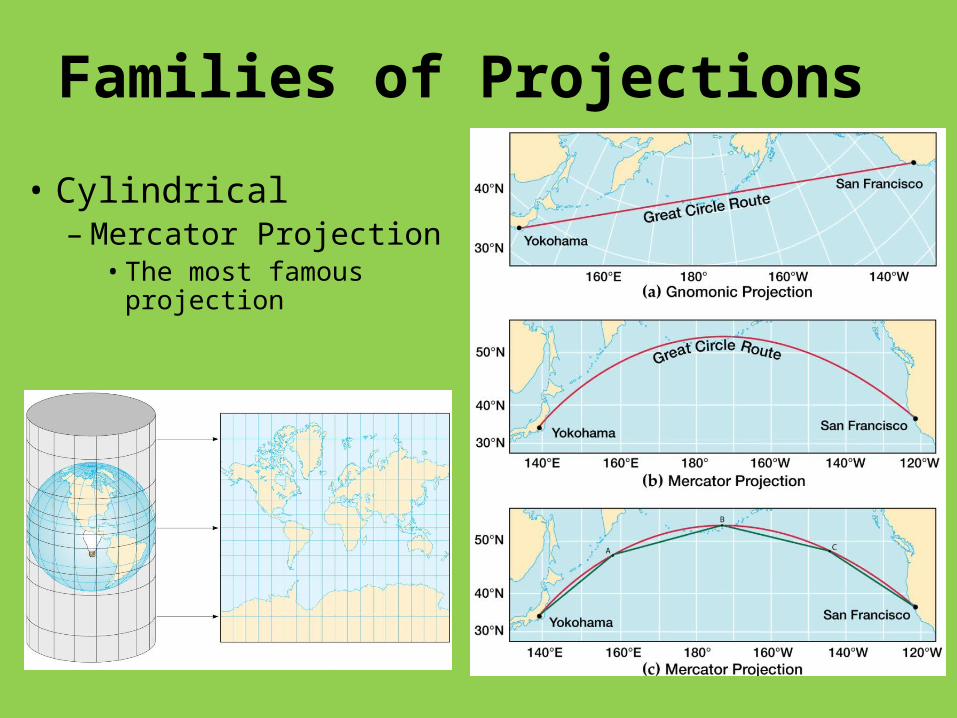
Families of Projections
• Cylindrical – Mercator Projection
• The most famous projection

• Plane Projections – Azimuthal or Zenithal
projections (correct direction from point of tangency)
– One-hemisphere view

• Conic Projections – Small-area maps
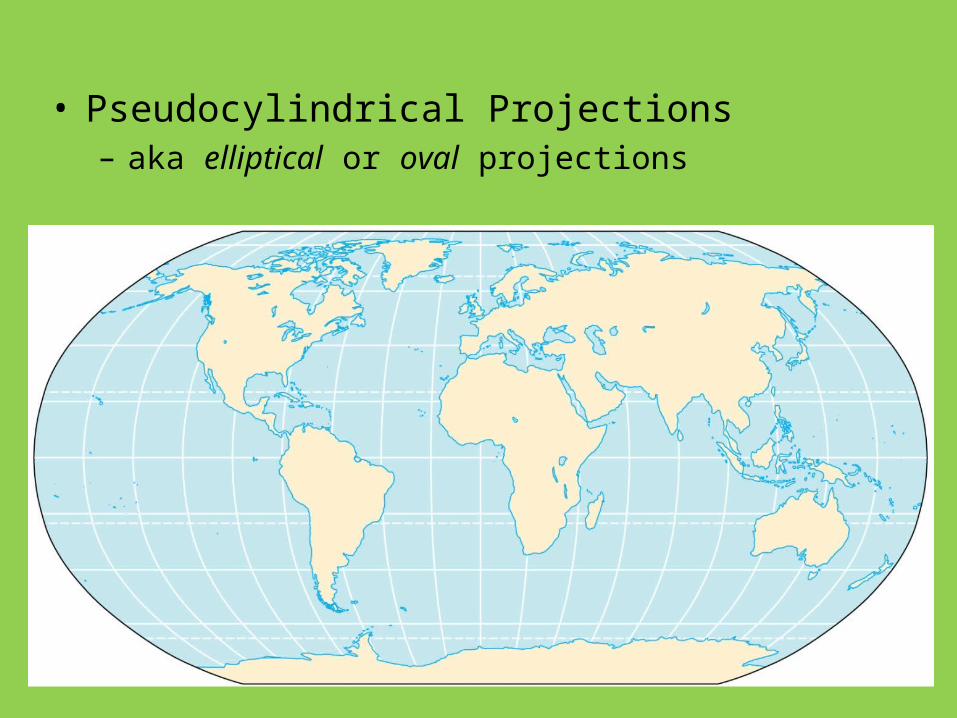
• Pseudocylindrical Projections– aka elliptical or oval projections

• Interrupted Projections

Map projections Youtube
• http://www.youtube.com/watch?v=n8zBC2dvERM&feature=PlayList&p=9DF42BD3AD0FB8ED&index=0&playnext=1
15
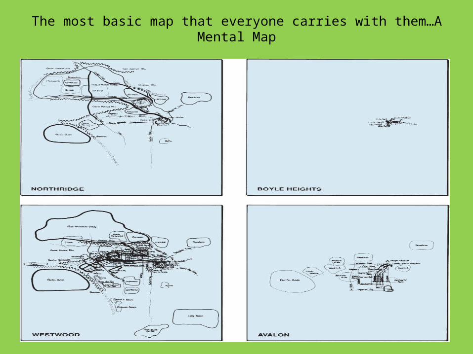
The most basic map that everyone carries with them…A Mental Map
16

Computer Cartography
• Mainframe computers– Symap
• Desktop computers
• Incredible improvements
• Demand for skilled cartographers

The Global Positioning System (GPS)
• Satellite-based• Accuracy
– Commercial/private users
– Military
Global positioning satellites

Remote Sensing• Collecting, storing, and extracting environmental
information using devices not in contact with what’s being studied
• Limits of human vision– Inexact storage and recall– Our non-vertical perspective– Small portion of the electromagnetic spectrum that
our eyes can discern

Geographic Information Systems (GIS)
• GIS systems combine spatial and attribute data
• Maps can contain multiple data layers:– Physical features– Cultural features
• Layers can be added to create composite overlay

GISystem
GIS work involves layers of data

GIS Example
Land Use on Cape Cod

A GIS map of the island of OAHU
23

A GIS Map and a Google Mapof Oahu, Hawaii
24

25

Another View of Geography

The Role of the Geographer
• Maps, globes, map projections, the GIS, remote sensing, GIS are merely TOOLS of the geographer
• They provide various ways the geographer can portray and study Earth’s surface
• To use them properly, must be trained in spatial thinking and understand place

Summary
• Geographers can portray Earth’s surface in many ways, each method has its advantages
• Geography is increasingly more valuable to government and business, as technological advances in computer mapping, imaging, and satellite remote sensing continue to occur

Resources
• De Blij, Harm, J. (2007). Human Geography People, Place and Culture. Hoboken, NJ: John Wiley & Sons Inc.
• Domosh, Mona, Neumann, Roderic, Price, Patricia, & Jordan-Bychkov, 2010. The Human Mosaic, A Cultural Approach to Human Geography. New York: W.H. Freeman and Company.
• Fellman, Jerome, D., Getis, Arthur, & Getis, Judith, 2008. Human Geography, Landscapes of Human Activities. Boston, MA: McGraw-Hill Higher Education.
• Pulsipher, Lydia Mihelic and Alex M. and Pulsipher, 2008. World Regional Geography, Global Patterns, Local Lives. W.H. Freeman and Company New York.
• Rubenstein, James M. (2008). An introduction to human geography The cultural landscape. Upper Saddle River, NJ: Pearson Prentice Hall.
• Benewick, Robert, & Donald, Stephanie H. (2005). The State of
• China Atlas. Berkeley: University of California Press.
29