advisory addendum #1 base flood elevations for … · advisory addendum #1 base flood elevations...
TRANSCRIPT
September 21, 2007 1
ADVISORY ADDENDUM #1 Base Flood Elevations for Plaquemines Parish, Louisiana
On April 12, 2006, following the landfall of Hurricanes Katrina and Rita in Louisiana, the U.S. Department of Homeland Security’s Federal Emergency Management Agency (FEMA) provided advisory information concerning coastal flood elevations to guide recovery efforts for areas outside the protection of levees. The April 12 guidance was intend-ed to address concerns about the accuracy of the flood risk information for Plaquemines Parish following Hurricanes Katrina and Rita, and other recent storms. The guidance doc-ument explained the recommended application of freeboard above the Plaquemines Parish effective Flood Insurance Rate Map (FIRM) information in areas outside of levee protec-tion and the use of Advisory Base Flood Elevations (ABFEs) for sub-basin “a” of the Belle Chasse polder within the levee protected areas.
This addendum to the April 12, 2006, guidance addresses the flood risk for previously described “undetermined” le-vee protected areas of Plaquemines Parish and establishes the ABFEs for those flood-prone areas. Based on updated flood data and levee repair information, this addendum is being issued for Plaquemines Parish levee polder sub-basins “b” to “i,” and is aimed at assisting in the progression of the re-covery process. This information is both reliable and current, and has been developed based on the best available technical information on levee protection and flood data. There are no changes to recovery guidance in sub-basin “a” (the Belle Chasse polder) or the recommended freeboard of areas pre-viously designated as outside of levee protection.
FEMA understands that assessing flood hazards in Plaquemines Parish is challenging due to the existence of numerous flood control facilities, which experienced dam-age of varying degrees as a result of Hurricanes Katrina and Rita. The U.S. Army Corps of Engineers (USACE) complet-ed repairs to damaged areas by June 2006 and continues to
improve the flood control system. Although USACE improve-ments will make Plaquemines Parish safer than it was before the storms, they will not eliminate the potential for flood-ing. In fact, based on USACE analyses, the flood control system will not meet the standards necessary to protect Plaquemines Parish against the 1-percent-annual-chance (100-year) flood, also referred to as the base flood. The National Flood Insurance Program (NFIP) uses the base flood as the standard for floodplain management. The April 12, 2006, guidance and this addendum represent the efforts of FEMA and USACE to develop flood hazard data and for-mulate recommendations for State and local governments as they make recovery decisions.
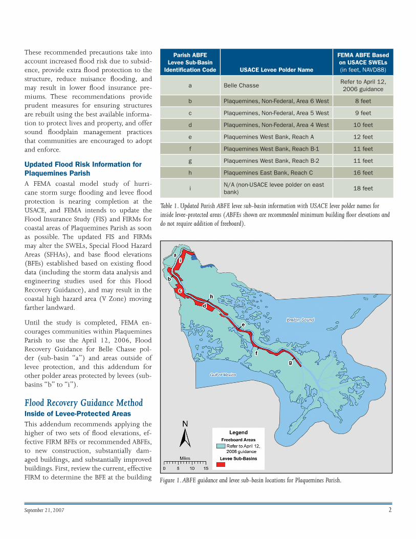
Inside of Levee-Protected AreasFEMA has updated the recovery guidance using the results of storm surge modeling recently completed by the USACE to determine an ABFE based on the prevailing 1-percent-an-nual-chance stillwater elevation (SWEL) in sub-basins “b” to “i” (see Table 1 and Figure 1). As required under FEMA Map Modernization, all ABFEs are now referenced to the North American Vertical Datum of 1988 (NAVD88).
Although FEMA is confident in the results from this current USACE storm surge assessment, the agency will continue to monitor progress made with regard to levee improvements, findings from other ongoing studies, and enhancements to the agency’s understanding of the probability of flooding in this area. FEMA may adjust the recommended flood eleva-tions, as necessary, as the agency prepares updated FIRMs for Plaquemines Parish.
Community Adoption FEMA is encouraging local officials and citizens to adopt the elevation recommendations provided in this Flood Recovery Guidance addendum and to elevate structures accordingly.
September 21, 2007 2
Figure 1. ABFE guidance and levee sub-basin locations for Plaquemines Parish.
These recommended precautions take into account increased flood risk due to subsid-ence, provide extra flood protection to the structure, reduce nuisance flooding, and may result in lower flood insurance pre-miums. These recommendations provide prudent measures for ensuring structures are rebuilt using the best available informa-tion to protect lives and property, and offer sound floodplain management practices that communities are encouraged to adopt and enforce.
Updated Flood Risk Information for Plaquemines ParishA FEMA coastal model study of hurri-cane storm surge flooding and levee flood protection is nearing completion at the USACE, and FEMA intends to update the Flood Insurance Study (FIS) and FIRMs for coastal areas of Plaquemines Parish as soon as possible. The updated FIS and FIRMs may alter the SWELs, Special Flood Hazard Areas (SFHAs), and base flood elevations (BFEs) established based on existing flood data (including the storm data analysis and engineering studies used for this Flood Recovery Guidance), and may result in the coastal high hazard area (V Zone) moving farther landward.
Until the study is completed, FEMA en-courages communities within Plaquemines Parish to use the April 12, 2006, Flood Recovery Guidance for Belle Chasse pol-der (sub-basin “a”) and areas outside of levee protection, and this addendum for other polder areas protected by levees (sub- basins “b” to “i”).
Flood Recovery Guidance Method Inside of Levee-Protected AreasThis addendum recommends applying the higher of two sets of flood elevations, ef-fective FIRM BFEs or recommended ABFEs, to new construction, substantially dam-aged buildings, and substantially improved buildings. First, review the current, effective FIRM to determine the BFE at the building
Parish ABFE Levee Sub-Basin
Identification Code USACE Levee Polder Name
FEMA ABFE Based on USACE SWELs (in feet, NAVD88)
a Belle ChasseRefer to April 12, 2006 guidance
b Plaquemines, Non-Federal, Area 6 West 8 feet
c Plaquemines, Non-Federal, Area 5 West 9 feet
d Plaquemines, Non-Federal, Area 4 West 10 feet
e Plaquemines West Bank, Reach A 12 feet
f Plaquemines West Bank, Reach B-1 11 feet
g Plaquemines West Bank, Reach B-2 11 feet
h Plaquemines East Bank, Reach C 16 feet
iN/A (non-USACE levee polder on east bank)
18 feet
Table 1. Updated Parish ABFE levee sub-basin information with USACE levee polder names for inside levee-protected areas (ABFEs shown are recommended minimum building floor elevations and do not require addition of freeboard).
September 21, 2007 �
site. Second, determine the recommended Parish ABFE from Table 1 for the appropriate levee sub-basins “b” to “i” at the building site. The lowest floor of the structure should be el-evated to the ABFE specified in Table 1 or the BFE shown on the effective FIRM, whichever is higher. This method ensures that adequate protection is provided to the building using updated flood data and existing status of levee protection.
Other Pertinent ABFE Information Although the information provided in this addendum and in the previous April 12, 2006, Flood Recovery Guidance are both advisory, communities should consider the recommen-dations to reduce future flood risk. For additional information and to access flood recovery advisories, community officials, residents, and other interested parties can access the FEMA website at http://www.fema.gov/hazard/flood/recovery-data/index.shtm.
In addition to determining site-specific ABFEs, community officials should consider additional protective measures to reduce future flood risks. These measures could include us-ing additional freeboard and building to the standards in the FEMA Coastal Construction Manual (CCM) (FEMA Publication 55). The CCM recommends the use of V Zone building stan-
dards in all areas subject to waves and velocity floodwaters caused by hurricane storm surges. For additional information on recommended practices, see the Coastal Construction Fact Sheet Series available at http://www.fema.gov/rebuild/mat/mat_fema499.shtm.
Ultimately local officials, working with property owners, will make final decisions regarding construction standards and applicable elevations during the recovery and rebuilding pro-cess. The ABFEs are a valuable tool until new model studies can be developed and incorporated into the FIS and FIRMs.
Vertical Datum The ABFEs in this addendum are referenced to the vertical da-tum of NAVD88. Previous FEMA flood data for Plaquemines Parish, including the effective FIRMs and April 12, 2006, Flood Recovery Guidance, are referenced to the National Geodetic Vertical Datum of 1929. As part of FEMA’s Map Modernization, existing and future FEMA flood elevations must be converted and referenced to NAVD88. The latest in-formation on NAVD88 elevations in Louisiana can be found on the National Oceanic and Atmospheric Administration’s (NOAA’s) National Geodetic Survey (NGS) website at http://www.ngs.noaa.gov/heightmod/LouisianaControl.shtml.