agenda - home - cassowary coast regional council€¦ · agenda cr bill shannon ... cr ian rule cr...
TRANSCRIPT

LOCAL GOVERNMENT MEETING
27 February 2014
AGENDA
Cr Bill Shannon
Cr Glenn Raleigh
Cr Bryce Macdonald
Cr Alister Pike
Cr Mark Nolan
Cr Ian Rule
Cr Kylie Farinelli
Mayor
Division 1
Division 2
Division 3
Division 4
Division 5
Division 6
Please find attached, agenda for the Local Government Meeting to be held in the Council Chambers - Board Room, 38-40 Bryant Street, Tully commencing at 9.00am.
Terry Brennan CHIEF EXECUTIVE OFFICER

AGENDA
9.00am Opening Prayer by a representative of the Tully Ministers' Fraternal
10.00am – 10.30am Morning Tea
1. CONFIRMATION OF MINUTES ................................................................................... 2 1.1 Confirmation of Minutes of Local Government Meeting, 13 February 2014 ................... 2
2. RECEIPT OF MINUTES .............................................................................................. 21
3. BUSINESS FROM PREVIOUS MINUTES .................................................................. 21
4. MANAGEMENT .......................................................................................................... 21
5. WORKS ...................................................................................................................... 21
6. COMMUNITY .............................................................................................................. 21
7. PLANNING & ENVIRONMENT ................................................................................... 22 7.1 Application for Permanent Road Closure - Unnamed Road (Lot 1 on RL4419) dividing
Lot 21 on SP212560 at Davis Road, Garradunga........................................................ 22 7.2 Single State Planning Policy ....................................................................................... 26
8. CORPORATE ............................................................................................................. 37 8.1 Corporate Services Financial Report January 2014 .................................................... 37
9. NOTICE OF MOTION ................................................................................................. 57
10. GENERAL BUSINESS ............................................................................................... 57
11. CONFIDENTIAL ......................................................................................................... 57

Agenda – CCRC Local Government Meeting
27 February 2014
2
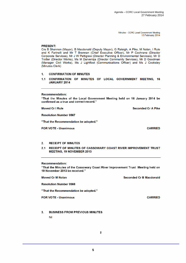
1. CONFIRMATION OF MINUTES
1.1 CONFIRMATION OF MINUTES OF LOCAL GOVERNMENT MEETING, 13 FEBRUARY 2014
Recommendation:
“That the Minutes of the Local Government Meeting held on 13 February 2014 be confirmed as a true and correct record.”

Agenda – CCRC Local Government Meeting
27 February 2014
3

Agenda – CCRC Local Government Meeting
27 February 2014
4
Agenda – CCRC Local Government Meeting
27 February 2014
5

Agenda – CCRC Local Government Meeting
27 February 2014
6

Agenda – CCRC Local Government Meeting
27 February 2014
7

Agenda – CCRC Local Government Meeting
27 February 2014
8

Agenda – CCRC Local Government Meeting
27 February 2014
9
Agenda – CCRC Local Government Meeting
27 February 2014
10

Agenda – CCRC Local Government Meeting
27 February 2014
11

Agenda – CCRC Local Government Meeting
27 February 2014
12

Agenda – CCRC Local Government Meeting
27 February 2014
13

Agenda – CCRC Local Government Meeting
27 February 2014
14

Agenda – CCRC Local Government Meeting
27 February 2014
15

Agenda – CCRC Local Government Meeting
27 February 2014
16

Agenda – CCRC Local Government Meeting
27 February 2014
17

Agenda – CCRC Local Government Meeting
27 February 2014
18

Agenda – CCRC Local Government Meeting
27 February 2014
19
Agenda – CCRC Local Government Meeting
27 February 2014
20

Agenda – CCRC Local Government Meeting
27 February 2014
21
2. RECEIPT OF MINUTES
Nil.
3. BUSINESS FROM PREVIOUS MINUTES
Nil.
4. MANAGEMENT
Nil.
5. WORKS
Nil.
6. COMMUNITY
Nil.

Agenda – CCRC Local Government Meeting
27 February 2014
22
7. PLANNING & ENVIRONMENT
7.1 APPLICATION FOR PERMANENT ROAD CLOSURE - UNNAMED ROAD (LOT 1 ON RL4419) DIVIDING LOT 21 ON SP212560 AT DAVIS ROAD, GARRADUNGA
Author & Officer's Title: Nicole Tsakissiris - Planning Officer
Meeting Date: 27 February 2013
Attachments: 1. Locality Plan 2. Aerial View
Executive Summary: Council is in receipt of correspondence requesting Council's views and/or requirements in relation to an application for the permanent closure of the unnamed road (Lot 1 on RL4419) which divides Lot 21 on SP212560 at Davis Road, Garradunga. Recommendation: “That the applicant is advised that Council does not object to the permanent closure of the unnamed road (Lot 1 on RL4419) dividing Lot 21 on SP212560 at Davis Road, Garradunga, on the condition that the closed road is amalgamated into Lot 21 on SP212560".
Background: Council received correspondence on 30 January 2014 from the owners of Lot 21 on SP212560, requesting Council's views and/or requirements in relation to an application for the permanent closure of the unnamed road (Lot 1 on RL4419) which divides Lot 21 on SP212560 at Davis Road, Garradunga. The unnamed road (Lot 1 on RL4419) is currently temporarily closed in association with Lot 21 on SP212560 (see Attachment 1).
The unnamed road is approximately 440m long and is 8900m2 in area. The unnamed road extends south of Davis Road and runs on a north-south alignment through the middle of Lot 21 on SP212560 (see Attachment 1).
There is an easement that appears to run from the southern end of the unnamed road in the Lot 18 SP215420, which is the lot below right of Lot 21 (see Attachment 1). However, this easement is unrelated to the unnamed road and Lot 21. The easement benefits Lot 2 RP704005 and Lot 3 RP814142 which are below left of Lot 21 and is for an irrigation system, extracting water from the creek on Lot 18 and delivering it to Lots 2 and 3. While this easement allows the owners of Lots 2 and 3 to enter Lot 18 to carry out maintenance and construction works on the irrigation system, it is not an access easement and is not reliant upon the unnamed road and Lot 21.
Lot 21 on SP212560 is approximately 63.38ha in area and is zoned Rural in the Johnstone Shire Planning Scheme. The unnamed road is currently used for faming purposes associated with Lot 21 on SP212560 (see Attachment 2).

Agenda – CCRC Local Government Meeting
27 February 2014
23
In accordance with Council's Road Closure Applications Policy, Council will object to an application for a permanent road closure where:
the road provides access to a watercourse or a place of public interest; the road is required for future road or public purposes; the road contains an environmentally valuable area; or the proposed road closure is inconsistent with the orderly planning of the area.
In this case, the unnamed road (Lot 1 on RL4419) extends south of Davis Road, runs through the middle of Lot 21 on SP212560 and ends at the southern boundary of Lot 21 on SP212560. It does not provide access to any other property or form part of a broader road network past the boundary of Lot 21. The road does not provide access to a watercourse or contain an environmentally valuable area. For these reasons, the closure of this road is not considered to be contrary to the provisions of the Road Closure Applications Policy.
Therefore, it is recommended that Council does not object to the permanent closure of the unnamed road (Lot 1 on RL4419) dividing Lot 21 on SP212560 at Davis Road, Garradunga, subject to the closed road being amalgamated into adjacent Lot 21.
Link to Corporate Plan:
Key strategy 5.4a) - Provide and manage the region's transport infrastructure network to enable the safe, efficient and sustainable movement of people, goods and freight. Consultation:
Officers within the Planning and Environment Services department and the Works department were consulted in preparing this report. Legal Implications (Statutory basis, legal risks):
Nil Policy Implications:
Nil Financial & Resource Implications:
Nil Report prepared by:
Nicole Tsakissiris - Planning Officer Report authorised by:
John Pettigrew - Director Planning & Environmental Services Report created date:
12 February 2014

Agenda – CCRC Local Government Meeting
27 February 2014
24
Attachment 1 - Locality Plan

Agenda – CCRC Local Government Meeting
27 February 2014
25
Attachment 2 - Aerial view

Agenda – CCRC Local Government Meeting
27 February 2014
26
7.2 SINGLE STATE PLANNING POLICY
Author & Officer's Title: Aletta Nugent - Manager Strategic Planning Meeting Date: 27 February 2014
Attachment 1 - Hierarchy of planning instruments.
Executive Summary:
On 2 December 2013, the State Government released the finalised single State Planning Policy (SPP). The single SPP replaces the existing 11 SPPs and represents a change in approach in relation to the way State interests are articulated and recognised through the planning scheme development and development assessment process. While the single SPP does express the relevant State interests in a different way to the approach adopted previously, the subject matters covered are largely the same. Some additional State interests have been included that were not previously dealt with in a SPP, however these matters were still raised by State agencies as part of the planning scheme development process and therefore still addressed in new planning schemes. While the subject matter covered by the SPP is not new, there are some changes in the specific requirements and mapping that relates to these State interests. However, the State has advised that it will be flexible in allowing local authorities to determine how the State interests are addressed in a planning scheme. Overall, we believe that the draft Planning Scheme largely addresses the matters raised in the single SPP. Recommendation:
“That the report be noted.”
Background: On 2 December 2013, the single State Planning Policy (SPP) took effect. The SPP had been in development for over a year as part of the State government's broader planning reform process. Previously, a separate SPP was prepared for each individual State interest. At the time the single SPP took effect, there were 11 SPPs in force, with 2 other SPPs allowed to lapse in anticipation of the single SPP's release. In addition, a number of State interests were raised by individual State agencies as part of the planning scheme development process, even though they weren't the subject of a SPP. Some of these State interests were contained in legislation and others were in internal State government policy documents. Now, all State interests relevant to land use planning and development are consolidated in the single SPP. As Council would be aware, the draft Planning Scheme was drafted before the single SPP was released. However, the draft single SPP was released during the State interest review of the draft Planning Scheme. This allowed for the modification of the Planning Scheme to better reflect the State interests as expressed through the single SPP and deal with any new

Agenda – CCRC Local Government Meeting
27 February 2014
27
matters that Council had not been required to address previously. This also allowed officers to clarify the State's position in relation to certain other State interests in the single SPP to ensure these interests were adequately addressed in the draft Planning Scheme. The single SPP contains 16 State interests arranged under 5 broad themes. The 16 State interests expressed in the SPP are not new and were either the subject of previous SPPs or raised by State agencies during the development of new planning schemes. However, there are some new requirements and mapping that has been included for these State interests. A brief description of each State interest and details of any new requirements or mapping is provided below: 1. Planning for liveable communities and housing:
(a) Liveable communities
Includes requirements for a planning scheme to: include best-practice urban design; manage residential and scenic amenity issues; require public access to natural areas and waterways; provide for public open space; protect local character and heritage places; provide an appropriate land use mix; consolidate urban development in and around existing settlements; maximise the use of existing infrastructure and services; provide for social infrastructure; provide for pedestrian, cycling and public transport infrastructure and
connectivity; and provide for connection to fibre telecommunications infrastructure.
Many of these requirements were either present in existing SPPs, were State policy that had to be included in a planning scheme, are requirements of the FNQ Regional Plan or are just basic best practice land use planning principles that are included in a planning scheme as a matter of course. (b) Housing supply and diversity
Includes requirements for a planning scheme to: locate land for housing development in areas that are accessible and well
connected to services, employment and infrastructure; provide a range of housing options for all residents; provide best-practice housing design; provide land to support non-resident workforce accommodation for large-scale
approved mining, agriculture, industry or infrastructure projects.
These matters were dealt with in the existing SPP 1/07 Housing and Residential Development or as State policy.

Agenda – CCRC Local Government Meeting
27 February 2014
28
2. Planning for economic growth:
(a) Agriculture Includes requirements for a planning scheme to: promote and optimise agricultural development opportunities and enable
increased agricultural production in important agricultural areas; protect Class A and Class B land for sustainable agricultural use by:
- avoiding fragmentation of this land into lot sizes inconsistent with the current or potential use of the land for agriculture; and
- maintaining or enhancing land condition and biophysical resources, protect fisheries resources from development that compromises its long-term
productivity and accessibility; and facilitate growth in agricultural production and a strong agriculture industry by:
- considering the value and suitability of land for current or potential agricultural uses when making land use decisions;
- considering the planning needs of hard to locate intensive agricultural land uses;
- locating new development (eg. sensitive land uses) in areas that minimise the potential for conflict with existing agricultural uses;
- including agriculture development codes or other similar development assessment requirements;
- facilitating opportunities for mutually beneficial co-existence with development that is complementary to agriculture and other non-agricultural uses that do not diminish agricultural productivity;
- considering the infrastructure and services necessary to support a strong agriculture industry and associated supply chains; and
- protecting the stock route network from development that would compromise its primary uses for stock movement and other values (eg. recreational).
Protection of agricultural land was previously dealt with under SPP 1/92 Development and the Conservation of Agricultural Land, which was allowed to lapse in anticipation of the single SPP taking effect. SPP 1/12 Protection of Queensland's Strategic Cropping Land also dealt with these issues. The FNQ Regional Plan also contains requirements in relation to the protection of agricultural land. It should be noted however that the new agricultural land mapping that was provided to Council as part of the development of the new planning scheme was incomplete. The mapping provided was for the draft single SPP, however it contained only the important agricultural land mapping. The Class A and B land mapping was not previously provided and Council officers were not aware of its existence. The draft planning scheme will need to be amended to include the Class A and B mapping prior to adoption by Council.
(b) Development and construction
Includes requirements for a planning scheme to: identify suitable land for residential, commercial, retail and industrial
development and provide a mix of zone types and locations that consider existing and anticipated demand, the nature of surrounding land uses, opportunities for mixed uses and the physical constraints of the land;
plan for the infrastructure to support urban development through a priority infrastructure plan;
facilitate an appropriate mix of lot sizes and configurations in residential, commercial and industrial zones to support the activities that will be carried out in these zones;

Agenda – CCRC Local Government Meeting
27 February 2014
29
facilitate development of mixed-use precincts to provide opportunities for a wider variety of uses, local employment, small businesses and innovation;
maintain industrial-zoned land for industrial development and discourage incompatible development;
adopt the lowest appropriate level of assessment for commercial and industrial uses on land zoned for that purpose;
consider any state development purposes and priority development areas; and consider the use of government land suitable for infill and redevelopment.
The Temporary SPP 2/12 Planning for Prosperity previously contained some of these requirements, but many are just basic best practice land use planning principles that are included in a planning scheme as a matter of course. The requirement for infrastructure planning comes from the existing Sustainable Planning Act 2009 and relevant statutory guidelines.
(c) Mining and extractive resources
Includes requirements for a planning scheme to: identify and protect key resource areas; consider the importance of areas identified as having valuable coal, minerals,
petroleum and gas resources and areas of mining and resource tenures; consider opportunities to facilitate mutually beneficial co-existence between
resource development operations and other land uses; and consider the location of specified petroleum infrastructure that occur on
petroleum leases or under petroleum facility licences and pipeline licences. These matters were previously covered by the Temporary SPP 2/12 Planning for Prosperity and SPP 2/07 Protection of Extractive Resources.
(d) Tourism
Includes requirements for a planning scheme to: consider the findings of relevant tourism studies and plans; identify and protect opportunities, localities or areas appropriate for tourism
development, both existing and potential; facilitate and streamline the delivery of sustainable tourism development that:
- is complementary to and compatible with other land uses; and - promotes the protection or enhancement of the character, landscape and
visual amenity, and the economic, social, cultural and environmental values of the natural and built assets associated with the tourism development, and
plan for appropriate infrastructure and services to support and enable tourism development.
The Temporary SPP 2/12 Planning for Prosperity previously dealt with this matter, and the FNQ Regional Plan contains specific requirements in relation to tourism planning. There is still quite a bit of work being carried out at State level in relation to best practice ways of supporting tourism through land use planning documents.
3. Planning for the environment and heritage:
(a) Biodiversity
Includes requirements for a planning scheme to: consider matters of national environmental significance and the requirements of
the Environment Protection and Biodiversity Conservation Act 1999; identify matters of state environmental significance (MSES); avoid significant adverse impacts on MSES;

Agenda – CCRC Local Government Meeting
27 February 2014
30
maintain or enhance ecological connectivity; facilitate the protection of MSES by requiring development to, in order of
priority: - avoid significant adverse environmental impacts; - mitigate significant adverse environmental impacts, where these cannot be
avoided; and - where applicable, offset any residual adverse impacts,
facilitate a net gain of koala bushland habitat in the SEQ region; consider matters of local environmental significance, where considered
appropriate by a local government. Council's draft planning scheme utilises the areas of ecological significance (AES) mapping from the FNQ Regional Plan. This mapping appears to be reasonably accurate in the context of the Cassowary Coast Region. In any event, Council can consider matters of local environmental significance where it considers this is appropriate.
(b) Coastal environment
Includes requirements for a planning scheme to: facilitate the protection of coastal processes and coastal resources; maintain or enhance the coastal scenic amenity; facilitate consolidation of coastal settlements by:
- concentrating future development in existing urban areas; and - conserving the natural state of coastal areas outside existing urban areas,
facilitate coastal-dependent development in areas adjoining the foreshore in preference to other types of development; and
maintain or enhance opportunities for public access and use of the foreshore; and
include the SPP code: Ship-sourced pollutants reception facilities in marinas or similar development requirements.
Coastal planning was a requirement for new planning schemes in accordance with the Coastal Protection State Planning Regulatory Provision (replacing the Coastal Protection SPP) and the FNQ Regional Plan, as well as relevant legislation. It should be noted that the requirement to include the SPP code: Ship-sourced pollutants reception facilities in marinas is a new requirement. It was not included in the draft single SPP and was not raised during the course of the drafting of the new planning scheme.
(c) Cultural heritage
Includes requirements for a planning scheme to: consider the location and cultural heritage significance of world heritage
properties and national heritage places; consider and integrate matters of Aboriginal and Torres Strait Islander cultural
heritage; consider the location and cultural heritage significance of Queensland heritage
places; identify local heritage places and areas; and protect and conserve the cultural heritage significance of heritage places and
areas, while allowing for their adaptive re-use.

Agenda – CCRC Local Government Meeting
27 February 2014
31
While the desirability of at least recognising world heritage properties, national heritage places and Aboriginal and Torres Strait Islander cultural heritage in a planning scheme has been raised by State agencies during the planning scheme drafting process in the past, it has never been formal State policy that this occur.
(d) Water quality
Includes requirements for a planning scheme to: facilitate the protection of environmental values; plan for safe, secure and efficient water supply; adopt best practice stormwater management design objectives relevant to the
climatic region; facilitate innovative and locally appropriate solutions for urban stormwater
management; avoid or minimise the disturbance to natural drainage and acid sulfate soils,
erosion risk, impact on groundwater and landscape features; protect the natural and built environment (including infrastructure) and human
health from the potential adverse impacts of acid sulfate soils; require that development for an urban purpose be located, designed,
constructed and/or managed to avoid or minimise: - impacts arising from altered stormwater quality or flow, waste water and
the creation or expansion of artificial waterways; and - the release and mobilisation of nutrients that increase the risk of algal
blooms, require that development in water catchments be undertaken in a manner
which contributes to the maintenance or enhancement of water quality to protect drinking water and aquatic ecosystems; and
require that development comply with the specific outcomes and measures contained in the SEQwater Development Guidelines: Development Guidelines for Water Quality Management in Drinking Water Catchments 2012 or similar development assessment requirements.
These matters were previously covered by SPP 4/10 Healthy Waters and SPP 2/02 Planning and Managing Development Involving Acid Sulfate Soils.
4. Planning for hazards and safety:
(a) Emissions and hazardous activities
Includes requirements for a planning scheme to: locate industrial and high impact sport and recreational activities in areas that
avoid, mitigate and manage the adverse impacts of emissions on sensitive land uses;
protect existing industrial and high impact sport and recreational activities and land designated for that purpose from encroachment by development that would compromise the ability of the land to function safely and effectively;
locate and manage development for activities involving the use, storage and disposal of hazardous materials and hazardous chemicals, dangerous goods and flammable or combustible substances to avoid or mitigate potential adverse impacts on surrounding uses, and minimise the health and safety risks to communities and individuals;
protect sensitive land uses from the impact of previous activities that may cause risk to people or property, including mining activities and hazards (eg disused underground mines, tunnels and shafts), landfill and refuse sites or contaminated land;
Agenda – CCRC Local Government Meeting
27 February 2014
32
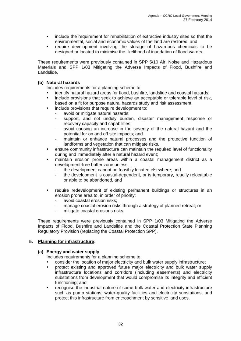
include the requirement for rehabilitation of extractive industry sites so that the
environmental, social and economic values of the land are restored; and require development involving the storage of hazardous chemicals to be
designed or located to minimise the likelihood of inundation of flood waters. These requirements were previously contained in SPP 5/10 Air, Noise and Hazardous Materials and SPP 1/03 Mitigating the Adverse Impacts of Flood, Bushfire and Landslide.
(b) Natural hazards
Includes requirements for a planning scheme to: identify natural hazard areas for flood, bushfire, landslide and coastal hazards; include provisions that seek to achieve an acceptable or tolerable level of risk,
based on a fit for purpose natural hazards study and risk assessment; include provisions that require development to:
- avoid or mitigate natural hazards; - support, and not unduly burden, disaster management response or
recovery capacity and capabilities; - avoid causing an increase in the severity of the natural hazard and the
potential for on and off site impacts; and - maintain or enhance natural processes and the protective function of
landforms and vegetation that can mitigate risks, ensure community infrastructure can maintain the required level of functionality
during and immediately after a natural hazard event; maintain erosion prone areas within a coastal management district as a
development-free buffer zone unless: - the development cannot be feasibly located elsewhere; and - the development is coastal-dependent, or is temporary, readily relocatable
or able to be abandoned, and
require redevelopment of existing permanent buildings or structures in an erosion prone area to, in order of priority: - avoid coastal erosion risks; - manage coastal erosion risks through a strategy of planned retreat; or - mitigate coastal erosions risks.
These requirements were previously contained in SPP 1/03 Mitigating the Adverse Impacts of Flood, Bushfire and Landslide and the Coastal Protection State Planning Regulatory Provision (replacing the Coastal Protection SPP).
5. Planning for infrastructure:
(a) Energy and water supply Includes requirements for a planning scheme to: consider the location of major electricity and bulk water supply infrastructure; protect existing and approved future major electricity and bulk water supply
infrastructure locations and corridors (including easements) and electricity substations from development that would compromise its integrity and efficient functioning; and
recognise the industrial nature of some bulk water and electricity infrastructure such as pump stations, water-quality facilities and electricity substations, and protect this infrastructure from encroachment by sensitive land uses.
Agenda – CCRC Local Government Meeting
27 February 2014
33
It was previously a requirement to consult with Ergon to ensure their existing infrastructure and future infrastructure planning is not impacted by a planning scheme. Ergon is also one of the State agencies involved in the State interest review process.
(b) State transport infrastructure
Includes requirements for a planning scheme to: identify existing and future state transport infrastructure and corridors; locate development in areas currently serviced by transport infrastructure or
facilitate development in a logical and orderly sequence to enable cost-effective delivery of new transport infrastructure;
ensure development is designed and located to ensure the most efficient use of State transport infrastructure and transport networks;
protect existing and future state transport infrastructure and corridors from development that may adversely affect the safety and efficiency of the infrastructure or corridor;
identify a road hierarchy that effectively manages all types of traffic; facilitate land use patterns and development which achieve a high level of
integration with transport infrastructure and support public passenger transport and active transport as attractive alternatives to private transport; and
include the SPP code: Land use and transport integration, or similar development assessment requirements, for development within 400 metres of a public passenger transport facility or future public passenger transport facility; and
ensure sensitive development is appropriately sited and designed to mitigate adverse impacts on the development from environmental emissions generated by the state transport infrastructure.
These requirements were previously communicated by the Department of Transport and Main Roads (DTMR) through the planning scheme development process and the State interest review process. Although there was no formal State interest that contained these requirements, they were well known and communicated DTMR policy. It does not appear that the SPP code: Land use and transport integration applies to Cassowary Coast Regional Council as it seems to relate to large scale public transport facilities such as transit centres and bus stations.
(c) Strategic airports and aviation facilities
Includes requirements for a planning scheme to: identify strategic airports and aviation facilities and associated operational
airspace, public safety areas, lighting area buffer zones, wildlife hazard buffer zones, Australian Noise Exposure Forecast (ANEF) contours, and building restricted areas;
facilitate development surrounding strategic airports that is compatible with, depends upon or gains significant economic advantage from being in proximity to a strategic airport, or supports the airport's role as a freight and logistics hub;
protect strategic airports by ensuring: - development and associated activities do not create incompatible
intrusions or compromise aircraft safety; - development avoids increasing the risk to public safety in public safety
areas; and - development mitigates the adverse impacts of aircraft noise and is
compatible with forecast levels of aircraft noise, protect aviation facilities by ensuring development and associated activities
within building restricted areas do not affect their functioning; identify and protect key transport corridors (passenger and freight) linking
strategic airports to the broader transport network; and

Agenda – CCRC Local Government Meeting
27 February 2014
34
include the SPP code: Strategic airports and aviation facilities or similar development assessment requirements.
SPP 1/02 Development in the Vicinity of Certain Airports and Aviation Facilities dealt with these issues previously. However that SPP did not identify any aviation facilities in the Cassowary Coast Region. As there are no strategic airports in the Cassowary Coast Region, Council was therefore not required to comply with the SPP. The single SPP shows the Innisfail NDB as an aviation facility that must be protected in accordance with the SPP. This requirement was in the draft single SPP and therefore the draft planning scheme was amended to ensure the protection of the Innisfail NDB in accordance with the single SPP.
d) Strategic ports
Includes requirements for a planning scheme to: identify strategic ports and associated strategic port land and core port land; facilitate development surrounding strategic ports that is compatible with,
depends upon or gains significant economic advantage from being in proximity to a strategic port, or supports the strategic port's role as a freight and logistics hub;
protect strategic ports from development which may adversely affect the safety, viability or efficiency of existing or future port operations;
ensure sensitive development is appropriately sited and designed to mitigate adverse impacts on the development from environmental emissions generated by port operations;
identify and protect key transport corridors (including freight corridors) linking strategic ports to the broader transport network; and
consider statutory land use plans for strategic ports and the findings of planning and environmental investigations undertaken in relation to strategic ports.
These requirements were communicated as part of the planning scheme development process in the past even though they were not included in an SPP.
It is intended that these State interests will be reflected in planning schemes, and as a result there are limited provisions provided for the purposes of development assessment. There are some interim development assessment requirements in relation to the following State interests that are consistent with the requirements for what needs to be included in a new planning scheme: Mining and extractive resources Biodiversity Coastal environment Water quality Emissions and hazardous activities Natural hazards State transport infrastructure Strategic airports and aviation facilities Once the SPP is reflected in a planning scheme, it is not necessary for the policy to be considered as part of the development assessment process. It should be noted that the FNQ Regional Plan must still be reflected in a planning scheme, and the hierarchy of planning instruments is shown for Council's information in Attachment 1 to this report. In accordance with the requirements of the Sustainable Planning Act 2009 and the Statutory Guideline 1/13 Making and amending local planning instruments, Council must demonstrate

Agenda – CCRC Local Government Meeting
27 February 2014
35
to the Minister that it has considered and integrated the relevant State interests in the draft planning scheme during the formal State interest review process. One of the major issues causing the delay of the State interest review for the draft CCRC planning scheme was the transitioning between the existing SPPs and the single SPP by the State government. Overall, the draft Planning Scheme addresses all of the State interests articulated in the single SPP. While there are some new elements for these State interests in the final version of the single SPP, the SPP is intended to allow a local government to find locally appropriate approaches to reflecting relevant State interests. Therefore, while there may be some minor amendments required to fully reflect the single SPP, we are confident that we have largely addressed the relevant State interests in the draft Planning Scheme. Discussions with the Department of State Development, Infrastructure and Planning support this view. It should be noted that the provisions relating to the agriculture State interest are broadly similar to those in the previous SPP. The wording relating to this State interest is less prescriptive and more general, but the single SPP still requires important agricultural land to be protected from fragmentation and kept free of non-agricultural development. These outcomes have to be reflected in the draft Planning Scheme. Link to Corporate Plan: 2.5 Planning for the Future
a) Actively engage in the development of regional planning at the state level to position the Cassowary Coast region for appropriate future growth and development.
5.1 Planning for Liveable Outcomes
a) Develop and implement a new Cassowary Coast Region Planning Scheme that guides the future growth of the region and delivers a balanced sustainable economy while maintaining its exceptional natural environment, culture and heritage preservation and unique tropical lifestyle.
Consultation: Council officers were involved in the consultation for the draft single SPP. Legal Implications (Statutory basis, legal risks): Nil Policy Implications: At this stage, it appears that the draft Planning Scheme does largely reflect the State interests captured by the single SPP. Financial & Resource Implications: Nil Report prepared by:
Aletta Nugent - Manager Strategic Planning Report authorised by: John Pettigrew - Director Planning and Environmental Services Report created date: 7 February 2014

Agenda – CCRC Local Government Meeting
27 February 2014
36
Attachment 1 - Hierarchy of planning instruments

Agenda – CCRC Local Government Meeting
27 February 2014
37
8. CORPORATE
8.1 CORPORATE SERVICES FINANCIAL REPORT JANUARY 2014
Author & Officer's Title: Andrew Page - Manager Finance
Meeting Date: 27 February 2014
Executive Summary:
The purpose of this report is for Council to receive the Financial Report for the period ending 31 January 2014 prepared on 18 February 2014. The Director Corporate Services and Manager Finance will be available at the Council meeting to answer any questions Councillors may have. Recommendation:
“That this report be received and noted.”
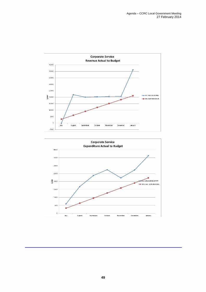
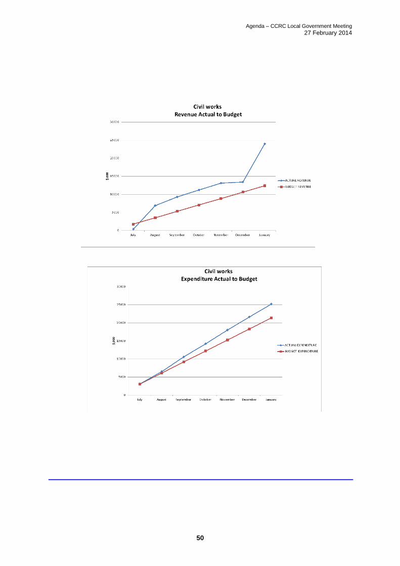
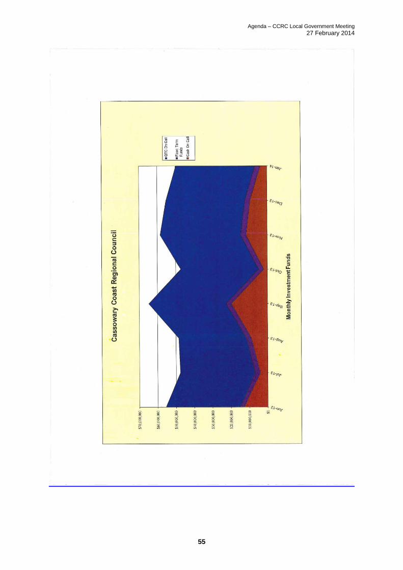
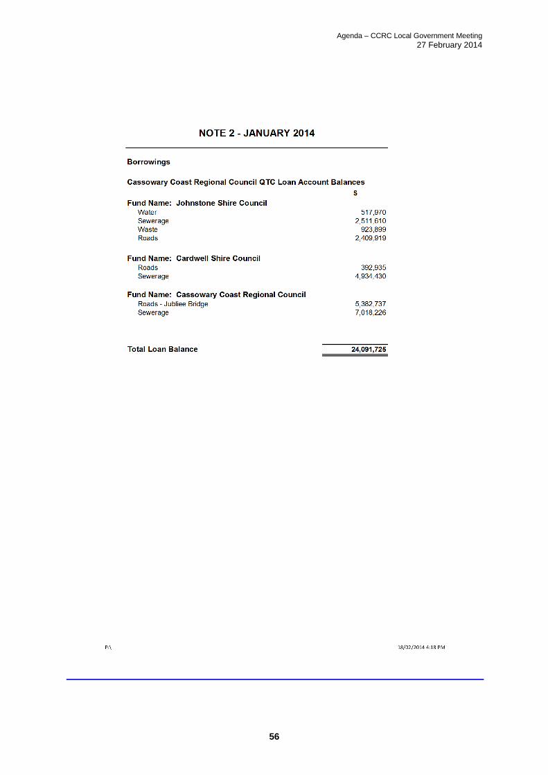
Background: The Chief Executive Officer is required by Section 204 (2) of the Local Government Regulation 2012 to present the financial report at a meeting of the local government once a month. The financial report must state the progress that has been made in relation to the local government’s budget for the period of the financial year up to a day as near as practicable to the end of the month before the meeting is held. The figures from the Operating Statement show expenditure up to the end of January 2014 which represent 60% of budget. This is approximately 2% above on a prorata basis. Some of the current expenditure includes annual costs such as insurance and this does impact on prorata calculations. A budget review is currently underway and a more detailed assessment of the financial position will then be possible. It is however clear, that we have a tight budget position which will be carefully monitored. The data used in the sub program areas and graphs differs from the data presented in the Operating Statement. The difference relate mainly to internal charges which are netted out in the Operating Statement. Timing is also an issue particularly with the current rates levy. • It is also noted that the cash position has fallen by $8.9M during the month to $49M • There has been a $1M increase in capital work in progress during the month Link to Corporate Plan: 1.3 Responsible Financial Management
a) Ensure operating surpluses in Council's Annual Budget. b) Manage debt within financial sustainable levels. c) Maximise funding from external sources
Consultation: Nil

Agenda – CCRC Local Government Meeting
27 February 2014
38
Legal Implications (Statutory basis, legal risks): Compliance with financial management policies and principles as set down in the Local Government Finance Standards and requirements of the Local Government Act. Policy Implications: Nil Financial & Resource Implications: Council adopted the 2013/14 Original Budget on 18 July 2013. The attached reports reflect the year to date revenue and expenditure figures across all adopted budget programs, and include various reports on Council's financial operations. Report prepared by:
Andrew Page - Manager Finance Report authorised by: Peter Cochrane - Director Corporate Services Report created date: 18 February 2014

Agenda – CCRC Local Government Meeting
27 February 2014
39

Agenda – CCRC Local Government Meeting
27 February 2014
40

Agenda – CCRC Local Government Meeting
27 February 2014
41

Agenda – CCRC Local Government Meeting
27 February 2014
42
Cassowary Coast Regional Council
Operating Statement
For the year ended 30-Jun-2014
As at 31-Jan-2014
Actual YTD to 31-
Jan-2014
$
2014 Budget
$
Budget
Variance FY
%
2013 Actual
$
Community Services
Aquatic Sub-Program
8,197 10,400 79% 10,339
(513,479) (695,266) 74% (649,909)
$ (505,282) $ (684,866) 74% $ (639,569)
Building Facilities
116,609 90,660 129% 112,975
(794,063) (1,077,043) 74% (4,355,728)
$ (677,454) $ (986,383) 69% $ (4,242,753)
Children's Services
202,202 421,400 48% 405,861
(213,744) (421,400) 51% (382,700)
$ (11,542) $ 0 NA $ 23,161
Community Development and Services Program Support
75,320 93,456 81% 89,872
(333,532) (707,118) 47% (601,673)
$ (258,212) $ (613,662) 42% $ (511,801)
Community Facilities
231,695 279,100 83% 3,192,788
(2,853,055) (4,534,967) 63% (2,751,194)
$ (2,621,361) $ (4,255,867) 62% $ 441,594
Community Planning
16,100 76,500 21% 755,800
(180,558) (437,198) 41% (955,011)
$ (164,458) $ (360,698) 46% $ (199,211)
Community Services Management
2,305 0 NA 4,183
(339,426) (618,809) 55% (771,281)
$ (337,121) $ (618,809) 54% $ (767,098)
Disaster Recovery
0 0 NA (16,980)
$ 0 $ 0 NA $ (16,980)
Economic & Tourism Development
66,505 91,600 73% 85,767
(470,803) (853,228) 55% (982,953)
$ (404,298) $ (761,628) 53% $ (897,186)
Housing Services
403,344 593,845 68% 518,087
(400,010) (703,938) 57% (478,301)
$ 3,334 $ (110,093) -3% $ 39,786
6 - Expenses
Net op surpl/(deficit) Special Projects & Planning
4 - Revenue
6 - Expenses
Net op surpl/(deficit) Community Development & Services
4 - Revenue
6 - Expenses
Net op surpl/(deficit) Community Services Program Management
6 - Expenses
Net op surpl/(deficit) Community Services Program Management
4 - Revenue
4 - Revenue
6 - Expenses
Net op surpl/(deficit) Special Projects & Planning
4 - Revenue
6 - Expenses
Net op surpl/(deficit) Community Development & Services
4 - Revenue
6 - Expenses
Net op surpl/(deficit) Community Development & Services
4 - Revenue
6 - Expenses
Net op surpl/(deficit) Community Facil ities
4 - Revenue
6 - Expenses
Net op surpl/(deficit) Community Facil ities
4 - Revenue
6 - Expenses
Net op surpl/(deficit) Community Facil ities

Agenda – CCRC Local Government Meeting
27 February 2014
43
Libraries
90,687 179,000 51% 189,907
(884,581) (1,665,757) 53% (1,447,132)
$ (793,894) $ (1,486,757) 53% $ (1,257,225)
Minor Infrastructure
2,760 0 NA 1,762
(8,350) (13,581) 61% (9,104)
$ (5,590) $ (13,581) 41% $ (7,342)
Natural Environment Management
235,953 495,000 48% 761,842
(649,978) (1,240,483) 52% (1,412,649)
$ (414,025) $ (745,483) 56% $ (650,807)
Outdoor Venues
314,113 394,000 80% 430,049
(700,608) (925,970) 76% (1,065,551)
$ (386,495) $ (531,970) 73% $ (635,502)
Parks/Open Spaces
124,112 212,000 59% 174,782
(1,470,370) (1,942,200) 76% (3,003,498)
$ (1,346,259) $ (1,730,200) 78% $ (2,828,716)
Total Community Services $ (7,922,655) $ (12,899,997) $ 1 $ (12,149,649)
Corporate Services
Corporate Services Program Support
1,774,283 4,752,375 37% 4,394,746
400,887 510,583 79% 216,717
$ 2,175,169 $ 5,262,958 41% $ 4,611,462
Customer Service
798 5,000 16% 4,172
(209,623) 0 NA (117,463)
$ (208,825) $ 5,000 -4176% $ (113,291)
Disaster Management
14,006 21,000 67% 29,089
(98,031) (169,219) 58% (204,906)
$ (84,024) $ (148,219) 57% $ (175,817)
Financial Services
3,180 10,000 32% 877,611
(1,358,046) (1,831,394) 74% (1,576,153)
$ (1,354,866) $ (1,821,394) 74% $ (698,543)
Corporate Governance
(1,027) 0 NA (790)
(125,398) 0 NA (70,489)
$ (126,426) $ 0 NA $ (71,278)
Information Technology Management
904 0 NA 0
413,032 952,549 43% 628,998
$ 413,936 $ 952,549 43% $ 628,998
6 - Expenses
Net op surpl/(deficit) Information Services
6 - Expenses
Net op surpl/(deficit) Finance
4 - Revenue
6 - Expenses
Net op surpl/(deficit) Corporate Governance & Program Management
4 - Revenue
6 - Expenses
Net op surpl/(deficit) Rates and Customer Service
4 - Revenue
6 - Expenses
Net op surpl/(deficit) Disaster
4 - Revenue
6 - Expenses
Net op surpl/(deficit) Parks and Open Space
4 - Revenue
6 - Expenses
Net op surpl/(deficit) Corporate Governance & Program Management
4 - Revenue
6 - Expenses
Net op surpl/(deficit) Special Projects & Planning
4 - Revenue
6 - Expenses
Net op surpl/(deficit) Parks and Open Space
4 - Revenue
6 - Expenses
Net op surpl/(deficit) Knowledge and Information
4 - Revenue
6 - Expenses
Net op surpl/(deficit) Community Facil ities
4 - Revenue
4 - Revenue

Agenda – CCRC Local Government Meeting
27 February 2014
44
Information Services Management
(48) 0 NA 0
(587,720) (1,424,052) 41% (1,160,466)
$ (587,768) $ (1,424,052) 41% $ (1,160,466)
Media & Corporate Communications
(56,124) (89,504) 63% (89,413)
$ (56,124) $ (89,504) 63% $ (89,413)
Rates & Properties
39,388,965 31,458,507 125% 30,708,456
(1,674,135) (1,394,261) 120% (1,407,312)
$ 37,714,829 $ 30,064,246 125% $ 29,301,144
Records Management
(209,159) (68,200) 307% (125,119)
$ (209,159) $ (68,200) 307% $ (125,119)
SES Support
21,156 0 NA 0
(64,706) (165,739) 39% (47,774)
$ (43,550) $ (165,739) 26% $ (47,774)
Total Corporate Services $ 37,633,194 $ 32,567,645 $ 1 $ 32,059,904
General Management
Councillors Services
41 0 NA 610
(390,489) (749,778) 52% (620,787)
$ (390,448) $ (749,778) 52% $ (620,177)
General Management Program Support
4,673 3,000 156% 3,633
(395,518) (634,836) 62% (656,293)
$ (390,845) $ (631,836) 62% $ (652,661)
Human Resources
677 0 NA 31,637
(202,493) (469,090) 43% (412,859)
$ (201,816) $ (469,090) 43% $ (381,222)
Workplace Health & Safety & Training
(147,558) (310,886) 47% (276,166)
$ (147,558) $ (310,886) 47% $ (276,166)
Total General Management $ (1,130,666) $ (2,161,590) $ 1 $ (1,930,226)
Planning and Environmental Services
Building
242,210 553,000 44% 526,865
(279,233) (524,667) 53% (493,100)
$ (37,023) $ 28,333 -131% $ 33,765
Environmental Health & Local Laws
292,528 436,000 67% 327,952
(801,361) (1,469,300) 55% (1,431,186)
$ (508,833) $ (1,033,300) 49% $ (1,103,234)
6 - Expenses
Net op surpl/(deficit) Environmental Services
6 - Expenses
Net op surpl/(deficit) Human Resources
4 - Revenue
6 - Expenses
Net op surpl/(deficit) Planning Services
4 - Revenue
4 - Revenue
6 - Expenses
Net op surpl/(deficit) General Managment
4 - Revenue
6 - Expenses
Net op surpl/(deficit) Human Resources
4 - Revenue
6 - Expenses
Net op surpl/(deficit) Disaster
4 - Revenue
6 - Expenses
Net op surpl/(deficit) General Managment
Net op surpl/(deficit) Corporate Governance & Program Management
4 - Revenue
6 - Expenses
Net op surpl/(deficit) Rates and Customer Service
6 - Expenses
Net op surpl/(deficit) Information Services
4 - Revenue
6 - Expenses
Net op surpl/(deficit) Information Services
6 - Expenses
Agenda – CCRC Local Government Meeting
27 February 2014
45
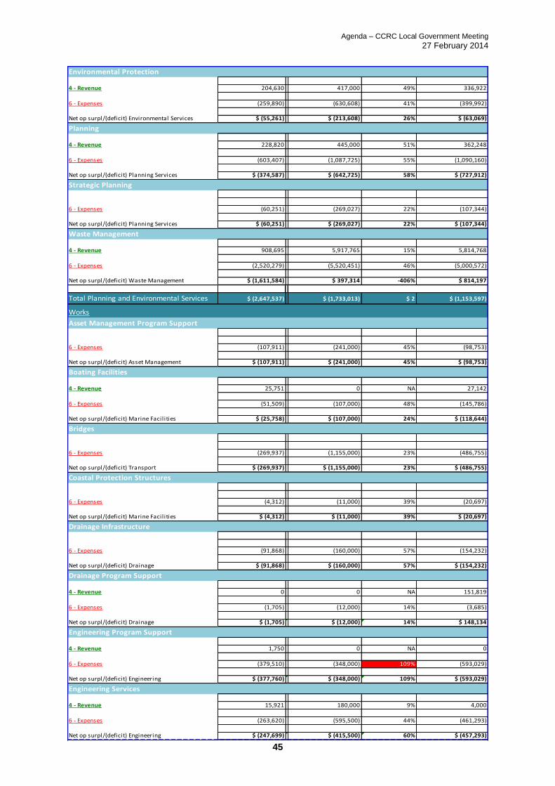
Environmental Protection
204,630 417,000 49% 336,922
(259,890) (630,608) 41% (399,992)
$ (55,261) $ (213,608) 26% $ (63,069)
Planning
228,820 445,000 51% 362,248
(603,407) (1,087,725) 55% (1,090,160)
$ (374,587) $ (642,725) 58% $ (727,912)
Strategic Planning
(60,251) (269,027) 22% (107,344)
$ (60,251) $ (269,027) 22% $ (107,344)
Waste Management
908,695 5,917,765 15% 5,814,768
(2,520,279) (5,520,451) 46% (5,000,572)
$ (1,611,584) $ 397,314 -406% $ 814,197
Total Planning and Environmental Services $ (2,647,537) $ (1,733,013) $ 2 $ (1,153,597)
Works
Asset Management Program Support
(107,911) (241,000) 45% (98,753)
$ (107,911) $ (241,000) 45% $ (98,753)
Boating Facilities
25,751 0 NA 27,142
(51,509) (107,000) 48% (145,786)
$ (25,758) $ (107,000) 24% $ (118,644)
Bridges
(269,937) (1,155,000) 23% (486,755)
$ (269,937) $ (1,155,000) 23% $ (486,755)
Coastal Protection Structures
(4,312) (11,000) 39% (20,697)
$ (4,312) $ (11,000) 39% $ (20,697)
Drainage Infrastructure
(91,868) (160,000) 57% (154,232)
$ (91,868) $ (160,000) 57% $ (154,232)
Drainage Program Support
0 0 NA 151,819
(1,705) (12,000) 14% (3,685)
$ (1,705) $ (12,000) 14% $ 148,134
Engineering Program Support
1,750 0 NA 0
(379,510) (348,000) 109% (593,029)
$ (377,760) $ (348,000) 109% $ (593,029)
Engineering Services
15,921 180,000 9% 4,000
(263,620) (595,500) 44% (461,293)
$ (247,699) $ (415,500) 60% $ (457,293)
4 - Revenue
6 - Expenses
Net op surpl/(deficit) Engineering
4 - Revenue
6 - Expenses
Net op surpl/(deficit) Drainage
4 - Revenue
6 - Expenses
Net op surpl/(deficit) Engineering
6 - Expenses
Net op surpl/(deficit) Transport
6 - Expenses
Net op surpl/(deficit) Marine Facil ities
6 - Expenses
Net op surpl/(deficit) Drainage
Net op surpl/(deficit) Waste Management
6 - Expenses
Net op surpl/(deficit) Asset Management
4 - Revenue
6 - Expenses
Net op surpl/(deficit) Marine Facil ities
6 - Expenses
Net op surpl/(deficit) Planning Services
6 - Expenses
Net op surpl/(deficit) Planning Services
4 - Revenue
6 - Expenses
4 - Revenue
6 - Expenses
Net op surpl/(deficit) Environmental Services
4 - Revenue

Agenda – CCRC Local Government Meeting
27 February 2014
46
Fleet & Plant Program Support
73,812 0 NA 75,376
(361,712) (586,000) 62% 958,529
$ (287,900) $ (586,000) 49% $ 1,033,905
Fleet & Plant
2,045,317 60,000 3409% 1,150,200
(2,312,372) 933,100 -248% (2,091,598)
$ (267,054) $ 993,100 -27% $ (941,398)
Asset Management & GIS Services
(155,322) (508,000) 31% (507,549)
$ (155,322) $ (508,000) 31% $ (507,549)
Marine Facilities Program Support
0 51,500 0% 0
(163,652) (248,373) 66% (8,591)
$ (163,652) $ (196,873) 83% $ (8,591)
Path & Cycleways
(28,302) (80,000) 35% (55,912)
$ (28,302) $ (80,000) 35% $ (55,912)
Public Transport Infrastructure
(13,155) (9,000) 146% (34,281)
$ (13,155) $ (9,000) 146% $ (34,281)
Quarry Management
90,327 0 NA 172,204
0 0 NA (9,143)
$ 90,327 $ 0 NA $ 163,060
Roads
6,106 0 NA 0
(2,355,324) (4,619,000) 51% (16,097,649)
$ (2,349,218) $ (4,619,000) 51% $ (16,097,649)
Sewerage Program Support
7,853,844 7,838,950 100% 24
(2,799,420) (5,082,423) 55% (4,623,817)
$ 5,054,425 $ 2,756,527 183% $ (4,623,793)
Sewerage Reticulation
(661,343) (1,363,000) 49% (505,997)
$ (661,343) $ (1,363,000) 49% $ (505,997)
Sewerage Treatment
0 0 NA 10,341,464
(1,042,904) (1,334,924) 78% (2,688,318)
$ (1,042,904) $ (1,334,924) 78% $ 7,653,146
Sewerage Planning & Performance
(5,889) 0 NA (11,573)
$ (5,889) $ 0 NA $ (11,573)
6 - Expenses
Net op surpl/(deficit) Sewerage
6 - Expenses
Net op surpl/(deficit) Sewerage
4 - Revenue
6 - Expenses
Net op surpl/(deficit) Sewerage
6 - Expenses
Net op surpl/(deficit) Sewerage
4 - Revenue
4 - Revenue
6 - Expenses
Net op surpl/(deficit) Fleet & Depots
4 - Revenue
6 - Expenses
Net op surpl/(deficit) Transport
6 - Expenses
Net op surpl/(deficit) Marine Facil ities
6 - Expenses
Net op surpl/(deficit) Transport
6 - Expenses
Net op surpl/(deficit) Transport
4 - Revenue
6 - Expenses
Net op surpl/(deficit) Fleet & Depots
6 - Expenses
Net op surpl/(deficit) Asset Management
4 - Revenue
4 - Revenue
6 - Expenses
Net op surpl/(deficit) Fleet & Depots

Agenda – CCRC Local Government Meeting
27 February 2014
47
Town Centres
(246,044) (289,000) 85% (324,264)
$ (246,044) $ (289,000) 85% $ (324,264)
Trade Waste
262,200 260,000 101% 282,276
(104,384) (205,000) 51% (247,124)
$ 157,816 $ 55,000 287% $ 35,152
Transport Program Support
1,975,478 2,668,235 74% 3,777,807
(5,208,516) (8,789,082) 59% (502,235)
$ (3,233,038) $ (6,120,847) 53% $ 3,275,571
Water Program Support
7,951,694 9,287,644 86% 9,813,456
(3,295,361) (5,892,944) 56% (4,744,262)
$ 4,656,333 $ 3,394,700 137% $ 5,069,193
Water Reticulation
58,259 72,000 81% 65,622
(785,663) (1,956,000) 40% (552,368)
$ (727,405) $ (1,884,000) 39% $ (486,746)
Water Planning & Performance
(103,995) (148,000) 70% (187,040)
$ (103,995) $ (148,000) 70% $ (187,040)
Water Treatment
37,401 0 NA 4,594,257
(451,161) (533,500) 85% (2,292,983)
$ (413,760) $ (533,500) 78% $ 2,301,274
Works Depots
(297,885) (422,000) 71% (462,142)
$ (297,885) $ (422,000) 71% $ (462,142)
Works Management
1,883,259 11,000 17121% 15,980,978
(2,423,961) (2,188,000) 111% (12,730,153)
$ (540,702) $ (2,177,000) 25% $ 3,250,825
Works - Recoverable Services
1,724,487 805,000 214% 1,484,638
(1,156,974) (683,000) 169% (2,356,783)
$ 567,513 $ 122,000 465% $ (872,145)
Total Works $ (1,138,104) $ (15,399,317) $ 0 $ (4,118,223)
$ 68,979,997 $ 68,189,937 $ 98,073,195 $ (44,274,631) $ (67,957,625) $ (85,472,371)
Net op surpl/(deficit) Works Productivity & Performance
4 - Revenue6 - Expenses
Net op surpl/(deficit) Fleet & Depots
4 - Revenue
6 - Expenses
Net op surpl/(deficit) Works Productivity & Performance
4 - Revenue
6 - Expenses
6 - Expenses
Net op surpl/(deficit) Water
4 - Revenue
6 - Expenses
Net op surpl/(deficit) Water
6 - Expenses
4 - Revenue
6 - Expenses
Net op surpl/(deficit) Water
4 - Revenue
6 - Expenses
Net op surpl/(deficit) Water
4 - Revenue
6 - Expenses
Net op surpl/(deficit) Sewerage
4 - Revenue
6 - Expenses
Net op surpl/(deficit) Transport
6 - Expenses
Net op surpl/(deficit) Transport

Agenda – CCRC Local Government Meeting
27 February 2014
48
Agenda – CCRC Local Government Meeting
27 February 2014
49
Agenda – CCRC Local Government Meeting
27 February 2014
50

Agenda – CCRC Local Government Meeting
27 February 2014
51

Agenda – CCRC Local Government Meeting
27 February 2014
52

Agenda – CCRC Local Government Meeting
27 February 2014
53

Agenda – CCRC Local Government Meeting
27 February 2014
54
Agenda – CCRC Local Government Meeting
27 February 2014
55
Agenda – CCRC Local Government Meeting
27 February 2014
56

Agenda – CCRC Local Government Meeting
27 February 2014
57
9. NOTICE OF MOTION
Nil.
10. GENERAL BUSINESS
Nil.
11. CONFIDENTIAL
Nil.