agenda item summary april 7, 2020 - fort collins, colorado
TRANSCRIPT

Agenda Item 16
Item # 16 Page 1
AGENDA ITEM SUMMARY April 7, 2020
City Council STAFF
Cameron Gloss, Planning Manager Brad Yatabe, Legal SUBJECT
Postponement of Second Reading of Ordinance No. 044, 2020, Updating the Harmony Corridor Plan for the Gateway Area and the Harmony Corridor Standards and Guidelines to May 19, 2020. EXECUTIVE SUMMARY
Staff requests this item be postponed to May 19, 2020 in order to prioritize Council agenda items and in light of the public participation expected for this item. This Ordinance, adopted on First Reading on March 3, 2020, by a vote of 4-2 (Nays: Summers, Troxell; Gorgol absent) amends the Harmony Corridor Plan and the Harmony Corridor Standards and Guidelines by adopting revised Plan polices, standards and guidelines pertaining to the “gateway” area located west of I-25. STAFF RECOMMENDATION
Staff recommends adoption of the Ordinance on Second Reading. BACKGROUND / DISCUSSION
During the City Council discussion at First Reading of the Ordinance, some Councilmembers discussed the possibility of the City staff and the major “Gateway” area property owner continuing a dialogue about land conservation strategies. No additional discussions with the major property owner have taken place since the time of the hearing on March 3.
ATTACHMENTS
1. First Reading Agenda Item Summary, March 3, 2020 (w/o attachments) (PDF) 2. Ordinance. No. 044, 2020 (PDF)

Agenda Item 8
Item # 8 Page 1
AGENDA ITEM SUMMARY March 3, 2020 City Council STAFF Cameron Gloss, Planning Manager Brad Yatabe, Legal SUBJECT First Reading of Ordinance No, 044, 2020, Updating the Harmony Corridor Plan for the Gateway Area and the Harmony Corridor Standards and Guidelines. EXECUTIVE SUMMARY The purpose of this item is to consider a request to amend the Harmony Corridor Plan and the Harmony Corridor Standards and Guidelines by adopting revised Plan polices, standards and guidelines pertaining to the ‘gateway’ area located west of I-25. STAFF RECOMMENDATION Staff recommends adoption of the Ordinance on First Reading. BACKGROUND / DISCUSSION A. PROJECT DESCRIPTION This is a staff-proposed update of the Harmony Corridor Plan, a policy plan, and the Harmony Corridor Standards and Guidelines, a document that sets forth binding development standards. The Harmony Corridor Plan and the Harmony Corridor Standards and Guidelines were originally adopted in 1991 and have been amended from time to time, most recently in 2006. The changes revise Plan polices and development standards and guidelines pertaining to the gateway area located west of the intersection of Harmony Road and I-25 and extending north and south of Harmony Road (“Gateway” or “Gateway Area”). The proposed vision reflects a shift in general direction regarding the type of development to occur in the developable portions of the area: away from low-intensity, non-retail employment uses, toward a mixed-use, multi-story pedestrian district that could take better advantage of multi-modal transportation improvements planned for Harmony Road and I-25. While this proposed vision reflects a shift in the basic concept for the mix of uses, three other aspects are consistent with the City’s existing vision for the area: first, a focus on the overall landscape treatment to highlight the river valley setting; second, an approach to development character that is different from typical commercial highway interchanges; and lastly, attention to the mix of uses, and private and public improvements that will match the desire for an inviting, attractive Fort Collins entry that provides a degree of community separation from the adjacent Town of Timnath. The requested Harmony Corridor Plan amendments include three components:
Harmony Corridor Plan Chapter 3 that updates the general policies pertaining to the entire Harmony Corridor. Revised Chapter 3 is Attachment 1 with deletions struck through and additions highlighted;
Harmony Corridor Plan Chapter 5 that updates policies and design strategy specifically for the Gateway, revised Chapter 5 is attached to the Ordinance because the revisions are extensive and the strike-through/highlight format was not feasible; and
ATTACHMENT 1

Agenda Item 8
Item # 8 Page 2
New Harmony Corridor Standards and Guidelines Section V for the Gateway, Section V is attached to the Ordinance and this is an entirely new section.
B. GATEWAY AREA CHARACTERISTICS
1. Current Conditions
Commercial Uses. Four visually prominent commercial uses have been developed under County zoning adjacent to the west side of the interchange, which substantially affect the image of the area as a gateway to the city. These include a gas station, cell tower, and landscape nursery business on the south side of Harmony Road, and a vehicular-oriented commercial building with outdoor storage on the north side. Across I-25 to the east, the Town of Timnath has developed a regional shopping area anchored by WalMart and Costco. Residential Uses. In 2018, a 368 unit-apartment complex (The Wyatt) was constructed on 23 acres at the southwest corner of Harmony and Strauss Cabin Roads. The development plan received a modification to the 25% secondary use limitations. One key attribute to the site design is the retention of the wetland at the corner of Harmony and Strauss Cabin and installation of cottonwoods and other river landscaping within an expanded setback.
Public Uses. The City of Fort Collins Arapaho Bend Natural Area located north of Harmony Road and east of Strauss Cabin Road, encompasses almost 50% of the land area within the Gateway. A state-owned Park-n-Ride facility operated by the City of Fort Collins and officially known as the Harmony Transportation Transfer Center lies north of Harmony Road, ¼ mile west of the interchange.
2. Zoning and Land Use Adjacent to the Gateway
North South East West
Zoning County FA-1 - Farming RUL (Rural Open Lands)
I-25; Town of Timnath Regional Commercial
HC (Harmony Corridor)
Land Use
Single-family residential; City-owned conservation area
Vacant; some delineated wetland resources.
Large format and in-line retail
Single and multi-family residential Morningside); Banner Medical Center; Hewlett-Packard
C. SUMMARY OF APPLICABLE ADOPTED PLANS AND POLICIES 1. Existing 1991 Harmony Corridor Plan The Harmony Corridor Plan (The Plan) was adopted in 1991, for the Harmony Road corridor from College Avenue to I-25. It includes the Gateway within its land use designation of “Basic Industrial Non-Retail Employment”, which covers a majority of the corridor. This designation emphasizes office, institutional, light industrial and other similar employment development, and also allows for some limited supporting commercial and residential uses. There were amendments to the Plan in 2006 impacting the use of some properties, including the Front Range Village shopping center site, yet there were no substantive changes related to the Gateway. The Plan also contains a special chapter (Chapter 5) highlighting the Gateway differently from the rest of the Harmony Corridor, due to the exceptional significance of the I-25 interchange entrance to Fort Collins, combined with the Cache La Poudre River valley setting. In effect, the existing Gateway Area chapter suggested that special tailoring of the underlying employment-based land use designation was needed; however, it did not establish a vision or specific strategy for the area over time. Instead, it explained issues that needed significant follow-up work. It also described “Alternative Gateway

Agenda Item 8
Item # 8 Page 3
Concepts”, ranging from typical highway interchange commercial development to public purchase for open space. It concluded that: “Additional work is required to develop a strategy for shaping the future of this important segment of the community.” It also stated that the starting point for additional work was to be the concept of a gateway entrance integrating high-quality development with the natural characteristics of the existing landscape. As the general ideas of the original Plan were explored further in subsequent years, they were clarified into concepts for a community edge tapering down in development intensity, with the river valley floodplain corridor helping to preserve the separate identities of Fort Collins and Timnath through ‘community separators’, and providing scenic, recreational, educational, habitat, and water management functions. The concepts include limited development that would be integrated and unobtrusive in the landscape, with low, horizontal buildings blended into river valley landscaping, with low-intensity development activity consisting mostly of employment uses. With recent development of a large, multi-phased commercial center (Walmart/Costco/restaurants/inline commercial), the community separator concept has been lost east of I-25 in the Town of Timnath; however, there are design elements supporting preservation of the Poudre River Valley landscape that continue to have validity west of I-25 and that can provide a degree to community separation from Timnath.
D. IMPETUS FOR PLAN AMENDMENT The existing 1991 Plan called for additional work to set a strategy for the Gateway Area. The proposed Plan update would: Reflect 29 years of additional work, changed conditions, and new information since the original Plan. Reflect aspects of the City Plan Update (2019) regarding compact, mixed-use pedestrian-oriented
development responsive to the needs of employers and the need to improve the linkage between land use patterns and transportation/transit investment.
Following are some key changes and new information since 1991: Since then, the City’s Growth Management Area has expanded approximately three miles further south
along I-25. City Natural Area Purchases. The portion of the Gateway Area north of Harmony Road was purchased as
a City Natural Area (Arapaho Bend) in 1995. In a multi-year process (1997- 2003), the City and Larimer County purchased the 843-acre Fossil Creek Reservoir Regional Open Space/Natural Area. Eagle View Natural Area was purchased immediately south of Kechter Road in 2002.
Gravel Mining Completed, late 1990’s. Gravel mining operations were completed in the 265-acre portion of
the area south of Harmony Road and east of Strauss Cabin Road, leaving a completely altered landscape with extensive open water in gravel pit ponds. These mining operations extended an additional half-mile south from the Gateway.
City Natural Area Purchase Declined South of Harmony Road. Around 2004, the undeveloped, gravel-mined
property south of Harmony Road was offered and considered for purchase as a City Natural Area, mainly for community separator and viewshed purposes. Wildlife habitat was not considered a significant purpose, due to the gravel-mined landscape. The City studied the opportunity, but declined to purchase the property, due to costs and liabilities of mining permit closeout, water augmentation, and site restoration, given numerous other higher priority demands on the Natural Areas Program. There have been subsequent discussions between area property owners and the Natural Areas program staff, yet the status remains the same.

Agenda Item 8
Item # 8 Page 4
Existing Commercial Uses. Four visually prominent commercial uses have been developed under County zoning adjacent to the interchange, which substantially affect the image of the area as a gateway to the city. These include a gas station, cell tower, and landscape nursery business on the south side of Harmony Road, and a vehicular oriented commercial building with outdoor storage on the north side. Larimer County approved a variance for the cell tower (2007) at the southwest corner of I-25 and Harmony Road over the objections of the City staff.
Transportation Transfer Center (TTC, or Park-and-Ride) Facility Built. The Natural Areas Program sold land
on the north side of Harmony Road for this use in the late 1990’s. City Structure Plan (1997). The original City Plan land use map (City Structure Plan) envisioned a low-
intensity “soft edge” of the city in the Gateway District area, suggesting that development intensity would generally taper down to a fairly open river valley landscape.
Two Community Separator Studies. Reports completed in 1999 and 2003 convened multiple jurisdictions,
explored issues, and described opportunities for preserving distinct visual and physical separation and identity of Fort Collins, Timnath, and Windsor in and around the subject area.
The 2003 Fort Collins-Timnath-Windsor Community Separator Study specifically identified a separator opportunity consisting of the Poudre River floodplain corridor, which forms a broad swath around all corners of the I-25/Harmony interchange. The separator studies generally described possible implementation actions, which would require increasing cooperation among regional cities and towns at their edges along I-25.
I-25 Land Use Plans Completed. Plans adopted in 2001 (Northern Colorado Regional Plan) and 2003 (Fort Collins) for land fronting the I-25 Corridor. The Regional I-25 Plan called for a common I-25 development vision to be created by Northern Colorado communities, but only Berthoud, Windsor and Fort Collins adopted the Plan. The preferred land use pattern supported development concentrated in mixed-use ‘activity centers’ that support alternate modes of transportation, and that natural areas, open lands and views were protected that contribute to the open character of the corridor. Fort Collins also adopted its own subarea plan mirroring the regional effort and creating complementary design standards.
Retail Development at Interchanges. During the last two decades, the retail industry has seen the evolution of “big box” superstores, power centers, lifestyle shopping centers, and mixed use “town center” developments, all creating increasingly regional market characteristics, typically wanting to locate at or near interstate interchanges. The retail evolution continues as a result of on-line purchase options.
Major Interstate Development. Retail/commercial activity and competition for sales tax has changed rapidly,
becoming fairly aggressive along I-25. The interstate has become a focus of annexations and development, with advocates of regional metropolitan development widely promoting I-25 as “Northern Colorado’s Main Street”. In 2003, the Larimer County Events Center and the Centerra Lifestyle Shopping Center opened, adding momentum to development pressures along I-25. A Super WalMart center was constructed in Timnath in 2009 on the northeast corner of the Harmony/I-25 interchange; the floodplain was filled; and the development was built directly against the interchange. Within the same timeframe, the entire east side of I-25, directly across from the Gateway Area, was re-planned by Timnath for Regional Commercial development, extending one mile southward from Harmony Road along I-25, thus significantly undermining Community Separator concepts for this area. Costco opened in 2014, with restaurants and freestanding retailers added since that time.
Taller Buildings (2000’s). Taller buildings began to emerge along I-25 in Northern Colorado, with the 8-story Embassy Suites constructed next to the Larimer County Events Center and other 6-story buildings planned nearby.

Agenda Item 8
Item # 8 Page 5
Ridgeline Development. Development has occurred and will continue along the top of the bluff, or river
valley wall, immediately west of the Gateway Area, with highly visible buildings along the ridgeline. This diminishes the potential for long scenic vistas across the river valley to the mountains beyond, as a defining concept for the Gateway Area.
Colorado Department of Transportation (CDOT) Highlights Harmony Road. A multi-year process spanning
2007-2010. CDOT undertook an Environmental Impact Statement (EIS) process from 2008-2010, evaluating alternative transportation scenarios for I-25 and related north-south transportation facilities between the Denver Metro area and North Front Range. The Harmony interchange is shown in the draft EIS as a significant hub for future bus transit on both I-25 and Harmony Road.
In 2008, the Riverwalk Project (later renamed Nine Bridges) was proposed on 268 acres at the southwest
quadrant of the Harmony interchange that included residential, commercial and employment uses with a channelized water feature/riverwalk passing through the property. The property was annexed after City Council approved a series of emergency ordinances to block Timnath’s annexation of the former Riverwalk site. The annexation issue was resolved through mediation. The development plan did not move forward, and the property was later sold. As part of Riverwalk, and different land use proposals for the other privately-owned properties on the south side of Harmony Road, additional work in the area has included:
o gravel mine permit closeout under State statutes, o consideration of City purchase of portions of the area for Natural Area and/or water utilities
purposes, o analysis of earthwork changes to reshape the floodplain under FEMA and City regulations, o sewer, water, and other utility services investigation and planning, and o consideration of various economic land use and development approaches.
Bustang, CDOT’s interregional express bus service, began its north terminus in Fort Collins during 2016.
The Harmony Transit Center becomes one of the area’s key pick-up and drop-off sites.
The Wyatt Apartments (2018). A 368 unit-apartment complex was constructed on 23 acres at the southwest corner of Harmony and Strauss Cabin Roads. The development plan received a modification to the 25% secondary use limitations. One key attribute to the site design is the retention of the wetland at the corner of Harmony and Strauss Cabin and installation of cottonwoods and other river landscaping within an expanded setback.
City Plan Update (April 2019). City Plan’s land use map (City Structure Plan) continues to designate the
Gateway Area for Parks and Natural/Protected Lands north of Harmony (except for the State Lands parcel) and the balance as a Mixed Employment district. The long-range transportation plan calls for high-frequency transit along Harmony Road and designates the southwest corner of the interchange as an activity center. One of the short-term, high-priority implementation actions of the City Plan Update is to assess our land supply to ensure that land is available to support business needs and to create a more detailed vision for the community’s gateways.
Larimer County denied a variance request in April 2019 for a freestanding electronic message center sign
on the north side of Harmony Road, 1/8 mile west of I-25. The proposed sign would have been non-compliant with the proposed Design Standards and Guidelines.
E. PROPOSED HARMONY GATEWAY DISTRICT VISION
The changes, issues, and additional work noted above, have led to a more refined future vision of this area. The proposed vision reflects a shift in general direction regarding the type of development to occur in the developable portions of the area: away from low-intensity, non-retail employment uses, toward a mixed-use,
Agenda Item 8
Item # 8 Page 6
multi-story pedestrian district that could take better advantage of transit planned for Harmony Road, the rest of the community, and I-25. While this proposed vision reflects a shift in the basic concept for the mix of uses, three other aspects are consistent with the City’s existing vision for the area: first, a focus on the overall landscape treatment to highlight the river valley setting; second, an approach to development quality that is different from typical commercial highway interchanges; and lastly, attention to private and public improvements that will match the desire for an attractive Fort Collins entry. The proposed vision would move the existing Plan forward to fulfillment of its call for additional work to set a strategy for the area. And finally, it would fit with numerous aspects of City Plan regarding integration of efficient land use, the environment and transportation choices, and investment in the community’s gateways. The update to Chapter 5 of the Harmony Corridor Plan describes ten basic design elements that apply to future development and public investment and that are implemented through metrics contained within Standards and Guidelines:
1. Naturalistic River Valley Landscape Cottonwood groves, willows, and other native plantings will form the most dominant aspect of the area’s image as seen by users of Harmony Road and drivers on I-25. Under this approach, a naturalistic river valley landscape, instead of buildings and signs, becomes the primary view that’s experienced.
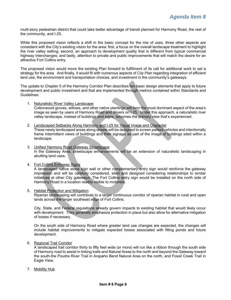
2. Landscaped Setbacks Along Harmony and I-25 for Visual Image and Character These newly landscaped areas along streets will be designed to screen parked vehicles and intentionally frame intermittent views of buildings and their signage as part of the image of buildings sited within a landscape.
3. Unified Harmony Road Gateway Streetscape
In the Gateway Area, streetscape enhancements will be an extension of naturalistic landscaping in abutting land uses.
4. Fort Collins Entryway Signs
A landscaped native stone sign wall or other complementary entry sign would reinforce the gateway impression and will be carefully considered, sited and designed considering relationships to similar initiatives at other City gateways. The Fort Collins entry sign would be installed on the north side of Harmony Road in a location readily visible to motorists.
5. Habitat Protection and Mitigation Riparian landscaping will contribute to a larger continuous corridor of riparian habitat in rural and open lands across the larger southeast edge of Fort Collins. City, State, and Federal regulations already govern impacts to existing habitat that would likely occur with development. They generally emphasize protection in place but also allow for alternative mitigation of losses if necessary. On the south side of Harmony Road where greater land use changes are expected, the changes will include habitat improvements to mitigate expected losses associated with filling ponds and future development.
6. Regional Trail Corridor A landscaped trail corridor thirty to fifty feet wide (or more) will run like a ribbon through the south side of Harmony road to assist in linking trails and Natural Areas to the north and beyond the Gateway toward the south-the Poudre River Trail in Arapaho Bend Natural Area on the north, and Fossil Creek Trail in Eagle View.
7. Mobility Hub

Agenda Item 8
Item # 8 Page 7
City Plan identifies the Harmony interchange area as a Mobility Hub recognizing its long-term potential to offer transfers, drop-offs, a station for bus rapid transit (BRT), intersecting multi-use trails, and regional bus transit in addition to its park-n-ride function.
8. Limitations on Commercial Signs Commercial signs within the Gateway Area will be consistent with the Plan’s character elements as well as compliant with the City’s Sign Code. Proposed is a prohibition of Electronic Message Center (EMC) signs within the Gateway Area.
9. Stealth Wireless Telecommunication Facilities New standards would prohibit conventional wireless and other telecommunication towers, unless in those cases where they are screened, roof-mounted equipment or are “stealth” installations located within church steeples, grain silos or other similar structures common to the area’s landscape.
10. Unique Land Use and Development Standards Development Standards and Guidelines (discussed more fully in the following section) provide clear direction for future development:
o The intention is to promote a mixed-use activity center within the Gateway Area on the south side of Harmony. While retail uses are included, and visibility to traffic is important, the proposed vision does not include typical shopping center or commercial strip formats oriented to the highway. Retail uses would be well-integrated into a pedestrian-oriented development. ‘Big Box’ stores (50,000 square feet or greater in size) and drive-through restaurants would be prohibited uses. Under the proposal, the mix of uses would be limited to the following distribution: Residential 25% minimum Retail and Commercial 50% maximum Employment 25% minimum
o To maximize community separation and promote a more ‘open’ site character, a minimum of 40% of the Gateway Area on the south side of Harmony Road must be as an open, landscaped area with naturalistic plant materials and landforms. Land included within this landscaped area may include:
Landscaped setbacks from I-25 and Harmony Road Designated floodways Delineated natural habitat or features Stormwater detention areas Other landscaped areas with a minimum land area of 10,000 square feet and 30
feet in width at any location. Landscaping within naturalistic areas is encouraged to be upsized to the extent reasonably feasible.
o An incentive to promote civic or cultural uses in the area south of Harmony Road is provided through an exemption of such uses from the Harmony Corridor land use limitations.
o Building heights limited to three stories for attached residential and five stories for commercial
and mixed-use buildings. An exemption permits one additional story for commercial and mixed-use buildings if structured parking is provided.
o Beyond the visual image, development would reflect community goals regarding efficient, walkable development. The combination of image and other underlying qualities would define it as a gateway to the community as well as a destination in itself.
o Integration of a regional bicycle trail sited and designed to maximum the user experience.

Agenda Item 8
Item # 8 Page 8
o A primary orientation to pedestrians and bicyclists would mutually support public transit planned for Harmony Road and I-25 and allow the Gateway Area to become less dependent on car traffic over time.
F. HARMONY GATEWAY DISTRICT STANDARDS AND GUIDELINES The Harmony Corridor Plan is accompanied by a companion Standards and Guidelines document. This document supplements the already high standards found in the Land Use Code to specifically implement the Plan as development occurs over time. The document includes provisions for required actions known as “standards” (denoted +), and suggested actions which are known as “guidelines” (denoted o). This new section is added to the document, in conjunction with the Plan amendment, to address defining aspects of development including: Required Mix of Uses Continued Prohibition of Large Retail Establishments Framework of Streets, Drives, and Walkways Building Grouping and Orientation - Streets and Waterway Parking Located to Support the Pedestrian District Transit-Ready Design Building Character to Enhance the Pedestrian District Landscape Setbacks Along Harmony Road and I-25 Landscaping for River Valley Character Trail Connections Commercial Sign Limitations
BOARD / COMMISSION RECOMMENDATION Planning and Zoning Board At its February 20, 2020 hearing, the Planning and Zoning Board approved a motion (4-2, Haefele and Schneider opposed) that City Council adopt the amendments to the Harmony Corridor Plan and Harmony Corridor Standards and Guidelines with the conditions that the City of Fort Collins participate with the private landowners in the creation, management, and maintenance of the 40% natural area created within a Development Plan, of which up to 20% of the natural area requirement could be satisfied by cultural amenities. City participation would include purchasing or contributing in other financial matters and maintaining the area in perpetuity for the public enjoyment. Further, the Board found that the Harmony Corridor Plan is in need of the proposed amendments and the proposed amendments will promote the public welfare and will be consistent with the vision, goals, principals, and policies of City Plan and the elements thereof. The February 20 Planning and Zoning Board minutes will be provided to Council in the read-before packet on March 3. Other Boards and Commissions At the direction of City Council, the Natural Resources Advisory Board, Land Conservation and Stewardship Board, Water Board, Transportation Advisory Board and Economic Advisory Commission held public hearings on the proposed Harmony Corridor Plan Amendment and Standards and Guidelines and made recommendations to City Council. All five of these advisory bodies unanimously recommended adoption of the amendments and supported the change in the revised ratio of land uses permitted, and which would result in a greater mixture of uses within the Harmony Gateway Area. Most of the Boards also raised concerns about the potential for higher water use given the increased landscaped setbacks along Harmony Road and I-25 and the 40% naturalistic landscaped area requirement. To address concerns about water use, one of the key design guidelines expressing support for xeric landscape principles and limiting more lush plantings to high-use areas was changed to a mandatory design standard. There was also a suggestion from the Water Board that setbacks along Harmony Road could be reduced should a regional trail corridor be constructed within the Gateway Area. PUBLIC OUTREACH

Agenda Item 8
Item # 8 Page 9
A. COMMUNITY MEETINGS Four public events have been held this past year to review the status of the Gateway Plan Update. These events included: This workshop provided an assessment of relevant Harmony Corridor Plan policies and Land Use Code standards, and opportunities and constraints that began the discussion of issues facing the area. The inventory covered topics such as: Land use summary of existing Structure Plan and Harmony Corridor Plan land use designations, Harmony
Corridor zone district use standards, and recommendations from the City Plan Update draft. Natural Resources identifying natural features and conditions such as Poudre River floodplain/floodway,
riparian and wetland areas, natural habitat and physical features. Transportation System including existing and future access and circulation within the Harmony Gateway;
and Appearance and Design summary of existing Land Use Code and Harmony Corridor Standards and
Guidelines requirements and previous viewshed analyses. Workshop 2 (January 30, 2019) Concepts and Vision The staff team prepared initial concepts based on public and stakeholder input from the Public Workshop 1, analyzed pros and cons, and worked with citizens in a second hands-on workshop setting to identify additional concepts, and-finally-define a preferred direction for amending the Harmony Corridor Plan. Several tools were used, including GIS mapping and hand drawn sketches, that illustrate the various design and land use options. A consultant illustrator was on-hand to allow participants to “draw” their ideas. Open House (February 27, 2019) Refining the Vision Maps and illustrations were refined, along with initial draft Chapter 5 Harmony Gateway text describing the direction provided in the first two workshops. I-25 Gateways Workshop (October 21, 2019) Land Use Scenarios Four Land Use Scenarios were developed by staff that depict potential alternative patterns for vacant or redevelopable land within the Gateway Area. Small group discussions were held that captured preferences for the proposed scenarios and suggest alternative scenarios or changes to the four scenarios evaluated. The four alternative future land use scenarios were distinguished primarily by differences in density/intensity of development, mix of uses, and amount of open and undeveloped areas, as summarized below. Scenario A: Base-case (current BINREAC (Basic Industrial and Non-Residential Activity Center) Harmony Corridor Plan land use designation) Mitigate floodplain impacts Reflect continuation of the current Harmony Corridor Plan policies and HC zone district standards Assumes at least 75% primary employment/industrial uses, with a maximum of 25% secondary
(commercial/retail, housing, public) uses 6 story non-residential and 3 story residential building height limit 80-foot wide landscaped setback along Harmony Road and I-25 Habitat buffer surrounding heron rookery
Scenario B: Increased Commercial and Housing with Big Box Mitigate floodplain impacts

Agenda Item 8
Item # 8 Page 10
Assumes a mixed-use employment district, with a greater retail and commercial (max 50%) and residential (min 25%) with a minimum of 20% primary employment/industrial uses
Provides limited big box retail (max cumulative 250,000 sq. ft.) Civic/community facilities are viewed independently and are not subject to the use proportions Allows potential for drive-through restaurants if screened and in areas subordinate to pedestrian spaces
and focal points Average 140-190-foot-wide “naturalistic” landscaped setbacks along Harmony Rd. and I-25 6 story non-residential and 3 story residential building height limit Regional trail corridor Habitat buffer surrounding heron rookery
Scenario C: Increased Commercial and Housing without Big Box Same as Scenario B, but big box and drive through restaurants are prohibited
Scenario D: Reduced Intensity Mitigate floodplain impacts Mix of concentrated uses with required open space to reduce development ‘footprint’ of buildings and
parking areas “Naturalistic” Open land areas constitute at least 40% of the area south of Harmony, between I-25 and
Strauss Cabin Road. Assumes a mixed-use employment district, with a greater retail and commercial (max 50%) and residential
(min 25%) with a minimum of 20% primary employment/industrial uses Average 140-190-foot-wide “naturalistic” landscaped setback along Harmony Road. Maximum height of 5 stories for commercial/retail and 3 for residential Regional trail corridor located further from I-25 Habitat buffer surrounding heron rookery
All of the scenarios reflect the removal of two of the three remaining open, unlined water ponds fed by groundwater. The ponds were created through the extraction of gravel which illegally exposed the groundwater. Under Colorado law, storing water in a pond requires a storage right unless the pond is included in a plan for augmentation or substitute water supply plan. The remaining pond area with legal rights for storage is located in the southeast corner of the ‘Gateway’, adjacent to which is a great blue heron nest site in a large Eastern Cottonwood tree near the southeast corner of the pond. City Council Work Session May 15, 2019 At its Work Session, City Council directed staff to incorporate the following additional comments into the public process and future drafts of the Harmony Corridor Plan Update for the ‘Gateway Area’: Land Use Intensity: Staff was requested to further explore alternative land use and development pattern
scenarios with lesser intensity. Each of the alternatives should consider impacts to transportation and natural features. The majority of Council expressed pursuit of a ‘middle pathway’ that would make the Gateway Area more inviting, but not too developed. Some members suggested that the proposed DRAFT changes were tantamount to an up-zoning.
Design Character: While there was acknowledgement that proposed design standards include naturalistic elements based on the Poudre River valley character, it was suggested by some members that the design parameters do not fully take into account the existing open character of the area and that Natural Areas and Nature in the City concepts could be incorporated more clearly. Some elements of the design standards, particularly the I-25 and Harmony landscaped edges, regional trail, and sign limits, were viewed positively.
Review Process: General support was expressed for the Gateway Plan Update community engagement process used to date. It was suggested that more time and public discussion is needed to examine

Agenda Item 8
Item # 8 Page 11
alternative scenarios, vet the ideas, and to receive comments from the Transportation Advisory Board and the Land Conservation and Stewardship Board.
City Council Work Session October 22, 2019 At the October 22nd Council Work Session, staff presented the four alternative land use scenarios that were the result of a four-month public process, including work sessions with six boards and commissions and a community workshop. Council Comments and General Direction The Council generally indicated support for Scenario D, and the concept of additional mixed-use within the Gateway, with further investigation of specific elements of a stakeholder-initiated alternative scenario. Elements within the revised Standards and Guidelines were requested to include: Potential for limitation of residential uses: Staff is being requested to further investigate potential for
reducing residential uses within the floodplain and due to air quality impacts. Staff will provide research to the Council on both topics when the item comes back for consideration.
Design Character: Council reiterated its support for the revised design standards shared at the May Work Session. Staff has been asked to consider a requirement to ‘upsize’ trees as a way to support wildlife. One member expressed concern about the lack of visibility to commercial uses given the dense landscaping proposed along I-25 and Harmony.
Cultural Recreational Uses: Staff was asked for measures to further incorporate cultural and recreational uses within the Gateway through development standards or incentives.
B. PUBLIC COMMENTS: A series of comments were collected during the course of the community engagement process that can be summarized under the following major topics: Expansion of the Gateway Boundary ½ mile further to the South
Earlier versions of the Harmony Gateway Amendment expanded the current Gateway Area boundary one half mile further to the south, bringing the south boundary to Kechter Road and including land zoned Rural Lands (RL). Objections were received about the appropriateness of expanding the gateway. Based on citizen concerns, the expanded area was removed from consideration so that the Gateway Area boundary remains unchanged from the 1991 delineation.
Update to the Harmony Corridor Plan Unnecessary There has been a general perspective expressed that the Harmony Corridor Plan does not need to be updated and that existing standards reflect present community values. Some citizens contend that the area south of Harmony Road should remain in an undeveloped state, including existing wetlands, ponds and the floodway/floodplain boundary configuration.
Changes do not Support Community Separation
Development South of Harmony Road will not support the Community Separator Concept or provide adequate protection of the Poudre River as a resource.
Lack of Support Toward Greater Retail and Residential Uses
A shift toward greater retail and residential uses South of Harmony Road is inappropriate in that the area is within a flood plain and development will negatively impact natural habitat and features.
Heron Rookery
Development could have a negative impact on the Heron Rookery located roughly in alignment with Rock Creek Drive.

Agenda Item 8
Item # 8 Page 12
Mandate for Cultural Uses Some stakeholders expressed an interest in mandating that 20% of the land area south of Harmony Road include a cultural use.
Building footprint limitations Some concern has been expressed about allowing large retail establishments (20,000 - 50,000 sq. ft.) in floor area despite the prohibition of “big box” retail uses (50,000 sq. ft. or greater).
Scenarios Feedback Of the four Scenarios presented at the community workshop and with several Advisory Boards and Commission, support for Scenario D was most prominent.
An alternative scenario was presented by a group of stakeholders that suggested a further lessening of development intensity than that suggested under Scenario D. ATTACHMENTS
1. Revised Harmony Corridor Plan Chapter 3 (highlighted to show changes) (PDF) 2. I-25 Gateways Workshop Summary, October 21, 2019 (PDF) 3. Community Comments (PDF) 4. Correspondence (PDF) 5. Alternative Harmony Corridor Plan-Stakeholders Proposal (PDF) 6. Work Session Summaries, May 14 and October 22, 2019 (PDF) 7. Powerpoint presentation (PDF)

-1-
ORDINANCE NO. 044, 2020 OF THE COUNCIL OF THE CITY OF FORT COLLINS
UPDATING THE HARMONY CORRIDOR PLAN FOR THE HARMONY GATEWAY AREA AND THE HARMONY CORRIDOR STANDARDS AND GUIDELINES
WHEREAS, City Council originally adopted the Harmony Corridor Plan (“Plan”) in 1991,
Resolution 91-42, as an element of the City’s comprehensive plan, now known as City Plan; and
WHEREAS, City Council also adopted in 1991, the Harmony Corridor Design Standards and Guidelines (“Standards and Guidelines”) by means of Ordinance 28, 1991, to further the policies set forth in the Plan by means of binding development standards and advisory guidelines; and
WHEREAS, Chapter 5 of the Plan, titled Alternative Gateway Concepts, discusses
implementation actions that should be taken to continue planning efforts specific to the Harmony gateway area (“Gateway”) located on the north and south sides of Harmony Road west of the intersection of Harmony Road and Interstate 25 and more particularly depicted in the Plan; and
WHEREAS, in furtherance of planning efforts for the Gateway as stated in the Plan, City
staff is proposing amendments to Chapters 3 and 5 of the Plan and to add a new section, Section V. Harmony Gateway Area, to the Standards and Guidelines and has initiated the amendment process; and
WHEREAS, because the Gateway serves as an entryway into the City, it is a uniquely important area in terms of its beneficial effect on civic pride, economic prosperity, and the health, safety, and welfare of the City; and WHEREAS, on February 20, 2020, the Planning and Zoning Board on a 4-2 vote recommended that Council approve the staff proposed changes conditional upon the City participation with private landowners in the creation, management, and maintenance of the required 40% natural area requirement within the ODP, of which up to 20% of the natural area requirement could be satisfied by cultural amenities, with City participation to include purchasing or contributing in other financial matters and maintaining such areas or amenities in perpetuity for the public enjoyment; and
WHEREAS, City Council finds that the amendments to the Plan and the Standards and Guidelines are in the best interest of the City and its citizens and promote the general public health, safety, and welfare. NOW, THEREFORE, BE IT ORDAINED BY THE COUNCIL OF THE CITY OF FORT COLLINS as follows: Section 1. That the City Council hereby makes and adopts the determinations and findings contained in the recitals set forth above.

-2-
Section 2. That the City Council finds that the Plan is in need of the proposed amendments in order to appropriately regulate and allow development within the Gateway while preserving its important role as an entry way into the City.
Section 3. That the City Council finds that the proposed amendment will promote the
public welfare and will be consistent with the visions, goals, principles, and policies of City Plan and the elements thereof.
Section 4. That the City Council finds that the proposed Standards and Guidelines contained in Section V, as set forth in Exhibit “A” attached hereto and incorporated herein, are necessary to carry out the policies contained in the Plan and are hereby incorporated into the Standards and Guidelines, and upon adoption, shall be binding upon development as though set forth in the Land Use Code.
Section 5. That the amendments to Plan Chapter 3 as set forth in Exhibit “B” attached
hereto and incorporated herein be incorporated into the Plan. Section 6. That the amendments to Plan Chapter 5 as set forth in Exhibit “C” attached
hereto and incorporated herein be incorporated into the Plan.
Introduced, considered favorably on first reading, and ordered published this 3rd day of March, A.D. 2020, and to be presented for final passage on the 7th day of April, A.D. 2020.
__________________________________ Mayor ATTEST: _______________________________ City Clerk
Passed and adopted on final reading on the 7th day of April, A.D. 2020.
__________________________________ Mayor ATTEST: _______________________________ City Clerk

1
EXHIBIT “A”
V. HARMONY GATEWAY AREA
The Harmony Gateway Area is an exceptional location due to high values the community
places on the Poudre River valley (“river valley”) and the high public visibility of the
entryway to the City.
The intent for the Gateway Area is to capture the special opportunity to integrate a
mixed-use employment activity center within a landscape that expresses community
values for environmental features and the larger corridor of open and rural lands edge of
the City along the river corridor and Fossil Creek Reservoir in southeast Fort Collins.
Development shall be programmed and designed with an emphasis on landscape
development to emphasize a sense of place derived from the river valley setting.
These Standards and Guidelines are to ensure that as development and redevelopment
occurs as part of the Gateway Area, it fulfills the vision described in Chapter 5 of the
Harmony Corridor Plan for the area.
(+) Denotes a development standard
(o) Denotes a suggested guideline

2
EXHIBIT “A”
Design Standards and Guidelines
1. Naturalistic Landscape Development: River Valley Character and Image
The intent is to create the effect of Harmony Road passing through a larger river
valley landscape that spans across Harmony Road with buildings and parking lots
carefully clustered and integrated unobtrusively within the landscape and not merely
lining the major roadways with conventional landscaping around buildings and
parking lots.
Landscaped Setback Dimensions. A landscaped setback area for buildings and
parking lots averaging 140 feet in depth for parking lots and 190 feet in depth for
buildings shall be provided from the edge of vehicular travel lanes along
Harmony Road and I-25. The landscaped setback area may include sidewalks and
tree lawns. Minimum landscaped setback depth shall be 70 feet for parking lots
and 95 feet for buildings. (+)
Landscaped Setback Design. This landscaped setback area shall be comprised of
a river valley landscape design that includes groupings of native cottonwoods,
willows, evergreens and other plant materials in conjunction with other native and
xeric plantings appropriate to specific positions within the landscape plan and
shall consist of one tree and ten shrubs per twenty-five lineal feet of frontage. (+)
2. Parking Lot Location and Screening. Locating large parking lots between buildings
and the landscape setback areas along Harmony Road and I-25 is encouraged to
consolidate vehicular impacts of both parking and traffic on the roadways away from the
internal pedestrian-friendly public space framework. (o)
If such parking lots adjacent Harmony Road and I-25 are not fully screened by berms and
planting in the landscape setback area, additional screening shall be provided with the
following:
o At least 30 additional shrubs per one hundred lineal feet of frontage, or
o At least 8 additional trees per one hundred lineal feet of frontage, or o An alternative combination of trees and shrubs approved by staff as providing
equal or better screening than the above; or
o Fences or site walls that replace the need for screening that such landscape
plantings would provide. (+)
Off-street parking shall be consolidated into shared parking lots wherever appropriate in
order to avoid interrupting pedestrian frontages in the public space framework. (+)

3
EXHIBIT “A”
3. Service and Loading Areas. If any truck operations for servicing and loading are not
fully screened from Harmony Road and I-25 by other means, they shall be fully screened
by building massing or architectural wall. (+)
4. Potential Channelized Floodway. If the Poudre River floodway is channelized within
the Harmony Road and I-25 setback area, the channel and adjacent upland areas shall be
designed to complement and reinforce the overall naturalistic landscape with informal,
undulating grading of landforms, to the maximum extent feasible and within engineering
requirements, not rigidly-engineered geometric grading. (+)
The programming and design of naturalistic river valley landscaping should be designed
to provide consideration for maintenance activities such as irrigation, weed control, tree
trimming, shrub and plant pruning, and replacement and reseeding, which consideration
should be equal to the consideration given to design. (o)
5. Incorporation of Water into Landscaped Setback. Drainage channels and/or
wetlands are strongly encouraged in landscaped areas along Harmony Road and I-25 to
further reinforce the distinct landscape setting. (o)
6. Landscaping Development: River Valley Character and Image. Landscaping
shall be developed to express xeriscape principles and characteristics consistent with
Section 3.2.1(E)(3) and include plants native to the river valley landscape. More lush
plantings that requiring significant watering, such as flower beds and lawns, shall be
limited to appropriate high-use areas. (+)
7. Mixed-Use Employment Activity Center Within the Landscape Setting
A. Public Space Framework
Development of streets, buildings, parking lots and other site improvements will be
arranged to form a unified mixed-use employment activity center. Within this center
shall be a framework of streets and public spaces that provide for an attractive,
cohesive and walkable area that reflects the unique site context.
A Framework of Streets. Street-like private drives, walkway spines and a trail
corridor shall be established to form sites for buildings and parking lots with the
emphasis on forming a distinct overall sense of place into which buildings and
parking lots fit. (+)
On-Street Parking. On-street parking should be maximized on streets scaled and
designed to reinforce the distinct pedestrian orientation of the Gateway Area. (o)
Trail Corridor. Development shall provide an area for a trail corridor, which
may be located within, and will be counted towards, the area for landscape
setbacks. The trail corridor should also create linkage with the Fossil Creek and

4
EXHIBIT “A”
Poudre River Trails to the south and north of the Gateway Area respectively.
Alignment and design shall be determined in collaboration with the City (+) and
maximize the user experience. (o)
Bus Transit. Accommodation should be provided for bus stops and routes linking
the mixed-use employment center to transit service on Harmony Road. Final
transit stops and route configuration is subject to the review and approval of
TransFort. (o)
B. Permitted Uses
All individual uses permitted in the Harmony Corridor (HC) Zone District shall be
permitted in the Gateway Area subject to the following minimum and maximum use
limitations. (+) The use percentages shall be measured using gross site area on
land located within the Gateway Area as set forth in any development plan. The
following use limitations and requirements shall be referred to collectively as the
“Land Use Limitations.”
Retail/Commercial Limitation. Retail and commercial uses shall not exceed
50% of development. (+)
Minimum Employment Use Requirement. Office, light industrial, and non-
retail employment uses shall occupy at least 25% of development. (+)
Minimum Residential Use Requirement. Residential uses shall occupy at least
25% of development. (+)
Minimum Naturalistic Landscaped Area Requirement. Coverage of streets,
buildings, and parking lots is limited to 60% of the site area. The remaining 40%
shall be retained as an open, landscaped area with naturalistic plantings. The
following areas shall be counted in fulfillment of the minimum 40% requirement:
o Landscaped setbacks from I-25 and Harmony Road
o Designated floodways
o Delineated natural habitat or features
o Stormwater detention areas
o Trail Corridor o Other landscaped areas with minimum dimensions of 10,000 square feet
and 30-foot width at any location. (+)

5
EXHIBIT “A”
Civic Uses Effect on Calculations. Civic uses such as parks and recreation space,
cultural facilities, community facilities, a trail corridor, and other public uses are
not subject to the Harmony Corridor land use limitations. Such uses, if developed,
may be applied toward the minimum employment or residential use requirements
at the election of the applicant. (+)
Additional uses shall be permitted as follows: artisan and photography studios
and galleries; limited and unlimited indoor and outdoor recreation facilities; dog
day-care facilities; grocery stores; supermarkets; exhibit halls; funeral homes;
parking lots and garages; small scale reception centers; large retail establishments
as defined below subject to individual and collective size limitations set forth
below; gasoline stations; entertainment facilities and theaters; day Shelters; and
open air farmers’ markets. (+)
Large Retail Establishment Size Limitations. No individual large retail
establishment may exceed 100,000 square foot footprint. (+)
Total floor area of large retail establishments (more than 25,000 square feet) in
the gateway area shall not exceed 250,000 square feet. (+)
Large retail establishment shall mean a retail establishment in a single building
occupying more than twenty-five thousand (25,000) gross square feet of floor
area. Movie theaters, recreational, entertainment and indoor recreational uses, and
similar shall not be classified as large retail establishments and shall not count
towards this limitation. (+)
Large Retail Establishment Exceptions. In instances where a large retail
establishment (more than 25,000 SF) is developed as part of a vertical mixed-use
building, it shall not count towards the large retail establishment floor area
limitations. (+)
Mixed Use Dwellings. Mixed use dwellings are encouraged to add vitality and
charm to the sense of place, add interest to the buildings, and reveal and capitalize
on specialized residential products uncommon in suburban markets. (o)
C. Buildings
Building Grouping and Orientation – Public Space Framework. Buildings
and their entrances should be brought together along the overall public space
framework. Each building should contribute to and reinforce the overall goal of
creating a walkable destination with a primary orientation to the overall

6
EXHIBIT “A”
framework and other buildings nearby; and orientation to individual parking lots
secondary. (o)
Buildings should offer attractive pedestrian-scale features and outdoor spaces to
complement the streetscape. (o)
Maximum Height. Five (5) stories for commercial and mixed-use buildings and
three (3) stories for residential buildings, with an exception provided for six (6)
story mixed-use buildings if structured parking is integrated into the mixed-use
building. (+)
Building Character. The architectural program for the Gateway Area shall
emphasize high-quality building materials providing visual interest for pedestrians
and that complement the colors and textures of the river valley (e.g., natural or
cultured stone, brick, textured concrete masonry units with architectural finishes,
stucco, high quality precast and prestressed architectural concrete, architectural
metals, glass, timbers); and architectural lighting. (+)
D. Signs
Commercial Signs. Signs should be designed and oriented to reduce visual
clutter along I-25 and Harmony Road. (o)
Wall signs should be designed as an integral element of the architecture, with the
sign shape and materials complementing the architectural style and features. (o)
Internally illuminated signs should not create glare that would distract motorists
or pedestrians, nor should the degree of illumination contribute to night sky light
pollution. (o)
Two types of signs are prohibited within the Harmony Gateway:
1. Off-premise advertising (billboards); and
2. Electronic Message Center (EMC) signs
(+)

3 LAND USE
The final test of an economic system is not the tons of iron, the tanks of oil, or miles of textiles it produces. The final test lies in its ultimate products – the sort of men and women it nurtures and the order and beauty and sanity of their communities.
LEWIS MUMFORD
EXHIBIT "B"

INTRODUCTION
The national image enjoyed by Fort Col- lins as an excellent place to live and do business is well deserved. Few cities in the nation have a more spectacular set- ting, a more qualified work force, or a more pleasing climate. The Harmony Corridor isa key opportunity to maintain and enhance the community’s positive image and quality of life.
As the Harmony Corridor emerges as a focus of development activity in south- east Fort Collins, this is an opportune time to look at current development trends and determine what specific fu- ture land uses would be most desirable to complement other development in the area.
ISSUES
The issues surrounding future land use in the Harmony Corridor appear to fo- cus on the need to manage development to achieve a level of quality consistent with the economic, environmental, visual and other “quality of life” objectives of the community; while guiding the corri- dor to become a major business center in northern Colorado that attracts desir- able industries and businesses and, at the same time, provides effective transitions from residential neighborhoods.
Another important issue is the concern that the Harmony Corridor should not develop as a typical commercial “strip” with frequent curb cuts, inadequate land- scaping, and highly fragmented develop- ment lacking coordinated site planning.
Finally, the corridor offers unique oppor- tunities to attract desirable industries and uses that can provide long-term economic stability for the community. Fort Collins has the opportunity to choose which in- dustries are important for its future. These choices will set the direction for the community’s economy for the next forty years. In this regard, the issue ap- pears to focus on the need for more pre- dictability in guiding industries and busi- nesses choosing to locate in the corridor area.
CURRENT LAND USE POLICIES AND REGULATIONS
City Plan, the City’s COMPREHENSIVE PLAN, is the official statement of long-range planning policy regarding a broad variety of land use planning issues including growth management,

environmental protection, and locational policies for specific land use classifica- tions.
The Harmony Corridor serves as an element of City Plan.
The Land Use Code, on the other hand, is not a Plan. It is a land use regulatory mechanism, like zoning, which is used to implement the goals, objectives and policies of City Plan.
The Harmony Corridor Plan promotes the maximum utilization of land within the corridor, higher density development, phased growth, a mix of uses and concentrated building activity. The availability of public facilities, includ- ing streets, sewer, water, natural gas, and electricity, establishes the corridor as a preferred location for intense urban ac- tivity including a mix of residential, in- dustrial, commercial and recreational uses. Properly designed, multiple use develop- ments make sense from both a public and private standpoint. People can and should have the opportunity to live near where they work, where they shop where they
go out to eat, and where they find recre- ation. The auto becomes less necessary, thereby relieving the transportation sys- tem and reducing air pollution. Direct- ing growth to those areas of the commu- nity where utilities are already in place, saves money and makes more efficient use of the existing public investment in in- frastructure improvements.
The adopted land use policies within the Harmony Corridor Plan also encourage a variety of retail activity in the corridor, including commu- nity and regional shopping centers. Strip commercial development is discouraged.
Transitional land uses or areas are also provided for in the Plan to be located between residential and commercial areas except in specified areas where a mix of residential and commercial uses are encouraged in a live-work environment. All residential areas are encouraged to include a mix of single family and multi-family dwelling units of differing types and densities. Other uses such as parks and schools are also expected to develop in the future to serve the expanding residential areas.
Since the late 1970’s, development in the Harmony Corridor has been especially attractive and sensitive to the unique char- acteristics and importance of the area. The decision by Hewlett-Packard to lo- cate in this corridor has had the positive effect of attracting other light industries and office users. The quality of recent commercial and

residential development in the area has also been very good. The challenge at hand is to determine if any additional land use policies are needed which could improve upon, reinforce and enhance the pattern of land use occurring within the corridor.
PLANNING FOR THE FUTURE
INTRODUCTION
Both the City Council and the Planning and Zoning Board have the responsibil- ity and the authority to undertake the preparation of long range plans and poli- cies. This planning effort offers an op- portunity to establish a refined vision for the corridor. It includes creating a desir- able living and working environment for future inhabitants, an exciting gateway into the community, as well as an impor- tant center for business and commerce.
The land use plan for the Harmony Cor- ridor is intended to improve upon, rein- force and enhance City Plan. It offers a vision of a future that many people and interests can identify with and seek to implement.
THE PROCESS
Several different land use alternatives were considered before finally arriving at the recommended one. These alterna- tives ranged considerably in intensity of
development, character and practicality. They were reviewed by the property own- ers in the study area and the general pub- lic. The recommended land use plan was synthesized by staff based on several months of public review and comment at a variety of forums.
The land use plan is depicted on Map 10. The intent of the land use plan and map is to provide for an orderly, efficient and attractive transition of vacant rural land to urban use; and to:
(a) Maximize the use of existing services
and facilities (streets and utilities).
(b) Promote the development of the corridor as a high quality, self-con- tained and compact business center.
(c) Provide for the location of industry
and business in the city by identify ing prime locations for such uses.
(d) Provide shopping and service areas
convenient to both residents and em- ployees of the corridor.
(e) Provide for a variety of housing
types.
(f) Preserve and protect existing residen- tial neighborhoods from intrusive or disruptive development.

THE VISION
The vision for the corridor area is that it become a major business center in north- ern Colorado attracting a variety of busi- nesses and industries serving local as well as regional markets. It should also include a mixture of land uses including open space, residential, office, recreational, and retail activities.
The focus of most development activity, especially commercial, should be at the major street intersections. The intensity of land use should decrease as distance from Harmony Road increases and as the distance from the major intersections in- creases. To promote pedestrian, bicycle and transit use, development in the area should be compact. Buildings, spaces and street frontages should be well-designed and of high quality materials and work- manship.
Business and industry provide the major economic focus of the corridor area. The land use mix also includes a variety of commercial uses to meet tenant and neighborhood resident needs.
Community and regional commercial ac- tivities are introduced in well-planned shopping centers, industrial parks and mixed used areas, and designed to draw shoppers from the surrounding community and region.
Free-standing highway related commer- cial (convenience stores, fast food restaurants, gas stations and the like) are not permitted to locate outside of planned shopping centers or industrial parks. Only neighborhood scale shopping centers are allowed in residential areas, although this restriction does not apply in certain mixed use areas.
Hotels to serve business tenants within the park will grow in importance. These hotels will be sited near major employment hubs, and in most cases be visible from Harmony Road.
Low intensity retail, restaurants, day care facilities, health clubs, personal service shops, business services (print shops, of- fice supply, etc.), banks and other similar commercial activity is concentrated in at- tractively designed centers, integrated into planned industrial parks and mixed use areas.
Buffer areas (transitional land uses, linear greenbelts, or other urban design elements) are provided to serve as cushions between the adjacent residential neighborhoods and the commercial areas. The existing, low density residential uses in the surrounding neighborhoods are maintained and enhanced. As business activity expands, new housing stock of a mix of types and densities is introduced as integral parts of the business and industrial parks and mixed use areas.

LAND USE PLAN
GOAL STATEMENT
Encourage and support mixed land use development in the Harmony Corridor while dis- couraging “strip commercial” development and promoting the vitality and livability of existing residential neighborhoods.
POLICIES
LU-1 Strive for excellence and high quality in the design and construction of
buildings, open spaces, pedestrian and bicycle facilities, and streetscapes by establishing and enforcing design guidelines specific to the corridor area.
An important part of the Harmony Corridor Plan is the desire to continue the high standard of quality established by recent development projects in the corridor area. One way that this can be accomplished is through the development and implementation of design guide- lines specific to the corridor itself. These guidelines should be adopted as a part of the criteria that the City uses to review development of the corridor area. These guidelines should address the following issues:
Streetscapes, including fencing and screening. Landscaping. Street and parking lot lighting. Building setbacks. Architectural design and materials. Pedestrian and bicycle access and circulation.
LU-2 Locate all industries and businesses in the “Basic Industrial and Non-
Retail Employment Activity Centers” in the areas of the Harmony Cor- ridor designated for such uses on Map 10. Secondary supporting uses will also be permitted in these Activity Centers, but shall occupy no more than 25 percent (25%) of the total gross area of the Overall Development Plan or Planned Unit Development, as applicable.
The Harmony Corridor offers an opportunity for creating a major business and industrial center in northern Colorado, due to its desirable location, accessibility, available infrastruc- ture, and land ownership pattern. Attracting desirable industries and businesses into the community, and in particular, the Harmony Corridor, achieves an important public pur- pose because it promotes primary and secondary jobs and generally enhances the local economy.

Basic Industrial and Non-Retail Employment Activity Centers are locations where indus- trial uses and/or office or institutional type land uses are planned to locate in the future in business park settings. Base industries are firms that produce goods and services which are produced for export outside the city, and thereby import income into the city. Typical business functions include research facilities, testing laboratories, offices and other facili- ties for research and development; industrial uses; hospitals, clinics, nursing and personal care facilities; regional, vocational, business or private schools and universities; finance, insurance and real estate services; professional offices; and other uses of similar character, as determined by the Planning and Zoning Board.
Secondary uses include hotels/motels; sit-down restaurants; neighborhood convenience shopping centers; childcare centers; athletic clubs; and, a mix of single family and multi- family housing. If single family housing is provided, at least a generally equivalent number of multi-family dwelling units must also be provided. “Multi-family” shall mean attached single family dwellings, 2-familly dwellings or multi-family dwellings.
Secondary uses shall be integrated both in function and in appearance with an office (or business) park, unless a special exemption is granted by the Planning and Zoning Board. In order for such an exemption to be granted, the applicant must demonstrate to the satisfaction of the Board that the granting of the exemption would neither be detrimental to the public good nor impact the intent and purposes of the foregoing requirement and that by reason of exceptional narrowness, small parcel size, or other special condition peculiar to a site, undue hardship would be caused by the strict application of this require- ment.
The essence of the Basic Industrial and Non-Retail Employment Activity Center is a com- bination of different types of land uses along with urban design elements that reduce dependence on the private automobile, encourage the utilization of alternative transporta- tion modes, and ensure an attractive appearance.
LU-3 All retail and commercial land uses, except those permitted as secondary uses in the Basic Industrial and Non-Retail Employment Activity Centers, shall be located in Mixed-Use Activity Centers which comprise different types of shopping centers. All shopping centers, except neighborhood convenience shopping centers, shall be limited to the locations shown on Map 10. Neighborhood convenience shopping centers shall also be permitted in the Basic Industrial and Non-Retail Employment Activity Center as described in LU-2.
The Plan allows for a broad range of retail uses to occur in shopping centers which satisfy the consumer demands of residents and employees who live and work in adjacent neighborhoods, as well as from the community or region. Coordinated planning of a “center” rather than isolated individual uses is the most effective means of avoiding the “strip” type of development.
The scale and design of the shopping centers should be compatible with neighboring uses. Shopping centers can and should play an important role in the identity, character and social interaction of surrounding neighborhoods. They should be easily accessible to existing or planned segments of public transit. Adequate auto accessibility, especially for

community and regional shopping centers, is important. Shopping centers should have a physical environment that is conducive to pedestrian and bicycle travel. LU-4 Allow a broader range of land uses within the Gateway Area as shown on Map 10. The Gateway
Area permits a mix of all uses allowed in the “Basic Industrial and Non-Retail Employment Activity Centers” plus additional complementary uses that fit a special urban design framework as described in Chapter 5. All uses including the individual uses in Convenience Shopping Centers may occur throughout the area. Retail and commercial uses shall occupy no more than 50% of the mix of uses in the Overall Development Plan or Planned Unit Development as applicable.
Development in the area is intended to form a mixed-use place to attract employment uses with the convenient mixing of uses as an amenity. Retail and commercial uses are allowed in any portion of the area because development will be coordinated to minimize impacts on sensitive uses such as residential uses and on visual quality. The focus within the Gateway Area will be on naturalistic landscaped edges along I-25 and Harmony Road; and on urban design of pedestrian-friendly placemaking in areas of building development. Building development will be clustered away from I-25 and Harmony Road and designed to blend unobtrusively into the landscape setting. LU-5 Provide for the advance planning of large, undeveloped properties in the
corridor area. Coordinated planning of large parcels of land in the corridor area can generally provide greater opportunity for more innovation and variation in design, increase efficiency in utility services, and accomplish many more of the policies and objectives of the commu- nity than does a more piecemeal approach to development planning.
LU-6 Locate a broader range of land uses in the areas of the Harmony Corridor known as Mixed-Use Activity Centers as shown on Map 10.
Mixed-Use Activity Centers are areas where a broader range of land uses may locate. The Mixed-Use Activity Center permits, in addition to the uses listed in the “Basic Industrial and Non-Retail Employment Activity Center,” a range of retail and commercial uses to occur in shopping centers. If single-family housing is provided, at least a generally equiva- lent number of multi-family dwelling units must also be provided. Neighborhood service centers, community shopping centers, and regional shopping centers, and a lifestyle shop- ping center shall be limited to those locations shown on Map 10. The essence of the Mixed-Use Activity Center is a combination of different types of land uses along with urban design elements that reduce dependence on the private automobile, encourage the utilization of alternative transportation modes, and ensure an attractive appearance. LU-7 Retail and commercial land uses are intended to be concentrated in shopping centers in most areas. Neighborhood convenience shopping centers shall also be permitted in the Basic Industrial and Non-Retail Employment Activity Center as described in LU-2. Retail and commercial land uses will be allowed in the Gateway Area both within shopping centers and as components of mixed use development.
The Plan allows for a broad range of retail uses to occur in shopping centers which satisfy the consumer demands of residents and employees who live and work in adjacent neigh- borhoods, as well as from the community or region. Coordinated planning of a “center” rather than isolated individual uses is the most effective means of avoiding the “strip” type of development.

The scale and design of the shopping centers should be compatible with neighboring uses. Shopping centers can and should play an important role in the identity, character and social interaction of surrounding neighborhoods. They should be easily accessible to existing or planned segments of public transit. Adequate auto accessibility, especially for community and regional shopping centers, is important. Shopping centers should have a physical environment that is conducive to pedestrian and bicycle travel.
LU-8 Recognize the importance of the continued livability and stability of existing residential neighborhoods as a means to expanding future eco- nomic opportunities in the corridor.
The corridor area contains existing residential areas whose existence contributes to the future economic health of the corridor area. Future development in the corridor should be sensitive to these areas.
LU-9 Preserve a transition or cushion of lower intensity uses or open space
between existing residential neighborhoods and the more intense indus- trial/commercial areas.
An important goal of the Harmony Corridor Plan is to provide a harmonious relationship between land uses and to protect the character of new and existing residential neighbor- hoods against intrusive and disruptive development. Open space, setbacks, landscaping, physical barriers and appropriate land use transitions can be effective was to provide a cushion between different uses. The following are generally considered to be appropriate transitional land uses:
professional offices multi-family housing churches childcare centers; and assisted living, memory care,and short-term care facilities.

Potential Lifestyle/Regional Shopping Center
HARMONY CORRIDOR PLAN
LAND USE PLAN MAP 10

IMPLEMENTATION ACTIONS
The following actions need to be taken by the City to ensure that the land use section of the Plan is implemented over the years to come.
1. The City Council and the Planning and Zoning Board should adopt the Plan amendment.
2. The City should annex all unincorporated areas within the Harmony Corridor, in
accordance with the parameters of the Intergovernmental Agreement between the City of Fort Collins and Larimer County.
3. The City should amend design standards and guidelines which reinforce the dis
tinctiveness and quality of the corridor area. 4. When reviewing new development proposals in the corridor, the City shall evalu-
ate such proposals according to the standards and guidelines adopted as part of the Harmony Corridor Plan. The Harmony Corridor Standards and Guidelines are in addition to existing development regulations that apply to specific development proposals.
5. The City should establish means of effectively encouraging industries and busi-
nesses to locate in the Harmony Corridor. 6. The City should explore local landmark district designation of existing historic
structures. 7. The City should continue to study the distribution of basic industrial and non-
retail jobs as part of the City Plan Update (2019) implementation recommendations and consider amendments to the Land Use Code recognizing changes in land use policy. Revise policies of the Plan as needed.

5 HARMONY GATEWAY AREA
Updated 2020
“The goal of gateway planning is to arrange the landscape with a sense of arrival and a positive image of the place”
Michael Barrette
EXHIBIT "C"


The gateway area comprises about 450 acres extending one mile north and one-half mile south of Harmony Road
Harmony Road, formerly State Highway 66, smooths out the topography of the bluff
North side of the road: Arapaho Bend Natural Area
INTRODUCTION This updated Chapter 5 builds upon ideas and recommendations of the original 1991 Harmony Corridor Plan. The Setting The Gateway Area extends along both sides of Harmony Road from I-25 to the edge of the Cache La Poudre river valley, defined by a bluff just over a half-mile west of I-25. The bluff, also known as the valley wall, is a result of the river’s down-cutting action as it meandered within its floodplain for many thousands of years. While it is a notable geographic feature from a historical perspective, it simply presents a modest hill for users of Harmony Road.
Lying within the river valley below the bluff, the area consists of low ground, ponds, and wetland areas—all remainders from extensive past gravel mining operations. The Gateway Area is an exceptional location due to high values the community
places on the Cache La Poudre River corridor and also on the Harmony Road interchange with I-25 as the most-traveled entryway into the city. This juxtaposition creates the unique opportunities and significance that make the Gateway Area a prominent aspect of the Harmony Corridor Plan.
The types of development that highway interchanges typically attract do not mesh well with the community’s values regarding this unique opportunity. The challenge is to balance different and sometimes competing objectives for land use and development.
What’s A Community Gateway -- Why Is It Important?
Community plans commonly address prominent entryways as special opportunities to cue entry into and departure from the given city. A well-planned gateway can: • Contribute to a sense of community with a look and
feel of local values, civic intention, and pride
• Offer a sense of arrival and welcome for visitors
• Offer a familiar and welcoming feel for residents, signifying home in a positive way
• Avoid homogenous highway-oriented corporate character that blurs local identity
• Invite attention to the city as a place to visit, in addition to being an area to drive through

Harmony Corridor Plan Background: General Direction for the Area The Harmony Corridor Plan, adopted in 1991, identified the ‘Gateway Area’ but did not establish a vision or strategy for the area. Rather, it explained issues that were still in flux at the time and described alternative concepts. It concluded that: “Additional work is required to develop a strategy for shaping the future of this important segment of the community.” The starting point for additional work was to be the concept of a well-planned and attractive entrance to Fort Collins integrating quality development with naturalistic characteristics and features of the river valley landscape. This concept was described as ‘Alternative A’ in the original plan. Key points are: • Incorporate wetlands, lakes and
drainageway areas as an elaborate open space network laced with an extensive system of trails.
• Blend development into naturalistic
landscaping, favoring light industrial and office uses and discouraging commercial uses unless they can be blended unobtrusively into the naturalistic setting.
• Provide significant setbacks from streets
for any development forming a greenbelt around the interchange.
• Establish standards for architecture and landscape plans emphasizing naturalistic character.
• Ownership, maintenance and liability
issues would need to be negotiated and could include re-investment of tax dollars created by development, dedication of land by property owners or developers, and public funding.
The Harmony Corridor Plan’s overarching direction for land use along the entire corridor included the Gateway Area. That is, the area was designated as ‘Basic Industrial Non-Retail Employment’ for future development with an emphasis on business park-type employment uses and avoidance of highway commercial “strip” type development with a generous landscaped setback area along the roadway. However, while the corridor-wide employment designation was applied to the Gateway Area, the area is also highlighted separately and prominently throughout the plan in addition to having its own chapter. The area is distinct and different from the uplands to the west which comprise the rest of the corridor. The plan’s direction for additional work based on ‘Alternative A’ included a listing of Implementation Actions—giving direction on the additional work needed. Over the past 25-plus years, a large body of that work along with new information, changed conditions, developer initiatives, studies and analysis has led to this 2020 amendment which sets forth a vision to fulfill the direction of the original plan.

EXISTING CONDITIONS ISSUES
Poudre River Floodway
In 2020, most of the property in the gateway area is within a 100-year floodplain of the Poudre River, and significant portions of the area are within a floodway (a mapped area reserved for the passage of flood flows with virtually no development permitted).
The river itself is the angled north edge of the gateway area. It then crosses I-25 a half-mile north of the interchange and continues east through the Town of Timnath.
However, limited flow capacity under the I-25 bridge crossing would cause floodflows to back up behind the bridge in aflood event and break out of the riverchannel to flow down through GatewayArea across Harmony Road.
The Colorado Department of Transportation (CDOT) and the City are exploring possibilities for a new I-25 bridge together with downstream flood improvements that could allow flood flows to remain in the river channel and remove the floodway from the Gateway Area.
Unless and until such a solution is reached, no residential development is allowed in the floodway, and any other development would face the very difficult challenge of showing no adverse impact on adjacent properties. This challenge would be prohibitive for any significant development in the floodway.
However, developers could propose to channelize and realign the floodway by
completely reshaping the landscape, to create developable land. The necessary filling and grading would require a multi-year process of engineering, design, coordination and permitting. The City, FEMA, and possibly other jurisdictions and stakeholders would be included.
Floodway issues are a complex interjurisdictional matter beyond the scope of this Harmony Corridor Plan.
This plan update establishes a vision and strategy for land use and development in the event that floodway constraints are removed in a separate process.
Gravel Pit Ponds
In 2020, four gravel pit ponds exist on the south side of Harmony Road in the gateway area and are in varying states of compliance with State water law. These ponds are unintentional residual results of past gravel mining and were never intended to be the permanent land use on the property.
The technical complexity of the water issues is beyond the scope of this plan, similar to the floodway issues noted above, and are interrelated with the floodway issues.
For planning purposes, at least two of these ponds should be considered as likely to be completely changed, with exposed water significantly reduced by filling and grading.
The habitat value associated with the ponds has been increasing with time as

wetlands develop around the edges in addition to the habitat value of open water. Anticipated future changes to the property would necessarily involve at least some degree of loss of habitat, and such changes require mitigation of the habitat loss under City Land Use Code standards. Mitigation requirements would offer opportunities for more intentional habitat improvements as part of a whole reshaped landscape. Existing Land Uses The north side of Harmony Road mostly consists of the City’s Arapaho Bend Natural Area and the Transportation Transfer Center (TTC or park-n-ride), a joint facility of the City and CDOT that was carefully carved out of the Natural Area. The commercial property abutting the northwest corner of the interchange is not within the City Limits. On the south side of Harmony Road, the existing gas station and adjacent cell tower are not within the City Limits. The existing plant nursery business was established under County jurisdiction prior to annexation and has since been annexed along with the remainder of the gateway area on the south side of Harmony Road. The remainder of the south side comprises gravel-mined ponds. Parcels on the southwest and southeast corners of Harmony and Strauss Cabin Roads are outside of the 100-year floodplain. The southwest corner of Harmony and Strauss Cabin Road was recently developed with an apartment complex. A 10-acre parcel on the southeast corner of Harmony and Strauss Cabin Road was approved in 2015 for a convenience shopping center,
although the development plan approval has expired, and the property remains undeveloped. Changed Conditions Since the Original 1991 Plan Major changes and new information since 1991 have informed the planning process for the Gateway Area plan update in 2020. Prominent examples include: • Jurisdiction over Harmony Road was
transferred from the Colorado Department of Transportation to the City of Fort Collins, and the designation as a State Highway was removed.
• Gravel mining operations were
completed, throughout much of the gateway area, altering the landscape.
• The portion of the gateway area on the north side of Harmony Road was purchased by the City as the Arapaho Bend Natural Area. (With the exception of the commercial property abutting the northwest corner of the interchange which remains under County jurisdiction at the present time.)
• The Transportation Transfer Center (TTC, aka park-n-ride), was built on the north side of Harmony Road, by the City and CDOT (on land purchased from the Natural Areas Program). The TTC and Arapaho Bend implemented ideas described protected wetland, wildlife and vegetative areas were described in the

original 1991 plan to maintain the character of the river valley.
• The portion of the gateway area on the south side of Harmony Road was considered for purchase as a City Natural Area for Community Separator and viewshed purposes starting in the late 1990’s. Habitat was not considered a significant purpose due to the gravel mined landscape. The City considered the opportunity on multiple occasions.
• A large, visually prominent cell phone tower was built adjacent to the interchange on the south side of Harmony Road in the County’s jurisdiction.
• The City’s 1997 Comprehensive Plan update known as City Plan designated Harmony Road as one of four Enhanced Travel Corridors for future high-frequency transit in the long-term structure of the city.
• The City Structure Plan map (City Plan’s land use map) envisioned a ‘Green Edge’ of the city along the low-lying southeastern edge of city including the Gateway Area, suggesting that development intensity would taper down to a fairly open and rural landscape, helping to preserve the separate identities of Fort Collins and Timnath.
• The City and County twice extended Fort Collins’ Growth Management Area southward from its boundary ½ mile south of Harmony Road at the time of the original Harmony Corridor Plan. In 2020, it extends 3½ miles further south to the SH 392/Carpenter road interchange area.
• Two Community Separator studies were conducted, in 1999 and 2003, describing potential opportunities for preserving distinct visual and physical separation and identity of Fort Collins, Timnath, and Windsor. These studies were a forum for discussion of cooperative land use planning among jurisdictions and property owners.
• The 2003 Fort Collins-Timnath-
Windsor Community Separator Study specifically identified the Poudre River floodplain corridor, which forms a broad swath around the I-25/Harmony interchange, as a primary opportunity to keep Fort Collins and Timnath separate. The Separator studies generally described possible implementation actions, which would require increasing cooperation and decreasing competition for sales tax among regional cities and towns at their edges along I-25.
• The retail industry saw the evolution of “big box” superstores, power centers, and lifestyle shopping centers, all serving an increasingly regional market.
• In 2003, the Larimer County Events Center and the Centerra Lifestyle Shopping Center opened.
• Retail/commercial activity and competition for sales tax has changed rapidly and becoming increasingly aggressive along the I-25 corridor. The interstate has become a focus of annexations and development, with advocates of regional metropolitan

development widely promoting I-25 as “Northern Colorado’s Main Street”.
• Fort Collins’ position in the regional retail trade area has weakened significantly since 2001. The City of Fort Collins faces increasing competition for regional retail purchases; this has translated into a decrease in retail sales inflow and increased retail sales leakage since 2001.
• Soon after the Separator studies were
completed in 2004, the Town of Timnath re-designated the east entire east side of I-25 directly across from the gateway area for Regional Commercial development, extending from the interchange one mile southward, negating the Separator concepts for that area. Walmart, Costco, and associated commercial pads were developed.
• CDOT conducted an Environmental Impact Study process evaluating alternative transportation scenarios for I-25 and related north-south transportation facilities between the Denver Metro area and North Front Range, showing the Harmony interchange as a significant hub for future bus transit.
• Taller buildings began to emerge along
I-25 in Northern Colorado, with an 8-story hotel constructed near the Larimer County Events Center and other 6-story buildings planned nearby.
• Development along the top of the
river valley wall has significantly altered the potential for scenic views looking west across the river valley to the
mountains beyond, as described in the original 1991 plan.
• Property owners, professional consultants, prospective developers, and City staff have evaluated several land use initiatives for the south side of Harmony Road. These were based on reclaiming gravel-mined land and ponds, completely reshaping the floodplain, developing an activity center, and exploring possibilities for City purchase of certain property. These efforts produced significant information and understanding, but none led to Harmony Corridor Plan amendments or land use actions.
• Most of the property in the Gateway
Area on the south side of Harmony Road was annexed with the exception of the existing gas station property.
• Eagle View Natural Area was purchased immediately south of the area across Kechter Road.
• An Overall Development Plan (ODP)
was approved for the south side of Harmony Road based on the requirement for 75% ‘Primary’ uses (non-retail employment and institutional uses). A Convenience Shopping Center was subsequently approved under the ODP as a ‘Secondary use’. The ODP presumes filling of ponds and complete reshaping of the floodplain.
• An apartment complex was built at the
southwest corner of Strauss Cabin Road.
• Regional traffic volumes continue to increase on Harmony, Strauss Cabin, and Kechter Roads.

VISION FOR THE GATEWAY AREA
Gateway Area Looking West
Overview Property owners, community members, decision makers, and various other stakeholders, both public and private, need a shared understanding of how continuing changes should be channeled to contribute to a positive vision. The original 1991 Harmony Corridor Plan set a direction and starting point: to create a community entryway that integrates high-quality development into a naturalistic landscape with riparian characteristics associated with the river valley. Office and light industrial uses were encouraged; commercial uses were discouraged unless they could be shown to blend unobtrusively into the naturalistic setting. That general direction has remained valid. 29-plus years of changes, new information, and public discussion have built on that starting point and reaffirmed the essential ideas to make the most of the unique opportunity to form a Fort Collins gateway and a special destination over time if land uses change. The community’s vision for this entryway includes specific acknowledgement that the whole approach to land use is notably different from typical commercial development oriented to interstate highway exits. Rather, the vision is to provide relief from the protypical highway development.

ESSENTIAL HARMONY GATEWAY DESIGN ELEMENTS Implemented as part of the Harmony Corridor Plan update and related Standards and Guidelines, ten basic design elements will apply to future development within the Gateway Area:
1. Naturalistic River Valley Landscape 2. Landscaped Setbacks Along Harmony and I-25 for Visual Image and
Character 3. Unified Harmony Road Gateway Streetscape 4. Fort Collins Entryway Signs 5. Habitat Protection and Mitigation 6. Regional Trail Corridor 7. Mobility Hub 8. Limitations on Commercial Signs 9. Stealth Wireless Telecommunication Facilities 10. Unique Land Use and Development Standards
1. Naturalistic River Valley Landscape
Cottonwood groves, willows, and other native plantings will form the most dominant aspect of the area’s image as seen by users of Harmony Road and drivers on I-25. Under this approach, a naturalistic river valley landscape, instead of buildings and signs, becomes the primary view.
Example of a landscape-dominant entryway corridor where buildings and signs are afforded intermittent visibility
2. Landscaped Setbacks Along Harmony and I-25 for Visual Image and
Character Where buildings and parking lots are developed, landscaped setback areas will be provided that average at least 140-190 feet wide along Harmony Road and I-25.These newly landscaped areas along streets will be designed to screen parked
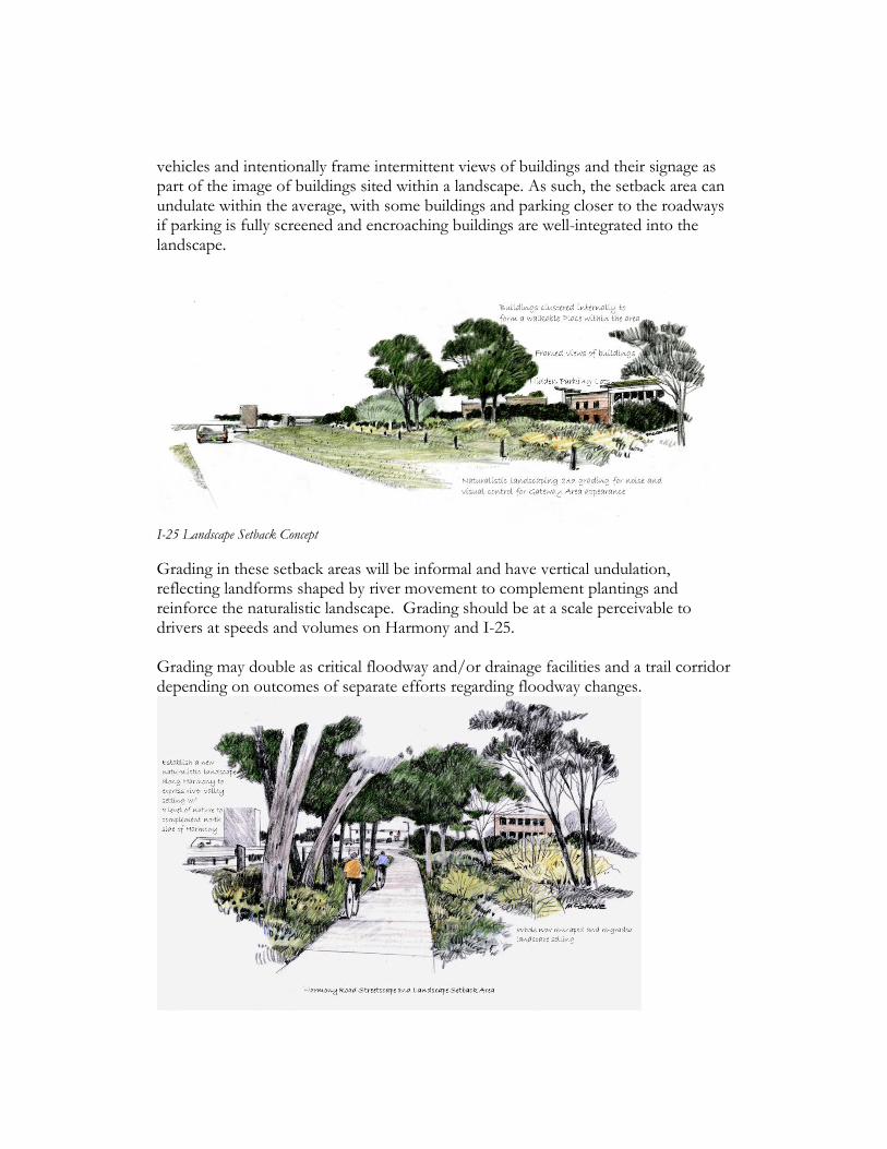
vehicles and intentionally frame intermittent views of buildings and their signage as part of the image of buildings sited within a landscape. As such, the setback area can undulate within the average, with some buildings and parking closer to the roadways if parking is fully screened and encroaching buildings are well-integrated into the landscape.
I-25 Landscape Setback Concept Grading in these setback areas will be informal and have vertical undulation, reflecting landforms shaped by river movement to complement plantings and reinforce the naturalistic landscape. Grading should be at a scale perceivable to drivers at speeds and volumes on Harmony and I-25. Grading may double as critical floodway and/or drainage facilities and a trail corridor depending on outcomes of separate efforts regarding floodway changes.

Harmony Streetscape with Naturalistic Landscaping Concept
3. Unified Harmony Road Gateway Streetscape Perhaps the strongest and most direct impression that can be made for people moving through or coming to the area is the Harmony Road streetscape. This streetscape includes the street edges as experienced by users of the street, and medians. It includes improvements within the City right-of-way and improvements as part of abutting land uses. For motorists entering the city, medians and streetscape improvements on the north side of Harmony Road would have the highest visibility. The landscaped medians reduce the scale of the large roadway and add beauty. As much as possible within space constraints, informal groupings of trees including cottonwoods will span across sidewalks which will be detached and slightly meandering in conjunction with naturalistic grading.
Harmony Road Streetscape, Landscape Setback Area, and New Street at Park-n-Ride Signal Concepts
4. Fort Collins Entry Sign
Streetscape design projects will explore the most complementary way to include an entry sign in conjunction with the landscaping. For years, public interest has been

expressed in a clearer message to motorists that they are entering Fort Collins, at all major highway entry areas. In the public planning process for the Gateway Area, community members’ input clearly indicated that any isolated, attention-grabbing sign, monument, sculpture or similar entry feature is not important in favor of a naturalistic landscape to move through. A landscaped native stone sign wall or other complementary entry sign would reinforce the gateway impression and will be carefully considered, sited and designed considering relationships to similar initiatives at other City gateways.
5. Habitat Protection and Mitigation Land use changes will include riparian landscaping that contributes to a larger continuous corridor of riparian habitat in rural and open lands across the larger southeast edge of Fort Collins. City, State, and Federal regulations already govern impacts to existing habitat that would likely occur with development. They generally emphasize protection, enhancement, and alternative mitigation of any losses with land use changes. For example, on the south side of Harmony Road where greater land use changes may occur, habitat improvements would be required to mitigate expected losses associated with filling ponds and future development. Newly created ponds, channels, and landscape areas would be part of the framework for development and would be extensively landscaped with native river valley plantings. This would provide a basic degree of urban habitat, mainly for birds and small aquatic species. With complete reshaping of the most or all of the landscape, there are apparent opportunities for improvements to go beyond minimal mitigation of losses and achieve significant enhancement over unintentional and unsanctioned status of the habitat that has formed in the gravel-mined landscape.
6. Regional Trail Corridor A landscaped trail corridor thirty to fifty feet wide (or more) will run like a ribbon through the south side of Harmony road to assist in linking trails and Natural Areas to the north and south—the Poudre River Trail in Arapaho Bend Natural Area on the north, and Fossil Creek Trail in Eagle View in the south.

The corridor will be an integral part of the formative framework of public space into which buildings and parking lots will fit. The corridor may be located within required landscape setback areas and should be sited and aligned to maximize the user experience. Developers will coordinate with the City on appropriate trail design, including alignment, width, surface materials and details.
Trail Corridor Concept, North Portion of South Side of Harmony
7. Mobility Hub
City Plan identifies the Harmony interchange area as a ‘Mobility Hub’ recognizing its long-term potential to offer transfers, drop-offs, a station for bus rapid transit (BRT), intersecting multi-use trails, and regional bus transit in addition to its park-n-ride function. This recognition centers around the TTC; but if any significant development is brought to fruition on the south side of Harmony as envisioned, it will complement the functioning of the TTC starting with a BRT stop and a comfortable pedestrian crossing of Harmony Road. Such development could add options such as car shares, electric charging, and shuttles to connect across Harmony.

8. Limitations on Commercial Signs
Commercial signs within the gateway area will be consistent with the Plan’s character elements as well as compliant with the City’s Sign Code. Present code provisions prohibit off-premise signs (billboards) and place limitations on sign size, height, and manner of display. Requests for modifications and/or variances to the Sign Code will be evaluated against adopted Harmony Gateway policies. Further, any Planned Unit Development (PUD) application would be required to include a Uniform Sign Program specifying sign type, heights, sizes, placement and lighting.
9. Stealth Wireless Telecommunication Facilities
Making a provision for wireless telecommunication facilities (typically cell towers) balances the needs for residents and the travelling public to have adequate telecommunication services while still protecting key views and upholding the naturalistic design character of the Gateway. New standards would prohibit conventional wireless and other telecommunication towers, unless in those cases where they are screened, roof-mounted equipment or are “stealth” installations located within church steeples, bell towers, flagpoles, grain silos, structures common to the area’s landscape or integrated into building architecture.
10. Land Use and Development Standards South Side of Harmony Road This 136-acre area has been zoned for development under the Basic Industrial Non-Retail Employment Activity Center land use designation since 1991, with the potential for major development if the floodway was to be removed and gravel pit ponds filled. In 2020, a 10-acre parcel of developable land exists at the southeast corner of Harmony and Strauss Cabin Roads. For development to proceed on the south side of Harmony Road beyond the vacant 10-acre parcel, the entire gravel-mined floodplain landscape would need to be completely reshaped from the current gravel pit configuration, filling the ponds in conjunction with a solution to contain the floodway. Naturalistic river valley landscaping dominated by groupings of cottonwoods and willows would be required to create a significant riparian greenbelt image along Harmony Road and I-25. This landscaping would complement and contribute to the

larger swath of open and rural lands at this southeast edge of the city and riparian tree groves on the north side of Harmony Road. Coverage of streets, buildings and parking lots would be limited to 60% of the site area, with the remaining 40%comprising he newly created naturalistic landscape setting. Groupings of evergreen trees would screen parking and help to frame selective intermittent visibility of buildings and their signage and add winter interest. Development will form an interesting, walkable mixed-use destination with buildings brought together along sidewalks and other walkways and outdoor spaces. While most people will arrive by private vehicle, the pattern will make it convenient and inviting to ‘park once’ and walk within the area. Because of the focus on a walkable framework, development would be mutually supportive of public transportation, by being convenient for walking, transit use, and bicycling upon arrival.
Buildings Brought Together in a Walkable, Mixed-Use Area
Beyond the visual image, the pattern would reflect multiple community values regarding livable, sustainable community development. Its character would define it as a notable gateway to Fort Collins and a unique shopping/employment/living destination in the region and state.

Mixed Land Uses A diverse mix of businesses, jobs, and urban housing at relatively high densities, allowing as many opportunities for cross-use as possible within walking distance. This mix offers a chance for people to live, work, and visit with minimal dependency on cars. Uses could include retail, restaurant, office and institutional buildings, corporate and light industrial employment, lodging and hospitality uses, and a variety of urban styles of housing. The mix of uses would be limited to the following distribution (as a percentage of net developable acreage): Residential: 25% minimum Retail and commercial: 50% maximum Employment: 25% minimum (office, light industrial, institutional) Public Space Framework of Streets Buildings and parking lots will be fitted into a well-planned framework of public space, with blocks formed by streets, or pedestrian ‘spines’ adequate to function in lieu of streets. ‘The term ‘streets’ is inclusive of street-like private drives. Pedestrian Crossings of Harmony and Strauss Cabin Roads Prominent pedestrian crossings would be provided at Strauss Cabin & Harmony Roads for reasonably comfortable east-west and north-south pedestrian

movement throughout the area.
. Strauss Cabin Pedestrian Crossing Concept at Apartments on West Side
Buildings and Parking Lots Buildings and their entrances would be brought together along streetfronts that may combine with a trail corridor and small park and public spaces and define the district.
Building Fitted in and Brought to Streetfronts
Accordingly, parking would be either distributed along active pedestrian streets, or consolidated in lots or structures that do not interrupt the pedestrian and visual environment. Landscape plantings internal to parking lots reflect the overall plant pallet for the area. North Side of Harmony Road

The existing land use is likely to remain within a reasonable planning time horizon. The park-n-ride could potentially expand to a degree or add a parking structure as part of long-range plans for a transit hub, but its essential footprint, function, streetscape, and naturalistic landscape are expected to remain consistent with the overall vision.
At such time that these properties redevelop, the Land Use and Development Standards described above for the south side of Harmony Road will be apply to the north side of Harmony Road.
TTC (Park-n-Ride) Landscape Setback Character
The commercial property abutting the interchange, under County jurisdiction, appears unlikely to request annexation and redevelopment within a planning time frame. In the meantime, it will remain a reminder of a past era when it was zoned for commercial uses at an outlying highway exit beyond the City Limits.
Northeast Commercial Corner Abutting the Interchange

DEVELOPMENT STANDARDS TO IMPLEMENT THE STRATEGIES Architectural, site, landscape and sign plans will be subject to design standards and guidelines that emphasize a distinct place and image consistent with the vision. PUBLIC SPACE MANAGEMENT Trail corridor and other open spaces: ownership, maintenance and liability issues would have to be negotiated. Retaining significant amounts of open space may require the expenditure of public funds or a reinvestment of tax dollars created by the development. GATEWAY AREA GOALS Shape the future of the gateway area to: 1. Emphasize opportunities of the river valley setting. 2. Express a positive image, community values, and a distinct local feel. 3. Shape development south of Harmony Road to form a walkable, mixed-use
district south, including diverse businesses, jobs, urban styles of housing and city amenities.
4. Take advantage of future public transportation systems along Harmony Road and I-25 by evolving a transit hub.
POLICIES GW-1 Establish a well-planned and attractive gateway entrance to Fort Collins at the I-25 interchange, emphasizing the natural scenic qualities of the area. GW-2 Protect and enhance the natural resource value of the Cache la Poudre River. GW-3 Encourage continued master planning efforts in the gateway area. GW-4 Establish design standards and guidelines for development in the gateway area that emphasize scenic and natural resource values. GW-6 Create networks of open space and trail systems, that incorporate urban wildlife habitat. GW-7 Support a balanced transportation system within the context of a pedestrian district that prioritizes pedestrian, transit and bicycle use as well as driving. IMPLEMENTATION ACTIONS The following actions need to be taken by the City to ensure that the gateway section of the Plan is implemented.

1. PLAN ADOPTION Gateway Plan amendment adoption by City Council. 2. GATEWAY PLANNING PHASE TWO The City should continue the gateway planning effort through the following design and coordination activities: DESIGN • Adopt Harmony Corridor Gateway Design Standards and Guidelines. • Develop and fund a Harmony Road gateway streetscape design. • Design a Fort Collins entry sign and develop a funding mechanism. • Develop a conceptual plan for a regional multi-purpose trail. • Design a naturalistic landscape design for the Harmony and I-25 rights-of-way. COORDINATION • Coordinate with the long-range planning efforts of other City departments – Transportation, Parks and Recreation, Water, Wastewater and Stormwater Utilities. • Coordinate with the Colorado Department of Transportation in regard to decommissioning of frontage roads, and landscaping in the highway right-of-way.