agenda of consultative traffic forum - 7 00 2020
TRANSCRIPT
Business Paper
Consultative Traffic Forum
Friday, 7 February 2020
8:30am
Committee Rooms 203 and 204,
Level 2, Administration Building,
4-20 Eton Street, Sutherland

Consultative Traffic Forum 7 February 2020
Page 2
ORDER OF BUSINESS
1. APOLOGIES
2. DISCLOSURES OF INTEREST
3 CONFIRMATION OF MINUTES OF THE PREVIOUS MEETING
4. REPORTS FROM OFFICERS – CONSULTATIVE TRAFFIC FORUM
CTF001-20 Continous Yellow Edge Linemarking in Cronulla Peninsula
CTF002-20 Statutory Parking Controls - February 2020
CTF003-20 East Parade, Sutherland - Pedestrian Crossing Detailed Design
5. ADDITIONAL MATTERS RAISED AT MEETING (if any)
Consultative Traffic Forum 7 February 2020
Page 3
CT
F00
1-2
0
CTF001-20 CONTINOUS YELLOW EDGE LINEMARKING IN CRONULLA
PENINSULA
Attachments: Appendix A,⇩ Appendix B,⇩ Appendix C,⇩ Appendix D,⇩ Appendix E,⇩ Appendix F,⇩
Appendix G⇩ and Appendix H⇩
EXECUTIVE SUMMARY
At the October 2018 meeting of the Sutherland Traffic and Traffic Safety Committee a report
was tabled proposing to provide yellow No Stopping line marking across areas experiencing
high parking demand and was subsequently endorsed;
The first trial area selected was Bundeena, which was marked in December 2018;
Council receives a large volume of parking related complaints from the Cronulla peninsula area
due to limited parking available at key attractions leading to illegal parking, particularly during
the warmer summer months; and
A further trial was conducted by marking intersections in the Cronulla peninsula area with
continuous yellow edge lines denoting No Stopping for at least 10 m from the adjacent kerb line
in November 2019 to reduce the likelihood of illegal parking and maintain adequate sight
distance at intersections.
REPORT RECOMMENDATION
THAT:
The information be received.

Consultative Traffic Forum 7 February 2020
Page 4
CT
F00
1-2
0
LOCATION
Selected intersections in the Cronulla peninsula, south of Waratah Street.
(Cronulla electorate).
REFERRAL TO COMMITTEE
Traffic and Transport Services Unit.
ISSUES
Parking demand outweighing supply in warmer months.
Maintaining minimum sight lines at intersections, in accordance with the Road Rules.
PREVIOUS CONSIDERATION BY COMMITTEE
In October 2018, the Sutherland Traffic and Traffic Safety Committee endorsed installing
continuous yellow edge line marking at intersection without traffic lights, across areas
experiencing high parking demand, on a trial basis (refer STR126-18).
In February 2019, the Consultative Traffic Forum received a report on the first trial conducted
during December 2018 in Bundeena (refer CTF001-19).
COMMENTS BY INVESTIGATING OFFICER
The Cronulla peninsula area, south of Waratah Street, was chosen as a second pilot scheme, due to
the large number of visitors in the warmer months of October to April. On-street parking is at a
premium during this period and subsequently, the incidence of parking within 10 metres of
intersections without traffic lights, contrary to Rule 170 of Road Rules 2014, is high. Furthermore,
many local roads in Cronulla are narrow, which increases the likelihood of vehicle conflicts in minor
roads.
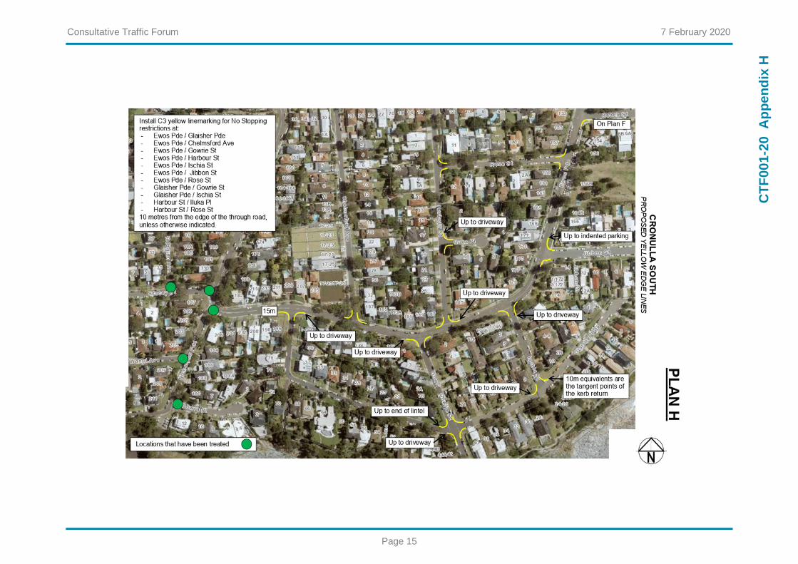
Continuous yellow edge lines were previously installed at 35 of the 74 intersections in the Cronulla
peninsula area. Each of the 39 remaining untreated intersections were assessed for the most suitable
parking controls, on a case-by-case basis. Subsequently, the works listed in Table 1 were undertaken
in November 2019 by Council’s contractor.
The continuous yellow edge lines were installed further than the statutory 10 metres for the following
reasons:
lines were extended to the nearest edge of a driveway, where a remaining parking space would
be less than 6 metres long (locations 14, 15, 32, 40, 41, 53, 75, 76, 79, 80, 82, 85, and 89);
lines were extended to the end of sections of road with dividing (BB) lines, where the combined
travel/parking lane would be less than 5.1 metres wide (locations 33, 34, 35, 36, 51, and 52);
and
lines were extended to the position of existing parking control signs (locations 1, 2, 3, 4, 5, 6, 8,
9, 10, 13, 14, 46, and 49).
Sketches of the yellow linemarking have been provided in the Appendices, Plans A to H.

Consultative Traffic Forum 7 February 2020
Page 5
CT
F00
1-2
0
Post-implementation review
An inspection on a Saturday during the summer school holidays indicated that self-compliance is very
high, with only one vehicle sighted parked contrary to the continuous yellow edge lines.
Residents have submitted nearly 50 customer requests for illegal parking in the Cronulla peninsula
since the start of December. The majority of these relate to driveway obstructing and only two
concerned parking contrary to the recently installed continuous yellow edge linemarking. It is
understood that on-street parking occupancy is not at 100% on peak days (summer public holidays
and weekends) and drivers are likely knowingly parking contrary to the Road Rules, rather than not
being able to park at all. Given that continuous yellow edge lines have been incorporated into NSW
legislation since at least 1999, it is expected that all drivers understand the meaning of the parking
control.
Council has received some positive feedback from residents and one request to reduce the length of a
yellow line in Ewos Parade north of Gardenia Street. After review it was decided to reduce the length
of the line to 12.5 metres.
Table 1 Continuous yellow edge line works undertaken in Cronulla South, November 2019
Location Intersection Corner Total Line Length (m)
1
1 Cronulla Street / Waratah Street / Nicholson Parade
North-west 34
2 North-east 41
3 South-west 50
4 South-east 32
5 2 Roker Street internal intersection
North-west 18
6 North-east 12
7 3 Waratah Street / Ewos Parade
North-west 24
8 East 34
9
4 Lewis Street / Clyde Avenue
North-west 21
10 North-east 20
11 South-west 17
12 South-east 17
13 5 Nicholson Parade / Taloombi Street
North-west 27
14 South-west 20
15 6 Richmount Street / Coronation Ave
South-west 17
16 South-east 18
17 7
Portsmouth Street / Hampshire Street
North-west 18
18 South-west 18
19 8 Richmount Street / Windsor Road
South-west 17
20 South-east 18
21
9 Windsor Road / Coronation Avenue
North-west 18
22 North-east 18
23 South-west 18
24 South-east 18

Consultative Traffic Forum 7 February 2020
Page 6
CT
F00
1-2
0
Location Intersection Corner Total Line Length (m)
25 10 Windsor Road / Portsmouth Street
North-west 18
26 North-east 18
27 11 Windsor Road / Pioneer Road
South-west 18
28 South-east 17
29 12 Nicholson Parade / Wilshire Avenue
North-east 25
30 South-east 23
31 13 Nicholson Parade / Trevellyan Street
North-east 18
32 South-east 23
33
14 Trevellyan Street / Coronation Avenue
North-west 18
34 North-east 18
35 South-west 17
36 South-east 18
37 15 Coronation Avenue / Sunset Avenue
North-west 18
38 South-west 18
39 16 Boronia Street / Gardenia Street
North-east 17
40 South-east 22
41 17 Ewos Parade / Rostrevor Street
North-east 21
42 South-east 16
43 18 Ewos Parade / Gardenia Street
North-west 28*
44 South-west 17
45 19 Ewos Parade / Orient Avenue
North-east 19
46 South-east 24
47 20 Ewos Parade / Oaks Street
North-west 18
48 South-west 16
49 21 Ewos Parade / Beach Street
North-east 35
50 South-east 18
51 22 Nicholson Parade / Gunyah Street
South-west 23
52 South-east 25
53
23 Nicholson Parade / Coronation Avenue
North 28
54 South-west 19
55 South-east 23
56 24 Nicholson Parade / Oaks Street
North-east 18
57 South-east 17
58 25 Oaks Street / Chelmsford Avenue
South-west 17
59 South-east 17
60 26 Oaks Street / John Street
North-west 18
61 North-east 18
62 27 Oaks Street / Harbour Street
South-west 18
63 South-east 26
64 28 Oaks Street / Boronia Street
North-west 19
65 North-east 19
66 29 Harbour Street / Rose Street
North-east 18
67 South-east 17

Consultative Traffic Forum 7 February 2020
Page 7
CT
F00
1-2
0
Location Intersection Corner Total Line Length (m)
68 30 Harbour Street / Iluka Place
North-east 18
69 South-east 19
70 31 Ewos Parade / Rose Street
North-west 18
71 South-west 16
72 32 Ewos Parade / Jibbon Street
North-east 22
73 South-east 20
74 33 Ewos Parade / Ischia Street
South-west 18
75 South-east 21
76 34 Ewos Parade / Harbour Street
North-east 18
77 North-west 19
78 35 Ewos Parade / Gowrie Street
South-east 19
79 South-west 23
80 36 Ewos Parade / Chelmsford Avenue
North-east 26
81 North-west 17
82 37 Ewos Parade / Glaisher Parade
South-east 21
83 South-west 22
84 38 Glaisher Parade / Ischia Street
North-east 11
85 North-west 19
86
39 Glaisher Parade / Gowrie Street
North-east 16
87 North-west 20
88 South-east 16
89 South-west 19
* reduced to 22m after review
FINANCIAL IMPLICATIONS
The works were fully funded within existing budget allocations, with significant savings compared to
undertaking the works on a case-by-case basis.
LIST OF APPENDICIES
Plan A Vicinity of Gerrale Street, Waratah Street and Ewos Parade
Plan B Ewos Parade side from Waratah Street to Coast Avenue
Plan C Nicholson Parade side from Lewis Street to Hampshire Street.
Plan D Ewos Parade side from Richmount Street to Trevellyan Street
Plan E Nicholson Parade side from Hampshire Street to Trevellyan Street
Plan F Ewos Parade side from Trevellyan Street to Beach Street
Plan G Nicholson Parade side from Trevellyan Street to Oaks Street
Plan H Ewos Parade vicinity of Bass and Flinders Point
RESPONSIBLE OFFICER
The officer responsible for the preparation of this Report is the Team Leader Traffic & Transport
Services, Greg Holding, who can be contacted on 9710 0514.
File Number: 2019/330295 (GvW)

Consultative Traffic Forum 7 February 2020
Page 8
CT
F00
1-2
0
Ap
pe
nd
ix A

Consultative Traffic Forum 7 February 2020
Page 9
CT
F00
1-2
0
Ap
pe
nd
ix B

Consultative Traffic Forum 7 February 2020
Page 10
CT
F00
1-2
0
Ap
pe
nd
ix C

Consultative Traffic Forum 7 February 2020
Page 11
CT
F00
1-2
0
Ap
pe
nd
ix D

Consultative Traffic Forum 7 February 2020
Page 12
CT
F00
1-2
0
Ap
pe
nd
ix E

Consultative Traffic Forum 7 February 2020
Page 13
CT
F00
1-2
0
Ap
pe
nd
ix F

Consultative Traffic Forum 7 February 2020
Page 14
CT
F00
1-2
0
Ap
pe
nd
ix G
Consultative Traffic Forum 7 February 2020
Page 15
CT
F00
1-2
0
Ap
pe
nd
ix H

Consultative Traffic Forum 7 February 2020
Page 16
CT
F00
2-2
0
CTF002-20 STATUTORY PARKING CONTROLS - FEBRUARY 2020
Attachments: Appendix A,⇩ Appendix B,⇩ Appendix C,⇩ Appendix D,⇩ Appendix E,⇩ Appendix F⇩
and Appendix G⇩
EXECUTIVE SUMMARY
The works outlined in the report were carried out by Council under Roads Act 1993, to reinforce
existing controls under Road Rules 2014.
REPORT RECOMMENDATION
THAT:
The information be received.

Consultative Traffic Forum 7 February 2020
Page 17
CT
F00
2-2
0
COMMENTS BY INVESTIGATING OFFICER
The works outlined in Table 1 were carried out by Council under Roads Act 1993, to reinforce existing
controls under Road Rules 2014.
Table 1 Works approved under Roads Act 1993, to reinforce Road Rules 2014
Reference Location Issue Measure
CR20-399298
(Plan A)
Intersection of Lilli Pilli Pt Rd & Bareena St, Lilli Pilli (Cronulla).
Parked vehicles close to intersection, restricting access into Bareena Street.
‘NO STOPPING’ at the intersection of Lilli Pilli Point Road & Bareena Street, Lilli Pilli.
CR20-400116
(Plan B)
Intersection of Gerald Rd and Oriana Dr, Illawong
(Heathcote).
Clarify 10 metre rule for ‘No Stopping’ at unsignalised intersections, to prevent illegal parking at intersections in the
proximity of a high school and primary school
Continuous yellow edge lines and ‘NO STOPPING’ signs at the intersection of Gerald Road and
Oriana Drive, Illawong.
CR20-400116
(Plan C)
Intersection of Gerald Rd and Orford Pl, Illawong
(Heathcote).
Clarify 10 metre rule for ‘No Stopping’ at unsignalised intersections, to prevent illegal parking at intersections in the
proximity of a high school and primary school
Continuous yellow edge lines and ‘NO STOPPING’ signs at the intersection of Gerald Road and
Orford Place, Illawong.
CR20-400116
(Plan D)
Intersection of Gerald Rd and Blaxland Dr, Illawong (Heathcote).
Clarify 10 metre rule for ‘No Stopping’ at unsignalised
intersections, to prevent illegal parking at intersections in the proximity of a high school and
primary school; and
Clarify the suitable distances for buses to access bus stops to
prevent illegal parking and improve safety.
Continuous yellow edge lines
and ‘NO STOPPING’ signs at the intersection of Gerald Road and Orford Place, Illawong; and
‘BUS ZONE’ signs at existing Bus Stops on the northern and southern side of Gerald Road,
west of Blaxland Road, Illawong.
CR19-393204
CR20-404250
(Plan E)
Intersection of Solveig Cr and Freya St, Kareela (Miranda).
Clarify 10 metre rule for ‘No Stopping’ at unsignalised intersections, to prevent illegal parking at intersections in the
proximity of a shopping centre.
Continuous yellow edge line and ‘NO STOPPING’ signs at the intersection of Solveig Crescent
and Freya Street, Kareela.
CR19-381732
(Plan C4)
Clio St and Glencoe St, Sutherland
Parked vehicles close to intersection, restricting sight vision for motorist.
Install continuous yellow edge lines at the intersection of Clio Street & Glencoe Street, Sutherland.
CR19-331912
(Plan C6)
Foch Av, Kirrawee (Miranda).
Parked cars close to intersection at Princess Highway service road and Foch Avenue, Kirrawee
Install continuous yellow edge lines at the intersection of Princes Highway service road and Foch
Avenue, Kirrawee.
Approvals
This matter is referred to the Consultative Traffic Forum for Council and Traffic Committee’s
information.
References
Roads Act 1993
Road Transport Act 2013 and Road Rules 2014
FINANCIAL / RESOURCE IMPLICATIONS
The approved measures will be fully funded within existing budget allocations.

Consultative Traffic Forum 7 February 2020
Page 18
CT
F00
2-2
0
RESPONSIBLE OFFICER
The officer responsible for the preparation of this Report is the Team Leader Traffic & Transport
Services, Greg Holding, who can be contacted on 9710 0514.
File Number: 2019/330295 (GH)

Consultative Traffic Forum 7 February 2020
Page 19
CT
F00
2-2
0
Ap
pe
nd
ix A

Consultative Traffic Forum 7 February 2020
Page 20
CT
F00
2-2
0
Ap
pe
nd
ix B

Consultative Traffic Forum 7 February 2020
Page 21
CT
F00
2-2
0
Ap
pe
nd
ix C

Consultative Traffic Forum 7 February 2020
Page 22
CT
F00
2-2
0
Ap
pe
nd
ix D

Consultative Traffic Forum 7 February 2020
Page 23
CT
F00
2-2
0
Ap
pe
nd
ix E

Consultative Traffic Forum 7 February 2020
Page 24
CT
F00
2-2
0
Ap
pe
nd
ix F

Consultative Traffic Forum 7 February 2020
Page 25
CT
F00
2-2
0
Ap
pe
nd
ix G

Consultative Traffic Forum 7 February 2020
Page 26
CT
F00
3-2
0
CTF003-20 EAST PARADE, SUTHERLAND - PEDESTRIAN CROSSING DETAILED
DESIGN
Attachments: Appendix A,⇩ Appendix B,⇩ Appendix C⇩ and Appendix D⇩
EXECUTIVE SUMMARY
In July 2019, options were presented to Sutherland Traffic & Traffic Safety Committee to
improve pedestrian access between the western side of East Parade and Sutherland Train
Station.
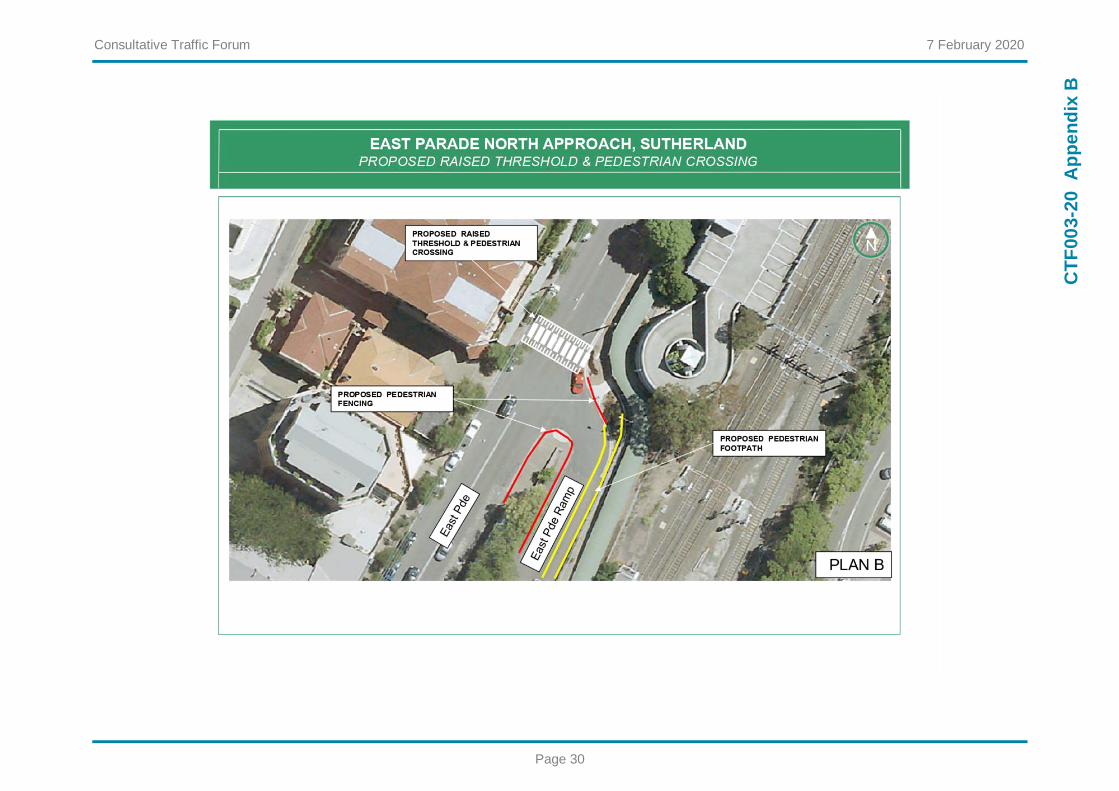
Traffic Committee recommended the option of constructing a raised pedestrian crossing in East
Parade, to the north of the ramp to the Sutherland railway overbridge, and an at-grade
pedestrian crossing on the north-western ramp to the Sutherland railway station overbridge.
Council endorsed the recommendation.
The proposed detailed design of the pedestrian crossings is attached to the report.
The proposed works are scheduled to be constructed before the end of the 2019/20 financial
year.
REPORT RECOMMENDATION
THAT:
The information be received.

Consultative Traffic Forum 7 February 2020
Page 27
CT
F00
3-2
0
LOCATION
Intersection of East Parade and the north western ramp to Sutherland station overbridge.
REFERRAL TO COMMITTEE
Representations from Councillor Diedree Steinwall.
ISSUES
Increase in pedestrian volumes crossing East Parade.
No formal pedestrian crossing facilities.
Pedestrian safety.
PREVIOUS CONSIDERATION BY COMMITTEE
STR030-19 – East Parade, Sutherland – Proposed Pedestrian Crossings.
BACKGROUND
There are no formal pedestrian crossings facilities provided at the intersection East Parade and the
north western ramp to Sutherland railway station. Pedestrian volumes at this location have increased
substantially following the completion of the new commuter car park in Robertson Street. Following a
pedestrian safety assessment, including collection of peak hour traffic and pedestrian survey data, the
traffic Committee endorsed and Council approved:
a raised pedestrian crossing and road narrowing in East Parade immediately north of the on
ramp intersection (refer to Appendix A, B and D).
an at grade (paint only) pedestrian crossing and road narrowing within the north western ramp
approximately 40m south of the East Parade/ on ramp intersection (refer to Appendix A, C & D).
a new footpath on the eastern side of the on ramp connecting the proposed pedestrian crossing
facilities (refer to Appendix D); and
pedestrian fencing (refer to Appendix A, B, C & D) to guide pedestrians to the crossing points
and prevent undesirable pedestrian movements at the intersection.
A detailed design has been undertaken, as shown in Appendix D, which is referred to the Consultative
Traffic Forum for comment.
FINANCIAL / RESOURCE IMPLICATIONS
The estimated cost of the proposed measures is $352,000. The works will be funded by TfNSW’s
2019/20 Minor Works Program and Council’s 2019/20 Traffic and Transport Works Program, under
agreement between RMS and Council.
LIST OF APPENDICES
Appendix A ...... Plan A - Site Concept Plan
Appendix B ...... Plan B - East Parade Pedestrian Crossing Concept Plan

Consultative Traffic Forum 7 February 2020
Page 28
CT
F00
3-2
0
Appendix C…... Plan C - North-western Ramp to Sutherland Railway Station Pedestrian Crossing
Concept Plan
Appendix D ...... East Parade and North-western Ramp to Sutherland Railway Station Pedestrian
Crossing Detailed Design
RESPONSIBLE OFFICER
The officer responsible for the preparation of this Report is the Team Leader Traffic and Transport
Services, Greg Holding, who can be contacted on 02 9710 0514.
File Number: 2020/363231 (CW)

Consultative Traffic Forum 7 February 2020
Page 29
CT
F00
3-2
0
Ap
pe
nd
ix A
Consultative Traffic Forum 7 February 2020
Page 30
CT
F00
3-2
0
Ap
pe
nd
ix B

Consultative Traffic Forum 7 February 2020
Page 31
CT
F00
3-2
0
Ap
pe
nd
ix C

Consultative Traffic Forum 7 February 2020
Page 32
CT
F00
3-2
0
Ap
pe
nd
ix D

Consultative Traffic Forum 7 February 2020
Page 33
CT
F00
3-2
0
Ap
pe
nd
ix D

Consultative Traffic Forum 7 February 2020
Page 34
CT
F00
3-2
0
Ap
pe
nd
ix D

Consultative Traffic Forum 7 February 2020
Page 35
CT
F00
3-2
0
Ap
pe
nd
ix D

Consultative Traffic Forum 7 February 2020
Page 36
CT
F00
3-2
0
Ap
pe
nd
ix D

Consultative Traffic Forum 7 February 2020
Page 37
CT
F00
3-2
0
Ap
pe
nd
ix D

Consultative Traffic Forum 7 February 2020
Page 38
CT
F00
3-2
0
Ap
pe
nd
ix D

Consultative Traffic Forum 7 February 2020
Page 39
CT
F00
3-2
0
Ap
pe
nd
ix D

Consultative Traffic Forum 7 February 2020
Page 40
CT
F00
3-2
0
Ap
pe
nd
ix D