agroclimatic zoning of crambe and bean for the … · paulo sergio lourenço de freitas1 adalberto...
TRANSCRIPT

GEOGRAFIA, Rio Claro, v. 40, Número Especial, p. 85-98, ago. 2015.
AGROCLIMATIC ZONING OF CRAMBE AND BEAN FORTHE BACIA DO ALTO PARAGUAI � MT, BRAZIL
Cleonir Andrade FARIA JÚNIOR1
Rivanildo DALLACORT2
Paulo Sergio Lourenço de FREITAS1
Adalberto SANTI2
William FENNER2
Sandra Mara Alves da Silva NEVES2
João Danilo BARBIERI2
Henrique da Cruz RAMOS2
Thiago Garcia VILLELA2
Abstract
The economic activities of the Pantanal, were directly influenced by the periodicflooding process. Therefore, it became highly necessary to diversify the economic outputof this region, especially in the area of agriculture. An expansion process is thus takingplace in the Upper Paraguay River Basin. This study, therefore, aims at performingzoning for cultivation of the Crambe and common bean in the Mato Grosso portion ofthe Upper Paraguay River Basin. This research was conducted in the University of MatoGrosso - UNEMAT Campus of Tangara da Serra - MT. Data on the temperature andprecipitation from 38 meteorological stations were provided by the National Institute ofMeteorology - INMET, Forecasting Center Weather and Climate Studies - CPETEC andthe Secretary of State and Environmental Development - SEDAM / RO. For the Crambeseeding culture done without utilizing the irrigation systems after the time 9, increasesthe risk of cultivation failure. In light of this fact it becomes evident that the lack of wateris the main limiting factor for cultivating Crambe in the area under study. However, ingeneral, most of the area available in the Upper Paraguay River Basin is able to sustainbean cultivation during all the sowing dates studied. Sowing Crambe from the first to theseventh day of the ten-day period is acertained as good for the fullest extent of theUpper Paraguay River Basin, whereas for the bean this period stretches until the ninth orten-day period.
Keywords: Geostatistics. Kriging. ISNA.
1 Universidade Estadual de Maringá � UEM - PGA/UEM, Av. Colombo, N° 5790 - Bloco J45 - 2°Piso, CEP - 87020-900, Maringá-PR
2 Universidade do Estado de Mato Grosso � UNEMAT. E-mails: [email protected];[email protected]; [email protected]; [email protected]; [email protected];[email protected]; [email protected]; [email protected]; [email protected]

8 6 GEOGRAFIAAgroclimatic zoning of crambe and bean for
the Bacia do Alto Paraguai � MT, Brazil
Resumo
Zoneamento agroclimático do crambe e do feijoeiropara a bacia do alto Paraguai � MT, Brasil
As atividades econômicas desenvolvidas no pantanal são diretamente influenciadaspelo processo de inundação periódica. Desta forma torna-se imprescindível a diversificaçãoda produção econômica desta região principalmente quando se trata da agricultura queencontra-se em processo de expansão na Bacia do Alto Paraguai. Sendo assim estetrabalho tem por objetivo realizar o zoneamento para as culturas do Crambe e dofeijoeiro comum para a porção mato-grossense da Bacia do Alto Paraguai. A presentepesquisa foi desenvolvida na Universidade do Estado de Mato Grosso � UNEMAT noCampus de Tangará da Serra � MT, utilizou-se de dados de temperatura e precipitaçãode 38 estações meteorológicas cedidos pelos: Instituto Nacional de Meteorologia �INMET, Centro de Previsão do Tempo e Estudos Climáticos � CPETEC e Secretaria deEstado e Desenvolvimento Ambiental � SEDAM/RO. Para a cultura do Crambe a semeadurasem a utilização de sistemas irrigados após a época 9 aumentam o risco do insucessodo cultivo. Tendo em vista que o déficit hídrico é o principal fator limitante para o cultivodo Crambe na região estudada. Para o feijoeiro de maneira geral, a maior parte daárea disponível da Bacia do Alto Paraguai é apta ao cultivo do feijoeiro em todas asépocas de semeadura estudadas. A semeadura do Crambe do primeiro até o sétimodecêndio do ano é considerada apta em toda a extensão da Bacia do Alto Paraguai emquanto para o feijoeiro este período se estende até o nono decêndio.
Palavras-chave: Geoestatística. Krigagem. ISNA.
INTRODUCTION
The Brazilian Pantanal is unique because of its intrinsic features when comparedwith the other parts of the world. Completely embraced within the Upper ParaguayRiver Basin, the Brazilian Pantanal covers an area equivalent to 363,000 km², ofwhich the state of Mato Grosso ocuupies approximately 47% (SEPLAN, 2010).
The flood plains support the development of several economic endeavors,especially those of livestock, fisheries, tourism and agriculture, chiefly for subsistence.All the activities cited above are directly influenced by seasonal flooding of the plain,a characteristic peculiar to the Brazilian Pantanal. Keeping this natural dynamic inperspective, it becomes necessary to diversify the economic output, so as to ensuresome means of income for the Pantanal populace, controlling the risks caused by thevagaries of the climate and the market, thus ensuring the development of the regionand the maintenance of the wealth afforded by this natural source of invaluablebiodiversity.
Family farming, according to Guimarães et al. (2011), has a fundamental partto play in the municipalities, as it is essential for the sustainable economic developmentof the region; however, their significance is limited by government programs whichare not involved in developing family agribusinesses, the commonest producers offresh produce.
In light of this, studies that enhance the endeavors prevealent here and facilitatethe incorporation of new crops in the region are vital to the maintenance and bettergrowth of the wetlands. The populations in the municipalities of the Upper ParaguayRiver Basin practice subsistence activities such as growing banana, cassava andcommon beans. Beans, in particular, forms an essential protein source for food. Due

8 7
Faria Júnior, C. A. / Dallacort, R. / Freitas, P. S. L. de /Santi, A. / Fenner, W. / Neves, S. M. A. da S. /Barbieri, J. D. / Ramos, H. da C. / Villela, T. G.v. 40, Número Especial ago. 2015
to the significance of this crop culture for the region, bean zoning in the basin becomesan important means for families who inhabit and cultivate in the Basin. This processenhances the decision-making related to sowing times and improves the productionsystem, while reducing the climate-induced production risks.
As this crop is a new culture and still in the adaptation phase in the state budget,it appears to be a potential crop for the region. The inherent characteristics of the cropare its tolerance to the climatic conditions of the region, and its water requirements(150 to 200 mm) until the full flowering phase (PITOL, 2008), and even a high early inyour cycle (JASPER et al., 2010). As a result of these unique characteristics relating tothe variable climatic factors, Crambe seems to be a good potential alternative as asecond crop in the state of Mato Grosso and other regions of the Midwest, South andSoutheast of Brazil (PITOL et al., 2010).
The IPCC studies (2007) indicate that Brazil has been experiencing climaticchanges, and the same changes taking place in the state have augmented the risk ofyield loss. The environmental factors such as excessive rainfall in short periods andhigh temperatures interfere directly with the planning and decision making. Therefore,new studies are being conducted to reduce the risk of losses in the production system;one way of doing this is by the introduction of new crops, which can minimize suchrisks and increase the possibilities of new markets in the agricultural sector.
In the context of this dynamic, the spatial interpolation of climate data and theimportance of the crop with respect to the studies on agro-climatic suitability, as wellas the variability of the hydrological regimes must be considered. Based on the results,Kriging has been shown to be the best among all the interpolation methods used(MELLO et al., 2003; VIOLA et al., 2010). In the basic work done by Farias et al.(2001), the authors showed that for soybeans during the drought periods there wasthe most demand for the introduction of the methods of interpolation and geostatistics,water balance and estimates of the water requirement satisfaction index - ISNA.
Thus, the aim of this researcher was to prove that the zoning of the agroclimaticcultures of Crambe and common bean could be based on the water requirementsatisfaction index for the Mato Grosso portion of the Upper Paraguay River Basin.
MATERIAL AND METHODS
This research study was performed at CEPEDA (Center for Research, Studiesand Agri-Environmental Development), in the Agrometeorology Laboratory, on thecampus of Tangara da Serra - MT State University of Mato Grosso - UNEMAT.
To focus on the main objective of this study, we used the data from ten-dayperiods of temperature and precipitation recorded from 38 meteorological stationsfound in Mato Grosso and the regions close to the State for the possible interpolationand data analysis for the Upper Paraguay River Basin. The data were collected fromthe stations of the National Institute of Meteorology - INMET, Prediction Center Weatherand Climate Studies - CPETEC and Secretary of State and Environmental Development- SEDAM / RO, as well as from those provided by the Agritempo site of the BrazilianAgricultural Research Corporation - EMBRAPA Computer agriculture, which have aminimum storage of 12 years of observed data. In order to organize the data, checkfor consistency and fault fills the CLIMATE software was used (Faria et al., 2003).
After processing the weather data the sowing time and Water RequirementSatisfaction Index - ISNA were determined for each crop according to the methodologyadapted by Rolim, Sentelhas and Barbieri (1998) for ten days 1-12, and considered

8 8 GEOGRAFIAAgroclimatic zoning of crambe and bean for
the Bacia do Alto Paraguai � MT, Brazil
Crambe and the common bean for the second crop in Mato Grosso. The indices thusgenerated were classified based on the methodology proposed by Farias et al. (2001)in which ISNA unable = <0.55; Restricted = 0.55 <Isna <0.65 and Apt = ISNA> 0.65,and compared to the critical stage of the crop (flowering / grain filling) for each sowingdate. The ISNA values were determined for the three water capabilities available, viz.,30, 50 and 75 mm for the Upper Paraguay River Basin.
While the Pantanal includes areas that flood all the time over the years, zoningfor the non floodplains of the municipalities found wthin the basin under study wasaccomplished (Figure 1). Thus, it disregarded the entire city of Barão Melgaço, 59%of Caceres, 29% of Curvelândia, 42% of Itiquira, 3% of Lambari D�Oeste, 21% ofNossa Senhora do Livramento, 83% of Poconé, 3% of Porto Estrela, 19% of Rondonópolisand 77% of Santo Antonio do Leverger. This represents an area of approximately55,451 km², which is a little over 30% of the Upper Paraguay River Basin in the stateof Mato Grosso. Also, the sum of the areas suitable for urban areas and those forreserves and permanent preservation was reduced.
Figure 1 - Location of the Upper ParaguayRiver Basin - MT, 2014
The ISNA values were calculated spatially with the weather stations beingconsidered as a reference, and then fitted as a semivariogram for each season. Finally,the models that presented the best fitting were selected, in which one of its parametersshowed the spatial dependence (GDE). Dalchiavon et al. (2012) classified the GDE asfollows: DGE <20% - very low spatial dependence; GDE 20% <40% - low dependence;GDE 40% <60% - average dependence; GDE 60% <80% - high dependence and 80%GDE <100% - very high dependence. According to the authors, the greater theseindices the greater the reliance on the variable they indicate, relative to the distance.

8 9
Faria Júnior, C. A. / Dallacort, R. / Freitas, P. S. L. de /Santi, A. / Fenner, W. / Neves, S. M. A. da S. /Barbieri, J. D. / Ramos, H. da C. / Villela, T. G.v. 40, Número Especial ago. 2015
After the data and the indexes were entered into the ArcGIS software, version10.0TM, ESRI, in which the ordinary Kriging from certain coefficients were incorporatedinto the semivariogram settings. The maps with fitness classes for the Upper ParaguayRiver Basin, Mato state Grosso were generated. The maps for each time span in theirCADs (30, 50 and 75 mm) were cut and put togehter to form a single map representingthe three CADs, enabling the interpretation of the information generated.
RESULTS AND DISCUSSION
The ISNA values for the different CADs in both the crop cultures studied revealedsimilar behavior over the ten day-period. It is well known that the standard deviationon average is lower in the first ten-day period and this is influenced by the increasedprecipitation (Figure 2). For the prior ten-day spans when the rainfall index is lower,the standard deviation is greater. This is justified by the fact that the extra length ofthe concentrated dry season throughout the Mato Grosso, due to the movement of airmasses over the active state, produced a greater variability in the average rainfall,resulting in a higher randomness of the data and thus increasing the deviation in thedata. According Marcuzzo et al. (2011), the state of Mato Grosso has intrinsic featuresof vegetation and relief which increase the variability and distribution of rainfall in thestate.
Figure 2 - Precipitation and standard deviationfor ten days for the state of Mato Grosso

9 0 GEOGRAFIAAgroclimatic zoning of crambe and bean for
the Bacia do Alto Paraguai � MT, Brazil
CRAMBE
The ISNA values for Crambe in CAD 30, from the first to seventh ten days showaverages of above 0.83 and standard deviation below 0.14. This does not represent aspatial variability considering the three fitness classes; the same is noted for DAC 50and 75, as well as for the first ISNA. The mean values are always found to be higherthan 0.88 with a standard deviation less than 0.11; however, the second ISNA averagevalues are higher than 0.91 with the standard deviation below 0.09. This enables theadjustment of the semivariograms and consequently the Kriging to generate thesuitability maps. Thus, the seeding of Crambe across the upper Paraguay basin hasbeen concluded as being suitable for ten-day periods of 1 to 6 for the DAC 30, from 1to 7 for the DAC 50 and 1 to 8 for the DAC 75 (Table 1).
Table 2 lists the coefficients of the semivariograms and the adjustments, theadjusted models, number of pairs in the first Lag, nugget effect, range and degree ofspatial dependence (GDE).
Table 1 - Water Requirement Satisfaction Index of the average values(ISNA) and standard deviations (SD) for the water storage
capacity in the soil of 30, 50 and 75 mm, for ten-dayperiods 1-12 for the state of Mato Grosso
Table 2 - The coefficients of the semivariograms adjusted for CADs30, 50 and 75 mm and their sowing dates for the state of Mato Grosso

9 1
Faria Júnior, C. A. / Dallacort, R. / Freitas, P. S. L. de /Santi, A. / Fenner, W. / Neves, S. M. A. da S. /Barbieri, J. D. / Ramos, H. da C. / Villela, T. G.v. 40, Número Especial ago. 2015
Semivariograms were adjusted only for those periods which revealed spatialdependence, i.e.times when no pure nugget effect was evident, which implies whenthe current sample was not significantly the sampled area, and Kriging could not beperformed, the spatial continuity could not be found.
Figure 3 shows the semivariogram models adjusted for the ISNA values of theCADs 30, 50 and 75 mm in the Mato Grosso state. According to Dalchiavon et al.(2012), in all the CADs, for all the times, the ISNA values revealed great spatialdependence except for season 9 in CAD 75 which showed an average spatialdependence.These results imply a good fit of the data, and Kriging is thus possible, asshown in figure 3.
Figure 3 - The semivariograms adjusted with the ISNA valuesfor the Crambe culture at different times for CADs 30,
50 and 75 mm, for the state of Mato Grosso

9 2 GEOGRAFIAAgroclimatic zoning of crambe and bean for
the Bacia do Alto Paraguai � MT, Brazil
Figure 4 Zoning of the water requirement satisfaction index for the Upper ParaguayBasin in the set times of the data, their sowing seasons and CADs of the basin soils.
For sowing 8, about 98.6% of the Upper Paraguay River Basin available area isrevealed to be capable of sowing Crambe, and only a fraction of the Tangara da Serramunicipality had restricted cultivation, representing 24.2 % of the area. For sowing inseason 9, about 80,775.9 km² (79.7% of the available areas of the Upper ParaguayRiver Basin) show fitness for seeding the Crambe. In fact, 19 of the 43 cities studieddemonstrated this feasibility in their entire territory, including Araputanga, Arenapolis,Cáceres, Curvelândia, Denise, Figueirópolis D�Oeste, Gloria D�Oeste, Indiavaí, Jaciara,Jauru, Lambari D�Oeste, Mirassol D�Oeste, Nossa Senhora do Livramento, Nova Olímpia,Poconé, Porto Esperidião, Porto Estrela, Rio Branco and São José dos Quatro Marcos.Only one city showed a small disability area, accounting for less than 1% of the basinarea.
Regarding the time 10 significant areas of disability for seeding Crambe areobserved with about 15,100 km² constituting 14.9% of the basin area. The unfit areasinclude part of the Upper Paraguay municipalities (28.8%), Chapada dos Guimarães(74.4%), Cuiabá (28.8%), Dom Aquino (23.4%), Itiquira (27.4%) Juscimeira (6.4%),Nortelândia (19.5%), Nova Brasilândia (23%), Nova Marilândia (23.1%) Pedra Preta(36.6%), Poxoréo (54.2%), Rondonópolis (17.9%), Rosário Oeste (40.7%), SantoAntônio do Leverger (6.9%), São José do Povo (20.2%) and São Pedro da Cipa (60.9%).The areas suitable for sowing amount to approximately 66,000 square kilometers intotal, mainly represented by the municipalities of Arenápolis, Curvelândia, Denise,Figueirópolis D�Oeste, Glória D�Oeste, Indiavaí, Jaciara, Mirassol D�Oeste, PortoEsperidião, Rio Branco and São José dos Quatro Marcos. These areas can fully supportcultivation of the Crambe, while the restricted areas account for approximately 20,000km².
Figure 4 - Risk ratings of the ISNA Zoning and Crambe sowing inthe Upper Paraguay River Basin for CADs 30, 50 and 75 mm

9 3
Faria Júnior, C. A. / Dallacort, R. / Freitas, P. S. L. de /Santi, A. / Fenner, W. / Neves, S. M. A. da S. /Barbieri, J. D. / Ramos, H. da C. / Villela, T. G.v. 40, Número Especial ago. 2015
For sowing in times 11 and 12, the 9 municipalities which continue to showfitness along the entire length are as follows: Curvelândia, Figueirópolis D�Oeste, GloriaD�Oeste, Indiavaí, Lambarí D�Oeste, Mirassol D�Oeste, Porto Espiridião, Rio Brancoand São José dos Quatro Marcos. For that time period all the 11 suitable areas constitutedapproximately 46,000 km², while for time 12 it was only 42,000 km². With respect tothe unsuitable areas for the time 12, nearly 38 825 km² were added, in which all themunicipalities of Dom Aquino, Poxoréo, São José do Povo and São Pedro da Cipawere included in this class; for time 11 the total was 21,159 km².
It is evident therefore that the sowing time required the support of the irrigatedsystems after time 9, where there was a rise in the risk of cultivation failure, as waterdeficit was identified as the main limiting factor for growing Crambe in the study area.
The scenario produced by this zoning can be altered if the farmer desires to usethe irrigation systems, thus reversing the restricted or even unsuitable areas mentionedabove.
In general, most of the area of the Upper Paraguay River Basin that is available,is suitable for the cultivation of Crambe in sowing times 8, 9 and 10.
BEAN
For bean, the ISNA values in the different CADs showed that contemplatingsowing during the first and eighth ten-day period was greater than 0.80, with standarddeviations exhibiting the same behavior. This indicated a low variability in the studyarea and verifying their fitness was not possible by Kriging. Table 3 shows the ISNAvalues and standard deviation for the twelve ten-day periods of sowing in the threesoil CADs in the basin.
Thus, the maps for the Upper Paraguay Basin are shown only for sowing times10, 11 and 12 for CAD 30mm, and times 11 and 12 for CAD 50mm. All the otherregions of the basin are considered suitable during the periods earlier than thesedates, including for CAD 75 mm, except when the regions of the basin mentionedabove where cultivation is restricted are flooded (Table 3).
Table 3 - Water requirement satisfaction index (ISNA) for the twelveten-day periods of sowing and standard deviation (SD) for the
three CAD studies during the twelve observation years
9 4 GEOGRAFIAAgroclimatic zoning of crambe and bean for
the Bacia do Alto Paraguai � MT, Brazil
The values shown for the ISNA for the Upper Paraguay River Basin are similarto those for rainfall in that region, in which the values decrease significantly as the dryseason proceeds. This behavior is probably due to the vegetation intrinsic to eachstate in each region. This increases the distribution of variability over the months,especially during lower accumulated periods (MARCUZZO et al., 2011).
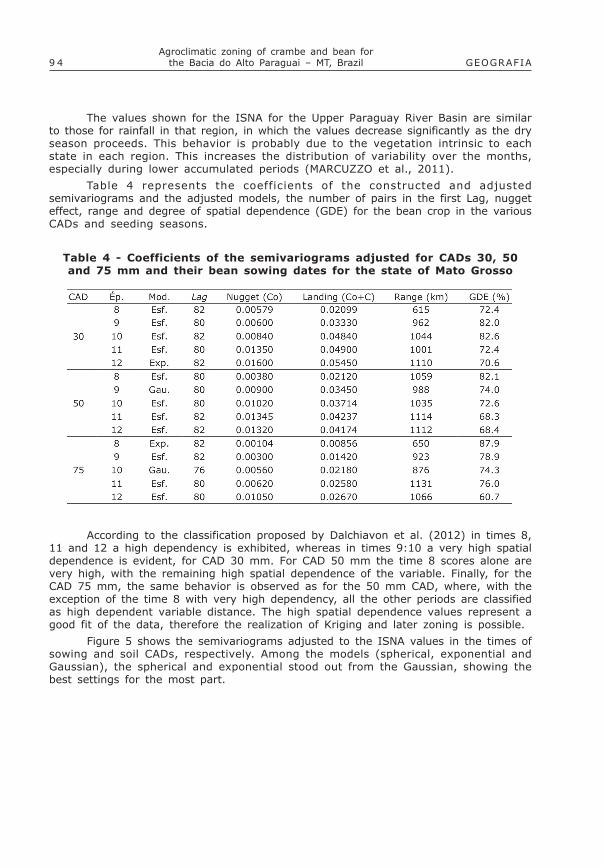
Table 4 represents the coefficients of the constructed and adjustedsemivariograms and the adjusted models, the number of pairs in the first Lag, nuggeteffect, range and degree of spatial dependence (GDE) for the bean crop in the variousCADs and seeding seasons.
Table 4 - Coefficients of the semivariograms adjusted for CADs 30, 50and 75 mm and their bean sowing dates for the state of Mato Grosso
According to the classification proposed by Dalchiavon et al. (2012) in times 8,11 and 12 a high dependency is exhibited, whereas in times 9:10 a very high spatialdependence is evident, for CAD 30 mm. For CAD 50 mm the time 8 scores alone arevery high, with the remaining high spatial dependence of the variable. Finally, for theCAD 75 mm, the same behavior is observed as for the 50 mm CAD, where, with theexception of the time 8 with very high dependency, all the other periods are classifiedas high dependent variable distance. The high spatial dependence values represent agood fit of the data, therefore the realization of Kriging and later zoning is possible.
Figure 5 shows the semivariograms adjusted to the ISNA values in the times ofsowing and soil CADs, respectively. Among the models (spherical, exponential andGaussian), the spherical and exponential stood out from the Gaussian, showing thebest settings for the most part.

9 5
Faria Júnior, C. A. / Dallacort, R. / Freitas, P. S. L. de /Santi, A. / Fenner, W. / Neves, S. M. A. da S. /Barbieri, J. D. / Ramos, H. da C. / Villela, T. G.v. 40, Número Especial ago. 2015
Figure 5 - Semivariograms adjusted to the ISNA values for thedry bean crop at different times for CADs 30, 50 and 75 mm,
for the state of Mato Grosso

9 6 GEOGRAFIAAgroclimatic zoning of crambe and bean for
the Bacia do Alto Paraguai � MT, Brazil
Figure 6 reveals zoning of the water requirement satisfaction index for theUpper Paraguay River Basin in the set times of the data and their sowing seasons andCADs of the basin soils.
In the times of sowing 8 and 9 (Figure 6), the entire area available for themunicipalities, with the exception of the urban areas of flooding or preservation, isable to support the bean cultivation in the rainfed system. It also takes into considerationthe critical phase of the culture (i.e. flowering / grain filling). In the sowing season 10,about 96.11% of the available area of the basin is found suitable for cultivation. Therestricted areas of cultivation include the towns of Nortelândia (15.67%), NovaBrasilândia (3.12%), Nova Marilândia (31.95%), Pedra Preta (5.07%), Poxoréu (43.07%) and São José do Povo (18.10%), which altogether extend over an area of 3,943.03km².
Considering sowing time 11, the areas observed unfit for cultivation representa total of 4,475.05 km2 (4.71%). The unfit areas include the municipalities of DomAquino (6.13%), Juscimeira (6, 38%), Nova Brasilândia (17.77%), Pedra Preta (10.14%),Poxoréu (54.17%), São José do Povo (20.21%) and São Pedro da Cipa (23.85%). Thenext 13.77% area is restricted to cultivation (part of the Upper Paraguay municipalities,comprising Chapada dos Guimarães, Cuiabá, Dom Aquino, Itiquira, Juscimeira,Nortelândia, Nova Brasilândia, Nova Marilândia, Pedra Preta, Rondonópolis, RosárioOeste, Santo Afonso, Santo Antônio do Leverger, São Pedro da Cipa and Tangará daSerra). The remaining 81.52% is considered suitable for cultivation. The evidencemakes it very clear this time that the direction of risk reduction is from East to West,which goes hand in hand with the advancement of the water regime and the Pantanalareas.
Finally, in the sowing time 12 have an increase observed areas unsuitable forthe common bean cultivation in the upland system. Currently, the 12.34% consideredunfit for cultivation includes the municipalities cited in part for time 11, but to a larger
Figure 6 - ISNA Zoning and categories of sowing risk for the commonbean in the Upper Paraguay Basin in CADs 30, 50 and 75 mm

9 7
Faria Júnior, C. A. / Dallacort, R. / Freitas, P. S. L. de /Santi, A. / Fenner, W. / Neves, S. M. A. da S. /Barbieri, J. D. / Ramos, H. da C. / Villela, T. G.v. 40, Número Especial ago. 2015
extent of unsuitable area. The restricted areas represent 9.36% and are situated inparts of the municipalities of Acorizal, Alto Paraguai, Chapada dos Guimarães, Cuiabá,Itiquira, Jangada, Nova Brasilândia, Nova Marilândia, Poxoréu, Rosário Oeste, SantoAfonso, Santo Antônio do Leverger and Tangará da Serra. The areas of the cities andother places are suited for the common bean rainfed crop.
If other cropping systems are considered like those being irrigated but havingdifferent cultural managements which emphasize the use of ground water, it may bepossible to raise those crops in the restricted and unsuitable areas. However, it mustbe noted that in these areas the climate risk of cultivation failure is higher. In thosespecific areas, the prospect of bean sowing is recommended, so that risks are minimized.
In general, most of the area of the Upper Paraguay River Basin available issuitable to support bean cultivation in all the sowing dates.
FINAL CONSIDERATIONS
Crambe sowing during the first ten days of the year until the seventh is fullyrecommended to the utmost extent of the Upper Paraguay River Basin; for the beanthis period is extended until the ninth and tenth days.
For Crambe, the sowing performed during times 8, 9 and 10, are recommendedas suitable in most parts of the Upper Paraguay River Basin. For sowing from time 10,the municipalities located Northeast of the basin show some restriction and unsuitability,and the sowing inability extends to the Southwest.
The risk category for sowing bean also shows the Northeast to the Southwesttrend, following certain characteristic movements of the air masses; however, it showsthe unfit class for bean alone from the 11th ten days; therefore, the Crambe andbeans are cultivars that can be utilized as good alternatives to rotate the second cropproduction system.
REFERENCES
DALCHIAVON, F. C.; CARVALHO, M. P.; ANDREOTTI, M.; MONTANARI, R. Variabilidadeespacial de atributos da fertilidade de um Latossolo Vermelho Distroférrico sob sistemaplantio direto. Revista Ciência Agronômica, Fortaleza, v. 43, n. 3, p. 453-461,2012.
FARIA, R. T.; CARAMORI, P. H.; CHIBANA, E. Y.; BRITO, L. R. S. CLIMA � Programacomputacional para organização e análise de dados meteorológicos. RevistaEngenharia Agrícola, Jaboticabal, v. 23, n. 2, p. 372-387, 2003.
FARIAS, J. R. B.; ASSAD, E. D.; ALMEIDA, I. R.; EVANGELISTA, B. A.; LAZZAROTTO,C.; NEUMAIER, N.; NEPOMUCENO, A. L. Caracterização de risco de déficit hídrico nasregiões produtoras de soja no Brasil. Revista Brasileira de Agrometeorologia,Santa Maria, v. 9, n. 3, p. 415-421, 2001.
GUIMARÃES, G. M. V.; RIBEIRO, F. L.; ECHEVÉRRIA, A. R. Importância da Agriculturafamiliar para o desenvolvimento sustentável de municípios com predominância doagronegócio. Revista Brasileira de Agropecuária Sustentável, Viçosa, v. 1, n.2, p. 1-11, 2011.
9 8 GEOGRAFIAAgroclimatic zoning of crambe and bean for
the Bacia do Alto Paraguai � MT, Brazil
JASPER, S.P.; BIAGGIONI, M. A. M.; SILVA, P. R. A.; SEKI, A. S. BUENO, O. C. Análiseenergética da cultura do crambe (Crambe abyssinica Hochst) 275 produzida em plantiodireto. Engenharia Agrícola, Jaboticabal, v. 30, n. 3, p. 395-403, 2010.
MARCUZZO, F. F. N.; MELO D. C. R.; ROCHA, M. H. Distribuição espaço-temporal esazonalidade das chuvas no Estado de Mato Grosso. Revista Brasileira de RecursosHídricos, Porto Alegre, v. 16, n. 4, p. 157-167, 2011.
MELLO, C. R.; LIMA, J. M.; SILVA, A. M.; MELLO, J. M.; OLIVEIRA, M. S. Krigagem einverso do quadrado da distância para interpolação dos parâmetros da equação dechuvas intensas. Revista Brasileira de Ciência do Solo, Viçosa, v. 27, n. 5, p. 925-933, 2003.
PITOL, C.; BROCH, D. L.; ROSCOE, R. Tecnologia e Produção - Crambe 2010.Maracaju: Fundação MS, 2010. 60p.
PITOL, C.; Cultura do Crambe. In: PITOL, C.; BROCH, D. L.; ROSCOE, R. Tecnologiae Produção - Milho Safrinha e Culturas de Inverno � 2008. 4.ed. Maracaju:Fundação MS, 2007. p. 85-88.
PITOL, C.; ROSCOE, R. Introdução e melhoramento de crambe no Brasil. In: PITOL,C.; BROCH, D. L.; ROSCOE, R. Tecnologia e produção crambe 2010. 1. ed.Maracaju: Fundação MS, 2010. v. 1. n. 1, p. 4-6.
ROLIM, G. S.; SENTELHAS, P. C.; BARBIERI, V. Planilhas no ambiente EXCELTM paraos cálculos de balanços hídricos normal, sequencial, de cultura e de produtividadereal e potencial. Revista Brasileira de Agrometeorologia. Santa Maria, v. 6, n. 1,p. 133-137, 1998.
VIOLA, M. R.; MELLO, C. R.; PINTO, D. B. F.; MELLO, J. M.; ÁVILA, L. F. Métodos deinterpolação espacial para o mapeamento da precipitação pluvial. Revista Brasileirade Engenharia Agrícola e Ambiental, Campina Grande, v. 14, n. 9, p. 970-978,2010.