aila: starting with landscape · aila: starting with landscape parliamentary friendship group for...
TRANSCRIPT

Start with Landscape; Parliamentary Friendship Group for Better Cities 1 181128_AILA_rod simpson_images_v2.docx
AILA: Starting with Landscape
Parliamentary Friendship Group for Better Cities 181128
Roderick Simpson, Environment Commissioner, Greater Sydney Commission
Firstly, I'd like to acknowledge that we meet on the land of the Ngunnawal people and I pay, and I'm sure you will all join with me in paying our respects to elders past, present, and emerging.
I would also like to thank the Australian Institute of Landscape Architects for the invitation and the opportunity to speak with you this evening, and for the introductory comments by the Honourable Members Trent Zimmerman and Andrew Giles, and those by Shaun Walsh President of the AILA, their comments really set the scene for what I am about to say.
It will perhaps come as no surprise, having been invited by AILA, when I say that I think we need new approaches to planning, and that these approaches should ‘start with landscape’. At first hearing this may seem obvious, and begs the question; ‘isn’t that what we already do?”
I will argue that it is not. More often than not, landscape is an afterthought, and in relation to natural systems we now take a very reductionist approach and consider how to minimise impacts, or protect ecosystems, which is well and good, indeed essential, but an alternative view, the one I will argue is to see landscape as the generator of form, liveability, identity and resilience in our cities.
I won't be talking in detail about the Greater Sydney Regional Plan or the operation and responsibilities of the Commission. Instead the idea of Sydney being a ‘metropolis of the three cities’ highlights challenges for planning, particularly in relation to the 3rd or western city I will use the planning we have been undertaking as an illustration of emerging approaches, compare it to some of the orthodoxies of recent years and, being in Canberra, look at the enduring legacy of its planning, its original and enduring response to landscape.
What I'm going to be putting forward is a very simple proposition, that hopefully gains its strength through being simple: it's to do with the order in which we plan. The way that we've been planning cities in the past has tended to start from transport, then thinking about the economy, and then thinking about housing, and then lastly of course the impact that that planning might have on the natural environment.
But if we think about the people who have been indigenous to a place, we might start to draw from that knowledge and appreciation and care for place, beyond simply acknowledging it as we have just done, and instead recognising it as the basis, the foundation for planning and in so doing reverse that sequence of planning by starting with country and landscape. So perhaps a very simple idea, but disruptive.
Slide 1

Start with Landscape; Parliamentary Friendship Group for Better Cities 2 181128_AILA_rod simpson_images_v2.docx
This is Sydney, you can see the scale here. Our area of the Greater Sydney Region is 12,000 square kilometres. Those are the five districts, as we call them, that the Greater Sydney Commission is responsible for planning. The urban footprint is around about 20% of that, 2,400 square kilometres, and about half of the whole area is in fact national park. The area outlined in red is the catchment area of Wianamatta or South Creek. And you can see the three circles there on the right that have become our corporate insignia representing the three cities.
Slide 2
Sydney is growing from 4.6 million at the moment up to 6.3 million by 2036. That will require around about another 725,000 dwellings and about another 870,000 jobs. In other words, very, quick growth. There's a lot of pressure on our existing systems and there's discussion at the moment, as you may be aware, of actually slowing down that growth because it's very hard to even service what we have at the moment.
Slide 3
On this image north is not up the page, west is up the page. Apart from the ease of drafting, I think it gives a much clearer impression of moving into country from the coast. In Sydney early on it was found was that the country in the east was infertile, sandstone country, and people moved very quickly out to the west where they found shale country, much more fertile soils, and a very much more soft, undulating landscape, very different to the landscape that you've all seen I'm sure around Sydney harbour.

Start with Landscape; Parliamentary Friendship Group for Better Cities 3 181128_AILA_rod simpson_images_v2.docx
Slide 4
That blue line is the Hawkesbury, that's the defining limit of the Cumberland Plain, as it's known. And that white line is the catchment line. And the significance of that is of course that all the water to up the page if you like, flowing westward, goes into the sensitive waterways of the Hawkesbury Nepean.
Slide 5
The national parks that we have surrounding the city, have not been a result of policy, but shear pragmatics. Too expensive to develop, these areas were overlaid much later with an intentional preservation as national parks. What you see here also, in the east were military reserves, swamps that were often reclaimed as land for open space, and port land reserved, which has provided an extraordinary amount of public domain.

Start with Landscape; Parliamentary Friendship Group for Better Cities 4 181128_AILA_rod simpson_images_v2.docx
Slide 6
The light blue line is South Creek or Wianamatta which means mother place in the local language, and there's the South Creek catchment outlined in red: 630 square kilometres and where there may be an additional million people by 2050.
Slide 7
Now, just passing by, in 1770 Parkinson on Cook's voyage remarked that the landscape looked ‘like plantations in a gentleman's park’, which was one of the motivations for the British to then return in 1788 because, of course, that park landscape was seen as a prime opportunity for transformation into a pastoral paradise for whole lot of cattle, which you can see here and sheep. What Parkinson and others later failed to appreciate was that this landscape was not a natural landscape; this was a managed landscape that had been carefully looked after though stewardship and custodianship over tens of thousands of years.
The landscape the result of unarguably of the most stable economic, social system that the world has ever known.
Here is Bill Gammage’s book; The Biggest Estate on Earth, so-called because that's a conception of Australia being carefully managed with a sensitivity to what could happen where. If you like, an ‘adaptive management system’.
I’m emphasising that term here because its one of the main propositions I am making;
This one is that although we may not be able to draw a direct line between indigenous values and indigenous management, I think we can draw a direct line to thinking of the importance of having an underlying ethos of stewardship and custodianship. And it may be that over time we can start to draw direct threads in terms of the pragmatic aspects of management. But I think that's probably

Start with Landscape; Parliamentary Friendship Group for Better Cities 5 181128_AILA_rod simpson_images_v2.docx
stretching it too far too quickly. However if we think about how we actually manage an entire mosaic of complexity in the urban area and new expansion areas in particular, I think there's a lot to be said by simply observing what was there before.
Slide 8
Now, moving westward. What you see here is the expropriation of land from the Aboriginal communities and a handout as land grants from the Crown to private citizens. In other words, the entire west of the city was privatised, unlike those reserves in the east that I mentioned before. The only thing that wasn't privatised are these green areas which were the commons that were reserved for stock. Pretty much all the land had been taken away and privatised by about 1820
A huge challenge when you think about it and now that we're thinking about expanding the city. A huge challenge because the attitude with which we moved into that country was one of exploitation.
Slide 9
This map is not the early 1800s, this is the 1920s and '30s, this is still the prevailing attitude illustrated here by Griffith Taylor that arguably persisted up until the 1960s.

Start with Landscape; Parliamentary Friendship Group for Better Cities 6 181128_AILA_rod simpson_images_v2.docx
Slide 10
What that totally ignored, is the way the country had been supporting Aboriginal communities for generations. The areas in yellow are the productive grasslands under Aboriginal ‘cultivation’. Not cultivation in the European sense but managed areas of grassland that actually produced grain across those same areas Griffith Taylor identified as having very low value.
Slide 11
What that attitude led to can be seen here when you look at the vegetation change from 1788 to 1990; complete devastation in the west. And you can see here also that rugged areas, sandstone country to the north and south of the city; now Ku-ring-gai and Royal National Parks to the north and south respectively. What it looks like at the moment, on the right.
We've got to imagine that black area as being not necessarily covered by a forest but certainly covered by woodland that you saw a moment ago. A managed landscape that's been devastated.

Start with Landscape; Parliamentary Friendship Group for Better Cities 7 181128_AILA_rod simpson_images_v2.docx
Slide 12
Here is what most of the landscape looks like today.
We've called the three cities the Eastern Harbour City, the Central River City, and the Western Parkland City. The choice of the word parkland is very deliberate, because it recognises; like it or not, we are in the Anthropocene, all landscapes are subject to human intention. So we have no choice but to think about how we now apply human intention to this landscape. The point being that the idea of returning it to an imagined wilderness would be flawed. It's disrespectful, because that too would be continuation of the denial of the careful management by aboriginal society, it's not appropriate because a return to that management system is not possible and we must recognise that the area will be transformed, and even if it were not to be transformed it's impossible to do because it doesn't take into account climate change, for a start.
It has been asked why the city should expand in any case; why it should not simply be intensified within the existing footprint. The main reason is that this would not necessarily re-balance the city.
Slide 13
The white areas on the map on the right are the 2,400 square kilometres of the urban area. These are two of probably a 100 to 200 maps we could produce which all show pretty much the same thing, which is that having come from the east and developed the city in the east around the harbour, having concentrated our infrastructure, transport, universities, the whole range of infrastructure in the east on the basis of reinforcing the strengths that we have in the city, at the very same time we may have also been entrenching disadvantage and entrenching weaknesses.
On the left is mapping of the Australian Index of Social Disadvantage. It shows the places that have entrenched disadvantage across of a whole range of issues in terms of education, income, health, across the board.
Another representation of the same sort of effect over on the right. This is a mapping of high performing schools, major hospital and universities. That redline in the local Sydney colloquial is

Start with Landscape; Parliamentary Friendship Group for Better Cities 8 181128_AILA_rod simpson_images_v2.docx
known as the ‘latte line’. People to the northeast of that line are supposed to drink ‘café lattes’ and those to the south of the line don't. Or it might be called the smashed avocado line. More importantly this divide of course is really one of disadvantage.
Slide 14
Those patterns have been developed and reinforced for 230 years, but to counter that there's been a decision to put in an airport in the west of the city. There will be 60,000 jobs around that airport, but really it's a massive investment in a piece of infrastructure that can be then leveraged to direct further investment in terms of industry, agribusiness, logistics, but also universities and a new way of thinking about development with the overall objectives of having jobs of all sorts within 30 minutes, even though those three cities may have different concentrations or focuses of jobs.
In other words, it's leveraging this massive commitment to an airport that has been talked about for decades. It's not just about infrastructure, it's essentially a mechanism to rebalance the city and to start to address those inequities. So it's even more a social objective than an economic one in terms of productivity, although of course there are productivity benefits.
Slide 15
So the question becomes how on earth did this become what it is and how did we get to this point? How did we get here? I think we got here through planning orthodoxies.
I'm an architect by training and moved into practicing and teaching urban design. Urban design practice is very dependent on precedents. It relies heavily on analysing different parts of different cities that exist which are good, and trying to understand and then repeat the essential characteristics that make them good.

Start with Landscape; Parliamentary Friendship Group for Better Cities 9 181128_AILA_rod simpson_images_v2.docx
Slide 16
This is what I'm talking about when I say driving us to the brink. This is actually what's the current practice of what's being rolled out and being accelerated through improved processes to deliver more of this as quickly as possible in the west. I'm not even making a judgment, I'm just stating a fact here.
Slide 17
This is Wellard in Perth, and what you can see is two urban conditions, one dominant and one subordinate, I'd suggest. The subordinate one on the right is in fact the textbook example of a new-urbanist transit-oriented development. Contrasting with this on the left is the ‘real story’ of the things that really drive the cities that we produce in Australia which is car dominated and a determined by the preferred geographies of major retail and commerce.
So unfortunately, this orthodox new urbanist exercise around the rail station can only be seen as having a symbolic value because the overall structure of the city has been determined by a completely different set of parameters, driven by cars and driven by the needs of investors in major retail, as you can see here in global condition on the left.

Start with Landscape; Parliamentary Friendship Group for Better Cities 10 181128_AILA_rod simpson_images_v2.docx
Slide 18
We have to challenge these planning orthodoxies because they have failed to counter car dominance. The image on the top right is the surface car parking around the shopping mall, but arguably even the small new-urbanist centre is dominated by the needs of the car.
Slide 19
Here is an excerpt from one such new-urbanist code. This is the Western Australian Liveable Neighbourhoods Manual that may be thought of as distillation and the codification of all that analysis as it might be applied to a more suburban context than King's Cross. It is part of an orthodox lineage of urban design based on precedent and based, to give it its due, on walkability. But you've seen that though this pattern might exist in some patches the dominant pattern is going to be car-based and operating to satisfy a much larger, coarser grain economic geography.

Start with Landscape; Parliamentary Friendship Group for Better Cities 11 181128_AILA_rod simpson_images_v2.docx
Slide 20
And when you look at the detail of this, what can you see? Well, very simply, you can see the idea that transport determines the urban form; that retail locates in the most accessible locations; that retail is equivalent to amenity and urban quality and access to retail is the most important thing; that we have to have density to support transport, which is why you have this higher density along the major road. And you can see also that you don't intrude into that catchment, the transport catchment, by locating schools and parks within that magic 400 meter radius. And that you have the major open space as far away as possible and not intruding into this higher density area.
Slide 21
Where does all this come from? You're probably familiar with central place theory from Christaller who analysed the patterns of settlement, and the way that different sizes of markets and centres worked in Europe, in this case it was an analysis of Poland just after it was invaded. Whether the empirical analysis by urban geographers that has been translated into normative approaches for how we design is appropriate or effective is my question and point.

Start with Landscape; Parliamentary Friendship Group for Better Cities 12 181128_AILA_rod simpson_images_v2.docx
Slide 22
Now let’s look at Canberra, over here on the left you can see the expansion of Canberra into a structured plan called the “Y” plan, for obvious reasons. But you can also see a very finely calibrated hierarchy of centres from the city to the town to what was called a group centre or a district centre to a neighbourhood centre. And accompanying that a finely calibrated and quite rigid hierarchy of roads. In other words, hierarchical, the idea of the city as a machine, the idea of components, a functional city.
Interestingly, five years before this plan, set out in a document called ‘Tomorrow’s Canberra’, we had had Christopher Alexander arguing that a city is not a tree, it's not hierarchical, it can't be broken into components. It's actually a complex system, a network, a lattice, it is not a tree. So it's interesting that five years before the plan the theoretical underpinnings of ‘functional’ urbanism was being questioned.
To say Alexander was ‘well ahead of his time’ is clearly nonsensical. It is more accurate to say that his thinking about complexity and patterns could not be accommodated or ‘operationalised’ through the planning systems that existed at the time, and was ahead of complexity theory that would follow, and I would suggest that we are still operating within a functionalist view of the city.
The hierarchical structure, and conception of the city as a complicated machine, rather than complex system has allowed it to be broken into components that can then be matched to bureaucracies and departments. The orthodoxy of transit oriented development and integrated land use and transport planning is the only superficial structure that binds the different components together. The appreciation and understanding that these components interact with each other to create a sense of place is lost.
Slide 23
And this is what results. What you see here is really the built result when the city is conceived as designed as separate components, planned and delivered by different departments, with different rules linked only by a functionalist notion of transit and supporting density.

Start with Landscape; Parliamentary Friendship Group for Better Cities 13 181128_AILA_rod simpson_images_v2.docx
One department responsible for the big structuring roads, another for the density located near those roads with the idea that then that would support public transport. And I'd suggest that's not a great result. In other words the way we have set up departments and the way we plan ignores the major findings of Alexander, that complex systems are emergent and finally find form in stable ‘patterns’ or ‘urban typologies’ what we would commonly refer to as the ‘character’ or ‘spirit’ of a place. So we need to understand and appreciate what makes a great place
Transport-oriented development ‘TOD’ is the dominant orthodoxy at the moment. TOD calls for ‘integrated transport and land use planning’. I am not questioning the need to integrate land use and transport, rather, it should not be the first and only consideration that overrides all others, and needs to be achieved alongside other considerations; walkability, access to nature and recreational areas, the overall liveability of an area, not simply access to public transport for commuting.
More importantly, I'm questioning whether transport planning and major roads are the best starting point for planning; and I'm arguing that no, they are not. In new urban areas, transport and road systems an can be fitted to a desirable urban pattern based on walkability. And the starting point should be country; the blue and green grids of waterways, habitat and open space, then walkability, centres and road systems.
In other words; ‘start with landscape’. But what does that mean?
Slide 24
Let’s have another look at Canberra; what better example of city planned starting with landscape? This is Burley Griffin's work of genius with Marion Mahony Griffin, his wife. The only reason they entered a competition in Australia from Chicago was that he saw Australia as being the leader in the world for new democratic institutions. He had never visited but was able to inhabit the place in his imagination through an extraordinary ability to interpret the surveys and drawings.
This is not simply overlaying a formal geometry on a landscape, it was overlaying a conception of a new democratic ethos that he thought was emerging in Australia before anywhere else in the world that could be experience, embodied in the landscape and incorporated in the citizen by walking the city.
At the same time there were the ideas of garden cities and Ebenezer Howard's ideas of how communities could actually reinvest in the public domain based on the seminal ideas of Henry George, now largely forgotten, but an internationally influential figure at the time, that strongly influenced Griffin’s ideas as well.
So perhaps most importantly, the spatial layout and design would be accompanied by a land leasehold system to avoid speculation by developers and private landowners. In other words, it was about the giving absolute and clear precedence to the public good, and that's why I am suggesting that a comprehensive landscape framework should be the foundational idea for the way we approach the planning of the Western Parkland City.

Start with Landscape; Parliamentary Friendship Group for Better Cities 14 181128_AILA_rod simpson_images_v2.docx
Slide 25
Griffin’s response to the topography even though it's been overlaid by car dominant patterns, and those functional systems I showed a moment ago, has an extraordinary resilience because it was based on landscape. And that appreciation for landscape, was carried through in the 1970s to understand that they wouldn't be developing over the hills, that there would be these great landscape valleys and systems of open sense poetically called the National Capital Open Space System- very 1970s terminology. It's not a plan, it's a system. But that landscape system of course is what gives Canberra this enduring resilience and capacity to absorb change.
Slide 26
These are images from Bruce MacKenzie’s wonderful memoir cum retrospective book. You can see here how Canberra is an intentional landscape. The upper images shows that some of it was cleared, but before it was cleared it was already a natural open woodland, largely grassland, with only dotted trees. There's a bit of clearing in there, but not a lot. That was its natural condition because of the soil conditions and the climate. So what you see in the lower image below is an intentional landscape. A landscape that mediates climate, makes it more habitable for humans, and integrates exotics trees and avenues. So it's unapologetically a constructed parkland city as well.

Start with Landscape; Parliamentary Friendship Group for Better Cities 15 181128_AILA_rod simpson_images_v2.docx
Slide 27
These drawings show the interplay of the landscape system with the hierarchical system of centres and roads. The two systems exist alongside and are complementary to each other. At first this arrangement seems at odds with the principles of ‘transit oriented development’ with too low density and open space ‘intruding’ into public transport catchments.
At this point it is important therefore to not only question the primacy given to ‘transit oriented development’, but also the spatial planning formulae and norms that accompany it. TOD asserts that public transport is entirely dependent density and particular arrangement as set out in the ‘liveable neighbourhoods manual’ that you saw previously.
Slide 28
So look at Canberra, in diagrammatic form on the left, the olive green areas are national parks around the outside.
In the central map the black areas are the urban areas, and the bright green areas the National Capital Open Space System. A transport planner would usually say, "That's a disaster. It's fractured, there's no way you can service that with transport." And it's been difficult in Canberra because it has actually given precedence to cars. However, let's compare it to Helsinki. It might seem like a strange comparison, but there it is at the same scale, just as fragmented, similar sorts of attitudes to landscape and the natural environment. The difference is in policies and taxation regimes and in the way that there's been an investment in public transport.

Start with Landscape; Parliamentary Friendship Group for Better Cities 16 181128_AILA_rod simpson_images_v2.docx
In other words, less than ideal geography, topography, urban form can be overcome by policy and investment. We shouldn't see the physical layout of the city as being an absolute game stopper, if you like, in terms of transport. We simply have to decide that's what we want to do. And that's why I still think that there's a capacity for that to happen in Canberra, as it is indeed with the commitment to light rail, support for cycling and enlightened parking policies that are being developed.
This is essentially the argument put by the late Paul Mees in his wonderful book Transport for Suburbia, which is arguing pretty much the case that policy and investment can overcome geography.
Look at the figures; the cycling 2.5% in Canberra, I think it's now about 3%, so this is a few years old, this data, it is increasing. But in Helsinki it's 6%. And you think, "Hang on, let's look at the temperature." This is minus 7.4 degrees in the middle of winter. Now, either that 6% is an average of zero in winter and 12% in summer, but it's still double.
The obsession that we've had with transport-oriented development and transport taking precedence over all other considerations in how we plan our cities, and then allowing the economic geography of retail to be driven by car-dependence needs to be questioned.
Slide 29
If we put aside transport oriented development, the question is what is the alternative, what is an alternative starting point? I'm suggesting it is with the water, habitat and open space systems. We know we have to protect these, but we need to transform that necessity into aspiration, from protection to generation, and that really leads to this idea of custodianship, and the need to create an intentional landscape.
Slide 30
Here are the three cities: a harbour city, a river city which might be restored, and this Western Parkland City.
Start with Landscape; Parliamentary Friendship Group for Better Cities 17 181128_AILA_rod simpson_images_v2.docx
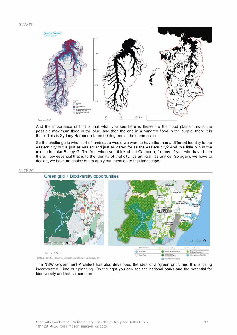
Slide 31
And the importance of that is that what you see here is these are the flood plains, this is the possible maximum flood in the blue, and then the one in a hundred flood in the purple, there it is there. This is Sydney Harbour rotated 90 degrees at the same scale.
So the challenge is what sort of landscape would we want to have that has a different identity to the eastern city but is just as valued and just as cared for as the eastern city? And this little blip in the middle is Lake Burley Griffin. And when you think about Canberra, for any of you who have been there, how essential that is to the identity of that city, it's artificial, it's artifice. So again, we have to decide, we have no choice but to apply our intention to that landscape.
Slide 32
The NSW Government Architect has also developed the idea of a “green grid”, and this is being incorporated it into our planning. On the right you can see the national parks and the potential for biodiversity and habitat corridors.

Start with Landscape; Parliamentary Friendship Group for Better Cities 18 181128_AILA_rod simpson_images_v2.docx
Slide 33
The idea of ‘green belts’ and ‘green grids’ in not new. These images show, interconnected regional open space in the County of Cumberland Plan for Sydney in 1948 and the idea of a ‘green belt’ drawing from the London Plan from a few years before.
On the right, you can see the tracts of open space following watercourses, left undeveloped primarily due to poor foundation condition and flood risk, being also identified as the ideal location for major roads.
This concept, if it deserves such a term, was of course adopted worldwide, and is where the term ‘parkway’ originates; from the opportunistic and devastating strategy of locating major road in popen space corridors as wreaked most famously by Robert Moses, in New York as Commissioner of Parks.
These illustrations show how important it is to have comprehensive plans, but it is also important to define what the areas and lines are for.
Slide 34
But the challenges of developing in the Western City are largely to do with its geography, hydrology and climate; it is a different catchment, it's a different climate zone; the east and the west of the city are actually different climate zones in terms of our building modelling.
A changing climate can be added to this, to result in a very different set of conditions in the west.

Start with Landscape; Parliamentary Friendship Group for Better Cities 19 181128_AILA_rod simpson_images_v2.docx
Slide 35
On the left is the 1948 County of Cumberland Plan. On the right the current extent of the city and historical growth, and in black catchment outline. You can see, we've pretty much avoided going into it. The reason we've avoided going into it is the sensitivity of the Hawkesbury River that the creek drains to.
Slide 36
Here is the creek, and while this might look attractive to the general public, it is clear that's a degraded bank that's unstable and is going to release nutrients into the river system with the first major flash flood.

Start with Landscape; Parliamentary Friendship Group for Better Cities 20 181128_AILA_rod simpson_images_v2.docx
Slide 37
Here is the result of excessive nutrients in the river from a few years ago. So we know that we have to manage all that much better. At the moment we don't have a coordinated, overall catchment management. We don't have a connected regime for diffuse source pollution and point source solution for sewage treatment plants and so forth. In other words the integrated governance, the stewardship for the whole landscape doesn't exist. And again, the need for integrated landscape scale stewardship.
Slide 38
The way we approach the management of water is also siloed-either being a threat in relation to flooding and water treatment, in the form of detention basins, not as being part of a living system.

Start with Landscape; Parliamentary Friendship Group for Better Cities 21 181128_AILA_rod simpson_images_v2.docx
Slide 39
But we are moving beyond that. So this is just an indication of some of the more joined-up thinking that is starting to happen across a number of catchments in Sydney. The ability to model in very fine detail not just the flooding but also nutrient loads which may allow us to then have what might be thought of as a nutrient trading scheme across sub-catchments.
And then we can start to think about how urban formats and design might be different from one place to another to be more sensitive to the receiving waters and the limits to the loads of nutrients we can put into those rather than relying on heavy engineered solutions.
Slide 40
But then we come to heat, the west of the city is already hotter. It's hotter for a number of reasons. One is that the cooling northeast breezes don't go much past the line running south to north west- look familiar? It's close to the latte line again, right? So coincidentally where the people who are the least able to withstand this extreme heat are in the areas which are going to be subject to it.

Start with Landscape; Parliamentary Friendship Group for Better Cities 22 181128_AILA_rod simpson_images_v2.docx
Slide 41
And it gets worse. What's going to happen in the future when the weather becomes more energised those easterly winds will penetrate further to the west but the westerly winds will also be stronger, which is the in the north west where it's constrained by the topography. We're talking about probably 13 degrees hotter than this area over in the east in the middle of summer. We may be getting close to 50 degrees centigrade.
Slide 42
What can we do about that? Everyone will say, "Plant more trees." Of course, we should, but trees take 20 years to grow to a size that would have an effect. Trees at 46 degrees start to shut down, the stomata close up. Some trees die after a few hours of stress at 46 degrees. So greenery without water isn't going to work. Greenery, water, cool materials need to be thought of as a system. We've got to go even further. The systems need to consider not just current conditions but the future, and not just performace but resilience in terms of local power generation, photovoltaics, localised storage in order for people to be able to afford and run air conditioning so that the mortality is actually kept at acceptable levels. Because the projections are it will go up six-fold and extreme heat is already the natural hazard that is responsible for the greatest number of deaths.

Start with Landscape; Parliamentary Friendship Group for Better Cities 23 181128_AILA_rod simpson_images_v2.docx
Slide 43
You can see the interaction of greenery, water, photovoltaics, that's a system, it's no longer the silos. As we move into this catchment thinking differently is an unavoidable necessity. So no longer will you think about building standards, greenery, canopy, as isolated components.
Slide 44
Breaking through current practice is our greatest challenge.
Slide 45
Here are some simple diagrams in the Greater Sydney Region Plan that have to communicate to everyone and may be the start of a new approach.

Start with Landscape; Parliamentary Friendship Group for Better Cities 24 181128_AILA_rod simpson_images_v2.docx
Slide 46
Let's start by questioning the new urbanist practice of locating the density near transport and put the density near the greatest amenity where people can both care for the landscape and appreciate it. The transport can follow. We don't have to run roads on ridges anymore.
We can actually reverse the entire sequence of planning: blue and green grids of waterways and open space, density for amenity, commerce, then transport.
Slide 47
It’s easy to see why you would put higher density near parks.

Start with Landscape; Parliamentary Friendship Group for Better Cities 25 181128_AILA_rod simpson_images_v2.docx
Slide 48
It happens elsewhere in the world, this is outside Helsinki. Starting with the water systems, starting with the greenery, starting with the walking systems, and of course, ensuring you can still deliver a fridge.
Slide 49
This shows the difference in approach; in Viikki the whole precinct is designed as an integrated system with a variety of housing forms, ownership, construction and car parking confined to the perimeter. In contrast and achieving a similar density are the 3-storey walk-ups that dot Sydney’s suburbs, repetition of similar forms with little variety, each with is own car parking on site, in other words approached as a subdivision and collection of lots, not a system. we can still achieve the same sort of density with this much more heterogeneous and mixed and much more sensitive sort of urban form.

Start with Landscape; Parliamentary Friendship Group for Better Cities 26 181128_AILA_rod simpson_images_v2.docx
Slide 50
There's current practice, you've seen the diagram before: main roads determining the location of centres and density.
Slide 51
There it is from 12 years ago, here it is from two years ago, and you've seen what it looks like when it's built.
Slide 52

Start with Landscape; Parliamentary Friendship Group for Better Cities 27 181128_AILA_rod simpson_images_v2.docx
Slide 53
There is the basic proposition of business as usual.
Slide 54
What about if we start with the water systems, design the open space systems,
Slide 55

Start with Landscape; Parliamentary Friendship Group for Better Cities 28 181128_AILA_rod simpson_images_v2.docx
Then think about where we locate community facilities and schools, make sure that they're linked up by walkable networks that are safe for cyclists and the least able to afford a car, make that system work, locate then the density and commerce in relationship to those schools and open space systems.
Slide 56
Then locate the density where there is the highest amenity, and design it as a system.
Slide 57
It should and achieve the transit patronage layouts that we require to get the transport systems. They are not incompatible, it's just that we should reverse the whole system.

Start with Landscape; Parliamentary Friendship Group for Better Cities 29 181128_AILA_rod simpson_images_v2.docx
Slide 58
And who knows, we might end up with more development potential and higher densities which should make the developers happy while at the same time minimising sprawl.
Slide 59
So to end with my overall proposition.
The images on this slide show broad landscape schemes for regions at the same scale. On the left the Emscher Park Region which is the rehabilitation of a vast tract of industrial land in the Ruhr Valley, in the centre is the catchment of the Don River, Toronto that was one of the first overall catchment plans that gave precedence to planning with water in the early 1990s.
Then the Wianamatta catchment that you are now very familiar with and on the far right the Sydney Harbour and Parramatta River Catchment in the east of Sydney but rotated 90 degrees.
The small squiggle in between is Lake Burley Griffin, but consider how important it and the other lakes are to the identity and amenity of Canberra; a legacy of ‘starting with landscape’.
Start with a landscape, walk country and start by taking in and engaging with the complexity and richness.
And when I say walk country, I mean for designers and planners we're walking country when we we're seeing geomorphology, we're seeing the capacity of receiving waters, we're seeing where the winds are coming from, we are looking at vegetation. That's what I mean by walking a country with respect and regard for the ethos of caring for country. What Aboriginal communities were able to do

Start with Landscape; Parliamentary Friendship Group for Better Cities 30 181128_AILA_rod simpson_images_v2.docx
without all of western science we now can do with Aboriginal communities by directing science to understanding how to make the landscape regenerative and resilient.
An urban mosaic, shared custodianship, in other words adaptive management. We'll leave it at that.
Postscript. Following the presentation, the question of the role of the Commonwealth in relation to city planning arose.
The greatest challenge to achieving better urban design, that I am suggesting should start with a consideration of landscape, is not the lack of expertise, nor even any resistance or objection to the overall idea of ‘starting with landscape’; it is in the inertia and path dependencies embodied in our processes.
The simple idea of reversing the planning process would involve changing development programs, the sequencing of planning, the redrafting of briefs, the reordering of planning studies and reprioritisation of objectives and outcomes.
This is where I do think the Commonwealth could have a simple, direct and effective role.
The AILA has already called for a ‘National Green Infrastructure Strategy’ .1 The strategy calls for the development of policy, action areas, investment criteria and governance.
Partial funding of proposals that adopt and demonstrate the effectiveness of a new approach, with the explicit requirement to develop procurement processes, study briefs, evaluation frameworks to underpin business cases that include the consideration of the value of ‘green infrastructure’ could overcome these institutional and procedural barriers, at low cost.
1 http://www.aila.org.au/iMIS_Prod/AILAWeb/Media_Releases/AILA_Calls_for_a_National_Green_Infrastructure_Strategy.aspx