air quality plan for the achievement of eu air quality ... the agglomeration zone and presentation...
TRANSCRIPT
1
www.defra.gov.uk
Air Quality Plan for the achievement of EU air quality limit values for nitrogen dioxide (NO2) in Greater London Urban Area (UK0001)
September 2011
2
Department for Environment, Food and Rural Affairs Nobel House 17 Smith Square London SW1P 3JR Telephone 020 7238 6000 Website: www.defra.gov.uk © Crown copyright 2011 Copyright in the typographical arrangement and design rests with the Crown. This publication (excluding the Royal Arms and departmental logos) may be re-used free of charge in any format or medium for research for non-commercial purposes, private study or for internal circulation within an organisation. This is subject to it being re-used accurately and not used in a misleading context. The material must be acknowledged as Crown copyright and the title of the publication specified.
For any other use of this material please apply for a Click-Use Licence for Public Sector Information (PSI) or core material at:
http://www.opsi.gov.uk/click-use/psi-licence-information/index.htm
or by writing to:
Office of Public Sector Information Information Policy Team St Clements House 2-16 Colegate Norwich NR3 1BQ Fax: 01603 723000
Email: [email protected]
Information about this publication and further copies are available from: Atmosphere and Local Environment Programme Defra Area 5F, Ergon House 17 Smith Square London SW1P 3JR
Email address: [email protected]
This document is also available on the Defra website at:
http://uk-air.defra.gov.uk/library/no2ten/ Published by the Department for Environment, Food and Rural Affairs
3
Contents 1. Introduction ...................................................................................................................................... 4
1.1. This document ......................................................................................................................... 4
1.2. Context .................................................................................................................................... 4
1.3. Zone status .............................................................................................................................. 4
1.4. Plan structure .......................................................................................................................... 5
2. General Information about the Zone ............................................................................................... 6
2.1. Administrative information ....................................................................................................... 6
2.2. Assessment details ................................................................................................................. 9
2.3. Reporting Under European Directives .................................................................................... 9
3. Overall Picture for 2008 reference year ........................................................................................ 11
3.1. Introduction ............................................................................................................................ 11
3.2. Reference year: NO2_UK0001_Annual_1 ............................................................................ 11
3.3. Reference year: NO2_UK0001_Annual_2 ............................................................................ 17
3.4. Reference year: NO2_UK0001_Hourly_1 ............................................................................. 20
4. Measures ....................................................................................................................................... 23
4.1. Introduction ............................................................................................................................ 23
4.2. Source apportionment ........................................................................................................... 23
4.3. Measures ............................................................................................................................... 23
4.4. Measures timescales ............................................................................................................ 24
4.5. Measures included in the Mayor's Air Quality Strategy ........................................................ 25
4.6. Measures included in Heathrow Airport's Air Quality Action Plan ........................................ 32
5. Baseline Model Projections ........................................................................................................... 37
5.1. Overview of model projections .............................................................................................. 37
5.2. Baseline projections: NO2_UK0001_Annual_1 ..................................................................... 37
5.3. Baseline projections: NO2_UK0001_Annual_2 ..................................................................... 43
5.4. Baseline projections: NO2_UK0001_Hourly_1 ...................................................................... 48
6. Projections including the impact of the low emissions zone (LEZ) scenario ................................ 50
6.1. Overview of model projections .............................................................................................. 50
6.2. LEZ scenario projections: NO2_UK0001_Annual_1 ............................................................. 52
6.3. LEZ scenario projections: NO2_UK0001_Annual_2 ............................................................. 58
4
1. Introduction
1.1. This document This document is the Greater London Urban Area (UK0001) air quality plan for the achievement of the EU air quality limit values for nitrogen dioxide (NO2). This plan presents the following information: • General information regarding the Greater London Urban Area agglomeration zone • Details of NO2 exceedence situation(s) within the Greater London Urban Area agglomeration zone • Details of local air quality measures that have been implemented, will be implemented or are being considered for implementation in this agglomeration zone. This air quality plan for Greater London Urban Area should be read in conjunction with the separate UK overview document and the list of UK and national measures that are available on the Defra website (http://www.defra.gov.uk/environment/quality/air/air-quality/eu/). The UK overview document sets out, amongst other things, the authorities responsible for delivering air quality improvements and the national measures that are applied in some or all UK zones. The measures presented in this plan and the accompanying UK overview and list of UK measures show how the UK will ensure that compliance with the NO2 limit values is achieved as soon as possible. This plan should also be read in conjunction with the supporting UK technical report (http://www.defra.gov.uk/environment/quality/air/air-quality/eu/), which presents information on assessment methods, input data and emissions inventories used in the analysis presented in this plan.
1.2. Context Two NO2 limit values for the protection of human health have been set in the Air Quality Directive (2008/50/EC). These are: • The annual limit value: an annual mean concentration of no more than 40 µgm
-3
• The hourly limit value: no more than 18 hourly exceedances of 200 µgm-3
in a calendar year The Air Quality Directive stipulates that compliance with the NO2 limit values will be achieved by 01/01/2010. However, where the limit values cannot be achieved by then, the Directive also allows Member States to postpone this attainment date until 01/01/2015 provided air quality plans are established demonstrating how the limit values will be met by this extended deadline.
1.3. Zone status The assessment undertaken for the Greater London Urban Area agglomeration zone indicates that the annual limit value is likely to be exceeded in 2010 and in 2015 and 2020, although with a much reduced compliance gap through introduction of measures included in the baseline modelling, a low emission zone (LEZ) scenario (if applied) and the non-quantifiable local measures outlined in this plan. In 2020, 24.4 km of road are predicted to exceed the limit value in this agglomeration zone. The maximum annual average NO2 concentration in 2020 is predicted to be 56.4 µm
-3. Based on an
extrapolation of baseline concentration projections for the location with the highest concentration from 2013 to 2020 and beyond, compliance with the annual limit value is estimated to be achieved in 2022. The assessment undertaken for the Greater London Urban Area agglomeration zone indicates that the hourly limit value is likely to be exceeded in 2010, but achieved by 2015 through introduction of the measures in the baseline and the non-quantifiable local measures outlined in this plan. Postponement of the compliance date to 2015 is sought for this limit value in this zone.
5
1.4. Plan structure General administrative information regarding this agglomeration zone is presented in section 2. Section 3 then presents the overall picture with respect to NO2 levels in this agglomeration zone for the 2008 reference year of this air quality plan. This includes the declaration of exceedance situations within the agglomeration zone and presentation of a detailed source apportionment for each exceedance situation. An overview of the measures already taken and to be taken within the agglomeration zone both before and after 2010 is given in section 4. Baseline modelled projections for 2010, 2015 and 2020 for each exceedance situation are presented in section 5. The baseline projections presented here include, where possible, the impact of measures that have already been taken and measures for which the relevant authority has made a firm commitment to take the measure(s). However, it has not been possible to quantify the impact of all measures. This section therefore also explains which measures have been quantified, and hence included in the model projections, and which measures have not been quantified. Details of an LEZ scenario under consideration as part of our investigation of additional measures to achieve the NO2 limit values is presented in section 6.
6
2. General Information about the Zone
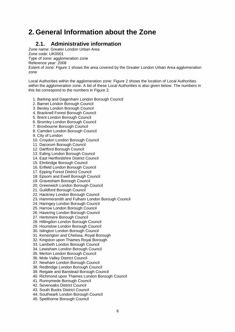
2.1. Administrative information Zone name: Greater London Urban Area Zone code: UK0001 Type of zone: agglomeration zone Reference year: 2008 Extent of zone: Figure 1 shows the area covered by the Greater London Urban Area agglomeration zone Local Authorities within the agglomeration zone: Figure 2 shows the location of Local Authorities within the agglomeration zone. A list of these Local Authorities is also given below. The numbers in this list correspond to the numbers in Figure 2. 1. Barking and Dagenham London Borough Council 2. Barnet London Borough Council 3. Bexley London Borough Council 4. Bracknell Forest Borough Council 5. Brent London Borough Council 6. Bromley London Borough Council 7. Broxbourne Borough Council 8. Camden London Borough Council 9. City of London 10. Croydon London Borough Council 11. Dacorum Borough Council 12. Dartford Borough Council 13. Ealing London Borough Council 14. East Hertfordshire District Council 15. Elmbridge Borough Council 16. Enfield London Borough Council 17. Epping Forest District Council 18. Epsom and Ewell Borough Council 19. Gravesham Borough Council 20. Greenwich London Borough Council 21. Guildford Borough Council 22. Hackney London Borough Council 23. Hammersmith and Fulham London Borough Council 24. Haringey London Borough Council 25. Harrow London Borough Council 26. Havering London Borough Council 27. Hertsmere Borough Council 28. Hillingdon London Borough Council 29. Hounslow London Borough Council 30. Islington London Borough Council 31. Kensington and Chelsea, Royal Borough 32. Kingston upon Thames Royal Borough 33. Lambeth London Borough Council 34. Lewisham London Borough Council 35. Merton London Borough Council 36. Mole Valley District Council 37. Newham London Borough Council 38. Redbridge London Borough Council 39. Reigate and Banstead Borough Council 40. Richmond upon Thames London Borough Council 41. Runnymede Borough Council 42. Sevenoaks District Council 43. South Bucks District Council 44. Southwark London Borough Council 45. Spelthorne Borough Council

7
46. St Albans District Council 47. Surrey Heath Borough Council 48. Sutton London Borough Council 49. Tandridge District Council 50. Three Rivers District Council 51. Tower Hamlets London Borough Council 52. Waltham Forest London Borough 53. Wandsworth Borough Council 54. Watford Borough Council 55. Westminster City Council 56. Windsor and Maidenhead Royal Borough Council 57. Woking Borough Council (Note: Local Authority boundaries do not necessarily coincide with zone boundaries. Hence Local Authorities may be listed within more than one zone plan.)
8
Figure 1. Map showing the extent of the Greater London Urban Area agglomeration zone (UK0001).
© Crown copyright. All rights reserved Defra, Licence number 100022861 [2011].
Figure 2. Map showing Local Authorities within the Greater London Urban Area agglomeration zone (UK0001).
© Crown copyright. All rights reserved Defra, Licence number 100022861 [2011].

9
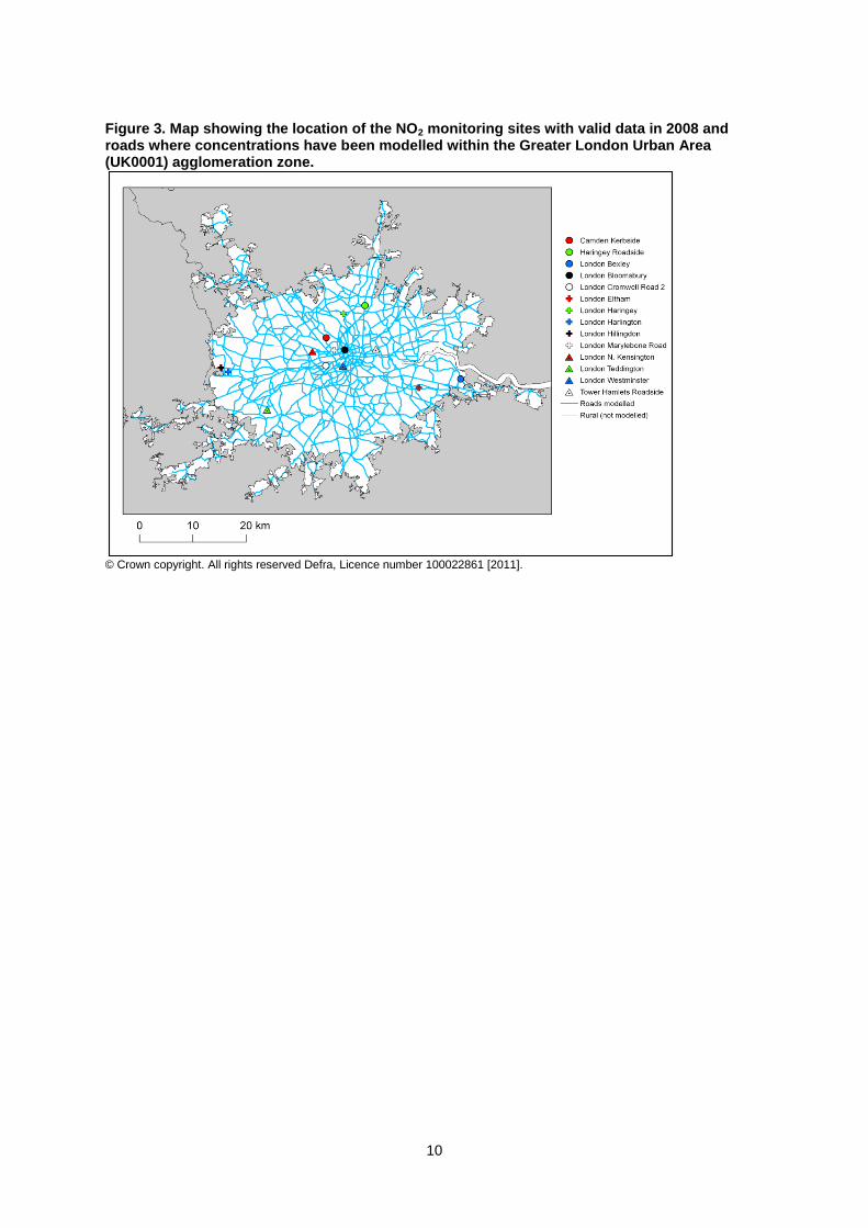
2.2. Assessment details Measurements NO2 measurements in this zone were available in 2008 from the following national network monitoring stations (NO2 data capture for each station in 2008 shown in brackets): • Camden Kerbside GB0636A (93.8%) • Haringey Roadside GB0637A (99.2%) • London Bexley GB0608A (97.5%) • London Bloomsbury GB0566A (99.2%) • London Cromwell Road 2 GB0695A (83.5%) • London Eltham GB0586A (95.7%) • London Haringey GB0638A (98.2%) • London Harlington GB0837A (97.7%) • London Hillingdon GB0642A (83.1%) • London Marylebone Road GB0682A (99%) • London N. Kensington GB0620A (89.8%) • London Teddington GB0644A (97%) • London Westminster GB0743A (98.1%) • Tower Hamlets Roadside GB0624A (97.6%) Full details of monitoring stations within the Greater London Urban Area agglomeration zone are available from http://uk-air.defra.gov.uk/networks/network-info?view=aurn. Modelling Modelling for the 2008 reference year has been carried out for the whole of the UK (see the UK technical report). This modelling covers the following extent within this zone: • Total background area within zone (approx): 1629 km
2
• Total population within zone (approx): 7787710 people • Total road length where an assessment of NO2 concentrations have been made: 1887.2 km in 2008 (and similar lengths in previous years). Zone maps Figure 3 presents the location of the NO2 monitoring stations within this zone for 2008 and the roads for which NO2 concentrations have been modelled. NO2 concentrations at background locations have been modelled across the entire zone at a 1 x 1 km
2 resolution.
2.3. Reporting Under European Directives Since 2001 the UK has reported annually on air quality concentrations using a standard excel questionnaire (Decision 2004/461/EC). These questionnaires are available online from http://cdr.eionet.europa.eu/gb/eu/annualair In addition, the UK has reported on air quality plans and programmes (Decision 2004/224/EC) on an annual basis depending on the reported concentrations in the previous year. Plans and programmes were first reported in this zone in 2003. Plans and programmes for 2003 and all other years for which they have been required are available from http://cdr.eionet.europa.eu/gb/eu/aqpp.
10
Figure 3. Map showing the location of the NO2 monitoring sites with valid data in 2008 and roads where concentrations have been modelled within the Greater London Urban Area (UK0001) agglomeration zone.
© Crown copyright. All rights reserved Defra, Licence number 100022861 [2011].
11
3. Overall Picture for 2008 reference year
3.1. Introduction There are two limit values for the protection of health for NO2. These are: • The annual limit value (annual mean concentration of no more than 40 µgm
-3)
• The hourly limit value (no more than 18 hourly exceedances of 200 µgm-3
in a calendar year) Within the Greater London Urban Area agglomeration zone there were exceedances of both these limit values in 2008. Three exceedance situations have been declared to cover these exceedances. These are: • NO2_UK0001_Annual_1, which covers exceedances of the annual limit value across London, excluding exceedances related to Heathrow Airport • NO2_UK0001_Annual_2, which covers exceedances of the annual limit value related to Heathrow Airport • NO2_UK0001_Hourly_1, which covers exceedances of the hourly limit value across London For both NO2 limit values, a margin of tolerance for 2008 and other years has been defined in the Air Quality Directive (2008/50/EC). Data comparing assessed concentrations at locations within this agglomeration zone with the 2008 margin of tolerance are presented in the annual reporting questionnaire for 2008 (http://cdr.eionet.europa.eu/gb/eu/annualair).
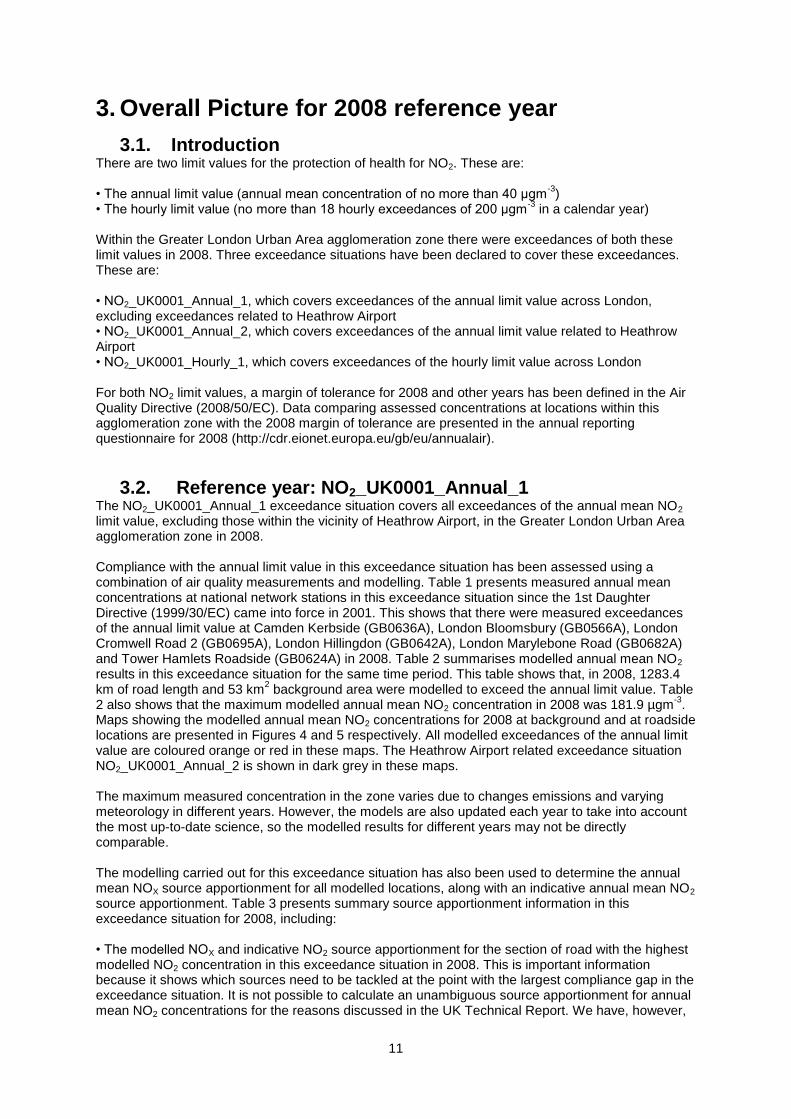
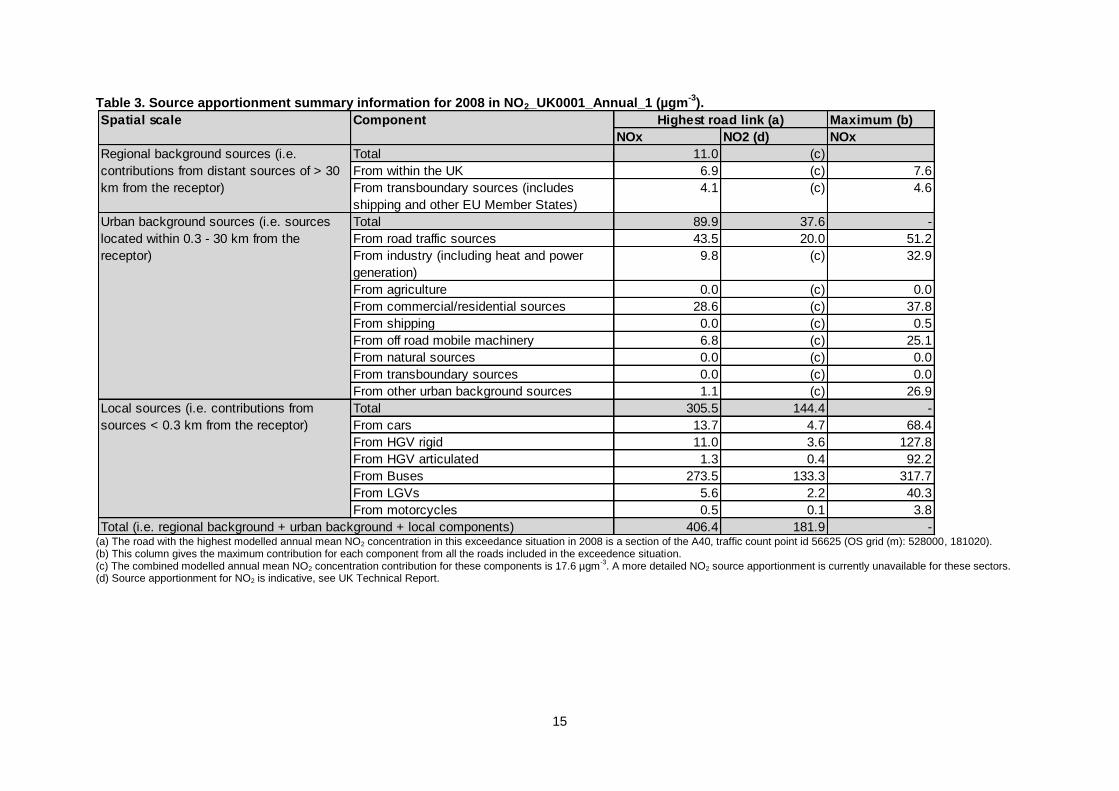
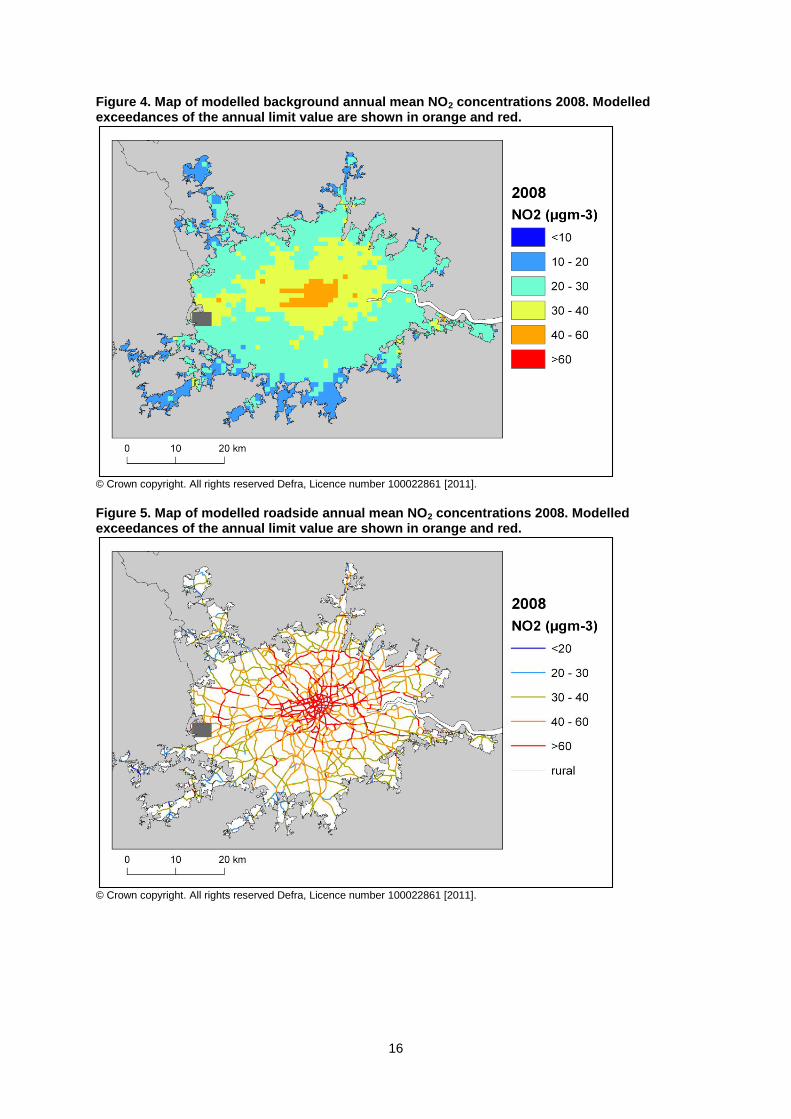
3.2. Reference year: NO2_UK0001_Annual_1 The NO2_UK0001_Annual_1 exceedance situation covers all exceedances of the annual mean NO2 limit value, excluding those within the vicinity of Heathrow Airport, in the Greater London Urban Area agglomeration zone in 2008. Compliance with the annual limit value in this exceedance situation has been assessed using a combination of air quality measurements and modelling. Table 1 presents measured annual mean concentrations at national network stations in this exceedance situation since the 1st Daughter Directive (1999/30/EC) came into force in 2001. This shows that there were measured exceedances of the annual limit value at Camden Kerbside (GB0636A), London Bloomsbury (GB0566A), London Cromwell Road 2 (GB0695A), London Hillingdon (GB0642A), London Marylebone Road (GB0682A) and Tower Hamlets Roadside (GB0624A) in 2008. Table 2 summarises modelled annual mean NO2 results in this exceedance situation for the same time period. This table shows that, in 2008, 1283.4 km of road length and 53 km
2 background area were modelled to exceed the annual limit value. Table
2 also shows that the maximum modelled annual mean NO2 concentration in 2008 was 181.9 µgm-3
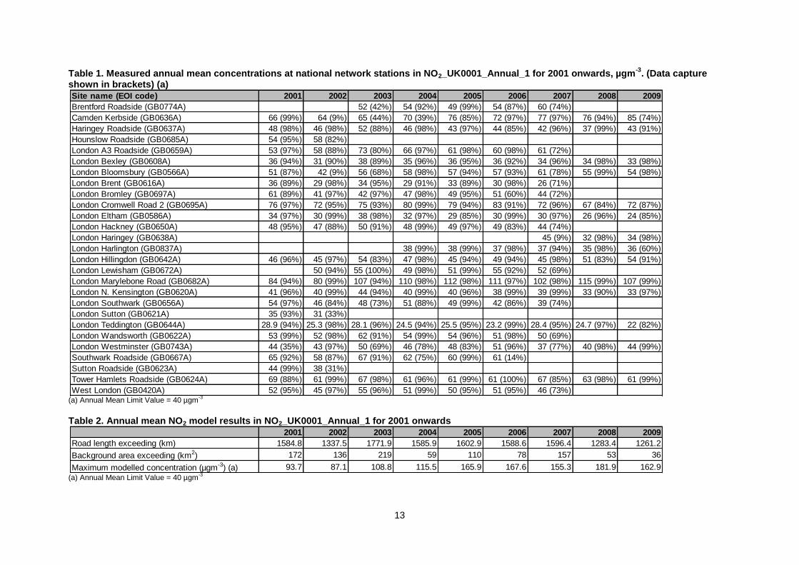
. Maps showing the modelled annual mean NO2 concentrations for 2008 at background and at roadside locations are presented in Figures 4 and 5 respectively. All modelled exceedances of the annual limit value are coloured orange or red in these maps. The Heathrow Airport related exceedance situation NO2_UK0001_Annual_2 is shown in dark grey in these maps. The maximum measured concentration in the zone varies due to changes emissions and varying meteorology in different years. However, the models are also updated each year to take into account the most up-to-date science, so the modelled results for different years may not be directly comparable. The modelling carried out for this exceedance situation has also been used to determine the annual mean NOX source apportionment for all modelled locations, along with an indicative annual mean NO2 source apportionment. Table 3 presents summary source apportionment information in this exceedance situation for 2008, including: • The modelled NOX and indicative NO2 source apportionment for the section of road with the highest modelled NO2 concentration in this exceedance situation in 2008. This is important information because it shows which sources need to be tackled at the point with the largest compliance gap in the exceedance situation. It is not possible to calculate an unambiguous source apportionment for annual mean NO2 concentrations for the reasons discussed in the UK Technical Report. We have, however,

12
developed a method to provide an indicative source apportionment for annual mean NO2 concentrations for these air quality plans. This method involves calculating the maximum and minimum possible contribution from each source to the NO2 concentration. The final source apportionment has been calculated as the average of the minimum and maximum contributions for each source, with the results normalised so that the contributions sum to the total modelled NO2 concentration. Further information on the methods used for source apportionment are provided in the UK Technical Report. • The maximum NOX contribution from each source from across all the roads included in this exceedance situation in 2008. This is important information because it highlights all the key sources that need to be tackled within the exceedance situation in order to achieve compliance across the entire area of the exceedance situation. Figure A1.1 in Annex 1 presents the annual mean NOX source apportionment for each section of road within the NO2_UK0001_Annual_1 exceedance situation (i.e. the source apportionment for all exceeding roads only) in 2008. Roads have been grouped into motorways, trunk roads and primary road in this figure.
13
Table 1. Measured annual mean concentrations at national network stations in NO2_UK0001_Annual_1 for 2001 onwards, µgm-3
. (Data capture shown in brackets) (a)
(a) Annual Mean Limit Value = 40 µgm
-3
Table 2. Annual mean NO2 model results in NO2_UK0001_Annual_1 for 2001 onwards
(a) Annual Mean Limit Value = 40 µgm
-3
Site name (EOI code) 2001 2002 2003 2004 2005 2006 2007 2008 2009
Brentford Roadside (GB0774A) 52 (42%) 54 (92%) 49 (99%) 54 (87%) 60 (74%)
Camden Kerbside (GB0636A) 66 (99%) 64 (9%) 65 (44%) 70 (39%) 76 (85%) 72 (97%) 77 (97%) 76 (94%) 85 (74%)
Haringey Roadside (GB0637A) 48 (98%) 46 (98%) 52 (88%) 46 (98%) 43 (97%) 44 (85%) 42 (96%) 37 (99%) 43 (91%)
Hounslow Roadside (GB0685A) 54 (95%) 58 (82%)
London A3 Roadside (GB0659A) 53 (97%) 58 (88%) 73 (80%) 66 (97%) 61 (98%) 60 (98%) 61 (72%)
London Bexley (GB0608A) 36 (94%) 31 (90%) 38 (89%) 35 (96%) 36 (95%) 36 (92%) 34 (96%) 34 (98%) 33 (98%)
London Bloomsbury (GB0566A) 51 (87%) 42 (9%) 56 (68%) 58 (98%) 57 (94%) 57 (93%) 61 (78%) 55 (99%) 54 (98%)
London Brent (GB0616A) 36 (89%) 29 (98%) 34 (95%) 29 (91%) 33 (89%) 30 (98%) 26 (71%)
London Bromley (GB0697A) 61 (89%) 41 (97%) 42 (97%) 47 (98%) 49 (95%) 51 (60%) 44 (72%)
London Cromwell Road 2 (GB0695A) 76 (97%) 72 (95%) 75 (93%) 80 (99%) 79 (94%) 83 (91%) 72 (96%) 67 (84%) 72 (87%)
London Eltham (GB0586A) 34 (97%) 30 (99%) 38 (98%) 32 (97%) 29 (85%) 30 (99%) 30 (97%) 26 (96%) 24 (85%)
London Hackney (GB0650A) 48 (95%) 47 (88%) 50 (91%) 48 (99%) 49 (97%) 49 (83%) 44 (74%)
London Haringey (GB0638A) 45 (9%) 32 (98%) 34 (98%)
London Harlington (GB0837A) 38 (99%) 38 (99%) 37 (98%) 37 (94%) 35 (98%) 36 (60%)
London Hillingdon (GB0642A) 46 (96%) 45 (97%) 54 (83%) 47 (98%) 45 (94%) 49 (94%) 45 (98%) 51 (83%) 54 (91%)
London Lewisham (GB0672A) 50 (94%) 55 (100%) 49 (98%) 51 (99%) 55 (92%) 52 (69%)
London Marylebone Road (GB0682A) 84 (94%) 80 (99%) 107 (94%) 110 (98%) 112 (98%) 111 (97%) 102 (98%) 115 (99%) 107 (99%)
London N. Kensington (GB0620A) 41 (96%) 40 (99%) 44 (94%) 40 (99%) 40 (96%) 38 (99%) 39 (99%) 33 (90%) 33 (97%)
London Southwark (GB0656A) 54 (97%) 46 (84%) 48 (73%) 51 (88%) 49 (99%) 42 (86%) 39 (74%)
London Sutton (GB0621A) 35 (93%) 31 (33%)
London Teddington (GB0644A) 28.9 (94%) 25.3 (98%) 28.1 (96%) 24.5 (94%) 25.5 (95%) 23.2 (99%) 28.4 (95%) 24.7 (97%) 22 (82%)
London Wandsworth (GB0622A) 53 (99%) 52 (98%) 62 (91%) 54 (99%) 54 (96%) 51 (98%) 50 (69%)
London Westminster (GB0743A) 44 (35%) 43 (97%) 50 (69%) 46 (78%) 48 (83%) 51 (96%) 37 (77%) 40 (98%) 44 (99%)
Southwark Roadside (GB0667A) 65 (92%) 58 (87%) 67 (91%) 62 (75%) 60 (99%) 61 (14%)
Sutton Roadside (GB0623A) 44 (99%) 38 (31%)
Tower Hamlets Roadside (GB0624A) 69 (88%) 61 (99%) 67 (98%) 61 (96%) 61 (99%) 61 (100%) 67 (85%) 63 (98%) 61 (99%)
West London (GB0420A) 52 (95%) 45 (97%) 55 (96%) 51 (99%) 50 (95%) 51 (95%) 46 (73%)
2001 2002 2003 2004 2005 2006 2007 2008 2009
Road length exceeding (km) 1584.8 1337.5 1771.9 1585.9 1602.9 1588.6 1596.4 1283.4 1261.2
Background area exceeding (km2) 172 136 219 59 110 78 157 53 36
Maximum modelled concentration (µgm-3) (a) 93.7 87.1 108.8 115.5 165.9 167.6 155.3 181.9 162.9

14
15
Table 3. Source apportionment summary information for 2008 in NO2_UK0001_Annual_1 (µgm-3
).
(a) The road with the highest modelled annual mean NO2 concentration in this exceedance situation in 2008 is a section of the A40, traffic count point id 56625 (OS grid (m): 528000, 181020). (b) This column gives the maximum contribution for each component from all the roads included in the exceedence situation. (c) The combined modelled annual mean NO2 concentration contribution for these components is 17.6 µgm
-3. A more detailed NO2 source apportionment is currently unavailable for these sectors.
(d) Source apportionment for NO2 is indicative, see UK Technical Report.
Maximum (b)
NOx NO2 (d) NOx
Total 11.0 (c)
From within the UK 6.9 (c) 7.6
From transboundary sources (includes
shipping and other EU Member States)
4.1 (c) 4.6
Total 89.9 37.6 -
From road traffic sources 43.5 20.0 51.2
From industry (including heat and power
generation)
9.8 (c) 32.9
From agriculture 0.0 (c) 0.0
From commercial/residential sources 28.6 (c) 37.8
From shipping 0.0 (c) 0.5
From off road mobile machinery 6.8 (c) 25.1
From natural sources 0.0 (c) 0.0
From transboundary sources 0.0 (c) 0.0
From other urban background sources 1.1 (c) 26.9
Total 305.5 144.4 -
From cars 13.7 4.7 68.4
From HGV rigid 11.0 3.6 127.8
From HGV articulated 1.3 0.4 92.2
From Buses 273.5 133.3 317.7
From LGVs 5.6 2.2 40.3
From motorcycles 0.5 0.1 3.8
406.4 181.9 -Total (i.e. regional background + urban background + local components)
Highest road link (a)
Regional background sources (i.e.
contributions from distant sources of > 30
km from the receptor)
Urban background sources (i.e. sources
located within 0.3 - 30 km from the
receptor)
Local sources (i.e. contributions from
sources < 0.3 km from the receptor)
Spatial scale Component
16
Figure 4. Map of modelled background annual mean NO2 concentrations 2008. Modelled exceedances of the annual limit value are shown in orange and red.
© Crown copyright. All rights reserved Defra, Licence number 100022861 [2011].
Figure 5. Map of modelled roadside annual mean NO2 concentrations 2008. Modelled exceedances of the annual limit value are shown in orange and red.
© Crown copyright. All rights reserved Defra, Licence number 100022861 [2011].
17
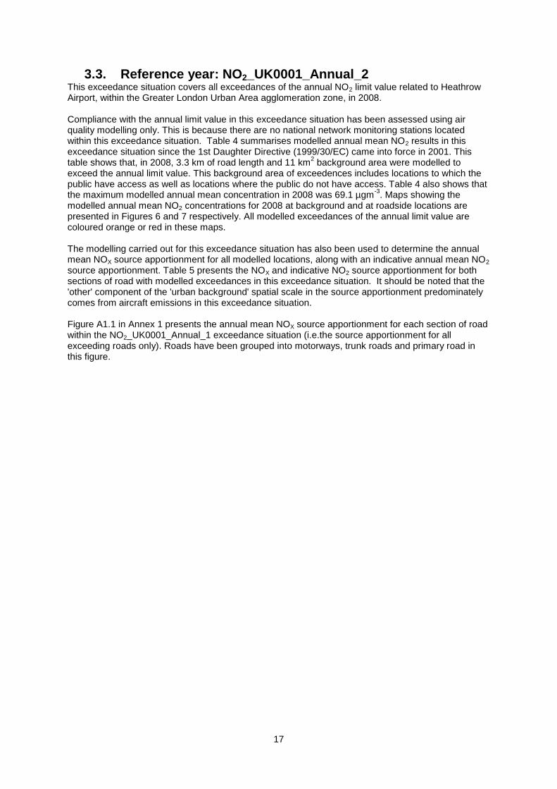
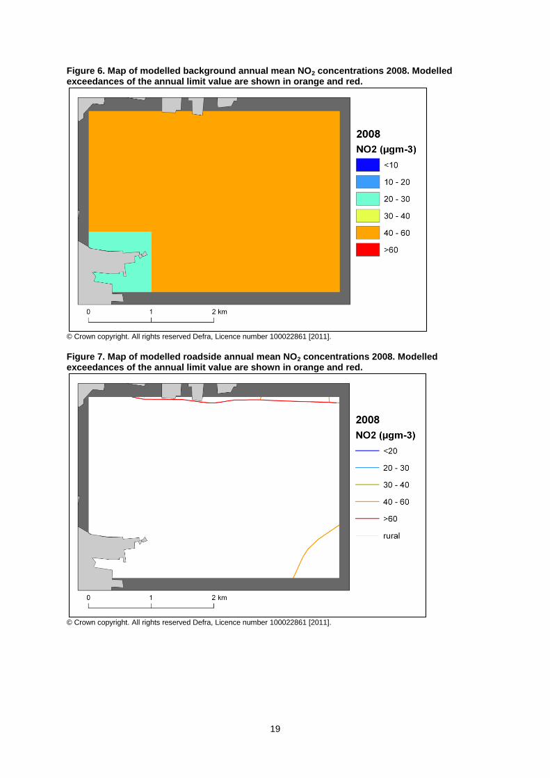
3.3. Reference year: NO2_UK0001_Annual_2 This exceedance situation covers all exceedances of the annual NO2 limit value related to Heathrow Airport, within the Greater London Urban Area agglomeration zone, in 2008. Compliance with the annual limit value in this exceedance situation has been assessed using air quality modelling only. This is because there are no national network monitoring stations located within this exceedance situation. Table 4 summarises modelled annual mean NO2 results in this exceedance situation since the 1st Daughter Directive (1999/30/EC) came into force in 2001. This table shows that, in 2008, 3.3 km of road length and 11 km
2 background area were modelled to
exceed the annual limit value. This background area of exceedences includes locations to which the public have access as well as locations where the public do not have access. Table 4 also shows that the maximum modelled annual mean concentration in 2008 was 69.1 µgm
-3. Maps showing the
modelled annual mean NO2 concentrations for 2008 at background and at roadside locations are presented in Figures 6 and 7 respectively. All modelled exceedances of the annual limit value are coloured orange or red in these maps. The modelling carried out for this exceedance situation has also been used to determine the annual mean NOX source apportionment for all modelled locations, along with an indicative annual mean NO2 source apportionment. Table 5 presents the NOX and indicative NO2 source apportionment for both sections of road with modelled exceedances in this exceedance situation. It should be noted that the 'other' component of the 'urban background' spatial scale in the source apportionment predominately comes from aircraft emissions in this exceedance situation. Figure A1.1 in Annex 1 presents the annual mean NOX source apportionment for each section of road within the NO2_UK0001_Annual_1 exceedance situation (i.e.the source apportionment for all exceeding roads only). Roads have been grouped into motorways, trunk roads and primary road in this figure.
18
Table 4. Annual mean NO2 model results in NO2_UK0001_Annual_2 for 2001 onwards
(a) Annual Mean Limit Value = 40 µgm
-3
(b)Model results are not available for 2001 and 2002 for this exceedance situation
Table 5. Source apportionment summary information for both roads with a modelled exceedance in 2008 (µgm
-3)
(a) OS grid (m): 508000, 176940. (b) OS grid (m): 506000, 176960. (c) The combined modelled annual mean NO2 concentration contribution for these components is 6.8 µgm
-3. A more detailed NO2 source apportionment is currently unavailable for these sectors.
(d) The combined modelled annual mean NO2 concentration contribution for these components is 7.1 µgm-3. A more detailed NO2 source apportionment is currently unavailable for these sectors.
(e) Source apportionment for NO2 is indicative, see UK Technical Report.
2001 2002 2003 2004 2005 2006 2007 2008 2009
Road length exceeding (km) (b) (b) 3.5 3.5 3.5 3.5 3.5 3.3 3.3
Background area exceeding (km2) (b) (b) 12 4 9 8 5 11 11
Maximum modelled concentration (µgm-3) (a) (b) (b) 66.7 54.0 66.3 65.2 57.5 69.1 66.5
NOx NO2 (c) NOx NO2 (e)
Total 10.2 (c) 10.2 (d)
From within the UK 6.0 (c) 6.0 (d)
From transboundary sources (includes
shipping and other EU Member States)
4.3 (c) 4.3 (d)
Total 95.9 40.4 92.7
From road traffic sources 15.2 33.6 15.9 32.5
From industry (including heat and power
generation)
1.9 (c) 1.6 (d)
From agriculture 0.0 (c) 0.0 (d)
From commercial/residential sources 5.0 (c) 3.8 (d)
From shipping 0.0 (c) 0.0 (d)
From off road mobile machinery 23.3 (c) 22.3 (d)
From natural sources 0.0 (c) 0.0 (d)
From transboundary sources 0.0 (c) 0.0 (d)
From other urban background sources 50.4 (c) 49.1 (d)
Total 63.6 28.7 54.6 24.4
From cars 21.1 8.8 19.5 8.1
From HGV rigid 10.6 4.6 9.3 4.0
From HGV articulated 2.8 1.2 5.6 2.4
From Buses 25.5 12.4 16.6 8.1
From LGVs 3.5 1.7 3.5 1.7
From motorcycles 0.1 0.1 0.1 0.0
Total (i.e. regional background + urban background + local components) 169.7 69.1 157.6 64.0
A4 (count point id 56114)(b)
Local sources (i.e. contributions from
sources < 0.3 km from the receptor)
Spatial scale Component A4 (count point id 16112)(a)
Regional background sources (i.e.
contributions from distant sources of > 30
km from the receptor)
Urban background sources (i.e. sources
located within 0.3 - 30 km from the
receptor)
19
Figure 6. Map of modelled background annual mean NO2 concentrations 2008. Modelled exceedances of the annual limit value are shown in orange and red.
© Crown copyright. All rights reserved Defra, Licence number 100022861 [2011].
Figure 7. Map of modelled roadside annual mean NO2 concentrations 2008. Modelled exceedances of the annual limit value are shown in orange and red.
© Crown copyright. All rights reserved Defra, Licence number 100022861 [2011].
20
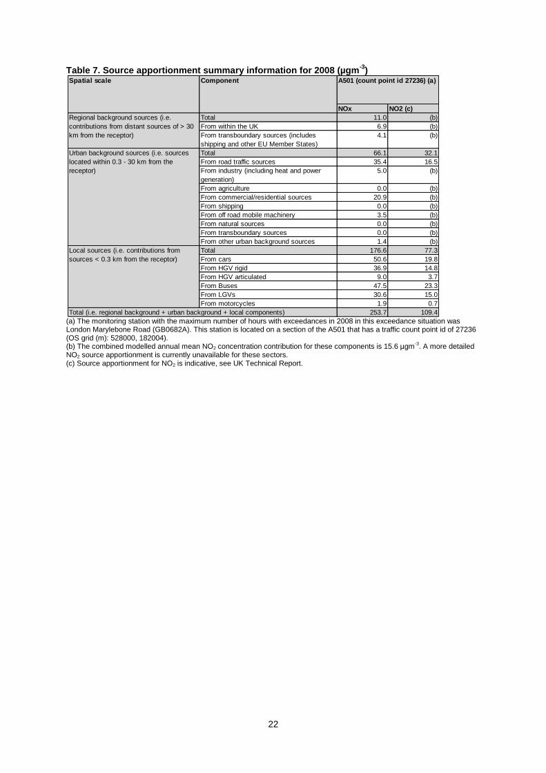
3.4. Reference year: NO2_UK0001_Hourly_1 This exceedance situation covers all exceedances of the hourly NO2 limit value in Greater London Urban Area agglomeration zone in 2008. Compliance with the hourly limit value in this exceedance situation has been assessed using air quality measurements only. Table 6 presents measured exceedance statistics at national network stations in this exceedance situation since the 1st Daughter Directive (1999/30/EC) came into force in 2001. This shows that there were measured exceedances of the hourly limit value in 2008 at Camden Kerbside (GB0636A) and London Marylebone Road (GB0682A). No modelling is available for the hourly limit value in the UK. However, the hourly limit value is generally less stringent than the annual limit value (AQEG, 2004). Hence, the geographical area where the hourly limit value is exceeded within this agglomeration zone is likely to be smaller than the area where the annual limit value is exceeded. Additionally, it is reasonable to assume that when compliance is achieved for the annual limit value, compliance with the hourly limit value will also have been achieved. Table 7 presents the modelled annual mean source apportionment for the road adjacent to the London Marylebone Road (GB0682A) monitoring station. This is the monitoring station with the highest measured number of hours exceeding the hourly limit value in this exceedance situation in 2008. The annual mean source apportionment is presented here because hourly source apportionment information is not available. In general, the annual mean source apportionment for this location is expected to provide a reasonable approximation of the sources contributing to the exceedance of the hourly limit value in the same location.

21
Table 6. The measured number of exceedances of the hourly limit value at national network sites in Greater London Urban Area for each calendar year from 2001 onwards. (Data capture shown in brackets) (a)
(a) Hourly Limit Value = No more than 18 hourly exceedances of 200 µgm
-3 in a calendar year
Site name (EOI code) 2001 2002 2003 2004 2005 2006 2007 2008 2009
Brentford Roadside (GB0774A) 0 (42%) 8 (92%) 3 (99%) 2 (87%) 7 (74%)
Camden Kerbside (GB0636A) 0 (99%) 0 (9%) 2 (44%) 6 (39%) 17 (85%) 40 (97%) 114 (97%) 72 (94%) 218 (74%)
Haringey Roadside (GB0637A) 0 (98%) 0 (98%) 0 (88%) 0 (98%) 1 (97%) 0 (85%) 21 (96%) 0 (99%) 0 (91%)
Hounslow Roadside (GB0685A) 0 (95%) 4 (82%)
London A3 Roadside (GB0659A) 0 (97%) 6 (88%) 16 (80%) 8 (97%) 23 (98%) 0 (98%) 13 (72%)
London Bexley (GB0608A) 0 (94%) 0 (90%) 0 (89%) 1 (96%) 0 (95%) 0 (92%) 0 (96%) 0 (98%) 0 (98%)
London Bloomsbury (GB0566A) 0 (87%) 0 (9%) 0 (68%) 0 (98%) 1 (94%) 0 (93%) 6 (78%) 0 (99%) 2 (98%)
London Brent (GB0616A) 0 (89%) 0 (98%) 3 (95%) 0 (91%) 0 (89%) 0 (98%) 0 (71%)
London Bromley (GB0697A) 0 (89%) 0 (97%) 0 (97%) 0 (98%) 1 (95%) 1 (60%) 2 (72%)
London Cromwell Road 2 (GB0695A) 2 (97%) 0 (95%) 6 (93%) 3 (99%) 9 (94%) 4 (91%) 2 (96%) 1 (84%) 3 (87%)
London Eltham (GB0586A) 0 (97%) 0 (99%) 0 (98%) 0 (97%) 0 (85%) 0 (99%) 0 (97%) 0 (96%) 0 (85%)
London Hackney (GB0650A) 0 (95%) 0 (88%) 5 (91%) 11 (99%) 15 (97%) 8 (83%) 3 (74%)
London Haringey (GB0638A) 3 (9%) 0 (98%) 4 (98%)
London Harlington (GB0837A) 0 (99%) 1 (99%) 2 (98%) 4 (94%) 0 (98%) 0 (60%)
London Hillingdon (GB0642A) 0 (96%) 0 (97%) 0 (83%) 0 (98%) 0 (94%) 0 (94%) 8 (98%) 1 (83%) 0 (91%)
London Lewisham (GB0672A) 0 (0%) 0 (94%) 1 (100%) 1 (98%) 3 (99%) 0 (92%) 7 (69%)
London Marylebone Road (GB0682A) 60 (94%) 2 (99%) 471 (94%) 542 (98%) 853 (98%) 686 (97%) 458 (98%) 822 (99%) 486 (99%)
London N. Kensington (GB0620A) 4 (96%) 0 (99%) 0 (94%) 0 (99%) 14 (96%) 0 (99%) 18 (99%) 0 (90%) 1 (97%)
London Southwark (GB0656A) 0 (97%) 0 (84%) 0 (73%) 0 (88%) 0 (99%) 0 (86%) 0 (74%)
London Sutton (GB0621A) 0 (93%) 0 (33%)
London Teddington (GB0644A) 0 (94%) 0 (98%) 0 (96%) 0 (94%) 0 (95%) 0 (99%) 0 (95%) 0 (97%) 0 (82%)
London Wandsworth (GB0622A) 0 (99%) 0 (98%) 8 (91%) 2 (99%) 10 (96%) 0 (98%) 0 (69%)
London Westminster (GB0743A) 0 (35%) 0 (97%) 0 (69%) 3 (78%) 0 (83%) 5 (96%) 0 (77%) 1 (98%) 0 (99%)
Southwark Roadside (GB0667A) 0 (92%) 0 (87%) 2 (91%) 0 (75%) 2 (99%) 0 (14%)
Sutton Roadside (GB0623A) 3 (99%) 0 (31%)
Tower Hamlets Roadside (GB0624A) 6 (88%) 2 (99%) 6 (98%) 3 (96%) 1 (99%) 7 (100%) 38 (85%) 0 (98%) 5 (99%)
West London (GB0420A) 0 (95%) 0 (97%) 0 (96%) 1 (99%) 1 (95%) 0 (95%) 0 (73%)
22
Table 7. Source apportionment summary information for 2008 (µgm-3
)
(a) The monitoring station with the maximum number of hours with exceedances in 2008 in this exceedance situation was London Marylebone Road (GB0682A). This station is located on a section of the A501 that has a traffic count point id of 27236 (OS grid (m): 528000, 182004). (b) The combined modelled annual mean NO2 concentration contribution for these components is 15.6 µgm
-3. A more detailed
NO2 source apportionment is currently unavailable for these sectors. (c) Source apportionment for NO2 is indicative, see UK Technical Report.
NOx NO2 (c)
Total 11.0 (b)
From within the UK 6.9 (b)
From transboundary sources (includes
shipping and other EU Member States)
4.1 (b)
Total 66.1 32.1
From road traffic sources 35.4 16.5
From industry (including heat and power
generation)
5.0 (b)
From agriculture 0.0 (b)
From commercial/residential sources 20.9 (b)
From shipping 0.0 (b)
From off road mobile machinery 3.5 (b)
From natural sources 0.0 (b)
From transboundary sources 0.0 (b)
From other urban background sources 1.4 (b)
Total 176.6 77.3
From cars 50.6 19.8
From HGV rigid 36.9 14.8
From HGV articulated 9.0 3.7
From Buses 47.5 23.3
From LGVs 30.6 15.0
From motorcycles 1.9 0.7
253.7 109.4Total (i.e. regional background + urban background + local components)
Local sources (i.e. contributions from
sources < 0.3 km from the receptor)
Spatial scale Component A501 (count point id 27236) (a)
Regional background sources (i.e.
contributions from distant sources of > 30
km from the receptor)
Urban background sources (i.e. sources
located within 0.3 - 30 km from the
receptor)
23
4. Measures
4.1. Introduction This section (section 4) gives details of measures that address exceedances of the NO2 limit values within Greater London Urban Area agglomeration zone. This includes both measures that have already been taken and measures for which there is a firm commitment that they will be taken. Section 5 then explains the extent to which it has been possible to incorporate the impacts of these measures into the baseline modelling carried out for this assessment.
4.2. Source apportionment It is important to understand which sources are responsible for causing the exceedance in order to most effectively tailor measures to address the NO2 exceedance situation(s) described in section 3 above. This can be achieved by considering the source apportionment for the exceedance situation, also presented in section 3. A summary of what the source apportionment shows and the implications for which measures would therefore be appropriate is given here. Local road traffic was the dominant source in exceedance situations NO2_UK0001_Annual_1 and NO2_UK0001_Hourly_1 in the reference year. The largest contribution was from buses at the location of maximum exceedance with a contribution of 273.5 ugm
-3 of NOX out of a total of 406.4 ugm
-3 of
NOX. All vehicle types were important sources on the motorway roads with the highest concentrations in this exceedance situation. Articulated HGVs, rigid HGVs, cars and on some roads buses were important sources on the trunk roads with the highest concentrations. Buses, rigid HGVs, cars and LGVs were important sources on the primary roads with the highest concentrations. This indicates that appropriate measures should impact on local road traffic sources in this zone. Other measures may also be beneficial depending on the source apportionment for the urban background. Airport related and local traffic sources were the dominant sources in exceedance situation NO2_UK0001_Annual_2. The largest contributions to total NOX were from aircraft (37%), off-road mobile machinery (14% and also associated with airport activities), buses (15%) and cars (12%).
4.3. Measures Measures potentially affecting NO2 in this agglomeration zone have been taken and/or are planned at a range of administrative levels. These are: • European Union • National (i.e. England, Scotland, Wales, Northern Ireland or whole UK) • Regional (i.e. Greater London Authority (GLA)) • Local (i.e. UK Local Authorities, airport measures) Details of European Union measures (e.g. euro standards, fuel quality directives, integrated pollution prevention and control) can be found on the European Commission‟s website (http://ec.europa.eu/environment/air/index_en.htm). Details of national measures are given in the UK overview document and list of UK and National measures. Regional measures taken by the GLA are described in section 4.5 below Local measures taken by Heathrow Airport Ltd (HAL) to reduce NO2 concentrations in and around Heathrow Airport as via its Air Quality Action Plan are described in section 4.6 below. Relevant Local Authority measures within this exceedance situation are listed in Table A2.1 (see Annex 2). Relevant Local Authority measures are considered to be those measures which directly target, or are in close geographical proximity to roads and/or background grid squares in exceedance of one or other of the NO2 limit values. Other Local Authority measures may also have been taken in
24
this zone, but they are not listed in this table. All the measures listed in Table A2.1 have been carried out, are in the process of being carried out or a firm commitment had been made to carry them out on the timetables listed at the point at which information on local measures was collected.
4.4. Measures timescales Timescales for national measures are given in the UK overview document and list of UK and National measures. The measures described within the Mayor‟s Air Quality Strategy for London are primarily forward looking and are focussed on action following the publication of the revised Strategy in 2010. Measures within the Heathrow Airport Ltd Air Quality Action Plan have been implemented before 2010 and further measures will be implemented after 2010. Information on local measures was collected in autumn 2009. Hence, any Local Authority action plans and measures adopted by Local Authorities after this time have not been included in this air quality plan. Many of the measures listed in Annex 2 will either have happened before autumn 2009 or have been planned for implementation before or during 2010. Others will be planned for after 2010. It should be noted that many of the measures taken before or during 2010 will continue to have a beneficial impact on air quality after the end of 2010. Local Authorities report on progress with the implementation of their action plans annually and review action plan measures regularly. Where future Local Authority measures to improve air quality are under consideration these would be included in future local authority action plans and published by the local authority.
25
4.5. Measures included in the Mayor's Air Quality Strategy This section provides information about the additional measures that have been taken to improve air quality in this agglomeration zone from the Mayor's Air Quality Strategy (MAQS). These measures are relevant to all of the exceedance situations in this zone. The Mayor of London has responsibility to prepare and publish the London Air Quality Strategy this must contain proposals and policies • for the implementation in Greater London of policies contained within the UK‟s Air Quality Strategy; • for the achievement in Greater London of the air quality standards and objectives prescribed in regulations under section 87(2)(a) and (b) of the Environment Act 1995; and may contain • such other proposals and policies relating to the improvement of air quality in Greater London as the Mayor considers appropriate. This plan summarises the content of the strategy and the most significant measures which will contribute to reductions in oxides of nitrogen and the attainment of the NO2 limit values. Some of these actions will take place at a London wide level others will be implemented by local authorities. Further information on all plans and measures can be found in the Mayor‟s Air Quality Strategy which is available at http://www.london.gov.uk/publication/mayors-air-quality-strategy. This is a new Air Quality Strategy for London, which replaces the previous Strategy which was published in 2002. Further information is on Local Authority measures is provided in Annex 2. Measures implemented prior to 2010 Low Emission Zone The Low Emission Zone (LEZ) is an area of environmental restriction covering 1580 square kilometres, operating 24 hours a day, every day of the year, which aims to cut harmful emissions to air by deterring the most polluting vehicles from driving in the area. There is a £200 daily charge for those that do not meet the required standard. It is the first scheme of its type in the UK and the largest LEZ in the world. The required emissions standard of the LEZ is currently the Euro III standard for particulate matter. However, since many operators have chosen to make their fleets compliant by buying newer vehicles, the LEZ has also resulted in reductions of NOX emissions. Two phases of the LEZ have so far been implemented: • LEZ Phase 1, Launched 4 Feb 2008, HGVs over 12 tonnes (including Goods Vehicles, Motor Caravans and Motorised Horseboxes), Euro III for PM • LEZ Phase 2, Launched 7 July 2008,Vehicles affected by the charge expanded to include HGVs of 3.5 – 12 tonnes & buses and coaches over 5 tonnes with nine or more seats, Euro III for PM Consistently high levels of vehicle compliance with the scheme are being achieved. Typically, 98 per cent of heavy goods vehicles and 96 per cent of medium goods vehicles are compliant on a daily basis. Operation of dirtier vehicles in the lower „Euro‟ emissions classes has therefore been virtually eliminated – bringing significant air quality benefits for London. These shifts in the emissions performance of heavier diesel vehicles in London have produced savings of over 500 tonnes of NOX per year. Promoting smarter travel There have been significant successes in moving people where possible from car use to public transport, which is lower emitting per passenger km. For example, Smarter Travel Sutton has used a range of initiatives, including personalised travel planning and work place and school travel plans which have resulted in roughly an 80 per cent increase locally in the rate of cycling in three years. More widely, TfL has promoted smarter travel choices across London through workplace and school travel plans. There have already been significant successes in this area. TfL promotes smarter travel choices across London through workplace and school travel plans. In addition, TfL is introducing a number of schemes to encourage motorists to leave their car at home and use more sustainable modes of transport. These include the introduction of a cycle hire scheme in central London, Cycle Superhighways, the biking boroughs scheme and 66,000 new cycle parking spaces.
26
Car clubs are becoming increasingly popular with over 100,000 members in London alone. Car clubs enable those who require occasional access to a car to have this on a pay-as-you-go basis without the need to own a vehicle. Thus members have an incentive to avoid non-essential car journeys. The Mayor, TfL and London boroughs have worked to promote car clubs through funding and by providing dedicated parking spaces. Since May 2008, the Mayor and TfL have invested more than £1million in the development of car clubs and London, with 100,000 car club members, accounts for 84 per cent of the UK's car clubs. Congestion Charging Although, as a policy, congestion charging does not directly target improving air quality, it has delivered reductions in NOX emissions from road traffic in and around central London. The beneficial impacts of the scheme occurred between 2002 and 2003. These were estimated at scheme-attributable reductions of 8 per cent to emissions of NOX from road vehicles in the central London zone. All other things being equal, these reductions will have persisted in the years after 2003, but would not show up as a year-on-year „step‟ change. However, although the traffic volume changes brought about by the scheme have been maintained, the decongestion benefits seen in 2003 have been progressively eroded. This means that the emissions reductions observed in 2003 will have correspondingly reduced in intensity over subsequent years. The Alternative Fuel Discount to the Congestion Charge, which was replaced in 2010 by the Greener Vehicle Discount, encouraged the use of low-emitting cars, offering a 100 per cent discount to electric, hybrid and LPG vehicles. The Greener Vehicle Discount currently offers a 100 percent discount to cars that emit 100g/km or less of carbon dioxide and that meet Euro 5 standard. Sustainable freight distribution TfL has developed a plan to promote sustainable freight distribution. This plan has two key aims: to reduce capacity used by road freight vehicles (particularly in peak hours); and, to improve the economic, environmental & social efficiencies of the remaining road freight vehicle movements. The Freight Operator Recognition Scheme (FORS) is the cornerstone of the Plan. It is designed to help increase road freight efficiency and increase opportunities for those companies to secure work by helping them to demonstrate their legal compliance (bronze) and through the use of best practice to reduce their costs, fines, collations, fuel use and therefore emissions (silver and gold), achieved by using on-line benchmarking. Benefits delivered by TfL, such as driver training, driver behaviour profiling and efficiency advice programmes, are designed to increase operator benchmark performance. This helps promote the uptake of low carbon vehicles. All organisations have contracts with businesses that have fleets or use companies that have fleets to make deliveries, collections or servicing trips to their premises. It is possible to use these contracts to make sure the fleets that are used embrace sustainable freight distribution. This is achieved using Delivery and Servicing Plans and Construction Logistics Plans, which are the equivalent of Travel Plans for freight. Bus emissions programme The London Bus fleet comprises over 8,000 vehicles. On average, 500 of the oldest buses in the fleet are replaced each year with the latest Euro standard vehicles available or diesel hybrid buses. New buses meet the latest Euro standards, ensuring reductions in NOX emissions from these vehicles. In October 2006 the Mayor announced a new programme to introduce hybrid and other low emission buses into London. Although the main objective of the programme is to reduce CO2 emissions, reductions in NOX emissions are also being achieved. Currently there are 112 hybrid buses in the fleet. Taxi emissions programme The fleet comprises 21,800 taxis and 42,200 private hire vehicles (PHV). TfL established a taxi emissions strategy in 2005 that required all licensed taxis to meet a minimum of Euro III emissions for NOX and PM by July 2008. Electric Vehicles
27
In May 2009, the Mayor launched the „Electric Vehicle Delivery Plan for London‟ to encourage the car industry to accelerate the delivery of new technology and to increase the level of support for drivers of electric cars in the capital. There are currently around 1,700 electric vehicles in London, and around 240 charge points. The current alternative fuel discount for the congestion charge and parking discounts in some London boroughs, provide an incentive for electric vehicle uptake. Around 1,000 electric cars are currently registered for the 100% discount on the congestion charge. Land Use Planning The London Plan (February 2008) set out the Spatial Development Strategy for London. Boroughs‟ development plan documents must be in „general conformity‟ with the Plan, hence it provides the London-wide context within which individual boroughs must set their local planning policies. The Plan also sets the policy framework for the Mayor‟s involvement in major planning decisions in London. Improving transport in a sustainable way is a key component of the London Plan. The Plan also promotes sustainable freight movement and distribution/servicing including promotion of the full range of road, rail and water-borne freight facilities in London and improved integration between the modes and between major rail interchanges and the centres they serve. At the local level, London Plan policy encourages boroughs to promote a pattern of development that reduces the need to travel, especially by car. The same broad transport principle is applied to major planning applications (referred to the Mayor). The London Plan is currently being revised. It will be consistent with the newly published Mayor‟s Air Quality Strategy. Planning Strategic planning applications in London, meeting a range of specific criteria, are required to be referred to the Mayor by the local planning authority concerned. These are assessed against various criteria, including air quality, and responses are then passed back to the local planning authority. Where appropriate, the Mayor can direct the local planning authority to refuse planning consent. The air quality aspects that planning applications are assessed against include: • Application of best practice guidance for construction and demolition; • Modelling of potentially polluting local energy generation (eg. large CHP), with mitigating measures proposed. • Proximity to sensitive receptors. • Modelling of emissions from transport sources associated with the development, with mitigating measures proposed. Measures to be taken after 2010 In December 2010, the Mayor published his revised Air Quality Strategy, which includes a number of further measures that will reduce emissions of NOX. Promoting smarter travel The Mayor will build on experience from earlier smarter travel schemes, working closely with schools and employers. There will be a focus on promoting walking and cycling, for example through better information for walking; promotional events; improved and more inviting public spaces; Barclays cycle superhighways; and event days to encourage cycling. By 2012 the Barclays cycle hire area will be extended beyond central London to include all of the Borough of Tower Hamlets as well as North Shoreditch in the Borough of Hackney. Altogether 2,000 more cycles and 4,200 extra docking points will be installed across the existing and new Barclays cycle hire area. Combined with improvements to public transport, this is expected to achieve long-term behavioural change resulting in a significant mode shift from private car use to more sustainable lower or zero-emission modes. As a result of measures in the Mayor‟s Transport Strategy, including improvements to public transport, it is estimated that private car use in London will reduce by six per cent by 2031. The measures to encourage cycling will increase cycling mode share from two to five per cent by 2026, reducing NOX emissions by 50 tonnes. Promoting eco-efficient driving TfL will implement emissions-efficient driver training for bus drivers and operators of GLA Group vehicles. TfL will also work with bus operators to promote best practice of monitoring driving performance and emissions, such as through new on board systems. Eco-efficient driving can
28
improve fuel efficiency by between five and ten per cent, with consequential reductions of air pollutant emissions. TfL will implement emissions-efficient driver training for bus drivers and operators of GLA Group vehicles. TfL will also work with bus operators to promote best practice of monitoring driving performance and emissions, such as through new on board systems. Eco-efficient driving can improve fuel efficiency by between five and ten per cent, with consequential reductions of air pollutant emissions. Smoothing traffic flow The Mayor‟s Transport Strategy sets out proposals to smooth traffic flow, which will reduce emissions resulting from stop/ start driving. This includes measures to maximise the efficient and reliable operation of the existing road network and to minimise the impact of planned interventions on the road network, including those that have the potential to disrupt traffic flows, such as roadworks, which are being addressed by the London Permit Scheme among other measures. This requires utility companies and other organisations that want to dig up London‟s busiest roads to apply for a permit before they begin work. This enables TfL to plan and coordinate the timing of roadworks. Reducing idling TfL will identify locations where vehicle idling is a problem and work with boroughs to raise awareness of the issue with drivers. The Mayor will establish a point of contact where members of the public can provide information about the problem. Information about idling will be provided during bus driver training and reinforced through contract management. The Mayor will also work with the taxi trade to reduce idling at taxi ranks, for example by changing the management of taxi ranks and by improving marshalling and fixed fare sharing. Efficient freight movements Through the Freight Operator Recognition Scheme (FORS) and Delivery and Servicing Plans (DSPs), TfL will further promote better route planning and the use of consolidation facilities. The GLA will also work with London Councils on reform of the London Lorry Control Scheme, to allow more freight to be moved in London at night, which would reduce congestion during daytime and consequently reduce emissions. Car clubs and car sharing The GLA will work with boroughs to provide additional dedicated parking spaces for car clubs, prioritising spaces for electric vehicles. TfL will look to use new media, including its Journey Planner website, to promote car sharing by developing mechanisms that link potential drivers and passengers. Spatial planning Through implementation of the policies and proposals of the London Plan, the Mayor will support a shift to public transport and walking and cycling through the planning of new developments. High trip-generating developments should be located in areas of high current or planned public transport accessibility, connectivity and capacity and all developments will be planned in a way to increase the attractiveness and potential mode share of walking and cycling. Encouraging electric vehicles In May 2009, the Mayor launched the „Electric Vehicle Delivery Plan for London‟. To support the uptake of electric vehicles including cars, vans, motorcycles and scooters, the Mayor is aiming to work with partners to deliver a network of at least 1,300 publicly accessible charge points located on streets, at supermarkets, in public car parks and transport hubs, and at retail and leisure facilities. The Mayor‟s aim is for no Londoner to be, on average, more than one mile from a publicly accessible charge point. TfL is also working with businesses and other organisations to install workplace charge points. In November 2010, the Mayor launched a one-stop website for electric vehicles (www.sourcelondon.net). In 2011, TfL will launch a new pan London scheme, Source London, to provide a single point of access to the public network of electric charging points. Electric vehicle drivers currently have to register in every borough they charge in. Source London will instead bring together the publicly accessible charge points in London into one network. Registered customers of
29
Source London will be able to use any of the publicly accessible charge points on the network, identified by the Source London brand. In February 2010 the Office for Low Emission Vehicles (OLEV) awarded a TfL-led public and private London consortium £9.3 million from the Plugged in Places (PiP) grant fund to deliver the charging infrastructure in the capital with at least 1,300 points installed on street, at stations, in supermarket car parks, and in workplaces by 2013. In addition, through the draft Replacement London Plan, the Mayor has proposed requirements for the provision of charge points in new developments, including a requirement for charge points or wiring for future charge point installation to be provided. One in five parking spaces in new residential developments will be fitted to allow for the installation of charge points. Reducing emissions from buses TfL plans to deliver 300 hybrid buses by the end of 2012, having benefited from two £5 million grants from the Government‟s Green Bus Fund. The pace of the roll-out of hybrid buses beyond 2012 will be dependent on funding being available and the rate at which vehicle production costs fall as volumes increase. TfL will work closely with bus operators and manufacturers to maximise the number of hybrids introduced after 2012. The New Bus for London will be hybrid. LT bus SCR Strategy Subject to funding, TfL expects that all buses will meet the Euro IV standard for NOX by 2015 in order to meet the proposed LEZ phase 5. This will involve the retrofitting of approximately 2,800 buses. In addition, the Mayor will continue exploring the potential of new technologies, such as hydrogen, which may deliver further emissions improvements and other benefits. Through the London Hydrogen Transport Plan, five hydrogen fuel cell hybrid buses will join the London buses fleet in 2010/11, and EU funding for a further three has been secured. These buses will emit nothing but water vapour from their exhausts. It is also expected that London‟s first hydrogen refuelling facility will be available from 2010. Reducing emissions from taxis and PHVs To further promote the use of newer, cleaner taxis, the Mayor will use the taxi and PHV licensing regime to remove the oldest vehicles from the fleet by introducing age limits for these vehicles. From 2012, a rolling 15 year age limit will be set for taxis so that no taxis over 15 years old could will be licensed to operate in London unless by a special exemption. For PHVs, a ten year rolling age limit will be introduced from 2012. This reflects the differential values of the vehicles used for private hire and taxis and the broader structures and licensing requirements of the two industries. In addition, all new taxis entering the fleet will be required to meet the Euro 5 emissions standard from 2012. Similarly, new PHVs entering the fleet from 2012 will be required to meet the Euro 4 standard and be five years old or newer. The Mayor will also amend the annual taxi inspection regime from its current form of one combined mechanical and licensing inspection to two MOTs per year, to ensure that taxis are operating as efficiently and cleanly as possible. This will be complemented by a requirement for all new taxi drivers to undertake an eco-driving course before becoming licensed drivers, which can reduce emissions and help drivers use their vehicles more economically, at no cost to themselves. Any changes to the taxi licensing regime will be consulted on with the industry. The Mayor believes that London‟s famous taxi trade can and should lead the world in moving towards a zero emission future. He will work with the trade and manufacturers to create a viable road map to this end. The taxi must be affordable for drivers and enhance the passenger experience. The aim is to produce a taxi with a 60 per cent improvement in fuel economy by 2015 (based on current levels) and capable of zero tail pipe emission operation by 2020. The introduction of such vehicles will deliver significant air quality benefits. There are a variety of promising propulsion and power technologies which could see hybrid, plug-in electric, full-electric and fuel cell taxis on London‟s roads in the future. The Mayor will establish a financial incentive scheme that will offer a reduction on the purchase prices of qualifying vehicles to London‟s taxi drivers. The scheme will be available to drivers for a limited time and for a pre-defined number of new vehicles meeting strict environmental requirements. Details of the scheme, its associated environmental criteria and terms and conditions will be announced in 2011. In addition, the GLA is working with partners to deliver 20 fuel cell taxis on London‟s streets by

30
2012. The Mayor will also work with the vehicle manufacturing industry to develop zero emitting vehicles that are suitable as PHVs by 2020. Measures to reduce emissions from taxis and PHVs will reduce NOX emissions by around 300 tonnes in 2015. Using the planning system to reduce emissions For developments that require an air quality assessment, both at strategic and local planning level, the Mayor encourages boroughs to require emissions assessments for new developments to be carried out alongside concentration modelling and included within submitted planning applications. For some sources, such as construction work, it may not be possible to make detailed estimates of emissions, but an outline risk assessment would in many cases still be useful. The GLA will work with boroughs and London Councils to develop a checklist of emissions sources that should be included in assessments, under the following categories: • Construction stage (including associated traffic); • On-site (eg. Water and space heating systems); and • Off-site (eg. transport-related). The checklist will be published on the GLA website to enable developers to carry out air quality assessments and boroughs to analyse and evaluate assessments. Such assessment of emissions will enable boroughs to identify where emissions reductions targets can be achieved. It would also be used in conjunction with concentration modelling to show whether new developments could exacerbate local poor air quality and to identify offsetting mitigation opportunities if necessary, as discussed in National guidance Planning Policy Statement 23 (PPS23). Biomass boilers and CHP The Mayor is committed to reducing London‟s carbon emissions and has set a target of generating 25 per cent of London‟s energy from decentralised sources by 2025. The primary opportunity in London is for heat networks fed by low to zero carbon technologies such as combined heat and power (CHP) systems at a range of sizes. A mix of energy sources can feed these systems, primarily mains gas, waste derived fuels and biomass. Biomass can also be used in individual boilers to provide a renewable source of heat. While these technologies will play a key role in reducing London‟s carbon emissions, consideration also needs to be given to their impact on air quality. The GLA will apply emissions limits for both PM and NOX for new biomass boilers and CHP systems across London. These emission limits will be regularly reviewed as new evidence becomes available and abatement technology improves. This will be applicable at a strategic and local level. The GLA will also require an emissions assessment to be included as part of the standard air quality assessment that is submitted at the planning application stage for new developments that include biomass boilers or CHP. Energy efficient buildings Most buildings in London use gas heating systems. While gas is a relatively clean fuel and improvements have been made in recent years to make heating systems more efficient, gas burning is still responsible for considerable emissions of NOX. The Mayor is committed to driving down London‟s CO2 emissions by 60 per cent of 1990 levels by 2025 through measures included in his draft Climate Change Mitigation and Energy Strategy. Using energy more efficiently is a crucial component of delivering this. Better energy efficiency will result in less gas use and consequently a reduction in emissions of NOX. The GLA will deliver RE:NEW, a pan-London programme to retrofit residential properties to improve energy and water efficiency. The GLA will also implement the RE:FIT programme to improve energy efficiency in public sector buildings. These schemes are expected to reduce NOX emissions in 2015 by 1,270 tonnes. The impact of measures taken after 2010 on NOX emissions in 2015 in London NOX emissions in Greater London are projected to fall from 56,000 tonnes in 2008 to 45,000 tonnes in 2011 and 36,000 tonnes in 2015 as a result of the quantified measures in the Mayor‟s Strategy and natural fleet turnover. This amounts to a reduction in NOX emissions across London of 35 per cent by 2015 (compared to levels in 2008). This reduction will be achieved by implementation of the range of
31
measures included in the Mayor‟s Strategy, as well as by measures already being undertaken and natural fleet turnover. • The proposed LEZ Phase 5 (Euro IV NOX standard for HGVs, buses and coaches) contributes about 280 tonnes to the overall reduction in HGV related emissions of NOX. • Fitting SCR abatement equipment to pre Euro IV buses will reduce NOX emissions by around 800 tonnes and the introduction of hybrid and lower emission buses (including the new bus for London) will reduce NOX emissions by around 180 tonnes in 2015. The introduction of a NOX standard to the LEZ in 2015 would reduce NOX emissions from coaches by over 100 tonnes. • The introduction of LEZ Phase 3 for heavier vans and minibuses will reduce NOX emissions from these vehicles by about 50 tonnes in 2015. The London Freight Plan will reduce LGV emissions of NOX in 2015 by about 80 tonnes. • Reductions in emissions of NOX due to the proposed age limit for private hire vehicles amount to 50 tonnes in 2015. • The reduction in taxi-related NOX emissions through age based limits is estimated to be 40 tonnes in 2015 with further reductions due to reductions in idling estimated at about 30 tonnes in 2015. Further reductions would be expected from the development of a taxi capable of zero tail pipe emissions by 2020 (it is not yet possible to estimate the impact of this proposal). • Measures to promote electric cars are estimated to reduce NOX emission in 2015 by about 25 tonnes. • Measures to promote eco-driving are estimated to reduce NOX emission in 2015 by about 110 tonnes across all vehicle types. • Significant reductions in NOX emissions are also expected from non-transport sources. Energy efficiency programmes will save 1,270 tonnes of NOX in 2015. The measures to be taken by the Mayor will result in a significant step forward in reducing NOX emissions within London, resulting in lower concentrations of NO2 and health benefits for all Londoners. The GLA‟s modelling, however, shows that even with affirmative action by the Mayor, areas of inner London and around Heathrow would exceed NO2 limit values and are at risk of continuing to exceed those limit values in 2015. Nevertheless, the Mayor considers that measures that he will implement, combined with those that he expects others, including the Government, to implement, will achieve the objectives of the National Air Quality Strategy and relevant EU limit values in Greater London.
32
4.6. Measures included in Heathrow Airport's Air Quality Action Plan
This section provides information about the additional measures that have been taken by Heathrow Airport Ltd (HAL) via its Air Quality Action Plan to improve air quality in the vicinity of Heathrow Airport. Quantitative information on the impact of these measures on emissions has been included where available. It has not been possible to quantify the impact on the Heathrow specific measures on ambient air quality for this plan. These measures are relevant to the NO2_UK0001_Annual_2 exceedance situation only. Current action to reduce the impact of Heathrow Airport Heathrow Airport Ltd has published an Air Quality Action Plan 2007 – 2011. This contains a number of actions to reduce emissions associated with the airport and is available at: www.heathrowairport.com. Heathrow published an Emissions Inventory in 2008/9 and this has been used to estimate the impact of the additional measures taken on emissions from the major sources listed below. Local_Heathrow_D1. Aircraft: NOX emission landing charges In April 2011 HAL increased the proportion of landing charges related to noise and air quality at Heathrow. Although charges are aimed primarily at discouraging noisier aircraft, NOX charges, based on the mass of NOX emitted, will be increased from £2.73 per kg to £5.18, helping to discourage aircraft with higher NOX emissions. HAL is committed to further reviews to ensure reducing NOX emissions remains a major focus of HAL‟s landing charges. Local_Heathrow_A1. Aircraft: Restricting APU (auxiliary power unit) use Since 2002, APU emissions were cut by approximately 40 tonnes to 346 tonnes in 2008/9 through the greater provision and use of FEGP (fixed electrical ground power) and PCA (pre-conditioned air), even though there were 3,500 more movements at the end of this period. HAL is working with airlines to maximise the use of FEGP and, where fitted, PCA to help meet tighter APU timing allowances, which were introduced at the beginning of January 2011. Local_Heathrow_A2. Aircraft: Reducing Taxiing emissions The main improvement to on-airport emissions is brought about from the opening of Terminal 5 enabling more efficient aircraft movements on the airport. Average taxi times were reduced by between 20 and 30% - cutting NOX emissions by approximately 75 tonnes, down to a total of 345 tonnes. HAL will develop a best practice guide for ground operations and departures in 2011 to optimise the operational performance of departing aircraft. Local_Heathrow_C1. Airside vehicles: HAL fuelling arrangements Over the last 10 years, the tax-exempt diesel available from HAL‟s fuel contractor has been the same grade as that available at public filling stations; principally in order to reduce emission of particulate matter. Approximately 700 airside vehicles are battery-electric models – one of the largest electric fleets in the UK. Local_Heathrow_A3. Airside vehicles: CVP (Clean Vehicle Programme) incentive scheme Forty eight airport companies are members of the CVP. The Programme is open to all airport fleet operators, but the biggest fleet owners are encouraged to join the scheme. Of the 7,500 vehicles registered to operate airside, approximately 5,000 are covered by the Partnership. Since 2008, CVP members have been encouraged to complete a vehicle self assessment to enable calculation of CO2 and NOX emissions. It is still being developed, but emissions reductions of 18 tonnes were calculated between 2007 and 2008. An assessment of 2010 will take place in spring 2011. Local_Heathrow_G3. Landside vehicles: Reducing emissions from airport-related landside vehicles Many projects have been implemented which help reduce emissions. There is a strong link to Heathrow‟s Surface Access Strategy 2007 - 2012 (available at: www.heathrow.com); which concentrates on shifting passenger and staff mode share towards using public transport. Approximately 40% of passengers use public transport to travel to and from the airport, which includes the tube as well as Heathrow Express and Heathrow Connect rail services. HAL subsidises
33
Transport for London to provide free bus travel into the airport from the local area – the biggest free travel zone in Europe. Local_Heathrow_E1. Landside vehicles: Consolidation centres Heathrow operates three consolidation centres, which are used to security screen goods before they enter the airport, improve the efficiency of airport operations and help reduce the number of commercial vehicles on local roads. These three consolidation centres cover the majority of „goods‟ received at the airport: retail goods, construction materials, aircraft food etc. Some work has been done to quantify the impact of the main consolidation centre: In 2009, it is has been calculated to save approximately 17,000 trips by a variety of vans and lorries, potentially saving 0.5 tonnes of NOX. Local_Heathrow_A4. Landside vehicles: Heathrow bus contracts On-airport coaching is provided for the transfer of passengers and airport staff around the airport campus and airside; between terminals. The functions include coaching for; staff and public car parks, inter-terminal operation and off-pier aircraft (for passengers whose aircraft are at stands remote from a terminal). In 2008, HAL consolidated all existing contracted coach services into fewer companies. The tendering exercise completed in 2009 and acts as a model for other contracts that operate on the airport – both BAA‟s and those operated by other airport users. It is thought to have reduced NOX emissions from these services by approximately 17 tonnes to 15 tonnes - a reduction in the region of 50%. Local_Heathrow_A5. Landside vehicles: Plugged in Places HAL is a member of Transport for London‟s Plugged in Places consortium and has installed eight publicly accessible charging points for electric vehicles. Although emissions reductions are likely to be extremely small in the early stages, the policy will help increase the use of electric vehicels landside and produce long-term benefits. HAL will assess the outcomes of this initial trial before deciding whether more charging points should be installed. Local_Heathrow_A6. Fixed boiler plant: Replacing existing boiler plant with new, more efficient equipment There has been a move from a large number of small, oil-fired boiler plants to fewer large gas-fired CHP (combined heat and power) installations with additional gas boilers. Work will continue to 2015 to re-engineer Heathrow‟s electrical and heat supply, together with measures to improve the energy efficiency of airport buildings. Future action to reduce the impact of Heathrow Airport The draft Heathrow Air Quality Strategy 2011 – 2020 sets out the measures and approach that HAL will take to reduce emissions from the airport. It follows on from two successive Air Quality Action Plans and implements recommendations from a number of studies and initiatives. The results from the Emissions Inventory 2008/09 and associated dispersion model have been used to direct where to focus cost-effective reductions to NOX emissions and local NO2 concentrations. During the life of the new Strategy, HAL will benchmark its approach to air quality management with other comparable airports. The following section gives an indication of HAL‟s focus. HAL expect to publish the new Strategy in autumn 2011. HAL take a logical, systematic approach to reducing air quality emissions which is balanced with the other needs of the airport - i.e. actions to reduce noise and CO2. The draft Strategy has the following four objectives, which are currently under review: • To limit and where possible reduce airport related emissions to help ensure that EU limit values are met in the Heathrow area; • To accurately quantify the contribution from airport related sources to local air quality concentrations at all relevant local receptors in order to focus management activity in areas with the most significant impacts • To continually improve its approach to managing its air quality impacts by actively supporting new technology, benchmarking its approach with other airports and participating in research projects, and; • To actively engage with internal and external stakeholders in order to develop shared objectives and a common understanding of air quality in the Heathrow area.
34
HAL believe the draft Strategy gives a rounded approach to help improve local air quality. The following information will concentrate on actions to reduce on-airport emissions. Where actions have an impact on emissions, the expected reductions are listed as: • low <20 T/yr • medium = 20 - 50 T/yr • high >50 T/yr HAL will also benchmark actions taken at HAL with other comparable airports in 2011 – the results of which will be used to review actions taken at Heathrow. To limit and, where possible, reduce airport related emissions to help ensure that EU limit values are met in the Heathrow area The draft Strategy addresses HAL‟s air quality management responsibilities. It is based on the main areas identified in the 2008/09 Heathrow Emissions Inventory and focuses on the four main emissions sources: aircraft, airport-related road traffic, airside vehicles and plant and fixed boiler plant. In 2011 HAL will conduct a quantification study to forecast emissions in 2015 and 2020 in order to understand the impact this Strategy is likely to make. HAL will use the outputs of the 2015 and 2020 forecasts to review the actions HAL will take to reduce emissions of NOX. The level of control HAL has can be divided into three areas. These are: • Control - over vehicles and equipment and services HAL owns or leases directly • Guide - over aircraft ground movements, aircraft fleet and airside vehicles • Influence - passenger travel to and from the airport and aircraft fleet mix It should be noted that emissions over which HAL have control are relatively small when compared to the emissions inherent in the makeup of the aircraft fleet mix and their time-in-mode emissions. A new consortium was launched in September 2010 – the Heathrow Sustainability Partnership. Currently comprising 16 of the biggest airport companies, it is charged with reducing the environmental impact of the airport and will help reduce emissions from the sources HAL guides and influences. Two of the four topic groups deal with vehicles operated on airport and for travel to and from it and additional actions to reduce emissions of NOX from these sources are being developed. More details can be found on; www.heathrowairthought.com. Local_Heathrow_D1. Aircraft: NOX emission landing charges HAL charges airlines for each aircraft that lands at the airport and part of these charges are aimed at reducing aircraft noise and NOX emissions. HAL will review the charges annually, with the aim of increasing the proportion of environmental charges. HAL‟s quantification study will inform the impacts to NOX emissions, but its aim is to use landing charges to reduce the number of flights made by the older portion of the aircraft fleet (pre-CAEP4) to reduce from the current level of 10% to 5% by 2015
and zero by 2020. This measure is expected to achieve a “high‟ reduction in NOX emissions, and
HAL‟s quantification study will better inform the predicted impact from changing the makeup of new aircraft fleets in future years. Local_Heathrow_A1. Aircraft: Restricting APU (auxiliary power unit) use HAL has a rule on the airport (Operating Safety Instruction) that gives maximum timings for airlines to use APUs. In 2011, these times were reduced by 30% for short-haul and by 50% for long-haul aircraft. HAL also has plans to review these APU use allowance times in 2015 to seek further emissions reduction. HAL Expects to achieve a „medium‟ reduction in NOX emissions, and it‟s quantification study will better inform the predicted impact of tightening the new APU allowance timings. Local_Heathrow_A2. Aircraft: Reducing Taxiing emissions The opening of Terminal 5 has helped bring about more efficient aircraft movements on the airport, because there is less congestion on the airport. A new Terminal 2 is expected to help reduce average taxi times even further and HAL have plans to work with NATS next year to define what scale of reductions to expect. This is expected to achieve a „high‟ reduction in NOX emissions, HAL‟s quantification study will better inform the predicted impact of reducing aircraft taxi times. Local_Heathrow_A6. Aircraft: Removal of the Cranford Agreement In September 2010, the Minister of State for Transport (Theresa Villers) re-affirmed the earlier decision in a statement to the House of Commons made by Geoff Hoon, stating “we support the
35
objective (of fairer distribution of noise around Heathrow) and do not intend to re-open the decision”. HAL is now looking to implement works to bring an end to the Cranford agreement. Ending the agreement will not affect aircraft NOX (and PM) emissions, but will alter the mix of departures and arrivals during easterly operations. The principal effect is to move NOX emissions from southern to northern runway and PM emissions from northern to southern runway. There may be some minor adverse impacts to local air quality and HAL is investigating quantifying mitigation procedures to limit any local air quality (and ground noise) impacts. Local_Heathrow_A7. Airside vehicles: Reducing emissions from the airside fleets Over the next 10 years, the development of low and zero emission vehicle fuels and technologies is likely to provide a range of choices to reduce NOX (and CO2). It isn‟t clear at this stage which will be most appropriate to use in airside vehicles and a number of trials will need to be conducted to assess the most cost-effective approach. It is likely that a mix of technologies and fuels will be needed due to the niche applications that exist on a major airport such as Heathrow. HAL will work with Heathrow Sustainability Partnership members to help implement actions to reduce NOX emissions from the airside fleets, including behavioural changes and new vehicle technologies (e.g. electric, hybrids, biofuels and hydrogen). Expected to achieve a „high‟ reduction in NOX emissions, HAL‟s feasibility study will better inform some of the predicted impact of using new vehicle technologies, fuels and operational practices in airside vehicles. Local_Heathrow_A8. Landside vehicles: Reducing emissions from airport-related landside fleets Specific actions will be developed in 2011 and, when the new Heathrow Transport Model has been produced, quantified in terms of emissions reductions and the impact on local air quality. HAL will work with Sustainability Partnership members to reduce emissions from the airport-related landside fleets and develop air quality objectives from HAL‟s Surface Access Strategy to help develop the most sustainable transport infrastructure and further reduce car journeys made by passengers and staff. One specific measure is HAL‟s support of the London/Copenhagen Hytec Project bid to bring 15 hydrogen taxis to the London by 2012. It is envisaged a principal route for these vehicles could be from Heathrow to central London. Local_Heathrow_A6. Fixed boiler plant: Reducing emissions from fixed boiler plant Two older gas-fired boiler plant will be decommissioned by 2014/15 and replaced with a syn-gas fired combined heat and power (CHP) plant; the syn-gas being generated from a wood chip gasifier. The balance of the heating demand will be provided by natural gas/gasoil boilers. The new plant will increase energy efficiency as well as generate more on-site electricity. The impact to airport NOX emissions was calculated using the 2002 inventory (study was carried out in 2007), and a decrease of approximately 45 tonnes was expected (from a 2002 base of 121.3 tonnes). Expected to achieve a „high‟ reduction in NOX emissions, HALs‟ quantification study will better inform the predicted impact of changing the nature of its fixed boiler plant. Access to a good quality, robust database is critical to HAL‟s ability to assess airport-related emissions on a year-on-year basis and their impact on local air quality. The availability of new sources of data may require a subsequent change to HALs‟ emission inventory methodology and HAL will seek to develop these two separate, but mutually dependent work streams in a coordinated way. Building on the 2008/09 Heathrow Emissions Inventory, HAL will commission an annual inventory update, to assess the impact of actual key activity data - primarily air traffic movements (ATMs) from the previous year for the whole of the landing and take-off cycle (LTO) . HAL will use the output to track annual changes to emissions and better assess the impact of operational changes on the airport brought about via implementation of its new Strategy, by airline operational changes or from other national and international agreements. In addition by using its FAST tool, HAL will estimate the impact these changes to emissions had to local air quality on an annual basis and estimate the new area of exceedence in the Heathrow Study Area (an 81km
2 zone around the airport) which includes the Great
Western main rail line, and the M4 and M25 motorways. Every five years HAL will commission a new inventory and dispersion model of Heathrow Airport and the surrounding area as well as the production of a new FAST tool to re-estimate the area of exceedence on an annual basis. Underlying changes to airport operations will be captured to produce a new 'base' for annual emission inventory updates. In addition, if major changes occur on the airport

36
and are thought to significantly impact on NOX emissions, HAL will conduct a full inventory and dispersion modelling as soon as practicable.
37
5. Baseline Model Projections
5.1. Overview of model projections Baseline projections for 2010 Model projections for 2010, starting from the 2008 reference year described in section 3, have been calculated in order to determine whether compliance with the NO2 limit values is likely to be achieved for each exceedance situation by the original deadline for compliance of 01/01/2010. Details of the methods used for the baseline emissions and concentration projections modelling are provided in the the UK technical report. For national measures, it has not been possible to quantify the impact of all measures on emissions and ambient concentrations. The impact for all quantifiable measures has been included in the baseline projections. The impacts of the individual Local Authority measures have not been explicitly included in the baseline model projections. However, measures may have been included implicitly if they have influenced the traffic counts for 2007 (used as a basis for the compilation of the emission inventory) or in the traffic activity projections to 2010 and beyond (used to calculate the emission projections). It should be recognised that these measures will have a beneficial impact on air quality, even if it has not been possible to quantify this impact here. A number of the local measures in Table A2.1 can be considered to be 'smarter choices' measures (see http://www.dft.gov.uk/pgr/sustainable/smarterchoices/ctwwt/ for a detailed description of this type of measure). We have quantified the impact of this group of measures on a national scale within the projections. Details of how this has been done can be found in the UK technical report. Table A2.1 indicates which local measures we have considered to be 'smarter choices'. A list of which London specific measures have been included in the baseline is provided in the UK technical report. It has not been possible to quantify the impact on the Heathrow specific measures on ambient air quality for this plan. Baseline projections for 2015 Model projections for 2015, starting from the 2008 reference year described above, have been calculated in order to determine whether compliance with the NO2 limit values is likely to be achieved for each exceedance situation by the revised deadline for compliance of 01/01/2015 on the basis of EU-wide measures and the measures currently planned. This modelling is described in detail in the UK technical report. Many of the measures listed in annex 2 of this document and the supporting list of UK and national measures will continue or will continue to have an impact beyond the original deadline for compliance of 01/01/2010. A List of which London specific measures have been included in the baseline is provided in the supporting technical report. It has not been possible to quantify the impact on the Heathrow specific measures on ambient air quality for this plan.
5.2. Baseline projections: NO2_UK0001_Annual_1 Table 8 presents summary results for the baseline model projections for 2010, 2015 and 2020 for the NO2_UK0001_Annual_1 exceedance situation. This shows that the maximum modelled annual mean NO2 concentration predicted for 2010 in this exceedance situation is 164.5 µgm
-3. By 2015, the
maximum modelled annual mean NO2 concentration is predicted to drop to 114.8 µgm-3
. Hence, the model results suggest that compliance with the NO2 annual limit value is unlikely to be achieved by 2015 under baseline conditions in this exceedance situation. The projected modelled NOX and indicative NO2 annual mean source apportionments for 2010, 2015 and 2020 at the location with the biggest compliance gap in 2008 are presented in Table 9. The model results suggest that this location will continue to have the highest annual mean NO2
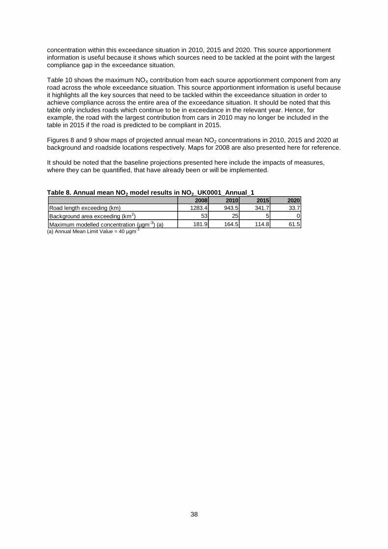
38
concentration within this exceedance situation in 2010, 2015 and 2020. This source apportionment information is useful because it shows which sources need to be tackled at the point with the largest compliance gap in the exceedance situation. Table 10 shows the maximum NOX contribution from each source apportionment component from any road across the whole exceedance situation. This source apportionment information is useful because it highlights all the key sources that need to be tackled within the exceedance situation in order to achieve compliance across the entire area of the exceedance situation. It should be noted that this table only includes roads which continue to be in exceedance in the relevant year. Hence, for example, the road with the largest contribution from cars in 2010 may no longer be included in the table in 2015 if the road is predicted to be compliant in 2015. Figures 8 and 9 show maps of projected annual mean NO2 concentrations in 2010, 2015 and 2020 at background and roadside locations respectively. Maps for 2008 are also presented here for reference. It should be noted that the baseline projections presented here include the impacts of measures, where they can be quantified, that have already been or will be implemented. Table 8. Annual mean NO2 model results in NO2_UK0001_Annual_1
(a) Annual Mean Limit Value = 40 µgm
-3
2008 2010 2015 2020
Road length exceeding (km) 1283.4 943.5 341.7 33.7
Background area exceeding (km2) 53 25 5 0
Maximum modelled concentration (µgm-3) (a) 181.9 164.5 114.8 61.5
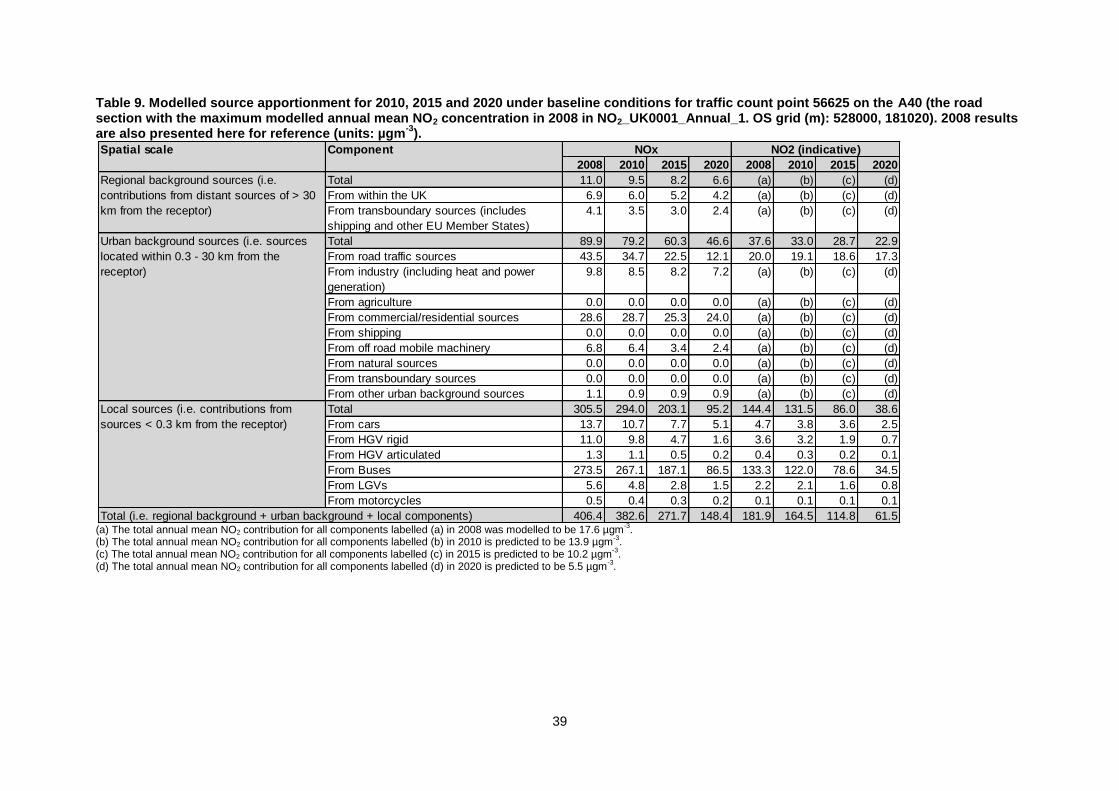
39
Table 9. Modelled source apportionment for 2010, 2015 and 2020 under baseline conditions for traffic count point 56625 on the A40 (the road section with the maximum modelled annual mean NO2 concentration in 2008 in NO2_UK0001_Annual_1. OS grid (m): 528000, 181020). 2008 results are also presented here for reference (units: µgm
-3).
(a) The total annual mean NO2 contribution for all components labelled (a) in 2008 was modelled to be 17.6 µgm
-3.
(b) The total annual mean NO2 contribution for all components labelled (b) in 2010 is predicted to be 13.9 µgm-3.
(c) The total annual mean NO2 contribution for all components labelled (c) in 2015 is predicted to be 10.2 µgm-3.
(d) The total annual mean NO2 contribution for all components labelled (d) in 2020 is predicted to be 5.5 µgm-3.
Spatial scale Component
2008 2010 2015 2020 2008 2010 2015 2020
Total 11.0 9.5 8.2 6.6 (a) (b) (c) (d)
From within the UK 6.9 6.0 5.2 4.2 (a) (b) (c) (d)
From transboundary sources (includes
shipping and other EU Member States)
4.1 3.5 3.0 2.4 (a) (b) (c) (d)
Total 89.9 79.2 60.3 46.6 37.6 33.0 28.7 22.9
From road traffic sources 43.5 34.7 22.5 12.1 20.0 19.1 18.6 17.3
From industry (including heat and power
generation)
9.8 8.5 8.2 7.2 (a) (b) (c) (d)
From agriculture 0.0 0.0 0.0 0.0 (a) (b) (c) (d)
From commercial/residential sources 28.6 28.7 25.3 24.0 (a) (b) (c) (d)
From shipping 0.0 0.0 0.0 0.0 (a) (b) (c) (d)
From off road mobile machinery 6.8 6.4 3.4 2.4 (a) (b) (c) (d)
From natural sources 0.0 0.0 0.0 0.0 (a) (b) (c) (d)
From transboundary sources 0.0 0.0 0.0 0.0 (a) (b) (c) (d)
From other urban background sources 1.1 0.9 0.9 0.9 (a) (b) (c) (d)
Total 305.5 294.0 203.1 95.2 144.4 131.5 86.0 38.6
From cars 13.7 10.7 7.7 5.1 4.7 3.8 3.6 2.5
From HGV rigid 11.0 9.8 4.7 1.6 3.6 3.2 1.9 0.7
From HGV articulated 1.3 1.1 0.5 0.2 0.4 0.3 0.2 0.1
From Buses 273.5 267.1 187.1 86.5 133.3 122.0 78.6 34.5
From LGVs 5.6 4.8 2.8 1.5 2.2 2.1 1.6 0.8
From motorcycles 0.5 0.4 0.3 0.2 0.1 0.1 0.1 0.1
406.4 382.6 271.7 148.4 181.9 164.5 114.8 61.5
NOx NO2 (indicative)
Regional background sources (i.e.
contributions from distant sources of > 30
km from the receptor)
Urban background sources (i.e. sources
located within 0.3 - 30 km from the
receptor)
Local sources (i.e. contributions from
sources < 0.3 km from the receptor)
Total (i.e. regional background + urban background + local components)
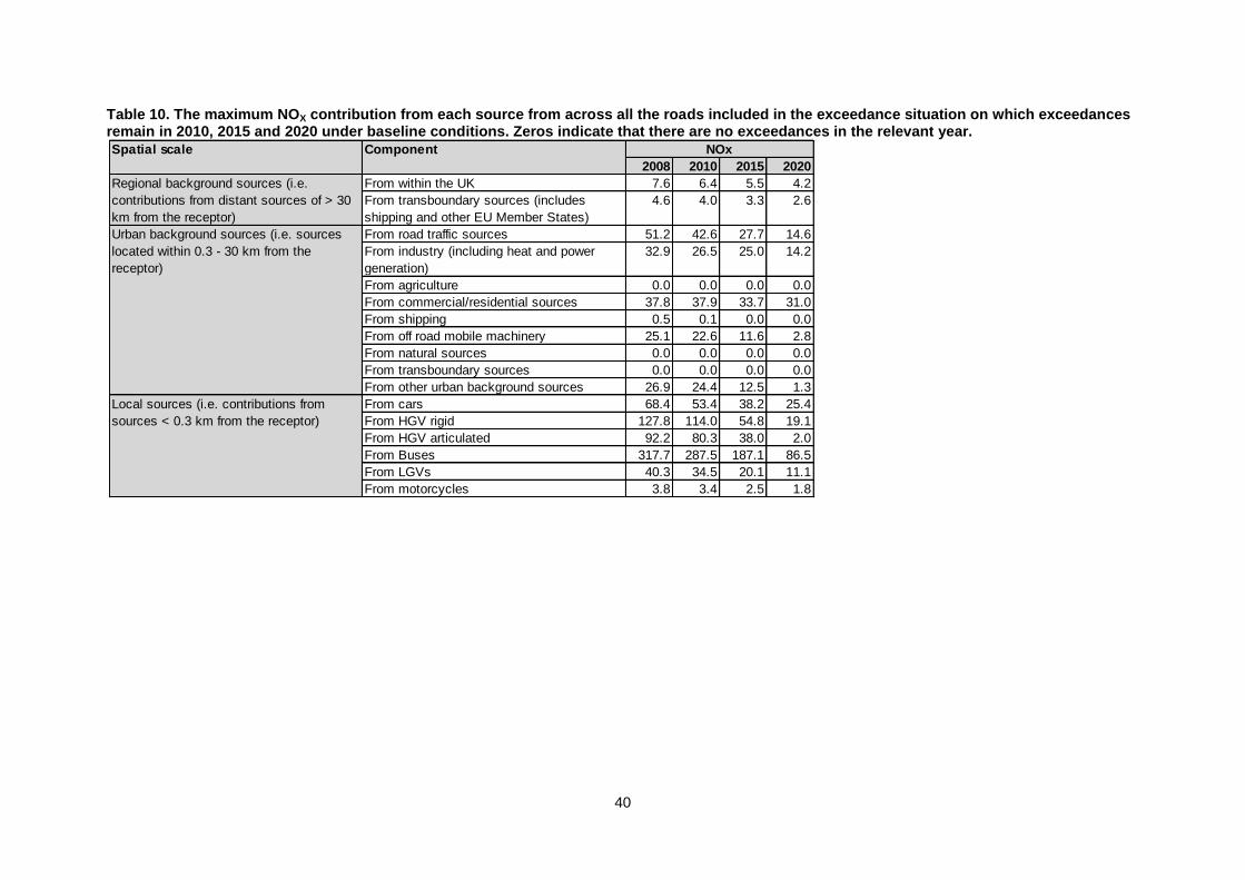
40
Table 10. The maximum NOX contribution from each source from across all the roads included in the exceedance situation on which exceedances remain in 2010, 2015 and 2020 under baseline conditions. Zeros indicate that there are no exceedances in the relevant year.
Spatial scale Component
2008 2010 2015 2020
From within the UK 7.6 6.4 5.5 4.2
From transboundary sources (includes
shipping and other EU Member States)
4.6 4.0 3.3 2.6
From road traffic sources 51.2 42.6 27.7 14.6
From industry (including heat and power
generation)
32.9 26.5 25.0 14.2
From agriculture 0.0 0.0 0.0 0.0
From commercial/residential sources 37.8 37.9 33.7 31.0
From shipping 0.5 0.1 0.0 0.0
From off road mobile machinery 25.1 22.6 11.6 2.8
From natural sources 0.0 0.0 0.0 0.0
From transboundary sources 0.0 0.0 0.0 0.0
From other urban background sources 26.9 24.4 12.5 1.3
From cars 68.4 53.4 38.2 25.4
From HGV rigid 127.8 114.0 54.8 19.1
From HGV articulated 92.2 80.3 38.0 2.0
From Buses 317.7 287.5 187.1 86.5
From LGVs 40.3 34.5 20.1 11.1
From motorcycles 3.8 3.4 2.5 1.8
Regional background sources (i.e.
contributions from distant sources of > 30
km from the receptor)
Urban background sources (i.e. sources
located within 0.3 - 30 km from the
receptor)
Local sources (i.e. contributions from
sources < 0.3 km from the receptor)
NOx
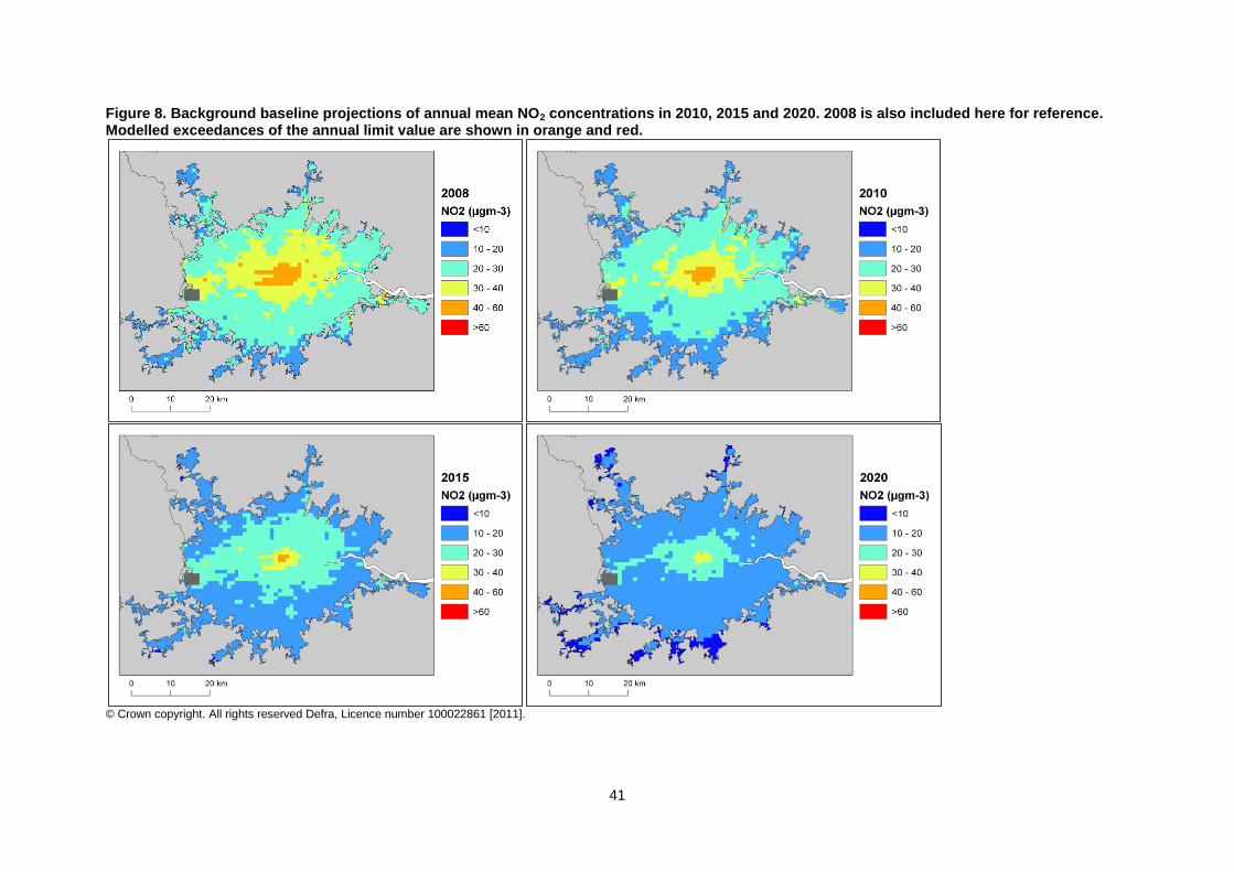
41
Figure 8. Background baseline projections of annual mean NO2 concentrations in 2010, 2015 and 2020. 2008 is also included here for reference. Modelled exceedances of the annual limit value are shown in orange and red.
© Crown copyright. All rights reserved Defra, Licence number 100022861 [2011].
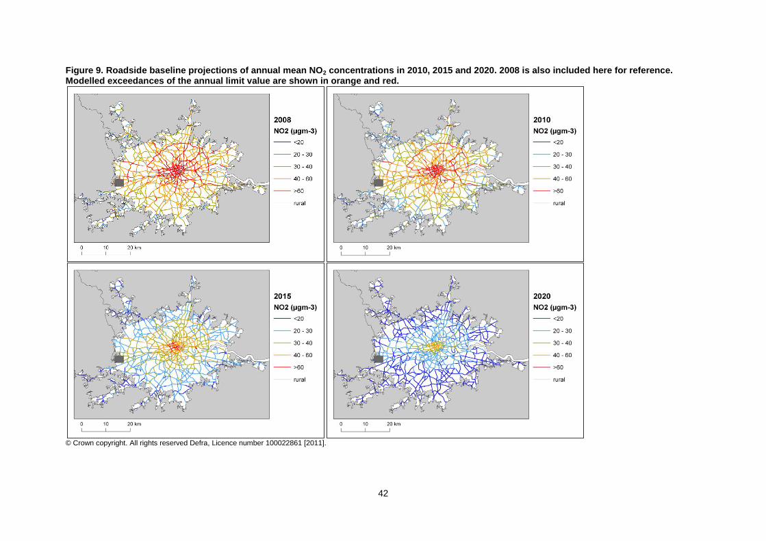
42
Figure 9. Roadside baseline projections of annual mean NO2 concentrations in 2010, 2015 and 2020. 2008 is also included here for reference. Modelled exceedances of the annual limit value are shown in orange and red.
© Crown copyright. All rights reserved Defra, Licence number 100022861 [2011].
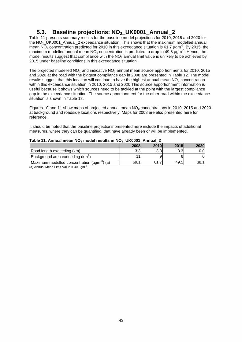
43
5.3. Baseline projections: NO2_UK0001_Annual_2 Table 11 presents summary results for the baseline model projections for 2010, 2015 and 2020 for the NO2_UK0001_Annual_2 exceedance situation. This shows that the maximum modelled annual mean NO2 concentration predicted for 2010 in this exceedance situation is 61.7 µgm
-3. By 2015, the
maximum modelled annual mean NO2 concentration is predicted to drop to 49.5 µgm-3
. Hence, the model results suggest that compliance with the NO2 annual limit value is unlikely to be achieved by 2015 under baseline conditions in this exceedance situation. The projected modelled NOX and indicative NO2 annual mean source apportionments for 2010, 2015 and 2020 at the road with the biggest compliance gap in 2008 are presented in Table 12. The model results suggest that this location will continue to have the highest annual mean NO2 concentration within this exceedance situation in 2010, 2015 and 2020.This source apportionment information is useful because it shows which sources need to be tackled at the point with the largest compliance gap in the exceedance situation. The source apportionment for the other road within the exceedance situation is shown in Table 13. Figures 10 and 11 show maps of projected annual mean NO2 concentrations in 2010, 2015 and 2020 at background and roadside locations respectively. Maps for 2008 are also presented here for reference. It should be noted that the baseline projections presented here include the impacts of additional measures, where they can be quantified, that have already been or will be implemented. Table 11. Annual mean NO2 model results in NO2_UK0001_Annual_2
(a) Annual Mean Limit Value = 40 µgm
-3
2008 2010 2015 2020
Road length exceeding (km) 3.3 3.3 3.3 0.0
Background area exceeding (km2) 11 9 6 0
Maximum modelled concentration (µgm-3) (a) 69.1 61.7 49.5 38.1
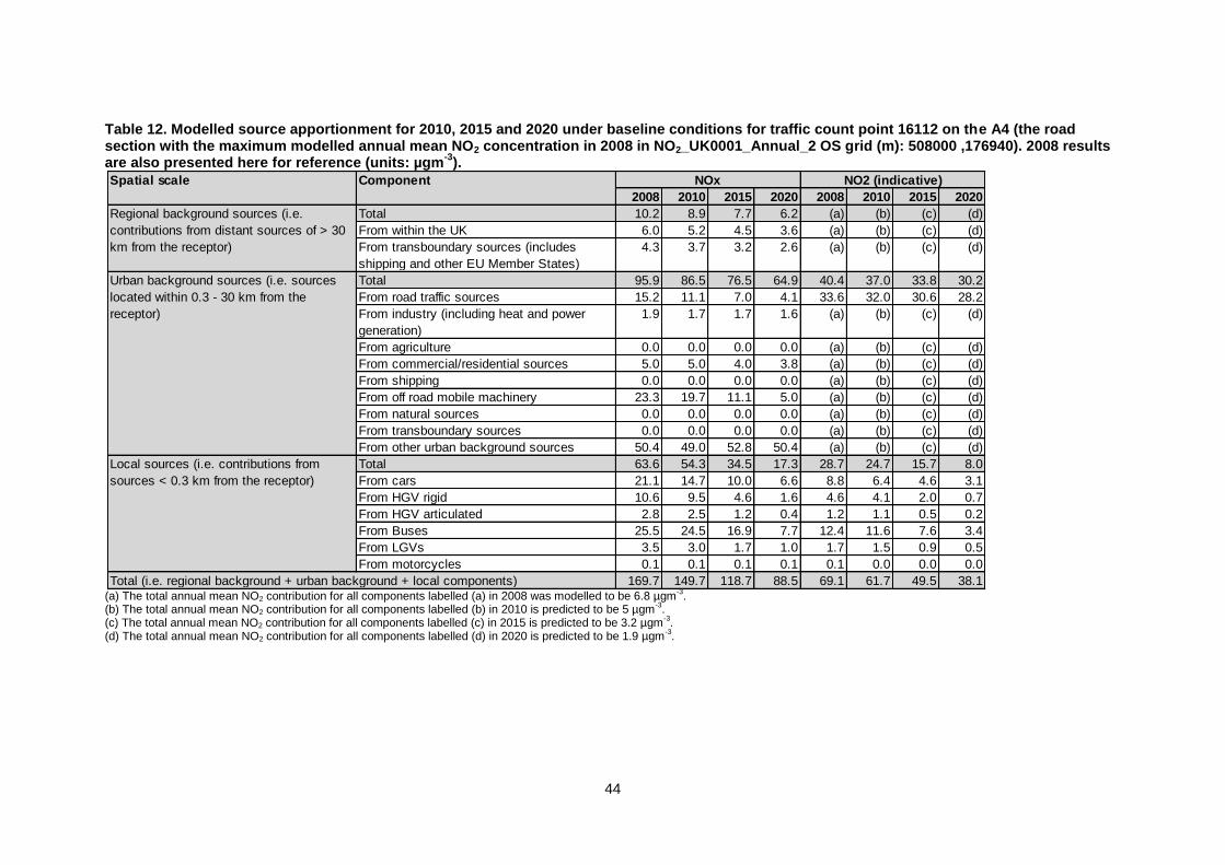
44
Table 12. Modelled source apportionment for 2010, 2015 and 2020 under baseline conditions for traffic count point 16112 on the A4 (the road section with the maximum modelled annual mean NO2 concentration in 2008 in NO2_UK0001_Annual_2 OS grid (m): 508000 ,176940). 2008 results are also presented here for reference (units: µgm
-3).
(a) The total annual mean NO2 contribution for all components labelled (a) in 2008 was modelled to be 6.8 µgm
-3.
(b) The total annual mean NO2 contribution for all components labelled (b) in 2010 is predicted to be 5 µgm-3.
(c) The total annual mean NO2 contribution for all components labelled (c) in 2015 is predicted to be 3.2 µgm-3.
(d) The total annual mean NO2 contribution for all components labelled (d) in 2020 is predicted to be 1.9 µgm-3.
Spatial scale Component
2008 2010 2015 2020 2008 2010 2015 2020
Total 10.2 8.9 7.7 6.2 (a) (b) (c) (d)
From within the UK 6.0 5.2 4.5 3.6 (a) (b) (c) (d)
From transboundary sources (includes
shipping and other EU Member States)
4.3 3.7 3.2 2.6 (a) (b) (c) (d)
Total 95.9 86.5 76.5 64.9 40.4 37.0 33.8 30.2
From road traffic sources 15.2 11.1 7.0 4.1 33.6 32.0 30.6 28.2
From industry (including heat and power
generation)
1.9 1.7 1.7 1.6 (a) (b) (c) (d)
From agriculture 0.0 0.0 0.0 0.0 (a) (b) (c) (d)
From commercial/residential sources 5.0 5.0 4.0 3.8 (a) (b) (c) (d)
From shipping 0.0 0.0 0.0 0.0 (a) (b) (c) (d)
From off road mobile machinery 23.3 19.7 11.1 5.0 (a) (b) (c) (d)
From natural sources 0.0 0.0 0.0 0.0 (a) (b) (c) (d)
From transboundary sources 0.0 0.0 0.0 0.0 (a) (b) (c) (d)
From other urban background sources 50.4 49.0 52.8 50.4 (a) (b) (c) (d)
Total 63.6 54.3 34.5 17.3 28.7 24.7 15.7 8.0
From cars 21.1 14.7 10.0 6.6 8.8 6.4 4.6 3.1
From HGV rigid 10.6 9.5 4.6 1.6 4.6 4.1 2.0 0.7
From HGV articulated 2.8 2.5 1.2 0.4 1.2 1.1 0.5 0.2
From Buses 25.5 24.5 16.9 7.7 12.4 11.6 7.6 3.4
From LGVs 3.5 3.0 1.7 1.0 1.7 1.5 0.9 0.5
From motorcycles 0.1 0.1 0.1 0.1 0.1 0.0 0.0 0.0
169.7 149.7 118.7 88.5 69.1 61.7 49.5 38.1Total (i.e. regional background + urban background + local components)
NOx NO2 (indicative)
Regional background sources (i.e.
contributions from distant sources of > 30
km from the receptor)
Urban background sources (i.e. sources
located within 0.3 - 30 km from the
receptor)
Local sources (i.e. contributions from
sources < 0.3 km from the receptor)
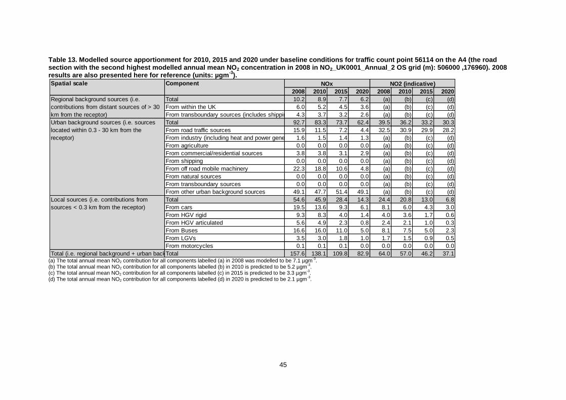
45
Table 13. Modelled source apportionment for 2010, 2015 and 2020 under baseline conditions for traffic count point 56114 on the A4 (the road section with the second highest modelled annual mean NO2 concentration in 2008 in NO2_UK0001_Annual_2 OS grid (m): 506000 ,176960). 2008 results are also presented here for reference (units: µgm
-3).
(a) The total annual mean NO2 contribution for all components labelled (a) in 2008 was modelled to be 7.1 µgm
-3.
(b) The total annual mean NO2 contribution for all components labelled (b) in 2010 is predicted to be 5.2 µgm-3.
(c) The total annual mean NO2 contribution for all components labelled (c) in 2015 is predicted to be 3.3 µgm-3.
(d) The total annual mean NO2 contribution for all components labelled (d) in 2020 is predicted to be 2.1 µgm-3.
Spatial scale Component
2008 2010 2015 2020 2008 2010 2015 2020
Total 10.2 8.9 7.7 6.2 (a) (b) (c) (d)
From within the UK 6.0 5.2 4.5 3.6 (a) (b) (c) (d)
From transboundary sources (includes shipping and other EU Member States)4.3 3.7 3.2 2.6 (a) (b) (c) (d)
Total 92.7 83.3 73.7 62.4 39.5 36.2 33.2 30.3
From road traffic sources 15.9 11.5 7.2 4.4 32.5 30.9 29.9 28.2
From industry (including heat and power generation)1.6 1.5 1.4 1.3 (a) (b) (c) (d)
From agriculture 0.0 0.0 0.0 0.0 (a) (b) (c) (d)
From commercial/residential sources 3.8 3.8 3.1 2.9 (a) (b) (c) (d)
From shipping 0.0 0.0 0.0 0.0 (a) (b) (c) (d)
From off road mobile machinery 22.3 18.8 10.6 4.8 (a) (b) (c) (d)
From natural sources 0.0 0.0 0.0 0.0 (a) (b) (c) (d)
From transboundary sources 0.0 0.0 0.0 0.0 (a) (b) (c) (d)
From other urban background sources 49.1 47.7 51.4 49.1 (a) (b) (c) (d)
Total 54.6 45.9 28.4 14.3 24.4 20.8 13.0 6.8
From cars 19.5 13.6 9.3 6.1 8.1 6.0 4.3 3.0
From HGV rigid 9.3 8.3 4.0 1.4 4.0 3.6 1.7 0.6
From HGV articulated 5.6 4.9 2.3 0.8 2.4 2.1 1.0 0.3
From Buses 16.6 16.0 11.0 5.0 8.1 7.5 5.0 2.3
From LGVs 3.5 3.0 1.8 1.0 1.7 1.5 0.9 0.5
From motorcycles 0.1 0.1 0.1 0.0 0.0 0.0 0.0 0.0
Total (i.e. regional background + urban background + local components)Total 157.6 138.1 109.8 82.9 64.0 57.0 46.2 37.1
NOx NO2 (indicative)
Regional background sources (i.e.
contributions from distant sources of > 30
km from the receptor)
Urban background sources (i.e. sources
located within 0.3 - 30 km from the
receptor)
Local sources (i.e. contributions from
sources < 0.3 km from the receptor)
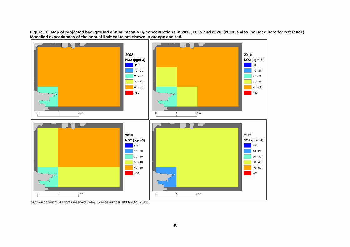
46
Figure 10. Map of projected background annual mean NO2 concentrations in 2010, 2015 and 2020. (2008 is also included here for reference). Modelled exceedances of the annual limit value are shown in orange and red.
© Crown copyright. All rights reserved Defra, Licence number 100022861 [2011].
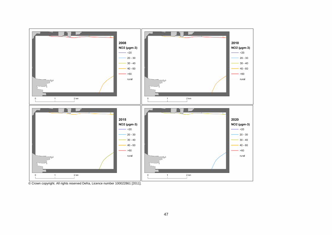
47
© Crown copyright. All rights reserved Defra, Licence number 100022861 [2011].
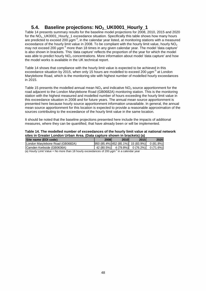
48
5.4. Baseline projections: NO2_UK0001_Hourly_1 Table 14 presents summary results for the baseline model projections for 2008, 2010, 2015 and 2020 for the NO2_UK0001_Hourly_1 exceedance situation. Specifically this table shows how many hours are predicted to exceed 200 µgm
-3, in the calendar year listed, at monitoring stations with a measured
exceedance of the hourly limit value in 2008. To be compliant with the hourly limit value, hourly NO2 may not exceed 200 µgm
-3 more than 18 times in any given calendar year. The model 'data capture'
is also shown in brackets. This 'data capture' reflects the proportion of the year for which the model was able to predict hourly NO2 concentrations. More information about model 'data capture' and how the model works is available in the UK technical report. Table 14 shows that compliance with the hourly limit value is expected to be achieved in this exceedance situation by 2015, when only 15 hours are modelled to exceed 200 µgm
-3 at London
Marylebone Road, which is the monitoring site with highest number of modelled hourly exceedances in 2015. Table 15 presents the modelled annual mean NOX and indicative NO2 source apportionment for the road adjacent to the London Marylebone Road (GB0682A) monitoring station. This is the monitoring station with the highest measured and modelled number of hours exceeding the hourly limit value in this exceedance situation in 2008 and for future years. The annual mean source apportionment is presented here because hourly source apportionment information unavailable. In general, the annual mean source apportionment for this location is expected to provide a reasonable approximation of the sources contributing to the exceedance of the hourly limit value in the same location. It should be noted that the baseline projections presented here include the impacts of additional measures, where they can be quantified, that have already been or will be implemented. Table 14. The modelled number of exceedances of the hourly limit value at national network sites in Greater London Urban Area. (Data capture shown in brackets) (a)
(a) Hourly Limit Value = No more than 18 hourly exceedances of 200 µgm
-3 in a calendar year
Site name (EOI code) 2008 2010 2015 2020
London Marylebone Road (GB0682A) 950 (85.4%) 452 (85.1%) 15 (83.9%) 0 (81.8%)
Camden Kerbside (GB0636A) 42 (80.5%) 4 (79.8%) 0 (76.2%) 0 (71.6%)
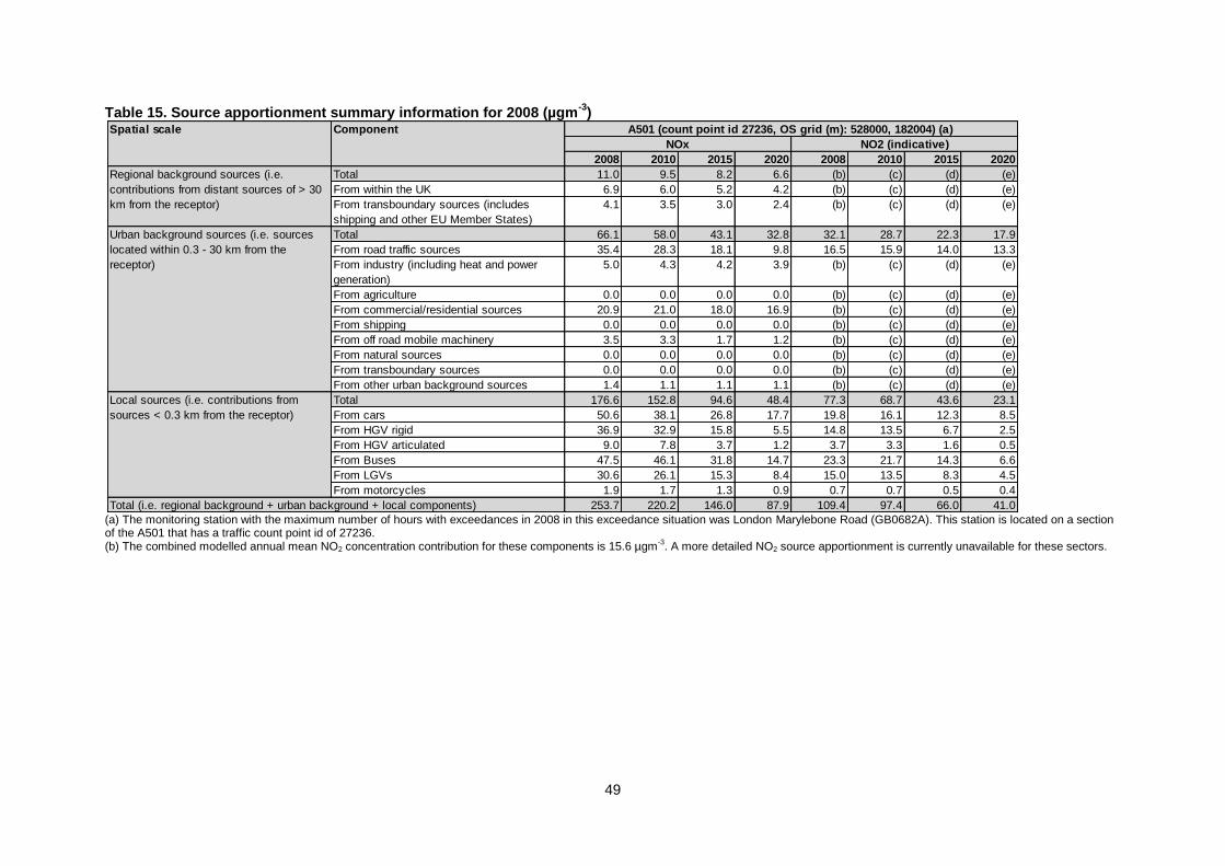
49
Table 15. Source apportionment summary information for 2008 (µgm-3
)
(a) The monitoring station with the maximum number of hours with exceedances in 2008 in this exceedance situation was London Marylebone Road (GB0682A). This station is located on a section of the A501 that has a traffic count point id of 27236. (b) The combined modelled annual mean NO2 concentration contribution for these components is 15.6 µgm
-3. A more detailed NO2 source apportionment is currently unavailable for these sectors.
2008 2010 2015 2020 2008 2010 2015 2020
Total 11.0 9.5 8.2 6.6 (b) (c) (d) (e)
From within the UK 6.9 6.0 5.2 4.2 (b) (c) (d) (e)
From transboundary sources (includes
shipping and other EU Member States)
4.1 3.5 3.0 2.4 (b) (c) (d) (e)
Total 66.1 58.0 43.1 32.8 32.1 28.7 22.3 17.9
From road traffic sources 35.4 28.3 18.1 9.8 16.5 15.9 14.0 13.3
From industry (including heat and power
generation)
5.0 4.3 4.2 3.9 (b) (c) (d) (e)
From agriculture 0.0 0.0 0.0 0.0 (b) (c) (d) (e)
From commercial/residential sources 20.9 21.0 18.0 16.9 (b) (c) (d) (e)
From shipping 0.0 0.0 0.0 0.0 (b) (c) (d) (e)
From off road mobile machinery 3.5 3.3 1.7 1.2 (b) (c) (d) (e)
From natural sources 0.0 0.0 0.0 0.0 (b) (c) (d) (e)
From transboundary sources 0.0 0.0 0.0 0.0 (b) (c) (d) (e)
From other urban background sources 1.4 1.1 1.1 1.1 (b) (c) (d) (e)
Total 176.6 152.8 94.6 48.4 77.3 68.7 43.6 23.1
From cars 50.6 38.1 26.8 17.7 19.8 16.1 12.3 8.5
From HGV rigid 36.9 32.9 15.8 5.5 14.8 13.5 6.7 2.5
From HGV articulated 9.0 7.8 3.7 1.2 3.7 3.3 1.6 0.5
From Buses 47.5 46.1 31.8 14.7 23.3 21.7 14.3 6.6
From LGVs 30.6 26.1 15.3 8.4 15.0 13.5 8.3 4.5
From motorcycles 1.9 1.7 1.3 0.9 0.7 0.7 0.5 0.4
253.7 220.2 146.0 87.9 109.4 97.4 66.0 41.0
A501 (count point id 27236, OS grid (m): 528000, 182004) (a)Spatial scale Component
Regional background sources (i.e.
contributions from distant sources of > 30
km from the receptor)
Total (i.e. regional background + urban background + local components)
Urban background sources (i.e. sources
located within 0.3 - 30 km from the
receptor)
Local sources (i.e. contributions from
sources < 0.3 km from the receptor)
NOx NO2 (indicative)
50
6. Projections including the impact of the low emissions zone (LEZ) scenario
6.1. Overview of model projections Further model projections for 2015 and 2020 have also been calculated that include the impact of the LEZ scenario. This scenario is under consideration as part of our investigation of additional measures to achieve the NO2 limit values. The scenario modelled here would require all HGVs and buses to meet at least Euro IV emission standards for NOX and PM10 in 2015 in order to travel on roads other than the strategic long distance road network within the selected Local Authority boundaries. More details of the work underway to explore the feasibility and costs of a national LEZ framework are provided in the UK overview document and a description of the modelling assumptions included in the LEZ scenario is available in the UK technical report. The LEZ scenario has been modelled for this zone because initial screening work indicated that, should it be applied, it would be effective at either reducing the gap to or achieving compliance with the limit value. The model results for these projections are presented in this section. A combination of London Transport's Selective Catalytic Reduction (SCR) Strategy and the London LEZ phase 5 are equivalent to the LEZ scenario. Further details of the methods used to estimate the impact of this measures in London are provided in the UK technical report. Projections for comparison with the 1-hour limit value have not been calculated for the LEZ scenario. Further work is underway to investigate the feasibility and practicality of a national framework for LEZ as an additional measure to reduce concentrations of NO2. These investigations include: • the likely effectiveness of any scheme at controlling air pollutant emissions and delivering increased compliance with European air quality standards within the timescales specified by the EU Ambient Air Quality Directive; • the effectiveness and reliability of available NOX abatement equipment, taking into account evidence on the performance of Euro standards; • the cost and resource such a measure might place upon national and/or local government; • administrative and enforcement considerations for the scheme and the implications of this for Government Executive Agencies; • the likely take-up of the scheme by local authorities and others; • how any scheme would relate to ongoing certification work at EU and UNECE level. These investigations will continue over the coming months and decisions will be made following the investigation as to whether or not it is feasible to introduce a national LEZ Framework and the details of any scheme. Should a local authority decide to introduce an LEZ, final decisions on the nature and extent of such a measure would be for the local authority to make taking into account local circumstances and any national arrangements put in place. These might not reflect what has been modelled in the scenario. The LEZ scenario examines the impact of a LEZ applied within the selected local authorities listed in the supporting technical report. The local authorities relevant to this zone are • Barking and Dagenham London Borough Council • Barnet London Borough Council • Bexley London Borough Council • Brent London Borough Council • Bromley London Borough Council • Camden London Borough Council • City of London • Croydon London Borough Council • Ealing London Borough Council • Enfield London Borough Council • Greenwich London Borough Council
51
• Hackney London Borough Council • Hammersmith and Fulham London Borough Council • Haringey London Borough Council • Harrow London Borough Council • Havering London Borough Council • Hillingdon London Borough Council • Hounslow London Borough Council • Islington London Borough Council • Kensington and Chelsea, Royal Borough • Kingston upon Thames Royal Borough • Lambeth London Borough Council • Lewisham London Borough Council • Merton London Borough Council • Newham London Borough Council • Redbridge London Borough Council • Richmond upon Thames London Borough Council • Southwark London Borough Council • Sutton London Borough Council • Tower Hamlets London Borough Council • Waltham Forest London Borough • Wandsworth Borough Council • Westminster City Council The impact of the LEZ scenario on projected NO2 concentrations in 2015 will be greatest in these local authorities. There are also expected to be smaller benefits in other areas as a result of the changes to the national HGV fleets required to ensure LEZ compliance within the LEZ locations. The impact of these fleet changes on projected NO2 concentrations in 2015 have been assessed in all zones for which the baseline projections do not show compliance with the annual mean limit value in 2015.
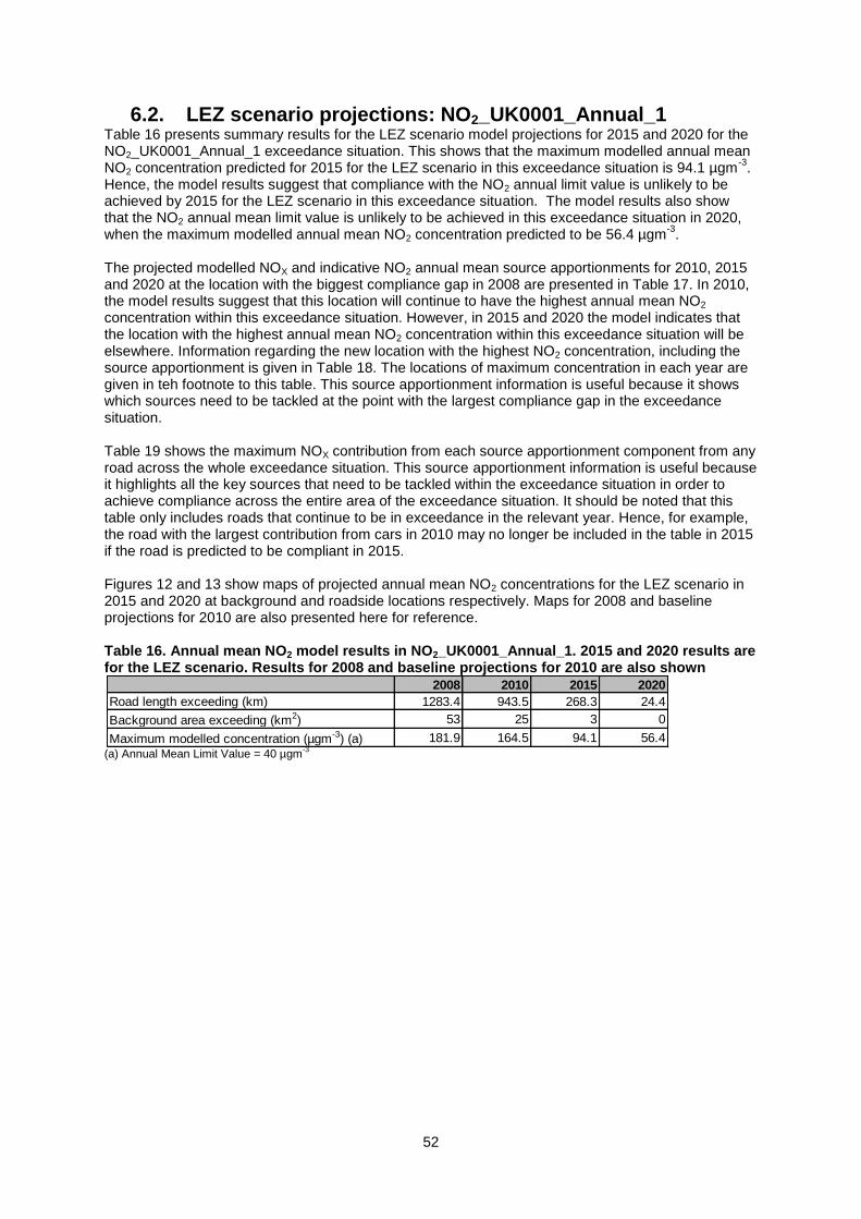
52
6.2. LEZ scenario projections: NO2_UK0001_Annual_1 Table 16 presents summary results for the LEZ scenario model projections for 2015 and 2020 for the NO2_UK0001_Annual_1 exceedance situation. This shows that the maximum modelled annual mean NO2 concentration predicted for 2015 for the LEZ scenario in this exceedance situation is 94.1 µgm
-3.
Hence, the model results suggest that compliance with the NO2 annual limit value is unlikely to be achieved by 2015 for the LEZ scenario in this exceedance situation. The model results also show that the NO2 annual mean limit value is unlikely to be achieved in this exceedance situation in 2020, when the maximum modelled annual mean NO2 concentration predicted to be 56.4 µgm
-3.
The projected modelled NOX and indicative NO2 annual mean source apportionments for 2010, 2015 and 2020 at the location with the biggest compliance gap in 2008 are presented in Table 17. In 2010, the model results suggest that this location will continue to have the highest annual mean NO2 concentration within this exceedance situation. However, in 2015 and 2020 the model indicates that the location with the highest annual mean NO2 concentration within this exceedance situation will be elsewhere. Information regarding the new location with the highest NO2 concentration, including the source apportionment is given in Table 18. The locations of maximum concentration in each year are given in teh footnote to this table. This source apportionment information is useful because it shows which sources need to be tackled at the point with the largest compliance gap in the exceedance situation. Table 19 shows the maximum NOX contribution from each source apportionment component from any road across the whole exceedance situation. This source apportionment information is useful because it highlights all the key sources that need to be tackled within the exceedance situation in order to achieve compliance across the entire area of the exceedance situation. It should be noted that this table only includes roads that continue to be in exceedance in the relevant year. Hence, for example, the road with the largest contribution from cars in 2010 may no longer be included in the table in 2015 if the road is predicted to be compliant in 2015. Figures 12 and 13 show maps of projected annual mean NO2 concentrations for the LEZ scenario in 2015 and 2020 at background and roadside locations respectively. Maps for 2008 and baseline projections for 2010 are also presented here for reference. Table 16. Annual mean NO2 model results in NO2_UK0001_Annual_1. 2015 and 2020 results are for the LEZ scenario. Results for 2008 and baseline projections for 2010 are also shown
(a) Annual Mean Limit Value = 40 µgm
-3
2008 2010 2015 2020
Road length exceeding (km) 1283.4 943.5 268.3 24.4
Background area exceeding (km2) 53 25 3 0
Maximum modelled concentration (µgm-3) (a) 181.9 164.5 94.1 56.4
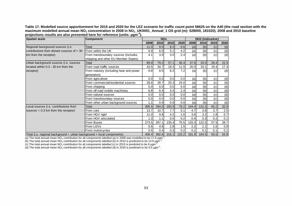
53
Table 17. Modelled source apportionment for 2015 and 2020 for the LEZ scenario for traffic count point 56625 on the A40 (the road section with the maximum modelled annual mean NO2 concentration in 2008 in NO2_UK0001_Annual_1 OS grid (m): 528000, 181020). 2008 and 2010 baseline projections results are also presented here for reference (units: µgm
-3).
(a) The total annual mean NO2 contribution for all components labelled (a) in 2008 was modelled to be 17.6 µgm
-3.
(b) The total annual mean NO2 contribution for all components labelled (b) in 2010 is predicted to be 13.9 µgm-3.
(c) The total annual mean NO2 contribution for all components labelled (c) in 2015 is predicted to be 9 µgm-3.
(d) The total annual mean NO2 contribution for all components labelled (d) in 2020 is predicted to be 5.5 µgm-3.
Spatial scale Component
2008 2010 2015 2020 2008 2010 2015 2020
Total 11.0 9.5 8.2 6.6 (a) (b) (c) (d)
From within the UK 6.9 6.0 5.1 4.2 (a) (b) (c) (d)
From transboundary sources (includes
shipping and other EU Member States)
4.1 3.5 3.0 2.4 (a) (b) (c) (d)
Total 89.9 79.2 57.1 46.4 37.6 33.0 28.4 22.9
From road traffic sources 43.5 34.7 19.3 11.9 20.0 19.1 19.4 17.4
From industry (including heat and power
generation)
9.8 8.5 8.2 7.2 (a) (b) (c) (d)
From agriculture 0.0 0.0 0.0 0.0 (a) (b) (c) (d)
From commercial/residential sources 28.6 28.7 25.3 24.0 (a) (b) (c) (d)
From shipping 0.0 0.0 0.0 0.0 (a) (b) (c) (d)
From off road mobile machinery 6.8 6.4 3.4 2.4 (a) (b) (c) (d)
From natural sources 0.0 0.0 0.0 0.0 (a) (b) (c) (d)
From transboundary sources 0.0 0.0 0.0 0.0 (a) (b) (c) (d)
From other urban background sources 1.1 0.9 0.9 0.9 (a) (b) (c) (d)
Total 305.5 294.0 150.9 79.2 144.4 131.5 65.2 32.9
From cars 13.7 10.7 7.7 5.1 4.7 3.8 3.7 2.5
From HGV rigid 11.0 9.8 4.2 1.6 3.6 3.2 1.8 0.7
From HGV articulated 1.3 1.1 0.5 0.2 0.4 0.3 0.2 0.1
From Buses 273.5 267.1 135.4 70.5 133.3 122.0 57.9 28.7
From LGVs 5.6 4.8 2.8 1.5 2.2 2.1 1.6 0.8
From motorcycles 0.5 0.4 0.3 0.2 0.1 0.1 0.1 0.1
406.4 382.6 216.1 132.2 181.9 164.5 93.6 55.8Total (i.e. regional background + urban background + local components)
NOx NO2 (indicative)
Regional background sources (i.e.
contributions from distant sources of > 30
km from the receptor)
Urban background sources (i.e. sources
located within 0.3 - 30 km from the
receptor)
Local sources (i.e. contributions from
sources < 0.3 km from the receptor)
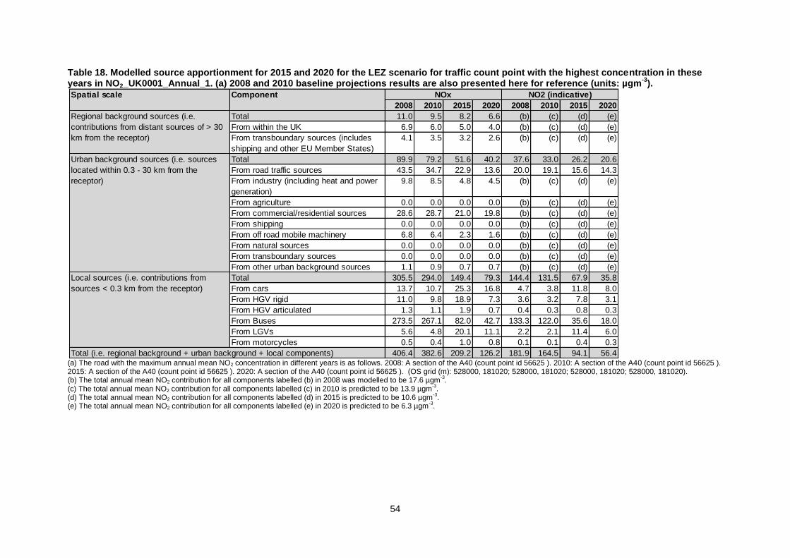
54
Table 18. Modelled source apportionment for 2015 and 2020 for the LEZ scenario for traffic count point with the highest concentration in these years in NO2_UK0001_Annual_1. (a) 2008 and 2010 baseline projections results are also presented here for reference (units: µgm
-3).
(a) The road with the maximum annual mean NO2 concentration in different years is as follows. 2008: A section of the A40 (count point id 56625 ). 2010: A section of the A40 (count point id 56625 ). 2015: A section of the A40 (count point id 56625 ). 2020: A section of the A40 (count point id 56625 ). (OS grid (m): 528000, 181020; 528000, 181020; 528000, 181020; 528000, 181020). (b) The total annual mean NO2 contribution for all components labelled (b) in 2008 was modelled to be 17.6 µgm
-3.
(c) The total annual mean NO2 contribution for all components labelled (c) in 2010 is predicted to be 13.9 µgm-3.
(d) The total annual mean NO2 contribution for all components labelled (d) in 2015 is predicted to be 10.6 µgm-3.
(e) The total annual mean NO2 contribution for all components labelled (e) in 2020 is predicted to be 6.3 µgm-3.
Spatial scale Component
2008 2010 2015 2020 2008 2010 2015 2020
Total 11.0 9.5 8.2 6.6 (b) (c) (d) (e)
From within the UK 6.9 6.0 5.0 4.0 (b) (c) (d) (e)
From transboundary sources (includes
shipping and other EU Member States)
4.1 3.5 3.2 2.6 (b) (c) (d) (e)
Total 89.9 79.2 51.6 40.2 37.6 33.0 26.2 20.6
From road traffic sources 43.5 34.7 22.9 13.6 20.0 19.1 15.6 14.3
From industry (including heat and power
generation)
9.8 8.5 4.8 4.5 (b) (c) (d) (e)
From agriculture 0.0 0.0 0.0 0.0 (b) (c) (d) (e)
From commercial/residential sources 28.6 28.7 21.0 19.8 (b) (c) (d) (e)
From shipping 0.0 0.0 0.0 0.0 (b) (c) (d) (e)
From off road mobile machinery 6.8 6.4 2.3 1.6 (b) (c) (d) (e)
From natural sources 0.0 0.0 0.0 0.0 (b) (c) (d) (e)
From transboundary sources 0.0 0.0 0.0 0.0 (b) (c) (d) (e)
From other urban background sources 1.1 0.9 0.7 0.7 (b) (c) (d) (e)
Total 305.5 294.0 149.4 79.3 144.4 131.5 67.9 35.8
From cars 13.7 10.7 25.3 16.8 4.7 3.8 11.8 8.0
From HGV rigid 11.0 9.8 18.9 7.3 3.6 3.2 7.8 3.1
From HGV articulated 1.3 1.1 1.9 0.7 0.4 0.3 0.8 0.3
From Buses 273.5 267.1 82.0 42.7 133.3 122.0 35.6 18.0
From LGVs 5.6 4.8 20.1 11.1 2.2 2.1 11.4 6.0
From motorcycles 0.5 0.4 1.0 0.8 0.1 0.1 0.4 0.3
406.4 382.6 209.2 126.2 181.9 164.5 94.1 56.4
NOx NO2 (indicative)
Regional background sources (i.e.
contributions from distant sources of > 30
km from the receptor)
Urban background sources (i.e. sources
located within 0.3 - 30 km from the
receptor)
Local sources (i.e. contributions from
sources < 0.3 km from the receptor)
Total (i.e. regional background + urban background + local components)
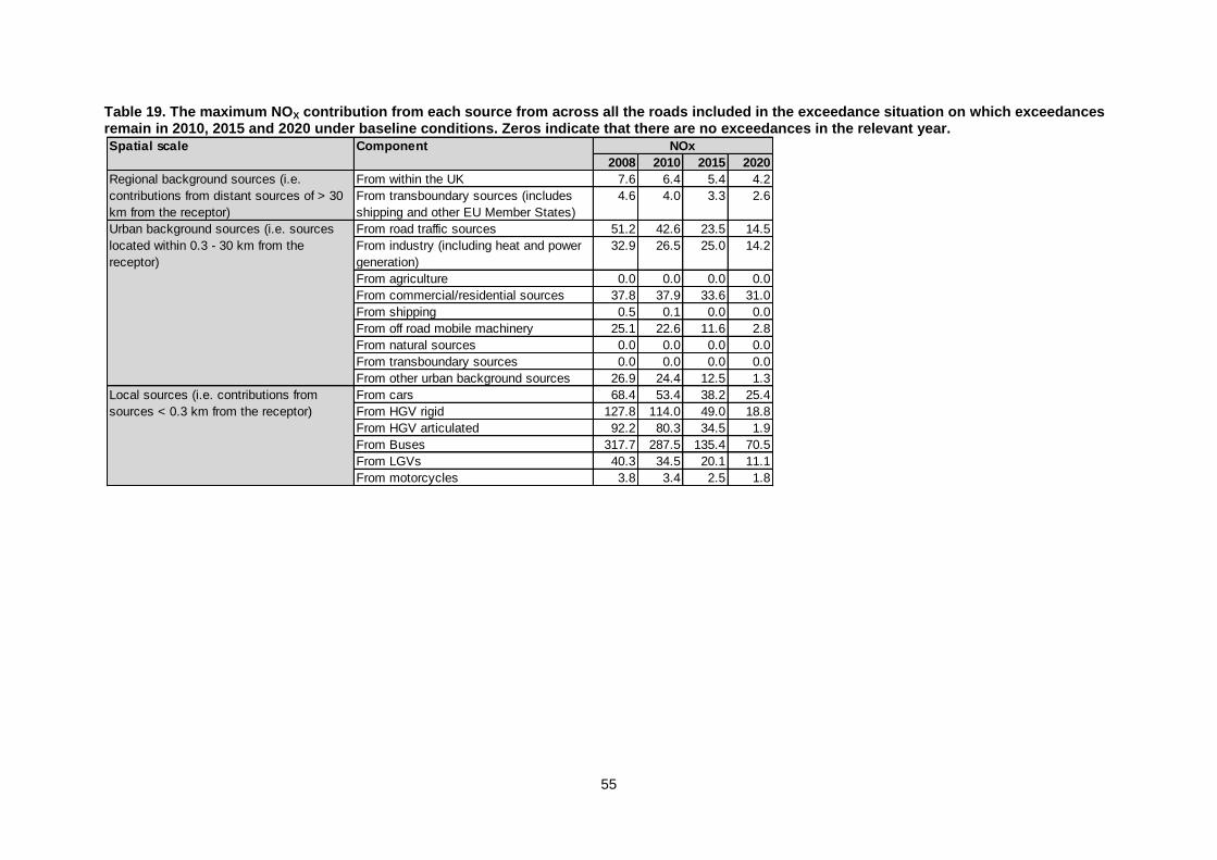
55
Table 19. The maximum NOX contribution from each source from across all the roads included in the exceedance situation on which exceedances remain in 2010, 2015 and 2020 under baseline conditions. Zeros indicate that there are no exceedances in the relevant year.
Spatial scale Component
2008 2010 2015 2020
From within the UK 7.6 6.4 5.4 4.2
From transboundary sources (includes
shipping and other EU Member States)
4.6 4.0 3.3 2.6
From road traffic sources 51.2 42.6 23.5 14.5
From industry (including heat and power
generation)
32.9 26.5 25.0 14.2
From agriculture 0.0 0.0 0.0 0.0
From commercial/residential sources 37.8 37.9 33.6 31.0
From shipping 0.5 0.1 0.0 0.0
From off road mobile machinery 25.1 22.6 11.6 2.8
From natural sources 0.0 0.0 0.0 0.0
From transboundary sources 0.0 0.0 0.0 0.0
From other urban background sources 26.9 24.4 12.5 1.3
From cars 68.4 53.4 38.2 25.4
From HGV rigid 127.8 114.0 49.0 18.8
From HGV articulated 92.2 80.3 34.5 1.9
From Buses 317.7 287.5 135.4 70.5
From LGVs 40.3 34.5 20.1 11.1
From motorcycles 3.8 3.4 2.5 1.8
NOx
Regional background sources (i.e.
contributions from distant sources of > 30
km from the receptor)
Urban background sources (i.e. sources
located within 0.3 - 30 km from the
receptor)
Local sources (i.e. contributions from
sources < 0.3 km from the receptor)
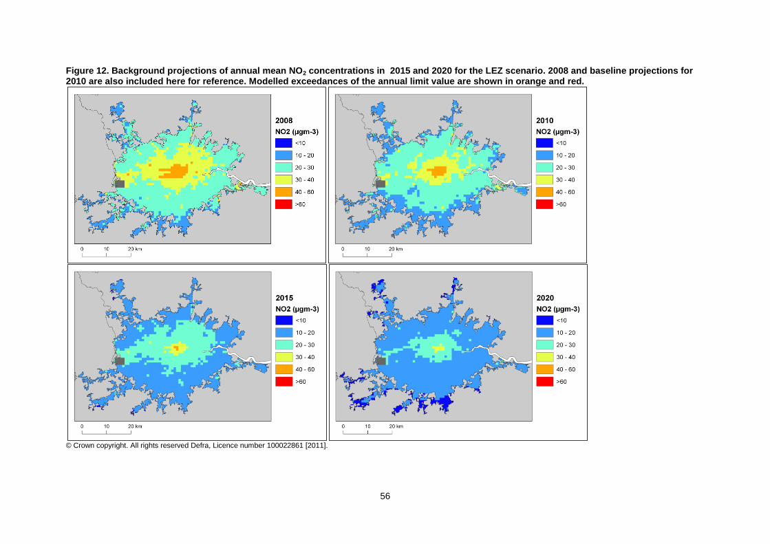
56
Figure 12. Background projections of annual mean NO2 concentrations in 2015 and 2020 for the LEZ scenario. 2008 and baseline projections for 2010 are also included here for reference. Modelled exceedances of the annual limit value are shown in orange and red.
© Crown copyright. All rights reserved Defra, Licence number 100022861 [2011].
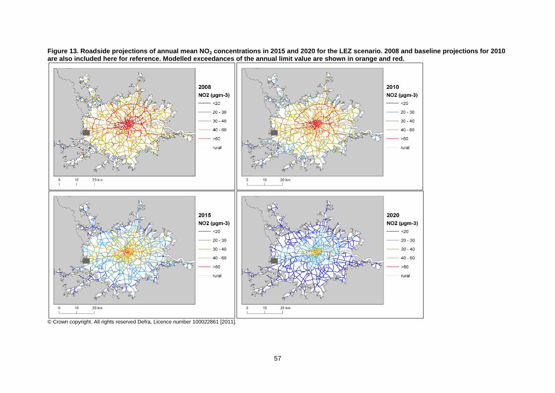
57
Figure 13. Roadside projections of annual mean NO2 concentrations in 2015 and 2020 for the LEZ scenario. 2008 and baseline projections for 2010 are also included here for reference. Modelled exceedances of the annual limit value are shown in orange and red.
© Crown copyright. All rights reserved Defra, Licence number 100022861 [2011].
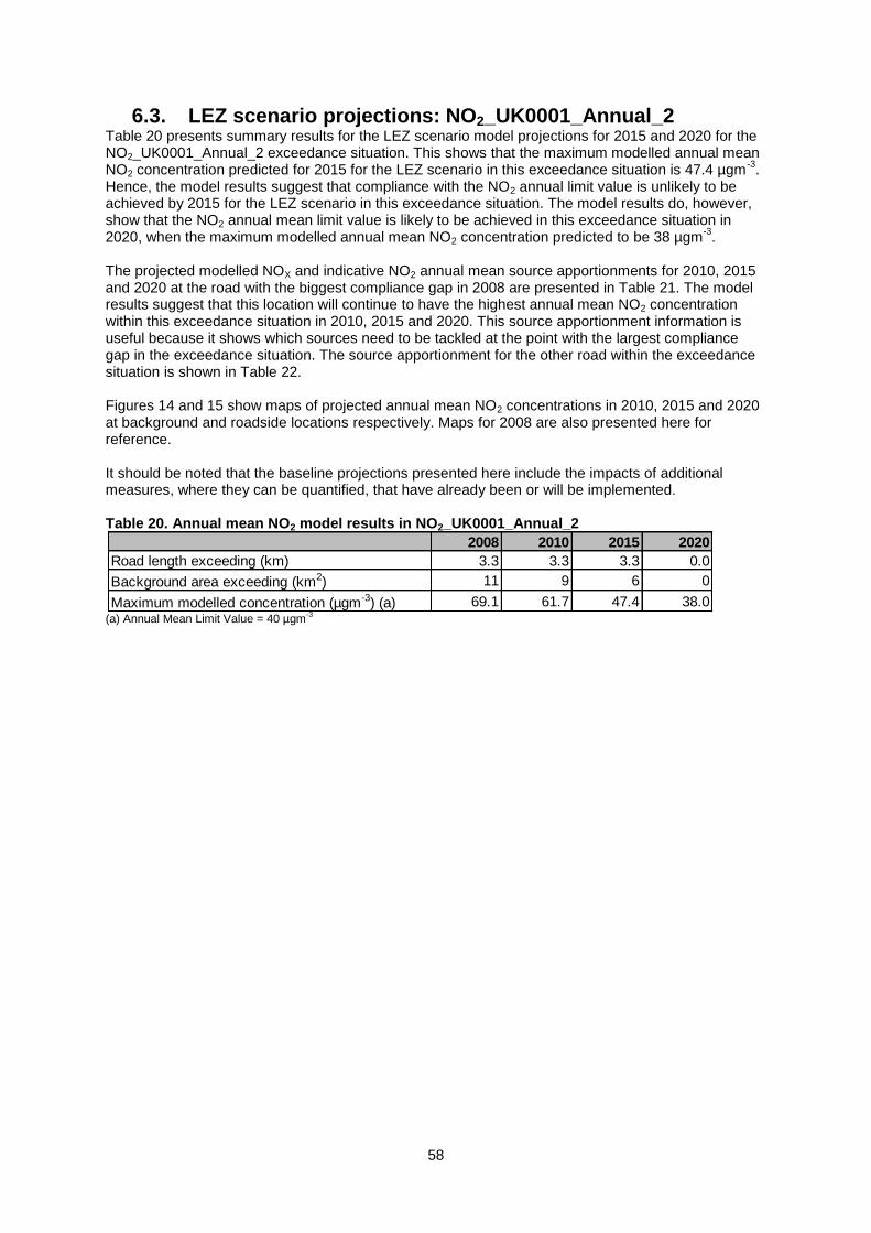
58
6.3. LEZ scenario projections: NO2_UK0001_Annual_2 Table 20 presents summary results for the LEZ scenario model projections for 2015 and 2020 for the NO2_UK0001_Annual_2 exceedance situation. This shows that the maximum modelled annual mean NO2 concentration predicted for 2015 for the LEZ scenario in this exceedance situation is 47.4 µgm
-3.
Hence, the model results suggest that compliance with the NO2 annual limit value is unlikely to be achieved by 2015 for the LEZ scenario in this exceedance situation. The model results do, however, show that the NO2 annual mean limit value is likely to be achieved in this exceedance situation in 2020, when the maximum modelled annual mean NO2 concentration predicted to be 38 µgm
-3.
The projected modelled NOX and indicative NO2 annual mean source apportionments for 2010, 2015 and 2020 at the road with the biggest compliance gap in 2008 are presented in Table 21. The model results suggest that this location will continue to have the highest annual mean NO2 concentration within this exceedance situation in 2010, 2015 and 2020. This source apportionment information is useful because it shows which sources need to be tackled at the point with the largest compliance gap in the exceedance situation. The source apportionment for the other road within the exceedance situation is shown in Table 22. Figures 14 and 15 show maps of projected annual mean NO2 concentrations in 2010, 2015 and 2020 at background and roadside locations respectively. Maps for 2008 are also presented here for reference. It should be noted that the baseline projections presented here include the impacts of additional measures, where they can be quantified, that have already been or will be implemented. Table 20. Annual mean NO2 model results in NO2_UK0001_Annual_2
(a) Annual Mean Limit Value = 40 µgm
-3
2008 2010 2015 2020
Road length exceeding (km) 3.3 3.3 3.3 0.0
Background area exceeding (km2) 11 9 6 0
Maximum modelled concentration (µgm-3) (a) 69.1 61.7 47.4 38.0
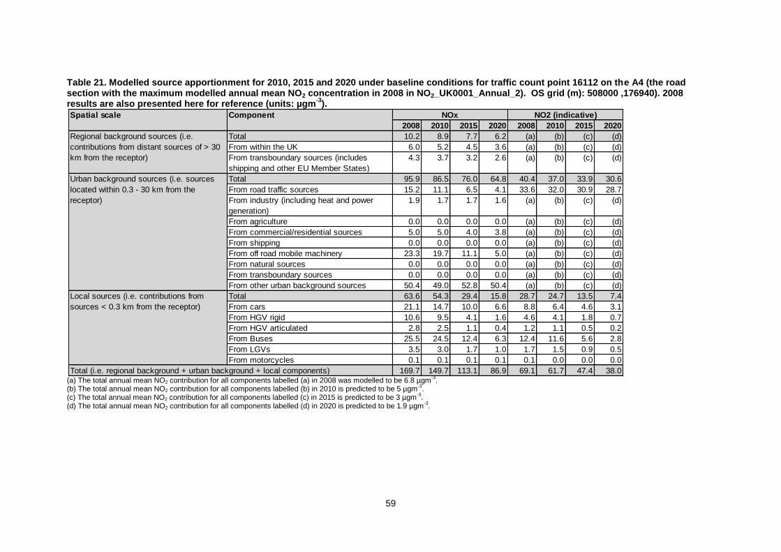
59
Table 21. Modelled source apportionment for 2010, 2015 and 2020 under baseline conditions for traffic count point 16112 on the A4 (the road section with the maximum modelled annual mean NO2 concentration in 2008 in NO2_UK0001_Annual_2). OS grid (m): 508000 ,176940). 2008 results are also presented here for reference (units: µgm
-3).
(a) The total annual mean NO2 contribution for all components labelled (a) in 2008 was modelled to be 6.8 µgm
-3.
(b) The total annual mean NO2 contribution for all components labelled (b) in 2010 is predicted to be 5 µgm-3.
(c) The total annual mean NO2 contribution for all components labelled (c) in 2015 is predicted to be 3 µgm-3.
(d) The total annual mean NO2 contribution for all components labelled (d) in 2020 is predicted to be 1.9 µgm-3.
Spatial scale Component
2008 2010 2015 2020 2008 2010 2015 2020
Total 10.2 8.9 7.7 6.2 (a) (b) (c) (d)
From within the UK 6.0 5.2 4.5 3.6 (a) (b) (c) (d)
From transboundary sources (includes
shipping and other EU Member States)
4.3 3.7 3.2 2.6 (a) (b) (c) (d)
Total 95.9 86.5 76.0 64.8 40.4 37.0 33.9 30.6
From road traffic sources 15.2 11.1 6.5 4.1 33.6 32.0 30.9 28.7
From industry (including heat and power
generation)
1.9 1.7 1.7 1.6 (a) (b) (c) (d)
From agriculture 0.0 0.0 0.0 0.0 (a) (b) (c) (d)
From commercial/residential sources 5.0 5.0 4.0 3.8 (a) (b) (c) (d)
From shipping 0.0 0.0 0.0 0.0 (a) (b) (c) (d)
From off road mobile machinery 23.3 19.7 11.1 5.0 (a) (b) (c) (d)
From natural sources 0.0 0.0 0.0 0.0 (a) (b) (c) (d)
From transboundary sources 0.0 0.0 0.0 0.0 (a) (b) (c) (d)
From other urban background sources 50.4 49.0 52.8 50.4 (a) (b) (c) (d)
Total 63.6 54.3 29.4 15.8 28.7 24.7 13.5 7.4
From cars 21.1 14.7 10.0 6.6 8.8 6.4 4.6 3.1
From HGV rigid 10.6 9.5 4.1 1.6 4.6 4.1 1.8 0.7
From HGV articulated 2.8 2.5 1.1 0.4 1.2 1.1 0.5 0.2
From Buses 25.5 24.5 12.4 6.3 12.4 11.6 5.6 2.8
From LGVs 3.5 3.0 1.7 1.0 1.7 1.5 0.9 0.5
From motorcycles 0.1 0.1 0.1 0.1 0.1 0.0 0.0 0.0
169.7 149.7 113.1 86.9 69.1 61.7 47.4 38.0Total (i.e. regional background + urban background + local components)
NOx NO2 (indicative)
Regional background sources (i.e.
contributions from distant sources of > 30
km from the receptor)
Urban background sources (i.e. sources
located within 0.3 - 30 km from the
receptor)
Local sources (i.e. contributions from
sources < 0.3 km from the receptor)

60
Table 22. Modelled source apportionment for 2010, 2015 and 2020 under baseline conditions for traffic count point 16112 on the A4 (the road section with the maximum modelled annual mean NO2 concentration in 2008 in NO2_UK0001_Annual_2). OS grid (m): 506000 ,176960). 2008 results are also presented here for reference (units: µgm
-3).
(a) The total annual mean NO2 contribution for all components labelled (a) in 2008 was modelled to be 7.1 µgm
-3.
(b) The total annual mean NO2 contribution for all components labelled (b) in 2010 is predicted to be 5.2 µgm-3.
(c) The total annual mean NO2 contribution for all components labelled (c) in 2015 is predicted to be 3.1 µgm-3.
(d) The total annual mean NO2 contribution for all components labelled (d) in 2020 is predicted to be 2.1 µgm-3.
Spatial scale Component
2008 2010 2015 2020 2008 2010 2015 2020
Total 10.2 8.9 7.7 6.2 (a) (b) (c) (d)
From within the UK 6.0 5.2 4.5 3.6 (a) (b) (c) (d)
From transboundary sources (includes shipping and other EU Member States)4.3 3.7 3.2 2.6 (a) (b) (c) (d)
Total 92.7 83.3 73.2 62.3 39.5 36.2 33.2 30.6
From road traffic sources 15.9 11.5 6.7 4.3 32.5 30.9 30.1 28.6
From industry (including heat and power generation)1.6 1.5 1.4 1.3 (a) (b) (c) (d)
From agriculture 0.0 0.0 0.0 0.0 (a) (b) (c) (d)
From commercial/residential sources 3.8 3.8 3.1 2.9 (a) (b) (c) (d)
From shipping 0.0 0.0 0.0 0.0 (a) (b) (c) (d)
From off road mobile machinery 22.3 18.8 10.6 4.8 (a) (b) (c) (d)
From natural sources 0.0 0.0 0.0 0.0 (a) (b) (c) (d)
From transboundary sources 0.0 0.0 0.0 0.0 (a) (b) (c) (d)
From other urban background sources 49.1 47.7 51.4 49.1 (a) (b) (c) (d)
Total 54.6 45.9 24.9 13.3 24.4 20.8 11.4 6.4
From cars 19.5 13.6 9.3 6.1 8.1 6.0 4.3 3.0
From HGV rigid 9.3 8.3 3.6 1.4 4.0 3.6 1.6 0.6
From HGV articulated 5.6 4.9 2.1 0.7 2.4 2.1 0.9 0.3
From Buses 16.6 16.0 8.1 4.1 8.1 7.5 3.7 1.9
From LGVs 3.5 3.0 1.8 1.0 1.7 1.5 0.9 0.5
From motorcycles 0.1 0.1 0.1 0.0 0.0 0.0 0.0 0.0
Total (i.e. regional background + urban background + local components)Total 157.6 138.1 105.8 81.9 64.0 57.0 44.7 37.1
NOx NO2 (indicative)
Regional background sources (i.e.
contributions from distant sources of > 30
km from the receptor)
Urban background sources (i.e. sources
located within 0.3 - 30 km from the
receptor)
Local sources (i.e. contributions from
sources < 0.3 km from the receptor)
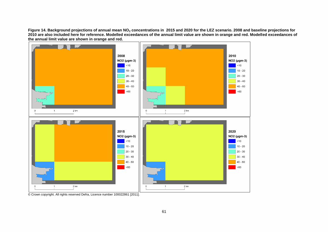
61
Figure 14. Background projections of annual mean NO2 concentrations in 2015 and 2020 for the LEZ scenario. 2008 and baseline projections for 2010 are also included here for reference. Modelled exceedances of the annual limit value are shown in orange and red. Modelled exceedances of the annual limit value are shown in orange and red.
© Crown copyright. All rights reserved Defra, Licence number 100022861 [2011].
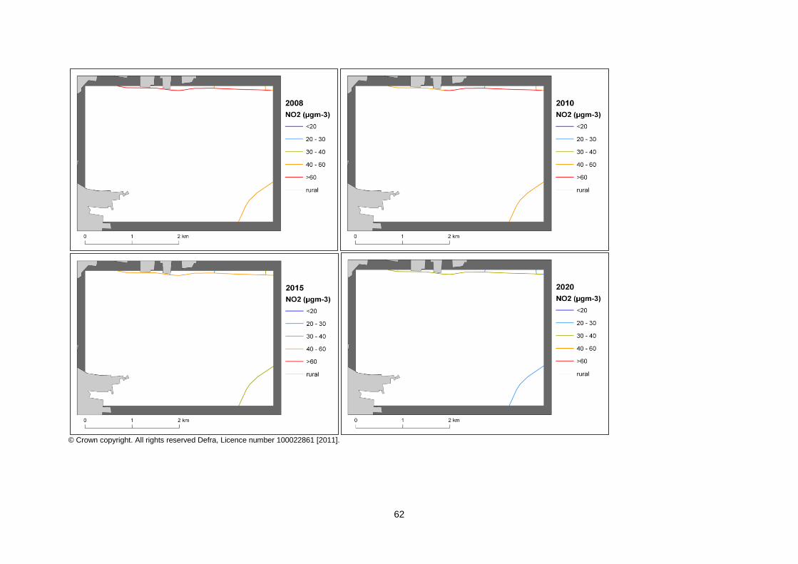
62
© Crown copyright. All rights reserved Defra, Licence number 100022861 [2011].
63
References Air Quality Expert Group (AQEG, 2004). Nitrogen Dioxide in the United Kingdom. http://www.defra.gov.uk/environment/quality/air/airquality/publications/nitrogen-dioxide/index.htm Decision 2004/224/EC. Commission Decision of 20 February 2004 laying down arrangements for the submission of information on plans or programmes required under Council Directive 96/62/EC in relation to limit values for certain pollutants in ambient air. From the Official Journal of the European Union, 6.3.2004, En series, L68/27 Decision 2004/461/EC. Commission Decision of 29 April 2004 laying down a questionnaire to be used for annual reporting on ambient air quality assessment under Council Directives 96/62/EC and 1999/30/EC and under Directives 2000/69/EC and 2002/3/EC of the European Parliament and of the Council. From the Official Journal of the European Union, 30.4.2004, En series, L 156/78 UK technical report, UK overview document and List of UK and National measures are available at http://www.defra.gov.uk/environment/quality/air/air-quality/eu/ CDR Central Data Repository. http://cdr.eionet.europa.eu/ Air Quality Directive 2008/50/EC. Council Directive 2008/50/EC, of 21 May 2008. On ambient air quality and cleaner air for Europe. From the Official Journal of the European Union, 11.6.2008, En series, L152/1 1st Daughter Directive 1999/30/EC. Council Directive 1999/30/EC, of 22 April 1999 relating to limit values for sulphur dioxide, nitrogen dioxide and oxides of nitrogen, particulate matter and lead in ambient air (The First Daughter Directive). From the Official Journal of the European Communities, 29.6.1999, En Series, L163/41. MAQS, 2010. Greater London Authority (December 2010). Clearing the Air, The Mayor's Air Quality Strategy. http://www.london.gov.uk/publication/mayors-air-quality-strategy

64
List of Annexes Annex 1: Source apportionment graphs Annex 2: Tables of measures

65
Annex 1: Source apportionment graphs
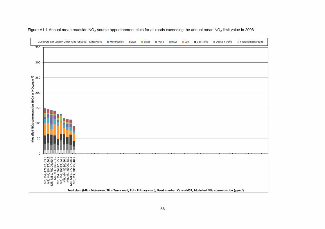
66
Figure A1.1 Annual mean roadside NOX source apportionment plots for all roads exceeding the annual mean NO2 limit value in 2008
0
50
100
150
200
250
300
350M
B, M
4, 4
78
92
, 63
.3M
B, M
4, 1
84
87
, 60
.5M
B, M
11
, 70
20
6, 6
0.2
MB
, M4
, 60
13
, 59
MB
, M4
, 26
01
2, 5
5.7
MB
, M4
, 36
01
3, 5
4.8
MB
, M4
, 82
80
, 50
.4M
B, M
1, 6
00
0, 4
8.9
MB
, M1
1, 5
72
27
, 48
.4M
B, M
3, 7
01
75
, 40
.2
Mo
de
lled
NO
x co
nce
ntr
atio
n (
NO
x as
NO
2, µ
gm-3
)
Road class (MB = Motorway, TU = Trunk road, PU = Primary road), Road number, Censusid07, Modelled NO 2 concentration (µgm-3)
2008: Greater London Urban Area (UK0001) - Motorways Motorcycles LGVs Buses HGVa HGVr Cars UB: Traffic UB: Non traffic Regional Background
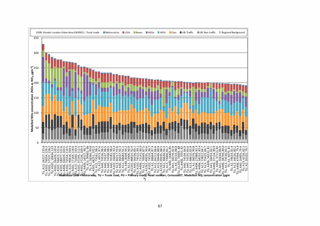
67
0
50
100
150
200
250
300
350
TU, A
13
, 26
21
7, 1
25
.6TU
, A5
01
, 76
05
4, 1
29
.3TU
, A5
01
, 57
53
7, 1
28
.2TU
, A5
01
, 18
45
4, 1
23
TU, A
50
1, 2
64
29
, 12
0.4
TU, A
50
1, 5
68
15
, 12
2.6
TU, A
50
1, 1
80
77
, 12
2.6
TU, A
40
6, 5
60
29
, 10
4.5
TU, A
10
2, 7
35
54
, 11
0.5
TU, A
13
, 99
81
6, 1
04
.5TU
, A5
01
, 17
16
9, 1
18
.6TU
, A1
3, 7
10
00
, 10
3.4
TU, A
50
1, 4
72
45
, 11
2.5
TU, A
50
1, 2
72
36
, 10
9.4
TU, A
40
6, 1
85
27
, 98
.7TU
, A1
3, 9
99
02
, 98
TU, A
2, 5
82
66
, 99
.8TU
, A5
01
, 48
25
1, 1
02
.5TU
, A1
2, 7
35
61
, 98
.3TU
, A1
2, 6
07
1, 9
7.6
TU, A
40
, 74
53
6, 9
8.5
TU, A
40
, 74
53
7, 9
8.5
TU, A
40
, 74
53
8, 9
8.5
TU, A
40
, 70
18
1, 9
8.4
TU, A
10
2, 2
66
43
, 93
.2TU
, A1
3, 4
62
17
, 93
.6TU
, A4
0, 3
64
37
, 92
.3TU
, A1
2, 3
86
83
, 91
.1TU
, A4
0, 8
50
9, 9
4.2
TU, A
12
, 73
90
6, 9
0.9
TU, A
12
61
, 48
81
4, 9
2.4
TU, A
40
, 56
43
6, 8
9.1
TU, A
10
2, 7
45
31
, 89
.1TU
, A4
06
, 73
14
1, 8
6.9
TU, A
12
, 70
04
9, 8
7.5
TU, A
12
61
, 49
03
5, 9
0.6
TU, A
10
2, 7
45
32
, 86
.7TU
, A2
, 38
66
4, 8
7.3
TU, A
12
, 26
21
2, 8
6.6
TU, A
13
, 58
44
6, 8
8.9
TU, A
12
03
, 39
03
5, 8
8.5
TU, A
41
, 38
63
0, 9
4.3
TU, A
13
, 73
00
0, 8
5.7
TU, A
40
, 16
40
4, 8
5TU
, A4
1, 1
82
70
, 83
.9TU
, A4
, 16
11
0, 8
8.8
TU, A
12
03
, 70
00
3, 8
8TU
, A4
06
, 70
55
, 82
TU, A
40
, 74
53
4, 8
4.9
TU, A
40
, 74
53
5, 8
4.6
TU, A
13
, 48
61
0, 8
3.9
TU, A
1, 3
60
76
, 90
.8TU
, A4
06
, 27
08
9, 8
2.3
TU, A
40
6, 5
82
31
, 83
.4TU
, A1
3, 7
38
22
, 84
.7TU
, A1
3, 7
54
25
, 84
.7TU
, A4
06
, 58
23
2, 8
1TU
, A4
1, 1
84
53
, 82
.1TU
, A4
06
, 37
11
6, 8
0.9
TU, A
40
6, 3
71
13
, 81
TU, A
41
, 16
43
4, 8
6.9
TU, A
40
6, 3
87
49
, 80
.6TU
, A1
2, 7
45
30
, 83
.3TU
, A1
, 60
76
, 81
TU, A
2, 7
46
24
, 81
.4TU
, A1
3, 1
85
26
, 80
.2TU
, A4
06
, 47
09
4, 7
9.9
TU, A
40
, 16
40
5, 7
9.4
TU, A
13
, 62
16
, 82
.1TU
, A2
, 26
10
2, 7
9.7
Mo
de
lled
NO
x co
nce
ntr
atio
n (
NO
x as
NO
2, µ
gm-3
)
Road class (MB = Motorway, TU = Trunk road, PU = Primary road), Road number, Censusid07, Modelled NO2 concentration (µgm-
3)
2008: Greater London Urban Area (UK0001) - Trunk roads Motorcycles LGVs Buses HGVa HGVr Cars UB: Traffic UB: Non traffic Regional Background
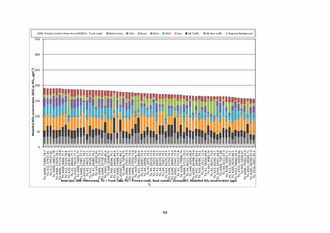
68
0
50
100
150
200
250
300
350
TU, A
40
6, 7
34
80
, 78
.7TU
, A1
2, 2
79
17
, 81
TU, A
12
, 74
52
7, 8
1TU
, A4
06
, 48
61
1, 7
8TU
, A4
06
, 17
02
0, 7
8.1
TU, A
40
6, 3
71
14
, 76
.8TU
, A4
06
, 84
68
, 77
.7TU
, A1
2, 7
45
29
, 78
.8TU
, A1
0, 2
61
81
, 86
.5TU
, A2
, 48
64
4, 7
7.7
TU, A
10
2, 7
45
33
, 77
.7TU
, A4
06
, 74
69
3, 7
7TU
, A4
06
, 27
08
7, 7
7.2
TU, A
32
20
, 74
54
1, 7
9.5
TU, A
2, 7
46
23
, 77
.1TU
, A1
2, 7
45
28
, 77
.5TU
, A1
, 26
08
0, 7
6.2
TU, A
10
, 28
50
2, 8
1TU
, A4
06
, 17
01
9, 7
5.3
TU, A
40
6, 5
67
58
, 75
.7TU
, A5
01
, 72
09
, 80
.3TU
, A4
0, 3
64
38
, 75
TU, A
40
, 38
59
6, 7
5.1
TU, A
41
, 16
43
5, 8
4.4
TU, A
40
6, 2
70
88
, 74
.7TU
, A5
20
0, 3
78
25
, 80
.2TU
, A4
06
, 70
58
, 73
TU, A
40
6, 1
70
21
, 74
.3TU
, A4
06
, 73
00
2, 7
4.4
TU, A
40
6, 5
70
56
, 72
.8TU
, A5
01
, 75
33
9, 7
9TU
, A4
1, 2
64
64
, 80
.6TU
, A3
, 56
09
7, 7
4.4
TU, A
4, 5
90
08
, 73
.2TU
, A1
, 60
75
, 76
.2TU
, A4
, 26
11
6, 7
3.3
TU, A
4, 7
50
72
, 70
.8TU
, A2
, 36
49
7, 7
2.3
TU, A
4, 3
61
19
, 74
.2TU
, A4
, 73
56
7, 7
4.2
TU, A
23
, 26
27
0, 7
9.4
TU, A
10
6, 5
77
54
, 74
.7TU
, A1
06
, 28
09
2, 7
4.6
TU, A
50
1, 1
76
41
, 77
.8TU
, A1
, 75
31
3, 7
1.8
TU, A
10
6, 7
49
06
, 74
TU, A
40
6, 5
71
15
, 70
.2TU
, A4
, 46
12
1, 7
0.2
TU, A
40
, 64
29
, 68
.8TU
, A2
05
, 46
78
8, 7
4.4
TU, A
41
, 26
46
3, 6
9.6
TU, A
10
, 36
18
6, 7
4.2
TU, A
3, 6
11
1, 7
1.3
TU, A
1, 7
83
56
, 69
.8TU
, A4
1, 8
08
3, 7
4TU
, A3
, 36
11
1, 7
3.9
TU, A
23
, 56
24
0, 7
4.7
TU, A
31
6, 2
69
21
, 66
.8TU
, A4
06
, 70
57
, 68
TU, A
4, 6
12
2, 6
7.4
TU, A
10
6, 7
49
07
, 71
TU, A
13
, 16
20
3, 7
3.2
TU, A
20
5, 8
57
6, 6
8.2
TU, A
31
2, 5
66
86
, 65
.4TU
, A3
12
, 26
91
4, 6
6TU
, A4
1, 6
45
8, 6
7TU
, A4
06
, 75
38
2, 6
5.9
TU, A
50
1, 2
85
04
, 71
TU, A
20
5, 3
67
99
, 67
.4TU
, A3
16
, 69
01
, 65
.4
Mo
de
lled
NO
x co
nce
ntr
atio
n (
NO
x as
NO
2, µ
gm-3
)
Road class (MB = Motorway, TU = Trunk road, PU = Primary road), Road number, Censusid07, Modelled NO2 concentration (µgm-
3)
2008: Greater London Urban Area (UK0001) - Trunk roads Motorcycles LGVs Buses HGVa HGVr Cars UB: Traffic UB: Non traffic Regional Background
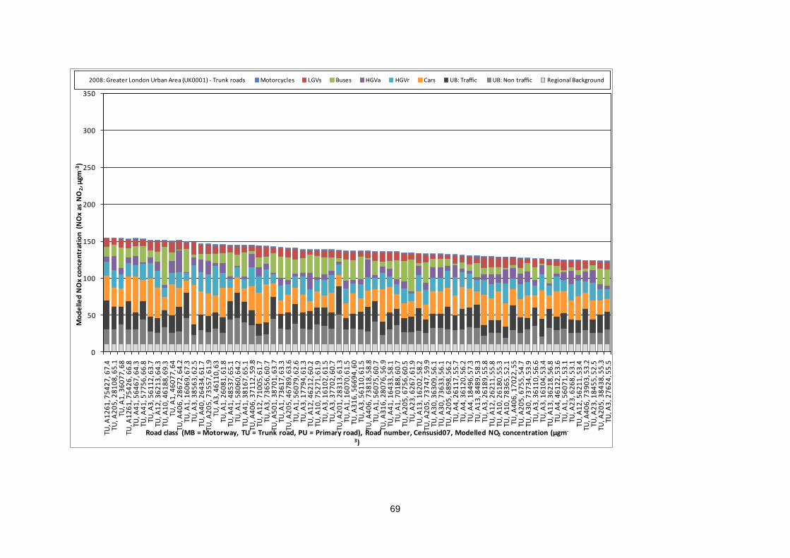
69
0
50
100
150
200
250
300
350
TU, A
12
61
, 75
42
7, 6
7.4
TU, A
20
5, 2
81
08
, 65
.1TU
, A1
, 36
07
7, 6
8TU
, A1
26
1, 7
54
26
, 66
.8TU
, A4
1, 5
64
67
, 64
.3TU
, A4
1, 5
77
56
, 66
.8TU
, A3
, 56
11
2, 6
3.7
TU, A
12
, 36
21
3, 6
4.3
TU, A
10
, 46
18
8, 6
9.3
TU, A
1, 4
60
77
, 64
TU, A
40
6, 2
86
72
, 64
.2TU
, A1
, 16
06
9, 6
7.3
TU, A
3, 3
85
63
, 62
.5TU
, A4
0, 2
64
34
, 61
.7TU
, A2
05
, 73
55
7, 6
1.9
TU, A
3, 4
61
10
, 63
TU, A
1, 2
60
81
, 61
.8TU
, A4
1, 4
85
37
, 65
.1TU
, A1
, 58
06
0, 6
4.2
TU, A
41
, 38
16
7, 6
5.1
TU, A
40
6, 3
71
12
, 59
.8TU
, A1
2, 7
10
05
, 61
.7TU
, A3
, 73
65
6, 6
0.7
TU, A
50
1, 3
87
01
, 63
.7TU
, A1
, 73
61
7, 6
3.3
TU, A
20
5, 4
67
89
, 63
.6TU
, A1
, 56
07
9, 6
2.6
TU, A
3, 1
77
94
, 61
.3TU
, A1
2, 4
62
12
, 60
.2TU
, A1
0, 7
52
71
, 61
.9TU
, A3
, 16
10
2, 6
1.5
TU, A
3, 3
77
02
, 60
.7TU
, A2
01
, 28
31
3, 6
1.3
TU, A
1, 1
60
70
, 61
.5TU
, A3
16
, 56
69
4, 6
0TU
, A3
, 56
11
0, 6
1.5
TU, A
40
6, 7
38
18
, 58
.8TU
, A1
, 56
07
5, 6
0.7
TU, A
31
6, 2
80
76
, 56
.9TU
, A4
1, 1
64
33
, 58
.1TU
, A1
, 70
18
8, 6
0.7
TU, A
20
5, 6
75
6, 6
0.5
TU, A
23
, 62
67
, 61
.9TU
, A1
3, 1
62
02
, 58
.2TU
, A2
05
, 73
74
7, 5
9.9
TU, A
30
, 36
30
9, 5
6.1
TU, A
30
, 73
63
3, 5
6.1
TU, A
20
5, 6
89
8, 5
6.2
TU, A
4, 2
61
17
, 55
.7TU
, A4
, 36
12
0, 5
6.2
TU, A
4, 1
84
96
, 57
.3TU
, A1
3, 8
48
9, 5
8.3
TU, A
3, 2
61
89
, 55
.8TU
, A1
2, 2
62
11
, 55
.8TU
, A1
0, 2
61
80
, 55
.3TU
, A1
0, 7
83
65
, 52
.1TU
, A4
06
, 17
02
2, 5
5TU
, A2
05
, 67
55
, 54
.7TU
, A3
0, 7
37
34
, 53
.9TU
, A3
, 36
11
0, 5
6.6
TU, A
3, 1
61
04
, 53
.4TU
, A1
3, 3
62
18
, 56
.8TU
, A4
, 46
12
2, 5
3.6
TU, A
1, 5
60
71
, 53
.1TU
, A2
3, 6
26
8, 5
3.1
TU, A
12
, 56
21
1, 5
3.4
TU, A
40
6, 7
39
03
, 53
.2TU
, A2
3, 1
84
55
, 52
.5TU
, A2
05
, 38
43
8, 5
5.3
TU, A
3, 2
76
24
, 55
.5
Mo
de
lled
NO
x co
nce
ntr
atio
n (
NO
x as
NO
2, µ
gm-3
)
Road class (MB = Motorway, TU = Trunk road, PU = Primary road), Road number, Censusid07, Modelled NO2 concentration (µgm-
3)
2008: Greater London Urban Area (UK0001) - Trunk roads Motorcycles LGVs Buses HGVa HGVr Cars UB: Traffic UB: Non traffic Regional Background
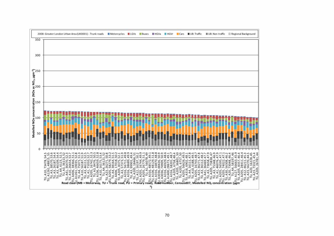
70
0
50
100
150
200
250
300
350
TU, A
10
, 73
47
8, 5
4.5
TU, A
12
61
, 48
81
5, 5
5TU
, A3
, 38
57
0, 5
3.6
TU, A
3, 2
61
87
, 54
.4TU
, A3
, 46
10
9, 5
4.4
TU, A
4, 6
12
3, 5
2.5
TU, A
3, 3
61
13
, 52
TU, A
41
, 36
47
0, 5
2.3
TU, A
10
, 26
65
4, 5
3.7
TU, A
40
6, 3
83
66
, 51
.1TU
, A1
26
1, 1
90
35
, 52
.8TU
, A4
, 75
07
1, 5
1.3
TU, A
10
, 56
18
7, 5
1.9
TU, A
3, 4
61
11
, 52
.5TU
, A1
, 71
01
0, 5
2.7
TU, A
20
5, 1
67
42
, 52
.3TU
, A3
, 84
76
, 50
.5TU
, A1
06
, 46
65
9, 5
2.8
TU, A
10
, 16
17
5, 5
3.4
TU, A
4, 3
61
21
, 52
TU, A
23
, 26
27
1, 5
0.8
TU, A
20
5, 5
82
79
, 53
.2TU
, A4
, 38
16
4, 5
1.5
TU, A
40
6, 1
70
18
, 50
.2TU
, A2
05
, 83
75
, 52
.1TU
, A3
, 57
37
3, 5
1.9
TU, A
31
6, 5
67
11
, 49
.8TU
, A3
16
, 38
68
9, 4
9.9
TU, A
3, 9
99
01
, 49
.4TU
, A2
05
, 18
46
6, 5
1TU
, A1
2, 1
61
97
, 50
.2TU
, A2
05
, 16
74
4, 4
9.9
TU, A
20
5, 2
67
79
, 51
.1TU
, A1
, 56
07
8, 4
9TU
, A3
16
, 48
57
2, 4
9.1
TU, A
10
6, 4
81
29
, 51
.8TU
, A3
16
, 16
87
0, 4
8.8
TU, A
30
36
, 48
42
6, 5
0.9
TU, A
30
36
, 74
90
9, 5
0.9
TU, A
31
6, 4
69
29
, 48
.6TU
, A1
40
0, 2
86
73
, 49
.1TU
, A3
16
, 58
20
1, 4
8.7
TU, A
20
5, 6
75
8, 4
8.4
TU, A
20
5, 3
68
01
, 50
TU, A
20
5, 6
75
7, 5
0TU
, A2
05
, 56
62
6, 4
9.5
TU, A
31
6, 6
90
2, 4
8.1
TU, A
4, 1
61
11
, 47
.8TU
, A1
0, 6
18
8, 4
9.5
TU, A
20
5, 1
67
43
, 48
.7TU
, A2
3, 3
62
71
, 47
.8TU
, A3
, 36
11
2, 4
8.2
TU, A
41
, 36
46
9, 4
7.7
TU, A
3, 7
36
58
, 47
.9TU
, A2
05
, 73
83
8, 4
7TU
, A3
, 75
34
8, 4
6.9
TU, A
1, 4
60
76
, 47
.9TU
, A2
05
, 56
59
5, 4
7.1
TU, A
20
5, 7
40
22
, 47
.1TU
, A3
0, 5
63
08
, 46
.2TU
, A2
0, 7
30
48
, 46
.4TU
, A4
, 58
19
7, 4
6TU
, A1
27
, 56
66
3, 4
5.9
TU, A
20
5, 8
35
7, 4
6.4
TU, A
20
5, 2
84
11
, 46
.4TU
, A1
2, 4
62
11
, 45
.3TU
, A2
3, 5
62
70
, 44
.5TU
, A2
0, 1
62
28
, 45
TU, A
23
, 73
32
1, 4
5.4
TU, A
20
5, 2
67
81
, 44
Mo
de
lled
NO
x co
nce
ntr
atio
n (
NO
x as
NO
2, µ
gm-3
)
Road class (MB = Motorway, TU = Trunk road, PU = Primary road), Road number, Censusid07, Modelled NO2 concentration (µgm-
3)
2008: Greater London Urban Area (UK0001) - Trunk roads Motorcycles LGVs Buses HGVa HGVr Cars UB: Traffic UB: Non traffic Regional Background
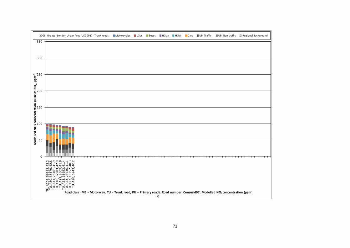
71
0
50
100
150
200
250
300
350
TU, A
20
5, 5
66
13
, 43
.2TU
, A3
0, 3
85
79
, 42
.8TU
, A4
1, 2
64
61
, 41
.9TU
, A1
0, 3
79
83
, 42
.9TU
, A2
3, 8
60
9, 4
1.9
TU, A
23
, 38
69
2, 4
1.4
TU, A
23
, 28
73
6, 4
1.1
TU, A
23
, 16
25
2, 4
0.3
TU, A
20
, 62
43
, 40
.2
Mo
de
lled
NO
x co
nce
ntr
atio
n (
NO
x as
NO
2, µ
gm-3
)
Road class (MB = Motorway, TU = Trunk road, PU = Primary road), Road number, Censusid07, Modelled NO2 concentration (µgm-
3)
2008: Greater London Urban Area (UK0001) - Trunk roads Motorcycles LGVs Buses HGVa HGVr Cars UB: Traffic UB: Non traffic Regional Background
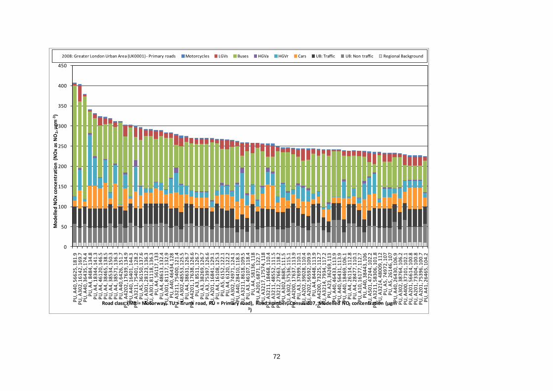
72
0
50
100
150
200
250
300
350
400
450
PU
, A4
0, 5
66
25
, 18
1.9
PU
, A3
02
, 16
14
2, 1
69
.7P
U, A
40
, 36
43
5, 1
74
.4P
U, A
4, 8
48
4, 1
34
.8P
U, A
4, 1
83
44
, 14
1.3
PU
, A4
, 46
12
0, 1
46
.5P
U, A
4, 3
84
65
, 13
8.5
PU
, A4
, 38
53
4, 1
50
.3P
U, A
4, 3
85
71
, 13
6.3
PU
, A4
0, 6
42
6, 1
51
.7P
U, A
42
02
, 17
63
9, 1
34
.9P
U, A
40
, 16
40
1, 1
44
.3P
U, A
32
11
, 75
40
1, 1
28
.2P
U, A
5, 3
61
50
, 13
7.6
PU
, A3
01
, 28
12
3, 1
36
.3P
U, A
30
1, 8
11
18
, 13
6.3
PU
, A4
, 56
11
7, 1
33
PU
, A4
, 48
61
3, 1
32
.4P
U, A
30
1, 8
11
17
, 13
2.9
PU
, A4
0, 4
64
34
, 12
8P
U, A
32
11
, 75
40
0, 1
21
.4P
U, A
30
2, 4
85
53
, 12
5.5
PU
, A4
, 38
63
1, 1
26
.7P
U, A
42
01
, 17
63
8, 1
26
.6P
U, A
3, 8
51
1, 1
26
.7P
U, A
3, 3
82
69
, 12
6.7
PU
, A3
, 75
39
7, 1
26
.6P
U, A
20
1, 1
68
41
, 12
9.1
PU
, A4
, 16
10
8, 1
25
.3P
U, A
5, 6
15
2, 1
22
.1P
U, A
4, 6
12
0, 1
22
.2P
U, A
30
2, 7
49
71
, 12
4.1
PU
, A4
0, 2
84
10
, 11
8.3
PU
, A3
21
1, 8
61
8, 1
09
.5P
U, A
3, 4
61
07
, 11
8.4
PU
, A4
, 58
13
6, 1
18
PU
, A2
01
, 68
71
, 12
2.7
PU
, A3
21
7, 1
75
74
, 11
8P
U, A
32
11
, 18
46
8, 1
10
.4P
U, A
32
11
, 48
55
2, 1
11
.5P
U, A
32
12
, 27
66
3, 1
18
.2P
U, A
30
2, 8
68
5, 1
11
.5P
U, A
30
2, 5
75
36
, 11
5.1
PU
, A4
20
0, 1
76
37
, 11
3.9
PU
, A3
, 37
69
9, 1
10
.1P
U, A
20
2, 3
90
28
, 11
0.4
PU
, A2
02
, 56
59
2, 1
09
.9P
U, A
4, 8
44
8, 1
13
.9P
U, A
42
00
, 73
22
5, 1
12
.7P
U, A
32
14
, 79
34
, 11
7.2
PU
, A2
3, 3
62
69
, 11
3P
U, A
40
, 46
43
3, 1
13
.9P
U, A
40
, 56
43
1, 1
13
.9P
U, A
40
, 18
46
9, 1
06
.1P
U, A
4, 2
61
14
, 11
2.8
PU
, A4
, 28
47
7, 1
10
.1P
U, A
10
, 16
17
7, 1
12
.7P
U, A
40
, 38
44
3, 1
06
PU
, A5
01
, 47
24
4, 1
02
.2P
U, A
32
11
, 58
30
6, 1
01
.8P
U, A
32
14
, 48
00
9, 1
12
PU
, A5
, 74
97
2, 1
07
PU
, A5
, 26
14
6, 1
07
PU
, A4
0, 2
64
30
, 10
6.9
PU
, A3
02
, 38
76
4, 1
06
.2P
U, A
40
0, 3
71
01
, 10
2.1
PU
, A2
01
, 56
61
4, 1
00
.8P
U, A
20
1, 7
33
04
, 10
0.8
PU
, A2
01
, 75
39
6, 1
00
.7P
U, A
41
, 26
46
5, 1
04
.2
Mo
de
lled
NO
x co
nce
ntr
atio
n (
NO
x as
NO
2, µ
gm-3
)
Road class (MB = Motorway, TU = Trunk road, PU = Primary road), Road number, Censusid07, Modelled NO2 concentration (µgm-
3)
2008: Greater London Urban Area (UK0001) - Primary roads Motorcycles LGVs Buses HGVa HGVr Cars UB: Traffic UB: Non traffic Regional Background
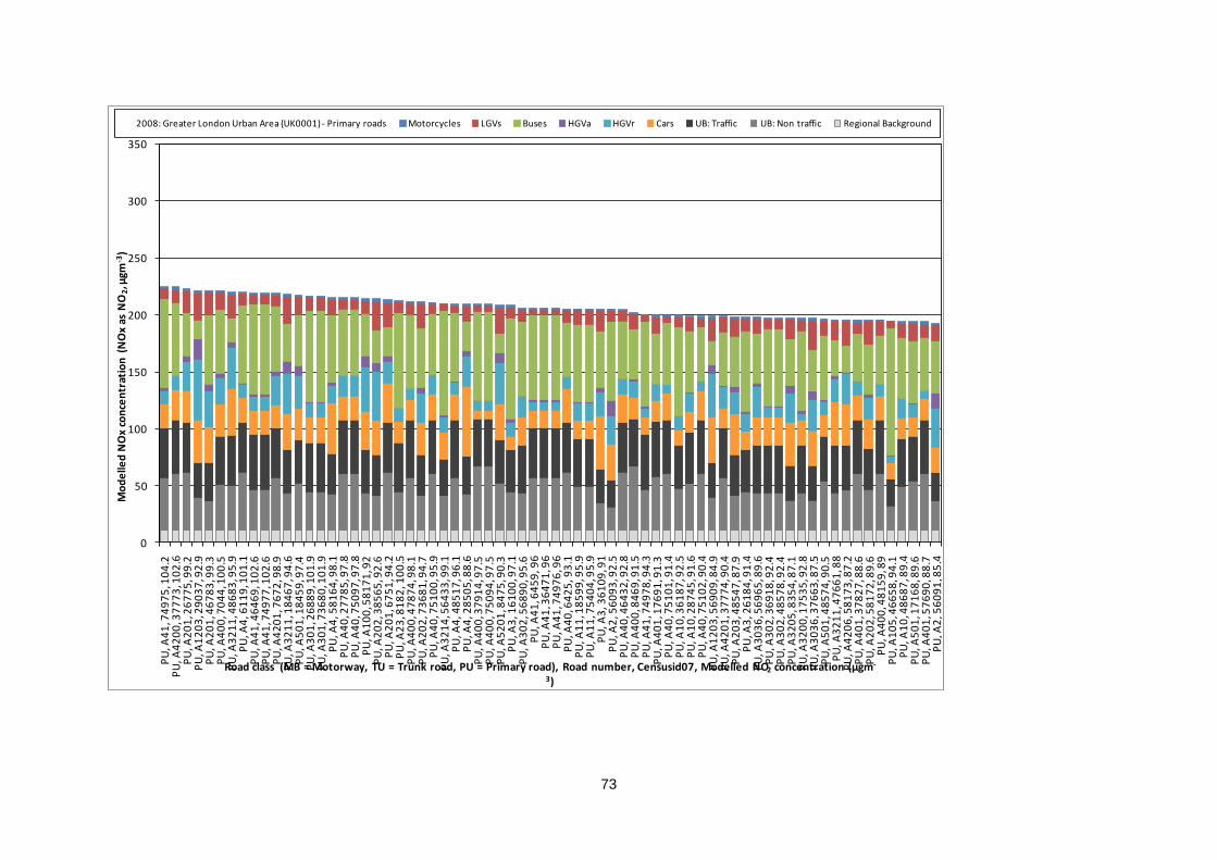
73
0
50
100
150
200
250
300
350
PU
, A4
1, 7
49
75
, 10
4.2
PU
, A4
20
0, 3
77
73
, 10
2.6
PU
, A2
01
, 26
77
5, 9
9.2
PU
, A1
20
3, 2
90
37
, 92
.9P
U, A
20
1, 4
67
83
, 99
.3P
U, A
40
0, 7
04
4, 1
00
.5P
U, A
32
11
, 48
68
3, 9
5.9
PU
, A4
, 61
19
, 10
1.1
PU
, A4
1, 4
64
69
, 10
2.6
PU
, A4
1, 7
49
77
, 10
2.6
PU
, A4
20
1, 7
67
2, 9
8.9
PU
, A3
21
1, 1
84
67
, 94
.6P
U, A
50
1, 1
84
59
, 97
.4P
U, A
30
1, 2
68
89
, 10
1.9
PU
, A3
01
, 73
68
0, 1
01
.9P
U, A
4, 5
81
64
, 98
.1P
U, A
40
, 27
78
5, 9
7.8
PU
, A4
0, 7
50
97
, 97
.8P
U, A
10
0, 5
81
71
, 92
PU
, A2
02
, 38
56
5, 9
2.6
PU
, A2
01
, 67
51
, 94
.2P
U, A
23
, 81
82
, 10
0.5
PU
, A4
00
, 47
87
4, 9
8.1
PU
, A2
02
, 73
68
1, 9
4.7
PU
, A4
0, 7
51
00
, 95
.9P
U, A
32
14
, 56
43
3, 9
9.1
PU
, A4
, 48
51
7, 9
6.1
PU
, A4
, 28
50
5, 8
8.6
PU
, A4
00
, 37
91
4, 9
7.5
PU
, A4
00
, 75
09
4, 9
7.5
PU
, A5
20
1, 8
47
5, 9
0.3
PU
, A3
, 16
10
0, 9
7.1
PU
, A3
02
, 56
89
0, 9
5.6
PU
, A4
1, 6
45
9, 9
6P
U, A
41
, 36
47
1, 9
6P
U, A
41
, 74
97
6, 9
6P
U, A
40
, 64
25
, 93
.1P
U, A
11
, 18
59
9, 9
5.9
PU
, A1
1, 7
54
04
, 95
.9P
U, A
3, 3
61
09
, 91
PU
, A2
, 56
09
3, 9
2.5
PU
, A4
0, 4
64
32
, 92
.8P
U, A
40
0, 8
46
9, 9
1.5
PU
, A4
1, 7
49
78
, 94
.3P
U, A
40
1, 1
76
91
, 91
.3P
U, A
40
, 75
10
1, 9
1.4
PU
, A1
0, 3
61
87
, 92
.5P
U, A
10
, 28
74
5, 9
1.6
PU
, A4
0, 7
51
02
, 90
.4P
U, A
12
03
, 56
90
9, 8
4.9
PU
, A4
20
1, 3
77
74
, 90
.4P
U, A
20
3, 4
85
47
, 87
.9P
U, A
3, 2
61
84
, 91
.4P
U, A
30
36
, 56
96
5, 8
9.6
PU
, A3
02
, 36
91
8, 9
2.4
PU
, A3
02
, 48
57
8, 9
2.4
PU
, A3
20
5, 8
35
4, 8
7.1
PU
, A3
20
0, 1
75
35
, 92
.8P
U, A
30
36
, 37
66
3, 8
7.5
PU
, A5
01
, 48
57
4, 9
0.5
PU
, A3
21
1, 4
76
61
, 88
PU
, A4
20
6, 5
81
73
, 87
.2P
U, A
40
1, 3
78
27
, 88
.6P
U, A
20
2, 5
81
72
, 89
.6P
U, A
40
0, 4
81
59
, 89
PU
, A1
05
, 46
65
8, 9
4.1
PU
, A1
0, 4
86
87
, 89
.4P
U, A
50
1, 1
71
68
, 89
.6P
U, A
40
1, 5
76
90
, 88
.7P
U, A
2, 5
60
91
, 85
.4
Mo
de
lled
NO
x co
nce
ntr
atio
n (
NO
x as
NO
2, µ
gm-3
)
Road class (MB = Motorway, TU = Trunk road, PU = Primary road), Road number, Censusid07, Modelled NO2 concentration (µgm-
3)
2008: Greater London Urban Area (UK0001) - Primary roads Motorcycles LGVs Buses HGVa HGVr Cars UB: Traffic UB: Non traffic Regional Background
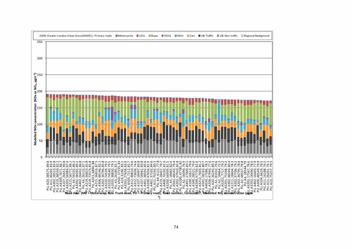
74
0
50
100
150
200
250
300
350
PU
, A2
0, 3
85
75
, 89
.8P
U, A
11
, 46
20
2, 8
3.9
PU
, A3
02
, 28
51
3, 8
5.8
PU
, A2
19
, 38
55
9, 8
2.2
PU
, A4
20
0, 7
67
1, 8
6.7
PU
, A1
07
, 26
65
1, 9
0.8
PU
, A3
20
3, 5
69
84
, 87
.4P
U, A
21
5, 5
67
71
, 89
.1P
U, A
4, 5
61
02
, 86
.3P
U, A
32
02
, 38
26
5, 8
9.2
PU
, A4
02
, 26
43
2, 8
6.8
PU
, A4
, 26
11
5, 8
7.1
PU
, A2
19
, 36
82
3, 8
5.8
PU
, A2
19
, 73
57
3, 8
5.8
PU
, A3
15
, 68
96
, 88
PU
, A2
15
, 36
81
6, 8
7.5
PU
, A3
06
, 48
14
6, 8
2.1
PU
, A2
02
, 36
79
6, 8
5.8
PU
, A3
22
0, 7
45
39
, 79
.5P
U, A
32
20
, 74
54
0, 7
9.5
PU
, A1
02
0, 3
88
30
, 79
.3P
U, A
3, 2
61
85
, 81
.7P
U, A
50
1, 5
72
35
, 83
PU
, A1
0, 6
19
0, 8
3.1
PU
, A3
20
2, 2
76
58
, 83
.9P
U, A
50
3, 7
21
2, 8
2.7
PU
, A3
12
, 48
81
0, 7
4.6
PU
, A3
12
, 73
63
6, 7
4.6
PU
, A1
07
, 18
49
7, 8
3.8
PU
, A1
07
, 56
66
1, 8
3.8
PU
, A4
01
, 38
59
2, 8
5.6
PU
, A3
20
0, 4
76
56
, 81
.9P
U, A
40
1, 3
71
02
, 84
.6P
U, A
11
, 70
19
3, 8
0.3
PU
, A4
, 61
21
, 77
.8P
U, A
21
9, 1
84
57
, 79
.7P
U, A
40
0, 7
01
92
, 81
.6P
U, A
32
00
, 56
93
9, 8
1.5
PU
, A3
, 18
46
5, 8
2.4
PU
, A5
01
, 48
54
3, 7
9.4
PU
, A2
02
, 57
91
0, 8
2.8
PU
, A5
20
0, 4
77
85
, 82
PU
, A2
, 16
09
0, 7
6.9
PU
, A4
01
, 17
00
9, 8
3.5
PU
, A1
00
, 16
61
3, 7
9.6
PU
, A1
00
, 28
52
1, 7
9.6
PU
, A4
20
9, 4
77
30
, 82
.6P
U, A
32
12
, 76
03
, 81
.2P
U, A
50
1, 5
81
63
, 80
.7P
U, A
40
20
, 17
58
6, 7
8.3
PU
, A2
06
, 47
94
3, 7
7.6
PU
, A2
0, 3
62
45
, 80
.3P
U, A
1, 8
10
32
, 79
.6P
U, A
2, 1
84
64
, 72
.3P
U, A
52
01
, 77
17
, 79
.2P
U, A
52
01
, 75
33
8, 7
9.2
PU
, A3
02
, 48
24
9, 8
0.4
PU
, A1
21
1, 1
86
04
, 78
.3P
U, A
20
2, 3
77
06
, 79
.2P
U, A
20
2, 3
67
95
, 78
.6P
U, A
2, 4
85
57
, 78
.8P
U, A
3, 2
85
44
, 79
PU
, A3
20
3, 1
75
67
, 78
.6P
U, A
32
03
, 18
49
0, 7
8.6
PU
, A4
02
, 16
40
3, 7
7.9
PU
, A2
00
, 48
54
9, 7
9.9
PU
, A1
04
, 66
29
, 78
.5P
U, A
11
, 16
18
8, 7
6.5
PU
, A1
1, 2
62
01
, 76
.1P
U, A
23
, 75
25
7, 7
9.3
Mo
de
lled
NO
x co
nce
ntr
atio
n (
NO
x as
NO
2, µ
gm-3
)
Road class (MB = Motorway, TU = Trunk road, PU = Primary road), Road number, Censusid07, Modelled NO2 concentration (µgm-
3)
2008: Greater London Urban Area (UK0001) - Primary roads Motorcycles LGVs Buses HGVa HGVr Cars UB: Traffic UB: Non traffic Regional Background
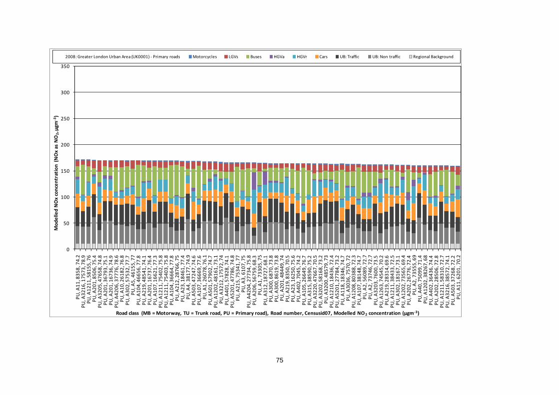
75
0
50
100
150
200
250
300
350
PU
, A1
1, 8
35
8, 7
4.2
PU
, A3
21
6, 1
75
73
, 78
.9P
U, A
12
11
, 58
15
5, 7
6P
U, A
20
1, 8
50
6, 7
5.4
PU
, A3
20
5, 4
76
58
, 74
.8P
U, A
20
1, 3
67
93
, 75
.1P
U, A
20
1, 1
67
36
, 74
.9P
U, A
42
06
, 37
77
6, 7
8.6
PU
, A1
0, 2
61
82
, 76
.8P
U, A
30
2, 5
75
32
, 77
.7P
U, A
5, 4
61
55
, 77
PU
, A1
04
, 46
65
6, 7
7.8
PU
, A2
19
, 48
54
1, 7
4.1
PU
, A2
01
, 16
73
7, 7
6.4
PU
, A1
07
, 16
62
1, 7
7.3
PU
, A1
21
1, 7
54
02
, 75
.8P
U, A
12
11
, 75
40
3, 7
5.8
PU
, A1
04
, 36
66
4, 7
7.8
PU
, A2
12
, 28
76
6, 7
5P
U, A
23
, 18
46
1, 7
7.4
PU
, A4
, 38
17
7, 7
4.9
PU
, A5
03
, 47
24
7, 7
4.6
PU
, A1
07
, 36
66
9, 7
7.6
PU
, A1
, 26
07
8, 7
6.1
PU
, A5
01
, 57
90
2, 7
4.7
PU
, A1
20
2, 4
81
61
, 73
.1P
U, A
32
12
, 17
57
2, 7
4P
U, A
40
1, 5
78
28
, 74
.1P
U, A
52
01
, 47
78
6, 7
4.8
PU
, A2
15
, 75
34
1, 7
7P
U, A
3, 6
10
7, 7
5P
U, A
42
04
, 27
73
4, 7
5.8
PU
, A2
06
, 56
75
9, 6
8.3
PU
, A1
, 73
30
5, 7
5P
U, A
31
2, 1
87
27
, 68
.1P
U, A
30
0, 6
87
0, 7
3.8
PU
, A3
00
, 86
19
, 73
.8P
U, A
20
1, 4
84
49
, 74
PU
, A2
19
, 83
50
, 70
.5P
U, A
23
, 16
25
0, 7
5.6
PU
, A4
02
, 70
45
, 74
.2P
U, A
10
5, 2
66
49
, 76
.7P
U, A
31
5, 3
85
90
, 75
.2P
U, A
32
20
, 47
66
7, 7
0.5
PU
, A3
20
2, 5
81
68
, 73
.2P
U, A
32
00
, 48
57
9, 7
3P
U, A
12
10
, 18
43
6, 7
2.4
PU
, A5
20
1, 2
77
84
, 73
.2P
U, A
11
8, 1
83
46
, 74
.7P
U, A
30
36
, 75
70
, 72
PU
, A1
20
8, 8
03
88
, 72
.3P
U, A
10
7, 3
81
48
, 74
.7P
U, A
2, 5
60
89
, 72
.7P
U, A
2, 7
37
46
, 72
.7P
U, A
32
03
, 76
00
, 73
.5P
U, A
12
63
, 74
54
5, 7
0.2
PU
, A2
19
, 28
31
4, 6
9.6
PU
, A1
21
1, 3
84
33
, 72
.5P
U, A
30
2, 1
81
67
, 73
.1P
U, A
12
02
, 73
56
5, 6
9.4
PU
, A2
02
, 26
77
6, 7
2.4
PU
, A2
, 73
55
5, 6
9P
U, A
40
, 75
09
9, 7
1.4
PU
, A1
20
2, 3
82
67
, 68
PU
, A4
02
, 36
43
6, 7
4.4
PU
, A2
02
, 28
50
6, 7
2.8
PU
, A1
21
1, 5
83
10
, 72
.7P
U, A
32
16
, 38
57
2, 7
4.1
PU
, A5
03
, 37
26
8, 7
2.2
PU
, A1
1, 6
20
1, 7
0.2
Mo
de
lled
NO
x co
nce
ntr
atio
n (
NO
x as
NO
2, µ
gm-3
)
Road class (MB = Motorway, TU = Trunk road, PU = Primary road), Road number, Censusid07, Modelled NO 2 concentration (µgm-3)
2008: Greater London Urban Area (UK0001) - Primary roads Motorcycles LGVs Buses HGVa HGVr Cars UB: Traffic UB: Non traffic Regional Background
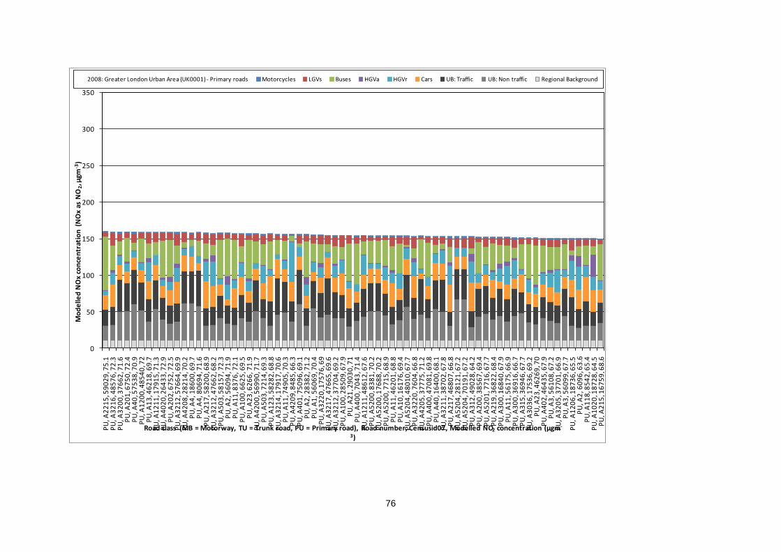
76
0
50
100
150
200
250
300
350
PU
, A2
21
5, 5
90
29
, 75
.1P
U, A
32
16
, 48
57
6, 7
2.3
PU
, A3
20
0, 3
76
62
, 71
.6P
U, A
20
1, 6
75
0, 7
2.4
PU
, A4
0, 5
75
38
, 70
.9P
U, A
12
00
, 48
54
0, 7
2P
U, A
13
, 46
21
8, 6
9.7
PU
, A1
21
1, 1
79
15
, 71
.3P
U, A
40
20
, 26
43
3, 7
2.9
PU
, A2
02
, 67
52
, 72
.5P
U, A
32
12
, 57
66
4, 6
9.9
PU
, A4
20
8, 2
82
14
, 70
.2P
U, A
4, 1
86
00
, 69
.7P
U, A
4, 8
06
94
, 71
.6P
U, A
21
7, 5
82
00
, 68
.9P
U, A
32
12
, 47
66
2, 6
8.2
PU
, A5
03
, 58
15
7, 7
2.3
PU
, A2
, 56
09
4, 7
1.9
PU
, A1
1, 8
37
6, 7
2.1
PU
, A1
00
, 66
25
, 69
.5P
U, A
23
, 62
66
, 71
.9P
U, A
42
00
, 56
99
0, 7
1.7
PU
, A5
03
, 72
14
, 69
.3P
U, A
12
3, 5
82
82
, 68
.8P
U, A
32
14
, 17
91
7, 7
0.6
PU
, A1
1, 7
49
05
, 70
.3P
U, A
42
09
, 84
85
, 66
.3P
U, A
40
1, 7
50
96
, 69
.1P
U, A
2, 2
83
82
, 71
.2P
U, A
1, 5
60
69
, 70
.4P
U, A
32
20
, 17
57
6, 6
9P
U, A
32
17
, 47
66
5, 6
9.6
PU
, A3
21
2, 3
77
04
, 69
.2P
U, A
10
0, 2
85
09
, 67
.9P
U, A
21
, 29
03
0, 7
1P
U, A
40
0, 7
04
3, 7
1.4
PU
, A1
21
1, 4
86
12
, 67
.6P
U, A
52
00
, 83
81
, 70
.2P
U, A
52
00
, 17
68
8, 7
0.2
PU
, A5
20
0, 7
71
5, 6
8.9
PU
, A1
1, 4
62
01
, 68
.8P
U, A
10
, 16
17
6, 6
9.4
PU
, A5
20
4, 4
80
10
, 67
.7P
U, A
32
20
, 76
04
, 66
.8P
U, A
42
05
, 37
77
5, 7
1.2
PU
, A4
00
, 47
08
1, 6
9.8
PU
, A4
0, 1
64
00
, 68
.1P
U, A
32
11
, 38
70
2, 6
7.8
PU
, A2
17
, 46
80
7, 6
6.8
PU
, A5
20
4, 2
81
21
, 67
.2P
U, A
52
04
, 70
19
1, 6
7.2
PU
, A3
12
, 49
02
8, 6
4.2
PU
, A2
00
, 38
56
7, 6
9.4
PU
, A5
20
1, 7
71
6, 6
7.7
PU
, A2
19
, 36
82
2, 6
8.4
PU
, A3
00
, 16
84
0, 6
7.9
PU
, A1
1, 5
61
75
, 66
.9P
U, A
30
0, 3
69
16
, 66
.7P
U, A
31
5, 3
69
46
, 67
.7P
U, A
30
36
, 17
53
6, 6
9.2
PU
, A2
3, 4
62
69
, 70
PU
, A4
02
, 46
43
5, 6
7.9
PU
, A3
, 56
10
8, 6
7.2
PU
, A3
20
5, 3
77
01
, 66
.9P
U, A
3, 5
60
99
, 67
.7P
U, A
12
06
, 18
73
6, 6
5.5
PU
, A2
, 60
96
, 63
.6P
U, A
11
8, 8
54
2, 6
5.4
PU
, A1
02
0, 1
87
28
, 64
.5P
U, A
21
5, 1
67
59
, 68
.6
Mo
de
lled
NO
x co
nce
ntr
atio
n (
NO
x as
NO
2, µ
gm-3
)
Road class (MB = Motorway, TU = Trunk road, PU = Primary road), Road number, Censusid07, Modelled NO2 concentration (µgm-
3)
2008: Greater London Urban Area (UK0001) - Primary roads Motorcycles LGVs Buses HGVa HGVr Cars UB: Traffic UB: Non traffic Regional Background
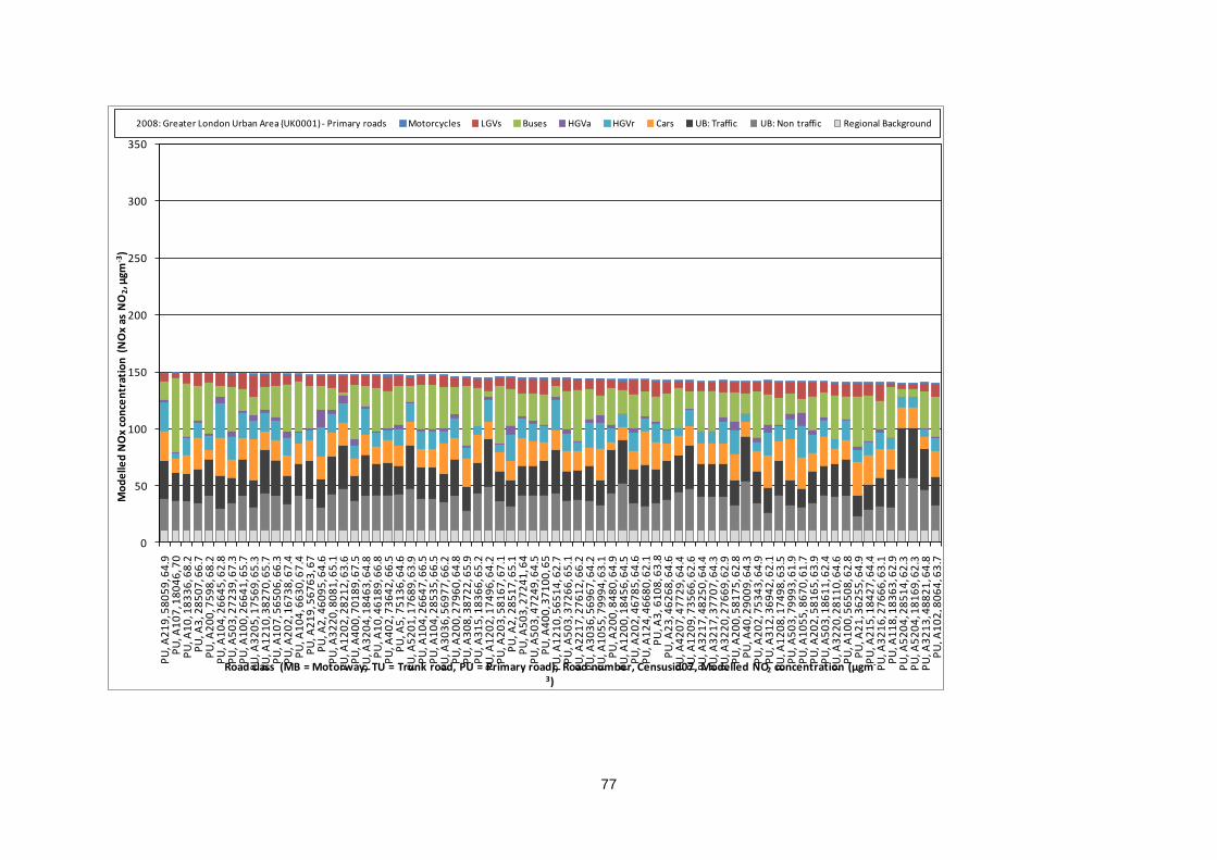
77
0
50
100
150
200
250
300
350
PU
, A2
19
, 58
05
9, 6
4.9
PU
, A1
07
, 18
04
6, 7
0P
U, A
10
, 18
33
6, 6
8.2
PU
, A3
, 28
50
7, 6
6.7
PU
, A2
00
, 75
98
, 68
.2P
U, A
10
4, 2
66
45
, 62
.8P
U, A
50
3, 2
72
39
, 67
.3P
U, A
10
0, 2
66
41
, 65
.7P
U, A
32
05
, 17
56
9, 6
5.3
PU
, A1
21
0, 3
82
70
, 65
.7P
U, A
10
7, 5
65
06
, 66
.3P
U, A
20
2, 1
67
38
, 67
.4P
U, A
10
4, 6
63
0, 6
7.4
PU
, A2
19
, 56
76
3, 6
7P
U, A
2, 4
60
95
, 64
.6P
U, A
32
20
, 80
81
, 65
.1P
U, A
12
02
, 28
21
2, 6
3.6
PU
, A4
00
, 70
18
9, 6
7.5
PU
, A3
20
4, 1
84
63
, 64
.8P
U, A
10
, 46
18
9, 6
6.8
PU
, A4
02
, 73
64
2, 6
6.5
PU
, A5
, 75
13
6, 6
4.6
PU
, A5
20
1, 1
76
89
, 63
.9P
U, A
10
4, 2
66
47
, 66
.5P
U, A
10
4, 2
85
35
, 66
.5P
U, A
30
36
, 56
97
7, 6
6.2
PU
, A2
00
, 27
96
0, 6
4.8
PU
, A3
08
, 38
72
2, 6
5.9
PU
, A3
15
, 18
36
6, 6
5.2
PU
, A1
20
2, 1
74
96
, 64
.2P
U, A
20
3, 5
81
67
, 67
.1P
U, A
2, 2
85
17
, 65
.1P
U, A
50
3, 2
72
41
, 64
PU
, A5
03
, 47
24
9, 6
4.5
PU
, A4
00
, 37
10
0, 6
5P
U, A
12
10
, 56
51
4, 6
2.7
PU
, A5
03
, 37
26
6, 6
5.1
PU
, A2
21
7, 2
76
12
, 66
.2P
U, A
30
36
, 56
96
7, 6
4.2
PU
, A1
05
5, 7
99
94
, 63
.1P
U, A
20
0, 8
48
0, 6
4.9
PU
, A1
20
0, 1
84
56
, 64
.5P
U, A
20
2, 4
67
85
, 64
.6P
U, A
12
4, 4
66
80
, 62
.1P
U, A
3, 6
10
8, 6
3.8
PU
, A2
3, 4
62
68
, 64
.6P
U, A
42
07
, 47
72
9, 6
4.4
PU
, A1
20
9, 7
35
66
, 62
.6P
U, A
32
17
, 48
25
0, 6
4.4
PU
, A3
21
7, 3
77
07
, 64
.3P
U, A
32
20
, 27
66
9, 6
2.9
PU
, A2
00
, 58
17
5, 6
2.8
PU
, A4
0, 2
90
09
, 64
.3P
U, A
20
2, 7
53
43
, 64
.9P
U, A
31
2, 3
69
42
, 62
.1P
U, A
12
08
, 17
49
8, 6
3.5
PU
, A5
03
, 79
99
3, 6
1.9
PU
, A1
05
5, 8
67
0, 6
1.7
PU
, A2
02
, 58
16
5, 6
3.9
PU
, A5
03
, 18
61
1, 6
2.4
PU
, A3
22
0, 2
81
10
, 64
.6P
U, A
10
0, 5
65
08
, 62
.8P
U, A
21
, 36
25
5, 6
4.9
PU
, A2
15
, 18
42
7, 6
4.4
PU
, A3
21
6, 2
76
66
, 63
.1P
U, A
11
8, 1
83
63
, 62
.9P
U, A
52
04
, 28
51
4, 6
2.3
PU
, A5
20
4, 1
81
69
, 62
.3P
U, A
32
13
, 48
82
1, 6
4.8
PU
, A1
02
, 80
64
, 63
.7
Mo
de
lled
NO
x co
nce
ntr
atio
n (
NO
x as
NO
2, µ
gm-3
)
Road class (MB = Motorway, TU = Trunk road, PU = Primary road), Road number, Censusid07, Modelled NO2 concentration (µgm-
3)
2008: Greater London Urban Area (UK0001) - Primary roads Motorcycles LGVs Buses HGVa HGVr Cars UB: Traffic UB: Non traffic Regional Background
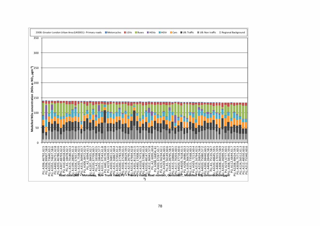
78
0
50
100
150
200
250
300
350
PU
, A2
06
, 46
79
2, 6
2.5
PU
, A2
06
, 99
90
7, 5
8.8
PU
, A3
22
0, 7
36
40
, 63
.2P
U, A
10
55
, 74
63
7, 5
8.6
PU
, A4
00
, 56
75
1, 6
2.8
PU
, A2
03
, 46
78
6, 6
3.6
PU
, A3
07
, 48
70
3, 6
2.4
PU
, A1
0, 4
84
18
, 63
.6P
U, A
5, 1
84
78
, 62
.7P
U, A
31
5, 7
01
80
, 63
.3P
U, A
11
99
, 28
09
1, 6
1.3
PU
, A3
20
4, 5
76
57
, 60
.6P
U, A
12
01
, 75
38
, 62
.5P
U, A
31
5, 3
69
45
, 63
.7P
U, A
30
6, 8
47
2, 6
2.9
PU
, A2
, 60
94
, 61
.3P
U, A
12
07
, 38
43
5, 6
2.7
PU
, A3
22
0, 3
77
09
, 60
.7P
U, A
2, 1
83
38
, 62
.5P
U, A
10
55
, 18
64
8, 5
7.7
PU
, A1
01
1, 3
75
43
, 61
.8P
U, A
40
, 18
17
0, 6
0.8
PU
, A2
19
, 64
28
, 61
.1P
U, A
50
3, 5
68
11
, 61
.4P
U, A
31
5, 1
68
67
, 60
.4P
U, A
12
01
, 57
30
2, 6
1.2
PU
, A5
20
0, 2
77
83
, 59
.8P
U, A
50
3, 2
72
40
, 61
.5P
U, A
11
8, 3
86
29
, 59
.5P
U, A
21
5, 2
67
95
, 62
.2P
U, A
32
16
, 47
66
4, 6
2.8
PU
, A3
01
, 81
11
9, 6
1.5
PU
, A4
00
, 17
00
8, 6
1.3
PU
, A1
01
0, 7
47
3, 6
3.2
PU
, A4
00
, 57
08
0, 6
1.8
PU
, A3
22
0, 4
81
47
, 60
.3P
U, A
31
2, 3
69
43
, 57
.8P
U, A
2, 6
09
5, 6
0.6
PU
, A3
08
, 16
85
4, 6
1P
U, A
50
3, 3
72
67
, 61
.7P
U, A
23
, 56
23
4, 6
2.1
PU
, A5
20
3, 8
28
5, 6
0.5
PU
, A5
, 56
14
9, 6
0.6
PU
, A1
05
5, 2
87
95
, 58
.3P
U, A
31
5, 1
68
66
, 60
.7P
U, A
11
7, 7
02
03
, 60
.5P
U, A
40
20
, 37
71
8, 6
0.6
PU
, A4
02
0, 7
61
8, 6
1.5
PU
, A2
06
, 84
86
, 60
.3P
U, A
10
5, 3
66
70
, 62
.2P
U, A
31
5, 7
35
68
, 60
.3P
U, A
50
3, 7
21
3, 6
0.4
PU
, A2
19
, 16
76
4, 6
2.5
PU
, A2
32
, 26
82
4, 5
6.8
PU
, A4
02
0, 7
50
80
, 57
.2P
U, A
20
0, 3
84
40
, 60
.5P
U, A
40
4, 2
84
96
, 58
.2P
U, A
5, 7
51
35
, 58
.7P
U, A
32
20
, 48
64
5, 5
9.5
PU
, A4
04
, 17
01
5, 5
9.9
PU
, A3
08
, 46
91
0, 5
8.9
PU
, A3
20
1, 2
60
99
, 59
.2P
U, A
21
9, 6
77
7, 6
0.5
PU
, A3
08
, 58
19
5, 5
9.6
PU
, A1
12
, 66
44
, 61
.7P
U, A
22
08
, 48
42
4, 5
9.3
PU
, A3
03
6, 7
57
1, 6
0.3
PU
, A1
24
, 56
51
2, 6
1.3
PU
, A2
12
, 48
55
0, 6
0.6
PU
, A2
12
, 75
34
0, 6
0.6
Mo
de
lled
NO
x co
nce
ntr
atio
n (
NO
x as
NO
2, µ
gm-3
)
Road class (MB = Motorway, TU = Trunk road, PU = Primary road), Road number, Censusid07, Modelled NO2 concentration (µgm-
3)
2008: Greater London Urban Area (UK0001) - Primary roads Motorcycles LGVs Buses HGVa HGVr Cars UB: Traffic UB: Non traffic Regional Background
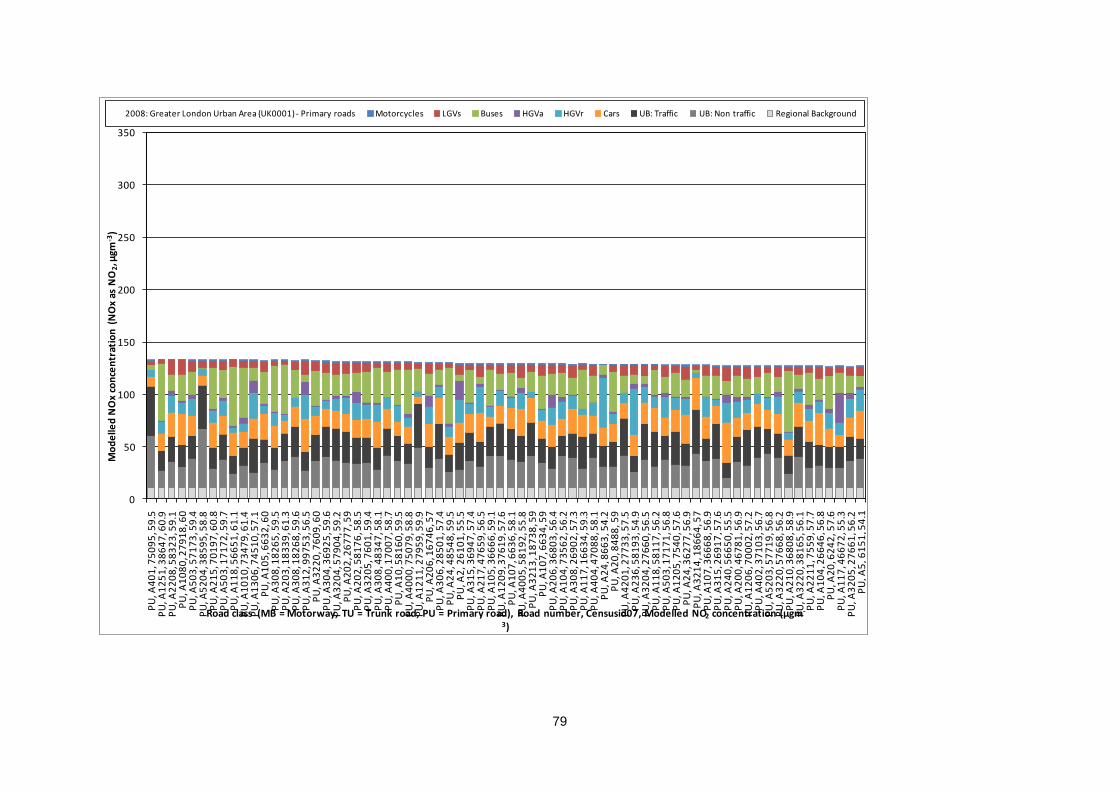
79
0
50
100
150
200
250
300
350
PU
, A4
01
, 75
09
5, 5
9.5
PU
, A1
25
1, 3
86
47
, 60
.9P
U, A
22
08
, 58
32
3, 5
9.1
PU
, A1
08
0, 2
79
18
, 60
PU
, A5
03
, 57
17
3, 5
9.4
PU
, A5
20
4, 3
85
95
, 58
.8P
U, A
21
5, 7
01
97
, 60
.8P
U, A
50
3, 1
71
72
, 59
.7P
U, A
11
8, 5
66
51
, 61
.1P
U, A
10
10
, 73
47
9, 6
1.4
PU
, A1
30
6, 7
45
10
, 57
.1P
U, A
10
5, 6
63
2, 6
0P
U, A
30
8, 1
82
65
, 59
.5P
U, A
20
3, 1
83
39
, 61
.3P
U, A
30
8, 1
82
68
, 59
.6P
U, A
31
2, 9
97
53
, 56
.5P
U, A
32
20
, 76
09
, 60
PU
, A3
04
, 36
92
5, 5
9.6
PU
, A3
20
4, 5
79
04
, 59
.2P
U, A
20
2, 2
67
77
, 59
PU
, A2
02
, 58
17
6, 5
8.5
PU
, A3
20
5, 7
60
1, 5
9.4
PU
, A3
08
, 48
34
7, 5
8.1
PU
, A4
00
, 17
00
7, 5
8.7
PU
, A1
0, 5
81
60
, 59
.5P
U, A
40
00
, 75
07
9, 5
8.8
PU
, A1
21
1, 2
79
59
, 59
.9P
U, A
20
6, 1
67
46
, 57
PU
, A3
06
, 28
50
1, 5
7.4
PU
, A2
4, 4
85
48
, 59
.5P
U, A
2, 2
61
01
, 55
.5P
U, A
31
5, 3
69
47
, 57
.4P
U, A
21
7, 4
76
59
, 56
.5P
U, A
10
5, 3
66
66
, 59
.1P
U, A
12
09
, 37
61
9, 5
7.6
PU
, A1
07
, 66
36
, 58
.1P
U, A
40
05
, 58
19
2, 5
5.8
PU
, A3
21
3, 1
87
38
, 59
PU
, A1
07
, 66
34
, 59
PU
, A2
06
, 36
80
3, 5
6.4
PU
, A1
04
, 73
56
2, 5
6.2
PU
, A3
08
, 26
90
2, 5
7.3
PU
, A1
17
, 16
63
4, 5
9.3
PU
, A4
04
, 47
08
8, 5
8.1
PU
, A2
4, 8
66
3, 5
4.2
PU
, A2
0, 8
48
8, 5
9P
U, A
42
01
, 27
73
3, 5
7.5
PU
, A2
36
, 58
19
3, 5
4.9
PU
, A3
20
4, 2
76
60
, 56
.5P
U, A
11
8, 5
81
17
, 56
.2P
U, A
50
3, 1
71
71
, 56
.8P
U, A
12
05
, 75
40
, 57
.6P
U, A
24
, 36
27
7, 5
6.9
PU
, A3
21
4, 1
86
64
, 57
PU
, A1
07
, 36
66
8, 5
6.9
PU
, A3
15
, 26
91
7, 5
7.6
PU
, A2
40
, 56
65
0, 5
5.5
PU
, A2
00
, 46
78
1, 5
6.9
PU
, A1
20
6, 7
00
02
, 57
.2P
U, A
40
2, 3
71
03
, 56
.7P
U, A
52
03
, 57
71
9, 5
6.8
PU
, A3
22
0, 5
76
68
, 56
.2P
U, A
21
0, 3
68
08
, 58
.9P
U, A
32
20
, 38
16
5, 5
6.1
PU
, A2
21
1, 7
55
9, 5
7.7
PU
, A1
04
, 26
64
6, 5
6.8
PU
, A2
0, 6
24
2, 5
7.6
PU
, A1
17
, 46
67
2, 5
5.3
PU
, A3
20
5, 2
76
61
, 56
.2P
U, A
5, 6
15
1, 5
4.1
Mo
de
lled
NO
x co
nce
ntr
atio
n (
NO
x as
NO
2, µ
gm-3
)
Road class (MB = Motorway, TU = Trunk road, PU = Primary road), Road number, Censusid07, Modelled NO2 concentration (µgm-
3)
2008: Greater London Urban Area (UK0001) - Primary roads Motorcycles LGVs Buses HGVa HGVr Cars UB: Traffic UB: Non traffic Regional Background
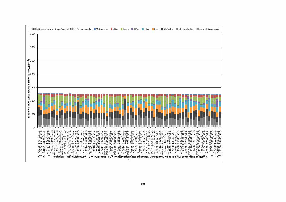
80
0
50
100
150
200
250
300
350
PU
, A4
20
6, 1
76
40
, 57
.8P
U, A
40
4, 1
84
52
, 54
.8P
U, A
10
55
, 58
39
2, 5
3.1
PU
, A4
04
, 17
01
4, 5
7.1
PU
, A1
24
, 75
29
1, 5
7.7
PU
, A5
03
, 28
49
8, 5
6.8
PU
, A1
20
3, 5
90
36
, 56
PU
, A3
07
, 56
92
9, 5
7.8
PU
, A3
20
7, 7
00
20
, 58
.4P
U, A
40
4, 8
46
7, 5
4.7
PU
, A2
19
, 26
80
3, 5
7P
U, A
32
17
, 76
06
, 57
PU
, A4
00
5, 7
61
3, 5
4.9
PU
, A3
21
8, 1
75
75
, 57
.7P
U, A
20
0, 3
67
92
, 56
.3P
U, A
20
0, 7
01
94
, 56
.6P
U, A
10
3, 3
85
60
, 57
.5P
U, A
22
08
, 47
60
4, 5
6.1
PU
, A2
14
, 26
79
4, 5
4.8
PU
, A2
05
, 16
09
1, 5
3.8
PU
, A3
, 56
18
6, 5
6.9
PU
, A2
18
, 46
81
1, 5
6.2
PU
, A2
02
, 84
78
, 56
PU
, A1
02
0, 4
90
07
, 54
.6P
U, A
21
4, 7
49
08
, 54
.7P
U, A
11
, 28
40
6, 5
6.6
PU
, A2
21
, 86
64
, 58
.3P
U, A
5, 5
61
24
, 56
.2P
U, A
32
16
, 76
05
, 57
.1P
U, A
10
, 38
43
4, 5
6.5
PU
, A1
07
, 46
66
0, 5
6.3
PU
, A5
98
, 57
07
8, 5
6.7
PU
, A2
12
, 46
79
8, 5
6.3
PU
, A4
20
1, 7
01
90
, 55
.9P
U, A
11
, 57
91
1, 5
5.7
PU
, A5
20
2, 8
07
22
, 56
.6P
U, A
22
08
, 37
64
6, 5
5.3
PU
, A3
05
, 56
69
1, 5
5.3
PU
, A5
20
3, 3
78
29
, 55
.3P
U, A
42
09
, 48
42
8, 5
5.4
PU
, A5
03
, 73
56
3, 5
5.4
PU
, A3
21
7, 2
76
67
, 55
.9P
U, A
11
2, 5
64
89
, 55
PU
, A1
12
, 58
17
8, 5
5P
U, A
30
8, 1
68
55
, 55
PU
, A3
22
0, 1
80
66
, 54
.6P
U, A
11
8, 4
87
02
, 53
.5P
U, A
20
, 38
43
7, 5
7.1
PU
, A2
1, 8
73
7, 5
5.9
PU
, A2
19
, 46
81
2, 5
5.7
PU
, A4
02
0, 2
70
92
, 54
.4P
U, A
20
0, 1
83
42
, 54
.3P
U, A
40
88
, 57
65
6, 5
4.4
PU
, A3
08
, 26
90
3, 5
5.3
PU
, A1
06
, 38
14
7, 5
2.5
PU
, A3
, 61
09
, 55
.2P
U, A
32
20
, 57
35
1, 5
4.4
PU
, A2
2, 1
85
90
, 51
.8P
U, A
22
09
, 84
87
, 53
.8P
U, A
40
8, 3
71
18
, 53
.8P
U, A
40
4, 7
05
2, 5
3.3
PU
, A2
36
, 36
84
6, 5
3.6
PU
, A3
15
, 68
97
, 56
PU
, A1
04
, 56
65
5, 5
3.9
PU
, A3
22
0, 2
76
68
, 54
.2P
U, A
24
, 84
79
, 52
.2P
U, A
20
3, 5
67
39
, 55
.5P
U, A
20
0, 1
67
35
, 55
.6P
U, A
10
55
, 16
61
7, 5
2.8
PU
, A2
00
, 38
46
3, 5
4.5
Mo
de
lled
NO
x co
nce
ntr
atio
n (
NO
x as
NO
2, µ
gm-3
)
Road class (MB = Motorway, TU = Trunk road, PU = Primary road), Road number, Censusid07, Modelled NO2 concentration (µgm-
3)
2008: Greater London Urban Area (UK0001) - Primary roads Motorcycles LGVs Buses HGVa HGVr Cars UB: Traffic UB: Non traffic Regional Background
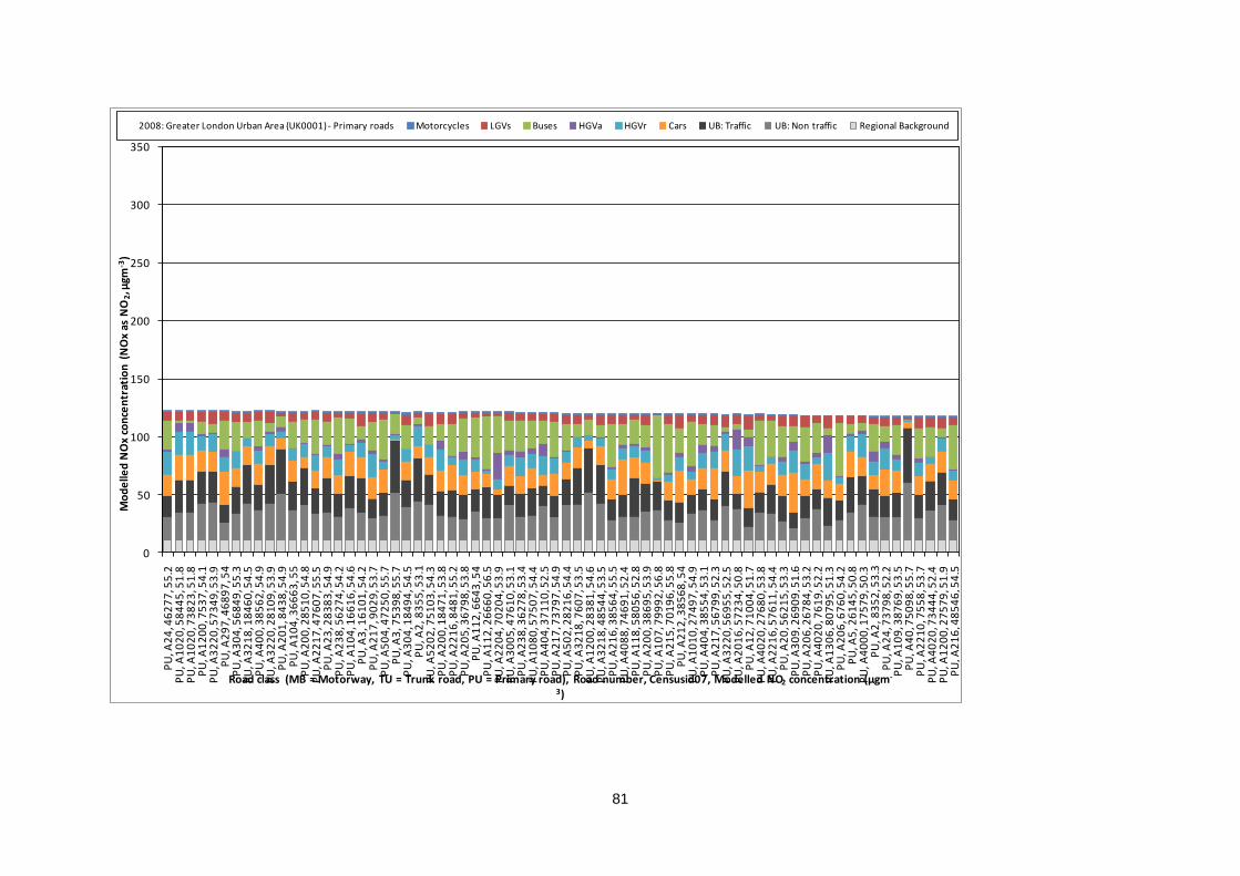
81
0
50
100
150
200
250
300
350
PU
, A2
4, 4
62
77
, 55
.2P
U, A
10
20
, 58
44
5, 5
1.8
PU
, A1
02
0, 7
38
23
, 51
.8P
U, A
12
00
, 75
37
, 54
.1P
U, A
32
20
, 57
34
9, 5
3.9
PU
, A2
97
, 46
89
7, 5
4P
U, A
30
4, 5
68
49
, 55
.3P
U, A
32
18
, 18
46
0, 5
4.5
PU
, A4
00
, 38
56
2, 5
4.9
PU
, A3
22
0, 2
81
09
, 53
.9P
U, A
20
1, 8
43
8, 5
4.9
PU
, A1
04
, 36
66
3, 5
5P
U, A
20
0, 2
85
10
, 54
.8P
U, A
22
17
, 47
60
7, 5
5.5
PU
, A2
3, 2
83
83
, 54
.9P
U, A
23
8, 5
62
74
, 54
.2P
U, A
10
4, 1
66
16
, 54
.6P
U, A
3, 1
61
01
, 54
.2P
U, A
21
7, 9
02
9, 5
3.7
PU
, A5
04
, 47
25
0, 5
5.7
PU
, A3
, 75
39
8, 5
5.7
PU
, A3
04
, 18
49
4, 5
4.5
PU
, A2
, 83
55
, 53
.1P
U, A
52
02
, 75
10
3, 5
4.3
PU
, A2
00
, 18
47
1, 5
3.8
PU
, A2
21
6, 8
48
1, 5
5.2
PU
, A2
05
, 36
79
8, 5
3.8
PU
, A1
12
, 66
43
, 54
PU
, A1
12
, 26
66
0, 5
6.5
PU
, A2
20
4, 7
02
04
, 53
.9P
U, A
30
05
, 47
61
0, 5
3.1
PU
, A2
38
, 36
27
8, 5
3.4
PU
, A1
08
0, 5
75
07
, 54
.4P
U, A
40
4, 3
71
10
, 52
.5P
U, A
21
7, 7
37
97
, 54
.9P
U, A
50
2, 2
82
16
, 54
.4P
U, A
32
18
, 76
07
, 53
.5P
U, A
12
00
, 28
38
1, 5
4.6
PU
, A3
21
8, 4
85
44
, 53
.5P
U, A
21
6, 3
85
64
, 55
.5P
U, A
40
88
, 74
69
1, 5
2.4
PU
, A1
18
, 58
05
6, 5
2.8
PU
, A2
00
, 38
69
5, 5
3.9
PU
, A1
07
, 79
99
2, 5
6.8
PU
, A2
15
, 70
19
6, 5
5.8
PU
, A2
12
, 38
56
8, 5
4P
U, A
10
10
, 27
49
7, 5
4.9
PU
, A4
04
, 38
55
4, 5
3.1
PU
, A2
17
, 56
79
9, 5
2.3
PU
, A3
22
0, 5
69
55
, 52
.5P
U, A
20
16
, 57
23
4, 5
0.8
PU
, A1
2, 7
10
04
, 51
.7P
U, A
40
20
, 27
68
0, 5
3.8
PU
, A2
21
6, 5
76
11
, 54
.4P
U, A
20
, 56
21
5, 5
3.3
PU
, A3
09
, 26
90
9, 5
1.6
PU
, A2
06
, 26
78
4, 5
3.2
PU
, A4
02
0, 7
61
9, 5
2.2
PU
, A1
30
6, 8
07
95
, 51
.3P
U, A
20
6, 6
76
0, 5
4.2
PU
, A5
, 26
14
5, 5
0.8
PU
, A4
00
0, 1
75
79
, 50
.3P
U, A
2, 8
35
2, 5
3.3
PU
, A2
4, 7
37
98
, 52
.2P
U, A
10
9, 3
87
69
, 53
.5P
U, A
40
, 75
09
8, 5
5.7
PU
, A2
21
0, 7
55
8, 5
3.7
PU
, A4
02
0, 7
34
44
, 52
.4P
U, A
12
00
, 27
57
9, 5
1.9
PU
, A2
16
, 48
54
6, 5
4.5
Mo
de
lled
NO
x co
nce
ntr
atio
n (
NO
x as
NO
2, µ
gm-3
)
Road class (MB = Motorway, TU = Trunk road, PU = Primary road), Road number, Censusid07, Modelled NO2 concentration (µgm-
3)
2008: Greater London Urban Area (UK0001) - Primary roads Motorcycles LGVs Buses HGVa HGVr Cars UB: Traffic UB: Non traffic Regional Background

82
0
50
100
150
200
250
300
350
PU
, A1
01
0, 3
75
42
, 51
.8P
U, A
12
4, 1
84
34
, 53
.1P
U, A
30
8, 4
87
04
, 50
.8P
U, A
31
2, 7
01
71
, 50
.4P
U, A
31
2, 7
36
35
, 50
.4P
U, A
12
01
, 85
07
, 54
.4P
U, A
21
4, 4
68
04
, 51
.6P
U, A
42
01
, 38
55
5, 5
2.3
PU
, A2
02
, 57
90
3, 5
3.2
PU
, A2
01
6, 4
79
42
, 50
.3P
U, A
52
05
, 27
78
7, 5
2.1
PU
, A2
19
, 46
81
3, 5
3.3
PU
, A4
12
7, 5
70
79
, 50
.2P
U, A
31
2, 1
68
63
, 51
.7P
U, A
30
06
, 17
52
7, 5
1.8
PU
, A5
20
3, 2
77
86
, 52
.6P
U, A
22
16
, 37
64
9, 5
3.5
PU
, A1
02
0, 5
84
44
, 50
.3P
U, A
20
4, 3
67
97
, 53
.3P
U, A
11
, 38
43
9, 5
2.5
PU
, A2
21
4, 2
76
10
, 53
.3P
U, A
21
98
, 58
16
9, 5
1.2
PU
, A3
15
, 70
17
4, 5
1.5
PU
, A1
12
, 36
67
6, 5
3.1
PU
, A4
1, 7
49
73
, 53
PU
, A1
01
, 73
96
1, 5
1.6
PU
, A3
21
7, 7
36
41
, 51
.8P
U, A
11
2, 4
66
69
, 52
.7P
U, A
32
02
, 75
99
, 51
.8P
U, A
30
7, 2
69
00
, 53
.4P
U, A
42
00
, 38
36
8, 5
2.3
PU
, A1
20
2, 5
77
55
, 51
.4P
U, A
40
0, 4
83
52
, 51
PU
, A4
00
0, 2
76
71
, 49
.7P
U, A
21
98
, 80
95
, 51
PU
, A3
21
6, 5
77
05
, 53
.2P
U, A
23
5, 6
80
1, 5
2.1
PU
, A1
09
, 66
38
, 51
.6P
U, A
12
4, 1
78
65
, 51
.2P
U, A
11
5, 7
35
60
, 51
.1P
U, A
30
2, 2
82
11
, 51
.8P
U, A
40
00
, 47
67
1, 4
9.2
PU
, A3
21
8, 3
77
08
, 52
.3P
U, A
52
02
, 47
26
9, 5
0.1
PU
, A1
24
, 26
67
2, 5
1.9
PU
, A1
06
, 56
61
9, 5
0.6
PU
, A5
02
, 37
26
4, 5
1.3
PU
, A2
00
, 26
77
3, 5
0.7
PU
, A4
00
0, 1
84
92
, 49
.5P
U, A
50
2, 1
71
70
, 51
.7P
U, A
31
5, 5
68
69
, 50
.2P
U, A
10
5, 2
85
32
, 51
.2P
U, A
20
0, 3
84
41
, 51
.3P
U, A
24
, 48
72
6, 4
9.6
PU
, A2
01
6, 5
83
69
, 49
.1P
U, A
52
05
, 47
78
8, 5
0.4
PU
, A1
05
, 73
56
4, 5
0.9
PU
, A2
96
, 28
44
3, 4
8.2
PU
, A4
07
, 70
61
, 49
.6P
U, A
40
20
, 37
71
9, 4
9P
U, A
12
05
, 73
55
8, 5
0.6
PU
, A3
00
, 56
89
9, 5
1.5
PU
, A3
05
, 16
85
1, 5
1.1
PU
, A3
, 75
39
9, 5
1.5
PU
, A1
18
, 26
66
4, 5
1.1
PU
, A2
20
9, 2
85
16
, 49
.1P
U, A
24
, 74
02
1, 5
0.4
PU
, A4
12
7, 1
76
14
, 48
.6P
U, A
11
8, 6
65
0, 5
0.9
PU
, A5
04
, 27
24
2, 5
0.9
Mo
de
lled
NO
x co
nce
ntr
atio
n (
NO
x as
NO
2, µ
gm-3
)
Road class (MB = Motorway, TU = Trunk road, PU = Primary road), Road number, Censusid07, Modelled NO2 concentration (µgm-
3)
2008: Greater London Urban Area (UK0001) - Primary roads Motorcycles LGVs Buses HGVa HGVr Cars UB: Traffic UB: Non traffic Regional Background
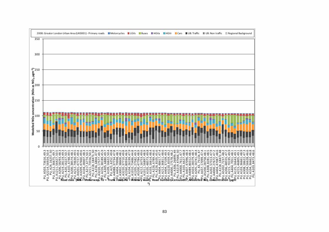
83
0
50
100
150
200
250
300
350
PU
, A5
03
, 73
61
6, 4
9.3
PU
, A2
21
4, 5
69
24
, 50
.4P
U, A
24
, 16
25
7, 5
0P
U, A
11
2, 3
66
75
, 49
.7P
U, A
12
11
, 56
42
7, 5
0.5
PU
, A2
06
, 58
29
3, 4
8.3
PU
, A2
19
, 28
11
9, 4
9.3
PU
, A2
0, 1
62
27
, 50
.7P
U, A
10
1, 6
74
8, 4
9.5
PU
, A2
00
, 38
57
4, 4
8.1
PU
, A2
12
, 74
63
0, 4
9.5
PU
, A4
20
1, 4
77
27
, 49
.4P
U, A
32
09
, 47
66
0, 4
9.6
PU
, A1
04
, 28
40
7, 4
8.3
PU
, A2
17
, 67
74
, 50
.1P
U, A
22
11
, 73
55
6, 5
0.3
PU
, A1
18
, 18
47
3, 5
0P
U, A
23
6, 6
80
4, 4
7.8
PU
, A3
22
0, 1
75
77
, 49
.7P
U, A
22
6, 3
81
89
, 45
.9P
U, A
30
5, 6
88
0, 4
9.7
PU
, A1
09
, 16
62
2, 5
0.4
PU
, A2
1, 6
25
2, 4
9.8
PU
, A4
08
8, 3
77
34
, 47
.8P
U, A
40
4, 7
99
98
, 48
.1P
U, A
30
02
, 38
60
0, 4
8.2
PU
, A3
22
0, 3
77
10
, 49
.8P
U, A
22
60
, 80
93
4, 4
6.9
PU
, A1
04
, 26
19
9, 4
7.9
PU
, A1
01
0, 7
34
86
, 44
.8P
U, A
12
05
, 27
58
2, 4
9.3
PU
, A5
20
0, 4
77
84
, 48
.9P
U, A
21
2, 1
67
53
, 49
.6P
U, A
10
11
, 56
89
7, 4
8.9
PU
, A1
05
, 48
57
3, 4
9.8
PU
, A1
03
, 16
61
4, 4
8.4
PU
, A2
26
, 67
89
, 46
.6P
U, A
22
6, 8
10
5, 4
5.6
PU
, A4
04
, 48
41
7, 4
7.4
PU
, A2
12
, 36
81
1, 4
8.6
PU
, A4
04
, 37
10
9, 4
9.3
PU
, A3
22
0, 8
35
9, 4
9.2
PU
, A4
00
0, 1
75
78
, 48
.2P
U, A
30
6, 2
68
99
, 49
PU
, A3
21
9, 4
76
66
, 50
PU
, A4
00
0, 7
61
1, 4
7.7
PU
, A1
03
, 66
27
, 48
.8P
U, A
40
7, 4
70
96
, 48
.3P
U, A
40
89
, 80
31
2, 4
8.4
PU
, A5
03
, 28
37
9, 4
8.7
PU
, A2
05
, 16
74
1, 4
8.4
PU
, A5
, 75
13
4, 4
7P
U, A
43
7, 1
70
99
, 47
.4P
U, A
52
00
, 28
75
8, 4
8.1
PU
, A3
08
, 82
81
, 48
.5P
U, A
20
2, 5
73
13
, 47
.9P
U, A
40
00
, 27
67
2, 4
7.2
PU
, A4
04
, 47
08
7, 4
8.6
PU
, A1
18
, 18
47
2, 4
8P
U, A
52
02
, 72
37
, 48
.2P
U, A
20
6, 4
85
55
, 47
.2P
U, A
21
5, 7
01
95
, 49
.9P
U, A
40
4, 7
05
1, 4
8.1
PU
, A1
25
, 16
64
3, 4
9.1
PU
, A2
15
, 46
80
5, 4
9.1
PU
, A1
03
, 36
66
1, 4
8.9
PU
, A3
08
, 18
62
2, 4
7.3
PU
, A1
04
, 56
62
8, 4
6.6
PU
, A1
04
, 36
66
2, 4
6.8
PU
, A1
03
, 84
73
, 48
.6
Mo
de
lled
NO
x co
nce
ntr
atio
n (
NO
x as
NO
2, µ
gm-3
)
Road class (MB = Motorway, TU = Trunk road, PU = Primary road), Road number, Censusid07, Modelled NO2 concentration (µgm-
3)
2008: Greater London Urban Area (UK0001) - Primary roads Motorcycles LGVs Buses HGVa HGVr Cars UB: Traffic UB: Non traffic Regional Background
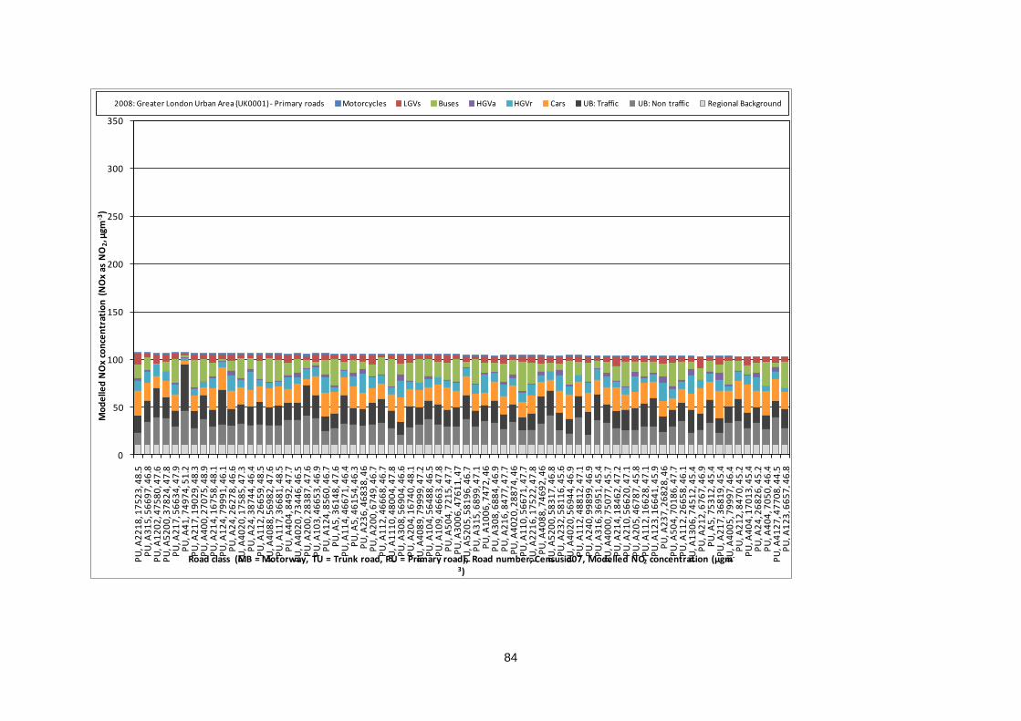
84
0
50
100
150
200
250
300
350
PU
, A2
21
8, 1
75
23
, 48
.5P
U, A
31
5, 5
66
97
, 46
.8P
U, A
12
02
, 47
58
0, 4
7.6
PU
, A5
20
0, 3
78
24
, 47
.8P
U, A
21
7, 5
66
34
, 47
.9P
U, A
41
, 74
97
4, 5
1.2
PU
, A2
17
, 19
02
9, 4
8.3
PU
, A4
00
, 27
07
5, 4
8.9
PU
, A2
14
, 16
75
8, 4
8.1
PU
, A1
24
, 79
99
1, 4
6.1
PU
, A2
4, 2
62
78
, 46
.6P
U, A
40
20
, 17
58
5, 4
7.3
PU
, A2
4, 3
87
44
, 46
.4P
U, A
11
2, 2
66
59
, 48
.5P
U, A
40
88
, 56
98
2, 4
7.6
PU
, A1
17
, 36
68
1, 4
8.5
PU
, A4
04
, 84
92
, 47
.7P
U, A
40
20
, 73
44
6, 4
6.5
PU
, A2
00
, 28
38
7, 4
7.6
PU
, A1
03
, 46
65
3, 4
6.9
PU
, A1
24
, 85
60
, 46
.7P
U, A
5, 3
61
48
, 47
.6P
U, A
11
4, 4
66
71
, 46
.4P
U, A
5, 4
61
54
, 46
.3P
U, A
23
6, 4
68
38
, 46
PU
, A2
00
, 67
49
, 46
.7P
U, A
11
2, 4
66
68
, 46
.7P
U, A
11
10
, 48
00
4, 4
7.8
PU
, A3
08
, 56
90
4, 4
6.6
PU
, A2
04
, 16
74
0, 4
8.1
PU
, A4
08
9, 7
99
99
, 47
.2P
U, A
10
4, 5
64
88
, 46
.5P
U, A
10
9, 4
66
63
, 47
.8P
U, A
50
4, 7
21
5, 4
7.7
PU
, A3
00
6, 4
76
11
, 47
PU
, A5
20
5, 5
81
96
, 46
.7P
U, A
31
5, 6
89
9, 4
7.1
PU
, A1
00
6, 7
47
2, 4
6P
U, A
30
8, 6
88
4, 4
6.9
PU
, A2
16
, 84
77
, 47
.7P
U, A
40
20
, 28
87
4, 4
6P
U, A
11
0, 5
66
71
, 47
.7P
U, A
22
16
, 17
52
2, 4
7.8
PU
, A4
08
8, 7
46
92
, 46
PU
, A5
20
0, 5
83
17
, 46
.8P
U, A
23
2, 5
81
16
, 45
.6P
U, A
40
20
, 56
94
4, 4
6.9
PU
, A1
12
, 48
81
2, 4
7.1
PU
, A2
40
, 99
89
9, 4
6.9
PU
, A3
16
, 36
95
1, 4
5.4
PU
, A4
00
0, 7
50
77
, 45
.7P
U, A
21
4, 1
84
62
, 47
.2P
U, A
21
0, 5
66
20
, 47
.1P
U, A
20
5, 4
67
87
, 45
.8P
U, A
11
2, 1
66
28
, 47
.1P
U, A
12
3, 1
66
41
, 45
.9P
U, A
23
7, 2
68
28
, 46
PU
, A5
04
, 70
18
6, 4
7.7
PU
, A1
12
, 26
65
8, 4
6.1
PU
, A1
30
6, 7
45
12
, 45
.4P
U, A
21
2, 6
76
7, 4
6.9
PU
, A5
, 75
31
2, 4
5.4
PU
, A2
17
, 36
81
9, 4
5.4
PU
, A4
00
5, 7
99
97
, 46
.4P
U, A
21
2, 8
47
0, 4
5.2
PU
, A4
04
, 17
01
3, 4
5.4
PU
, A2
4, 2
68
26
, 45
.2P
U, A
40
4, 7
05
0, 4
6.4
PU
, A4
12
7, 4
77
08
, 44
.5P
U, A
12
3, 6
65
7, 4
6.8
Mo
de
lled
NO
x co
nce
ntr
atio
n (
NO
x as
NO
2, µ
gm-3
)
Road class (MB = Motorway, TU = Trunk road, PU = Primary road), Road number, Censusid07, Modelled NO2 concentration (µgm-
3)
2008: Greater London Urban Area (UK0001) - Primary roads Motorcycles LGVs Buses HGVa HGVr Cars UB: Traffic UB: Non traffic Regional Background
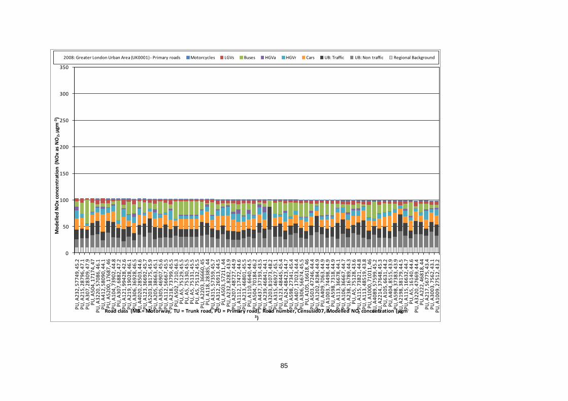
85
0
50
100
150
200
250
300
350
PU
, A2
32
, 57
74
9, 4
5.2
PU
, A2
15
, 28
79
6, 4
7.1
PU
, A3
07
, 28
30
9, 4
7.9
PU
, A5
04
, 17
17
4, 4
7P
U, A
32
20
, 57
08
6, 4
6.1
PU
, A4
12
, 58
09
0, 4
4.1
PU
, A5
20
0, 1
76
87
, 46
PU
, A1
04
, 73
90
2, 4
4.8
PU
, A3
07
, 68
82
, 47
.2P
U, A
12
1, 9
94
28
, 42
.6P
U, A
21
9, 1
90
28
, 46
.1P
U, A
30
6, 3
69
28
, 46
.5P
U, A
40
20
, 28
50
3, 4
4.6
PU
, A1
23
, 36
69
2, 4
5.7
PU
, A5
20
3, 3
81
75
, 45
.9P
U, A
20
5, 3
86
63
, 45
.1P
U, A
30
5, 4
69
07
, 45
.6P
U, A
11
2, 5
66
67
, 45
.5P
U, A
21
8, 7
37
99
, 45
.5P
U, A
50
2, 7
21
0, 4
6.3
PU
, A5
, 75
12
9, 4
5.5
PU
, A5
, 75
13
0, 4
5.5
PU
, A5
, 75
13
1, 4
5.5
PU
, A5
, 75
13
2, 4
5.5
PU
, A2
20
3, 3
66
60
, 45
PU
, A1
18
, 28
38
5, 4
4P
U, A
31
5, 5
73
59
, 45
.7P
U, A
31
2, 2
69
13
, 44
.5P
U, A
50
3, 5
72
11
, 44
PU
, A2
32
, 82
82
, 43
.9P
U, A
20
7, 4
87
27
, 44
.9P
U, A
11
12
, 17
47
2, 4
4.6
PU
, A2
13
, 46
80
1, 4
5.5
PU
, A1
10
, 66
40
, 44
.5P
U, A
50
4, 7
01
84
, 46
.2P
U, A
43
7, 3
71
93
, 43
.5P
U, A
23
9, 4
68
41
, 44
.1P
U, A
32
03
, 81
07
3, 4
8.2
PU
, A3
15
, 46
92
7, 4
5.1
PU
, A1
23
, 48
44
5, 4
5.4
PU
, A2
4, 4
84
23
, 44
.7P
U, A
59
8, 2
73
41
, 45
.4P
U, A
40
7, 1
70
23
, 44
.4P
U, A
30
6, 5
66
74
, 45
.5P
U, A
10
5, 1
66
18
, 46
PU
, A5
03
, 47
24
6, 4
4.4
PU
, A1
20
2, 8
28
4, 4
4.9
PU
, A4
09
, 70
63
, 44
.9P
U, A
10
03
, 74
49
8, 4
4.9
PU
, A5
98
, 73
18
, 44
.9P
U, A
11
3, 3
66
78
, 44
.1P
U, A
10
6, 3
66
67
, 44
.7P
U, A
23
8, 1
67
89
, 44
.3P
U, A
5, 7
51
28
, 43
.6P
U, A
11
5, 7
38
21
, 44
.8P
U, A
11
3, 4
85
19
, 43
.8P
U, A
10
00
, 71
01
1, 4
6P
U, A
40
89
, 57
59
9, 4
5.2
PU
, A2
21
4, 3
76
48
, 45
.3P
U, A
10
5, 6
63
1, 4
4.2
PU
, A4
04
, 85
15
, 43
.9P
U, A
59
8, 3
73
83
, 43
.9P
U, A
21
98
, 38
17
9, 4
4.5
PU
, A1
15
, 16
63
2, 4
4.7
PU
, A5
, 16
14
0, 4
4.6
PU
, A3
22
0, 4
76
69
, 44
.4P
U, A
22
2, 4
68
18
, 44
PU
, A2
17
, 56
77
5, 4
3.4
PU
, A3
00
3, 7
56
2, 4
3.1
PU
, A1
00
9, 2
75
12
, 43
.2
Mo
de
lled
NO
x co
nce
ntr
atio
n (
NO
x as
NO
2, µ
gm-3
)
Road class (MB = Motorway, TU = Trunk road, PU = Primary road), Road number, Censusid07, Modelled NO2 concentration (µgm-
3)
2008: Greater London Urban Area (UK0001) - Primary roads Motorcycles LGVs Buses HGVa HGVr Cars UB: Traffic UB: Non traffic Regional Background

86
0
50
100
150
200
250
300
350
PU
, A2
15
, 58
13
0, 4
5.2
PU
, A2
07
, 46
79
4, 4
4.4
PU
, A2
24
, 56
83
0, 4
3.9
PU
, A1
08
3, 1
74
61
, 43
.9P
U, A
10
06
, 37
54
1, 4
3.5
PU
, A4
02
0, 2
81
18
, 43
.5P
U, A
22
0, 5
68
14
, 43
.7P
U, A
11
4, 5
65
15
, 43
.1P
U, A
31
5, 2
69
20
, 43
.3P
U, A
31
5, 3
69
48
, 43
.6P
U, A
12
4, 1
82
67
, 43
.4P
U, A
11
70
, 58
39
1, 4
0.7
PU
, A1
24
, 36
69
3, 4
4P
U, A
23
5, 6
80
2, 4
4.1
PU
, A2
19
, 16
25
8, 4
2.8
PU
, A2
32
, 18
48
9, 4
3.4
PU
, A2
15
, 46
80
6, 4
3.7
PU
, A2
22
, 56
75
7, 4
3.6
PU
, A2
36
, 59
03
0, 4
3.3
PU
, A3
00
5, 3
76
53
, 43
PU
, A5
98
, 17
27
4, 4
3.5
PU
, A2
43
, 38
36
3, 4
3.4
PU
, A5
20
2, 2
72
64
, 44
.2P
U, A
12
01
, 47
57
9, 4
4.1
PU
, A4
08
, 17
02
4, 4
2.6
PU
, A2
07
, 67
63
, 44
.1P
U, A
50
4, 5
72
69
, 44
.7P
U, A
22
14
, 47
60
6, 4
4P
U, A
40
4, 3
71
08
, 43
.5P
U, A
12
5, 7
88
9, 4
2.7
PU
, A1
17
, 66
49
, 44
.9P
U, A
50
2, 7
10
09
, 43
.2P
U, A
21
2, 2
67
88
, 44
PU
, A2
40
, 99
89
8, 4
3P
U, A
22
, 57
73
4, 4
2.5
PU
, A2
14
, 67
70
, 43
.3P
U, A
21
4, 3
68
15
, 43
.4P
U, A
50
2, 2
72
37
, 42
.4P
U, A
21
3, 2
67
92
, 42
.8P
U, A
10
08
, 28
47
4, 4
3P
U, A
21
4, 1
83
40
, 43
.9P
U, A
5, 5
81
56
, 43
.1P
U, A
22
1, 7
46
20
, 42
.7P
U, A
23
9, 1
67
90
, 42
PU
, A1
12
, 48
81
3, 4
3.7
PU
, A4
02
0, 8
35
1, 4
2.4
PU
, A2
13
, 38
59
3, 4
3.6
PU
, A5
, 28
49
7, 4
2.3
PU
, A2
24
, 38
83
6, 4
2.7
PU
, A5
, 75
12
7, 4
2.3
PU
, A2
39
, 26
83
0, 4
2.5
PU
, A2
35
, 48
67
3, 4
3.2
PU
, A1
00
0, 2
74
90
, 43
.5P
U, A
20
15
, 73
16
2, 4
3.3
PU
, A3
12
, 46
92
2, 4
2.6
PU
, A4
18
0, 7
34
45
, 42
.2P
U, A
41
80
, 99
74
8, 4
2.2
PU
, A2
07
, 48
70
8, 4
2.6
PU
, A4
12
7, 7
65
2, 4
2.2
PU
, A4
12
7, 2
85
33
, 42
.2P
U, A
30
7, 5
83
28
, 42
.9P
U, A
13
06
, 74
51
1, 4
2P
U, A
50
4, 1
71
76
, 42
.3P
U, A
30
8, 2
87
67
, 42
.5P
U, A
24
, 46
27
8, 4
3.3
PU
, A2
97
, 26
88
7, 4
3P
U, A
22
2, 6
78
0, 4
3.6
PU
, A1
24
, 26
67
1, 4
3P
U, A
21
2, 3
68
10
, 43
.3P
U, A
11
0, 1
87
37
, 43
.7
Mo
de
lled
NO
x co
nce
ntr
atio
n (
NO
x as
NO
2, µ
gm-3
)
Road class (MB = Motorway, TU = Trunk road, PU = Primary road), Road number, Censusid07, Modelled NO2 concentration (µgm-
3)
2008: Greater London Urban Area (UK0001) - Primary roads Motorcycles LGVs Buses HGVa HGVr Cars UB: Traffic UB: Non traffic Regional Background
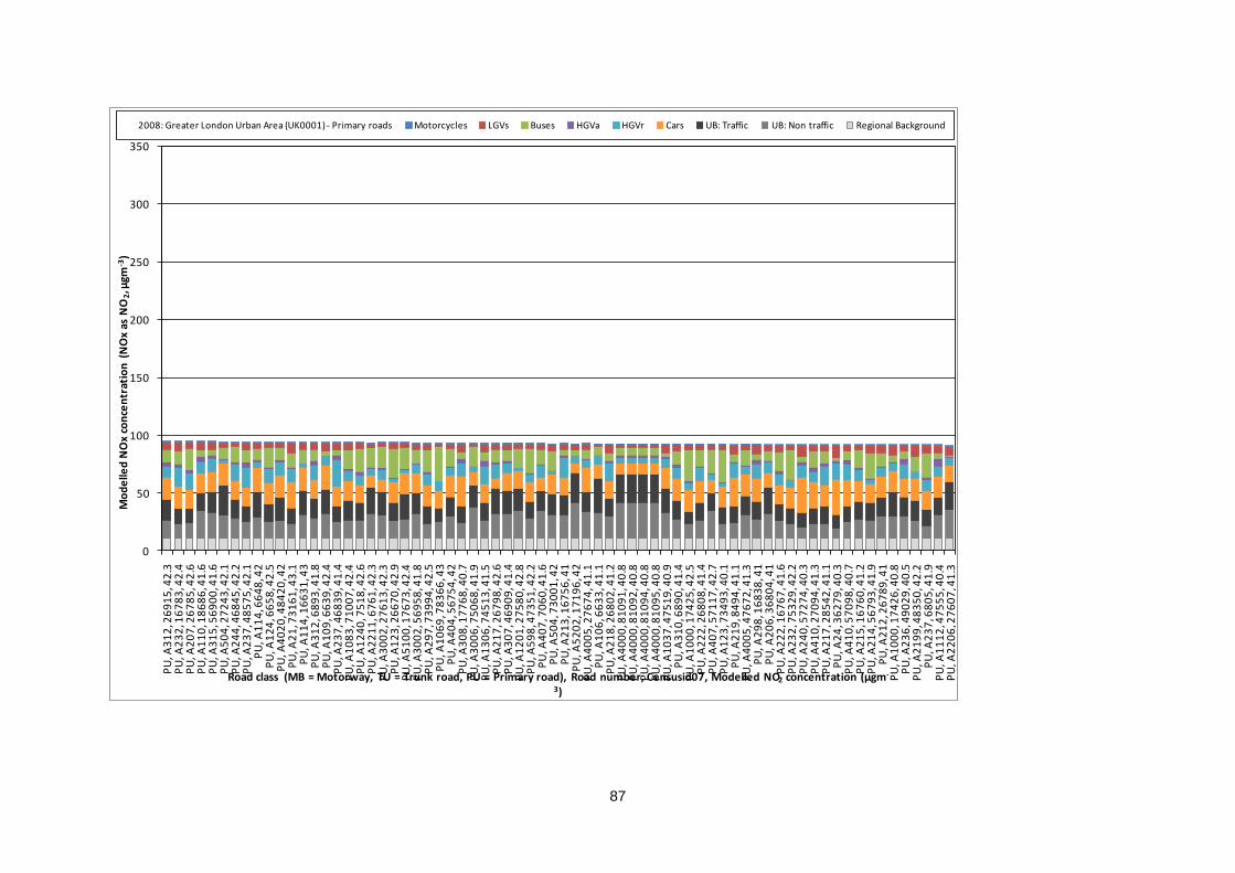
87
0
50
100
150
200
250
300
350
PU
, A3
12
, 26
91
5, 4
2.3
PU
, A2
32
, 16
78
3, 4
2.4
PU
, A2
07
, 26
78
5, 4
2.6
PU
, A1
10
, 18
68
6, 4
1.6
PU
, A3
15
, 56
90
0, 4
1.6
PU
, A5
04
, 27
24
3, 4
2.1
PU
, A2
44
, 46
84
5, 4
2.2
PU
, A2
37
, 48
57
5, 4
2.1
PU
, A1
14
, 66
48
, 42
PU
, A1
24
, 66
58
, 42
.5P
U, A
40
20
, 48
42
0, 4
2P
U, A
21
, 73
16
1, 4
3.1
PU
, A1
14
, 16
63
1, 4
3P
U, A
31
2, 6
89
3, 4
1.8
PU
, A1
09
, 66
39
, 42
.4P
U, A
23
7, 4
68
39
, 41
.4P
U, A
10
83
, 71
00
7, 4
2.4
PU
, A1
24
0, 7
51
8, 4
2.6
PU
, A2
21
1, 6
76
1, 4
2.3
PU
, A3
00
2, 2
76
13
, 42
.3P
U, A
12
3, 2
66
70
, 42
.9P
U, A
51
00
, 17
67
3, 4
2.4
PU
, A3
00
2, 5
69
58
, 41
.8P
U, A
29
7, 7
39
94
, 42
.5P
U, A
10
69
, 78
36
6, 4
3P
U, A
40
4, 5
67
54
, 42
PU
, A3
08
, 17
76
8, 4
0.7
PU
, A3
00
6, 7
50
68
, 41
.9P
U, A
13
06
, 74
51
3, 4
1.5
PU
, A2
17
, 26
79
8, 4
2.6
PU
, A3
07
, 46
90
9, 4
1.4
PU
, A1
20
1, 2
75
80
, 42
.8P
U, A
59
8, 4
73
51
, 42
.2P
U, A
40
7, 7
06
0, 4
1.6
PU
, A5
04
, 73
00
1, 4
2P
U, A
21
3, 1
67
56
, 41
PU
, A5
20
2, 1
71
96
, 42
PU
, A4
00
5, 2
76
74
, 41
.1P
U, A
10
6, 6
63
3, 4
1.1
PU
, A2
18
, 26
80
2, 4
1.2
PU
, A4
00
0, 8
10
91
, 40
.8P
U, A
40
00
, 81
09
2, 4
0.8
PU
, A4
00
0, 8
10
94
, 40
.8P
U, A
40
00
, 81
09
5, 4
0.8
PU
, A1
03
7, 4
75
19
, 40
.9P
U, A
31
0, 6
89
0, 4
1.4
PU
, A1
00
0, 1
74
25
, 42
.5P
U, A
22
2, 2
68
08
, 41
.4P
U, A
40
7, 5
71
17
, 42
.7P
U, A
12
3, 7
34
93
, 40
.1P
U, A
21
9, 8
49
4, 4
1.1
PU
, A4
00
5, 4
76
72
, 41
.3P
U, A
29
8, 1
68
38
, 41
PU
, A2
06
, 36
80
4, 4
1P
U, A
22
2, 1
67
67
, 41
.6P
U, A
23
2, 7
53
29
, 42
.2P
U, A
24
0, 5
72
74
, 40
.3P
U, A
41
0, 2
70
94
, 41
.3P
U, A
21
7, 2
85
42
, 41
.1P
U, A
24
, 36
27
9, 4
0.3
PU
, A4
10
, 57
09
8, 4
0.7
PU
, A2
15
, 16
76
0, 4
1.2
PU
, A2
14
, 56
79
3, 4
1.9
PU
, A2
12
, 26
78
9, 4
1P
U, A
10
00
, 17
42
6, 4
0.8
PU
, A2
36
, 49
02
9, 4
0.5
PU
, A2
19
9, 4
83
50
, 42
.2P
U, A
23
7, 6
80
5, 4
1.9
PU
, A1
11
2, 4
75
55
, 40
.4P
U, A
22
06
, 27
60
7, 4
1.3
Mo
de
lled
NO
x co
nce
ntr
atio
n (
NO
x as
NO
2, µ
gm-3
)
Road class (MB = Motorway, TU = Trunk road, PU = Primary road), Road number, Censusid07, Modelled NO2 concentration (µgm-
3)
2008: Greater London Urban Area (UK0001) - Primary roads Motorcycles LGVs Buses HGVa HGVr Cars UB: Traffic UB: Non traffic Regional Background
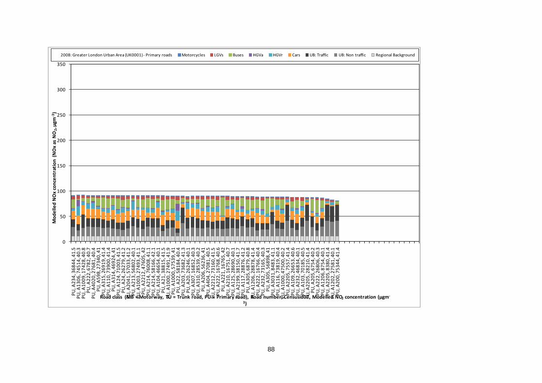
88
0
50
100
150
200
250
300
350
PU
, A2
34
, 36
84
4, 4
1.5
PU
, A1
30
6, 7
45
14
, 40
.3P
U, A
10
09
, 17
42
8, 4
0.8
PU
, A2
22
, 67
82
, 40
.7P
U, A
40
20
, 27
68
1, 4
0.4
PU
, A5
98
, 27
34
0, 4
1P
U, A
31
5, 2
69
19
, 41
.4P
U, A
11
0, 7
39
00
, 41
.4P
U, A
31
4, 4
69
24
, 41
PU
, A1
24
, 71
00
3, 4
1.5
PU
, A2
4, 2
62
79
, 41
.2P
U, A
20
41
, 57
03
3, 4
1.2
PU
, A2
13
, 56
80
2, 4
0.1
PU
, A1
00
3, 2
74
93
, 41
.1P
U, A
22
12
, 47
60
5, 4
2P
U, A
21
4, 7
60
08
, 41
.1P
U, A
21
4, 5
81
66
, 42
.1P
U, A
10
4, 4
66
54
, 40
.1P
U, A
21
, 38
81
5, 4
1.5
PU
, A1
00
0, 2
74
91
, 41
.9P
U, A
10
00
, 57
53
9, 4
1P
U, A
22
, 58
18
4, 4
0.4
PU
, A2
03
, 73
68
2, 4
1.3
PU
, A2
0, 2
62
46
, 40
.1P
U, A
30
7, 1
68
52
, 40
.3P
U, A
31
0, 2
85
39
, 40
.2P
U, A
20
6, 5
62
36
, 41
PU
, A4
04
, 27
08
1, 4
0.5
PU
, A2
21
2, 7
31
60
, 41
.5P
U, A
22
2, 1
67
68
, 40
.6P
U, A
22
1, 1
67
65
, 42
PU
, A2
10
, 16
75
1, 4
0.7
PU
, A1
25
, 28
69
0, 4
0.1
PU
, A2
19
9, 3
81
50
, 41
.7P
U, A
11
7, 2
88
76
, 41
.2P
U, A
30
5, 6
87
9, 4
0.8
PU
, A1
20
6, 2
88
78
, 41
.4P
U, A
22
2, 1
67
66
, 40
.4P
U, A
23
2, 7
31
65
, 40
.3P
U, A
30
5, 5
68
98
, 41
PU
, A3
03
1, 8
48
3, 4
1.1
PU
, A1
16
, 73
81
9, 4
0.4
PU
, A1
00
0, 4
75
00
, 40
.2P
U, A
22
05
, 75
57
, 41
.4P
U, A
10
9, 2
66
53
, 40
.6P
U, A
23
2, 4
68
34
, 40
.1P
U, A
10
3, 7
01
85
, 40
.5P
U, A
22
05
, 28
21
0, 4
1.4
PU
, A2
05
, 67
54
, 40
.2P
U, A
22
2, 2
68
06
, 40
.3P
U, A
12
06
, 87
54
, 40
.1P
U, A
22
05
, 83
80
, 41
.4P
U, A
12
02
, 27
58
1, 4
0.1
PU
, A2
00
, 75
34
4, 4
1.4
Mo
de
lled
NO
x co
nce
ntr
atio
n (
NO
x as
NO
2, µ
gm-3
)
Road class (MB = Motorway, TU = Trunk road, PU = Primary road), Road number, Censusid07, Modelled NO2 concentration (µgm-
3)
2008: Greater London Urban Area (UK0001) - Primary roads Motorcycles LGVs Buses HGVa HGVr Cars UB: Traffic UB: Non traffic Regional Background
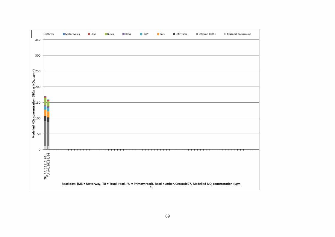
89
0
50
100
150
200
250
300
350
TU, A
4, 1
61
12
, 69
.1TU
, A4
, 56
11
4, 6
4
Mo
de
lled
NO
x co
nce
ntr
atio
n (
NO
x as
NO
2, µ
gm-3
)
Road class (MB = Motorway, TU = Trunk road, PU = Primary road), Road number, Censusid07, Modelled NO2 concentration (µgm-
3)
Heathrow Motorcycles LGVs Buses HGVa HGVr Cars UB: Traffic UB: Non traffic Regional Background

90
Annex 2: Tables of measures
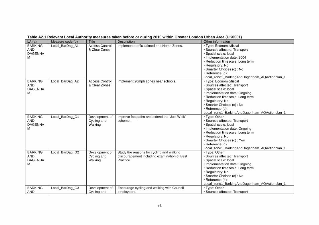
91
Table A2.1 Relevant Local Authority measures taken before or during 2010 within Greater London Urban Area (UK0001) LA (a) Measure code (b) Title Description Other information
BARKING AND DAGENHAM
Local_BarDag_A1 Access Control & Clear Zones
Implement traffic calmed and Home Zones. • Type: Economic/fiscal • Sources affected: Transport • Spatial scale: local • Implementation date: 2004 • Reduction timescale: Long term • Regulatory: No • Smarter Choices (c) : No • Reference (d): Local_zone1_BarkingAndDagenham_AQActionplan_1
BARKING AND DAGENHAM
Local_BarDag_A2 Access Control & Clear Zones
Implement 20mph zones near schools. • Type: Economic/fiscal • Sources affected: Transport • Spatial scale: local • Implementation date: Ongoing • Reduction timescale: Long term • Regulatory: No • Smarter Choices (c) : No • Reference (d): Local_zone1_BarkingAndDagenham_AQActionplan_1
BARKING AND DAGENHAM
Local_BarDag_G1 Development of Cycling and Walking
Improve footpaths and extend the „Just Walk‟ scheme.
• Type: Other • Sources affected: Transport • Spatial scale: local • Implementation date: Ongoing • Reduction timescale: Long term • Regulatory: No • Smarter Choices (c) : Yes • Reference (d): Local_zone1_BarkingAndDagenham_AQActionplan_1
BARKING AND DAGENHAM
Local_BarDag_G2 Development of Cycling and Walking
Study the reasons for cycling and walking discouragement including examination of Best Practice.
• Type: Other • Sources affected: Transport • Spatial scale: local • Implementation date: Ongoing. • Reduction timescale: Long term • Regulatory: No • Smarter Choices (c) : No • Reference (d): Local_zone1_BarkingAndDagenham_AQActionplan_1
BARKING AND
Local_BarDag_G3 Development of Cycling and
Encourage cycling and walking with Council employeers.
• Type: Other • Sources affected: Transport
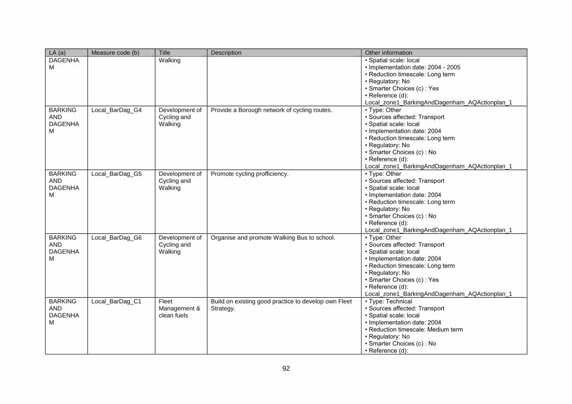
92
LA (a) Measure code (b) Title Description Other information
DAGENHAM
Walking • Spatial scale: local • Implementation date: 2004 - 2005 • Reduction timescale: Long term • Regulatory: No • Smarter Choices (c) : Yes • Reference (d): Local_zone1_BarkingAndDagenham_AQActionplan_1
BARKING AND DAGENHAM
Local_BarDag_G4 Development of Cycling and Walking
Provide a Borough network of cycling routes. • Type: Other • Sources affected: Transport • Spatial scale: local • Implementation date: 2004 • Reduction timescale: Long term • Regulatory: No • Smarter Choices (c) : No • Reference (d): Local_zone1_BarkingAndDagenham_AQActionplan_1
BARKING AND DAGENHAM
Local_BarDag_G5 Development of Cycling and Walking
Promote cycling profficiency. • Type: Other • Sources affected: Transport • Spatial scale: local • Implementation date: 2004 • Reduction timescale: Long term • Regulatory: No • Smarter Choices (c) : No • Reference (d): Local_zone1_BarkingAndDagenham_AQActionplan_1
BARKING AND DAGENHAM
Local_BarDag_G6 Development of Cycling and Walking
Organise and promote Walking Bus to school. • Type: Other • Sources affected: Transport • Spatial scale: local • Implementation date: 2004 • Reduction timescale: Long term • Regulatory: No • Smarter Choices (c) : Yes • Reference (d): Local_zone1_BarkingAndDagenham_AQActionplan_1
BARKING AND DAGENHAM
Local_BarDag_C1 Fleet Management & clean fuels
Build on existing good practice to develop own Fleet Strategy.
• Type: Technical • Sources affected: Transport • Spatial scale: local • Implementation date: 2004 • Reduction timescale: Medium term • Regulatory: No • Smarter Choices (c) : No • Reference (d):
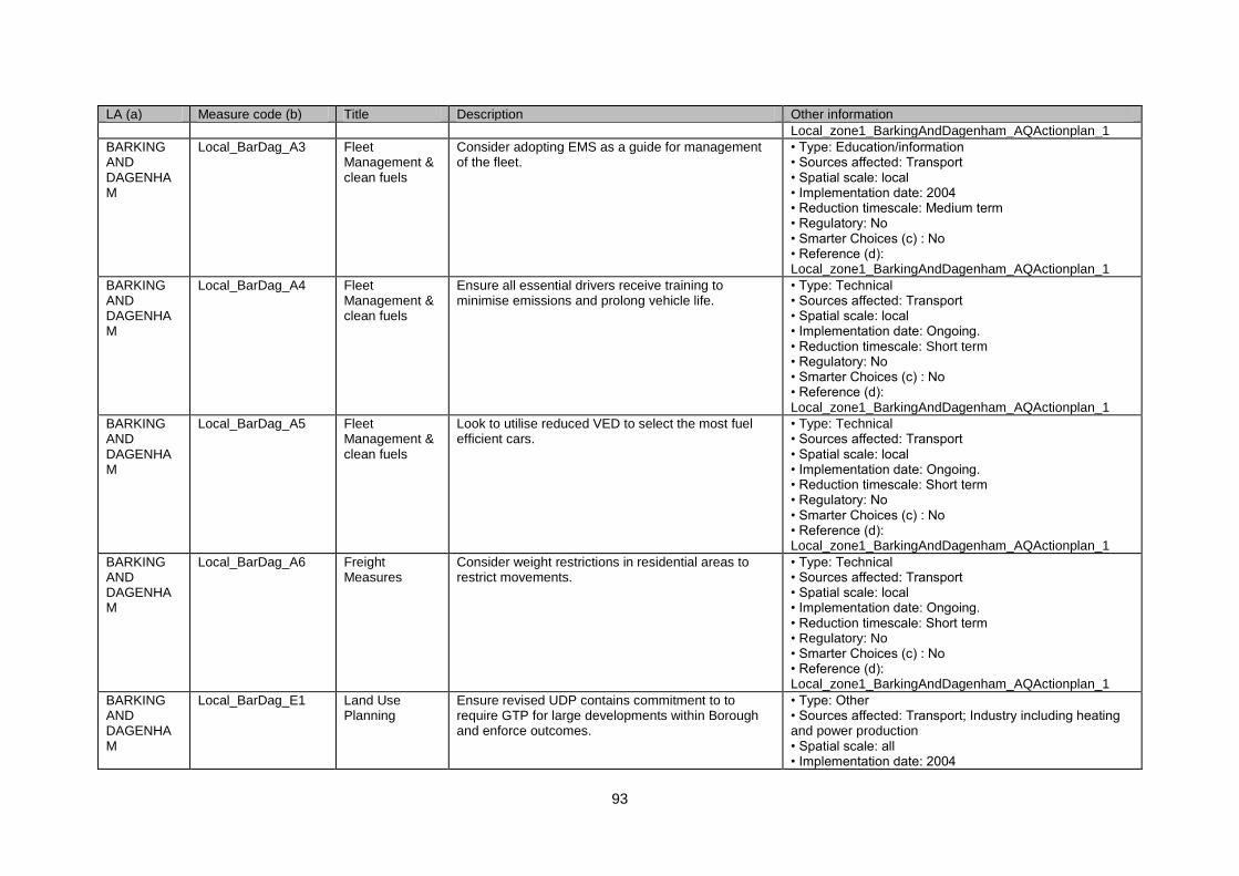
93
LA (a) Measure code (b) Title Description Other information
Local_zone1_BarkingAndDagenham_AQActionplan_1
BARKING AND DAGENHAM
Local_BarDag_A3 Fleet Management & clean fuels
Consider adopting EMS as a guide for management of the fleet.
• Type: Education/information • Sources affected: Transport • Spatial scale: local • Implementation date: 2004 • Reduction timescale: Medium term • Regulatory: No • Smarter Choices (c) : No • Reference (d): Local_zone1_BarkingAndDagenham_AQActionplan_1
BARKING AND DAGENHAM
Local_BarDag_A4 Fleet Management & clean fuels
Ensure all essential drivers receive training to minimise emissions and prolong vehicle life.
• Type: Technical • Sources affected: Transport • Spatial scale: local • Implementation date: Ongoing. • Reduction timescale: Short term • Regulatory: No • Smarter Choices (c) : No • Reference (d): Local_zone1_BarkingAndDagenham_AQActionplan_1
BARKING AND DAGENHAM
Local_BarDag_A5 Fleet Management & clean fuels
Look to utilise reduced VED to select the most fuel efficient cars.
• Type: Technical • Sources affected: Transport • Spatial scale: local • Implementation date: Ongoing. • Reduction timescale: Short term • Regulatory: No • Smarter Choices (c) : No • Reference (d): Local_zone1_BarkingAndDagenham_AQActionplan_1
BARKING AND DAGENHAM
Local_BarDag_A6 Freight Measures
Consider weight restrictions in residential areas to restrict movements.
• Type: Technical • Sources affected: Transport • Spatial scale: local • Implementation date: Ongoing. • Reduction timescale: Short term • Regulatory: No • Smarter Choices (c) : No • Reference (d): Local_zone1_BarkingAndDagenham_AQActionplan_1
BARKING AND DAGENHAM
Local_BarDag_E1 Land Use Planning
Ensure revised UDP contains commitment to to require GTP for large developments within Borough and enforce outcomes.
• Type: Other • Sources affected: Transport; Industry including heating and power production • Spatial scale: all • Implementation date: 2004

94
LA (a) Measure code (b) Title Description Other information
• Reduction timescale: Medium term • Regulatory: No • Smarter Choices (c) : Yes • Reference (d): Local_zone1_BarkingAndDagenham_AQActionplan_1
BARKING AND DAGENHAM
Local_BarDag_E2 Land Use Planning
Produce planning guidelines to develop criteri for developments within the AQMA addressing sustainability, energy conservation, alternative energy sources.
• Type: Other • Sources affected: Transport; Industry including heating and power production • Spatial scale: local • Implementation date: 2004 • Reduction timescale: Medium term • Regulatory: No • Smarter Choices (c) : No • Reference (d): Local_zone1_BarkingAndDagenham_AQActionplan_1
BARKING AND DAGENHAM
Local_BarDag_E3 Land Use Planning
Ensure impact assessments done for new developments and making AQ a material consideration.
• Type: Technical • Sources affected: Transport • Spatial scale: local • Implementation date: 2004 • Reduction timescale: Medium term • Regulatory: No • Smarter Choices (c) : No • Reference (d): Local_zone1_BarkingAndDagenham_AQActionplan_1
BARKING AND DAGENHAM
Local_BarDag_E4 Land Use Planning
Review the UDP to include AQMA as a material consideration.
• Type: Technical • Sources affected: Transport • Spatial scale: local • Implementation date: 2004 - Ongoing. • Reduction timescale: Medium term • Regulatory: No • Smarter Choices (c) : No • Reference (d): Local_zone1_BarkingAndDagenham_AQActionplan_1
BARKING AND DAGENHAM
Local_BarDag_A7 Low Emission Zones
Consider introduction of LEZ in a phased manner. • Type: Economic/fiscal • Sources affected: Transport • Spatial scale: regional • Implementation date: Ongoing. • Reduction timescale: Long term • Regulatory: No • Smarter Choices (c) : No • Reference (d): Local_zone1_BarkingAndDagenham_AQActionplan_1
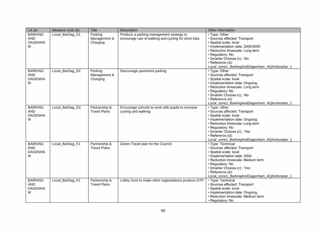
95
LA (a) Measure code (b) Title Description Other information
BARKING AND DAGENHAM
Local_BarDag_D1 Parking Management & Charging
Produce a parking management strategy to encourage use of walking and cycling for short trips
• Type: Other • Sources affected: Transport • Spatial scale: local • Implementation date: 2004/2005 • Reduction timescale: Long term • Regulatory: No • Smarter Choices (c) : No • Reference (d): Local_zone1_BarkingAndDagenham_AQActionplan_1
BARKING AND DAGENHAM
Local_BarDag_D2 Parking Management & Charging
Discourage pavement parking • Type: Other • Sources affected: Transport • Spatial scale: local • Implementation date: Ongoing. • Reduction timescale: Long term • Regulatory: No • Smarter Choices (c) : No • Reference (d): Local_zone1_BarkingAndDagenham_AQActionplan_1
BARKING AND DAGENHAM
Local_BarDag_D3 Partnership & Travel Plans
Encourage schools to work with pupils to increase cycling and walking
• Type: Other • Sources affected: Transport • Spatial scale: local • Implementation date: Ongoing. • Reduction timescale: Long term • Regulatory: No • Smarter Choices (c) : Yes • Reference (d): Local_zone1_BarkingAndDagenham_AQActionplan_1
BARKING AND DAGENHAM
Local_BarDag_F1 Partnership & Travel Plans
Green Travel plan for the Council • Type: Technical • Sources affected: Transport • Spatial scale: local • Implementation date: 2004 • Reduction timescale: Medium term • Regulatory: No • Smarter Choices (c) : Yes • Reference (d): Local_zone1_BarkingAndDagenham_AQActionplan_1
BARKING AND DAGENHAM
Local_BarDag_F2 Partnership & Travel Plans
Lobby Govt to make other organisations produce GTP • Type: Technical • Sources affected: Transport • Spatial scale: local • Implementation date: Ongoing. • Reduction timescale: Medium term • Regulatory: No
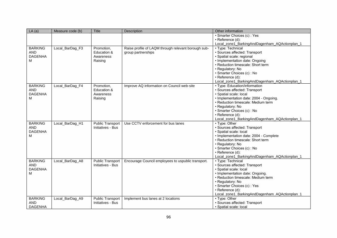
96
LA (a) Measure code (b) Title Description Other information
• Smarter Choices (c) : Yes • Reference (d): Local_zone1_BarkingAndDagenham_AQActionplan_1
BARKING AND DAGENHAM
Local_BarDag_F3 Promotion, Education & Awareness Raising
Raise profile of LAQM through relevant borough sub-group partnerships
• Type: Technical • Sources affected: Transport • Spatial scale: regional • Implementation date: Ongoing • Reduction timescale: Short term • Regulatory: No • Smarter Choices (c) : No • Reference (d): Local_zone1_BarkingAndDagenham_AQActionplan_1
BARKING AND DAGENHAM
Local_BarDag_F4 Promotion, Education & Awareness Raising
Improve AQ information on Council web-site • Type: Education/information • Sources affected: Transport • Spatial scale: local • Implementation date: 2004 - Ongoing. • Reduction timescale: Medium term • Regulatory: No • Smarter Choices (c) : No • Reference (d): Local_zone1_BarkingAndDagenham_AQActionplan_1
BARKING AND DAGENHAM
Local_BarDag_H1 Public Transport Initiatives - Bus
Use CCTV enforcement for bus lanes • Type: Other • Sources affected: Transport • Spatial scale: local • Implementation date: 2004 - Complete • Reduction timescale: Short term • Regulatory: No • Smarter Choices (c) : No • Reference (d): Local_zone1_BarkingAndDagenham_AQActionplan_1
BARKING AND DAGENHAM
Local_BarDag_A8 Public Transport Initiatives - Bus
Encourage Council employees to uspublic transport. • Type: Technical • Sources affected: Transport • Spatial scale: local • Implementation date: Ongoing. • Reduction timescale: Medium term • Regulatory: No • Smarter Choices (c) : Yes • Reference (d): Local_zone1_BarkingAndDagenham_AQActionplan_1
BARKING AND DAGENHA
Local_BarDag_A9 Public Transport Initiatives - Bus
Implement bus lanes at 2 locations • Type: Other • Sources affected: Transport • Spatial scale: local
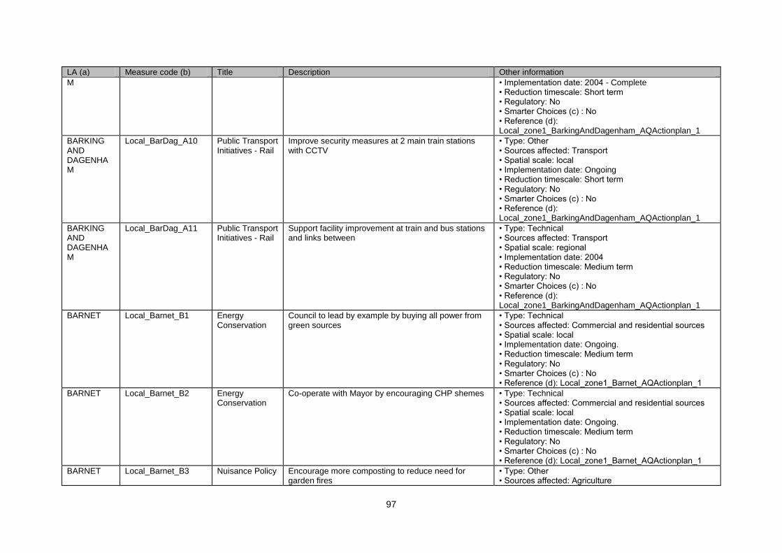
97
LA (a) Measure code (b) Title Description Other information
M • Implementation date: 2004 - Complete • Reduction timescale: Short term • Regulatory: No • Smarter Choices (c) : No • Reference (d): Local_zone1_BarkingAndDagenham_AQActionplan_1
BARKING AND DAGENHAM
Local_BarDag_A10 Public Transport Initiatives - Rail
Improve security measures at 2 main train stations with CCTV
• Type: Other • Sources affected: Transport • Spatial scale: local • Implementation date: Ongoing • Reduction timescale: Short term • Regulatory: No • Smarter Choices (c) : No • Reference (d): Local_zone1_BarkingAndDagenham_AQActionplan_1
BARKING AND DAGENHAM
Local_BarDag_A11 Public Transport Initiatives - Rail
Support facility improvement at train and bus stations and links between
• Type: Technical • Sources affected: Transport • Spatial scale: regional • Implementation date: 2004 • Reduction timescale: Medium term • Regulatory: No • Smarter Choices (c) : No • Reference (d): Local_zone1_BarkingAndDagenham_AQActionplan_1
BARNET Local_Barnet_B1 Energy Conservation
Council to lead by example by buying all power from green sources
• Type: Technical • Sources affected: Commercial and residential sources • Spatial scale: local • Implementation date: Ongoing. • Reduction timescale: Medium term • Regulatory: No • Smarter Choices (c) : No • Reference (d): Local_zone1_Barnet_AQActionplan_1
BARNET Local_Barnet_B2 Energy Conservation
Co-operate with Mayor by encouraging CHP shemes • Type: Technical • Sources affected: Commercial and residential sources • Spatial scale: local • Implementation date: Ongoing. • Reduction timescale: Medium term • Regulatory: No • Smarter Choices (c) : No • Reference (d): Local_zone1_Barnet_AQActionplan_1
BARNET Local_Barnet_B3 Nuisance Policy Encourage more composting to reduce need for garden fires
• Type: Other • Sources affected: Agriculture
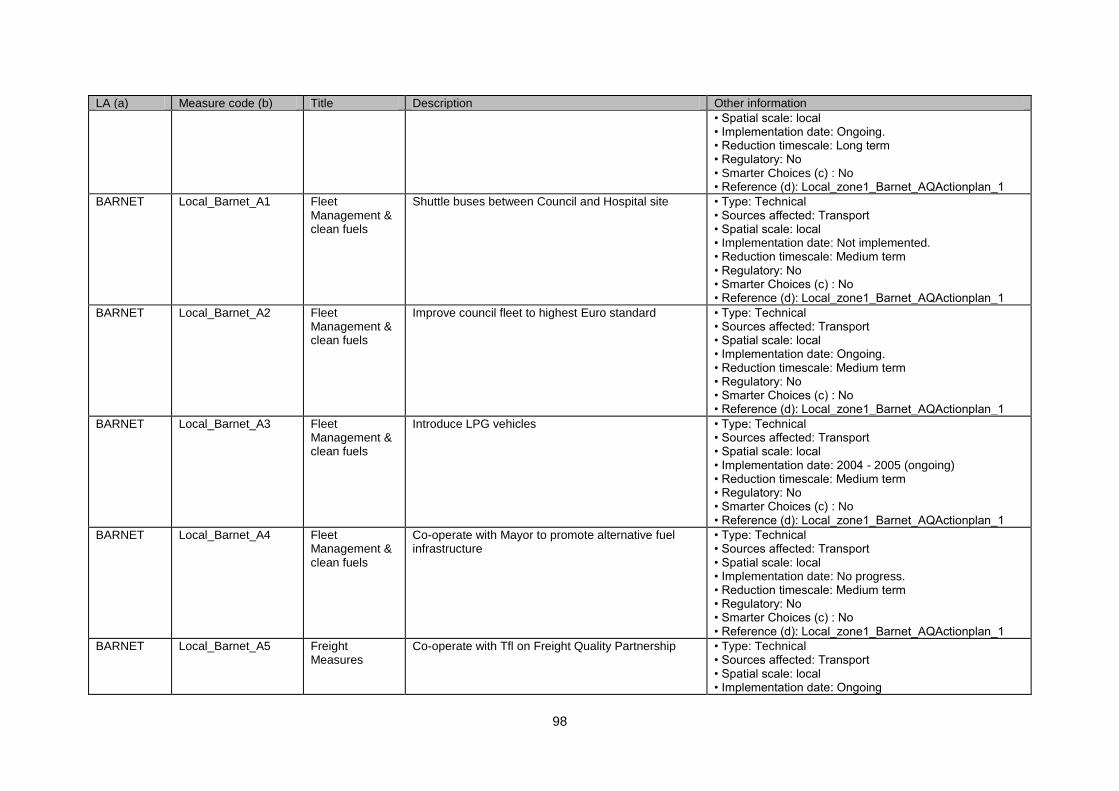
98
LA (a) Measure code (b) Title Description Other information
• Spatial scale: local • Implementation date: Ongoing. • Reduction timescale: Long term • Regulatory: No • Smarter Choices (c) : No • Reference (d): Local_zone1_Barnet_AQActionplan_1
BARNET Local_Barnet_A1 Fleet Management & clean fuels
Shuttle buses between Council and Hospital site • Type: Technical • Sources affected: Transport • Spatial scale: local • Implementation date: Not implemented. • Reduction timescale: Medium term • Regulatory: No • Smarter Choices (c) : No • Reference (d): Local_zone1_Barnet_AQActionplan_1
BARNET Local_Barnet_A2 Fleet Management & clean fuels
Improve council fleet to highest Euro standard • Type: Technical • Sources affected: Transport • Spatial scale: local • Implementation date: Ongoing. • Reduction timescale: Medium term • Regulatory: No • Smarter Choices (c) : No • Reference (d): Local_zone1_Barnet_AQActionplan_1
BARNET Local_Barnet_A3 Fleet Management & clean fuels
Introduce LPG vehicles • Type: Technical • Sources affected: Transport • Spatial scale: local • Implementation date: 2004 - 2005 (ongoing) • Reduction timescale: Medium term • Regulatory: No • Smarter Choices (c) : No • Reference (d): Local_zone1_Barnet_AQActionplan_1
BARNET Local_Barnet_A4 Fleet Management & clean fuels
Co-operate with Mayor to promote alternative fuel infrastructure
• Type: Technical • Sources affected: Transport • Spatial scale: local • Implementation date: No progress. • Reduction timescale: Medium term • Regulatory: No • Smarter Choices (c) : No • Reference (d): Local_zone1_Barnet_AQActionplan_1
BARNET Local_Barnet_A5 Freight Measures
Co-operate with Tfl on Freight Quality Partnership • Type: Technical • Sources affected: Transport • Spatial scale: local • Implementation date: Ongoing

99
LA (a) Measure code (b) Title Description Other information
• Reduction timescale: Short term • Regulatory: No • Smarter Choices (c) : No • Reference (d): Local_zone1_Barnet_AQActionplan_1
BARNET Local_Barnet_A6 Freight Measures
Co-operate with Tfl on freight to rail • Type: Technical • Sources affected: Transport • Spatial scale: local • Implementation date: Ongoing • Reduction timescale: Short term • Regulatory: No • Smarter Choices (c) : No • Reference (d): Local_zone1_Barnet_AQActionplan_1
BARNET Local_Barnet_D1 Parking Management & Charging
C P Z • Type: Economic/fiscal • Sources affected: Transport • Spatial scale: local • Implementation date: Ongoing • Reduction timescale: Long term • Regulatory: No • Smarter Choices (c) : No • Reference (d): Local_zone1_Barnet_AQActionplan_1
BARNET Local_Barnet_H1 Partnership & Travel Plans
Safe routes to school • Type: Other • Sources affected: Transport • Spatial scale: local • Implementation date: Ongoing. • Reduction timescale: Long term • Regulatory: No • Smarter Choices (c) : Yes • Reference (d): Local_zone1_Barnet_AQActionplan_1
BARNET Local_Barnet_A7 Partnership & Travel Plans
Better school bus services • Type: Other • Sources affected: Transport • Spatial scale: local • Implementation date: Ongoing. • Reduction timescale: Long term • Regulatory: No • Smarter Choices (c) : No • Reference (d): Local_zone1_Barnet_AQActionplan_1
BARNET Local_Barnet_A8 Partnership & Travel Plans
Promote car sharing software • Type: Other • Sources affected: Transport • Spatial scale: local • Implementation date: Ongoing. • Reduction timescale: Long term • Regulatory: No
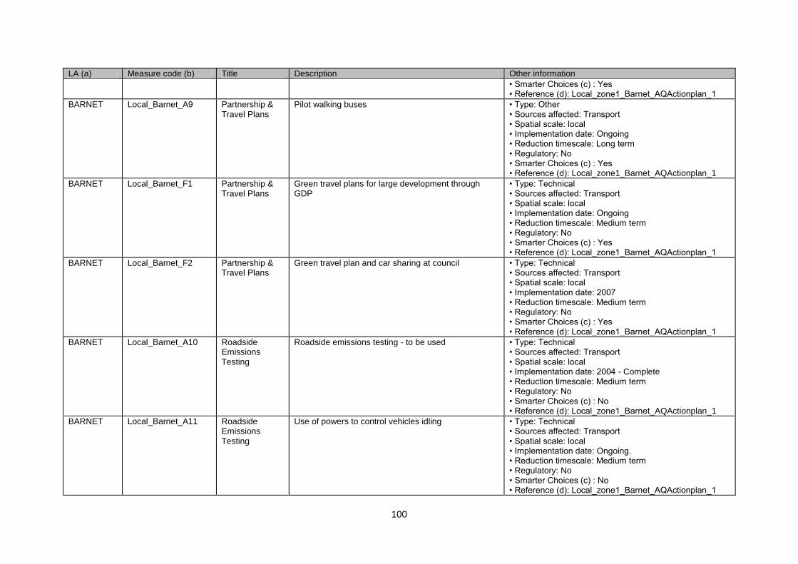
100
LA (a) Measure code (b) Title Description Other information
• Smarter Choices (c) : Yes • Reference (d): Local_zone1_Barnet_AQActionplan_1
BARNET Local_Barnet_A9 Partnership & Travel Plans
Pilot walking buses • Type: Other • Sources affected: Transport • Spatial scale: local • Implementation date: Ongoing • Reduction timescale: Long term • Regulatory: No • Smarter Choices (c) : Yes • Reference (d): Local_zone1_Barnet_AQActionplan_1
BARNET Local_Barnet_F1 Partnership & Travel Plans
Green travel plans for large development through GDP
• Type: Technical • Sources affected: Transport • Spatial scale: local • Implementation date: Ongoing • Reduction timescale: Medium term • Regulatory: No • Smarter Choices (c) : Yes • Reference (d): Local_zone1_Barnet_AQActionplan_1
BARNET Local_Barnet_F2 Partnership & Travel Plans
Green travel plan and car sharing at council • Type: Technical • Sources affected: Transport • Spatial scale: local • Implementation date: 2007 • Reduction timescale: Medium term • Regulatory: No • Smarter Choices (c) : Yes • Reference (d): Local_zone1_Barnet_AQActionplan_1
BARNET Local_Barnet_A10 Roadside Emissions Testing
Roadside emissions testing - to be used • Type: Technical • Sources affected: Transport • Spatial scale: local • Implementation date: 2004 - Complete • Reduction timescale: Medium term • Regulatory: No • Smarter Choices (c) : No • Reference (d): Local_zone1_Barnet_AQActionplan_1
BARNET Local_Barnet_A11 Roadside Emissions Testing
Use of powers to control vehicles idling • Type: Technical • Sources affected: Transport • Spatial scale: local • Implementation date: Ongoing. • Reduction timescale: Medium term • Regulatory: No • Smarter Choices (c) : No • Reference (d): Local_zone1_Barnet_AQActionplan_1

101
LA (a) Measure code (b) Title Description Other information
BARNET Local_Barnet_E1 UTMC Systems Co-ordination of traffic lights in North Finchley • Type: Technical • Sources affected: Transport • Spatial scale: local • Implementation date: Ongoing. • Reduction timescale: Medium term • Regulatory: No • Smarter Choices (c) : No • Reference (d): Local_zone1_Barnet_AQActionplan_1
BRENT Local_Brent_E2 Access Control & Clear Zones
Develop new 20mph zones • Type: Economic/fiscal • Sources affected: Transport • Spatial scale: lcoal • Implementation date: April 2006. • Reduction timescale: Long term • Regulatory: No • Smarter Choices (c) : No • Reference (d): Local_zone1_Brent_AQActionplan_1
BRENT Local_Brent_G1 Development of Cycling and Walking
Encourage adequate cycle parking in new developments
• Type: Technical • Sources affected: Transport • Spatial scale: local • Implementation date: December 2005. • Reduction timescale: Medium term • Regulatory: No • Smarter Choices (c) : No • Reference (d): Local_zone1_Brent_AQActionplan_1
BRENT Local_Brent_G2 Development of Cycling and Walking
Improve cycle routes / paths • Type: Other • Sources affected: Transport • Spatial scale: local • Implementation date: December 2005 - Ongoing • Reduction timescale: Long term • Regulatory: No • Smarter Choices (c) : No • Reference (d): Local_zone1_Brent_AQActionplan_1
BRENT Local_Brent_G3 Development of Cycling and Walking
Aim for high standards of pedestrian route cleaning • Type: Other • Sources affected: Transport • Spatial scale: local • Implementation date: December 2005. • Reduction timescale: Long term • Regulatory: No • Smarter Choices (c) : No • Reference (d): Local_zone1_Brent_AQActionplan_1
BRENT Local_Brent_G4 Development of Cycling and
Tackle 'Enviro Crimes' which make using routes for walking / cycling less pleasant
• Type: Other • Sources affected: Transport
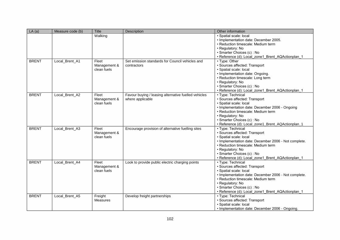
102
LA (a) Measure code (b) Title Description Other information
Walking • Spatial scale: local • Implementation date: December 2005. • Reduction timescale: Medium term • Regulatory: No • Smarter Choices (c) : No • Reference (d): Local_zone1_Brent_AQActionplan_1
BRENT Local_Brent_A1 Fleet Management & clean fuels
Set emission standards for Council vehicles and contractors
• Type: Other • Sources affected: Transport • Spatial scale: local • Implementation date: Ongoing. • Reduction timescale: Long term • Regulatory: No • Smarter Choices (c) : No • Reference (d): Local_zone1_Brent_AQActionplan_1
BRENT Local_Brent_A2 Fleet Management & clean fuels
Favour buying / leasing alternative fuelled vehicles where applicable
• Type: Technical • Sources affected: Transport • Spatial scale: local • Implementation date: December 2006 - Ongoing • Reduction timescale: Medium term • Regulatory: No • Smarter Choices (c) : No • Reference (d): Local_zone1_Brent_AQActionplan_1
BRENT Local_Brent_A3 Fleet Management & clean fuels
Encourage provision of alternative fuelling sites • Type: Technical • Sources affected: Transport • Spatial scale: local • Implementation date: December 2006 - Not complete. • Reduction timescale: Medium term • Regulatory: No • Smarter Choices (c) : No • Reference (d): Local_zone1_Brent_AQActionplan_1
BRENT Local_Brent_A4 Fleet Management & clean fuels
Look to provide public electric charging points • Type: Technical • Sources affected: Transport • Spatial scale: local • Implementation date: December 2006 - Not complete. • Reduction timescale: Medium term • Regulatory: No • Smarter Choices (c) : No • Reference (d): Local_zone1_Brent_AQActionplan_1
BRENT Local_Brent_A5 Freight Measures
Develop freight partnerships • Type: Technical • Sources affected: Transport • Spatial scale: local • Implementation date: December 2006 - Ongoing.

103
LA (a) Measure code (b) Title Description Other information
• Reduction timescale: Short term • Regulatory: No • Smarter Choices (c) : No • Reference (d): Local_zone1_Brent_AQActionplan_1
BRENT Local_Brent_A6 Freight Measures
Carry out feasibility study into freight partnership with Royal Parks in Brent
• Type: Technical • Sources affected: Transport • Spatial scale: local • Implementation date: December 2006 - Ongoing. • Reduction timescale: Short term • Regulatory: No • Smarter Choices (c) : No • Reference (d): Local_zone1_Brent_AQActionplan_1
BRENT Local_Brent_E1 Land Use Planning
Application of S106 agreements • Type: Technical • Sources affected: Transport • Spatial scale: local • Implementation date: Ongoing. • Reduction timescale: Medium term • Regulatory: Yes • Smarter Choices (c) : No • Reference (d): Local_zone1_Brent_AQActionplan_1
BRENT Local_Brent_E3 Land Use Planning
Green code of practise for building sites • Type: Technical • Sources affected: Transport • Spatial scale: local • Implementation date: Three Actions - Ongoing. • Reduction timescale: Medium term • Regulatory: No • Smarter Choices (c) : No • Reference (d): Local_zone1_Brent_AQActionplan_1
BRENT Local_Brent_A7 Low Emission Zones
Will consider LEZ in light of study results • Type: Economic/fiscal • Sources affected: Transport • Spatial scale: regional • Implementation date: Dec 2005 & Dec 2007 • Reduction timescale: Long term • Regulatory: Yes • Smarter Choices (c) : No • Reference (d): Local_zone1_Brent_AQActionplan_1
BRENT Local_Brent_D1 Parking Management & Charging
Create 6 new CPZ • Type: Economic/fiscal • Sources affected: Transport • Spatial scale: local • Implementation date: Dec 2005 & Dec 2007 • Reduction timescale: Long term • Regulatory: No
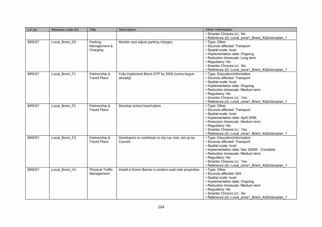
104
LA (a) Measure code (b) Title Description Other information
• Smarter Choices (c) : No • Reference (d): Local_zone1_Brent_AQActionplan_1
BRENT Local_Brent_D2 Parking Management & Charging
Monitor and adjust parking charges • Type: Other • Sources affected: Transport • Spatial scale: local • Implementation date: Ongoing • Reduction timescale: Long term • Regulatory: No • Smarter Choices (c) : No • Reference (d): Local_zone1_Brent_AQActionplan_1
BRENT Local_Brent_F1 Partnership & Travel Plans
Fully implement Brent GTP by 2006 (some begun already)
• Type: Education/information • Sources affected: Transport • Spatial scale: local • Implementation date: Ongoing. • Reduction timescale: Medium term • Regulatory: No • Smarter Choices (c) : Yes • Reference (d): Local_zone1_Brent_AQActionplan_1
BRENT Local_Brent_F2 Partnership & Travel Plans
Develop school travel plans • Type: Other • Sources affected: Transport • Spatial scale: local • Implementation date: April 2006. • Reduction timescale: Medium term • Regulatory: No • Smarter Choices (c) : Yes • Reference (d): Local_zone1_Brent_AQActionplan_1
BRENT Local_Brent_F3 Partnership & Travel Plans
Developers to contribute to city car club, set up by Council
• Type: Education/information • Sources affected: Transport • Spatial scale: local • Implementation date: Dec 20056 - Complete • Reduction timescale: Medium term • Regulatory: No • Smarter Choices (c) : Yes • Reference (d): Local_zone1_Brent_AQActionplan_1
BRENT Local_Brent_H1 Physical Traffic Management
Install a Green Barrier to protect road-side properties • Type: Other • Sources affected: N/A • Spatial scale: local • Implementation date: Ongoing. • Reduction timescale: Medium term • Regulatory: No • Smarter Choices (c) : No • Reference (d): Local_zone1_Brent_AQActionplan_1
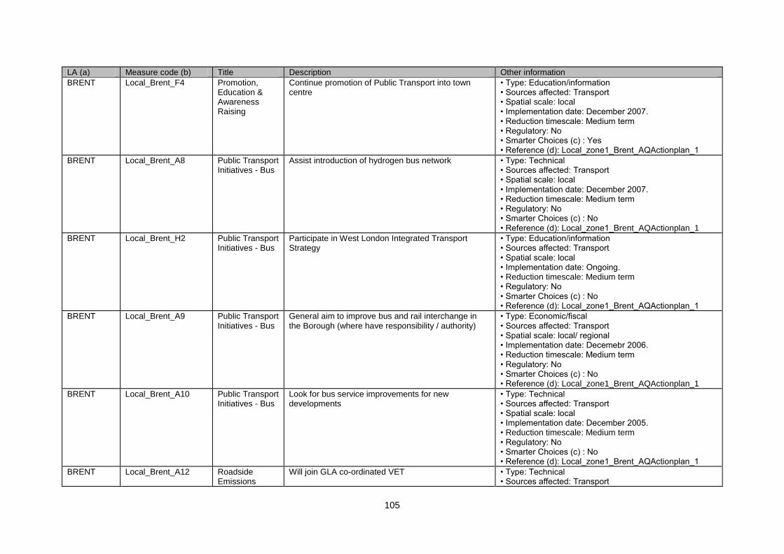
105
LA (a) Measure code (b) Title Description Other information
BRENT Local_Brent_F4 Promotion, Education & Awareness Raising
Continue promotion of Public Transport into town centre
• Type: Education/information • Sources affected: Transport • Spatial scale: local • Implementation date: December 2007. • Reduction timescale: Medium term • Regulatory: No • Smarter Choices (c) : Yes • Reference (d): Local_zone1_Brent_AQActionplan_1
BRENT Local_Brent_A8 Public Transport Initiatives - Bus
Assist introduction of hydrogen bus network • Type: Technical • Sources affected: Transport • Spatial scale: local • Implementation date: December 2007. • Reduction timescale: Medium term • Regulatory: No • Smarter Choices (c) : No • Reference (d): Local_zone1_Brent_AQActionplan_1
BRENT Local_Brent_H2 Public Transport Initiatives - Bus
Participate in West London Integrated Transport Strategy
• Type: Education/information • Sources affected: Transport • Spatial scale: local • Implementation date: Ongoing. • Reduction timescale: Medium term • Regulatory: No • Smarter Choices (c) : No • Reference (d): Local_zone1_Brent_AQActionplan_1
BRENT Local_Brent_A9 Public Transport Initiatives - Bus
General aim to improve bus and rail interchange in the Borough (where have responsibility / authority)
• Type: Economic/fiscal • Sources affected: Transport • Spatial scale: local/ regional • Implementation date: Decemebr 2006. • Reduction timescale: Medium term • Regulatory: No • Smarter Choices (c) : No • Reference (d): Local_zone1_Brent_AQActionplan_1
BRENT Local_Brent_A10 Public Transport Initiatives - Bus
Look for bus service improvements for new developments
• Type: Technical • Sources affected: Transport • Spatial scale: local • Implementation date: December 2005. • Reduction timescale: Medium term • Regulatory: No • Smarter Choices (c) : No • Reference (d): Local_zone1_Brent_AQActionplan_1
BRENT Local_Brent_A12 Roadside Emissions
Will join GLA co-ordinated VET • Type: Technical • Sources affected: Transport
106
LA (a) Measure code (b) Title Description Other information
Testing • Spatial scale: local • Implementation date: Ongoing. • Reduction timescale: Medium term • Regulatory: No • Smarter Choices (c) : No • Reference (d): Local_zone1_Brent_AQActionplan_1
BRENT Local_Brent_A11 Roadside Emissions Testing
Will look how to enforce idle engine powers • Type: Technical • Sources affected: Transport • Spatial scale: local • Implementation date: Various Measures Dec 2005 - Feb 2006 • Reduction timescale: Medium term • Regulatory: No • Smarter Choices (c) : No • Reference (d): Local_zone1_Brent_AQActionplan_1
BROXBOURNE
Local_Broxborne_E1 Land Use Planning
Ensuring AQ issues are taken into account in assessment of planning applications
• Type: Technical • Sources affected: Transport • Spatial scale: local • Implementation date: • Reduction timescale: Long term • Regulatory: No • Smarter Choices (c) : No • Reference (d): Local_zone1_Broxbourne_AQActionplan_1
BROXBOURNE
Local_Broxborne_A1 Low Emission Zones
Consider impact of London LEZ. • Type: Economic/fiscal • Sources affected: Transport • Spatial scale: regional • Implementation date: • Reduction timescale: Long term • Regulatory: No • Smarter Choices (c) : No • Reference (d): Local_zone1_Broxbourne_AQActionplan_1
BROXBOURNE
Local_Broxborne_A2 Physical Traffic Management
M25 J23-27 widening & Congestion scheme • Type: Technical • Sources affected: Transport • Spatial scale: regional • Implementation date: • Reduction timescale: Medium term • Regulatory: No • Smarter Choices (c) : No • Reference (d): Local_zone1_Broxbourne_AQActionplan_1
107
LA (a) Measure code (b) Title Description Other information
CAMDEN Local_Camden_A1 Fleet Management & clean fuels
Propose improvements in own fleet, contractors‟ fleet and across businesses and individuals within Borough
• Type: Technical • Sources affected: Transport • Spatial scale: local • Implementation date: 2003 • Reduction timescale: Medium term • Regulatory: No • Smarter Choices (c) : No • Reference (d): Local_zone1_camden_AQActionplan_1
CAMDEN Local_Camden_A2 Low Emission Zones
Work in this area is heavily dependent upon the London LEZ study that is on-going. Active consideration of LEZ is stated. Previous modelling work is referred to. Some consideration of effects on business of LEZ.
• Type: Economic/fiscal • Sources affected: Transport • Spatial scale: regional • Implementation date: Decision 2002 - Implement from 2007. • Reduction timescale: Long term • Regulatory: Yes • Smarter Choices (c) : No • Reference (d): Local_zone1_camden_AQActionplan_1
CAMDEN Local_Camden_F1 Partnership & Travel Plans
Other on-going partnership activities e.g travel plans, car clubs, cycling /walking strategies are set out which could contribute to modal shift and may reduce emissions.
• Type: Other • Sources affected: Transport • Spatial scale: local • Implementation date: Ongoing. • Reduction timescale: Long term • Regulatory: No • Smarter Choices (c) : Yes • Reference (d): Local_zone1_camden_AQActionplan_1
CITY AND COUNTY OF THE CITY OF LONDON
Local_CityOL_G1 Development of Cycling and Walking
Development of existing schemes and work with neighbouring authorities
• Type: Other • Sources affected: Transport • Spatial scale: regional • Implementation date: 2008 • Reduction timescale: Medium term • Regulatory: No • Smarter Choices (c) : No • Reference (d): Local_zone1_CityAndCountyOfTheCityOfLondon_AQActionplan_1
CITY AND COUNTY OF THE CITY OF LONDON
Local_CityOL_A1 Fleet Management & clean fuels
Council fleet, the police, taxis and local organisations to adopt greener vehicles.
• Type: Technical • Sources affected: Transport • Spatial scale: local • Implementation date: 2004 - Ongoing. • Reduction timescale: Medium term • Regulatory: No • Smarter Choices (c) : No
108
LA (a) Measure code (b) Title Description Other information
• Reference (d): Local_zone1_CityAndCountyOfTheCityOfLondon_AQActionplan_1
CITY AND COUNTY OF THE CITY OF LONDON
Local_CityOL_E1 Land Use Planning
UDP review • Type: Other • Sources affected: Transport; Industry including heating and power production • Spatial scale: all • Implementation date: Ongoing. • Reduction timescale: Medium term • Regulatory: No • Smarter Choices (c) : Yes • Reference (d): Local_zone1_CityAndCountyOfTheCityOfLondon_AQActionplan_1
CITY AND COUNTY OF THE CITY OF LONDON
Local_CityOL_A2 Low Emission Zones
Strongly support London-wide LEZ. • Type: Economic/fiscal • Sources affected: Transport • Spatial scale: regional • Implementation date: 2008 • Reduction timescale: Long term • Regulatory: Yes • Smarter Choices (c) : No • Reference (d): Local_zone1_CityAndCountyOfTheCityOfLondon_AQActionplan_1
CITY AND COUNTY OF THE CITY OF LONDON
Local_CityOL_E2 Parking Management & Charging
Existing parking policies. • Type: Other • Sources affected: Transport • Spatial scale: local • Implementation date: Ongoing. • Reduction timescale: Long term • Regulatory: No • Smarter Choices (c) : No • Reference (d): Local_zone1_CityAndCountyOfTheCityOfLondon_AQActionplan_1
CITY AND COUNTY OF THE CITY OF LONDON
Local_CityOL_F1 Partnership & Travel Plans
Existing safe routes to school • Type: Economic/fiscal • Sources affected: Transport • Spatial scale: local • Implementation date: 2003 • Reduction timescale: Long term • Regulatory: No • Smarter Choices (c) : Yes • Reference (d):
109
LA (a) Measure code (b) Title Description Other information
Local_zone1_CityAndCountyOfTheCityOfLondon_AQActionplan_1
CITY AND COUNTY OF THE CITY OF LONDON
Local_CityOL_H1 Road User Charging
Following developments of the London Congestion Charging Scheme
• Type: Economic/fiscal • Sources affected: Transport • Spatial scale: regional • Implementation date: Ongoing. • Reduction timescale: Long term • Regulatory: Yes • Smarter Choices (c) : No • Reference (d): Local_zone1_CityAndCountyOfTheCityOfLondon_AQActionplan_1
CITY OF WESTMINSTER
Local_Westminster_C1
LEZ Promotion of Low Emission Zone in London • Type: Other • Sources affected: Transport • Spatial scale: regional • Implementation date: Complete. • Reduction timescale: Medium term • Regulatory: No • Smarter Choices (c) : No • Reference (d): Local_zone1_Westminster_AQActionplan_1
CITY OF WESTMINSTER
Local_Westminster_C2
Alternative fuels/ vehicles
Incorporate cleaner vehicle technology and alternative fuels within Council fleet
• Type: Technical • Sources affected: Transport • Spatial scale: local • Implementation date: Various ongoing. • Reduction timescale: Medium term • Regulatory: No • Smarter Choices (c) : No • Reference (d): Local_zone1_Westminster_AQActionplan_1
CITY OF WESTMINSTER
Local_Westminster_C3
Alternative fuels/ vehicles
Require Westminster City Council contractors to use minimum Euro 5 vehicles and encourage use of electric, electric, LPG and other alternatives.
• Type: Other • Sources affected: Transport; Industry including heating and power production • Spatial scale: local • Implementation date: 2008 - Ongoing. • Reduction timescale: Medium term • Regulatory: No • Smarter Choices (c) : No • Reference (d): Local_zone1_Westminster_AQActionplan_1
CITY OF WESTMINS
Local_Westminster_C4
Alternative fuels/ vehicles
Work with London Bus Services and other partners on EU hydrogen fuel cell project, on provision of
• Type: Economic/fiscal • Sources affected: Transport
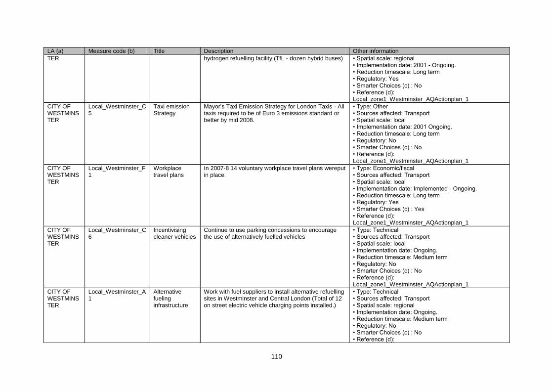
110
LA (a) Measure code (b) Title Description Other information
TER hydrogen refuelling facility (TfL - dozen hybrid buses) • Spatial scale: regional • Implementation date: 2001 - Ongoing. • Reduction timescale: Long term • Regulatory: Yes • Smarter Choices (c) : No • Reference (d): Local_zone1_Westminster_AQActionplan_1
CITY OF WESTMINSTER
Local_Westminster_C5
Taxi emission Strategy
Mayor‟s Taxi Emission Strategy for London Taxis - All taxis required to be of Euro 3 emissions standard or better by mid 2008.
• Type: Other • Sources affected: Transport • Spatial scale: local • Implementation date: 2001 Ongoing. • Reduction timescale: Long term • Regulatory: No • Smarter Choices (c) : No • Reference (d): Local_zone1_Westminster_AQActionplan_1
CITY OF WESTMINSTER
Local_Westminster_F1
Workplace travel plans
In 2007-8 14 voluntary workplace travel plans wereput in place.
• Type: Economic/fiscal • Sources affected: Transport • Spatial scale: local • Implementation date: Implemented - Ongoing. • Reduction timescale: Long term • Regulatory: Yes • Smarter Choices (c) : Yes • Reference (d): Local_zone1_Westminster_AQActionplan_1
CITY OF WESTMINSTER
Local_Westminster_C6
Incentivising cleaner vehicles
Continue to use parking concessions to encourage the use of alternatively fuelled vehicles
• Type: Technical • Sources affected: Transport • Spatial scale: local • Implementation date: Ongoing. • Reduction timescale: Medium term • Regulatory: No • Smarter Choices (c) : No • Reference (d): Local_zone1_Westminster_AQActionplan_1
CITY OF WESTMINSTER
Local_Westminster_A1
Alternative fueling infrastructure
Work with fuel suppliers to install alternative refuelling sites in Westminster and Central London (Total of 12 on street electric vehicle charging points installed.)
• Type: Technical • Sources affected: Transport • Spatial scale: regional • Implementation date: Ongoing. • Reduction timescale: Medium term • Regulatory: No • Smarter Choices (c) : No • Reference (d):
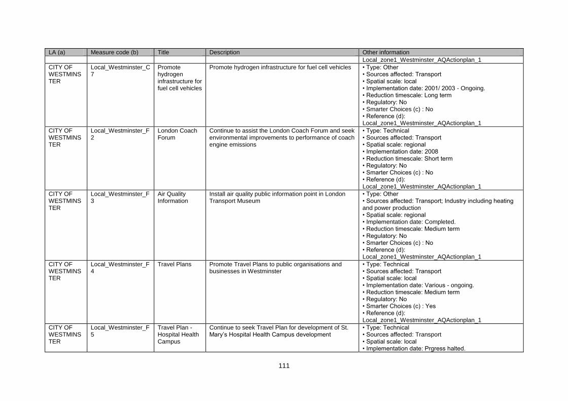
111
LA (a) Measure code (b) Title Description Other information
Local_zone1_Westminster_AQActionplan_1
CITY OF WESTMINSTER
Local_Westminster_C7
Promote hydrogen infrastructure for fuel cell vehicles
Promote hydrogen infrastructure for fuel cell vehicles • Type: Other • Sources affected: Transport • Spatial scale: local • Implementation date: 2001/ 2003 - Ongoing. • Reduction timescale: Long term • Regulatory: No • Smarter Choices (c) : No • Reference (d): Local_zone1_Westminster_AQActionplan_1
CITY OF WESTMINSTER
Local_Westminster_F2
London Coach Forum
Continue to assist the London Coach Forum and seek environmental improvements to performance of coach engine emissions
• Type: Technical • Sources affected: Transport • Spatial scale: regional • Implementation date: 2008 • Reduction timescale: Short term • Regulatory: No • Smarter Choices (c) : No • Reference (d): Local_zone1_Westminster_AQActionplan_1
CITY OF WESTMINSTER
Local_Westminster_F3
Air Quality Information
Install air quality public information point in London Transport Museum
• Type: Other • Sources affected: Transport; Industry including heating and power production • Spatial scale: regional • Implementation date: Completed. • Reduction timescale: Medium term • Regulatory: No • Smarter Choices (c) : No • Reference (d): Local_zone1_Westminster_AQActionplan_1
CITY OF WESTMINSTER
Local_Westminster_F4
Travel Plans Promote Travel Plans to public organisations and businesses in Westminster
• Type: Technical • Sources affected: Transport • Spatial scale: local • Implementation date: Various - ongoing. • Reduction timescale: Medium term • Regulatory: No • Smarter Choices (c) : Yes • Reference (d): Local_zone1_Westminster_AQActionplan_1
CITY OF WESTMINSTER
Local_Westminster_F5
Travel Plan - Hospital Health Campus
Continue to seek Travel Plan for development of St. Mary‟s Hospital Health Campus development
• Type: Technical • Sources affected: Transport • Spatial scale: local • Implementation date: Prgress halted.
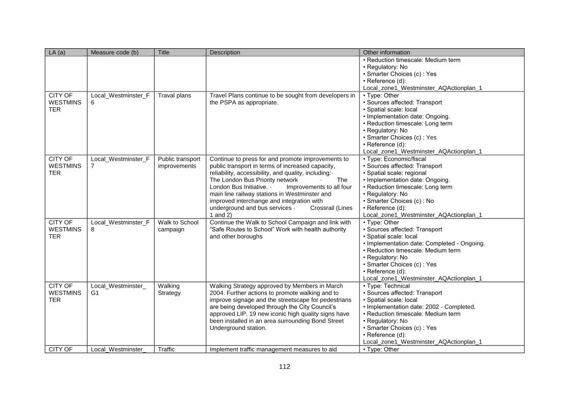
112
LA (a) Measure code (b) Title Description Other information
• Reduction timescale: Medium term • Regulatory: No • Smarter Choices (c) : Yes • Reference (d): Local_zone1_Westminster_AQActionplan_1
CITY OF WESTMINSTER
Local_Westminster_F6
Traval plans Travel Plans continue to be sought from developers in the PSPA as appropriate.
• Type: Other • Sources affected: Transport • Spatial scale: local • Implementation date: Ongoing. • Reduction timescale: Long term • Regulatory: No • Smarter Choices (c) : Yes • Reference (d): Local_zone1_Westminster_AQActionplan_1
CITY OF WESTMINSTER
Local_Westminster_F7
Public transport improvements
Continue to press for and promote improvements to public transport in terms of increased capacity, reliability, accessibility, and quality, including:· The London Bus Priority network · The London Bus Initiative. · Improvements to all four main line railway stations in Westminster and improved interchange and integration with underground and bus services · Crossrail (Lines 1 and 2)
• Type: Economic/fiscal • Sources affected: Transport • Spatial scale: regional • Implementation date: Ongoing. • Reduction timescale: Long term • Regulatory: No • Smarter Choices (c) : No • Reference (d): Local_zone1_Westminster_AQActionplan_1
CITY OF WESTMINSTER
Local_Westminster_F8
Walk to School campaign
Continue the Walk to School Campaign and link with “Safe Routes to School” Work with health authority and other boroughs
• Type: Other • Sources affected: Transport • Spatial scale: local • Implementation date: Completed - Ongoing. • Reduction timescale: Medium term • Regulatory: No • Smarter Choices (c) : Yes • Reference (d): Local_zone1_Westminster_AQActionplan_1
CITY OF WESTMINSTER
Local_Westminster_G1
Walking Strategy
Walking Strategy approved by Members in March 2004. Further actions to promote walking and to improve signage and the streetscape for pedestrians are being developed through the City Council‟s approved LIP. 19 new iconic high quality signs have been installed in an area surrounding Bond Street Underground station.
• Type: Technical • Sources affected: Transport • Spatial scale: local • Implementation date: 2002 - Completed. • Reduction timescale: Medium term • Regulatory: No • Smarter Choices (c) : Yes • Reference (d): Local_zone1_Westminster_AQActionplan_1
CITY OF Local_Westminster_ Traffic Implement traffic management measures to aid • Type: Other
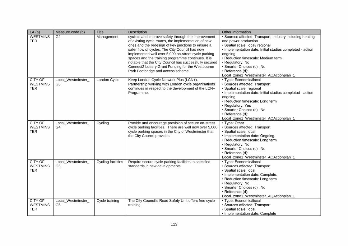
113
LA (a) Measure code (b) Title Description Other information
WESTMINSTER
G2 Management cyclists and improve safety through the improvement of existing cycle routes, the implementation of new ones and the redesign of key junctions to ensure a safer flow of cycles. The City Council has now implemented well over 5,000 on-street cycle parking spaces and the training programme continues. It is notable that the City Council has successfully secured Connect2 Lottery Grant Funding for the Westbourne Park Footbridge and access scheme.
• Sources affected: Transport; Industry including heating and power production • Spatial scale: local/ regional • Implementation date: Initial studies completed - action ongoing. • Reduction timescale: Medium term • Regulatory: No • Smarter Choices (c) : No • Reference (d): Local_zone1_Westminster_AQActionplan_1
CITY OF WESTMINSTER
Local_Westminster_G3
London Cycle Keep London Cycle Network Plus (LCN+). Partnership working with London cycle organisations continues in respect to the development of the LCN+ Programme.
• Type: Economic/fiscal • Sources affected: Transport • Spatial scale: regional • Implementation date: Initial studies completed - action ongoing. • Reduction timescale: Long term • Regulatory: Yes • Smarter Choices (c) : No • Reference (d): Local_zone1_Westminster_AQActionplan_1
CITY OF WESTMINSTER
Local_Westminster_G4
Cycling Provide and encourage provision of secure on-street cycle parking facilities. There are well now over 5,000 cycle parking spaces in the City of Westminster that the City Council provides
• Type: Other • Sources affected: Transport • Spatial scale: local • Implementation date: Ongoing. • Reduction timescale: Long term • Regulatory: No • Smarter Choices (c) : No • Reference (d): Local_zone1_Westminster_AQActionplan_1
CITY OF WESTMINSTER
Local_Westminster_G5
Cycling facilities Require secure cycle parking facilities to specified standards in new developments
• Type: Economic/fiscal • Sources affected: Transport • Spatial scale: local • Implementation date: Complete. • Reduction timescale: Long term • Regulatory: No • Smarter Choices (c) : No • Reference (d): Local_zone1_Westminster_AQActionplan_1
CITY OF WESTMINSTER
Local_Westminster_G6
Cycle training The City Council‟s Road Safety Unit offers free cycle training.
• Type: Economic/fiscal • Sources affected: Transport • Spatial scale: local • Implementation date: Complete
114
LA (a) Measure code (b) Title Description Other information
• Reduction timescale: Long term • Regulatory: Yes • Smarter Choices (c) : No • Reference (d): Local_zone1_Westminster_AQActionplan_1
CITY OF WESTMINSTER
Local_Westminster_D1
Parking provision
Encourage the conversion of office parking space for other uses
• Type: Economic/fiscal • Sources affected: Transport • Spatial scale: local • Implementation date: Encorporated into plan but to be reviewed as part of LDF. • Reduction timescale: Long term • Regulatory: No • Smarter Choices (c) : No • Reference (d): Local_zone1_Westminster_AQActionplan_1
CITY OF WESTMINSTER
Local_Westminster_D2
Parking Standards
Specify new parking standards for new residential and commercial developments
• Type: Technical • Sources affected: Transport • Spatial scale: local • Implementation date: Part of UDP. • Reduction timescale: Medium term • Regulatory: No • Smarter Choices (c) : No • Reference (d): Local_zone1_Westminster_AQActionplan_1
CITY OF WESTMINSTER
Local_Westminster_A2
Red Route implementation of Red Route • Type: Other • Sources affected: Transport; Industry including heating and power production • Spatial scale: local • Implementation date: Completed. • Reduction timescale: Medium term • Regulatory: No • Smarter Choices (c) : No • Reference (d): Local_zone1_Westminster_AQActionplan_1
CITY OF WESTMINSTER
Local_Westminster_A3
Traffic Calming Continue programme of traffic calming measures to reduce speed, improve the local environment and reduce access.
• Type: Economic/fiscal • Sources affected: Transport • Spatial scale: local • Implementation date: Annually reviewed. • Reduction timescale: Long term • Regulatory: Yes • Smarter Choices (c) : No • Reference (d):
115
LA (a) Measure code (b) Title Description Other information
Local_zone1_Westminster_AQActionplan_1
CITY OF WESTMINSTER
Local_Westminster_H1
CCTV Use of CCTV enforcement solutions • Type: Other • Sources affected: Transport • Spatial scale: local • Implementation date: Ongoing. • Reduction timescale: Long term • Regulatory: No • Smarter Choices (c) : No • Reference (d): Local_zone1_Westminster_AQActionplan_1
CITY OF WESTMINSTER
Local_Westminster_F9
Car Plus The City Council joined Car Plus an organisation established to promote car clubs and their usage.
• Type: Economic/fiscal • Sources affected: Transport • Spatial scale: local • Implementation date: Member since 2008. • Reduction timescale: Long term • Regulatory: No • Smarter Choices (c) : Yes • Reference (d): Local_zone1_Westminster_AQActionplan_1
CITY OF WESTMINSTER
Local_Westminster_E1
Development control
Require Transport Impact and/ or Environmental Impact Assessment Statements for major developments
• Type: Economic/fiscal • Sources affected: Transport • Spatial scale: local • Implementation date: Part of planning process - completed. • Reduction timescale: Long term • Regulatory: Yes • Smarter Choices (c) : No • Reference (d): Local_zone1_Westminster_AQActionplan_1
CITY OF WESTMINSTER
Local_Westminster_B2
Development control
Devise strategy to ensure that emissions from standby diesel generators and those used on building sites are not excessive.
• Type: Technical • Sources affected: Transport • Spatial scale: local • Implementation date: Completed. • Reduction timescale: Medium term • Regulatory: No • Smarter Choices (c) : No • Reference (d): Local_zone1_Westminster_AQActionplan_1
CITY OF WESTMINSTER
Local_Westminster_E2
Energy Efficiency
Information on energy efficient and low emission heating and air conditioning systems is included in Sustainable Buildings Supplementary Planning Guidance, and in the Environment Chapter of the
• Type: Technical • Sources affected: Commercial and residential sources • Spatial scale: regional • Implementation date: Part of planning guidance -
116
LA (a) Measure code (b) Title Description Other information
Replacement Unitary Development Plan., replacing the Building Control Handbook
complete. • Reduction timescale: Medium term • Regulatory: No • Smarter Choices (c) : No • Reference (d): Local_zone1_Westminster_AQActionplan_1
CITY OF WESTMINSTER
Local_Westminster_F10
Promotion, Education & Awareness Raising
„YOUR AIR‟ text service. Daily information will also be available at www.westminster.gov.uk/airquality
• Type: Education/information • Sources affected: Transport • Spatial scale: local • Implementation date: Implemented - ongoing. • Reduction timescale: Long term • Regulatory: No • Smarter Choices (c) : No • Reference (d): Local_zone1_Westminster_AQActionplan_1
CITY OF WESTMINSTER
Local_Westminster_F11
Promotion, Education & Awareness Raising
Comprehensive and up-to-date air quality data and information is now provided on the City Councils‟ website
• Type: Education/information • Sources affected: Transport • Spatial scale: local • Implementation date: Ongoing. • Reduction timescale: Short term • Regulatory: No • Smarter Choices (c) : No • Reference (d): Local_zone1_Westminster_AQActionplan_1
CITY OF WESTMINSTER
Local_Westminster_F12
Promotion, Education & Awareness Raising
Add suitable information on air quality and noise issues using latest adopted UDP and other statutory and non-statutory guidance
• Type: Other • Sources affected: Transport; Industry including heating and power production • Spatial scale: local • Implementation date: 2008 - Ongoing. • Reduction timescale: Medium term • Regulatory: No • Smarter Choices (c) : No • Reference (d): Local_zone1_Westminster_AQActionplan_1
CROYDON Local_Croydon_A1 Promotion, Education & Awareness Raising
Vehicle idling enforcement • Type: Technical • Sources affected: Transport • Spatial scale: local • Implementation date: Ongoing… • Reduction timescale: Medium term • Regulatory: No • Smarter Choices (c) : No • Reference (d): Local_zone1_Croydon_AQActionplan_1
117
LA (a) Measure code (b) Title Description Other information
CROYDON Local_Croydon_A2 Roadside Emissions Testing
Roadside Vehicle emissions testing • Type: Technical • Sources affected: Transport • Spatial scale: local • Implementation date: Ongoing. • Reduction timescale: Medium term • Regulatory: No • Smarter Choices (c) : No • Reference (d): Local_zone1_Croydon_AQActionplan_1
CROYDON Local_Croydon_A3 Freight Measures
Support for London LEZ • Type: Economic/fiscal • Sources affected: Transport • Spatial scale: regional • Implementation date: Ongoing. • Reduction timescale: Long term • Regulatory: Yes • Smarter Choices (c) : No • Reference (d): Local_zone1_Croydon_AQActionplan_1
CROYDON Local_Croydon_A4 Fleet Management & clean fuels
Making our fleet compliant with the proposed low emission zone standards
• Type: Technical • Sources affected: Transport • Spatial scale: local • Implementation date: Ongoing. • Reduction timescale: Medium term • Regulatory: No • Smarter Choices (c) : No • Reference (d): Local_zone1_Croydon_AQActionplan_1
CROYDON Local_Croydon_E1 Fuel Improvement
Developing Unitary Development Plan policy to require 10% energy generation from renewable sources for new developments
• Type: Technical • Sources affected: Transport • Spatial scale: local • Implementation date: Ongoing. • Reduction timescale: Medium term • Regulatory: No • Smarter Choices (c) : No • Reference (d): Local_zone1_Croydon_AQActionplan_1
CROYDON Local_Croydon_E2 Land Use Planning
Supplementary planning guidance on developing green travel plans
• Type: Other • Sources affected: Transport; Industry including heating and power production • Spatial scale: local • Implementation date: Ongoing. • Reduction timescale: Medium term • Regulatory: No • Smarter Choices (c) : Yes • Reference (d): Local_zone1_Croydon_AQActionplan_1
CROYDON Local_Croydon_F1 Promotion, Implementing Croydon airTEXT project • Type: Education/information
118
LA (a) Measure code (b) Title Description Other information
Education & Awareness Raising
• Sources affected: N/A • Spatial scale: local • Implementation date: Ongoing. • Reduction timescale: Short term • Regulatory: No • Smarter Choices (c) : No • Reference (d): Local_zone1_Croydon_AQActionplan_1
DARTFORD Local_Dartford_C1 Fleet Management & clean fuels
Encouraging cleaner vehicles • Type: Technical • Sources affected: Transport • Spatial scale: local • Implementation date: 2002 • Reduction timescale: Medium term • Regulatory: No • Smarter Choices (c) : No • Reference (d): Local_zone1_dartford_AQActionplan_1
DARTFORD Local_Dartford_F1 Partnership & Travel Plans
Council Travel Plan • Type: Technical • Sources affected: Transport • Spatial scale: local • Implementation date: 2002 • Reduction timescale: Medium term • Regulatory: No • Smarter Choices (c) : Yes • Reference (d): Local_zone1_dartford_AQActionplan_1
DARTFORD Local_Dartford_F2 Partnership & Travel Plans
Advice to businesses • Type: Education/information • Sources affected: Transport • Spatial scale: local • Implementation date: 2002 - 2003 • Reduction timescale: Medium term • Regulatory: No • Smarter Choices (c) : No • Reference (d): Local_zone1_dartford_AQActionplan_1
DARTFORD Local_Dartford_A1 Partnership & Travel Plans
Development of borough transport strategy • Type: Technical • Sources affected: Transport • Spatial scale: local • Implementation date: 2002 • Reduction timescale: Medium term • Regulatory: No • Smarter Choices (c) : No • Reference (d): Local_zone1_dartford_AQActionplan_1
DARTFORD Local_Dartford_F3 Promotion, Education & Awareness
Development of website • Type: Education/information • Sources affected: Transport • Spatial scale: local
119
LA (a) Measure code (b) Title Description Other information
Raising • Implementation date: 2002 - 2003 • Reduction timescale: Medium term • Regulatory: No • Smarter Choices (c) : No • Reference (d): Local_zone1_dartford_AQActionplan_1
DARTFORD Local_Dartford_F4 Promotion, Education & Awareness Raising
Ad hoc talks to schools • Type: Education/information • Sources affected: Transport • Spatial scale: local • Implementation date: 2002 - ongoing • Reduction timescale: Medium term • Regulatory: No • Smarter Choices (c) : No • Reference (d): Local_zone1_dartford_AQActionplan_1
DARTFORD Local_Dartford_E1 Public Transport Initiatives - Bus
Fastrack public transport infrastructure improvements. • Type: Technical • Sources affected: Transport • Spatial scale: regional • Implementation date: 2004 • Reduction timescale: Medium term • Regulatory: No • Smarter Choices (c) : No • Reference (d): Local_zone1_dartford_AQActionplan_1
DARTFORD Local_Dartford_A2 Roadside Emissions Testing
Promotion of local vehicle emissions testing • Type: Technical • Sources affected: Transport • Spatial scale: local • Implementation date: 2002 • Reduction timescale: Medium term • Regulatory: No • Smarter Choices (c) : No • Reference (d): Local_zone1_dartford_AQActionplan_1
EALING Local_Ealing_B1 Nuisance Policy Encouraging composting, discouraging bonfires • Type: Other • Sources affected: Agriculture • Spatial scale: local • Implementation date: 2006 • Reduction timescale: Short term • Regulatory: No • Smarter Choices (c) : No • Reference (d): Local_zone1_Ealing_AQActionplan_1
EALING Local_Ealing_B2 Local Abatement
Continue to regulate Part B processes • Type: Technical • Sources affected: Industry including heating and power production • Spatial scale: local • Implementation date: 2006
120
LA (a) Measure code (b) Title Description Other information
• Reduction timescale: Medium term • Regulatory: No • Smarter Choices (c) : No • Reference (d): Local_zone1_Ealing_AQActionplan_1
EALING Local_Ealing_G1 Development of Cycling and Walking
Cycling and walking initiatives • Type: Other • Sources affected: Transport • Spatial scale: local • Implementation date: 2006 • Reduction timescale: Long term • Regulatory: No • Smarter Choices (c) : No • Reference (d): Local_zone1_Ealing_AQActionplan_1
EALING Local_Ealing_A1 Freight Measures
measures for cleaner waste vehicles • Type: Other • Sources affected: Transport • Spatial scale: local • Implementation date: 2006 • Reduction timescale: Long term • Regulatory: No • Smarter Choices (c) : No • Reference (d): Local_zone1_Ealing_AQActionplan_1
EALING Local_Ealing_A2 Freight Measures
Potential measures for freight quality partnership • Type: Technical • Sources affected: Transport • Spatial scale: regional • Implementation date: 2003 - ongoing. • Reduction timescale: Medium term • Regulatory: No • Smarter Choices (c) : No • Reference (d): Local_zone1_Ealing_AQActionplan_1
EALING Local_Ealing_A3 Land Use Planning
Faciliate development of major projects. • Type: Technical • Sources affected: Transport • Spatial scale: local • Implementation date: 2003 - 2006 • Reduction timescale: Medium term • Regulatory: No • Smarter Choices (c) : No • Reference (d): Local_zone1_Ealing_AQActionplan_1
EALING Local_Ealing_E1 Land Use Planning
Require bus improvements with new devlopments. • Type: Technical • Sources affected: Transport • Spatial scale: local • Implementation date: 2003 - 2006 • Reduction timescale: Medium term • Regulatory: No
121
LA (a) Measure code (b) Title Description Other information
• Smarter Choices (c) : No • Reference (d): Local_zone1_Ealing_AQActionplan_1
EALING Local_Ealing_A4 Low Emission Zones
LEZ measures modelled as part of Stage 4, but looking to London LEZ study for guidance.
• Type: Economic/fiscal • Sources affected: Transport • Spatial scale: regional • Implementation date: 2007 • Reduction timescale: Long term • Regulatory: Yes • Smarter Choices (c) : No • Reference (d): Local_zone1_Ealing_AQActionplan_1
EALING Local_Ealing_D1 Parking Management & Charging
Consult on new CPZs • Type: Economic/fiscal • Sources affected: Transport • Spatial scale: local • Implementation date: 2006 • Reduction timescale: Long term • Regulatory: No • Smarter Choices (c) : No • Reference (d): Local_zone1_Ealing_AQActionplan_1
EALING Local_Ealing_D2 Parking Management & Charging
Parking standards • Type: Other • Sources affected: Transport • Spatial scale: local • Implementation date: 2006 • Reduction timescale: Long term • Regulatory: No • Smarter Choices (c) : No • Reference (d): Local_zone1_Ealing_AQActionplan_1
EALING Local_Ealing_A5 Partnership & Travel Plans
Car clubs • Type: Other • Sources affected: Transport • Spatial scale: local • Implementation date: 2006 • Reduction timescale: Medium term • Regulatory: No • Smarter Choices (c) : Yes • Reference (d): Local_zone1_Ealing_AQActionplan_1
EALING Local_Ealing_A6 Physical Traffic Management
Home zones • Type: Other • Sources affected: Transport • Spatial scale: local • Implementation date: 2007 • Reduction timescale: Long term • Regulatory: No • Smarter Choices (c) : No • Reference (d): Local_zone1_Ealing_AQActionplan_1
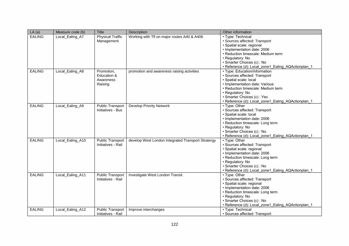
122
LA (a) Measure code (b) Title Description Other information
EALING Local_Ealing_A7 Physical Traffic Management
Working with Tfl on major routes A40 & A406 • Type: Technical • Sources affected: Transport • Spatial scale: regional • Implementation date: 2006 • Reduction timescale: Medium term • Regulatory: No • Smarter Choices (c) : No • Reference (d): Local_zone1_Ealing_AQActionplan_1
EALING Local_Ealing_A8 Promotion, Education & Awareness Raising
promotion and awareness raising activities • Type: Education/information • Sources affected: Transport • Spatial scale: local • Implementation date: Various • Reduction timescale: Medium term • Regulatory: No • Smarter Choices (c) : Yes • Reference (d): Local_zone1_Ealing_AQActionplan_1
EALING Local_Ealing_A9 Public Transport Initiatives - Bus
Develop Priority Network • Type: Other • Sources affected: Transport • Spatial scale: local • Implementation date: 2006 • Reduction timescale: Long term • Regulatory: No • Smarter Choices (c) : No • Reference (d): Local_zone1_Ealing_AQActionplan_1
EALING Local_Ealing_A10 Public Transport Initiatives - Rail
develop West London Integrated Transport Stratergy • Type: Other • Sources affected: Transport • Spatial scale: regional • Implementation date: 2006 • Reduction timescale: Long term • Regulatory: No • Smarter Choices (c) : No • Reference (d): Local_zone1_Ealing_AQActionplan_1
EALING Local_Ealing_A11 Public Transport Initiatives - Rail
Investigate West London Transit. • Type: Other • Sources affected: Transport • Spatial scale: regional • Implementation date: 2006 • Reduction timescale: Long term • Regulatory: No • Smarter Choices (c) : No • Reference (d): Local_zone1_Ealing_AQActionplan_1
EALING Local_Ealing_A12 Public Transport Initiatives - Rail
Improve interchanges • Type: Technical • Sources affected: Transport
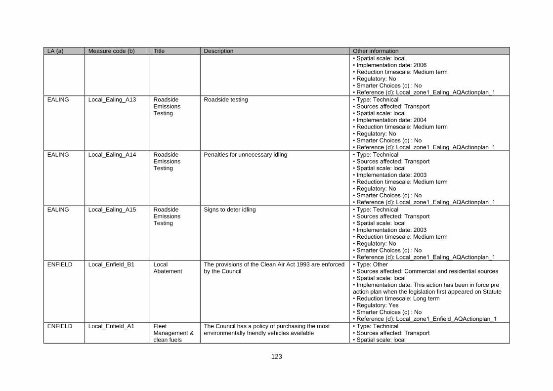
123
LA (a) Measure code (b) Title Description Other information
• Spatial scale: local • Implementation date: 2006 • Reduction timescale: Medium term • Regulatory: No • Smarter Choices (c) : No • Reference (d): Local_zone1_Ealing_AQActionplan_1
EALING Local_Ealing_A13 Roadside Emissions Testing
Roadside testing • Type: Technical • Sources affected: Transport • Spatial scale: local • Implementation date: 2004 • Reduction timescale: Medium term • Regulatory: No • Smarter Choices (c) : No • Reference (d): Local_zone1_Ealing_AQActionplan_1
EALING Local_Ealing_A14 Roadside Emissions Testing
Penalties for unnecessary idling • Type: Technical • Sources affected: Transport • Spatial scale: local • Implementation date: 2003 • Reduction timescale: Medium term • Regulatory: No • Smarter Choices (c) : No • Reference (d): Local_zone1_Ealing_AQActionplan_1
EALING Local_Ealing_A15 Roadside Emissions Testing
Signs to deter idling • Type: Technical • Sources affected: Transport • Spatial scale: local • Implementation date: 2003 • Reduction timescale: Medium term • Regulatory: No • Smarter Choices (c) : No • Reference (d): Local_zone1_Ealing_AQActionplan_1
ENFIELD Local_Enfield_B1 Local Abatement
The provisions of the Clean Air Act 1993 are enforced by the Council
• Type: Other • Sources affected: Commercial and residential sources • Spatial scale: local • Implementation date: This action has been in force pre action plan when the legislation first appeared on Statute • Reduction timescale: Long term • Regulatory: Yes • Smarter Choices (c) : No • Reference (d): Local_zone1_Enfield_AQActionplan_1
ENFIELD Local_Enfield_A1 Fleet Management & clean fuels
The Council has a policy of purchasing the most environmentally friendly vehicles available
• Type: Technical • Sources affected: Transport • Spatial scale: local
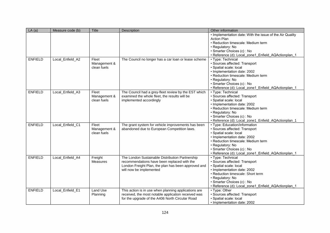
124
LA (a) Measure code (b) Title Description Other information
• Implementation date: With the issue of the Air Quality Action Plan • Reduction timescale: Medium term • Regulatory: No • Smarter Choices (c) : No • Reference (d): Local_zone1_Enfield_AQActionplan_1
ENFIELD Local_Enfield_A2 Fleet Management & clean fuels
The Council no longer has a car loan or lease scheme • Type: Technical • Sources affected: Transport • Spatial scale: local • Implementation date: 2002 • Reduction timescale: Medium term • Regulatory: No • Smarter Choices (c) : No • Reference (d): Local_zone1_Enfield_AQActionplan_1
ENFIELD Local_Enfield_A3 Fleet Management & clean fuels
The Council had a grey-fleet review by the EST which examined the whole fleet, the results will be implemented accordingly
• Type: Technical • Sources affected: Transport • Spatial scale: local • Implementation date: 2002 • Reduction timescale: Medium term • Regulatory: No • Smarter Choices (c) : No • Reference (d): Local_zone1_Enfield_AQActionplan_1
ENFIELD Local_Enfield_C1 Fleet Management & clean fuels
The grant system for vehicle improvements has been abandoned due to European Competition laws.
• Type: Education/information • Sources affected: Transport • Spatial scale: local • Implementation date: 2002 • Reduction timescale: Medium term • Regulatory: No • Smarter Choices (c) : No • Reference (d): Local_zone1_Enfield_AQActionplan_1
ENFIELD Local_Enfield_A4 Freight Measures
The London Sustainable Distribution Partnership recommendations have been replaced with the London Freight Plan, the plan has been approved and will now be implemented
• Type: Technical • Sources affected: Transport • Spatial scale: local • Implementation date: 2002 • Reduction timescale: Short term • Regulatory: No • Smarter Choices (c) : No • Reference (d): Local_zone1_Enfield_AQActionplan_1
ENFIELD Local_Enfield_E1 Land Use Planning
This action is in use when planning applications are received, the most notable application received was for the upgrade of the A406 North Circular Road
• Type: Other • Sources affected: Transport • Spatial scale: local • Implementation date: 2002
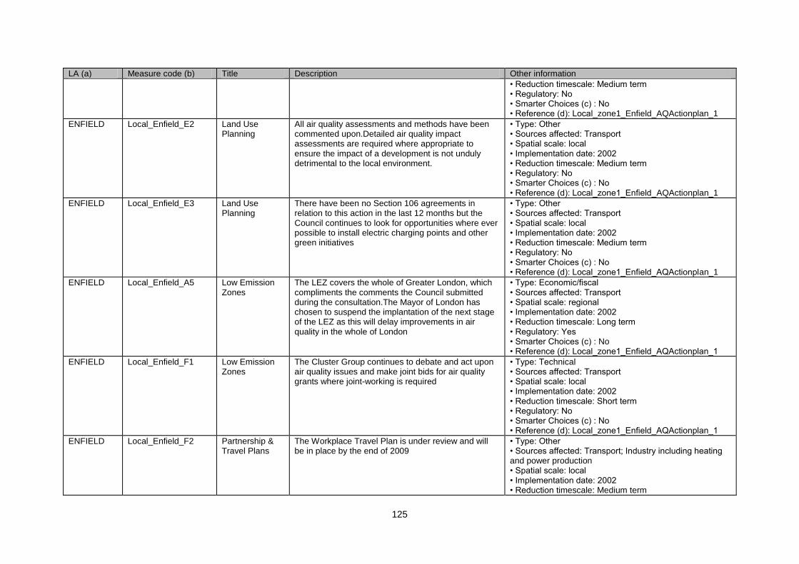
125
LA (a) Measure code (b) Title Description Other information
• Reduction timescale: Medium term • Regulatory: No • Smarter Choices (c) : No • Reference (d): Local_zone1_Enfield_AQActionplan_1
ENFIELD Local_Enfield_E2 Land Use Planning
All air quality assessments and methods have been commented upon.Detailed air quality impact assessments are required where appropriate to ensure the impact of a development is not unduly detrimental to the local environment.
• Type: Other • Sources affected: Transport • Spatial scale: local • Implementation date: 2002 • Reduction timescale: Medium term • Regulatory: No • Smarter Choices (c) : No • Reference (d): Local_zone1_Enfield_AQActionplan_1
ENFIELD Local_Enfield_E3 Land Use Planning
There have been no Section 106 agreements in relation to this action in the last 12 months but the Council continues to look for opportunities where ever possible to install electric charging points and other green initiatives
• Type: Other • Sources affected: Transport • Spatial scale: local • Implementation date: 2002 • Reduction timescale: Medium term • Regulatory: No • Smarter Choices (c) : No • Reference (d): Local_zone1_Enfield_AQActionplan_1
ENFIELD Local_Enfield_A5 Low Emission Zones
The LEZ covers the whole of Greater London, which compliments the comments the Council submitted during the consultation.The Mayor of London has chosen to suspend the implantation of the next stage of the LEZ as this will delay improvements in air quality in the whole of London
• Type: Economic/fiscal • Sources affected: Transport • Spatial scale: regional • Implementation date: 2002 • Reduction timescale: Long term • Regulatory: Yes • Smarter Choices (c) : No • Reference (d): Local_zone1_Enfield_AQActionplan_1
ENFIELD Local_Enfield_F1 Low Emission Zones
The Cluster Group continues to debate and act upon air quality issues and make joint bids for air quality grants where joint-working is required
• Type: Technical • Sources affected: Transport • Spatial scale: local • Implementation date: 2002 • Reduction timescale: Short term • Regulatory: No • Smarter Choices (c) : No • Reference (d): Local_zone1_Enfield_AQActionplan_1
ENFIELD Local_Enfield_F2 Partnership & Travel Plans
The Workplace Travel Plan is under review and will be in place by the end of 2009
• Type: Other • Sources affected: Transport; Industry including heating and power production • Spatial scale: local • Implementation date: 2002 • Reduction timescale: Medium term
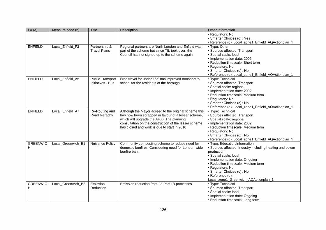
126
LA (a) Measure code (b) Title Description Other information
• Regulatory: No • Smarter Choices (c) : Yes • Reference (d): Local_zone1_Enfield_AQActionplan_1
ENFIELD Local_Enfield_F3 Partnership & Travel Plans
Regional partners are North London and Enfield was part of the scheme but since TfL took over, the Council has not signed up to the scheme again
• Type: Other • Sources affected: Transport • Spatial scale: local • Implementation date: 2002 • Reduction timescale: Short term • Regulatory: No • Smarter Choices (c) : No • Reference (d): Local_zone1_Enfield_AQActionplan_1
ENFIELD Local_Enfield_A6 Public Transport Initiatives - Bus
Free travel for under 16s‟ has improved transport to school for the residents of the borough
• Type: Technical • Sources affected: Transport • Spatial scale: regional • Implementation date: 2002 • Reduction timescale: Medium term • Regulatory: No • Smarter Choices (c) : No • Reference (d): Local_zone1_Enfield_AQActionplan_1
ENFIELD Local_Enfield_A7 Re-Routing and Road hierachy
Although the Mayor agreed to the original scheme this has now been scrapped in favour of a lesser scheme, which will upgrade the A406. The planning consultation on the construction of the lesser scheme has closed and work is due to start in 2010
• Type: Technical • Sources affected: Transport • Spatial scale: regional • Implementation date: 2002 • Reduction timescale: Medium term • Regulatory: No • Smarter Choices (c) : No • Reference (d): Local_zone1_Enfield_AQActionplan_1
GREENWICH
Local_Greenwich_B1 Nuisance Policy Community composting scheme to reduce need for domestic bonfires, Considering need for London-wide bonfire ban.
• Type: Education/information • Sources affected: Industry including heating and power production • Spatial scale: local • Implementation date: Ongoing • Reduction timescale: Medium term • Regulatory: No • Smarter Choices (c) : No • Reference (d): Local_zone1_Greenwich_AQActionplan_1
GREENWICH
Local_Greenwich_B2 Emission Reduction
Emission reduction from 28 Part I B processes. • Type: Technical • Sources affected: Transport • Spatial scale: local • Implementation date: Ongoing • Reduction timescale: Long term
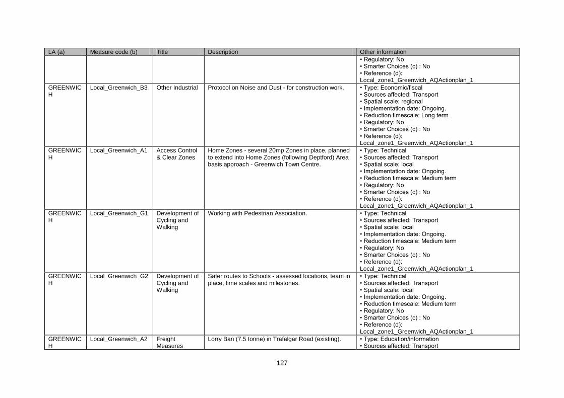
127
LA (a) Measure code (b) Title Description Other information
• Regulatory: No • Smarter Choices (c) : No • Reference (d): Local_zone1_Greenwich_AQActionplan_1
GREENWICH
Local_Greenwich_B3 Other Industrial Protocol on Noise and Dust - for construction work. • Type: Economic/fiscal • Sources affected: Transport • Spatial scale: regional • Implementation date: Ongoing. • Reduction timescale: Long term • Regulatory: No • Smarter Choices (c) : No • Reference (d): Local_zone1_Greenwich_AQActionplan_1
GREENWICH
Local_Greenwich_A1 Access Control & Clear Zones
Home Zones - several 20mp Zones in place, planned to extend into Home Zones (following Deptford) Area basis approach - Greenwich Town Centre.
• Type: Technical • Sources affected: Transport • Spatial scale: local • Implementation date: Ongoing. • Reduction timescale: Medium term • Regulatory: No • Smarter Choices (c) : No • Reference (d): Local_zone1_Greenwich_AQActionplan_1
GREENWICH
Local_Greenwich_G1 Development of Cycling and Walking
Working with Pedestrian Association. • Type: Technical • Sources affected: Transport • Spatial scale: local • Implementation date: Ongoing. • Reduction timescale: Medium term • Regulatory: No • Smarter Choices (c) : No • Reference (d): Local_zone1_Greenwich_AQActionplan_1
GREENWICH
Local_Greenwich_G2 Development of Cycling and Walking
Safer routes to Schools - assessed locations, team in place, time scales and milestones.
• Type: Technical • Sources affected: Transport • Spatial scale: local • Implementation date: Ongoing. • Reduction timescale: Medium term • Regulatory: No • Smarter Choices (c) : No • Reference (d): Local_zone1_Greenwich_AQActionplan_1
GREENWICH
Local_Greenwich_A2 Freight Measures
Lorry Ban (7.5 tonne) in Trafalgar Road (existing). • Type: Education/information • Sources affected: Transport
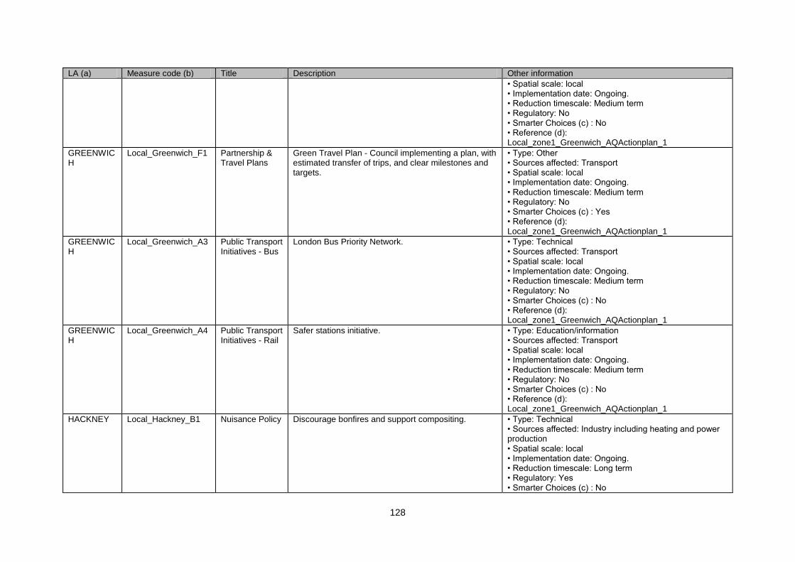
128
LA (a) Measure code (b) Title Description Other information
• Spatial scale: local • Implementation date: Ongoing. • Reduction timescale: Medium term • Regulatory: No • Smarter Choices (c) : No • Reference (d): Local_zone1_Greenwich_AQActionplan_1
GREENWICH
Local_Greenwich_F1 Partnership & Travel Plans
Green Travel Plan - Council implementing a plan, with estimated transfer of trips, and clear milestones and targets.
• Type: Other • Sources affected: Transport • Spatial scale: local • Implementation date: Ongoing. • Reduction timescale: Medium term • Regulatory: No • Smarter Choices (c) : Yes • Reference (d): Local_zone1_Greenwich_AQActionplan_1
GREENWICH
Local_Greenwich_A3 Public Transport Initiatives - Bus
London Bus Priority Network. • Type: Technical • Sources affected: Transport • Spatial scale: local • Implementation date: Ongoing. • Reduction timescale: Medium term • Regulatory: No • Smarter Choices (c) : No • Reference (d): Local_zone1_Greenwich_AQActionplan_1
GREENWICH
Local_Greenwich_A4 Public Transport Initiatives - Rail
Safer stations initiative. • Type: Education/information • Sources affected: Transport • Spatial scale: local • Implementation date: Ongoing. • Reduction timescale: Medium term • Regulatory: No • Smarter Choices (c) : No • Reference (d): Local_zone1_Greenwich_AQActionplan_1
HACKNEY Local_Hackney_B1 Nuisance Policy Discourage bonfires and support compositing. • Type: Technical • Sources affected: Industry including heating and power production • Spatial scale: local • Implementation date: Ongoing. • Reduction timescale: Long term • Regulatory: Yes • Smarter Choices (c) : No
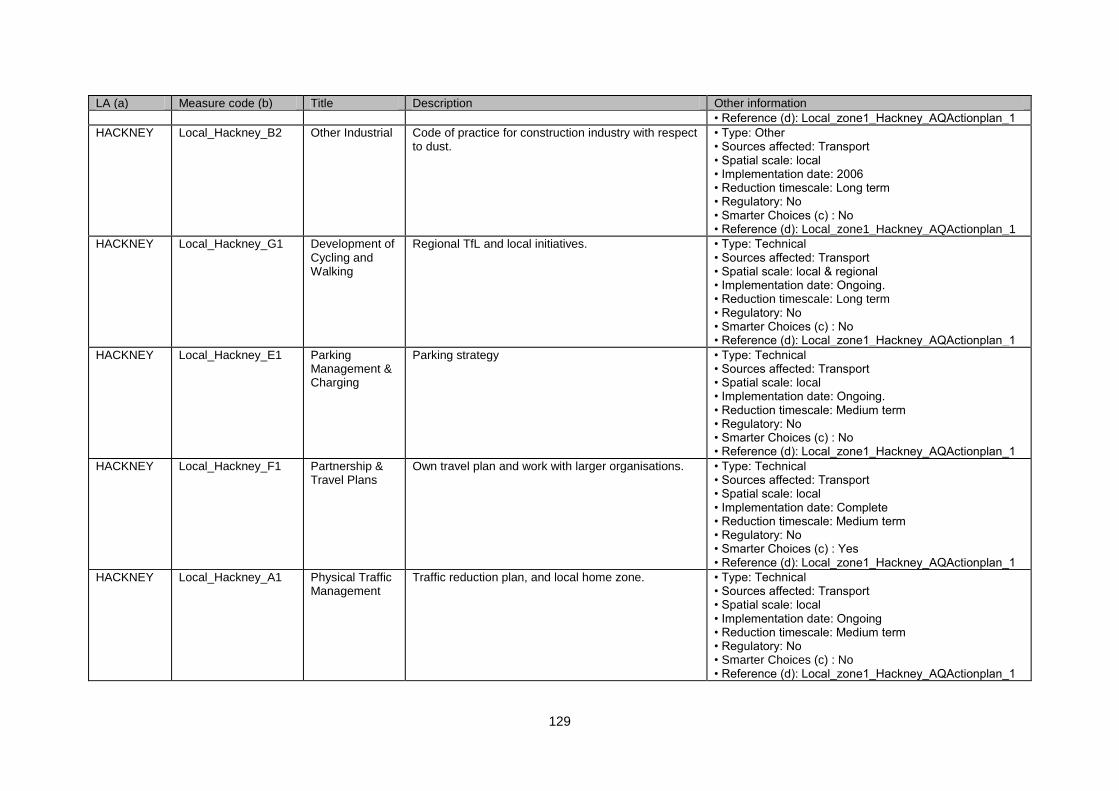
129
LA (a) Measure code (b) Title Description Other information
• Reference (d): Local_zone1_Hackney_AQActionplan_1
HACKNEY Local_Hackney_B2 Other Industrial Code of practice for construction industry with respect to dust.
• Type: Other • Sources affected: Transport • Spatial scale: local • Implementation date: 2006 • Reduction timescale: Long term • Regulatory: No • Smarter Choices (c) : No • Reference (d): Local_zone1_Hackney_AQActionplan_1
HACKNEY Local_Hackney_G1 Development of Cycling and Walking
Regional TfL and local initiatives. • Type: Technical • Sources affected: Transport • Spatial scale: local & regional • Implementation date: Ongoing. • Reduction timescale: Long term • Regulatory: No • Smarter Choices (c) : No • Reference (d): Local_zone1_Hackney_AQActionplan_1
HACKNEY Local_Hackney_E1 Parking Management & Charging
Parking strategy • Type: Technical • Sources affected: Transport • Spatial scale: local • Implementation date: Ongoing. • Reduction timescale: Medium term • Regulatory: No • Smarter Choices (c) : No • Reference (d): Local_zone1_Hackney_AQActionplan_1
HACKNEY Local_Hackney_F1 Partnership & Travel Plans
Own travel plan and work with larger organisations. • Type: Technical • Sources affected: Transport • Spatial scale: local • Implementation date: Complete • Reduction timescale: Medium term • Regulatory: No • Smarter Choices (c) : Yes • Reference (d): Local_zone1_Hackney_AQActionplan_1
HACKNEY Local_Hackney_A1 Physical Traffic Management
Traffic reduction plan, and local home zone. • Type: Technical • Sources affected: Transport • Spatial scale: local • Implementation date: Ongoing • Reduction timescale: Medium term • Regulatory: No • Smarter Choices (c) : No • Reference (d): Local_zone1_Hackney_AQActionplan_1
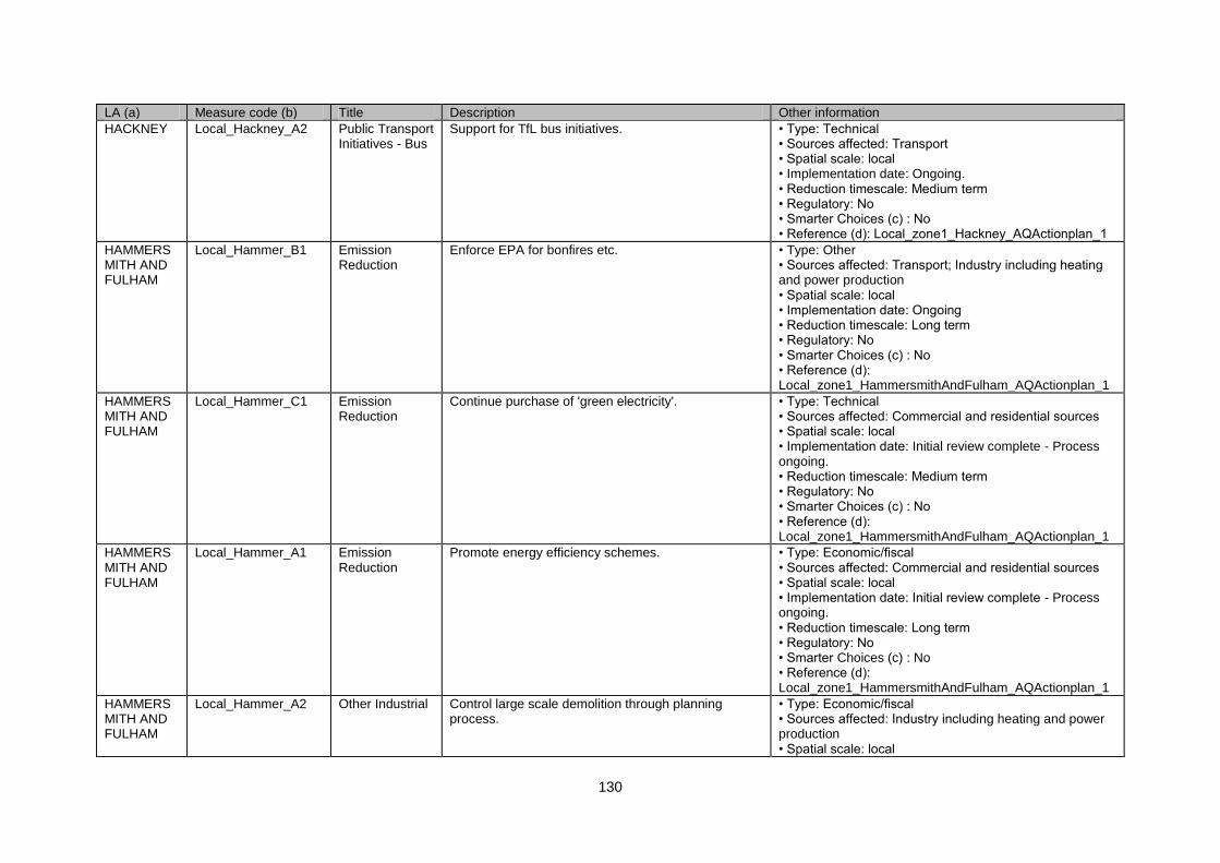
130
LA (a) Measure code (b) Title Description Other information
HACKNEY Local_Hackney_A2 Public Transport Initiatives - Bus
Support for TfL bus initiatives. • Type: Technical • Sources affected: Transport • Spatial scale: local • Implementation date: Ongoing. • Reduction timescale: Medium term • Regulatory: No • Smarter Choices (c) : No • Reference (d): Local_zone1_Hackney_AQActionplan_1
HAMMERSMITH AND FULHAM
Local_Hammer_B1 Emission Reduction
Enforce EPA for bonfires etc. • Type: Other • Sources affected: Transport; Industry including heating and power production • Spatial scale: local • Implementation date: Ongoing • Reduction timescale: Long term • Regulatory: No • Smarter Choices (c) : No • Reference (d): Local_zone1_HammersmithAndFulham_AQActionplan_1
HAMMERSMITH AND FULHAM
Local_Hammer_C1 Emission Reduction
Continue purchase of 'green electricity'. • Type: Technical • Sources affected: Commercial and residential sources • Spatial scale: local • Implementation date: Initial review complete - Process ongoing. • Reduction timescale: Medium term • Regulatory: No • Smarter Choices (c) : No • Reference (d): Local_zone1_HammersmithAndFulham_AQActionplan_1
HAMMERSMITH AND FULHAM
Local_Hammer_A1 Emission Reduction
Promote energy efficiency schemes. • Type: Economic/fiscal • Sources affected: Commercial and residential sources • Spatial scale: local • Implementation date: Initial review complete - Process ongoing. • Reduction timescale: Long term • Regulatory: No • Smarter Choices (c) : No • Reference (d): Local_zone1_HammersmithAndFulham_AQActionplan_1
HAMMERSMITH AND FULHAM
Local_Hammer_A2 Other Industrial Control large scale demolition through planning process.
• Type: Economic/fiscal • Sources affected: Industry including heating and power production • Spatial scale: local

131
LA (a) Measure code (b) Title Description Other information
• Implementation date: Ongoing. • Reduction timescale: Long term • Regulatory: No • Smarter Choices (c) : No • Reference (d): Local_zone1_HammersmithAndFulham_AQActionplan_1
HAMMERSMITH AND FULHAM
Local_Hammer_B2 Other Industrial Develop and publicise guidance based on Considerate Builders Code.
• Type: Other • Sources affected: Transport • Spatial scale: local • Implementation date: 2007 • Reduction timescale: Long term • Regulatory: No • Smarter Choices (c) : No • Reference (d): Local_zone1_HammersmithAndFulham_AQActionplan_1
HAMMERSMITH AND FULHAM
Local_Hammer_A3 Freight rail Encourage additional Freight rail uptake. • Type: Other • Sources affected: Transport • Spatial scale: local • Implementation date: Ongoing. • Reduction timescale: Long term • Regulatory: No • Smarter Choices (c) : No • Reference (d): Local_zone1_HammersmithAndFulham_AQActionplan_1
HAMMERSMITH AND FULHAM
Local_Hammer_E1 Access Control & Clear Zones
Continue Home Zone implementation program. • Type: Other • Sources affected: Transport • Spatial scale: local • Implementation date: Complete. • Reduction timescale: Long term • Regulatory: No • Smarter Choices (c) : No • Reference (d): Local_zone1_HammersmithAndFulham_AQActionplan_1
HAMMERSMITH AND FULHAM
Local_Hammer_G1 Development of Cycling and Walking
Continue rolling Safer Routes program. • Type: Other • Sources affected: Transport • Spatial scale: local • Implementation date: Investment ongoing. • Reduction timescale: Long term • Regulatory: No • Smarter Choices (c) : No • Reference (d): Local_zone1_HammersmithAndFulham_AQActionplan_1
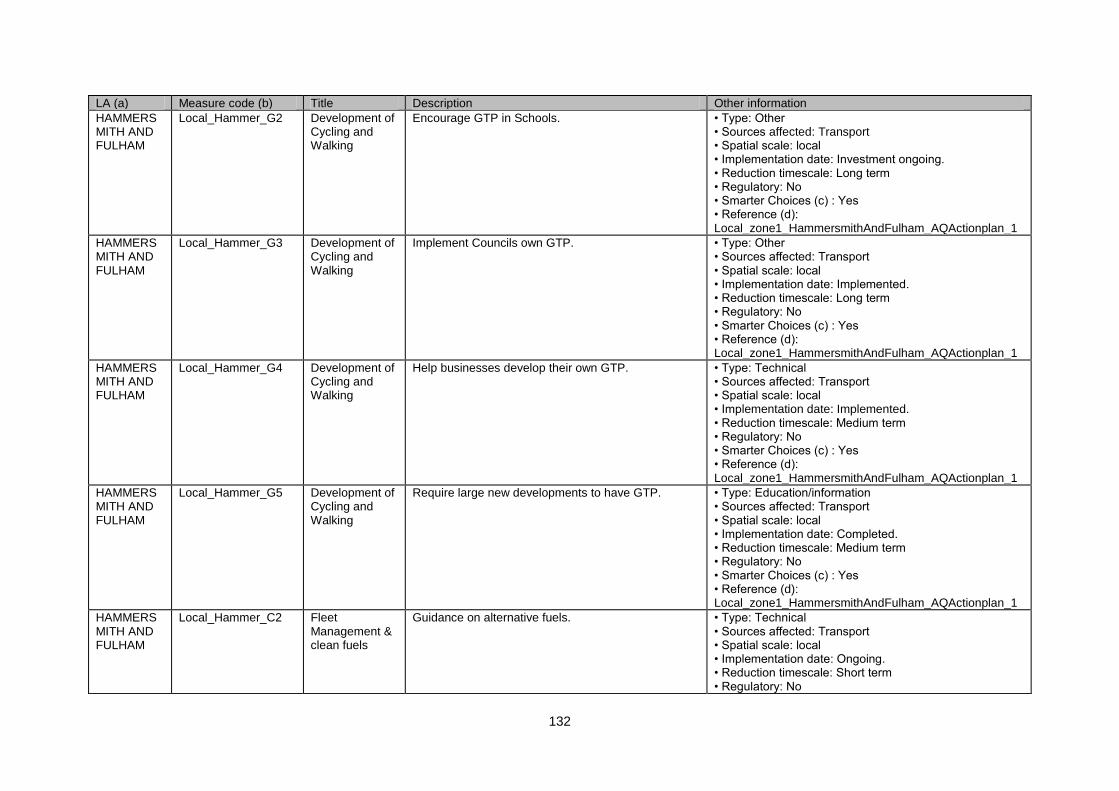
132
LA (a) Measure code (b) Title Description Other information
HAMMERSMITH AND FULHAM
Local_Hammer_G2 Development of Cycling and Walking
Encourage GTP in Schools. • Type: Other • Sources affected: Transport • Spatial scale: local • Implementation date: Investment ongoing. • Reduction timescale: Long term • Regulatory: No • Smarter Choices (c) : Yes • Reference (d): Local_zone1_HammersmithAndFulham_AQActionplan_1
HAMMERSMITH AND FULHAM
Local_Hammer_G3 Development of Cycling and Walking
Implement Councils own GTP. • Type: Other • Sources affected: Transport • Spatial scale: local • Implementation date: Implemented. • Reduction timescale: Long term • Regulatory: No • Smarter Choices (c) : Yes • Reference (d): Local_zone1_HammersmithAndFulham_AQActionplan_1
HAMMERSMITH AND FULHAM
Local_Hammer_G4 Development of Cycling and Walking
Help businesses develop their own GTP. • Type: Technical • Sources affected: Transport • Spatial scale: local • Implementation date: Implemented. • Reduction timescale: Medium term • Regulatory: No • Smarter Choices (c) : Yes • Reference (d): Local_zone1_HammersmithAndFulham_AQActionplan_1
HAMMERSMITH AND FULHAM
Local_Hammer_G5 Development of Cycling and Walking
Require large new developments to have GTP. • Type: Education/information • Sources affected: Transport • Spatial scale: local • Implementation date: Completed. • Reduction timescale: Medium term • Regulatory: No • Smarter Choices (c) : Yes • Reference (d): Local_zone1_HammersmithAndFulham_AQActionplan_1
HAMMERSMITH AND FULHAM
Local_Hammer_C2 Fleet Management & clean fuels
Guidance on alternative fuels. • Type: Technical • Sources affected: Transport • Spatial scale: local • Implementation date: Ongoing. • Reduction timescale: Short term • Regulatory: No
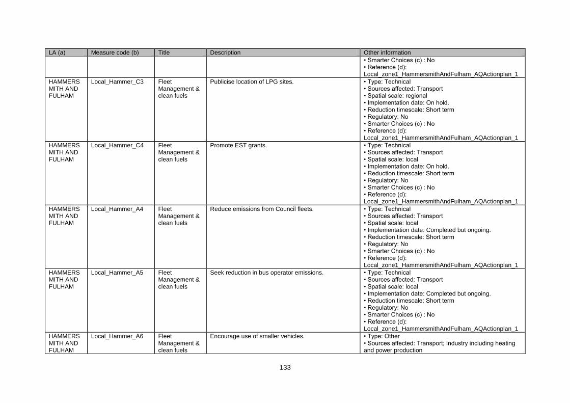
133
LA (a) Measure code (b) Title Description Other information
• Smarter Choices (c) : No • Reference (d): Local_zone1_HammersmithAndFulham_AQActionplan_1
HAMMERSMITH AND FULHAM
Local_Hammer_C3 Fleet Management & clean fuels
Publicise location of LPG sites. • Type: Technical • Sources affected: Transport • Spatial scale: regional • Implementation date: On hold. • Reduction timescale: Short term • Regulatory: No • Smarter Choices (c) : No • Reference (d): Local_zone1_HammersmithAndFulham_AQActionplan_1
HAMMERSMITH AND FULHAM
Local_Hammer_C4 Fleet Management & clean fuels
Promote EST grants. • Type: Technical • Sources affected: Transport • Spatial scale: local • Implementation date: On hold. • Reduction timescale: Short term • Regulatory: No • Smarter Choices (c) : No • Reference (d): Local_zone1_HammersmithAndFulham_AQActionplan_1
HAMMERSMITH AND FULHAM
Local_Hammer_A4 Fleet Management & clean fuels
Reduce emissions from Council fleets. • Type: Technical • Sources affected: Transport • Spatial scale: local • Implementation date: Completed but ongoing. • Reduction timescale: Short term • Regulatory: No • Smarter Choices (c) : No • Reference (d): Local_zone1_HammersmithAndFulham_AQActionplan_1
HAMMERSMITH AND FULHAM
Local_Hammer_A5 Fleet Management & clean fuels
Seek reduction in bus operator emissions. • Type: Technical • Sources affected: Transport • Spatial scale: local • Implementation date: Completed but ongoing. • Reduction timescale: Short term • Regulatory: No • Smarter Choices (c) : No • Reference (d): Local_zone1_HammersmithAndFulham_AQActionplan_1
HAMMERSMITH AND FULHAM
Local_Hammer_A6 Fleet Management & clean fuels
Encourage use of smaller vehicles. • Type: Other • Sources affected: Transport; Industry including heating and power production
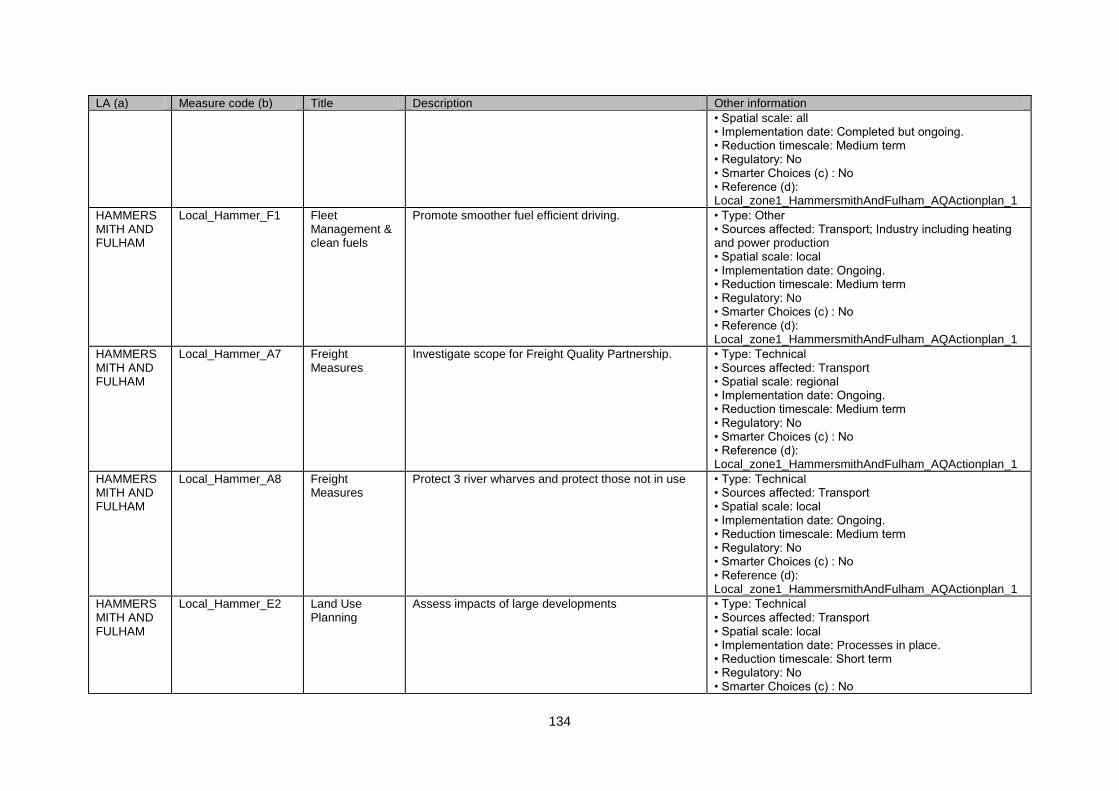
134
LA (a) Measure code (b) Title Description Other information
• Spatial scale: all • Implementation date: Completed but ongoing. • Reduction timescale: Medium term • Regulatory: No • Smarter Choices (c) : No • Reference (d): Local_zone1_HammersmithAndFulham_AQActionplan_1
HAMMERSMITH AND FULHAM
Local_Hammer_F1 Fleet Management & clean fuels
Promote smoother fuel efficient driving. • Type: Other • Sources affected: Transport; Industry including heating and power production • Spatial scale: local • Implementation date: Ongoing. • Reduction timescale: Medium term • Regulatory: No • Smarter Choices (c) : No • Reference (d): Local_zone1_HammersmithAndFulham_AQActionplan_1
HAMMERSMITH AND FULHAM
Local_Hammer_A7 Freight Measures
Investigate scope for Freight Quality Partnership. • Type: Technical • Sources affected: Transport • Spatial scale: regional • Implementation date: Ongoing. • Reduction timescale: Medium term • Regulatory: No • Smarter Choices (c) : No • Reference (d): Local_zone1_HammersmithAndFulham_AQActionplan_1
HAMMERSMITH AND FULHAM
Local_Hammer_A8 Freight Measures
Protect 3 river wharves and protect those not in use • Type: Technical • Sources affected: Transport • Spatial scale: local • Implementation date: Ongoing. • Reduction timescale: Medium term • Regulatory: No • Smarter Choices (c) : No • Reference (d): Local_zone1_HammersmithAndFulham_AQActionplan_1
HAMMERSMITH AND FULHAM
Local_Hammer_E2 Land Use Planning
Assess impacts of large developments • Type: Technical • Sources affected: Transport • Spatial scale: local • Implementation date: Processes in place. • Reduction timescale: Short term • Regulatory: No • Smarter Choices (c) : No
135
LA (a) Measure code (b) Title Description Other information
• Reference (d): Local_zone1_HammersmithAndFulham_AQActionplan_1
HAMMERSMITH AND FULHAM
Local_Hammer_A9 Low Emission Zones
Join the London LEZ • Type: Economic/fiscal • Sources affected: Transport • Spatial scale: regional • Implementation date: Complete 2008. • Reduction timescale: Long term • Regulatory: No • Smarter Choices (c) : No • Reference (d): Local_zone1_HammersmithAndFulham_AQActionplan_1
HAMMERSMITH AND FULHAM
Local_Hammer_E3 Parking Management & Charging
Review parking policies • Type: Other • Sources affected: Transport • Spatial scale: local • Implementation date: Complete 2007 • Reduction timescale: Long term • Regulatory: No • Smarter Choices (c) : No • Reference (d): Local_zone1_HammersmithAndFulham_AQActionplan_1
HAMMERSMITH AND FULHAM
Local_Hammer_E4 Parking Management & Charging
Limit parking provision in new developments • Type: Other • Sources affected: Transport • Spatial scale: local • Implementation date: Completed. • Reduction timescale: Long term • Regulatory: No • Smarter Choices (c) : No • Reference (d): Local_zone1_HammersmithAndFulham_AQActionplan_1
HAMMERSMITH AND FULHAM
Local_Hammer_F2 Promotion, Education & Awareness Raising
Promote car-sharing in Council and other organisations
• Type: Other • Sources affected: Transport • Spatial scale: local • Implementation date: Complete. • Reduction timescale: Long term • Regulatory: No • Smarter Choices (c) : Yes • Reference (d): Local_zone1_HammersmithAndFulham_AQActionplan_1
HAMMERSMITH AND FULHAM
Local_Hammer_F3 Promotion, Education & Awareness Raising
Develop rolling programme of awareness rasing on AQ
• Type: Technical • Sources affected: Transport • Spatial scale: local • Implementation date: Ongoing.
136
LA (a) Measure code (b) Title Description Other information
• Reduction timescale: Medium term • Regulatory: No • Smarter Choices (c) : No • Reference (d): Local_zone1_HammersmithAndFulham_AQActionplan_1
HAMMERSMITH AND FULHAM
Local_Hammer_A10 Public Transport Initiatives - Bus
Continue introducing bus priority improvements • Type: Technical • Sources affected: Transport • Spatial scale: local • Implementation date: Ongoing. • Reduction timescale: Medium term • Regulatory: No • Smarter Choices (c) : No • Reference (d): Local_zone1_HammersmithAndFulham_AQActionplan_1
HAMMERSMITH AND FULHAM
Local_Hammer_E5 Re-Routing and Road hierachy
Press Mayor to take action on A4 and A40 • Type: Technical • Sources affected: Transport • Spatial scale: regional • Implementation date: Ongoing. • Reduction timescale: Short term • Regulatory: No • Smarter Choices (c) : No • Reference (d): Local_zone1_HammersmithAndFulham_AQActionplan_1
HAMMERSMITH AND FULHAM
Local_Hammer_A11 Roadside Emissions Testing
Join plans to bring in VET • Type: Education/information • Sources affected: Transport • Spatial scale: local • Implementation date: 2007- 2008 • Reduction timescale: Medium term • Regulatory: No • Smarter Choices (c) : No • Reference (d): Local_zone1_HammersmithAndFulham_AQActionplan_1
HAMMERSMITH AND FULHAM
Local_Hammer_F4 Roadside Emissions Testing
Investigate effectiveness of anti-idling campaigns • Type: Other • Sources affected: Transport • Spatial scale: local • Implementation date: Ongoing. • Reduction timescale: Short term • Regulatory: No • Smarter Choices (c) : No • Reference (d): Local_zone1_HammersmithAndFulham_AQActionplan_1
HAMMERS Local_Hammer_F5 Roadside Promote switch off to London Buses drivers • Type: Other
137
LA (a) Measure code (b) Title Description Other information
MITH AND FULHAM
Emissions Testing
• Sources affected: Transport • Spatial scale: local • Implementation date: 2008 • Reduction timescale: Medium term • Regulatory: No • Smarter Choices (c) : No • Reference (d): Local_zone1_HammersmithAndFulham_AQActionplan_1
HARINGEY Local_Haringey_B1 Nuisance Policy Council provides support for the restriction on bonfires contained in the 8th London Local Authorities Bill 2001.
• Type: Technical • Sources affected: Transport • Spatial scale: local • Implementation date: Ongoing. • Reduction timescale: Medium term • Regulatory: No • Smarter Choices (c) : No • Reference (d): Local_zone1_Haringey_AQActionplan_1
HARINGEY Local_Haringey_G1 Development of Cycling and Walking
Cycling and Walking Strategies. • Type: Other • Sources affected: Transport • Spatial scale: local • Implementation date: Ongoing. • Reduction timescale: Short term • Regulatory: No • Smarter Choices (c) : Yes • Reference (d): Local_zone1_Haringey_AQActionplan_1
HARINGEY Local_Haringey_A1 Fleet Management & clean fuels
Seek to replace it's vehicle fleet to the highest standards.
• Type: Technical • Sources affected: Transport • Spatial scale: local • Implementation date: Complete • Reduction timescale: Medium term • Regulatory: No • Smarter Choices (c) : No • Reference (d): Local_zone1_Haringey_AQActionplan_1
HARINGEY Local_Haringey_E1 Land Use Planning
Land use planning and air quality considerations. • Type: Technical • Sources affected: Transport • Spatial scale: local • Implementation date: Ongoing. • Reduction timescale: Medium term • Regulatory: No • Smarter Choices (c) : No • Reference (d): Local_zone1_Haringey_AQActionplan_1
HARINGEY Local_Haringey_A2 Low Emission Zones
Sign up to LEZ. • Type: Technical • Sources affected: Transport
138
LA (a) Measure code (b) Title Description Other information
• Spatial scale: regional • Implementation date: Completed in 2008. • Reduction timescale: Medium term • Regulatory: No • Smarter Choices (c) : No • Reference (d): Local_zone1_Haringey_AQActionplan_1
HARINGEY Local_Haringey_D1 Parking Management & Charging
Parking Management. • Type: Other • Sources affected: Transport • Spatial scale: local • Implementation date: Ongoing. • Reduction timescale: Medium term • Regulatory: No • Smarter Choices (c) : No • Reference (d): Local_zone1_Haringey_AQActionplan_1
HARINGEY Local_Haringey_A3 Roadside Emissions Testing
Roadside emissions testing carried out monthly. • Type: Technical • Sources affected: Transport • Spatial scale: local • Implementation date: Completed. • Reduction timescale: Medium term • Regulatory: No • Smarter Choices (c) : No • Reference (d): Local_zone1_Haringey_AQActionplan_1
HARROW Local_Harrow_G1 Development of Cycling and Walking
Mainly information measures building on existing transport policies.
• Type: Technical • Sources affected: Transport • Spatial scale: local • Implementation date: Ongoing. • Reduction timescale: Medium term • Regulatory: No • Smarter Choices (c) : Yes • Reference (d): Local_zone1_Harrow_AQActionplan_1
HARROW Local_Harrow_F1 Fleet Management & clean fuels
Promote the use of alternative and clean fuelled vehicles.
• Type: Other • Sources affected: Agriculture • Spatial scale: local • Implementation date: 2008 • Reduction timescale: Long term • Regulatory: No • Smarter Choices (c) : No • Reference (d): Local_zone1_Harrow_AQActionplan_1
HARROW Local_Harrow_A1 Freight Measures
Mostly around developing ideas for freight. • Type: Technical • Sources affected: Transport • Spatial scale: local • Implementation date: Complete - Ongoing
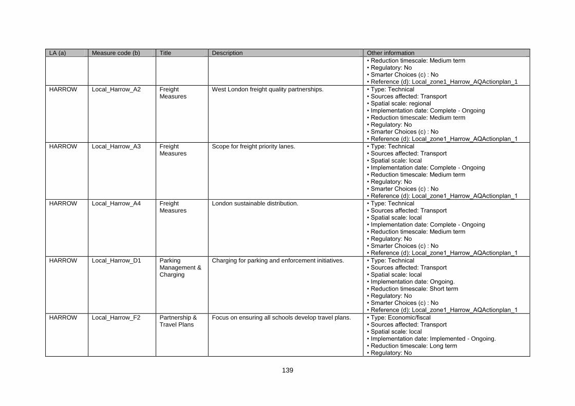
139
LA (a) Measure code (b) Title Description Other information
• Reduction timescale: Medium term • Regulatory: No • Smarter Choices (c) : No • Reference (d): Local_zone1_Harrow_AQActionplan_1
HARROW Local_Harrow_A2 Freight Measures
West London freight quality partnerships. • Type: Technical • Sources affected: Transport • Spatial scale: regional • Implementation date: Complete - Ongoing • Reduction timescale: Medium term • Regulatory: No • Smarter Choices (c) : No • Reference (d): Local_zone1_Harrow_AQActionplan_1
HARROW Local_Harrow_A3 Freight Measures
Scope for freight priority lanes. • Type: Technical • Sources affected: Transport • Spatial scale: local • Implementation date: Complete - Ongoing • Reduction timescale: Medium term • Regulatory: No • Smarter Choices (c) : No • Reference (d): Local_zone1_Harrow_AQActionplan_1
HARROW Local_Harrow_A4 Freight Measures
London sustainable distribution. • Type: Technical • Sources affected: Transport • Spatial scale: local • Implementation date: Complete - Ongoing • Reduction timescale: Medium term • Regulatory: No • Smarter Choices (c) : No • Reference (d): Local_zone1_Harrow_AQActionplan_1
HARROW Local_Harrow_D1 Parking Management & Charging
Charging for parking and enforcement initiatives. • Type: Technical • Sources affected: Transport • Spatial scale: local • Implementation date: Ongoing. • Reduction timescale: Short term • Regulatory: No • Smarter Choices (c) : No • Reference (d): Local_zone1_Harrow_AQActionplan_1
HARROW Local_Harrow_F2 Partnership & Travel Plans
Focus on ensuring all schools develop travel plans. • Type: Economic/fiscal • Sources affected: Transport • Spatial scale: local • Implementation date: Implemented - Ongoing. • Reduction timescale: Long term • Regulatory: No
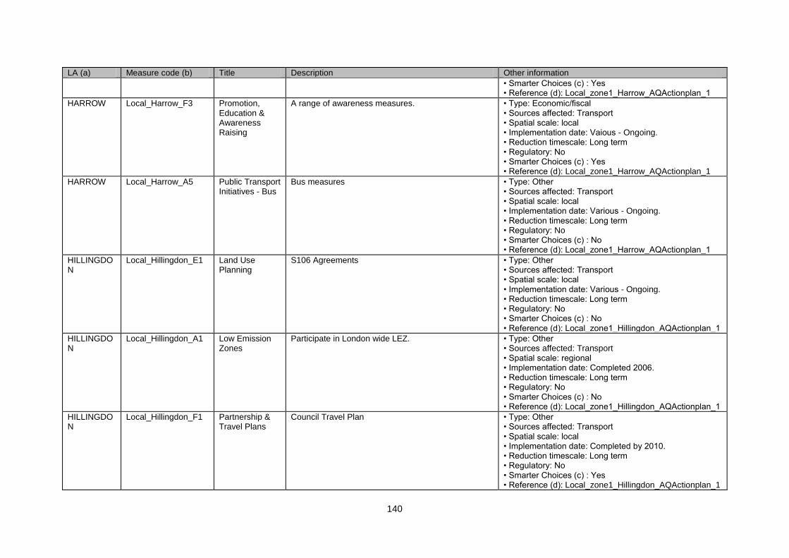
140
LA (a) Measure code (b) Title Description Other information
• Smarter Choices (c) : Yes • Reference (d): Local_zone1_Harrow_AQActionplan_1
HARROW Local_Harrow_F3 Promotion, Education & Awareness Raising
A range of awareness measures. • Type: Economic/fiscal • Sources affected: Transport • Spatial scale: local • Implementation date: Vaious - Ongoing. • Reduction timescale: Long term • Regulatory: No • Smarter Choices (c) : Yes • Reference (d): Local_zone1_Harrow_AQActionplan_1
HARROW Local_Harrow_A5 Public Transport Initiatives - Bus
Bus measures • Type: Other • Sources affected: Transport • Spatial scale: local • Implementation date: Various - Ongoing. • Reduction timescale: Long term • Regulatory: No • Smarter Choices (c) : No • Reference (d): Local_zone1_Harrow_AQActionplan_1
HILLINGDON
Local_Hillingdon_E1 Land Use Planning
S106 Agreements • Type: Other • Sources affected: Transport • Spatial scale: local • Implementation date: Various - Ongoing. • Reduction timescale: Long term • Regulatory: No • Smarter Choices (c) : No • Reference (d): Local_zone1_Hillingdon_AQActionplan_1
HILLINGDON
Local_Hillingdon_A1 Low Emission Zones
Participate in London wide LEZ. • Type: Other • Sources affected: Transport • Spatial scale: regional • Implementation date: Completed 2006. • Reduction timescale: Long term • Regulatory: No • Smarter Choices (c) : No • Reference (d): Local_zone1_Hillingdon_AQActionplan_1
HILLINGDON
Local_Hillingdon_F1 Partnership & Travel Plans
Council Travel Plan • Type: Other • Sources affected: Transport • Spatial scale: local • Implementation date: Completed by 2010. • Reduction timescale: Long term • Regulatory: No • Smarter Choices (c) : Yes • Reference (d): Local_zone1_Hillingdon_AQActionplan_1
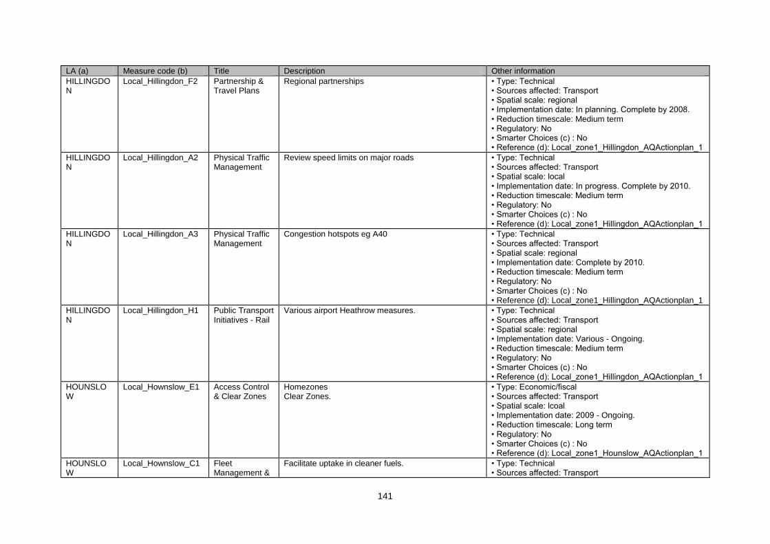
141
LA (a) Measure code (b) Title Description Other information
HILLINGDON
Local_Hillingdon_F2 Partnership & Travel Plans
Regional partnerships • Type: Technical • Sources affected: Transport • Spatial scale: regional • Implementation date: In planning. Complete by 2008. • Reduction timescale: Medium term • Regulatory: No • Smarter Choices (c) : No • Reference (d): Local_zone1_Hillingdon_AQActionplan_1
HILLINGDON
Local_Hillingdon_A2 Physical Traffic Management
Review speed limits on major roads • Type: Technical • Sources affected: Transport • Spatial scale: local • Implementation date: In progress. Complete by 2010. • Reduction timescale: Medium term • Regulatory: No • Smarter Choices (c) : No • Reference (d): Local_zone1_Hillingdon_AQActionplan_1
HILLINGDON
Local_Hillingdon_A3 Physical Traffic Management
Congestion hotspots eg A40 • Type: Technical • Sources affected: Transport • Spatial scale: regional • Implementation date: Complete by 2010. • Reduction timescale: Medium term • Regulatory: No • Smarter Choices (c) : No • Reference (d): Local_zone1_Hillingdon_AQActionplan_1
HILLINGDON
Local_Hillingdon_H1 Public Transport Initiatives - Rail
Various airport Heathrow measures. • Type: Technical • Sources affected: Transport • Spatial scale: regional • Implementation date: Various - Ongoing. • Reduction timescale: Medium term • Regulatory: No • Smarter Choices (c) : No • Reference (d): Local_zone1_Hillingdon_AQActionplan_1
HOUNSLOW
Local_Hownslow_E1 Access Control & Clear Zones
Homezones Clear Zones.
• Type: Economic/fiscal • Sources affected: Transport • Spatial scale: lcoal • Implementation date: 2009 - Ongoing. • Reduction timescale: Long term • Regulatory: No • Smarter Choices (c) : No • Reference (d): Local_zone1_Hounslow_AQActionplan_1
HOUNSLOW
Local_Hownslow_C1 Fleet Management &
Facilitate uptake in cleaner fuels. • Type: Technical • Sources affected: Transport
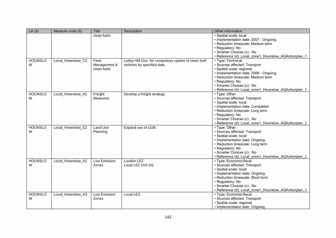
142
LA (a) Measure code (b) Title Description Other information
clean fuels • Spatial scale: local • Implementation date: 2007 - Ongoing. • Reduction timescale: Medium term • Regulatory: No • Smarter Choices (c) : No • Reference (d): Local_zone1_Hounslow_AQActionplan_1
HOUNSLOW
Local_Hownslow_C2 Fleet Management & clean fuels
Lobby HM Gov. for compulsory uptake of clean fuel/ vehicles by specified date.
• Type: Technical • Sources affected: Transport • Spatial scale: regional • Implementation date: 2006 - Ongoing. • Reduction timescale: Medium term • Regulatory: No • Smarter Choices (c) : No • Reference (d): Local_zone1_Hounslow_AQActionplan_1
HOUNSLOW
Local_Hownslow_A1 Freight Measures
Develop a freight strategy. • Type: Other • Sources affected: Transport • Spatial scale: local • Implementation date: Completed. • Reduction timescale: Long term • Regulatory: No • Smarter Choices (c) : No • Reference (d): Local_zone1_Hounslow_AQActionplan_1
HOUNSLOW
Local_Hownslow_E2 Land Use Planning
Expand use of s106. • Type: Other • Sources affected: Transport • Spatial scale: local • Implementation date: Ongoing. • Reduction timescale: Long term • Regulatory: No • Smarter Choices (c) : No • Reference (d): Local_zone1_Hounslow_AQActionplan_1
HOUNSLOW
Local_Hownslow_A2 Low Emission Zones
London LEZ Local LEZ (m3.10).
• Type: Economic/fiscal • Sources affected: Transport • Spatial scale: local • Implementation date: Ongoing. • Reduction timescale: Short term • Regulatory: No • Smarter Choices (c) : No • Reference (d): Local_zone1_Hounslow_AQActionplan_1
HOUNSLOW
Local_Hownslow_A3 Low Emission Zones
Local LEZ. • Type: Economic/fiscal • Sources affected: Transport • Spatial scale: regional • Implementation date: Ongoing.
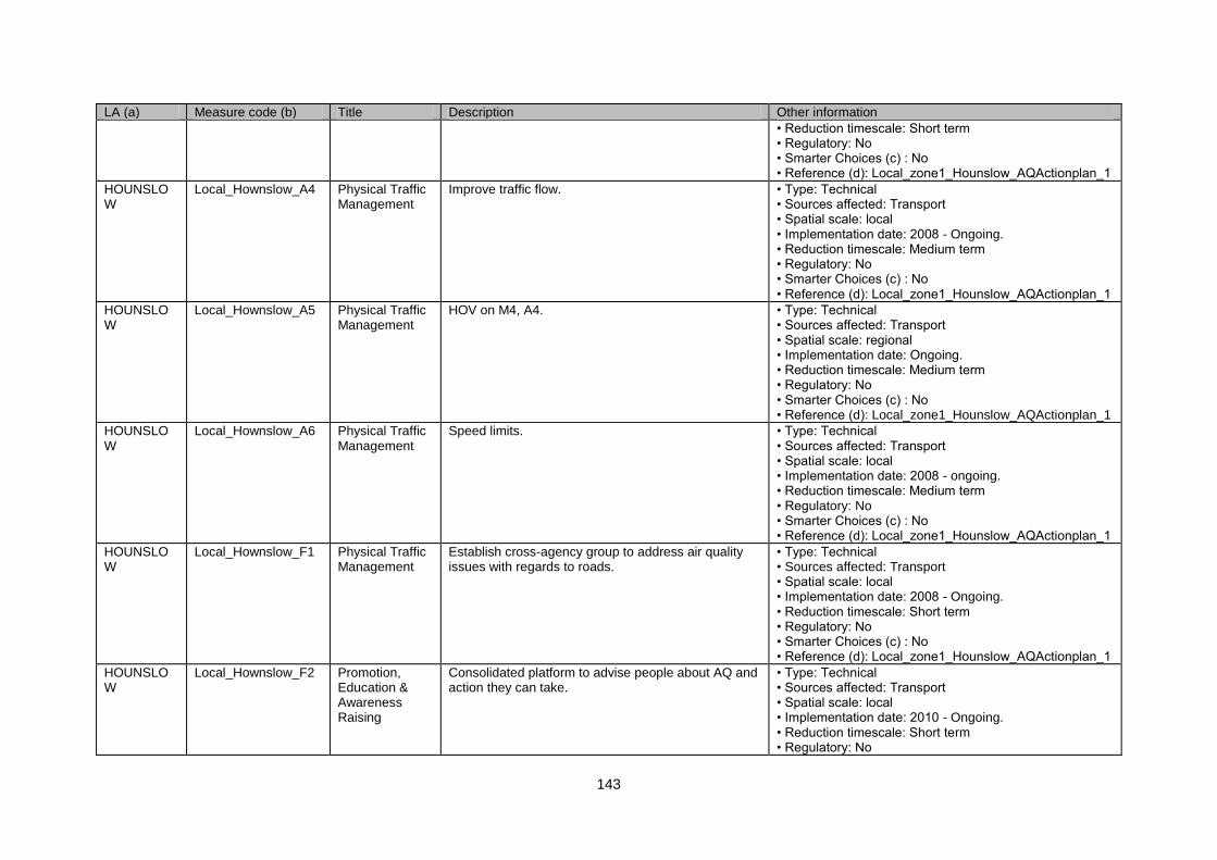
143
LA (a) Measure code (b) Title Description Other information
• Reduction timescale: Short term • Regulatory: No • Smarter Choices (c) : No • Reference (d): Local_zone1_Hounslow_AQActionplan_1
HOUNSLOW
Local_Hownslow_A4 Physical Traffic Management
Improve traffic flow. • Type: Technical • Sources affected: Transport • Spatial scale: local • Implementation date: 2008 - Ongoing. • Reduction timescale: Medium term • Regulatory: No • Smarter Choices (c) : No • Reference (d): Local_zone1_Hounslow_AQActionplan_1
HOUNSLOW
Local_Hownslow_A5 Physical Traffic Management
HOV on M4, A4. • Type: Technical • Sources affected: Transport • Spatial scale: regional • Implementation date: Ongoing. • Reduction timescale: Medium term • Regulatory: No • Smarter Choices (c) : No • Reference (d): Local_zone1_Hounslow_AQActionplan_1
HOUNSLOW
Local_Hownslow_A6 Physical Traffic Management
Speed limits. • Type: Technical • Sources affected: Transport • Spatial scale: local • Implementation date: 2008 - ongoing. • Reduction timescale: Medium term • Regulatory: No • Smarter Choices (c) : No • Reference (d): Local_zone1_Hounslow_AQActionplan_1
HOUNSLOW
Local_Hownslow_F1 Physical Traffic Management
Establish cross-agency group to address air quality issues with regards to roads.
• Type: Technical • Sources affected: Transport • Spatial scale: local • Implementation date: 2008 - Ongoing. • Reduction timescale: Short term • Regulatory: No • Smarter Choices (c) : No • Reference (d): Local_zone1_Hounslow_AQActionplan_1
HOUNSLOW
Local_Hownslow_F2 Promotion, Education & Awareness Raising
Consolidated platform to advise people about AQ and action they can take.
• Type: Technical • Sources affected: Transport • Spatial scale: local • Implementation date: 2010 - Ongoing. • Reduction timescale: Short term • Regulatory: No

144
LA (a) Measure code (b) Title Description Other information
• Smarter Choices (c) : Yes • Reference (d): Local_zone1_Hounslow_AQActionplan_1
HOUNSLOW
Local_Hownslow_F3 Promotion, Education & Awareness Raising
Develop regional AQ Strategy. • Type: Technical • Sources affected: Transport • Spatial scale: local • Implementation date: 2006 Completed. • Reduction timescale: Medium term • Regulatory: No • Smarter Choices (c) : No • Reference (d): Local_zone1_Hounslow_AQActionplan_1
HOUNSLOW
Local_Hownslow_A7 Public Transport Initiatives - Rail
Support West London Transit • Type: Technical • Sources affected: Transport • Spatial scale: regional • Implementation date: Ongoing. • Reduction timescale: Medium term • Regulatory: No • Smarter Choices (c) : No • Reference (d): Local_zone1_Hounslow_AQActionplan_1
HOUNSLOW
Local_Hownslow_H1 Public Transport Initiatives - Rail
Lobby for Airtrack • Type: Technical • Sources affected: Transport • Spatial scale: regional • Implementation date: Ongoing. • Reduction timescale: Medium term • Regulatory: No • Smarter Choices (c) : No • Reference (d): Local_zone1_Hounslow_AQActionplan_1
HOUNSLOW
Local_Hownslow_A8 Re-Routing and Road hierachy
Enclose main roads • Type: Technical • Sources affected: Transport • Spatial scale: local • Implementation date: N/A • Reduction timescale: Medium term • Regulatory: No • Smarter Choices (c) : No • Reference (d): Local_zone1_Hounslow_AQActionplan_1
HOUNSLOW
Local_Hownslow_D1 Road User Charging
Use fiscal measures such as road pricing, for reducing traffic on major road networks.
• Type: Technical • Sources affected: Transport • Spatial scale: local • Implementation date: 2008 - Ongoing. • Reduction timescale: Medium term • Regulatory: Yes • Smarter Choices (c) : No • Reference (d): Local_zone1_Hounslow_AQActionplan_1
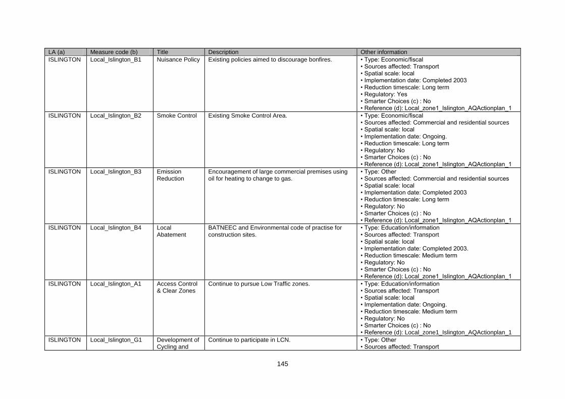
145
LA (a) Measure code (b) Title Description Other information
ISLINGTON Local_Islington_B1 Nuisance Policy Existing policies aimed to discourage bonfires. • Type: Economic/fiscal • Sources affected: Transport • Spatial scale: local • Implementation date: Completed 2003 • Reduction timescale: Long term • Regulatory: Yes • Smarter Choices (c) : No • Reference (d): Local_zone1_Islington_AQActionplan_1
ISLINGTON Local_Islington_B2 Smoke Control Existing Smoke Control Area. • Type: Economic/fiscal • Sources affected: Commercial and residential sources • Spatial scale: local • Implementation date: Ongoing. • Reduction timescale: Long term • Regulatory: No • Smarter Choices (c) : No • Reference (d): Local_zone1_Islington_AQActionplan_1
ISLINGTON Local_Islington_B3 Emission Reduction
Encouragement of large commercial premises using oil for heating to change to gas.
• Type: Other • Sources affected: Commercial and residential sources • Spatial scale: local • Implementation date: Completed 2003 • Reduction timescale: Long term • Regulatory: No • Smarter Choices (c) : No • Reference (d): Local_zone1_Islington_AQActionplan_1
ISLINGTON Local_Islington_B4 Local Abatement
BATNEEC and Environmental code of practise for construction sites.
• Type: Education/information • Sources affected: Transport • Spatial scale: local • Implementation date: Completed 2003. • Reduction timescale: Medium term • Regulatory: No • Smarter Choices (c) : No • Reference (d): Local_zone1_Islington_AQActionplan_1
ISLINGTON Local_Islington_A1 Access Control & Clear Zones
Continue to pursue Low Traffic zones. • Type: Education/information • Sources affected: Transport • Spatial scale: local • Implementation date: Ongoing. • Reduction timescale: Medium term • Regulatory: No • Smarter Choices (c) : No • Reference (d): Local_zone1_Islington_AQActionplan_1
ISLINGTON Local_Islington_G1 Development of Cycling and
Continue to participate in LCN. • Type: Other • Sources affected: Transport
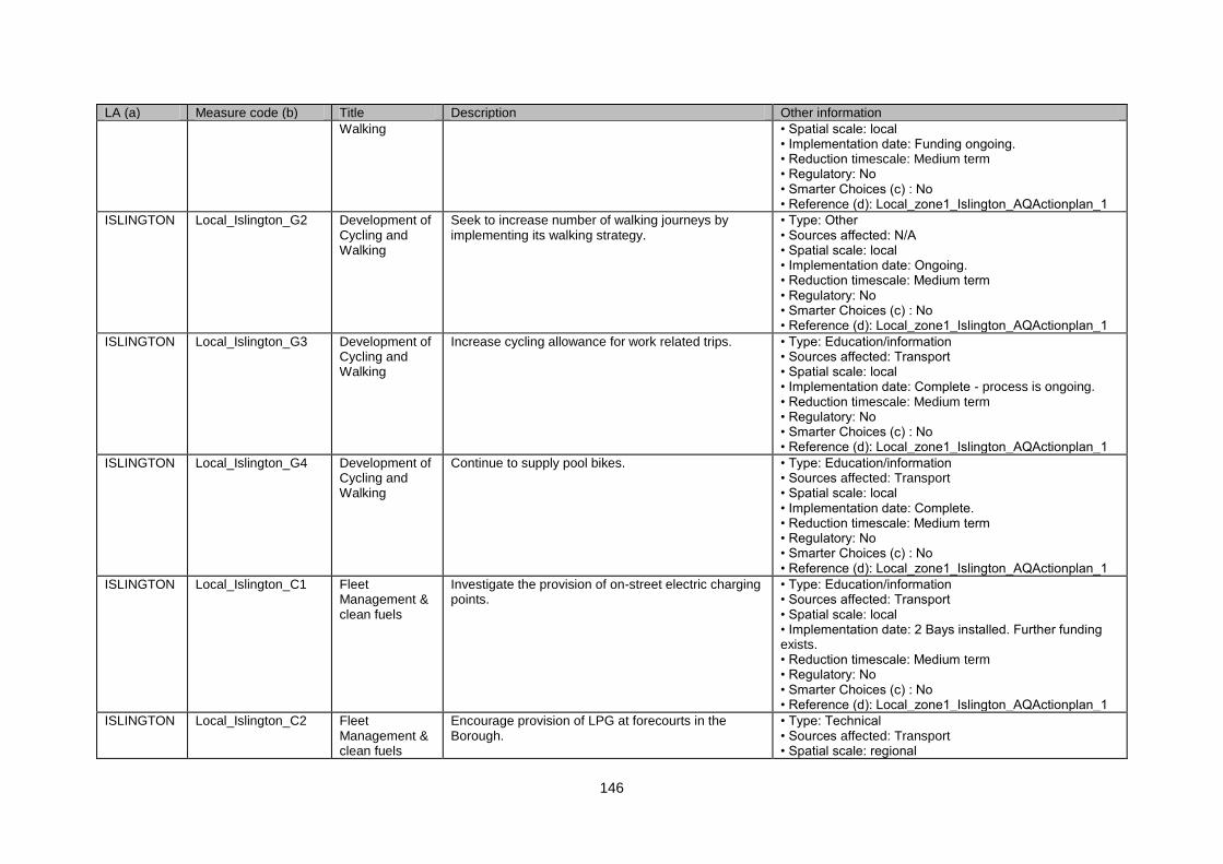
146
LA (a) Measure code (b) Title Description Other information
Walking • Spatial scale: local • Implementation date: Funding ongoing. • Reduction timescale: Medium term • Regulatory: No • Smarter Choices (c) : No • Reference (d): Local_zone1_Islington_AQActionplan_1
ISLINGTON Local_Islington_G2 Development of Cycling and Walking
Seek to increase number of walking journeys by implementing its walking strategy.
• Type: Other • Sources affected: N/A • Spatial scale: local • Implementation date: Ongoing. • Reduction timescale: Medium term • Regulatory: No • Smarter Choices (c) : No • Reference (d): Local_zone1_Islington_AQActionplan_1
ISLINGTON Local_Islington_G3 Development of Cycling and Walking
Increase cycling allowance for work related trips. • Type: Education/information • Sources affected: Transport • Spatial scale: local • Implementation date: Complete - process is ongoing. • Reduction timescale: Medium term • Regulatory: No • Smarter Choices (c) : No • Reference (d): Local_zone1_Islington_AQActionplan_1
ISLINGTON Local_Islington_G4 Development of Cycling and Walking
Continue to supply pool bikes. • Type: Education/information • Sources affected: Transport • Spatial scale: local • Implementation date: Complete. • Reduction timescale: Medium term • Regulatory: No • Smarter Choices (c) : No • Reference (d): Local_zone1_Islington_AQActionplan_1
ISLINGTON Local_Islington_C1 Fleet Management & clean fuels
Investigate the provision of on-street electric charging points.
• Type: Education/information • Sources affected: Transport • Spatial scale: local • Implementation date: 2 Bays installed. Further funding exists. • Reduction timescale: Medium term • Regulatory: No • Smarter Choices (c) : No • Reference (d): Local_zone1_Islington_AQActionplan_1
ISLINGTON Local_Islington_C2 Fleet Management & clean fuels
Encourage provision of LPG at forecourts in the Borough.
• Type: Technical • Sources affected: Transport • Spatial scale: regional
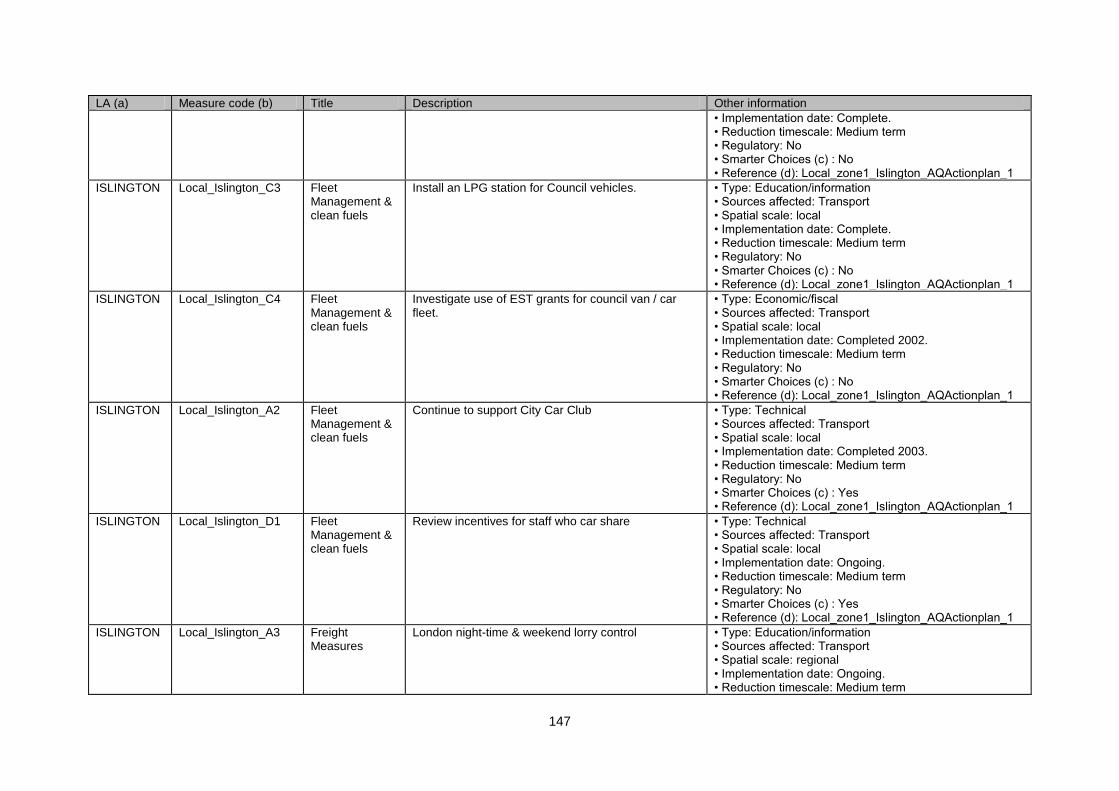
147
LA (a) Measure code (b) Title Description Other information
• Implementation date: Complete. • Reduction timescale: Medium term • Regulatory: No • Smarter Choices (c) : No • Reference (d): Local_zone1_Islington_AQActionplan_1
ISLINGTON Local_Islington_C3 Fleet Management & clean fuels
Install an LPG station for Council vehicles. • Type: Education/information • Sources affected: Transport • Spatial scale: local • Implementation date: Complete. • Reduction timescale: Medium term • Regulatory: No • Smarter Choices (c) : No • Reference (d): Local_zone1_Islington_AQActionplan_1
ISLINGTON Local_Islington_C4 Fleet Management & clean fuels
Investigate use of EST grants for council van / car fleet.
• Type: Economic/fiscal • Sources affected: Transport • Spatial scale: local • Implementation date: Completed 2002. • Reduction timescale: Medium term • Regulatory: No • Smarter Choices (c) : No • Reference (d): Local_zone1_Islington_AQActionplan_1
ISLINGTON Local_Islington_A2 Fleet Management & clean fuels
Continue to support City Car Club • Type: Technical • Sources affected: Transport • Spatial scale: local • Implementation date: Completed 2003. • Reduction timescale: Medium term • Regulatory: No • Smarter Choices (c) : Yes • Reference (d): Local_zone1_Islington_AQActionplan_1
ISLINGTON Local_Islington_D1 Fleet Management & clean fuels
Review incentives for staff who car share • Type: Technical • Sources affected: Transport • Spatial scale: local • Implementation date: Ongoing. • Reduction timescale: Medium term • Regulatory: No • Smarter Choices (c) : Yes • Reference (d): Local_zone1_Islington_AQActionplan_1
ISLINGTON Local_Islington_A3 Freight Measures
London night-time & weekend lorry control • Type: Education/information • Sources affected: Transport • Spatial scale: regional • Implementation date: Ongoing. • Reduction timescale: Medium term
148
LA (a) Measure code (b) Title Description Other information
• Regulatory: No • Smarter Choices (c) : No • Reference (d): Local_zone1_Islington_AQActionplan_1
ISLINGTON Local_Islington_A4 Freight Measures
Continue to operate 7.5 tonne bans • Type: Economic/fiscal • Sources affected: Transport • Spatial scale: local • Implementation date: Ongoing. • Reduction timescale: Long term • Regulatory: No • Smarter Choices (c) : No • Reference (d): Local_zone1_Islington_AQActionplan_1
ISLINGTON Local_Islington_A5 Freight Measures
Consider 3.5 tonne bans • Type: Technical • Sources affected: Transport • Spatial scale: local • Implementation date: Ongoing. • Reduction timescale: Medium term • Regulatory: No • Smarter Choices (c) : No • Reference (d): Local_zone1_Islington_AQActionplan_1
ISLINGTON Local_Islington_A6 Freight Measures
Support London wide lorry ban • Type: Economic/fiscal • Sources affected: Transport • Spatial scale: regional • Implementation date: Ongoing. • Reduction timescale: Long term • Regulatory: Yes • Smarter Choices (c) : No • Reference (d): Local_zone1_Islington_AQActionplan_1
ISLINGTON Local_Islington_D2 Parking Management & Charging
Reduced residential parking charges for smaller / less polluting vehicles
• Type: Other • Sources affected: Transport • Spatial scale: local • Implementation date: No info. • Reduction timescale: Long term • Regulatory: No • Smarter Choices (c) : No • Reference (d): Local_zone1_Islington_AQActionplan_1
ISLINGTON Local_Islington_F1 Partnership & Travel Plans
Encourage large employers to GTP, and seek this commitment during development negotiations.
• Type: Technical • Sources affected: Transport • Spatial scale: local • Implementation date: Completed. • Reduction timescale: Medium term • Regulatory: No • Smarter Choices (c) : Yes
149
LA (a) Measure code (b) Title Description Other information
• Reference (d): Local_zone1_Islington_AQActionplan_1
ISLINGTON Local_Islington_G5 Partnership & Travel Plans
Promote walking to school in partnership with Borough schools.
• Type: Other • Sources affected: Transport; Industry including heating and power production • Spatial scale: all • Implementation date: Completed. • Reduction timescale: Medium term • Regulatory: No • Smarter Choices (c) : Yes • Reference (d): Local_zone1_Islington_AQActionplan_1
ISLINGTON Local_Islington_A7 Physical Traffic Management
Consider introduction of 20mph corridors • Type: Economic/fiscal • Sources affected: Transport • Spatial scale: local • Implementation date: Completed. • Reduction timescale: Long term • Regulatory: Yes • Smarter Choices (c) : No • Reference (d): Local_zone1_Islington_AQActionplan_1
ISLINGTON Local_Islington_A8 Physical Traffic Management
Promote a programme of traffic calming • Type: Other • Sources affected: Transport • Spatial scale: local • Implementation date: Completed. • Reduction timescale: Long term • Regulatory: No • Smarter Choices (c) : No • Reference (d): Local_zone1_Islington_AQActionplan_1
ISLINGTON Local_Islington_A9 Physical Traffic Management
Seek to implement its traffic reduction strategy • Type: Economic/fiscal • Sources affected: Transport • Spatial scale: local • Implementation date: Completed. • Reduction timescale: Long term • Regulatory: No • Smarter Choices (c) : No • Reference (d): Local_zone1_Islington_AQActionplan_1
ISLINGTON Local_Islington_E1 Physical Traffic Management
Seek to introduce its speed management plan • Type: Economic/fiscal • Sources affected: Transport • Spatial scale: local • Implementation date: Completed. • Reduction timescale: Long term • Regulatory: Yes • Smarter Choices (c) : No • Reference (d): Local_zone1_Islington_AQActionplan_1
150
LA (a) Measure code (b) Title Description Other information
ISLINGTON Local_Islington_G6 Public Transport Initiatives - Bus
Work with London Buses to improve bus measures (Bus Initiative Partnership)
• Type: Technical • Sources affected: Transport • Spatial scale: local • Implementation date: Completed - Ongoing. • Reduction timescale: Medium term • Regulatory: No • Smarter Choices (c) : No • Reference (d): Local_zone1_Islington_AQActionplan_1
ISLINGTON Local_Islington_A10 Public Transport Initiatives - Rail
Support extensions to the London Underground and National Rail
• Type: Technical • Sources affected: Transport • Spatial scale: local • Implementation date: Completed - ongoing. • Reduction timescale: Medium term • Regulatory: No • Smarter Choices (c) : No • Reference (d): Local_zone1_Islington_AQActionplan_1
ISLINGTON Local_Islington_D3 Public Transport Initiatives - Rail
Review interest rates charges on staff season ticket loans
• Type: Economic/fiscal • Sources affected: Transport • Spatial scale: local • Implementation date: Completed - Ongoing. • Reduction timescale: Long term • Regulatory: Yes • Smarter Choices (c) : No • Reference (d): Local_zone1_Islington_AQActionplan_1
ISLINGTON Local_Islington_E2 Re-Routing and Road hierachy
Undertake a review of road-signage with TfL • Type: Technical • Sources affected: Transport • Spatial scale: regional • Implementation date: Completed. • Reduction timescale: Medium term • Regulatory: No • Smarter Choices (c) : No • Reference (d): Local_zone1_Islington_AQActionplan_1
ISLINGTON Local_Islington_A11 Roadside Emissions Testing
Will seek to adopt new VET powers • Type: Other • Sources affected: Transport • Spatial scale: local • Implementation date: Completed - ongoing. • Reduction timescale: Long term • Regulatory: No • Smarter Choices (c) : No • Reference (d): Local_zone1_Islington_AQActionplan_1
ISLINGTON Local_Islington_A12 Roadside Emissions
Seek to join a London-wide scheme • Type: Technical • Sources affected: Transport
151
LA (a) Measure code (b) Title Description Other information
Testing • Spatial scale: regional • Implementation date: Completed. • Reduction timescale: Medium term • Regulatory: No • Smarter Choices (c) : No • Reference (d): Local_zone1_Islington_AQActionplan_1
ISLINGTON Local_Islington_A13 Roadside Emissions Testing
Consider making use of powers to direct drivers to switch off idling engines
• Type: Other • Sources affected: Transport • Spatial scale: local • Implementation date: Ongoing. • Reduction timescale: Long term • Regulatory: No • Smarter Choices (c) : No • Reference (d): Local_zone1_Islington_AQActionplan_1
ISLINGTON Local_Islington_A14 Roadside Emissions Testing
Implement policy so that staff using Council loans to purchase vehicles are required to have them tested for emission levels.
• Type: Economic/fiscal • Sources affected: Transport • Spatial scale: local • Implementation date: Not implemented. • Reduction timescale: Long term • Regulatory: No • Smarter Choices (c) : No • Reference (d): Local_zone1_Islington_AQActionplan_1
KENSINGTON AND CHELSEA
Local_Kensington_H1 Energy Conservation
Promote energy efficiency in homes through HEC A and Affordable Warmth
• Type: Other • Sources affected: Commercial and residential sources • Spatial scale: local • Implementation date: No Info • Reduction timescale: Medium term • Regulatory: No • Smarter Choices (c) : No • Reference (d): Local_zone1_KensingtonAndChelsea_AQActionplan_1
KENSINGTON AND CHELSEA
Local_Kensington_H2 Other Domestic Encourage residents to compost more household waste
• Type: Other • Sources affected: Agriculture • Spatial scale: local • Implementation date: No Info • Reduction timescale: Medium term • Regulatory: No • Smarter Choices (c) : No • Reference (d): Local_zone1_KensingtonAndChelsea_AQActionplan_1
KENSINGTON AND
Local_Kensington_B1 Smoke Control Re-designate smoke control zone • Type: Technical • Sources affected: Transport
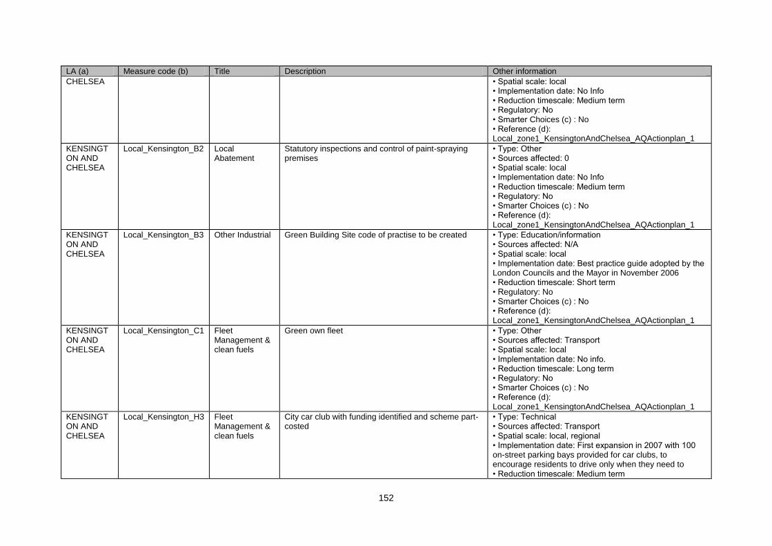
152
LA (a) Measure code (b) Title Description Other information
CHELSEA • Spatial scale: local • Implementation date: No Info • Reduction timescale: Medium term • Regulatory: No • Smarter Choices (c) : No • Reference (d): Local_zone1_KensingtonAndChelsea_AQActionplan_1
KENSINGTON AND CHELSEA
Local_Kensington_B2 Local Abatement
Statutory inspections and control of paint-spraying premises
• Type: Other • Sources affected: 0 • Spatial scale: local • Implementation date: No Info • Reduction timescale: Medium term • Regulatory: No • Smarter Choices (c) : No • Reference (d): Local_zone1_KensingtonAndChelsea_AQActionplan_1
KENSINGTON AND CHELSEA
Local_Kensington_B3 Other Industrial Green Building Site code of practise to be created • Type: Education/information • Sources affected: N/A • Spatial scale: local • Implementation date: Best practice guide adopted by the London Councils and the Mayor in November 2006 • Reduction timescale: Short term • Regulatory: No • Smarter Choices (c) : No • Reference (d): Local_zone1_KensingtonAndChelsea_AQActionplan_1
KENSINGTON AND CHELSEA
Local_Kensington_C1 Fleet Management & clean fuels
Green own fleet • Type: Other • Sources affected: Transport • Spatial scale: local • Implementation date: No info. • Reduction timescale: Long term • Regulatory: No • Smarter Choices (c) : No • Reference (d): Local_zone1_KensingtonAndChelsea_AQActionplan_1
KENSINGTON AND CHELSEA
Local_Kensington_H3 Fleet Management & clean fuels
City car club with funding identified and scheme part-costed
• Type: Technical • Sources affected: Transport • Spatial scale: local, regional • Implementation date: First expansion in 2007 with 100 on-street parking bays provided for car clubs, to encourage residents to drive only when they need to • Reduction timescale: Medium term
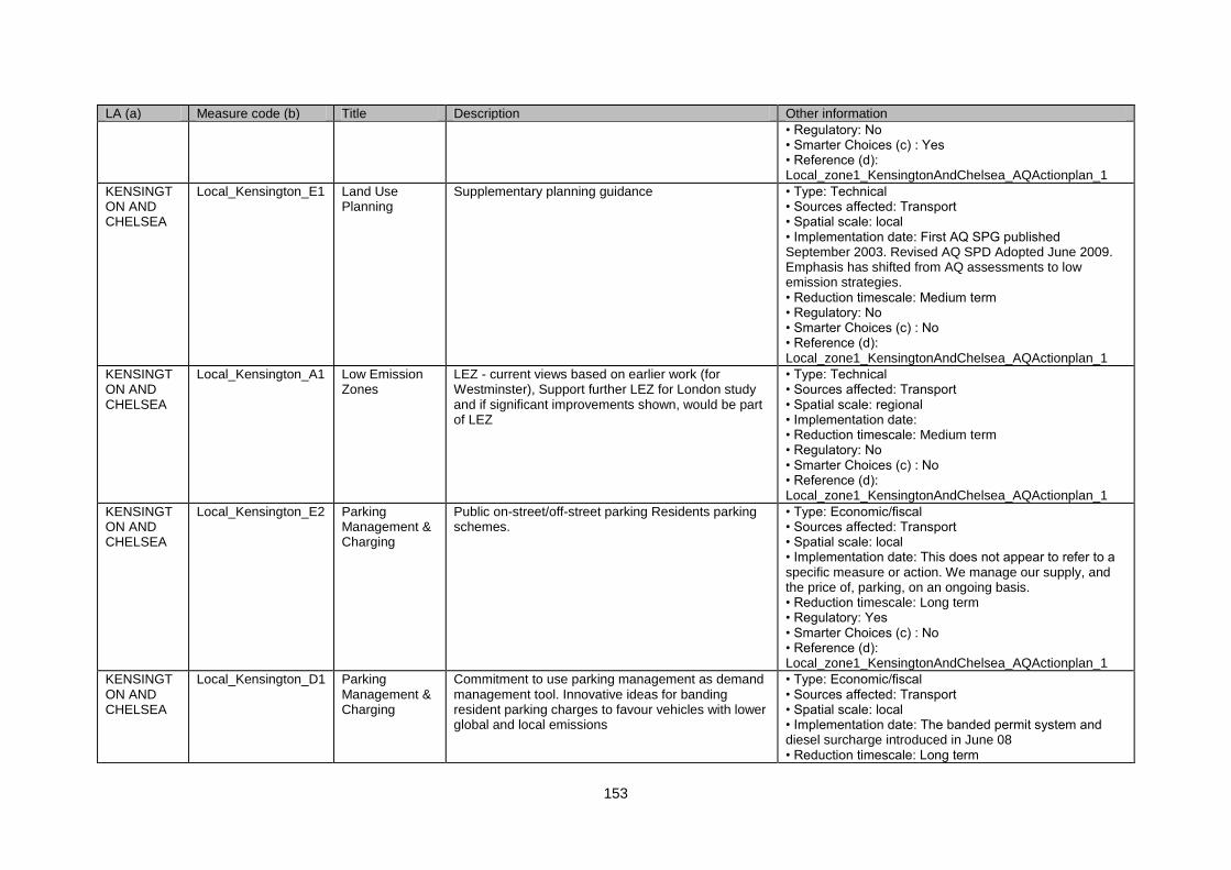
153
LA (a) Measure code (b) Title Description Other information
• Regulatory: No • Smarter Choices (c) : Yes • Reference (d): Local_zone1_KensingtonAndChelsea_AQActionplan_1
KENSINGTON AND CHELSEA
Local_Kensington_E1 Land Use Planning
Supplementary planning guidance • Type: Technical • Sources affected: Transport • Spatial scale: local • Implementation date: First AQ SPG published September 2003. Revised AQ SPD Adopted June 2009. Emphasis has shifted from AQ assessments to low emission strategies. • Reduction timescale: Medium term • Regulatory: No • Smarter Choices (c) : No • Reference (d): Local_zone1_KensingtonAndChelsea_AQActionplan_1
KENSINGTON AND CHELSEA
Local_Kensington_A1 Low Emission Zones
LEZ - current views based on earlier work (for Westminster), Support further LEZ for London study and if significant improvements shown, would be part of LEZ
• Type: Technical • Sources affected: Transport • Spatial scale: regional • Implementation date: • Reduction timescale: Medium term • Regulatory: No • Smarter Choices (c) : No • Reference (d): Local_zone1_KensingtonAndChelsea_AQActionplan_1
KENSINGTON AND CHELSEA
Local_Kensington_E2 Parking Management & Charging
Public on-street/off-street parking Residents parking schemes.
• Type: Economic/fiscal • Sources affected: Transport • Spatial scale: local • Implementation date: This does not appear to refer to a specific measure or action. We manage our supply, and the price of, parking, on an ongoing basis. • Reduction timescale: Long term • Regulatory: Yes • Smarter Choices (c) : No • Reference (d): Local_zone1_KensingtonAndChelsea_AQActionplan_1
KENSINGTON AND CHELSEA
Local_Kensington_D1 Parking Management & Charging
Commitment to use parking management as demand management tool. Innovative ideas for banding resident parking charges to favour vehicles with lower global and local emissions
• Type: Economic/fiscal • Sources affected: Transport • Spatial scale: local • Implementation date: The banded permit system and diesel surcharge introduced in June 08 • Reduction timescale: Long term
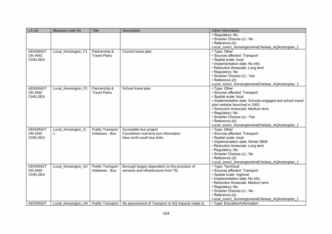
154
LA (a) Measure code (b) Title Description Other information
• Regulatory: No • Smarter Choices (c) : No • Reference (d): Local_zone1_KensingtonAndChelsea_AQActionplan_1
KENSINGTON AND CHELSEA
Local_Kensington_F1 Partnership & Travel Plans
Council travel plan • Type: Other • Sources affected: Transport • Spatial scale: local • Implementation date: No info. • Reduction timescale: Long term • Regulatory: No • Smarter Choices (c) : Yes • Reference (d): Local_zone1_KensingtonAndChelsea_AQActionplan_1
KENSINGTON AND CHELSEA
Local_Kensington_F2 Partnership & Travel Plans
School travel plan • Type: Other • Sources affected: Transport • Spatial scale: local • Implementation date: Schools engaged and school travel plan website launched in 2002 • Reduction timescale: Medium term • Regulatory: No • Smarter Choices (c) : Yes • Reference (d): Local_zone1_KensingtonAndChelsea_AQActionplan_1
KENSINGTON AND CHELSEA
Local_Kensington_G1
Public Transport Initiatives - Bus
Accessible bus project Countdown real-time bus information New north-south bus links
• Type: Other • Sources affected: Transport • Spatial scale: local • Implementation date: Winter 0809 • Reduction timescale: Long term • Regulatory: No • Smarter Choices (c) : No • Reference (d): Local_zone1_KensingtonAndChelsea_AQActionplan_1
KENSINGTON AND CHELSEA
Local_Kensington_A2 Public Transport Initiatives - Bus
Borough largely dependent on the provision of services and infrastructure from TfL.
• Type: Technical • Sources affected: Transport • Spatial scale: regional • Implementation date: No info. • Reduction timescale: Medium term • Regulatory: No • Smarter Choices (c) : No • Reference (d): Local_zone1_KensingtonAndChelsea_AQActionplan_1
KENSINGT Local_Kensington_H4 Public Transport No assessment of Transport or AQ impacts made to • Type: Education/information
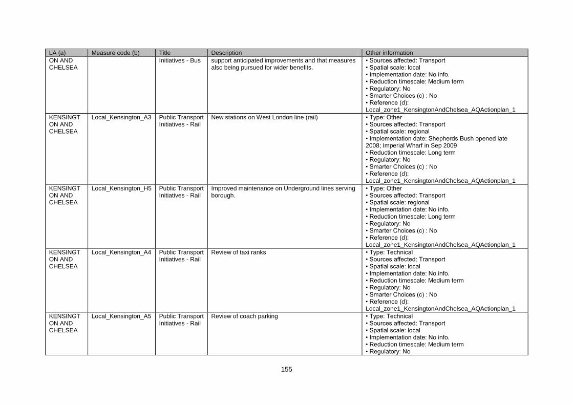
155
LA (a) Measure code (b) Title Description Other information
ON AND CHELSEA
Initiatives - Bus support anticipated improvements and that measures also being pursued for wider benefits.
• Sources affected: Transport • Spatial scale: local • Implementation date: No info. • Reduction timescale: Medium term • Regulatory: No • Smarter Choices (c) : No • Reference (d): Local_zone1_KensingtonAndChelsea_AQActionplan_1
KENSINGTON AND CHELSEA
Local_Kensington_A3 Public Transport Initiatives - Rail
New stations on West London line (rail) • Type: Other • Sources affected: Transport • Spatial scale: regional • Implementation date: Shepherds Bush opened late 2008; Imperial Wharf in Sep 2009 • Reduction timescale: Long term • Regulatory: No • Smarter Choices (c) : No • Reference (d): Local_zone1_KensingtonAndChelsea_AQActionplan_1
KENSINGTON AND CHELSEA
Local_Kensington_H5 Public Transport Initiatives - Rail
Improved maintenance on Underground lines serving borough.
• Type: Other • Sources affected: Transport • Spatial scale: regional • Implementation date: No info. • Reduction timescale: Long term • Regulatory: No • Smarter Choices (c) : No • Reference (d): Local_zone1_KensingtonAndChelsea_AQActionplan_1
KENSINGTON AND CHELSEA
Local_Kensington_A4 Public Transport Initiatives - Rail
Review of taxi ranks • Type: Technical • Sources affected: Transport • Spatial scale: local • Implementation date: No info. • Reduction timescale: Medium term • Regulatory: No • Smarter Choices (c) : No • Reference (d): Local_zone1_KensingtonAndChelsea_AQActionplan_1
KENSINGTON AND CHELSEA
Local_Kensington_A5 Public Transport Initiatives - Rail
Review of coach parking • Type: Technical • Sources affected: Transport • Spatial scale: local • Implementation date: No info. • Reduction timescale: Medium term • Regulatory: No
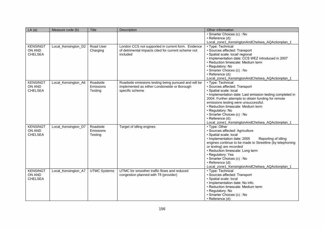
156
LA (a) Measure code (b) Title Description Other information
• Smarter Choices (c) : No • Reference (d): Local_zone1_KensingtonAndChelsea_AQActionplan_1
KENSINGTON AND CHELSEA
Local_Kensington_D2 Road User Charging
London CCS not supported in current form. Evidence of detrimental impacts cited for current scheme not included
• Type: Technical • Sources affected: Transport • Spatial scale: local/ regional • Implementation date: CCS WEZ introduced in 2007 • Reduction timescale: Medium term • Regulatory: No • Smarter Choices (c) : No • Reference (d): Local_zone1_KensingtonAndChelsea_AQActionplan_1
KENSINGTON AND CHELSEA
Local_Kensington_A6 Roadside Emissions Testing
Roadside emissions testing being pursued and will be implemented as either Londonwide or Borough specific scheme
• Type: Technical • Sources affected: Transport • Spatial scale: local • Implementation date: Last emission testing completed in 2004. Further attempts to obtain funding for remote emissions testing were unsuccessful. • Reduction timescale: Medium term • Regulatory: No • Smarter Choices (c) : No • Reference (d): Local_zone1_KensingtonAndChelsea_AQActionplan_1
KENSINGTON AND CHELSEA
Local_Kensington_D7 Roadside Emissions Testing
Target of idling engines • Type: Other • Sources affected: Agriculture • Spatial scale: local • Implementation date: 2005 Reporting of idling engines continue to be made to Streetline (by telephoning or texting) are recorded • Reduction timescale: Long term • Regulatory: Yes • Smarter Choices (c) : No • Reference (d): Local_zone1_KensingtonAndChelsea_AQActionplan_1
KENSINGTON AND CHELSEA
Local_Kensington_A7 UTMC Systems UTMC for smoother traffic flows and reduced congestion planned with Tfl (provider)
• Type: Technical • Sources affected: Transport • Spatial scale: local • Implementation date: No info. • Reduction timescale: Medium term • Regulatory: No • Smarter Choices (c) : No • Reference (d):
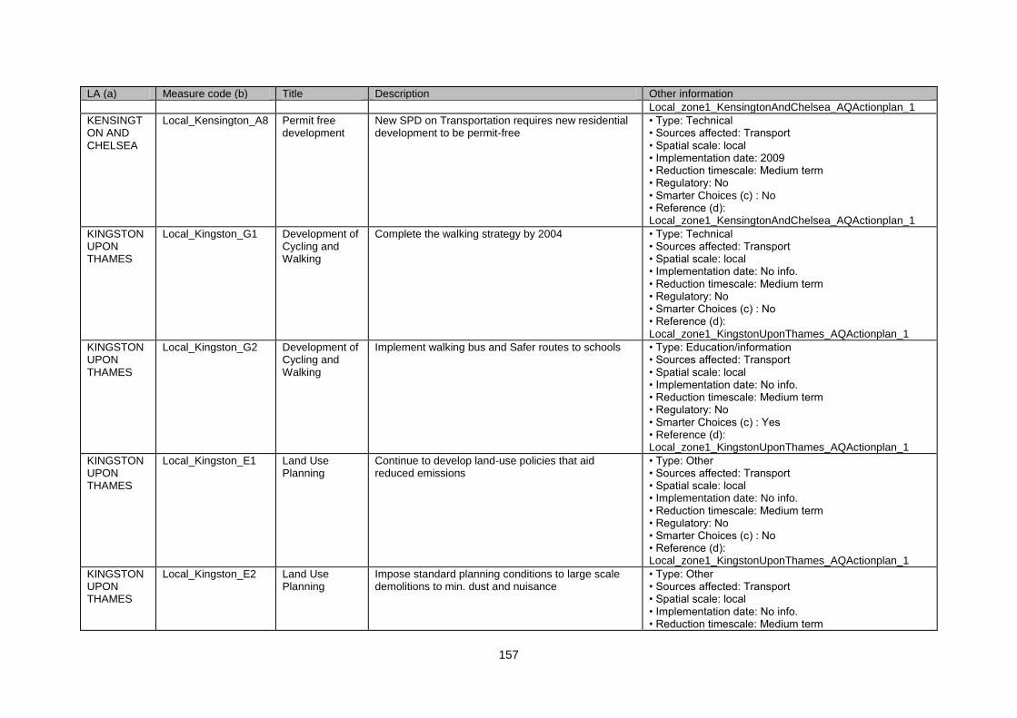
157
LA (a) Measure code (b) Title Description Other information
Local_zone1_KensingtonAndChelsea_AQActionplan_1
KENSINGTON AND CHELSEA
Local_Kensington_A8 Permit free development
New SPD on Transportation requires new residential development to be permit-free
• Type: Technical • Sources affected: Transport • Spatial scale: local • Implementation date: 2009 • Reduction timescale: Medium term • Regulatory: No • Smarter Choices (c) : No • Reference (d): Local_zone1_KensingtonAndChelsea_AQActionplan_1
KINGSTON UPON THAMES
Local_Kingston_G1 Development of Cycling and Walking
Complete the walking strategy by 2004 • Type: Technical • Sources affected: Transport • Spatial scale: local • Implementation date: No info. • Reduction timescale: Medium term • Regulatory: No • Smarter Choices (c) : No • Reference (d): Local_zone1_KingstonUponThames_AQActionplan_1
KINGSTON UPON THAMES
Local_Kingston_G2 Development of Cycling and Walking
Implement walking bus and Safer routes to schools • Type: Education/information • Sources affected: Transport • Spatial scale: local • Implementation date: No info. • Reduction timescale: Medium term • Regulatory: No • Smarter Choices (c) : Yes • Reference (d): Local_zone1_KingstonUponThames_AQActionplan_1
KINGSTON UPON THAMES
Local_Kingston_E1 Land Use Planning
Continue to develop land-use policies that aid reduced emissions
• Type: Other • Sources affected: Transport • Spatial scale: local • Implementation date: No info. • Reduction timescale: Medium term • Regulatory: No • Smarter Choices (c) : No • Reference (d): Local_zone1_KingstonUponThames_AQActionplan_1
KINGSTON UPON THAMES
Local_Kingston_E2 Land Use Planning
Impose standard planning conditions to large scale demolitions to min. dust and nuisance
• Type: Other • Sources affected: Transport • Spatial scale: local • Implementation date: No info. • Reduction timescale: Medium term
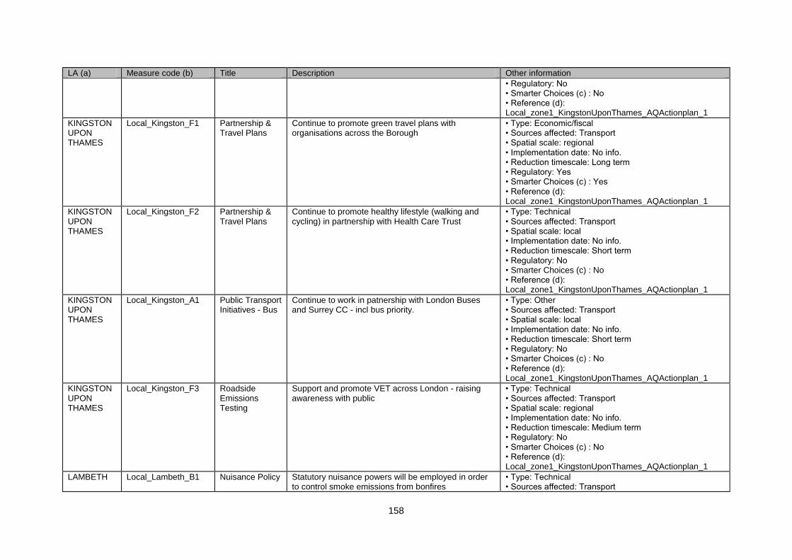
158
LA (a) Measure code (b) Title Description Other information
• Regulatory: No • Smarter Choices (c) : No • Reference (d): Local_zone1_KingstonUponThames_AQActionplan_1
KINGSTON UPON THAMES
Local_Kingston_F1 Partnership & Travel Plans
Continue to promote green travel plans with organisations across the Borough
• Type: Economic/fiscal • Sources affected: Transport • Spatial scale: regional • Implementation date: No info. • Reduction timescale: Long term • Regulatory: Yes • Smarter Choices (c) : Yes • Reference (d): Local_zone1_KingstonUponThames_AQActionplan_1
KINGSTON UPON THAMES
Local_Kingston_F2 Partnership & Travel Plans
Continue to promote healthy lifestyle (walking and cycling) in partnership with Health Care Trust
• Type: Technical • Sources affected: Transport • Spatial scale: local • Implementation date: No info. • Reduction timescale: Short term • Regulatory: No • Smarter Choices (c) : No • Reference (d): Local_zone1_KingstonUponThames_AQActionplan_1
KINGSTON UPON THAMES
Local_Kingston_A1 Public Transport Initiatives - Bus
Continue to work in patnership with London Buses and Surrey CC - incl bus priority.
• Type: Other • Sources affected: Transport • Spatial scale: local • Implementation date: No info. • Reduction timescale: Short term • Regulatory: No • Smarter Choices (c) : No • Reference (d): Local_zone1_KingstonUponThames_AQActionplan_1
KINGSTON UPON THAMES
Local_Kingston_F3 Roadside Emissions Testing
Support and promote VET across London - raising awareness with public
• Type: Technical • Sources affected: Transport • Spatial scale: regional • Implementation date: No info. • Reduction timescale: Medium term • Regulatory: No • Smarter Choices (c) : No • Reference (d): Local_zone1_KingstonUponThames_AQActionplan_1
LAMBETH Local_Lambeth_B1 Nuisance Policy Statutory nuisance powers will be employed in order to control smoke emissions from bonfires
• Type: Technical • Sources affected: Transport
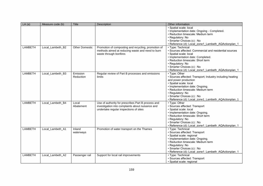
159
LA (a) Measure code (b) Title Description Other information
• Spatial scale: local • Implementation date: Ongoing - Completed. • Reduction timescale: Medium term • Regulatory: No • Smarter Choices (c) : No • Reference (d): Local_zone1_Lambeth_AQActionplan_1
LAMBETH Local_Lambeth_B2 Other Domestic Promotion of composting and recycling, promotion of methods aimed at reducing waste and need to burn waste through bonfires
• Type: Technical • Sources affected: Commercial and residential sources • Spatial scale: local • Implementation date: Completed. • Reduction timescale: Short term • Regulatory: No • Smarter Choices (c) : No • Reference (d): Local_zone1_Lambeth_AQActionplan_1
LAMBETH Local_Lambeth_B3 Emission Reduction
Regular review of Part B processes and emissions limits
• Type: Other • Sources affected: Transport; Industry including heating and power production • Spatial scale: local • Implementation date: Ongoing. • Reduction timescale: Medium term • Regulatory: No • Smarter Choices (c) : No • Reference (d): Local_zone1_Lambeth_AQActionplan_1
LAMBETH Local_Lambeth_B4 Local Abatement
Use of authority for prescribes Part B process and investigation into complaints about nuisance and undertake regular inspections of sites
• Type: Other • Sources affected: Transport • Spatial scale: local • Implementation date: Ongoing. • Reduction timescale: Short term • Regulatory: No • Smarter Choices (c) : No • Reference (d): Local_zone1_Lambeth_AQActionplan_1
LAMBETH Local_Lambeth_A1 Inland waterways
Promotion of water transport on the Thames • Type: Technical • Sources affected: Transport • Spatial scale: regional • Implementation date: Ongoing. • Reduction timescale: Medium term • Regulatory: No • Smarter Choices (c) : No • Reference (d): Local_zone1_Lambeth_AQActionplan_1
LAMBETH Local_Lambeth_A2 Passenger rail Support for local rail improvements • Type: Technical • Sources affected: Transport • Spatial scale: regional
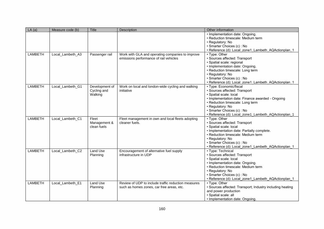
160
LA (a) Measure code (b) Title Description Other information
• Implementation date: Ongoing. • Reduction timescale: Medium term • Regulatory: No • Smarter Choices (c) : No • Reference (d): Local_zone1_Lambeth_AQActionplan_1
LAMBETH Local_Lambeth_A3 Passenger rail Work with GLA and operating companies to improve emissions performance of rail vehicles
• Type: Other • Sources affected: Transport • Spatial scale: regional • Implementation date: Ongoing. • Reduction timescale: Long term • Regulatory: No • Smarter Choices (c) : No • Reference (d): Local_zone1_Lambeth_AQActionplan_1
LAMBETH Local_Lambeth_G1 Development of Cycling and Walking
Work on local and london-wide cycling and walking initiative
• Type: Economic/fiscal • Sources affected: Transport • Spatial scale: local • Implementation date: Finance awarded - Ongoing • Reduction timescale: Long term • Regulatory: No • Smarter Choices (c) : No • Reference (d): Local_zone1_Lambeth_AQActionplan_1
LAMBETH Local_Lambeth_C1 Fleet Management & clean fuels
Fleet management in own and local fleets adopting cleaner fuels.
• Type: Other • Sources affected: Transport • Spatial scale: local • Implementation date: Partially complete. • Reduction timescale: Medium term • Regulatory: No • Smarter Choices (c) : No • Reference (d): Local_zone1_Lambeth_AQActionplan_1
LAMBETH Local_Lambeth_C2 Land Use Planning
Encouragement of alternative fuel supply infrastructure in UDP
• Type: Technical • Sources affected: Transport • Spatial scale: local • Implementation date: Ongoing. • Reduction timescale: Medium term • Regulatory: No • Smarter Choices (c) : No • Reference (d): Local_zone1_Lambeth_AQActionplan_1
LAMBETH Local_Lambeth_E1 Land Use Planning
Review of UDP to include traffic reduction measures such as homes zones, car free areas, etc.
• Type: Other • Sources affected: Transport; Industry including heating and power production • Spatial scale: all • Implementation date: Ongoing.
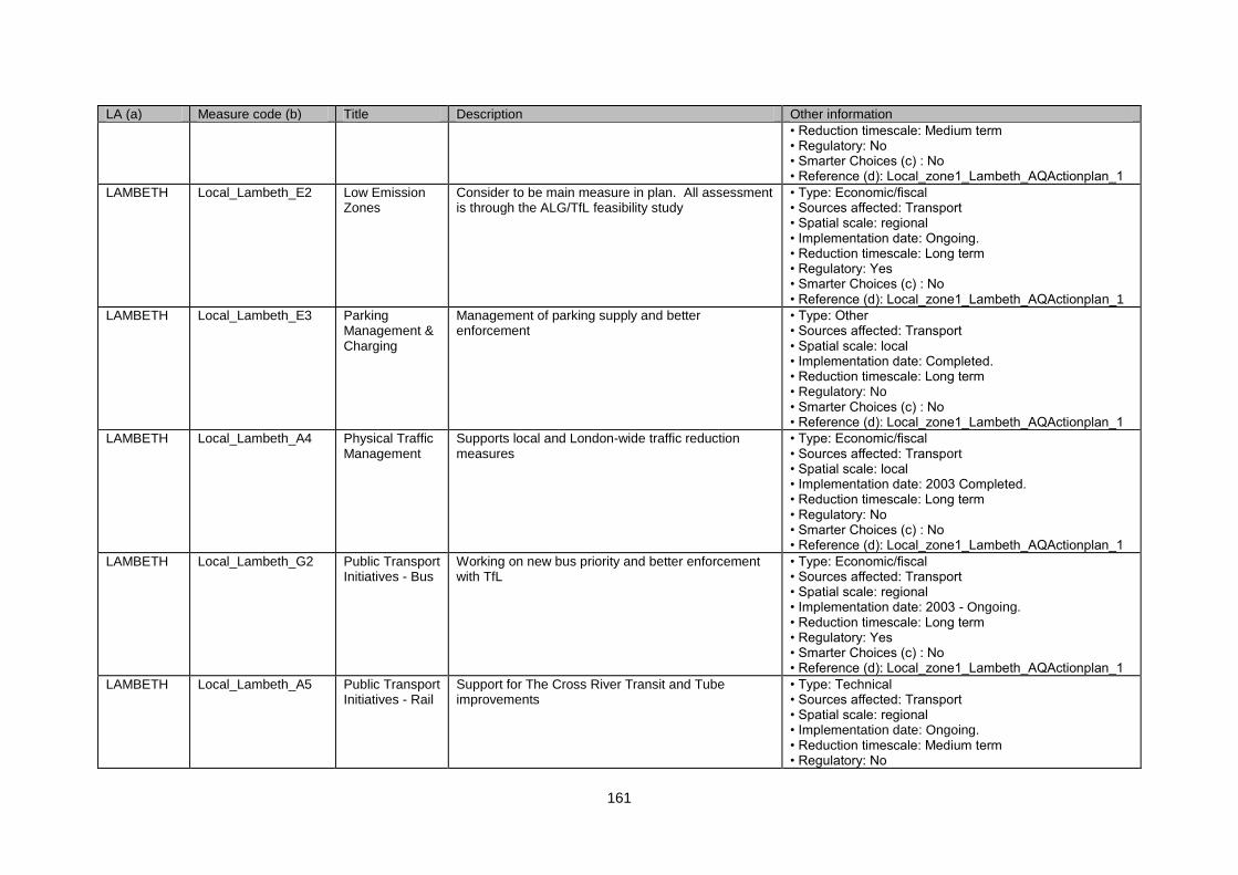
161
LA (a) Measure code (b) Title Description Other information
• Reduction timescale: Medium term • Regulatory: No • Smarter Choices (c) : No • Reference (d): Local_zone1_Lambeth_AQActionplan_1
LAMBETH Local_Lambeth_E2 Low Emission Zones
Consider to be main measure in plan. All assessment is through the ALG/TfL feasibility study
• Type: Economic/fiscal • Sources affected: Transport • Spatial scale: regional • Implementation date: Ongoing. • Reduction timescale: Long term • Regulatory: Yes • Smarter Choices (c) : No • Reference (d): Local_zone1_Lambeth_AQActionplan_1
LAMBETH Local_Lambeth_E3 Parking Management & Charging
Management of parking supply and better enforcement
• Type: Other • Sources affected: Transport • Spatial scale: local • Implementation date: Completed. • Reduction timescale: Long term • Regulatory: No • Smarter Choices (c) : No • Reference (d): Local_zone1_Lambeth_AQActionplan_1
LAMBETH Local_Lambeth_A4 Physical Traffic Management
Supports local and London-wide traffic reduction measures
• Type: Economic/fiscal • Sources affected: Transport • Spatial scale: local • Implementation date: 2003 Completed. • Reduction timescale: Long term • Regulatory: No • Smarter Choices (c) : No • Reference (d): Local_zone1_Lambeth_AQActionplan_1
LAMBETH Local_Lambeth_G2 Public Transport Initiatives - Bus
Working on new bus priority and better enforcement with TfL
• Type: Economic/fiscal • Sources affected: Transport • Spatial scale: regional • Implementation date: 2003 - Ongoing. • Reduction timescale: Long term • Regulatory: Yes • Smarter Choices (c) : No • Reference (d): Local_zone1_Lambeth_AQActionplan_1
LAMBETH Local_Lambeth_A5 Public Transport Initiatives - Rail
Support for The Cross River Transit and Tube improvements
• Type: Technical • Sources affected: Transport • Spatial scale: regional • Implementation date: Ongoing. • Reduction timescale: Medium term • Regulatory: No
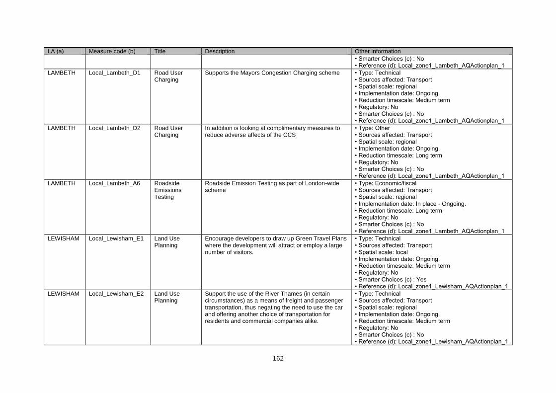
162
LA (a) Measure code (b) Title Description Other information
• Smarter Choices (c) : No • Reference (d): Local_zone1_Lambeth_AQActionplan_1
LAMBETH Local_Lambeth_D1 Road User Charging
Supports the Mayors Congestion Charging scheme • Type: Technical • Sources affected: Transport • Spatial scale: regional • Implementation date: Ongoing. • Reduction timescale: Medium term • Regulatory: No • Smarter Choices (c) : No • Reference (d): Local_zone1_Lambeth_AQActionplan_1
LAMBETH Local_Lambeth_D2 Road User Charging
In addition is looking at complimentary measures to reduce adverse affects of the CCS
• Type: Other • Sources affected: Transport • Spatial scale: regional • Implementation date: Ongoing. • Reduction timescale: Long term • Regulatory: No • Smarter Choices (c) : No • Reference (d): Local_zone1_Lambeth_AQActionplan_1
LAMBETH Local_Lambeth_A6 Roadside Emissions Testing
Roadside Emission Testing as part of London-wide scheme
• Type: Economic/fiscal • Sources affected: Transport • Spatial scale: regional • Implementation date: In place - Ongoing. • Reduction timescale: Long term • Regulatory: No • Smarter Choices (c) : No • Reference (d): Local_zone1_Lambeth_AQActionplan_1
LEWISHAM Local_Lewisham_E1 Land Use Planning
Encourage developers to draw up Green Travel Plans where the development will attract or employ a large number of visitors.
• Type: Technical • Sources affected: Transport • Spatial scale: local • Implementation date: Ongoing. • Reduction timescale: Medium term • Regulatory: No • Smarter Choices (c) : Yes • Reference (d): Local_zone1_Lewisham_AQActionplan_1
LEWISHAM Local_Lewisham_E2 Land Use Planning
Support the use of the River Thames (in certain circumstances) as a means of freight and passenger transportation, thus negating the need to use the car and offering another choice of transportation for residents and commercial companies alike.
• Type: Technical • Sources affected: Transport • Spatial scale: regional • Implementation date: Ongoing. • Reduction timescale: Medium term • Regulatory: No • Smarter Choices (c) : No • Reference (d): Local_zone1_Lewisham_AQActionplan_1
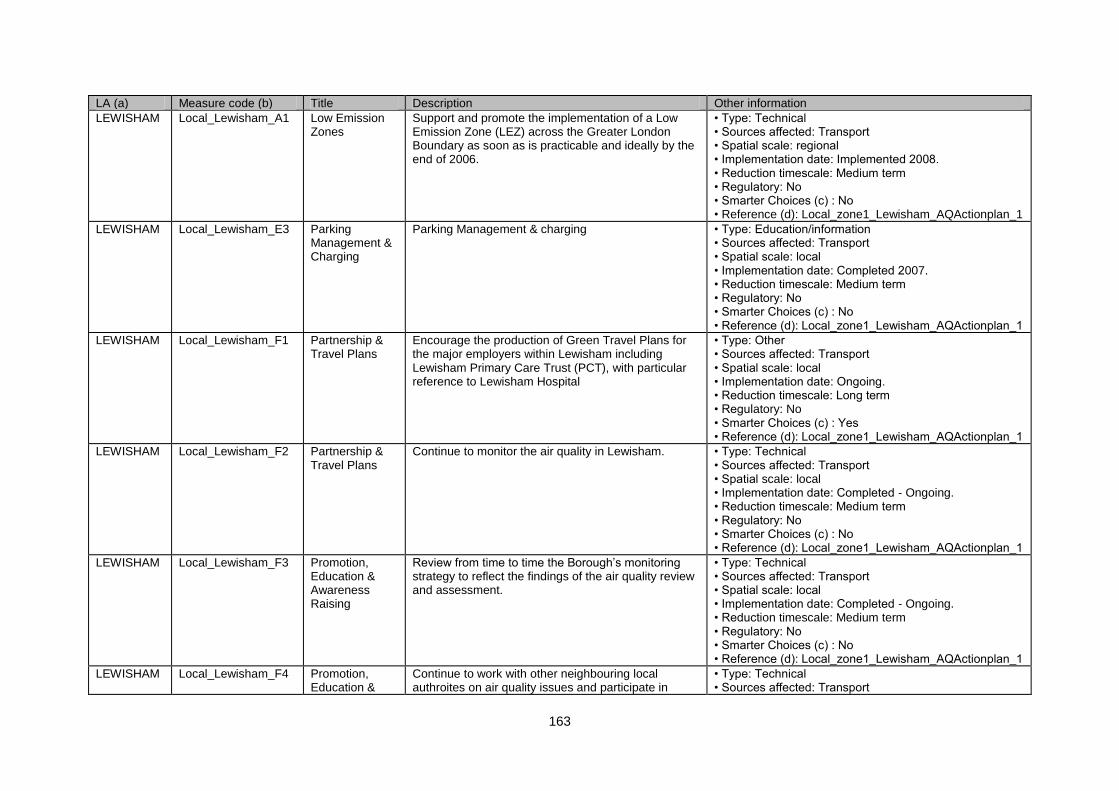
163
LA (a) Measure code (b) Title Description Other information
LEWISHAM Local_Lewisham_A1 Low Emission Zones
Support and promote the implementation of a Low Emission Zone (LEZ) across the Greater London Boundary as soon as is practicable and ideally by the end of 2006.
• Type: Technical • Sources affected: Transport • Spatial scale: regional • Implementation date: Implemented 2008. • Reduction timescale: Medium term • Regulatory: No • Smarter Choices (c) : No • Reference (d): Local_zone1_Lewisham_AQActionplan_1
LEWISHAM Local_Lewisham_E3 Parking Management & Charging
Parking Management & charging • Type: Education/information • Sources affected: Transport • Spatial scale: local • Implementation date: Completed 2007. • Reduction timescale: Medium term • Regulatory: No • Smarter Choices (c) : No • Reference (d): Local_zone1_Lewisham_AQActionplan_1
LEWISHAM Local_Lewisham_F1 Partnership & Travel Plans
Encourage the production of Green Travel Plans for the major employers within Lewisham including Lewisham Primary Care Trust (PCT), with particular reference to Lewisham Hospital
• Type: Other • Sources affected: Transport • Spatial scale: local • Implementation date: Ongoing. • Reduction timescale: Long term • Regulatory: No • Smarter Choices (c) : Yes • Reference (d): Local_zone1_Lewisham_AQActionplan_1
LEWISHAM Local_Lewisham_F2 Partnership & Travel Plans
Continue to monitor the air quality in Lewisham. • Type: Technical • Sources affected: Transport • Spatial scale: local • Implementation date: Completed - Ongoing. • Reduction timescale: Medium term • Regulatory: No • Smarter Choices (c) : No • Reference (d): Local_zone1_Lewisham_AQActionplan_1
LEWISHAM Local_Lewisham_F3 Promotion, Education & Awareness Raising
Review from time to time the Borough‟s monitoring strategy to reflect the findings of the air quality review and assessment.
• Type: Technical • Sources affected: Transport • Spatial scale: local • Implementation date: Completed - Ongoing. • Reduction timescale: Medium term • Regulatory: No • Smarter Choices (c) : No • Reference (d): Local_zone1_Lewisham_AQActionplan_1
LEWISHAM Local_Lewisham_F4 Promotion, Education &
Continue to work with other neighbouring local authroites on air quality issues and participate in
• Type: Technical • Sources affected: Transport
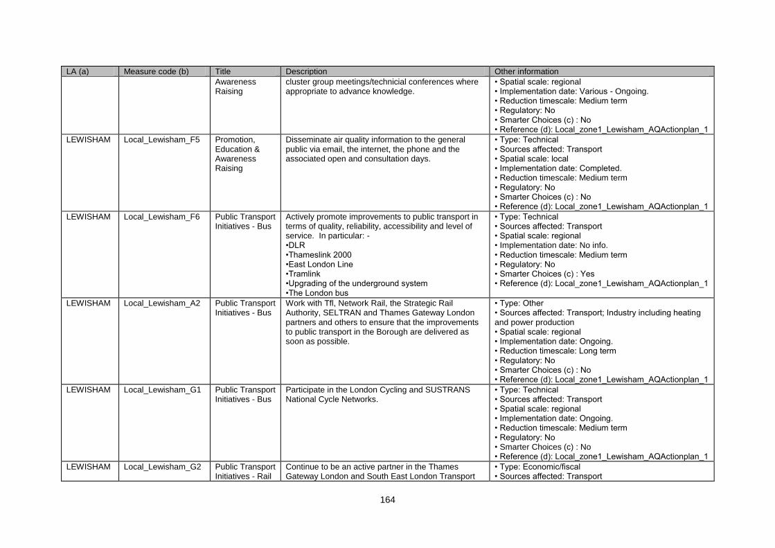
164
LA (a) Measure code (b) Title Description Other information
Awareness Raising
cluster group meetings/technicial conferences where appropriate to advance knowledge.
• Spatial scale: regional • Implementation date: Various - Ongoing. • Reduction timescale: Medium term • Regulatory: No • Smarter Choices (c) : No • Reference (d): Local_zone1_Lewisham_AQActionplan_1
LEWISHAM Local_Lewisham_F5 Promotion, Education & Awareness Raising
Disseminate air quality information to the general public via email, the internet, the phone and the associated open and consultation days.
• Type: Technical • Sources affected: Transport • Spatial scale: local • Implementation date: Completed. • Reduction timescale: Medium term • Regulatory: No • Smarter Choices (c) : No • Reference (d): Local_zone1_Lewisham_AQActionplan_1
LEWISHAM Local_Lewisham_F6 Public Transport Initiatives - Bus
Actively promote improvements to public transport in terms of quality, reliability, accessibility and level of service. In particular: - •DLR •Thameslink 2000 •East London Line •Tramlink •Upgrading of the underground system •The London bus
• Type: Technical • Sources affected: Transport • Spatial scale: regional • Implementation date: No info. • Reduction timescale: Medium term • Regulatory: No • Smarter Choices (c) : Yes • Reference (d): Local_zone1_Lewisham_AQActionplan_1
LEWISHAM Local_Lewisham_A2 Public Transport Initiatives - Bus
Work with Tfl, Network Rail, the Strategic Rail Authority, SELTRAN and Thames Gateway London partners and others to ensure that the improvements to public transport in the Borough are delivered as soon as possible.
• Type: Other • Sources affected: Transport; Industry including heating and power production • Spatial scale: regional • Implementation date: Ongoing. • Reduction timescale: Long term • Regulatory: No • Smarter Choices (c) : No • Reference (d): Local_zone1_Lewisham_AQActionplan_1
LEWISHAM Local_Lewisham_G1 Public Transport Initiatives - Bus
Participate in the London Cycling and SUSTRANS National Cycle Networks.
• Type: Technical • Sources affected: Transport • Spatial scale: regional • Implementation date: Ongoing. • Reduction timescale: Medium term • Regulatory: No • Smarter Choices (c) : No • Reference (d): Local_zone1_Lewisham_AQActionplan_1
LEWISHAM Local_Lewisham_G2 Public Transport Initiatives - Rail
Continue to be an active partner in the Thames Gateway London and South East London Transport
• Type: Economic/fiscal • Sources affected: Transport
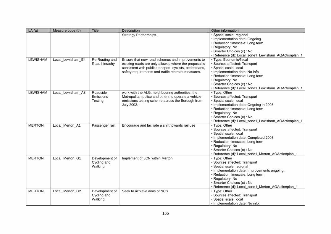
165
LA (a) Measure code (b) Title Description Other information
Strategy Partnerships. • Spatial scale: regional • Implementation date: Ongoing. • Reduction timescale: Long term • Regulatory: No • Smarter Choices (c) : No • Reference (d): Local_zone1_Lewisham_AQActionplan_1
LEWISHAM Local_Lewisham_E4 Re-Routing and Road hierachy
Ensure that new road schemes and improvements to existing roads are only allowed where the proposal is consistent with public transport, cyclists, pedestrians, safety requirements and traffic restraint measures.
• Type: Economic/fiscal • Sources affected: Transport • Spatial scale: local • Implementation date: No info • Reduction timescale: Long term • Regulatory: No • Smarter Choices (c) : No • Reference (d): Local_zone1_Lewisham_AQActionplan_1
LEWISHAM Local_Lewisham_A3 Roadside Emissions Testing
work with the ALG, neighbouring authorities, the Metropolitan police and others to operate a vehicle-emissions testing scheme across the Borough from July 2003.
• Type: Other • Sources affected: Transport • Spatial scale: local • Implementation date: Ongoing in 2008. • Reduction timescale: Long term • Regulatory: No • Smarter Choices (c) : No • Reference (d): Local_zone1_Lewisham_AQActionplan_1
MERTON Local_Merton_A1 Passenger rail Encourage and faciliate a shift towards rail use • Type: Other • Sources affected: Transport • Spatial scale: local • Implementation date: Completed 2008. • Reduction timescale: Long term • Regulatory: No • Smarter Choices (c) : No • Reference (d): Local_zone1_Merton_AQActionplan_1
MERTON Local_Merton_G1 Development of Cycling and Walking
Implement of LCN within Merton • Type: Other • Sources affected: Transport • Spatial scale: regional • Implementation date: Improvements ongoing. • Reduction timescale: Long term • Regulatory: No • Smarter Choices (c) : No • Reference (d): Local_zone1_Merton_AQActionplan_1
MERTON Local_Merton_G2 Development of Cycling and Walking
Seek to achieve aims of NCS • Type: Other • Sources affected: Transport • Spatial scale: local • Implementation date: No info.
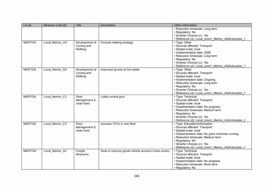
166
LA (a) Measure code (b) Title Description Other information
• Reduction timescale: Long term • Regulatory: No • Smarter Choices (c) : No • Reference (d): Local_zone1_Merton_AQActionplan_1
MERTON Local_Merton_G3 Development of Cycling and Walking
Formula walking strategy • Type: Other • Sources affected: Transport • Spatial scale: local • Implementation date: 2008 • Reduction timescale: Long term • Regulatory: No • Smarter Choices (c) : No • Reference (d): Local_zone1_Merton_AQActionplan_1
MERTON Local_Merton_G4 Development of Cycling and Walking
Improved access to Ind estate • Type: Other • Sources affected: Transport • Spatial scale: local • Implementation date: Ongoing. • Reduction timescale: Long term • Regulatory: No • Smarter Choices (c) : No • Reference (d): Local_zone1_Merton_AQActionplan_1
MERTON Local_Merton_C1 Fleet Management & clean fuels
Lobby central govt. • Type: Technical • Sources affected: Transport • Spatial scale: local • Implementation date: No progress. • Reduction timescale: Medium term • Regulatory: No • Smarter Choices (c) : No • Reference (d): Local_zone1_Merton_AQActionplan_1
MERTON Local_Merton_C2 Fleet Management & clean fuels
Increase CFVs in own fleet • Type: Education/information • Sources affected: Transport • Spatial scale: local • Implementation date: No grant schemes running. • Reduction timescale: Medium term • Regulatory: No • Smarter Choices (c) : No • Reference (d): Local_zone1_Merton_AQActionplan_1
MERTON Local_Merton_A2 Freight Measures
Seek to improve goods vehicle access in town centre. • Type: Technical • Sources affected: Transport • Spatial scale: local • Implementation date: No progress. • Reduction timescale: Short term • Regulatory: No
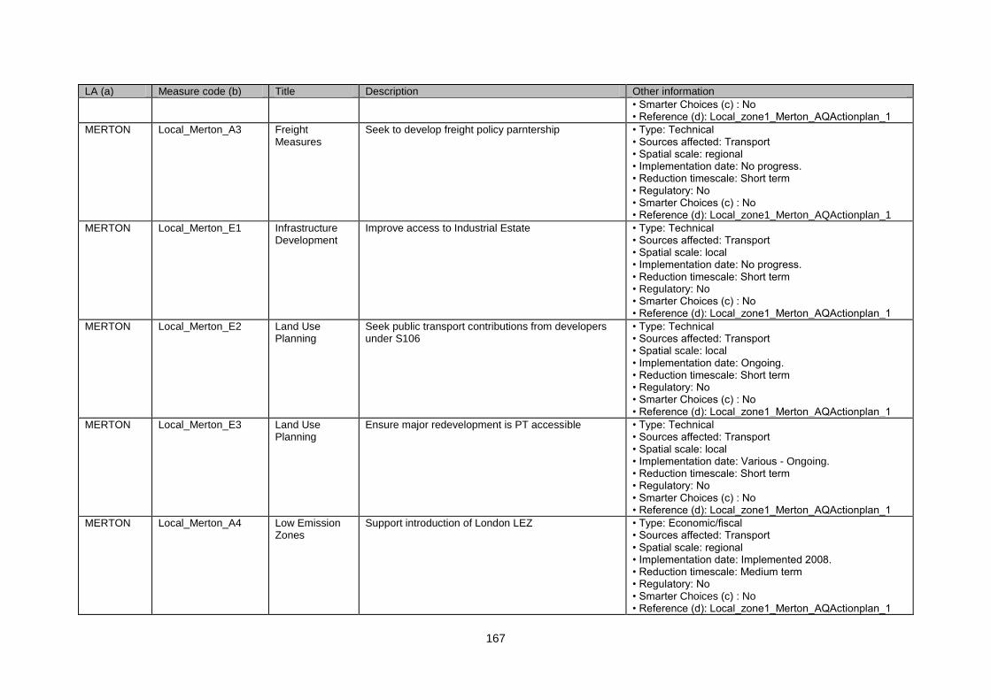
167
LA (a) Measure code (b) Title Description Other information
• Smarter Choices (c) : No • Reference (d): Local_zone1_Merton_AQActionplan_1
MERTON Local_Merton_A3 Freight Measures
Seek to develop freight policy parntership • Type: Technical • Sources affected: Transport • Spatial scale: regional • Implementation date: No progress. • Reduction timescale: Short term • Regulatory: No • Smarter Choices (c) : No • Reference (d): Local_zone1_Merton_AQActionplan_1
MERTON Local_Merton_E1 Infrastructure Development
Improve access to Industrial Estate • Type: Technical • Sources affected: Transport • Spatial scale: local • Implementation date: No progress. • Reduction timescale: Short term • Regulatory: No • Smarter Choices (c) : No • Reference (d): Local_zone1_Merton_AQActionplan_1
MERTON Local_Merton_E2 Land Use Planning
Seek public transport contributions from developers under S106
• Type: Technical • Sources affected: Transport • Spatial scale: local • Implementation date: Ongoing. • Reduction timescale: Short term • Regulatory: No • Smarter Choices (c) : No • Reference (d): Local_zone1_Merton_AQActionplan_1
MERTON Local_Merton_E3 Land Use Planning
Ensure major redevelopment is PT accessible • Type: Technical • Sources affected: Transport • Spatial scale: local • Implementation date: Various - Ongoing. • Reduction timescale: Short term • Regulatory: No • Smarter Choices (c) : No • Reference (d): Local_zone1_Merton_AQActionplan_1
MERTON Local_Merton_A4 Low Emission Zones
Support introduction of London LEZ • Type: Economic/fiscal • Sources affected: Transport • Spatial scale: regional • Implementation date: Implemented 2008. • Reduction timescale: Medium term • Regulatory: No • Smarter Choices (c) : No • Reference (d): Local_zone1_Merton_AQActionplan_1
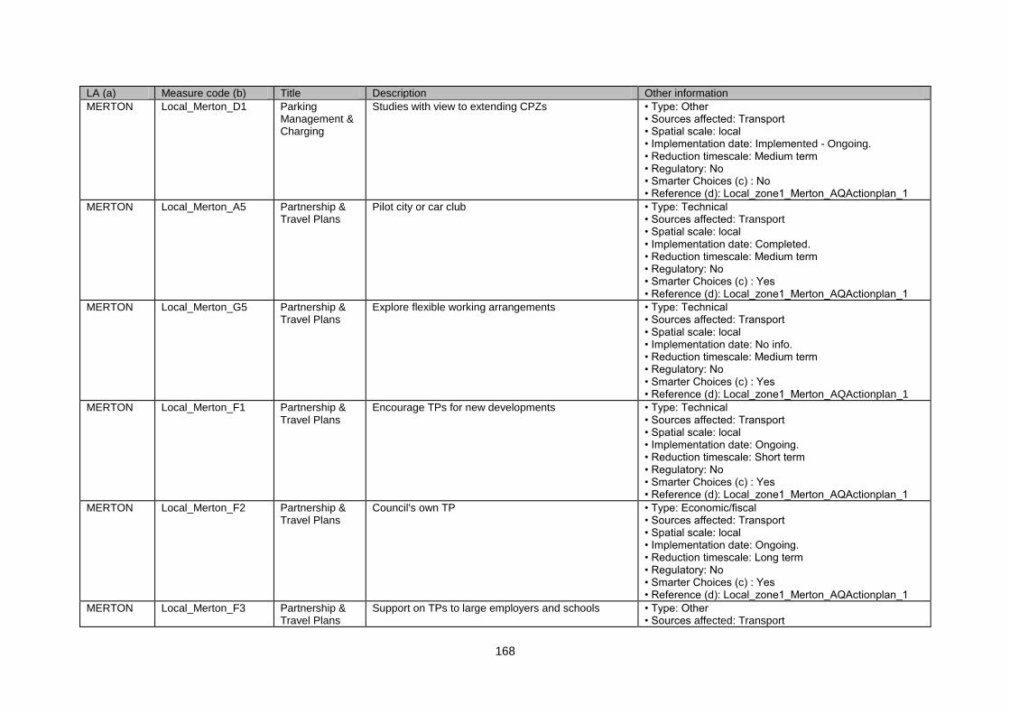
168
LA (a) Measure code (b) Title Description Other information
MERTON Local_Merton_D1 Parking Management & Charging
Studies with view to extending CPZs • Type: Other • Sources affected: Transport • Spatial scale: local • Implementation date: Implemented - Ongoing. • Reduction timescale: Medium term • Regulatory: No • Smarter Choices (c) : No • Reference (d): Local_zone1_Merton_AQActionplan_1
MERTON Local_Merton_A5 Partnership & Travel Plans
Pilot city or car club • Type: Technical • Sources affected: Transport • Spatial scale: local • Implementation date: Completed. • Reduction timescale: Medium term • Regulatory: No • Smarter Choices (c) : Yes • Reference (d): Local_zone1_Merton_AQActionplan_1
MERTON Local_Merton_G5 Partnership & Travel Plans
Explore flexible working arrangements • Type: Technical • Sources affected: Transport • Spatial scale: local • Implementation date: No info. • Reduction timescale: Medium term • Regulatory: No • Smarter Choices (c) : Yes • Reference (d): Local_zone1_Merton_AQActionplan_1
MERTON Local_Merton_F1 Partnership & Travel Plans
Encourage TPs for new developments • Type: Technical • Sources affected: Transport • Spatial scale: local • Implementation date: Ongoing. • Reduction timescale: Short term • Regulatory: No • Smarter Choices (c) : Yes • Reference (d): Local_zone1_Merton_AQActionplan_1
MERTON Local_Merton_F2 Partnership & Travel Plans
Council's own TP • Type: Economic/fiscal • Sources affected: Transport • Spatial scale: local • Implementation date: Ongoing. • Reduction timescale: Long term • Regulatory: No • Smarter Choices (c) : Yes • Reference (d): Local_zone1_Merton_AQActionplan_1
MERTON Local_Merton_F3 Partnership & Travel Plans
Support on TPs to large employers and schools • Type: Other • Sources affected: Transport
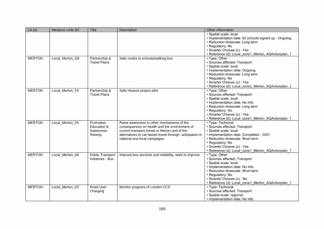
169
LA (a) Measure code (b) Title Description Other information
• Spatial scale: local • Implementation date: 62 schools signed up - Ongoing. • Reduction timescale: Long term • Regulatory: No • Smarter Choices (c) : Yes • Reference (d): Local_zone1_Merton_AQActionplan_1
MERTON Local_Merton_G6 Partnership & Travel Plans
Safe routes to schools/walking bus • Type: Other • Sources affected: Transport • Spatial scale: local • Implementation date: Ongoing. • Reduction timescale: Long term • Regulatory: No • Smarter Choices (c) : Yes • Reference (d): Local_zone1_Merton_AQActionplan_1
MERTON Local_Merton_F4 Partnership & Travel Plans
Safe Havens project pilot • Type: Other • Sources affected: Transport • Spatial scale: local • Implementation date: No info. • Reduction timescale: Long term • Regulatory: No • Smarter Choices (c) : Yes • Reference (d): Local_zone1_Merton_AQActionplan_1
MERTON Local_Merton_F5 Promotion, Education & Awareness Raising
Raise awareness to other mechanisms of the consequences on health and the environment of current transport trends in Merton and of the alternatives to car-based travel through articipation in national and local campaigns.
• Type: Technical • Sources affected: Transport • Spatial scale: local • Implementation date: Completed - 2007. • Reduction timescale: Short term • Regulatory: No • Smarter Choices (c) : Yes • Reference (d): Local_zone1_Merton_AQActionplan_1
MERTON Local_Merton_A6 Public Transport Initiatives - Bus
Improve bus services and reliability, seek to improve • Type: Other • Sources affected: Transport • Spatial scale: local • Implementation date: No info. • Reduction timescale: Short term • Regulatory: No • Smarter Choices (c) : No • Reference (d): Local_zone1_Merton_AQActionplan_1
MERTON Local_Merton_D2 Road User Charging
Monitor progress of London CCS • Type: Technical • Sources affected: Transport • Spatial scale: regional • Implementation date: No info.
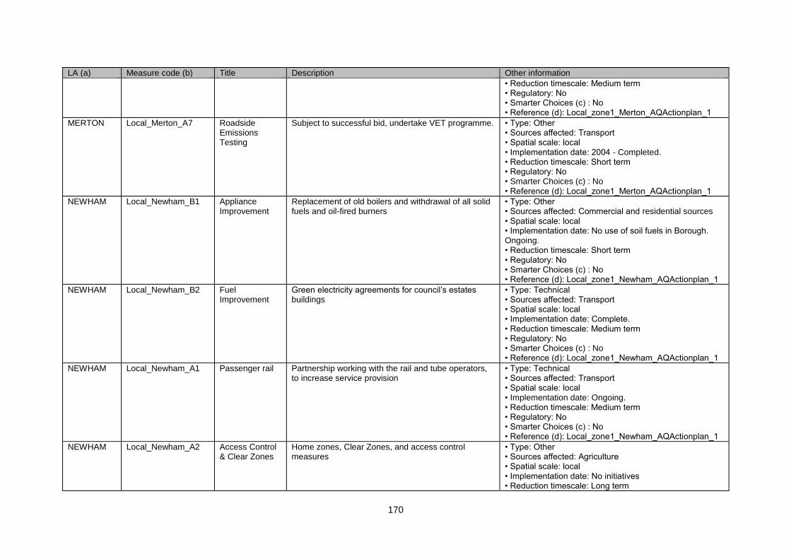
170
LA (a) Measure code (b) Title Description Other information
• Reduction timescale: Medium term • Regulatory: No • Smarter Choices (c) : No • Reference (d): Local_zone1_Merton_AQActionplan_1
MERTON Local_Merton_A7 Roadside Emissions Testing
Subject to successful bid, undertake VET programme. • Type: Other • Sources affected: Transport • Spatial scale: local • Implementation date: 2004 - Completed. • Reduction timescale: Short term • Regulatory: No • Smarter Choices (c) : No • Reference (d): Local_zone1_Merton_AQActionplan_1
NEWHAM Local_Newham_B1 Appliance Improvement
Replacement of old boilers and withdrawal of all solid fuels and oil-fired burners
• Type: Other • Sources affected: Commercial and residential sources • Spatial scale: local • Implementation date: No use of soil fuels in Borough. Ongoing. • Reduction timescale: Short term • Regulatory: No • Smarter Choices (c) : No • Reference (d): Local_zone1_Newham_AQActionplan_1
NEWHAM Local_Newham_B2 Fuel Improvement
Green electricity agreements for council‟s estates buildings
• Type: Technical • Sources affected: Transport • Spatial scale: local • Implementation date: Complete. • Reduction timescale: Medium term • Regulatory: No • Smarter Choices (c) : No • Reference (d): Local_zone1_Newham_AQActionplan_1
NEWHAM Local_Newham_A1 Passenger rail Partnership working with the rail and tube operators, to increase service provision
• Type: Technical • Sources affected: Transport • Spatial scale: local • Implementation date: Ongoing. • Reduction timescale: Medium term • Regulatory: No • Smarter Choices (c) : No • Reference (d): Local_zone1_Newham_AQActionplan_1
NEWHAM Local_Newham_A2 Access Control & Clear Zones
Home zones, Clear Zones, and access control measures
• Type: Other • Sources affected: Agriculture • Spatial scale: local • Implementation date: No initiatives • Reduction timescale: Long term
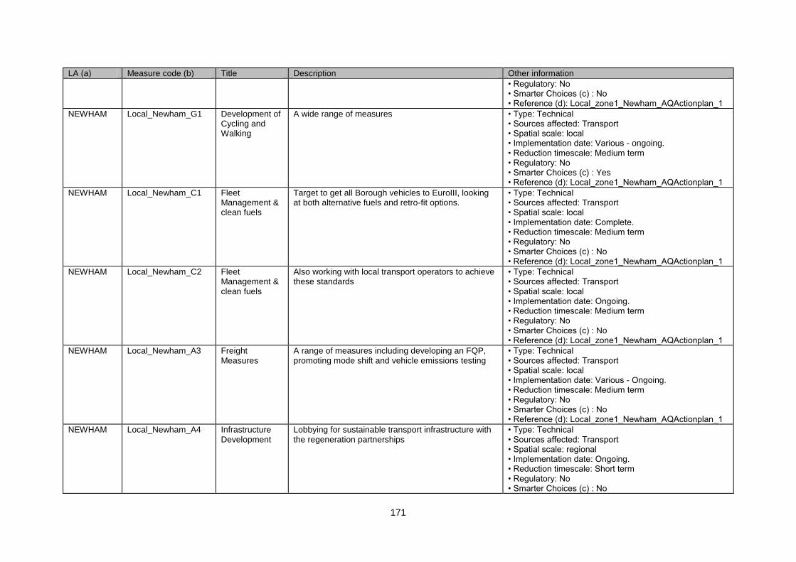
171
LA (a) Measure code (b) Title Description Other information
• Regulatory: No • Smarter Choices (c) : No • Reference (d): Local_zone1_Newham_AQActionplan_1
NEWHAM Local_Newham_G1 Development of Cycling and Walking
A wide range of measures • Type: Technical • Sources affected: Transport • Spatial scale: local • Implementation date: Various - ongoing. • Reduction timescale: Medium term • Regulatory: No • Smarter Choices (c) : Yes • Reference (d): Local_zone1_Newham_AQActionplan_1
NEWHAM Local_Newham_C1 Fleet Management & clean fuels
Target to get all Borough vehicles to EuroIII, looking at both alternative fuels and retro-fit options.
• Type: Technical • Sources affected: Transport • Spatial scale: local • Implementation date: Complete. • Reduction timescale: Medium term • Regulatory: No • Smarter Choices (c) : No • Reference (d): Local_zone1_Newham_AQActionplan_1
NEWHAM Local_Newham_C2 Fleet Management & clean fuels
Also working with local transport operators to achieve these standards
• Type: Technical • Sources affected: Transport • Spatial scale: local • Implementation date: Ongoing. • Reduction timescale: Medium term • Regulatory: No • Smarter Choices (c) : No • Reference (d): Local_zone1_Newham_AQActionplan_1
NEWHAM Local_Newham_A3 Freight Measures
A range of measures including developing an FQP, promoting mode shift and vehicle emissions testing
• Type: Technical • Sources affected: Transport • Spatial scale: local • Implementation date: Various - Ongoing. • Reduction timescale: Medium term • Regulatory: No • Smarter Choices (c) : No • Reference (d): Local_zone1_Newham_AQActionplan_1
NEWHAM Local_Newham_A4 Infrastructure Development
Lobbying for sustainable transport infrastructure with the regeneration partnerships
• Type: Technical • Sources affected: Transport • Spatial scale: regional • Implementation date: Ongoing. • Reduction timescale: Short term • Regulatory: No • Smarter Choices (c) : No
172
LA (a) Measure code (b) Title Description Other information
• Reference (d): Local_zone1_Newham_AQActionplan_1
NEWHAM Local_Newham_E1 Land Use Planning
UDP Review • Type: Technical • Sources affected: Transport • Spatial scale: local • Implementation date: Changes under review. • Reduction timescale: Short term • Regulatory: No • Smarter Choices (c) : No • Reference (d): Local_zone1_Newham_AQActionplan_1
NEWHAM Local_Newham_A5 Low Emission Zones
Support for the London LEZ • Type: Economic/fiscal • Sources affected: Transport • Spatial scale: regional • Implementation date: Complete. • Reduction timescale: Long term • Regulatory: No • Smarter Choices (c) : No • Reference (d): Local_zone1_Newham_AQActionplan_1
NEWHAM Local_Newham_D1 Parking Management & Charging
Further development of CPZs • Type: Other • Sources affected: Transport • Spatial scale: local • Implementation date: Ongoing. • Reduction timescale: Long term • Regulatory: No • Smarter Choices (c) : No • Reference (d): Local_zone1_Newham_AQActionplan_1
NEWHAM Local_Newham_D2 Parking Management & Charging
Enforcement work • Type: Other • Sources affected: Transport • Spatial scale: local • Implementation date: Various - ongoing. • Reduction timescale: Long term • Regulatory: No • Smarter Choices (c) : No • Reference (d): Local_zone1_Newham_AQActionplan_1
NEWHAM Local_Newham_F1 Partnership & Travel Plans
A range of measures including school travel plans and partnership working with businesses.
• Type: Other • Sources affected: Transport • Spatial scale: local • Implementation date: Various - Ongoing. • Reduction timescale: Long term • Regulatory: No • Smarter Choices (c) : Yes • Reference (d): Local_zone1_Newham_AQActionplan_1
173
LA (a) Measure code (b) Title Description Other information
NEWHAM Local_Newham_A6 Physical Traffic Management
Traffic calming and bus lane enforcement • Type: Other • Sources affected: Transport • Spatial scale: local • Implementation date: Ongoing. • Reduction timescale: Long term • Regulatory: No • Smarter Choices (c) : No • Reference (d): Local_zone1_Newham_AQActionplan_1
NEWHAM Local_Newham_F2 Promotion, Education & Awareness Raising
A range of measures focused around providing air quality information
• Type: Technical • Sources affected: Transport • Spatial scale: local • Implementation date: Ongoing. • Reduction timescale: Medium term • Regulatory: No • Smarter Choices (c) : Yes • Reference (d): Local_zone1_Newham_AQActionplan_1
NEWHAM Local_Newham_A7 Public Transport Initiatives - Bus
Support for wider bus priority measures • Type: Technical • Sources affected: Transport • Spatial scale: local • Implementation date: Ongoing. • Reduction timescale: Medium term • Regulatory: No • Smarter Choices (c) : No • Reference (d): Local_zone1_Newham_AQActionplan_1
NEWHAM Local_Newham_A8 Public Transport Initiatives - Bus
local bus emissions testing with the VL • Type: Technical • Sources affected: Transport • Spatial scale: local • Implementation date: Ongoing. • Reduction timescale: Medium term • Regulatory: No • Smarter Choices (c) : No • Reference (d): Local_zone1_Newham_AQActionplan_1
NEWHAM Local_Newham_A9 Public Transport Initiatives - Bus
Also support for PCO work with taxis and taxi emission testing
• Type: Technical • Sources affected: Transport • Spatial scale: local • Implementation date: Complete. • Reduction timescale: Medium term • Regulatory: No • Smarter Choices (c) : No • Reference (d): Local_zone1_Newham_AQActionplan_1
NEWHAM Local_Newham_A10 Public Transport Initiatives - Rail
Partnership working with the rail and tube operators, to increase service provision
• Type: Technical • Sources affected: Transport
174
LA (a) Measure code (b) Title Description Other information
• Spatial scale: regional • Implementation date: Ongoing. • Reduction timescale: Medium term • Regulatory: No • Smarter Choices (c) : No • Reference (d): Local_zone1_Newham_AQActionplan_1
NEWHAM Local_Newham_A11 Re-Routing and Road hierachy
Speed management on local distributor roads • Type: Technical • Sources affected: Industry including heating and power production • Spatial scale: local • Implementation date: Ongoing. • Reduction timescale: Medium term • Regulatory: No • Smarter Choices (c) : No • Reference (d): Local_zone1_Newham_AQActionplan_1
NEWHAM Local_Newham_D3 Road User Charging
Support for the London CCS and its expansion • Type: Economic/fiscal • Sources affected: Transport • Spatial scale: regional • Implementation date: Completed. • Reduction timescale: Long term • Regulatory: No • Smarter Choices (c) : No • Reference (d): Local_zone1_Newham_AQActionplan_1
NEWHAM Local_Newham_A12 Roadside Emissions Testing
Measures supporting the London-wide vehicle emissions testing scheme
• Type: Economic/fiscal • Sources affected: Transport • Spatial scale: lcoal • Implementation date: Ongoing. • Reduction timescale: Long term • Regulatory: No • Smarter Choices (c) : No • Reference (d): Local_zone1_Newham_AQActionplan_1
NEWHAM Local_Newham_A13 UTMC Systems Signal timing • Type: Economic/fiscal • Sources affected: Transport • Spatial scale: lcoal • Implementation date: No info. • Reduction timescale: Long term • Regulatory: No • Smarter Choices (c) : No • Reference (d): Local_zone1_Newham_AQActionplan_1
NEWHAM Local_Newham_A14 UTMC Systems Bus priority • Type: Technical • Sources affected: Transport • Spatial scale: local
175
LA (a) Measure code (b) Title Description Other information
• Implementation date: Ongoing. • Reduction timescale: Medium term • Regulatory: No • Smarter Choices (c) : No • Reference (d): Local_zone1_Newham_AQActionplan_1
REDBRIDGE
Local_Redbridge_G1 Development of Cycling and Walking
Improve paving, lighting, street furniture and security. • Type: Other • Sources affected: Transport • Spatial scale: local • Implementation date: Ongoing. • Reduction timescale: Long term • Regulatory: No • Smarter Choices (c) : No • Reference (d): Local_zone1_Redbridge_AQActionplan_1
REDBRIDGE
Local_Redbridge_G2 Development of Cycling and Walking
Work on the Cross London Strategic Walking Partnership
• Type: Other • Sources affected: Transport • Spatial scale: regional • Implementation date: Ongoing. • Reduction timescale: Long term • Regulatory: No • Smarter Choices (c) : No • Reference (d): Local_zone1_Redbridge_AQActionplan_1
REDBRIDGE
Local_Redbridge_G3 Development of Cycling and Walking
Lobby for a dedicated 'Walking Officer' • Type: Other • Sources affected: Transport • Spatial scale: local • Implementation date: No info. • Reduction timescale: Medium term • Regulatory: No • Smarter Choices (c) : No • Reference (d): Local_zone1_Redbridge_AQActionplan_1
REDBRIDGE
Local_Redbridge_G4 Development of Cycling and Walking
Continue to offer cycle training to children • Type: Other • Sources affected: Transport • Spatial scale: local • Implementation date: No info. • Reduction timescale: Long term • Regulatory: No • Smarter Choices (c) : No • Reference (d): Local_zone1_Redbridge_AQActionplan_1
REDBRIDG Local_Redbridge_A1 Fleet Continue with trials with nitrogen inflated tyres • Type: Technical
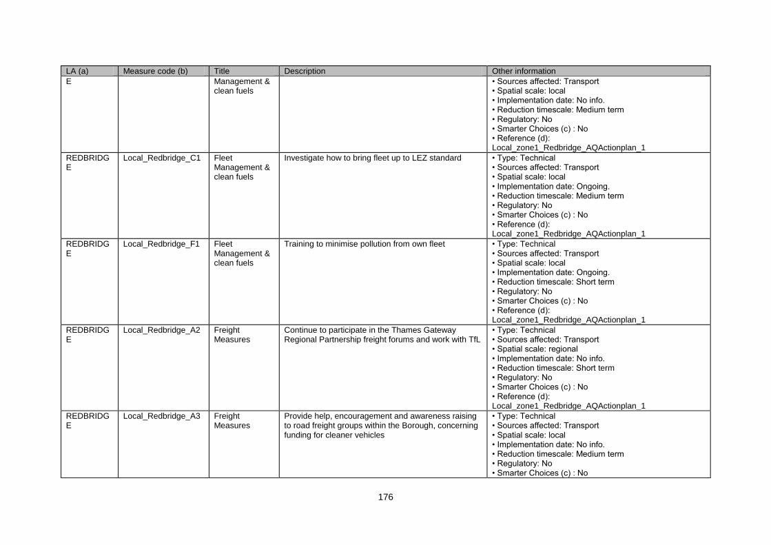
176
LA (a) Measure code (b) Title Description Other information
E Management & clean fuels
• Sources affected: Transport • Spatial scale: local • Implementation date: No info. • Reduction timescale: Medium term • Regulatory: No • Smarter Choices (c) : No • Reference (d): Local_zone1_Redbridge_AQActionplan_1
REDBRIDGE
Local_Redbridge_C1 Fleet Management & clean fuels
Investigate how to bring fleet up to LEZ standard • Type: Technical • Sources affected: Transport • Spatial scale: local • Implementation date: Ongoing. • Reduction timescale: Medium term • Regulatory: No • Smarter Choices (c) : No • Reference (d): Local_zone1_Redbridge_AQActionplan_1
REDBRIDGE
Local_Redbridge_F1 Fleet Management & clean fuels
Training to minimise pollution from own fleet • Type: Technical • Sources affected: Transport • Spatial scale: local • Implementation date: Ongoing. • Reduction timescale: Short term • Regulatory: No • Smarter Choices (c) : No • Reference (d): Local_zone1_Redbridge_AQActionplan_1
REDBRIDGE
Local_Redbridge_A2 Freight Measures
Continue to participate in the Thames Gateway Regional Partnership freight forums and work with TfL
• Type: Technical • Sources affected: Transport • Spatial scale: regional • Implementation date: No info. • Reduction timescale: Short term • Regulatory: No • Smarter Choices (c) : No • Reference (d): Local_zone1_Redbridge_AQActionplan_1
REDBRIDGE
Local_Redbridge_A3 Freight Measures
Provide help, encouragement and awareness raising to road freight groups within the Borough, concerning funding for cleaner vehicles
• Type: Technical • Sources affected: Transport • Spatial scale: local • Implementation date: No info. • Reduction timescale: Medium term • Regulatory: No • Smarter Choices (c) : No
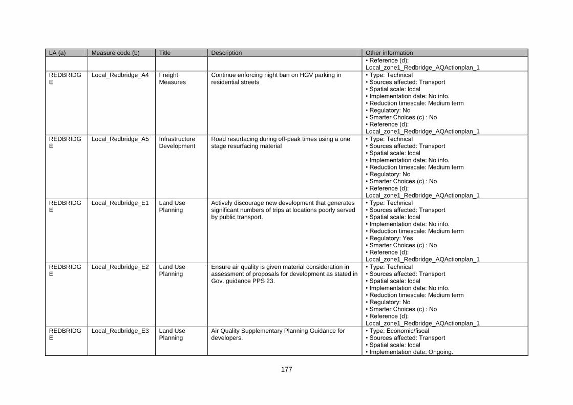
177
LA (a) Measure code (b) Title Description Other information
• Reference (d): Local_zone1_Redbridge_AQActionplan_1
REDBRIDGE
Local_Redbridge_A4 Freight Measures
Continue enforcing night ban on HGV parking in residential streets
• Type: Technical • Sources affected: Transport • Spatial scale: local • Implementation date: No info. • Reduction timescale: Medium term • Regulatory: No • Smarter Choices (c) : No • Reference (d): Local_zone1_Redbridge_AQActionplan_1
REDBRIDGE
Local_Redbridge_A5 Infrastructure Development
Road resurfacing during off-peak times using a one stage resurfacing material
• Type: Technical • Sources affected: Transport • Spatial scale: local • Implementation date: No info. • Reduction timescale: Medium term • Regulatory: No • Smarter Choices (c) : No • Reference (d): Local_zone1_Redbridge_AQActionplan_1
REDBRIDGE
Local_Redbridge_E1 Land Use Planning
Actively discourage new development that generates significant numbers of trips at locations poorly served by public transport.
• Type: Technical • Sources affected: Transport • Spatial scale: local • Implementation date: No info. • Reduction timescale: Medium term • Regulatory: Yes • Smarter Choices (c) : No • Reference (d): Local_zone1_Redbridge_AQActionplan_1
REDBRIDGE
Local_Redbridge_E2 Land Use Planning
Ensure air quality is given material consideration in assessment of proposals for development as stated in Gov. guidance PPS 23.
• Type: Technical • Sources affected: Transport • Spatial scale: local • Implementation date: No info. • Reduction timescale: Medium term • Regulatory: No • Smarter Choices (c) : No • Reference (d): Local_zone1_Redbridge_AQActionplan_1
REDBRIDGE
Local_Redbridge_E3 Land Use Planning
Air Quality Supplementary Planning Guidance for developers.
• Type: Economic/fiscal • Sources affected: Transport • Spatial scale: local • Implementation date: Ongoing.
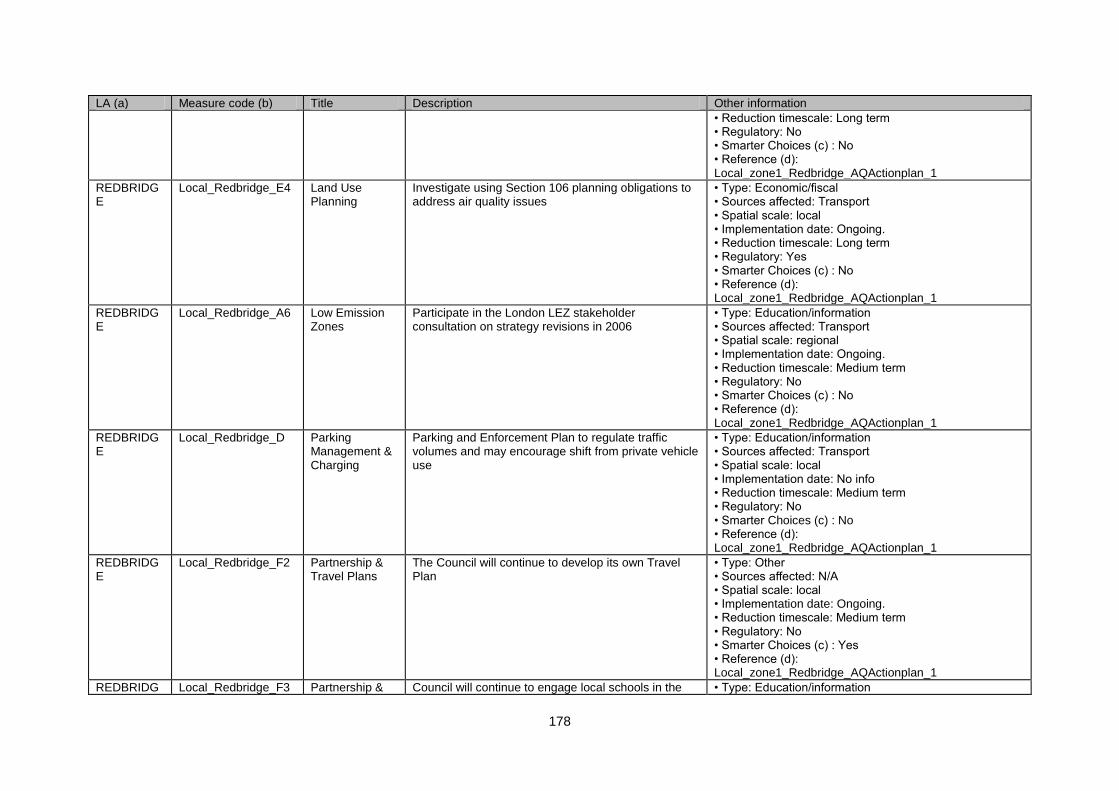
178
LA (a) Measure code (b) Title Description Other information
• Reduction timescale: Long term • Regulatory: No • Smarter Choices (c) : No • Reference (d): Local_zone1_Redbridge_AQActionplan_1
REDBRIDGE
Local_Redbridge_E4 Land Use Planning
Investigate using Section 106 planning obligations to address air quality issues
• Type: Economic/fiscal • Sources affected: Transport • Spatial scale: local • Implementation date: Ongoing. • Reduction timescale: Long term • Regulatory: Yes • Smarter Choices (c) : No • Reference (d): Local_zone1_Redbridge_AQActionplan_1
REDBRIDGE
Local_Redbridge_A6 Low Emission Zones
Participate in the London LEZ stakeholder consultation on strategy revisions in 2006
• Type: Education/information • Sources affected: Transport • Spatial scale: regional • Implementation date: Ongoing. • Reduction timescale: Medium term • Regulatory: No • Smarter Choices (c) : No • Reference (d): Local_zone1_Redbridge_AQActionplan_1
REDBRIDGE
Local_Redbridge_D Parking Management & Charging
Parking and Enforcement Plan to regulate traffic volumes and may encourage shift from private vehicle use
• Type: Education/information • Sources affected: Transport • Spatial scale: local • Implementation date: No info • Reduction timescale: Medium term • Regulatory: No • Smarter Choices (c) : No • Reference (d): Local_zone1_Redbridge_AQActionplan_1
REDBRIDGE
Local_Redbridge_F2 Partnership & Travel Plans
The Council will continue to develop its own Travel Plan
• Type: Other • Sources affected: N/A • Spatial scale: local • Implementation date: Ongoing. • Reduction timescale: Medium term • Regulatory: No • Smarter Choices (c) : Yes • Reference (d): Local_zone1_Redbridge_AQActionplan_1
REDBRIDG Local_Redbridge_F3 Partnership & Council will continue to engage local schools in the • Type: Education/information
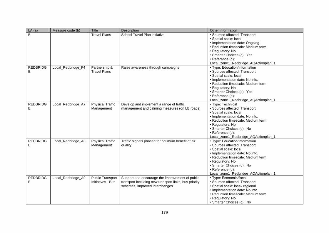
179
LA (a) Measure code (b) Title Description Other information
E Travel Plans School Travel Plan initiative • Sources affected: Transport • Spatial scale: local • Implementation date: Ongoing. • Reduction timescale: Medium term • Regulatory: No • Smarter Choices (c) : Yes • Reference (d): Local_zone1_Redbridge_AQActionplan_1
REDBRIDGE
Local_Redbridge_F4 Partnership & Travel Plans
Raise awareness through campaigns • Type: Education/information • Sources affected: Transport • Spatial scale: local • Implementation date: No info. • Reduction timescale: Medium term • Regulatory: No • Smarter Choices (c) : Yes • Reference (d): Local_zone1_Redbridge_AQActionplan_1
REDBRIDGE
Local_Redbridge_A7 Physical Traffic Management
Develop and implement a range of traffic management and calming measures (on LB roads)
• Type: Technical • Sources affected: Transport • Spatial scale: local • Implementation date: No info. • Reduction timescale: Medium term • Regulatory: No • Smarter Choices (c) : No • Reference (d): Local_zone1_Redbridge_AQActionplan_1
REDBRIDGE
Local_Redbridge_A8 Physical Traffic Management
Traffic signals phased for optimum benefit of air quality
• Type: Education/information • Sources affected: Transport • Spatial scale: local • Implementation date: No info. • Reduction timescale: Medium term • Regulatory: No • Smarter Choices (c) : No • Reference (d): Local_zone1_Redbridge_AQActionplan_1
REDBRIDGE
Local_Redbridge_A9 Public Transport Initiatives - Bus
Support and encourage the improvement of public transport including new transport links, bus priority schemes, improved interchanges
• Type: Economic/fiscal • Sources affected: Transport • Spatial scale: local/ regional • Implementation date: No info. • Reduction timescale: Medium term • Regulatory: No • Smarter Choices (c) : No
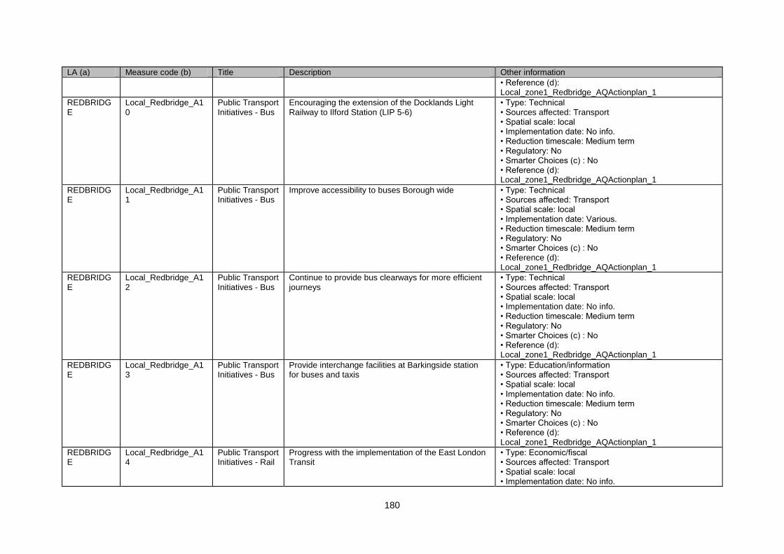
180
LA (a) Measure code (b) Title Description Other information
• Reference (d): Local_zone1_Redbridge_AQActionplan_1
REDBRIDGE
Local_Redbridge_A10
Public Transport Initiatives - Bus
Encouraging the extension of the Docklands Light Railway to Ilford Station (LIP 5-6)
• Type: Technical • Sources affected: Transport • Spatial scale: local • Implementation date: No info. • Reduction timescale: Medium term • Regulatory: No • Smarter Choices (c) : No • Reference (d): Local_zone1_Redbridge_AQActionplan_1
REDBRIDGE
Local_Redbridge_A11
Public Transport Initiatives - Bus
Improve accessibility to buses Borough wide • Type: Technical • Sources affected: Transport • Spatial scale: local • Implementation date: Various. • Reduction timescale: Medium term • Regulatory: No • Smarter Choices (c) : No • Reference (d): Local_zone1_Redbridge_AQActionplan_1
REDBRIDGE
Local_Redbridge_A12
Public Transport Initiatives - Bus
Continue to provide bus clearways for more efficient journeys
• Type: Technical • Sources affected: Transport • Spatial scale: local • Implementation date: No info. • Reduction timescale: Medium term • Regulatory: No • Smarter Choices (c) : No • Reference (d): Local_zone1_Redbridge_AQActionplan_1
REDBRIDGE
Local_Redbridge_A13
Public Transport Initiatives - Bus
Provide interchange facilities at Barkingside station for buses and taxis
• Type: Education/information • Sources affected: Transport • Spatial scale: local • Implementation date: No info. • Reduction timescale: Medium term • Regulatory: No • Smarter Choices (c) : No • Reference (d): Local_zone1_Redbridge_AQActionplan_1
REDBRIDGE
Local_Redbridge_A14
Public Transport Initiatives - Rail
Progress with the implementation of the East London Transit
• Type: Economic/fiscal • Sources affected: Transport • Spatial scale: local • Implementation date: No info.
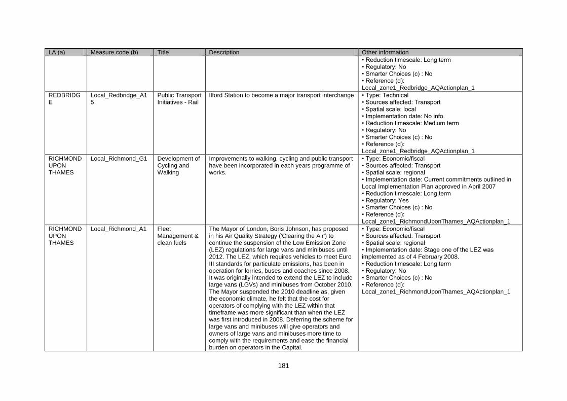
181
LA (a) Measure code (b) Title Description Other information
• Reduction timescale: Long term • Regulatory: No • Smarter Choices (c) : No • Reference (d): Local_zone1_Redbridge_AQActionplan_1
REDBRIDGE
Local_Redbridge_A15
Public Transport Initiatives - Rail
Ilford Station to become a major transport interchange • Type: Technical • Sources affected: Transport • Spatial scale: local • Implementation date: No info. • Reduction timescale: Medium term • Regulatory: No • Smarter Choices (c) : No • Reference (d): Local_zone1_Redbridge_AQActionplan_1
RICHMOND UPON THAMES
Local_Richmond_G1 Development of Cycling and Walking
Improvements to walking, cycling and public transport have been incorporated in each years programme of works.
• Type: Economic/fiscal • Sources affected: Transport • Spatial scale: regional • Implementation date: Current commitments outlined in Local Implementation Plan approved in April 2007 • Reduction timescale: Long term • Regulatory: Yes • Smarter Choices (c) : No • Reference (d): Local_zone1_RichmondUponThames_AQActionplan_1
RICHMOND UPON THAMES
Local_Richmond_A1 Fleet Management & clean fuels
The Mayor of London, Boris Johnson, has proposed in his Air Quality Strategy ('Clearing the Air') to continue the suspension of the Low Emission Zone (LEZ) regulations for large vans and minibuses until 2012. The LEZ, which requires vehicles to meet Euro III standards for particulate emissions, has been in operation for lorries, buses and coaches since 2008. It was originally intended to extend the LEZ to include large vans (LGVs) and minibuses from October 2010. The Mayor suspended the 2010 deadline as, given the economic climate, he felt that the cost for operators of complying with the LEZ within that timeframe was more significant than when the LEZ was first introduced in 2008. Deferring the scheme for large vans and minibuses will give operators and owners of large vans and minibuses more time to comply with the requirements and ease the financial burden on operators in the Capital.
• Type: Economic/fiscal • Sources affected: Transport • Spatial scale: regional • Implementation date: Stage one of the LEZ was implemented as of 4 February 2008. • Reduction timescale: Long term • Regulatory: No • Smarter Choices (c) : No • Reference (d): Local_zone1_RichmondUponThames_AQActionplan_1
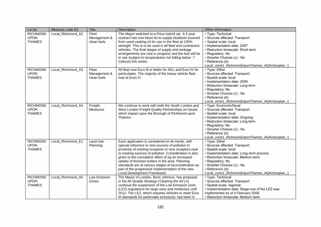
182
LA (a) Measure code (b) Title Description Other information
RICHMOND UPON THAMES
Local_Richmond_A2 Fleet Management & clean fuels
The Mayor switched to a Prius hybrid car. A 5 year contract has now been let to supply biodiesel sourced from used cooking oil for use in the fleet at 100% strength. This is to be used in all fleet and contractors vehicles. The final stages of supply and tankage arrangements are now in progress and the fuel will be in use (subject to temperatutes not falling below -7 Celcius) this winter.
• Type: Technical • Sources affected: Transport • Spatial scale: local • Implementation date: 2007 • Reduction timescale: Short term • Regulatory: No • Smarter Choices (c) : No • Reference (d): Local_zone1_RichmondUponThames_AQActionplan_1
RICHMOND UPON THAMES
Local_Richmond_A3 Fleet Management & clean fuels
All fleet now Euro lll or better for NOX and Euro lV for particulates. The majority of the heavy vehicle fleet now at Euro IV
• Type: Other • Sources affected: Transport • Spatial scale: local • Implementation date: 2009 • Reduction timescale: Long term • Regulatory: No • Smarter Choices (c) : No • Reference (d): Local_zone1_RichmondUponThames_AQActionplan_1
RICHMOND UPON THAMES
Local_Richmond_A4 Freight Measures
We continue to work with both the South London and West London Freight Quality Partnerships on issues which impact upon the Borough of Richmond upon Thames.
• Type: Economic/fiscal • Sources affected: Transport • Spatial scale: local • Implementation date: Ongoing • Reduction timescale: Long term • Regulatory: No • Smarter Choices (c) : No • Reference (d): Local_zone1_RichmondUponThames_AQActionplan_1
RICHMOND UPON THAMES
Local_Richmond_E1 Land Use Planning
Each application is considered on its merits, with special reference to new sources of pollution in proximity of existing receptors or new receptors near to existing sources of pollution. Consideration is also given to the cumulative effect of eg an increased uptake of biomass boilers in the area. Planning standards are at various stages of reconsideration as part of the progressive implementation of the new Local Development Framework.
• Type: Other • Sources affected: Transport • Spatial scale: local • Implementation date: Long-term process. • Reduction timescale: Medium term • Regulatory: No • Smarter Choices (c) : No • Reference (d): Local_zone1_RichmondUponThames_AQActionplan_1
RICHMOND UPON THAMES
Local_Richmond_A5 Low Emission Zones
The Mayor of London, Boris Johnson, has proposed in his Air Quality Strategy ('Clearing the Air') to continue the suspension of the Low Emission Zone (LEZ) regulations for large vans and minibuses until 2012. The LEZ, which requires vehicles to meet Euro III standards for particulate emissions, has been in
• Type: Technical • Sources affected: Transport • Spatial scale: regional • Implementation date: Stage one of the LEZ was implemented as of 4 February 2008. • Reduction timescale: Medium term
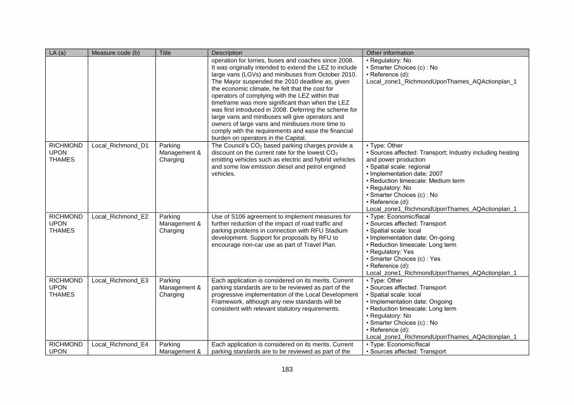
183
LA (a) Measure code (b) Title Description Other information
operation for lorries, buses and coaches since 2008. It was originally intended to extend the LEZ to include large vans (LGVs) and minibuses from October 2010. The Mayor suspended the 2010 deadline as, given the economic climate, he felt that the cost for operators of complying with the LEZ within that timeframe was more significant than when the LEZ was first introduced in 2008. Deferring the scheme for large vans and minibuses will give operators and owners of large vans and minibuses more time to comply with the requirements and ease the financial burden on operators in the Capital.
• Regulatory: No • Smarter Choices (c) : No • Reference (d): Local_zone1_RichmondUponThames_AQActionplan_1
RICHMOND UPON THAMES
Local_Richmond_D1 Parking Management & Charging
The Council‟s CO2 based parking charges provide a discount on the current rate for the lowest CO2 emitting vehicles such as electric and hybrid vehicles and some low emission diesel and petrol engined vehicles.
• Type: Other • Sources affected: Transport; Industry including heating and power production • Spatial scale: regional • Implementation date: 2007 • Reduction timescale: Medium term • Regulatory: No • Smarter Choices (c) : No • Reference (d): Local_zone1_RichmondUponThames_AQActionplan_1
RICHMOND UPON THAMES
Local_Richmond_E2 Parking Management & Charging
Use of S106 agreement to implement measures for further reduction of the impact of road traffic and parking problems in connection with RFU Stadium development. Support for proposals by RFU to encourage non-car use as part of Travel Plan.
• Type: Economic/fiscal • Sources affected: Transport • Spatial scale: local • Implementation date: On-going • Reduction timescale: Long term • Regulatory: Yes • Smarter Choices (c) : Yes • Reference (d): Local_zone1_RichmondUponThames_AQActionplan_1
RICHMOND UPON THAMES
Local_Richmond_E3 Parking Management & Charging
Each application is considered on its merits. Current parking standards are to be reviewed as part of the progressive implementation of the Local Development Framework, although any new standards will be consistent with relevant statutory requirements.
• Type: Other • Sources affected: Transport • Spatial scale: local • Implementation date: Ongoing • Reduction timescale: Long term • Regulatory: No • Smarter Choices (c) : No • Reference (d): Local_zone1_RichmondUponThames_AQActionplan_1
RICHMOND UPON
Local_Richmond_E4 Parking Management &
Each application is considered on its merits. Current parking standards are to be reviewed as part of the
• Type: Economic/fiscal • Sources affected: Transport
184
LA (a) Measure code (b) Title Description Other information
THAMES Charging progressive implementation of the Local Development Framework, although any new standards will be consistent with relevant statutory requirements.
• Spatial scale: local • Implementation date: Ongoing • Reduction timescale: Long term • Regulatory: No • Smarter Choices (c) : No • Reference (d): Local_zone1_RichmondUponThames_AQActionplan_1
RICHMOND UPON THAMES
Local_Richmond_F1 Partnership & Travel Plans
The Council Travel Plan has been drafted following a staff survey and site audit and is due to be approved in the spring 2010. The Plan seeks to reduce the impact the Council has on travel and support a shift to more sustainable modes in line with national indicators NI 184 and NI185/NI 194, and lead by example for other local organisations developing travel plans. Efforts to promote greener travel options are underway with staff events, the opening of a new cycle parking, changing and storage facility at the Civic in November 2009 and raising the profile of existing staff travel benefits such as season ticket loans.
• Type: Economic/fiscal • Sources affected: Transport • Spatial scale: local • Implementation date: Ongoing • Reduction timescale: Long term • Regulatory: Yes • Smarter Choices (c) : Yes • Reference (d): Local_zone1_RichmondUponThames_AQActionplan_1
RICHMOND UPON THAMES
Local_Richmond_F2 Partnership & Travel Plans
Through the Smarter Travel Richmond upon Thames programme, the Council is supporting the development and implementation of travel plans to improve the green travel options for people working in the borough. The programme target is to have 20,000 employees covered by a level 4/5 travel plan by September 2011. Progress towards meeting this target has involved determining the baseline of workplace travel plans before Smarter Travel was launched (there were a total of approximately 1100 employees covered by a level 4/5 travel plan in April 2009) and developing a comprehensive package of products and promotions to assist organisations in implementing travel plans. Titled „Connecting Businesses‟, these products and promotions address the gaps in the current Transport for London Enterprise and Corporate travel plan packages and are being delivered through local
• Type: Technical • Sources affected: Transport • Spatial scale: local • Implementation date: Ongoing • Reduction timescale: Medium term • Regulatory: No • Smarter Choices (c) : Yes • Reference (d): Local_zone1_RichmondUponThames_AQActionplan_1
185
LA (a) Measure code (b) Title Description Other information
networks in Richmond and Twickenham. Further to this, Smarter Travel is working with the Thames Landscape Strategy to develop a travel plan network centred on The River – addressing both staff and visitor sustainable access.
RICHMOND UPON THAMES
Local_Richmond_A6 Physical Traffic Management
Pollution hot spots identified from Stage 4 and subsequent modelling. The aim is to treat the Borough as a whole, for air quality, and not to resolve one problem by simply displacing the air pollution from one place to another. A review of road traffic signage is underway to help reduce pollution at identified hotspots.
• Type: Technical • Sources affected: Transport • Spatial scale: local • Implementation date: Ongoing • Reduction timescale: Medium term • Regulatory: No • Smarter Choices (c) : No • Reference (d): Local_zone1_RichmondUponThames_AQActionplan_1
RICHMOND UPON THAMES
Local_Richmond_E5 Physical Traffic Management
SWELTRAC is a successful inter borough initiative, with actions ongoing. A significant development is the installation of new Electric Vehicle Charging Points across several SWELTRAC Boroughs - including two in Richmond. One of these is at the Cedar Road car park in Teddington and one at the Old Deer car park in Richmond.
• Type: Economic/fiscal • Sources affected: Transport • Spatial scale: regional • Implementation date: On-going • Reduction timescale: Long term • Regulatory: Yes • Smarter Choices (c) : Yes • Reference (d): Local_zone1_RichmondUponThames_AQActionplan_1
RICHMOND UPON THAMES
Local_Richmond_A7 Physical Traffic Management
The A316 and the A205 are within the transport for London Road Network (TLRN). As such Transport for London (TFL) are the highways authority for these roads and would be responsible for any physical works.
• Type: Technical • Sources affected: Transport • Spatial scale: regional • Implementation date: Ongoing • Reduction timescale: Medium term • Regulatory: No • Smarter Choices (c) : No • Reference (d): Local_zone1_RichmondUponThames_AQActionplan_1
RICHMOND UPON THAMES
Local_Richmond_F3 Promotion, Education & Awareness Raising
Promotion and education measures aimed at raising awareness of transport issues and, in particular, the Smarter Travel messages are an integral part of the Local Implementation Plan and annual transport work programme. Additionally, Smarter Travel Richmond upon Thames, a partnership between Transport for London (TfL) and the London Borough of Richmond upon Thames. Launched in March 2009. It is a three year, £4.2million initiative to promote walking, cycling
• Type: Other • Sources affected: Transport • Spatial scale: local • Implementation date: Ongoing • Reduction timescale: Long term • Regulatory: No • Smarter Choices (c) : Yes • Reference (d): Local_zone1_RichmondUponThames_AQActionplan_1
186
LA (a) Measure code (b) Title Description Other information
and public transport in the Borough.Social marketing initiatives include: Targeted promotion (including advertising and events) of infrastructure, products and services. Customer Relationship Management whereby customer data is collected and regular communication is sent Partnership marketing and sponsorship whereby credible partners are sought for joint activity and part-funding of initiatives. Media relations and stakeholder engagement (including internal communications at the Council, and a press and stakeholder launch event on 30 March 2009). A creative concept and style-guide for the programme. A website for public access with information on the programme and projects.
RICHMOND UPON THAMES
Local_Richmond_F4 Promotion, Education & Awareness Raising
As of October 2009 there are 71 on-street car club bays in the Borough. A further 36 are planned for November 2009. Further expansion of the programme to meet resident needs is expected in 2010, although exact numbers have not yet been calculated. Car club bays are a key conisderation in the assessment of larger residential development proposals.
• Type: Technical • Sources affected: Transport • Spatial scale: regional • Implementation date: February 2009 • Reduction timescale: Medium term • Regulatory: No • Smarter Choices (c) : No • Reference (d): Local_zone1_RichmondUponThames_AQActionplan_1
RICHMOND UPON THAMES
Local_Richmond_A8 Public Transport Initiatives - Bus
The Parking Enforcement Plan, which complements the Local Implementation Plan, has an action to carry out a study of coach travel and parking needs in the borough to minimise traffic disruption to residents and others. We are constantly working with local attractions to minimise traffic imacts of visitor movements, including the development of visitor travel plans.
• Type: Other • Sources affected: Transport • Spatial scale: local • Implementation date: On-going • Reduction timescale: Long term • Regulatory: No • Smarter Choices (c) : No • Reference (d): Local_zone1_RichmondUponThames_AQActionplan_1
RICHMOND UPON THAMES
Local_Richmond_A9 Roadside Emissions Testing
This proposal was reviewed and it was decided that it was not an appropriate use of resources. The failure rate in 2004 was very low in this Borough .
• Type: Economic/fiscal • Sources affected: Transport • Spatial scale: local • Implementation date: Not implemented, past the initial
187
LA (a) Measure code (b) Title Description Other information
ALG led London-wide programme in 2004. • Reduction timescale: Long term • Regulatory: No • Smarter Choices (c) : No • Reference (d): Local_zone1_RichmondUponThames_AQActionplan_1
RUNNYMEDE
Local_Runnymede_E1
Land Use Planning
Using the planning system to bring air quality benefits, through imposing planning conditions and through using section 106 agreements for new developments for car free developments and other benefits.
• Type: Technical • Sources affected: Transport • Spatial scale: local • Implementation date: Implemented. • Reduction timescale: Medium term • Regulatory: No • Smarter Choices (c) : No • Reference (d): Local_zone1_Runnymede_AQActionplan_1
RUNNYMEDE
Local_Runnymede_G1
Development of Cycling and Walking
The Runnymede Travel Initiative: providing increased cycle routes and shelters
• Type: Technical • Sources affected: Transport • Spatial scale: local • Implementation date: Implemented. • Reduction timescale: Medium term • Regulatory: No • Smarter Choices (c) : No • Reference (d): Local_zone1_Runnymede_AQActionplan_1
RUNNYMEDE
Local_Runnymede_A1
Partnership & Travel Plans
The Runnymede Travel Initiative is a major step forward in working with businesses and schools in reducing peak hour congestion by providing walking buses and the Yellow Bus Scheme for school children.
• Type: Technical • Sources affected: Transport • Spatial scale: local • Implementation date: 2001 • Reduction timescale: Medium term • Regulatory: No • Smarter Choices (c) : Yes • Reference (d): Local_zone1_Runnymede_AQActionplan_1
RUNNYMEDE
Local_Runnymede_A2
Physical Traffic Management
The Council is taking a proactive role in supporting the implementation of several major transport schemes including Airtrack.
• Type: Technical • Sources affected: Transport • Spatial scale: regional • Implementation date: • Reduction timescale: Medium term • Regulatory: No • Smarter Choices (c) : No • Reference (d): Local_zone1_Runnymede_AQActionplan_1
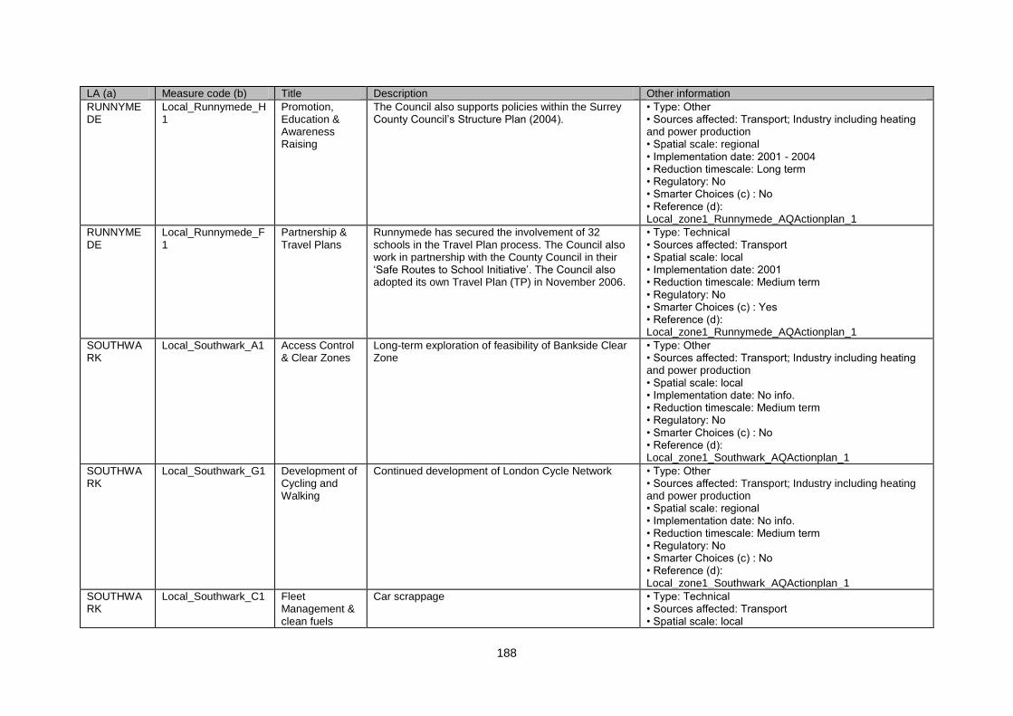
188
LA (a) Measure code (b) Title Description Other information
RUNNYMEDE
Local_Runnymede_H1
Promotion, Education & Awareness Raising
The Council also supports policies within the Surrey County Council‟s Structure Plan (2004).
• Type: Other • Sources affected: Transport; Industry including heating and power production • Spatial scale: regional • Implementation date: 2001 - 2004 • Reduction timescale: Long term • Regulatory: No • Smarter Choices (c) : No • Reference (d): Local_zone1_Runnymede_AQActionplan_1
RUNNYMEDE
Local_Runnymede_F1
Partnership & Travel Plans
Runnymede has secured the involvement of 32 schools in the Travel Plan process. The Council also work in partnership with the County Council in their „Safe Routes to School Initiative‟. The Council also adopted its own Travel Plan (TP) in November 2006.
• Type: Technical • Sources affected: Transport • Spatial scale: local • Implementation date: 2001 • Reduction timescale: Medium term • Regulatory: No • Smarter Choices (c) : Yes • Reference (d): Local_zone1_Runnymede_AQActionplan_1
SOUTHWARK
Local_Southwark_A1 Access Control & Clear Zones
Long-term exploration of feasibility of Bankside Clear Zone
• Type: Other • Sources affected: Transport; Industry including heating and power production • Spatial scale: local • Implementation date: No info. • Reduction timescale: Medium term • Regulatory: No • Smarter Choices (c) : No • Reference (d): Local_zone1_Southwark_AQActionplan_1
SOUTHWARK
Local_Southwark_G1 Development of Cycling and Walking
Continued development of London Cycle Network • Type: Other • Sources affected: Transport; Industry including heating and power production • Spatial scale: regional • Implementation date: No info. • Reduction timescale: Medium term • Regulatory: No • Smarter Choices (c) : No • Reference (d): Local_zone1_Southwark_AQActionplan_1
SOUTHWARK
Local_Southwark_C1 Fleet Management & clean fuels
Car scrappage • Type: Technical • Sources affected: Transport • Spatial scale: local
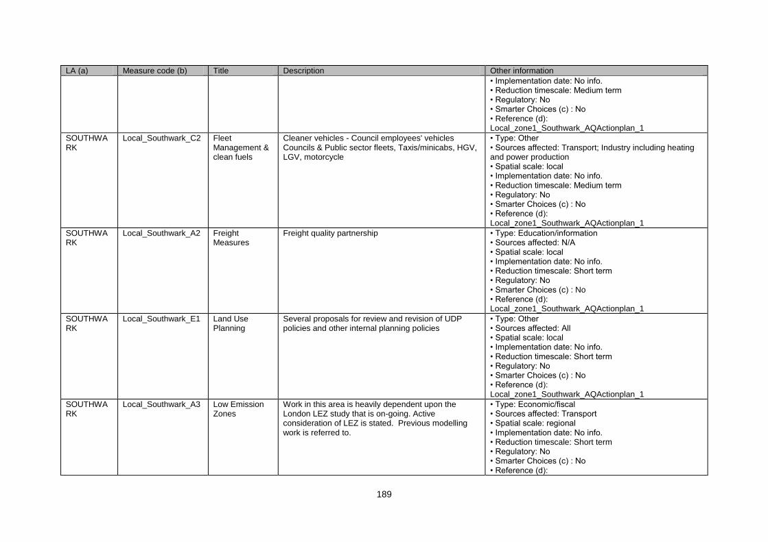
189
LA (a) Measure code (b) Title Description Other information
• Implementation date: No info. • Reduction timescale: Medium term • Regulatory: No • Smarter Choices (c) : No • Reference (d): Local_zone1_Southwark_AQActionplan_1
SOUTHWARK
Local_Southwark_C2 Fleet Management & clean fuels
Cleaner vehicles - Council employees' vehicles Councils & Public sector fleets, Taxis/minicabs, HGV, LGV, motorcycle
• Type: Other • Sources affected: Transport; Industry including heating and power production • Spatial scale: local • Implementation date: No info. • Reduction timescale: Medium term • Regulatory: No • Smarter Choices (c) : No • Reference (d): Local_zone1_Southwark_AQActionplan_1
SOUTHWARK
Local_Southwark_A2 Freight Measures
Freight quality partnership • Type: Education/information • Sources affected: N/A • Spatial scale: local • Implementation date: No info. • Reduction timescale: Short term • Regulatory: No • Smarter Choices (c) : No • Reference (d): Local_zone1_Southwark_AQActionplan_1
SOUTHWARK
Local_Southwark_E1 Land Use Planning
Several proposals for review and revision of UDP policies and other internal planning policies
• Type: Other • Sources affected: All • Spatial scale: local • Implementation date: No info. • Reduction timescale: Short term • Regulatory: No • Smarter Choices (c) : No • Reference (d): Local_zone1_Southwark_AQActionplan_1
SOUTHWARK
Local_Southwark_A3 Low Emission Zones
Work in this area is heavily dependent upon the London LEZ study that is on-going. Active consideration of LEZ is stated. Previous modelling work is referred to.
• Type: Economic/fiscal • Sources affected: Transport • Spatial scale: regional • Implementation date: No info. • Reduction timescale: Short term • Regulatory: No • Smarter Choices (c) : No • Reference (d):
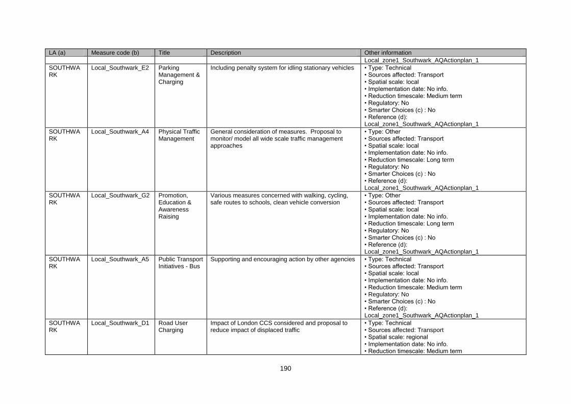
190
LA (a) Measure code (b) Title Description Other information
Local_zone1_Southwark_AQActionplan_1
SOUTHWARK
Local_Southwark_E2 Parking Management & Charging
Including penalty system for idling stationary vehicles • Type: Technical • Sources affected: Transport • Spatial scale: local • Implementation date: No info. • Reduction timescale: Medium term • Regulatory: No • Smarter Choices (c) : No • Reference (d): Local_zone1_Southwark_AQActionplan_1
SOUTHWARK
Local_Southwark_A4 Physical Traffic Management
General consideration of measures. Proposal to monitor/ model all wide scale traffic management approaches
• Type: Other • Sources affected: Transport • Spatial scale: local • Implementation date: No info. • Reduction timescale: Long term • Regulatory: No • Smarter Choices (c) : No • Reference (d): Local_zone1_Southwark_AQActionplan_1
SOUTHWARK
Local_Southwark_G2 Promotion, Education & Awareness Raising
Various measures concerned with walking, cycling, safe routes to schools, clean vehicle conversion
• Type: Other • Sources affected: Transport • Spatial scale: local • Implementation date: No info. • Reduction timescale: Long term • Regulatory: No • Smarter Choices (c) : No • Reference (d): Local_zone1_Southwark_AQActionplan_1
SOUTHWARK
Local_Southwark_A5 Public Transport Initiatives - Bus
Supporting and encouraging action by other agencies • Type: Technical • Sources affected: Transport • Spatial scale: local • Implementation date: No info. • Reduction timescale: Medium term • Regulatory: No • Smarter Choices (c) : No • Reference (d): Local_zone1_Southwark_AQActionplan_1
SOUTHWARK
Local_Southwark_D1 Road User Charging
Impact of London CCS considered and proposal to reduce impact of displaced traffic
• Type: Technical • Sources affected: Transport • Spatial scale: regional • Implementation date: No info. • Reduction timescale: Medium term
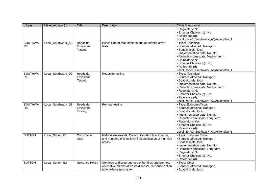
191
LA (a) Measure code (b) Title Description Other information
• Regulatory: No • Smarter Choices (c) : No • Reference (d): Local_zone1_Southwark_AQActionplan_1
SOUTHWARK
Local_Southwark_A6 Roadside Emissions Testing
Public plan at MoT stations and undertake covert tests
• Type: Technical • Sources affected: Transport • Spatial scale: local • Implementation date: No info. • Reduction timescale: Medium term • Regulatory: No • Smarter Choices (c) : No • Reference (d): Local_zone1_Southwark_AQActionplan_1
SOUTHWARK
Local_Southwark_D2 Roadside Emissions Testing
Roadside testing • Type: Technical • Sources affected: Transport • Spatial scale: local • Implementation date: No info. • Reduction timescale: Medium term • Regulatory: No • Smarter Choices (c) : No • Reference (d): Local_zone1_Southwark_AQActionplan_1
SOUTHWARK
Local_Southwark_D3 Roadside Emissions Testing
Remote testing • Type: Economic/fiscal • Sources affected: Transport • Spatial scale: local • Implementation date: No info. • Reduction timescale: Long term • Regulatory: Yes • Smarter Choices (c) : No • Reference (d): Local_zone1_Southwark_AQActionplan_1
SUTTON Local_Sutton_B1 Construction sites
Method statements, Code of Construction Practise and mapping of sites in GIS (identification of high risk areas)
• Type: Economic/fiscal • Sources affected: Transport • Spatial scale: local • Implementation date: No info. • Reduction timescale: Long term • Regulatory: No • Smarter Choices (c) : No • Reference (d):
SUTTON Local_Sutton_B2 Nuisance Policy Continue to discourage use of bonfires and promote alternative means of waste disposal. Nuisance action taken where necessary
• Type: Other • Sources affected: Transport • Spatial scale: local
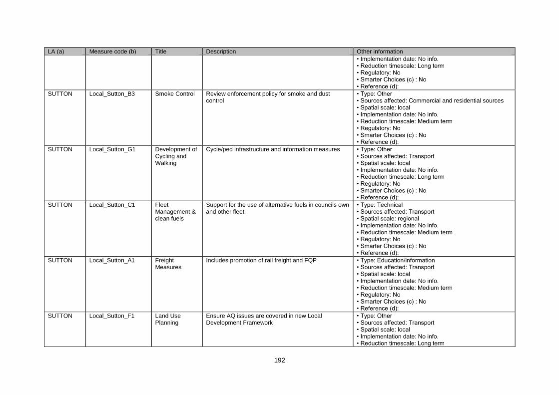
192
LA (a) Measure code (b) Title Description Other information
• Implementation date: No info. • Reduction timescale: Long term • Regulatory: No • Smarter Choices (c) : No • Reference (d):
SUTTON Local_Sutton_B3 Smoke Control Review enforcement policy for smoke and dust control
• Type: Other • Sources affected: Commercial and residential sources • Spatial scale: local • Implementation date: No info. • Reduction timescale: Medium term • Regulatory: No • Smarter Choices (c) : No • Reference (d):
SUTTON Local_Sutton_G1 Development of Cycling and Walking
Cycle/ped infrastructure and information measures • Type: Other • Sources affected: Transport • Spatial scale: local • Implementation date: No info. • Reduction timescale: Long term • Regulatory: No • Smarter Choices (c) : No • Reference (d):
SUTTON Local_Sutton_C1 Fleet Management & clean fuels
Support for the use of alternative fuels in councils own and other fleet
• Type: Technical • Sources affected: Transport • Spatial scale: regional • Implementation date: No info. • Reduction timescale: Medium term • Regulatory: No • Smarter Choices (c) : No • Reference (d):
SUTTON Local_Sutton_A1 Freight Measures
Includes promotion of rail freight and FQP • Type: Education/information • Sources affected: Transport • Spatial scale: local • Implementation date: No info. • Reduction timescale: Medium term • Regulatory: No • Smarter Choices (c) : No • Reference (d):
SUTTON Local_Sutton_F1 Land Use Planning
Ensure AQ issues are covered in new Local Development Framework
• Type: Other • Sources affected: Transport • Spatial scale: local • Implementation date: No info. • Reduction timescale: Long term
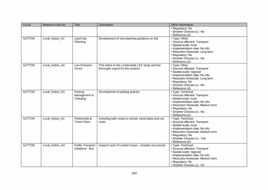
193
LA (a) Measure code (b) Title Description Other information
• Regulatory: No • Smarter Choices (c) : No • Reference (d):
SUTTON Local_Sutton_F2 Land Use Planning
Development of new planning guidance on AQ • Type: Other • Sources affected: Transport • Spatial scale: local • Implementation date: No info. • Reduction timescale: Long term • Regulatory: No • Smarter Choices (c) : No • Reference (d):
SUTTON Local_Sutton_A2 Low Emission Zones
This refers to the Londonwide LEZ study and the Boroughs suport for this scheme
• Type: Other • Sources affected: Transport • Spatial scale: regional • Implementation date: No info. • Reduction timescale: Long term • Regulatory: No • Smarter Choices (c) : No • Reference (d):
SUTTON Local_Sutton_D1 Parking Management & Charging
Development of parking policies • Type: Technical • Sources affected: Transport • Spatial scale: local • Implementation date: No info. • Reduction timescale: Medium term • Regulatory: No • Smarter Choices (c) : No • Reference (d):
SUTTON Local_Sutton_E1 Partnership & Travel Plans
Including safe routes to school, travel plans and car clubs
• Type: Technical • Sources affected: Transport • Spatial scale: local • Implementation date: No info. • Reduction timescale: Medium term • Regulatory: No • Smarter Choices (c) : Yes • Reference (d):
SUTTON Local_Sutton_A3 Public Transport Initiatives - Bus
Support work of London buses - includes bus priority • Type: Technical • Sources affected: Transport • Spatial scale: regional • Implementation date: No info. • Reduction timescale: Medium term • Regulatory: No • Smarter Choices (c) : No
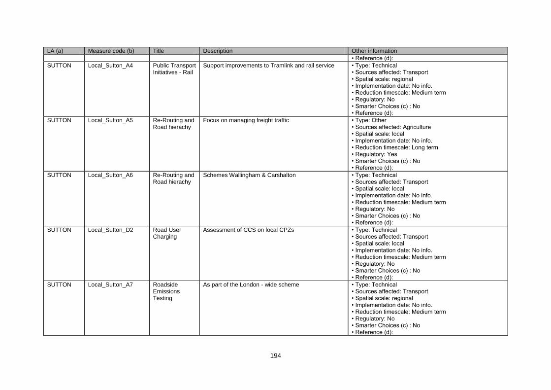
194
LA (a) Measure code (b) Title Description Other information
• Reference (d):
SUTTON Local_Sutton_A4 Public Transport Initiatives - Rail
Support improvements to Tramlink and rail service • Type: Technical • Sources affected: Transport • Spatial scale: regional • Implementation date: No info. • Reduction timescale: Medium term • Regulatory: No • Smarter Choices (c) : No • Reference (d):
SUTTON Local_Sutton_A5 Re-Routing and Road hierachy
Focus on managing freight traffic • Type: Other • Sources affected: Agriculture • Spatial scale: local • Implementation date: No info. • Reduction timescale: Long term • Regulatory: Yes • Smarter Choices (c) : No • Reference (d):
SUTTON Local_Sutton_A6 Re-Routing and Road hierachy
Schemes Wallingham & Carshalton • Type: Technical • Sources affected: Transport • Spatial scale: local • Implementation date: No info. • Reduction timescale: Medium term • Regulatory: No • Smarter Choices (c) : No • Reference (d):
SUTTON Local_Sutton_D2 Road User Charging
Assessment of CCS on local CPZs • Type: Technical • Sources affected: Transport • Spatial scale: local • Implementation date: No info. • Reduction timescale: Medium term • Regulatory: No • Smarter Choices (c) : No • Reference (d):
SUTTON Local_Sutton_A7 Roadside Emissions Testing
As part of the London - wide scheme • Type: Technical • Sources affected: Transport • Spatial scale: regional • Implementation date: No info. • Reduction timescale: Medium term • Regulatory: No • Smarter Choices (c) : No • Reference (d):
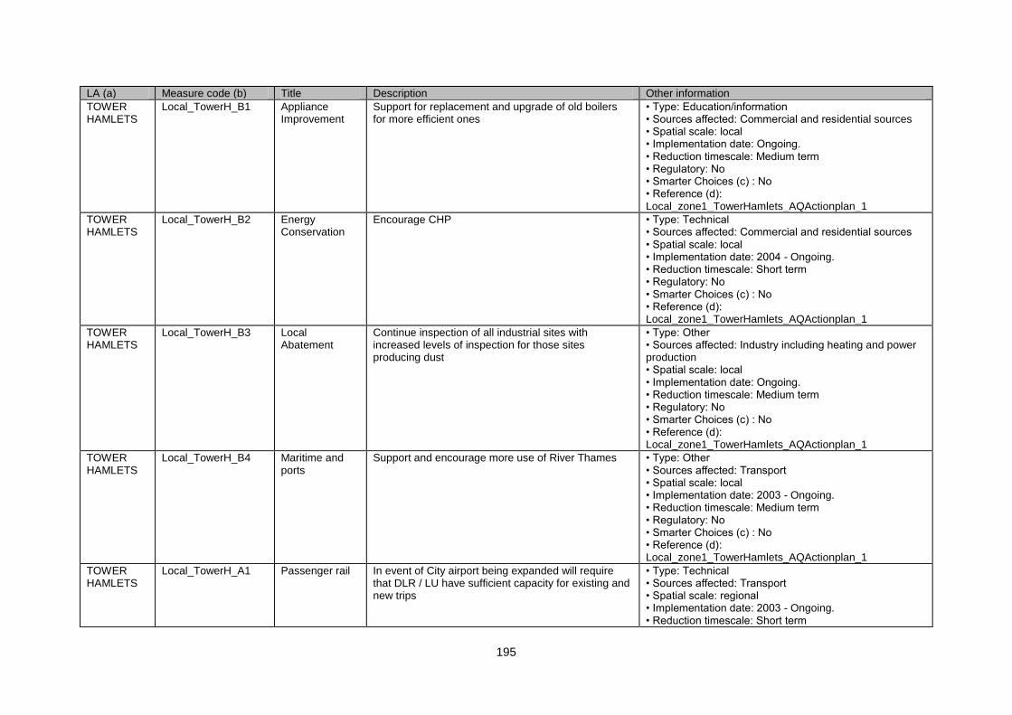
195
LA (a) Measure code (b) Title Description Other information
TOWER HAMLETS
Local_TowerH_B1 Appliance Improvement
Support for replacement and upgrade of old boilers for more efficient ones
• Type: Education/information • Sources affected: Commercial and residential sources • Spatial scale: local • Implementation date: Ongoing. • Reduction timescale: Medium term • Regulatory: No • Smarter Choices (c) : No • Reference (d): Local_zone1_TowerHamlets_AQActionplan_1
TOWER HAMLETS
Local_TowerH_B2 Energy Conservation
Encourage CHP • Type: Technical • Sources affected: Commercial and residential sources • Spatial scale: local • Implementation date: 2004 - Ongoing. • Reduction timescale: Short term • Regulatory: No • Smarter Choices (c) : No • Reference (d): Local_zone1_TowerHamlets_AQActionplan_1
TOWER HAMLETS
Local_TowerH_B3 Local Abatement
Continue inspection of all industrial sites with increased levels of inspection for those sites producing dust
• Type: Other • Sources affected: Industry including heating and power production • Spatial scale: local • Implementation date: Ongoing. • Reduction timescale: Medium term • Regulatory: No • Smarter Choices (c) : No • Reference (d): Local_zone1_TowerHamlets_AQActionplan_1
TOWER HAMLETS
Local_TowerH_B4 Maritime and ports
Support and encourage more use of River Thames • Type: Other • Sources affected: Transport • Spatial scale: local • Implementation date: 2003 - Ongoing. • Reduction timescale: Medium term • Regulatory: No • Smarter Choices (c) : No • Reference (d): Local_zone1_TowerHamlets_AQActionplan_1
TOWER HAMLETS
Local_TowerH_A1 Passenger rail In event of City airport being expanded will require that DLR / LU have sufficient capacity for existing and new trips
• Type: Technical • Sources affected: Transport • Spatial scale: regional • Implementation date: 2003 - Ongoing. • Reduction timescale: Short term
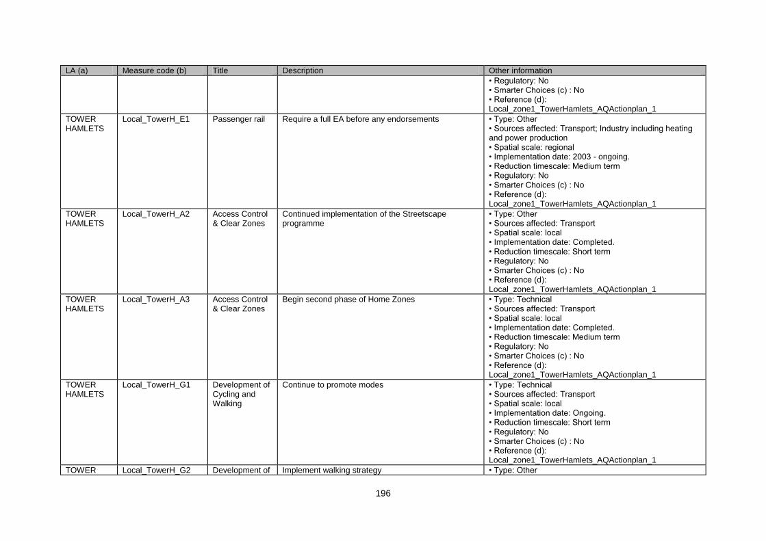
196
LA (a) Measure code (b) Title Description Other information
• Regulatory: No • Smarter Choices (c) : No • Reference (d): Local_zone1_TowerHamlets_AQActionplan_1
TOWER HAMLETS
Local_TowerH_E1 Passenger rail Require a full EA before any endorsements • Type: Other • Sources affected: Transport; Industry including heating and power production • Spatial scale: regional • Implementation date: 2003 - ongoing. • Reduction timescale: Medium term • Regulatory: No • Smarter Choices (c) : No • Reference (d): Local_zone1_TowerHamlets_AQActionplan_1
TOWER HAMLETS
Local_TowerH_A2 Access Control & Clear Zones
Continued implementation of the Streetscape programme
• Type: Other • Sources affected: Transport • Spatial scale: local • Implementation date: Completed. • Reduction timescale: Short term • Regulatory: No • Smarter Choices (c) : No • Reference (d): Local_zone1_TowerHamlets_AQActionplan_1
TOWER HAMLETS
Local_TowerH_A3 Access Control & Clear Zones
Begin second phase of Home Zones • Type: Technical • Sources affected: Transport • Spatial scale: local • Implementation date: Completed. • Reduction timescale: Medium term • Regulatory: No • Smarter Choices (c) : No • Reference (d): Local_zone1_TowerHamlets_AQActionplan_1
TOWER HAMLETS
Local_TowerH_G1 Development of Cycling and Walking
Continue to promote modes • Type: Technical • Sources affected: Transport • Spatial scale: local • Implementation date: Ongoing. • Reduction timescale: Short term • Regulatory: No • Smarter Choices (c) : No • Reference (d): Local_zone1_TowerHamlets_AQActionplan_1
TOWER Local_TowerH_G2 Development of Implement walking strategy • Type: Other
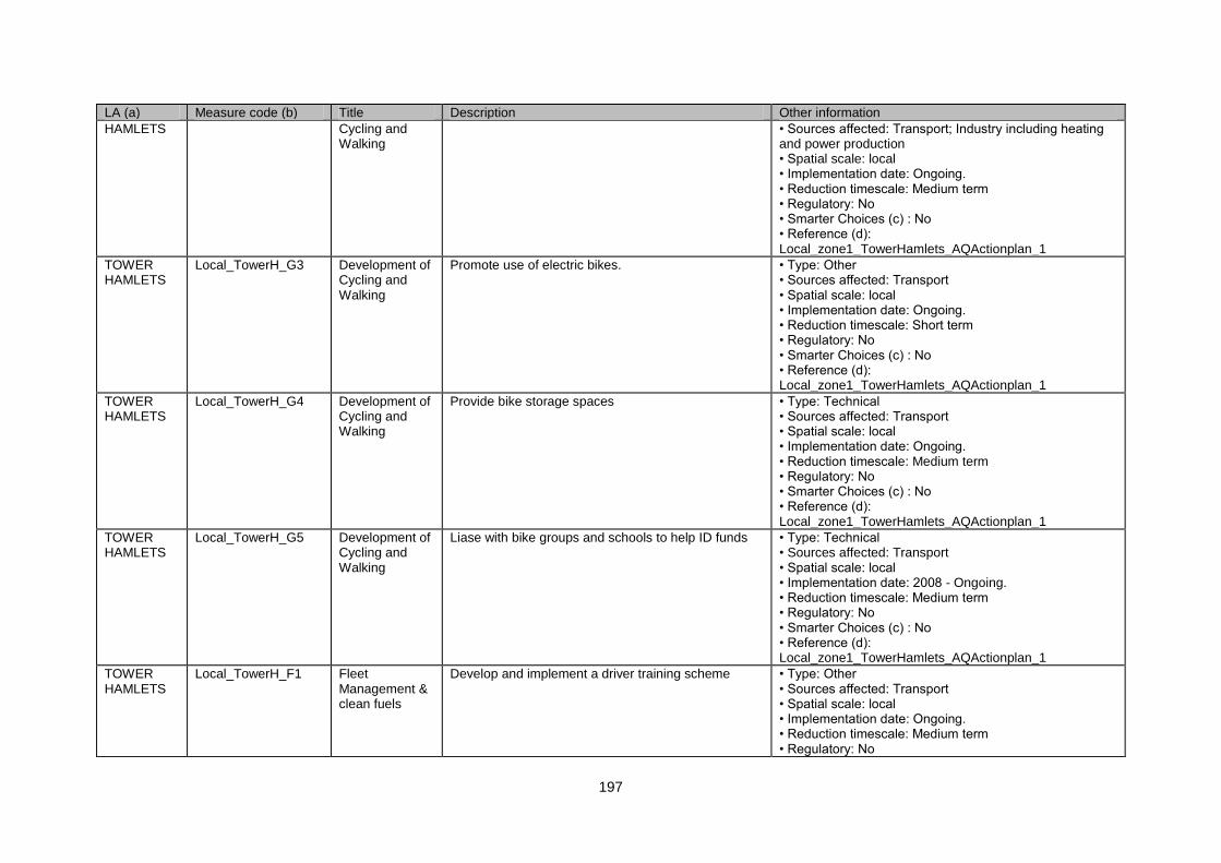
197
LA (a) Measure code (b) Title Description Other information
HAMLETS Cycling and Walking
• Sources affected: Transport; Industry including heating and power production • Spatial scale: local • Implementation date: Ongoing. • Reduction timescale: Medium term • Regulatory: No • Smarter Choices (c) : No • Reference (d): Local_zone1_TowerHamlets_AQActionplan_1
TOWER HAMLETS
Local_TowerH_G3 Development of Cycling and Walking
Promote use of electric bikes. • Type: Other • Sources affected: Transport • Spatial scale: local • Implementation date: Ongoing. • Reduction timescale: Short term • Regulatory: No • Smarter Choices (c) : No • Reference (d): Local_zone1_TowerHamlets_AQActionplan_1
TOWER HAMLETS
Local_TowerH_G4 Development of Cycling and Walking
Provide bike storage spaces • Type: Technical • Sources affected: Transport • Spatial scale: local • Implementation date: Ongoing. • Reduction timescale: Medium term • Regulatory: No • Smarter Choices (c) : No • Reference (d): Local_zone1_TowerHamlets_AQActionplan_1
TOWER HAMLETS
Local_TowerH_G5 Development of Cycling and Walking
Liase with bike groups and schools to help ID funds • Type: Technical • Sources affected: Transport • Spatial scale: local • Implementation date: 2008 - Ongoing. • Reduction timescale: Medium term • Regulatory: No • Smarter Choices (c) : No • Reference (d): Local_zone1_TowerHamlets_AQActionplan_1
TOWER HAMLETS
Local_TowerH_F1 Fleet Management & clean fuels
Develop and implement a driver training scheme • Type: Other • Sources affected: Transport • Spatial scale: local • Implementation date: Ongoing. • Reduction timescale: Medium term • Regulatory: No
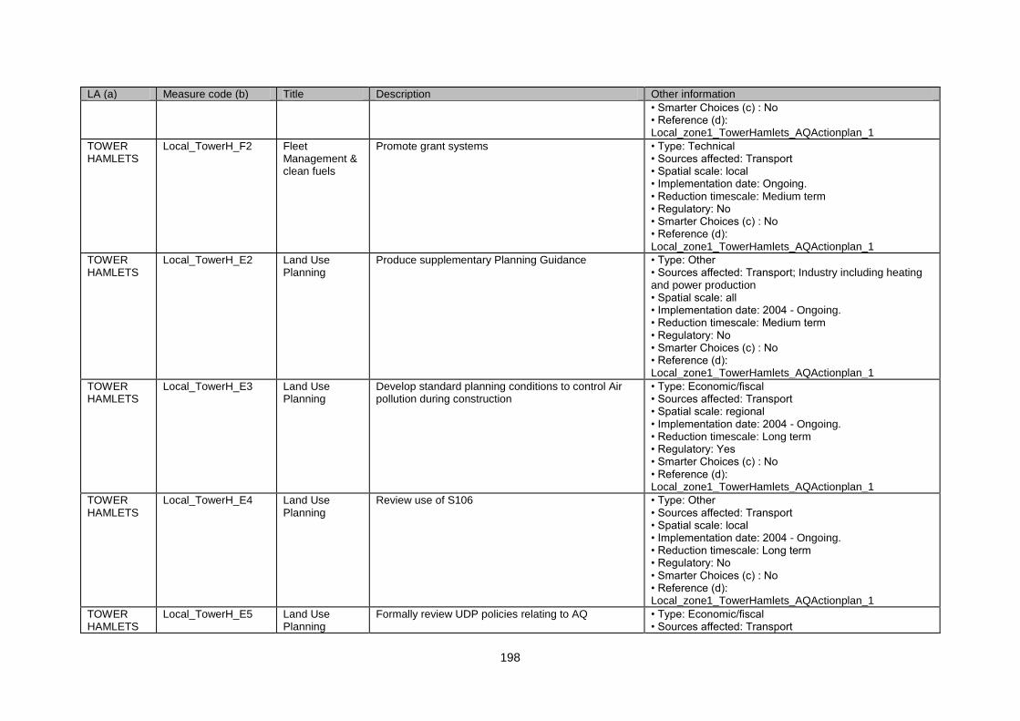
198
LA (a) Measure code (b) Title Description Other information
• Smarter Choices (c) : No • Reference (d): Local_zone1_TowerHamlets_AQActionplan_1
TOWER HAMLETS
Local_TowerH_F2 Fleet Management & clean fuels
Promote grant systems • Type: Technical • Sources affected: Transport • Spatial scale: local • Implementation date: Ongoing. • Reduction timescale: Medium term • Regulatory: No • Smarter Choices (c) : No • Reference (d): Local_zone1_TowerHamlets_AQActionplan_1
TOWER HAMLETS
Local_TowerH_E2 Land Use Planning
Produce supplementary Planning Guidance • Type: Other • Sources affected: Transport; Industry including heating and power production • Spatial scale: all • Implementation date: 2004 - Ongoing. • Reduction timescale: Medium term • Regulatory: No • Smarter Choices (c) : No • Reference (d): Local_zone1_TowerHamlets_AQActionplan_1
TOWER HAMLETS
Local_TowerH_E3 Land Use Planning
Develop standard planning conditions to control Air pollution during construction
• Type: Economic/fiscal • Sources affected: Transport • Spatial scale: regional • Implementation date: 2004 - Ongoing. • Reduction timescale: Long term • Regulatory: Yes • Smarter Choices (c) : No • Reference (d): Local_zone1_TowerHamlets_AQActionplan_1
TOWER HAMLETS
Local_TowerH_E4 Land Use Planning
Review use of S106 • Type: Other • Sources affected: Transport • Spatial scale: local • Implementation date: 2004 - Ongoing. • Reduction timescale: Long term • Regulatory: No • Smarter Choices (c) : No • Reference (d): Local_zone1_TowerHamlets_AQActionplan_1
TOWER HAMLETS
Local_TowerH_E5 Land Use Planning
Formally review UDP policies relating to AQ • Type: Economic/fiscal • Sources affected: Transport
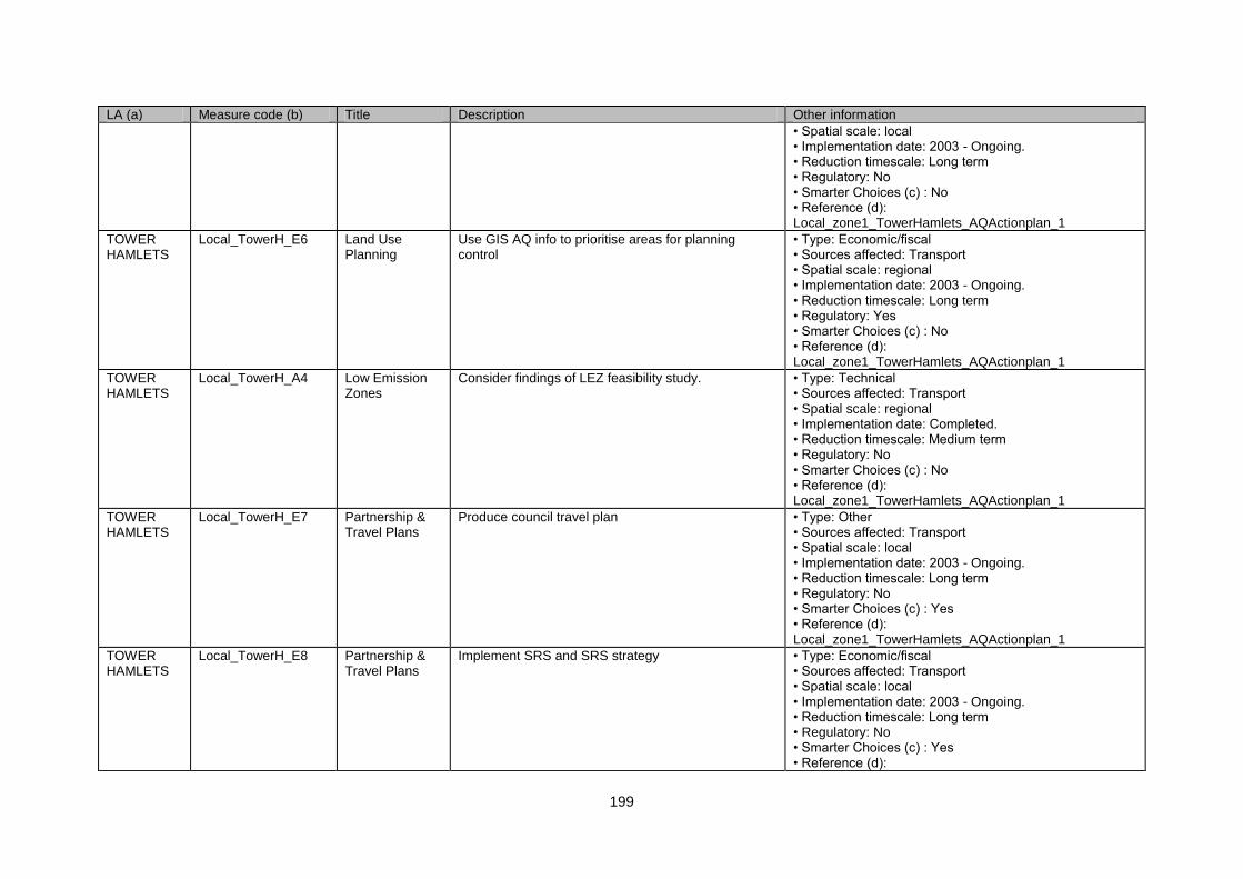
199
LA (a) Measure code (b) Title Description Other information
• Spatial scale: local • Implementation date: 2003 - Ongoing. • Reduction timescale: Long term • Regulatory: No • Smarter Choices (c) : No • Reference (d): Local_zone1_TowerHamlets_AQActionplan_1
TOWER HAMLETS
Local_TowerH_E6 Land Use Planning
Use GIS AQ info to prioritise areas for planning control
• Type: Economic/fiscal • Sources affected: Transport • Spatial scale: regional • Implementation date: 2003 - Ongoing. • Reduction timescale: Long term • Regulatory: Yes • Smarter Choices (c) : No • Reference (d): Local_zone1_TowerHamlets_AQActionplan_1
TOWER HAMLETS
Local_TowerH_A4 Low Emission Zones
Consider findings of LEZ feasibility study. • Type: Technical • Sources affected: Transport • Spatial scale: regional • Implementation date: Completed. • Reduction timescale: Medium term • Regulatory: No • Smarter Choices (c) : No • Reference (d): Local_zone1_TowerHamlets_AQActionplan_1
TOWER HAMLETS
Local_TowerH_E7 Partnership & Travel Plans
Produce council travel plan • Type: Other • Sources affected: Transport • Spatial scale: local • Implementation date: 2003 - Ongoing. • Reduction timescale: Long term • Regulatory: No • Smarter Choices (c) : Yes • Reference (d): Local_zone1_TowerHamlets_AQActionplan_1
TOWER HAMLETS
Local_TowerH_E8 Partnership & Travel Plans
Implement SRS and SRS strategy • Type: Economic/fiscal • Sources affected: Transport • Spatial scale: local • Implementation date: 2003 - Ongoing. • Reduction timescale: Long term • Regulatory: No • Smarter Choices (c) : Yes • Reference (d):
200
LA (a) Measure code (b) Title Description Other information
Local_zone1_TowerHamlets_AQActionplan_1
TOWER HAMLETS
Local_TowerH_F3 Partnership & Travel Plans
Work in Thames Gateway Partnership to promote sustainable transport schemes.
• Type: Technical • Sources affected: Transport • Spatial scale: local/ regional • Implementation date: 2003 - Ongoing. • Reduction timescale: Short term • Regulatory: No • Smarter Choices (c) : No • Reference (d): Local_zone1_TowerHamlets_AQActionplan_1
TOWER HAMLETS
Local_TowerH_A5 Physical Traffic Management
Improvements on Aldgate East Gyratory traffic contol system.
• Type: Other • Sources affected: Transport; Industry including heating and power production • Spatial scale: local • Implementation date: Implementation ongoing. • Reduction timescale: Medium term • Regulatory: No • Smarter Choices (c) : No • Reference (d): Local_zone1_TowerHamlets_AQActionplan_1
TOWER HAMLETS
Local_TowerH_A6 Physical Traffic Management
Impose 40mph limit on A12 • Type: Other • Sources affected: Transport • Spatial scale: local • Implementation date: No info. • Reduction timescale: Short term • Regulatory: No • Smarter Choices (c) : No • Reference (d): Local_zone1_TowerHamlets_AQActionplan_1
TOWER HAMLETS
Local_TowerH_A7 Physical Traffic Management
Introduce 20mph zones in worst accident areas • Type: Technical • Sources affected: Transport • Spatial scale: local • Implementation date: No info. • Reduction timescale: Medium term • Regulatory: No • Smarter Choices (c) : No • Reference (d): Local_zone1_TowerHamlets_AQActionplan_1
TOWER HAMLETS
Local_TowerH_A8 Physical Traffic Management
Use GIS info to target traffic management • Type: Technical • Sources affected: Transport • Spatial scale: local • Implementation date: Ongoing.
201
LA (a) Measure code (b) Title Description Other information
• Reduction timescale: Medium term • Regulatory: No • Smarter Choices (c) : No • Reference (d): Local_zone1_TowerHamlets_AQActionplan_1
TOWER HAMLETS
Local_TowerH_A9 Re-Routing and Road hierachy
Work closely with Mayor with GLA to review London road hierarchy
• Type: Other • Sources affected: Transport; Industry including heating and power production • Spatial scale: all • Implementation date: Ongoing. • Reduction timescale: Medium term • Regulatory: No • Smarter Choices (c) : No • Reference (d): Local_zone1_TowerHamlets_AQActionplan_1
TOWER HAMLETS
Local_TowerH_A10 Re-Routing and Road hierachy
Review land use along distributor roads with regard to AQ and planning controls to help improve flow
• Type: Economic/fiscal • Sources affected: Transport • Spatial scale: regional • Implementation date: Ongoing. • Reduction timescale: Long term • Regulatory: Yes • Smarter Choices (c) : No • Reference (d): Local_zone1_TowerHamlets_AQActionplan_1
TOWER HAMLETS
Local_TowerH_D1 Road User Charging
Work with TfL to resolve red route parking / controlled parking zone disparity is removed
• Type: Other • Sources affected: Transport • Spatial scale: local • Implementation date: Ongoing. • Reduction timescale: Long term • Regulatory: No • Smarter Choices (c) : No • Reference (d): Local_zone1_TowerHamlets_AQActionplan_1
TOWER HAMLETS
Local_TowerH_D2 Road User Charging
Review parking fees and increase if necessary • Type: Economic/fiscal • Sources affected: Transport • Spatial scale: local • Implementation date: Ongoing. • Reduction timescale: Long term • Regulatory: No • Smarter Choices (c) : No • Reference (d): Local_zone1_TowerHamlets_AQActionplan_1
202
LA (a) Measure code (b) Title Description Other information
TOWER HAMLETS
Local_TowerH_D3 Road User Charging
Consider discount for alternatively fuelled vehicles • Type: Economic/fiscal • Sources affected: Transport • Spatial scale: local • Implementation date: No info. • Reduction timescale: Long term • Regulatory: Yes • Smarter Choices (c) : No • Reference (d): Local_zone1_TowerHamlets_AQActionplan_1
TOWER HAMLETS
Local_TowerH_D Road User Charging
Parking Control and Planning officers to work together to ID development areas that should be car free
• Type: Technical • Sources affected: Transport • Spatial scale: regional • Implementation date: No info. • Reduction timescale: Medium term • Regulatory: No • Smarter Choices (c) : No • Reference (d): Local_zone1_TowerHamlets_AQActionplan_1
TOWER HAMLETS
Local_TowerH_A11 Roadside Emissions Testing
Support and take part in London wide scheme • Type: Technical • Sources affected: Transport • Spatial scale: regional • Implementation date: No info. • Reduction timescale: Medium term • Regulatory: No • Smarter Choices (c) : No • Reference (d): Local_zone1_TowerHamlets_AQActionplan_1
TOWER HAMLETS
Local_TowerH_F4 UTMC Systems UTC improvements • Type: Other • Sources affected: Transport • Spatial scale: local • Implementation date: No info. • Reduction timescale: Long term • Regulatory: No • Smarter Choices (c) : No • Reference (d): Local_zone1_TowerHamlets_AQActionplan_1
WALTHAM FOREST
Local_Waltham_B1 Energy Conservation
Continue programme of boiler replacement in Council area.
• Type: Economic/fiscal • Sources affected: Commercial and residential sources • Spatial scale: local • Implementation date: Ongoing. • Reduction timescale: Long term • Regulatory: No
203
LA (a) Measure code (b) Title Description Other information
• Smarter Choices (c) : No • Reference (d): Local_zone1_WalthamForest_AQActionplan_1
WALTHAM FOREST
Local_Waltham_H1 Local Abatement
Enforce air pollution regulations and legislation • Type: Technical • Sources affected: Industry including heating and power production • Spatial scale: local • Implementation date: In place - Ongoing. • Reduction timescale: Short term • Regulatory: No • Smarter Choices (c) : No • Reference (d): Local_zone1_WalthamForest_AQActionplan_1
WALTHAM FOREST
Local_Waltham_E1 Access Control & Clear Zones
Home Zone • Type: Other • Sources affected: Transport • Spatial scale: local • Implementation date: Ongoing. • Reduction timescale: Long term • Regulatory: No • Smarter Choices (c) : No • Reference (d): Local_zone1_WalthamForest_AQActionplan_1
WALTHAM FOREST
Local_Waltham_G1 Development of Cycling and Walking
Cycle training in schools • Type: Economic/fiscal • Sources affected: Transport • Spatial scale: local • Implementation date: Ongoing. • Reduction timescale: Long term • Regulatory: No • Smarter Choices (c) : No • Reference (d): Local_zone1_WalthamForest_AQActionplan_1
WALTHAM FOREST
Local_Waltham_G2 Development of Cycling and Walking
Improve cycle networks • Type: Other • Sources affected: Transport • Spatial scale: local • Implementation date: Partnership working ongoing. • Reduction timescale: Medium term • Regulatory: No • Smarter Choices (c) : No • Reference (d): Local_zone1_WalthamForest_AQActionplan_1
WALTHAM FOREST
Local_Waltham_G3 Development of Cycling and
Improve „streetscape‟ • Type: Technical • Sources affected: Transport
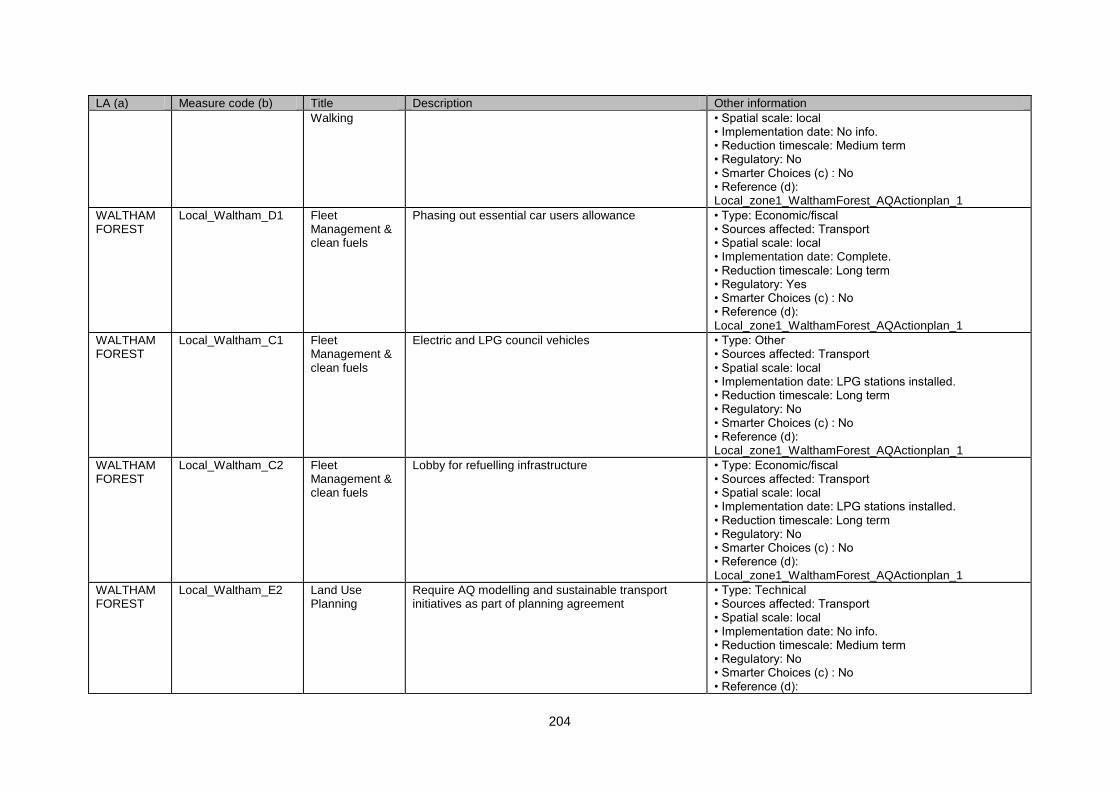
204
LA (a) Measure code (b) Title Description Other information
Walking • Spatial scale: local • Implementation date: No info. • Reduction timescale: Medium term • Regulatory: No • Smarter Choices (c) : No • Reference (d): Local_zone1_WalthamForest_AQActionplan_1
WALTHAM FOREST
Local_Waltham_D1 Fleet Management & clean fuels
Phasing out essential car users allowance • Type: Economic/fiscal • Sources affected: Transport • Spatial scale: local • Implementation date: Complete. • Reduction timescale: Long term • Regulatory: Yes • Smarter Choices (c) : No • Reference (d): Local_zone1_WalthamForest_AQActionplan_1
WALTHAM FOREST
Local_Waltham_C1 Fleet Management & clean fuels
Electric and LPG council vehicles • Type: Other • Sources affected: Transport • Spatial scale: local • Implementation date: LPG stations installed. • Reduction timescale: Long term • Regulatory: No • Smarter Choices (c) : No • Reference (d): Local_zone1_WalthamForest_AQActionplan_1
WALTHAM FOREST
Local_Waltham_C2 Fleet Management & clean fuels
Lobby for refuelling infrastructure • Type: Economic/fiscal • Sources affected: Transport • Spatial scale: local • Implementation date: LPG stations installed. • Reduction timescale: Long term • Regulatory: No • Smarter Choices (c) : No • Reference (d): Local_zone1_WalthamForest_AQActionplan_1
WALTHAM FOREST
Local_Waltham_E2 Land Use Planning
Require AQ modelling and sustainable transport initiatives as part of planning agreement
• Type: Technical • Sources affected: Transport • Spatial scale: local • Implementation date: No info. • Reduction timescale: Medium term • Regulatory: No • Smarter Choices (c) : No • Reference (d):
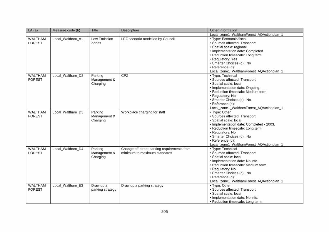
205
LA (a) Measure code (b) Title Description Other information
Local_zone1_WalthamForest_AQActionplan_1
WALTHAM FOREST
Local_Waltham_A1 Low Emission Zones
LEZ scenario modelled by Council. • Type: Economic/fiscal • Sources affected: Transport • Spatial scale: regional • Implementation date: Completed. • Reduction timescale: Long term • Regulatory: Yes • Smarter Choices (c) : No • Reference (d): Local_zone1_WalthamForest_AQActionplan_1
WALTHAM FOREST
Local_Waltham_D2 Parking Management & Charging
CPZ • Type: Technical • Sources affected: Transport • Spatial scale: local • Implementation date: Ongoing. • Reduction timescale: Medium term • Regulatory: No • Smarter Choices (c) : No • Reference (d): Local_zone1_WalthamForest_AQActionplan_1
WALTHAM FOREST
Local_Waltham_D3 Parking Management & Charging
Workplace charging for staff • Type: Other • Sources affected: Transport • Spatial scale: local • Implementation date: Completed - 2003. • Reduction timescale: Long term • Regulatory: No • Smarter Choices (c) : No • Reference (d): Local_zone1_WalthamForest_AQActionplan_1
WALTHAM FOREST
Local_Waltham_D4 Parking Management & Charging
Change off-street parking requirements from minimum to maximum standards
• Type: Technical • Sources affected: Transport • Spatial scale: local • Implementation date: No info. • Reduction timescale: Medium term • Regulatory: No • Smarter Choices (c) : No • Reference (d): Local_zone1_WalthamForest_AQActionplan_1
WALTHAM FOREST
Local_Waltham_E3 Draw up a parking strategy
Draw up a parking strategy • Type: Other • Sources affected: Transport • Spatial scale: local • Implementation date: No info. • Reduction timescale: Long term
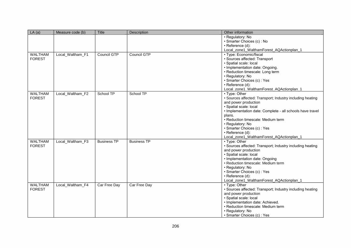
206
LA (a) Measure code (b) Title Description Other information
• Regulatory: No • Smarter Choices (c) : No • Reference (d): Local_zone1_WalthamForest_AQActionplan_1
WALTHAM FOREST
Local_Waltham_F1 Council GTP Council GTP • Type: Economic/fiscal • Sources affected: Transport • Spatial scale: local • Implementation date: Ongoing. • Reduction timescale: Long term • Regulatory: No • Smarter Choices (c) : Yes • Reference (d): Local_zone1_WalthamForest_AQActionplan_1
WALTHAM FOREST
Local_Waltham_F2 School TP School TP • Type: Other • Sources affected: Transport; Industry including heating and power production • Spatial scale: local • Implementation date: Complete - all schools have travel plans. • Reduction timescale: Medium term • Regulatory: No • Smarter Choices (c) : Yes • Reference (d): Local_zone1_WalthamForest_AQActionplan_1
WALTHAM FOREST
Local_Waltham_F3 Business TP Business TP • Type: Other • Sources affected: Transport; Industry including heating and power production • Spatial scale: local • Implementation date: Ongoing • Reduction timescale: Medium term • Regulatory: No • Smarter Choices (c) : Yes • Reference (d): Local_zone1_WalthamForest_AQActionplan_1
WALTHAM FOREST
Local_Waltham_F4 Car Free Day Car Free Day • Type: Other • Sources affected: Transport; Industry including heating and power production • Spatial scale: local • Implementation date: Achieved. • Reduction timescale: Medium term • Regulatory: No • Smarter Choices (c) : Yes
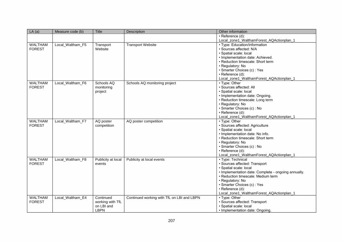
207
LA (a) Measure code (b) Title Description Other information
• Reference (d): Local_zone1_WalthamForest_AQActionplan_1
WALTHAM FOREST
Local_Waltham_F5 Transport Website
Transport Website • Type: Education/information • Sources affected: N/A • Spatial scale: local • Implementation date: Achieved. • Reduction timescale: Short term • Regulatory: No • Smarter Choices (c) : Yes • Reference (d): Local_zone1_WalthamForest_AQActionplan_1
WALTHAM FOREST
Local_Waltham_F6 Schools AQ monitoring project
Schools AQ monitoring project • Type: Other • Sources affected: All • Spatial scale: local • Implementation date: Ongoing. • Reduction timescale: Long term • Regulatory: No • Smarter Choices (c) : No • Reference (d): Local_zone1_WalthamForest_AQActionplan_1
WALTHAM FOREST
Local_Waltham_F7 AQ poster competition
AQ poster competition • Type: Other • Sources affected: Agriculture • Spatial scale: local • Implementation date: No info. • Reduction timescale: Short term • Regulatory: No • Smarter Choices (c) : No • Reference (d): Local_zone1_WalthamForest_AQActionplan_1
WALTHAM FOREST
Local_Waltham_F8 Publicity at local events
Publicity at local events • Type: Technical • Sources affected: Transport • Spatial scale: local • Implementation date: Complete - ongoing annually. • Reduction timescale: Medium term • Regulatory: No • Smarter Choices (c) : Yes • Reference (d): Local_zone1_WalthamForest_AQActionplan_1
WALTHAM FOREST
Local_Waltham_E4 Continued working with TfL on LBI and LBPN
Continued working with TfL on LBI and LBPN • Type: Other • Sources affected: Transport • Spatial scale: local • Implementation date: Ongoing.
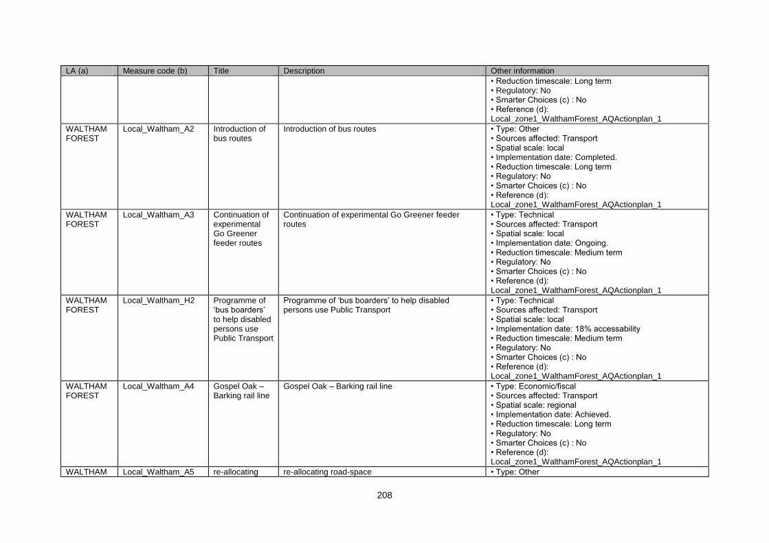
208
LA (a) Measure code (b) Title Description Other information
• Reduction timescale: Long term • Regulatory: No • Smarter Choices (c) : No • Reference (d): Local_zone1_WalthamForest_AQActionplan_1
WALTHAM FOREST
Local_Waltham_A2 Introduction of bus routes
Introduction of bus routes • Type: Other • Sources affected: Transport • Spatial scale: local • Implementation date: Completed. • Reduction timescale: Long term • Regulatory: No • Smarter Choices (c) : No • Reference (d): Local_zone1_WalthamForest_AQActionplan_1
WALTHAM FOREST
Local_Waltham_A3 Continuation of experimental Go Greener feeder routes
Continuation of experimental Go Greener feeder routes
• Type: Technical • Sources affected: Transport • Spatial scale: local • Implementation date: Ongoing. • Reduction timescale: Medium term • Regulatory: No • Smarter Choices (c) : No • Reference (d): Local_zone1_WalthamForest_AQActionplan_1
WALTHAM FOREST
Local_Waltham_H2 Programme of „bus boarders‟ to help disabled persons use Public Transport
Programme of „bus boarders‟ to help disabled persons use Public Transport
• Type: Technical • Sources affected: Transport • Spatial scale: local • Implementation date: 18% accessability • Reduction timescale: Medium term • Regulatory: No • Smarter Choices (c) : No • Reference (d): Local_zone1_WalthamForest_AQActionplan_1
WALTHAM FOREST
Local_Waltham_A4 Gospel Oak – Barking rail line
Gospel Oak – Barking rail line • Type: Economic/fiscal • Sources affected: Transport • Spatial scale: regional • Implementation date: Achieved. • Reduction timescale: Long term • Regulatory: No • Smarter Choices (c) : No • Reference (d): Local_zone1_WalthamForest_AQActionplan_1
WALTHAM Local_Waltham_A5 re-allocating re-allocating road-space • Type: Other
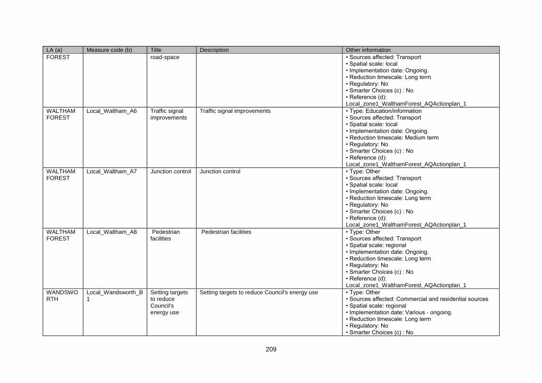
209
LA (a) Measure code (b) Title Description Other information
FOREST road-space • Sources affected: Transport • Spatial scale: local • Implementation date: Ongoing. • Reduction timescale: Long term • Regulatory: No • Smarter Choices (c) : No • Reference (d): Local_zone1_WalthamForest_AQActionplan_1
WALTHAM FOREST
Local_Waltham_A6 Traffic signal improvements
Traffic signal improvements • Type: Education/information • Sources affected: Transport • Spatial scale: local • Implementation date: Ongoing. • Reduction timescale: Medium term • Regulatory: No • Smarter Choices (c) : No • Reference (d): Local_zone1_WalthamForest_AQActionplan_1
WALTHAM FOREST
Local_Waltham_A7 Junction control Junction control • Type: Other • Sources affected: Transport • Spatial scale: local • Implementation date: Ongoing. • Reduction timescale: Long term • Regulatory: No • Smarter Choices (c) : No • Reference (d): Local_zone1_WalthamForest_AQActionplan_1
WALTHAM FOREST
Local_Waltham_A8 Pedestrian facilities
Pedestrian facilities • Type: Other • Sources affected: Transport • Spatial scale: regional • Implementation date: Ongoing. • Reduction timescale: Long term • Regulatory: No • Smarter Choices (c) : No • Reference (d): Local_zone1_WalthamForest_AQActionplan_1
WANDSWORTH
Local_Wandsworth_B1
Setting targets to reduce Council's energy use
Setting targets to reduce Council's energy use • Type: Other • Sources affected: Commercial and residential sources • Spatial scale: regional • Implementation date: Various - ongoing. • Reduction timescale: Long term • Regulatory: No • Smarter Choices (c) : No
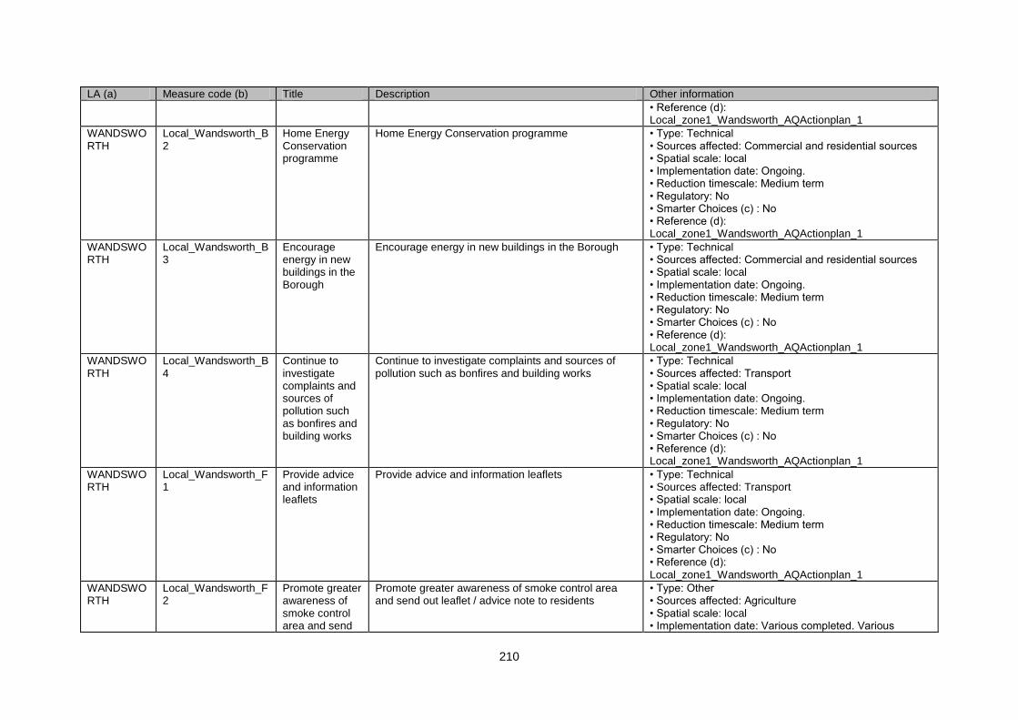
210
LA (a) Measure code (b) Title Description Other information
• Reference (d): Local_zone1_Wandsworth_AQActionplan_1
WANDSWORTH
Local_Wandsworth_B2
Home Energy Conservation programme
Home Energy Conservation programme • Type: Technical • Sources affected: Commercial and residential sources • Spatial scale: local • Implementation date: Ongoing. • Reduction timescale: Medium term • Regulatory: No • Smarter Choices (c) : No • Reference (d): Local_zone1_Wandsworth_AQActionplan_1
WANDSWORTH
Local_Wandsworth_B3
Encourage energy in new buildings in the Borough
Encourage energy in new buildings in the Borough • Type: Technical • Sources affected: Commercial and residential sources • Spatial scale: local • Implementation date: Ongoing. • Reduction timescale: Medium term • Regulatory: No • Smarter Choices (c) : No • Reference (d): Local_zone1_Wandsworth_AQActionplan_1
WANDSWORTH
Local_Wandsworth_B4
Continue to investigate complaints and sources of pollution such as bonfires and building works
Continue to investigate complaints and sources of pollution such as bonfires and building works
• Type: Technical • Sources affected: Transport • Spatial scale: local • Implementation date: Ongoing. • Reduction timescale: Medium term • Regulatory: No • Smarter Choices (c) : No • Reference (d): Local_zone1_Wandsworth_AQActionplan_1
WANDSWORTH
Local_Wandsworth_F1
Provide advice and information leaflets
Provide advice and information leaflets • Type: Technical • Sources affected: Transport • Spatial scale: local • Implementation date: Ongoing. • Reduction timescale: Medium term • Regulatory: No • Smarter Choices (c) : No • Reference (d): Local_zone1_Wandsworth_AQActionplan_1
WANDSWORTH
Local_Wandsworth_F2
Promote greater awareness of smoke control area and send
Promote greater awareness of smoke control area and send out leaflet / advice note to residents
• Type: Other • Sources affected: Agriculture • Spatial scale: local • Implementation date: Various completed. Various
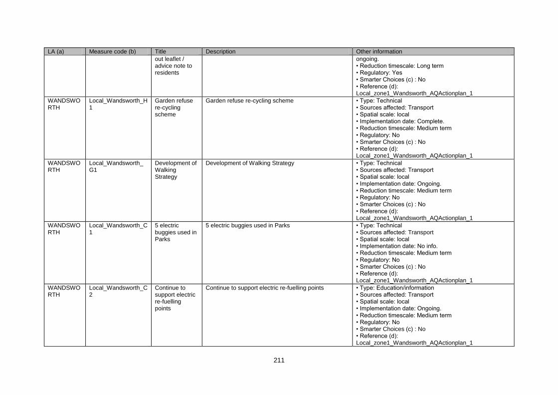
211
LA (a) Measure code (b) Title Description Other information
out leaflet / advice note to residents
ongoing. • Reduction timescale: Long term • Regulatory: Yes • Smarter Choices (c) : No • Reference (d): Local_zone1_Wandsworth_AQActionplan_1
WANDSWORTH
Local_Wandsworth_H1
Garden refuse re-cycling scheme
Garden refuse re-cycling scheme • Type: Technical • Sources affected: Transport • Spatial scale: local • Implementation date: Complete. • Reduction timescale: Medium term • Regulatory: No • Smarter Choices (c) : No • Reference (d): Local_zone1_Wandsworth_AQActionplan_1
WANDSWORTH
Local_Wandsworth_G1
Development of Walking Strategy
Development of Walking Strategy • Type: Technical • Sources affected: Transport • Spatial scale: local • Implementation date: Ongoing. • Reduction timescale: Medium term • Regulatory: No • Smarter Choices (c) : No • Reference (d): Local_zone1_Wandsworth_AQActionplan_1
WANDSWORTH
Local_Wandsworth_C1
5 electric buggies used in Parks
5 electric buggies used in Parks • Type: Technical • Sources affected: Transport • Spatial scale: local • Implementation date: No info. • Reduction timescale: Medium term • Regulatory: No • Smarter Choices (c) : No • Reference (d): Local_zone1_Wandsworth_AQActionplan_1
WANDSWORTH
Local_Wandsworth_C2
Continue to support electric re-fuelling points
Continue to support electric re-fuelling points • Type: Education/information • Sources affected: Transport • Spatial scale: local • Implementation date: Ongoing. • Reduction timescale: Medium term • Regulatory: No • Smarter Choices (c) : No • Reference (d): Local_zone1_Wandsworth_AQActionplan_1
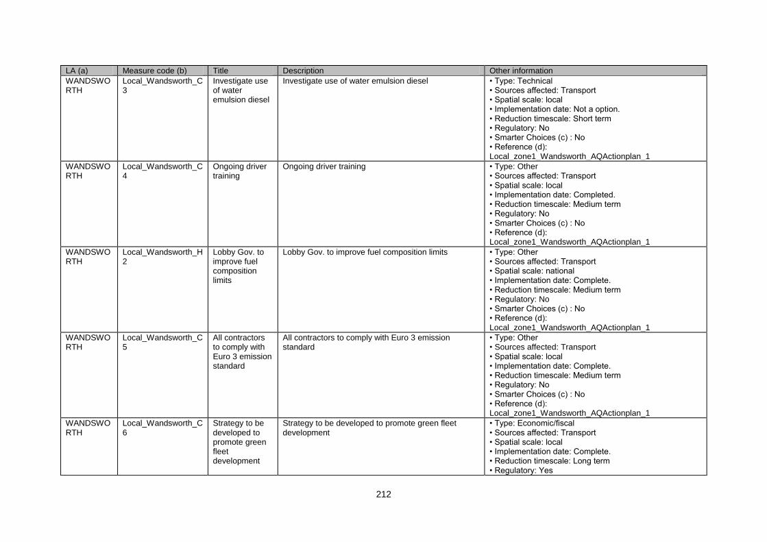
212
LA (a) Measure code (b) Title Description Other information
WANDSWORTH
Local_Wandsworth_C3
Investigate use of water emulsion diesel
Investigate use of water emulsion diesel • Type: Technical • Sources affected: Transport • Spatial scale: local • Implementation date: Not a option. • Reduction timescale: Short term • Regulatory: No • Smarter Choices (c) : No • Reference (d): Local_zone1_Wandsworth_AQActionplan_1
WANDSWORTH
Local_Wandsworth_C4
Ongoing driver training
Ongoing driver training • Type: Other • Sources affected: Transport • Spatial scale: local • Implementation date: Completed. • Reduction timescale: Medium term • Regulatory: No • Smarter Choices (c) : No • Reference (d): Local_zone1_Wandsworth_AQActionplan_1
WANDSWORTH
Local_Wandsworth_H2
Lobby Gov. to improve fuel composition limits
Lobby Gov. to improve fuel composition limits • Type: Other • Sources affected: Transport • Spatial scale: national • Implementation date: Complete. • Reduction timescale: Medium term • Regulatory: No • Smarter Choices (c) : No • Reference (d): Local_zone1_Wandsworth_AQActionplan_1
WANDSWORTH
Local_Wandsworth_C5
All contractors to comply with Euro 3 emission standard
All contractors to comply with Euro 3 emission standard
• Type: Other • Sources affected: Transport • Spatial scale: local • Implementation date: Complete. • Reduction timescale: Medium term • Regulatory: No • Smarter Choices (c) : No • Reference (d): Local_zone1_Wandsworth_AQActionplan_1
WANDSWORTH
Local_Wandsworth_C6
Strategy to be developed to promote green fleet development
Strategy to be developed to promote green fleet development
• Type: Economic/fiscal • Sources affected: Transport • Spatial scale: local • Implementation date: Complete. • Reduction timescale: Long term • Regulatory: Yes
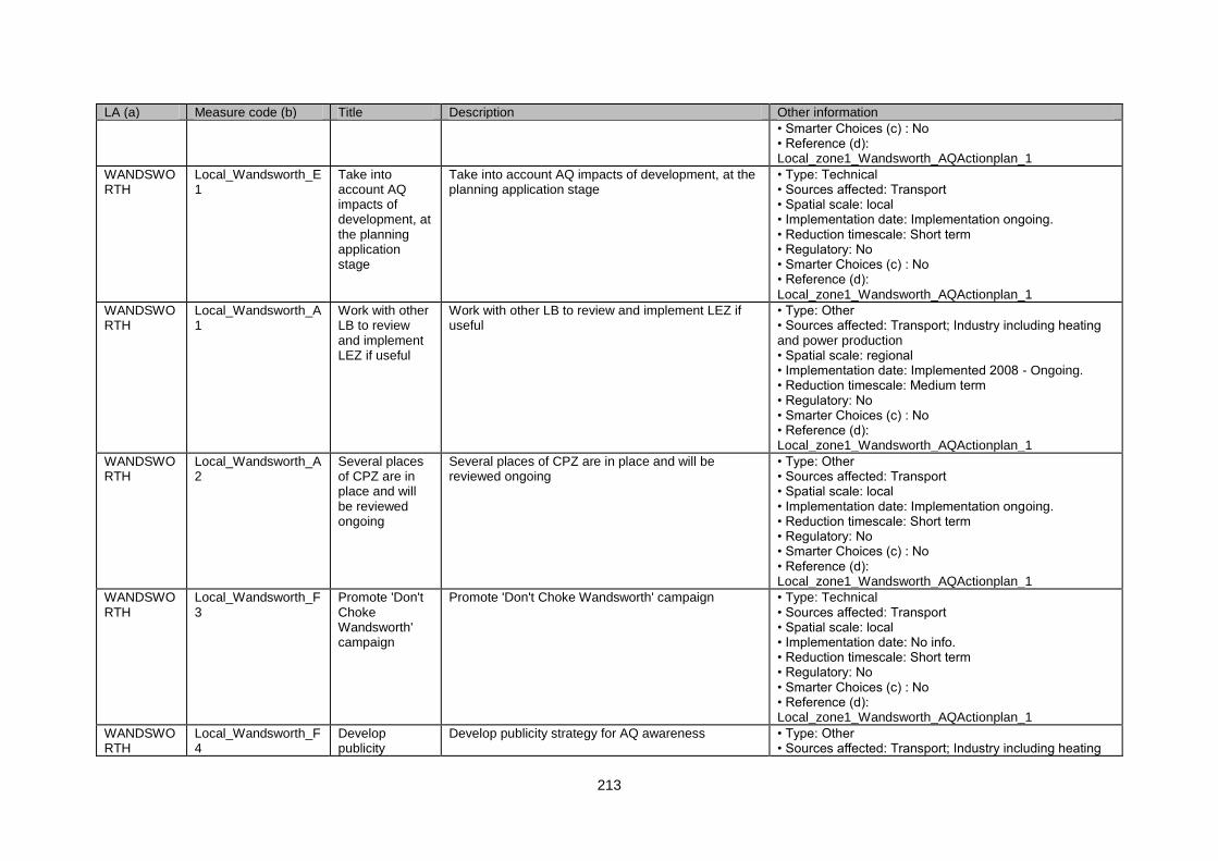
213
LA (a) Measure code (b) Title Description Other information
• Smarter Choices (c) : No • Reference (d): Local_zone1_Wandsworth_AQActionplan_1
WANDSWORTH
Local_Wandsworth_E1
Take into account AQ impacts of development, at the planning application stage
Take into account AQ impacts of development, at the planning application stage
• Type: Technical • Sources affected: Transport • Spatial scale: local • Implementation date: Implementation ongoing. • Reduction timescale: Short term • Regulatory: No • Smarter Choices (c) : No • Reference (d): Local_zone1_Wandsworth_AQActionplan_1
WANDSWORTH
Local_Wandsworth_A1
Work with other LB to review and implement LEZ if useful
Work with other LB to review and implement LEZ if useful
• Type: Other • Sources affected: Transport; Industry including heating and power production • Spatial scale: regional • Implementation date: Implemented 2008 - Ongoing. • Reduction timescale: Medium term • Regulatory: No • Smarter Choices (c) : No • Reference (d): Local_zone1_Wandsworth_AQActionplan_1
WANDSWORTH
Local_Wandsworth_A2
Several places of CPZ are in place and will be reviewed ongoing
Several places of CPZ are in place and will be reviewed ongoing
• Type: Other • Sources affected: Transport • Spatial scale: local • Implementation date: Implementation ongoing. • Reduction timescale: Short term • Regulatory: No • Smarter Choices (c) : No • Reference (d): Local_zone1_Wandsworth_AQActionplan_1
WANDSWORTH
Local_Wandsworth_F3
Promote 'Don't Choke Wandsworth' campaign
Promote 'Don't Choke Wandsworth' campaign • Type: Technical • Sources affected: Transport • Spatial scale: local • Implementation date: No info. • Reduction timescale: Short term • Regulatory: No • Smarter Choices (c) : No • Reference (d): Local_zone1_Wandsworth_AQActionplan_1
WANDSWORTH
Local_Wandsworth_F4
Develop publicity
Develop publicity strategy for AQ awareness • Type: Other • Sources affected: Transport; Industry including heating
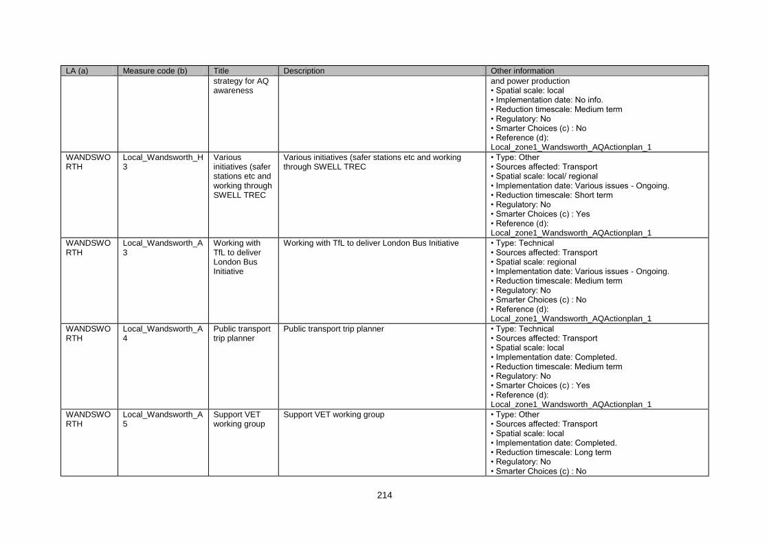
214
LA (a) Measure code (b) Title Description Other information
strategy for AQ awareness
and power production • Spatial scale: local • Implementation date: No info. • Reduction timescale: Medium term • Regulatory: No • Smarter Choices (c) : No • Reference (d): Local_zone1_Wandsworth_AQActionplan_1
WANDSWORTH
Local_Wandsworth_H3
Various initiatives (safer stations etc and working through SWELL TREC
Various initiatives (safer stations etc and working through SWELL TREC
• Type: Other • Sources affected: Transport • Spatial scale: local/ regional • Implementation date: Various issues - Ongoing. • Reduction timescale: Short term • Regulatory: No • Smarter Choices (c) : Yes • Reference (d): Local_zone1_Wandsworth_AQActionplan_1
WANDSWORTH
Local_Wandsworth_A3
Working with TfL to deliver London Bus Initiative
Working with TfL to deliver London Bus Initiative • Type: Technical • Sources affected: Transport • Spatial scale: regional • Implementation date: Various issues - Ongoing. • Reduction timescale: Medium term • Regulatory: No • Smarter Choices (c) : No • Reference (d): Local_zone1_Wandsworth_AQActionplan_1
WANDSWORTH
Local_Wandsworth_A4
Public transport trip planner
Public transport trip planner • Type: Technical • Sources affected: Transport • Spatial scale: local • Implementation date: Completed. • Reduction timescale: Medium term • Regulatory: No • Smarter Choices (c) : Yes • Reference (d): Local_zone1_Wandsworth_AQActionplan_1
WANDSWORTH
Local_Wandsworth_A5
Support VET working group
Support VET working group • Type: Other • Sources affected: Transport • Spatial scale: local • Implementation date: Completed. • Reduction timescale: Long term • Regulatory: No • Smarter Choices (c) : No
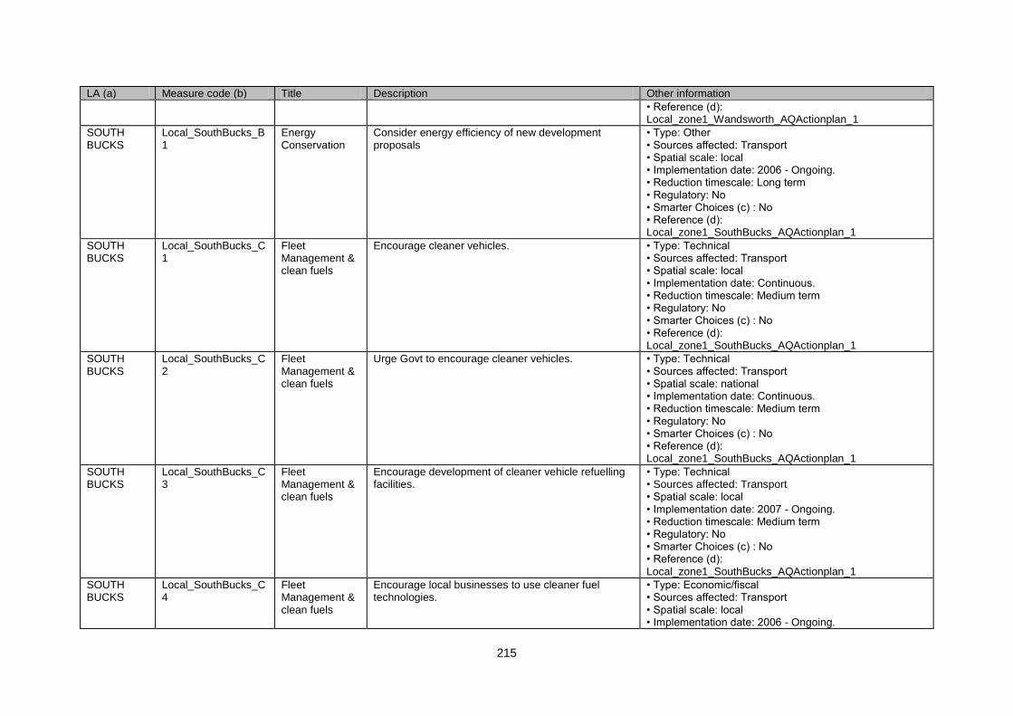
215
LA (a) Measure code (b) Title Description Other information
• Reference (d): Local_zone1_Wandsworth_AQActionplan_1
SOUTH BUCKS
Local_SouthBucks_B1
Energy Conservation
Consider energy efficiency of new development proposals
• Type: Other • Sources affected: Transport • Spatial scale: local • Implementation date: 2006 - Ongoing. • Reduction timescale: Long term • Regulatory: No • Smarter Choices (c) : No • Reference (d): Local_zone1_SouthBucks_AQActionplan_1
SOUTH BUCKS
Local_SouthBucks_C1
Fleet Management & clean fuels
Encourage cleaner vehicles. • Type: Technical • Sources affected: Transport • Spatial scale: local • Implementation date: Continuous. • Reduction timescale: Medium term • Regulatory: No • Smarter Choices (c) : No • Reference (d): Local_zone1_SouthBucks_AQActionplan_1
SOUTH BUCKS
Local_SouthBucks_C2
Fleet Management & clean fuels
Urge Govt to encourage cleaner vehicles. • Type: Technical • Sources affected: Transport • Spatial scale: national • Implementation date: Continuous. • Reduction timescale: Medium term • Regulatory: No • Smarter Choices (c) : No • Reference (d): Local_zone1_SouthBucks_AQActionplan_1
SOUTH BUCKS
Local_SouthBucks_C3
Fleet Management & clean fuels
Encourage development of cleaner vehicle refuelling facilities.
• Type: Technical • Sources affected: Transport • Spatial scale: local • Implementation date: 2007 - Ongoing. • Reduction timescale: Medium term • Regulatory: No • Smarter Choices (c) : No • Reference (d): Local_zone1_SouthBucks_AQActionplan_1
SOUTH BUCKS
Local_SouthBucks_C4
Fleet Management & clean fuels
Encourage local businesses to use cleaner fuel technologies.
• Type: Economic/fiscal • Sources affected: Transport • Spatial scale: local • Implementation date: 2006 - Ongoing.
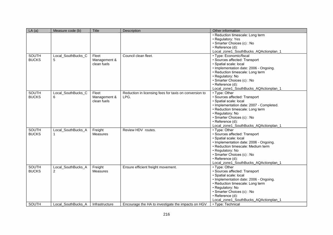
216
LA (a) Measure code (b) Title Description Other information
• Reduction timescale: Long term • Regulatory: Yes • Smarter Choices (c) : No • Reference (d): Local_zone1_SouthBucks_AQActionplan_1
SOUTH BUCKS
Local_SouthBucks_C5
Fleet Management & clean fuels
Council clean fleet. • Type: Economic/fiscal • Sources affected: Transport • Spatial scale: local • Implementation date: 2006 - Ongoing. • Reduction timescale: Long term • Regulatory: No • Smarter Choices (c) : No • Reference (d): Local_zone1_SouthBucks_AQActionplan_1
SOUTH BUCKS
Local_SouthBucks_C6
Fleet Management & clean fuels
Reduction in licensing fees for taxis on conversion to LPG.
• Type: Other • Sources affected: Transport • Spatial scale: local • Implementation date: 2007 - Completed. • Reduction timescale: Long term • Regulatory: No • Smarter Choices (c) : No • Reference (d): Local_zone1_SouthBucks_AQActionplan_1
SOUTH BUCKS
Local_SouthBucks_A1
Freight Measures
Review HDV routes. • Type: Other • Sources affected: Transport • Spatial scale: local • Implementation date: 2006 - Ongoing. • Reduction timescale: Medium term • Regulatory: No • Smarter Choices (c) : No • Reference (d): Local_zone1_SouthBucks_AQActionplan_1
SOUTH BUCKS
Local_SouthBucks_A2
Freight Measures
Ensure efficient freight movement. • Type: Other • Sources affected: Transport • Spatial scale: local • Implementation date: 2006 - Ongoing. • Reduction timescale: Long term • Regulatory: No • Smarter Choices (c) : No • Reference (d): Local_zone1_SouthBucks_AQActionplan_1
SOUTH Local_SouthBucks_A Infrastructure Encourage the HA to investigate the impacts on HGV • Type: Technical
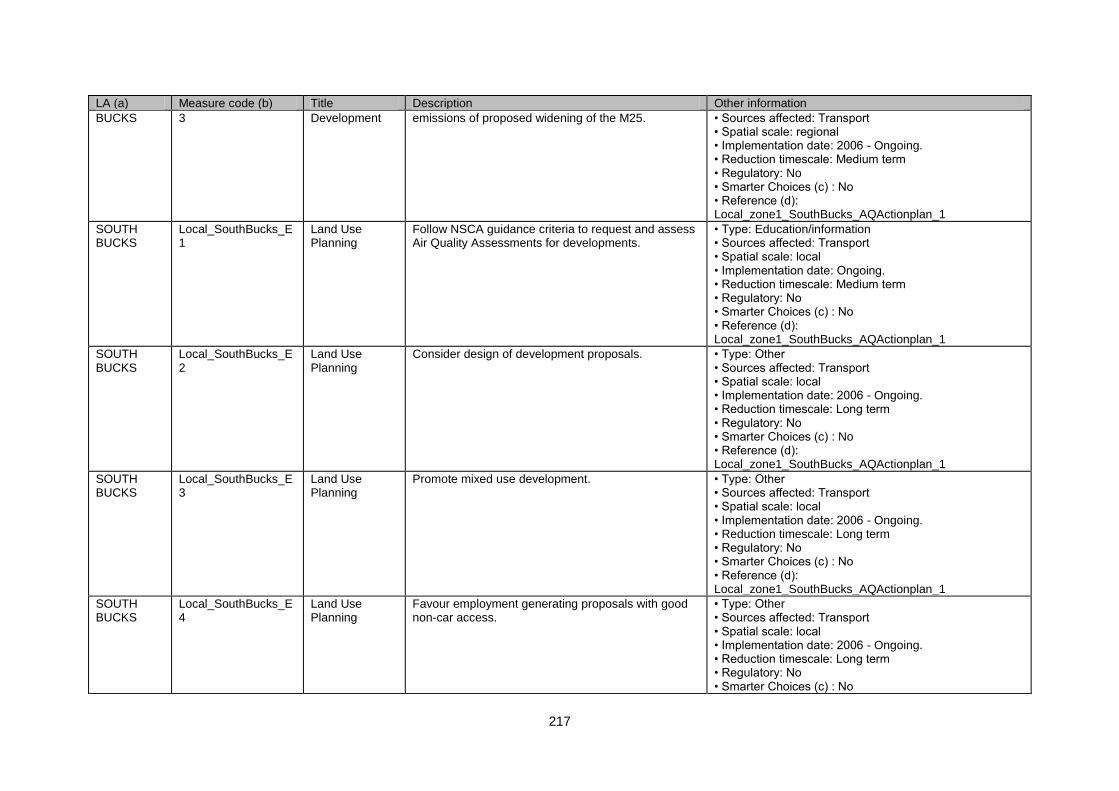
217
LA (a) Measure code (b) Title Description Other information
BUCKS 3 Development emissions of proposed widening of the M25. • Sources affected: Transport • Spatial scale: regional • Implementation date: 2006 - Ongoing. • Reduction timescale: Medium term • Regulatory: No • Smarter Choices (c) : No • Reference (d): Local_zone1_SouthBucks_AQActionplan_1
SOUTH BUCKS
Local_SouthBucks_E1
Land Use Planning
Follow NSCA guidance criteria to request and assess Air Quality Assessments for developments.
• Type: Education/information • Sources affected: Transport • Spatial scale: local • Implementation date: Ongoing. • Reduction timescale: Medium term • Regulatory: No • Smarter Choices (c) : No • Reference (d): Local_zone1_SouthBucks_AQActionplan_1
SOUTH BUCKS
Local_SouthBucks_E2
Land Use Planning
Consider design of development proposals. • Type: Other • Sources affected: Transport • Spatial scale: local • Implementation date: 2006 - Ongoing. • Reduction timescale: Long term • Regulatory: No • Smarter Choices (c) : No • Reference (d): Local_zone1_SouthBucks_AQActionplan_1
SOUTH BUCKS
Local_SouthBucks_E3
Land Use Planning
Promote mixed use development. • Type: Other • Sources affected: Transport • Spatial scale: local • Implementation date: 2006 - Ongoing. • Reduction timescale: Long term • Regulatory: No • Smarter Choices (c) : No • Reference (d): Local_zone1_SouthBucks_AQActionplan_1
SOUTH BUCKS
Local_SouthBucks_E4
Land Use Planning
Favour employment generating proposals with good non-car access.
• Type: Other • Sources affected: Transport • Spatial scale: local • Implementation date: 2006 - Ongoing. • Reduction timescale: Long term • Regulatory: No • Smarter Choices (c) : No
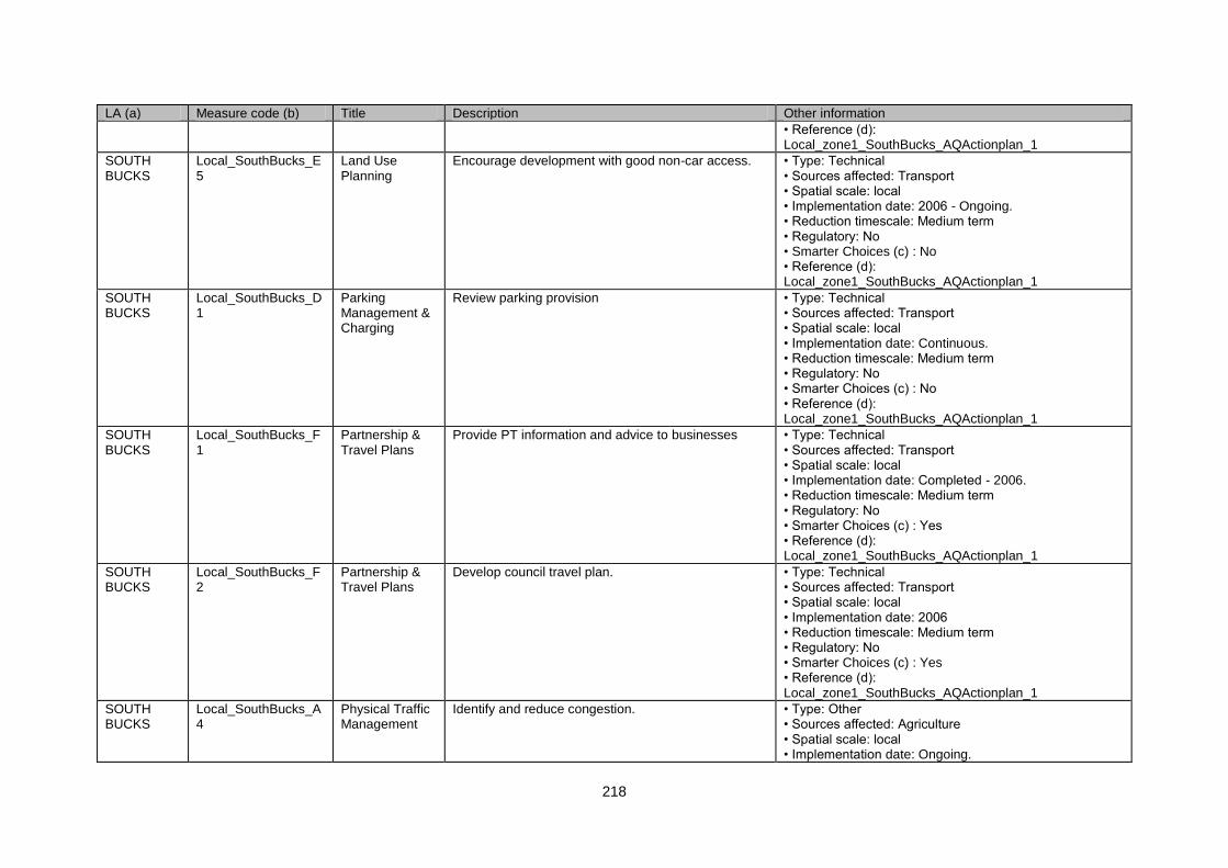
218
LA (a) Measure code (b) Title Description Other information
• Reference (d): Local_zone1_SouthBucks_AQActionplan_1
SOUTH BUCKS
Local_SouthBucks_E5
Land Use Planning
Encourage development with good non-car access. • Type: Technical • Sources affected: Transport • Spatial scale: local • Implementation date: 2006 - Ongoing. • Reduction timescale: Medium term • Regulatory: No • Smarter Choices (c) : No • Reference (d): Local_zone1_SouthBucks_AQActionplan_1
SOUTH BUCKS
Local_SouthBucks_D1
Parking Management & Charging
Review parking provision • Type: Technical • Sources affected: Transport • Spatial scale: local • Implementation date: Continuous. • Reduction timescale: Medium term • Regulatory: No • Smarter Choices (c) : No • Reference (d): Local_zone1_SouthBucks_AQActionplan_1
SOUTH BUCKS
Local_SouthBucks_F1
Partnership & Travel Plans
Provide PT information and advice to businesses • Type: Technical • Sources affected: Transport • Spatial scale: local • Implementation date: Completed - 2006. • Reduction timescale: Medium term • Regulatory: No • Smarter Choices (c) : Yes • Reference (d): Local_zone1_SouthBucks_AQActionplan_1
SOUTH BUCKS
Local_SouthBucks_F2
Partnership & Travel Plans
Develop council travel plan. • Type: Technical • Sources affected: Transport • Spatial scale: local • Implementation date: 2006 • Reduction timescale: Medium term • Regulatory: No • Smarter Choices (c) : Yes • Reference (d): Local_zone1_SouthBucks_AQActionplan_1
SOUTH BUCKS
Local_SouthBucks_A4
Physical Traffic Management
Identify and reduce congestion. • Type: Other • Sources affected: Agriculture • Spatial scale: local • Implementation date: Ongoing.
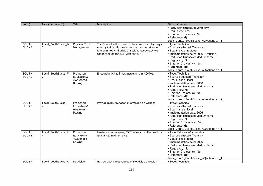
219
LA (a) Measure code (b) Title Description Other information
• Reduction timescale: Long term • Regulatory: Yes • Smarter Choices (c) : No • Reference (d): Local_zone1_SouthBucks_AQActionplan_1
SOUTH BUCKS
Local_SouthBucks_A5
Physical Traffic Management
The Council will continue to liaise with the Highways Agency to identify measures that can be taken to reduce nitrogen dioxide emissions associated with congestion on the M4, M40 and M25.
• Type: Technical • Sources affected: Transport • Spatial scale: regional • Implementation date: 2006 - Ongoing. • Reduction timescale: Medium term • Regulatory: No • Smarter Choices (c) : No • Reference (d): Local_zone1_SouthBucks_AQActionplan_1
SOUTH BUCKS
Local_SouthBucks_F3
Promotion, Education & Awareness Raising
Encourage HA to investigate signs in AQMAs. • Type: Technical • Sources affected: Transport • Spatial scale: local • Implementation date: 2006 • Reduction timescale: Medium term • Regulatory: No • Smarter Choices (c) : No • Reference (d): Local_zone1_SouthBucks_AQActionplan_1
SOUTH BUCKS
Local_SouthBucks_F4
Promotion, Education & Awareness Raising
Provide public transport information on website. • Type: Technical • Sources affected: Transport • Spatial scale: local • Implementation date: 2006 • Reduction timescale: Medium term • Regulatory: No • Smarter Choices (c) : Yes • Reference (d): Local_zone1_SouthBucks_AQActionplan_1
SOUTH BUCKS
Local_SouthBucks_F5
Promotion, Education & Awareness Raising
Leaflets to accompany MOT advising of the need for regular car maintenance.
• Type: Education/information • Sources affected: Transport • Spatial scale: local • Implementation date: 2006 • Reduction timescale: Medium term • Regulatory: No • Smarter Choices (c) : No • Reference (d): Local_zone1_SouthBucks_AQActionplan_1
SOUTH Local_SouthBucks_A Roadside Review cost effectiveness of Roadside emission • Type: Technical
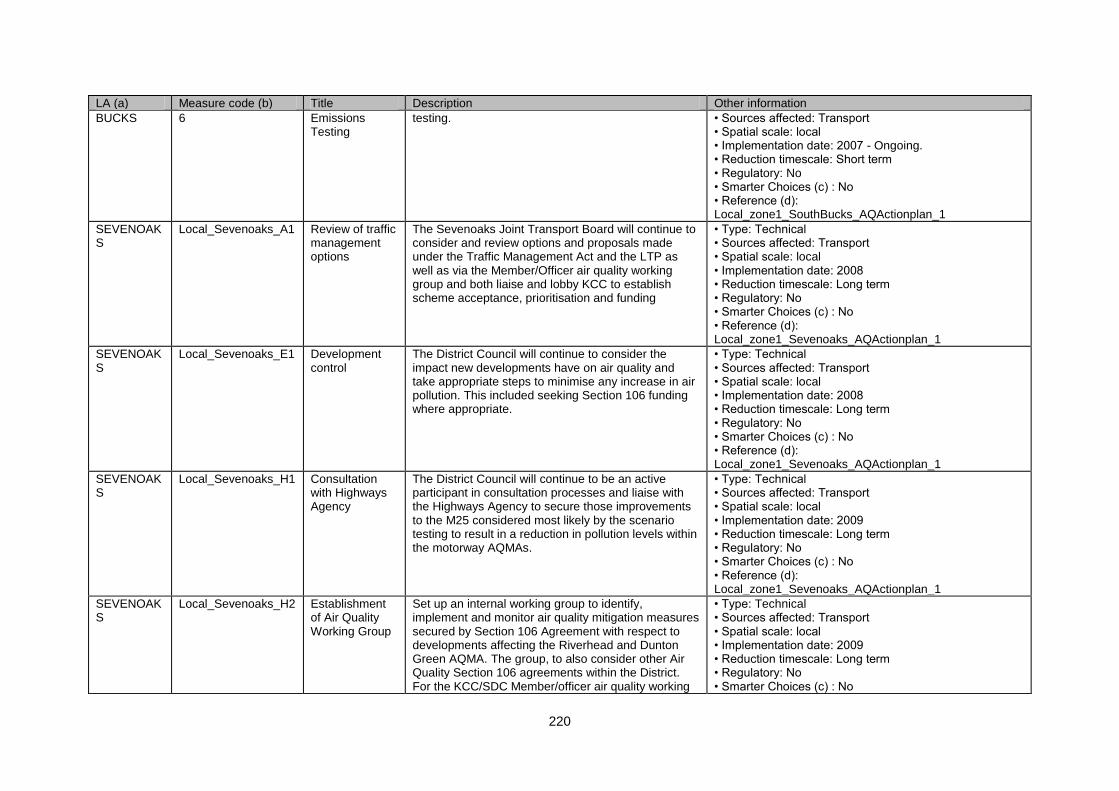
220
LA (a) Measure code (b) Title Description Other information
BUCKS 6 Emissions Testing
testing. • Sources affected: Transport • Spatial scale: local • Implementation date: 2007 - Ongoing. • Reduction timescale: Short term • Regulatory: No • Smarter Choices (c) : No • Reference (d): Local_zone1_SouthBucks_AQActionplan_1
SEVENOAKS
Local_Sevenoaks_A1 Review of traffic management options
The Sevenoaks Joint Transport Board will continue to consider and review options and proposals made under the Traffic Management Act and the LTP as well as via the Member/Officer air quality working group and both liaise and lobby KCC to establish scheme acceptance, prioritisation and funding
• Type: Technical • Sources affected: Transport • Spatial scale: local • Implementation date: 2008 • Reduction timescale: Long term • Regulatory: No • Smarter Choices (c) : No • Reference (d): Local_zone1_Sevenoaks_AQActionplan_1
SEVENOAKS
Local_Sevenoaks_E1 Development control
The District Council will continue to consider the impact new developments have on air quality and take appropriate steps to minimise any increase in air pollution. This included seeking Section 106 funding where appropriate.
• Type: Technical • Sources affected: Transport • Spatial scale: local • Implementation date: 2008 • Reduction timescale: Long term • Regulatory: No • Smarter Choices (c) : No • Reference (d): Local_zone1_Sevenoaks_AQActionplan_1
SEVENOAKS
Local_Sevenoaks_H1 Consultation with Highways Agency
The District Council will continue to be an active participant in consultation processes and liaise with the Highways Agency to secure those improvements to the M25 considered most likely by the scenario testing to result in a reduction in pollution levels within the motorway AQMAs.
• Type: Technical • Sources affected: Transport • Spatial scale: local • Implementation date: 2009 • Reduction timescale: Long term • Regulatory: No • Smarter Choices (c) : No • Reference (d): Local_zone1_Sevenoaks_AQActionplan_1
SEVENOAKS
Local_Sevenoaks_H2 Establishment of Air Quality Working Group
Set up an internal working group to identify, implement and monitor air quality mitigation measures secured by Section 106 Agreement with respect to developments affecting the Riverhead and Dunton Green AQMA. The group, to also consider other Air Quality Section 106 agreements within the District. For the KCC/SDC Member/officer air quality working
• Type: Technical • Sources affected: Transport • Spatial scale: local • Implementation date: 2009 • Reduction timescale: Long term • Regulatory: No • Smarter Choices (c) : No
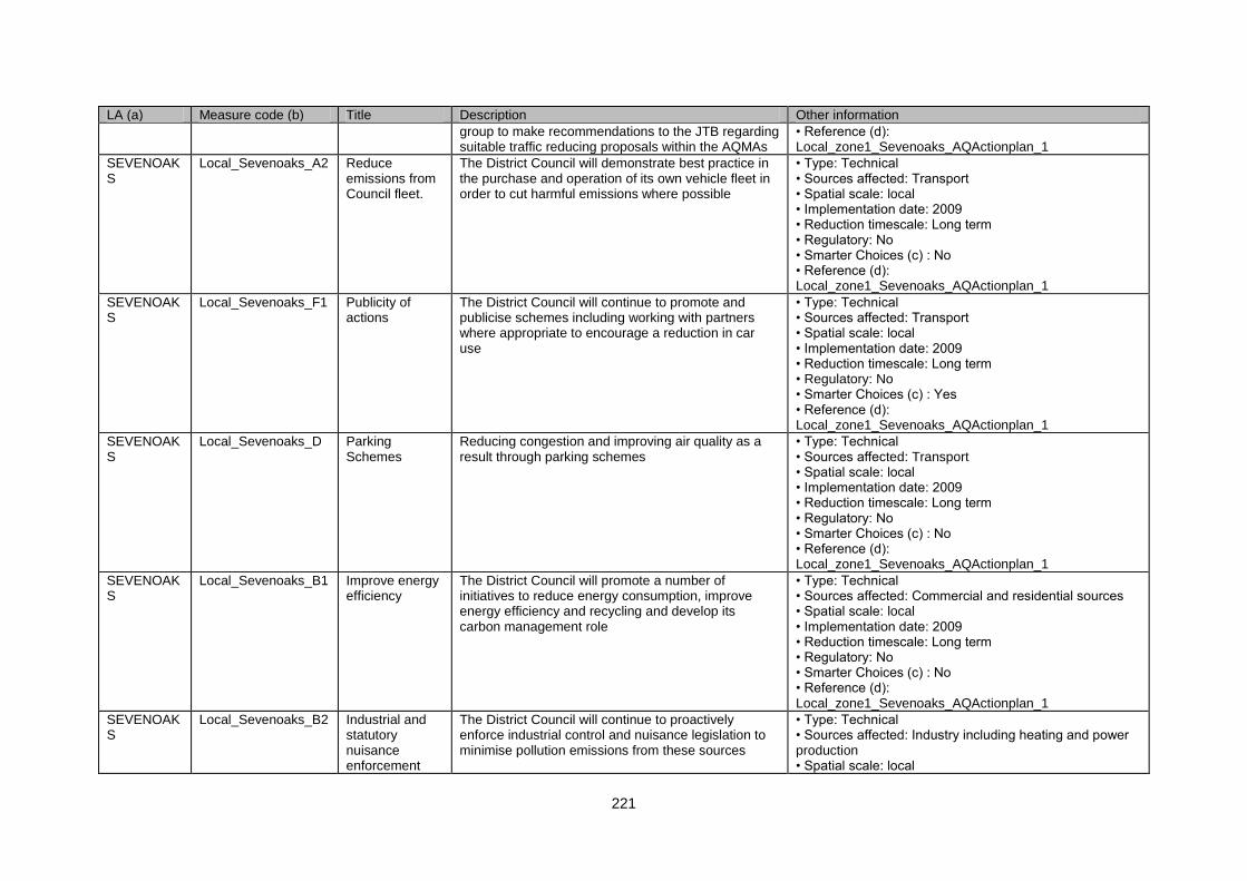
221
LA (a) Measure code (b) Title Description Other information
group to make recommendations to the JTB regarding suitable traffic reducing proposals within the AQMAs
• Reference (d): Local_zone1_Sevenoaks_AQActionplan_1
SEVENOAKS
Local_Sevenoaks_A2 Reduce emissions from Council fleet.
The District Council will demonstrate best practice in the purchase and operation of its own vehicle fleet in order to cut harmful emissions where possible
• Type: Technical • Sources affected: Transport • Spatial scale: local • Implementation date: 2009 • Reduction timescale: Long term • Regulatory: No • Smarter Choices (c) : No • Reference (d): Local_zone1_Sevenoaks_AQActionplan_1
SEVENOAKS
Local_Sevenoaks_F1 Publicity of actions
The District Council will continue to promote and publicise schemes including working with partners where appropriate to encourage a reduction in car use
• Type: Technical • Sources affected: Transport • Spatial scale: local • Implementation date: 2009 • Reduction timescale: Long term • Regulatory: No • Smarter Choices (c) : Yes • Reference (d): Local_zone1_Sevenoaks_AQActionplan_1
SEVENOAKS
Local_Sevenoaks_D Parking Schemes
Reducing congestion and improving air quality as a result through parking schemes
• Type: Technical • Sources affected: Transport • Spatial scale: local • Implementation date: 2009 • Reduction timescale: Long term • Regulatory: No • Smarter Choices (c) : No • Reference (d): Local_zone1_Sevenoaks_AQActionplan_1
SEVENOAKS
Local_Sevenoaks_B1 Improve energy efficiency
The District Council will promote a number of initiatives to reduce energy consumption, improve energy efficiency and recycling and develop its carbon management role
• Type: Technical • Sources affected: Commercial and residential sources • Spatial scale: local • Implementation date: 2009 • Reduction timescale: Long term • Regulatory: No • Smarter Choices (c) : No • Reference (d): Local_zone1_Sevenoaks_AQActionplan_1
SEVENOAKS
Local_Sevenoaks_B2 Industrial and statutory nuisance enforcement
The District Council will continue to proactively enforce industrial control and nuisance legislation to minimise pollution emissions from these sources
• Type: Technical • Sources affected: Industry including heating and power production • Spatial scale: local
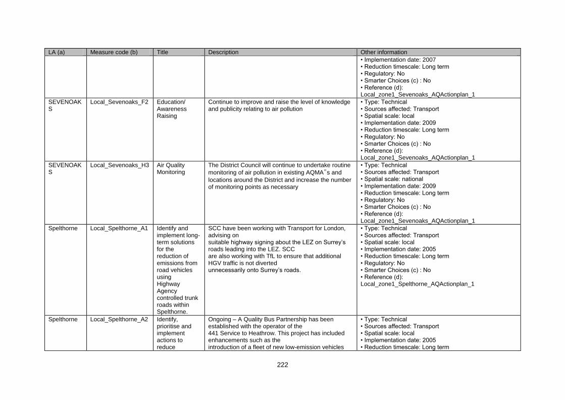
222
LA (a) Measure code (b) Title Description Other information
• Implementation date: 2007 • Reduction timescale: Long term • Regulatory: No • Smarter Choices (c) : No • Reference (d): Local_zone1_Sevenoaks_AQActionplan_1
SEVENOAKS
Local_Sevenoaks_F2 Education/ Awareness Raising
Continue to improve and raise the level of knowledge and publicity relating to air pollution
• Type: Technical • Sources affected: Transport • Spatial scale: local • Implementation date: 2009 • Reduction timescale: Long term • Regulatory: No • Smarter Choices (c) : No • Reference (d): Local_zone1_Sevenoaks_AQActionplan_1
SEVENOAKS
Local_Sevenoaks_H3 Air Quality Monitoring
The District Council will continue to undertake routine
monitoring of air pollution in existing AQMA‟s and
locations around the District and increase the number of monitoring points as necessary
• Type: Technical • Sources affected: Transport • Spatial scale: national • Implementation date: 2009 • Reduction timescale: Long term • Regulatory: No • Smarter Choices (c) : No • Reference (d): Local_zone1_Sevenoaks_AQActionplan_1
Spelthorne Local_Spelthorne_A1 Identify and implement long-term solutions for the reduction of emissions from road vehicles using Highway Agency controlled trunk roads within Spelthorne.
SCC have been working with Transport for London, advising on suitable highway signing about the LEZ on Surrey‟s roads leading into the LEZ. SCC are also working with TfL to ensure that additional HGV traffic is not diverted unnecessarily onto Surrey‟s roads.
• Type: Technical • Sources affected: Transport • Spatial scale: local • Implementation date: 2005 • Reduction timescale: Long term • Regulatory: No • Smarter Choices (c) : No • Reference (d): Local_zone1_Spelthorne_AQActionplan_1
Spelthorne Local_Spelthorne_A2 Identify, prioritise and implement actions to reduce
Ongoing – A Quality Bus Partnership has been established with the operator of the 441 Service to Heathrow. This project has included enhancements such as the introduction of a fleet of new low-emission vehicles
• Type: Technical • Sources affected: Transport • Spatial scale: local • Implementation date: 2005 • Reduction timescale: Long term
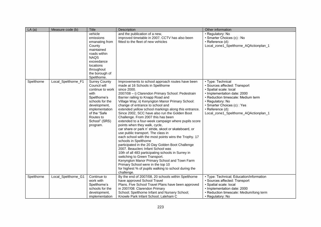
223
LA (a) Measure code (b) Title Description Other information
vehicle emissions emanating from County maintained roads within NAQS exceedance locations throughout the borough of Spelthorne.
and the publication of a new, improved timetable in 2007. CCTV has also been fitted to the fleet of new vehicles
• Regulatory: No • Smarter Choices (c) : No • Reference (d): Local_zone1_Spelthorne_AQActionplan_1
Spelthorne Local_Spelthorne_F1 Surrey County Council will continue to work with Spelthorne‟s schools for the development, implementation of the “Safe Routes to School” (SRS) program.
Improvements to school approach routes have been made at 16 Schools in Spelthorne since 2000. 2007/08 – i) Clarendon Primary School: Pedestrain Barrier railing to Knapp Road and Village Way; ii) Kenyngton Manor Primary School: change of entrance to school and extended yellow school markings along this entrance. Since 2002, SCC have also run the Golden Boot Challenge. From 2007 this has been extended to a four-week campaign where pupils score points when they walk, cycle, car share or park n‟ stride, skoot or skateboard, or use public transport. The class in each school with the most points wins the Trophy. 17 schools in Spelthorne participated in the 20 Day Golden Boot Challenge 2007. Beauclerc Infant School was 10th of all 483 participating schools in Surrey in switching to Green Transport. Kenyngton Manor Primary School and Town Farm Primary School were in the top 10 for highest % of pupils walking to school during the challenge.
• Type: Technical • Sources affected: Transport • Spatial scale: local • Implementation date: 2000 • Reduction timescale: Medium term • Regulatory: No • Smarter Choices (c) : Yes • Reference (d): Local_zone1_Spelthorne_AQActionplan_1
Spelthorne Local_Spelthorne_G1 Continue to work with Spelthorne‟s schools for the development, implementation
By the end of 2007/08, 20 schools within Spelthorne have approved School Travel Plans. Five School Travel Plans have been approved in 2007/08: Clarendon Primary School; Spelthorne Infant and Nursery School; Knowle Park Infant School; Laleham C
• Type: Technical; Education/information • Sources affected: Transport • Spatial scale: local • Implementation date: 2000 • Reduction timescale: Medium/long term • Regulatory: No
224
LA (a) Measure code (b) Title Description Other information
and the annual review of School Travel Plans.
Of E Primary School; and Kenyngton manor Primary School. A further six schools are expected to have TPs approved in 2008/09. This would leave only 7 schools in the Borough without a TP. Progress on Actions in School Travel Plans is available on SCC‟s website. A total of 305 extra cycle parking places have been provided at 12 schools within the borough since 2000. In 2007/08 20 new places and a new shelter have been provided at Our Lady of the Rosary R.C. Primary School.
• Smarter Choices (c) : Yes • Reference (d): Local_zone1_Spelthorne_AQActionplan_1
Spelthorne Local_Spelthorne_G2 Continue to work with schools in Spelthorne help organise “Walking Buses” & “Cycling Buses”.
2007/08 – There are now 3 walking bus schemes operating in Spelthorne: Spelthorne Infant & Nursery School; The Hythe School; and Knowle Park Infant School – the latter has 15 pupils using the scheme on a daily basis.
• Type: Technical; Education/information • Sources affected: Transport • Spatial scale: local • Implementation date: 2005 • Reduction timescale: Medium term • Regulatory: No • Smarter Choices (c) : Yes • Reference (d): Local_zone1_Spelthorne_AQActionplan_1
Spelthorne Local_Spelthorne_G3 Continue to work to help schools teach pupils cycling proficiency training and cycle skills.
2006/07 – Cycling Proficiency training was given to 363 pupils from 7 schools, while a further 1845 pupils from 28 schools completed other cycling training schemes.
• Type: Technical; Education/information • Sources affected: Transport • Spatial scale: local • Implementation date: 2000 • Reduction timescale: Medium/long term • Regulatory: No • Smarter Choices (c) : No • Reference (d): Local_zone1_Spelthorne_AQActionplan_1
Spelthorne Local_Spelthorne_G4 Mobility Management & Travel Planning
SCC provides road reports to local radio stations; and their website provides details of Road and Street works that effect travel. 2007 – 19 Bus routes in Spelthorne now operate with low-floor accessible buses.
• Type: Technical • Sources affected: Transport • Spatial scale: local • Implementation date: 2005 • Reduction timescale: Long term • Regulatory: No • Smarter Choices (c) : No • Reference (d): Local_zone1_Spelthorne_AQActionplan_1
Spelthorne Local_Spelthorne_A3 Install vehicle activated signs to control road
Mobile vehicle activated signs are now used around the borough in selected locations to control traffic speeds, together with a ‟30 mph‟ post
• Type: Technical • Sources affected: Transport • Spatial scale: local
225
LA (a) Measure code (b) Title Description Other information
traffic speeds at appropriate locations within Spelthorne.
campaign and special „snail‟ posters outside schools. 2006/07 - The Surrey Safety Camera Partnership invested in 26 new mobile vehicle activated signs (VAS) on the approach to safety camera sites, to remind drivers of the limits and to warn of the enforcement.
• Implementation date: 2000 • Reduction timescale: Long term • Regulatory: No • Smarter Choices (c) : No • Reference (d): Local_zone1_Spelthorne_AQActionplan_1
Spelthorne Local_Spelthorne_G Encouraging Walking
SCC Network Management Centre (NMIC) opened in 2004 and is already allowing much closer integration and coordination of SCC‟s traffic management systems. Over the next 5 years the NMIC will increasingly focus on better management of the network, such as real-time surveillance of key congestion hotspots allowing for quick intervention to tackle problems. 2007 - a „real-time‟ Car Park Monitoring and Information System was launched in Staines – providing information to motorists on the number of spaces available in the town‟s main public car parks, via a network of new Variable Message Signs (VMS). A Christmas Park & Ride bus scheme has been in use in Staines for a number of years. 2007 - The Surrey Car Share website – the countywide database for sharing car journeys - now has 2100 members and SCC are continuing to recruit more companies and individuals to join, with a target of 3000 members by 2008.
• Type: Technical • Sources affected: Transport • Spatial scale: local • Implementation date: 2005 • Reduction timescale: Long term • Regulatory: No • Smarter Choices (c) : Yes • Reference (d): Local_zone1_Spelthorne_AQActionplan_1
Spelthorne Local_Spelthorne_D1 Implement decriminalised parking enforcement within the borough of Spelthorne
Spelthorne Borough Council acts as an agent of Surrey County Council to implement Decriminalised Parking Enforcement (DPE) yellow line restrictions. A review of the Decriminalised Parking Enforcement (DPE) is to happen in 2008 exploring how DPE can be better managed to deliver and improved service for the community with the aim of reducing traffic levels and congestion.
• Type: Technical • Sources affected: Transport • Spatial scale: local • Implementation date: 2005 • Reduction timescale: Long term • Regulatory: No • Smarter Choices (c) : No • Reference (d): Local_zone1_Spelthorne_AQActionplan_1
Spelthorne Local_Spelthorne_D2 Publicise the Significant publicity has been undertaken through • Type: Technical
226
LA (a) Measure code (b) Title Description Other information
establishment of decriminalised parking enforcement within the borough of Spelthorne
local press and the Borough Bulletin to inform Spelthorne residents of the new enforcement regime
• Sources affected: Transport • Spatial scale: local • Implementation date: 2005 • Reduction timescale: Long term • Regulatory: No • Smarter Choices (c) : No • Reference (d): Local_zone1_Spelthorne_AQActionplan_1
Spelthorne Local_Spelthorne_A4 Carry out a feasibility study into the development of a lorry routing strategy.
2007 - A Freight Quality Partnership (FQP) for north-west Surrey was established and a routing strategy for the Woking transport hub has been developed. A lorry route strategy and signing scheme is being developed for the remainder of the north-west area.
• Type: Technical • Sources affected: Transport • Spatial scale: local • Implementation date: 2004 • Reduction timescale: Long term • Regulatory: No • Smarter Choices (c) : No • Reference (d): Local_zone1_Spelthorne_AQActionplan_1
Spelthorne Local_Spelthorne_G5 Promote bus travel as a good alternative form of transport to the car and improve facilities at bus stops within Spelthorne.
Promote bus travel as a good alternative form of transport to the car and improve facilities at bus stops within Spelthorne.
• Type: Education/information • Sources affected: Transport • Spatial scale: local • Implementation date: 2004 • Reduction timescale: Long term • Regulatory: No • Smarter Choices (c) : Yes • Reference (d): Local_zone1_Spelthorne_AQActionplan_1
Spelthorne Local_Spelthorne_A5 Buses operating along critical corridors within the borough of Spelthorne will be encouraged to have Euro III compliant engines.
Buses operating along critical corridors within the borough of Spelthorne will be encouraged to have Euro III compliant engines.
• Type: Technical • Sources affected: Transport • Spatial scale: local • Implementation date: 2004 • Reduction timescale: Long term • Regulatory: No • Smarter Choices (c) : No • Reference (d): Local_zone1_Spelthorne_AQActionplan_1
Spelthorne Local_Spelthorne_E1 Bus prioritised infrastructure will be installed at strategic locations
Bus prioritised infrastructure will be installed at strategic locations throughout Spelthorne.
• Type: Technical • Sources affected: Transport • Spatial scale: local • Implementation date: 2004 • Reduction timescale: Long term

227
LA (a) Measure code (b) Title Description Other information
throughout Spelthorne.
• Regulatory: No • Smarter Choices (c) : No • Reference (d): Local_zone1_Spelthorne_AQActionplan_1
Spelthorne Local_Spelthorne_A6 Improved access to railway stations within Spelthorne
Much of the work has been completed. However, over the next 5 years SCC will identify further access improvements and working with train operating companies to provide improved cycle storage facilities, especially at Staines station.
• Type: Technical • Sources affected: Transport • Spatial scale: local • Implementation date: 2006 • Reduction timescale: Long term • Regulatory: No • Smarter Choices (c) : No • Reference (d): Local_zone1_Spelthorne_AQActionplan_1
Spelthorne Local_Spelthorne_G6 SCC has set a Countywide target to increase the number of journeys made by cycle by 20%, using 2005/06 as the base level, by 2010.
SCC has set up 12 cycle monitoring stations on cycle routes within Spelthorne during 2005 to establish base-level data and monitor progress locally. 2005 ~ SCC (with support from Spelthorne LSP) held an “In Town without my Car” event in Staines.
• Type: Technical • Sources affected: Transport • Spatial scale: local • Implementation date: 2001 - previous target 2006 - this target • Reduction timescale: Long term • Regulatory: No • Smarter Choices (c) : Yes • Reference (d): Local_zone1_Spelthorne_AQActionplan_1
Spelthorne Local_Spelthorne_G7 Inprove National Cycle Route 4 between Ferry Point (Shepperton) and Staines Bridge via Laleham & the River Thames
Work has commenced with route signing and cycle lane facilities. Ferry Point to Chertsey Road (Shepperton) Cycle track completed (April 2005). Remainder of improvements planned for 2005 to 2008
• Type: Technical • Sources affected: Transport • Spatial scale: local • Implementation date: 2005 • Reduction timescale: Long term • Regulatory: No • Smarter Choices (c) : No • Reference (d): Local_zone1_Spelthorne_AQActionplan_1
Spelthorne Local_Spelthorne_G8 The production of a series of Cycle Guides that will detail all the cycle routes throughout Surrey.
Completed (April 2004). 2007/08 - Cycle guides have been updated in March 2008 to include the latest cycle improvements. Further promotion and publicity has accompanied the guides.
• Type: Technical • Sources affected: Transport • Spatial scale: local • Implementation date: 2004 • Reduction timescale: Long term • Regulatory: No • Smarter Choices (c) : Yes • Reference (d): Local_zone1_Spelthorne_AQActionplan_1
228
LA (a) Measure code (b) Title Description Other information
Spelthorne Local_Spelthorne_C1 Promote the use of “cleaner technology and fuels” within Spelthorne.
Information about of “cleaner technology and fuels” have been placed on the Council‟s website and within the Borough Bulletin. Ongoing.
• Type: Education/information • Sources affected: Transport • Spatial scale: local • Implementation date: 2005 • Reduction timescale: Long term • Regulatory: No • Smarter Choices (c) : No • Reference (d): Local_zone1_Spelthorne_AQActionplan_1
Spelthorne Local_Spelthorne_G9 Promote the development and implementation of “business travel plans” by companies located within the borough of Spelthorne.
The majority of the largest employers in the borough of Spelthorne have business travel plans. Such companies include: BP (Sunbury), Ashford Hospital, Spelthorne Borough Council, and BUPA. Where large commercial redevelopment proposals are considered to make an impact on air quality, travel plans are required by virtue of Planning Condition. SCC will continue to work closely with Thorpe Park on providing an excellent Rail & Ride (Thorpe Park Express Bus) facility from Staines station to Thorpe Park during the theme parks operating period. 2005 ~ SCC web site allows for travel planning, using all modes of transport, from start to end destination using fully integrated travel means
• Type: Technical • Sources affected: Transport • Spatial scale: local • Implementation date: 2005 • Reduction timescale: Long term • Regulatory: No • Smarter Choices (c) : Yes • Reference (d): Local_zone1_Spelthorne_AQActionplan_1
Spelthorne Local_Spelthorne_H1 Car Share Scheme
Reduce car dependency and facilitate transport choice by encouraging alternatives to car use along with changes in working arrangements.
• Type: Technical • Sources affected: Transport • Spatial scale: local • Implementation date: 2005 • Reduction timescale: Long term • Regulatory: No • Smarter Choices (c) : Yes • Reference (d): Local_zone1_Spelthorne_AQActionplan_1
Spelthorne Local_Spelthorne_G10
Spelthorne Borough Council‟s Business Travel Plan.
This review took place in 2006 to link into Surrey‟s Local Transportation Plan 2
• Type: Technical • Sources affected: Transport • Spatial scale: local • Implementation date: 2005 • Reduction timescale: Long term • Regulatory: No • Smarter Choices (c) : Yes
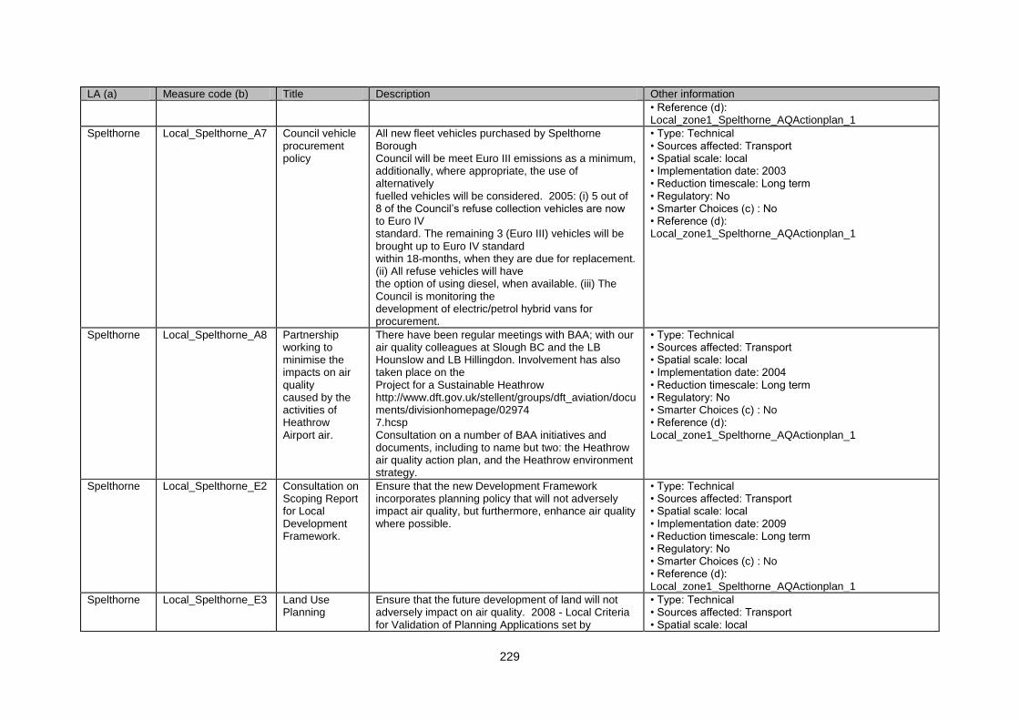
229
LA (a) Measure code (b) Title Description Other information
• Reference (d): Local_zone1_Spelthorne_AQActionplan_1
Spelthorne Local_Spelthorne_A7 Council vehicle procurement policy
All new fleet vehicles purchased by Spelthorne Borough Council will be meet Euro III emissions as a minimum, additionally, where appropriate, the use of alternatively fuelled vehicles will be considered. 2005: (i) 5 out of 8 of the Council‟s refuse collection vehicles are now to Euro IV standard. The remaining 3 (Euro III) vehicles will be brought up to Euro IV standard within 18-months, when they are due for replacement. (ii) All refuse vehicles will have the option of using diesel, when available. (iii) The Council is monitoring the development of electric/petrol hybrid vans for procurement.
• Type: Technical • Sources affected: Transport • Spatial scale: local • Implementation date: 2003 • Reduction timescale: Long term • Regulatory: No • Smarter Choices (c) : No • Reference (d): Local_zone1_Spelthorne_AQActionplan_1
Spelthorne Local_Spelthorne_A8 Partnership working to minimise the impacts on air quality caused by the activities of Heathrow Airport air.
There have been regular meetings with BAA; with our air quality colleagues at Slough BC and the LB Hounslow and LB Hillingdon. Involvement has also taken place on the Project for a Sustainable Heathrow http://www.dft.gov.uk/stellent/groups/dft_aviation/documents/divisionhomepage/02974 7.hcsp Consultation on a number of BAA initiatives and documents, including to name but two: the Heathrow air quality action plan, and the Heathrow environment strategy.
• Type: Technical • Sources affected: Transport • Spatial scale: local • Implementation date: 2004 • Reduction timescale: Long term • Regulatory: No • Smarter Choices (c) : No • Reference (d): Local_zone1_Spelthorne_AQActionplan_1
Spelthorne Local_Spelthorne_E2 Consultation on Scoping Report for Local Development Framework.
Ensure that the new Development Framework incorporates planning policy that will not adversely impact air quality, but furthermore, enhance air quality where possible.
• Type: Technical • Sources affected: Transport • Spatial scale: local • Implementation date: 2009 • Reduction timescale: Long term • Regulatory: No • Smarter Choices (c) : No • Reference (d): Local_zone1_Spelthorne_AQActionplan_1
Spelthorne Local_Spelthorne_E3 Land Use Planning
Ensure that the future development of land will not adversely impact on air quality. 2008 - Local Criteria for Validation of Planning Applications set by
• Type: Technical • Sources affected: Transport • Spatial scale: local

230
LA (a) Measure code (b) Title Description Other information
Spelthorne will require an air quality assessment to be submitted with any application for a major project.
• Implementation date: 2005 • Reduction timescale: Long term • Regulatory: No • Smarter Choices (c) : No • Reference (d): Local_zone1_Spelthorne_AQActionplan_1
Spelthorne Local_Spelthorne_B1 Continue to ensure that emissions from all „prescribed processes‟ remain controlled and regulated in line with national policy.
100% of programmed inspections completed for each year.
• Type: Technical • Sources affected: Transport • Spatial scale: local • Implementation date: 2000 • Reduction timescale: Long term • Regulatory: No • Smarter Choices (c) : No • Reference (d): Local_zone1_Spelthorne_AQActionplan_1
Spelthorne Local_Spelthorne_F2 Awareness Raising
Raise the public‟s awareness of initiatives that will improve the quality of air within the borough of Spelthorne.
• Type: Technical • Sources affected: Transport • Spatial scale: local • Implementation date: 2000 • Reduction timescale: Long term • Regulatory: No • Smarter Choices (c) : Yes • Reference (d): Local_zone1_Spelthorne_AQActionplan_1
Spelthorne Local_Spelthorne_H2 Partnership working
Spelthorne Borough Council will continue to work, in partnership with its neighbouring boroughs and others for the control of air pollution and continued improvement of air quality.
• Type: Technical • Sources affected: Transport • Spatial scale: local • Implementation date: 2004 • Reduction timescale: Long term • Regulatory: No • Smarter Choices (c) : No • Reference (d): Local_zone1_Spelthorne_AQActionplan_1
Spelthorne Local_Spelthorne_H3 Partnership working
Spelthorne Borough Council will seek opportunities for effective partnerships for the continued improvement of air quality
• Type: Technical • Sources affected: Transport • Spatial scale: local • Implementation date: 2005 • Reduction timescale: Long term • Regulatory: No • Smarter Choices (c) : No • Reference (d):
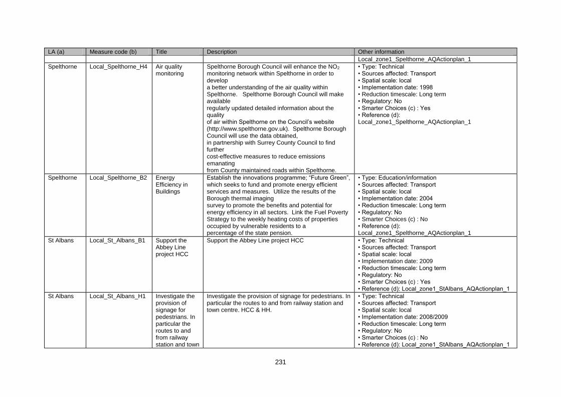
231
LA (a) Measure code (b) Title Description Other information
Local_zone1_Spelthorne_AQActionplan_1
Spelthorne Local_Spelthorne_H4 Air quality monitoring
Spelthorne Borough Council will enhance the NO2 monitoring network within Spelthorne in order to develop a better understanding of the air quality within Spelthorne. Spelthorne Borough Council will make available regularly updated detailed information about the quality of air within Spelthorne on the Council‟s website (http://www.spelthorne.gov.uk). Spelthorne Borough Council will use the data obtained, in partnership with Surrey County Council to find further cost-effective measures to reduce emissions emanating from County maintained roads within Spelthorne.
• Type: Technical • Sources affected: Transport • Spatial scale: local • Implementation date: 1998 • Reduction timescale: Long term • Regulatory: No • Smarter Choices (c) : Yes • Reference (d): Local_zone1_Spelthorne_AQActionplan_1
Spelthorne Local_Spelthorne_B2 Energy Efficiency in Buildings
Establish the innovations programme; “Future Green”, which seeks to fund and promote energy efficient services and measures. Utilize the results of the Borough thermal imaging survey to promote the benefits and potential for energy efficiency in all sectors. Link the Fuel Poverty Strategy to the weekly heating costs of properties occupied by vulnerable residents to a percentage of the state pension.
• Type: Education/information • Sources affected: Transport • Spatial scale: local • Implementation date: 2004 • Reduction timescale: Long term • Regulatory: No • Smarter Choices (c) : No • Reference (d): Local_zone1_Spelthorne_AQActionplan_1
St Albans Local_St_Albans_B1 Support the Abbey Line project HCC
Support the Abbey Line project HCC • Type: Technical • Sources affected: Transport • Spatial scale: local • Implementation date: 2009 • Reduction timescale: Long term • Regulatory: No • Smarter Choices (c) : Yes • Reference (d): Local_zone1_StAlbans_AQActionplan_1
St Albans Local_St_Albans_H1 Investigate the provision of signage for pedestrians. In particular the routes to and from railway station and town
Investigate the provision of signage for pedestrians. In particular the routes to and from railway station and town centre. HCC & HH.
• Type: Technical • Sources affected: Transport • Spatial scale: local • Implementation date: 2008/2009 • Reduction timescale: Long term • Regulatory: No • Smarter Choices (c) : No • Reference (d): Local_zone1_StAlbans_AQActionplan_1
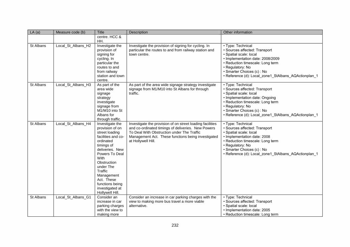
232
LA (a) Measure code (b) Title Description Other information
centre. HCC & HH.
St Albans Local_St_Albans_H2 Investigate the provision of signing for cycling. In particular the routes to and from railway station and town centre.
Investigate the provision of signing for cycling. In particular the routes to and from railway station and town centre.
• Type: Technical • Sources affected: Transport • Spatial scale: local • Implementation date: 2008/2009 • Reduction timescale: Long term • Regulatory: No • Smarter Choices (c) : No • Reference (d): Local_zone1_StAlbans_AQActionplan_1
St Albans Local_St_Albans_H3 As part of the area wide signage strategy investigate signage from M1/M10 into St Albans for through traffic.
As part of the area wide signage strategy investigate signage from M1/M10 into St Albans for through traffic.
• Type: Technical • Sources affected: Transport • Spatial scale: local • Implementation date: Ongoing • Reduction timescale: Long term • Regulatory: No • Smarter Choices (c) : No • Reference (d): Local_zone1_StAlbans_AQActionplan_1
St Albans Local_St_Albans_H4 Investigate the provision of on street loading facilities and co-ordinated timings of deliveries. New Powers To Deal With Obstruction under The Traffic Management Act. These functions being investigated at Hollywell Hill.
Investigate the provision of on street loading facilities and co-ordinated timings of deliveries. New Powers To Deal With Obstruction under The Traffic Management Act. These functions being investigated at Hollywell Hill.
• Type: Technical • Sources affected: Transport • Spatial scale: local • Implementation date: 2008 • Reduction timescale: Long term • Regulatory: No • Smarter Choices (c) : No • Reference (d): Local_zone1_StAlbans_AQActionplan_1
St Albans Local_St_Albans_G1 Consider an increase in car parking charges with the view to making more
Consider an increase in car parking charges with the view to making more bus travel a more viable alternative.
• Type: Technical • Sources affected: Transport • Spatial scale: local • Implementation date: 2005 • Reduction timescale: Long term
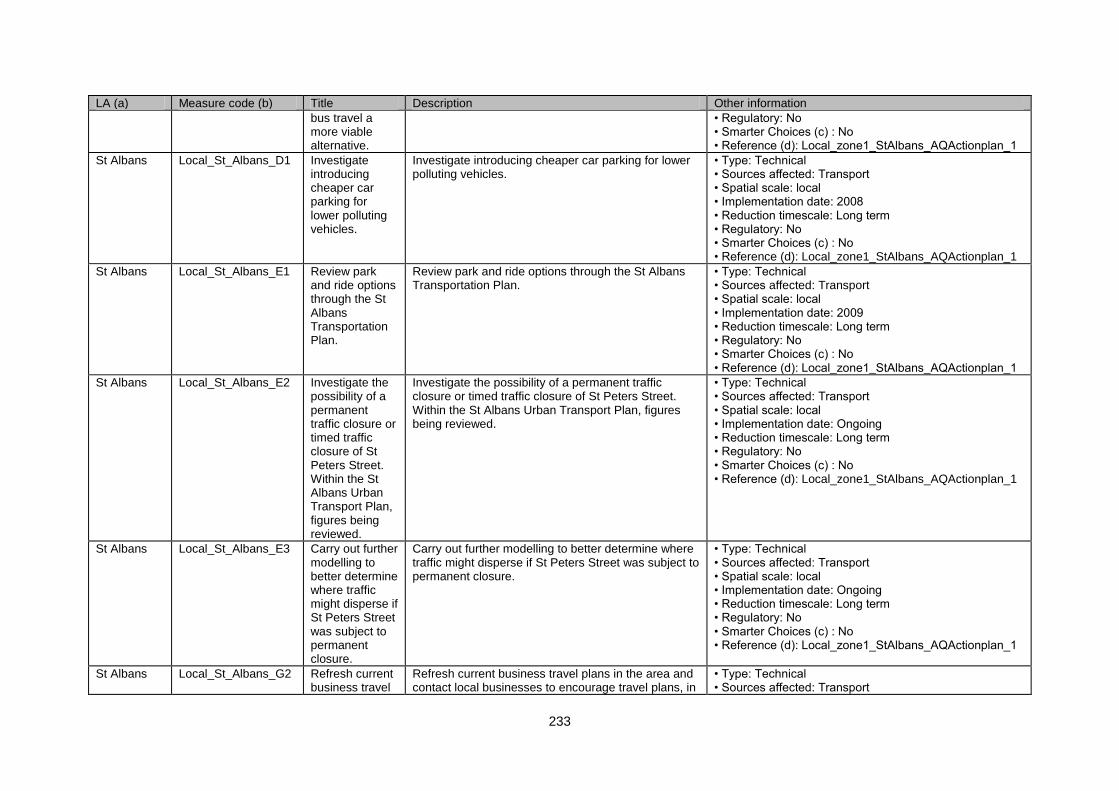
233
LA (a) Measure code (b) Title Description Other information
bus travel a more viable alternative.
• Regulatory: No • Smarter Choices (c) : No • Reference (d): Local_zone1_StAlbans_AQActionplan_1
St Albans Local_St_Albans_D1 Investigate introducing cheaper car parking for lower polluting vehicles.
Investigate introducing cheaper car parking for lower polluting vehicles.
• Type: Technical • Sources affected: Transport • Spatial scale: local • Implementation date: 2008 • Reduction timescale: Long term • Regulatory: No • Smarter Choices (c) : No • Reference (d): Local_zone1_StAlbans_AQActionplan_1
St Albans Local_St_Albans_E1 Review park and ride options through the St Albans Transportation Plan.
Review park and ride options through the St Albans Transportation Plan.
• Type: Technical • Sources affected: Transport • Spatial scale: local • Implementation date: 2009 • Reduction timescale: Long term • Regulatory: No • Smarter Choices (c) : No • Reference (d): Local_zone1_StAlbans_AQActionplan_1
St Albans Local_St_Albans_E2 Investigate the possibility of a permanent traffic closure or timed traffic closure of St Peters Street. Within the St Albans Urban Transport Plan, figures being reviewed.
Investigate the possibility of a permanent traffic closure or timed traffic closure of St Peters Street. Within the St Albans Urban Transport Plan, figures being reviewed.
• Type: Technical • Sources affected: Transport • Spatial scale: local • Implementation date: Ongoing • Reduction timescale: Long term • Regulatory: No • Smarter Choices (c) : No • Reference (d): Local_zone1_StAlbans_AQActionplan_1
St Albans Local_St_Albans_E3 Carry out further modelling to better determine where traffic might disperse if St Peters Street was subject to permanent closure.
Carry out further modelling to better determine where traffic might disperse if St Peters Street was subject to permanent closure.
• Type: Technical • Sources affected: Transport • Spatial scale: local • Implementation date: Ongoing • Reduction timescale: Long term • Regulatory: No • Smarter Choices (c) : No • Reference (d): Local_zone1_StAlbans_AQActionplan_1
St Albans Local_St_Albans_G2 Refresh current business travel
Refresh current business travel plans in the area and contact local businesses to encourage travel plans, in
• Type: Technical • Sources affected: Transport
234
LA (a) Measure code (b) Title Description Other information
plans in the area and contact local businesses to encourage travel plans, in particular St Albans District Council.
particular St Albans District Council. • Spatial scale: local • Implementation date: 2008 • Reduction timescale: Long term • Regulatory: No • Smarter Choices (c) : Yes • Reference (d): Local_zone1_StAlbans_AQActionplan_1
St Albans Local_St_Albans_H5 Open to the broader community Stalbanstravel.com, car sharing scheme. Linking employers & staff for journeys in & out of St Albans.
Open to the broader community Stalbanstravel.com, car sharing scheme. Linking employers & staff for journeys in & out of St Albans.
• Type: Technical • Sources affected: Transport • Spatial scale: local • Implementation date: 2008 • Reduction timescale: Long term • Regulatory: No • Smarter Choices (c) : Yes • Reference (d): Local_zone1_StAlbans_AQActionplan_1
St Albans Local_St_Albans_G3 LSP to fund the employment for 1 year of a travel plan co-ordinator. Their role will be to study parking pressures, business parking, traffic movements, and congestion within the city centre.
LSP to fund the employment for 1 year of a travel plan co-ordinator. Their role will be to study parking pressures, business parking, traffic movements, and congestion within the city centre.
• Type: Technical • Sources affected: Transport • Spatial scale: local • Implementation date: 2008 • Reduction timescale: Long term • Regulatory: No • Smarter Choices (c) : Yes • Reference (d): Local_zone1_StAlbans_AQActionplan_1
St Albans Local_St_Albans_D2 Implementation of „Buzz Scheme‟, where free charging is provided for electric cars at NCP car parks within St
Implementation of „Buzz Scheme‟, where free charging is provided for electric cars at NCP car parks within St Albans.
• Type: Technical • Sources affected: Transport • Spatial scale: local • Implementation date: 2008 • Reduction timescale: Long term • Regulatory: No • Smarter Choices (c) : No • Reference (d): Local_zone1_StAlbans_AQActionplan_1
235
LA (a) Measure code (b) Title Description Other information
Albans.
St Albans Local_St_Albans_H6 „Wizzgo Car Club‟, a fleet of Citroen CV1‟s made available to St Albans residents to encourage one car per household ownership.
„Wizzgo Car Club‟, a fleet of Citroen CV1‟s made available to St Albans residents to encourage one car per household ownership.
• Type: Technical • Sources affected: Transport • Spatial scale: local • Implementation date: 2008 • Reduction timescale: Long term • Regulatory: No • Smarter Choices (c) : Yes • Reference (d): Local_zone1_StAlbans_AQActionplan_1
St Albans Local_St_Albans_H7 Review usefulness of monitoring locations with regard to modelling results.
Review usefulness of monitoring locations with regard to modelling results.
• Type: Technical • Sources affected: Transport • Spatial scale: local • Implementation date: Ongoing • Reduction timescale: Long term • Regulatory: No • Smarter Choices (c) : No • Reference (d): Local_zone1_StAlbans_AQActionplan_1
St Albans Local_St_Albans_A1 Promote the benefits of switching off idling engines whilst in traffic queues.
Promote the benefits of switching off idling engines whilst in traffic queues.
• Type: Technical • Sources affected: Transport • Spatial scale: local • Implementation date: Ongoing • Reduction timescale: Long term • Regulatory: No • Smarter Choices (c) : No • Reference (d): Local_zone1_StAlbans_AQActionplan_1
St Albans Local_St_Albans_A2 Investigate the creation of „Low Emission Zones‟.
Investigate the creation of „Low Emission Zones‟. • Type: Technical • Sources affected: Transport • Spatial scale: local • Implementation date: 2009 • Reduction timescale: Long term • Regulatory: No • Smarter Choices (c) : No • Reference (d): Local_zone1_StAlbans_AQActionplan_1
St Albans Local_St_Albans_H8 Continue the Trees Against Pollution (TAP) project.
Continue the Trees Against Pollution (TAP) project. • Type: Technical • Sources affected: Transport • Spatial scale: local • Implementation date: Ongoing • Reduction timescale: Long term • Regulatory: No • Smarter Choices (c) : No
236
LA (a) Measure code (b) Title Description Other information
• Reference (d): Local_zone1_StAlbans_AQActionplan_1
SURREY HEATH
Local_SurreyHeath_G1
Reallocated Roadspace
High Occupancy Vehicle Lanes. • Type: Technical • Sources affected: Transport • Spatial scale: local • Implementation date: Ongoing. • Reduction timescale: Medium term • Regulatory: No • Smarter Choices (c) : No • Reference (d): Local_zone1_SurreyHeath_AQActionplan_1
SURREY HEATH
Local_SurreyHeath_G2
Reallocated Roadspace
Enhanced vehicle emission testing. • Type: Technical • Sources affected: Transport • Spatial scale: local • Implementation date: Ongoing. • Reduction timescale: Long term • Regulatory: Yes • Smarter Choices (c) : No • Reference (d): Local_zone1_SurreyHeath_AQActionplan_1
SURREY HEATH
Local_SurreyHeath_D1
Road User Charging
Introduce road tolling. • Type: Technical • Sources affected: Transport; Industry including heating and power production • Spatial scale: local • Implementation date: Ongoing. • Reduction timescale: Medium term • Regulatory: No • Smarter Choices (c) : No • Reference (d): Local_zone1_SurreyHeath_AQActionplan_1
Windsor and Maidenhead
Local_Windsor_&_Maidenhead_F1
Awareness campaigns
Undertaking activities designed to highlight the adverse impacts of unsustainable car use, and draw attention to the existence and benefits of alternative travel modes and fuels, e.g. printed materials, web site information, promotional events, etc. This will encourage a change in travel behaviour and fuel use, leading to a reduction in emissions.
• Type: Technical • Sources affected: Transport • Spatial scale: local • Implementation date: Ongoing. • Reduction timescale: Long term • Regulatory: No • Smarter Choices (c) : Yes • Reference (d): Local_zone1_WindsorAndMaidenhead_AQActionplan_1
Windsor and Maidenhead
Local_Windsor_&_Maidenhead_F2
Education programmes
Delivering training to give people the necessary skills to be able to travel safely and independently using sustainable travel modes rather than the private car. o Providing educational material designed to increase
• Type: Technical • Sources affected: Transport • Spatial scale: local • Implementation date: Ongoing.
237
LA (a) Measure code (b) Title Description Other information
knowledge and understanding of air quality and environmental issues, encouraging sustainable behaviour.
• Reduction timescale: Long term • Regulatory: No • Smarter Choices (c) : Yes • Reference (d): Local_zone1_WindsorAndMaidenhead_AQActionplan_1
Windsor and Maidenhead
Local_Windsor_&_Maidenhead_F3
Travel information & advice
Providing information on available travel options, both pre-trip and in-trip, to enable individuals to make informed decisions about where, when and how to travel. This includes printed material (e.g. public transport timetables), as well as real-time information (e.g. bus arrival times, car parking data, congestion information, air quality statistics, etc).
• Type: Technical • Sources affected: Transport • Spatial scale: local • Implementation date: Ongoing. • Reduction timescale: Long term • Regulatory: No • Smarter Choices (c) : Yes • Reference (d): Local_zone1_WindsorAndMaidenhead_AQActionplan_1
Windsor and Maidenhead
Local_Windsor_&_Maidenhead_G1
Travel plans Delivering measures tailored to the needs of individual organisations, such as schools, hospitals and businesses, aimed at promoting sustainable travel choices and reducing reliance on the private car, e.g. changes to corporate policies, working practices, pay and benefits, on-site facilities, etc. These will be secured through voluntary take-up and as legal requirements associated with planning consents, and will include construction travel plans where appropriate. o The Council will progress its own travel plan to act as an exemplar.
• Type: Technical • Sources affected: Transport • Spatial scale: local • Implementation date: Ongoing. • Reduction timescale: Long term • Regulatory: No • Smarter Choices (c) : Yes • Reference (d): Local_zone1_WindsorAndMaidenhead_AQActionplan_1
Windsor and Maidenhead
Local_Windsor_&_Maidenhead_H1
Lift sharing Working in conjunction with neighbouring authorities to develop an area-wide lift-sharing database, encouraging individuals and organisations to make use of the scheme in order to reduce the number of single-occupancy car journeys, particularly for commuting & business purposes. Establishing self-contained lift-sharing schemes for both LEA and independent schools to reduce the number of car trips to and from schools, particularly where alternative modes of travel are unavailable or impractical.
• Type: Technical • Sources affected: Transport • Spatial scale: local • Implementation date: Ongoing. • Reduction timescale: Long term • Regulatory: No • Smarter Choices (c) : Yes • Reference (d): Local_zone1_WindsorAndMaidenhead_AQActionplan_1
Windsor and Maidenhead
Local_Windsor_&_Maidenhead_H2
E-services Providing on-line services to enable everyday activities to be completed electronically, thereby reducing the need to travel, e.g. on-line applications and payments for Council services, shopping, banking, home working, etc.
• Type: Technical • Sources affected: Transport • Spatial scale: local • Implementation date: Ongoing. • Reduction timescale: Long term
238
LA (a) Measure code (b) Title Description Other information
• Regulatory: No • Smarter Choices (c) : Yes • Reference (d): Local_zone1_WindsorAndMaidenhead_AQActionplan_1
Windsor and Maidenhead
Local_Windsor_&_Maidenhead_G2
Ticketing solutions
Establishing electronic payment systems to facilitate use of public transport, making these services more attractive, and providing operators with detailed usage information, informing service development. Promoting combined travel/entry tickets for major events and tourist attractions to encourage access by public transport.
• Type: Technical • Sources affected: Transport • Spatial scale: local • Implementation date: Ongoing. • Reduction timescale: Long term • Regulatory: No • Smarter Choices (c) : No • Reference (d): Local_zone1_WindsorAndMaidenhead_AQActionplan_1
Windsor and Maidenhead
Local_Windsor_&_Maidenhead_E1
Urban traffic control
Extending the current UTC system in Maidenhead and Windsor to allow central management and control of signal-controlled junctions, enabling signal phasing to be optimised to respond to changing traffic flows and co-ordination of signals across an area in order to reduce congestion and exhaust emissions.
• Type: Technical • Sources affected: Transport • Spatial scale: local • Implementation date: Ongoing. • Reduction timescale: Long term • Regulatory: No • Smarter Choices (c) : No • Reference (d): Local_zone1_WindsorAndMaidenhead_AQActionplan_1
Windsor and Maidenhead
Local_Windsor_&_Maidenhead_G3
Bus / cycle priority
Introducing priority measures will help reduce journey times, improve journey reliability and improve safety for cyclists / motorcyclists, making these modes more attractive for everyday travel.
• Type: Technical • Sources affected: Transport • Spatial scale: local • Implementation date: Ongoing. • Reduction timescale: Long term • Regulatory: No • Smarter Choices (c) : No • Reference (d): Local_zone1_WindsorAndMaidenhead_AQActionplan_1
Windsor and Maidenhead
Local_Windsor_&_Maidenhead_E2
Junction improvements
Modifying the layout of junctions experiencing chronic congestion in order to optimise traffic movements and reduce emissions.
• Type: Technical • Sources affected: Transport • Spatial scale: local • Implementation date: Ongoing. • Reduction timescale: Long term • Regulatory: No • Smarter Choices (c) : No • Reference (d): Local_zone1_WindsorAndMaidenhead_AQActionplan_1
Windsor and Maidenhead
Local_Windsor_&_Maidenhead_G4
Safer routes to schools
Creating an appropriate environment for children to walk and cycle to school, addressing safety and
• Type: Technical • Sources affected: Transport
239
LA (a) Measure code (b) Title Description Other information
security concerns identified through consultation for School Travel Plans. Schools prioritised by number of road traffic accident casualties and car mode share.
• Spatial scale: local • Implementation date: Ongoing. • Reduction timescale: Long term • Regulatory: No • Smarter Choices (c) : Yes • Reference (d): Local_zone1_WindsorAndMaidenhead_AQActionplan_1
Windsor and Maidenhead
Local_Windsor_&_Maidenhead_E3
Parking enforcement
Improving enforcement of parking restrictions and off-street parking to reduce congestion, and increase turnover and reduce the number of vehicles circulating in town centres to look for parking.
• Type: Technical • Sources affected: Transport • Spatial scale: local • Implementation date: Ongoing. • Reduction timescale: Long term • Regulatory: No • Smarter Choices (c) : No • Reference (d): Local_zone1_WindsorAndMaidenhead_AQActionplan_1
Windsor and Maidenhead
Local_Windsor_&_Maidenhead_G5
Pedestrian / Cycling Facilities
Providing new / improved routes and crossing facilities along desire lines to increase walking / cycling activity and reduce unnecessary car use for short trips.
• Type: Technical • Sources affected: Transport • Spatial scale: local • Implementation date: Ongoing. • Reduction timescale: Long term • Regulatory: No • Smarter Choices (c) : No • Reference (d): Local_zone1_WindsorAndMaidenhead_AQActionplan_1
Windsor and Maidenhead
Local_Windsor_&_Maidenhead_G6
Supported bus services
Providing financial support to local bus services with the aim of achieving commercially sustainable levels of patronage, encouraging a shift away from car use.
• Type: Technical • Sources affected: Transport • Spatial scale: local • Implementation date: Ongoing. • Reduction timescale: Long term • Regulatory: No • Smarter Choices (c) : No • Reference (d): Local_zone1_WindsorAndMaidenhead_AQActionplan_1
Windsor and Maidenhead
Local_Windsor_&_Maidenhead_G7
Public transport infrastructure improvements
Introducing a range of improvements to enhance the accessibility and attractiveness of public transport, e.g. raised kerbs, shelters, lighting, etc.
• Type: Technical • Sources affected: Transport • Spatial scale: local • Implementation date: Ongoing. • Reduction timescale: Long term • Regulatory: No • Smarter Choices (c) : No • Reference (d):
240
LA (a) Measure code (b) Title Description Other information
Local_zone1_WindsorAndMaidenhead_AQActionplan_1
Windsor and Maidenhead
Local_Windsor_&_Maidenhead_A1
Quality bus partnership
Working with operators and neighbouring local authorities to develop high-quality, cross-boundary bus services, incorporating criteria relating to vehicle emission standards where appropriate.
• Type: Technical • Sources affected: Transport • Spatial scale: local • Implementation date: Ongoing. • Reduction timescale: Long term • Regulatory: No • Smarter Choices (c) : No • Reference (d): Local_zone1_WindsorAndMaidenhead_AQActionplan_1
Windsor and Maidenhead
Local_Windsor_&_Maidenhead_E4
Park & Ride Exploring opportunities for park and ride to the north of Windsor to intercept M4 traffic, and tackle air quality problems along the Windsor & Eton Relief Road. Options under consideration include a possible link with the centre of Windsor via the Windsor/Slough rail line.
• Type: Technical • Sources affected: Transport • Spatial scale: local • Implementation date: Ongoing. • Reduction timescale: Long term • Regulatory: No • Smarter Choices (c) : No • Reference (d): Local_zone1_WindsorAndMaidenhead_AQActionplan_1
Windsor and Maidenhead
Local_Windsor_&_Maidenhead_A2
Inter-urban coach services
Working with neighbouring authorities and the Highways Agency to progress a north-south route linking High Wycombe, Marlow, Maidenhead, Bracknell, Blackwater and Farnborough, reducing the number of inter-urban car trips.
• Type: Technical • Sources affected: Transport • Spatial scale: local • Implementation date: Ongoing. • Reduction timescale: Long term • Regulatory: No • Smarter Choices (c) : No • Reference (d): Local_zone1_WindsorAndMaidenhead_AQActionplan_1
Windsor and Maidenhead
Local_Windsor_&_Maidenhead_H3
Rail partnerships
Working in partnership with DfT Rail and train operating companies to develop better and more attractive services, tackling peak hour congestion, improve interchange, enhance accessibility and facilitate integration with other modes, making rail travel a realistic alternative to the car for commuting, shopping and leisure trips.
• Type: Technical • Sources affected: Transport • Spatial scale: local • Implementation date: Ongoing. • Reduction timescale: Long term • Regulatory: No • Smarter Choices (c) : No • Reference (d): Local_zone1_WindsorAndMaidenhead_AQActionplan_1
Windsor and Maidenhead
Local_Windsor_&_Maidenhead_D1
Parking standards
Imposing strict maximum parking standards for new development as identified in the Borough‟s Parking Strategy will help to mitigate the traffic and air quality impacts of new development
• Type: Technical • Sources affected: Transport • Spatial scale: local • Implementation date: Ongoing. • Reduction timescale: Long term
241
LA (a) Measure code (b) Title Description Other information
• Regulatory: No • Smarter Choices (c) : No • Reference (d): Local_zone1_WindsorAndMaidenhead_AQActionplan_1
Windsor and Maidenhead
Local_Windsor_&_Maidenhead_D2
Public parking regimes
Setting parking charges and permitted length of stay in public car parks in town centre locations to favour short-stay parking for shoppers and visitors will encourage use of park and ride / sustainable modes for long-stay visits / commuting trips.
• Type: Technical • Sources affected: Transport • Spatial scale: local • Implementation date: Ongoing. • Reduction timescale: Long term • Regulatory: No • Smarter Choices (c) : No • Reference (d): Local_zone1_WindsorAndMaidenhead_AQActionplan_1
Windsor and Maidenhead
Local_Windsor_&_Maidenhead_A3
Council own fleet and contractors
Ensuring compliance with emission standards and ensuring that vehicles are used sensibly and are well maintained and that routes and tasks are co-ordinated to be as efficient as possible.
• Type: Technical • Sources affected: Transport • Spatial scale: local • Implementation date: Ongoing. • Reduction timescale: Long term • Regulatory: No • Smarter Choices (c) : No • Reference (d): Local_zone1_WindsorAndMaidenhead_AQActionplan_1
Windsor and Maidenhead
Local_Windsor_&_Maidenhead_A4
VOSA and other Testing
Carbon moNOXide (CO) and hydrocarbons (HC) are normally tested, RBWM will look into the possibility of testing NOX emissions
• Type: Technical • Sources affected: Transport • Spatial scale: local • Implementation date: Ongoing. • Reduction timescale: Long term • Regulatory: No • Smarter Choices (c) : No • Reference (d): Local_zone1_WindsorAndMaidenhead_AQActionplan_1
Windsor and Maidenhead
Local_Windsor_&_Maidenhead_H4
New schemes and trails
Participating in and supporting schemes that involve the use of alternative fuels and trials of new materials that will adsorb reduce or eliminate NOX emissions.
• Type: Technical • Sources affected: Transport • Spatial scale: local • Implementation date: Ongoing. • Reduction timescale: Long term • Regulatory: No • Smarter Choices (c) : No • Reference (d): Local_zone1_WindsorAndMaidenhead_AQActionplan_1
Windsor and Maidenhead
Local_Windsor_&_Maidenhead_C1
Hybrid vehicles and hydrogen
Promoting, where possible, the use of less and non polluting vehicles
• Type: Technical • Sources affected: Transport
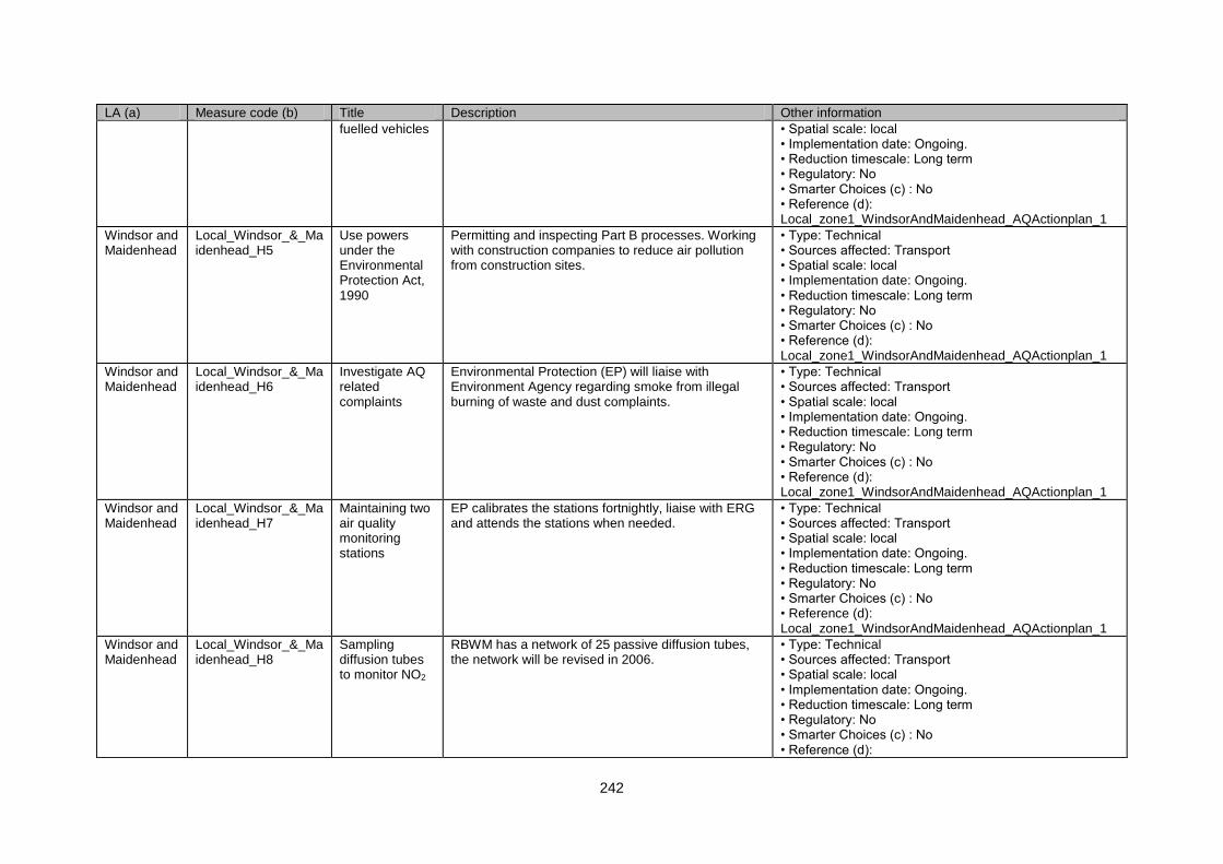
242
LA (a) Measure code (b) Title Description Other information
fuelled vehicles • Spatial scale: local • Implementation date: Ongoing. • Reduction timescale: Long term • Regulatory: No • Smarter Choices (c) : No • Reference (d): Local_zone1_WindsorAndMaidenhead_AQActionplan_1
Windsor and Maidenhead
Local_Windsor_&_Maidenhead_H5
Use powers under the Environmental Protection Act, 1990
Permitting and inspecting Part B processes. Working with construction companies to reduce air pollution from construction sites.
• Type: Technical • Sources affected: Transport • Spatial scale: local • Implementation date: Ongoing. • Reduction timescale: Long term • Regulatory: No • Smarter Choices (c) : No • Reference (d): Local_zone1_WindsorAndMaidenhead_AQActionplan_1
Windsor and Maidenhead
Local_Windsor_&_Maidenhead_H6
Investigate AQ related complaints
Environmental Protection (EP) will liaise with Environment Agency regarding smoke from illegal burning of waste and dust complaints.
• Type: Technical • Sources affected: Transport • Spatial scale: local • Implementation date: Ongoing. • Reduction timescale: Long term • Regulatory: No • Smarter Choices (c) : No • Reference (d): Local_zone1_WindsorAndMaidenhead_AQActionplan_1
Windsor and Maidenhead
Local_Windsor_&_Maidenhead_H7
Maintaining two air quality monitoring stations
EP calibrates the stations fortnightly, liaise with ERG and attends the stations when needed.
• Type: Technical • Sources affected: Transport • Spatial scale: local • Implementation date: Ongoing. • Reduction timescale: Long term • Regulatory: No • Smarter Choices (c) : No • Reference (d): Local_zone1_WindsorAndMaidenhead_AQActionplan_1
Windsor and Maidenhead
Local_Windsor_&_Maidenhead_H8
Sampling diffusion tubes to monitor NO2
RBWM has a network of 25 passive diffusion tubes, the network will be revised in 2006.
• Type: Technical • Sources affected: Transport • Spatial scale: local • Implementation date: Ongoing. • Reduction timescale: Long term • Regulatory: No • Smarter Choices (c) : No • Reference (d):

243
LA (a) Measure code (b) Title Description Other information
Local_zone1_WindsorAndMaidenhead_AQActionplan_1
Windsor and Maidenhead
Local_Windsor_&_Maidenhead_H9
AADT EP will liaise with Highway to undertake additional traffic flow monitoring.
• Type: Technical • Sources affected: Transport • Spatial scale: local • Implementation date: Ongoing. • Reduction timescale: Long term • Regulatory: No • Smarter Choices (c) : No • Reference (d): Local_zone1_WindsorAndMaidenhead_AQActionplan_1
Brentwood Local_Brentwood_H1 Air Quality Monitoring
The Council will continue to monitor air quality within the Borough via its real time NOX monitoring station and NO2 diffusion tubes (currently at 37 locations)
• Type: Technical • Sources affected: Transport • Spatial scale: local • Implementation date: 2008 • Reduction timescale: Long term • Regulatory: No • Smarter Choices (c) : No • Reference (d): Local_zone1_Brentwood_AQActionplan_1
Brentwood Local_Brentwood_H2 Air Quality Monitoring II
The Council will consider extending or relocating the existing NO2 diffusion tube survey locations to monitor air quality „hot spots‟
• Type: Technical • Sources affected: Transport • Spatial scale: local • Implementation date: 2008 • Reduction timescale: Long term • Regulatory: No • Smarter Choices (c) : No • Reference (d): Local_zone1_Brentwood_AQActionplan_1
Brentwood Local_Brentwood_H3 Air Quality Monitoring III
Consider extending the monitoring network and/or carrying out further air quality monitoring in areas associated with major new developments. (Costs may be met by developer via S106 Agreement)
• Type: Technical • Sources affected: Transport • Spatial scale: local • Implementation date: 2008 • Reduction timescale: Long term • Regulatory: No • Smarter Choices (c) : No • Reference (d): Local_zone1_Brentwood_AQActionplan_1
Brentwood Local_Brentwood_F1 Awareness Raising
Raise the profile of air quality in the Borough (probably in conjunction with climate change issues) using the Council website, newspaper, leaflets and the media.
• Type: Education/information • Sources affected: Transport • Spatial scale: local • Implementation date: 2008 • Reduction timescale: Long term
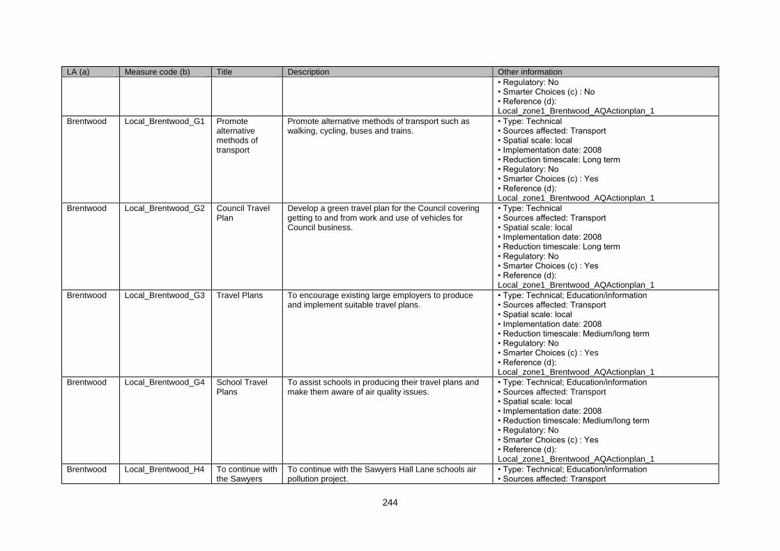
244
LA (a) Measure code (b) Title Description Other information
• Regulatory: No • Smarter Choices (c) : No • Reference (d): Local_zone1_Brentwood_AQActionplan_1
Brentwood Local_Brentwood_G1 Promote alternative methods of transport
Promote alternative methods of transport such as walking, cycling, buses and trains.
• Type: Technical • Sources affected: Transport • Spatial scale: local • Implementation date: 2008 • Reduction timescale: Long term • Regulatory: No • Smarter Choices (c) : Yes • Reference (d): Local_zone1_Brentwood_AQActionplan_1
Brentwood Local_Brentwood_G2 Council Travel Plan
Develop a green travel plan for the Council covering getting to and from work and use of vehicles for Council business.
• Type: Technical • Sources affected: Transport • Spatial scale: local • Implementation date: 2008 • Reduction timescale: Long term • Regulatory: No • Smarter Choices (c) : Yes • Reference (d): Local_zone1_Brentwood_AQActionplan_1
Brentwood Local_Brentwood_G3 Travel Plans To encourage existing large employers to produce and implement suitable travel plans.
• Type: Technical; Education/information • Sources affected: Transport • Spatial scale: local • Implementation date: 2008 • Reduction timescale: Medium/long term • Regulatory: No • Smarter Choices (c) : Yes • Reference (d): Local_zone1_Brentwood_AQActionplan_1
Brentwood Local_Brentwood_G4 School Travel Plans
To assist schools in producing their travel plans and make them aware of air quality issues.
• Type: Technical; Education/information • Sources affected: Transport • Spatial scale: local • Implementation date: 2008 • Reduction timescale: Medium/long term • Regulatory: No • Smarter Choices (c) : Yes • Reference (d): Local_zone1_Brentwood_AQActionplan_1
Brentwood Local_Brentwood_H4 To continue with the Sawyers
To continue with the Sawyers Hall Lane schools air pollution project.
• Type: Technical; Education/information • Sources affected: Transport
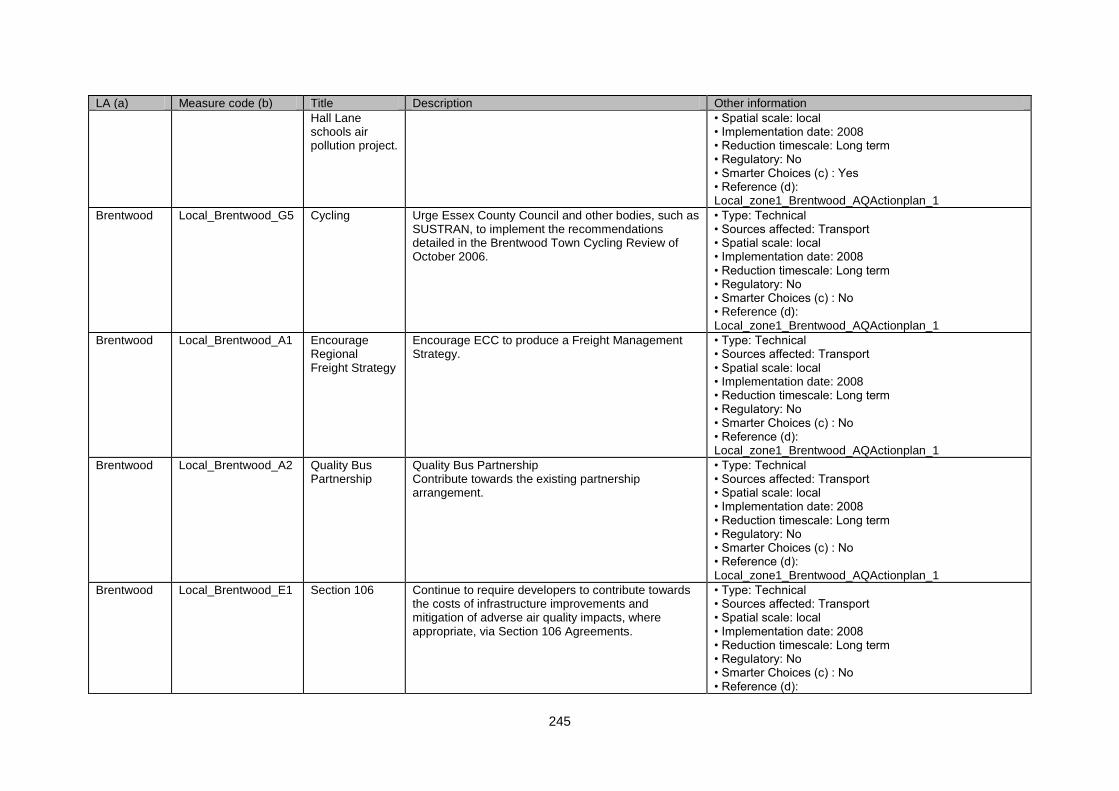
245
LA (a) Measure code (b) Title Description Other information
Hall Lane schools air pollution project.
• Spatial scale: local • Implementation date: 2008 • Reduction timescale: Long term • Regulatory: No • Smarter Choices (c) : Yes • Reference (d): Local_zone1_Brentwood_AQActionplan_1
Brentwood Local_Brentwood_G5 Cycling Urge Essex County Council and other bodies, such as SUSTRAN, to implement the recommendations detailed in the Brentwood Town Cycling Review of October 2006.
• Type: Technical • Sources affected: Transport • Spatial scale: local • Implementation date: 2008 • Reduction timescale: Long term • Regulatory: No • Smarter Choices (c) : No • Reference (d): Local_zone1_Brentwood_AQActionplan_1
Brentwood Local_Brentwood_A1 Encourage Regional Freight Strategy
Encourage ECC to produce a Freight Management Strategy.
• Type: Technical • Sources affected: Transport • Spatial scale: local • Implementation date: 2008 • Reduction timescale: Long term • Regulatory: No • Smarter Choices (c) : No • Reference (d): Local_zone1_Brentwood_AQActionplan_1
Brentwood Local_Brentwood_A2 Quality Bus Partnership
Quality Bus Partnership Contribute towards the existing partnership arrangement.
• Type: Technical • Sources affected: Transport • Spatial scale: local • Implementation date: 2008 • Reduction timescale: Long term • Regulatory: No • Smarter Choices (c) : No • Reference (d): Local_zone1_Brentwood_AQActionplan_1
Brentwood Local_Brentwood_E1 Section 106 Continue to require developers to contribute towards the costs of infrastructure improvements and mitigation of adverse air quality impacts, where appropriate, via Section 106 Agreements.
• Type: Technical • Sources affected: Transport • Spatial scale: local • Implementation date: 2008 • Reduction timescale: Long term • Regulatory: No • Smarter Choices (c) : No • Reference (d):
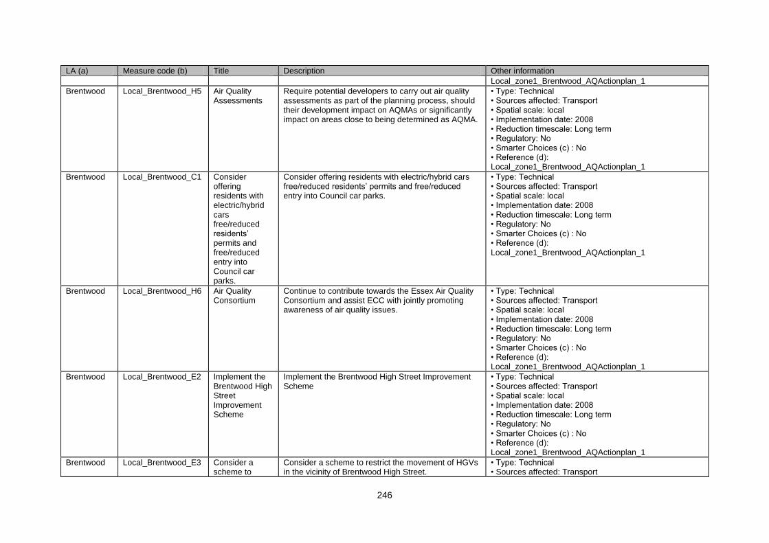
246
LA (a) Measure code (b) Title Description Other information
Local_zone1_Brentwood_AQActionplan_1
Brentwood Local_Brentwood_H5 Air Quality Assessments
Require potential developers to carry out air quality assessments as part of the planning process, should their development impact on AQMAs or significantly impact on areas close to being determined as AQMA.
• Type: Technical • Sources affected: Transport • Spatial scale: local • Implementation date: 2008 • Reduction timescale: Long term • Regulatory: No • Smarter Choices (c) : No • Reference (d): Local_zone1_Brentwood_AQActionplan_1
Brentwood Local_Brentwood_C1 Consider offering residents with electric/hybrid cars free/reduced residents‟ permits and free/reduced entry into Council car parks.
Consider offering residents with electric/hybrid cars free/reduced residents‟ permits and free/reduced entry into Council car parks.
• Type: Technical • Sources affected: Transport • Spatial scale: local • Implementation date: 2008 • Reduction timescale: Long term • Regulatory: No • Smarter Choices (c) : No • Reference (d): Local_zone1_Brentwood_AQActionplan_1
Brentwood Local_Brentwood_H6 Air Quality Consortium
Continue to contribute towards the Essex Air Quality Consortium and assist ECC with jointly promoting awareness of air quality issues.
• Type: Technical • Sources affected: Transport • Spatial scale: local • Implementation date: 2008 • Reduction timescale: Long term • Regulatory: No • Smarter Choices (c) : No • Reference (d): Local_zone1_Brentwood_AQActionplan_1
Brentwood Local_Brentwood_E2 Implement the Brentwood High Street Improvement Scheme
Implement the Brentwood High Street Improvement Scheme
• Type: Technical • Sources affected: Transport • Spatial scale: local • Implementation date: 2008 • Reduction timescale: Long term • Regulatory: No • Smarter Choices (c) : No • Reference (d): Local_zone1_Brentwood_AQActionplan_1
Brentwood Local_Brentwood_E3 Consider a scheme to
Consider a scheme to restrict the movement of HGVs in the vicinity of Brentwood High Street.
• Type: Technical • Sources affected: Transport
247
LA (a) Measure code (b) Title Description Other information
restrict the movement of HGVs in the vicinity of Brentwood High Street.
• Spatial scale: local • Implementation date: 2008 • Reduction timescale: Long term • Regulatory: No • Smarter Choices (c) : No • Reference (d): Local_zone1_Brentwood_AQActionplan_1
Brentwood Local_Brentwood_E4 Replacing the existing four pelican crossings at Wilson‟s Corner junction with PUFIN crossings.
Replacing the existing four pelican crossings at Wilson‟s Corner junction with PUFIN crossings.
• Type: Technical • Sources affected: Transport • Spatial scale: local • Implementation date: 2008 • Reduction timescale: Long term • Regulatory: No • Smarter Choices (c) : No • Reference (d): Local_zone1_Brentwood_AQActionplan_1
Brentwood Local_Brentwood_H7 Urge ECC to consider other physical improvements that could be implemented at the Wilson‟s Corner junction.
Urge ECC to consider other physical improvements that could be implemented at the Wilson‟s Corner junction.
• Type: Technical • Sources affected: Transport • Spatial scale: local • Implementation date: 2008 • Reduction timescale: Long term • Regulatory: No • Smarter Choices (c) : No • Reference (d): Local_zone1_Brentwood_AQActionplan_1
Brentwood Local_Brentwood_G6 Where appropriate, impose planning conditions to require developers to provide bus passes for new residents.
Where appropriate, impose planning conditions to require developers to provide bus passes for new residents.
• Type: Technical • Sources affected: Transport • Spatial scale: local • Implementation date: 2008 • Reduction timescale: Long term • Regulatory: No • Smarter Choices (c) : No • Reference (d): Local_zone1_Brentwood_AQActionplan_1
Brentwood Local_Brentwood_G7 Ensure that existing planning conditions regarding travel plans are enforced.
Ensure that existing planning conditions regarding travel plans are enforced.
• Type: Technical • Sources affected: Transport • Spatial scale: local • Implementation date: 2008 • Reduction timescale: Long term • Regulatory: No • Smarter Choices (c) : Yes • Reference (d):
248
LA (a) Measure code (b) Title Description Other information
Local_zone1_Brentwood_AQActionplan_1
Brentwood Local_Brentwood_A3 Consider periodic exhaust emission surveys.
Consider periodic exhaust emission surveys. • Type: Technical; Education/information • Sources affected: Transport • Spatial scale: local • Implementation date: 2008 • Reduction timescale: Long term • Regulatory: No • Smarter Choices (c) : No • Reference (d): Local_zone1_Brentwood_AQActionplan_1
Brentwood Local_Brentwood_A4 Improvement of Council fleet
The Council to investigate the further greening of its existing fleet and to consider air pollution as a factor when procuring extra or replacement vehicles and investigate the availability of grants.
• Type: Technical • Sources affected: Transport • Spatial scale: local • Implementation date: 2008 • Reduction timescale: Long term • Regulatory: No • Smarter Choices (c) : No • Reference (d): Local_zone1_Brentwood_AQActionplan_1
Brentwood Local_Brentwood_H8 Park and ride feasibility study
The Council to carry out a feasibility study of the costs, benefits and practicality of introducing a park-and-ride (or park and walk) scheme for Brentwood/Shenfield.
• Type: Technical • Sources affected: Transport • Spatial scale: local • Implementation date: 2008 • Reduction timescale: Long term • Regulatory: No • Smarter Choices (c) : No • Reference (d): Local_zone1_Brentwood_AQActionplan_1
Brentwood Local_Brentwood_G8 Consider further investment in bus services.
Consider further investment in bus services. • Type: Technical • Sources affected: Transport • Spatial scale: local • Implementation date: 2008 • Reduction timescale: Long term • Regulatory: No • Smarter Choices (c) : No • Reference (d): Local_zone1_Brentwood_AQActionplan_1
Brentwood Local_Brentwood_G9 Encourage ECC to introduce telemetrics at bus stops on main bus routes
Encourage ECC to introduce telemetrics at bus stops on main bus routes in the town, together with improvements to bus stops and bus fleet.
• Type: Technical • Sources affected: Transport • Spatial scale: local • Implementation date: 2008 • Reduction timescale: Long term
249
LA (a) Measure code (b) Title Description Other information
in the town, together with improvements to bus stops and bus fleet.
• Regulatory: No • Smarter Choices (c) : No • Reference (d): Local_zone1_Brentwood_AQActionplan_1
Three Rivers Local_Three_Rivers_H1
Expanded NO2 monitoring network
TRDC is working in co-operation with Mouchel Packman (consultants for the HA), in the provision of further passive monitoring for N02 within the largest AQMA at Junction 18 of the M25. TRDC will encourage and support the HA in any actions that will result in a reduction in pollution levels from the M25 motorway.
• Type: Technical • Sources affected: Transport • Spatial scale: local • Implementation date: No info. • Reduction timescale: Long term • Regulatory: No • Smarter Choices (c) : No • Reference (d): Local_zone1_ThreeRivers_AQActionplan_1
Three Rivers Local_Three_Rivers_G1
Alternative Modes of Transport: Travelwise Initiative
TRDC will continue to support the County Council with its aim to encourage alternative modes of transport through its various initiatives and through 2006
• Type: Technical • Sources affected: Transport • Spatial scale: local • Implementation date: No info. • Reduction timescale: Long term • Regulatory: No • Smarter Choices (c) : Yes • Reference (d): Local_zone1_ThreeRivers_AQActionplan_1
Three Rivers Local_Three_Rivers_G2
Alternative Modes of Transport: Mode of Transport and Average Distance by Journey Purposes
The Council will encourage cycling by: - Seeking to provide a network of cycle routes throughout the District, which is safe and convenient for all users. - Seeking to ensure that those responsible for the design of new roads or road improvements take the safety and needs of cyclists into account.
• Type: Technical • Sources affected: Transport • Spatial scale: local • Implementation date: ON-GOING SINCE 2006 - a number of new cycle routes have been implemented and others are planned • Reduction timescale: Long term • Regulatory: No • Smarter Choices (c) : No • Reference (d): Local_zone1_ThreeRivers_AQActionplan_1
Three Rivers Local_Three_Rivers_H2
Indicator AQ1 – Air pollution
TRDC, through membership of the Herts. And Beds Monitoring Group, will continue to provide base line data from the monitoring station for this indicator to be in use
• Type: Technical • Sources affected: Transport • Spatial scale: local • Implementation date: ongoing since 2006 and used in our annual report to DEFRA • Reduction timescale: Long term • Regulatory: No • Smarter Choices (c) : No
250
LA (a) Measure code (b) Title Description Other information
• Reference (d): Local_zone1_ThreeRivers_AQActionplan_1
Three Rivers Local_Three_Rivers_C1
Alternative Fuels/ Fuel Usage: Local Authority Staff
TRDC will explore suitable options to encourage staff in receipt of car allowance to switch or convert to low emission vehicles, such as LPG
• Type: Technical • Sources affected: Transport • Spatial scale: local • Implementation date: No info. • Reduction timescale: Long term • Regulatory: No • Smarter Choices (c) : No • Reference (d): Local_zone1_ThreeRivers_AQActionplan_1
Three Rivers Local_Three_Rivers_C2
Alternative Fuels/ Fuel Usage: Tendering Contracts
TRDC will consider air quality as part of the assessment for any new tender and require contractors to use fuel-efficient vehicles
• Type: Technical • Sources affected: Transport • Spatial scale: local • Implementation date: No info. • Reduction timescale: Long term • Regulatory: No • Smarter Choices (c) : No • Reference (d): Local_zone1_ThreeRivers_AQActionplan_1
Three Rivers Local_Three_Rivers_H3
Alternative Fuels/ Fuel Usage: Car Pool Schemes
Encourage employers to review the suitability of a car pool schemes and the current car allowance systems and establish the most effective system to include fairness and benefits to air quality
• Type: Technical • Sources affected: Transport • Spatial scale: local • Implementation date: No info. • Reduction timescale: Long term • Regulatory: No • Smarter Choices (c) : Yes • Reference (d): Local_zone1_ThreeRivers_AQActionplan_1
Three Rivers Local_Three_Rivers_C3
Alternative Fuels/ Fuel Usage: Roadside Emissions Testing
The Council will investigate the feasibility of introducing roadside emission testing, possibly in partnership with neighbouring stakeholders
• Type: Technical • Sources affected: Transport • Spatial scale: local • Implementation date: No info. • Reduction timescale: Long term • Regulatory: No • Smarter Choices (c) : No • Reference (d): Local_zone1_ThreeRivers_AQActionplan_1
Three Rivers Local_Three_Rivers_B1
Emissions for Industry and Domestic Sources
TRDC will continue to provide comprehensive control over Part B processes
• Type: Technical • Sources affected: Commercial and residential sources • Spatial scale: local • Implementation date: No info.
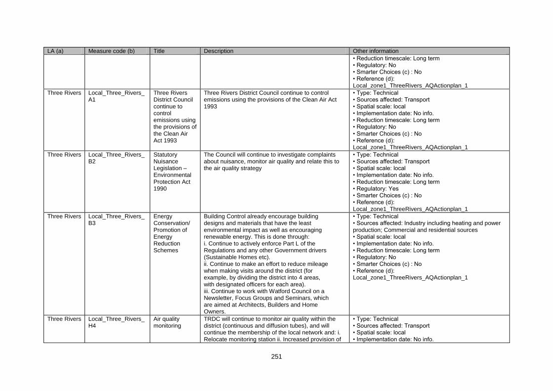
251
LA (a) Measure code (b) Title Description Other information
• Reduction timescale: Long term • Regulatory: No • Smarter Choices (c) : No • Reference (d): Local_zone1_ThreeRivers_AQActionplan_1
Three Rivers Local_Three_Rivers_A1
Three Rivers District Council continue to control emissions using the provisions of the Clean Air Act 1993
Three Rivers District Council continue to control emissions using the provisions of the Clean Air Act 1993
• Type: Technical • Sources affected: Transport • Spatial scale: local • Implementation date: No info. • Reduction timescale: Long term • Regulatory: No • Smarter Choices (c) : No • Reference (d): Local_zone1_ThreeRivers_AQActionplan_1
Three Rivers Local_Three_Rivers_B2
Statutory Nuisance Legislation – Environmental Protection Act 1990
The Council will continue to investigate complaints about nuisance, monitor air quality and relate this to the air quality strategy
• Type: Technical • Sources affected: Transport • Spatial scale: local • Implementation date: No info. • Reduction timescale: Long term • Regulatory: Yes • Smarter Choices (c) : No • Reference (d): Local_zone1_ThreeRivers_AQActionplan_1
Three Rivers Local_Three_Rivers_B3
Energy Conservation/ Promotion of Energy Reduction Schemes
Building Control already encourage building designs and materials that have the least environmental impact as well as encouraging renewable energy. This is done through: i. Continue to actively enforce Part L of the Regulations and any other Government drivers (Sustainable Homes etc). ii. Continue to make an effort to reduce mileage when making visits around the district (for example, by dividing the district into 4 areas, with designated officers for each area). iii. Continue to work with Watford Council on a Newsletter, Focus Groups and Seminars, which are aimed at Architects, Builders and Home Owners.
• Type: Technical • Sources affected: Industry including heating and power production; Commercial and residential sources • Spatial scale: local • Implementation date: No info. • Reduction timescale: Long term • Regulatory: No • Smarter Choices (c) : No • Reference (d): Local_zone1_ThreeRivers_AQActionplan_1
Three Rivers Local_Three_Rivers_H4
Air quality monitoring
TRDC will continue to monitor air quality within the district (continuous and diffusion tubes), and will continue the membership of the local network and: i. Relocate monitoring station ii. Increased provision of
• Type: Technical • Sources affected: Transport • Spatial scale: local • Implementation date: No info.
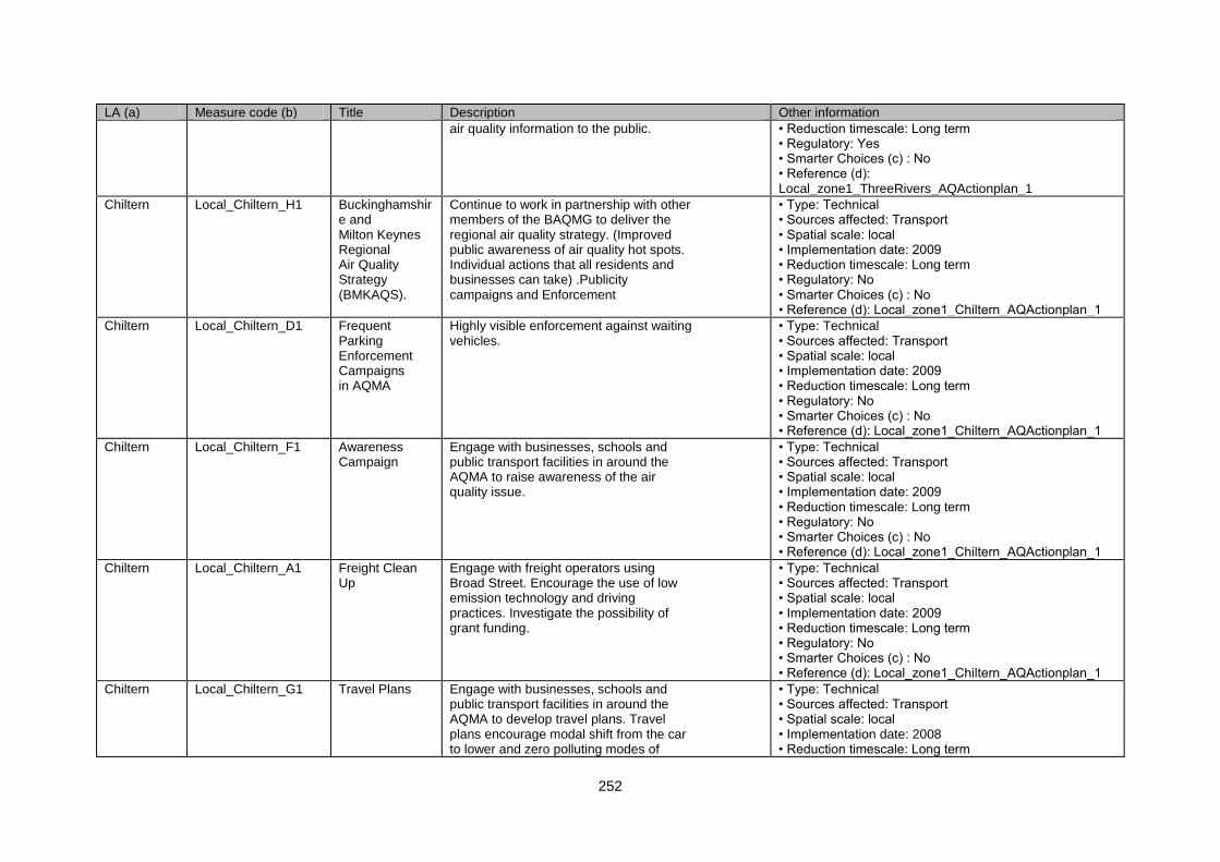
252
LA (a) Measure code (b) Title Description Other information
air quality information to the public. • Reduction timescale: Long term • Regulatory: Yes • Smarter Choices (c) : No • Reference (d): Local_zone1_ThreeRivers_AQActionplan_1
Chiltern Local_Chiltern_H1 Buckinghamshire and Milton Keynes Regional Air Quality Strategy (BMKAQS).
Continue to work in partnership with other members of the BAQMG to deliver the regional air quality strategy. (Improved public awareness of air quality hot spots. Individual actions that all residents and businesses can take) .Publicity campaigns and Enforcement
• Type: Technical • Sources affected: Transport • Spatial scale: local • Implementation date: 2009 • Reduction timescale: Long term • Regulatory: No • Smarter Choices (c) : No • Reference (d): Local_zone1_Chiltern_AQActionplan_1
Chiltern Local_Chiltern_D1 Frequent Parking Enforcement Campaigns in AQMA
Highly visible enforcement against waiting vehicles.
• Type: Technical • Sources affected: Transport • Spatial scale: local • Implementation date: 2009 • Reduction timescale: Long term • Regulatory: No • Smarter Choices (c) : No • Reference (d): Local_zone1_Chiltern_AQActionplan_1
Chiltern Local_Chiltern_F1 Awareness Campaign
Engage with businesses, schools and public transport facilities in around the AQMA to raise awareness of the air quality issue.
• Type: Technical • Sources affected: Transport • Spatial scale: local • Implementation date: 2009 • Reduction timescale: Long term • Regulatory: No • Smarter Choices (c) : No • Reference (d): Local_zone1_Chiltern_AQActionplan_1
Chiltern Local_Chiltern_A1 Freight Clean Up
Engage with freight operators using Broad Street. Encourage the use of low emission technology and driving practices. Investigate the possibility of grant funding.
• Type: Technical • Sources affected: Transport • Spatial scale: local • Implementation date: 2009 • Reduction timescale: Long term • Regulatory: No • Smarter Choices (c) : No • Reference (d): Local_zone1_Chiltern_AQActionplan_1
Chiltern Local_Chiltern_G1 Travel Plans Engage with businesses, schools and public transport facilities in around the AQMA to develop travel plans. Travel plans encourage modal shift from the car to lower and zero polluting modes of
• Type: Technical • Sources affected: Transport • Spatial scale: local • Implementation date: 2008 • Reduction timescale: Long term
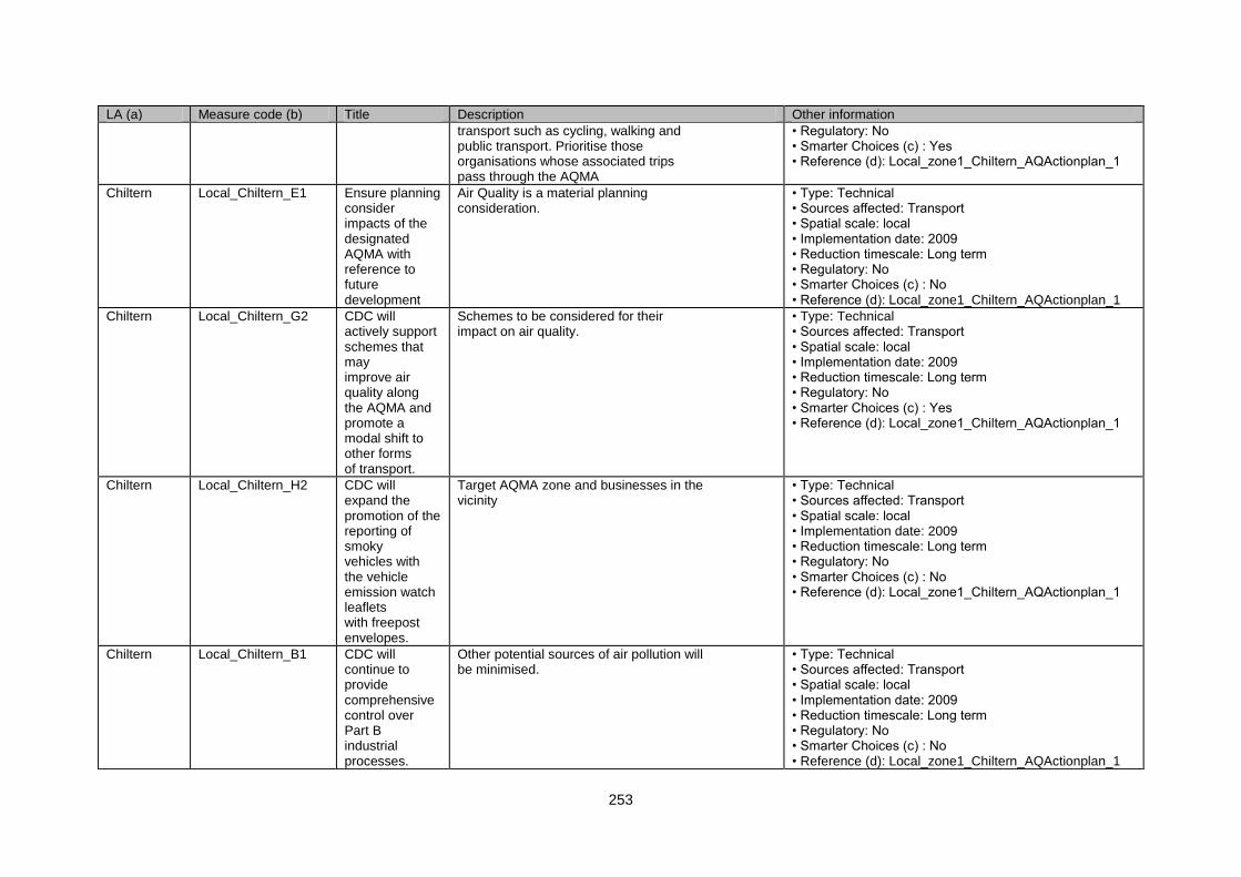
253
LA (a) Measure code (b) Title Description Other information
transport such as cycling, walking and public transport. Prioritise those organisations whose associated trips pass through the AQMA
• Regulatory: No • Smarter Choices (c) : Yes • Reference (d): Local_zone1_Chiltern_AQActionplan_1
Chiltern Local_Chiltern_E1 Ensure planning consider impacts of the designated AQMA with reference to future development
Air Quality is a material planning consideration.
• Type: Technical • Sources affected: Transport • Spatial scale: local • Implementation date: 2009 • Reduction timescale: Long term • Regulatory: No • Smarter Choices (c) : No • Reference (d): Local_zone1_Chiltern_AQActionplan_1
Chiltern Local_Chiltern_G2 CDC will actively support schemes that may improve air quality along the AQMA and promote a modal shift to other forms of transport.
Schemes to be considered for their impact on air quality.
• Type: Technical • Sources affected: Transport • Spatial scale: local • Implementation date: 2009 • Reduction timescale: Long term • Regulatory: No • Smarter Choices (c) : Yes • Reference (d): Local_zone1_Chiltern_AQActionplan_1
Chiltern Local_Chiltern_H2 CDC will expand the promotion of the reporting of smoky vehicles with the vehicle emission watch leaflets with freepost envelopes.
Target AQMA zone and businesses in the vicinity
• Type: Technical • Sources affected: Transport • Spatial scale: local • Implementation date: 2009 • Reduction timescale: Long term • Regulatory: No • Smarter Choices (c) : No • Reference (d): Local_zone1_Chiltern_AQActionplan_1
Chiltern Local_Chiltern_B1 CDC will continue to provide comprehensive control over Part B industrial processes.
Other potential sources of air pollution will be minimised.
• Type: Technical • Sources affected: Transport • Spatial scale: local • Implementation date: 2009 • Reduction timescale: Long term • Regulatory: No • Smarter Choices (c) : No • Reference (d): Local_zone1_Chiltern_AQActionplan_1
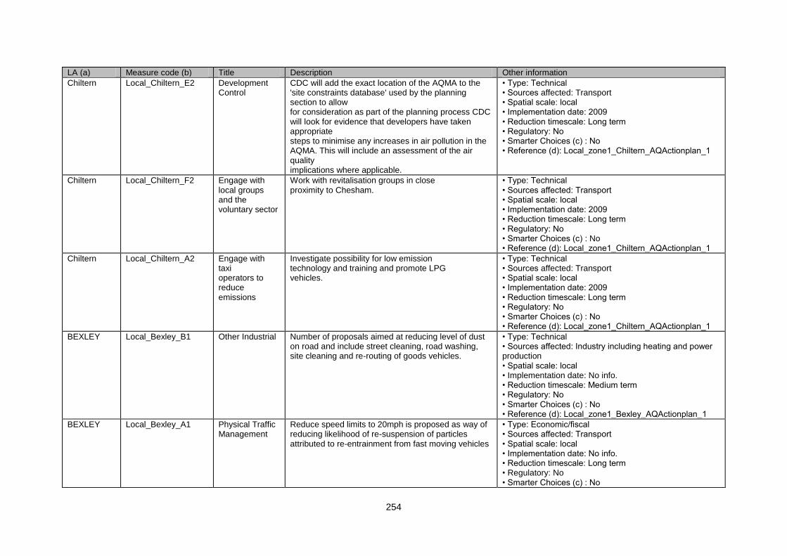
254
LA (a) Measure code (b) Title Description Other information
Chiltern Local_Chiltern_E2 Development Control
CDC will add the exact location of the AQMA to the 'site constraints database' used by the planning section to allow for consideration as part of the planning process CDC will look for evidence that developers have taken appropriate steps to minimise any increases in air pollution in the AQMA. This will include an assessment of the air quality implications where applicable.
• Type: Technical • Sources affected: Transport • Spatial scale: local • Implementation date: 2009 • Reduction timescale: Long term • Regulatory: No • Smarter Choices (c) : No • Reference (d): Local_zone1_Chiltern_AQActionplan_1
Chiltern Local_Chiltern_F2 Engage with local groups and the voluntary sector
Work with revitalisation groups in close proximity to Chesham.
• Type: Technical • Sources affected: Transport • Spatial scale: local • Implementation date: 2009 • Reduction timescale: Long term • Regulatory: No • Smarter Choices (c) : No • Reference (d): Local_zone1_Chiltern_AQActionplan_1
Chiltern Local_Chiltern_A2 Engage with taxi operators to reduce emissions
Investigate possibility for low emission technology and training and promote LPG vehicles.
• Type: Technical • Sources affected: Transport • Spatial scale: local • Implementation date: 2009 • Reduction timescale: Long term • Regulatory: No • Smarter Choices (c) : No • Reference (d): Local_zone1_Chiltern_AQActionplan_1
BEXLEY Local_Bexley_B1 Other Industrial Number of proposals aimed at reducing level of dust on road and include street cleaning, road washing, site cleaning and re-routing of goods vehicles.
• Type: Technical • Sources affected: Industry including heating and power production • Spatial scale: local • Implementation date: No info. • Reduction timescale: Medium term • Regulatory: No • Smarter Choices (c) : No • Reference (d): Local_zone1_Bexley_AQActionplan_1
BEXLEY Local_Bexley_A1 Physical Traffic Management
Reduce speed limits to 20mph is proposed as way of reducing likelihood of re-suspension of particles attributed to re-entrainment from fast moving vehicles
• Type: Economic/fiscal • Sources affected: Transport • Spatial scale: local • Implementation date: No info. • Reduction timescale: Long term • Regulatory: No • Smarter Choices (c) : No
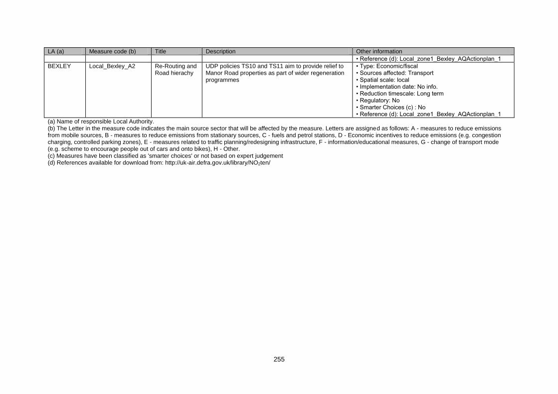
255
LA (a) Measure code (b) Title Description Other information
• Reference (d): Local_zone1_Bexley_AQActionplan_1
BEXLEY Local_Bexley_A2 Re-Routing and Road hierachy
UDP policies TS10 and TS11 aim to provide relief to Manor Road properties as part of wider regeneration programmes
• Type: Economic/fiscal • Sources affected: Transport • Spatial scale: local • Implementation date: No info. • Reduction timescale: Long term • Regulatory: No • Smarter Choices (c) : No • Reference (d): Local_zone1_Bexley_AQActionplan_1
(a) Name of responsible Local Authority. (b) The Letter in the measure code indicates the main source sector that will be affected by the measure. Letters are assigned as follows: A - measures to reduce emissions from mobile sources, B - measures to reduce emissions from stationary sources, C - fuels and petrol stations, D - Economic incentives to reduce emissions (e.g. congestion charging, controlled parking zones), E - measures related to traffic planning/redesigning infrastructure, F - information/educational measures, G - change of transport mode (e.g. scheme to encourage people out of cars and onto bikes), H - Other. (c) Measures have been classified as 'smarter choices' or not based on expert judgement (d) References available for download from: http://uk-air.defra.gov.uk/library/NO2ten/

256