airspace change proposal robin hood airport hood... · 2 airspace arrangements ... airspace (cas)...
TRANSCRIPT

Airspace Change Proposal Robin Hood Airport

AIRSPACE CHANGE PROPOSAL
RHADS ACP 16 Dec 06 1 of 43
Contents
1 Introduction .............................................................................................................. 3 1.1 Overview .................................................................................................................... 3 1.2 Brief History of the Airport .......................................................................................... 3 1.3 Airport Growth ............................................................................................................ 3 1.4 Development of an ACP ............................................................................................. 4 1.5 Sponsor Consultation ................................................................................................. 4
2 Airspace Arrangements ........................................................................................... 5 2.1 Current Airspace and Safety-Related Issues ............................................................. 5 2.2 Current ATC Operation .............................................................................................. 5 2.3 Air Incidents ............................................................................................................... 6 2.4 Future Air Traffic Developments ................................................................................ 7
3 Options for Change .................................................................................................. 8 3.1 General ...................................................................................................................... 8 3.2 Do Nothing ................................................................................................................. 8 3.3 Agreement with local operators .................................................................................. 8 3.4 Establish Controlled Airspace .................................................................................... 9
4 Design Proposal ..................................................................................................... 11 4.1 Background .............................................................................................................. 11 4.2 Design Considerations ............................................................................................. 11 4.3 Evolution of Design .................................................................................................. 12 4.4 Proposed Design of the CAS ................................................................................... 14 4.5 CTR .......................................................................................................................... 14 4.6 CTA-1 ....................................................................................................................... 15 4.7 CTA-2 ....................................................................................................................... 16 4.8 CTA-3 ....................................................................................................................... 17 4.9 CTA-4 ....................................................................................................................... 17 4.10 CTA-5 ....................................................................................................................... 18 4.11 CTA-6 ....................................................................................................................... 20 4.12 CTA-7 ....................................................................................................................... 21 4.13 CTA-8 ....................................................................................................................... 21 4.14 Other Controlled Airspace ........................................................................................ 21 4.15 VFR Operations ....................................................................................................... 22

AIRSPACE CHANGE PROPOSAL
RHADS ACP 16 Dec 06 2 of 43
5 Route Design - Arrivals ......................................................................................... 24 5.1 General .................................................................................................................... 24 5.2 Arrival Routes ........................................................................................................... 24 5.3 DAP Buffer Policy ..................................................................................................... 24 5.4 Hold Design .............................................................................................................. 26
6 Route Design – Departures ................................................................................... 27 6.1 General .................................................................................................................... 27 6.2 Departure Design Criteria ........................................................................................ 27 6.3 Current Departures .................................................................................................. 28 6.4 Additional Departure Route ...................................................................................... 28
7 Environmental Considerations ............................................................................. 31 7.1 Overview .................................................................................................................. 31 7.2 Noise ........................................................................................................................ 31 7.3 Climate Change ....................................................................................................... 34 7.4 Visual Impact and Tranquillity .................................................................................. 35 7.5 Air Quality ................................................................................................................. 35
8 Summary ................................................................................................................. 36
A Abbreviations and Acronym ................................................................................. 37
B Glossary of Terms .................................................................................................. 39
C Classifications of Airspace ................................................................................... 43

AIRSPACE CHANGE PROPOSAL
RHADS ACP 16 Dec 06 3 of 43
1 Introduction
1.1 Overview
1.1.1 This consultative document details the case for the establishment of Controlled Airspace (CAS) at Robin Hood Airport Doncaster Sheffield (RHADS). A short history and growth of the Airport, which underlines the need for this airspace change, follows this overview together with details of where the formal details of the Airspace Change Process (ACP) can be found. Thereafter, the current airspace and Air Traffic Control (ATC) arrangements are explained together with the safety-related issues and details of incidents. The future plans for ATC at RHADS are then covered. Next, the actual ACP is described as applicable to RHADS. In accord with this process, a number of options to resolve the existing unsatisfactory airspace arrangements are explored.
1.1.2 The design of the proposed airspace is then outlined together with details of the Standard Instrument Departures (SIDs), Standard Arrivals (STARs), holding procedures and Visual Flight Rules (VFR) flight and operating procedures within CAS.
1.1.3 An analysis of the impact on the environment concludes the document before a summary of the case for change is provided. For ease of reference a list of abbreviations and acronyms are at Annex A, a Glossary of Terms at Annex B and Classifications of Airspace at Annex C.
1.2 Brief History of the Airport
1.2.1 Following the closure of RAF Finningley in the mid-nineties an application was submitted on 1 November 1999 to Doncaster Metropolitan Borough Council (DMBC) for planning permission comprising a redevelopment of Finningley Airfield for the purposes of a commercial airport with airport related business. On 30 March 2001 the Secretary of State called in the application which resulted in a Public Inquiry (PI).
1.2.2 RHADS was granted planning consent by Government in March 2004 following the PI examination. Extensive documentation and briefings were presented at the PI about the proposed operation and the airspace arrangements needed to sustain it. The application was supported by an Environmental Assessment with a non-technical summary and technical appendices dealing with a number of issues including noise and vibration, air quality and an environmental management strategy. The Inspector accepted the case that was presented and no variations were appended to the planning approval in regard to operational matters.
1.2.3 The Airport provides welcome employment and no doubt further growth will be encouraged as the numbers of aircraft and passengers.
1.3 Airport Growth
1.3.1 Commercial operations at the RHADS commenced in April 2005 and since the opening the Airport has flourished and continues to grow apace in terms of Passenger Air Transport Movements (PATM) and passenger numbers. Similarly, the transport of freight has increased considerably in recent months and this upsurge is expected to continue.

AIRSPACE CHANGE PROPOSAL
RHADS ACP 16 Dec 06 4 of 43
1.3.2 The passenger numbers for the first 12 months of operation were 840,000 and rapid growth is forecast for future years. Indeed, by the end of 2007 the numbers are predicted to be approaching 2 million and this is anticipated to double by the end of 2010. Thomson Fly, Ryanair, Thomas Cook, Flybe and Wizz have all demonstrated a commitment to the Airport and other scheduled and charter operators are expected to follow suit in the near future. Already this summer Air Europa and Balkan Holidays have introduced new services and also there have been a number of ‘one off’ charters.
1.3.3 Away from the public transport and freight operations, the Airport deals with an assortment of other flying activities. It provides an opportunity for General Aviation (GA) aircraft to visit and train at RHADS; furthermore, business jets are increasingly making use of the Airport and it is proving popular for IFR training. Lastly, adjacent military airfields nominate RHADS on a regular basis as one of their diversion airfields in case circumstances prevent a landing back at their base. In tandem with this military pilots carry out practice instrument approaches at RHADS on a regular basis.
1.3.4 The plethora of flying activities described above taking place in uncontrolled airspace has led to a number of safety-related incidents which together with the illustrations of predicted growth underline the pressing need for a revision in the airspace arrangements.
1.4 Development of an ACP
1.4.1 Having determined the operational requirement to establish different airspace arrangements, RHADS has decided to develop an airspace change in accordance with the ACP as detailed in the Airspace Charter published by the Directorate of Airspace Policy (DAP) as Civil Air Publication (CAP) 724. Further guidance is also provided in the CAP 725, a revised version of which is currently out to consultation. In the main, RHADS will be following the existing process as published; however, under guidance from DAP certain parts of the new process, particularly with regard to the environment, have been incorporated. Both the CAP 724 and 725 are available at www.caa.co.uk/dap.
1.4.2 The Directorate, which is part of the Civil Aviation Authority (CAA), is the Airspace and Regulatory Authority for the UK. The Airspace Charter defines the authorities, responsibilities and principles by which DAP, conducts the planning of airspace and related arrangements in the UK. In addition, due recognition of the contents of the Government document “Guidance to the Civil Aviation Authority on Environmental Objectives relating to the Exercise of its Air Navigation Functions” has also been taken. This document is also available on www.dft.gov.uk
1.5 Sponsor Consultation
1.5.1 As a first step, RHADS is now required to undertake sponsor consultation, which is the purpose of this document. It is our responsibility to consult at local level on both the aviation and environmental issues associated with the proposed changes. All affected local Parish, Borough, District and County Councils are being informed, together with the Airport Consultative Committee (ACC) and all affected airspace stakeholders; to date we have identified over 160 consultees. This process is in accord with Government policy as it gives the Airport Operator the opportunity to consider and address local concerns at an early stage.

AIRSPACE CHANGE PROPOSAL
RHADS ACP 16 Dec 06 5 of 43
2 Airspace Arrangements
2.1 Current Airspace and Safety-Related Issues
2.1.1 At present, this increasingly busy and developing airport is operating in Class G airspace (see Annex C) with its only protection from itinerant traffic being an Air Traffic Zone (ATZ). In this airspace aircraft are able to fly without filing a flight plan or obtaining an air traffic clearance thus making the overall air picture completely unpredictable.
2.1.2 The ATZ extends to a radius of 2½ nm from the centre of the aerodrome up to 2000 feet above aerodrome elevation. The airspace within this ATZ is also Class G although pilots must obtain permission from ATC to enter the ATZ. In the local area there is a profusion of GA activities associated with Sandtoft airfield, which also has an ATZ, located only 7 miles from RHADS. Other airfields in the vicinity include Gamston, Sheffield, Sherburn-in-Elmet and Netherthorpe embracing myriad aviation activities. Moreover, there are numerous gliding and microlights sites plus parachuting takes place at nearby Hibaldstow. The nearby military airfields of RAF Waddington, RAF Coningsby, RAF Scampton, RAF Cottesmore, RAF Cranwell and RAF Barkston Heath generate considerable traffic, much of this operates at low level. The Lincolnshire Area of Intense Aerial Activity (AIAA) is situated to the south of the Airport and the Yorkshire AIAA is to the north. In summary there are a multitude of disparate aviation operations in the area and this is now further complicated by the ever increasing operations from RHADS. A map illustrating the current and proposed airspace arrangements is provided at Enclosure 1.
2.1.3 Although arrival and departure lanes have been established at RHADS to facilitate commercial traffic operating to/from the Airport, any aircraft can conduct operations quite legitimately in these lanes while the airspace remains as Class G. Many of the training GA aircraft undertake aerobatic and unusual manoeuvres in the conduct of their flight that renders any conflict resolution most difficult due to the unpredictable nature of their flights. In addition, much of this GA activity is gliders and microlights who, in the main, are difficult to see on radar and do not carry transponders.
2.1.4 Above and around the Airport there are airways which are Class A airspace. For aircraft arriving at and departing from RHADS there is a need to fit in with the particular flows of these airways. It should be noted that the procedures remain the same as presented to the PI and provide inherent constraints to the efficacy of operations at the Airport. Furthermore, these constraints have made a major impact on the design of the Proposed Airspace and their effect will be explained in Section 4.
2.2 Current ATC Operation
2.2.1 RHADS provides an ATC Service, which includes an Approach Radar Service. Currently, this radar service is provided using off-site radar located at RAF Waddington which restricts the low level coverage in the RHADS area. Nevertheless, whatever the radar coverage, pilots of aircraft operating in the vicinity of RHADS are not required to communicate with RHADS ATC unless they wish to enter the ATZ. To achieve safe separation pilots must rely on the ‘see and
AIRSPACE CHANGE PROPOSAL
RHADS ACP 16 Dec 06 6 of 43
avoid’ principle and take avoiding action as appropriate. Thus, it should be noted that the Approach Radar Service is provided to aircraft arriving and departing from RHADS in an environment where other aircraft may be operating, quite legitimately, but which are unidentified to the radar controller.
2.2.2 If the RHADS Radar Controller observes one of these aircraft on radar it must be considered as ‘unknown’. When providing a Radar Advisory Service (RAS) the controller is then required to avoid this ‘unknown’ by 3000ft vertically if there is any indication of its altitude or 5nm laterally. Whilst this may be a normal and acceptable situation for the less busy regional airports there are a number of factors which have led to this situation being no longer tenable at RHADS. Some of these ‘unknowns’ are military fast jet traffic operating around 400 knots and their direction of turn is difficult to predict. The situation is further exacerbated by the fact that the conflicting aircraft can suddenly pop up from low level. When directing an aircraft travelling at 250 knots, the radar controller, in the worst-case scenario, could be faced with pop up, head on traffic with a combined closing speed of 650 knots. Consequently, the controller has little chance of achieving the standard separation criteria. At best, if time permits, advice is provided on avoiding action and traffic information. Importantly, it should also be noted that the pilots of both aircraft could be in cloud and therefore, would be unable to see each other. If the pilot opts for a Radar Information Service (RIS) only details of the conflicting aircraft are passed. It is then the responsibility of the pilot to ‘locate’ the aircraft and take any avoiding action if deemed necessary.
2.2.3 At present ATC controllers strive to create a safe environment for all aircraft in the area; however, the inherent limitations of Class G airspace together with the continuing expansion of the Airport make this more and more difficult.
2.3 Air Incidents
2.3.1 During the exceptional growth in airport activity, it has been a matter of concern that there have been a continuing number of reports involving passenger carrying aircraft and unidentified aircraft operating in the RHADS area. A number of Mandatory Occurrence Reports (MORs) quickly followed after the Airport opened and any amplification of these occurrences can be obtained from the Safety Regulation Group (SRG) CAA. Two Air Proximity (AIRPROX) Reports have been filed in recent months and these more serious occurrences highlight our concerns. The majority of these incidents have occurred within 10 nm of RHADS; however, the possibilities of incidents taking place elsewhere on the departure and recovery tracks between the Airport and existing CAS remain high.
2.3.2 Between September and November 2006 a log was maintained of some 50 aircraft flying close to or adjacent to the Airport who had failed to call RHADS ATC. In some cases there was no formal requirement to call; however, in all cases the knowledge of these aircraft and their intention would have enabled ATC to have a better airspace picture thereby enabling a safer operating environment.
2.3.3 The CAA is constantly looking at ways of reducing the number of AIRPROX and air incidents throughout the UK and the establishment of CAS at RHADS would be a positive step towards that ideal. As long ago as 2000 following an inquiry into an incident at another regional airport the UK Air Accidents Investigation Branch recommended that: ‘the CAA should assess whether there is adequate provision

AIRSPACE CHANGE PROPOSAL
RHADS ACP 16 Dec 06 7 of 43
of regulated airspace for scheduled air transport operations to and from regional airports that are not directly linked by airways or advisory routes.’
2.4 Future Air Traffic Developments
2.4.1 A new Primary Surveillance Radar (PSR) is being installed at RHADS, which will provide better low-level coverage of the surrounding area and it should be operational by early 2007; this radar is owned and controlled by the Airport operator. The Secondary Surveillance Radar (SSR) is currently provided by radar located at RAF Scampton although this will change, in conjunction with the introduction of the new PSR, to a data feed from the NATS radar at Claxby. The operational requirement is for the radars to provide coverage out to 42.5 nm up to 24,500 feet and this will be comfortably achieved. The radar will be available 24 hours and predicted outages are minimal. The data from radar will be fed through to a radar room at Liverpool John Lennon Airport, where the radar ATCOs who are on duty are based. It should be noted that RHADS has the required number of personnel (together with the requisite licences) to provide manpower to support the operation of the new radar and provide effective management of any additional airspace at all times.
2.4.2 RHADS has applied formally to join the Lower Airspace Radar Service (LARS) system that will re-install the LARS provision which RAF Finningley provided up to 1995. The loss of this service led to the GA fraternity frequently voicing their concern to the lack of radar service in the area. However, prior to any formal incorporation of RHADS into the LARS system, RHADS will continue to provide a radar service to any pilot calling for such a service.
2.4.3 Letters of Agreement (LoA) are already in existence with a number of local operators. Draft amendments and, where necessary, new agreements are being formulated to take into account the proposal to establish CAS.
2.4.4 The sustained expansion of the Airport will increase controllers’ workload and changes to the current airspace arrangements are urgently needed to enable more efficient air operations to take place and to enhance safety as traffic levels increase.

AIRSPACE CHANGE PROPOSAL
RHADS ACP 16 Dec 06 8 of 43
3 Options for Change
3.1 General
3.1.1 When developing an ACP, it is a requirement that a number of options be explored to establish what configuration best suits the current and future operation and this process is discussed below.
3.1.2 Options include:
Do Nothing;
Arrangements with local operators;
Establish Class D Airspace.
3.1.3 Each of these options has been discussed with primary airspace stakeholders in order to achieve an airspace design which accommodates, to the maximum extent possible, the various requirements of each entity. It has not been easy to meet the needs of all stakeholders’ requirements and, indeed, has led to a number of compromises. The proposal as presented in this consultation document has been modified to reflect the outcome of these preliminary negotiations.
3.2 Do Nothing
3.2.1 There is every indication that the “low-cost airline” operation, which is a growing phenomenon in Europe and at RHADS in particular, is unlikely to be short-lived. In addition, a considerable growth in freight operations is expected. Consequently, the air traffic and passenger throughput at RHADS will not abate and the latest forecasts indicate rapidly increasing growth.
3.2.2 To do nothing and maintain current airspace arrangements would not address the main issue of assuring a safe and expeditious air operation. In this option, the creation of a known traffic environment is not achieved. The threat from itinerant traffic will not diminish and it is likely that the air incidents that regrettably occur will continue without some positive steps to adopt formal airspace arrangements. Indeed, the number of air incidents could conceivably increase as more scheduled PATMs use the Airport. In summary, the current uncertainties and unpredictability of the airspace causes airspace management inefficiencies and this, in turn, has a negative impact on the efficiency and safety of the commercial aircraft operations.
3.3 Agreement with local operators
3.3.1 A proportion of conflicting aircraft are fast jet military traffic exercising their tactical freedom in Class G airspace. As was explained in the paragraphs above the nature of the military operations often create difficult situations for the radar controller to resolve. Ideally, military aircraft would contact RHADS when operating within 15 nm of the Airport and provide timely traffic information to the controller on all occasions and thus obviate the need for avoiding action with the commercial civilian traffic. However, if military aircraft were required to contact RHADS to assure some sort of co-ordinated action to resolve conflictions, it is likely any agreement would only work to a limited extent.

AIRSPACE CHANGE PROPOSAL
RHADS ACP 16 Dec 06 9 of 43
3.3.2 As described earlier there are a myriad of local GA activities in the area and it would be much safer if more formal operating arrangements could be established with all these operators. There are already existing LoAs with a number of the nearby local air operations; however, increasing the number of LoA to accommodate all potential airspace users would make their management most burdensome. The detailed specifics required to allow the flexibility of operations for both the Airport and every GA operator to cover every eventuality would make the documents lengthy and complex.
3.3.3 It should be recognised that LoAs are not always enforceable. In addition, the operations at these bases are ever-changing which means that LoAs need regular updating and amendment; the management of this process creates a heavy administrative load in terms of negotiation and documentation. At this stage it is considered that the critical mass has almost been reached and too many LoA may well undermine the efficacy of operations. Lastly, any agreements do not cover the itinerant flyer who currently is free to conduct operations in the vicinity of the airport clear of the ATZ.
3.4 Establish Controlled Airspace
3.4.1 At present flying at and around the Airport is taking place in Class G airspace, which by definition is uncontrolled airspace. The proposal is to change the status of some of the airspace to controlled airspace.
3.4.2 Within this option there are 3 alternatives. Firstly, a stand alone Control Zone (CTR) could be established around the airfield, which would protect the final stages of approach and the early stages of departure. However, on departure after leaving the protection of the CTR the aircraft would again be subject to the uncertainties and potential hazards of operating in Class G airspace prior to entry into the known environment of the airway (Class A) system. Equally, on arrival the aircraft would leave the assured safety of the airway and need to transit through Class G airspace until reaching the edge of the CTR.
3.4.3 Secondly, a CTR and associated Control Area (CTA) could be established which would provide additional protection to further parts of the departure and arrival procedures; however, the main shortcoming is that essential connectivity to the airways system still would not be achieved.
3.4.4 Lastly, the establishment of a CTR together with a number of adjacent CTAs would provide protection throughout all stages of flight through a continuum of CAS into the airways system. Clearly this is the optimal solution, because throughout all stages of flight these large passenger-carrying aircraft, some with up to 300 persons on board, would be operating within airspace where the height and intention of all other aircraft within that airspace are known.
3.4.5 There are 5 ICAO Airspace classifications reserved for controlled airspace. Class A was considered be too restrictive because VFR flight would not be permitted and this would have an unacceptable adverse effect on both GA and military operations. Class B is not used in the UK. At present Class C, with the exception of 2 isolated segments of airspace is only used above Flight Level 245 (FL195 from March 2007). Class E, whilst similar to Class D, provides reduced traffic information from ATC. More significantly, no ATC clearance for aircraft flying VFR is required which means that the controller is never fully aware of the complete air

AIRSPACE CHANGE PROPOSAL
RHADS ACP 16 Dec 06 10 of 43
picture which can lead to untimely advisory avoiding action, unnecessary delays and possible erosions of safety. The preferred option is, therefore, Class D, which provides the air traffic environment whereby the controller knows every aircraft operating within the airspace at and adjacent to the airport. In turn this knowledge leads to a safe and expeditious flow of all traffic in the area.
3.4.6 Undoubtedly, the existing GA and military operations together with the existing and planned traffic levels of the Airport merit the establishment of the proposed Class D airspace. At the same time, aircraft operating under Visual Flight Rules (VFR) would still be permitted to operate in the CAS as it is not creating ‘brick walls’ for aircraft wishing to access or transit the area. Of the 3 alternatives the establishment of a CTR and associated CTAs as Class D airspace is the preferred option and is also the best for accommodating Continuous Descent Approaches (CDAs) which are recognised as most important from an environmental perspective, an element of the design which is covered later in this document.

AIRSPACE CHANGE PROPOSAL
RHADS ACP 16 Dec 06 11 of 43
4 Design Proposal
4.1 Background
4.1.1 At the Public Inquiry held in 2001/02, the departure and arrival air routes from and to RHADS were examined. The Inspector accepted that the routes as presented were required and these were adopted as operational procedures by RHADS when planning consent was given by the Secretary of State. Coincident with the announcement for planning consent was the promulgation of a revised airways structure over South Yorkshire, which resulted from an ACP developed by National Air Traffic Services (NATS) and the Ministry of Defence (MoD) to accommodate military training airspace in the North Sea. This strategically important airspace change resulted in the disestablishment of the airway Bravo 1 and the introduction of new air routes linking the Manchester area and Dutch airspace. In addition, some changes were made to the arrival and departure profiles at those regional airports that were affected by the change to ensure access to the new air route structure.
4.1.2 The introduction of the revised enroute structure required RHADS to re-consider the entry and exit procedures to and from the airways. Whilst RHADS has adhered to the departure routes as presented at the PI to the maximum extent possible, and at least until passing 3000 feet which is the end of the Noise Preferential Routes (NPR), there has been a need to make some adjustments in the latter stages of the departure profile. In addition, a route based upon the little-used TRENT departure (up to the end of the NPR) is proposed.
4.1.3 The design of the CAS has to satisfy certain conventions which are derived from ICAO design criteria and national requirements. For example, CAS must encompass all of the departure, arrival and holding patterns. Where practicable, boundary lines should be established that are aligned with existing airspace boundaries and/or geographical features e.g. major river. These requirements have been met to the maximum extent possible.
4.1.4 It should be noted that this proposal does not seek to change the current arrangements per se, but does seek to reclassify the airspace within which the air operations to and from the Airport are conducted. Furthermore, the operating hours of the proposed CAS would be the same as the Airport’s opening hours, which is H24. RHADS will ensure that a radar service will be available during the notified hours to those stakeholders requiring transit through the area.
4.2 Design Considerations
4.2.1 In developing this proposal, a number of preliminary discussions took place with primary stakeholders including NATS, MOD, British Gliding Association (BGA) and a number of local GA operators. The purpose of the meetings was to inform and discuss the proposal with a key objective to achieve an appropriate airspace configuration that was mutually acceptable to all parties whilst assuring effective air traffic management throughout.
4.2.2 RHADS looked at the scope for introducing Flexible Use of Airspace (FUA) arrangements within the design proposal; however, it is understood that none of the UK regional airports that enjoy the benefit of Class D airspace limit the time periods of its operation (for example establishing the airspace sunrise to sunset)

AIRSPACE CHANGE PROPOSAL
RHADS ACP 16 Dec 06 12 of 43
Given the nature of both civil and military operations operating locally, it was decided that there are no perceived benefits to be derived from applying a timing schedule to the airspace.
4.2.3 Having concluded the preparatory work and development of a draft airspace design, attention turned to environmental issues that might arise from the proposal. It was recognised by the airport operator that, during the period from when the RAF station ceased flying operations in the mid 1990s to the commencement of commercial air operations in April 2005, the environmental impact from aircraft operations was relatively very small. Consequently, a great deal of effort was expended on the Environmental Impact Assessment of the planned future operation of RHADS at the 2001/02 PI and extensive evidence was provided on: air quality, noise, risk and air operations. The planned departure and arrival route structure coupled with the use of ‘best practice’ for descent and climb profiles for aircraft resulted in the least disruption to the local population and minimising the fuel burn and emissions. RHADS aim from the outset has been to avoid overflight of urban areas, such as Doncaster, Worksop and Retford, as much as possible and we have adhered to that maxim throughout our design.
4.2.4 Where possible, the lateral boundaries of the proposed design coincide with the segmentation of the airways system above so as to minimise misunderstandings that can arise from boundary depiction on maps used for navigation. Where it has not been possible to make the new CAS boundaries coincident, it is proposed to adjust the existing boundaries of the current airway design. The adjustments proposed are described later in this Section. In addition, it has been necessary to make some minor adjustments to the arrival and departure profiles from the East and these are described in Sections 5 and 6 respectively.
4.3 Evolution of Design
4.3.1 The CAS proposal has evolved from its initial concept as input from stakeholders was obtained during the informal consultation. It is perhaps useful to understand how some of the segments have been shaped by the consultation process. These are explained briefly below.
Adjustment to CTR
4.3.2 The original design envisaged a CTR with wider lateral extents and a higher upper limit. However, this design would have limited the airspace available in an important low flying area for the military and made cross country flying difficult for gliders. Consequently, the CTR has been redesigned to a more conventional layout with a lower upper limit. This reduces the amount of controlled airspace, east of RHADS in the vicinity of the River Trent.
Withdrawal of CTA segments
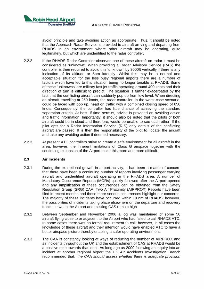
4.3.3 CTA segments to the south of the airway L603 (as shown in Figure 4-1) to accommodate climb profiles on the ROGAG SID from runway 20 were developed. However, if established, these would have inhibited effective holding at Waddington and also training aircraft operating at lower and medium levels (FL50 to FL120). It is intended that a LoA between units (RHADS and RAF Waddington) be forged to enable reasonable access through Restricted Area (R) 313 when it is declared ‘active’ (but not being used). The current design presented assumes that the agreement on airspace sharing will be forthcoming.
AIRSPACE CHANGE PROPOSAL
RHADS ACP 16 Dec 06 13 of 43
Figure 4-1: Runway 20 Departure Profile Avoiding R313
Revised Holding Arrangements
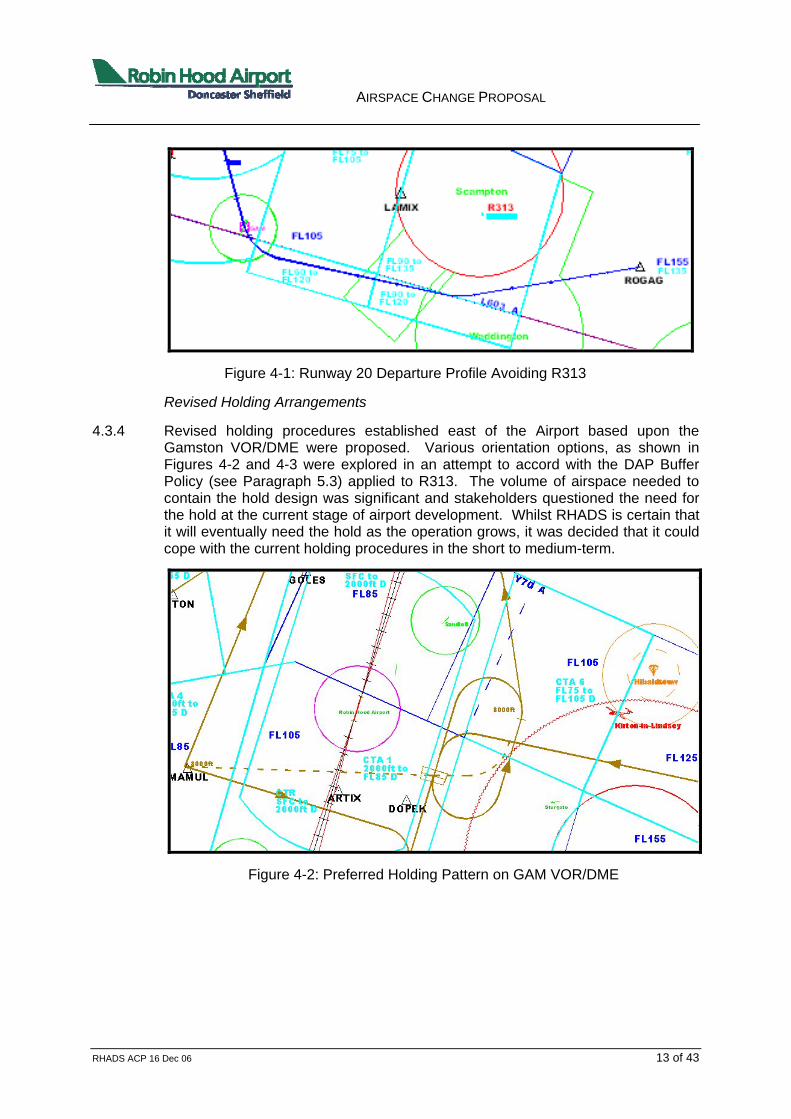
4.3.4 Revised holding procedures established east of the Airport based upon the Gamston VOR/DME were proposed. Various orientation options, as shown in Figures 4-2 and 4-3 were explored in an attempt to accord with the DAP Buffer Policy (see Paragraph 5.3) applied to R313. The volume of airspace needed to contain the hold design was significant and stakeholders questioned the need for the hold at the current stage of airport development. Whilst RHADS is certain that it will eventually need the hold as the operation grows, it was decided that it could cope with the current holding procedures in the short to medium-term.
Figure 4-2: Preferred Holding Pattern on GAM VOR/DME

AIRSPACE CHANGE PROPOSAL
RHADS ACP 16 Dec 06 14 of 43
Figure 4-3: Alternative Holding Pattern on GAM VOR/DME
4.4 Proposed Design of the CAS
4.4.1 The airspace proposal comprises a CTR established about the runway at RHADS and then a series of CTA segments to join the CTR to the enroute. In addition there is a requirement to establish an additional CTA below the base of the airway airspace above R313 and changes to the lateral boundaries of 2 other sectors of the airway.
4.5 CTR
4.5.1 The key consideration for the design of the CTR was the need to contain the IAPs. On runway 20, the IAP design has been influenced by the presence of Sandtoft ATZ and for the runway 02 IAP the Gamston ATZ has been influential in shaping the current IAP profile. The lateral boundaries of the CTR are based upon the orientation of the runway. The eastern and western boundaries are offset from the mid-point of the runway by 5 nm. The boundary extends north and south to a point 7nm from the eastern and western offset points. An 8nm arc from either end of the runway is scribed through the end points of the lines that lie parallel to the runway to form a lozenge shape. The design of the CTR is shown in Figure 4-4. The CTR extends from the surface to 2000 feet AMSL. Most of the Sandtoft ATZ will be embedded within the CTR, but will continue to operate in accordance with its operating licence. A draft LoA has been crafted to ensure effective air operations continues at both airports.
4.5.2 The CTR contains the initial departure routes to 3000 feet above aerodrome level (AAL), the final approach segment and initial missed approach. Aircraft operating with the visual circuit to the east of the Airport and the VFR traffic arriving at and departing from the Airport will also be fully contained within the Zone.

AIRSPACE CHANGE PROPOSAL
RHADS ACP 16 Dec 06 15 of 43
Figure 4-4: CTR & CTA-1
4.6 CTA-1
4.6.1 CTA-1 lies over the top of the CTR. Generally, the lateral limits of CTA-1 (to east and west) are formed by the sectors of the enroute airspace above; although minor adjustments to the airway will be necessary to make the boundaries coincident (as outlined in paragraph 4.14). The eastern and western boundaries are 26 nm long in a north/south axis centred on a point that lies perpendicular to the mid point of the runway. The northern and southern boundaries are formed by scribing a 13 nm arc from the ends of the runway; however see text in CTA-2 for additional explanation.
4.6.2 The CTA-1 lower limit is 2000 feet Above Mean Sea Level (AMSL) and the upper limit shall extend to FL85. In the northern sector this abuts to the base of airway Y70. However, in the southern sector airway L603 has a lower limit of FL105; therefore it is proposed to develop another segment of CTA which is described in CTA-5 below. The design of CTA-1 is shown in Figure 4-4.
4.6.3 This CTA contains the initial and intermediate segments of the Instrument Approach Procedure (IAP). These segments together with the NDB hold are fully contained by the lateral boundaries of the CAS. Aircraft will be manoeuvred within this CTA for positioning onto final approach (see section 5).

AIRSPACE CHANGE PROPOSAL
RHADS ACP 16 Dec 06 16 of 43
4.7 CTA-2
4.7.1 CTA-2 lies to the north west of RHADS and just west of GOLES. With the exception of the eastern boundary, its boundaries are coincident with current sectorisation of the airways system. It is proposed to realign the sector of airway where L975 and Y70 meet so that it overlies the proposed boundary between CTA-1 and CTA-2. If it is required that a reporting point lies on the boundary between the 2 airways, then the removal of GOLES and replacing it with another 5-letter reporting point will need to take place. Given that the proposal is to establish CAS (albeit Class D), it may not be necessary to make any change as there is no risk of aircraft leaving controlled airspace if following the airway in this area.
4.7.2 The airspace has a lower limit of 3000 feet AMSL and an upper limit of FL65. The lower limit will accommodate the arrival profiles and the departure profiles heading west (to UPTON) from runway 02 (see Sections 5 and 6 respectively). The eastern boundary (shown as a black line) is the desired profile which would necessitate the current airway boundary line above (greyed out line and currently to the east of the proposed boundary) to be realigned. The depiction of CTA-2 is shown in Figure 4-5.
Figure 4-5: CTA-2 and CTA-3
4.7.3 Alternative designs were explored, but the shape and size of this proposal is the optimum to accommodate arriving and departing traffic. The alternative designs

AIRSPACE CHANGE PROPOSAL
RHADS ACP 16 Dec 06 17 of 43
required changes to the lateral boundary of CTA-1 with the attendant increase in the volume of CAS overall.
4.7.4 Aircraft from Sherburn in Elmet airfield routinely use this area for training. A draft LoA has been crafted to explain how FUA can be employed to enable the training requirements to continue.
4.7.5 This CTA is necessary to accommodate the departures from runway 02 routing via GOLES to UPTON. Manchester Area Control Centre (MACC) has to integrate RHADS departures with those from Leeds Bradford, Manchester and Liverpool. The current procedures are inefficient and the proposed airspace change would allow RHADS departures to join the airways system at a lower level resulting in smoother integration between them and departures from other airfields. Given the geographical positions of each airport relative to UPTON, it is not possible for the level allocations to be reassigned. CTA-2 also provides protection to the arrivals from the west positioning for runway 20.
4.8 CTA-3
4.8.1 CTA-3 abuts to CTA-2 on the eastern boundary with the northern and southern boundary lines equivalent to those of L975 and a new boundary line established to the west. The base level is FL45 and the upper limit FL55. An alternative design would be to lower the airway from FL55 to FL45 (Class A CAS); however, this would be more restrictive and could be expected to attract opposition from local airspace users. Consequently, this CTA, which is essential for the departures routing to the west from both runway 02 and 20, would need to be established as Class D. The depiction of CTA-3 is shown in Figure 4-5.
4.8.2 It might have been possible to remove this segment of CTA from the proposal if NATS could approve an achievable higher joining level to the airways system. The proposed procedures to enable efficient and effective integration of RHADS departures from other local airports require that RHADS aircraft be allocated a nominal level of FL50 at UPTON.
4.9 CTA-4
4.9.1 CTA-4 lies to the south-west of the Airport under airway L603 centred on the reporting point MAMUL. It serves to protect the arrivals to both runways and the UPTON departure from runway 20. The lower limit is 3000ft and the upper limit FL85. This segment is depicted in Figure 4-6.
4.9.2 Netherthorpe uses this area routinely for training and indeed, a few of the cross county navigational routes for MoD training aircraft are also seen in this area from time to time. Discussions with both stakeholders continue in order to reach an accord on the practices and procedures to be employed which will enable these training flights to operate effectively.

AIRSPACE CHANGE PROPOSAL
RHADS ACP 16 Dec 06 18 of 43
Figure 4-6: CTA-4 and CTA-5
4.10 CTA-5
4.10.1 Paragraph 4.6 described the shape and form of CTA-1 which lies below the airways system, the base levels of which are not uniform. A small segment of CTA needs to be inserted between the upper limit (FL85) of CTA-1 and the base level (FL105) of L603. The western lateral boundary abuts to CTA-4 and the eastern lateral boundary abuts CTA-7. The north and south boundaries are coincident with the current airways boundary. The area is depicted by a dashed line in Figure 4-6.
4.10.2 To help understanding of how this CTA fits into the overall proposal a plan view is shown at Figure 4-7 followed by a vertical cut profile along the axis of the approach paths to the runway in Figure 4-8.

AIRSPACE CHANGE PROPOSAL
RHADS ACP 16 Dec 06 19 of 43
Figure 4-7: plan view

AIRSPACE CHANGE PROPOSAL
RHADS ACP 16 Dec 06 20 of 43
Figure 4-8: vertical cut
4.11 CTA-6
4.11.1 The purpose of CTA-6 is to accommodate the descent profile from the east into the radar vectoring pattern for either runway or the FNY hold at RHADS. It abuts to CTA-1 below airway Y70 as shown in Figure 4-9. The lower limit is FL75 and the upper limit is FL105. This segment lies adjacent to airspace used by the parachuting site at Hibaldstow and the gliding site at Kirton-in-Lindsey. Inbound aircraft need to be descended below the base level of the current CAS (FL105) if they are not to fly extended routings to loose height. It would be desirable to make the base level of CTA-6 lower, but the proposed level is a compromise to enable other airspace users the freedom to operate up to FL75 in this area. It is essential that CTA-6 be established to enable safe and expeditious handling of inbound aircraft to either runway.
4.11.2 Although the drop zone for the parachuting site at Hibaldstow partially encroaches on the proposed CAS a draft LoA has been crafted to explain how FUA can be employed to enable the parachuting operation to continue unaffected. Discussion with the BGA indicated that the revised airspace arrangements would not inhibit the glider operations at Kirton-in-Lindsey.
Figure 4-9: CTA-6, CTA-7 and CTA-8

AIRSPACE CHANGE PROPOSAL
RHADS ACP 16 Dec 06 21 of 43
4.12 CTA-7
4.12.1 CTA-7 lies to the south of CTA-6 and just west of R313 in the vicinity of LAMIX reporting point. It provides additional airspace to enable departure climb profiles from both runways to remain in CAS whilst climbing towards ROGAG. The current airways clearance from MACC is for aircraft to join at FL160 at ROGAG.
4.12.2 In Class G, controllers are often required to avoid unknown traffic between Gamston and ROGAG and due to the workload MACC will not provide a RAS to aircraft outside CAS.
4.12.3 This requirement to be FL160 by ROGAG is very demanding and can only be achieved if there are no deviations and uninterrupted climb profiles. If CTA-7 and CTA-8 (described in paragraph 4-13) are established, the minimum climb gradient for the departure profile would need to be 8% to ensure that aircraft are able to achieve the joining clearance. For instance, the nominal passing level at the CTA-1/CTA-7 boundary would be FL80 and at the CTA-7/CTA-8 boundary it would be FL130. Although in theory greater climb gradients could be used in the design, the 8% value is already higher than the standard value of about 6% used in most UK SIDs.
4.12.4 The base level of CTA-7 is FL75 and the upper limit FL105. In the vicinity of LAMIX the eastern boundary of the CTA follows the R313 boundary. The airspace is depicted in Figure 4-9.
4.13 CTA-8
4.13.1 An additional volume of controlled airspace below airway L603 east of LAMIX and above R313 is required to assist the climb profiles to ROGAG from runway 20 at RHADS. It was intended to seek a lowering of the airway from FL155 to FL125 (Class A CAS); however, access to this classification of airspace would be difficult for some airspace users who would like to transit through this area. Consequently, it has been decided that another CTA segment (CTA-8) should be created with boundaries which coincide with the airway segment above (Class D CAS). This is depicted in Figure 4-9. The preferred base level would be FL115 as this would ease the climb profile for aircraft trying to remain inside CAS on the ROGAG SID. However, the DAP Buffer Policy requires that FL125 be employed to preserve the buffer whenever low pressure weather systems prevail during R313 activity.
4.13.2 MACC has indicated that if lowering of the airway over Scampton option was taken (Class A CAS) then this would not impact on their operations and that effective co-ordination procedures can be developed to enable RHADS to get aircraft into the airway more efficiently. If accepted, it is likely that the airways joining point will be moved from ROGAG to LAMIX for easterly departures.
4.14 Other Controlled Airspace
4.14.1 Above the northern part of CTA-1 and CTA-6 is a segment of airway which has a base level of FL105. The western boundary of this sector, if left unchanged would leave a small volume of unusable Class G between the CTA below and the airway above. This small segment would be routinely be used by aircraft descending for an approach to runway 20 which could result in aircraft having to leave CAS which

AIRSPACE CHANGE PROPOSAL
RHADS ACP 16 Dec 06 22 of 43
contravenes current regulations. It is proposed to move the western boundary of this sector of Y70 further east as indicated by the dashed blue line in Figure 4-10.
4.14.2 Neither the proposed minor change to the airway stated here nor the additional proposal to realign a boundary in the vicinity of GOLES has attracted adverse comment from NATS during the stakeholder consultation. NATS staff at MACC indicated a willingness to redefine the airway if the CAS proposal is approved.
Figure 4-10: Revised Boundary of Airway Y70
4.15 VFR Operations
4.15.1 The establishment of CAS does not result in the prohibition of transit traffic through the airspace, nor are aircraft wishing to operate VFR to and from the Airport prevented from so doing. In Class D airspace, pilots will require an ATC clearance from Doncaster Radar which is no different to entry at any other regional airport CAS.
4.15.2 To facilitate VFR and Special VFR traffic whilst causing as little disruption as possible to the traffic flow of the IFR traffic, a number of Visual Reference Points (VRP) will be established and preferred routes published in the AIP. In essence, these routes would be no different to those flown today. The runway in use will determine the route that will be applicable to a particular flight. The landscape to the east of RHADS is not featureless, but it has been difficult to select suitable reference points which enable safe and effective integration of IFR/VFR. Nonetheless 4 VRPs have been selected as follows:

AIRSPACE CHANGE PROPOSAL
RHADS ACP 16 Dec 06 23 of 43
To the West – A1/M18 junction
To the North West - Motorway Services M18/M180 junction
To the East – Haxey (Water Tower)
To the South – A1/A57 junction
4.15.3 The UK AIP shall notify pilots of the ATC requirements for accessing the CAS via the VRP and the preferred routes. The location of each proposed VRP is shown in Figure 4-11.
Figure 4-11: Proposed VRP

AIRSPACE CHANGE PROPOSAL
RHADS ACP 16 Dec 06 24 of 43
5 Route Design - Arrivals
5.1 General
5.1.1 The arrival profiles are predicated on 2 factors: homing to the airport navigational aid (FNY) and/or radar vectoring to final approach. Most IFR aircraft inbound to RHADS are released by the en-route controllers at the base of the airways system either aiming towards UPTON and GOLES (from the west) or the FNY beacon. The rate of descent of an aircraft will determine at what point it will leave the airway and control staff at RHADS are permitted to take control.
5.1.2 The nominal routes of the arrivals are depicted in Figures 5-1 and 5-2 and are defined so that the minimum amount of airspace necessary for containment is established. Whilst controllers generally vector aircraft to fly close to the nominal route, occasionally they will shorten or extend routes, within the confines of CAS, to sequence arriving traffic and establish a more orderly flow.
5.2 Arrival Routes
5.2.1 For arriving traffic the ATC system aims to achieve the maximum runway utilisation commensurate with safety, including the requisite separation standards. The en-route airways system will deliver inbound aircraft via standard arrival routes (STARs) towards the terminal holding pattern serving the Airport. The STAR finishes at the hold and thereafter controllers provide radar vectors to the final approach; the nominal tracks flown from the hold are shown as a dashed line in Figures 5-1 and 5-2. If radar is not available, pilots are instructed to follow the published IAP.
5.2.2 The arrival routes shall remain unchanged from those used today. Routinely radar controllers are able to vector aircraft to the final approach in a more expeditious manner. Prior to reaching the airport beacon, aircraft that are released from the airways system are provided with instructions to manoeuvre and descend towards the final approach. The preference is to route to the east of the Airport. For aircraft coming from the east to runway 20, the release point is generally about 25 nm due east of RHADS; aircraft are not turned towards the final approach area until clear of Hibaldstow. The nominal route and descent profile with CAS in place is shown in Figure 5-1. Aircraft from the west aircraft are released in the vicinity of MAMUL or UPTON and GOLES and are given direct routings to the final approach area if traffic permits; otherwise they are routed via the beacon to position from the east.
5.2.3 The arrival profile to runway 02 shows that aircraft are positioned to the east of the airfield. Direct approaches from the west to runway 02 could be flown but this would require the overflight of Worksop. The final approach track to the runways at RHADS will not alter with this airspace change. The nominal tracks are shown in Figure 5-2.
5.3 DAP Buffer Policy
5.3.1 Where aircraft are operating within existing segregated airspace such as R313 and engaged in unusual air activities, there have been occurrences where such aircraft have unintentionally exceeded the promulgated limits of that area, albeit for

AIRSPACE CHANGE PROPOSAL
RHADS ACP 16 Dec 06 25 of 43
Figure 5-1: Arrival routes Runway 20
Figure 5-2: Arrival routes Runway 02

AIRSPACE CHANGE PROPOSAL
RHADS ACP 16 Dec 06 26 of 43
brief periods. Consequently, DAP has decreed that an additional safety buffer may be required between the edge of the segregated area and adjacent IFR route as follows:
a. Lateral buffer requirement. Within the UK FIR a segregated area will normally only be established or promulgated so that it is no closer than 5nm of the edge of an airway, CTA or CTR.
b. Vertical buffer requirement. A minimum of 2000 feet above or below a segregated airspace structure is to be maintained.
5.4 Hold Design
5.4.1 The current hold at RHADS is directly above the airfield based upon the NDB as depicted in Figures 5-1 and 5-2. Generally, it is used mainly for training flights and when weather conditions require aircraft to hold for a short while prior to landing. Until traffic levels increase to a point where holding becomes a routine application for the sequencing of traffic, RHADS will continue to utilise the NDB holding facility.

AIRSPACE CHANGE PROPOSAL
RHADS ACP 16 Dec 06 27 of 43
6 Route Design – Departures
6.1 General
6.1.1 All current departures are predicated on the designs that were ‘approved’ at the PI. It is recognised that due to the realignment of the en-route airways structure the easterly departure profiles no longer provide easy access to the en-route system. Nonetheless, RHADS has persevered with the current routes until the aircraft pass 3000 feet at which point radar vectoring is employed.
6.1.2 One of the routes ‘approved’ at the PI was the runway 20 TRENT profile but it has not been used routinely up to now. Utilising the initial part of this route (up to 3000 feet) a revised departure towards Gamston has been explored which will enable a better flight profile for route to the east to be employed. A more direct route has also been investigated.
6.1.3 The airspace as defined in Section 4 encompasses all departure profiles currently in use. The routes to the east are less easy to accommodate given the constraints attached to R313.
6.2 Departure Design Criteria
6.2.1 The design criteria used for the development of the departures is shown in Table 6-1 and is wholly compatible with ICAO guidance material.
Table 6-1: Design Criteria for SID Routes
Criterion ICAO Criteria used Remarks Area 1 (earliest Turn point – 500ft)
1.9 nms 1.0 nms Compatible with modern aircraft performance characteristics
Procedure Design Gradient
3.3%
6.0% or 8.0%
Obstacle search was conducted using the ICAO criterion. Steeper gradient flyable by the regular users
Height at DER 15ft
150ft
More realistic of actual height achieved by aircraft
Bank angle for turns
15o to 1000 ft, 20o from 1000ft to 3000ft and 25o above 3000ft
15o to 1000 ft, 20o from 1000ft to 3000ft and 25o above 3000ft
Compatible with empirical evidence obtained from achieved aircraft performance at UK airports
Design speed 180-265 kts IAS 210kts IAS Mid-range and flyable by all modern aircraft. Not permitted to exceed 250kts below 10000 feet

AIRSPACE CHANGE PROPOSAL
RHADS ACP 16 Dec 06 28 of 43
6.2.2 The guidance in ICAO Doc 8168 (Chap 3, paragraph 3.1) suggests that:
“………departure routes shall be based on track guidance acquired within 10.8 nm from the departing end of the runway (DER) on straight departures and 5.4 nm after completion of turns on departures requiring turns”.
6.2.3 It is preferable for an early acquisition of a navigational aid to provide better accuracy in track keeping. Furthermore, greater accuracy in track keeping is obtained from “flying to” rather than “flying away from” a navigational facility. Where practicable, these philosophies have been employed. Some departures, however, rely upon a period of Dead Reckoning (DR) where suitable navigational facilities cannot be acquired. The DR tracks comply with the guidance provided by the Reference.
6.2.4 The Department for Transport (DfT) issued guidelines on the application of track dispersal swathe dimensions (1500m either side of nominal track) to departure routes at the London designated airports. Provided that aircraft remain within the swathe up to the end of the NPR, they are deemed to be flying within acceptable limits. This is considered as ‘best practice’ by RHADS and has been applied to each of the departure routes up to the nominal 3000 feet (AAL) point. Although the nominal routes have been planned to permit smooth transition into the airways system, ATC shall be permitted to vector aircraft, upon reaching 3000 feet AAL, onto a more direct routing if appropriate. The graduated shading within the swathe depicts the likely position of aircraft along the route. The darker the shade the greater the likelihood of aircraft following the nominal track.
6.3 Current Departures
6.3.1 The current departures from runway 02 are depicted in Figures 6-1 and 6-2 and are readily accommodated in the airspace design as described in Section 4. Similarly, the departures towards UPTON from runway 20 and the easterly route to GOLES from this runway are readily accommodated by the design. These are shown in Figure 6-3. Each of these SIDs has been designed with a climb gradient of 6% which can readily be accommodated by all aircraft currently operating at RHADS
6.4 Additional Departure Route
6.4.1 The existing TRENT route from Runway 20, which is rarely used, will become defunct if CAS is established because it will not be possible to encompass it within CAS along its full length. However, the initial part of the profile can be utilised to good effect to enable a path between Harworth and Bircotes towards Gamston to be flown. This route requires a climb gradient of 8% or more if it is to be contained within CAS.
6.4.2 A more direct route was investigated but it was concluded that it would not provide sufficient track distance to achieve the required height in the vicinity of Retford.

AIRSPACE CHANGE PROPOSAL
RHADS ACP 16 Dec 06 29 of 43
Figure 6-1: Runway 02 Departure Profiles
Figure 6-2: Runway 02 Departure Profiles to 3000ft

AIRSPACE CHANGE PROPOSAL
RHADS ACP 16 Dec 06 30 of 43
Figure 6-3: Runway 20 Departure Profiles
Figure 6-4: Runway 02 Departure Profiles to 3000ft & Alternate

AIRSPACE CHANGE PROPOSAL
RHADS ACP 16 Dec 06 31 of 43
7 Environmental Considerations
7.1 Overview
7.1.1 The CAA (Air Navigation) Directions 2001 (HMG, 2001) requires the CAA to take into account ‘the need to reduce, control and mitigate as far as possible the environmental impacts of civil aircraft operations, including the disturbance caused to the general public arising from aircraft noise and emissions from aircraft engines’. In order to achieve this DAP requires the Airport to undertake an environmental assessment of the proposed airspace change. The environmental impact of the airspace was considered at the start of the airspace design process by RHADS in parallel with aircraft safety and the needs of other airspace users.
7.1.2 An extensive Environmental Impact Assessment (EIA) was undertaken in 1999 for the Airport planning application which was followed by a PI in 2001/2. The design of the new airspace takes into account the planning conditions and the Section 106 obligations required by Doncaster Metropolitan Borough Council (DMBC) to minimise the environmental impact to the local area.
7.1.3 The proposal does not cause significant differences in terms of the initial arrival and departure routes (where environmental impact is most evident to the local community). This assessment has been made with reference to the earlier EIA and taking into account detailed guidance from the CAA and technical dialogue with DAP advisors. This Environmental Assessment (EA) examines the implication of the airspace design with regard to noise, air quality and climate change.
7.2 Noise
Quiet Operations Policy
7.2.1 The Airport operates a Quiet Operations Policy (QOP) which has been developed in conjunction with Doncaster MBC. The QOP requires operators to operate aircraft as quietly as possible commensurate with safe operations and to meet all conditions with which the Airport has to comply: for example, adoption of noise preferential departure routes (NPRs); runway preferential use; best flight operational techniques; restrictions on engine testing; departure noise limits and other noise management techniques. It should be noted that throughout the development of this proposal the QOP was taken into account. In addition, the Airport operates a Sound Insulation Grant Scheme and will also be installing a Noise Monitoring and Track Keeping System (NMTKS) to monitor all aircraft movements and their adherence to the departure and arrival routes. The equipment will be used to investigate and report back to complainants. The NMTKS will be operated in accordance with the S106 Local Planning Agreement.
7.2.2 The description of the planned departure routes and the arrival routes and hold is contained in Sections 5 and 6 respectively. Overall, the ability of establishing standard routes inside CAS has a net benefit environmentally and enables the Airport to conduct operations in the most efficient and effective manner.
7.2.3 The current usage of the hold at RHADS is infrequent and it is envisaged that even with the anticipated growth of the airport the usage rates are unlikely to change. The PI examined a ‘holding stack’ and considered that even if it were to

AIRSPACE CHANGE PROPOSAL
RHADS ACP 16 Dec 06 32 of 43
be operated for aircraft approaching RHADS there is no clear evidence that it would cause noise problems on the ground.
Noise Modelling
7.2.4 RHADS has carried out noise modelling work as a part of the implementation plan for the departure routes and review of the arrival routes. This modelling work includes the production of updated noise contours which take into account the fleet mix and airspace changes proposed. The assessment considers traffic levels using the current airspace arrangements and traffic forecasts up to 2014 following the airspace change, including aircraft type, runway and route. The noise modelling contours are depicted in Enclosure 2 with extracts shown in Figures 7-1 to 7-3. The contour lines are colour coded as per the legend below.
7.2.5 Figure 7-1 demonstrates the current noise exposure contours based on current departure and arrival routes and traffic levels for 2006. Figure 7-2 demonstrates noise exposure contours based on departures and arrival routes after the airspace change. Figure 7-3 demonstrates noise exposure contours based on departure and arrival routes after the airspace change and traffic levels forecast in 2014.
Night Noise
7.2.6 The planning permission for RHADS was for a 24-hour International Airport. The Section 106 obligations restrict the number of aircraft that are allowed to operate at night throughout the year and the type of aircraft that are allowed to depart during the night time period (23:00-07:00). RHADS has also implemented a Noise Charging Policy penalising departing aircraft that contravene an agreed noise level specific to the aircraft type.
7.2.7 RHADS has also carried out night noise modelling for 80 dB SEL and 90 dB SEL footprints respectively for the most frequent current aircraft type (Boeing 737-300) using the proposed departure routes. It is anticipated that this aircraft type will remain the most popular at RHADS into the foreseeable future (at least until 2014).
7.2.8 Noise modelling for 80 dB SEL and 90 dB SEL footprints respectively for the noisiest future aircraft type (Boeing 767-300) using the proposed departure routes has also been carried out.

AIRSPACE CHANGE PROPOSAL
RHADS ACP 16 Dec 06 33 of 43
Figure 7-1: Current Noise Exposure Contours
Figure 7-2: Post Airspace Change Noise Exposure Contours

AIRSPACE CHANGE PROPOSAL
RHADS ACP 16 Dec 06 34 of 43
Figure 7-2: 2014 Noise Exposure Contours
7.3 Climate Change
7.3.1 It is recognised that aircraft do contribute to the CO2 emissions and this has an impact on climate change. A responsible approach to the airspace planning is to balance between competing demands and ensure that the most direct routes possible are used commensurate with optimal aircraft performance as this will minimise fuel burn and emissions and therefore reduce the impact upon climate change.
7.3.2 As explained earlier in Section 2 due to existing airspace arrangements occasionally, RHADS traffic has to be taken off the existing departure route or deviate from the arrival track in order to achieve the prescribed separation standards. The additional track distance flown or increased climb rate requires additional fuel burn. The introduction of Class D airspace will create creates a more known environment for RHADS controllers which should significantly reduce the need to re-route traffic.

AIRSPACE CHANGE PROPOSAL
RHADS ACP 16 Dec 06 35 of 43
7.4 Visual Impact and Tranquillity
7.4.1 Although difficult to measure, the potential visual intrusion and impact to tranquillity is recognised. The Airport recognises the importance of the Hatfield Moors SSSI and indeed the air routes were thoroughly examined at the PI and are constituted in the S106. In accordance with the S106 all of the aircraft manoeuvring for both runways is planned to take place east of the Airport where the population impact is lower than to the west. Aircraft will be kept at the maximum altitude practicable for the approach procedures and the descent profiles shall employ CDA where it is practicable, safe and effective so to do.
7.5 Air Quality
7.5.1 Technical guidance from CAA does not require the Airport to make an assessment on air quality as neither the Airport nor the surrounding airspace lies within an Air Quality Management Area (AQMA) identified by DMBC. The Airport did however conduct an air quality assessment for its current planning permission which was approved at the PI.
7.5.2 The Airport monitors nitrogen dioxide levels surrounding the Airport and on the airfield on a monthly basis and produces a report at the end of each month. To date the Airport has not breached the National Air Quality Standard (NAQS) for nitrogen dioxide

AIRSPACE CHANGE PROPOSAL
RHADS ACP 16 Dec 06 36 of 43
8 Summary
8.1 It should be recognised that the Airport continues to grow apace and investment in further infrastructure improvements, that will prepare RHADS for the foreseeable future, continues. UK airports of comparable size and number of passengers handled all enjoy the benefits of the establishment of CAS.
8.2 The establishment of Class D would provide that ‘known traffic environment‘ with its inherent safety benefits which the ever-increasing development of the Airport merits. It is accepted that no airspace arrangements are perfect and regrettably it is anticipated that occasional infringements may still take place. However, the formal requirements of Class D, which necessitate the pilot to obtain an ATC clearance before entering the airspace, would ensure that, in the main, controllers would be operating in a completely known environment.
8.3 It is emphasised that the establishment of controlled airspace will not inhibit the free flow of traffic through the area, as ready access to the airspace would be available. New surveillance radar will become operational in early 2007 and the required supporting infrastructure (including the requisite number of appropriately qualified controllers) will be in place to provide a radar service on demand. To enhance the radar services available, the Airport is in the process of formally applying to join LARS.
8.4 Ensuring that the CAS around RHADS is appropriate for current and future needs is a sensible and necessary initiative, which we trust you can support. If you would like further explanation of the proposal we would be delighted to arrange for a presentation outlining the proposed design and management at a suitable time, date and location. Further information is also available on our website www.robinhoodairport.com

AIRSPACE CHANGE PROPOSAL
RHADS ACP 16 Dec 06 37 of 43
A Abbreviations and Acronym
AAL Above Aerodrome Level
ACC Airport Consultative Committee
ACP Airspace Change Process
AIAA Area of Intense Aerial Activity
AIRPROX Aircraft Proximity (air miss)
AMSL Above Mean Sea Level
AQMA Air Quality Management Area
ATC Air Traffic Control
ATCO Air Traffic Control Officer
ATM Air Traffic Management
ATS Air Traffic Service
ATZ Air Traffic Zone
BAA British Airports Authority
BGA British Gliding Association
CAA Civil Aviation Authority
CAP Civil Aviation Publication
CAS Controlled Airspace
CDA Continuous Descent Approach
CTA Control Area
CTR/CTZ Controlled Zone
DAP Directorate of Airspace Policy (CAA)
DER Departure End of the Runway
DMBC Doncaster Metropolitan Borough Council
DME Distance Measuring Equipment
DOC Designated Operational Coverage
DR Dead Reckoning
DfT Department for Transport
EA Environmental Assessment
EIA Environmental Impact Assessment
FIR Flight Information Region
FUA Flexible Use of Airspace
GA General Aviation
IAP Instrument Approach Procedure
ICAO International Civil Aviation Organisation
IFR Instrument Flight Rules
ILS Instrument Landing System

AIRSPACE CHANGE PROPOSAL
RHADS ACP 16 Dec 06 38 of 43
LARS Lower Airspace Radar Service
LoA Letter of Agreement
MACC Manchester Area Control Centre
MOC Minimum Obstacle Clearance
MOR Mandatory Occurrence Report
MoD Ministry of Defence
MRO Maintenance and Repair
MSD Minimum Safe Distance
MTWA Minimum Take off Weight Allowed
MUACT Military Users Airspace Co-ordination Team
NAQS National Air Quality Standard
NATS National Air Traffic Services
NDB Non-Directional Beacon
nm Nautical Mile
NMTKS Noise Monitoring and Track Keeping System
NPR Noise Preferential Route
PANS-OPS Procedures for Air Navigation – Operations
PATM Passenger Air Transport Movement
PDG Procedure Design Gradient
PPG Planning Policy Guide
PI Public Inquiry
PSR Primary Surveillance Radar
QOP Quiet Operations Policy
RAS Radar Advisory Service
RHADS Robin Hood Airport Doncaster Sheffield
RIS Radar Information Service
RNAV Area Navigation
SEL Sound Exposure Level
SRG Safety Regulation Group
SSR Secondary Surveillance Radar
SSSI Sites of Special Scientific Interest
VFR Visual Flight Rules
VRP Visual Reference Point
VOR Very High Frequency Omni Range

AIRSPACE CHANGE PROPOSAL
RHADS ACP 16 Dec 06 39 of 43
B Glossary of Terms
AIRAC Aeronautical Information Regulation And Control. A publication to notify changes in aviation arrangements to interested parties in the industry.
AIRPROX Air Proximity Report. An AIRPROX is a situation which, in the opinion of a pilot or controller, the distance between aircraft as well as their relative position and speed have been such that the safety of the aircraft involved was or may have been compromised.
ALTITUDE Altitude. The vertical distance of a level, a point or object considered as a point measured from a specified datum.
ATM Air Traffic Management. The aggregation of the airborne functions and the ground based functions (air traffic services, airspace management and air traffic flow management) required to ensure the safe and efficient movement of aircraft during all phases of operations.
ATS Air Traffic Service. A generic term meaning variously, flight information service, alerting service, air traffic advisory service, air traffic control service (area control service, approach control service or aerodrome control service).
ATZ Aerodrome Traffic Zone. The airspace in the vicinity of an aerodrome, the size of which is dependent on the length of the runway. For runways less than 1850 metres the airspace extends from the surface to a height of 2000ft above the level of the aerodrome within the area bounded by a circle centred on the notified mid-point of the longest runway and having a radius of 2 nautical miles. Where the runway is more than 1850 metres e.g. RHADS the radius is 2 and 1/2 miles.
CAA Civil Aviation Authority. It is the duty of the CAA to develop, promulgate, monitor and enforce a policy for the sustainable use of UK airspace and for the provision of necessary supporting infrastructure for air navigation.
CDA Continuous Descent Approach. A noise abatement technique for which the pilot, when given descent clearance below Transition Altitude by ATC, will at the rate he judges will be best suited to the achievement of continuous descent, whilst meeting the ATC speed control requirements, the objective being to join the glidepath at the appropriate height for the distance without recourse to level flight.
dBA dBA is used to denote the levels of noise measured on an A-weighted decibel scale (i.e. a frequency weighting that is applied to the electrical signal within a noise measuring instrument as a way of simulating the way the human ear responds to a range of acoustic frequencies).

AIRSPACE CHANGE PROPOSAL
RHADS ACP 16 Dec 06 40 of 43
DAP Directorate of Airspace Policy. The airspace approval and regulatory authority which conducts the planning of airspace and related arrangements in the UK. It ensures that the UK airspace is utilized in a safe and efficient manner. This is achieved through the developments, approvals and enforcement of policies for the effective allocation and use of UK airspace and its supporting infrastructure taking into account the needs of all stakeholders.
DME Distance Measuring Equipment. A combination of ground and airborne equipment which gives a continuous slant range distance-from-station readout by measuring time=lapse of a signal transmitted by the aircraft to the station and responded back. DME can also provide groundspeed and time-to-station readouts by differentiation.
HEIGHT Height. The vertical distance of a level, a point or object considered as a point measured from a specified datum.
IFR Instrument Flight Rules. To be obeyed by pilots when it is not possible for an aircraft to be flown in Visual Meteorological Conditions or at night, or when operating in airspace in which IFR must be adhered to in all meteorological conditions.
NATS National Air Traffic Services. NATS provides air traffic control services at 15 of the UK's biggest airports, and "en-route" air traffic services for aircraft flying through UK airspace and the eastern part of the North Atlantic.
NDB Non-Directional Beacon. A medium frequency navigational aid which transmits non-directional signals, superimposed with a Morse Code identifier and received by an aircraft’s automatic direction finder.
NPR Noise Preferential Route. Departure route designed for noise abatement purposes, No turns are to be commenced below a height of 500 ft above aerodrome level. Airport Operators may specify the criteria used to determine individual NPRs. These criteria are for guidance only and aircraft operators should adhere to the routes to the maximum extent practicable commensurate with the safe operation of the aircraft.
PANS-OPS Procedures for Air Navigation Services – Operations. An ICAO document describing the criteria against which air traffic control procedures and airspace are to be designed.
PATM Passenger Air Transport Movement. A landing or take-off by a passenger-carrying public transport aircraft.
PSR The PSR transmits a beam of RF (Radio Frequency) energy in a given direction through 360° as the radar antenna rotates. This beam is narrow in azimuth and wide in elevation. The RF energy is reflected by objects within the beam and these objects are referred to as targets. Some of the reflected energy is collected

AIRSPACE CHANGE PROPOSAL
RHADS ACP 16 Dec 06 41 of 43
by the antenna and routed to the radar receiver which will then process the received signals and produce a target report containing the range and azimuth position of the target. If digital processing is used, then the heading and velocity of the target can also be calculated. Data is sent to a radar display system which produces a Plan Position Indicator (PPI) map for the use of the ATC controller.
RAS Radar Advisory Service. A radar service whereby pilots will be passed the position of conflicting traffic, followed by advice to maintain separation. Exceptionally, at controllers’ discretion, separation advice will be given first, followed by the position of the conflicting traffic.
RIS Radar Information Service. This service provides only traffic information i.e. bearing, distance and if available the level of conflicting traffic. No avoiding action will be offered and pilots are wholly responsible for maintaining separation from other traffic whether or not controllers have passed traffic information.
RNAV Area Navigation. A method of navigation that permits aircraft operation on any desired flight path, using waypoints defined by latitude and longitude without the need to fly directly over ground-based navigation facilities.
SEL Sound Exposure Level. Generated by a single aircraft at the measurement point, measured in dBA. This accounts for the duration of the sound as well as its intensity.
SID Standard Instrument Departure. A designated IFR departure route linking the aerodrome or specified runway of an aerodrome with a specified significant point, normally on a designated ATS route, at which the en route phase of a flight commences.
STAR Standard Arrival Route. A designated IFR arrival route linking a significant point, normally on an ATS route, with a point from which a published instrument approach procedure can be commenced.
SSR SSR differs from PSR in that it transmits a coded interrogation as a series of pulses to a responder fitted to the aircraft. When the transponder receives the message it responds with a coded reply, the content of which is dependant on the type of interrogation. The coded reply can be one of several parameters. The azimuth of the radar scanner at the time of the reply and the time delay between interrogation and reply derive the azimuth and range of the aircraft relative to the radar. In addition, the interrogation can be used to ascertain the barometric height of an aircraft. SSR is an active system and only displays returns on a PPI from suitably equipped aircraft and thus is immune to the clutter arising from passive reflective objects that affect PSR.

AIRSPACE CHANGE PROPOSAL
RHADS ACP 16 Dec 06 42 of 43
SVFR Special Visual Flight Rules. A flight made at any time in a control zone which is Class A airspace, or in any other control zone in IMC or at night, in respect of which the appropriate air traffic control unit has given permission for the flight to be made in accordance with special instructions given by that unit instead of in accordance with the Instrument Flight Rules and in the course of which flight the aircraft complies with any instructions given by that unit and remains clear of cloud and in sight of the surface.
TERMINAL AIRSPACE
Terminal Airspace. A generic term referring to airspace in the vicinity of aerodromes in which air traffic control services are provided to aircraft operating under Instrument Flight Rules (IFR) and Visual Flight Rules (VFR) in order to provide an adequate level of safety to aircraft operations. Such airspace will include Control Zones and Control Areas established around specific aerodromes, and the air traffic control procedures contained therein. Terminal Control Areas are control areas normally established at the confluence of air traffic service routes in the vicinity of one or more major aerodromes. There is no ICAO definition of 'Terminal Airspace'.
VOR Very High Frequency Omni-Directional (Radio) Range. A radio navigation aid operating in the 108-118 MHz band. A VOR ground station transmits a 2-phase directional signal through 360 degrees. The aircraft’s VOR receiver enables a pilot to identify his radial or bearing from/to the ground station.
VFR Visual Flight Rules. Meteorological conditions expressed in terms of visibility, horizontal and vertical distance equal to or better than a specified minima.
VRP Visual Reference Point. A prominent natural or man-made feature which will be readily identifiable from the air established in the vicinity of an aerodrome located within CAS in order to facilitate access to and from aerodromes located within, and transit of, CAS by VFR traffic. They may also be used to assist pilots to plan routes around CAS when traffic conditions require.

AIRSPACE CHANGE PROPOSAL
RHADS ACP 16 Dec 06 43 of 43
C Classifications of Airspace
C.1 Definition of Controlled Airspace (CAS). Airspace of defined dimensions within which an Air Traffic Control (ATC) is provided to aircraft in accordance with the airspace classification.
C.2 Within CAS pilots are required to comply with ATC and other regulations forming part of the UK Air Navigation Order and Rules of the Air Regulations. CAS comprises different types of control zone and area to which are assigned one of the ICAO Airspace classifications A to E. Classes F and G are reserved for ‘uncontrolled’ airspace. CAS can be in several forms:
C.3 Control Zone (CTR/CTZ). A controlled airspace extending upwards from the surface of the earth to a specified upper limit.
C.4 Control Area (CTA). A controlled airspace extending upwards from a specified limit above the earth to a specified upper limit. CTAs can be further classified as:
(i) Airway A control area, or part thereof, in the form of a corridor, equipped with radio navigation aids.
(ii) Terminal Control Area (TMA) A control area, normally established at the confluence of airways, in the vicinity of one or more major aerodromes.
C.5 Classifications of Airspace
Controlled Airspace
Class A Airways, except where they pass through a TMA or CTR of a lower status. Aircraft flying under visual flight rules are not allowed in this airspace. Separation is provided to all aircraft flying in this airspace.
Class B This class is not currently allocated in the UK
Class C Except for 2 isolated segments this airspace is only used above FL 245 in the UK (FL195 from March 2007).
Class D. Mostly CTRs and CTAs that permit IFR and VFR flight in accordance with specified conditions. The most common class of CAS established around airports within the UK.
Class E Allocated to segments of the Scottish TMA, Belfast TMA and Durham Tees Valley Control Zone. It is similar to Class D but with a reduced traffic information from ATC and no ATC clearance is required.
Uncontrolled Airspace
Class F This is for advisory routes along which a civil air traffic advisory service is available to participating aircraft.
Class G Free Airspace. Aircraft are able to fly without any flight plan or air traffic clearance in accordance with specified flight rules. This is the most common class of airspace outside CAS and advisory airspace in the UK.