al power plant barry final report | us epa archive document
TRANSCRIPT


United States Environmental Protection AgencyWashington, DC
December 8, 2010
Dam Safety Assessment of CCW Impoundments
James M. Barry Electric Generating Plant
FINAL REPORT


DAM SAFETY ASSESSMENT OF CCW IMPOUNDMENTS
JAMES M. BARRY ELECTRIC GENERATING PLANT
i | December 8, 2010
I:\US‐EPA.13498\46122.Assess‐Of‐Dam‐S\Docs\REPORTS\Alabama Power\Final Report\3 Assess Report Dec 8 2010.doc
TABLE OF CONTENTS
1. Introduction ..................................................................................................................................................................................... 1
1.1. General ....................................................................................................................................................................................... 1
1.2. Project Purpose and Scope ................................................................................................................................................ 1
2. Project/Facility Description ...................................................................................................................................................... 2
2.1. Management Unit Identification ...................................................................................................................................... 2
2.2. Hazard Potential Classification ........................................................................................................................................ 3
2.3. Impounding Structure Details .......................................................................................................................................... 3
2.3.1. Embankment Configuration ...................................................................................................................................... 4
2.3.2. Type of Materials Impounded .................................................................................................................................. 4
2.3.3. Outlet Works .................................................................................................................................................................... 4
3. Records Review .............................................................................................................................................................................. 5
3.1. Engineering Documents ...................................................................................................................................................... 6
3.1.1. Stormwater Inflows ...................................................................................................................................................... 8
3.1.2. Stability Analyses ........................................................................................................................................................... 8
3.1.3. Modifications from Original Construction .......................................................................................................... 9
3.1.4. Instrumentation ............................................................................................................................................................. 9
3.2. Previous Inspections ......................................................................................................................................................... 10
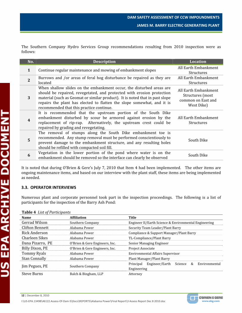
3.3. Operator Interviews .......................................................................................................................................................... 12
4. Visual Inspection ......................................................................................................................................................................... 14
4.1. General .................................................................................................................................................................................... 14
4.2. Summary of Findings ........................................................................................................................................................ 14
5. Conclusions ................................................................................................................................................................................... 15
6. Recommendations ...................................................................................................................................................................... 16
6.1. Urgent Action Items ........................................................................................................................................................... 16
6.2. Long Term Improvement ................................................................................................................................................ 16
6.3. Monitoring and Future Inspection .............................................................................................................................. 16
6.4. Time Frame for Completion of Repairs/Improvements .................................................................................... 16
6.5. Certification Statement .................................................................................................................................................... 17

DAM SAFETY ASSESSMENT OF CCW IMPOUNDMENTS
JAMES M. BARRY ELECTRIC GENERATING PLANT
ii | December 8, 2010
I:\US‐EPA.13498\46122.Assess‐Of‐Dam‐S\Docs\REPORTS\Alabama Power\Final Report\3 Assess Report Dec 8 2010.doc
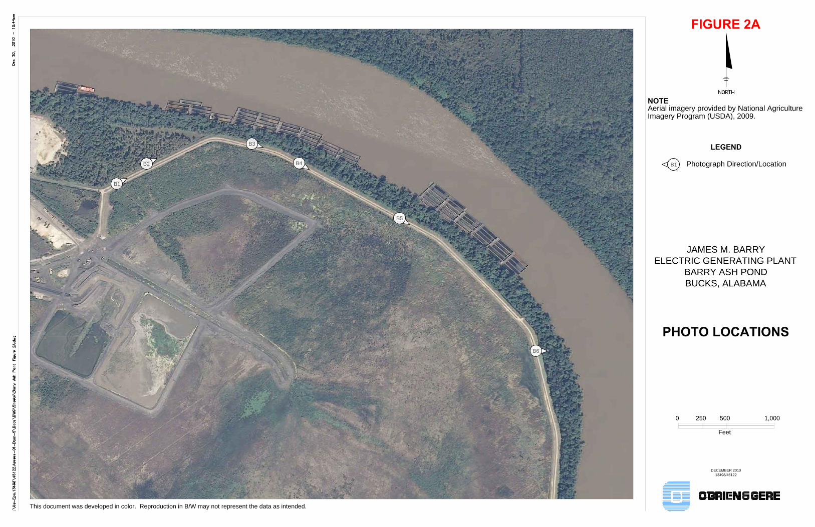
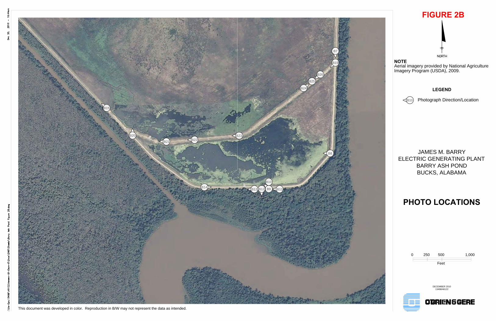
Figures Figure 1 – Site Location Map Figure 2 – Site Layout Figure 2A – Photo Locations Figure 2B – Photo Locations Figure 2C– Photo Locations Appendices Appendix A – Visual Inspection Checklists Appendix B – Photographs—Barry Ash Pond
DAM SAFETY ASSESSMENT OF CCW IMPOUNDMENTS
JAMES M. BARRY ELECTRIC GENERATING PLANT
1 | December 8, 2010
I:\US‐EPA.13498\46122.Assess‐Of‐Dam‐S\Docs\REPORTS\Alabama Power\Final Report\3 Assess Report Dec 8 2010.doc
1. INTRODUCTION 1.1. GENERAL In response to the coal combustion waste (CCW) impoundment failure at the TVA/Kingston coal‐fired electric generating station in December of 2008, the U. S. Environmental Protection Agency has initiated a nationwide program of structural integrity and safety assessments of coal combustion waste impoundments or “management units”. A CCW management unit is defined as a surface impoundment or similar diked or bermed management unit or management units designated as landfills that receive liquid‐borne material and are used for the storage or disposal of residuals or by‐products from the combustion of coal, including, but not limited to, fly ash, bottom ash, boiler slag, or flue gas emission control residuals. Management units also include inactive impoundments that have not been formally closed in compliance with applicable federal or state closure/reclamation regulations. The U.S. EPA has authorized O’Brien & Gere to provide actual site specific impoundment assessments at selected facilities. This project is being conducted in accordance with the terms of BPA#EP10W000673, Order No. EP‐CALL‐0001 dated June 14, 2010. 1.2. PROJECT PURPOSE AND SCOPE The purpose of this work is to provide Dam Safety Assessment of CCW management units, including the following: Identify conditions that may adversely affect the structural stability and functionality of a management unit
and its appurtenant structures Note the extent of deterioration, status of maintenance, and/or need for immediate repair Evaluate conformity with current design and construction practices Determine the hazard potential classification for units not currently classified by the management unit
owner or by state or federal agencies O’Brien & Gere’s scope of services for this project includes performing a site specific dam safety assessment of all CCW management units at the subject facility. Specifically, the scope includes the following tasks: Perform a review of pertinent records (prior inspections, engineering reports, drawings, etc.) made
available at the time of the site visit to review previously documented conditions and safety issues and gain an understanding of the original design and modifications of the facility.
Perform a site visit and visual inspection of each CCW management unit and complete the visual inspection checklist to document conditions observed.
Perform an evaluation of the adequacy of the outlet works, structural stability, quality and adequacy of the management unit’s inspection, maintenance, and operations procedures.
Identify critical infrastructure within 5 miles down gradient of management units. Evaluate the risks and effects of potential overtopping and evaluate effects of flood loading on the
management units. Immediate notification of conditions requiring emergency or urgent corrective action. Identify all environmental permits issued for the management units Identify all leaks, spills, or releases of any kind from the management units within the last 5 years.

DAM SAFETY ASSESSMENT OF CCW IMPOUNDMENTS
JAMES M. BARRY ELECTRIC GENERATING PLANT
2 | December 8, 2010
I:\US‐EPA.13498\46122.Assess‐Of‐Dam‐S\Docs\REPORTS\Alabama Power\Final Report\3 Assess Report Dec 8 2010.doc
Prepare a report summarizing the findings of the assessment, conclusions regarding the safety and structural integrity, recommendations for maintenance and corrective action, and other action items as appropriate.
This report addresses the above issues for the CCW Management Unit (the Barry Ash Pond or pond) at the James M. Barry Electric Generating Plant in Bucks, Alabama. The Barry Ash Pond is owned and operated by Alabama Power Company (Alabama Power), a subsidiary of the Southern Company. In the course of this assessment, O’Brien & Gere representatives obtained information from representatives of Alabama Power, the Southern Company, and the law firm of Balch & Bingham, LLP. 2. PROJECT/FACILITY DESCRIPTION The James M. Barry Electric Generating Plant (Plant Barry) is located along the west bank of the Mobile River at 15300 U.S. Highway 43 North, Bucks, Alabama 36512, approximately 30 miles north of Mobile, Alabama, and is owned and operated by Alabama Power. A Site Location Map is included as Figure 1. Plant Barry is a seven unit electric generating facility, and it includes two, natural gas fired combined cycle units and five coal fire units with a total generating capacity of 2,657,200 KW. The five coal units produce approximately 400,000 tons of coal combustion waste (CCW) by‐products per year, including bottom ash and fly ash. CCW that is produced during power generation is managed on‐site with a single CCW management unit (Barry Ash Pond). Currently, only generating unit #5 at Plant Barry ‐ the largest of the five coal‐fired units ‐ is equipped with a flue‐gas desulphurization (FGD) scrubber, which helps to remove emissions such as sulphur dioxide and nitrous oxide. A byproduct of the emission scrubbing process is synthetic gypsum, which is also currently disposed of in the Barry Ash Pond. Future plans call for the gypsum to be collected in a new Gypsum Collection Basin (GCB) currently under construction with an anticipated operational date of October 29, 2010. After the GCB is operational, the only gypsum byproduct disposed of in the Barry Ash Pond will be the decant water from the GCB. . This safety assessment report summarizes the July 7, 2010 inspection performed by the O’Brien & Gere team of the Barry Ash Pond management unit at Plant Barry. 2.1. MANAGEMENT UNIT IDENTIFICATION The location of the Barry Ash Pond inspected during this safety assessment is identified on Figure 2 – Site Layout. The Barry Ash Pond is located on the east to southeast side of the power plant. The pond area is bounded on the north by Plant Barry, on the east and south by the Mobile River. The southwest side of the Barry Ash Pond area is bounded by the Plant Barry cooling water discharge canal. The pond dam structure is not listed in the National Inventory of Dams (NID) database and therefore not rated. No federal or state agency regulates the Barry Ash Pond dam structure relative to the NID. Currently, there are no dam safety regulations in the State of Alabama. The Barry Ash Pond was reportedly placed into service in 1965 and is approximately 600 acres in size. As of March 25, 2009, the total approximate ash storage capacity of the pond utilizing wet sluicing methods was estimated to be 9,623,753 cubic yards. At the same time the approximate volume of ash stored in the pond based on wet sluicing was estimated to be 6,305,645 cubic yards. As of December 2009, the approximate remaining available capacity based on wet sluicing was calculated to be 1,278,500 cubic yards. Using dry stacking operations, the approximate available capacity was calculated to be 8,000,000 cubic yards. These capacity estimates are based on surveys and calculations performed by Southern Company Services, a corporate affiliate of Alabama Power Company.
DAM SAFETY ASSESSMENT OF CCW IMPOUNDMENTS
JAMES M. BARRY ELECTRIC GENERATING PLANT
3 | December 8, 2010
I:\US‐EPA.13498\46122.Assess‐Of‐Dam‐S\Docs\REPORTS\Alabama Power\Final Report\3 Assess Report Dec 8 2010.doc
The pond is a diked impoundment formed by east, south and west embankments; the west and east embankments appear to tie into natural ground on the north side of the impoundment. The embankment has reportedly been modified four different times, in 1972, 1992, 1998, and 2004. Records of the 1972 and 1992 modifications were not available. In reviewing the literature, it was noted that the embankment was raised 3 feet in 1992. There have been no major modifications to the pond outfall structure. The pond was built on a marsh area and continues to support marsh‐like wildlife, such as cat‐tails, water hyacinths, alligators, swamp rats (nutria), and wild hogs. According to documentation provided to USEPA by Alabama Power, CCW materials contained in the Barry Ash Pond include fly ash, boiler slag, flue gas emission control residuals, and other regulatory permitted low volume wastes, i.e., waste that is not hazardous for purposes of RCRA Subtitle C and is otherwise permitted under applicable regulations such as 40 C.F.R. §423.11. These materials, including storm water runoff from the Plant Barry, are transferred to the pond via the plant’s storm water pump station. Water flows from north to south through the pond and through two bridge openings in the diversion dike near the southeastern end of the pond, and, ultimately, into the outfall structure for discharge to the Mobile River. The riser portion of the concrete outfall structure is made up of a four‐sided, 8‐feet square overflow weir. The discharge conduit is a 48‐inch diameter corrugated metal pipe (CMP). The outfall structure is protected by a timber debris barrier. The discharge is permitted under NPDES permit number AL0002879. 2.2. HAZARD POTENTIAL CLASSIFICATION Currently, the State of Alabama does not have a Dam Safety law. Legislation under HB 454: Alabama Dam Inventory and Classification Act has been pending in the Alabama Legislature since February 2008. Should the State of Alabama implement the pending legislation into the law, the Barry Ash Pond would meet the definition of a regulated dam and be assigned a hazard classification. An opinion on potential hazard classification per the proposed Alabama legislation is beyond the scope of this report. The definitions for the four hazard potentials (Less than Low, Low, Significant and High) to be used in this assessment are included in the EPA CCW checklist found in Appendix A. Based on the checklist definitions and as a result of this assessment, the hazard potential rating recommended for the Barry Ash Pond is SIGNIFICANT. The eastern embankment of the Barry Ash Pond is located adjacent to the Mobile River with the toe of slope of the embankment within approximately 100 feet of the edge of the river in some locations. A failure of embankments impounding the Barry Ash Pond could cause significant environmental damage if the CCW was released into the Mobile River thereby damaging the surrounding area, wildlife and habitat. The power station is located in a semi‐rural area; therefore, damage to critical infrastructure or lifeline facilities in the event of a dam failure would likely be limited to the power plant facilities. 2.3. IMPOUNDING STRUCTURE DETAILS The following sections summarize the structural components and basic operations of the Barry Ash Pond. A site plan showing the location of the pond on the plant property and its relevant features is shown on Figure 2. Also shown on Figure 2 is the approximate location of the Gypsum Collection Basin presently under construction. Note that Figure 2 was adapted from the available aerial imagery as noted and may not depict all of the present features and conditions. Additionally, photos taken of the Barry Ash Pond during the visual inspection are incorporated in a Photographic Log provided as Appendix B. The locations of the photos are shown on Figures 2A, 2B, 2C.
DAM SAFETY ASSESSMENT OF CCW IMPOUNDMENTS
JAMES M. BARRY ELECTRIC GENERATING PLANT
4 | December 8, 2010
I:\US‐EPA.13498\46122.Assess‐Of‐Dam‐S\Docs\REPORTS\Alabama Power\Final Report\3 Assess Report Dec 8 2010.doc
2.3.1. Embankment Configuration The Barry Ash Pond is a diked earthen embankment structure that impounds an area of approximately 600 acres and has a capacity of approximately 9,623,753 cubic yards (5,965 acre‐feet) according to the EPA ICR Response, dated March 26, 2009. There is no indication or record of the pond being lined. The pond is divided into the main ash storage area and the decant area downstream of the diversion dike. Both areas are delineated on Figure 2. The crest of the main ash storage area, including the east and west embankments and the diversion dike, is at approximately elevation (EL) 24.5 feet above mean sea level. The south embankment elevation surrounding the decant area downstream of the diversion dike is at approximately EL 21.5 above mean sea level. The original pond bottom is at approximately EL 3.0 and the original dike side slopes before the 1998 raise and the construction of the diversion dike were approximately 3H:1V. The embankment was originally constructed to a top elevation of approximately EL 18 feet above mean sea level. According to the Plant Barry Ash Pond South Dike and Diversion Dike Slope Stability Report (September 2004), in 1992, the east and west embankments were raised three feet (approximate EL 21 feet above mean sea level) to obtain additional storage capacity. In 1998, the east and west embankment crest elevation was raised to between approximately EL 23 to EL 24.5 feet above mean sea level. A flow diversion dike was also constructed in 1999 near the south end of the pond to create a decant area prior to discharge through the outlet structure. The diversion dike crest elevation was constructed to approximately EL 18 feet above mean sea level. In 2004, the diversion dike crest elevation was raised to approximately EL 24.5 feet above mean sea level, and the crest of the south embankment was raised to approximately EL 21.5 feet above mean sea level. The side slopes were constructed at approximately 3H:1V. There are no records or reports of major breaches or repairs to the structure. There have been minor repairs over the years such as filling of animal burrows, repairs to shallow slides, regular maintenance and mowing, stump removal at toe of slope, filling and compaction of surface erosion features, and placement of riprap along water’s edge at south end of pond to help reduce wave action erosion. There are no toe drains in the embankment. There is currently no operating instrumentation or monitoring piezometers. 2.3.2. Type of Materials Impounded Influent into the Barry Ash Pond includes surface water runoff from Plant Barry, water with fly ash, bottom ash, boiler slag, flue gas emission control residuals, and other (regulatory permitted low volume wastes, i.e., waste that is not hazardous for purposes of RCRA Subtitle C and is otherwise permitted under applicable regulations such as 40 C.F.R. §423/11) wastes. 2.3.3. Outlet Works The Barry Ash Pond is a diked impoundment that receives sluiced flows, plant storm water runoff, and direct precipitation. CCW enters the pond through the sluice pipes on the north end of the pond. The ash/water mixture travels through three separate cells in a “stream” where it begins the settling process. The flow path is shown on Figure 2. The ash settles out in the main part of the pond, and water is discharged to the decant area through the diversion dike where it flows to the pond outlet structure where it is discharged to the Mobile River. The pond outlet structure, located approximately near the center of the southern embankment of the impoundment, consists of a four‐sided concrete weir riser box with a 48‐inch CMP discharge barrel (See Appendix B ‐ Photo B12 thru B16). The pond discharge to the Mobile River is permitted under ADEM NPDES
DAM SAFETY ASSESSMENT OF CCW IMPOUNDMENTS
JAMES M. BARRY ELECTRIC GENERATING PLANT
5 | December 8, 2010
I:\US‐EPA.13498\46122.Assess‐Of‐Dam‐S\Docs\REPORTS\Alabama Power\Final Report\3 Assess Report Dec 8 2010.doc
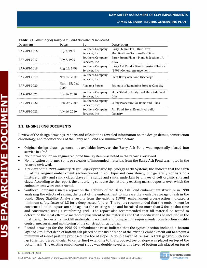
permit # AL0002879. There have been no reported major modifications to the outfall structure since it was originally constructed according to plant personnel and the Plant Barry Ash Pond South Dike and Diversion Dike Slope Stability Report (September 2004). 3. RECORDS REVIEW A review of the available records related to design, construction, operation and inspection of the Barry Ash Pond was performed as part of this assessment. The documents provided by Alabama Power, with their document designations, are listed below: Table 3.1 Summary of Barry Ash Pond Documents Reviewed
Document Dates By Description
BAR‐API‐0001 2010 Alabama Power
Aerial Photo of James M. Barry Electric Generating Plant, Aerial Photo of Barry Ash Pond, Aerial Photo of New Gypsum Collection Basin under Construction
BAR‐API‐0002 2010 Alabama Power Aerial Photo/Topo of Barry Ash Pond
BAR‐API‐0003 Jan. 1998 Alabama Power Alabama Power Plant Barry Report of Ash Pond Dike Proposed Modifications
BAR‐API‐0004 Sept. 2004 Alabama Power Plant Barry Ash Pond South Dike and Diversion Dike Slope Stability Report
BAR‐API‐0005 June 16, 2010 Southern Company Barry Steam Plant Ash Pond Dam – 2010 Dam Safety Inspection
BAR‐API‐0006 June 16, 2009 Southern Company Barry Steam Plant Ash Pond Dam – 2009 Dam Safety Inspection
BAR‐API‐0007 Nov. 7, 2007 L.F. Dunlap & R.L. Mickwee
Barry Steam Plant Ash Pond Dam – Report of Biennial Dam Safety Inspection, November 7, 2007
BAR‐API‐0008 June 5, 1998 Synergy Earth Systems, Inc.
Summary Design Report – Existing Ash Pond Dike Impoundments, Barry Steam Plant – Bucks, Alabama
BAR‐API‐0009 Jan. 15, 2010
Alabama Department of Environmental Management
NPDES Permit No. AL0002879
BAR‐API‐0010 Oct. 1, 2009 Alabama Power Barry Steam Plant – Ash Pond Visual Inspection Check List and Report Template
BAR‐API‐0011 Mar. 29, 2010 No Author Indicated
Barry Electric Generating Plant, BMP Site Plan, Figure 1
BAR‐API‐0012 Oct. 6, 2004 Southern Company Services, Inc.
Barry Steam Plant – Diversion Dike & South Main Dike Raise‐Geologic Cross Sections & Typ. Dike Raise Sections
BAR‐API‐0013 Sept. 28, 2004 Southern Company Services, Inc.
Barry Steam Plant – Ash Pond Dike Raise‐ Geologic & Typical Dike Cross Sections
BAR‐API‐0014 Aug. 16, 1999 Southern Company Services, Inc.
Barry Ash Pond – Dike Extension‐Phase 1 (1998) General Arrangement
BAR‐API‐0015 July 7, 1999 Southern Company Services, Inc.
Barry Steam Plant – Dike Crest Modifications‐Sections West Side
DAM SAFETY ASSESSMENT OF CCW IMPOUNDMENTS
JAMES M. BARRY ELECTRIC GENERATING PLANT
6 | December 8, 2010
I:\US‐EPA.13498\46122.Assess‐Of‐Dam‐S\Docs\REPORTS\Alabama Power\Final Report\3 Assess Report Dec 8 2010.doc
Table 3.1 Summary of Barry Ash Pond Documents Reviewed
Document Dates By Description
BAR‐API‐0016 July 7, 1999 Southern Company Services, Inc.
Barry Steam Plan – Dike Crest Modifications‐Sections‐East Side
BAR‐API‐0017 July 7, 1999 Southern Company Services, Inc.
Barry Steam Plant – Plans & Sections 1A & 5A
BAR‐API‐0018 Aug. 16, 1999 Southern Company Services, Inc.
Barry Ash Pond – Dike Extension‐Phase 2 (1998) General Arrangement
BAR‐API‐0019 Nov. 17, 2004 Southern Company Services, Inc.
Plant Barry Ash Pond Discharge
BAR‐API‐0020 Mar. 25/Dec. 2009
Alabama Power Estimate of Remaining Storage Capacity
BAR‐API‐0021 July 16, 2010 Southern Company Services, Inc.
Slope Stability Analysis of Main Ash Pond Dike
BAR‐API‐0022 June 29, 2009 Southern Company Services, Inc.
Safety Procedure for Dams and Dikes
BAR‐API‐0023 July 16, 2010 Southern Company Services, Inc.
Ash Pond Storm Event Hydraulic Capacity
3.1. ENGINEERING DOCUMENTS Review of the design drawings, reports and calculations revealed information on the design details, construction chronology, and modifications of the Barry Ash Pond are summarized below. Original design drawings were not available; however, the Barry Ash Pond was reportedly placed into
service in 1965. No information on an engineered pond liner system was noted in the records reviewed. No indication of former spills or releases of impounded materials from the Barry Ash Pond was noted in the
records reviewed. A review of the 1998 Summary Design Report prepared by Synergy Earth Systems, Inc. indicate that the earth
fill of the original embankment section varied in soil type and consistency, but generally consists of a mixture of silty and sandy clays, clayey fine sands and sands underlain by a layer of soft organic silts and clays. According to the report, the underlying soils are the naturally existing marsh deposits over which the embankments were constructed.
Southern Company issued a report on the stability of the Barry Ash Pond embankment structure in 1998 analyzing the effects of raising the crest of the embankment to increase the available storage of ash in the pond. Slope Stability Analysis results from the existing (1998) embankment cross‐section indicated a minimum safety factor of 1.3 for a deep seated failure. The report recommended that the embankment be constructed on the upstream side against the existing slope and be raised no more than 3 feet at that time and constructed using a reinforcing grid. The report also recommended that fill material be tested to determine the most effective method of placement of the materials and that specifications be included in the final design to describe backfill materials, placement and compaction requirements, construction quality control measures, and monitoring of the construction activities.
Record drawings for the 1998‐99 embankment raise indicate that the typical section included a bottom layer of 2 to 3‐feet deep of bottom ash placed on the inside slope of the existing embankment out to a point a minimum of 6‐feet past the proposed new toe of slope. A double layer of Tensar Bx1200 geogrid 50% side lap (oriented perpendicular to centerline) extending to the proposed toe of slope was placed on top of the bottom ash. The existing embankment slope was double keyed with a layer of bottom ash placed on top of

DAM SAFETY ASSESSMENT OF CCW IMPOUNDMENTS
JAMES M. BARRY ELECTRIC GENERATING PLANT
7 | December 8, 2010
I:\US‐EPA.13498\46122.Assess‐Of‐Dam‐S\Docs\REPORTS\Alabama Power\Final Report\3 Assess Report Dec 8 2010.doc
the geogrid into the lower keyed section. A single layer of Tensar Ux1500HS geogrid was placed on the layer of bottom ash with the final lift of the embankment consisting of a clay layer keyed into the bottom ash and the existing embankment. The side slopes were constructed to 2H:1V. The top of the embankment was raised approximately 3 feet above the existing embankment.
Design drawings provided as part of the 1998‐99 embankment raise indicate that the diversion dike was also constructed in 1998‐99.
The 2004 Slope Stability Report referenced in Section 2.3.3 of this report was prepared in anticipation of raising the south main embankment and the diversion dike. The report indicated that the south main embankment could be raised 3 feet with a fly ash bolster, geogrid using bottom ash and clay fill with loads applied and still maintain a safety factor of 1.7. The diversion dike could be raised 4 feet with slopes laid back 4:1 with a 30 foot fly ash bolster on either side using a well compacted clay and still maintain a safety factor of 1.8. According to design drawings provided, construction of the south main embankment and the diversion dike would meet or exceed the specifications outlined above.
As‐built drawings were not provided in the records reviewed for the 2004 modifications. Southern Company prepared an Ash Pond Storm Event Hydraulic Capacity, dated July 16, 2010. This report
was received from Alabama Power after the on‐site inspection. The report concludes the following:
The ash pond has a present capacity of 414 acreft above the operating pool (Elev. 15 in the lower pond) using the July, 2009 topographical survey. The rainfall volume during 100yr, 24hour storm event is 204 acreft. Additional inflow to the pond from sluicing, plant storm water, and other sources, using maximum pump rates, is about 54 MGD. For the 24hour event, the minimum freeboard is about 2.9 feet. During the critical 100year, 2hour storm, the minimum freeboard of the pond is 1.3 feet. The report indicates that the conclusions are based on the following methodology: The topography and layout of the ash pond was obtained from Drawing ES TopoPlant Barry Ash Pond. Existing pond volumes were computed from the topography using AutoCad Civil 3D. The 100year IntensityDurationFrequency Data for Plant Barry was obtained from the Rainfall Atlas of Alabama, published by the University of Alabama. The rainfall cases from 30 minutes to 24hours were evaluated to determine the critical rain event. The critical rain event and the design 24hour precipitation case were evaluated using the Rational Method to determine the peak level of stored water.
Southern Company prepared a report entitled, Slope Stability Analyses of Main Ash Pond Dike, dated July 16,
2010. This report was received from Alabama Power after the on‐site inspection. This analysis was performed to support the embankment modifications in 1998 and 2004. The analysis also addresses supplemental loading conditions, particularly earthquake seismic loading. A review of the report states that the slope stability computer model was run using the following assumptions and design criteria: According to the USGS earthquake acceleration probability maps for the vicinity of Plant Barry, the
ground motion having a 2% probability of exceedance in 50 years is 0.06g. The current required minimum criteria (factors of safety) were taken from the US Corps of Engineers
Manual EM 111021902, October 2003. The soil properties of unit weight, phi angle, and cohesion were obtained from historical laboratory
results. Soil stratigraphy and piezometric data was estimated from the historical boring logs
According to the Summary of Conclusions presented in the report, the South Main Dike and the North East Main Dike factors of safety for various slope stability failure conditions under steady state and seismic conditions exceed the typical minimum factors of safety published in USACE Manual EM‐1110‐2‐1902. The report concluded that based on the results of these analyses all structures are stable.
DAM SAFETY ASSESSMENT OF CCW IMPOUNDMENTS
JAMES M. BARRY ELECTRIC GENERATING PLANT
8 | December 8, 2010
I:\US‐EPA.13498\46122.Assess‐Of‐Dam‐S\Docs\REPORTS\Alabama Power\Final Report\3 Assess Report Dec 8 2010.doc
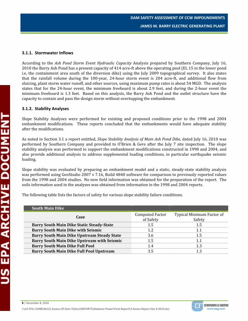
3.1.1. Stormwater Inflows According to the Ash Pond Storm Event Hydraulic Capacity Analysis prepared by Southern Company, July 16, 2010 the Barry Ash Pond has a present capacity of 414 acre‐ft above the operating pool (EL 15 in the lower pond i.e, the containment area south of the diversion dike) using the July 2009 topographical survey. It also states that the rainfall volume during the 100‐year, 24‐hour storm event is 204 acre‐ft, and additional flow from sluicing, plant storm water runoff, and other sources, using maximum pump rates is about 54 MGD. The analysis states that for the 24‐hour event, the minimum freeboard is about 2.9 feet, and during the 2‐hour event the minimum freeboard is 1.3 feet. Based on this analysis, the Barry Ash Pond and the outlet structure have the capacity to contain and pass the design storm without overtopping the embankment. 3.1.2. Stability Analyses Slope Stability Analyses were performed for existing and proposed conditions prior to the 1998 and 2004 embankment modifications. These reports concluded that the embankments would have adequate stability after the modifications. As noted in Section 3.1 a report entitled, Slope Stability Analysis of Main Ash Pond Dike, dated July 16, 2010 was performed by Southern Company and provided to O’Brien & Gere after the July 7 site inspection. The slope stability analysis was performed to support the embankment modifications constructed in 1998 and 2004, and also provide additional analysis to address supplemental loading conditions, in particular earthquake seismic loading. Slope stability was evaluated by preparing an embankment model and a static, steady‐state stability analysis was performed using GeoStudio 2007 v 7.16, Build 4840 software for comparison to previously reported values from the 1998 and 2004 studies. No new field information was obtained for the preparation of the report. The soils information used in the analyses was obtained from information in the 1998 and 2004 reports. The following table lists the factors of safety for various slope stability failure conditions.
South Main Dike
Case Computed Factor
of Safety Typical Minimum Factor of
Safety Barry South Main Dike Static SteadyState 1.5 1.5 Barry South Main Dike with Seismic 1.2 1.1 Barry South Main Dike Upstream Steady State 3.6 1.5 Barry South Main Dike Upstream with Seismic 1.5 1.1 Barry South Main Dike Full Pool 1.4 1.3 Barry South Main Dike Full Pool Upstream 3.5 1.3

DAM SAFETY ASSESSMENT OF CCW IMPOUNDMENTS
JAMES M. BARRY ELECTRIC GENERATING PLANT
9 | December 8, 2010
I:\US‐EPA.13498\46122.Assess‐Of‐Dam‐S\Docs\REPORTS\Alabama Power\Final Report\3 Assess Report Dec 8 2010.doc
North East Main Dike
Case Computed Factor
of Safety Typical Minimum Factor of
Safety Barry North East Dike Static SteadyState 1.6 1.5 Barry North East Dike with Seismic 1.4 1.1 Barry North East Dike Upstream Steady State 6.4 1.5 Barry North East Dike Upstream with Seismic 3.6 1.1 Barry North East Dike Full Pool 1.6 1.3 Barry North East Dike Full Pool Upstream 11.7 1.3
Based on our review of the dike stability evaluation reports, the soil strength parameters were based on in‐situ standard penetration tests, dilatometer tests, and cone penetration test data of the materials forming the dikes and natural foundation soils. Parameters for the new materials used to raise the dikes were based on laboratory testing and prior experience with similar materials. The soil strength parameters used in the slope stability analyses appear to have been conservatively estimated based on the lower bound results of the in‐situ testing. The stability analysis methods appear to have been performed in general accordance with USACE Slope Stability Analysis Engineer Manual EM 1110‐2‐1902, and the computed factors of safety for the various loading conditions and dike sections analyzed appear to meet the minimums required by US Army Corps of Engineers for embankment dams.
3.1.3. Modifications from Original Construction As noted above, the Barry Ash Pond has undergone modifications since its original construction. A review of the documentation provided indicates that Barry Ash Pond has undergone major modifications on four different occasions, 1972, 1992, 1998, and 2004. A summary of the available details from each modification follow:
1) 1972 – From the interview with plant personnel, it was learned that the embankment was raised slightly in 1972. No other information available concerning the 1972 modifications
2) 1992 – In 1992, the east and west embankments were raised 3 feet to obtain additional storage capacity. 3) 1998 – In 1998, the embankments were raised an additional four feet on the inboard side. The
embankments were raised on the inboard due to outboard stability concerns and to avoid taking of wetlands. The internal raise sections were founded on existing deposited fly ash. During this modification, the diversion dike was also added to the pond. It was constructed on top of existing fly ash deposits using bottom ash as the dike fill. During the previous modifications, the south embankment was not raised.
4) 2004 – In 2004, the south main embankment and the diversion dike were raised. The south main embankment was raised approximately 3 feet and the diversion dike was raised approximately 4 feet. The cross‐sections show that the material used to raise the diversion dike is a clay soil placed over the existing dike with a bolster of fly ash on both sides of the dike. The main south dike raise consisted of a clay fill material over a compacted bottom ash material placed on a fly ash bolster on the upstream side of the embankment.
3.1.4. Instrumentation No instrumentation is present; however, there is a staff gauge which is read and recorded weekly by plant personnel.
DAM SAFETY ASSESSMENT OF CCW IMPOUNDMENTS
JAMES M. BARRY ELECTRIC GENERATING PLANT
10 | December 8, 2010
I:\US‐EPA.13498\46122.Assess‐Of‐Dam‐S\Docs\REPORTS\Alabama Power\Final Report\3 Assess Report Dec 8 2010.doc
3.2. PREVIOUS INSPECTIONS As noted above in this report, there is not a Dam Safety Regulation in the State of Alabama. Alabama Power’s parent company, Southern Company through its Hydro Services Group performs an annual inspection of the Barry Ash Pond. Records of the 2007, 2009, and 2010 inspections were provided for review. Prior to 2009, the inspections were performed on a biennial basis. A summary of the 2009 inspection,performed on January 20, 2009 follows: Main Ash Pond Dam – West Dike
Full length of dam was inspected Shallow slides were noted in embankment at few locations, but not indicative of any kind of
deep seated failure, although some tension cracks were observed near the dam crest. Similar areas have been repaired in past and seem to be performing well.
Small nutria rat burrows observed on downstream face of dam and some locations show significant damage from ‘rooting’ activities by feral hogs
Small seeps observed on west dike. Flow was not perceptible, and it did not appear that material was being removed from the dike, but it was observed that feral hog rooting was common in the small seep areas. Condition may be influenced by frequent and heavy rains experienced through December and January in State of Alabama
Main Ash Pond Dam ‐ South Dike
Many of same observations observed along western portion of dike were common along southern portion, but did not include any zones of seepage or significant damage from feral hogs.
Crest observed to be in good condition except for one fairly sizable surface drainage rill along its interior or upstream side. Several smaller rills were also noted. Just east of outlet structure, a shallow slide was observed on downstream face of embankment.
Discharge Structure
Inspected and observed to be in good condition
Main Ash Pond Dam – East Dike Crest and roadway generally observed to be in excellent condition Noted stumps from past clearing operations had been left in place near toe of slope Shallow slide observed on face of dike Notable surface drainage rills in portions of crest Feral hog activity and nutria rat burrows observed.
The Southern Company Hydro Services Group recommendations resulting from 2009 Inspection included the following:
1. Continue regular maintenance and mowing of embankment slopes 2. Conduct inspections of the ash pond dam at least weekly, with close observation of the dam toe by
walking once per month 3. Fill in any nutria rat burrows with concrete or flowable fill material and repair any areas damaged by
feral hog wallowing or rooting 4. Repair shallow slides along embankment face as time and budgeting allow. The first area that the
inspection recommends be repaired is located near the midpoint of the eastern portion of the dam
DAM SAFETY ASSESSMENT OF CCW IMPOUNDMENTS
JAMES M. BARRY ELECTRIC GENERATING PLANT
11 | December 8, 2010
I:\US‐EPA.13498\46122.Assess‐Of‐Dam‐S\Docs\REPORTS\Alabama Power\Final Report\3 Assess Report Dec 8 2010.doc
5. The removal of stumps along the dam toe is recommended. Any stump removal must be performed conscientiously to prevent damage to the embankment structure, and any resulting holes should be refilled with compacted soil fill.
6. Repair the two noted surface drainage erosion features noted on the crest of the dam south and east dikes with compacted soil fill and re‐vegetate.
7. Pay close attention to area of seepage along west dike. Any detrimental changes to seepage flow and/or any indications of materials being removed from the dike by flow should be reported to SCG Hydro Services immediately
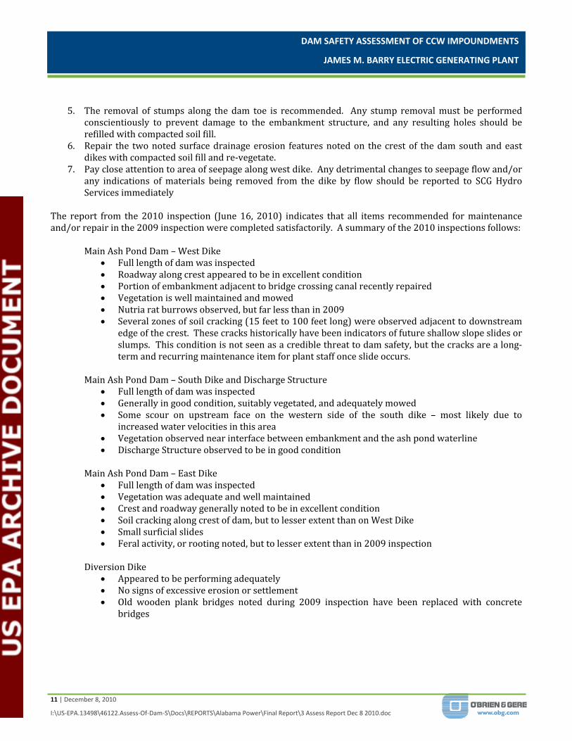
The report from the 2010 inspection (June 16, 2010) indicates that all items recommended for maintenance and/or repair in the 2009 inspection were completed satisfactorily. A summary of the 2010 inspections follows: Main Ash Pond Dam – West Dike
Full length of dam was inspected Roadway along crest appeared to be in excellent condition Portion of embankment adjacent to bridge crossing canal recently repaired Vegetation is well maintained and mowed Nutria rat burrows observed, but far less than in 2009 Several zones of soil cracking (15 feet to 100 feet long) were observed adjacent to downstream
edge of the crest. These cracks historically have been indicators of future shallow slope slides or slumps. This condition is not seen as a credible threat to dam safety, but the cracks are a long‐term and recurring maintenance item for plant staff once slide occurs.
Main Ash Pond Dam – South Dike and Discharge Structure
Full length of dam was inspected Generally in good condition, suitably vegetated, and adequately mowed Some scour on upstream face on the western side of the south dike – most likely due to
increased water velocities in this area Vegetation observed near interface between embankment and the ash pond waterline Discharge Structure observed to be in good condition
Main Ash Pond Dam – East Dike
Full length of dam was inspected Vegetation was adequate and well maintained Crest and roadway generally noted to be in excellent condition Soil cracking along crest of dam, but to lesser extent than on West Dike Small surficial slides Feral activity, or rooting noted, but to lesser extent than in 2009 inspection
Diversion Dike
Appeared to be performing adequately No signs of excessive erosion or settlement Old wooden plank bridges noted during 2009 inspection have been replaced with concrete
bridges
DAM SAFETY ASSESSMENT OF CCW IMPOUNDMENTS
JAMES M. BARRY ELECTRIC GENERATING PLANT
12 | December 8, 2010
I:\US‐EPA.13498\46122.Assess‐Of‐Dam‐S\Docs\REPORTS\Alabama Power\Final Report\3 Assess Report Dec 8 2010.doc
The Southern Company Hydro Services Group recommendations resulting from 2010 inspection were as follows:
No. Description Location
1 Continue regular maintenance and mowing of embankment slopes All Earth Embankment
Structures
2 Burrows and /or areas of feral hog disturbance be repaired as they are located
All Earth Embankment Structures
3
When shallow slides on the embankment occur, the disturbed areas are should be repaired, revegetated, and protected with erosion protection material (such as Geomat or similar product). It is noted that in past slope repairs the plant has elected to flatten the slope somewhat, and it is recommended that this practice continue.
All Earth Embankment Structures (most
common on East and West Dike)
4
It is recommended that the upstream portion of the South Dike embankment disturbed by scour be armored against erosion by the replacement of rip‐rap. Alternatively, the upstream crest could be repaired by grading and revegetating.
All Earth Embankment Structures
5
The removal of stumps along the South Dike embankment toe is recommended. Any stump removal must be performed conscientiously to prevent damage to the embankment structure, and any resulting holes should be refilled with compacted soil fill.
South Dike
6 Vegetation in the lower portion of the pond where water is on the embankment should be removed so the interface can clearly be observed
South Dike
It is noted that during O’Brien & Gere’s July 7, 2010 that Item 4 had been implemented. The other items are ongoing maintenance items, and based on our interview with the plant staff, these items are being implemented as needed. 3.3. OPERATOR INTERVIEWS Numerous plant and corporate personnel took part in the inspection proceedings. The following is a list of participants for the inspection of the Barry Ash Pond: Table 4 List of Participants Name Affiliation Title Gerrad Wilson Southern Company Engineer II/Earth Science & Environmental Engineering Clifton Bennett Alabama Power Security Team Leader/Plant Barry Rick Anderson Alabama Power Compliance & Support Manager/Plant Barry Charleen Sikes Alabama Power TL‐Compliance/Plant Barry Dana Pizarro, PE O’Brien & Gere Engineers, Inc. Senior Managing Engineer Billy Dixon, PE O’Brien & Gere Engineers, Inc. Project Associate Tommy Ryals Alabama Power Environmental Affairs Supervisor Stan Connally Alabama Power Plant Manager/Plant Barry
Jim Pegues, PE Southern Company Principal Engineer/Earth Science & Environmental Engineering
Steve Burns Balch & Bingham, LLP Attorney

DAM SAFETY ASSESSMENT OF CCW IMPOUNDMENTS
JAMES M. BARRY ELECTRIC GENERATING PLANT
13 | December 8, 2010
I:\US‐EPA.13498\46122.Assess‐Of‐Dam‐S\Docs\REPORTS\Alabama Power\Final Report\3 Assess Report Dec 8 2010.doc
Facility personnel provided a good working knowledge of both the Barry Ash Pond, provided general plant operation background and provided requested historical documentation. In addition to the facility personnel (Alabama Power), Engineers from Southern Company (Owner of Alabama Power) were present to provide additional information from previous impoundment inspections. Also present was legal counsel representing Southern Company and Alabama Power. These personnel also accompanied O’Brien & Gere throughout the visual inspections to answer questions and to provide additional information as needed in the field. A summary of the interview follows:
No known spills or releases of impounded materials from the Barry Ash Pond have occurred. There is no indication of major seepage An annual inspection is performed by Southern Company’s Hydro Services Group Weekly top of dam inspections are performed by Plant Barry staff Monthly top of dam inspections are performed by Plant Barry staff If minor deficiencies are noted during inspections, plant staff work to make repairs immediately The plant has dedicated materials for embankment repairs stockpiled north of cell 1 area . Major deficiencies are brought immediately to the attention of plant management for resolution. Hydro Services Group provides formal dam inspection training to Plant Barry staff No major modifications to outfall structure There are no design drawings available for the original embankment structure There have been minor repairs over the years such as filling in minor rutting, animal burrows, removal
of stumps, but no major repairs have been required. Plant Barry is owned and operated by Alabama Power. Alabama Power is a subsidiary of Southern
Company Plant Barry has written Emergency Response Plan and Spill Prevention Control and Countermeasure
Plan The embankment has no toe drains Major modifications to the embankments were performed in 1998‐99 and 2004‐2005 consisting of
raising the embankment height 4 feet and 3 feet, respectively.
DAM SAFETY ASSESSMENT OF CCW IMPOUNDMENTS
JAMES M. BARRY ELECTRIC GENERATING PLANT
14 | December 8, 2010
I:\US‐EPA.13498\46122.Assess‐Of‐Dam‐S\Docs\REPORTS\Alabama Power\Final Report\3 Assess Report Dec 8 2010.doc
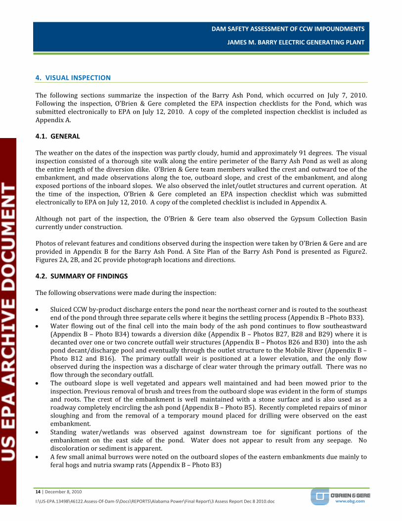
4. VISUAL INSPECTION The following sections summarize the inspection of the Barry Ash Pond, which occurred on July 7, 2010. Following the inspection, O’Brien & Gere completed the EPA inspection checklists for the Pond, which was submitted electronically to EPA on July 12, 2010. A copy of the completed inspection checklist is included as Appendix A. 4.1. GENERAL The weather on the dates of the inspection was partly cloudy, humid and approximately 91 degrees. The visual inspection consisted of a thorough site walk along the entire perimeter of the Barry Ash Pond as well as along the entire length of the diversion dike. O’Brien & Gere team members walked the crest and outward toe of the embankment, and made observations along the toe, outboard slope, and crest of the embankment, and along exposed portions of the inboard slopes. We also observed the inlet/outlet structures and current operation. At the time of the inspection, O’Brien & Gere completed an EPA inspection checklist which was submitted electronically to EPA on July 12, 2010. A copy of the completed checklist is included in Appendix A. Although not part of the inspection, the O’Brien & Gere team also observed the Gypsum Collection Basin currently under construction. Photos of relevant features and conditions observed during the inspection were taken by O’Brien & Gere and are provided in Appendix B for the Barry Ash Pond. A Site Plan of the Barry Ash Pond is presented as Figure2. Figures 2A, 2B, and 2C provide photograph locations and directions. 4.2. SUMMARY OF FINDINGS The following observations were made during the inspection: Sluiced CCW by‐product discharge enters the pond near the northeast corner and is routed to the southeast
end of the pond through three separate cells where it begins the settling process (Appendix B –Photo B33). Water flowing out of the final cell into the main body of the ash pond continues to flow southeastward
(Appendix B – Photo B34) towards a diversion dike (Appendix B – Photos B27, B28 and B29) where it is decanted over one or two concrete outfall weir structures (Appendix B – Photos B26 and B30) into the ash pond decant/discharge pool and eventually through the outlet structure to the Mobile River (Appendix B – Photo B12 and B16). The primary outfall weir is positioned at a lower elevation, and the only flow observed during the inspection was a discharge of clear water through the primary outfall. There was no flow through the secondary outfall.
The outboard slope is well vegetated and appears well maintained and had been mowed prior to the inspection. Previous removal of brush and trees from the outboard slope was evident in the form of stumps and roots. The crest of the embankment is well maintained with a stone surface and is also used as a roadway completely encircling the ash pond (Appendix B – Photo B5). Recently completed repairs of minor sloughing and from the removal of a temporary mound placed for drilling were observed on the east embankment.
Standing water/wetlands was observed against downstream toe for significant portions of the embankment on the east side of the pond. Water does not appear to result from any seepage. No discoloration or sediment is apparent.
A few small animal burrows were noted on the outboard slopes of the eastern embankments due mainly to feral hogs and nutria swamp rats (Appendix B – Photo B3)

DAM SAFETY ASSESSMENT OF CCW IMPOUNDMENTS
JAMES M. BARRY ELECTRIC GENERATING PLANT
15 | December 8, 2010
I:\US‐EPA.13498\46122.Assess‐Of‐Dam‐S\Docs\REPORTS\Alabama Power\Final Report\3 Assess Report Dec 8 2010.doc
There is some minor surficial sloughing at numerous locations and some bulging at locations where recent embankment raising meets previous embankment, but no cracks or scarps were observed in these areas (Appendix B – Photo B5).
Approximately 5‐7 trees on downstream embankment just up from toe of slope near stabilized portion of pond on Northwest end (Appendix B – Photo B23).
The outlet structure appeared to be in good condition and functioning normally (Appendix B – Photos B12 and B16). Flow over the discharge weirs appeared clear.
5. CONCLUSIONS Based on the ratings defined in the BPA Task Order Performance Work Statement (Satisfactory, Fair, Poor and Unsatisfactory), the information reviewed and the visual inspection, the overall condition of the Barry Ash Pond is considered to be SATISFACTORY. Acceptable performance is expected under all loading conditions. The owner has implemented regular inspections and maintenance which enable the impoundment to be kept in good working order. Our interviews with plant engineering personnel responsible for the operation of the impoundment indicate that a regular operations plan (Safety Procedure for Dams and Dikes prepared by Southern Company) is in use at the Barry Ash Pond facility. Since 1998, any modifications to the existing embankments have been supported with engineering analyses to ensure that such modifications will not impact the stability of the embankment. The regular operating procedures of the facility do not appear to be impacting the structural integrity of the impounding embankments. The plant engineering staff maintain all design documents and inspection reports in a well organized manner. Plant personnel participated and cooperated with this inspection and provided all information requested. The plant operations personnel have received training in dam safety inspections and currently perform weekly inspections of the embankment with monthly inspections of the toe of the embankment. The Southern Company Hydro Services Group performs a yearly inspection and publishes a detailed inspection report containing findings and recommendations for the Plant Barry management. Based on these findings, we are of the opinion that the operations and maintenance procedures being practiced at the Barry Ash Pond are adequate, provided that recommended maintenance items identified in the most recent Southern Company Hydro Services Group inspection are carried out.

DAM SAFETY ASSESSMENT OF CCW IMPOUNDMENTS
JAMES M. BARRY ELECTRIC GENERATING PLANT
16 | December 8, 2010
I:\US‐EPA.13498\46122.Assess‐Of‐Dam‐S\Docs\REPORTS\Alabama Power\Final Report\3 Assess Report Dec 8 2010.doc
6. RECOMMENDATIONS Based on the findings of our visual inspection and review of the available records for the Barry Ash Pond, O’Brien & Gere recommends that Plant Barry continue with the inspection and maintenance program in place, and additional maintenance of the embankments be performed to correct the miscellaneous deficiencies cited in the most recent Southern Company Hydro Services Group inspection. 6.1. URGENT ACTION ITEMS None of the recommendations are considered to be urgent, since the issues noted above do not appear to threaten the structural integrity of the dam in the near term. 6.2. LONG TERM IMPROVEMENT The deficient conditions observed during the inspection do not require immediate attention, but should be addressed in the near future as part of a regular maintenance plan. 6.3. MONITORING AND FUTURE INSPECTION O’Brien & Gere recommends continued participation in annual inspections performed by Southern Company’s Hydro Services Group as well as the weekly and monthly inspections performed by Plant Barry personnel. Since standing water from the river and wetlands in East Dike area make it difficult to assess whether or not seepage is coming from the dam, we recommend that the inspector(s) pay special attention when performing the monthly toe of slope inspections in this area to look for sediment in the water or discoloration that may indicate a potential for loss of embankment material. O’Brien & Gere also recommends that the inspection procedures in the Southern Company’s Safety Procedure for Dams and Dikes continue to be followed, and that the document be updated as new Federal, State and Local rules and regulations are implemented. 6.4. TIME FRAME FOR COMPLETION OF REPAIRS/IMPROVEMENTS Based on our conversations with representatives of Alabama Power the maintenance/repair items noted above are currently underway and being implemented without delay. We recommend that the owner continue toward this schedule as planned.


0 1,000 2,000500
Feet
This document was developed in color. Reproduction in B/W may not represent the data as intended.
^
NOTEAerial imagery provided by National AgricultureImagery Program (USDA), 2009.
DECEMBER 201013498/46122
JAMES M. BARRYELECTRIC GENERATING PLANT
BARRY ASH PONDBUCKS, ALABAMA
SITE LAYOUT
FIGURE 2
PUMP STATION
DISCHARGE PIPING
DISCHARGE POINT CELL #1CELL #2
CELL #3
EAST EMBANKMENT
MOBILERIVER
WEST EMBANKMENT SECONDARY DIVERSION DIKE OUTFALL
DIVERSION DIKE
PRIMARY DIVERSION DIKE OUTFALLSOUTH EMBANKMENT
OUTLET STRUCTURE
BARRY ASH POND
FUTURE GYPSUMCOLLECTION BASIN
(UNDER CONSTRUCTION)
COOLING WATER DISCHARGE CANAL
0 500 1,000250
Feet
This document was developed in color. Reproduction in B/W may not represent the data as intended.
NOTEAerial imagery provided by National AgricultureImagery Program (USDA), 2009.
DECEMBER 201013498/46122
JAMES M. BARRYELECTRIC GENERATING PLANT
BARRY ASH PONDBUCKS, ALABAMA
PHOTO LOCATIONS
FIGURE 2A
B1
LEGEND
Photograph Direction/Location
B1
B2
B3
B4
B5
B6
0 500 1,000250
Feet
This document was developed in color. Reproduction in B/W may not represent the data as intended.
NOTEAerial imagery provided by National AgricultureImagery Program (USDA), 2009.
DECEMBER 201013498/46122
JAMES M. BARRYELECTRIC GENERATING PLANT
BARRY ASH PONDBUCKS, ALABAMA
PHOTO LOCATIONS
FIGURE 2B
B10
LEGEND
Photograph Direction/Location
B7
B19
B8
B9
B10
B11B12B13B14
B20
B25
B15
B21 B22B23
B24
B26

0 500 1,000250
Feet
This document was developed in color. Reproduction in B/W may not represent the data as intended.
NOTEAerial imagery provided by National AgricultureImagery Program (USDA), 2009.
DECEMBER 201013498/46122
JAMES M. BARRYELECTRIC GENERATING PLANT
BARRY ASH PONDBUCKS, ALABAMA
PHOTO LOCATIONS
FIGURE 2C
B21
LEGEND
Photograph Direction/Location
B16
B18
B17
B27B28
B29B30
B31

0 500 1,000250
Feet
This document was developed in color. Reproduction in B/W may not represent the data as intended.
NOTEAerial imagery provided by National AgricultureImagery Program (USDA), 2009.
DECEMBER 201013498/46122
JAMES M. BARRYELECTRIC GENERATING PLANT
BARRY ASH PONDBUCKS, ALABAMA
PHOTO LOCATIONS
FIGURE 2D
C1
LEGEND
Photograph Direction/Location
FUTURE GYPSUMCOLLECTION BASIN
(UNDER CONSTRUCTION)
C1C2C3C4

APPENDIX A
Visual Inspection Checklists
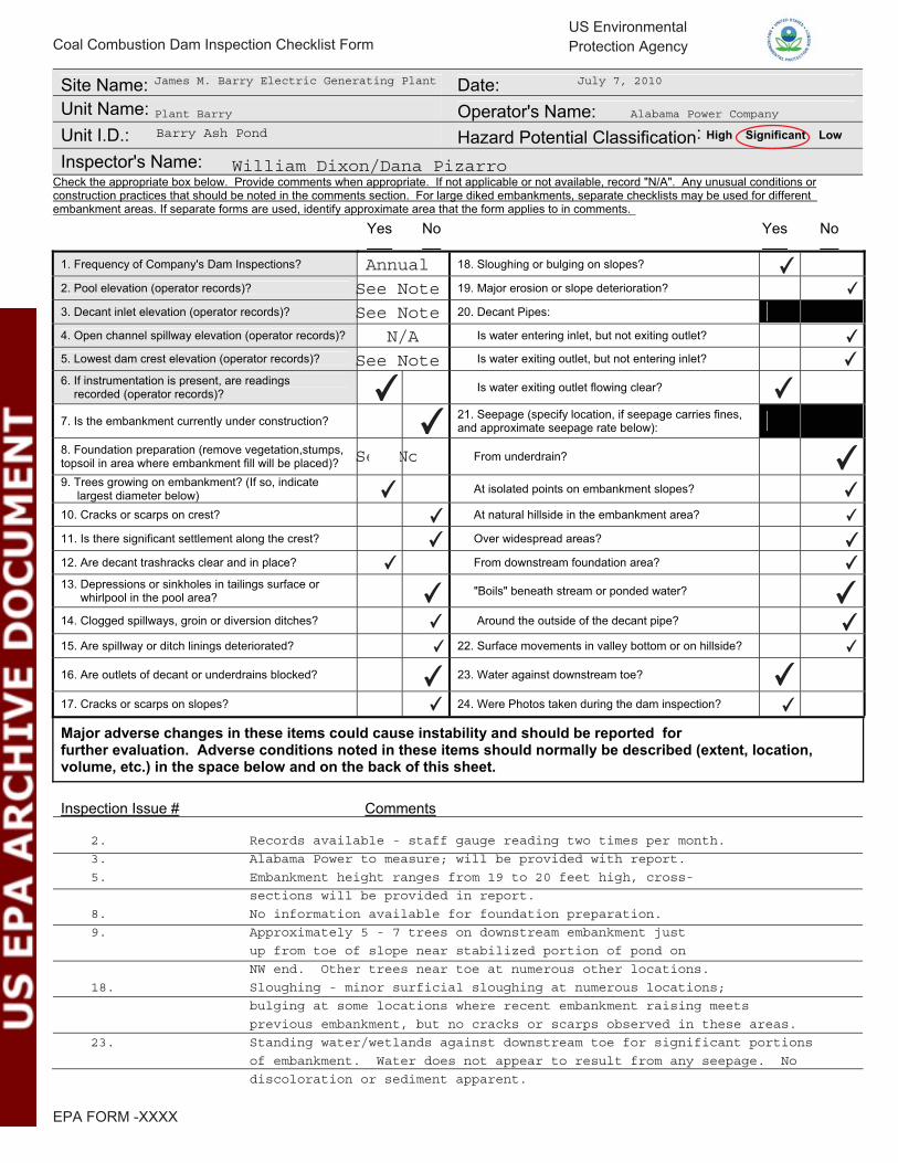
Site Name: Date: Unit Name: Operator's Name: Unit I.D.: Hazard Potential Classification: High Significant Low Inspector's Name:
Check the appropriate box below. Provide comments when appropriate. If not applicable or not available, record "N/A". Any unusual conditions or construction practices that should be noted in the comments section. For large diked embankments, separate checklists may be used for different embankment areas. If separate forms are used, identify approximate area that the form applies to in comments.
Yes No Yes No
1. Frequency of Company's Dam Inspections? 18. Sloughing or bulging on slopes? 2. Pool elevation (operator records)? 19. Major erosion or slope deterioration? 3. Decant inlet elevation (operator records)? 20. Decant Pipes: 4. Open channel spillway elevation (operator records)? Is water entering inlet, but not exiting outlet? 5. Lowest dam crest elevation (operator records)? Is water exiting outlet, but not entering inlet? 6. If instrumentation is present, are readings recorded (operator records)? Is water exiting outlet flowing clear?
7. Is the embankment currently under construction? 21. Seepage (specify location, if seepage carries fines, and approximate seepage rate below):
8. Foundation preparation (remove vegetation,stumps, topsoil in area where embankment fill will be placed)? From underdrain? 9. Trees growing on embankment? (If so, indicate largest diameter below) At isolated points on embankment slopes? 10. Cracks or scarps on crest? At natural hillside in the embankment area? 11. Is there significant settlement along the crest? Over widespread areas? 12. Are decant trashracks clear and in place? From downstream foundation area? 13. Depressions or sinkholes in tailings surface or whirlpool in the pool area? "Boils" beneath stream or ponded water? 14. Clogged spillways, groin or diversion ditches? Around the outside of the decant pipe? 15. Are spillway or ditch linings deteriorated? 22. Surface movements in valley bottom or on hillside? 16. Are outlets of decant or underdrains blocked? 23. Water against downstream toe? 17. Cracks or scarps on slopes? 24. Were Photos taken during the dam inspection? Major adverse changes in these items could cause instability and should be reported for further evaluation. Adverse conditions noted in these items should normally be described (extent, location, volume, etc.) in the space below and on the back of this sheet.
Inspection Issue # Comments
Coal Combustion Dam Inspection Checklist FormUS EnvironmentalProtection Agency
EPA FORM -XXXX
James M. Barry Electric Generating Plant July 7, 2010
Plant Barry Alabama Power Company
Barry Ash Pond
Annual See Note See Note
N/A See Note
See Note
2. Records available - staff gauge reading two times per month.
3. Alabama Power to measure; will be provided with report.
5. Embankment height ranges from 19 to 20 feet high, cross-
sections will be provided in report.
8. No information available for foundation preparation.
9. Approximately 5 - 7 trees on downstream embankment just
up from toe of slope near stabilized portion of pond on
NW end. Other trees near toe at numerous other locations.
18. Sloughing - minor surficial sloughing at numerous locations;
bulging at some locations where recent embankment raising meets
previous embankment, but no cracks or scarps observed in these areas.
23. Standing water/wetlands against downstream toe for significant portions
of embankment. Water does not appear to result from any seepage. No
discoloration or sediment apparent.
William Dixon/Dana Pizarro
✔✔
✔
✔
✔
✔
✔✔
✔
✔✔
✔✔
✔
✔
✔
✔✔
✔
✔
✔
✔✔✔
✔✔
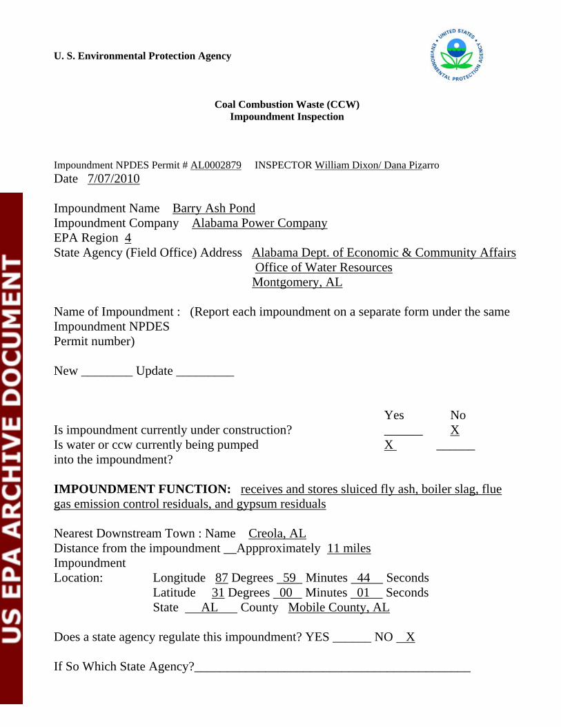
U. S. Environmental Protection Agency
Coal Combustion Waste (CCW) Impoundment Inspection
Impoundment NPDES Permit # AL0002879 INSPECTOR William Dixon/ Dana Pizarro Date 7/07/2010 Impoundment Name Barry Ash Pond Impoundment Company Alabama Power Company EPA Region 4 State Agency (Field Office) Address Alabama Dept. of Economic & Community Affairs Office of Water Resources Montgomery, AL Name of Impoundment : (Report each impoundment on a separate form under the same Impoundment NPDES Permit number) New ________ Update _________ Yes No Is impoundment currently under construction? ______ X Is water or ccw currently being pumped X ______ into the impoundment? IMPOUNDMENT FUNCTION: receives and stores sluiced fly ash, boiler slag, flue gas emission control residuals, and gypsum residuals Nearest Downstream Town : Name Creola, AL Distance from the impoundment __Appproximately 11 miles Impoundment Location: Longitude 87 Degrees 59 Minutes 44 Seconds Latitude 31 Degrees 00 Minutes 01 Seconds State AL County Mobile County, AL Does a state agency regulate this impoundment? YES ______ NO X If So Which State Agency?___________________________________________

EPA Form XXXX-XXX, Jan 09 HAZARD POTENTIAL (In the event the impoundment should fail, the following would occur): ______ LESS THAN LOW HAZARD POTENTIAL: Failure or misoperation of the dam results in no probable loss of human life or economic or environmental losses. ______ LOW HAZARD POTENTIAL: Dams assigned the low hazard potential classification are those where failure or misoperation results in no probable loss of human life and low economic and/or environmental losses. Losses are principally limited to the owner’s property. X SIGNIFICANT HAZARD POTENTIAL: Dams assigned the significant hazard potential classification are those dams where failure or misoperation results in no probable loss of human life but can cause economic loss, environmental damage, disruption of lifeline facilities, or can impact other concerns. Significant hazard potential classification dams are often located in predominantly rural or agricultural areas but could be located in areas with population and significant infrastructure. ______ HIGH HAZARD POTENTIAL: Dams assigned the high hazard potential classification are those where failure or misoperation will probably cause loss of human life. DESCRIBE REASONING FOR HAZARD RATING CHOSEN: Environmental damage to Mobile River. Failure would cause shutdown of power plant. ___________________________________________________________________ ______________________________________________________________________ ______________________________________________________________________ ______________________________________________________________________ ______________________________________________________________________ ______________________________________________________________________ ______________________________________________________________________ ______________________________________________________________________ ______________________________________________________________________ ______________________________________________________________________ ______________________________________________________________________ ______________________________________________________________________ ______________________________________________________________________ ______________________________________________________________________ ______________________________________________________________________ ______________________________________________________________________

EPA Form XXXX-XXX, Jan 09 CONFIGURATION:
_____ Cross-Valley _____ Side-Hill X Diked _____ Incised (form completion optional) _____ Combination Incised/Diked Embankment Height 19 to 20 feet Embankment Material_Sandy clay Pool Area 597 acres Liner None
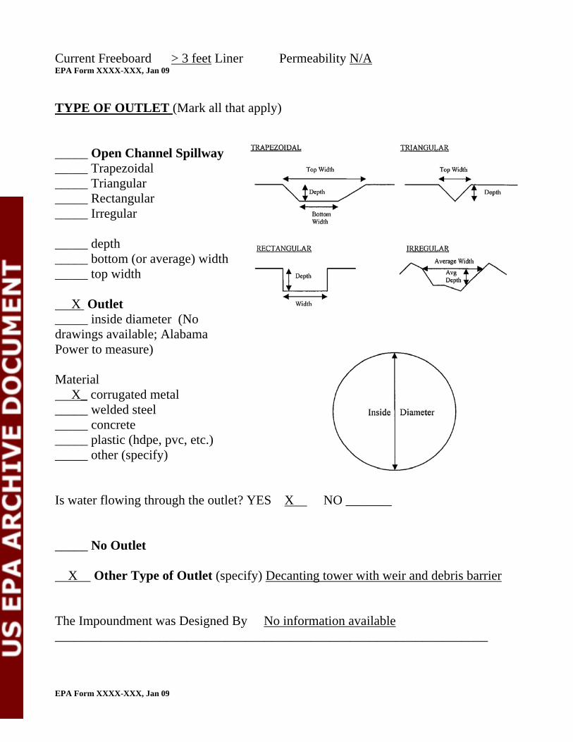
Current Freeboard > 3 feet Liner Permeability N/A EPA Form XXXX-XXX, Jan 09
TYPE OF OUTLET (Mark all that apply) _____ Open Channel Spillway _____ Trapezoidal _____ Triangular _____ Rectangular _____ Irregular _____ depth _____ bottom (or average) width _____ top width X Outlet _____ inside diameter (No drawings available; Alabama Power to measure) Material X_ corrugated metal _____ welded steel _____ concrete _____ plastic (hdpe, pvc, etc.) _____ other (specify) Is water flowing through the outlet? YES X NO _______ _____ No Outlet X Other Type of Outlet (specify) Decanting tower with weir and debris barrier The Impoundment was Designed By No information available __________________________________________________________________ EPA Form XXXX-XXX, Jan 09

Has there ever been a failure at this site? YES __________ NO X If So When? ___________________________
If So Please Describe : ___________________________________________________ ______________________________________________________________________ ______________________________________________________________________ ______________________________________________________________________ ______________________________________________________________________ ______________________________________________________________________ ______________________________________________________________________ ______________________________________________________________________ ______________________________________________________________________ ______________________________________________________________________ ______________________________________________________________________ ______________________________________________________________________ ______________________________________________________________________ ______________________________________________________________________ ______________________________________________________________________ ______________________________________________________________________ ______________________________________________________________________ ______________________________________________________________________ ______________________________________________________________________ ______________________________________________________________________ ______________________________________________________________________ ______________________________________________________________________ ______________________________________________________________________ ______________________________________________________________________ ______________________________________________________________________ ______________________________________________________________________ ______________________________________________________________________ ______________________________________________________________________ ______________________________________________________________________ ______________________________________________________________________ EPA Form XXXX-XXX, Jan 09

Has there ever been significant seepages at this site? YES _______ NO X If So When? ___________________________ IF So Please Describe: ___________________________________________________ ______________________________________________________________________ ______________________________________________________________________ ______________________________________________________________________ ______________________________________________________________________ ______________________________________________________________________ ______________________________________________________________________ ______________________________________________________________________ ______________________________________________________________________ ______________________________________________________________________ ______________________________________________________________________ ______________________________________________________________________ ______________________________________________________________________ ______________________________________________________________________ ______________________________________________________________________ ______________________________________________________________________ ______________________________________________________________________ ______________________________________________________________________ ______________________________________________________________________ ______________________________________________________________________ ______________________________________________________________________ ______________________________________________________________________ ______________________________________________________________________ ______________________________________________________________________ ______________________________________________________________________ ______________________________________________________________________ ______________________________________________________________________ ______________________________________________________________________ ______________________________________________________________________ ______________________________________________________________________ ______________________________________________________________________ EPA Form XXXX-XXX, Jan 09

Has there ever been any measures undertaken to monitor/lowerPhreatic water able levels based on past seepages or breaches at this site? YES ________NO X If so, which method (e.g., piezometers, gw pumping,...)? ________________________ If so Please Describe : ____________________________________________ ______________________________________________________________________ ______________________________________________________________________ ______________________________________________________________________ ______________________________________________________________________ ______________________________________________________________________ ______________________________________________________________________ ______________________________________________________________________ ______________________________________________________________________ ______________________________________________________________________ ______________________________________________________________________ ______________________________________________________________________ ______________________________________________________________________ ______________________________________________________________________ ______________________________________________________________________ ______________________________________________________________________ ______________________________________________________________________ ______________________________________________________________________ ______________________________________________________________________ ______________________________________________________________________ ______________________________________________________________________ ______________________________________________________________________ ______________________________________________________________________ ______________________________________________________________________ ______________________________________________________________________ ______________________________________________________________________ ______________________________________________________________________ ______________________________________________________________________ ______________________________________________________________________ ______________________________________________________________________ ______________________________________________________________________ EPA Form XXXX-XXX, Jan 09

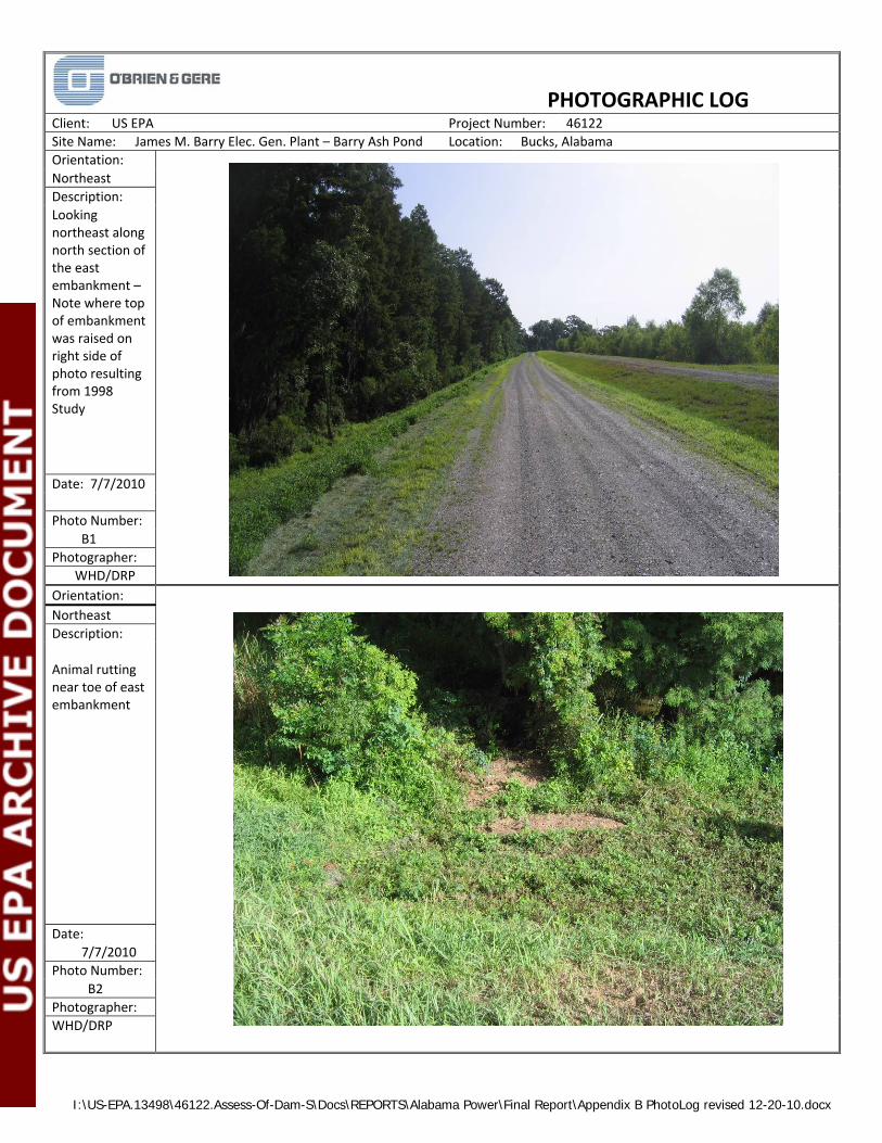
APPENDIX B
Photographs – Barry Ash Pond
I:\US-EPA.13498\46122.Assess-Of-Dam-S\Docs\REPORTS\Alabama Power\Final Report\Appendix B PhotoLog revised 12-20-10.docx
PHOTOGRAPHIC LOG
Client: US EPA Project Number: 46122
Site Name: James M. Barry Elec. Gen. Plant – Barry Ash Pond Location: Bucks, Alabama
Orientation:
Northeast
Description:
Looking northeast along north section of the east embankment – Note where top of embankment was raised on right side of photo resulting from 1998 Study
Date: 7/7/2010
Photo Number:
B1
Photographer:
WHD/DRP
Orientation:
Northeast
Description:
Animal rutting near toe of east embankment
Date:
7/7/2010
Photo Number:
B2
Photographer:
WHD/DRP
I:\US-EPA.13498\46122.Assess-Of-Dam-S\Docs\REPORTS\Alabama Power\Final Report\Appendix B PhotoLog revised 12-20-10.docx
PHOTOGRAPHIC LOG
Client: US EPA Project Number: 46122
Site Name: James M. Barry Elec. Gen. Plant – Barry Ash Pond Location: Bucks, Alabama
Orientation:
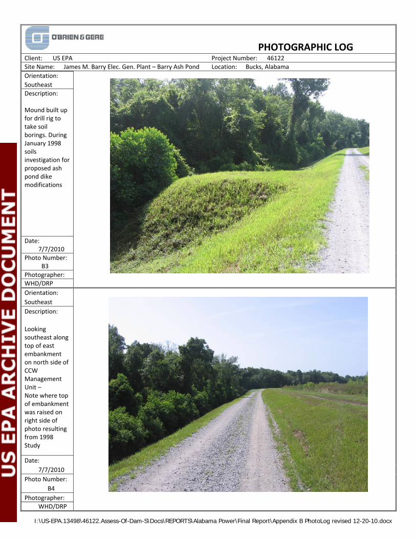
Southeast
Description: Mound built up for drill rig to take soil borings. During January 1998 soils investigation for proposed ash pond dike modifications
Date: 7/7/2010
Photo Number: B3
Photographer:
WHD/DRP
Orientation:
Southeast
Description:
Looking southeast along top of east embankment on north side of CCW Management Unit – Note where top of embankment was raised on right side of photo resulting from 1998 Study
Date:
7/7/2010
Photo Number:
B4
Photographer:
WHD/DRP
I:\US-EPA.13498\46122.Assess-Of-Dam-S\Docs\REPORTS\Alabama Power\Final Report\Appendix B PhotoLog revised 12-20-10.docx
PHOTOGRAPHIC LOG
Client: US EPA Project Number: 46122
Site Name: James M. Barry Elec. Gen. Plant – Barry Ash Pond Location: Bucks, Alabama
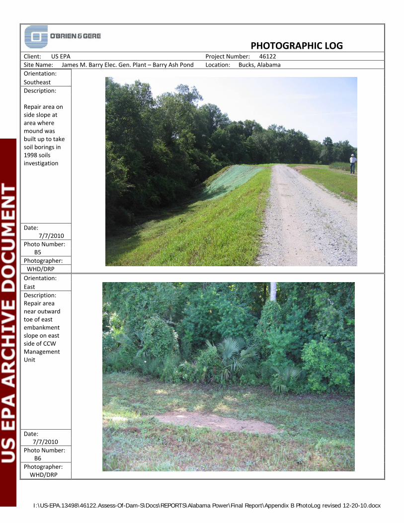
Orientation:
Southeast
Description: Repair area on side slope at area where mound was built up to take soil borings in 1998 soils investigation
Date: 7/7/2010
Photo Number: B5
Photographer:
WHD/DRP
Orientation:
East
Description: Repair area near outward toe of east embankment slope on east side of CCW Management Unit
Date: 7/7/2010
Photo Number: B6
Photographer: WHD/DRP

I:\US-EPA.13498\46122.Assess-Of-Dam-S\Docs\REPORTS\Alabama Power\Final Report\Appendix B PhotoLog revised 12-20-10.docx
PHOTOGRAPHIC LOG
Client: US EPA Project Number: 46122
Site Name: James M. Barry Elec. Gen. Plant – Barry Ash Pond Location: Bucks, Alabama
Orientation:
South
Description: Looking south along east embankment. Diversion Dike is seen breaking off to the right (west) in the photo.
Date: 7/7/2010
Photo Number: B7
Photographer:
WHD/DRP
Orientation:
West
Description:
Looking west towards southern portion of embankment
Date:
7/7/2010
Photo Number:
B8
Photographer:
WHD/DRP
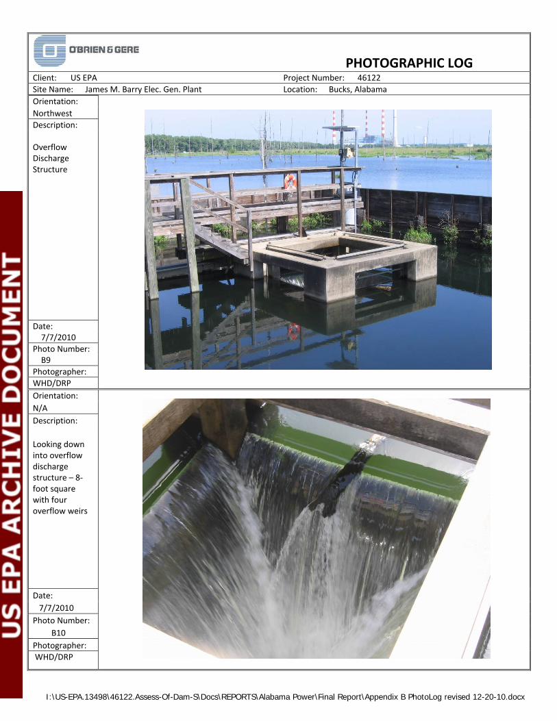
I:\US-EPA.13498\46122.Assess-Of-Dam-S\Docs\REPORTS\Alabama Power\Final Report\Appendix B PhotoLog revised 12-20-10.docx
PHOTOGRAPHIC LOG
Client: US EPA Project Number: 46122
Site Name: James M. Barry Elec. Gen. Plant Location: Bucks, Alabama
Orientation:
Northwest
Description: Overflow Discharge Structure
Date: 7/7/2010
Photo Number: B9
Photographer:
WHD/DRP
Orientation:
N/A
Description:
Looking down into overflow discharge structure – 8‐foot square with four overflow weirs
Date:
7/7/2010
Photo Number:
B10
Photographer:
WHD/DRP
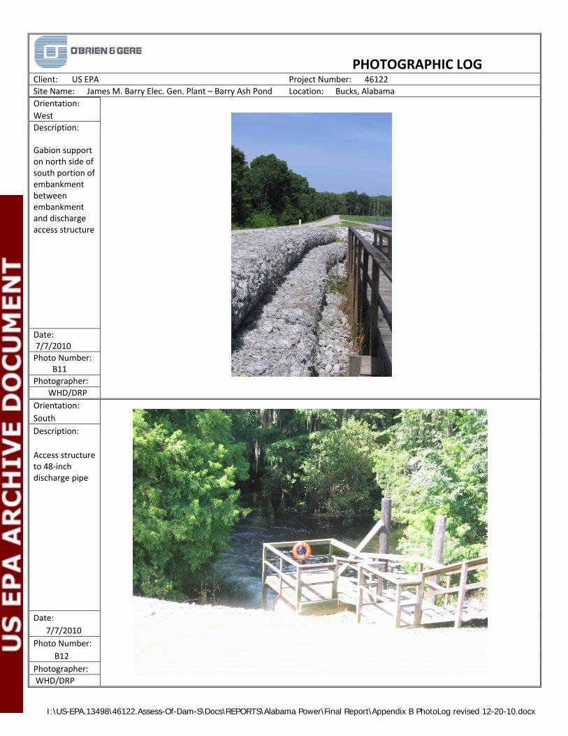
I:\US-EPA.13498\46122.Assess-Of-Dam-S\Docs\REPORTS\Alabama Power\Final Report\Appendix B PhotoLog revised 12-20-10.docx
PHOTOGRAPHIC LOG
Client: US EPA Project Number: 46122
Site Name: James M. Barry Elec. Gen. Plant – Barry Ash Pond Location: Bucks, Alabama
Orientation:
West
Description: Gabion support on north side of south portion of embankment between embankment and discharge access structure
Date: 7/7/2010
Photo Number: B11
Photographer:
WHD/DRP
Orientation:
South
Description:
Access structure to 48‐inch discharge pipe
Date:
7/7/2010
Photo Number:
B12
Photographer:
WHD/DRP
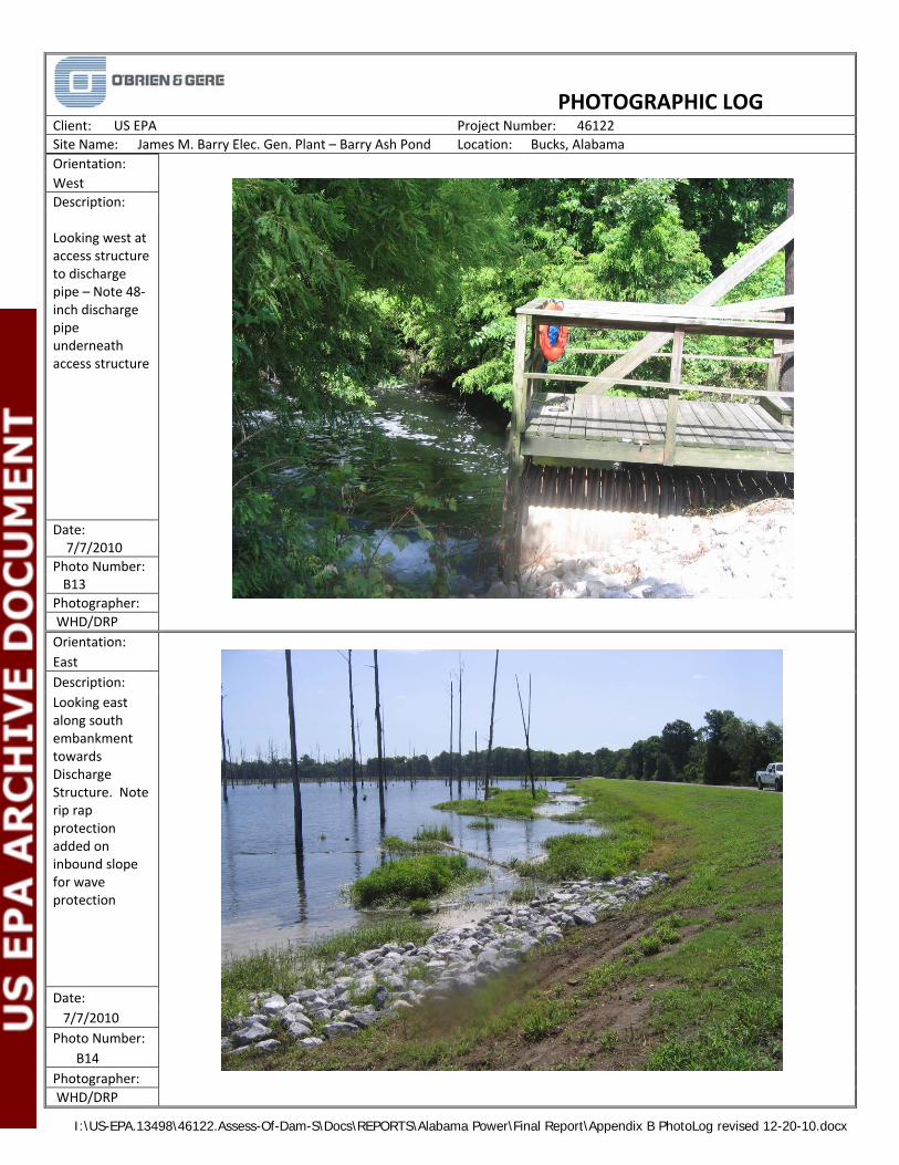
I:\US-EPA.13498\46122.Assess-Of-Dam-S\Docs\REPORTS\Alabama Power\Final Report\Appendix B PhotoLog revised 12-20-10.docx
PHOTOGRAPHIC LOG
Client: US EPA Project Number: 46122
Site Name: James M. Barry Elec. Gen. Plant – Barry Ash Pond Location: Bucks, Alabama
Orientation:
West
Description: Looking west at access structure to discharge pipe – Note 48‐inch discharge pipe underneath access structure
Date: 7/7/2010
Photo Number: B13
Photographer:
WHD/DRP
Orientation:
East
Description:
Looking east along south embankment towards Discharge Structure. Note rip rap protection added on inbound slope for wave protection
Date:
7/7/2010
Photo Number:
B14
Photographer:
WHD/DRP
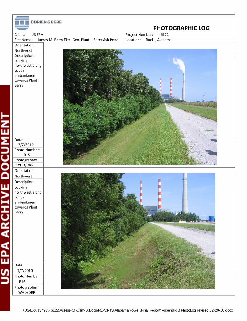
I:\US-EPA.13498\46122.Assess-Of-Dam-S\Docs\REPORTS\Alabama Power\Final Report\Appendix B PhotoLog revised 12-20-10.docx
PHOTOGRAPHIC LOG
Client: US EPA Project Number: 46122
Site Name: James M. Barry Elec. Gen. Plant – Barry Ash Pond Location: Bucks, Alabama
Orientation:
Northwest
Description: Looking northwest along south embankment towards Plant Barry
Date: 7/7/2010
Photo Number: B15
Photographer:
WHD/DRP
Orientation:
Northwest
Description:
Looking northwest along south embankment towards Plant Barry
Date:
7/7/2010
Photo Number:
B16
Photographer:
WHD/DRP

I:\US-EPA.13498\46122.Assess-Of-Dam-S\Docs\REPORTS\Alabama Power\Final Report\Appendix B PhotoLog revised 12-20-10.docx
PHOTOGRAPHIC LOG
Client: US EPA Project Number: 46122
Site Name: James M. Barry Elec. Gen. Plant – Barry Ash Pond Location: Bucks, Alabama
Orientation:
Northwest
Description: Looking northwest along south embankment towards Plant Barry – Note closed and stabilized portion of embankment on right side of road
Date: 7/7/2010
Photo Number: B17
Photographer:
WHD/DRP
Orientation:
Northwest
Description:
Trees near toe of outward slope of south embankment. This portion of embankment is in area where CCW Management Unit has been closed and stabilized
Date:
7/7/2010
Photo Number:
B18
Photographer:
WHD/DRP

I:\US-EPA.13498\46122.Assess-Of-Dam-S\Docs\REPORTS\Alabama Power\Final Report\Appendix B PhotoLog revised 12-20-10.docx
PHOTOGRAPHIC LOG
Client: US EPA Project Number: 46122
Site Name: James M. Barry Elec. Gen. Plant Ash Pond Location: Bucks, Alabama
Orientation:
Southwest
Description: Diversion Dike Sign near intersection of main embankment and diversion dike on east side of CCW Management Unit
7/7/2010
Photo Number: B19
Photographer:
WHD/DRP
Orientation:
Northeast
Diversion Dike sign near intersection of east embankment and diversion dike on west side of CCW Management Unit
Date:
7/7/2010
Photo Number:
B20
Photographer:
WHD/DRP

I:\US-EPA.13498\46122.Assess-Of-Dam-S\Docs\REPORTS\Alabama Power\Final Report\Appendix B PhotoLog revised 12-20-10.docx
PHOTOGRAPHIC LOG
Client: US EPA Project Number: 46122
Site Name: James M. Barry Elec. Gen. Plant – Barry Ash Pond Location: Bucks, Alabama
Orientation:
Northwest
Description: Looking northwest from Bridge over Primary Diversion Dike Outfall near west end of Diversion Dike
Date: 7/7/2010
Photo Number: B21
Photographer:
WHD/DRP
Orientation:
West
Description:
Looking west along Diversion Dike towards Primary Diversion Dike Outfall
Date:
7/7/2010
Photo Number:
B22
Photographer:
WHD/DRP

I:\US-EPA.13498\46122.Assess-Of-Dam-S\Docs\REPORTS\Alabama Power\Final Report\Appendix B PhotoLog revised 12-20-10.docx
PHOTOGRAPHIC LOG
Client: US EPA Project Number: 46122
Site Name: James M. Barry Elec. Gen. Plant Location: Bucks, Alabama
Orientation:
East
Description:
Looking east along Diversion Dike from Primary Diversion Dike Outfall – Note rutting from machinery on right side of photo
Date:
7/7/2010
Photo Number:
B23
Photographer:
WHD/DRP
Orientation:
Northeast
Description: Northwest side of Secondary Diversion Dike Outfall
Date: 7/7/2010
Photo Number: B24
Photographer: WHD/DRP
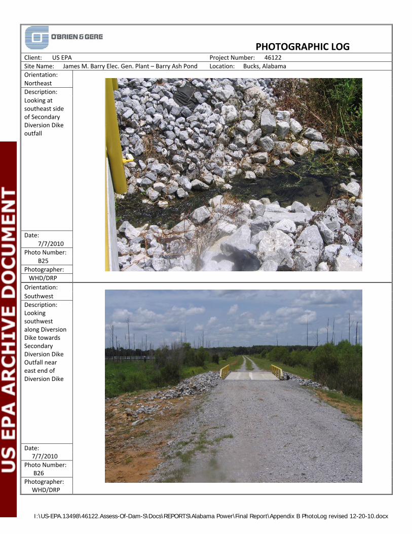
I:\US-EPA.13498\46122.Assess-Of-Dam-S\Docs\REPORTS\Alabama Power\Final Report\Appendix B PhotoLog revised 12-20-10.docx
PHOTOGRAPHIC LOG
Client: US EPA Project Number: 46122
Site Name: James M. Barry Elec. Gen. Plant – Barry Ash Pond Location: Bucks, Alabama
Orientation:
Northeast
Description:
Looking at southeast side of Secondary Diversion Dike outfall
Date:
7/7/2010
Photo Number:
B25
Photographer:
WHD/DRP
Orientation:
Southwest
Description: Looking southwest along Diversion Dike towards Secondary Diversion Dike Outfall near east end of Diversion Dike
Date: 7/7/2010
Photo Number: B26
Photographer: WHD/DRP
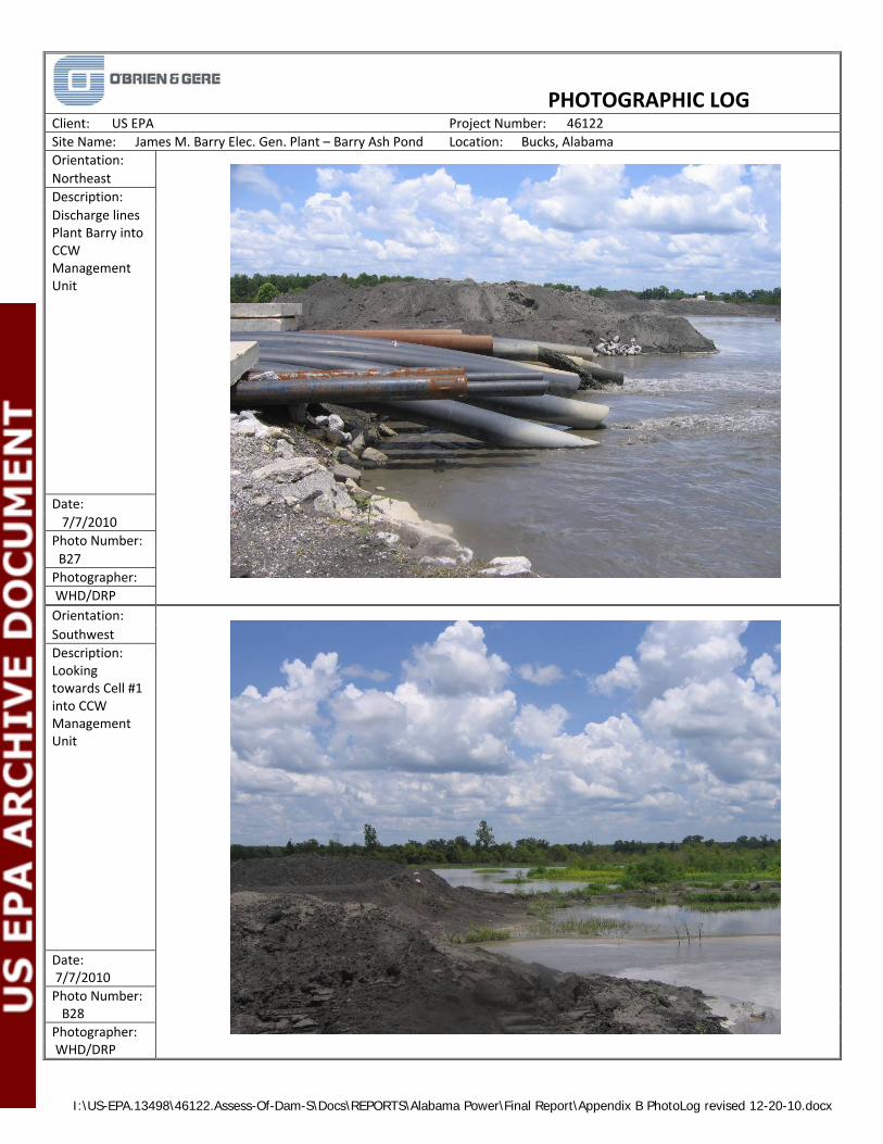
I:\US-EPA.13498\46122.Assess-Of-Dam-S\Docs\REPORTS\Alabama Power\Final Report\Appendix B PhotoLog revised 12-20-10.docx
PHOTOGRAPHIC LOG
Client: US EPA Project Number: 46122
Site Name: James M. Barry Elec. Gen. Plant – Barry Ash Pond Location: Bucks, Alabama
Orientation:
Northeast
Description:
Discharge lines Plant Barry into CCW Management Unit
Date:
7/7/2010
Photo Number:
B27
Photographer:
WHD/DRP
Orientation:
Southwest
Description: Looking towards Cell #1 into CCW Management Unit
Date: 7/7/2010
Photo Number: B28
Photographer: WHD/DRP
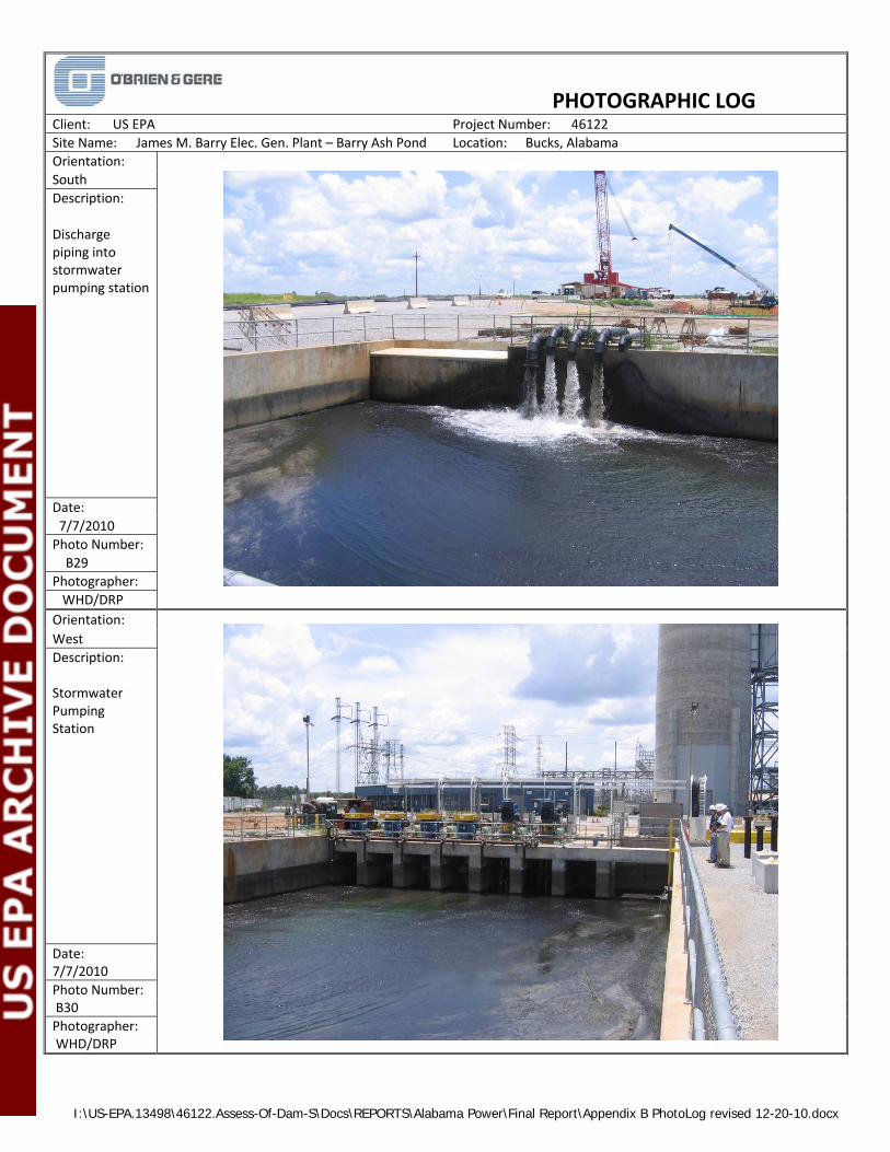
I:\US-EPA.13498\46122.Assess-Of-Dam-S\Docs\REPORTS\Alabama Power\Final Report\Appendix B PhotoLog revised 12-20-10.docx
PHOTOGRAPHIC LOG
Client: US EPA Project Number: 46122
Site Name: James M. Barry Elec. Gen. Plant – Barry Ash Pond Location: Bucks, Alabama
Orientation:
South
Description:
Discharge piping into stormwater pumping station
Date:
7/7/2010
Photo Number:
B29
Photographer:
WHD/DRP
Orientation:
West
Description: Stormwater Pumping Station
Date: 7/7/2010
Photo Number: B30
Photographer: WHD/DRP
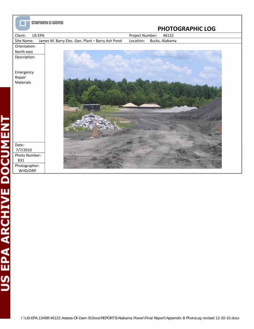
I:\US-EPA.13498\46122.Assess-Of-Dam-S\Docs\REPORTS\Alabama Power\Final Report\Appendix B PhotoLog revised 12-20-10.docx
PHOTOGRAPHIC LOG
Client: US EPA Project Number: 46122
Site Name: James M. Barry Elec. Gen. Plant – Barry Ash Pond Location: Bucks, Alabama
Orientation:
North east
Description: Emergency Repair Materials
Date: 7/7/2010
Photo Number: B31
Photographer: WHD/DRP

APPENDIX C
Photographs – Gypsum Collection Basin

I:\US‐EPA.13498\46122.ASSESS‐OF‐DAM‐S\DOCS\REPORTS\ALABAMA POWER\FINAL REPORT\APPENDIX C PHOTOLOG REVISED 12-20-10.DOCX
PHOTOGRAPHIC LOG
Client: US EPA Project Number: 46122
Site Name: James M. Barry Elec. Gen. Plant – Gypsum Basin Location: Bucks, Alabama
Orientation:
Northeast
Description:
Gypsum Collection Basin Area – Emergency Slurry Pond Pumps
Date:
7/7/2010
Photo Number:
C1
Photographer:
WHD/DRP
Orientation:
Southeast
Description: Cell 1 of – Gypsum Collection Basin
Date: 7/7/2010
Photo Number: C2
Photographer: WHD/DRP

I:\US‐EPA.13498\46122.ASSESS‐OF‐DAM‐S\DOCS\REPORTS\ALABAMA POWER\FINAL REPORT\APPENDIX C PHOTOLOG REVISED 12-20-10.DOCX
PHOTOGRAPHIC LOG
Client: US EPA Project Number: 46122
Site Name: James M. Barry Elec. Gen. Plant – Gypsum Basin Location: Bucks, Alabama
Orientation:
Southeast
Description:
Riser Assembly and Decant Structure – Gypsum Collection Basin
Date:
7/7/2010
Photo Number:
C3
Photographer:
WHD/DRP
Orientation:
West
Description: Gypsum Collection Basin – Surge pond Pumps
Date: 7/7/2010
Photo Number: C4
Photographer: WHD/DRP