alaska fisheries science center bin c15700, building 4
TRANSCRIPT

1
Alaska Fisheries Science Center
7600 Sand Point Way Northeast
BIN C15700, Building 4
Seattle, Washington 98115-0070
1/23/2008
Commanding Officer
NOAA Ship Oscar Dyson
CRUISE INSTRUCTIONS: DY0802, ECHO INTEGRATION-TRAWL SURVEY OF WALLEYE POLLOCK IN THE CENTRAL ALEUTIAN ISLANDS
Chief Scientist: Elizabeth (Libby) Logerwell
NOAA/AFSC Resource Ecology and Fisheries Management Status of Stocks and Multispecies Assessment (SSMA)
1.0 SCHEDULE - AREA OF OPERATIONS
Scientists from the Alaska Fisheries Science Center (AFSC), REFM Division, SSMA Program will conduct an echo integration-trawl (EIT) survey of walleye pollock (Theragra chalcogramma) in the central Aleutian Islands from Seguam Pass to the Tanaga Island area (extending to Delarof Islands if time permits)aboard the NOAA ship Oscar Dyson from 16 February to 3 March for a total of 16 sea days (see figure in Appendix 1). The cruise will begin in Dutch Harbor and end in Kodiak, Alaska.
2.0 VESSEL ITINERARY
Feb 16 Embark scientists in Dutch Harbor.
Feb 16-17 Transit to survey start Seguam Pass. Feb 17-27 Echo integration-trawl survey of the central Aleutian
Islands. Survey end at Tanaga Island (or Delarof Islands if time permits).
Feb 28-Mar 1 Transit to Dutch Harbor. Scientists debark. March 2-3 Transit to Kodiak. 3.0 SCIENTIFIC OBJECTIVES
The primary objectives of the cruise are to:

2
3.1 collect echo integration data and trawl data necessary to determine the distribution, biomass, and biological composition of walleye pollock in the central Aleutian Islands between Seguam Pass and the Tanaga Island area (if time permits the survey will be extended to the Delarof Islands); 3.2 conduct Methot tows to groundtruth multi-frequency acoustic data on euphausiid distribution; 3.3 collect physical oceanographic data (temperature and salinity profiles) at selected sites (Appendix 2) with Niskin bottle water samples, and continuously collect sea surface temperature, salinity, oxygen, nitrate and fluorescence data;
3.4. conduct Bongo zooplankton tows at selected sites to collect samples of ichthyoplankton and zooplankton; 3.5 conduct midwater and bottom trawls to collect stomach specimens and gonads from selected species to elucidate key predator-prey relationships and spawning behavior in the Aleutian Islands; 3.6 conduct a seabird census survey. A U.S. Fish and Wildlife Service scientist will conduct this work (Appendix 3); 3.7 conduct marine mammal census surveys (killer whales and Steller sea lions). NMML scientist(s) will conduct this work (Appendix 4); Secondary objectives of the cruise include scientific research requested by AFSC and other investigators. Detailed descriptions of ancillary projects associated with this cruise will be provided as soon as possible. Significant changes to these projects that affect vessel operations will be communicated as soon as they are known. Final project descriptions will be delivered to the Field Operations Officer prior to the vessel’s departure from Seattle. 4.0 OPERATIONAL PLANS
To reduce vessel motion and thus improve the quality of the acoustic data, we request that the vessel use the roll tank when sea conditions warrant.
4.1 Survey operations will be conducted 24 hours per day. The primary EIT survey operations will be conducted during nighttime hours (approximately 12 hours per day), requiring participation of the deck crew and Survey Technician. Acoustic data will be collected continuously along a series of parallel transects with a Simrad ER60 echo integration system incorporating centerboard-mounted transducers at 18, 38, 70, 120, and 200 kHz. The vessel must not operate other echo sounders or acoustic equipment that interfere with collection of scientific acoustic data. The ADCP will be secured and not operated for

3
this cruise. The bow thrusters, Doppler speed log and bridge Furuno depth sounder should all be secured, as they degrade the quality of acoustic data. Transect spacing will be 2.5 nm, except in areas of anticipated high pollock biomass where transect spacing will be smaller, at 1.25 nm. Trackline waypoints are provided in Appendix 1. Trackline endpoints will be provided in an electronic file to the Field Operations Officer. On occasion, transects may be extended in the offshore direction, to assess the extent of the distribution of bathypelagic fishes (such as myctophids). The nearshore waypoints are as close as 0.75 nm to shore in some areas. The Chief Scientist will confer with Ship’s command before the start of the cruise to discuss whether it will be feasible to occupy those waypoints. Ship speed is expected to average 11.0 to 12.0 knots in favorable conditions.
Daytime operations will occur regularly requiring participation of
the deck crew and Survey Technician. These will include additional trawling, CTD casts, Bongo net tows, Methot net tows and other requested special scientific projects.
EIT survey operations require that an Aleutian wing trawl (AWT) and Poly Nor’eastern (PNE) bottom trawl with roller gear are loaded onto the net reels. Codend liner mesh size will be 0.5 in for the AWT and 1.25 in. for the bottom trawl. A second AWT and PNE will be stowed on board the vessel as backup gear. The backup AWT will be equipped with a 1.25-inch liner. Fishbuster doors will be used with all trawls. We request that the chief boatswain keep a trawl gear logbook to record any modifications made to trawl gear during the cruise. Small fishes and macrozooplankton will be sampled using the Methot trawl.
Midwater and bottom trawl hauls will be made to identify echo sign and provide pollock samples and other biological data. An average of 3-4 trawl hauls per 24 hrs is anticipated. On occasion, trawling will occur more frequently. Haul duration will be kept to the minimum necessary to ensure an adequate sample. A MOA button should be set up to mark trawl number, date, time, position and water depth at the following events: doors in, EQ, haul back, and doors up. Biological data collected from each haul will include species composition by weight and number, sex composition, length frequencies, whole fish and ovary weights, maturities, otoliths, stomachs and fin clips.
4.2 Midwater and bottom trawl hauls will also be made to collect
stomachs for a detailed feeding ecology study and gonads for a reproductive biology study. Species to be targeted include walleye pollock and Pacific cod. The estimated average of 3-4 hauls per 24 hrs includes these hauls.
4.3 Methot trawls will be conducted to sample small fishes and
macrozooplankton. The Methot trawl is deployed off the stern of the vessel. A Simrad ITI depth sensor will be used to receive real-time depth information. Where and when the trawl will be conducted depends on

4
the acoustic sign, most likely during daytime. Tows will likely be conducted from near bottom to the surface, although particular depth layers may be targeted. A MOA button should be set up to mark Methot number and the at-depth position, date, time, and bottom depth. See FOCI Standard Operating Instructions (SOI) for NOAA Ship Miller Freeman (attached) section 3.2.8 for specific requirements.
4.4 Conductivity-temperature-depth (CTD) data will be collected with the vessel’s CTD/rosette system. CTDs will be deployed opportunistically throughout the survey, primarily during the day, at water depths from 100 to 200 meters. Additional CTD casts will be made at selected passes, shown on the figure in Appendix 2. In these areas, CTDs will be deployed at water depths around 100 to 200 meters and around 500 meters. CTD casts and Bongo tows will be made at the same stations whenever possible. Water samples will be collected from Niskin bottles deployed at the surface, 200 m and 500 m (for the deeper casts). Small Niskin bottles (<10-liters) may be used for this purpose. The samples will be filtered for chlorophyll and frozen for nutrients. In addition, water samples from the surface and bottom (one each in alternation from cast to cast) will be bottled for calibrating the conductivity/salinity sensor. All water samples (including salinity samples) will be transported back to AFSC for analysis. A MOA button should be set up to mark CTD number and the at-depth position, date, time, and bottom depth. A standard oceanographic watch is requested for CTD casts, which consists of a winch operator, a scientific staff of three and a Survey Tech on deck. See FOCI Standard Operating Instructions (SOI) for NOAA Ship Miller Freeman (attached) section 3.2.1 for specific requirements. 4.5 Temperature and depth profile data will be collected with a Seabird SBE39 micro-bathythermograph attached to the trawl headrope. 4.6 The Scientific Computing System (SCS) is configured to log data from various sensors during the cruise. Navigational and meteorological data will collected. Data on surface seawater temperature, salinity, oxygen, nitrate and fluorescence will also be collected from seachest sensors and sent to the SCS system. It is requested that collection of the oceanographic sensors data be synchronized with the navigational data so that the temperature, salinity, fluorescence, etc. data can be assigned the date, time and position it was collected. This can be accomplished by configuring the ship’s SCS ASCII-logger feature to log one-minute averaged data including: GPS time, GPS position, water depth (m), seawater temperature, seawater salinity, fluorometer voltage, nitrate sensor data (ISI) and oxygen sensor data. See FOCI Standard Operating Instructions (SOI) for NOAA Ship Miller (attached) section 5.2 for specific requirements. AFSC scientists will collect water samples periodically to calibrate fluorescence, nutrient and oxygen sensors. Oxygen calibration samples will be analyzed on board by AFSC scientists using a titrator belonging to PMEL. The fluorescence and nutrient samples will be transported back to AFSC for analysis.

5
4.7 A 60-cm aluminum Bongo frame with 333-μm mesh nets, flow meters, hard plastic cod-ends, and a 40-kg lead weight for a depressor will be used to sample zooplankton and ichthyoplankton at selected locations. A 20-cm Bongo with 505-μm mesh nets will be deployed above the 60-cm frame on the same cable. Tows will be conducted to 400 m, or 10 meters off the bottom, whichever is shallowest. Three Bongo tows will be conducted each day, if possible, at three different depths: shallower than 200 m water depth, between 200 m and approx. 400 m water depth, and offshore of 400 m water depth. Bongo tows and CTD casts will be made at the same stations whenever possible. A MOA button should be set up to mark Bongo tow number, position, date, time and bottom depth when net is at surface, at-depth, and has returned to surface. A standard oceanographic watch is requested for plankton towing, which consists of a winch operator, a scientific staff of three and a Survey Tech on deck. See FOCI Standard Operating Instructions (SOI) for NOAA Ship Miller Freeman (attached) section 3.2.2 for specific requirements. 5.0 SCIENTIFIC PERSONNEL
5.1 The Chief Scientist is Libby Logerwell phone (206) 526-4231, email
[email protected] FAX 206-526-6723, AFSC, Seattle, WA.
5.2 The Chief Scientist has the authority to revise or alter the
technical portions of the instructions provided that, after consultation with
the Commanding Officer, it is ascertained that the proposed changes will not:
1) jeopardize the safety of personnel on the ship; 2) exceed the time
allotted for the project; 3) result in undue additional expense; or 4) alter
the general intent of the cruise instructions.
5.3 All scientific personnel are required to have a completed NOAA
Health Services questionnaire aboard before embarking. Clearances are valid
for 2 years for scientists under age 50 and 1 year for age 50 and over.
5.4 Scientific Staff:
Sex/
Name Nationality Position Organization
Libby Logerwell F/USA Chief Scientist AFSC
Steve Barbeaux M/USA Fish. Biologist AFSC
Sandi Neidetcher F/USA Fish. Biologist AFSC
Kim Rand F/USA Fish. Biologist AFSC
Liz Conners F/USA Fish. Biologist AFSC
Darin Jones M/USA Fish. Biologist AFSC

6
Tamara Mills F/USA Seabird observer USFW
Holly Fearnbach F/USA Mammal observer NMML
AFSC - Alaska Fisheries Science Center, Seattle, WA
NMML – National Marine Mammal Laboratory
USFWS – U.S. Fish and Wildlife Service
6.0 EQUIPMENT
6.1 Scientific gear will be loaded and mounted onto the vessel prior to
its departure from Seattle on 26 January 2008. The exact loading schedule will
be arranged with the Field Operations Officer.
6.2 Acoustic Equipment Quantity Vessel Project
Simrad ER60 system 1 -- X
Backup Simrad ER60 system 1 -- X
Simrad ES18 transducer 1 -- X
Simrad ES38B transducer 1 -- X
Simrad ES70 transducer 1 -- X
Simrad ES120-7C transducer 1 -- X
Simrad ES200-7C transducer 1 -- X
GPS (with NEMA 183 to ER60) 2 X --
ES60 Bridge sounder (50/200 kHz) 1 X --
Furuno FE-700 fathometer 1 X --
6.3 Trawling Equipment1 Quantity Vessel Project
Aleutian wing trawl with
accessories (e.g., 1.25"
and 0.5" mesh liners) 2 -- X
Poly Nor’eastern bottom trawl
with roller gear 2 -- X
Dandylines (10 fm x ½ in.) * -- X
Dandylines (30 fm x 5/8 in.) * –- X
Fishbuster door with accessories 2 set -- X
Spare webbing & twine * -- X
Spare hardware * -- X
3rd wire Simrad FS-70 net sonar
w/ winch and accessories 2 X --
Simrad ITI net mensuration system 2 X --
Furuno CN24-40 headrope transducer 1 X --

7
Tom weights (500 lbs. each) 4 items -- X
Tom weights (250 lbs. each) 4 items -- X
Methot net with accessories 1 -- X
Miscellaneous supplies * -- X
6.4 Oceanographic Equipment Quantity Vessel Project
Seabird CTD System 2 X X
Seabird SBE39 2 -- X
6.5 Zooplankton Sampling Equip. Quantity Vessel Project
60-cm Bongo Frame 1 -- X
20-cm Bongo Frame 1 -- X
Formaldehyde Containers, 20-l 1 -- X
Carboy, Saturated Sodium Borate 1 -- X
Glass Jars, 32-oz, cases 5 -- X
Glass Jars, 8-oz 5 -- X
6.5 Fish Sampling Equip. Quantity Vessel Project
Fish lab conveyor system 1 X --
Catch sorting and weighing table 1 X --
Dynamometer (5000 kg scale) 2 -- X
Marel M60 60 kg scale (electr.) 2 -- X
Marel M60 6 kg scale (electr.) 2 -- X
Platform scale (mechanical) 2 -- X
Fish baskets 30 -- X
Storage freezer (-20°C ) 1 X --
Blast freezer (-80°C ) 1 X --
Buckets for stomach samples 12 -- X
Buckets for ovary samples 15 -- X
Biological supplies (misc.) * -- X
Formaldehyde (liters) 23 -- X
6.6 Computing equipment Quantity Vessel Project
IBM compatibles (w/XP Op.System) * -- X
Dell PowerEdge MACEBASE Server 1 -- X
Printers * -- X
Scientific Computing System (SCS) 1 X --

8
Fisheries Scientific
Computer System (FSCS) 1 X X
Note: "*" indicates amount not specified.
1 Trawling equipment specifications may be updated prior to the cruise.
6.7 The Chief Scientist shall be responsible for complying with MOCDOC
15, Fleet Environmental Compliance #07, Hazardous Material and Hazardous Waste
Management Requirements for Visiting Scientists, released July 2002. The
MOCDOC website address is:
http://205.156.48.106/
By federal regulations and NOAA Marine and Aviation Operations policy, the
ship may not sail without a complete inventory of all hazardous materials by
name, and the anticipated quantity brought aboard, MSDS and appropriate
neutralizing agents, buffers, and/or absorbents in amounts adequate to address
spills of a size equal to the amount of chemicals brought aboard, and a
chemical hygiene plan. The Chief Scientist shall account for the amount of
hazardous material arriving and leaving the vessel. See Appendix 5 for HAZMAT
Inventory.
7.0 RECORDS AND REPORTS
7.1 An electronic Marine Operations Abstract (MOA) will be created to
log all operations via daily transfers of position data from the ship's SCS
system to REFM scientists. An appropriate logging interval (possibly every 30
seconds) will be used for automated track position data. Events to be
recorded are described above for specific operations. Additional events to be
logged will be decided at the beginning of the cruise. Globe software will be
available to log operations data as a backup. All times should be recorded as
Greenwich Mean Time (GMT).
7.2 The data set requested by the Chief Scientist from the ship will
include the following:
7.2.1 Electronic files (MOA) from the SCS of all operations logged
during the cruise.
7.2.2 Backup media (e.g., DVDs) with all sensor data
logged to the Scientific Computer System (SCS).

9
7.3 Data Disposition: The Chief Scientist will represent the AFSC lab
director for data disposition. A single copy of all data gathered by the
vessel will be delivered to the Chief Scientist for forwarding to the AFSC lab
director, who in turn will be responsible for distributing data to other
investigators desiring copies.
7.4 Operational Reports: Pertinent reports per MOC OPORDER 1.3 will be
completed and forwarded.
7.5 Additional Reporting: Any injuries or fatalities to, or incidental
catch of, marine mammals as a result of activities of this project, shall be
reported within 24 hours to Robyn Angliss, Deputy Director, National Marine
Mammal Laboratory, at 206-526-4032, e-mail [email protected].
8.0 ADDITIONAL INVESTIGATIONS AND PROJECTS
8.1 Additional Investigations: Any other work done during the cruise
period will be subordinate to the main project and performed so as not to
interfere with that outlined in these instructions. The Chief Scientist will
determine the priority of additional work relative to the main project.
8.2 Ancillary Projects:
8.2.1 Definition: Ancillary projects are secondary to the
objectives of the cruise and should be treated as additional investigations.
An ancillary project does not have representation aboard and is accomplished
by the ship's personnel.
8.2.2. Ancillary Projects: Ancillary tasks will be accomplished in
accordance with the NOAA Fleet Standing Ancillary Instructions.
9.0 MISCELLANEOUS
9.1 Navigation Control: Primary control during the project will be
GPS, supplemented by radar, visual, etc. NEMA 183 data stream suitable for
the ER60 must be provided from the GPS.
9.2 Pre- and post-cruise meetings will be held between the Commanding
Officer and the Chief Scientist. The pre-cruise meeting will identify day-to-
day project requirements with regard to overtime and logistic support in order
to best utilize ship personnel resources. If serious problems are identified

10
during the post-cruise meeting, the Commanding Officer shall notify the marine
center by the most direct means available. The Chief Scientist shall document
identified problems in the Ship Operations Evaluation Form.
10.0 COMMUNICATIONS
10.1 Daily email via the Internet will be maintained between the AFSC
and the Oscar Dyson. Radio contact will be maintained when possible. A
scientific progress report will be sent to AFSC via email or other means when
requested by the Chief Scientist. An AFSC cellular telephone will be used for
scientific communications where possible.
10.2 Because it is sometimes necessary for the scientific staff to
communicate with other research vessels, commercial vessels, and shore-based
NOAA facilities, the Chief Scientist or his designee may request the use of
radio transceivers aboard the vessel. The acoustics lab has a VHF radio and a
station license. Scientific personnel will occasionally use the lab radio for
communications and will notify the bridge before doing so.
10.3 The Oscar Dyson is equipped with Iridium, Wavetalk, INMARSAT (a
telephone/ teletype satellite communication system), and Rapifax. The
scientific staff will be obligated to pay for any incoming or outgoing calls
on these systems. Iridium is estimated at about $0.34/minute. INMARSAT is
estimated at $6.02 per minute for voice and $4. per minute for telex. Rapifax
will be available to scientists at the estimated $6.02 voice rate. Because
the Rapifax is often used by scientific personnel, it is considered essential
for successful operations.
10.4 Communication with the commercial fishing fleet provides
information that allows scientists to direct their efforts more efficiently.
The bridge will notify the Chief Scientist or his designee whenever such
communication is received.
The Oscar Dyson’s home port is Kodiak, Alaska. The telephone numbers for
contacting the vessel are as follows:
Wavetalk:
1-800-668-4950 – toll free
IRIDIUM voice 011-881-676-310-050
INMARSAT B 011-872-336 995 910 (Voice Line 1)

11
INMARSAT B 011-872-336 995 920 (Voice Line 2)
INMARSAT B 011-872-336 995 911 (Fax)
While the ship is at sea, email (text only) to scientific personnel should be
addressed to [email protected]
For further vessel specifications, please visit the Oscar Dyson website
http://www.moc.noaa.gov/od/
___________________________ ________________________
CAPT Michele G. Bullock, NOAA Dr. Doug DeMaster
Commanding Officer Science and Research Director
Marine Operations Center, Alaska Fisheries Science Center
Pacific 206-526-4000

12
APPENDIX 1
Survey Tracklines
Survey transects for DY0802. Black lines show primary transects from Seguam Pass to Tanaga Island. Orange lines show additional transects to the Delarof Islands (if time permits). Depth contours in meters are also shown.
13
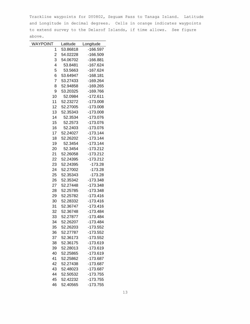
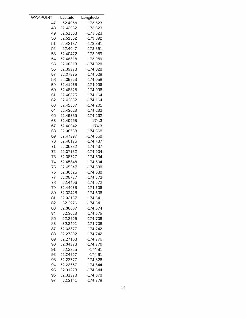
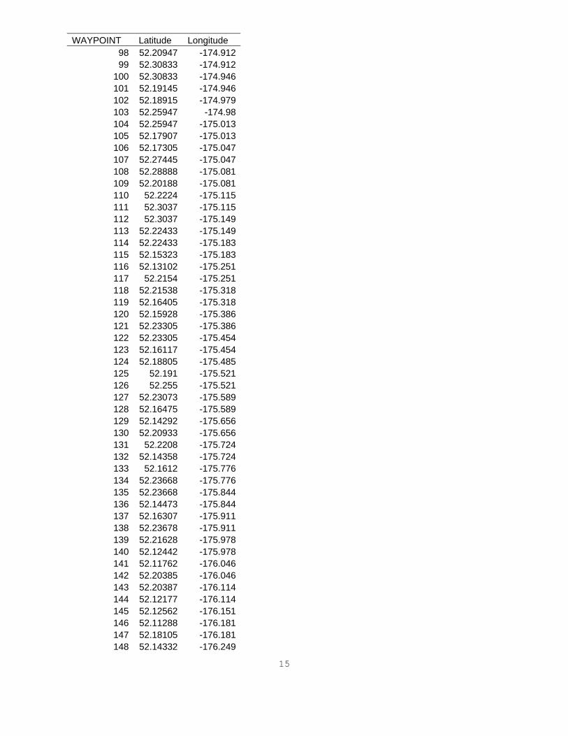
Trackline waypoints for DY0802, Seguam Pass to Tanaga Island. Latitude
and Longitude in decimal degrees. Cells in orange indicates waypoints
to extend survey to the Delarof Islands, if time allows. See figure
above.
WAYPOINT Latitude Longitude 1 53.86818 -166.5972 54.02228 -166.5093 54.06702 -166.8814 53.8481 -167.6245 53.5663 -167.6246 53.64947 -168.1817 53.27433 -169.2648 52.94858 -169.2659 53.20325 -169.766
10 52.0984 -172.61111 52.23272 -173.00812 52.27005 -173.00813 52.35343 -173.00814 52.3534 -173.07615 52.2573 -173.07616 52.2403 -173.07617 52.24027 -173.14418 52.26202 -173.14419 52.3454 -173.14420 52.3454 -173.21221 52.26058 -173.21222 52.24395 -173.21223 52.24395 -173.2824 52.27002 -173.2825 52.35343 -173.2826 52.35342 -173.34827 52.27448 -173.34828 52.25785 -173.34829 52.25782 -173.41630 52.28332 -173.41631 52.36747 -173.41632 52.36748 -173.48433 52.27877 -173.48434 52.26207 -173.48435 52.26203 -173.55236 52.27787 -173.55237 52.36173 -173.55238 52.36175 -173.61939 52.28013 -173.61940 52.25865 -173.61941 52.25862 -173.68742 52.27438 -173.68743 52.48023 -173.68744 52.50532 -173.75545 52.42232 -173.75546 52.40565 -173.755
14
WAYPOINT Latitude Longitude 47 52.4056 -173.82348 52.42982 -173.82349 52.51353 -173.82350 52.51352 -173.89251 52.42137 -173.89152 52.4047 -173.89153 52.40472 -173.95954 52.48818 -173.95955 52.48818 -174.02856 52.39278 -174.02857 52.37985 -174.02858 52.39963 -174.05859 52.41268 -174.09660 52.48825 -174.09661 52.48825 -174.16462 52.43032 -174.16463 52.42687 -174.20164 52.42023 -174.23265 52.49235 -174.23266 52.49235 -174.367 52.40942 -174.368 52.38788 -174.36869 52.47297 -174.36870 52.46175 -174.43771 52.36382 -174.43772 52.37182 -174.50473 52.38727 -174.50474 52.45348 -174.50475 52.45347 -174.53876 52.36625 -174.53877 52.35777 -174.57278 52.4406 -174.57279 52.44058 -174.60680 52.32428 -174.60681 52.32167 -174.64182 52.3926 -174.64183 52.36867 -174.67484 52.3023 -174.67585 52.2969 -174.70886 52.3491 -174.70887 52.33877 -174.74288 52.27802 -174.74289 52.27163 -174.77690 52.34273 -174.77691 52.3325 -174.8192 52.24957 -174.8193 52.23777 -174.82694 52.22657 -174.84495 52.31278 -174.84496 52.31278 -174.87897 52.2141 -174.878
15
WAYPOINT Latitude Longitude 98 52.20947 -174.91299 52.30833 -174.912
100 52.30833 -174.946101 52.19145 -174.946102 52.18915 -174.979103 52.25947 -174.98104 52.25947 -175.013105 52.17907 -175.013106 52.17305 -175.047107 52.27445 -175.047108 52.28888 -175.081109 52.20188 -175.081110 52.2224 -175.115111 52.3037 -175.115112 52.3037 -175.149113 52.22433 -175.149114 52.22433 -175.183115 52.15323 -175.183116 52.13102 -175.251117 52.2154 -175.251118 52.21538 -175.318119 52.16405 -175.318120 52.15928 -175.386121 52.23305 -175.386122 52.23305 -175.454123 52.16117 -175.454124 52.18805 -175.485125 52.191 -175.521126 52.255 -175.521127 52.23073 -175.589128 52.16475 -175.589129 52.14292 -175.656130 52.20933 -175.656131 52.2208 -175.724132 52.14358 -175.724133 52.1612 -175.776134 52.23668 -175.776135 52.23668 -175.844136 52.14473 -175.844137 52.16307 -175.911138 52.23678 -175.911139 52.21628 -175.978140 52.12442 -175.978141 52.11762 -176.046142 52.20385 -176.046143 52.20387 -176.114144 52.12177 -176.114145 52.12562 -176.151146 52.11288 -176.181147 52.18105 -176.181148 52.14332 -176.249

16
WAYPOINT Latitude Longitude 149 52.05655 -176.249150 52.02038 -176.316151 52.13307 -176.316152 52.1006 -176.384153 52.01623 -176.384154 52.01618 -176.451155 52.0978 -176.451156 52.09768 -176.519157 52.00627 -176.519158 52.00627 -176.586159 52.08228 -176.586160 52.07258 -176.654161 51.98118 -176.654162 51.98107 -176.721163 52.05535 -176.721164 52.05535 -176.789165 51.9813 -176.789166 51.93827 -176.856167 52.03427 -176.856168 51.99968 -176.923169 51.9269 -176.923170 51.93327 -176.991171 51.99968 -176.991172 52.0188 -177.058173 51.95168 -177.058174 51.94975 -177.125175 52.01727 -177.125176 52.01728 -177.159177 51.94637 -177.159178 51.9417 -177.193179 52.00197 -177.193180 51.96842 -177.227181 51.8487 -177.227182 51.84127 -177.26183 51.96033 -177.26184 51.96033 -177.294185 51.83057 -177.294186 51.81805 -177.328187 51.95745 -177.328188 51.96685 -177.362189 51.80998 -177.362190 51.81 -177.395191 51.9852 -177.395192 52.00038 -177.429193 51.93027 -177.429194 51.92645 -177.42195 51.92287 -177.41196 51.89803 -177.41197 51.89527 -177.419198 51.89277 -177.429199 51.8059 -177.429

17
WAYPOINT Latitude Longitude 200 51.8059 -177.462201 51.88288 -177.462202 51.8984 -177.479203 51.924 -177.479204 51.93695 -177.463205 51.99275 -177.463206 52.00028 -177.496207 51.79265 -177.496208 51.79267 -177.53209 51.9739 -177.53210 51.96325 -177.563211 51.88653 -177.563212 51.79137 -177.563213 51.89297 -177.597214 51.97107 -177.597215 51.97107 -177.63216 51.8985 -177.63217 51.8819 -177.664218 51.96625 -177.664219 51.95797 -177.698220 51.86818 -177.698221 51.86818 -177.731222 51.96805 -177.731223 51.96185 -177.765224 51.87957 -177.765225 51.87957 -177.799226 51.96198 -177.799227 51.96548 -177.832228 51.87087 -177.832229 51.87087 -177.866230 51.95877 -177.866231 51.97327 -177.899232 51.89138 -177.899233 51.92038 -177.933234 51.97518 -177.933235 51.97517 -177.967236 51.92692 -177.967237 51.92692 -178238 51.98832 -178239 51.9883 -178.068240 51.92585 -178.068241 51.9258 -178.135242 51.9898 -178.135243 51.98975 -178.203244 51.91098 -178.203245 51.97042 -178.27246 51.8443 -178.27247 51.8086 -178.136248 51.72383 -178.136249 51.59712 -178.203250 51.84458 -178.203

18
WAYPOINT Latitude Longitude 251 51.84458 -178.27252 51.59707 -178.271253 51.59707 -178.338254 51.77515 -178.338255 51.73928 -178.405256 51.60428 -178.405257 51.60428 -178.472258 51.72708 -178.472259 51.72708 -178.539260 51.63445 -178.539261 51.63445 -178.606262 51.71552 -178.606263 51.78508 -178.673264 51.62867 -178.674265 51.61883 -178.741266 51.74903 -178.741267 51.73538 -178.808268 51.59713 -178.808269 51.59708 -178.875270 51.75728 -178.875271 51.7871 -178.943272 51.59652 -178.943273 51.59647 -179.01274 51.84682 -179.01275 51.87295 -178.943276 51.7878 -178.943277 51.82047 -178.876278 51.88113 -178.876279 51.90195 -178.808280 51.85137 -178.808281 51.84448 -178.768282 51.81687 -178.741283 51.90283 -178.741284 51.90277 -178.673285 51.78505 -178.673

19
APPENDIX 2 CTD Sampling Locations
CTDs will be deployed opportunistically throughout the survey, primarily during the day, at water depths from 100 to 200 meters. Additional CTD casts will be made at selected passes, shown on the figure below, at depths around 200 meters and 500 meters.
Areas at selected passes for additional CTD casts (at 200 m and 500 m water depth), shown in pink. Black lines show primary transects from Seguam Pass to Tanaga Island. Orange lines show additional transects to the Delarof Islands (if time permits). Depth contours from 100 to 1000 m are also shown.
20
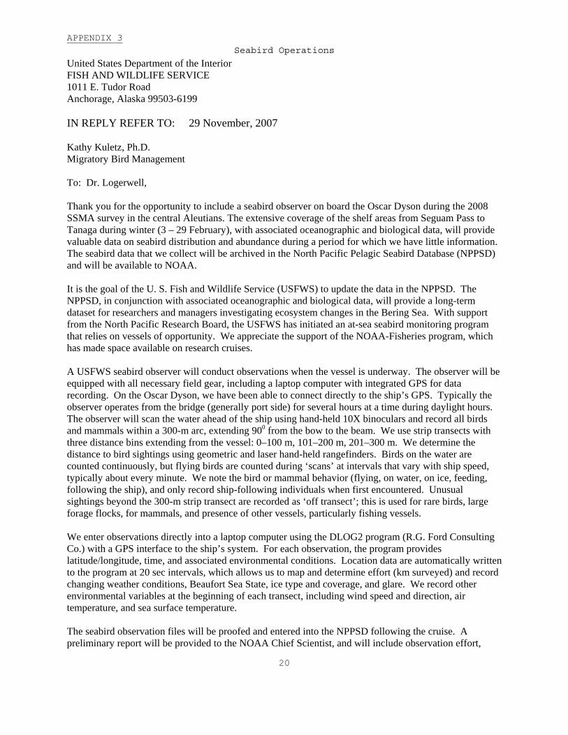
APPENDIX 3 Seabird Operations
United States Department of the Interior FISH AND WILDLIFE SERVICE 1011 E. Tudor Road Anchorage, Alaska 99503-6199 IN REPLY REFER TO: 29 November, 2007 Kathy Kuletz, Ph.D. Migratory Bird Management To: Dr. Logerwell, Thank you for the opportunity to include a seabird observer on board the Oscar Dyson during the 2008 SSMA survey in the central Aleutians. The extensive coverage of the shelf areas from Seguam Pass to Tanaga during winter (3 – 29 February), with associated oceanographic and biological data, will provide valuable data on seabird distribution and abundance during a period for which we have little information. The seabird data that we collect will be archived in the North Pacific Pelagic Seabird Database (NPPSD) and will be available to NOAA. It is the goal of the U. S. Fish and Wildlife Service (USFWS) to update the data in the NPPSD. The NPPSD, in conjunction with associated oceanographic and biological data, will provide a long-term dataset for researchers and managers investigating ecosystem changes in the Bering Sea. With support from the North Pacific Research Board, the USFWS has initiated an at-sea seabird monitoring program that relies on vessels of opportunity. We appreciate the support of the NOAA-Fisheries program, which has made space available on research cruises. A USFWS seabird observer will conduct observations when the vessel is underway. The observer will be equipped with all necessary field gear, including a laptop computer with integrated GPS for data recording. On the Oscar Dyson, we have been able to connect directly to the ship’s GPS. Typically the observer operates from the bridge (generally port side) for several hours at a time during daylight hours. The observer will scan the water ahead of the ship using hand-held 10X binoculars and record all birds and mammals within a 300-m arc, extending 900 from the bow to the beam. We use strip transects with three distance bins extending from the vessel: 0–100 m, 101–200 m, 201–300 m. We determine the distance to bird sightings using geometric and laser hand-held rangefinders. Birds on the water are counted continuously, but flying birds are counted during ‘scans’ at intervals that vary with ship speed, typically about every minute. We note the bird or mammal behavior (flying, on water, on ice, feeding, following the ship), and only record ship-following individuals when first encountered. Unusual sightings beyond the 300-m strip transect are recorded as ‘off transect’; this is used for rare birds, large forage flocks, for mammals, and presence of other vessels, particularly fishing vessels. We enter observations directly into a laptop computer using the DLOG2 program (R.G. Ford Consulting Co.) with a GPS interface to the ship’s system. For each observation, the program provides latitude/longitude, time, and associated environmental conditions. Location data are automatically written to the program at 20 sec intervals, which allows us to map and determine effort (km surveyed) and record changing weather conditions, Beaufort Sea State, ice type and coverage, and glare. We record other environmental variables at the beginning of each transect, including wind speed and direction, air temperature, and sea surface temperature. The seabird observation files will be proofed and entered into the NPPSD following the cruise. A preliminary report will be provided to the NOAA Chief Scientist, and will include observation effort,

21
maps of seabird transects, and number of sightings by species. Sincerely, Kathy Kuletz

22
APPENDIX 4 Marine Mammal Operations
Primary operations Visual sighting surveys Visual surveys will be conducted during daylight hours by a two-person observer rotation. Typically, this will involve a primary observer using hand-held 7x binoculars from inside the bridge deck, but will also utilize fixed-mount 25x magnification “big-eye” binoculars mounted on top of the wheelhouse when weather conditions allow. A second observer with 7x binoculars will remain on the bridge deck and serve as a data-recorder to enter marine mammal sightings and weather conditions into the real-time data logging program WinCRUZ. The observers will communicate using hand-held VHF radios when the primary observer is outside. When killer whale sightings are made, the primary observer will use the big-eyes (where possible) to assess ecotype and group size, and the second observer will take photographs to document ecotype and individual identity if the group is sufficiently close to the ship. Secondary operations Photo-identification Where opportunity allows, marine mammal groups will be approached for photo-identification. This will specifically occur during transit legs, or when transect lines have been completed, and the primary target species will be killer whales. Digital SLR cameras equipped with telephoto lenses and telephoto extenders will be used to take high quality photographs to document species occurrence, ecotype (for killer whales), and individual identity based on natural markings. Images were shot as Nikon Electronic Format (NEF) files, allowing later conversion to high-resolution TIF files for storage. Inert laser-pointers were also used to project two beams at a fixed distance apart onto the body of killer whales, and photographs of these laser dots will be taken to allow morphometric measurements. Biopsy sampling Should close-approaches be possible, then tissue samples will be collected using remote biopsy techniques using cartridge-powered air rifles. Small, lightweight darts will be retrieved using a tether. Skim samples will be frozen in glass vials for stable isotope and fatty acid analyses of diet, persistent organic pollutant analyses, and molecular genetic examination of population identity.

23
APPENDIX 5
Hazardous Material Inventory
Chemicals for specimen preparations
Chemical CAS Number Respondee Org. Qty H F R Storage Code Hazard Class
Packing Group
Number UN Reportable
Quantity Response Indices
Formaldehyde, 37% 50-00-0 Logerwell AFSC 43-L 3 2 2 Flammable 3 & 8 III 1198 100 LBS 2 Sodium Borate 1330-43-4 Logerwell AFSC 500-g 1 0 0 General Not regulated 3
Sodium Borate Solution, Saturated mix Logerwell AFSC 20-L 1 0 0 General Not regulated 3
Alcohol, Reagent, 95% mix Logerwell AFSC 1 x 20-l 3 3 1 Flammable 3 II 1987 350 Lb 1
Spill Response 1: Ventilate area of leak or spill. Wear appropriate personal protective equipment. Isolate hazard area. Keep unnecessary and unprotected personnel from entering. Contain and recover liquid when possible. Neutralize with alkaline material (soda ash, lime), then absorb with an inert material (e. g., vermiculite, dry sand, earth), and place in a chemical waste container. Do not use combustible materials, such as saw dust. Do not flush to sewer! U.S. Regulations (CERCLA) requires reporting spills and releases to soil, water and air in excess of reportable quantities. The toll free number for the U.S. Coast Guard National Response Center is (800) 424-8802.
Spill Response 2: Ventilate area of leak or spill. Remove all sources of ignition. Wear appropriate personal protective equipment. Isolate hazard area. Keep unnecessary and unprotected personnel from entering. Contain and recover liquid when possible. Use non-sparking tools and equipment. Collect liquid in an appropriate container or absorb with an inert material (e. g., vermiculite, dry sand, or earth), and place in a chemical waste container. Do not use combustible materials, such as saw dust. Do not flush to sewer! If a leak or spill has not ignited, use water spray to disperse the vapors, to protect personnel attempting to stop leak, and to flush spills away from exposures. U.S. Regulations (CERCLA) requires reporting spills and releases to soil, water and air in excess of reportable quantities. The toll free number for the U.S. Coast Guard National Response Center is (800) 424-8802.
Spill Response 3: Ventilate area of leak or spill. Wear appropriate personal protective equipment. Pick up and place in a suitable container for reclamation or disposal, using a method that does not generate dust.

24
Chemicals for oxygen titration.
Chemical name
Chemical formula Health
Flamm-ability Instability
Special Hazard
Hazard Class
Packing Group Number UN
Spill response
Quantity (each container)
Number of containers
Manganese Chloride MnCl2-4H2O 2 0 0 not regulated A 600 g 2
Sodium Hydroxide NaOH 3 0 1 8 II 1823 B 320 g 2
Sodium Iodide NaI 1 0 0 not available B 600 g 2
Sulfuric Acid H2SO4 3 0 2 -W- footnote 1 8 II 1830 C 0.5 l 2
Sodium Thiosulfate Na2S2O3-5H2O 1 0 0 not regulated A 0.5 g 2
Footnote 1: Danger! Causes eye and skin burns. Causes digestive and respiratory tract burns. May be fatal if mist inhaled. Strong inorganic acid mists containing sulfuric acid may cause cancer. Concentrated sulfuric acid reacts violently with water and many other substances under certain conditions. May cause lung damage. Hygroscopic (absorbs moisture from the air). Corrosive to metal. Spill responses A: Vacuum or sweep up material and place into a suitable disposal container. Avoid generating dusty conditions. Provide ventilation. B: Vacuum or sweep up material and place into a suitable disposal container. Avoid runoff into storm sewers and ditches which lead to waterways. Clean up spills immediately, observing precautions in the Protective Equipment section. Avoid generating dusty conditions. Provide ventilation. Do not get water on spilled substances or inside containers. C: Avoid runoff into storm sewers and ditches which lead to waterways. Clean up spills immediately, observing precautions in the Protective Equipment section. Carefully scoop up and place into appropriate disposal container. Provide ventilation. Do not get water inside containers. Cover with dry earth, dry sand, or other non-combustible material followed with plastic sheet to minimize spreading and contact with water.