alaska's volcanic landforms and features - u.s. …s volcanic landforms and features handout...
TRANSCRIPT

89
Chapter 4 Alaska's Volcanic Landforms and Features
Resources • Alaska Volcano Observatory website. (Available at http://www.avo.alaska.edu.) • Brantley, S.R., 1999, Volcanoes of the United States: U.S. Geological Survey
General Interest Publication. (Available at http://pubs.usgs.gov/gip/volcus/index.html.)
• Miller, T.P., McGimsey, R.G., Richter, D.H., Riehle, J.R., Nye, C.J., Yount, M.E., and Dumoulin, J.A., 1998, Catalog of the historically active volcanoes of Alaska: U.S. Geological Survey Open-File Report 98-0582, 104 p. (Also available at http://www.avo.alaska.edu/downloads/classresults.php?citid=645.)
• Nye, C.J., and others, 1998, Volcanoes of Alaska: Alaska Division of Geological and Geophysical Surveys Information Circular IC 0038, accessed June 1, 2010, at PDF Front (6.4 MB)
http://www.dggs.dnr.state.ak.us/webpubs/dggs/ic/oversized/ic038_sh001.PDF and
PDF Back (6.6 MB) http://www.dggs.dnr.state.ak.us/webpubs/dggs/ic/oversized/ic038_sh002.PDF.
• Smithsonian Institution, [n.d.], Global volcanism program—Augustine: Smithsonian Institution web page, accessed June 1, 2010, at http://www.volcano.si.edu/world/volcano.cfm?vnum=1103-01-&volpage=photos&phoyo=026071.
• Tilling, R.I., 1997, Volcanoes—On-line edition: U.S. Geological Survey General Interest Product. (Available at http://pubs.usgs.gov/gip/volc/.)
• U.S. Geological Survey, 1997 [2007], Volcanoes teacher’s guide: U.S. Geological Survey website. (Available at http://erg.usgs.gov/isb/pubs/teachers-packets/volcanoes/.
• U.S. Geological Survey, 2010, Volcano Hazards Program—USGS photo glossary of volcanic terms: U.S. Geological Survey website. (Available at http://volcanoes.usgs.gov/images/pglossary/index.php.)
Activities Through research, mapping projects, and classroom discussion these activities will provide students with an understanding of the various landforms associated with volcanoes in Alaska, the development and use of topographic profiles, and pertinent information including the names, locations, and types of most of the historically active volcanoes in the state. These activities build on the student’s knowledge of igneous rock types, volcano types, and the subduction zone tectonics driving Alaska’s volcanism. Activity I. Volcanic Landforms and Features Information Search Activity II. Topographic Profiles of Alaskan Volcanoes Activity III. Alaska Volcanic Arc of Fame

90
Activity I. Volcanic Landforms and Features Information Search Grade Level 6―11 Setting Classroom Time 45―90 minutes Vocabulary (see Glossary) andesite, basalt, caldera, cinder cone, cross section, debris-avalanche, fault zone, flood basalt, geyser, hummock, ignimbrite, intracaldera, lava dome, maar, map view, morphology, phreatic, phreatomagmatic, profile, pyroclastic flow, pyroclastic flow deposit, resurgent dome, rhyolite, shield volcano , stratovolcano or composite cone, truncated, tuya, viscosity, voluminous Correlations to Alaska State Department of Education (2006) Performance Standards (Grade Level Expectations) D1—Concepts of Earth Science SD[6-11] Students develop an understanding of the concepts, processes, theories,
models, evidence, and systems of earth and space sciences. SD2[6-11] Students develop an understanding of the origins, ongoing processes, and
forces that shape the structure, composition, and physical history of the Earth.
SD2.3[6] The student demonstrates an understanding of the forces that shape Earth by describing how the surface can change rapidly as a result of geological activities (i.e., earthquakes, tsunamis, volcanoes, floods, landslides, avalanches).
Overview These activities will provide students with an understanding of the various landforms associated with volcanoes in Alaska using photographic examples, worksheets, and student derived presentations, papers, and (or) posters. Background Alaskan volcanism produces several types of volcanoes and eruption products (discussed as landforms and features). This wide and varied volcanic history can lead to misconceptions about the shapes, features, and landforms of Alaska’s volcanoes and the hazards they may pose. Students have already learned about the many types of volcanoes in Alaska, and that the same volcano can produce vastly different products. In this section students will be introduced to volcanic features not necessarily associated with an eruption, such as hot springs and fumaroles, and will learn about formations associated with long past volcanic activity, such as the Togiak Tuya—a basaltic lava flow that occurred underneath a glacier.

91
Objectives Students will be able to identify the most common types of volcanic landforms and features found in Alaska. Materials drawing paper colored pens, pencils, crayons, and (or) thin markers Alaska's Volcanic Landforms and Features handout and (or) worksheet and (or)
presentation Volcanic Landforms and Features worksheet Procedure A. Classroom introduction 1. Ask students to draw a volcano on paper and label as many parts as possible. You can
ask your students to draw a volcano from the side (cross section, also known as profile view) and (or) from a bird’s-eye or map view (view from above). Be careful not to lead the students in any other way; they can decide on their own how to orient the paper, what shapes, colors to use, and so on. This way, you will be able to identify students’ knowledge of volcanoes.
2. After completion, discuss the drawings with your students. One good way to do this is to collect the drawings and display or pass out several of them for the class to observe. Below are a few example questions that may be used to instigate discussion. You can gear your discussion to reflect students’ comments and preconceptions about the volcanoes. • What do most of these drawings have in common? • What differences do you notice between these drawings? • Do all real volcanoes have to have the same appearance? Explain your answer. • What characteristics make a volcano “look like a volcano”?
3. Review the main types of volcanoes and eruption types with your class. Note Activity
I in Chapter 3 of this activity guidebook covers this material and activities in Chapter 5 discuss the potential hazards of some of these landforms and features.
B. Alaska’s volcanoes in photos 1. Included as a handout (with and without captions) and as a digital presentation (also,
with and without captions) is a collection of photographs of Alaskan landforms and features. • You may distribute the uncaptioned handouts or show the uncaptioned
photographs to the class and allow students the chance to name the feature, landform, and volcano in each of the photographs. The handouts have space provided for students to write in their answers.
Or • You can distribute the captioned handouts or review the captioned photographic
presentation and introduce students to the feature, landform, and volcano in each of the photographs.

92
In either case, • Discuss with your class the most likely processes that formed each volcano and
review the types of volcanoes and their Alaskan examples with your students. 2. Tell the students to draw another volcano and label as many parts as possible. Have
the students compare this new drawing to their original one and to note what they have learned.
C. Volcanic Landforms and Features worksheet 1. Hand out the Volcanic Landforms and Features worksheet and have students answer
the questions based on information they find on the internet or through resources available in the library and (or) the classroom. Several websites are available to lead students to answers for these questions. Two suggestions are: • Nelson, Prof. S.A., 2008, EENS 204—Volcanic landforms, volcanoes, and plate
tectonics: Tulane University website, accessed June 1, 2010, at http://www.tulane.edu/~sanelson/geol204/volclandforms.htm.
• U.S. Geological Survey, 2010, Volcano Hazards Program—USGS photo glossary of volcanic terms website. (Available at http://volcanoes.usgs.gov/images/pglossary/index.php.)
2. Discuss the answers with your students and ask them which volcanic landforms and
features are likely to be found in Alaska, and why or why not. Dozens of volcanoes are in Alaska and every volcanic eruption type can be found if one looks hard enough. Generally, subduction, the dominant tectonic process, generates most of the volcanic activity in Alaska.
Extensions 1. Show a wafer, chocolate chip, chocolate kiss, and chocolate drop (or similar shaped
food items) and ask students which food represents which type of volcano and why (from Lillie, R.J., 2005, p. 39). Note Photographs for this extension are included in the accompanying digital presentation, Alaska’s Volcanic Types—Food for Thought. • Wafer – the broad flat shape of a shield volcano is like that of a wafer • Chocolate kiss – a steep pointed stratovolcano is like a chocolate kiss. A white
and dark chocolate swirl can illustrate lava flows along the flanks or varying lava types.
• Chocolate chip – like a cinder cone, a chocolate chip is dark and steep sided but much smaller than a shield or composite stratovolcano.
• Chocolate drop – is similar in shape to a lava dome with a rounded top. • Ice cream cone – is similar in shape to a caldera with a flat bottom and steep sides
walls
2. Have the students write an essay explaining what they now know about volcanoes and their landforms and features. Give students key words to use in their essays.

93
3. Students research a specific volcano and make a chart with its associated landforms and features. Students can contrast and compare how many volcanoes have the various types of landforms or volcanic features (cones, domes, and so on) and why.
4. Have students create their own presentation, poster, or paper focused on various
volcanic landforms and features. References Cited Alaska State Department of Education and Early Development, 2006, Standards and
grade level expectations, March 2006: State of Alaska website, accessed October 2009 at http://www.eed.state.ak.us/tls/assessment/GLEHome.html.
Lillie, R.J., 2005, Parks and plates—The geology of our National parks, monuments, and seashores: New York, W.W. Norton and Comdishy, 298 p.
Motyka, R.J., Liss, S.A., Nye, C.J., and Moorman, M.A., 1994, Geothermal resources of the Aleutian arc: Alaska Division of Geological and Geophysical Surveys Professional Report 114, 17 p., 4 sheets, scale 1:1,000,000, accessed June 1, 2010, at http://www.dggs.dnr.state.ak.us./pubs/pubs?reqtype=citation&ID=2314.
Glossary Andesite – A gray to black volcanic rock with between about 52 and 63 weight percent silica (SiO2). Basalt – A hard black volcanic rock with less than about 52 weight percent silica (SiO2). Caldera – A caldera is a large, usually circular depression at the summit of a volcano formed when magma is withdrawn or erupted from a shallow underground magma reservoir. The removal of large volumes of magma may result in loss of structural support for the overlying rock, thereby leading to collapse of the ground and formation of a large depression. Calderas are different from craters, which are smaller, circular depressions created primarily by explosive excavation of rock during eruptions. Cinder cone – A steep, conical hill of volcanic fragments that accumulate around and downwind from a vent. Cross section – A diagram or drawing that shows features transected by a given plane, typically a vertical section drawn at right angles to the longer axis of a geologic feature. Fault zone – Region of fractures in the Earth's crust along which one side moves with respect to the other. Flood basalt – The result of a giant volcanic eruption or series of eruptions that coats large stretches of land or the ocean floor with basalt lava. Geyser – Hot springs that episodically erupt fountains of scalding water and steam.

94
Hummock – Rounded or conical mounds within a volcanic landslide or debris avalanche deposit; debris-avalanche -debris avalanches are moving masses of rock, soil, and snow that occur when the flank of a mountain or volcano collapses and slides down slope. Ignimbrite – The rock formed by the widespread deposition and consolidation of volcanic ash flows. Intracaldera – Within a caldera. Lava dome – A roughly circular mound-shaped protrusion resulting from the slow eruption of felsic lava (usually rhyolite or dacite) from a volcano, or from multiple lava episodes of different magma types. Maar – A low-relief, broad volcanic crater formed by shallow explosive eruptions. The explosions are usually caused by the heating and boiling of groundwater when magma invades the groundwater table. A maar will often fill with water to form a lake. Map view – View of an area from overhead. Morphology – The study of the shape of the Earth’s surface and the external structure, form, and arrangement of rock in relation to the development of landforms. Phreatic – A volcanic explosion of steam, mud, or other material that is not incandescent; the explosion is caused by the heating and consequent expansion of groundwater due to an underlying igneous heat source. Phreatomagmatic – A volcanic explosion that extrudes steam and magmatic gases; the explosion is caused by the contact of magma with shallow or surface water. Profile – The outline produced where the plane of a vertical section intersects the surface of the ground Pyroclastic flow – A ground-hugging avalanche of hot ash, pumice, rock fragments, and volcanic gas that rushes down the side of a volcano as fast as 100 km/hour (~60 mi/hour) or more. The temperature within a pyroclastic flow may be greater than 500°C (900°F), sufficient to burn and carbonize wood. Once deposited, the ash, pumice, and rock fragments may deform (flatten) and weld together because of the intense heat and the weight of the overlying material. The emplaced flow is called a pyroclastic flow deposit. Resurgent dome – Volcanic domes are rounded, steep-sided mounds built by very viscous magma, usually either dacite or rhyolite. If domes are resurgent then they have appeared again after a previous growth or eruption. Rhyolite – A light-colored rock with silica (SiO2) content greater than about 68 weight percent. Sodium and potassium oxides can reach about 5 weight percent.

95
Shield volcano – A volcano characterized by low angle slopes. Stratovolcano – A type of volcano (also called a composite cone), characterized by slope angles of as much as 35 degrees. Truncated – Stopped, prevented, or chopped off. Tuya – A flat-topped and steep-sided volcano that has erupted into a lake thawed in a glacier by the volcano’s heat. Viscosity – The property of a substance to offer internal resistance to flow; specifically the ratio of the shear stress to the rate of shear strain known as the coefficient of friction. Voluminous – Great in volume. Source of Glossary Definitions Bates, R.K., and Jackson, J.A., eds., 1987, Glossary of Geology (3rd ed.): Falls Church,
Va., American Geological Institute, 571 p. U.S. Geological Survey, 2008, Cascades Volcano Observatory—Volcano Types : U.S.
Geological Survey web page. (Available at http://vulcan.wr.usgs.gov/Glossary/VolcanoTypes/volcano_types.html.
U.S. Geological Survey, 2010, Volcano Hazards Program—USGS photo glossary of volcanic terms: U.S. Geological Survey website. (Available at http://volcanoes.usgs.gov/images/pglossary/index.php.)

96
Alaska's Volcanic Landforms and Features Handout
1. Mount Wrangell, a 4,317-m (14,163-ft) high andesite shield volcano on the right
skyline, is the only volcano in the Wrangell Mountains with documented historical activity consisting of several minor, possibly phreatic eruptions in the early 1900s. Andesite is a gray to black volcanic rock with between about 52 and 63 weight percent silica (SiO2). The shield shape is rare for an andesitic volcano and is due to a high volume of lava erupting from the volcano over a short amount of time. View is to the northeast. Photograph taken by B. Cella, National Park Service, 1987.
2. Vent Mountain in the foreground is a cinder cone inside Aniakchak Caldera. The
caldera wall is in the background. Aniakchak Volcano is on the Alaska Peninsula. Photograph taken by R.G. McGimsey, U.S. Geological Survey, June 28, 1997.

97
3. Augustine Volcano in the Cook Inlet is a stratovolcano (or composite cone). This
photograph was taken looking northwest; volcanic ash covers the upper flanks of the summit. White steam is being emitted. Photograph was taken by J. Adleman, U.S. Geological Survey, February 24, 2006.
(A) (B)
4. (A) Aerial view of a phreatomagmatic eruption of the East Maar of Ukinrek Maars. The Ukinrek Maars are on the south shore of Becharof Lake on the Alaska Peninsula; the maar craters formed during a 10-day eruption in March and April 1977. Photograph was taken by Juergen Kienle, University of Alaska Geophysical Institute, April 6, 1977. (B) Near-vertical view of the east Ukinrek Maar crater, 300 m (980 ft) across. Photograph was taken by D. Dewhurst, U.S. Fish and Wildlife Service, July 8, 1990.

98
(A) (B) 5. (A) Aerial view of 80-m (260-ft) high Novarupta, a blocky rhyolite (high silica) lava
dome that marks the vent for the 1912 eruption that created the Valley of Ten Thousand Smokes in Katmai National Park and Preserve, Alaska. This eruption was the most voluminous on Earth in the 20th century, ejecting nearly 30 km3 (7 mi3) of material in 60 hours. Falling Mountain, a lava dome truncated by the 1912 eruption, is visible behind the Novarupta dome; snow-capped stratovolcano Mount Mageik can be seen at top of the photograph. Rhyolite is a light-colored rock with silica (SiO2) content greater than about 68 weight percent. Photograph taken by T. Miller, U.S. Geological Survey, June 1979.
(B) Summit dome on Augustine Volcano, Cook Inlet, Alaska. Photograph taken by J. Adleman, U.S. Geological Survey, May 12, 2006.

99
6. Aerial view, looking east, of Aniakchak caldera. Formed during a catastrophic ash-flow producing eruption about 3,400 years ago, Aniakchak caldera is about 10 km (6 mi) across and averages 500 m (1,640 ft) in depth. Voluminous post-caldera eruptive activity has produced a wide variety of volcanic landforms and deposits within the caldera. The opening in the caldera is called the Gates and one of the largest floods on Earth in the past 10,000 years occurred when a proto-Surprise lake catastrophically emptied through this low point in the caldera rim. The volcano is located in Aniakchak National Park and Preserve on the Alaska Peninsula. Photograph taken by M. Williams, National Park Service, 1977.
7. Large-pool thermal hot springs area southwest of Korovin Volcano and west-
northwest of Kluichef Volcano on Atka Island in the Aleutians. Photograph taken by R.G. McGimsey, U.S. Geological Survey, July 14, 2004.

100
8. Fumarolic activity at the summit of Fourpeaked Volcano in Kamtai National Park and Preserve on the Alaska Peninsula. Photograph taken by J. Adleman, U.S. Geological Survey, November 4, 2006.
9. View of 1997 basaltic andesite lava flow inside Okmok caldera, a 9.3-km (5.8-mi) diameter circular crater that truncates the top of a large shield volcano on the northeastern part of Umnak Island in the eastern Aleutian Islands. The most recent caldera-forming eruption at Okmok occurred about 2,400 years ago. Since then, numerous intracaldera eruptions have occurred, including the eruption that extruded these blocky lava flows onto the caldera floor. Basaltic andesite is a hard, dark volcanic rock with approximately 52 weight percent silica (SiO2). Photograph taken by C. Nye, Alaska Division of

101
Geological and Geophysical Surveys, September 1980.
(A) (B)
10. (A) Pyroclastic flow (deposits of volcanic ash, gas, and pumice flows) deposits on the southwestern flank of Augustine Volcano, Cook Inlet, Alaska. Photograph taken by M. Coombs, U.S. Geological Survey, August 14, 2006.
(B) View southeast looking up the Valley of Ten Thousand Smokes from the Overlook Cabin in Katmai National Park and Preserve, Alaska. The valley has been filled with as much as 200 m (660 ft) of pyroclastic flow deposits (ignimbrite) from the 1912 eruption of Novarupta volcano. The rim of the Katmai Caldera is on the skyline at left. Photograph taken by R.G. McGimsey, U.S. Geological Survey, June 8, 1991.
(A) (B)
11. (A) Collapse of the summit and flank of a volcano can produce massive volcanic landslides. The resulting highly mobile debris avalanches rapidly sweep down the volcano and far beyond its flanks. These small hills in the foreground of Alaska's Augustine volcano show morphology common to debris-avalanche deposits. The hummocks consist of relatively intact segments of the volcanic edifice that were transported long distances without disaggregating (separating, crumbling). This debris avalanche traveled roughly 11 km (~6.8 mi) from the summit about 450 years ago. Photograph and caption courtesy of Smithsonian Institution, dated 1987. (B) Debris avalanche deposits from the 1883 eruption of Augustine Volcano entered Cook Inlet along the north shoreline of the island forming hummocky topography.

102
Photograph by U.S. Geological Survey, April 27, 1986.
12. Togiak Tuya in the Ahklun Mountains. The Ahklun Mountains form the highest range in Alaska west of the Alaska Range and north of the Alaska Peninsula. A tuya is a table mountain that forms when a volcano erupts underneath a glacier. Photograph taken by Darrell S. Kaufman, Professor of Geology and Environmental Science, Department of Geology, Northern Arizona University, Flagstaff, Arizona, dated 2004.

103
(A ) (B)
13. (A) “Old Faithful” (spring G8) of Geyser Bight geothermal area on Umnak Island, Alaska (shown here at maximum activity). An eruption cycle of 12 minutes was noted when venting of steam was observed (1870, 1948, 1980, and 1988). This activity likely continues when people are not able to see it. This area contains one of the hottest and most extensive areas of geothermal activity in Alaska. This is the only area in Alaska where sustained geyser activity has been documented: geothermal activity was observed at five springs during 1988 (Motkya and others, 1994). Photograph taken by Shirley Liss, Alaska Department of Natural Resources, Division of Geological and Geophysical Surveys, 1988.
(B) Geyser Bight geothermal resource area. Photograph taken by Dave Szumigala, Alaska Department of Natural Resources, Division of Geological and Geophysical Surveys, 1985.

104
Name ____________________________________ Date ______________ Period _____
Alaska's Volcanic Landforms and Features Worksheet Label each image with the type of volcanic feature or landform illustrated. If possible, identify the volcano, its location, and any other information about it.
1.
2.

105
3.
(A) (B)
4. (A)
(B)

106
(A) (B) 5. (A)
(B)
6.

107
7.
8.

108
9.
(A) (B)
10. (A)
(B)

109
(A) (B)
11. (A)
(B)
12.

110
(A) (B)
13. (A)
(B)
111
Name ____________________________________ Date ______________ Period _____
Volcanic Landforms and Features Worksheet 1. Which type of volcano often shows a layering of lava and pyroclastic flows?
2. Which type of volcano is the least explosive?
3. Which type of volcano has long periods of inactivity?
4. Which type of volcano has the steepest slopes?
5. Which type of volcano forms gentle slopes with low viscosity (resistance to flow) lava?
6. What causes the formation of maars?
7. Why do lava domes form close to a volcano’s vent?
8. Why are lava domes dangerous?
9. Describe the difference between a crater and a caldera.
10. Why are some calderas filled with water?
11. What causes the formation of a resurgent dome?

112
12. Describe a fumarole.
13. Why are hot springs located along fault zones?
14. Give an example of a geyser and its location.
15. What are plateau basalts or flood basalts?
16. Draw and label your favorite volcanic landform. Would you expect to see it in Alaska? Why or why not?

113
Volcanic Landforms and Features Answer Key 1. Which type of volcano often shows a layering of lava and pyroclastic flows?
Stratovolcano or composite cone or volcano 2. Which type of volcano is generally the least explosive?
Shield 3. Which type of volcano may have long periods of inactivity?
Stratovolcano or composite cone or volcano 4. Which type of volcano typically has the steepest slopes?
Tephra or cinder cones 5. Which type of volcano forms gentle slopes with low viscosity (resistance to flow)
lava?
Shield 6. What causes the formation of maars?
Maars result from phreatic (or phreatomagmatic) activity wherein magma heats up water in the groundwater system, pressure builds as the water to turns to steam, and then the water and preexisting rock (if it includes new magma it is phreatomagmatic) are blasted out of the ground to form a tephra cone with gentle slopes.
7. Why do lava domes form close to a volcano’s vent?
Because the viscosity of the type of lava that forms a dome is so high, the lava does not flow away from the vent, but instead piles up over the vent. Recall that viscosity is resistance to flow, so a high viscosity material would move very slowly resist flow.

114
8. Why are lava domes dangerous?
Lava domes can be extremely dangerous because they form steep, unstable slopes that may collapse to expose gas-rich, viscous magma to atmospheric pressure. Lava domes often can cause a variety of dangerous hot, buoyant, and gas-rich volcanic surface flows such as a pyroclastic flow. A pyroclastic flow is a ground-hugging avalanche of hot ash, pumice, rock fragments, and volcanic gas that rushes down the side of a volcano as fast as 100 km/hour (~60 mi/hour) or more. The temperature within a pyroclastic flow may be greater than 500°C (~930°F), sufficient to burn and carbonize wood. Once deposited, the ash, pumice, and rock fragments may deform (flatten) and weld together because of the intense heat and the weight of the overlying material; the feature is then called a pyroclastic flow deposit.
9. Describe the difference between a crater and a caldera.
Craters are circular depressions, usually less than 1 km (~0.6 mi) in diameter, that form as a result of explosions that emit gases and tephra. Calderas are much larger depressions, circular to elliptical in shape, with diameters ranging from 1 km to 50 km (0.6 to 31 mi). Calderas form as a result of collapse of a volcanic structure. The collapse results from evacuation of the underlying magma chamber.
10. Why are some calderas filled with water?
Calderas are often enclosed depressions that can collect rainwater and snow melt, and lakes often form within them.
11. What causes the formation of a resurgent dome?
After the formation of a caldera by collapse, magma is sometimes re-injected into the area below the caldera. This can result in uplift of one or more areas within the caldera to form a resurgent dome.
12. Describe a fumarole.
A fumarole is vent where gases, either from a magma body at depth, or steam from heated groundwater, emerge at the ground surface.
13. Why are hot springs located along fault zones?
Hot springs are areas where hot water comes to the ground surface. A hot spring results if hot water can find its way back to the surface, usually along fault zones.

115
14. Give an example of a geyser and its location. A geyser results if a hot spring has a plumbing system cavern of chamber that allows for the accumulation of steam from local boiling water. When the steam pressure builds so that it is higher than the pressure of the overlying water in the system, the steam will move rapidly toward the surface, causing the eruption of the overlying water. Some geysers, like Old Faithful in Yellowstone National Park in Wyoming, and Calistoga’s Old Faithful Geyser in California, erupt at regular intervals. The “Old Faithful" of the Geyser Bight geothermal resource area in Alaska had an eruption cycle of 12 minutes (Motkya and others, 1994). The time between eruptions is controlled by the time it takes for the steam pressure to build in the underlying plumbing system. 15. What are plateau basalts or flood basalts?
Plateau or flood basalts are extremely large volume outpourings of low viscosity basaltic magma from fissure vents. The basalts spread huge areas of relatively low slope and build up plateaus.
16. Draw and label your favorite volcanic landform. Would you expect to see it in
Alaska? Why or why not?
Variable

116
Activity II. Topographic Profiles of Alaskan Volcanoes Grade Level 6―11 Setting Classroom Time 45―90 minutes Vocabulary (see Glossary) caldera, cinder cone, shield volcano, stratovolcano (or composite cone), topographic map, topographic profile Correlations to Alaska State Department of Education (2006) Performance Standards (Grade Level Expectations) D1—Concepts of Earth Science SD[6-11] Students develop an understanding of the concepts, processes, theories,
models, evidence, and systems of earth and space sciences. SD2[6-11] Students develop an understanding of the origins, ongoing processes, and
forces that shape the structure, composition, and physical history of the Earth. Overview Students will produce topographic profiles from topographic maps of varying types of volcanoes in Alaska. Background • Jacaranda, 2005, Project j—How to draw a cross-section: John Wiley & Sons
Australia, Ltd website, accessed June 10, 2010, at http://www.jaconline.com.au/downloads/sose/2004-09-x-section.pdf.
• National Park Service, [n.d], WebRangers—Reading a Map: National Park Service webpage, accessed July 2, 2010, at http://www.webrangers.us/activities/readingmap/.
• Save the Bay’s San Francisco Bay Watershed Curriculum, Three Ways to be 3-D—Understanding Topographic Maps PDF http://www.savesfbay.org/sites/default/files/Three_Ways_to_be_3d.pdf.
• U.S. Geological Survey, 2007, What do maps show? Lesson 4—How to read a topographic map: U.S. Geological Survey webpage. (Available at http://egsc.usgs.gov/isb/pubs/teachers-packets/mapshow/lesson4.html.)
• U.S. Geological Survey, 2008, Topographic mapping—Online edition: U.S. Geological Survey website. (Available at http://erg.usgs.gov/isb/pubs/booklets/topo/topo.html.)
• Topographic Profile and Vertical Exaggeration information sheets provided

117
Objectives These activities will provide students with an understanding of the types of volcanoes in Alaska, and their different topographic features. Students will practice or learn new mapping skills. Materials topographic and road maps of roughly the same location pencils drawing paper (lined, graph, or blank) ruler or straightedge (optional) Wrangell, Shishaldin, Okmok, and Tanaga Island worksheets
Procedure A. Different type of maps and Venn diagrams 1. Show your students a topographic map and a road map of the same location. These
maps do not need to include a volcanic region. The maps could show the community you teach in, a common vacation spot, or a distant location. The goal is to draw attention to different kinds of maps and give examples of how the same location can be illustrated differently.
2. Ask students to make a Venn diagram that shows how the topographic and roadmaps are similar and different. Venn diagrams are illustrations to show the relation between different groups of things (sets, typically as circles): where they (these circles) overlap and where they do not.
3. Discuss with your students how topographic maps are used and how they differ from road maps. For example, topographic maps illustrate changes in slope, uphill and down, and even the steepness or gentleness of the slope. In many cases, roadmaps do not illustrate changes in slope and may not be to scale. Both types of maps likely have a distance scale, labels for certain streets, community features, hospitals, and schools. See the Background section for reference materials to aid in leading discussion.
B. Volcano Profiles and Topographic Profile Questions worksheets 1. Hand out all profile worksheets and guide the students through the process of
generating topographic profiles. Have the students answer the Topographic Profile Questions worksheet based on their profiles. Discuss their answers.

118
Extensions 1. Driedger, C.L., Doherty, Anne, and Dixon, Cheryll, 2005, Living with a volcano in
your backyard—An educator’s guide with emphasis on Mount Rainier: U.S. Geological Survey General Interest Product 19; produced in cooperation with the National Park service. (Available at • Chapter 3: Don't be Scared—Be Prepared! Play Dough Topo!
http://vulcan.wr.usgs.gov/Outreach/Publications/GIP19/chapter_three_play-dough_topo.pdf.
2. U.S. Geological Survey, 1997 [2007], Volcanoes teacher’s guide—Windows into the Earth—Why volcanoes occur: U.S. Geological Survey website. (Available at http://erg.usgs.gov/isb/pubs/teachers-packets/volcanoes/lesson1/lesson1.html.)
References Cited Alaska State Department of Education and Early Development, 2006, Standards and
grade level expectations, March 2006: State of Alaska website, accessed October 2009 at http://www.eed.state.ak.us/tls/assessment/GLEHome.html.
Motyka, R.J., Liss, S.A., Nye, C.J., and Moorman, M.A., 1994, Geothermal resources of the Aleutian arc: Alaska Division of Geological and Geophysical Surveys Professional Report 114, 17 p., 4 sheets, scale 1:1,000,000, accessed June 1, 2010, at http://www.dggs.dnr.state.ak.us./pubs/pubs?reqtype=citation&ID=2314.
Glossary Caldera ― A caldera is a large, usually circular depression at the summit of a volcano formed when magma is withdrawn or erupted from a shallow underground magma reservoir. The removal of large volumes of magma may result in loss of structural support for the overlying rock, thereby leading to collapse of the ground and formation of a large depression. Calderas are different from craters, which are smaller, circular depressions created primarily by explosive excavation of rock during eruptions. Cinder cone ― A steep, conical hill of volcanic fragments that accumulate around and downwind from a vent. Shield volcano ― A volcano characterized by low angle slopes Stratovolcano ― A type of volcano (also called a composite cone), characterized by slope angles of as much as 35 degrees Topographic map – A map showing topographic features of a land surface, commonly by means on contour lines. Topographic profile ― The outline produced where the plane of a vertical section intersects the surface of the ground

119
Source of Glossary Definitions Bates, R.K., and Jackson, J.A., eds., 1987, Glossary of Geology (3rd ed.): Falls Church,
Va., American Geological Institute, 571 p. U.S. Geological Survey, 2008, Cascades Volcano Observatory—Volcano Types : U.S.
Geological Survey web page. (Available at http://vulcan.wr.usgs.gov/Glossary/VolcanoTypes/volcano_types.html.

120
Topographic Profiles and Vertical Exaggeration Topographic Profiles 1. Draw a line the length of A-A` on a separate piece of paper. Match up this line
with A-A` on the worksheet. Draw light or dashed lines from where the map A-A` line crosses a contour line to your newly drawn line of the same length on your separate paper. On your separate paper note the contour value that A-A` crossed. Repeat this process until you have reached the end of A-A`.

121
2. Match up your separate paper with A-A` and contour values with the horizontal line A-A` on the plot area of your worksheet. Extend your light or dashed lines from the additional paper to the appropriate horizontal line for each noted contour value on your worksheet plot area and make a dot.
3. Connect the dots on the plot to complete.

122
Vertical Exaggeration Each map has a different vertical exaggeration noted near the region in which the profile will be drawn. The vertical exaggeration is the ratio between the vertical scale and the horizontal scale. If the two were the same, the ratio would be 1 and there would be no vertical exaggeration. However, because of the scale of most maps, the small amount of variation in elevation at map scale will mask most details of topography. Therefore, topographic profiles are typically generated with vertical exaggeration to emphasize the variations in topography. One can figure out the vertical exaggeration in the following steps. 1. Determine the number of feet represented by 1 in. on the vertical axis of the
topographic profile. 2. The horizontal scale of the profile is the same as the map. 3. The vertical exaggeration is determined by dividing the horizontal scale by the
vertical scale. vertical exaggeration = horizontal (map) scale/vertical scale Calculated Vertical Exaggerations for Worksheets Okmok Caldera Horizontal: 3.125 mi / 1 in. = 16,500 ft / 1 in. Vertical: 1,254 ft / 1 in. 16,500 / 1,254 = 13.16 vertical exaggeration (~13x) Mt. Shishaldin Horizontal: 2.71 mi / 1 in. = 14,309 ft / 1 in. Vertical: 2,800 ft / 1 in. 14,309 / 2,800 = 5.11 vertical exaggeration (~5x) Tanaga Island Horizontal: 3.75 mi / 1 in. = 19,800 ft / 1 in. Vertical: 640 ft / 1 in. 19,800 / 640 = 30.94 vertical exaggeration (~31x) Mt. Wrangell Horizontal: 4.1 mi / 1 in. = 21,648 ft / 1 in. Vertical: 7,000 ft / 1 in. 27,648 / 7,000 = 3.09 vertical exaggeration (~3x)

123
500
30002000
1500
2000
2500
3500
1000
1500
2000
3000
2000
1000
2500
0
3000
2500
2500
1500 1500
3000
3000
1000
1500
1500
2500
500
1500
0Miles
1.25 2.5 5
Topographic Profile of a caldera
Okmok Caldera
0 1.5 3 6Kilometers
A
A´
N
Name Date Period
NW SEA´
660
(ft) (ft)
A2640
1980
1320
2310
1650
990
330
13 x vertical exageration

124
500
30002000
150020
00
2500
3500
1000
1500
2000
3000
2000
1000
2500
0
3000
2500
2500
1500 1500
3000
3000
1000
1500
1500
2500
500
1500
0Miles
1.25 2.5 5
Topographic Profile of a caldera
Okmok Caldera
0 1.5 3 6Kilometers
A N
NW SE
(ft) (ft)
A2640
1980
1320
2310
1650
990
330
13 x vertical exageration
660
A´
A´

125
Topographic Profile of a stratocone
N
NW SEA A´
1400
2800
4300
5400
7000
700
2100
3500
4900
6300
(ft) (ft)
A
A´
Name Date Period
Miles0 1.25 2.5 5
Mt. Shishaldin
0 2.5 5 10Kilometers
5x vertical exaggeration
1000
3000
5000
7000
40003000
3000
2000
4000
6000
2000
1000
2000
2000
4000
50004000

126
Topographic Profile of a Stratocone
N
A
A‘
NW SEA A´
1400
2800
4300
5400
70006300
4900
3500
2100
700
(ft) (ft)
5x vertical exaggeration
Miles0 1.25 2.5 5
Mt. Shishaldin
0 2.5 5 10Kilometers
1000
3000
5000
7000
40003000
3000
2000
4000
6000
2000
1000
2000
2000
4000
50004000

127
1000
200
0
1400
200
0600
1200
800
100012
00
400
600
0
800
400
200
600
400
400
200
anag
a Is
land
olca
noes
and
feat
ures
on
TTh
e P
rofil
es o
f V
1600
105
2.5
Mile
s
0
105
2.5
0 Kilo
met
ers
N
A´ ASE NW
320
640
960
1280
1600
160
480
800
1440
(ft) (ft)
120 1
A´
ang
awa an
oak o
lcT V
Tan
aga
ano
a ano
olc
V
A ajak
olc
S V
tion a xagger al e tic er 31x v
anag
aas
t TE
Per
iod
Dat
eN
ame

128
1000
200
0
1400
200
0600
1200
800
100012
00
400
600
0
800
400
200
600
400
400
200
anag
a Is
land
olca
noes
and
feat
ures
on
TTh
e P
rofil
es o
f V
1600
105
2.5
Mile
s
0
105
2.5
0 Kilo
met
ers
N
A´ ASE NW
320
640
960
1280
1600
160
480
800
1440
(ft) (ft)
120 1
A´
A
ang
awa an
oak o
lcT V
ano
a ano
olc
Tan
aga
ajak V
olc
S V
tio
nxa
gg
era
al e
tic
er31
x v
anag
aas
t TE

129
Topographic Profile of a shield
N
NW SEA A´
5000
7000
9000
11000
13000
4000
6000
8000
12000
(ft)(ft)
A
A´
10000
8000
5000
10000
8000
5000
5000
11000
4000
8000
4000
12000
6000
3000
13000
7000 7000
6000
6000
8000
7000
9000
Miles0 2.5 5 10
0 5 10 20Kilometers
Mt. Wrangell
Name Date Period
3x vertical exaggeration

130
Topographic Profile of a Shield
N
NWA
5000
7000
9000
11000
13000
4000
6000
8000
12000
(ft)(ft)
A
A´
10000
8000
5000
10000
8000
5000
5000
11000
4000
8000
4000
12000
6000
3000
13000
7000 7000
6000
6000
8000
7000
9000
SEA´
3x vertical exaggeration
Miles0 2.5 5 10
0 5 10 20Kilometers
Mt. Wrangell

131
Name ____________________________________ Date ______________ Period _____
Topographic Profile Questions
1. How do these topographic profiles compare to one another?
2. What type of volcano has the steepest slopes? The most gentle slopes? Why?
3. Can a single volcano have more than one peak? If yes, give an example from this activity.
4. Can a single volcanic island be composed of more than one volcano? If so, give an
example from this activity. 5. Do topographic profiles illustrate the type of rock that comprises a volcano? Explain.

132
Topographic Profile Questions Key
1. How do these topographic profiles compare to one another? Mt. Shishaldin’s topographic profile is steep and pointy… Okmok Caldera has a rim (students may wrongly think two peaks) on either side of a low area… Mt. Wrangell’s profile is high and gently sloping with abroad flat appearing summit region… Tanaga Island’s profile has several features combined…
2. What type of volcano has the steepest slopes? The most gentle slopes? Why? Shishaldin is steepest and is a stratovolcano. Wrangell is a shield volcano with the gentlest slopes. The viscosity of the lavas and deposits that form these volcanoes varies, contributing to the shape of volcanoes. The steeper the volcanic shape, the greater the likelihood of a higher viscosity of the lava.
3. Can a single volcano have more than one peak? If yes, give an example from this
activity. Yes (Tanaga is an example here). Students may think Okmok does, but what looks like two peaks in profile is really a rim.
4. Can a single volcanic island be composed of more than one volcano? If so, give an example from this activity. Yes (Tanaga is the example here).
5. Do topographic profiles illustrate the type of rock that comprises a volcano is comprised? Explain. In some cases, yes. The shape and slope angle of a shield volcano may relate to the viscosity and type of lava that formed the volcano. One example is the basaltic shield volcano Kilauea on the Big Island of Hawai’i. However, we have previously discussed that Wrangell volcano, also a shield volcano, is andesitic in composition and is made of more viscous lava than Kilauea. The shield shape of Wrangell is due to an eruption, which released a large volume of lava in a short amount of time.

133
Activity III. Alaska’s Volcanic Arc of Fame Grade Level 6―11 Setting Classroom Time 30―90 minutes (or can be completed as a homework assignment) Vocabulary (see Glossary) acidic, altitude, amphitheater, ancestral, anoxic, ash plume, basal, caldera, cinder cone, composite volcano, crater, decapitated, diameter, dormance, edifice(s), elliptical, emergent, emission, ephemeral, erosion, explosive volcanic eruption, extinct, fissure, flank, fumarole, fumarole field, geothermal glaciation, hot springs, inadvertently, incandescence, intermittently, intracaldera, lahar(s), latitude, lava dome, longitude, maar, margin, marine terrace, olivine basalt, originating, parasitic, peak, phreatomagmatic, plateau, postcaldera, quadrangle, radiate, remnant, saddle, shield volcano, SO2, stratovolcano, submarine, submerged, sulfur, summit, symmetrical, truncated, vigorous, volcanic center, volcanic front, voluminous Correlations to Alaska State Department of Education (2006) Performance Standards (Grade Level Expectations) D1—Concepts of Earth Science SD[6-11] Students develop an understanding of the concepts, processes, theories,
models, evidence, and systems of earth and space sciences. SD2[6-11] Students develop an understanding of the origins, ongoing processes, and
forces that shape the structure, composition, and physical history of the Earth. Overview This activity will provide students with an overview of most of historically active volcanoes in Alaska. Background There are approximately 50 historically active volcanoes in Alaska. This activity will help familiarize students with the names, locations, and types of most of the historically active volcanoes in the state. Objectives Students will be able to identify several volcanoes in Alaska, their location, history of activity, and importance. Materials pencils, pens or thin markers Alaska Map worksheet Alaska’s Volcanic Arc of Fame worksheets scissors glue stick, glue for paper or tape

134
Procedure A. Alaska Map worksheet 1. Ask students to draw and label as many volcanoes on the Alaska Map worksheet as
possible.
2. Through class discussion, or in a written form, have the students discuss why they might have heard of the specific volcanoes they were able to draw and label on the map (erupted recently, visited, saw on the news, in a documentary, and so on.)
3. Distribute the Alaskan Volcanic Arc of Fame handouts class-wide and have them complete the blanks using library, classroom, and on-line resources. It may be worthwhile to assign a page of two cards to each student as a homework assignment.
4. The cards were developed using the Alaska Volcano Observatory (AVO) website.
Specifically, the information is available in the under the “Description” section on the corresponding AVO website webpage for each Alaskan volcano. The complete list of Alaskan volcanoes is available in map view and as an alphabetical list here: http://www.avo.alaska.edu/volcanoes/index.php. Move your computer mouse over the name of each volcano to see a list of options. Select “Description” for information about the selected volcano. In almost all cases, the text provided on the Alaska Volcanic Arc of Fame worksheets (each is two cards) also can be found here. The images used on the bulk of the cards are also are available at the AVO website.
5. Students can cut out and paste together the individual cards and swap, collect, and use
them like collector cards.

135

136
Extensions 1. Students can make these cards into a scaled mobile using a map of Alaska that notes
the locations. Examples of these maps are: • Nye, C.J., and others, 1998, Volcanoes of Alaska: Alaska Division of Geological
and Geophysical Surveys Information Circular IC 0038, 1 sheet [2 sides], accessed June 1, 2010, at Front PDF (6.4 MB)
http://www.dggs.dnr.state.ak.us/webpubs/dggs/ic/oversized/ic038ed1998_sh001.PDF and
Back PDF (6.6 MB) http://www.dggs.dnr.state.ak.us/webpubs/dggs/ic/oversized/ic038ed1998_sh002.PDF.
• Schaefer, J., and Nye, C. J., 2002, Historically active volcanoes of the Aleutian Arc: Alaska Division of Geological and Geophysical Surveys Miscellaneous Publication MP 0123, 1 sheet, accessed June 1, 2010, at Page size PDF http://www.avo.alaska.edu/pdfs/mp123_pagesize.pdf Poster size PDF http://www.avo.alaska.edu/pdfs/mp123.pdf (4.75 MB).
2. Have students develop game(s) using the cards and the information on them. Modified from Driedger, C.L., Doherty, Anne, and Dixon, Cheryll, 2005, Living with a volcano in your
backyard—An educator's guide with emphasis on Mount Rainier: U.S. Geological Survey General Interest Product 19; produced in cooperation with the National Park Service, available at • Chapter 1: What the past tells us—Activity: A string of volcanoes
http://vulcan.wr.usgs.gov/Outreach/Publications/GIP19/chapter_one_string_of_volcanoes.pdf (6.9 MB)
Reference Cited Alaska State Department of Education and Early Development, 2006, Standards and
grade level expectations, March 2006: State of Alaska website, accessed October 2009 at http://www.eed.state.ak.us/tls/assessment/GLEHome.html.

137
Glossary Acidic ― Having a pH of between 6 and 1. Amphitheater ― A concave landform, generally oval or circular in outline, nearly surrounded by steep slopes, and having a relatively flat floor. Ancestral – Pertaining to ancestors. A person, object, idea, or style serving as the prototype, forerunner, or inspiration from which another has descended. Anoxic – With little or no oxygen. Ash plume ―Volcanic ash-cloud eruption consisting of rock, mineral, and volcanic glass fragments smaller than 2 mm (0.1 in.) in diameter, which is slightly larger than the size of a pinhead. The ash is hard, does not dissolve in water, and can be extremely small—ash particles less than 0.025 mm (1/1,000th of an inch) in diameter are common. Basal – The base of a feature. Caldera ― A large, usually circular depression at the summit of a volcano formed when magma is withdrawn or erupted from a shallow underground magma reservoir. The removal of large volumes of magma may result in loss of structural support for the overlying rock, thereby leading to collapse of the ground and formation of a large depression. Calderas are different from craters, which are smaller, circular depressions created primarily by explosive excavation of rock during eruptions. Cinder cone ― A steep, conical hill of volcanic fragments that accumulate around and downwind from a vent. Composite volcano ― Also called a stratovolcano. Crater ― Small circular depressions created primarily by explosive excavation of rock during eruptions. Decapitated – The head (or top, or summit) has been removed, beheaded. Diameter – A straight line passing through the center of a circle or sphere and meeting at each end the circumference or surface. Dormance ― A period of rest or inactivity. Edifice(s) ― A structural edge or face of a cliff. Elevation ― The height above sea level of a given point. Elliptical ― Oval in shape or orbit.

138
Emergent ― Still growing, becoming exposed to the surface or air. Emission ― Discharge. Ephemeral – Something that lasts a very short time. Erosion – Process by which the surface is worn away. Explosive volcanic eruption ― A volcanic eruption dominated by the violent fragmentation of magma. Extinct – A volcano that is not currently erupting and is not likely to erupt in the future. Fissure – A surface of fracture or a crack in rock along which there is distinct separation. Flank ― Side slope. Fumarole ― Vents from which volcanic gas escapes into the atmosphere. Fumaroles may occur along tiny cracks or long fissures, in chaotic clusters or fields, and on the surfaces of lava flows and thick deposits of pyroclastic flows. They may persist for decades or centuries if they are above a persistent heat source or disappear within weeks to months if they occur atop a fresh volcanic deposit that quickly cools. Fumarole field ― An area where a number of fumaroles may be located. Geothermal – Pertaining to heat from the interior of the Earth. Glaciation ― The formation, movement, and recession or glaciers or ice sheets. Hot springs ― A thermal spring whose temperature is above that of the human body. Incandescence (Incandescent) – The emission of light energy (visible radiation) by a body caused by its high temperature. Intermittently ― Occurring at intervals. Intracaldera – Within a caldera. Lahar(s) ― An Indonesian word for a rapidly flowing mixture of rock debris and water that originates on the slopes of a volcano. Latitude – The angular distance north or south from the equator of a point on the Earth’s surface, measured on the meridian of the point.

139
Lava dome ― A roughly circular mound-shaped protrusion resulting from the slow eruption of felsic lava (usually rhyolite or dacite) from a volcano, or from multiple lava episodes of different magma types. Longitude – The angular distance east or west on the Earth’s surface measured by the angle contained between the meridian of a particular place and a prime meridian such as Greenwich, England. Maar ― A low-relief, broad volcanic crater formed by shallow explosive eruptions. The explosions are usually caused by the heating and boiling of groundwater when magma invades the groundwater table. Often fill with water to form a lake. Margin – Border or edge. Marine terrace – A narrow constructional coastal strip sloping gently seaward, veneered by marine deposit. Olivine basalt – Basalt that contains olivine. Originating ― Beginning with. Parasitic ― Living off and taking resources from someone or something else. Phreatomagmatic – A volcanic explosion that extrude steam and magmatic gases; it is caused by the contact of magma with shallow or surface water. Plateau ― A flattened landform, usually at higher altitude that surrounds areas. Postcaldera ― Occurring or forming after the formation of a caldera. Quadrangle – A rectangular area bounded by parallels of latitude and meridians of longitude used as a unit in systematic mapping. Radiate ― Spreading outwards like rays from a center. Remnant ― A piece of a much larger formation or structure that remains. Saddle ― A low point in the crest line of a ridge. A broad, flat gap or pass sloping gently on both sides. Shield volcano ― A volcano characterized by low angle slopes.
SO2 ― Sulfur dioxide. Stratovolcano – Steep, conical volcano built by the eruption of viscous lava flows, tephra, and pyroclastic flows (also called a composite cone).

140
Submarine ― Under the surface of the ocean. Submerged ― Underneath either water or land. Sulfur (S) ― An element and mineral characterized by its yellow color and strong rotten egg smell. Summit ― The top or pinnacle. Symmetrical ― Of even shape, both sides are equal. Volcanic Center ― The middle of a volcano or system of multiple volcanoes. Volcanic front ― The edge of a system of volcanoes (more than one). Source of Glossary Definitions Bates, R.K., and Jackson, J.A., eds., 1987, Glossary of Geology (3rd ed.): Falls Church,
Va., American Geological Institute, 571 p. Stein, Jess, ed., 1982, The Random House College Dictionary, revised edition: New
York, Random House, Inc. U.S. Geological Survey, 2008, Cascades Volcano Observatory—Volcano Types : U.S.
Geological Survey web page. (Available at http://vulcan.wr.usgs.gov/Glossary/VolcanoTypes/volcano_types.html.
U.S. Geological Survey, 2010, Volcano Hazards Program—USGS photo glossary of volcanic terms: U.S. Geological Survey website. (Available at http://volcanoes.usgs.gov/images/pglossary/index.php.)

141
USGS 8/11/05
Alaska’s Volcanic Arc of Fame
This volcano is a composite stratovolcano with a circular summit caldera about 2 km (1.2 mi) across and 60–365 m (197–1,198 ft) deep, and an active intracaldera cinder cone. There are active hot springs northeast of the caldera at the head of Hot Springs Bay valley and along the shore of Hot Springs Bay. The caldera rim reaches a maximum altitude of 1,303 m (4,275 ft).
This volcano comprises three main volcanic edifices on the northern part of an island by the same name. The island lies in the Andreanof Islands ~100 km (~63 mi) west of the village of Adak in the Aleutians. Sajaka volcano lies west of this ediface and Takawangha lies east. No historical eruptions are known from Sajaka or Takawangha.
Name:
Type:
Most Recent Activity:
Elevation:
Latitude:
Longitude:
Quandrangle:
Cool Fact:
Alaska’s Volcanic Arc of Fame
Alaska’s Volcanic Arc of Fame Alaska’s Volcanic Arc of Fame
USGS 8/28/03
USGS 6/14/06
A
B
Name:
Type:
Most Recent Activity:
Elevation:
Latitude:
Longitude:
Quandrangle:
Cool Fact:
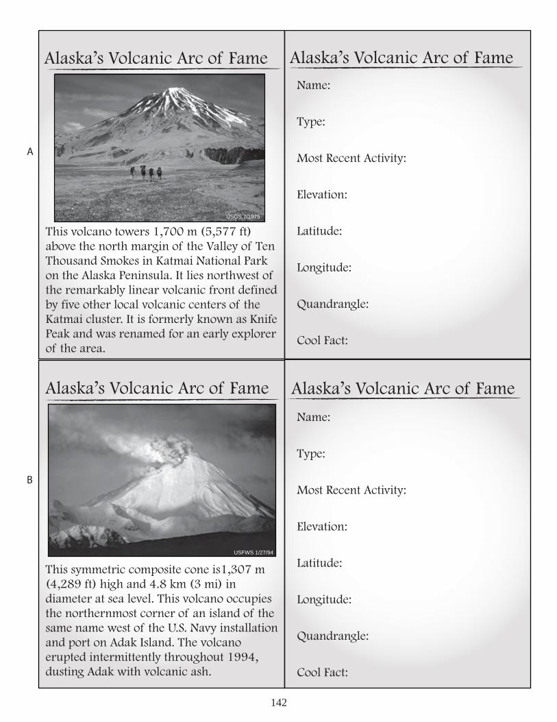
142
USGS 8/11/05
Alaska’s Volcanic Arc of Fame
This volcano towers 1,700 m (5,577 ft) above the north margin of the Valley of Ten Thousand Smokes in Katmai National Park on the Alaska Peninsula. It lies northwest of the remarkably linear volcanic front defined by five other local volcanic centers of the Katmai cluster. It is formerly known as Knife Peak and was renamed for an early explorer of the area.
Name:
Type:
Most Recent Activity:
Elevation:
Latitude:
Longitude:
Quandrangle:
Cool Fact:
Name:
Type:
Most Recent Activity:
Elevation:
Latitude:
Longitude:
Quandrangle:
Cool Fact:
Alaska’s Volcanic Arc of Fame
Alaska’s Volcanic Arc of Fame Alaska’s Volcanic Arc of Fame
USGS 7/1975
This symmetric composite cone is1,307 m (4,289 ft) high and 4.8 km (3 mi) in diameter at sea level. This volcano occupies the northernmost corner of an island of the same name west of the U.S. Navy installation and port on Adak Island. The volcano erupted intermittently throughout 1994, dusting Adak with volcanic ash.
USFWS 1/27/94
A
B

143
Alaska’s Volcanic Arc of Fame
This ~3 km (1.9 mi) diameter, 300 m (984 ft)high, island volcano in the central Aleutian Islands erupted violently on August 7, 2008 after an intense period of earthquake activity. The island is part of the Alaska Maritime National Wildlife Refuge and was occupied by two USFWS biologists when the precursory earthquakes began. A local fisherman safely evacuated the scientists less than 30 minutes prior to the eruption.
This volcano occupies most of the southern half of an island of the same name in the eastern Aleutian arc. The volcano consists of two cones and has an oval shape. The larger cone at the southeastern end of the volcano has an elevation of 893 m (2,930 ft); the cone at the northwestern end is about 610 m (2,000 ft) high and appears to have two small summit craters.
Name:
Type:
Most Recent Activity:
Elevation:
Latitude:
Longitude:
Quandrangle:
Cool Fact:
Name:
Type:
Most Recent Activity:
Elevation:
Latitude:
Longitude:
Quandrangle:
Cool Fact:
Alaska’s Volcanic Arc of Fame
Alaska’s Volcanic Arc of Fame Alaska’s Volcanic Arc of Fame
Steve Smith 8/5/03
Jerry Morris, 2008
A
B

144
USGS 8/11/05
Alaska’s Volcanic Arc of Fame
This volcano is often attributed incorrectly as the source of the voluminous pyroclastic flows erupted in 1912 forming the Valley of Ten Thousand Smokes in Katmai National Park. The correct source is Novarupta dome. Much of this volcano is mantled by snow and ice and several valley glaciers radiate out from the flanks. Three glaciers originating from the upper caldera walls descend into the crater to the lake.
In 1916, a National Geographic Society expedition led by Robert Griggs visited the Katmai Valley. Among many other things, the expedition discovered this newly formed lava dome they named. This volcanic dome formed during the 1912 eruption that createdthe Valley of Ten Thousand Smokes in Katmai National Park. It is ~400 m (1,312 ft) in diameter and 65 m (213 ft) high.
Name:
Type:
Most Recent Activity:
Elevation:
Latitude:
Longitude:
Quandrangle:
Cool Fact:
Name:
Type:
Most Recent Activity:
Elevation:
Latitude:
Longitude:
Quandrangle:
Cool Fact:
Alaska’s Volcanic Arc of Fame
Alaska’s Volcanic Arc of Fame Alaska’s Volcanic Arc of Fame
USGS 6/4/91
ADGGS 8/1991
A
B

145
Alaska’s Volcanic Arc of Fame
This stratovolcano is 1,221 m (4,006 ft) high. It is on the northern end of a western Aleutian island of the same name. Surface lava flows on this volcano are younger than the last major glaciation. Five of the youngest lava flows have been mapped and have steep fronts as much as 30 m (98 ft) high. On June 1, 1990, an observer on nearby Amchitka Island observed steam and minor ash emission from an upper flank vent of this volcano.
This is a stratovolcano on the northern end of an Aleutian island of the same name. It is 8.5 by 6.4 km in diameter at its base and 1,221 m high. A slightly elliptical crater occupies the summit. A parasitic 30-m-high cinder cone, formed in 1962 near sea level, occurs at Sirius Point and an older parasitic cone, now leveled by marine erosion, occurs at sea level 5.6 km southwest of the volcano.
Name:
Type:
Most Recent Activity:
Elevation:
Latitude:
Longitude:
Quandrangle:
Cool Fact:
Name:
Type:
Most Recent Activity:
Elevation:
Latitude:
Longitude:
Quandrangle:
Cool Fact:
Alaska’s Volcanic Arc of Fame
Alaska’s Volcanic Arc of Fame Alaska’s Volcanic Arc of Fame
NASA 10/23/02
I.L. Jones 5/12/92
A
B

146
USGS 8/11/05
Alaska’s Volcanic Arc of Fame
This is a stratovolcano, 1,533 m (5,030 ft) high and almost 7 km (4.3 mi) in basal diameter. It has two summit vents. One summit vent is a symmetric cone with a small crater. The other summit vent is on the remnant of a cone with a steep-walled crater, about 1 km (0.6 mi) wide at the rim and at least several hundred meters deep.
Above, you can see a young vent on the northeast shoulder of this volcano. Sarichef volcano is in the distance. This and other volcanoes are products of the latest stage of volcanic activity on Adak Island. Hot springs and fumaroles occur on the south and west flanks of this volcano.
Name:
Type:
Most Recent Activity:
Elevation:
Latitude:
Longitude:
Quandrangle:
Cool Fact:
Name:
Type:
Most Recent Activity:
Elevation:
Latitude:
Longitude:
Quandrangle:
Cool Fact:
Alaska’s Volcanic Arc of Fame
Alaska’s Volcanic Arc of Fame Alaska’s Volcanic Arc of Fame
USGS 7/14/04
USGS 7/11/04
A
B

147
USGS 8/11/05
Alaska’s Volcanic Arc of Fame
This is the largest and best known volcano ofthe Stepovak Bay chain of five volcanoes on the Alaska Peninsula. The Stepovak Bay chain includes the better known Veniaminof and Aniakchak calderas. This volcano is 1,895 m (2,217 ft) high and there is a fumarolic area marked by sulfur deposits at an elevation of 1,524 m (5,000 ft).
This volcano is a broad, stratovolcano. It is 6 km (1 mi) diameter at its base. It is on Unalaska Island in the Aleutians. Its summit caldera, ~3 km (~1.9 mi) across, contains a small cinder cone, remnants of other cones, and several fumaroles. The volcano is capped by an ~40-km2 (~15-mi2) icefield. This volcano has also been called Cheerful Mountain.
Name:
Type:
Most Recent Activity:
Elevation:
Lattitude:
Longitude:
Quandrangle:
Cool Fact:
Name:
Type:
Most Recent Activity:
Elevation:
Lattitude:
Longitude:
Quandrangle:
Cool Fact:
Alaska’s Volcanic Arc of Fame
Alaska’s Volcanic Arc of Fame Alaska’s Volcanic Arc of Fame
UAFGI 1996
USGS 1984
A
B

148
USGS 8/11/05
Alaska’s Volcanic Arc of Fame
This almost completely ice-covered volcano lies west of Hallo Bay in Katmai National Park. Unlike nearby Denison and Steller volcanoes, this volcano has a vigorous fumarole field. This volcano is 2,040 m (6,693 ft) high.
This volcano forms part of an Aleutian Island by the same name. It lies within the eroded remnants of a nested double caldera. There are fumaoles, hot springs, and inactive small mud volcanoes ~10-20 cm (4-8 in.) high at this volcano inland of West Cove. This volcano lies near Kvostof and Davidof Islands.
Name:
Type:
Most Recent Activity:
Elevation:
Latitude:
Longitude:
Quandrangle:
Cool Fact:
Name:
Type:
Most Recent Activity:
Elevation:
Latitude:
Longitude:
Quandrangle:
Cool Fact:
Alaska’s Volcanic Arc of Fame
Alaska’s Volcanic Arc of Fame Alaska’s Volcanic Arc of Fame
USGS 1990
USGS 9/28/05
A
B

149
USGS 8/11/05
Alaska’s Volcanic Arc of Fame
This volcano is within the Katmai Cluster ofvolcanoes in Katmai National Park’s Valley of Ten Thousand Smokes. The ice-covered summit area consists of one central high peak (elevation 2,165 m [7,100 ft]) and three small vent-cones. A small crater on the northeast side of the central peak contains a crater lake and supports vigorous fumarolic activity accompanied by sulfur deposition.
This volcano is within the Katmai Cluster ofvolcanoes in Katmai National Park’s Valley of Ten Thousand Smokes. It’s ~300 m (984 ft) diameter summit crater is the site of intense fumarolic activity and steam emission, and contains an ephemeral crater lake.
Name:
Type:
Most Recent Activity:
Elevation:
Latitude:
Longitude:
Quandrangle:
Cool Fact:
Name:
Type:
Most Recent Activity:
Elevation:
Latitude:
Longitude:
Quandrangle:
Cool Fact:
Alaska’s Volcanic Arc of Fame
Alaska’s Volcanic Arc of Fame Alaska’s Volcanic Arc of Fame
S. Smith 6/13/03
S. Smith 6/13/03
A
B

150
Alaska’s Volcanic Arc of Fame
This volcano is an active caldera on the northeast end of Umnak Island, ~100 km (~62 mi) southwest of Dutch Harbor, Alaska. The caldera is 10 km (6 mi) indiameter and 500-800 m (1,640-2,625 ft) deep. Very large floods and lahars have accompanied past eruptions of this volcano.
Beautifully symmetrical and one of the highest and most active volcanoes of the Aleutians, the 2,587-m (8,488-ft) high, glacier covered volcano is located in the eastern half of Unimak Island. The Aleutsnamed it Sisquk, meaning, “mountain which point the way I am lost.” A steady steam plume rises from its small summit crater.
Name:
Type:
Most Recent Activity:
Elevation:
Latitude:
Longitude:
Quandrangle:
Cool Fact:
Name:
Type:
Most Recent Activity:
Elevation:
Latitude:
Longitude:
Quandrangle:
Cool Fact:
Alaska’s Volcanic Arc of Fame
Alaska’s Volcanic Arc of Fame Alaska’s Volcanic Arc of Fame
ADGGS no date
ADGGS 5/10/94
A
B

151
USGS 8/11/05
Alaska’s Volcanic Arc of Fame
The volcano on the right, above is a largely snow-covered, cone-shaped mountain with a high ridge extending to the southwest toward the rim of Emmons Lake Caldera. This volcano is ~7 km (~4 mi) in diameter and has active vents on the north and east sides close to the summit. The volcano is one of the most active of Alaska’s volcanoes. Pavlof Sister is the volcano on left, above.
This volcanic center includes Pavlof, Little Pavlof, Double Crater, Mt. Hague, and this volcano. This volcano is a 1,436 m (4,711 ft) high postcaldera stratovolcano within acaldera of the same name on the Alaska Peninsula. The most recent of several caldera-forming eruptions at Emmons Lake occurred more than 10,000 years ago. No historical eruptions have occurred here.
Name:
Type:
Most Recent Activity:
Elevation:
Latitude:
Longitude:
Quandrangle:
Cool Fact:
Name:
Type:
Most Recent Activity:
Elevation:
Latitude:
Longitude:
Quandrangle:
Cool Fact:
Alaska’s Volcanic Arc of Fame
Alaska’s Volcanic Arc of Fame Alaska’s Volcanic Arc of Fame
USGS 7/1975
USGS 5/9/94
A
B

152
USGS 8/11/05
Alaska’s Volcanic Arc of Fame
This small, young volcano encompasses an island in the Bering Sea ~50 km (~31 mi) north of Frosty Peak volcano at the western tip of the Alaska Peninsula. It is unusual in its position, which is significantly north of the main Aleutian volcanic front; Bogoslof is the only other such Aleutian volcano. This volcano is 995 m (3,264 ft) high.
This complex volcanic center is almost entirely covered by the Serpant Tounge Glacier. It is within Katmai National Park. Three peaks extending above the ice along a northeast-southwest trending ridge define the summit.There is an active fumarole field on the summit of the tallest peak. This volcano is 2,161 m (7,090 ft) high.
Name:
Type:
Most Recent Activity:
Elevation:
Latitude:
Longitude:
Quandrangle:
Cool Fact:
Name:
Type:
Most Recent Activity:
Elevation:
Latitude:
Longitude:
Quandrangle:
Cool Fact:
Alaska’s Volcanic Arc of Fame
Alaska’s Volcanic Arc of Fame Alaska’s Volcanic Arc of Fame
USFWS 10/1/84
USGS 1999
A
B

153
Alaska’s Volcanic Arc of Fame
A brand-new Boeing 747 encountered an ash cloud from an eruption of this volcano in 1989. All four of the plane’s engines failed when the plane inadvertently flew through an ash cloud from this volcano. Thecrew successfully restarted a few of the engines and landed safely in Anchorage.
This volcano is close to Anchorage. Its 1992 eruption was from a satellite cone called Crater Peak. This eruption deposited ~6 mm (~1/4 in.) of volcanic ash in Anchorage, closed the airport, businesses, and schools. Air traffic as far away as Cleveland, Ohio, was disturbed.
Name:
Type:
Most Recent Activity:
Elevation:
Latitude:
Longitude:
Quandrangle:
Cool Fact:
Name:
Type:
Most Recent Activity:
Elevation:
Latitude:
Longitude:
Quandrangle:
Cool Fact:
Alaska’s Volcanic Arc of Fame
Alaska’s Volcanic Arc of Fame Alaska’s Volcanic Arc of Fame
USGS 3/1/05
USGS 8/11/05
A
B

154
Alaska’s Volcanic Arc of Fame
This volcano lies on an island of the same name between Amlia and Amukta Islands in the central Aleutians. This volcano is also referred to as Pyre Peak. Incandescent lava fountained from a fissure eruption near this volcano in March 1977. Explosive ash eruptions and a lava flow were reported by U.S. Coast Guard observers from July 31 to August 19, 1993.
This caldera, one of the largest calderas in the Aleutian arc, is 11 km (6.8 mi) wide and 18 km (11 mi) long. It is one of at least three volcanoes on Unimak Island that have been active in historical time.
Name:
Type:
Most Recent Activity:
Elevation:
Latitude:
Longitude:
Quandrangle:
Cool Fact:
Name:
Type:
Most Recent Activity:
Elevation:
Latitude:
Longitude:
Quandrangle:
Cool Fact:
Alaska’s Volcanic Arc of Fame
Alaska’s Volcanic Arc of Fame Alaska’s Volcanic Arc of Fame
NASA 09/92
USFWS 1996
A
B

155
Alaska’s Volcanic Arc of Fame
This volcano is the largest, young volcanic island in the western Aleutians. It boasts an 8-km (5-mi) wide caldera and small composite cones. One young composite cone (called Sugarloaf) has olivine basalt. This volcano is also on a small submarine ridge that extends northward as a part of the scorpion-tail-shaped Bower’s Ridge. The latest reported activity occurred on April 13, 1987, when a plume extending 90 km (56 mi) from the island was observed on satellite imagery.
This a large shield volcano. It is capped by a 4 by 6 km (2.5 by 3.7 mi), ice-filled summit caldera whose depth may exceed 1 km(0.6 mi). Mt. Zanetti, a large, steep-sided cinder-spatter cone is high on the northwest flank of the shield and may be the source of some lava flows.
Name:
Type:
Most Recent Activity:
Elevation:
Latitude:
Longitude:
Quandrangle:
Cool Fact:
Name:
Type:
Most Recent Activity:
Elevation:
Latitude:
Longitude:
Quandrangle:
Cool Fact:
Alaska’s Volcanic Arc of Fame
Alaska’s Volcanic Arc of Fame Alaska’s Volcanic Arc of Fame
USGS 7/13/05
NPS 1987
A
B

156
Alaska’s Volcanic Arc of Fame
This is an eroded volcanic complex of three stratovolcanoes and numerous domes, as high as 1,864 m (6,115 ft) in elevation, on the Alaska Peninsula in Katmai National Park’s Valley of Ten Thousand Smokes. A new fragmental cone was built from1953 to 1974 to an altitude of 1,515 m (4,970 ft) in an amphitheater on the southwest flank of the southwest peak.
This volcano is 35 km (~22 mi) wide at its base. It is capped by an ice-filled caldera. In the western part of the caldera is an active intracaldera cone with a small summit crater. This cone has an elevation of ~330 m (~1,083 ft) above the surrounding ice field. This volcano is on the Alaska Peninsula.
Name:
Type:
Most Recent Activity:
Elevation:
Latitude:
Longitude:
Quandrangle:
Cool Fact:
Name:
Type:
Most Recent Activity:
Elevation:
Latitude:
Longitude:
Quandrangle:
Cool Fact:
Alaska’s Volcanic Arc of Fame
Alaska’s Volcanic Arc of Fame Alaska’s Volcanic Arc of Fame
USGS 7/12/90
Sam Egli 6/5/06
A
B

157
Alaska’s Volcanic Arc of Fame
This caldera is ~5 km (~3 mi) in diameter and is south of Becharof Lake and east of Upper Ugashik Lake on the Alaska Peninsula. At least five lava domes (snow-covered in this view) currently occupy the floor of the caldera. The peak of the caldera is 1,474 m (4,836 ft) high.
This volcano, a small truncated stratovolcano with a basal diameter of ~10 km, (~6 mi)is near Becharof Lake on the Alaska Peninsula. The volcano partially overlaps the north flank of Ugashik caldera. Flows from flank eruptions of this volcano cover ~8 km2 (3 mi2) north of the volcano extending as far as Becharof Lake.
Name:
Type:
Most Recent Activity:
Elevation:
Latitude:
Longitude:
Quandrangle:
Cool Fact:
Name:
Type:
Most Recent Activity:
Elevation:
Latitude:
Longitude:
Quandrangle:
Cool Fact:
Alaska’s Volcanic Arc of Fame
Alaska’s Volcanic Arc of Fame Alaska’s Volcanic Arc of Fame
USGS 4/11/84
USGS 6/1993
A
B

158
USGS 8/11/05
Alaska’s Volcanic Arc of Fame
This peak, including nearby Faris Peak and Pogromni volcano, is located on a gently sloping plateau that may represent the surface of a truncated ancestral cone on Unimak Island in the eastern Aleutians. This volcano is ~18 km (11 mi) in diameter at the base. On January 7, 2004, 90 earthquakes occurred over a period of 12 hours beneath this volcano.
This volcano is a symmetrical stratovolcano near the southwest end of Umnak Island. It is ~10 km (~6 mi) wide at the base and steepens from 15 degrees at 300 m (984 ft) altitude to about 30 degrees near the summit. A crater occupies the summit. Glacial ice fills the crater and extends down the north and east flanks of the cone.
Name:
Type:
Most Recent Activity:
Elevation:
Latitude:
Longitude:
Quandrangle:
Cool Fact:
Name:
Type:
Most Recent Activity:
Elevation:
Latitude:
Longitude:
Quandrangle:
Cool Fact:
Alaska’s Volcanic Arc of Fame
Alaska’s Volcanic Arc of Fame Alaska’s Volcanic Arc of Fame
ADGGS 8/1985
USFWS 1/2/93
A
B

159
Alaska’s Volcanic Arc of Fame
The most recent explosive eruption of this volcano occurred on Sept. 4, 1987, and wasreported by a local pilot. The pilot observeda small dark ash plume rising at least 300 m (984 ft) above the summit of the volcano then drifting as much as 1 km (0.6 mi). The nearly circular volcanic cone is 1,066 m (3,497 ft) high and is topped by a -rater.
This is the largest of a cluster of small, low- lying islands that comprise the summit of a large submarine stratovolcano that rises more than 1,500 m (4,921 ft) above the floor of the Bering Sea. It occurs north of the volcanic front of the main Aleutian arc. The island has undergone dramatic changes in size and shape during historical time, an evolution that has been well observed and recorded for such an isolated volcano.
Name:
Type:
Most Recent Activity:
Elevation:
Latitude:
Longitude:
Quandrangle:
Cool Fact:
Name:
Type:
Most Recent Activity:
Elevation:
Attitude:
Longitude:
Quandrangle:
Cool Fact:
Alaska’s Volcanic Arc of Fame
Alaska’s Volcanic Arc of Fame Alaska’s Volcanic Arc of Fame
USFWS 6/92
USGS 5/10/94
A
B

160
Alaska’s Volcanic Arc of Fame
Ash flows from the caldera forming eruption of this volcano ~3,400 years ago reached both the Bering Sea and the Pacific Ocean. The caldera is 10 km (~6.2 mi)across and 1 km (0.6 mi) deep at its deepest. The rim of the caldera varies from 610–1,341 m (2,000–4,400 ft). Within this caldera is 3.2-km (2 mi) long lake at an elevation of 335 m (1,100 ft).
This volcano is located in a region calledIsland of the Four Mountains in the centralAleutian Islands. This the symmetric cone is 1,524 m (5,000 ft) high and ~6.5 km (4 mi)in diameter at sea level. Little is knownabout its structure or composition. There is some evidence of a 50 m (164 ft) high plateau on the western side of the island suggesting an emergent marine terrace.
Name:
Type:
Most Recent Activity:
Elevation:
Latitude:
Longitude:
Quandrangle:
Cool Fact:
Name:
Type:
Most Recent Activity:
Elevation:
Latitude:
Longitude:
Quandrangle:
Cool Fact:
Alaska’s Volcanic Arc of Fame
Alaska’s Volcanic Arc of Fame Alaska’s Volcanic Arc of Fame
NPS1977
Steve Smith 7/21/04
NPS. 1977
A
B

161
USGS 8/11/05USGS 1/30/06
Alaska’s Volcanic Arc of Fame
This volcano frequently is seen steaming from a fumarole and is often mistaken for eruptive activity. This volcano can be seen from several points on the Kenai Peninsula when looking southwest down Cook Inlet. Just south of the summit region of this volcano are a pair of peaks known as North Twin and South Twin.
This is the most active and youngest volcanoin the Cook Inlet. It erupted five times inthe 20th century. The most recent eruption of this volcano began in the winter of 2006 and lasted throughout the spring and earlysummer. This is an island volcano and looksa lot like a pointy witch’s hat with a wide, low brim close to shore and a pointy peak near the center.
Name:
Type:
Most Recent Activity:
Elevation:
Latitude:
Longitude:
Quandrangle:
Cool Fact:
Name:
Type:
Most Recent Activity:
Elevation:
Latitude:
Longitude:
Quandrangle:
Cool Fact:
Alaska’s Volcanic Arc of Fame
Alaska’s Volcanic Arc of Fame Alaska’s Volcanic Arc of Fame
USGS 7/28/06
A
B

162
USGS 8/11/05
Alaska’s Volcanic Arc of Fame
This volcano sits southwest of Mother Goose Lake in the Alaska Peninsula NationalWildlife Refuge, Uagshik Unit. It is a 2,135- m (7,000-ft) high symmetrical cone ~8 km (5 mi) in diamemter. In 2004, a lake formed in the summit crater. In 2005, this acidic lake drained causing lahars, flooding, an anoxic lake, and acidic streams.
These maars were caused by phreato-magmatic explosions (water flashing to steam due to the proximity of heat from nearby magma) in the spring of 1977. The maars are south of Becharof Lake northwest of Peulik volcano and are ~600 m (1,968 ft) apart. The East Maar is 300 m (984 ft) across, 70 m (230 ft) deep and has a submerged lava dome.
Name:
Type:
Most Recent Activity:
Elevation:
Latitude:
Longitude:
Quandrangle:
Cool Fact:
Name:
Type:
Most Recent Activity:
Elevation:
Latitude:
Longitude:
Quandrangle:
Cool Fact:
Alaska’s Volcanic Arc of Fame
Alaska’s Volcanic Arc of Fame Alaska’s Volcanic Arc of Fame
USGS 8/20/04
USGS 5/9/94
A
B

163
Alaska’s Volcanic Arc of Fame
This volcano encompasses an island by the same name in the western Aleutians. It has two summits separated by a narrow saddle. Thirteen young craters are aligned along a south-southeastward trending fissure on the southernmost peak and formed in 1929.
This volcano is in a region known as the Island of the Four Mountains in the central Aleutians. It makes up the western half ofChuginadak Island. It is ~1,730 m (~5,676 ft) high. On May 23, 2006, an astronaut aboard the International Space Station shot the image above and contacted the Alaska Volcano Observatory.
Name:
Type:
Most Recent Activity:
Elevation:
Latitude:
Longitude:
Quandrangle:
Cool Fact:
Name:
Type:
Most Recent Activity:
Elevation:
Latitude:
Longitude:
Quandrangle:
Cool Fact:
Alaska’s Volcanic Arc of Fame
Alaska’s Volcanic Arc of Fame Alaska’s Volcanic Arc of Fame
NASA 5/23/06
USGS 9/25/03
A
B

164
USGS 8/11/05
Alaska’s Volcanic Arc of Fame
This volcano is in the northeasternmost part of Katmai National Park on the Alaska Peninsula, and is mostly covered by the Spotted Glacier. On the north side of thesummit crater, there is an active fumarole field. There is no historical activity at this volcano, but the presence of a lake in the summit crater indicates recent activity.
On Sept. 17, 2006, this volcano appeared to reawake from thousands of years of possible dormance. On that day, two steam plumes over this volcano were visible from Homer on the tip of the Kenai Peninsula. Satellite data showed that although these plumes did not contain significant amounts of volcanic ash, they did have high concentrations of magmatic SO .
Name:
Type:
Most Recent Activity:
Elevation:
Latitude:
Longitude:
Quandrangle:
Cool Fact:
Name:
Type:
Most Recent Activity:
Elevation:
Latitude:
Longitude:
Quandrangle:
Cool Fact:
Alaska’s Volcanic Arc of Fame
Alaska’s Volcanic Arc of Fame Alaska’s Volcanic Arc of Fame
USGS 9/30/06
USGS 11/4/06
2
A
B

165
Alaska’s Volcanic Arc of Fame
This is a small extinct volcano on the northernmost Akun Island. The summit has been completely eroded. Before 1948, active fumaroles in this area produced steam plumes visible as a distance. This activity has since stopped. Altered group northeast of the present summit There was an unsuccessful attempt to mine sulfur on the northeastern part of the volcano.
Name:
Type:
Most Recent Activity:
Elevation:
Latitude:
Longitude:
Quandrangle:
Cool Fact:
Name:
Type:
Most Recent Activity:
Elevation:
Latitude:
Longitude:
Quandrangle:
Cool Fact:
Alaska’s Volcanic Arc of Fame
Alaska’s Volcanic Arc of Fame Alaska’s Volcanic Arc of Fame
ADGGS 1994
USFWS 1/29/86
This volcano occupies the northern partof the island of the same name in the Andreanof Islands group of the central Aleutians. It is 1,740 m (5,709 ft) high. The volcano consists of the remains of an older, decapitated volcano and a younger parasitic cone that collapsed to form a small caldera on the west flank. This volcano looms over the town of Adak.
A
B

166
p. # A. volcano B. volcano p. 141 A. Akutan B. Tanaga p. 142 A. Griggs B. Kanaga p. 143 A. Kasatochi B. Kagamil p. 144 A. Katmai B. Novarupta p. 145 A. Kiska B. Yunaska p. 146 A. Kluichef B. Sarichef p. 147 A. Kupreanof B. Makushin p. 148 A. Kukak B. Little Sitkin
p. 149 A. Mageik B. Martin p. 150 A. Okmok B. Shishaldin p. 151 A. Pavlov B. Emmons p. 152 A. Amak B. Snowy p. 153 A. Redoubt B. Spurr p. 154 A. Seguam B. Fisher p. 155 A. Semisopochnoi B. Wrangell p. 156 A. Trident B. Veniaminof p. 157 A. Ugashik B. Peulik
p. 158 A. Westdahl B. Vsevidof p. 159 A. AMutka B. Bogoslof p. 160 A. Aniakchak B. Carlise p. 161 A. Iliamna B. Augustine p. 162 A. Chiginigak B. Ukinrek p. 163 A. Gareloi B. Cleveland p. 164 A. Douglas B. Fourpeaked p. 165 A. Gilbert B. Great Sitkin