alexandria waterfront - alexandriava.gov · alexandria waterfront small area plan city of...
TRANSCRIPT
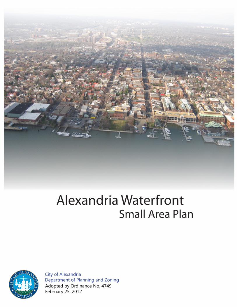
Alexandria WaterfrontSmall Area Plan
City of Alexandria Department of Planning and ZoningAdopted by Ordinance No. 4749February 25, 2012
Alex
andr
ia W
ater
front
Sm
all A
rea
Plan
: Illu
stra
tive
(Nor
ther
n Co
re)
Alex
andr
ia W
ater
front
Sm
all A
rea
Plan
: Illu
stra
tive
(Sou
ther
n Co
re)

Alexandria Waterfront Small Area Plan i
Table of ContentsList of Figures ivAcknowledgements viExecutive Summary ixChapter 1: A Waterfront Introduction 1
> Waterfront History > Waterfront Planning History > The Concept Plan > The Plan
Chapter 2: Goals and Waterfront Wide Elements 13 > A Plan for the Public Realm
> A Plan for Development > A Plan Which is Uniquely Alexandrian > A Plan Which Creates Systems that Work
Chapter 3: Character and Theme Areas 33 > Gateway North/Canal Center > Tide Lock Park and Rivergate/Rowing Facility > Oronoco Bay Park > West’s Point - Robinson Terminal North > Founders Park > King Street to Queen Street -The Waterfront’s Core > The Strand > Point Lumley - Robinson Terminal South > The Waterfront Periphery - North and South > Waterfront Hotel/Restaurant Policy > Proposed Zoning for Private Development Sites
Chapter 4: Transportation, Circulation, and Parking 105 > Vehicular Traffic > Pedestrian Movement > Bicycle Travel > Transit > Water Taxi and Water Transportation > Parking
Chapter 5: Implementation 125 > Revenue Potential > Developer Contribution Potential > Taxes and Funding > Phasing
Appendix 1: Community ParticipationAppendix 2: Regulatory and Permitting Considerations and Settlement AgreementsAppendix 3: Hotel Technical MemorandumAppendix 4: Marina Market Assessment DataAppendix 5: Alexandria Waterfront Art PlanAppendix 6: Alexandria History Plan - Alexandria, A living History
ii Alexandria Waterfront Small Area Plan
List of Figures and TablesFigure 1 Arts and Culture: Theme Areas
Table 1: Public Space Summary ix
Table 2: Private Redevelopment Sites: Density and Height Analysis x
Table 3: Garage Spaces and Utilization xi
Table 4: Historical Periods 3
Figure 2: Waterfront Planning Boundary 4
Figure 3: Activities Map 5
Table 5: Waterfront Planning History 7
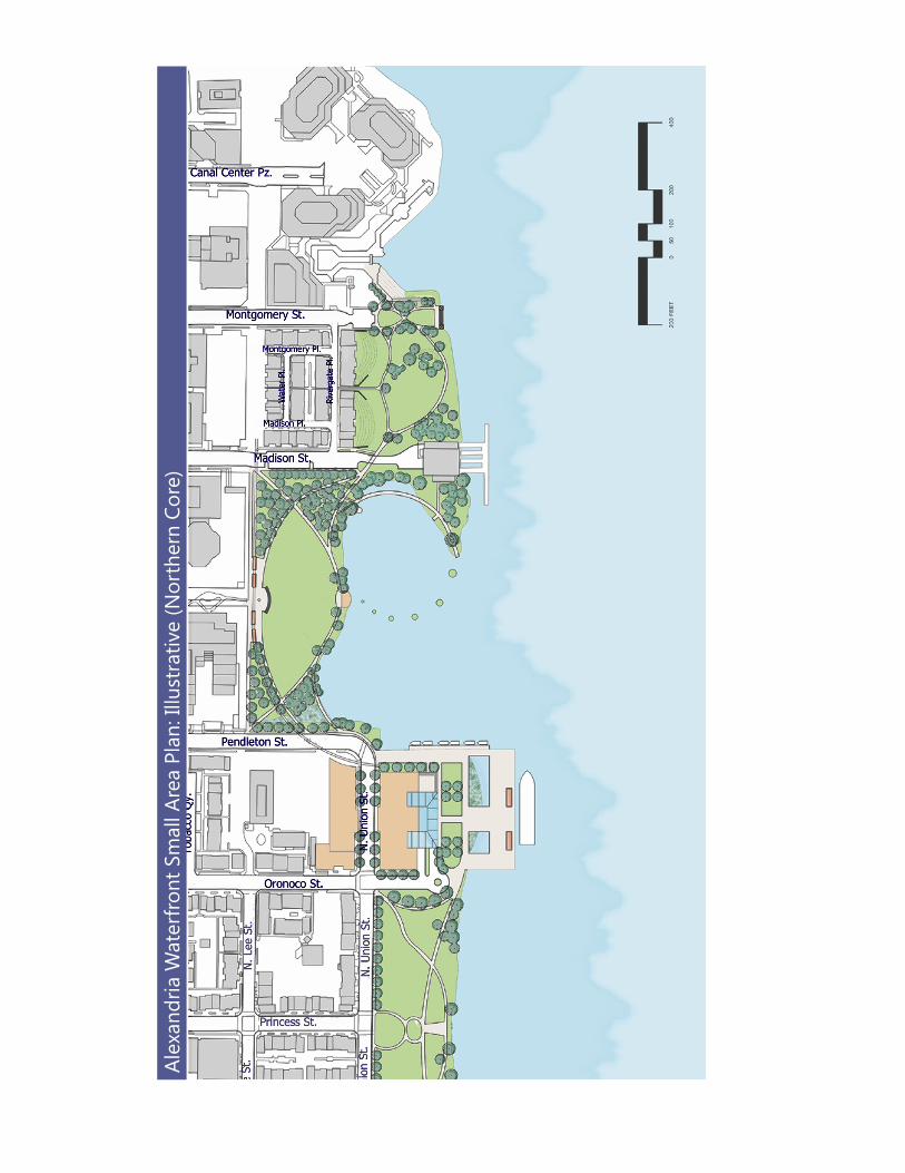
Figure 4a: Waterfront Early Concept Illustrative Plan (May 2010) - North Section 8
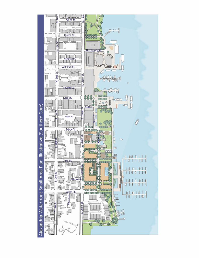
Figure 4b: Waterfront Early Concept Illustrative Plan (May 2010) - South Section 9Figure 5a: Waterfront Small Area Illustrative Plan with Place Names - North Section 10Figure 5b: Waterfront Small Area Illustrative Plan with Place Names - South Section 11Figure 6: Waterfront Small Area Illustrative Plan 15Figure 7a: Connections - North Section 16Figure 7b: Connections - South Section 17
Figure 8: Existing and Proposed Public Space 21Figure 9a: Existing Open Space in the Core Area 22Figure 9b: Proposed Park or Plaza Public Space in the Core Area 22Figure 9c: Proposed Park, Plaza, or On-Pier Public Space in the Core Area 23
Figure 9d: Proposed Park, Plaza, On-Pier, or Pedestrianized Street Public Space at Full Build-Out in the Core Area 23
Figure 10: Development Sites 24Figure 11: Integrated Flood Control System Concept 28Figure 12: Illustrative Plan showing Oronoco Bay Park 40Figure 13: Illustrative Plan for Robinson Terminal North showing Conceptual Pipefitter’s Building Expansion 43Figure 14: Original Shoreline 44Figure 15: Illustrative Plan showing Founders Park 46
Figure 16: Illustrative Plan View of the Food Court and Chart House, showing Conceptual Piers Near the Foot of Thompsons Alley and Extending from Cameron Street 50
Figure 17: Developer’s Conceptual Perspective of a Redesigned Food Court 51Figure 18: Illustrative Plan showing Torpedo Plaza and the Expanded Marina Concept 52Figure 19: Activity Levels in the Core Area 55Figure 20a: Existing Public Spaces - King Street Park and Waterfront Park 59Figure 20b: Conceptual Proposed Public Spaces - Fitzgerald Square and Waterfront Park 59Figure 21: Portion of Plaza Constructed over Water as Proposed 60Figure 22: Illustrative Plan showing a Marina Arrangement Extending only to the Pierhead Line 66
Figure 23: Illustrative Plan showing an Expanded Point Lumley Park and a Portion of the Redevelopment in the Surrounding Area 69
Figure 24: Illustrative Plan of Robinson Terminal South showing Conceptual Marina 78Figure 25: Windmill Hill Park Concept Plan 80
Alexandria Waterfront Small Area Plan iii
List of Figures and Tables (Continued)Figure 26: Crowne Plaza Infill Concept 85Figure 27: Height Districts 89Figure 28a: Active Frontages - North Section 90Figure 28b: Active Frontages - South Section 91Figure 29: Robinson Terminal North settlement agreement Map 92Figure 30: Robinson Terminal North Conceptual Massing Model 93Figure 31: Robinson Terminal North Proposed Public Space and Active Frontages 94Figure 32: Robinson Terminal South settlement agreement Map 96Figure 33: Robinson Terminal South Conceptual Massing Model 97Figure 34: Robinson Terminal South and Cummings-Turner Proposed Public Space and Active Frontages 100Figure 35: Cummings-Turner Redevelopment Conceptual Massing Model 102Table 2: Private Redevelopment Sites: Density and Height Analysis 105Table 6: Private Redevelopment Sites: Uses 105
Figure 36: Road Network 108Table 7: Pedestrian Volumes 110
Figure 37: Crash Map 112Figure 38: Motorcoach Locations Map 115Table 8: Core Area Garage Spaces and Utilization 119
Figure 39: Publicly Available Off-Street Parking Locations (Old Town Area Parking Study) 121Table 9: Waterfront Demand Generators and Parking Space Analysis 122Table 10: Core Parking Area Supply Summary 122Figure 40: Public and Private Parking Locations Map 123Table 11 Cost by Phasing Location 142Table 12 Cost Summary 142
iv Alexandria Waterfront Small Area Plan
AcknowledgementsCity CouncilMayor William D. EuilleVice Mayor Kerry DonleyFrank H. FannonAlicia HughesRob KrupickaRedella S. PepperPaul C. Smedberg
Planning CommissionChair John KomoroskeVice Chair H. Stewart Dunn, Jr.Donna FossumJesse JenningsMary LymanJ. Lawrence RobinsonEric R. Wagner
Committee for Public Arts, Alexandria Commission for the ArtsMatthew Harwood, ChairRebecca Adams Susie Cohen Karen Conkey Mike Detomo Dene Garbow Kathy Glennon Pat Miller (Chair, Alexandria Commission for the Arts)
History Plan Committee, Alexandria Archaeological CommissionJames McCall, ChairKaty CannadyAnn DavinTom FultonEllen HamiltonVince LaPointeTed PulliamSeth Tinkham
Alexandria Restaurant Commission, Alexandria Chamber of CommerceTina Leone, President & CEO, Alexandria Chamber of CommerceJay Palermino, Director, Membership and Sponsorship Investments
Marina Subcommittee, Alexandria Waterfront CommitteeDoug Gosnell, ChairLinda HaferNate Macek (Chair, Alexandria Waterfront Committee)Peter Pennington (Vice Chair, Alexandria Waterfront Committee)Townsend Van Fleet
City Departments
Alexandria Economic Development Partnership, Inc.Val Hawkins, President & CEOStephanie Landrum, Senior Vice PresidentChristine Mindrup, Vice President Commercial Real Estate
Alexandria Convention and Visitors AssociationStephanie Pace Brown, President & CEO
City Manager’s OfficeRashad M. Young, City Manager Mark Jinks, Deputy City ManagerTom Gates, Assistant City Manager
Fire DepartmentAdam K. Thiel, Fire ChiefJohn North, Battalion ChiefRodney Masser, Fire Captain General Services AdministrationJeremy McPike, Deputy DirectorPatrice McAuliffe, Capital Projects Manager
Office of Historic AlexandriaJ. Lance Mallamo, DirectorDr. Pamela Cressey, City Archaeologist
Police DepartmentEarl L. Cook, Police Chief Tamara Hooper, CaptainLen Fouch, Lieutentant
Alexandria Waterfront Small Area Plan v
Acknowledgements (Continued)Planning and Zoning Waterfront Team Faroll Hamer, DirectorJeffrey Farner, Deputy DirectorKarl Moritz, Deputy DirectorBarbara Ross, Deputy DirectorTom Canfield, City ArchitectAl Cox, Historic Preservation ManagerNancy Williams, Principal PlannerBen Aiken, Urban Planner
Planning and Zoning Gary Wagner, Principal PlannerBrandi Collins, Urban Planner IIIPat Mann, Urban Planner IIICatherine Miliaras, Urban Planner IIIGarry Meus, Urban Planner IIJim Roberts, Urban Planner IIColleen Willger, Urban Planner IIIKim Agee, Administrative Support VBarbara Carter, Administrative Support V
Recreation, Parks and Cultural ActivitiesJames Spengler, DirectorAlisa Carrel, Office of the Arts, DirectorRon Kagawa, Division ChiefLaura Durham, Open Space CoordinatorJames Hixon, Dockmaster
Transportation and Environmental ServicesRich Baier, DirectorYon Lambert, Deputy DirectorAbi Lerner, Deputy DirectorEmily Baker, City EngineerSandra Marks, Division ChiefJim Maslanka, Division ChiefDr. Claudia Hamblin-Katnik, Watershed Program AdministratorLisa Jaatinen, Civil Engineer IVDaniel Imig, Civil Engineer IIIDaphne Kott, Civil Engineer IIICarrie Sanders, Principal PlannerAndrea Wilkinson, Principal Parking Planner
Waterfront Plan Work Group (WPWG)
Christopher Ballard Bert ElyMelinda LyleElliot RhodesideNathan MacekDavid OlingerLt. General Bob Wood (Ret.)Councilman Paul Smedberg, Convener
Consultants
Plan AECOMAECOM – EconomicsAECOM - TransportationMoffatt and Nichol The Perspectives Group
Hotel Analysis W-ZHA, LLC
Model Trojan Models
vi Alexandria Waterfront Small Area Plan
Alex
andr
ia W
ater
front
Pla
n: K
ey S
ites
and
Reco
mm
enda
tions
Alexandria Waterfront Small Area Plan vii
Executive SummaryAlexandria’s waterfront is special.
Alexandria’s waterfront is special because of its unique and significant role in the nation’s history and because it is a world renowned example of the revitalizing role of art in the community. The waterfront is a source of prosperity, hometown pride and national significance. It is Alexandria’s front door; it is where the City was born; it is where we often go to celebrate; and it is where we take our guests from out of town. The waterfront is where we live; it is where we make a living; and it is where we go daily to walk, relax, meet neighbors, and see what’s happening.
Weaving art and history into every aspect of the Waterfront
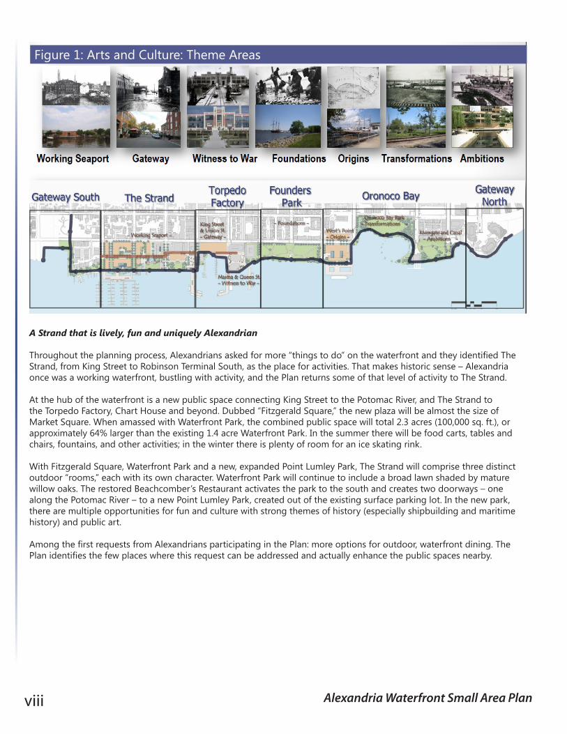
The City is the beneficiary of exceptional efforts by two groups of hardworking Alexandrians that resulted in the Alexandria History Plan – Alexandria, a Living History (History Plan), prepared by the Waterfront History Committee of the Alexandria Archaeological Commission, and the Alexandria Waterfront Art Plan (Art Plan), prepared by the Public Art Committee of the Alexandria Commission for the Arts. These efforts recognize the important contributions of history and art to Alexandria, especially at the waterfront. The Waterfront Small Area Plan (Plan) is an opportunity to add back history that’s been missing from the waterfront for too long. Moreover, the Art Walk concept is ideally suited to link the series of public spaces that comprise the waterfront, and public art has a limitless potential to interpret the stories, people and places of our past.
Based on recommendations in the History Plan and the Art Plan, six Art and Culture Theme Areas are utilized as guiding elements for each of the character areas of the Plan. The Art and Culture Theme Areas, like the Plan’s character areas, are linked by the proposed Art Walk designed to help unify them and other elements of the waterfront together. These Art and Culture Theme Areas are reflected in Figure 1. As one moves from one Art and Culture Theme Area to another, one will be introduced to the rich history of that given area through interpretation, art, architecture, activities and more. Additionally, a History Center in the vicinity of the 200 block of The Strand is proposed. There, one would be able to learn not only about the waterfront’s maritime history but also about other cultural resources, along the waterfront, and throughout the City. The History Center would be the history counterpart to the Torpedo Arts Center a few blocks north. This Plan not only incorporates these concepts and ideals contained in the History Plan and Art Plan but it also includes each plan in its entirety as Appendices 5 and 6, respectively.
Planning Area Boundaries u The waterfront planning area
is approximately 3 miles long and extends between the Potomac River on the east, North Fairfax Street and South Union Street on the west, Daingerfield Island on the north and Jones Point Park on the south.
Planning Process u Community Participation
Process: community and group meetings, charettes, topical meetings, website, video, comment board and more - April 2009 to January 2012
u Concept Plan Released – June 2010
u Draft Small Area Plan Released – February 2011
u Planning Commission Public Meetings and Approval – April/May 2011
u City Council Public Meeting – May 2011
u City Council Meeting – June 11, 2011
u Establishment of the Waterfront Plan Work Group (WPWG) - June 2011
u WPWG Report Released December 2011
u City Council Public Hearing and Plan approval - January 2012
Website Address and Key Content: www.alexandriava.gov/Waterfront
u What’s New? u Approved Waterfront Small
Area Plan u Implementation Activities u Information Archive u Public Comment Board
viii Alexandria Waterfront Small Area Plan
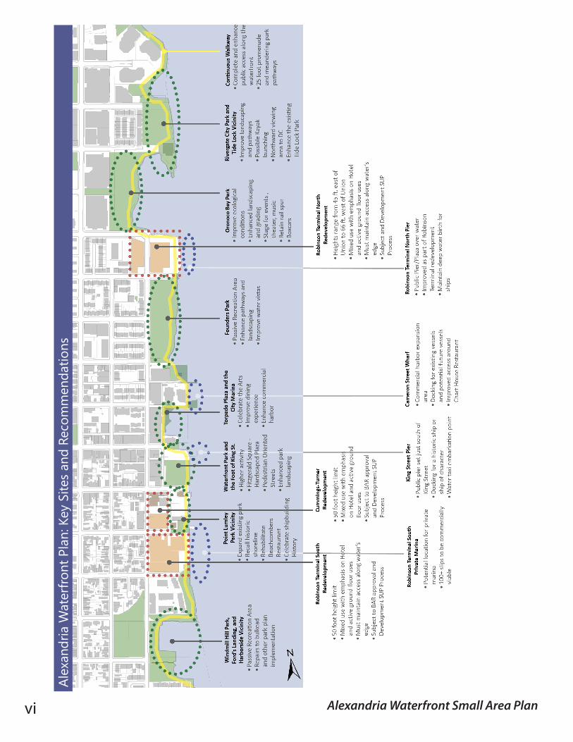
A Strand that is lively, fun and uniquely Alexandrian
Throughout the planning process, Alexandrians asked for more “things to do” on the waterfront and they identified The Strand, from King Street to Robinson Terminal South, as the place for activities. That makes historic sense – Alexandria once was a working waterfront, bustling with activity, and the Plan returns some of that level of activity to The Strand.
At the hub of the waterfront is a new public space connecting King Street to the Potomac River, and The Strand to the Torpedo Factory, Chart House and beyond. Dubbed “Fitzgerald Square,” the new plaza will be almost the size of Market Square. When amassed with Waterfront Park, the combined public space will total 2.3 acres (100,000 sq. ft.), or approximately 64% larger than the existing 1.4 acre Waterfront Park. In the summer there will be food carts, tables and chairs, fountains, and other activities; in the winter there is plenty of room for an ice skating rink.
With Fitzgerald Square, Waterfront Park and a new, expanded Point Lumley Park, The Strand will comprise three distinct outdoor “rooms,” each with its own character. Waterfront Park will continue to include a broad lawn shaded by mature willow oaks. The restored Beachcomber’s Restaurant activates the park to the south and creates two doorways – one along the Potomac River – to a new Point Lumley Park, created out of the existing surface parking lot. In the new park, there are multiple opportunities for fun and culture with strong themes of history (especially shipbuilding and maritime history) and public art.
Among the first requests from Alexandrians participating in the Plan: more options for outdoor, waterfront dining. The Plan identifies the few places where this request can be addressed and actually enhance the public spaces nearby.
Figure 1: Arts and Culture: Theme Areas
Alexandria Waterfront Small Area Plan ix
At the heart of the Waterfront, a new gateway to the City
During its earliest days and for long afterward, Alexandria recognized its waterfront as the front door to the City. Pictures of the ferry terminal that was once located at the foot of King Street remind us that for many visitors and residents, this location was the gateway to the City. As waterfront uses became more industrial, the daily life of Alexandrians moved away from the water’s edge and new waterfront buildings often faced away rather than toward the river.
Early in the public process for this Plan, Alexandrians expressed a strong wish to see the foot of King Street once again become a gateway to the City. The hundred or so participants in an early public meeting identified “extending King Street as a pier” as a highly desired element of the Plan and so it was included in the Waterfront Concept Plan released in the summer of 2010. With the advice of residents, the pier concept has been refined and would provide:
u a dramatically improved arrival experience, with water taxis delivering new visitors and returning residents to a pier with “natural” wayfinding: a clear view of the entire waterfront core area and of King Street to the George Washington Masonic National Memorial as well as easy access to the King Street Trolley;
u a docking location for a historic ship or other “ship of character” as requested by residents to be visible as one walks down King Street toward the Potomac River;
u a connection to Alexandria’s past, since long piers characterized Alexandria’s waterfront for more than 100 years; u a way to let people do what they really wish when they come to a river: get out over the water and enjoy the view;
and u a clear marker that this spot, where one of America’s great streets meets one of America’s great rivers, is the “center”
of the waterfront.
More and better public spaces of all kinds
The essence of Alexandria’s waterfront is public space and the Plan not only increases the amount of space for the public, it also adds to the variety of public spaces. The redesign of Waterfront Park, combined with the new Fitzgerald Square, adds 40,000 square feet (approximately an acre) of park at the heart of the waterfront. Overall the Plan adds nearly six acres, or 250,000 square feet, of new public spaces of all kinds, including new public piers, streets that are converted to pedestrian-oriented spaces, and more. Over 5 acres of public space will be located between Thompsons Alley and Wilkes Street (Table 1).
The Plan completes the long-standing goal of “where land meets water, the public is welcome” by planning for continuous access and accessibility along the river. The Plan calls for continued investment in our existing parks, inspired by art, history, and the environment, and adding small scale active recreation in many locations along the waterfront.
Total Current Public Space 2.3 AcresPlan Implemented Public Space 1.8 AcresOther New Public Spcae 1.2 AcresPublic Space from Private Redevlopment 2.5 AcresTotal Net Gain 5.5 AcresTotal Public Space 7.8 Acres
Table 1: Public Space Summary
x Alexandria Waterfront Small Area Plan
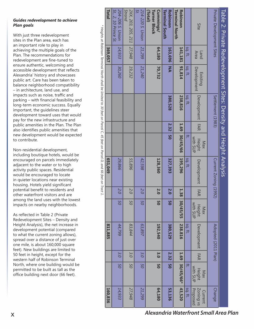
Guides redevelopment to achieve Plan goals
With just three redevelopment sites in the Plan area, each has an important role to play in achieving the multiple goals of the Plan. The recommendations for redevelopment are fine-tuned to ensure authentic, welcoming and accessible development that reflects Alexandria’ history and showcases public art. Care has been taken to balance neighborhood compatibility – in architecture, land use, and impacts such as noise, traffic and parking – with financial feasibility and long-term economic success. Equally important, the guidelines steer development toward uses that would pay for the new infrastructure and public amenities in the Plan. The Plan also identifies public amenities that new development would be expected to contribute.
Non-residential development, including boutique hotels, would be encouraged on parcels immediately adjacent to the water or to high activity public spaces. Residential would be encouraged to locate in quieter locations near existing housing. Hotels yield significant potential benefit to residents and other waterfront visitors and are among the land uses with the lowest impacts on nearby neighborhoods.
As reflected in Table 2 (Private Redevelopment Sites – Density and Height Analysis), the net increase in development potential (compared to what the current zoning allows), spread over a distance of just over one mile, is about 160,000 square feet). New buildings are limited to 50 feet in height, except for the western half of Robinson Terminal North, where one building would be permitted to be built as tall as the office building next door (66 feet).
Table 2: Private Redevelopment Sites: D
ensity and Height Analysis
Private Developm
ent Sites Settlem
ent (1983)Current Zoning (1992)
Adopted (2011 Plan)Change
SiteLand Area
Existing D
evelopment
Developm
entFAR
Max
Height
with SU
PD
evelopment
FAR M
ax H
eight w
ith SUP
Developm
ent FAR
Max
Height
with SU
P
Current Zoning vs Proposed
sq. ft.sq. ft.
sq. ft.ft.
sq. ft.sq. ft.
ft.sq. ft.
Robinson Term
inal North
141,18191,814
238,8161.69
30/45/66195,296
1.3830/45/55
238.8161.69
30/45/66*43,520
Robinson Term
inal South163,696
NA
380,5282.32
50327,393
2.050
380,5292.32
5053,136
Cumm
ings/Turner Block (Total)
64,18070,732
128,3602.0
50192,540
3.050
64,180
214-220 S. Union
St. 21,299
21,24042,598
2.050
63,8973.0
5021,299
2XX, 203, 205, 211 Strand
27,94819,232
55,8962.0
5083,844
3.050
27,948
204-206 S. Union
St., 2, 10 Prince St.14,933
30,26029,866
2.050
44,7993.0
5014,933
Total369,057
651,049811,885
160,836* H
eights at Robinson Terminal N
orth shall be limited to 30 feet on Parcel C, 45 feet on Parcel D
, and 66 feet on Tract 1.
Alexandria Waterfront Small Area Plan xi
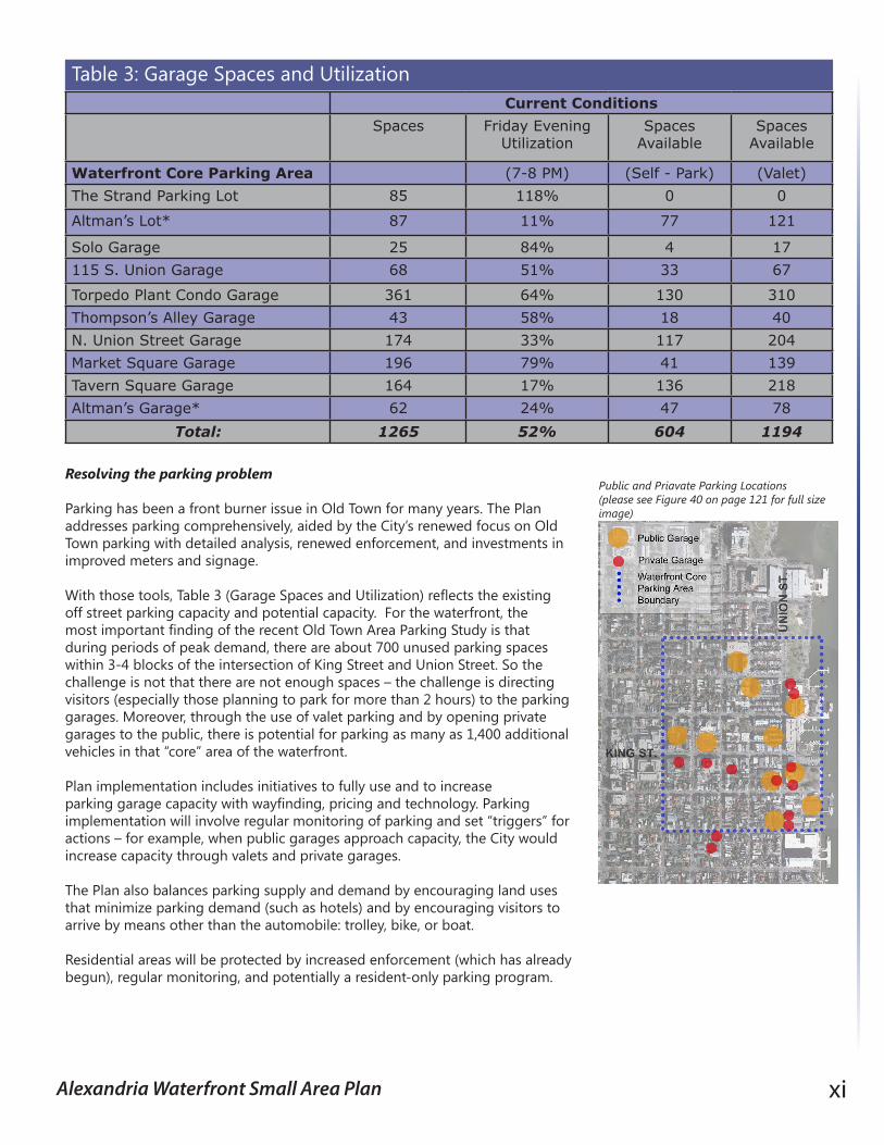
Resolving the parking problem
Parking has been a front burner issue in Old Town for many years. The Plan addresses parking comprehensively, aided by the City’s renewed focus on Old Town parking with detailed analysis, renewed enforcement, and investments in improved meters and signage.
With those tools, Table 3 (Garage Spaces and Utilization) reflects the existing off street parking capacity and potential capacity. For the waterfront, the most important finding of the recent Old Town Area Parking Study is that during periods of peak demand, there are about 700 unused parking spaces within 3-4 blocks of the intersection of King Street and Union Street. So the challenge is not that there are not enough spaces – the challenge is directing visitors (especially those planning to park for more than 2 hours) to the parking garages. Moreover, through the use of valet parking and by opening private garages to the public, there is potential for parking as many as 1,400 additional vehicles in that “core” area of the waterfront.
Plan implementation includes initiatives to fully use and to increase parking garage capacity with wayfinding, pricing and technology. Parking implementation will involve regular monitoring of parking and set “triggers” for actions – for example, when public garages approach capacity, the City would increase capacity through valets and private garages.
The Plan also balances parking supply and demand by encouraging land uses that minimize parking demand (such as hotels) and by encouraging visitors to arrive by means other than the automobile: trolley, bike, or boat.
Residential areas will be protected by increased enforcement (which has already begun), regular monitoring, and potentially a resident-only parking program.
Current Conditions
Spaces Friday Evening Utilization
Spaces Available
Spaces Available
Waterfront Core Parking Area (7-8 PM) (Self - Park) (Valet)
The Strand Parking Lot 85 118% 0 0
Altman’s Lot* 87 11% 77 121
Solo Garage 25 84% 4 17
115 S. Union Garage 68 51% 33 67
Torpedo Plant Condo Garage 361 64% 130 310
Thompson’s Alley Garage 43 58% 18 40
N. Union Street Garage 174 33% 117 204
Market Square Garage 196 79% 41 139
Tavern Square Garage 164 17% 136 218
Altman’s Garage* 62 24% 47 78
Total: 1265 52% 604 1194
Table 3: Garage Spaces and Utilization
Public and Priavate Parking Locations (please see Figure 40 on page 121 for full size image)
xii Alexandria Waterfront Small Area Plan
Improving environmental conditions
Alexandria’s industrial past has left a legacy that includes pollutants in the soil and in the riverbed. In addition, as in many of the country’s oldest cities, Old Town has combined sanitary and storm sewers that have the potential to overflow into the river during rain events. Flooding is a recurring issue in The Strand area; a two phased solution to the most frequent flooding is included in the Plan.
The City is addressing in-soil contaminants near the foot of Oronoco Street through the use of biosparging technology, while the separation of the sanitary and storm sewers is expensive and long-term. The Plan recognizes these efforts and also addresses flooding by integrating mitigation measures into structures and landscaping. The Plan recommends replacing rip-rap with a more natural shoreline including native plants wherever possible.
Practical and educational initiatives include a series of floating “islands” of water-cleansing plants in Oronoco Bay, as well as the re-creation of a marsh once known as “Ralph’s Gutt” that will also assist in cleansing stormwater runoff.
Practical, cost-conscious, and pays for itself
Throughout the planning process, concerns were raised that the Plan would call for public expenditures that the City could not afford. The Plan addresses this concern by keeping proposed expenditures well within what can be supported by net revenues from new development.
The recommendations in the Plan are estimated to cost $51 million, of which $6.5 million is for flood mitigation. Improved or new bulkheads, along with completing the waterside esplanade, are estimated at $4 to $6 million, with the remainder for improvements to the Marina area and to parks and public spaces from Windmill Hill Park to the Tide Lock.
Revenue estimates were based upon four potential sources of new revenues: the real property taxes on new development, the meals taxes from new restaurants, the lodging taxes from new hotel rooms, and the sales taxes on both the restaurants and hotels. Waterfront improvements are likely to spin off additional economic benefits but these were not included in the analysis and summary, which shows that the Plan could “pay for itself.”
Public spending on parks, flood mitigation, and other benefits can occur after private development (to ensure that tax revenues precede public expenditures - emphasizing fiscal discipline), or they can proceed before private development to ensure that the public benefits come in a timely manner and to encourage higher quality private development. A key aspect of the Plan is that there is significant flexibility as to when the public investments are made.
A plan to complete the final chapter of the Waterfront’s transformation
The Plan reaffirms Alexandria’s commitment to this precious resource. It seeks to continue the remarkable achievement of reclaiming the City’s waterfront for itself and for the country. Not so many decades ago, it took people of tremendous vision to imagine a waterfront dedicated to public enjoyment instead of industrial production. Today, the results of their efforts are clearly evident, enjoyed daily, and the source of great pride.
The transformation of the waterfront over the past four decades was the result of Alexandrians making great plans and working together to achieve them. At each step, the plans aimed high, and it was never certain that every goal could or would be achieved. That’s always true, to some extent, of any long range plan. So it is clear that the heroes of waterfront’s decades-long transformation were more than visionary.
This Plan continues that tradition since it is the collective product of Alexandrians applying their knowledge, understanding, experience, history, and ideas toward the goal of completing the final chapter in the transformation of the waterfront. This Plan is Alexandrian because the key elements of the Plan come from Alexandrians.
NoteThe illustrative figures in this summary as well as the illustrative figures throughout the Plan should not be construed as final development schemes. They communicate intent. Further design, engineering and planning, and construction-related study will be required for each sub-area design as part of the implementation process.
Alexandria Waterfront Small Area Plan 1
A Waterfront Introduction1

Alexandria Waterfront Small Area Plan 3
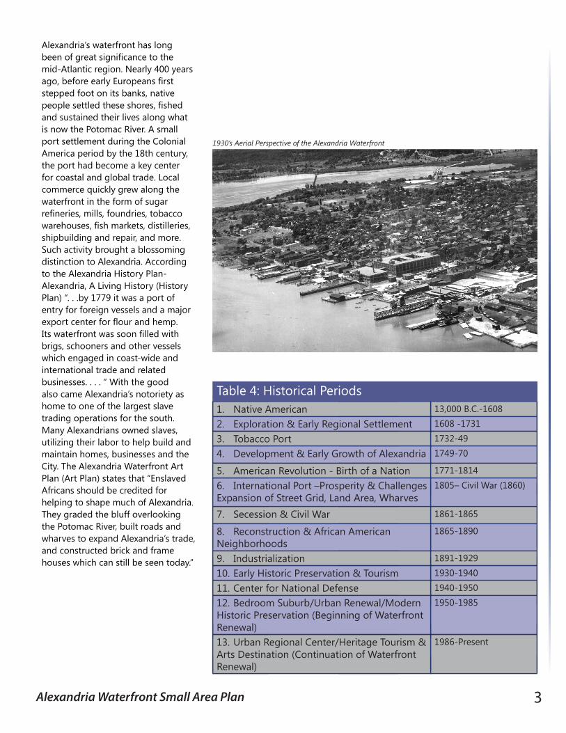
Alexandria’s waterfront has long been of great significance to the mid-Atlantic region. Nearly 400 years ago, before early Europeans first stepped foot on its banks, native people settled these shores, fished and sustained their lives along what is now the Potomac River. A small port settlement during the Colonial America period by the 18th century, the port had become a key center for coastal and global trade. Local commerce quickly grew along the waterfront in the form of sugar refineries, mills, foundries, tobacco warehouses, fish markets, distilleries, shipbuilding and repair, and more. Such activity brought a blossoming distinction to Alexandria. According to the Alexandria History Plan-Alexandria, A Living History (History Plan) “. . .by 1779 it was a port of entry for foreign vessels and a major export center for flour and hemp. Its waterfront was soon filled with brigs, schooners and other vessels which engaged in coast-wide and international trade and related businesses. . . . “ With the good also came Alexandria’s notoriety as home to one of the largest slave trading operations for the south. Many Alexandrians owned slaves, utilizing their labor to help build and maintain homes, businesses and the City. The Alexandria Waterfront Art Plan (Art Plan) states that “Enslaved Africans should be credited for helping to shape much of Alexandria. They graded the bluff overlooking the Potomac River, built roads and wharves to expand Alexandria’s trade, and constructed brick and frame houses which can still be seen today.”
Alexandria Waterfront Historical Periods:1. Native American 13,000 B.C.-1608
2. Exploration & Early Regional Settlement 1608 -1731
3. Tobacco Port 1732-49
4. Development & Early Growth of Alexandria 1749-70
5. American Revolution - Birth of a Nation 1771-1814
6. International Port –Prosperity & Challenges Expansion of Street Grid, Land Area, Wharves
1805– Civil War (1860)
7. Secession & Civil War 1861-1865
8. Reconstruction & African American Neighborhoods
1865-1890
9. Industrialization 1891-1929
10. Early Historic Preservation & Tourism 1930-1940
11. Center for National Defense 1940-1950
12. Bedroom Suburb/Urban Renewal/Modern Historic Preservation (Beginning of Waterfront Renewal)
1950-1985
13. Urban Regional Center/Heritage Tourism & Arts Destination (Continuation of Waterfront Renewal)
1986-Present
Table 4: Historical Periods
1930’s Aerial Perspective of the Alexandria Waterfront
4 Alexandria Waterfront Small Area Plan
In the 18th and 19th centuries, Alexandria found itself serving a strategic role in several major wars, including the French and Indian Wars, the Revolutionary War, the War of 1812, and the Civil War. It was not only its designation as a key trading port that made it a significant location during these conflicts, but it was its close proximity to strategic points in the North and South. Following these conflicts, Alexandria was able to continue to prosper as a seaport, except for the Civil War; the impacts of that event were so overwhelming that it was difficult for the area to fully recover.
As the 20th century emerged, Alexandria’s waterfront transitioned towards industrial use, and later, became a critical national defense center. During the latter part of the century, the City and the area around it experienced rapid growth as a metropolitan center. With that change, the industrial buildings and uses were replaced with housing, parks and open space. While the area has transformed into a destination for residents and visitors alike to enjoy, there are still opportunities to enhance it by further building on the history and character of the past and incorporating activities and elements that can help sustain its future. Table 4 is a summary of general historic time periods of Alexandria’s history:
In addition to recognizing the importance of these periods, the City requested and received two white papers from the history and art communities as part of the planning process for the Waterfront Small Area Plan (Plan). Both documents, referenced above, are included as addenda to this Plan and their recommendations will be utilized to help shape the implementation process through the use of historic preservation, interpretative tools, cultural and historic programming, public art and related creative resources. The History Plan was produced by a committee organized by the Alexandria Archaeological Commission. The Art Plan was produced by the Public Art Subcommittee of the Commission on the Arts.
Recognizing and embracing the core components of these documents, the Plan seeks to, as it has been eloquently stated in the History Plan, create a vision for the waterfront in which “real people and their daily lives, as well as witnesses to history, form the core of the physical representation of history and programming for the waterfront.”
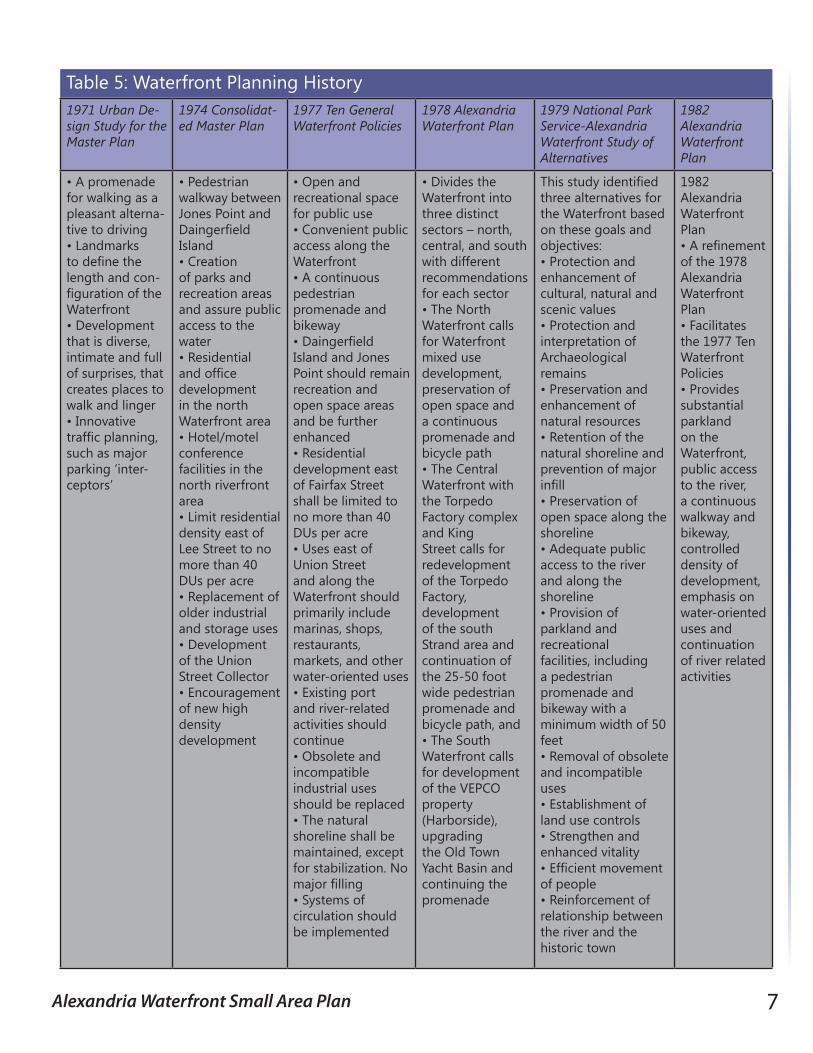
Waterfront Planning History
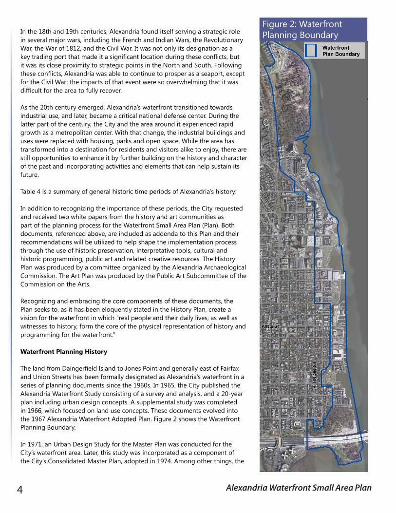
The land from Daingerfield Island to Jones Point and generally east of Fairfax and Union Streets has been formally designated as Alexandria’s waterfront in a series of planning documents since the 1960s. In 1965, the City published the Alexandria Waterfront Study consisting of a survey and analysis, and a 20-year plan including urban design concepts. A supplemental study was completed in 1966, which focused on land use concepts. These documents evolved into the 1967 Alexandria Waterfront Adopted Plan. Figure 2 shows the Waterfront Planning Boundary.
In 1971, an Urban Design Study for the Master Plan was conducted for the City’s waterfront area. Later, this study was incorporated as a component of the City’s Consolidated Master Plan, adopted in 1974. Among other things, the
Figure 2: Waterfront Planning Boundary
Alexandria Waterfront Small Area Plan 5
Consolidated Master Plan replaced previous waterfront planning documents and served as the new guide for the waterfront. Included in the plan was an outline for future redevelopment.
Three years later, in April of 1977, Alexandria’s City Council adopted ten general waterfront policies to guide planning. These policies evolved into the draft Alexandria Waterfront Plan, published in 1978. The Alexandria Waterfront Plan divided the study area into three sections: North Waterfront, Central Waterfront, and South Waterfront. Each section was given different recommendations. Due to the proximity to the District of Columbia; land-ownership disputes between local, federal, and private entities; and the historic nature of the area, the National Park Service of the U.S. Department of Interior drafted an Alexandria Waterfront Study of Alternatives in August of 1979. After the publishing of this document, the City and the National Park Service began to collaborate in the waterfront planning process.
Jones Point Park Illustrative Plan
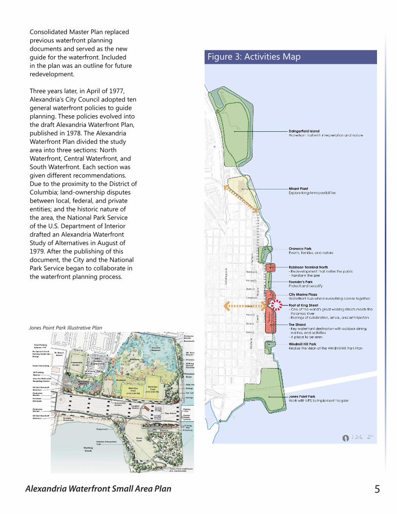
Figure 3: Activities Map
6 Alexandria Waterfront Small Area Plan
In 1982, the City adopted the 1982 Alexandria Waterfront Plan, which updated the previous Alexandria Waterfront Plan and defined the waterfront even further. Breaking the previously delineated three sections into five areas: Jones Point, South Waterfront, Urban Waterfront Core, Founders Park and Oronoco Bay, and North Waterfront, the 1982 Plan successfully combined the previous planning efforts and provided direction on specific areas along the waterfront. Many of the goals in all the above plans are consistent, such as:
u Promotion of public access along the waterfront; u Multi-modal connectivity along the waterfront, particularly for pedestrians
and cyclists; u Creation of parks and open space and the linkage of those amenities; and u Redevelopment of obsolete sites and development of a mix of uses to
promote an active waterfront with a diversity of activities.
Many goals have since been achieved or remain underway, such as
u 2010-2012 Jones Point park planned improvements; u Pedestrian bicycle trails; u Torpedo Factory redevelopment; u Founders Park improvements; u Oronoco Bay development; u Alexandria Public Schools Rowing Facility relocation; u Restoration of the Alexandria Canal Tidal Lock; u Daingerfield Island improvements; and u Acquisition of priority public open space fronting the Potomac River.
The above prior planning efforts and goals have been summarized in Table 5. The City’s Open Space Master Plan, which was adopted in 2003 and seeks to enhance and grow the City’s open space network through a strategic framework of 15 goals, is also a related component of the waterfront’s planning history. The Open Space Plan includes reference to multiple waterfront properties and states a goal of reviewing and completing implementation of the Potomac River Waterfront Plan, which this Plan replaces. Many of the Open Space Plan’s other goals fall in harmony with the goals of this Plan, and the two plans are complimentary in terms of preserving and enhancing public open space. For example, the Open Space Plan’s goal of “expanding, enhancing, and maintaining public access and spaces” is fully endorsed and buttressed by the goals identified in this Plan.
The City’s Comprehensive Transportation Master Plan, adopted in 2008, envisions a multimodal transportation system which reduces automobile dependence and puts more emphasis on transit-oriented, pedestrian friendly development. The Old Town Area Parking Study has been another transportation related analysis aiding in the waterfront planning process. The study, completed in February 2010, analyzed parking utilization in Old Town. This Plan’s intent for transportation is in keeping with the goals of the Comprehensive Transportation Master Plan, and seeks to achieve a well-planned transportation future for the City’s waterfront. This Plan is informed greatly by the work of both the Old Town Area Parking Study and Comprehensive Transportation Master Plan.
Ford’s Landing Promenade
Tide Lock Looking West
Alexandria Waterfront Small Area Plan 7
1971 Urban De-sign Study for the Master Plan
1974 Consolidat-ed Master Plan
1977 Ten General Waterfront Policies
1978 Alexandria Waterfront Plan
1979 National Park Service-Alexandria Waterfront Study of Alternatives
1982 Alexandria Waterfront Plan
• A promenade for walking as a pleasant alterna-tive to driving• Landmarks to define the length and con-figuration of the Waterfront • Development that is diverse, intimate and full of surprises, that creates places to walk and linger• Innovative traffic planning, such as major parking ‘inter-ceptors’
• Pedestrian walkway between Jones Point and Daingerfield Island• Creation of parks and recreation areas and assure public access to the water • Residential and office development in the north Waterfront area• Hotel/motel conference facilities in the north riverfront area• Limit residential density east of Lee Street to no more than 40 DUs per acre• Replacement of older industrial and storage uses• Development of the Union Street Collector • Encouragement of new high density development
• Open and recreational space for public use• Convenient public access along the Waterfront• A continuous pedestrian promenade and bikeway • Daingerfield Island and Jones Point should remain recreation and open space areas and be further enhanced• Residential development east of Fairfax Street shall be limited to no more than 40 DUs per acre• Uses east of Union Street and along the Waterfront should primarily include marinas, shops, restaurants, markets, and other water-oriented uses• Existing port and river-related activities should continue• Obsolete and incompatible industrial uses should be replaced • The natural shoreline shall be maintained, except for stabilization. No major filling• Systems of circulation should be implemented
• Divides the Waterfront into three distinct sectors – north, central, and south with different recommendations for each sector• The North Waterfront calls for Waterfront mixed use development, preservation of open space and a continuous promenade and bicycle path• The Central Waterfront with the Torpedo Factory complex and King Street calls for redevelopment of the Torpedo Factory, development of the south Strand area and continuation of the 25-50 foot wide pedestrian promenade and bicycle path, and• The South Waterfront calls for development of the VEPCO property (Harborside), upgrading the Old Town Yacht Basin and continuing the promenade
This study identified three alternatives for the Waterfront based on these goals and objectives:• Protection and enhancement of cultural, natural and scenic values• Protection and interpretation of Archaeological remains• Preservation and enhancement of natural resources• Retention of the natural shoreline and prevention of major infill• Preservation of open space along the shoreline• Adequate public access to the river and along the shoreline• Provision of parkland and recreational facilities, including a pedestrian promenade and bikeway with a minimum width of 50 feet• Removal of obsolete and incompatible uses• Establishment of land use controls • Strengthen and enhanced vitality • Efficient movement of people• Reinforcement of relationship between the river and the historic town
1982 Alexandria Waterfront Plan • A refinement of the 1978 Alexandria Waterfront Plan• Facilitates the 1977 Ten Waterfront Policies• Provides substantial parkland on the Waterfront, public access to the river, a continuous walkway and bikeway, controlled density of development, emphasis on water-oriented uses and continuation of river related activities
Table 5: Waterfront Planning History
8 Alexandria Waterfront Small Area Plan
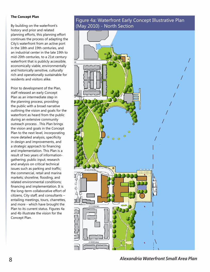
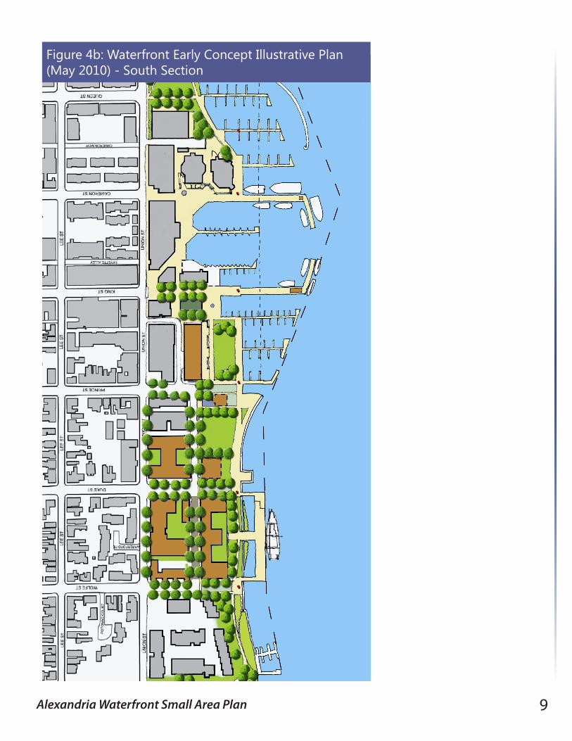
The Concept Plan
By building on the waterfront’s history and prior and related planning efforts, this planning effort continues the process of adapting the City’s waterfront from an active port in the 18th and 19th centuries, and an industrial center in the late 19th to mid-20th centuries, to a 21st century waterfront that is publicly accessible, economically viable, environmentally and historically sensitive, culturally rich and operationally sustainable for residents and visitors alike.
Prior to development of the Plan, staff released an early Concept Plan as an intermediate step in the planning process, providing the public with a broad narrative outlining the vision and goals for the waterfront as heard from the public during an extensive community outreach process . This Plan brings the vision and goals in the Concept Plan to the next level, incorporating more detailed analysis, specificity in design and improvements, and a strategic approach to financing and implementation. This Plan is a result of two years of information-gathering; public input; research and analysis on critical technical issues such as parking and traffic; the commercial, retail and marina markets; shoreline, flooding, and related environmental conditions; financing and implementation. It is the long-term collaborative effort of citizens, City staff, and consultants – entailing meetings, tours, charrettes, and more - which have brought the Plan to its current status. Figures 4a and 4b illustrate the vision for the Concept Plan.
Figure 4a: Waterfront Early Concept Illustrative Plan (May 2010) - North Section
Alexandria Waterfront Small Area Plan 9
Figure 4b: Waterfront Early Concept Illustrative Plan (May 2010) - South Section
10 Alexandria Waterfront Small Area Plan
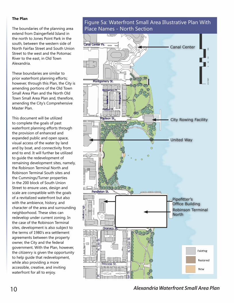
The Plan
The boundaries of the planning area extend from Daingerfield Island in the north to Jones Point Park in the south, between the western side of North Fairfax Street and South Union Street to the west and the Potomac River to the east, in Old Town Alexandria.
These boundaries are similar to prior waterfront planning efforts; however, through this Plan, the City is amending portions of the Old Town Small Area Plan and the North Old Town Small Area Plan and, therefore, amending the City’s Comprehensive Master Plan.
This document will be utilized to complete the goals of past waterfront planning efforts through the provision of enhanced and expanded public and open space, visual access of the water by land and by boat, and connectivity from end to end. It will further be utilized to guide the redevelopment of remaining development sites, namely, the Robinson Terminal North and Robinson Terminal South sites and the Cummings/Turner properties in the 200 block of South Union Street to ensure uses, design and scale are compatible with the goals of a revitalized waterfront but also with the ambience, history, and character of the area and surrounding neighborhood. These sites can redevelop under current zoning. In the case of the Robinson Terminal sites, development is also subject to the terms of 1980’s era settlement agreements between the property owner, the City and the federal government. With the Plan, however, the citizenry is given the opportunity to help guide that redevelopment, while also providing a more accessible, creative, and inviting waterfront for all to enjoy.
City Rowing Facility
Canal Center
Robinson Terminal North
Pipefitter’s Office Building
United Way
Figure 5a: Waterfront Small Area Illustrative Plan With Place Names - North Section
Alexandria Waterfront Small Area Plan 11
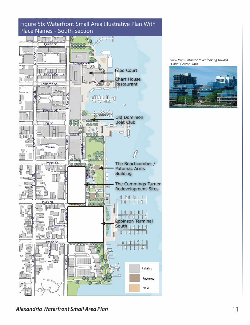
The Beachcomber / Potomac Arms Building
Food Court
Chart House Restaurant
Old Dominion Boat Club
The Cummings-TurnerRedevelopment Sites
Robinson Terminal South
View from Potomac River looking toward Canal Center Plaza
Figure 5b: Waterfront Small Area Illustrative Plan With Place Names - South Section

12 Alexandria Waterfront Small Area Plan
As noted under the Concept Plan section, the planning process for this Plan incorporates extensive information-gathering, public input and technical analysis.
The Plan is organized into chapters and appendices. Chapter 2 - Goals and Area-wide Systems describes the vision and goals for the Plan and the critical area-wide systems needed to help the area function adequately; Chapter 3 – Character Areas and Themes describes existing conditions of each subarea and recommendations for enhancements, improvements and in the case of the development sites, recommendations for development guidelines and a proposed zoning text amendment; this chapter also includes information on how art and history are integrated into the areas based on recommendations of the art and history white papers with particular emphasis on a cultural theme for each area, the Art Walk, and how a History Museum helps establish a cultural anchor in the southern core; Chapter 4- Transportation, Circulation and Parking describes the area’s multi-modal transportation and circulation systems and recommendations for anticipating and addressing potential impacts, including vehicular and pedestrian congestion; addressing handicapped accessibility; and also addressing parking by including a parking inventory and a parking management strategy to ensure adequate parking remains available throughout the implementation of the Plan; and Chapter 5 – Implementation describes recommendations for implementation of the Plan and the projected costs and revenues associated with the implementation process. The appendices include: Appendix 1 – Community Participation Process; Appendix 2 – Jurisdictional Notes and settlement agreements; Appendix 3 – Hotel Technical Memorandum; Appendix 4 – Marina Market Assessment Data; Appendix 5 – Alexandria Waterfront Art Plan; Appendix 6 - Alexandria History Plan - Alexandria, A Living History.
Finally, since the Concept Plan, the City has received various comments regarding the restaurant building once proposed for Waterfront Park. The building has been eliminated from the Plan.