ali boom article published 2013 09
TRANSCRIPT
hadley and peter arnold
Pivot: Reconceiving Water Scarcityas Design Opportunity
Mapping a more absorbent landscape
T hirty million people in the American West depend on snowmelt to grow food,
slake their thirst, and run their towns, cities, and industries. Twenty-two
million of them live in Southern California. As in many parts of the world,
western water supplies are over-allocated and populations are growing. Increasing
variability in precipitation—the primary impact of climate change on the hydrologic
cycle—exacerbates the stress: longer droughts, less snowpack, and earlier snowmelt
are already observable. Current climate models estimate that 70 percent of western
snowpack will be gone by 2100.
Water scarcity presents a profound challenge and opportunity for designers of the
built environment. The questions reach beyond, where do we get more water? And
how do we make do with less? Or even how do we build margins of water security into
our cities or restore damaged ecoystems in our source ranges and valleys? These are
critical questions engaging vast fields of engineers, economists, environmentalists,
and policymakers. But the answers do not all lie in policy or technology. For designers,
the questions are physical, spatial, qualitative, and experiential—fully vested in the
BOOM: The Journal of California, Vol. 3, Number 3, pps 95–101, ISSN 2153-8018, electronic ISSN 2153-764X.
© 2013 by the Regents of the University of California. All rights reserved. Please direct all requests for
permission to photocopy or reproduce article content through the University of California Press’s Rights and
Permissions website, http://www.ucpressjournals.com/reprintInfo.asp. DOI: 10.1525/boom.2013.3.3.95.
BOOM | F A L L 2 0 1 3 95
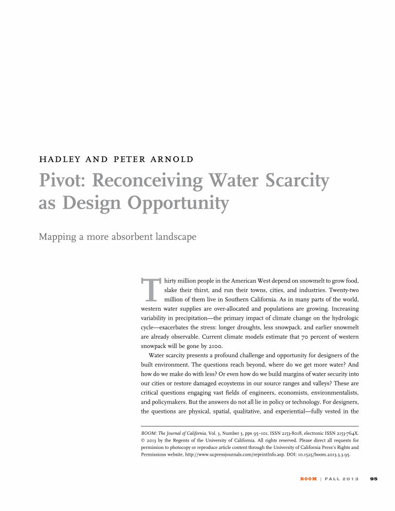
Mapping the Los Angeles Aqueduct. MAP COURTESY OF ARID LANDS INSTITUTE, CESIA LOPEZ AND ERIC LADOUCEUR.

knowledge that space and place matter. How do we craft
cities and buildings that consciously and visibly mitigate,
anticipate, and even celebrate, hydrologic variability? How
would architectural systems, building codes, and zoning
laws have to change? What shape would neighborhoods,
architecture, and the urban experience take if design fully
recognized and exploited the challenges of water scarcity?
Los Angeles provides the quintessential test-bed for
answering some of these questions: a progressive, diverse,
global city with an intense concentration of creative capital
and widespread public recognition of urgent water chal-
lenges ahead. Drylands design innovation in Los Angeles
has the potential to benefit not only the city’s residents and
ecosystems, but those of its broader watershed, a watershed
created by epic engineering, stretching from the Sierra Nevada
to the Rockies. Even if Los Angeles cannot wean itself entirely
from water imports, can drylands design reduce depen-
dence and lighten the city’s impacts on the communities
and ecosystems drained by the metropolis? Can design that
exploits local urban water more effectively help Los Angeles
and the Owens Valley renegotiate a shared water future?
At the Arid Lands Institute at Woodbury University, our
goal is to catalyze drylands design leadership for public
benefit, challenging design professionals and educators to
marry exacting quantitative data with compelling design
vision. With the support of the Metropolitan Water District
of Southern California and the World Water Forum, we
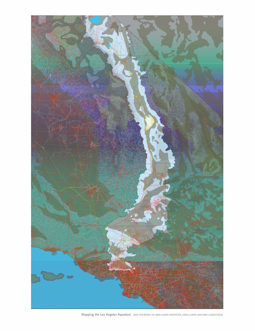
recently developed a high-resolution geospatial model to
strategically identify and quantify the potential for improv-
ing stormwater capture within urban areas. Our modeling
project, ‘‘Where is it? Let’s reuse it,’’ was designed as
a riposte to William Mulholland’s famously callous remark
upon opening the spigot of the LA Aqueduct in 1913, ‘‘There
it is. Take it.’’ The research recognizes that maximizing
recovery and reuse of rain and stormwater will be central
to establishing a robust localized water portfolio for any
drylands city seeking to buffer the effects of climate change.
Within the Metropolitan Water District’s service area in
Southern California, an estimated average of 1 million acre-
feet of stormwater runs off from valley floors each year. Less
than half is captured in spreading basins or other facilities
for groundwater recharge: 520,000 acre-feet of unused
stormwater is sent as discharge to the Pacific Ocean each
year, enough to support 500,000 families at current usage
rates with no conservation measures in place. 1 The Met, as
the water district is also known, estimates that urban storm-
water and recycled municipal supplies combined with
increased efficiency could meet up to 82 percent of Los
Angeles’ water demand.2 The challenge for us was to iden-
tify exactly where stormwater can be harvested and with
what results.
Our Arid Lands Institute model focuses on one water-
shed within the larger Los Angeles basin: the Upper Los
Angeles River Watershed Area, also known as the San
Fernando Valley. The model builds on a foundational
groundwater augmentation model developed by the US
Department of Interior, Bureau of Reclamation, and Coun-
cil for Watershed Health. But our model takes a finer-grain
approach. We model the valley at the scale of rooftops,
roads, curbs, parking lots, concrete, asphalt, and compacted
earthen materials, and analyze three critical datasets and
constraint layers. We model surface runoff as a function
of precipitation rates and the permeability of different sur-
faces. Then we model soil types and conditions to under-
stand how much water can move through the soil and where
it is susceptible to liquefaction. Finally, we map the location
of constraints on storing water in groundwater aquifers:
groundwater contamination, the movement of plumes of
contamination in the groundwater, where contaminated
water is pumped out for treatment, and known under-
ground chemical storage tanks that are leaking or could leak
in the future. Putting the three layers together one on top of
the other gives us an understanding of how water moves
through the basin: where it comes from, where it’s going, at
what rate and volume. Soil types and conditions tell us
where water can percolate into the ground. And the con-
straint layer tells us where it is not a good idea to add water
to groundwater aquifers.
Our model suggests that around 92,000 acre-feet of
stormwater runoff could be harvested in the San Fernando
Can design help Los Angeles and the Owens
Valley renegotiate a shared water future?
BOOM | F A L L 2 0 1 3 97
Valley, enough to sustain almost 100,000 households at
current usage rates. That number has a certain poignancy
in the larger context of California’s contested water systems:
it is nearly identical to the amount of water that the Los
Angeles Department of Water and Power is currently
required to use to keep harmful dust from blowing off of
Owens Lake, desiccated in part by LA’s thirst.
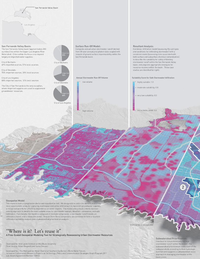
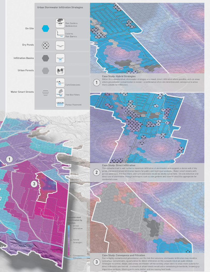
More importantly, the model can guide our efforts to
capture local water in precisely identified zones by applying
particular landscape design strategies. Neighborhood by
neighborhood, street by street, lot by lot, the model tells
us where effort and investment are best targeted for specific
hydrologic functions using low-impact best management
practices such as vegetated swales to slow and direct the
movement of stormwater runoff, detention basins to store
water, and urban forests to absorb water. Notably, the model
clearly tells us that ‘‘infiltrate everywhere’’ is not an advis-
able strategy. Some parts of the valley are appropriate for
capturing and storing water. Others will work well for mov-
ing water from one place to another. Some areas could filter
water. Others could be used to allow the water to percolate
into the groundwater aquifers in the valley. And others—
particularly where groundwater is contaminated—should
be avoided until they are cleaned up.
Data-rich modeling has the potential to inspire compel-
ling, high-performance, cost-effective design strategies for
transforming the city. As Los Angeles embarks on a compre-
hensive redrafting of its 1946 zoning laws, our model offers
new planning elements and parameters for twenty-first-
century drylands urbanism. In partnership with collabora-
tors in the public, private, and academic sectors, the Arid
Lands Institute is inviting multidisciplinary design teams to
take up these findings and envision a new climate-adapted
LA. The challenge could yield new ways of organizing
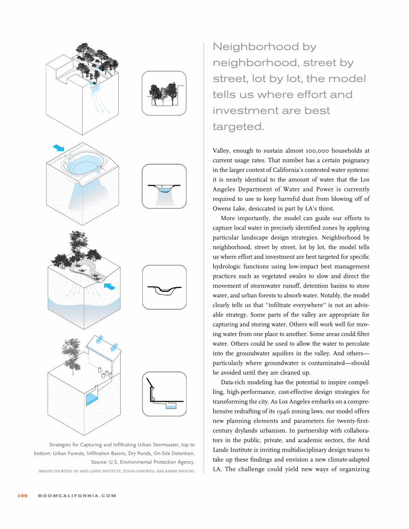
Strategies for Capturing and Infiltrating Urban Stormwater, top to
bottom: Urban Forests, Infiltration Basins, Dry Ponds, On-Site Detention.
Source: U.S. Environmental Protection Agency.
IMAGES COURTESY OF ARID LANDS INSTITUTE, ETHAN DINGWELL AND KARIM SNOUSSI.
Neighborhood by
neighborhood, street by
street, lot by lot, the model
tells us where effort and
investment are best
targeted.
100 B O O M C A L I F O R N I A . C O M

metropolitan landscapes, and the infrastructure, architec-
ture, and agriculture that support them—not just in LA
but around the world. Los Angeles could lead the way in
creating localized models for living with water scarcity. To
do so will require design intelligence rooted in science and
design vision as a catalyst for the public imagination. B
Notes
1 Metropolitan Water District of Southern California Blue Ribbon
Committee, Developing New Water Options for Southern Califor-
nia, 8 April 2011, 126.2 Metropolitan Water District of Southern California, Final Report
of the Blue Ribbon Committee, 12 April 2011.
BOOM | F A L L 2 0 1 3 101