alternatives analysis report - montana department of ... · this alternatives analysis report...
TRANSCRIPT

ALTERNATIVES ANALYSIS REPORT
TOSTON STRUCTURES
OCTOBER 2014

TOSTON STRUCTURES • MORRISON-MAIERLE • 1
ALTERNATIVES ANALYSIS REPORT
Introduction:The Toston Structures project was nominated to reconstruct US 287 between the recently completed Townsend-South Passing Lanes project and the on-going the Toston-South project. The existing bridges over the Missouri River and the Montana Rail Link railroad tracks will be removed and replaced, either with two new structures, or a single structure, depending on which corridor identified in the Toston Missouri River Crossing Corridor Study dated February 2011 is selected.
This alternatives analysis report evaluates an alignment within each of two corridors, the central and eastern, identified in the pre-NEPA/MEPA Corridor Study (see Figure 6-4). The outcome of this alternatives analysis will be the selection of a single alignment for further design development.
The two alignments are identical from the project beginning at Reference Point (RP) 85.9 to RP 87.4, after which the alignments diverge. The alignments then converge at RP 89.2, once again being identical to the end of the project at RP 89.3
BackgroundUS Highway 287 is an important state highway connecting Three Forks and Interstate 90 to Helena, Montana, and surrounding communities. The segment of US Highway 287 between Reference Posts 85.9 and 89.3 in Broadwater County is inadequate for future traffic volumes and desired operating characteristics. The existing roadway is over 70 years old and does not meet current geometric design standards as outlined in MDT’s Road Design Manual. In a recent 5-year period, this segment of the corridor had higher crash and severity rates than the statewide averages for similar highways. In addition, the bridge over the BNSF/Montana Rail Link railroad tracks is functionally obsolete and nearing the end of its useful life.
The purpose of the proposed Toston Structures project is to improve highway traffic safety, functionality, and operations on this segment of US Highway 287 to accommodate existing and future traffic demands for the diverse nature of traffic on the corridor, and to cost-effectively improve the physical conditions of the roadway surface and bridge structures. Reconstructing the roadway is needed to bring this section of U.S. Highway 287 up to the contemporary geometric design criteria applicable to this National Highway System route. This project also needs to replace the existing bridges on this segment with new structures that will be functional over their 75-year design life.
More specifically, the purpose of this project is to continue highway widening improvements from the end of the Townsend-South Passing Lanes project through the Toston area to efficiently connect with the highway improvements designed for the Toston-South project with a highway crossing over the Missouri River.
To accomplish this purpose, specific project elements must include:
1. Designing new bridges to a minimum of 4-lane (64 feet) width;2. Constructing horizontal and vertical curves to applicable MDT design criteria;3. Constructing slopes to applicable MDT design criteria;4. Improving the geometric layout at major intersections to reduce traffic conflicts and crashes;5. Improving safety for through traffic;6. Improving the driving surface; 7. Replacing all existing culverts, structures and bridges;8. Maintaining the grade separation between the highway and the railroad tracks;9. Maintaining access to the community of Toston and adjoining properties; 10. Incorporating physical changes to the roadway and its adjoining environment so the highway’s design complies
with MDT’s geometric design criteria for Rural Principal Arterials;11. Preserving railroad operations during construction; and12. Maintaining traffic flow on Highway 287 during construction.

TOSTON STRUCTURES • MORRISON-MAIERLE • 2
TOSTON STRUCTURES • MORRISON-MAIERLE • 3
Evaluation CriteriaIn order to objectively evaluate the two subject alignments, a number of design-related criteria have been identified:
• Horizontal curves and superelevation rates• Maximum vertical grades• Sight distance considerations• Earthwork volumes and distribution• Special soils considerations• Hydraulics, irrigation, and floodplain considerations• Traffic operations considerations• Bridge considerations• Right-of-way acquisition areas and impacts• Utilities conflicts • Railroad considerations• Environmental considerations, specifically screening-level impacts to
• terrestrial resources• aquatic resources• species of concern• threatened & endangered species • wetlands • cultural resources• 4(f) impacts• farmlands • noise impacts• public opinion• hazardous materials
• Preliminary project cost estimatesSide by side comparisons of these criteria are presented on the following pages.
Additional, more detailed information can be found in the various technical reports and engineering drawings that have been prepared to document the project conditions.

TOSTON STRUCTURES • MORRISON-MAIERLE • 4
Criteria:1) HORIZONTAL CURVES / SUPERELEVATION RATES
Central Corridor:1. Curves to Left & Right Radii = 2,550’ to 7,700’
Superelevation range = 3% to 8% Length in curves = 3,500’ to 4,000’
Eastern Corridor:1. Curves to Left & Right Radii = 1,950’ to 4,000’
Superelevation range = 6% to 8% Length in curves = 8,500’ to 9,000’
Discussion:The alignments identified within both corridors conform to the geometric design criteria in the Montana Department of Transportation Road Design Manual for Rural Principal Arterials (National Highway System – Non Interstate). Specifically, the horizontal curve radii and corresponding superelevation rates for each curve accommodates the design speed of 70 miles per hour.
The alignments were selected to be fully contained within the identified corridors, balance the various roadway design-related factors addressed in this report, and meet the Department’s design criteria.
ALTERNATIVES ANALYSIS REPORT
Facts:

TOSTON STRUCTURES • MORRISON-MAIERLE • 5
Criteria:2) MAXIMUM VERTICAL GRADES
Central Corridor:2.5% to 2.6%
Eastern Corridor:2.6% to 2.7%
Discussion:The Toston Structures project lies within level terrain. However, two primary grade controls exist for both corridors. The first requirement is to provide adequate clearance over the Montana Rail Link railroad tracks; the second is to provide adequate freeboard over the Missouri River. Both measures of “adequate” are well defined in the Department’s Structures Manual and Hydraulic Design Manual, respectively. Of these, clearance over the railroad tracks governs the vertical profiles in both corridors.
On the central corridor, there is approximately 900’ of lateral separation between the railroad tracks and the east bank of the Missouri River. On the eastern corridor, the lateral clearance is approximately 50’. With the greater separation on the central corridor, the road gradient between the tracks and the river “lowers” the river bridge. The resulting freeboard over the Missouri River, i.e. height of the structure over water, is approximately 17’ less with the central alignment when compared to the eastern.
Secondary grade controls involve crossings of local roads, irrigation canals & ditches, and other major drainage features. The eastern corridor is more affected by these secondary controls, as two crossings of the Broadwater-Missouri East Canal are necessary.
The maximum grades within each corridor are effectively the same, and represent the approach grades to the bridges. The grades were chosen to be less than 3%, which is considered the critical grade for vehicle operations on snow or ice covered roadways.
ALTERNATIVES ANALYSIS REPORT
Facts:

TOSTON STRUCTURES • MORRISON-MAIERLE • 6
Criteria:3) SIGHT DISTANCE CONSIDERATIONS
Central Corridor:Southbound stopping sight distance may be limited to approximately 55 mph in the lane closest to the shoulder in the area of the MRL bridge.
Eastern Corridor:70 mph stopping sight distance provided throughout.
Discussion:Stopping sight distance is the sum of the distance traveled at speed while a driver perceives and reacts to the need to stop, plus the distance traveled while braking to a full stop. At a design speed of 70 miles per hour, stopping sight distance is 730’. Sight obstructions on a rural highway in level terrain are generally associated with guardrail / bridge rail protection at bridges on or near horizontal curves. This situation exists on both corridors.
In order to evaluate stopping sight distance, the line of sight from the middle of the lane adjacent to the shoulder (Lane 1) at an eye height of 3.5’ is projected out to an object at a height of 2.0’, also in the middle of Lane 1. The line of sight was reviewed in both the plan and profile for both corridors where applicable, taking into account superelevation of the roadway.
For both corridors, the line of sight passes behind the guardrail/bridge rail, i.e. outside of the bridge, and involves looking over the rail in two places. A line of sight drawn in front of the rail provides stopping sight distance in the 55 mph range.
For southbound vehicles on the central corridor, sight distance could be less than stopping sight distance on the MRL overpass bridge structure, as drivers aren’t able to see a 2.0’ object from 730’ away as they approach and cross over the bridge. Possible solutions include widening the right shoulder on the bridge, adjusting the vertical profile, eliminating the guardrail between the MRL and Missouri River structures, or a combination of these solutions.
Stopping sight distance was checked on the eastern corridor in the same way for the Broadwater-Missouri Canal South bridge. The relatively short sections of barrier/guardrail needed for the canal bridge, along with the vertical profile, allow the driver to see behind the guardrail over the tops of the obstructions.
ALTERNATIVES ANALYSIS REPORT
Facts:

TOSTON STRUCTURES • MORRISON-MAIERLE • 7
Criteria:4) EARTHWORK VOLUMES / DISTRIBUTION
Central Corridor:North of Missouri River:
• Approximately 265,000 yd3 of material needed
South of Missouri River:
• Approximately 32,000 yd3 of material needed
Totals:
Between 280,000 and 300,000 yd3 of material needed
Eastern Corridor:North of Missouri River:
• Approximately 94,000 yd3 of material needed
South of Missouri River:
• Approximately 103,000 yd3 of material needed
Totals:
Between 180,000 and 200,000 yd3 of material needed
Discussion:Both corridors require a large amount of material obtained from local borrow pits to construct, which is primarily because the roadway has to be built up to pass over the MRL railroad tracks in otherwise level terrain. Two components of the earthwork are notable.
First, the railroad tracks are approximately 15’ lower in comparison to the surrounding ground in the eastern corridor, whereas the tracks are essentially level with the surrounding ground in the central corridor. This difference accounts for roughly two-thirds of the additional quantity of borrow required for the central corridor over the eastern corridor.
Second, the approximately 900 lineal feet along the central alignment between the MRL tracks and the Missouri River is filled, rather than spanned with bridge as in the eastern corridor. This fill is built against the existing embankment, and represents about one third of the additional quantity of borrow material required.
ALTERNATIVES ANALYSIS REPORT
Facts:

TOSTON STRUCTURES • MORRISON-MAIERLE • 8
Criteria:5) SPECIAL SOILS CONSIDERATIONS
Central Corridor:Approximately 0.6 miles of road construction over 6’ - 10’ of looser silts and clays.
Four (4) bridge ends with large fills.
Eastern Corridor:Approximately 1.4 miles of road construction over 6’ - 10’ of looser silts and clays.
Two (2) bridge ends with large fills.
Discussion:Both alignments cross the gentle slopes on the east side of the Missouri River that emanate from the foothills further to the east. These slopes generally have 6 to 10 feet of looser silts and clays that could settle about 1 to 2 inches after construction if good drainage cannot be maintained and the soils become wet. This could result in a somewhat uneven pavement surface and reduced ride quality.
The larger embankments at the Montana Rail Link and Missouri River crossings are susceptible to moderate settlement. This settlement at the ends of bridges often results in differential movement, which creates a bump.
On the central corridor, about 400 feet of the embankment on the east side of the Missouri River would be constructed near an existing wetland. If steeper side slopes are proposed to avoid filling in part of the wetland, reinforcement with geosynthetics would be needed – adding cost to the project.
No differences in bridge foundations are anticipated between the two corridors because of soils encountered.
ALTERNATIVES ANALYSIS REPORT
Facts:

TOSTON STRUCTURES • MORRISON-MAIERLE • 9
Criteria:6) HYDRAULICS / FLOODPLAIN / IRRIGATION CONSIDERATIONS
Central Corridor:1. Missouri River bridge hydraulics:
a. Channel width at crossing: approximately 575’
b. Bridge length: approximately 720’c. Up to 4 piers in the river
2. Floodplain:Base flood elevation expected to drop about 1 inch, depending on bridge type
3. Irrigation impacts: a. Canal/Ditch Crossings: = 1b. Flood Irrigated Property: = 0c. Pivot Irrigation: = 3d. Wheel Sprinkler: = 1 Total: = 5
Eastern Corridor:1. Missouri River bridge hydraulics:
a. Channel width at crossing: approximately 665’
b. Bridge length: approximately 1,000’c. Up to 4 piers in the river
2. Floodplain:Base flood elevation expected to drop about 6”, depending on bridge type
3. Irrigation impacts: a. Canal/Ditch Crossings: = 2b. Flood Irrigated Property: = 3c. Pivot Irrigation: = 4d. Wheel Sprinkler: = 2 Total: = 11
Discussion:Three bridge span alternatives for both the central and eastern corridors were analyzed for their effect on the Missouri River floodplain within the project area. The analyses, documented in the Preliminary Hydraulics Report (PHR), produced similar results for each alternative. The results presented above are for the bridges discussed later under criteria 8) Bridge Considerations.
Both corridors cross the Missouri River within a FEMA-regulated Zone A floodplain. Therefore a Floodplain Permit from Broadwater County will be required for the Toston Structures project, for either corridor. A ‘No-Rise’ analysis, relative to an existing Letter of Map Amendment (LOMA) property on the south side of the Toston Bypass Road, on the west bank of the Missouri River, will need to be prepared for the required Floodplain Permit application. The County requires a ‘No-Rise’ analysis to document that the proposed bridge crossing, along with removal of the existing US 287 bridge, would not increase the existing 100-year Base Flood Elevations (BFE’s). The changes in BFE at the LOMA property developed for this analysis of the two corridors are listed above.
The existing irrigation activity and infrastructure for both corridors is shown on the Irrigation Map (Figure 35 from the PHR), and the total count of impacts on irrigation for both corridors are listed above. However, the magnitude of the individual impacts varies, e.g. crossing the Broadwater-Missouri East Canal with a bridge is relatively benign, while constructing a roadway over the center of a pivot sprinkler affects a much greater area than just the roadway footprint.
ALTERNATIVES ANALYSIS REPORT
Facts:

TOSTON STRUCTURES • MORRISON-MAIERLE • 10

TOSTON STRUCTURES • MORRISON-MAIERLE • 11
Criteria:7) TRAFFIC CONSIDERATIONS
Central Corridor:Total length = 3.5 miles
Total length in curves = 0.7 miles
New alignment in curves = 20%
Year2013 AADT= 3,280 Present2018 AADT= 3,530 Letting Year2038 AADT= 4,760 Design Year
DHV= 570D=T= 17.3%
EAL= 278AGR= 1.5%
20-year user operating costs estimate = $53M
Eastern Corridor:Total length = 4.1 miles
Total length in curves = 1.7 miles
New alignment in curves = 40%
Year2013 AADT= 3,280 Present2018 AADT= 3,530 Letting Year2038 AADT= 4,760 Design Year
DHV= 570D=T= 17.3%
EAL= 278AGR= 1.5%
20-year user operating costs estimate = $62M
Discussion:Both corridors introduce curvature within an otherwise tangent segment of US 287, which requires greater driver attention and more decisions to travel through the area. Notably, the roadway length within horizontal curves in the eastern corridor is 130% greater than the central corridor.
In both corridors, the roadway would be built with two through lanes in each direction, 8’ wide outside shoulders, and a 12’ wide center lane that would be striped for use as either a dedicated left-turn lane at major intersections, or as a two-way left-turn lane for minor approaches. When combined with the two recent projects that bookend the Toston Structures project, this basic typical section would result in a continuous length of two through lanes in each direction of over 13 miles, extending north and south of Toston.
Given the high initial construction costs and subsequent maintenance expenses associated with the required bridges over the Missouri River and MRL tracks, both corridors would be designed to locate intersections well away from the bridges, allowing for carrying only four lanes across the structures. These transitions would meet the geometric design criteria contained in the Montana Department of Transportation Road Design Manual.
Dedicated left-turn bays are recommended at Six Mile Road, Greaves Road, and Radersburg Road (S-285). Depending on which corridor is being considered, the latter two intersections would be moved either slightly, or as much as 1,000 feet from their current locations. However, the same basic access to the towns of Toston and Radersburg would be provided with either corridor.
Through traffic user operating costs over a 20-year period for each corridor were estimated for non-truck traffic only. The American Automobile Association’s (AAA) 2014 composite driving cost of 50.2 cents per mile for sedans averaging 20,000 miles per year was used for the estimate. Because the cost per mile, as calculated by AAA has historically increased over time, the cost per mile was increased by 1.0% per year over the 20-year period.
ALTERNATIVES ANALYSIS REPORT
Facts:

TOSTON STRUCTURES • MORRISON-MAIERLE • 12
Criteria:8) BRIDGE CONSIDERATIONS
Central Corridor:1. Number of structures and approximate lengths
Two bridges: • Missouri River• MRL Railroad
Total length of bridges: 1,200’
2. Width/Typical section66’wide, consisting of four 12-foot lanes, two 8-foot shoulders, and standard outside barriers
3. Approximate bridge deck area = 79,000 ft2
4. Alignment informationMissouri River crossing: tangent, ~ 30° skew, normal crown.
MRL Railroad crossing: on a horizontal curve, ~ 60° skew, superelevated roadway
5. Piers: Up to 4 in the water depending on structure type.Greatest height: 42’ from bridge deck to existing ground.
6. New bridges located next to existing bridges, therefore little to no disruption of traffic during construction of the new bridges.
7. Construction duration: ~ 1year
Eastern Corridor:1. Number of structures and approximate overall
lengthThree bridges:• Broadwater-Missouri Canal North• Broadwater-Missouri Canal South• Missouri River & MRL Railroad
Total length of bridges: approximately 1,100’
2. Width/Typical section66’wide, consisting of four 12-foot lanes, two 8-foot shoulders, and standard outside barriers
3. Approximate bridge deck area = 73,000 ft2
4. Alignment informationMissouri River crossing: tangent, ~ 6° skew, normal crown.
MRL Railroad crossing: tangent, ~ 10° skew, normal crown.
Broadwater-Missouri Canal North: on a horizontal curve, ~ 24° skew, superelevated roadway.
Broadwater-Missouri Canal South: on transition from a horizontal curve to tangent, ~ 36° skew, superelevated roadway.
5. Piers: Up to 4 in the water depending on structure type. Greatest height: 55’ from bridge deck to existing ground.
6. New bridges located well away from existing bridges, therefore little to no disruption of traffic during construction of the new bridges.
7. Construction duration: ~ 1year
Discussion:To simplify the analysis of the two corridors, the Six Mile Creek crossing is not included in the information above, as Six Mile is common to both corridors, and of straightforward design and construction. South of Six Mile, both alignments will have skewed and long structures.
The finished deck area of both alignments are similar and have similar square foot cost. Any differences between the structures’ cost at this point are beyond the accuracy of this analysis. The future maintenance costs will also be similar.
With the exception of the new Six Mile structure, construction activities to build the bridges for either alignment should not affect the travelling public. The duration of construction of bridges on both alignments will also be similar.
The eastern alignment has more bridges, with two skewed structures over the Broadwater-Missouri East Canal; one on a horizontal curve, one on a spiral transition. However, the horizontally curved superstructure on the MRL railroad crossing on the central alignment entails more complex design and construction.
ALTERNATIVES ANALYSIS REPORT
Facts:

TOSTON STRUCTURES • MORRISON-MAIERLE • 13
Criteria:9) PRELIMINARY RIGHT-OF-WAY ACQUISITION AREAS
Central Corridor:1. Commercial property: 3 to 5 acres
2. Residential property: 0.5 to 1 acre
3. Open land: 5 to 10 acres
4. Non-irrigated farm/grazing land: 5 to 10 acres
5. Irrigated farm land: 25 to 30 acres
6. Other (MRL / DNRC): 7 to 10 acres
Total = 45 to 66 acres
Eastern Corridor:1. Commercial property: 1 to 3 acres
2. Residential property: 0.5 to 1 acre
3. Open land: 0 acres
4. Non-irrigated farm/grazing land: 15 to 20 acres
5. Irrigated farm land: 45 to 50 acres
6. Other (MRL / DNRC): 9 to 12 acres
Total = 70 to 86 acres
Discussion:Both corridors may include relocation of a commercial operation because the existing on-site truck circulation around the site will be impacted by the improvements.
Reconnection of Radersburg Road (S-285) for the central corridor may require relocation of one to three large open-sided storage buildings, depending on final design. Additionally, internal re-orientation or relocation of the Toston Fire Department building would be required, as direct access to US-287 is not recommended.
No residential relocations are anticipated with either corridor.
ALTERNATIVES ANALYSIS REPORT
Facts:

TOSTON STRUCTURES • MORRISON-MAIERLE • 14
Criteria:10) UTILITIES CONFLICTS
Central Corridor:1. Power lines:
a. 6 overhead distribution line conflictsb. 2 service line conflicts
2. Power pole relocations / removals:a. 31 power distribution poles in conflict
3. Telephone cable: a. 8 25- to 100-pair telephone cable conflicts
4. Fiber optic cable:a. 1 underground fiber optic cable along railroad
right-of-way
Eastern Corridor:1. Power lines:
a. 5 overhead distribution line conflicts
b. 1 service line conflicts
c. 2 100KV transmission line crossings
2. Power pole relocations / removals:a. 18 power distribution poles in conflict
b. 2 power transmission poles in conflict
3. Telephone cable: a. 5 3- to 100-pair telephone cable conflicts
4. Fiber optic cable:a. 1 underground fiber optic cable along railroad
right-of-way
ALTERNATIVES ANALYSIS REPORT
Facts:
Discussion:In considering existing utilities, both corridors affect existing installations to a considerable degree. Both corridors would have impacts, while the resulting effects vary only by degree in direct comparison.
The central corridor presents utility challenges that generally involve overhead power distribution lines and poles. NorthWestern Energy (NWE) facilities are generally parallel to the roadway, whereas Vigilante Power generally crosses the alignment.
Both power utilities would be required to complete pole relocations consisting of distribution lines, although Vigilante Power has more direct service lines. Century Link telephone conflicts in the central corridor are expected and likely unavoidable.
The eastern corridor presents utility conflict impacts to a varying degree. Where the central corridor conflicts focused on overhead distribution power, the eastern corridor affects larger overhead transmission power. The eastern corridor would impact NWE’s 100KV transmission line from the Toston Dam hydroelectric facility. The eastern corridor crosses this large transmission line twice and will require relocation of a double-pole power support structure that is in direct conflict. Impacts to distribution lines and telephone crossings are located at both ends of the corridor.
Fiber optic conflicts in both corridors are expected to be minimal since the line is close to the railroad track bed and would therefore be largely undisturbed.

TOSTON STRUCTURES • MORRISON-MAIERLE • 15
Criteria:11) RAILROAD CONSIDERATIONS
Central Corridor:Alignment crosses the Montana Rail Link railroad (overpass) at 60° skew.
Eastern Corridor:Alignment crosses Montana Rail Link railroad (overpass) at 10° skew.
Discussion:Coordination with, and approvals by Montana Rail Link (MRL) are required for both corridors. There may be some encroachment into railroad right-of-way for both corridors where the improvements parallel the tracks.
Additionally, building a structure over the tracks will require negotiation of a Construction and Maintenance Agreement with MRL. No extraordinary terms are anticipated in the agreement.
For the central corridor, constructing the new embankment between the Missouri River and the railroad tracks is likely to include hauling or conveying material across the tracks. This would require close coordination with MRL personnel, and would necessitate additional use of a railroad flagger to provide safe working conditions.
ALTERNATIVES ANALYSIS REPORT
Facts:

TOSTON STRUCTURES • MORRISON-MAIERLE • 16
Criteria:12) ENVIRONMENTAL CONSIDERATIONS
Central Corridor:1. Terrestrial resources:
• General Vegetation: Adjacency to existing roadway embankments could reduce project footprint
• General Wildlife: Impacts to known riparian wildlife habitat associated with the Toston Fishing Access site and wetland areas
• Mammals: Greater impacts to better quality tree habitat and structural diversity could have greater impact on tree dwelling small mammals; longer bridge could provide additional habitat for bats
• Birds: More quality bird habitat is present and could potentially be impacted
• Amphibians: Impacts additional potential amphibian breeding area.
2. Aquatic resources:
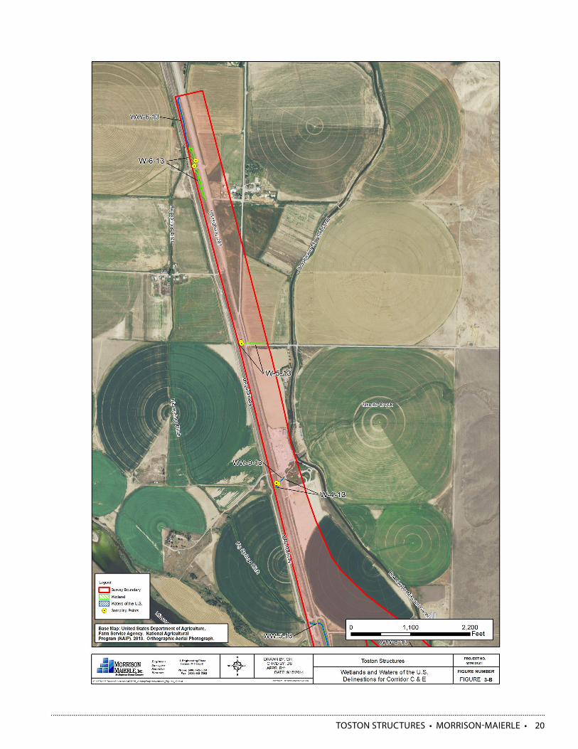
• Impacts to Waters of the United States: 450 to 500 lineal feet.
3. Species of concern:
• Terrestrial Species: More quality bird habitat is present could potentially impact Great Blue Heron and Bald Eagle.
4. Threatened and Endangered species:
• Ute Ladies’ Tresses: More suitable ULT habitat present but not located within alignment in two consecutive years of investigations.
Eastern Corridor:1. Terrestrial resources:
• General Vegetation: 0.6 mile longer roadway, with about 2 miles over non-highway ground
• Noxious Weeds/Invasive Species: Greater impacts with 0.6 mile longer alignment
• General Wildlife: Greater Impacts with 0.6 mile longer alignment; new alignment disturbs previously undisturbed area. Relocation of highway 287 crossing of Missouri River will enhance general wildlife connectivity at existing alignment and Fishing Access Site.
• Mammals: Lesser impacts to trees and poorer quality tree habitat and structural diversity would have less impact on tree dwelling small mammals
• Birds: Less quantity of quality bird habitat is present, therefore fewer impacts to bird habitat anticipated
• Amphibians: Lesser impacts to potential amphibian breeding area.
2. Aquatic resources:
• Impacts to Waters of the United States: 375 to 425 lineal feet.
3. Species of concern:
• Terrestrial Species: Less quantity of quality bird habitat would be disturbed, therefore less impact to Great Blue Heron and Bald Eagle.
4. Threatened and Endangered species:
• Ute Ladies’ Tresses: Less suitable ULT habitat associated with this corridor and not located within alignment in two consecutive years of investigations
ALTERNATIVES ANALYSIS REPORT
Facts:

TOSTON STRUCTURES • MORRISON-MAIERLE • 17
5. Wetland Impacts: 1.0 to 1.5 acres
6. Cultural Resources:
• Two historic sites eligible for placement on the National Historic Register were identified along the Central Corridor, the Northern Pacific (NP) railroad original main line (24BW0818) and the Big Springs Ditch irrigation ditch (24BW0836). The irrigation ditch will be impacted with a new box culvert.
7. 4(f) Impacts:
• Both historic sites eligible for placement on the National Historic Register would be 4(f) properties that could be impacted by the project. There would also be impacts to the Toston Fishing Access Site (FAS) in the Central Corridor. The total area of the FAS parcel is 4.24 acres and the central alignment would impact between 1.0 and 2.0 acres.
8. Farmlands:
• No Farmland of Prime Statewide importance.• If irrigated, between 30 and 35 acres of
Prime Farmland would be impacted by ROW acquisition.
9. Noise Impacts:
• No predicted noise impacts.
10.Public Opinion:
• No specific, expressed opinion received to-date.
11.Hazardous Materials:
• No underground storage tanks or hazardous materials identified.
5. Wetlands Impacts: 0.25 to 0.75 acres
6. Cultural Resources:
• Three historic sites eligible for placement on the National Historic Register identified as the Northern Pacific (NP) railroad original main line (24BW0818), and irrigation ditches (24BW0499 and 24BW0836) will be impacted with new bridges within this corridor.
7. 4(f) Impacts:
• All three historic sites eligible for placement on the National Historic Register would be 4(f) properties that could be impacted by the project.
8. Farmlands:
• No Farmland of Prime Statewide importance.• If irrigated, between 50 and 55 acres of
Prime Farmland would be impacted by ROW acquisition.
9. Noise Impacts:
• Impacts to 12 residential structures are anticipated. Further analysis required.
10.Public Opinion:
• Petition opposed to the “East Corridor Route” signed by 118 persons, received by the Department of Transportation on December 27, 2013.
11.Hazardous Materials:
• No underground storage tanks or hazardous materials identified.

TOSTON STRUCTURES • MORRISON-MAIERLE • 18
Discussion:No design exceptions for roadway embankment slopes were used to develop the alignments. Consequently the anticipated impacts to natural, cultural and public resources for the alignments in either corridor could potentially be reduced through additional avoidance and minimization measures.
Impacts within the Missouri River and Six Mile Creek ordinary high water marks would essentially be equivalent between either alignment (number and size of bridge piers, approximate river width at bridge crossing location). Water quality impacts would also be similar with both alignments.
The central corridor would impact the Big Springs Irrigation Ditch with a new box culvert; the eastern corridor bridge over the Missouri River would also span the ditch. Both corridors require ROW or an easement on railroad property but would not impact the original Northern Pacific mainline. Both the railroad and the irrigation ditch are eligible for placement on the National Historic Register and as a consequence are 4(f) properties that would also require additional agency coordination once impacts to these properties are more completely quantified.
There are two threatened species and two candidate species under the Endangered Species Act identified by the USFWS for Broadwater County. Based on available information at this time, regardless of which corridor is selected, the proposed project would have no effect on listed threatened species Ute Ladies’ Tresses, and Canada Lynx, and neither corridor is likely to jeopardize the continued existence of Sprague’s Pipit and the Whitebark Pine candidate species. There are no plant or aquatic species of concern likely to occur within one mile of either corridor.
Because the alignment in the eastern corridor would be approximately 20% longer than the central corridor, there would be proportional increases in impacts to general wildlife and vegetation, prime farmland, and potential for noxious weeds and invasive species from disturbed areas. Because this alignment is well removed from existing highway US-287, there may be 12 residences impacted by traffic noise.
Since the 2011 Corridor Study was completed, 118 persons have signed a petition opposed to further consideration of the eastern corridor.
Although the central alignment is shorter and generally adjacent to existing Highway 287, it would impact more wetlands, more lineal feet of waters of the US, and more trees and shrubs that create structural diversity and habitat for birds and wildlife. There would also be an impact to the Toston Fishing Access Site (FAS) of approximately 1.0 to 2.0 acres. This FAS is a 4(f) property that would also require additional agency coordination if impacted.
Avoidance and minimization measures like pursuing design exceptions such as adding guardrail, and steepening roadway embankment slopes could reduce the amount of impacts to the environment, natural and public resources with either alignment.

TOSTON STRUCTURES • MORRISON-MAIERLE • 19
TOSTON STRUCTURES • MORRISON-MAIERLE • 20

TOSTON STRUCTURES • MORRISON-MAIERLE • 21
Criteria:13) PRELIMINARY PROJECT COST ESTIMATES
Central Corridor:Cost Estimate:
Estimated cost
Inflation (INF)
TOTAL costs
w/INF + IDC
Road Work $7,761,900New Structure $13,620,800Remove Structure $525,000Detour $0Traffic Control $532,500Subtotal $22,440,200Mobilization (15%) $3,366,000Subtotal $25,806,200Contingencies (20%) $5,161,200Total CN $30,967,400 $4,932,000 $39,177,000CE (12%) $3,716,100 $592,000 $4,701,000 TOTAL CN+CE $34,683,500 $5,524,000 $43,878,000
Eastern Corridor:Cost Estimate:
Estimated cost
Inflation (INF)
TOTAL costs
w/INF + IDC
Road Work $8,125,200New Structure $13,192,900Remove Structure $525,000Detour $0Traffic Control $670,700Subtotal $22,513,800Mobilization (15%) $3,377,100Subtotal $25,890,900Contingencies (20%) $5,178,200Total CN $31,069,100 $4,949,000 $39,307,000CE (12%) $3,728,300 $594,000 $4,717,000 TOTAL CN+CE $34,797,400 $5,543,000 $44,024,000
ALTERNATIVES ANALYSIS REPORT
Facts: