althouse arboretumalthouse arboretum master plan · althouse arboretumalthouse arboretum master...
TRANSCRIPT
The The The The
Althouse ArboretumAlthouse ArboretumAlthouse ArboretumAlthouse Arboretum
MASTER PLANMASTER PLANMASTER PLANMASTER PLAN
GreenAlliesGreenAlliesGreenAlliesGreenAllies
Summary:
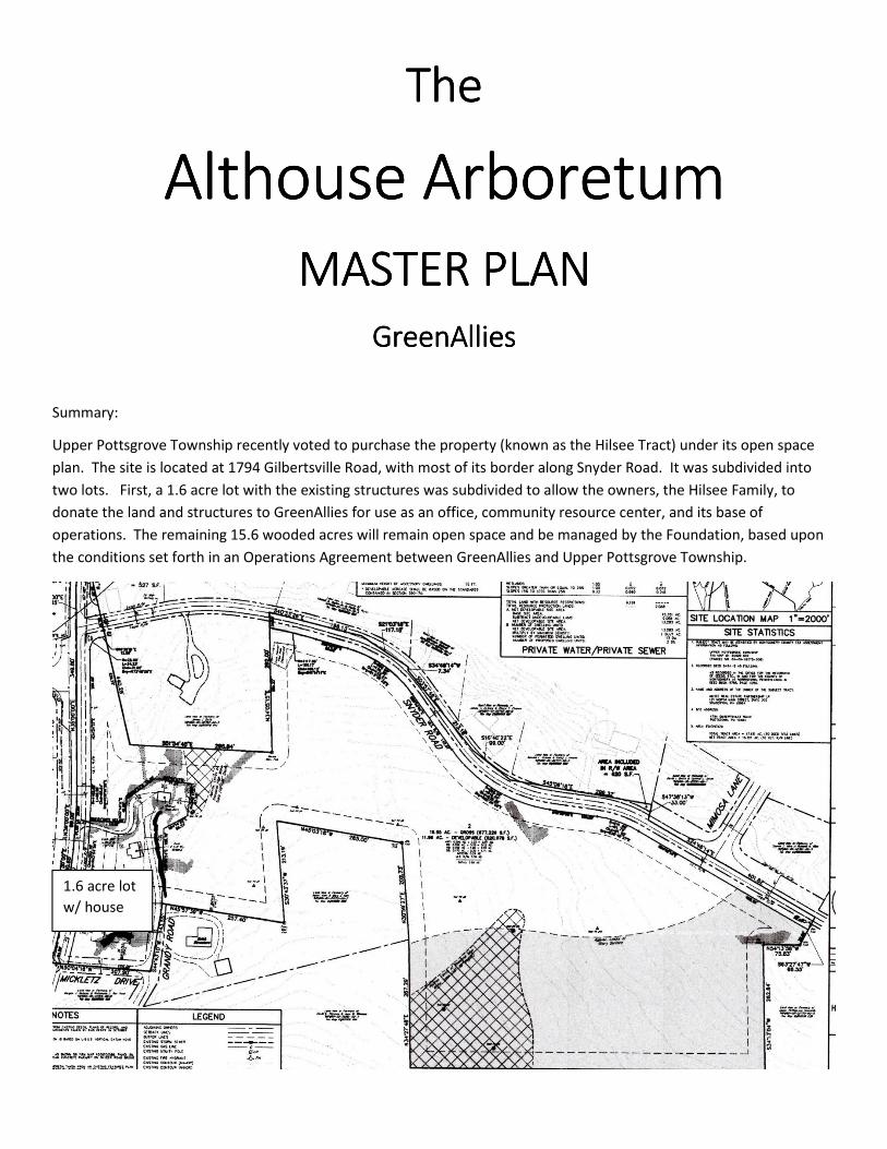
Upper Pottsgrove Township recently voted to purchase the property (known as the Hilsee Tract) under its open space
plan. The site is located at 1794 Gilbertsville Road, with most of its border along Snyder Road. It was subdivided into
two lots. First, a 1.6 acre lot with the existing structures was subdivided to allow the owners, the Hilsee Family, to
donate the land and structures to GreenAllies for use as an office, community resource center, and its base of
operations. The remaining 15.6 wooded acres will remain open space and be managed by the Foundation, based upon
the conditions set forth in an Operations Agreement between GreenAllies and Upper Pottsgrove Township.
1.6 acre lot
w/ house
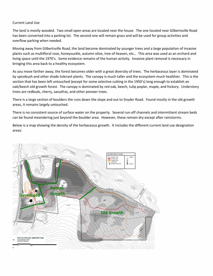
Current Land Use
The land is mostly wooded. Two small open areas are located near the house. The one located near Gilbertsville Road
has been converted into a parking lot. The second one will remain grass and will be used for group activities and
overflow parking when needed.
Moving away from Gilbertsville Road, the land become dominated by younger trees and a large population of invasive
plants such as multifloral rose, honeysuckle, autumn olive, tree of heaven, etc… This area was used as an orchard and
living space until the 1970’s. Some evidence remains of the human activity. Invasive plant removal is necessary in
bringing this area back to a healthy ecosystem.
As you move farther away, the forest becomes older with a great diversity of trees. The herbaceous layer is dominated
by spicebush and other shade tolerant plants. The canopy is much taller and the ecosystem much healthier. This is the
section that has been left untouched (except for some selective cutting in the 1950’s) long enough to establish an
oak/beech old growth forest. The canopy is dominated by red oak, beech, tulip poplar, maple, and hickory. Understory
trees are redbuds, cherry, sassafras, and other pioneer trees.
There is a large section of boulders the runs down the slope and out to Snyder Road. Found mostly in the old growth
areas, it remains largely untouched.
There is no consistent source of surface water on the property. Several run-off channels and intermittent stream beds
can be found meandering just beyond the boulder area. However, these remain dry except after rainstorms.
Below is a map showing the density of the herbaceous growth. It includes the different current land use designation
areas:
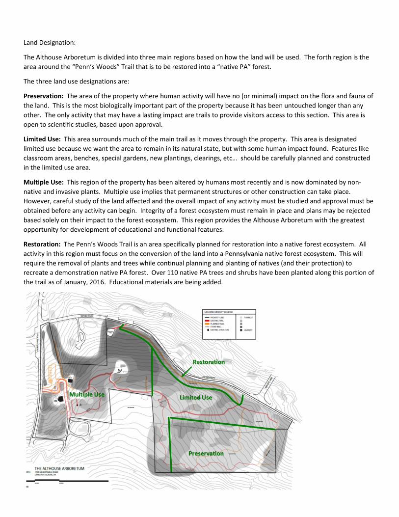
Land Designation:
The Althouse Arboretum is divided into three main regions based on how the land will be used. The forth region is the
area around the “Penn’s Woods” Trail that is to be restored into a “native PA” forest.
The three land use designations are:
Preservation: The area of the property where human activity will have no (or minimal) impact on the flora and fauna of
the land. This is the most biologically important part of the property because it has been untouched longer than any
other. The only activity that may have a lasting impact are trails to provide visitors access to this section. This area is
open to scientific studies, based upon approval.
Limited Use: This area surrounds much of the main trail as it moves through the property. This area is designated
limited use because we want the area to remain in its natural state, but with some human impact found. Features like
classroom areas, benches, special gardens, new plantings, clearings, etc… should be carefully planned and constructed
in the limited use area.
Multiple Use: This region of the property has been altered by humans most recently and is now dominated by non-
native and invasive plants. Multiple use implies that permanent structures or other construction can take place.
However, careful study of the land affected and the overall impact of any activity must be studied and approval must be
obtained before any activity can begin. Integrity of a forest ecosystem must remain in place and plans may be rejected
based solely on their impact to the forest ecosystem. This region provides the Althouse Arboretum with the greatest
opportunity for development of educational and functional features.
Restoration: The Penn’s Woods Trail is an area specifically planned for restoration into a native forest ecosystem. All
activity in this region must focus on the conversion of the land into a Pennsylvania native forest ecosystem. This will
require the removal of plants and trees while continual planning and planting of natives (and their protection) to
recreate a demonstration native PA forest. Over 110 native PA trees and shrubs have been planted along this portion of
the trail as of January, 2016. Educational materials are being added.
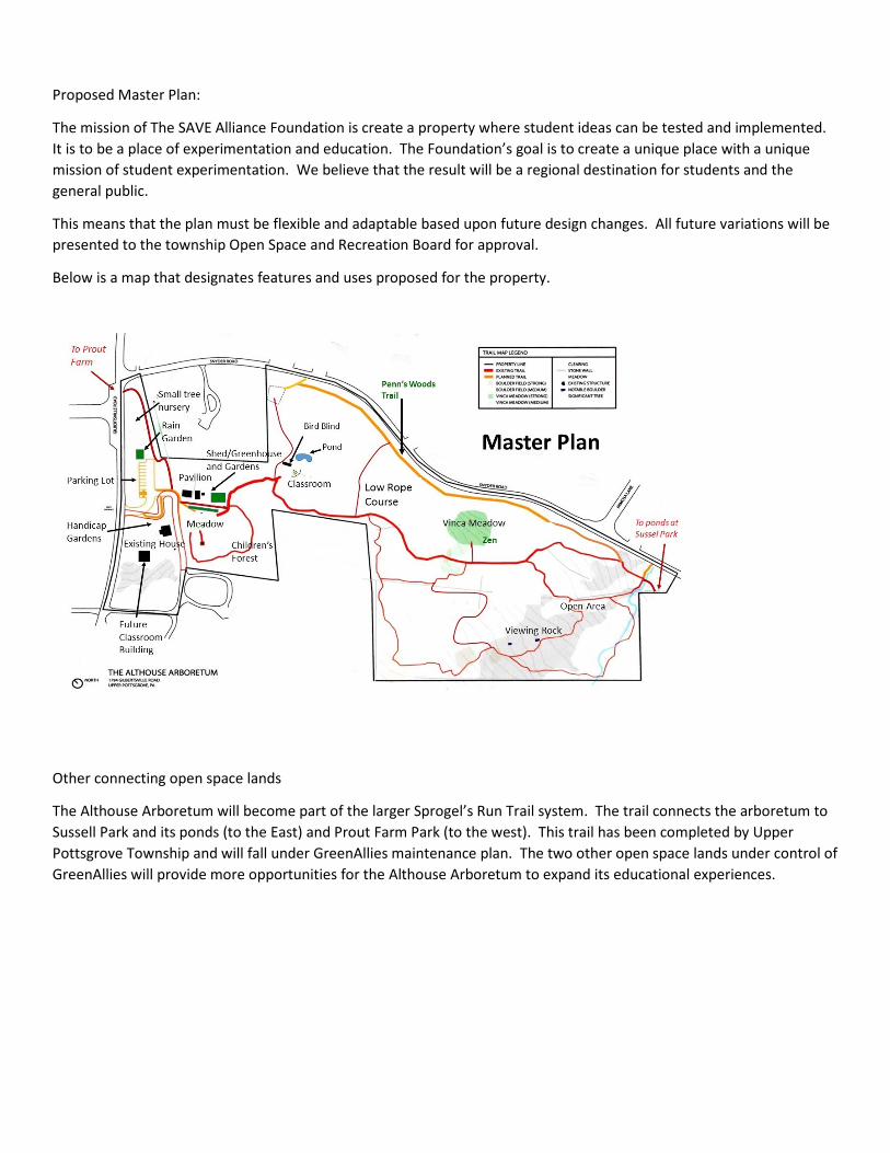
Proposed Master Plan:
The mission of The SAVE Alliance Foundation is create a property where student ideas can be tested and implemented.
It is to be a place of experimentation and education. The Foundation’s goal is to create a unique place with a unique
mission of student experimentation. We believe that the result will be a regional destination for students and the
general public.
This means that the plan must be flexible and adaptable based upon future design changes. All future variations will be
presented to the township Open Space and Recreation Board for approval.
Below is a map that designates features and uses proposed for the property.
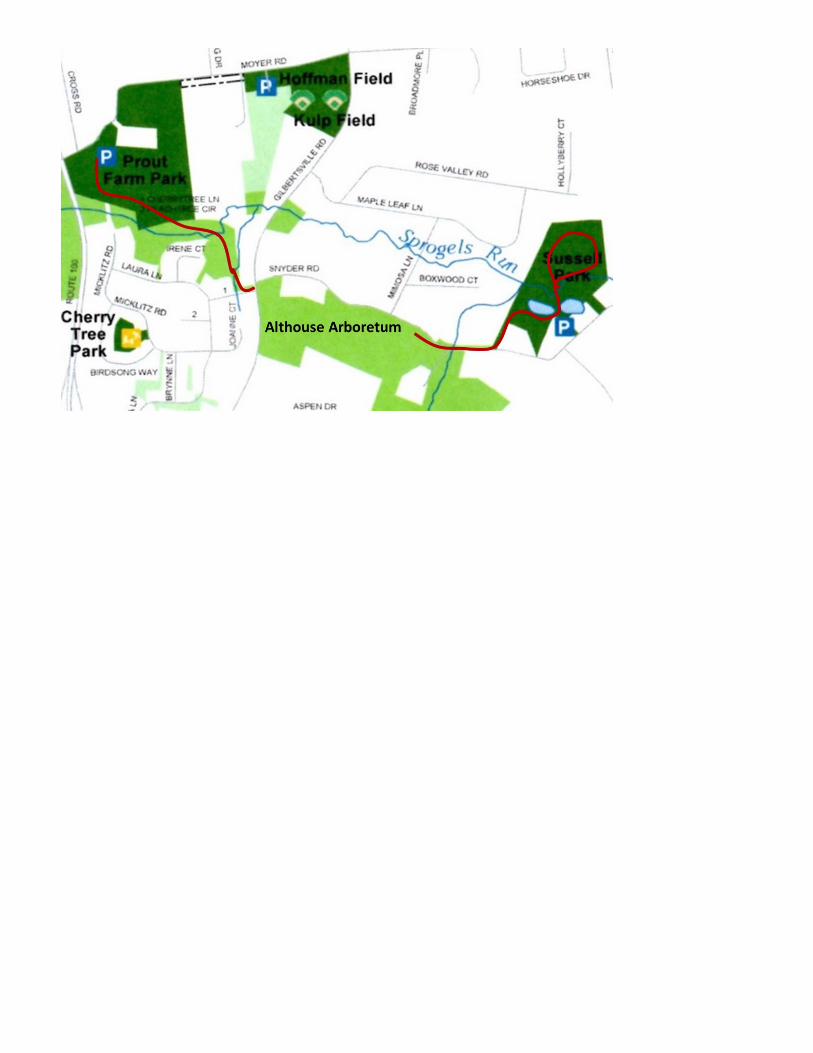
Other connecting open space lands
The Althouse Arboretum will become part of the larger Sprogel’s Run Trail system. The trail connects the arboretum to
Sussell Park and its ponds (to the East) and Prout Farm Park (to the west). This trail has been completed by Upper
Pottsgrove Township and will fall under GreenAllies maintenance plan. The two other open space lands under control of
GreenAllies will provide more opportunities for the Althouse Arboretum to expand its educational experiences.