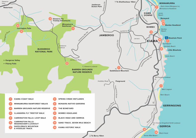
amberoo | minnamurra | bombo
TRANSCRIPT

KIAMA | GERRINGONG | GERROA | JAMBEROO | MINNAMURRA | BOMBO

OUR WALKS – A SUMMARYRef. Name Distance Time Grade Conditions
1 Kiama Coast Walk(North)
8.5km 3hrs 3 - Medium
A mix of paved, track and sand walking. Limited signage.
1 Kiama Coast Walk(Mid)
5km 1.5hrs 3 - Medium
A mix of paved, track and sand walking taking in both Blowholes.
1 Kiama Coast Walk(South)
6km 2hrs 4 - Hard Unpaved, steep track, along cliff tops, no shelter or services.
2 Minnamurra Rainforest Loop
1.6km loop 30min - 1hr
3 -Medium
Suspended path, partly accessi-ble by wheelchair. Family friendly.
2 Minnamurra Rainforest Falls Walk
4.2km circuit
1hr - 2hrs
4 -Hard
Elevated walkway & paved track, steep section to reach the Falls.
3 Barren Grounds Nature Reserve
1.5 - 19km return
30min - 8hr
2/3/4 - Varies
A series of trail paths, varying levels, well signposted.
4 Illawarra Fly Treetop Walk
1.5km return
Allow 1hr
2 - Easy
Paved path and steel cantilever walkway 30m up.
5 Carrington Falls: Loop Walk
600m loop 20 - 45min
3 - Medium
Formed track, good signage. Some stairs. Family friendly.
6 Carrington Falls: Missingham's Lookout
1.1 - 3.8km return
30min - 2hrs
3 - Medium
Formed tracks, good signage to Warris' Chair, Missingham's Lookout & Nellies Glen.
7 Saddleback Mtn & Hoddles Track
7km return 5hrs 4 - Hard Steep gradient, mix of grass and trail path, can be boggy.
8 Spring Creek Wetlands
1.5km return
30min 2 - Easy Flat terrain, formed paths. Bird hide.
9 Bonaira Native Gardens
600m return
20min 2 - Easy Flat terrain, formed paths. Picnic area. Family friendly.
10 Boneyard 2.7km return
1hr 3 - Medium
A mix of paved path and sand walking, steep gradient in parts.
11 The Bombo Headland Walk
2km return 45min 3 - Medium
Trail paths, loose underfoot, tidal rock shelf & close to cliff edge.
12 Black Head and Gerroa
8.3km return
3hrs 3 - Medium
No designated path, low gradient walk, tidal rock shelf.
13 Sand Track, Seven Mile Beach
2km sth-3km nth
2hr sth 3hr nth
3 - Medium
Flat terrain, loose underfoot, well- maintained track. Limited signage.
14 Kiama Historic Walk 2km 45min 2 - Easy Flat terrain.
BBQ Area
Discover how great the great outdoors can be.
The Kiama area has so much to see and do, much of which can be seen and explored on foot.
From our elevated escarpment to rainforest foothills and waterfalls to volcanic headlands and spectacular coastal tracks, our unique ecosystems have a wide range of vegetation and diverse wildlife as well as sites of historic and cultural interest.
Although most walks explore unique wilderness areas, they are surprisingly easy to reach and our towns and villages are seldom far away, offering great visitor information, food, and accommodation options.
KEY
Wheechair access Picnic area
Lookout Entry fee
Steep in parts
Dogs on leash
Toilets
Restaurant or café
Information centre
South Co
ast
Tra
in
Lin
e
Minnamurra River
Kan
gar
oo
Ri ver
Pr ince
s H
wy
Princes Hwy
Jam
ber
oo
Rd
Jamberoo Rd
Fo
un
tain
dal
e R
d
Sadd
leba
ck Mtn Rd
Jam
beroo M
tn R
d
Illawarra Hwy
Fo
xground R
oad
�
�
�
�
�
Sw
amp
Rd
Foxground
D onova
n
Road
Hoddles Road
KIAMABlowhole PointJerrara
Mt Pleasant Lookout
Werri Lagoon
Sir Charles Kingsford Smith Lookout
Little Blowhole
KIAMA COAST WALK
� To Berry 10km
Saddleback Mountain
Carrington Falls
Robertson
MinnamurraRainforest
Illawarra FlyTreetop Adventures
Black Head
Seven Mile Beach
Bombo Beach
Surf Beach
Kendalls Beach
Easts Beach
Jones Beach
BOMBO
KIAMA DOWNS
Werri Beach
GERRINGONG
JAMBEROO
BARREN GROUNDS NATURE RESERVE
BUDDEROO NATIONAL PARK
� Kangeroo Valley
� Fitzroy Falls
GERROA
Boneyard
Minnamurra HeadlandStack Island (Rangoon Is.)
Bombo Headland
Jamberoo Action Park
MINNAMURRA
1
MINNAMURRA RAINFOREST WALKS
BARREN GROUNDS NATURE RESERVE3
3
ILLAWARRA FLY TREETOP WALK4
5 CARRINGTON FALLS: LOOP WALK
6
SADDLEBACK MOUNTAIN& HODDLES TRACK
SPRING CREEK WETLANDS8
8
BONAIRA NATIVE GARDENS
THE BONEYARD
BLACK HEAD AND GERROA
SAND TRACK, SEVEN MILE BEACH13
KIAMA HISTORIC WALK
� To Shellharbour 10km
Jamberoo Lookout
Jamberoo Pass
Illawarra Lookout
�
CARRINGTON FALLS: MISSINGHAM’S LOOKOUT
BOMBO HEADLAND11

One of Australia’s most scenic coastlines is yours to explore. Ocean views, sea caves, rock pools, spectacular rock formations,
and unspoilt beaches.
The Kiama Coast Walk has three sections, made up of a series of shorter walks/shared paths from the mouth of the Minnamurra River south, through Kiama to Gerringong’s Werri Beach.
Offering a mix of sealed paths, grassed tracks and beach walking, the hills are strenuous yet gentle enough for most fitness levels.
A 20km unbroken ribbon of exploration is waiting for you...
KIAMA COAST WALK
kiama.com.au @kiamansw 1300 654 262 32 kiama.com.au @kiamansw 1300 654 262
Distance: 8.4km Time: 3hrs Grade: 3 - Medium Conditions: Mix of paved and loose surfaces. Steep in sections. Limited signage.
Starting from the north, you will begin at Minnamurra Train Station, head south to James Oates Reserve and the picturesque Minnamurra River mouth. The track continues south taking in Jones Beach, photogenic Cathedral Rocks, Boneyard and the surreal landscape of Bombo Headland, finishing up at Blowhole Point.
⊲ See Walk #10 and #11 for the Boneyard/Bombo Walk.
MINNAMURRA RIVER TO KIAMA BLOWHOLE
NORTH SECTION
Start at the Visitor Information Centre. For the most part this section takes you through a series of waterfront reserves; Storm Bay, Surf Beach, Kendalls Beach, Easts Beach and Loves Bay, laced together by headlands. The Little Blowhole is a great feature found midway along this section.
⊲ An option halfway along this section is to add a trip to to Bonaira Native Gardens (Walk #9).
Step away from civilisation as you follow a zig-zag of coastal pastures south from Kiama Heights to Werri Beach. Once dominated by a rainforest known as the 'long brush', you are able to discover rainforest remnants, visit Aboriginal Dreaming poles welcoming you to Wodi-Wodi and Dharawal land and take in the endless ocean views.
⊲ Werri Beach Lagoon may be open to the sea, call ahead to ensure you are able to cross 1300 654 262 or be prepared to turn around. Gerringong Train Station is found by continuing up the southern headland and west along Belinda Street for approx 3km. Taxi ph. 4237 7505.
KIAMA BLOWHOLE TO LOVES BAY
LOVES BAY TO GERRINGONG
MID SECTION
SOUTH SECTION
Distance: 5km Time: 1.5hrs Grade: 3 - Medium Conditions: Mix of paved, and loose surfaces. Limited signage.
Distance: 6km Time: 2hrs Grade: 4 - Hard/Strenuous Conditions: Rough, unpaved, steep track along exposed clifftops. Care required.

Let's all work to keep our natural areas pristine and join together in the principles of #leavenotrace leaving our wild places exactly as we found them.
MINNAMURRA RAINFOREST WALKS
Time/Distance: 30min - 2hrs, 4.2km circuit; optional 1.6km loop
Grade: 3/4 - Medium/Hard
Conditions: Suspended path, partly wheelchair accessible, steep in sections.
How to get there: 15 minutes west of Kiama, follow Tourist Drive 9 through Jamberoo, turn at Jamberoo Mountain Rd and then Minnamurra Falls Rd.
The superb lyrebird, famous for its incredible ability to mimic anything from its immediate surroundings including chainsaws, car engines and local birds.
LISTEN OUT FOR
BUDDEROO NATIONAL PARK
kiama.com.au @kiamansw 1300 654 2624 5
A multi-award winning attraction where visitors can experience the splendour and beauty of a rare remnant of subtropical and warm temperate rainforest, which is representative of the once extensive rainforests of the Illawarra region. Discover waterdragons on the river banks, bowerbirds, lyrebirds, ancient fig trees, rock orchids, elk horns and lush ferns.
From the Information Centre, start the rainforest experience along a network of elevated walkways and paved tracks. Meander along the Loop Walk, a 1.6km walk, linked by a suspension bridge across the Minnamurra Rivulet. The first 500m of this walk provides for assisted wheelchair access. Visitors should allow 45mins – 1 hour to complete this loop walk.
Half way around the loop you are able to deviate up the paved Falls Walk (2.6km return). A more challenging walk offering the reward of spectacular views over the rainforest canopy and the gorge carved by Minnamurra Rivulet. The walk concludes with a viewing platform from the base of the upper falls.
⊲ Open daily at 9am (not Christmas Day)⊲ Gates close at 5pm⊲ Last entry for the Falls Walk: 3pm⊲ Last entry for the Loop Walk: 4pm⊲ Phone: 02 4236 0469⊲ $12 entry per car, payable at the gate
kiama.com.au @kiamansw 1300 654 2626 7
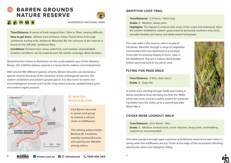
BARREN GROUNDS NATURE RESERVE
Time/Distance: A series of trails ranging from 1.5km to 19km, varying difficulty.
How to get there: 30mins west of Kiama, follow Tourist Drive 9 through Jamberoo, turning onto Jamberoo Mountain Rd, the entrance to the reserve is found on the left after Jamberoo Pass.
Conditions: Formed track, loose underfoot, well marked. Unpredictable weather conditions can be experienced. No mobile coverage. Basic facilities.
Stretching from Kiama to Robertson on the south-easterly spur of the Illawarra Range, this 2,000ha plateau reserve is a favourite for walkers and birdwatchers.
With around 180 different species of birds, Barren Grounds was declared a special reserve because of the presence of two endangered species, the eastern bristlebird and eastern ground parrot. It is also home to some rare and endangered animals such as the long-nosed potoroo, spotted-tailed quoll and eastern pigmy possum.
Visit Barren Grounds in winter and spring to witness a vibrant cloak of wildflowers.
The striking yellow Heath Banksia (B. ericafolia), sweetly scented Boronia, and spectacular Waratah among others.
WINTER WONDERLAND
�
�
�
BARREN GROUNDSNATURE RESERVE
NOORINANMOUNTAIN
COOKSNOSE
KANGAROORIDGE
FLYING FOX PASS
ILLAWARRALOOKOUT
BIRDS AUSTRALIANATURE STUDY CENTRE
TO ROBERTSON �
�
�
�
�
��
�
0 2km1km
BUDDEROO NATIONAL PARK
Time/Distance: 2.5hrs, 5km return
Grade: 2 - Easy, flat
A scenic track winding through heath and ending in dense woodland at an old flying fox from the 1940s which was once used as a pulley system for transport-ing timber from the valley up to a sawmill just after World War II.
Time/Distance: 2hrs 30min - 3hrs
Grade: 3 - Medium, formed track, some obtacles, steep parts, bushwalking experience recommended.
COOKS NOSE LOOKOUT WALK
This track wanders through open expanses of heathland, which burst with colour in spring when the wildflowers are out. Finish at the edge of the escarpment affording spectacular views over Kangaroo Valley.
GRIFFITHS LOOP TRAIL
Time/Distance: 2-3 hours, 7.4km loop
Grade: 3 - Medium, steep parts
Highlights: The Illawarra Lookout with views of the coast and hinterland. Spot the eastern bristlebird, eastern ground parrot (pictured), southern emu-wren, beautiful fantails and tawny and white-eared honeyeater.
The main walk in the reserve, with a couple of tributaries. Meander through a range of vegetation communities from low heathland to a eucalypt forest with an amazing display of ferns. Take in the Saddleback Trig and a natural stone bridge before returning back to the picnic area.
FLYING FOX PASS WALK
Rare eastern ground parrot

kiama.com.au @kiamansw 1300 654 2628 9
ILLAWARRA FLY TREETOP WALK
Time/Distance: Allow 1hr, 1.5km Grade: 2 - Easy
Highlights: Elevated walkway, rainforest, views
Conditions: Undulating path and hinged steel cantilever. Best on a clear day.
How to get there: 182 Knights Hill Road. 45 mins west of Kiama, follow Tourist Drive 9.
The Treetop Walk is a gentle 1.5 kilometre loop track with 500 metres of elevated steel walkway through the treetops, some 20-30 metres above the forest floor. This steel walkway features two cantilevered arms and culminates at Knights Tower, a spiral tower that rises to a breathtaking 45 metres above the ground.
Positioned 710 metres above sea level, the stunning panoramic views take in everything from the rainforest canopy, coastal towns and out to the Pacific Ocean.
Open 10am - 5pm Friday, Saturday and Sunday and everyday over the NSW school holidays. A zipline experience is also available, however booked separately.
Tickets available from the Kiama Visitor Information Centre or online illawarrafly.com.
Time/Distance: 30-45min, 2km loop
Grade: 2 - Easy, flat
Highlights: Spot eight different honeyeater varieties, as well as winter and spring flowering hakeas, tea trees and banksias.
HERBARIUM LOOP WALK
Traverse wide-open heath making your way to the edge of the Illawarra Escarpment offering great views of Berry and on to Jervis Bay. If you're lucky, spot a wedgetailed eagle or white bellied sea eagle.
Starting and finishing 500m from the carpark (as you come in to the reserve), this walk takes you through open heath as well as higher shrubs.
Time/Distance: 7-8 hours, 19km loop
Grade: 4 - Experienced bushwalkers only due to length
Conditions: Undulating, loose underfoot, wide firetrail.
Cooks Nose Lookout Walk
KANGAROO RIDGE WALK
ILLAWARRA LOOKOUT WALK
Taking you to the eastern escarpment of the Illawarra Plateau where you can view the coastline as far north as Wollongong. You may even spot an echidna waddling across the track.
Time/Distance: 30min - 1 hour, 2km return
Grade: 2 - Easy, flat
Illawarra Fly Treetop Walk

kiama.com.au @kiamansw 1300 654 26210 11
CARRINGTON FALLS
Time/Distance: A series of trails ranging from 500m to 3.8km.
How to get there: Turn off Jamberoo Mountain Road onto Cloonty Road (Carrington Falls signposted) and follow for about 1.4km. Turn right into Nellies Glen picnic area (unsealed road) or continue on to Thomas Place.
Highlights: Spring and summer wildflowers including vibrant red waratahs. If you’re lucky, you might see a lyrebird, a shy swamp wallaby or long-nosed potoroo.
With cascades, waterholes, and rock pools, Carrington Falls is regarded by many as one of the most beautiful on the south coast. You will find easy to access lookouts as well as a variety of walking tracks, picnic spots and swimming holes along with breathtaking scenery.
KANGAROO RIVER
0 250m
��
�
�
�
�
�
�
CARRINGTON FALLS
IZZARDS LOOKOUT
BUDDEROONATIONAL PARK
WARRIS CHAIR
MISSINGHAM STEPS NELLIES GLEN
THOMAS PLACE
CLO
ON
TY
RO
AD
STEVOS TRACK
Time/Distance: 30-45mins, 600m loop Grade: 3 - Medium
Conditions: Formed track and stairs.
CARRINGTON FALLS: LOOP WALK
This track loops around the edge of the escarpment, passing several lookouts. You’ll have ever-changing views of Carrington Falls waterfall, which cascades 90m down to the Kangaroo River below.
Soak up the natural beauty from the Falls View lookout, then make your way down a steep metal stairway into a shady rainforest gully for rock-framed views. The track then climbs back up the escarpment, passing Valley View lookout beside Carrington Falls for different views of the waterfall and valley, before returning to the picnic area. Tip: A visit midweek to Carrington Falls allows you
to enjoy the serenity and isolation of the area without the crowds.
BUDDEROO NATIONAL PARKParking at Thomas’ Place picnic area, you have options to view the falls from different angles.
CARRINGTON FALLS CIRCUITConsider cooling off in the upper falls - while safe for families, a high amount of care is to be taken as the area is not fenced.
A beautiful swimming hole also ex-ists at Nellies Glen (pictured right).
TAKE A DIP
Nellies GlenWaratah - Telopea speciosis

Did you know? Resin from the stem of the grass tree grown in the understorey of the woodland were used by Aboriginal people for glue and the soft part of the leaves for food. During WW1 its resin and acids were used to manufacture explosives and varnish.
kiama.com.au @kiamansw 1300 654 26212 13
Nellies Glen, found 100m from the carpark, is the perfect spot for a picnic before venturing out and exploring a range of nearby walks including Warris Chair or Missingham Lookout tracks.
WARRIS CHAIR WALKING TRACK
Time/Distance: 30mins – 1 hour, 1km return Grade: Easy
Conditions: Formed track.
Time/Distance: 1.5hr - 2hrs, 3.8km return Grade: Medium
Conditions: Formed track, steep in sections.
Feel like you are on top of the world, after an easy walk on the western edge of Kangaroo Valley through heathlands of swamp banksia. Sit on the sandstone “chair” and take in the scenic views of the south coast and down into the valley. The honeyeaters, flame robins, and firetails are attracted to the heath in spring, when it erupts in colour and fragrance.
Further along, the walking track to the Missingham Lookout leads along the western edge of the escarpment and offers picturesque views of Kangaroo Valley, as well as views of the impressive Carrington Falls Gorge.
An option for the experienced walker is to head west down the Missingham Steps to a beautiful mossy glen. Caution: The area can become very slippery and utmost care must be taken.
NB: Budderoo National Park is always open but may have to close at times due to poor weather or fire danger. For updates, call 1300 072 757.
MISSINGHAM LOOKOUT TRACK
NELLIES GLEN, WARRIS CHAIR WALKING TRACK & MISSINGHAM'S LOOKOUT
Carrington Falls (aerial view)

kiama.com.au @kiamansw 1300 654 26214 15
SADDLEBACK MOUNTAIN & HODDLES TRACK
Time/Distance: 3hr, 8km return Grade: 4 - Hard
Highlights: Lookout, rainforest, escarpment views, birdwatching, farmland.
Conditions: Steep & eroded in places, loose underfoot, can be slippery. Mix of bush, rainforest and farmland with extraordinary rock formations.
How to get there: 8km from central Kiama, take Saddleback Mountain Road, park at the summit. Follow signage to the western lookout for Hoddles Track.
Hoddles Track was named after surveyor, Robert Hoddle, who forged a route from the Southern Highlands to Kiama Harbour back in the 1830’s.
The track begins as a fire trail near the western lookout where it steeply descends to a saddle. From here, follow green route markers as the track rises again towards the escarpment and into a rainforest ending at Mount Noorinan.
Option to join the track midway by parking your car at the corner of Foxground and Hoddles Rd, and walking along the road, past farmland and up the steep incline to the t-junction of the track.
NB: Do not venture off the track or disturb the historic dry stone walls.
Sitting 600 metres above sea level on the Illawarra Escarpment, Saddleback Mountain Lookout provides exceptional 360 degree views from three viewing platforms. See all the way to Cronulla to Jervis Bay, Mt Noorinan and Pigeon House Mountain.
THE LOOKOUT
SPRING CREEK WETLANDS
Time/Distance: 30mins, 1.5km return. Grade: 2 - Easy
Highlights: Wetlands, birdwatching, bird hide, freshwater lake.
Conditions: Flat terrain, formed paths.
How to get there: Follow Terralong Street, Kiama, towards Jamberoo, turn right into Dido Street and then Glenbrook Drive.
The ultimate bird watching experience and located only a few minutes from the centre of Kiama. Walk along the banks of Spring Creek to the lagoon through a variety of rehabilitated wetlands or enjoy the birdlife from a constructed hide.
Before it was cleared for farmland, Spring Creek Wetlands was covered in a variety of different plant communities. Local species are now planted to help re-establish
the original vegetation.
Get a close up look at many water birds including cormorants, moorhens, coots, swans and an array of other local species.
Listen out for the distinct growling call of the endangered green and golden bell frog that inhabits this area. Other threatened species including the australasian bittern and the square-tailed kite have also been seen at this site.
Option to extend your walk by using the Princes Hwy underpass at the entrance to Riddell Street and join the Kiama Coast Walk towards Bombo Headland.
�
��
SPRING CREEK WETLANDS
BIRD HIDE
HISTORICCULVERT
BOMBO BEACH
CEMETERY
TERRALONG STREET
RIDDELL STREET
PRINCES HIGHWAY
Common Kingfisher
BONEYARD
�
�
�
�
MINNAMURRA
BONEYARD
CATHEDRAL ROCKS
JONESBEACH
TO KIAMA �
BOMBO BEACH
kiama.com.au @kiamansw 1300 654 26216 17
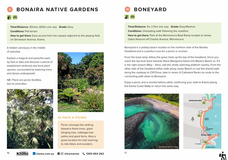
BONAIRA NATIVE GARDENS
Time/Distance: 30mins, 600m one way Grade: Easy
Conditions: Flat terrain
How to get there: Easy access from the carpark adjacent to the playing field on Girraween Avenue, Kiama.
A hidden sanctuary in the middle of suburbia.
Explore a magical and peaceful oasis by foot or bike and discover a parcel of established rainforest and local plant species, surrounded by towering trees and dense undergrowth.
NB. There are picnic facilities, but no amenities.
Time/Distance: 1hr, 2.7km one way Grade: Easy/Medium
Conditions: Undulating walk following the coastline
How to get there: Park at the Minnamurra Boat Ramp located at James Oates Reserve off Charles Avenue, Minnamurra.
Boneyard is a pebbly beach located on the northern side of the Bombo Headland and is a perfect cove for a picnic or snorkel.
From the boat ramp, follow the grass track up the top of the headland. Once you reach the top look back towards Stack (Rangoon) Island and Mystics Beach or, if it is the right season (May – Nov), visit the whale watching platform nearby. From the other side of the headland either walk along Jones Beach or use the shared path along the roadway to Cliff Drive, take in views of Cathedral Rocks en-route to the connecting path down to Boneyard.
Enjoy a picnic and a snorkel before either continuing your walk to Kiama (along the Kiama Coast Walk) or return the same way.
Picnic amongst the striking Illawarra flame trees, giant stinging tree, cabbage tree palms and giant ferns. Also a great location for kids learning to ride bikes and scooters.
PACK A PICNIC
Boneyard (aerial view)
Bonaira Native Gardens

kiama.com.au @kiamansw 1300 654 26218 19
BLACK HEAD & GERROA
Time/Distance: 3hrs, 8.3km return Grade: Easy
Conditions: Start the walk on the ebb tide; Road, path and rock shelf walk-ing; no designated path.
How to get there: Take Crooked River Road onto Riverleigh Avenue, taking a sharp right turn onto Park Road near Emery Park.
This adventure starts from Park Road and heads north along the Crooked River foreshore. If the tide permits, you may wish to cross the footbridge onto the beach (be prepared to get your feet wet), otherwise continue along Burke Parade until you reach the boat ramp.
Once on the beach, continue north around the headland towards Shelly (or Little) Beach, along the shoreline and across the rock platform.
At low tide you can explore your way all the way around to the secluded Walkers Beach.
If high tide prevents your return, there is a public right of way along the northern boundary of the Gerringong Golf Club which leads to a shared foot/bike path back to Gerroa.
Explore the rocks and rock pools for fossils, sea anemones, crabs, octopus, algae and starfish.
Pack your binoculars from late May – November to catch Humpback and Southern Right whales on their migration or dolphins enjoying the wide beach year-round.
CRITTERS AND CREATURES
BOMBO HEADLAND
Time/Distance: 1hr return Grade: 3 - Medium
Conditions: Exposed, rocky terrain, loose underfoot, unfenced cliffs.
How to get there: Park at North Bombo Beach. Or access the northern side overlooking Boneyard via Cliff Drive, Kiama Downs.
A short walk to another world, or at least that’s what it feels like as you walk amongst the clusters of hexagonal basalt columns, a legacy of blue metal quarrying in the 1880s and 1900s.
Start from the carpark at the north end of Bombo Beach and follow the path hugging the coast, this southern side of the headland has been extensively quarried and provides for a very interesting walk. Views to the north include Cathedral Rocks, Minnamurra Headland and Jones’ Beach. Look south and you can see an impressive view of Kiama and the iconic lighthouse. A popular spot for photographers, sunrise "instameets" are frequently scheduled by locals, sharing their passion for landscape photography. Search the #igbombo hashtag for information.
Bombo Headland features a dog agility park and the centre section of Bombo Beach is a dog off-leash area.
Bombo Headland is of one of the most significant geological sites in NSW while the rock type and its formation features have technical significance at a national level. It is also a popular spot for filming - episodes of the children's television show Power Rangers was staged here.
DID YOU KNOW?

kiama.com.au @kiamansw 1300 654 26220 21
SAND TRACK WALK (NORTH & SOUTH), SEVEN MILE BEACH
Time/Distance: North Track 3hrs, 3km one way; South Track 2hrs, 2km one way
Grade: Medium
Highlights: Forest and beach circuit walk, accessible viewing platform, picnic area with BBQs, scenic beach views, swimming.
Conditions: Flat terrain, loose underfoot, well-maintained track.
How to get there: Heading south on Crooked River Road, turn left at Beach Road and park at the Beach Road Picnic Area.
Otherwise known as the Waterline Track, the Sand Track (north) starts at the Beach Road picnic area and heads north towards the smaller Gerroa picnic area through dune blackbutt and bangalay forests. Return the same way or via Seven Mile Beach.
The Sand Track (south), or Linksand Track begins from the opposite end of the Beach Road picnic area and runs parallel to the beach, after about 2kms, the track emerges onto a secluded stretch of Seven Mile Beach. From here, retrace your steps or continue the circuit back to the picnic area via the beach.
NB: Beach Road Picnic Area is open from 6am-6pm 7 days and until 8pm in Summer.
Look out for thornbills, wrens, honeyeaters and the brown cuckoo dove. Wallabies are often seen here too.
KEEP YOUR EYES PEELED
KIAMA HISTORIC WALK
Time/Distance: 2km, 45 minutes
Grade: 2 - Easy
Highlights: Digital tour of Kiama, historical building landmarks, streetscapes, architecture.
Conditions: Flat to undulating terrain on paved footpath.
How to get there: Park at the Kiama Visitor Information Centre, Blowhole Point Road, Kiama.
Take a leisurely stroll and immerse yourself in the historically significant points of interest in the Kiama township. Start out at Blowhole Point before heading into town.
Before you set out download the Kiama Library's My Place: A Digital Tour of Kiama app on your iPhone, iPad or Android device and learn about the history of some of our beautiful old buildings both past and present through words, photos and oral histories. Listen to people's memories of living and working in our municipality, from taking part in the local agricultural show in the 1940s to what happened when the circus came to town, as well as a tour devoted to Charmian Clift, her work, and her life in Kiama.
Search for ‘Kiama Library Tours’ to download the app. Or pick up a copy of the Heritage Walks flyer from the Kiama Visitor Information Centre at Blowhole Point.
Norfolk Pines (Araucaria heterophylla) and fig trees (Ficus macrophylla) can be seen around town. The fig tree, located in front of the Kiama Library on Railway Parade, is over 150yrs old.
LOOK UP
Western Whistler (male) Pilot's Cottage Museum, Blowhole Point

DISCOVER HOW GREAT THE GREAT OUTDOORS CAN BE…
WALK WITH CARE
⊲ The walk distance and duration publicised in this guide are approximate and may vary. Know your limits and turn around if necessary. ⊲ Each walk is graded using the Australian Walking Track Grading System but generally are accessible and achievable for all levels of fitness and expertise.⊲ Keep to formed tracks, obey signs and use carparks provided.⊲ Walk safely. Take care around the ocean and cliff tops check the weather forecast and ocean tides.⊲ Be well prepared by taking adequate water, food and clothing/weather protection.⊲ Walk softly. All native plants and animals are protected; please only take memories away with you.⊲ Fires are not permitted on any of the walks.⊲ Take your rubbish with you or place in bins provided.⊲ Unless otherwise signposted, keep your pet’s at home.⊲ Camping is only permitted in designated camping areas.
If you would like further information on walking, please contact the Destination Kiama team at the Kiama Visitor Information Centre, or scan the QR code to go directly to our website.
Kiama Visitor Information CentreBlowhole Point Kiama NSW 2533
Phone: 1300 654 262 Email: [email protected]: Kiama.com.auSocials: @KiamaNSW
Published by Destination Kiama / Kiama Municipal CouncilThe Kiama Walking Guide is general in nature to be used as a guide only. While care has been taken to ensure that
the information contained within this publication is correct at the time of publishing, changes in circumstances after
publication may impact on the accuracy of this information, and no warranty or assurance is given.
Design by Eureka Creative
Photography: Peter Izzard Photography, Phil Winterton Photography, Atmosphere Productions, Lachlan Hall,
Hayden McLean, Benjamin Sailour Photography.
Kiama Visitor Information Centre, Blowhole Point

Welcome to Dharawal Country Bereewagal, - naa niya. – Yura ngurang gurugal
People who come from afar, I see all of you. Aboriginal people camped here at this place long ago.
Ngoon dyalgala niya, ngoon bamaradbanga ni. We embrace all of you; we open the door to all of you.
Ngoon – mari ngurang – niya mudang yura ngurra We lend this place to all of you to live while we sleep.
Dyi nga ni nura Here, I see my country
Steven Russell of the Dharawal Nation