amphitheater-headed canyons formed by megaflooding at malad … · amphitheater-headed canyons...
TRANSCRIPT

Amphitheater-headed canyons formed bymegaflooding at Malad Gorge, IdahoMichael P. Lamb1, Benjamin H. Mackey2, and Kenneth A. Farley
Division of Geological and Planetary Sciences, California Institute of Technology, Pasadena, CA 91125
Edited by Thure E. Cerling, University of Utah, Salt Lake City, UT, and approved November 25, 2013 (received for review June 27, 2013)
Many bedrock canyons on Earth and Mars were eroded byupstream propagating headwalls, and a prominent goal in geo-morphology and planetary science is to determine formationprocesses from canyon morphology. A diagnostic link betweenprocess and form remains highly controversial, however, and fieldinvestigations that isolate controls on canyon morphology areneeded. Here we investigate the origin of Malad Gorge, Idaho,a canyon system cut into basalt with three remarkably distinctheads: two with amphitheater headwalls and the third housingthe active Wood River and ending in a 7% grade knickzone.Scoured rims of the headwalls, relict plunge pools, sediment-transport constraints, and cosmogenic (3He) exposure ages indi-cate formation of the amphitheater-headed canyons by large-scaleflooding ∼46 ka, coeval with formation of Box Canyon 18 km tothe south as well as the eruption of McKinney Butte Basalt,suggesting widespread canyon formation following lava-flowdiversion of the paleo-Wood River. Exposure ages within theknickzone-headed canyon indicate progressive upstream young-ing of strath terraces and a knickzone propagation rate of 2.5cm/y over at least the past 33 ka. Results point to a potential di-agnostic link between vertical amphitheater headwalls in basaltand rapid erosion during megaflooding due to the onset of blocktoppling, rather than previous interpretations of seepage erosion,with implications for quantifying the early hydrosphere of Mars.
megaflood | knickpoint | sapping | waterfall
Landscapes adjust to perturbations in tectonics and base levelthrough upstream propagation of steepened river reaches,
or knickzones, thereby communicating environmental signalsthroughout a drainage basin (e.g., ref. 1). Nowhere are knick-zones more important and apparent than in landscapes wherecanyon heads actively cut into plateaus, such as tributaries of theGrand Canyon, United States, and the basaltic plains of Mars(e.g., refs. 2–4). Here the stark topographic contrast betweenlow-relief uplands and deeply incised canyons sharply delineatescanyon rims and planform morphology. Canyon heads can havevaried shapes from amphitheaters with vertical headwalls to morepointed planform shapes with lower gradients, and a prominentgoal in geomorphology and planetary science is to link canyonmorphology to formation processes (e.g., refs. 4–8), with impli-cations for understanding the history of water on Mars.Amphitheater-headed canyons on Mars are most likely cut
into layered basalt (9, 10), and canyon-formation interpretationshave ranged widely from slow seepage erosion to catastrophicmegafloods (4–6, 11, 12). Few studies have been conducted onthe formation of amphitheater-headed canyons in basalt on Earth,however, and instead, terrestrial canyons in other substrates areoften used as Martian analogs. For example, groundwater sap-ping is a key process in forming amphitheater-headed canyons inunconsolidated sand (e.g., refs. 8, 13, 14), but its importance iscontroversial in rock (5, 12, 15). Amphitheater-headed canyonsare also common to plateaus with strong-over-weak sedimentaryrocks (3, 16); however, here the tendency for undercutting is sostrong that canyon-head morphology may bear little informationabout erosional processes, whether driven by groundwater oroverland flow (e.g., refs. 3, 5, 17). Canyons in some basaltic
landscapes lack strong-over-weak stratigraphy, contain largeboulders that require transport, and show potential for headwallretreat by block toppling (18–21), all of which make extension ofprocess–form relationships in sand and sedimentary rocks tobasalt and Mars uncertain.To test the hypothesis of a link between canyon formation and
canyon morphology in basalt, we need field measurements thatcan constrain formation processes for canyons with distinct mor-phologies, but carved into the same rock type. Here we report onthe origin of Malad Gorge, a canyon complex eroded into co-lumnar basalt with markedly different shaped canyon heads.Results point to a potential diagnostic link between canyon-headmorphology and formative process by megaflood erosion in basalt.Malad Gorge is a tributary to the Snake River Canyon, Idaho,
within the Snake River Plain, a broad depression filled by volcanicflows that erupted between ∼15 Ma and ∼2 ka (22, 23). The gorgesits at the northern extent of Hagerman Valley, a particularly wide(∼7 km) part of the Snake River Canyon (Fig. 1). Malad Gorge iseroded into the Gooding Butte Basalt [40Ar/39Ar eruption age:373 ± 12 ka (25)] which is composed of stacked lava beds, eachseveral meters thick with similar well-defined columns bounded bycooling joints and no apparent differences in strength betweenbeds. The Wood (or Malad) River, a major drainage system fromthe Sawtooth Range to the north, drains through Malad Gorgebefore joining the Snake River. The Wood River is thought tohave been diverted from an ancestral, now pillow lava-filled can-yon into Malad Gorge by McKinney Butte basalt flows (24)[40Ar/39Ar eruption age: 52 ± 24 ka (25) (Fig. 1).Malad Gorge contains three distinct canyon heads herein re-
ferred to as Woody’s Cove, Stubby Canyon, and Pointed Canyon(Fig. 2A). Woody’s Cove and Stubby have amphitheater headswith ∼50-m-high vertical headwalls (Fig. 2C), and talus accu-mulation at headwall bases indicates long-lived inactive fluvial
Significance
The shapes of bedrock canyons offer clues to the history ofsurface water on Earth and Mars. Using field examples inIdaho, we found that canyons with amphitheater-shapedheads were likely carved rapidly by outburst flooding about46,000 y ago and that canyons with more pointed headsevolved progressively by river erosion over tens of thousandsof years. Our study suggests that the many amphitheater-headed canyons in fractured basalt on Mars, long inferred tobe carved by groundwater seepage, may owe their originsinstead to megafloods.
Author contributions: M.P.L. and B.H.M. designed research; M.P.L. and B.H.M. performedresearch; K.A.F. contributed new reagents/analytic tools; M.P.L., B.H.M., and K.A.F. ana-lyzed data; and M.P.L., B.H.M., and K.A.F. wrote the paper.
The authors declare no conflict of interest.
This article is a PNAS Direct Submission.1To whom correspondence should be addressed. E-mail: [email protected] address: Department of Geological Sciences, University of Canterbury, Christ-church, New Zealand.
This article contains supporting information online at www.pnas.org/lookup/suppl/doi:10.1073/pnas.1312251111/-/DCSupplemental.
www.pnas.org/cgi/doi/10.1073/pnas.1312251111 PNAS | January 7, 2014 | vol. 111 | no. 1 | 57–62
EART
H,A
TMOSP
HER
IC,
ANDPL
ANET
ARY
SCIENCE
S
Dow
nloa
ded
by g
uest
on
May
31,
202
0

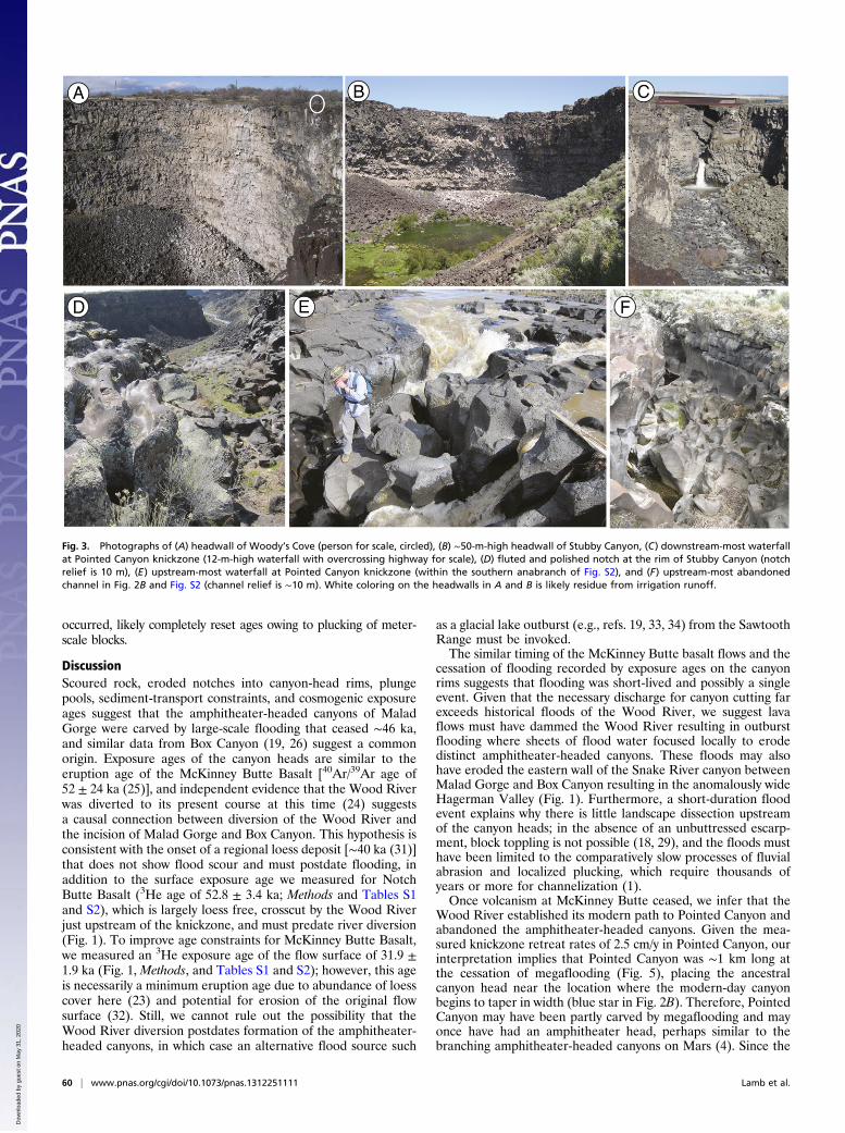
transport (Fig. 3 A and B). Woody’s Cove, the shortest of thethree canyons, lacks major spring flows and has minor, in-termittent overland flow partially fed by irrigation runoff thatspills over the canyon rim. Stubby has no modern-day overlandflow entering the canyon, and springs emanate from a pool nearits headwall (Fig. 3B). In contrast, Pointed Canyon is distinctlymore acute in planform morphology, contains a 7% gradeknickzone composed of multiple steps rather than a verticalheadwall (Figs. 2C and 3C), and extends the farthest upstream.Early work attributed the amphitheater-headed canyons in this
region—Malad Gorge, Box Canyon, located 18 km south ofMalad Gorge (Fig. 1), and Blue Lakes Canyon located 42 km tothe SE—to formation by seepage erosion because of no modernoverland flow and the occurrence of some of the largest springsin the United States in this region (7). Because spring flows (e.g.,∼10 m3/s in Box Canyon; US Geological Survey gauge 13095500)are far deficient to move the boulders that line the canyon floors,Stearns (7) reasoned that the boulders must chemically erode inplace. This explanation is improbable, however, given the youngage of the Quaternary basalt (25), spring water saturated indissolved solids (19), and no evidence of rapid chemical weath-ering (e.g., talus blocks are angular and have little to noweathering rinds). Instead of groundwater sapping, Box Canyonwas likely carved by a large-scale flood event that occurred ∼45ka based on 3He cosmogenic exposure age dating of the scouredrim of the canyon headwall (19, 26). In addition, Blue LakesCanyon was formed during the Bonneville Flood [∼18–22 ka (27,28)], one of the world’s largest outburst floods that occurred asa result of catastrophic draining of glacial lake Bonneville (21).In both cases, canyon formation was inferred to have occurredthrough upstream headwall propagation by waterfall erosion.
Herein we aim to test whether the amphitheater-headed canyonsat Malad Gorge also owe their origin to catastrophic flooding,whether Pointed Canyon has a different origin, and whether can-yon morphology is diagnostic of formation process. To this end wepresent field observations, sediment-size measurements, hydraulicmodeling, and cosmogenic exposure ages of water-scoured rocksurfaces and basalt-flow surfaces (Methods and Tables S1 and S2).
ResultsWe inspected the canyon rims and the escarpment that separatesWoody’s Cove from the rest of Malad Gorge and mappedscoured rock as indications of overland flow. Scours consist oflinear abrasion marks (flutes), often millimeters in depth andcentimeters long, that fan outward in the inferred downstreamflow direction (Fig. S1). The amphitheater-headed canyons atMalad Gorge have scoured rock upstream indicating overlandflow in the past (Fig. 2). Both amphitheater-headed canyons havenotches cut into their headwalls showing evidence for plucking(missing blocks) and abrasion (polished and fluted rock surfaces).For example, the notch at the head of Stubby Canyon is ∼10 mdeep with respect to the neighboring basaltic plain and cuts ba-salt-flow stratigraphy (Fig. 3D). In addition, both amphitheater-headed canyons have large pools at their heads (e.g., Fig. 3B),similar to plunge pools at the base of waterfalls. The pool atStubby Canyon, for example, is ∼120 m in diameter (Fig. 4A)and partially filled with sediment. Canyon headwalls are verticaland not undercut (Fig. 3 A and B), and the bedrock is blocky andjointed suggesting canyon-head erosion by block plucking andtoppling (18, 29). The bedrock scours upstream of the canyonheads, scoured notches at the canyon-head rims, vertical and blockycanyon headwalls, and large relict plunge pools at Malad Gorgecanyons are similar to features found at Box Canyon and BlueLakes Canyon, evidence used at those sites and elsewhere to sup-port canyon formation by large-scale flooding (e.g., refs. 19–21, 30).We collected samples of polished bedrock surfaces from the
notches of the amphitheater-headed canyons for cosmogenic3He exposure age dating (Methods and Tables S1 and S2). Inboth cases, eroded notches are sufficiently deep (10 m for StubbyCanyon and 2.6 m for Woody’s Cove) that any inherited cosmo-genic exposure before erosion is negligible. The exposure age at therim of Woody’s Cove is 47 ± 3 ka, which is within error of theoldest of three samples taken from the rim of Stubby (46 ± 3 ka).These ages are also within error of the age of the notch cut intothe rim of Box Canyon [45 ± 5 ka (26)]. The other four samples ofscoured rock within Stubby Canyon cluster with an average of20.6 ± 2.6 ka (Table S2), coincident with upper age constraints forthe Bonneville Flood (27, 28). Together, these exposure ages in-dicate the formation of all three amphitheater-headed canyons inthis region (Box Canyon, Woody’s Cove, and Stubby Canyon)may have been coeval, ceasing ∼46 ka, except for later reworkingduring backwater inundation by the Bonneville Flood.To constrain the discharge necessary to mobilize the boulders
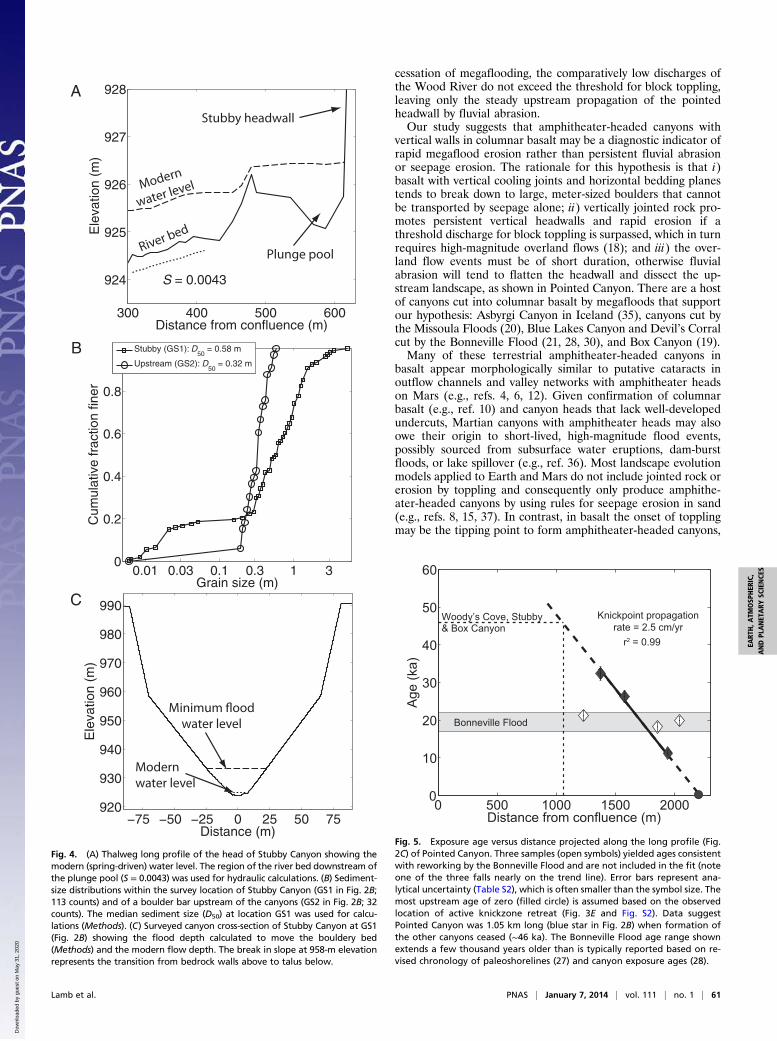
that line the canyon floors, which is a necessary condition forcanyon formation, we measured sediment sizes and surveyedchannel dimensions within Stubby Canyon (at GS1 in Fig. 2B;Methods). Median particle diameters are 0.58 m with the largestboulders exceeding 3 m (Fig. 4B). The river-bed gradient down-stream of the plunge pool has a near-constant slope of 0.0043(Fig. 4A), and modern spring-fed water depths average 1.0 m(Fig. 4C). These data were used as inputs into hydraulic re-sistance and incipient sediment motion formulas (Methods) tofind a modern spring discharge of 11 m3/s [similar to measure-ments within Box Canyon (19)] and a paleoflood necessary tomobilize the boulder bed that has a calculated minimum dis-charge of 1,250 m3/s and a minimum water depth of 9 m (Fig.4C). Large paleodischarges are also inferred from boulder bars(median grain diameter of 0.32 m; Fig. 4B) upstream of thecanyon (GS2 in Fig. 2B) where the flood was largely unconfined.
2
114°45'0"W114°50'0"W114°55'0"W
42°5
5'0"
N42
°50'
0"N
42°4
5'0"
N
0 5km
McKinney Butte Basalt
Gooding Butte Basalt
Notch Butte Basalt
Malad Gorge
Box Canyon
Snake River Woo
d Ri
ver
HagermanValley
Woody’s Cove
Idaho
Fig. 2A
Ancestral
Wood River?
Sample location
32 ka
53 ka
Fig. 1. Shaded relief map of the study region (50-m contour interval)showing basalt flows (23), their exposure age sample locations, and the pathof the ancestral Wood River following Malde (24) (US Geological Survey).
58 | www.pnas.org/cgi/doi/10.1073/pnas.1312251111 Lamb et al.
Dow
nloa
ded
by g
uest
on
May
31,
202
0

The calculated minimum canyon-forming discharge is approxi-mately sevenfold the largest historic discharge of the WoodRiver (181 m3/s over a 98-y record; US Geological Survey gauge13152500) and more than 100-fold the calculated modern springdischarge, indicating that the flood(s) that carved the amphi-theater-headed canyons of Malad Gorge were extraordinary.Our discharge estimate is consistent with calculated flow depthsof 2–6 m needed to exceed the threshold for megaflood erosionby block toppling in this region (18). Moreover, it is similar tothe discharge calculated for the canyon-carving flood at BoxCanyon [800–2,800 m3/s (19)] and far smaller than dischargecalculated for the Bonneville Flood [106 m3/s (30)].In contrast to the two amphitheater-headed canyons at Malad
Gorge, the third canyon ends in an active knickzone that housesthe Wood River (Fig. 3C) and contains abundant markers ofactive fluvial abrasion (rather than block toppling), most notably,nested potholes (Fig. 3E). At the upstream extent of the knick-zone, the active channel narrows from ∼20 to ∼1 m in width aswater plunges into the gorge and abandons the pothole-ladenriver bed at its margins as a strath terrace (Fig. 3E). Similar strathterraces abut both sides of Pointed Canyon along its upper ∼1 km.Upstream of Malad Gorge, the Wood River is anabranching, andthe propagation of the uppermost knickpoint appears to have pi-rated water that once flowed into a neighboring channel (Fig. S2).The abandoned channel contains abundant potholes and a now-drywaterfall (Fig. 3F). Additional abandoned channels exist fartherdownstream on both sides of Pointed Canyon (Fig. 2B), and
abrasion marks within the channels indicate flow into PointedCanyon in some cases and out of Pointed Canyon in other cases,supporting progressive abandonment of anabranches due toknickzone propagation.To test whether Pointed Canyon was formed by progressive
knickzone retreat, we collected samples for exposure age datingfrom strath terraces and abandoned channels (Fig. 2B, Methods,and Tables S1 and S2). Three of the resulting dates fall withinthe age range of the Bonneville Flood, and because the Bon-neville Flood likely inundated Malad Gorge in full (30), re-working and erosion of even the uppermost terraces cannot beruled out. The other exposure ages show progressive younging inthe upstream direction (Fig. 5) with a ∼33-ka abandoned channelat x = 1,300 m (where x is the distance from the confluence ofPointed and Stubby canyons), to an 11-ka abandoned channel atx = 1,900 m, to the most upstream extent of the knickzone whereterrace abandonment is active (Fig. S2 and Fig. 3E). These agessuggest, over at least the past 33 ka, a constant rate of knickzoneretreat of 2.5 cm/y (by linear regression, r2 = 0.99), and a con-stant rate is expected given that 1 km of retreat has not affectedthe 7,800 km2 drainage area to the knickpoint (e.g., refs. 1, 2). Itis possible that the Bonneville Flood partially affected all of theexposure ages in Pointed Canyon, but this cannot explain the 11ka age that is younger than the flood, nor the linear, upstream-younging trend in ages that intersects the modern knickpointlocation at ∼0 ka (Fig. 5). Moreover, flood erosion, where it
114°51'0"W114°52'0"W114°53'0"W
42°5
2'0"
N
0 0.5
km
Woody’s Cove
Stubby
Pointed
47 ka
Fig. 2B
Scour marks
0 500 1000 1500 2000900
950
1000
S = 0.019
S = 0.073
S = 0.0043
Distance from confluence (m)
Ele
vatio
n (m
)
A
114°51'0"W114°52'0"W
42°5
2'0"
N
0 0.25
km
Most upstreamwaterfall
19, 24 ka18, 22, 46 ka
21 ka
33 ka 26 ka18 ka 11 ka
20 ka
Fig. S2
GS1GS1
GS2GS2
Abandonedchannel
B
C
Sample location
StubbyPointed
Fig. 2. Malad Gorge topography (10-m contour in-terval) and aerial orthophotography (US GeologicalSurvey). (A) Overview map and (B) close-up forStubby and Pointed canyons showing mapped bed-rock scours (white arrows), exposure age samplelocations (red circles) with age results, location of theuppermost active knickpoint (black circle), aban-doned bedrock channels (blue dashed lines), andgrain-size analysis sites (blue squares). The blue starshows the reconstructed location of the headwall ofPointed Canyon at 46 ka (see Discussion and Fig. 5).(C) Longitudinal profile along Stubby and Pointedcanyons from their confluence (shown as white linesin B) with local slope, S, averaged over regionsdemarked by dashed lines (Fig. 4A shows close-up ofprofile in Stubby Canyon).
Lamb et al. PNAS | January 7, 2014 | vol. 111 | no. 1 | 59
EART
H,A
TMOSP
HER
IC,
ANDPL
ANET
ARY
SCIENCE
S
Dow
nloa
ded
by g
uest
on
May
31,
202
0
occurred, likely completely reset ages owing to plucking of meter-scale blocks.
DiscussionScoured rock, eroded notches into canyon-head rims, plungepools, sediment-transport constraints, and cosmogenic exposureages suggest that the amphitheater-headed canyons of MaladGorge were carved by large-scale flooding that ceased ∼46 ka,and similar data from Box Canyon (19, 26) suggest a commonorigin. Exposure ages of the canyon heads are similar to theeruption age of the McKinney Butte Basalt [40Ar/39Ar age of52 ± 24 ka (25)], and independent evidence that the Wood Riverwas diverted to its present course at this time (24) suggestsa causal connection between diversion of the Wood River andthe incision of Malad Gorge and Box Canyon. This hypothesis isconsistent with the onset of a regional loess deposit [∼40 ka (31)]that does not show flood scour and must postdate flooding, inaddition to the surface exposure age we measured for NotchButte Basalt (3He age of 52.8 ± 3.4 ka; Methods and Tables S1and S2), which is largely loess free, crosscut by the Wood Riverjust upstream of the knickzone, and must predate river diversion(Fig. 1). To improve age constraints for McKinney Butte Basalt,we measured an 3He exposure age of the flow surface of 31.9 ±1.9 ka (Fig. 1, Methods, and Tables S1 and S2); however, this ageis necessarily a minimum eruption age due to abundance of loesscover here (23) and potential for erosion of the original flowsurface (32). Still, we cannot rule out the possibility that theWood River diversion postdates formation of the amphitheater-headed canyons, in which case an alternative flood source such
as a glacial lake outburst (e.g., refs. 19, 33, 34) from the SawtoothRange must be invoked.The similar timing of the McKinney Butte basalt flows and the
cessation of flooding recorded by exposure ages on the canyonrims suggests that flooding was short-lived and possibly a singleevent. Given that the necessary discharge for canyon cutting farexceeds historical floods of the Wood River, we suggest lavaflows must have dammed the Wood River resulting in outburstflooding where sheets of flood water focused locally to erodedistinct amphitheater-headed canyons. These floods may alsohave eroded the eastern wall of the Snake River canyon betweenMalad Gorge and Box Canyon resulting in the anomalously wideHagerman Valley (Fig. 1). Furthermore, a short-duration floodevent explains why there is little landscape dissection upstreamof the canyon heads; in the absence of an unbuttressed escarp-ment, block toppling is not possible (18, 29), and the floods musthave been limited to the comparatively slow processes of fluvialabrasion and localized plucking, which require thousands ofyears or more for channelization (1).Once volcanism at McKinney Butte ceased, we infer that the
Wood River established its modern path to Pointed Canyon andabandoned the amphitheater-headed canyons. Given the mea-sured knickzone retreat rates of 2.5 cm/y in Pointed Canyon, ourinterpretation implies that Pointed Canyon was ∼1 km long atthe cessation of megaflooding (Fig. 5), placing the ancestralcanyon head near the location where the modern-day canyonbegins to taper in width (blue star in Fig. 2B). Therefore, PointedCanyon may have been partly carved by megaflooding and mayonce have had an amphitheater head, perhaps similar to thebranching amphitheater-headed canyons on Mars (4). Since the
Fig. 3. Photographs of (A) headwall of Woody’s Cove (person for scale, circled), (B) ∼50-m-high headwall of Stubby Canyon, (C) downstream-most waterfallat Pointed Canyon knickzone (12-m-high waterfall with overcrossing highway for scale), (D) fluted and polished notch at the rim of Stubby Canyon (notchrelief is 10 m), (E) upstream-most waterfall at Pointed Canyon knickzone (within the southern anabranch of Fig. S2), and (F) upstream-most abandonedchannel in Fig. 2B and Fig. S2 (channel relief is ∼10 m). White coloring on the headwalls in A and B is likely residue from irrigation runoff.
60 | www.pnas.org/cgi/doi/10.1073/pnas.1312251111 Lamb et al.
Dow
nloa
ded
by g
uest
on
May
31,
202
0
cessation of megaflooding, the comparatively low discharges ofthe Wood River do not exceed the threshold for block toppling,leaving only the steady upstream propagation of the pointedheadwall by fluvial abrasion.Our study suggests that amphitheater-headed canyons with
vertical walls in columnar basalt may be a diagnostic indicator ofrapid megaflood erosion rather than persistent fluvial abrasionor seepage erosion. The rationale for this hypothesis is that i)basalt with vertical cooling joints and horizontal bedding planestends to break down to large, meter-sized boulders that cannotbe transported by seepage alone; ii) vertically jointed rock pro-motes persistent vertical headwalls and rapid erosion if athreshold discharge for block toppling is surpassed, which in turnrequires high-magnitude overland flows (18); and iii) the over-land flow events must be of short duration, otherwise fluvialabrasion will tend to flatten the headwall and dissect the up-stream landscape, as shown in Pointed Canyon. There are a hostof canyons cut into columnar basalt by megafloods that supportour hypothesis: Asbyrgi Canyon in Iceland (35), canyons cut bythe Missoula Floods (20), Blue Lakes Canyon and Devil’s Corralcut by the Bonneville Flood (21, 28, 30), and Box Canyon (19).Many of these terrestrial amphitheater-headed canyons in
basalt appear morphologically similar to putative cataracts inoutflow channels and valley networks with amphitheater headson Mars (e.g., refs. 4, 6, 12). Given confirmation of columnarbasalt (e.g., ref. 10) and canyon heads that lack well-developedundercuts, Martian canyons with amphitheater heads may alsoowe their origin to short-lived, high-magnitude flood events,possibly sourced from subsurface water eruptions, dam-burstfloods, or lake spillover (e.g., ref. 36). Most landscape evolutionmodels applied to Earth and Mars do not include jointed rock orerosion by toppling and consequently only produce amphithe-ater-headed canyons by using rules for seepage erosion in sand(e.g., refs. 8, 15, 37). In contrast, in basalt the onset of topplingmay be the tipping point to form amphitheater-headed canyons,
−75 −50 −25 0 25 50 75920
930
940
950
960
970
980
990
Distance (m)
Ele
vatio
n (m
)
300 400 500 600
924
925
926
927
928
S = 0.0043
Distance from confluence (m)
Ele
vatio
n (m
)
0.01 0.03 0.1 0.3 1 30
0.2
0.4
0.6
0.8
1
Grain size (m)
Cum
ulat
ive
frac
tion
finer
Stubby (GS1): D50
= 0.58 m
Upstream (GS2): D50
= 0.32 m
Modernwater level
water level
Modern
water level
River bed
Stubby headwall
Plunge pool
A
B
C
Fig. 4. (A) Thalweg long profile of the head of Stubby Canyon showing themodern (spring-driven) water level. The region of the river bed downstream ofthe plunge pool (S = 0.0043) was used for hydraulic calculations. (B) Sediment-size distributions within the survey location of Stubby Canyon (GS1 in Fig. 2B;113 counts) and of a boulder bar upstream of the canyons (GS2 in Fig. 2B; 32counts). The median sediment size (D50) at location GS1 was used for calcu-lations (Methods). (C) Surveyed canyon cross-section of Stubby Canyon at GS1(Fig. 2B) showing the flood depth calculated to move the bouldery bed(Methods) and the modern flow depth. The break in slope at 958-m elevationrepresents the transition from bedrock walls above to talus below.
0 500 1000 1500 20000
10
20
30
40
50
60
Bonneville Flood
Woody’s Cove, Stubby & Box Canyon
Knickpoint propagation rate = 2.5 cm/yr
r2 = 0.99
Distance from confluence (m)
Age
(ka)
Fig. 5. Exposure age versus distance projected along the long profile (Fig.2C) of Pointed Canyon. Three samples (open symbols) yielded ages consistentwith reworking by the Bonneville Flood and are not included in the fit (noteone of the three falls nearly on the trend line). Error bars represent ana-lytical uncertainty (Table S2), which is often smaller than the symbol size. Themost upstream age of zero (filled circle) is assumed based on the observedlocation of active knickzone retreat (Fig. 3E and Fig. S2). Data suggestPointed Canyon was 1.05 km long (blue star in Fig. 2B) when formation ofthe other canyons ceased (∼46 ka). The Bonneville Flood age range shownextends a few thousand years older than is typically reported based on re-vised chronology of paleoshorelines (27) and canyon exposure ages (28).
Lamb et al. PNAS | January 7, 2014 | vol. 111 | no. 1 | 61
EART
H,A
TMOSP
HER
IC,
ANDPL
ANET
ARY
SCIENCE
S
Dow
nloa
ded
by g
uest
on
May
31,
202
0

which implies drastically different water discharges and flowdurations for canyon formation than groundwater sapping.
MethodsFourteen rock samples were taken for 3He cosmogenic exposure-age dating:five from Stubby Canyon, six from Pointed Canyon, one from Woody’s Cove,one from McKinney Butte Basalt, and one from Notch Butte Basalt (Figs. 1and 2 and Tables S1 and S2). A cosmic ray-shielded sample used to correct allcanyon erosion samples (BG0 in Table S1) was taken from 5.8 m deep withina crack located ∼4 m from the canyon sidewall of Pointed Canyon. The cracksplits a viewing platform indicating it has opened historically. Shieldedsamples for McKinney Butte and Notch Butte basalts were taken from roadcuts (MB0 and NB0 in Table S2).
Samples were collected by chipping off the upper 4 cm of rock on near-horizontal surfaces. We separated 250- to 450-μm-diameter olivine and py-roxene grains from the crushed host rock by standard magnetic, heavy liquid,and hand picking techniques. Adhering groundmass was removed by sonicat-ing samples in 5% (vol/vol) 2:1 HF:HNO3 acid for ∼1 h. Samples were groundand wet-sieved to <37 microns which largely removes mantle-derived 3Hetrapped in melt and/or fluid inclusions (38). The remaining matrix-sited 3Heand 4He was measured on a MAP 215-50 noble gas mass spectrometer
following heating to 1,300 °C in vacuum to release the gas (39) (Table S1).Shielded samples were used to correct for remaining mantle-derived andnucleogenic 3He (40), which only averaged 6% of the total measured 3He(Table S1). Accumulation ages and production rates (Tables S1 and S2) werecalculated using the Lifton/Sato scaling scheme (41, 42) on the CRONOS 3Hecalculator (43, 44).
To calculate minimum paleodischarge, we surveyed a cross-section andlong profile using a total station (Fig. 4 A and C). Sediment-size measure-ments of the intermediate particle axis (Fig. 4B) were made on a regular-spaced grid (Fig. 2A). Thalweg flow depths required for transport of the me-dian particle size were calculated using ref. 45. Using calculated water depthand surveyed canyon cross-sectional area (Fig. 4C), we calculated the minimumpaleoflood discharge following (46), where the bed-roughness length scalewas 1.3 D84 (where D84 = 1.3 m is the sediment diameter in which 84% of thebed is finer; Fig. 4B) following a calibration in similar Box Canyon (19).
ACKNOWLEDGMENTS. We thank Joel Scheingross, Mathieu Lapotre, andJim McKean for field assistance; Willy Amidon for sample preparation; andBill Phillips for regional comparisons and mapping. This work was supportedby NSF Grant 1147381 and NASA Grant PGG12-0107 to M.P.L. Commentsfrom two reviewers strengthened the final version of this paper.
1. Whipple KX (2004) Bedrock rivers and the geomorphology of active orogens. AnnuRev Earth Planet Sci 32:151–185.
2. Berlin MM, Anderson RS (2007) Modeling of knickpoint retreat on the Roan Plateau,western Colorado. J Geophys Res 112(F3):1–16.
3. Laity JE, Malin MC (1985) Sapping processes and the development of theater-headedvalley networks on the Colorado Plateau. Geol Soc Am Bull 96:203–217.
4. Sharp RP, Malin MC (1975) Channels on Mars. Geol Soc Am Bull 86(5):593–609.5. Lamb MP, et al. (2006) Can springs cut canyons into rock? J Geophys Res 111(E7):1–18.6. Malin MC, Carr MH (1999) Groundwater formation of martian valleys. Nature
397(6720):589–591.7. Stearns HT (1936) Origin of the large springs and their alcoves along the Snake River
in southern Idaho. J Geol 44:429–450.8. Petroff AP, et al. (2011) Geometry of valley growth. J Fluid Mech 673:245–254.9. Bandfield JL, Hamilton VE, Christensen PR (2000) A global view of Martian surface
compositions from MGS-TES. Science 287(5458):1626–1630.10. Milazzo MP, et al. (2009) Discovery of columnar jointing on Mars. Geology 37(2):171–174.11. Warner NH, Gupta S, Kim J-R, Lin S-Y, Muller J-P (2010) Retreat of a giant cataract in
a long-lived (3.7-2.6 Ga) martian outflow channel. Geology 38(9):791–794.12. Craddock RA, Howard AD (2002) The case for rainfall on a warm, wet early Mars.
J Geophys Res 107(E11):1–36.13. Howard AD, McLane CF (1988) Erosion of cohesionless sediment by groundwater
seepage. Water Resour Res 24(10):1659–1674.14. Schumm SA, Boyd KF, Wolff CG, Spitz WJ (1995) A ground-water sapping landscape in
the Florida Panhandle. Geomorphology 12(4):281–297.15. Pelletier JD, Baker VR (2011) The role of weathering in the formation of bedrock
valleys on Earth and Mars: A numerical modeling investigation. J Geophys Res116(E11007):1–13.
16. Howard AD, Kochel RC, Holt H (1988) Sapping features of the Colorado Plateau: Acomparative planetary geology field guide. NASA Spec Publ 491:71–83.
17. Haviv I, et al. (2010) Evolution of vertical knickpoints (waterfalls) with resistant cap-rock: Insights from numerical modeling. J Geophys Res 115:1–22.
18. Lamb MP, Dietrich WE (2009) The persistence of waterfalls in fractured rock. Geol SocAm Bull 121(7–8):1123–1134.
19. Lamb MP, Dietrich WE, Aciego SM, Depaolo DJ, Manga M (2008) Formation of BoxCanyon, Idaho, by megaflood: Implications for seepage erosion on Earth and Mars.Science 320(5879):1067–1070.
20. Bretz JH (1923) The channeled scabland of the Columbia Plateau. J Geol 31:617–649.21. Malde HE (1968) The Catastrophic Late Pleistocene Bonneville Flood in the Snake
River Plain, Idaho, USGS Prof Pap, 596:1–52.22. Malde HE (1991) Quaternary geology and structural history of the Snake River
Plain, Idaho and Oregon. Quaternary Nonglacial Geology; Conterminous U.S, edMorrison RB (Geol Soc Am, Boulder, CO), Vol K-2, pp 251–280.
23. Kauffman JD, Otherberg KL, Gillerman VS, Garwood DL (2005) Geologic Map of theTwin Falls 30 x 60 Minute Quadrangle, Idaho (Idaho Geol Surv, Moscow, ID).
24. Malde HE (1971) History of the Snake River canyon indicated by revised stratigraphyof the Snake River Group near Hagerman and King Hill, Idaho. US Geol Surv Prof Pap644-F, 20 pp.
25. Tauxe L, Luskin C, Selkin P, Gans P, Calvert A (2004) Paleomagnetic results from theSnake River Plain: Contribution to the time-averaged field global database. GeochemGeophys Geosyst 5(8):1–19.
26. Aciego SM, et al. (2007) Combining He-3 cosmogenic dating with U-Th/He eruption
ages using olivine in basalt. Earth Planet Sci Lett 254(3–4):288–302.27. Miller DM, Oviatt CG, McGeehin JP (2013) Stratigraphy and chronology of Provo
shoreline deposits and lake-level implications, Late Pleistocene Lake Bonneville,
eastern Great Basin, USA. Boreas 42(2):342–361.28. Amidon WH, Clark A, Barrett B (2011) Snake River side canyons: Ages and process of
formation. The Bonneville Flood Revisited, ed Crosby BT (Friends of the Pleistocene
Guidebook), pp 50–61. Available at http://www2.cose.isu.edu/~crosby/fop_flood/FOP2011_Bonneville_Flood.pdf. Accessed June 1, 2013.
29. Goodman NM, Bray JW (1977) Toppling of rock slopes. Rock Engineering for Foun-
dations and Slopes (Am Soc Civ Eng, NY), pp 201–234.30. O’Connor JE (1993) Hydrology, Hydraulics and Geomorphology of the Bonneville
Flood (Geol Soc Am, Boulder, CO), 90 pp.31. Forman SL, Smith RP, Hackett WR, Tullis JA, McDaniel PA (1993) Timing of late
Quaternary glaciations in the western United States based on the age of loess on the
eastern Snake River Plain, Idaho. Quat Res 40(1):30–37.32. Sims KWW, et al. (2007) Determining eruption ages and erosion rates of Quaternary
basaltic volcanism from combined U-series disequilibria and cosmogenic exposure
ages. Geology 35(5):471–474.33. Rathburn SL (1993) Pleistocene cataclysmic flooding along the Big Lost River, east
central Idaho. Geomorphology 8(4):305–319.34. Cerling TE, Poreda RJ, Rathburn SL (1994) Cosmogenic He-3 and Ne-21 age of the Big
Lost River Flood, Snake River Plain, Idaho. Geology 22(3):227–230.35. Tomasson H (1973) Hamfarahlaup i Jokulsa a Fjollum. Natturufraeoingurinn 43:12–34.36. Warner NH, Sowe M, Gupta S, Dumke A, Goddard K (2013) Fill and spill of giant lakes
in the eastern Valles Marineris region of Mars. Geology 41(6):675–678.37. Luo W, Howard AD (2008) Computer simulation of the role of groundwater seepage
in forming Martian valley networks. J Geophys Res 113(E5):1–14.38. Kurz MD (1986) In-situ production of terrestrial cosmogenic helium and some appli-
cations in geochronology. Geochim Cosmochim Acta 50(12):2855–2862.39. Amidon WH, Farley KA (2011) Cosmogenic He-3 production rates in apatite, zircon and
pyroxene inferred from Bonneville flood erosional surfaces. Quat Geochronol 6(1):10–21.40. Cerling TE, Craig H (1994) Geomorphology and in-situ cosmogenic isotopes. Annu Rev
Earth Planet Sci 22:273–317.41. Lifton NA, et al. (2005) Addressing solar modulation and long-term uncertainties in
scaling secondary cosmic rays for in situ cosmogenic nuclide applications. Earth Planet
Sci Lett 239(1–2):140–161.42. Sato T, Niita K (2006) Analytical functions to predict cosmic-ray neutron spectra in the
atmosphere. Radiat Res 166(3):544–555.43. Balco G, Stone JO, Lifton NA, Dunai TJ (2008) A complete and easily accessible means
of calculating surface exposure ages or erosion rates from (10)Be and (26)Al meas-
urements. Quat Geochronol 3(3):174–195.44. Goehring BM, et al. (2010) A reevaluation of in situ cosmogenic He-3 production
rates. Quat Geochronol 5:410–418.45. Lamb MP, Dietrich WE, Venditti JG (2008) Is the critical Shields stress for incipient
sediment motion dependent on channel-bed slope? J Geophys Res 113(F2):1–20.46. Bathurst JC (2002) At-a-site variation and minimum flow resistance for mountain rivers.
J Hydrol 269(1–2):11–26.
62 | www.pnas.org/cgi/doi/10.1073/pnas.1312251111 Lamb et al.
Dow
nloa
ded
by g
uest
on
May
31,
202
0