an active crawler for discovering geospatial web services and their distribution pattern
TRANSCRIPT

PLEASE SCROLL DOWN FOR ARTICLE
This article was downloaded by: [University of California, Santa Barbara]On: 17 October 2010Access details: Access Details: [subscription number 918976320]Publisher Taylor & FrancisInforma Ltd Registered in England and Wales Registered Number: 1072954 Registered office: Mortimer House, 37-41 Mortimer Street, London W1T 3JH, UK
International Journal of Geographical Information SciencePublication details, including instructions for authors and subscription information:http://www.informaworld.com/smpp/title~content=t713599799
An active crawler for discovering geospatial Web services and theirdistribution pattern - A case study of OGC Web Map ServiceWenwen Lia; Chaowei Yanga; Chongjun Yangb
a Joint Center for Intelligent Spatial Computing, College of Science, George Mason University, Fairfax,VA, USA b Institute of Remote Sensing Applications, Chinese Academy of Sciences, Beijing, China
Online publication date: 16 June 2010
To cite this Article Li, Wenwen , Yang, Chaowei and Yang, Chongjun(2010) 'An active crawler for discovering geospatialWeb services and their distribution pattern - A case study of OGC Web Map Service', International Journal ofGeographical Information Science, 24: 8, 1127 — 1147To link to this Article: DOI: 10.1080/13658810903514172URL: http://dx.doi.org/10.1080/13658810903514172
Full terms and conditions of use: http://www.informaworld.com/terms-and-conditions-of-access.pdf
This article may be used for research, teaching and private study purposes. Any substantial orsystematic reproduction, re-distribution, re-selling, loan or sub-licensing, systematic supply ordistribution in any form to anyone is expressly forbidden.
The publisher does not give any warranty express or implied or make any representation that the contentswill be complete or accurate or up to date. The accuracy of any instructions, formulae and drug dosesshould be independently verified with primary sources. The publisher shall not be liable for any loss,actions, claims, proceedings, demand or costs or damages whatsoever or howsoever caused arising directlyor indirectly in connection with or arising out of the use of this material.

An active crawler for discovering geospatial Web services and theirdistribution pattern – A case study of OGC Web Map Service
Wenwen Lia*, Chaowei Yanga and Chongjun Yangb
aJoint Center for Intelligent Spatial Computing, College of Science, George Mason University,Fairfax, VA, USA; bInstitute of Remote Sensing Applications, Chinese Academy of Sciences,
Beijing, China
(Received 1 February 2008; final version received 22 November 2009)
The increased popularity of standards for geospatial interoperability has led to anincreasing number of geospatial Web services (GWSs), such as Web Map Services(WMSs), becoming publicly available on the Internet. However, finding the services ina quick and precise fashion is still a challenge. Traditional methods collect the servicesthrough centralized registries, where services can be manually registered. But the meta-data of the registered services cannot be updated timely. This paper addresses the abovechallenges by developing an effective crawler to discover and update the services in (1)proposing an accumulated term frequency (ATF)–based conditional probability modelfor prioritized crawling, (2) utilizing concurrent multi-threading technique, and (3)adopting an automatic mechanism to update the metadata of identified services.Experiments show that the proposed crawler achieves good performance in both crawlingefficiency and results’ coverage/liveliness. In addition, an interesting finding regardingthe distribution pattern of WMSs is discussed. We expect this research to contribute toautomatic GWS discovery over the large-scale and dynamic World Wide Web and thepromotion of operational interoperable distributed geospatial services.
Keywords: geospatial Web service (GWS); crawler; Web Map Service (WMS); accu-mulated term frequency (ATF); conditional probability; clumped distribution
1. Introduction
The development of geospatial information acquisition methods helps to collect hugeamounts of geospatial information. In 2006 alone, NASA’s Earth Observing System Dataand Information System (EOSDIS) produced over 3 terabytes (TB) of Earth system sciencedata on a daily basis (NASA 2007). The geospatial information is widely utilized in differentapplications, such as navigation (Rae-Dupree 2006), transportation (Peytchev andClaramunt 2001), urban planning (Stevens et al. 2007), and emergency response(Rauschert et al. 2002). However, they are archived in various forms, and the geospatialapplications, provided by different vendors, are highly heterogeneous in data representation,storage, and access (Paul and Ghosh 2006). The heterogeneity makes it difficult to share andexchange geospatial information.
To solve this heterogeneity problem and to facilitate better sharing of geospatial infor-mation, standards have been developed by a variety of organizations. In 1994 the OpenGeospatial Consortium (OGC), the Federal Geographic Data Committee (FGDC), and the
International Journal of Geographical Information ScienceVol. 24, No. 8, August 2010, 1127–1147
*Corresponding author. Email: [email protected]
ISSN 1365-8816 print/ISSN 1362-3087 online# 2010 Taylor & FrancisDOI: 10.1080/13658810903514172http://www.informaworld.com
Downloaded By: [University of California, Santa Barbara] At: 22:36 17 October 2010

International Organization for Standardization/Technical Committee 211 (ISO/TC211) wereestablished to develop a series of specifications and standards, such as FGDC MetadataContent Standards (Nebert 2004), WebMap Service (WMS; de La Beaujardiere 2004), WebFeature Service (WFS; Vretanos 2005), and Web Coverage Service (WCS; Whiteside andEvans 2006). Most of the specifications leverage geospatial Web services (GWSs), alsoreferred to as distributed geospatial information services (DGISs; Yang and Tao 2006), tofacilitate the sharing of geospatial information. The GWS defines software componentinterfaces that provide access to geospatial information through Hypertext TransferProtocol (HTTP)-based queries.
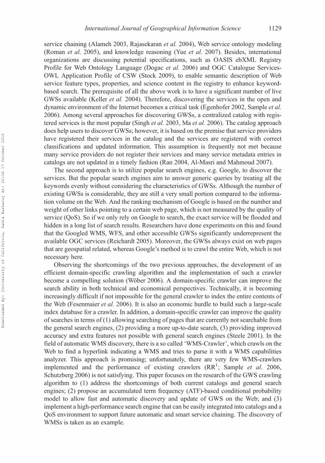
For example, the WMS defines the interface for accessing geospatial data uniformly fromremote servers in a standard format, such as Portable Network Graphics (PNG) and GraphicsInterchange Format (GIF), through HTTP. Three WMS operations are defined and used in thefollowing sequence: (1) ‘GetCapabilities’ requests the servicemetadata; (2) ‘GetMap’ requestsa static map according to given geospatial and other parameters; and (3) ‘GetFeatureInfo’requests data of selected features. The three operations are issued to a WMS in the format ofhttp://WMS_URL? Request=Operations&Service=WMS&Version=1.*.* through the HTTPPOST or GET protocols. The procedure allows a WMS to integrate different geospatialinformation and services at the mapping level. Figure 1 shows a WMS link residing in aweb page as a hyperlink.
Other GWSs are defined to address interoperability at different levels, such as howWFSsupports interoperation among vector data encapsulated by Geographic Markup Language(GML) and howWCS supports the interoperation of geospatial data (such as GeoTIFF). Thedifference is that WMS provides an image map rather than raw data (De La Beaujardiere2004). WFS and WCS provide raw data to the client, but they are not immediately visible asthe data are generally geometric objects/features described by a set of vertices and slightlyprimitive (Vretanos 2005, Whiteside and Evans 2006). Therefore, the implementation logicof WFS and WCS at the client side would be more complex.
The increased popularity of these standards has led to an increasing number of GWSsbecoming publicly available on the Internet. Recently, researchers have explored automaticassembly of different GWSs to build distributed geospatial information systems utilizing
Figure 1. WMS’s appearance on the Web: Aweb page may contain an anchor text with a Web link.The link may refer to a WMS URL for invoking a WMS capability file that describes basic serviceinformation for the WMS.
1128 W. Li et al.
Downloaded By: [University of California, Santa Barbara] At: 22:36 17 October 2010
service chaining (Alameh 2003, Rajasekaran et al. 2004), Web service ontology modeling(Roman et al. 2005), and knowledge reasoning (Yue et al. 2007). Besides, internationalorganizations are discussing potential specifications, such as OASIS ebXML RegistryProfile for Web Ontology Language (Dogac et al. 2006) and OGC Catalogue Services-OWL Application Profile of CSW (Stock 2009), to enable semantic description of Webservice feature types, properties, and science content in the registry to enhance keyword-based search. The prerequisite of all the above work is to have a significant number of liveGWSs available (Keller et al. 2004). Therefore, discovering the services in the open anddynamic environment of the Internet becomes a critical task (Egenhofer 2002, Sample et al.2006). Among several approaches for discovering GWSs, a centralized catalog with regis-tered services is the most popular (Singh et al. 2003, Ma et al. 2006). The catalog approachdoes help users to discover GWSs; however, it is based on the premise that service providershave registered their services in the catalog and the services are registered with correctclassifications and updated information. This assumption is frequently not met becausemany service providers do not register their services and many service metadata entries incatalogs are not updated in a timely fashion (Ran 2004, Al-Masri and Mahmoud 2007).
The second approach is to utilize popular search engines, e.g. Google, to discover theservices. But the popular search engines aim to answer generic queries by treating all thekeywords evenly without considering the characteristics of GWSs. Although the number ofexisting GWSs is considerable, they are still a very small portion compared to the informa-tion volume on the Web. And the ranking mechanism of Google is based on the number andweight of other links pointing to a certain web page, which is not measured by the quality ofservice (QoS). So if we only rely on Google to search, the exact service will be flooded andhidden in a long list of search results. Researchers have done experiments on this and foundthat the Googled WMS, WFS, and other accessible GWSs significantly underrepresent theavailable OGC services (Reichardt 2005). Moreover, the GWSs always exist on web pagesthat are geospatial related, whereas Google’s method is to crawl the entire Web, which is notnecessary here.
Observing the shortcomings of the two previous approaches, the development of anefficient domain-specific crawling algorithm and the implementation of such a crawlerbecome a compelling solution (Wober 2006). A domain-specific crawler can improve thesearch ability in both technical and economical perspectives. Technically, it is becomingincreasingly difficult if not impossible for the general crawler to index the entire contents ofthe Web (Fesenmaier et al. 2006). It is also an economic hurdle to build such a large-scaleindex database for a crawler. In addition, a domain-specific crawler can improve the qualityof searches in terms of (1) allowing searching of pages that are currently not searchable fromthe general search engines, (2) providing a more up-to-date search, (3) providing improvedaccuracy and extra features not possible with general search engines (Steele 2001). In thefield of automatic WMS discovery, there is a so called ‘WMS-Crawler’, which crawls on theWeb to find a hyperlink indicating a WMS and tries to parse it with a WMS capabilitiesanalyzer. This approach is promising; unfortunately, there are very few WMS-crawlersimplemented and the performance of existing crawlers (RR1; Sample et al. 2006,Schutzberg 2006) is not satisfying. This paper focuses on the research of the GWS crawlingalgorithm to (1) address the shortcomings of both current catalogs and general searchengines; (2) propose an accumulated term frequency (ATF)-based conditional probabilitymodel to allow fast and automatic discovery and update of GWS on the Web; and (3)implement a high-performance search engine that can be easily integrated into catalogs and aQoS environment to support future automatic and smart service chaining. The discovery ofWMSs is taken as an example.
International Journal of Geographical Information Science 1129
Downloaded By: [University of California, Santa Barbara] At: 22:36 17 October 2010
2. Related work
The most notable research conducted in developing crawlers to discover WMSs on theInternet are Refractions Research (RR)’s WMS Crawler, GIDB WMS-Crawler (GIDB;Sample et al. 2006), and a WMS-crawler by Skylab Mobilesystems Ltd (Skylab;Schutzberg 2006).
RR utilizes the Google application programming interfaces (APIs) to find GWSs bysearching WMS operation strings. It also supports the discovery of WFS and WFS-G(Gazetteer Service). However, the method of using Google APIs has inherited the limitationof Google’s internal crawler and indexer: some recently available WMSs that have not beencrawled by Google cannot be found by the Google API search.
The GIDB WMS-Crawler also leverages, but does not completely depend on, theGoogle APIs. GIDB uses GIS Web sites as seed URLs to reduce the number of web pagesto be processed. It then extracts the URLs and sends GetCapabilities request to determine if afound URL is a real WMS by validating the response. Some technical approaches, such asfiltering out ‘none’ XML responses, are followed to improve the performance. GIDB hasadvantages over the RR by using these techniques, but it does not designate priority for seedURLs during crawling. Therefore, even the discovery starts from several GISWeb sites. Theout-links can still go far beyond the geospatial pages, where WMSs are embedded.
Skylab Mobilesystems Ltd. (Skylab) has developed a WMS-crawler, which is a com-mercial product, without sharing the technical design or performance evaluations. Therefore,it is hard to tell whether Skylab designed its own strategy or algorithm to crawl or utilizedGoogle APIs. The known information is that the number of WMSs found through thecrawler is 904 (both live and dead)2, which is apparently below the real number.
This paper is trying to address the issues related to current WMS-crawlers to improvetheir performance in the following aspects by developing a new WMS crawler: (1)Efficiency: We will try to improve the discovery speed using multi-threading and otherprocess management techniques. Since it is not realistic and necessary to crawl the entireWeb, the goal is set to identify as many WMSs as possible within a specific time period. (2)Effectiveness: We will propose a special approach to focus on geospatially related pages tonarrow the crawling scope by deciding which set of URLs has higher possibilities ofcontaining or linking to WMSs to minimize the required Web crawling. (3) Updates:Since the availability of WMS is dynamic because of maintenance, a mechanism will bedesigned to keep the service metadata up to date.
The rest of the paper is organized as follows: Section 3 introduces the architecture designof our crawler, Section 4 presents the ATF-based conditional probability model and othertechniques we used to improve the crawler, Section 5 introduces the crawler interface,workflow, and technical implementation, Section 6 compares the performance of our crawlerto other existing crawlers, analyzes the results, and discusses the importance of findings ondistribution pattern of GWSs, and Section 7 concludes the paper, discusses the universalproblem in automated service discovery and possible solutions, and points out futureresearch directions.
3. Crawler architecture
The crawler developed for WMS (Figure 2) includes crawling entry, buffer, source pageanalyzer, filter, repository, request/response (R/R handler), XML resolver, and a database toarchive the WMS and relevant metadata discovery.
1130 W. Li et al.
Downloaded By: [University of California, Santa Barbara] At: 22:36 17 October 2010

Crawling entry is where the crawler starts to work. One or more seeding Web URLs areeither identified by users or fetched automatically from the repository. The concurrent multi-threading technique detailed in Section 4.3 is used to crawl the Web for improvingefficiency.
Buffer selectively caches Web source code linked by URLs. Different from other genericcrawlers which cache all the crawledWeb documents for revisit, our buffer only caches thosehaving the possibility of containing a WMS URL due to WMS’s characteristics: web pagesnot containing WMS URLs when being crawled will have a low possibility of containing aWMS URL later on. Therefore, they are discarded. The hyperlinks cached in the bufferwould be exported and stored to hard disk periodically. Once an unexpected error occurs, thecrawling process can be recovered by loading the recorded information back to the memory.This buffering strategy helps to reduce memory waste, lower the maintenance cost, as well astolerate fault during crawling.
Source page analyzer is used to analyze the Web source code that has been cached in thebuffer. It extracts all out-links and transforms the relative URLs of the links into absoluteURLs. After completing the process, the analyzer removes the source code based on thestrategy adopted for the buffer module. Then the URL goes to the filter, which utilizespriorities based on the probability of linking to a WMS before putting URLs into therepository. The filter also filters out the URLs that already exist in the URL repository.
The repository maintains the URLs crawled using a priority queue, which are dividedinto several segments based on importance. R/R (request/response) handler gets the URL atthe head of the repository and sends the WMS GetCapabilities requests to the serverspecified by the URL. The responses are parsed by the XML resolver to validate theURL’s status using WMS tags, such as ,WMS_Capabilities/., ,Service., and,layer.. Once a WMS is found, metadata information such as layer numbers, servicebounding box, spatial coverage, supported mapping projections, as well as other QoS-related information, including availability (whether a Web service is present or ready forimmediate use) and latency (the round-trip time between sending a request and receiving theresponse), will be extracted and stored in the service catalog. The automatic metadata updatewill update the catalog periodically by a complementary model detailed in Section 4.4.
Figure 2. Crawler architecture (Li, 2007).
International Journal of Geographical Information Science 1131
Downloaded By: [University of California, Santa Barbara] At: 22:36 17 October 2010

Section 4 details the improved techniques adopted for the crawler compared to thecrawlers reviewed in Section 2.
4. Techniques for improving WMS crawler
4.1. Prioritized crawling: an ATF-based conditional probability model
It is very inefficient for a WMS crawler to visit all of the web pages on the Internet only tofind a tiny part of resources that are needed. Therefore, quicker access to a web page with aWMS URL will improve the performance. This can be achieved by assigning crawlingpriorities to web pages and URLs. Given a URL u, the probability of u referring to a WMScan be determined as follows.
Definition 1: Given a URL u, we define the probability of u as PðuÞ ¼ ðUP;WPÞðuÞ,where UP(u) denotes to URL priority and WP(u) denotes to priority of the web page fromwhich u is extracted; both UP(u) and WP(u) have the same range f0; 1; 2; 3g.
The URL priority UP(u) is determined according to the characteristic of a WMS. TheWMS is exposed in the format of a URL, which can handle a client’s request through KVP(keyword value pair) encoding; thus the URLmust be linked to an active web page instead ofa static web page. Therefore, URLs linking to static web pages would not be considered asWMSs. But considering that the static web pages that the URLs link to might containinformation related to a WMS, we still reserve them but assign them the lowest priority,UP(u) = 3. Some well-known image/document/video/audio formats can be excluded.
Higher priority is given to the active pages. An ATF analysis is performed and the initialpriority levels (UP(u) = 0, 1 or 2) are assigned based on the elementary statistical results. Thestatistical priorities change dynamically when more WMSs are identified. To obtain this, thesystem maintains a list which contains terms (atomic substrings extracted from URL string)in descending order of their frequencies. Initially, based on the first N (we chose N = 50)WMSs found, we extracted the terms from their URL strings and calculated the TF values.Then the list was divided into three equal parts: the top one has the highest priority (Pr(t) = 0,t is any term in the top part), the middle one has the second highest priority (Pr(t) = 1), and thebottom one has the priority Pr(t) = 2. Each time a URL u is crawled, all the atomic substringsof the URL except protocol/host name are extracted, represented by Tu ¼ ft1; t2 . . . tng. Thepriority WP(u) is determined by the highest priority of term ti in Tu, namelyUPðuÞ ¼ maxfPrðt1Þ; Prðt2Þ . . . PrðtnÞg. If there is no occurrence of ti in the list, the priorityis assigned as PrðtiÞ ¼ 2. If this URL is later justified as a WMS URL, all terms will beextracted and both the term occurrences and frequencies will be updated. For example,suppose list L contains five terms in current stage, which is L = {‘request = GetCapabilities’(t1), 20; ‘service =WMS’ (t2), 16; ‘version = 1.1.0’ (t3), 10; ‘cgi-bin’ (t4), 3; ‘servlet’ (t5), 3}in descending order of TF value. According to the section partition, the top two of them willbe given the highest priority (0), namely Prðt1Þ ¼ Prðt2Þ ¼ 0, the following two have priorityPrðt3Þ ¼ Prðt4Þ ¼ 1, and the last one has lowest priority among the current terms,Prðt5Þ ¼ 2. When a new URL ux (http://hazards.fema.gov/wmsconnector/wmsconnector/Servlet/NFHL?request=GetCapabilities&service=WMS) is retrieved, the atomicsubstrings are extracted as Tux ¼ {‘wmsconnector’, ‘wmsconnector’, ‘Servlet’,‘request = GetCapabilities’, ‘service = WMS’, ‘NFHL’}. According to the definition ofUP, we obtain thatUPðuxÞ ¼ maxfPrðtiÞ; ti 2 Lg ¼ minf2; 2; 2; 1; 0g ¼ 0. As ux is testifiedas a WMS URL later on, all the terms in Tux will be combined with those in L. The new Lwith updated TF is L = {‘request = GetCapabilities’ (t1), 21; ‘service = WMS’ (t2), 17;‘version = 1.1.1’ (t3), 10; ‘servlet’ (t4), 4; ‘cgi-bin’ (t5), 3; ‘wmsconnector’ (t6), 2; ‘NFHL’
1132 W. Li et al.
Downloaded By: [University of California, Santa Barbara] At: 22:36 17 October 2010
(t7), 1}. Partitioning L into three sections, the priority for each term is obtainedasPrðt1Þ ¼ Prðt2Þ ¼ Prðt3Þ ¼ 0, Prðt4Þ ¼ Prðt5Þ ¼ 1, and Prðt6Þ ¼ Prðt7Þ ¼ 2, whichwould be used for future UP judgment. By a continuously learning process, the size of Lincreases gradually to generate an enriched controlled vocabulary, which contains funda-mental semantic information to guide future crawling jobs.
Based on Definition 1, the priority for URLs can be formalized as
P u1jUPðu1Þ ¼ ið Þ > P u2jUPðu2Þ ¼ jð Þ; where i; j 2 f0; 1; 2; 3g and i < j (1)
which means that if the URL priority of u1is higher (smaller in value) than that of u2, theprobability that u1is a WMS URL is larger than the probability that u2 is a WMS URL.
By investigating web pages that may contain a WMS URL, the probability of web pagescontaining keywords [Web Map Service] (we define WP(u) = 0) is higher than that of thosecontaining [WMS, Service] (defining WP(u) = 1), which is higher than that of thosecontaining [WMS, Server] (defining WP(u) = 2), which is higher than any others that donot contain these keywords (defining WP(u) = 3). To verify this, we collected the top 400web pages returned from the Google search engine with the above query keywords, and testsshow that 16% of the web pages that contain [WebMap Service] contain aWMSURL in thesource code, and the ratio is 13.25% and 10% for those containing [WMS service] and[WMS server], respectively. Those without the keywords have a ratio of having a WMSURL near zero. So the priority of a web page that may contain a WMS URL can beformalized as
Pðu1jWPðu1Þ ¼ i;UPðu1Þ ¼ kÞ > Pðu2jWPðu2Þ ¼ j;UPðu2Þ ¼ kÞ;where i; j; k 2 f0; 1; 2; 3g and i < j
(2)
This means that when the UP of two URLs is equal, the less WP a URL is, the higherprobability it has to refer to a WMS.
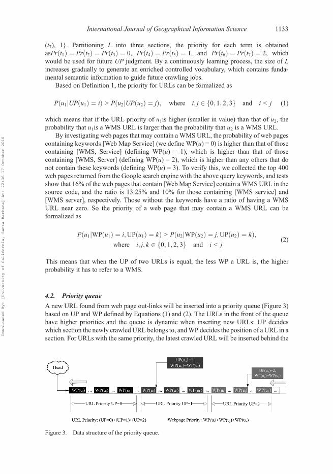
4.2. Priority queue
A new URL found from web page out-links will be inserted into a priority queue (Figure 3)based on UP and WP defined by Equations (1) and (2). The URLs in the front of the queuehave higher priorities and the queue is dynamic when inserting new URLs: UP decideswhich section the newly crawled URL belongs to, andWP decides the position of a URL in asection. For URLs with the same priority, the latest crawled URL will be inserted behind the
Figure 3. Data structure of the priority queue.
International Journal of Geographical Information Science 1133
Downloaded By: [University of California, Santa Barbara] At: 22:36 17 October 2010

ones crawled previously. By this strategy, the crawling path is determined and recordeddynamically into the priority queue.
4.3. Multi-thread
Crawling web pages to find URLs and analyzing web pages to findWMSs are the most time-consuming components of the crawler. The processes are independent from each otherexcept when they are trying to access the same section of the queue. Therefore, two groupsof multi-threads can be utilized to speed up the crawling and analysis respectively: (1) Group1 crawls theWWW, extracts URLs, and inserts the extracted URLs into a priority queue; and(2) Group 2 picks URLs from the priority queue and sends GetCapabilities requests todetermine whether the URLs refer to live WMSs and updates the catalog. The priority queueis set as a critical section for the two thread groups. The concurrent threading could speed upthe crawling but there is an optimal number of threads for performance tested in Section 6.1.
4.4. Automatic update
The automatic update module (Figure 4) is adopted to keep the WMS metadata up to date inthe catalog and resolve the metadata for service and layers. It works in two modes: (1)Message driven: when a WMS is retrieved by the crawler, the automatic update module willbe invoked to resolve metadata; (2) Revisit control: periodically, the module will pull therecords out from the catalog and communicate with WMS servers to get the updatedmetadata. If the server is unavailable, the module will record it as an error and update the‘reason of unavailability’ column in the catalog. The module could be added to scheduledtasks, so the operating system can invoke the module periodically to revisit and updateWMSs’ status. The revisit period is chosen by users and can be of any length, depending onthe liveliness requirement of various application systems. The WMSs typically do notchange as frequently as news Web sites do. Therefore, the update can be conducted asinfrequently as once per day. Meanwhile, separating this module from the crawler architec-ture helps to isolate this time-consuming process from the crawling tasks, so the automaticstatus update is able to be conducted in parallel with crawling process. In this way, crawlingefficiency is improved and the design complexity is reduced.
Figure 4. The WMS metadata automatic update module.
1134 W. Li et al.
Downloaded By: [University of California, Santa Barbara] At: 22:36 17 October 2010
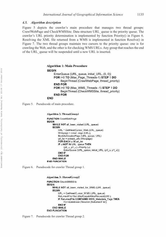
4.5. Algorithm description
Figure 5 depicts the crawler’s main procedure that manages two thread groups:CrawlWebPage and CheckWMSSite. Data structure URL_queue is the priority queue. Thecrawler’s URL priority determination is implemented by function Priority() in Figure 6.Resolving the XML file returned from a WMS is implemented in function Resolve() inFigure 7. The two thread groups maintain two cursors to the priority queue: one is forcrawling theWeb, and the other is for checkingWMSURLs. Any group that reaches the endof the URL_queue will be suspended until a new URL is inserted.
Figure 5. Pseudocode of main procedure.
Figure 6. Pseudocode for crawler Thread group 1.
Figure 7. Pseudocode for crawler Thread group 2.
International Journal of Geographical Information Science 1135
Downloaded By: [University of California, Santa Barbara] At: 22:36 17 October 2010

5. Prototype implementation
We implement proposed techniques into a prototype based on the Microsoft .NET frame-work. The main goal of the prototype is to enable an end user to customize the process ofWMS crawling and to monitor system resource usage during crawling. The prototype isopen source and available through an SVN server. Major technical details are as follows:
l Crawler is coded using Visual C++ and the graphic user interface (GUI) of the crawleris created using Microsoft Foundation Class (MFC).
l Automatic update model is coded using Visual Basic Script and is made executableusing Windows Task Scheduler.
l Backend database adopts Microsoft SQL Server 2005 SP1 and its connection with thecrawler is through Microsoft’s Open Database Connectivity (ODBC) driver.
Figure 8 shows the GUI designed for a general user to utilize the prototype of our crawler.The top to bottom of the left side of the GUI is designated as the start point of the crawler:crawler status reports, including start time and duration of the crawling task; the number ofcrawling threads of the two groups; search results, including web pages that have beencrawled and the WMS address if any WMS is found. The right side of the GUI showsstatistical information including average processing speed and hardware usage for monitor-ing the crawler’s status.
The sequence diagram of the crawler can be illustrated in Figure 9.
(1) Designate the start URL(s) and send requests to the crawler.(2) Crawler sends HTTP GET Request to remote web server.
Figure 8. GUI of the crawler.
1136 W. Li et al.
Downloaded By: [University of California, Santa Barbara] At: 22:36 17 October 2010

(3) Return source code to the crawler.(4) Crawler resolves the source code, extracts all the URL addresses that exist on the
web page as hyperlinks or common text, then puts them into priority queueaccording to their priority.
(5) Crawler returns the accessed URL address to the client side for display.(6) If crawler finds a similar WMS service, it sends GetCapabilities request.(7) Capability file returns to crawler.(8) Determines whether the URL is linked to a WMS server.(9) Return the WMS URLs to client for display.
(10) Client and crawler communicate to get the status information while crawling.
For these functions, (2)–(5) are accomplished by Thread group 1 in modules ‘source pageanalyzer’ and ‘filter’. Steps (6)–(9) are accomplished by Thread group 2 in modules ‘R/Rhandler’ and ‘XML resolver’.
6. Crawler evaluation
This section compares the performance of our crawler to that of other popular crawlers, andevaluates how well our crawler performs with and without the proposed algorithm. The testswere conducted on a computer with a Pentium� 4 3.4 GHz CPU, 4 GB of RAM, and a100 Mbps Internet connection. The test includes three parts: (1) efficiency (2) coverage andtimeliness, and (3) precision.
Figure 9. User sequence diagram.
International Journal of Geographical Information Science 1137
Downloaded By: [University of California, Santa Barbara] At: 22:36 17 October 2010

6.1. Efficiency improvement by concurrent threads
Since the operating system (OS) only allocates limited CPU cycles and memory to execute athread, it is very hard to speed up a single thread within a single program. Multi-threading,which increases the utilization of a single CPU core, leverages thread-level parallelism(Yang et al. 2005). Especially when a thread gets a lot of cache misses, the other threads cantake advantage of unused computing resources to continue the crawling task. This leads tofaster overall execution and higher system throughput. However, multiple threads alsointerfere with each other due to the sharing of hardware resources and thus generate criticalinter-thread communication overhead. The optimal number of threads is a balance betweenthe tasks and the computing resources including CPU, memory, hard disk, and networkbandwidth. In Section 4.3, we discussed the threading model, in which one group of threadsperforms crawling tasks, and another group of threads performs determination tasks.
Figure 10 demonstrates that (1) when there is only one crawling thread and onedetermination thread, the crawler’s throughput is very low; and (2) when we increase thenumber of crawling and determination threads to 10 each, the crawler’s throughput increasesdramatically. Through successive tests, we determined that having 72 crawling threads and72 determination threads optimized the throughput (of course, this result only applies to thetested computing environment). Equal numbers of threads were chosen for crawling anddetermination because our initial experiments showed that this approach optimized thethroughput.
It is also important that a crawler behaves politely to remote servers while maintaining ahigh crawling speed. If a crawler is performing many requests per second, the performanceof a server could be negatively impacted. When calculating the crawling speed from theoptimized thread groups (72, 72) obtained from the above experiment, our crawler averages0.5 s per page, which is consistent with the polite access interval (1-s-per-page result)proposed by Dill et al. (2002). In addition, the priority determination mechanism introducedin our crawling algorithm helps the crawler to gather high-priority pages first. Unlike generalsearch engines that tend to crawl a web page hosted by a server regardless of its format and
Figure 10. Crawling speed with different numbers of concurrent threads.
1138 W. Li et al.
Downloaded By: [University of California, Santa Barbara] At: 22:36 17 October 2010
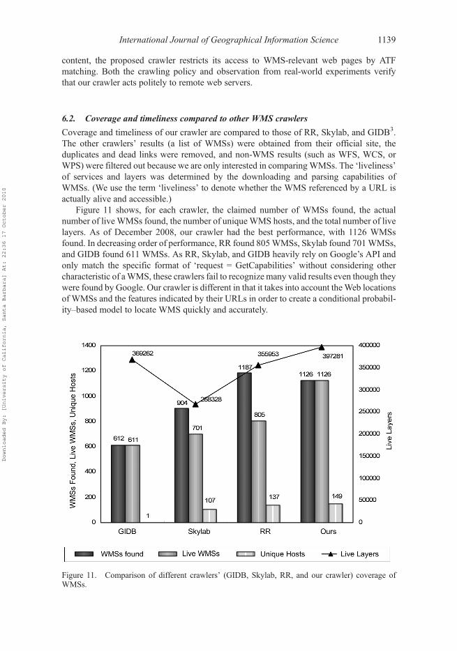
content, the proposed crawler restricts its access to WMS-relevant web pages by ATFmatching. Both the crawling policy and observation from real-world experiments verifythat our crawler acts politely to remote web servers.
6.2. Coverage and timeliness compared to other WMS crawlers
Coverage and timeliness of our crawler are compared to those of RR, Skylab, and GIDB3.The other crawlers’ results (a list of WMSs) were obtained from their official site, theduplicates and dead links were removed, and non-WMS results (such as WFS, WCS, orWPS) were filtered out because we are only interested in comparingWMSs. The ‘liveliness’of services and layers was determined by the downloading and parsing capabilities ofWMSs. (We use the term ‘liveliness’ to denote whether the WMS referenced by a URL isactually alive and accessible.)
Figure 11 shows, for each crawler, the claimed number of WMSs found, the actualnumber of live WMSs found, the number of uniqueWMS hosts, and the total number of livelayers. As of December 2008, our crawler had the best performance, with 1126 WMSsfound. In decreasing order of performance, RR found 805WMSs, Skylab found 701WMSs,and GIDB found 611 WMSs. As RR, Skylab, and GIDB heavily rely on Google’s API andonly match the specific format of ‘request = GetCapabilities’ without considering othercharacteristic of aWMS, these crawlers fail to recognize many valid results even though theywere found by Google. Our crawler is different in that it takes into account theWeb locationsof WMSs and the features indicated by their URLs in order to create a conditional probabil-ity–based model to locate WMS quickly and accurately.
Figure 11. Comparison of different crawlers’ (GIDB, Skylab, RR, and our crawler) coverage ofWMSs.
International Journal of Geographical Information Science 1139
Downloaded By: [University of California, Santa Barbara] At: 22:36 17 October 2010

In terms of timeliness, all of the other crawlers that we tested had a significant number ofdead links in their results. When employing these results into practical applications, thesystem’s performance would drop dramatically due to dead WMS reports, which is a greatdrawback of existing crawlers. In contrast, the liveliness of WMSs found by our crawler is100%. Our crawler’s automatic updating algorithm, described in Section 4.4, enables thehigh liveliness rate.
Interestingly, although our crawler discovered more liveWMSs than the RR crawler did,the number of unique hosts where the services were located was almost the same for bothcrawlers. An explanation is that Google (RR relies on Google API) has the advantage of avery large-scale cache which can be easily searched, even though it is not designed fordomain-specific crawling. However, Google limits its crawl depth by its page rank (PR)value (Sergey and Page 1999), so some web pages that have higher WP or UP but lower PRwill not be crawled. In contrast, our crawler is better at analyzing and fully extractingWMSsfrom web pages in a single host. The reason for this is that our algorithm considers thecharacteristic of WMSs and employs a text-analyzing technique combined with a purehyperlink analysis.
6.3. Quickness in locating WMSs and findings regarding WMS distribution
The priority queue based on a conditional probability model is adopted to make our crawlerfind WMSs more quickly. This experiment evaluates the proposed algorithm in comparisonto a pure FIFO algorithm. The parameter ‘quickness’ (formula [3]) is used to measure howfast a crawler is able to identify a WMS.
Quickness ¼ Number of WMSs Found
Total Webpage crawled(3)
Notice that the quality of seed URLs will greatly affect the experimental results. Bad seedsmay lead to a very time-consuming crawling without any WMSs found. To conduct ameaningful crawl, the crawler could start from a popular geospatial Web site (retrievedfrom general search engines by the keywords provided in Section 4.1), or it could start from aweb server that is hosting a WMS or that has hosted WMSs before (as given by results ofexisting crawlers). Choosing one of these servers as a starting point is useful because it ismore likely for such servers to host new WMSs or links to other Web sites that host aWMS. In this experiment, the seeds that were chosen are the following: (1) NationalAeronautics and Space Administration (NASA): http://www.nasa.gov, (2) NationalOceanic and Atmospheric Administration (NOAA): http://www.noaa.gov, and (3) OpenGeospatial Consortium (OGC): http://www.opengeospatial.org. Among these seeds, boththe NASA and NOAA seed URLs are located on the crawling path of the OGC seed, whichmeans that all the WMSs that are found by starting from NASA and NOAA’s web pages canbe retrieved by starting from the OGC Web site. Here, extracting them out as independentseeds makes the discovery process more effective by avoiding unnecessary crawling jobs.But the OGC Web site is still an important seed because WMSs that are not located in theNASA and NOAA’s reachable network may connect from other links in the OGC Web site.
Figure 12 was generated from the experimental results of crawling the first 40,000 webpages starting at NASA, NOAA, and OGC. In those results, 23WMSs were found. The figureshows that both algorithms have similar trends because of the FIFO algorithm utilized.However, the proposed algorithm, which applies an ATF-based conditional probability
1140 W. Li et al.
Downloaded By: [University of California, Santa Barbara] At: 22:36 17 October 2010
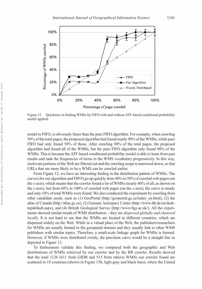
model to FIFO, is obviously faster than the pure FIFO algorithm. For example, when crawling50% of the total pages, the proposed algorithm had found nearly 90% of theWMSs, while pureFIFO had only found 50% of those. After crawling 90% of the total pages, the proposedalgorithm had found all of the WMSs, but the pure FIFO algorithm only found 90% of theWMSs. This is because the ATF-based conditional probability model is able to learn from pastresults and rank the frequencies of terms in the WMS vocabulary progressively. In this way,irrelevant portions of theWeb are filtered out and the crawling scope is narrowed down, so thatURLs that are more likely to be a WMS can be crawled earlier.
From Figure 12, we have an interesting finding in the distribution pattern of WMSs. Thecurves (for our algorithm and FIFO) go up quickly from 40% to 50% of crawledweb pages (onthe x-axis), which means that the crawler found a lot ofWMSs (nearly 40% of all, as shown onthe y-axis), but from 60% to 100% of crawled web pages (on the x-axis), the curve is steadyand only 10% of totalWMSs were found.We also conducted the experiment by crawling fromother candidate seeds, such as (1) GeoPortal (http://geoportal.gc.ca/index_en.html), (2) theatlas of Canada (http://atlas.gc.ca), (3) German Aerospace Center (http://www.dlr.de/en/desk-topdefault.aspx), and (4) British Geological Survey (http://www.bgs.ac.uk/). All the experi-ments showed similar trends of WMS distribution – they are dispersed globally and clusteredlocally. It is not hard to see that the WMSs are located in different countries, which aredispersed widely on the Web. While in a virtual place of the Web, the publishers/researchersfor WMSs are usually limited to the geospatial domain and they usually link to other WMSpublishers with similar topics. Therefore, a small-scale linkage graph for WMSs is formed.However, if WMSs were distributed evenly, the precision curve would be a straight line asdepicted in Figure 12.
To furthermore validate this finding, we compared both the geographic and Webdistributions of WMSs retrieved by our crawler and by the RR crawler. Results showedthat the total 1126 (611 from GIDB and 515 from others) WMSs our crawler found arescattered in 18 countries (shown in Figure 13b, light gray and black bars), where the United
Figure 12. Quickness in findingWMSs by FIFOwith and without ATF-based conditional probabilitymodel applied.
International Journal of Geographical Information Science 1141
Downloaded By: [University of California, Santa Barbara] At: 22:36 17 October 2010

Figure13
.Com
parisonof
glob
aldistribu
tion
ofWMSsfoun
dby
RRandou
rCrawler.Allthebarsusethesamescale,show
ninthelegend
sof
(a)and(b).The
legend
in(b)show
snu
mbersthatdo
notexistin
thelegend
of(a).(Toillustratetheresultson
themap
clearly,theleng
thsof
someof
thebarsareno
tto
scale.)(a)Global
distribu
tion
ofWMSsfoun
dby
RR(byDecem
ber20
08).(b)Globaldistributionof
WMSsfoun
dby
ourcraw
ler(byDecem
ber20
08andJune
2009
).Therearethree
typesof
bars,w
hich
areblack,ligh
tgray,anddark
gray.B
lack
barsaretheWMSdistribu
tion
identified
inDecem
ber20
08.L
ightgray
barsshow
theWMSsthatwere
availablein
Decem
ber20
08bu
twereun
availablein
June
2009
.Darkgray
barsdemon
stratetheincreasedWMSsfrom
Decem
ber20
08to
June
2009
.
1142 W. Li et al.
Downloaded By: [University of California, Santa Barbara] At: 22:36 17 October 2010

Figure13.
(Con
tinu
ed)
International Journal of Geographical Information Science 1143
Downloaded By: [University of California, Santa Barbara] At: 22:36 17 October 2010
States hosts the most WMSs (852), then Germany (145), Canada (42), Spain (38),Netherlands (12), Switzerland (6), Czech Republic (6), Australia (5), United Kingdom (4)and others (17). The WMSs found by RR (Figure 13a) are located in 20 countries, mainly inUnited States, Germany, Canada, Spain, Czech Republic, Australia, Russian Federation,Netherlands, and others. Results from both crawlers illustrated the clustering of WMSs aswell. On average, our crawler found 8 services per server, while the RR crawler found6 services per server.
We also observed the Web diffusion of WMS servers over time (using a 6-month frame)to illustrate distribution variation. By June 2009, our crawler had identified 228 more liveWMSs clustered on 68 web servers (dark gray bars in Figure 13b) than the number found byDecember 2008 (Figure 11). The United States had the biggest increase in absolute number(146). Services in Europe had increased by 78, which were distributed among Norway (60),Sweden (11), Denmark (5), France (1), and Finland (1). The crawler had also found 4 moreWMSs in Canada. However, 168 WMSs (light gray bars in Figure 13b) identified byDecember 2008 became dead by June 2009. This phenomenon reflects the fact that thestability cycle of a WMS is short. Although more WMSs are becoming available to provideonline geospatial data services, they still lack effective maintenance methods. Meanwhile,the frequent changes of WMS hosting makes it hard for current catalogs to adapt. Therefore,although crawling techniques proposed in this paper can automatically detect the changes,the instability of WMSs creates a very challenging issue within the geospatial community.
In total, the unique web servers hosting these WMSs increased to 186 and on averagethere were 6.38 services per web server. These results still show that WMSs are highlyclustered. Note that although the crawling task has been conducted for a long time and asignificant number of WMSs have been identified, there is still a big vacuum in Asian andAfrican countries. In contrast, countries like the United States and Canada in North Americaand European countries such as Norway, Sweden, and Denmark all have significant con-tributions to the total WMSs. This may reflect the fact that the research of GWSs andinteroperability in some Asian and African countries need great advancement.
Overall, the trends shown in Figure 13 demonstrate the clumped distribution of WMSs.This distribution pattern indicates that WMSs can be more effectively discovered bydesigning a focused and small-scale crawler than by relying on general search engines likeGoogle. ‘Small scale’ is a relative measurement compared to the total size of the Web,estimated to be more than 17.27 billion (indexable) pages (Kunder 2009). In total, ourcrawler has crawled around 1.3 million web pages. In comparison to Google which usesmore than 100,000 servers (Mingay 2007) to conduct crawling tasks, the design of theproposed crawler leads to a big savings in computing resources, network bandwidth, andcrawling costs.
7. Discussion and conclusion
The increasing availability of the GWSs on the Internet poses a challenge in discoveringGWSs from the vast amounts of information on the Internet. This paper reports on ourresearch in improving crawling for quickly discovering GWSs. Multiple techniques, such asa priority queue and multi-threading, are adopted to improve the crawling process in thedevelopment of our crawler. The methodology, algorithm, and system architecture aredescribed in detail. Performance evaluations are conducted from two aspects: (1) with andwithout optimization techniques and (2) comparing our crawler to the three other popularGWS crawlers. Results demonstrate that our crawler performs better than the others, in termsof efficiency and effectiveness, with the techniques adopted.
1144 W. Li et al.
Downloaded By: [University of California, Santa Barbara] At: 22:36 17 October 2010

Although the proposed crawler has identified a significant number of live WMSs, webelieve this number still underrepresents the total amount of the real-world WMSs. This isbecause there are a fair number of services residing in deepWeb (Lawrence and Giles 1999),such as those behind firewalls or hosted on private servers (Ramsey 2005). Solving thisproblem needs the efforts from researchers in both GIS and information retrieval (IR)communities. Currently, GIS researchers propose to develop a supportive environment forcrawlers by implementing a ‘public library’ through Universal Description Discovery andIntegration (UDDI) (Reichardt 2005). In the IR community, alternative ways are beingexploited to facilitate the crawling of the deep Web. For example, Google provides theSitemap Protocol and mod oai mechanism to enable search engines and other interestedparties to discover deep Web resources on particular web servers (Brandman et al. 2000).They accomplish this by allowing the servers to advertise the accessible URLs to searchengines such that resources that have no obvious linkage can be discovered automatically.Another way is to exploit the deep Web using human crawlers as supplements to machinecrawlers, which means that humans find interesting links that machine crawlers cannot findat the current stage inWeb harvesting, e.g. StumbleUpon (http://www.stumbleupon.com). Inaddition, the process of seed selection discussed in Section 6.3 can be considered as humancrawling, which assists the algorithmic crawler proposed. We believe that with optimizationtechniques proposed in this study and the maturing of the supportive environments, futurecrawling would be more efficient and effective.
Furthermore, the clumped distribution of WMSs was discovered: they are globallydispersed and locally clustered. Following this pattern, the OpenGIS community would beable to build a larger and more open environment for geospatial information sharing andinteroperating. The above findings also provide effective guidance and principles fordesigning an efficient crawling engine to discover WMSs. As the WMSs are Web servicesin nature, the algorithms used for discovering WMSs are also applicable for discoveringother types ofWeb services. In addition, with the significant number of services identified bythe proposed crawler, semantic relationships can be analyzed based on the content describedin the capability file of each service and a knowledge base can be built to allow semanticquery from available services to enhance traditional search ability (Li et al. 2008).
In the future, we aim to integrate more effective politeness policies such as a robotsexclusion protocol and a comprehensive fault-tolerant mechanism.Wewill also combine ourresearch outcome with other advanced computing techniques, such as grid and peer-to-peercomputing, to further improve the performance (Yang et al. 2008) of crawling and utilizationof WMSs and other GWSs for application development (Yang et al. 2007).
Notes1. Refractions Research (RR)’s white paper. http://refractions.net/expertise/whitepapers/ogcsurvey/
ogcsurvey/2. Skylab Mobilesystems’ WMS list. http://ogc-services.net/3. GIDB WMS Service list: http://columbo.nrlssc.navy.mil/ogcwms/servlet/WMSServlet?
REQUEST=ServiceLinks
ReferencesAlameh, N., 2003. Chaining geographic information Web services. Internet Computing, 7, 22–29.Al-Masri, E. and Mahmoud, Q.H., 2007. Interoperability among service registry standards. Internet
Computing, 11, 74–77.
International Journal of Geographical Information Science 1145
Downloaded By: [University of California, Santa Barbara] At: 22:36 17 October 2010
Brandman, O., et al., 2000. Crawler-friendly web servers. SIGMETRICS Performance EvaluationReview, 28, 9–14.
De La Beaujardiere, J., ed., 2004. Web Map Service implementation specifications, Version 1.3. OGCDocument Number: 04-024, Open Geospatial Consortium, 85pp. Available online at: http://portal.opengeospatial.org/files/?artifact_id=5316 (accessed 15th January 2010).
Dogac, A., Kabak, Y., and Laleci, G.B., 2006. ebXML Registry Profile for Web Ontology Language(OWL). Organization for the Advancement of Structured Information Standards (OASIS), 75pp.Available online at: http://xml.coverpages.org/OASIS-regrepOWL-Profile-22611.pdf (accessed15th January 2010).
Dill, S., et al., 2002. Self-similarity in theWeb. ACMTransactions on Internet Technology, 2, 205–223.Egenhofer, M., 2002. Toward the semantic geospatial Web. In: Proceedings of the 10th ACM interna-
tional symposium on advances in geographic information systems, VA, A. Voisard and S. Chen(Eds.) New York: ACM, 1–4.
Fesenmaier, D.R., Wober, K.W., and Werthner, H., 2006. Destination recommendation systems:behavioral foundations and applications. Oxford, UK: Oxford University Press, 205–220.
Keller, U., Lara, R., and Polleres, A., 2004. WSMO Web service discovery. In: U. Keller, et al., eds.WSMO Web service discovery working draft D5.1v0.1, 13–15. Galway, Ireland: DERI. Availableonline at: http://www.wsmo.org/2004/d5/d5.1/v0.1/ (accessed 15th January 2010).
Kunder, M.D., 2009. The size of World Wide Web [online]. Available from: http://www.worldwide-websize.com/ [Accessed September 2009].
Lawrence, S. and Giles, C.L., 1999. Accessibility of information on the Web. Nature, 400, 107–109.Li, W., 2007. Interoperability based spatial information retrieval and ontology based semantic search.
Thesis (MSc), Institute of Remote Sensing Applications, Chinese Academy of Sciences, Beijing,China, 84pp.
Li, W., Yang, C., and Raskin, R., 2008. A semantic enhanced search for spatial Web portals. In:Technical report of semantic scientific knowledge integration of AAAI spring symposium,D. McGuinness, P. Fox, and B. Brodaric (Eds.). Merlo Park, CA: AAAI Press, 47–50.
Ma, X., et al., 2006. A peer-to-peer approach to geospatial Web service discovery. In: Proceedingsof 1st international conference on Scalable information system. Hong Kong, China, Article. 53.New York: ACM.
Mingay, S., 2007. Green IT: the new industry shock wave. Gartner RAS core research noteG00153703, 2, Article 10. Gartner Inc: Stamford, Connecticut, US. Available online at: http://www.netdesign.dk/manedens-tema/telepresence/green-it-the-new-industry.pdf (accessed 15th
January 2010).NASA, 2007. Earth system science data resources: tapping into a wealth of data, information, and
services. National Aeronautics and Space Administration, 65pp. Available online at: http://outreach.eos.nasa.gov/outreach/broch/daac/ESSDR112007.pdf (accessed 15th January 2010).
Nebert, D., ed., 2004. Developing spatial data infrastructures: the SDI cookbook, Version 2.0,Global Spatial Data Infrastructure, 171pp. Available online at: http://www.gsdi.org/docs2004/Cookbook/cookbookV2.0.pdf (accessed 15th January 2010).
Paul, M. and Ghosh, S.K., 2006. An approach for service oriented discovery and retrieval of spatialdata. In: Proceedings of the 2006 international workshop on service-oriented software engineer-ing, E. Di Nitto, R. J. Hall, J. Han, Y. Han, A. Polini, K. Sandkuhl, A. Zisman (Eds.), 88–94.New York: ACM.
Peytchev, E. and Claramunt, C., 2001. Inelegant transportation systems and network algorithms:Experiences in building decision support systems for traffic and transportation GIS. In:Proceedings of the 9th ACM international symposium on advances in geographic informationsystems GIS 001, GA, 154–159. W. G. Aref (Ed.). New York: ACM.
Rae-Dupree, J., 2006. Dash navigation – real-time GPS driving. Business Journal, Available from:http://sanjose.bizjournals.com/sanjose/stories/2006/11/20/focus15.html [Accessed 23 January2008].
Rajasekaran, P., et al., 2004. Enhancing Web services description and discovery to facilitate composi-tion. In: Proceedings of first international semantic Web services and Web process compositionworkshop. San Diego, CA J. Cardoso and A. Sheth (Eds.) Berlin: Springer–Verlag.
Ramsey, P., 2005. A census of public OGC Web services. Presentation to the OGC planning 600 Q19committee, 2005 CGDI Implementor’s Forum. Available online at: http://www.geoconnections.org/developersCorner/devCorner_devNetwork/meetings/2005.02.16/cgdi_200502_ows_survey.ppt(accessed 15th January 2010).
1146 W. Li et al.
Downloaded By: [University of California, Santa Barbara] At: 22:36 17 October 2010

Ran, S., 2004. A model for Web services discovery with QoS. SIGEcom Exchanges, 4, 1–10.Rauschert, I., et al., 2002. User interfaces: designing a human-centered, multimodal GIS interface to
support emergency management. In: Proceedings of the 10th ACM international symposium onadvances in geographic information systems GIS 002. VA, 119–124. A. Voisard and S. Chen(Eds.), New York: ACM.
Reichardt, M., 2005. GSDI depends on widespread adoption of OGC standards. In: Proceedings of theFIG working week and GSDI8: from pharaohs to geoinformatics. Cairo, Egypt.
Roman, D., et al., 2005. Web service modeling ontology. Applied Ontology, 1, 77–106.Sample, J.T., et al., 2006. Enhancing the US Navy’s GIDB portal with Web services. Internet
Computing, 10, 53–60.Schutzberg, A., 2006. Skylab Mobilesystems crawls the Web for Web Map Services. OGC User, 8,
1–3.Sergey, B. and Page, L., 1999. The anatomy of a large-scale hypertextualWeb search engine.Computer
Networks and ISDN Systems, 30, 107–117.Singh, G., et al., 2003. A metadata catalog service for data intensive applications. In: Proceedings of
the 2003 ACM/IEEE conference on supercomputing. Washington, DC: IEEE Computer Society.Steele, R., 2001. Techniques for specialized search engines. In: Proceedings of the international
conference on Internet computing, IC 02001. Las Vegas, NV, 25–28. P. Graham, M. Maheswaranand M. R. Eskicioglu (Eds.). Las Vegas, Nevada: CSREA Press.
Stevens, D., Dragicevic, S., and Rothley, K., 2007. iCity: a GIS-CA modeling tool for urban planningand decision making. Environmental Modeling and Software, 22, 761–773.
Stock, K., ed., 2009. OGC catalogue services – OWL application profile of CSW. OGC document no.09-010, Open Geospatial Consortium, 70pp.
Vretanos, P.A., ed., 2005. Web feature service implementation specifications, version 1.1.0. OGCdocument no. 04-094. Open Geospatial Consortium, 131pp.
Whiteside, A. and Evans, J., eds., 2006. Web coverage service implementation specifications, version1.1.0. OGC document no. 06–083r8. Open Geospatial Consortium, 143pp.
Wober, K., 2006. Domain specific search engines. In: D.R. Fesenmaier, K. Wober, and H. Werthner,eds.Destination recommendation systems: behavioral foundations and applications, Wallingford,UK: CABI, 205–226.
Yang, C., Cao, Y., and Evans, J., 2007. WMS performance and client design principles. Journal ofGIScience and Remote Sensing, 44, 320–333.
Yang, C. and Tao, C.V., 2006. Distributed Geospatial Information Service (Distributed GIService). In:S. Rana and J. Sharma, eds. Frontiers of geographic information technology. New York: Springer,103–120.
Yang, C., et al., 2005. Performance improving techniques in WebGIS. International Journal ofGeographical Information Science, 19, 319–342.
Yang, C., et al., 2008. Distributed geospatial information processing – sharing distributed geospatialresources to support the digital Earth. International Journal of Digital Earth, 1, 259–278.
Yue, P., et al., 2007. Semantics-based automatic composition of geospatial Web service chains.Computers and Geosciences, 33, 649–665.
International Journal of Geographical Information Science 1147
Downloaded By: [University of California, Santa Barbara] At: 22:36 17 October 2010