an adult male (usnm 578755), a giant anole endemic to the...
TRANSCRIPT

203
An adult male Norops loveridgei (USNM 578755), a giant anole endemic to the Cordillera Nombre de Dios in the Northern Cordillera of the Chortís Block Biogeographic Province. This canopy-dwelling species is considered Endangered by the IUCN due to continued loss of its Premontane Wet Forest habitat. La Liberación, Refugio de Vida Silvestre Texíguat, Departamento de Atlántida, Honduras, elev. 1,090 m.
' © Josiah H. Townsend
203

Mesoamerican Herpetology 204 December 2014 | Volume 1 | Number 2
Characterizing the Chortís Block Biogeographic Province: geological, physiographic, and ecological associations and
herpetofaunal diversity Josiah h. Townsend
Department of Biology, Indiana University of Pennsylvania, Indiana, Pennsylvania 15705–1081, United States.
E-mail: [email protected]
absTracT: The geological history of Central America is remarkably complex, as the region has served as the biological dispersal route between North and South America, and also has been the site of extensive in situ evolution. Nuclear Central America is recognized as a region of high biodiversity, and the eastern portion of Nuclear Central America (the Chortís Block) largely has been overlooked as a biodiversity hotspot. In this paper, I present a characterization of geological, physiographic, and ecological associations to define the Chortís Block Biogeographic Province. The Chortís Block is partitioned into the Caribbean and Pacific Lowlands and the Northern, Central, and Southern cordilleras, which in turn are delimited into 24 distinct highland areas and 14 intermontane valleys. I provide contextualized definitions of ecological formations and identify six lowland-associated habitats, of which four habitats are shared between lowlands and highlands, and 10 habitats are associated with highlands areas. I present a summary of the diversity, distribution, and conservation status of the herpetofauna of the Chortís Block, using a combination of the published literature and results from 19 expeditions to over 60 localities from 2006 to 2014. The Chortís herpetofauna is characterized by a high degree of endemism (38% of all species are endemic) and equally high extinction risk (42% threatened, including 94% of endemic species). Endemism is highest among the salamanders (86%), followed by the lizards (43%), the anurans (38%), and the snakes (23%).
Key Words: Amphibian, biogeography, Central America, CSS, El Salvador, endemism, EVS, geomorphology, Guatemala, Honduras, IUCN, Nicaragua, reptile
resumen: Centro América tiene una historia geológica extraordinariamente compleja, ha servido como ruta de dispersión biológica entre América del Norte y América del Sur, y es el sitio de extensa evolución in situ. Centroamérica Nuclear es reconocida como una región de elevada biodiversidad, y la porción oriental de América Central Nuclear (el Bloque Chortís) ha sido en gran parte pasado por alto como un hotspot de biodiversidad. En este artículo, presento una caracterización de asociaciones geológicas, fisiográficas y ecológicas para definir la Provincia Biogeográfica del Bloque Chortís. El Bloque Chortís se dividen en Tierras bajas del Caribe y del Pacífico y las Coordilleras del Norte, Centro y Sur, las que a su vez están delimitadas en 24 zonas distintas de tierras altas y 14 valles intermontanos. Proporciono definiciones contextualizadas de formaciones ecológicas, identificando seis hábitats asociados a tierras bajas, de los cuales cuatro hábitats están compartidos entre tierras bajas y las tierras altas, y 10 hábitats asociados a zonas altas. Proporciono un resumen de la diversidad de herpetofauna, distribución y estado de conservación del Bloque Chortís, utilizando una combinación de la literatura publicada y los resultados de 19 expediciones a más de 60 localidades entre el 2006 y 2014. La herpetofauna Chortís se caracteriza por un alto grado de endemismo (38% de todas las especies son endémicas) y riesgo de extinción igualmente elevado (42% amenazado, incluyendo 94% de las especies endémicas). El endemismo es más alto entre las salamandras (86%), seguidas por las lagartijas (43%), los anuros (38%), y las serpientes (23%).
Palabras Claves: Anfibio, biogeografía, Centroamérica, CSS, El Salvador, endemismo, EVS, geomorfología, Guatemala, Honduras, Nicaragua, reptil, UICN
www.mesoamericanherpetology.com www.eaglemountainpublishing.com

205 Mesoamerican Herpetology December 2014 | Volume 1 | Number 2
Townsend Chortís Block Biogeographic Province
Citation: Townsend, J. 2014. Characterizing the Chortís Block Biogeographic Province: geological, physiographic, and ecological associations and herpetofaunal diversity. Mesoamerican Herpetology 1: 204–252.
Copyright: Townsend, 2014. This work is licensed under a Creative Commons Attribution-NoDerivatives 4.0 International License.
Received: 17 November 2014; Accepted: 30 November 2014; Published: 26 December 2014.
INTRODUCTION
The formation of the Central American land bridge and subsequent interchange of previously isolated organisms of Laurasian and Gondwanian origin has been the object of biogeographic inquiry since the founding of the discipline (Wallace, 1876; Stehli and Webb, 1985). The geological history of Central America has been remarkably complex, owing in large part to its position as the contact zone for four of the world’s 14 major tectonic plates: the Caribbean, Cocos, North American, and South American plates (Fig. 1; Bird, 2003). Central America not only has served as the dispersal route between North and South America, but the region’s extreme topographical and ecological heteroge-neity also has fuelled significant in situ diversification, particularly associated with the disjunct highland areas of Nuclear Central America and southern Central America (Savage, 1966, 1983; Wake and Lynch, 1976; Wake 1987).
Fig. 1. Relative contemporary locations of four major tectonic plates and selected elements of the Central American Isthmus are indicated, with the present-day position of the Chortís Block highlighted in green (map generated using ODSN Plate Tectonic Reconstruction Service and modified by author).

206 Mesoamerican Herpetology December 2014 | Volume 1 | Number 2
Townsend Chortís Block Biogeographic Province
Whereas Nuclear Central America long has been accepted as a region of high biodiversity, some observers have recognized the western and eastern portions of this highland block as distinct biogeographic entities (Johnson, 1989; Campbell, 1999; Townsend 2006, 2009). Eastern Nuclear Central America, corresponding to the Chortís Block tectonic formation (Fig. 1), has been shown to have a distinctive component of endemic biodiversity, partic-ularly in amphibians and reptiles (Wilson and Johnson, 2010).
In previous works, I favored the use of “Eastern Nuclear Central America” biogeographic province (Townsend 2006, 2009; Townsend and Wilson, 2010a) in order to set this region apart from proximate regions, in recognition of its distinctiveness. Geographically, this region is analogous to the Chortís Block, an allochthonous geological for-mation that today forms the only modern continental portion of the Caribbean Tectonic Plate and the largest terres-trial segment of the contemporary Central American land bridge (Rogers, 2003; Marshall, 2007). The history of the Chortís Block is challengingly complex and recently has been the subject of increased focus, and sometimes-con-tentious debate, within the geological research community (James, 2007; Mann et al., 2007; Ortega-Gutiérrez et al., 2007; Silva-Romo, 2008; Morán-Zenteno et al., 2009).
Politically, the contemporary region I refer to as the Chortís Block includes all of the country of Honduras, the northern portion of El Salvador, eastern Guatemala, and northern Nicaragua (Fig. 2). Without including the associ-ated lowlands, Campbell’s (1999: 116) concept of Eastern Nuclear Central America is synomymous with the high-lands of the Chortís Block, referred to collectively as the serranía (Carr, 1950) or the Chortís Highlands (Marshall, 2007). I include the associated coastal plains, with the western extent of the Chortís Block at the edge of the Río Motagua Valley (the eastern edge of the Polochic-Motagua fault complex) to a north-south line roughly extending through Zacapa, Chiquimula, Concepcíon Las Minas, and the Guatemalan-El Salvador border at the Pacific coast. The region extends eastward to include all of Honduras and El Salvador, and south to a line roughly between Lago Xolotlán (= Lago de Managua) and Lago Colcibolca (= Lago de Nicaragua) in northern Nicaragua (Fig. 3).
Fig. 2. Political divisions of the Chortís Block; countries are shaded differently and labeled in all capital letters, while departments are labeled in sentence-case in a smaller font.

207 Mesoamerican Herpetology December 2014 | Volume 1 | Number 2
Townsend Chortís Block Biogeographic Province
The purpose of this contribution is to present an integrative definition of the Chortís Block Biogeographic Province, combining an ecological and biodiversity-based framework used to delineate Eastern Nuclear Central America with that of a physiographically and tectonically-defined Chortís Block. Within this context, I include an overview of the amphibian and reptile diversity, distribution, and conservation status within the Chortís Block Biogeographic Province, while also providing a comparative baseline for future research in this region.
MATERIALS AND METHODS
Field Sampling
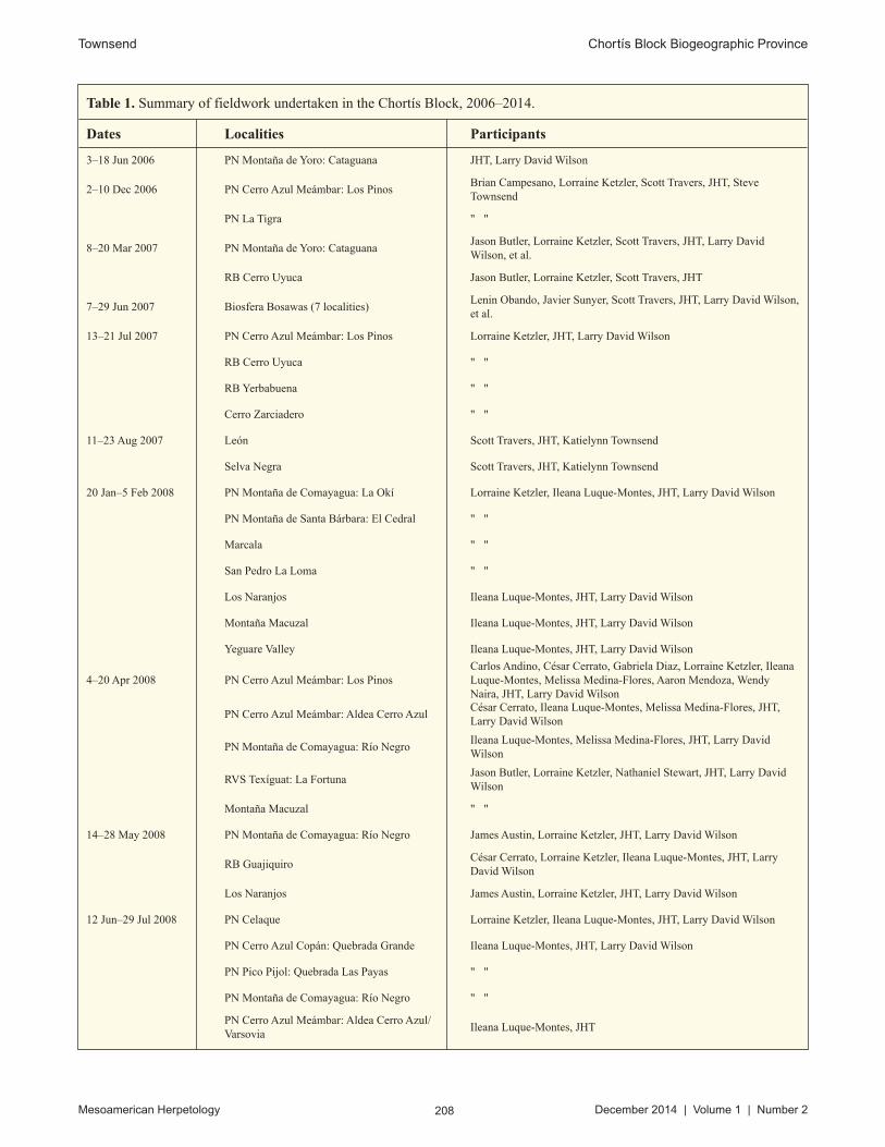
From June 2006 to June 2014, I made 19 fieldtrips totaling over 2,760 person-hours of effort (over 13,120 per-son-hours were logged by expedition participants) over the course of 302 field-days in Honduras and Nicaragua, sampling over 60 localities in the Chortís Block (Table 1). Voucher specimens were preserved in 10% formalin solu-tion and later transferred to 70% ethanol for permanent storage. Tissue samples were taken from freshly euthanized vouchers and stored in SED buffer (250 mM EDTA/20% DMSO/saturated NaCl; Seutin et al., 1991; Williams, 1997). Vouchers were deposited in the Carnegie Museum of Natural History (CM), Florida Museum of Natural History, University of Florida (UF), the Museum of Vertebrate Zoology, University of California, Berkeley (MVZ), and the National Museum of Natural History, Smithsonian Institution (USNM).
Taxonomic Scope and Standards
I recognize a Chortís Block herpetofauna inclusive of species that occur south or east of the Río Motagua and north of a latitudinal line across the northernmost edge of Lago Xolotlán (= Lago de Managua). I included taxa from the Islas de la Bahía and Cayos Miskitos, as they are continental islands of Chortís Block origin, but not the offshore islands of Belize, the smaller cays far offshore from eastern Honduras and Nicaragua, or the Islas del Cisne, as they are neither geological nor biogeographically related directly to the Chortís Block. I excluded marine taxa (sea turtle
Fig. 3. Major physiographic regions and limits of the Chortís Block (after Carr, 1950).
208 Mesoamerican Herpetology December 2014 | Volume 1 | Number 2
Townsend Chortís Block Biogeographic Province
Table 1. Summary of fieldwork undertaken in the Chortís Block, 2006–2014.
Dates Localities Participants
3–18 Jun 2006 PN Montaña de Yoro: Cataguana JHT, Larry David Wilson
2–10 Dec 2006 PN Cerro Azul Meámbar: Los PinosBrian Campesano, Lorraine Ketzler, Scott Travers, JHT, Steve Townsend
PN La Tigra " "
8–20 Mar 2007 PN Montaña de Yoro: CataguanaJason Butler, Lorraine Ketzler, Scott Travers, JHT, Larry David Wilson, et al.
RB Cerro Uyuca Jason Butler, Lorraine Ketzler, Scott Travers, JHT
7–29 Jun 2007 Biosfera Bosawas (7 localities)Lenin Obando, Javier Sunyer, Scott Travers, JHT, Larry David Wilson, et al.
13–21 Jul 2007 PN Cerro Azul Meámbar: Los Pinos Lorraine Ketzler, JHT, Larry David Wilson
RB Cerro Uyuca " "
RB Yerbabuena " "
Cerro Zarciadero " "
11–23 Aug 2007 León Scott Travers, JHT, Katielynn Townsend
Selva Negra Scott Travers, JHT, Katielynn Townsend
20 Jan–5 Feb 2008 PN Montaña de Comayagua: La Okí Lorraine Ketzler, Ileana Luque-Montes, JHT, Larry David Wilson
PN Montaña de Santa Bárbara: El Cedral " "
Marcala " "
San Pedro La Loma " "
Los Naranjos Ileana Luque-Montes, JHT, Larry David Wilson
Montaña Macuzal Ileana Luque-Montes, JHT, Larry David Wilson
Yeguare Valley Ileana Luque-Montes, JHT, Larry David Wilson
4–20 Apr 2008 PN Cerro Azul Meámbar: Los PinosCarlos Andino, César Cerrato, Gabriela Diaz, Lorraine Ketzler, Ileana Luque-Montes, Melissa Medina-Flores, Aaron Mendoza, Wendy Naira, JHT, Larry David Wilson
PN Cerro Azul Meámbar: Aldea Cerro AzulCésar Cerrato, Ileana Luque-Montes, Melissa Medina-Flores, JHT, Larry David Wilson
PN Montaña de Comayagua: Río NegroIleana Luque-Montes, Melissa Medina-Flores, JHT, Larry David Wilson
RVS Texíguat: La FortunaJason Butler, Lorraine Ketzler, Nathaniel Stewart, JHT, Larry David Wilson
Montaña Macuzal " "
14–28 May 2008 PN Montaña de Comayagua: Río Negro James Austin, Lorraine Ketzler, JHT, Larry David Wilson
RB GuajiquiroCésar Cerrato, Lorraine Ketzler, Ileana Luque-Montes, JHT, Larry David Wilson
Los Naranjos James Austin, Lorraine Ketzler, JHT, Larry David Wilson
12 Jun–29 Jul 2008 PN Celaque Lorraine Ketzler, Ileana Luque-Montes, JHT, Larry David Wilson
PN Cerro Azul Copán: Quebrada Grande Ileana Luque-Montes, JHT, Larry David Wilson
PN Pico Pijol: Quebrada Las Payas " "
PN Montaña de Comayagua: Río Negro " "
PN Cerro Azul Meámbar: Aldea Cerro Azul/Varsovia
Ileana Luque-Montes, JHT

209 Mesoamerican Herpetology December 2014 | Volume 1 | Number 2
Townsend Chortís Block Biogeographic Province
RB GüisayoteLorraine Ketzler, Ileana Luque-Montes, Melissa Medina-Flores, JHT, Larry David Wilson
Copán RuinasLorraine Ketzler, Ileana Luque-Montes, Melissa Medina-Flores, JHT, Larry David Wilson
La Esperanza area (3 localities) Lorraine Ketzler, Ileana Luque-Montes, JHT, Larry David Wilson
14 Aug–1 Oct 2008PN Cerro Azul Meámbar: Aldea Cerro Azul/Varsovia
Ileana Luque-Montes, JHT
PN CusucoCésar Cerrato, Ileana Luque-Montes, Melissa Medina-Flores, JHT, Larry David Wilson
PN Montaña de Yoro: above Guaymas Ileana Luque-Montes, JHT, Larry David Wilson
PN Pico Pijol: Pino Alto César Cerrato, Ileana Luque-Montes, JHT, Larry David Wilson
RB El Pital César Cerrato, Melissa Medina-Flores, Larry David Wilson
RB Güisayote " "
RB Mixicuri " "
Erandique " "
La Esperanza area " "
10–20 Apr 2009 PN Montaña de Comayagua: Río NegroSergio Gonzalez, Christina Martin, Mario Solis, JHT, Rony Valle, Christopher Wolf
25 Nov–6 Dec 2009 PN Cerro Azul Meámbar: Los Pinos César Cerrato, Vladlen Henriquez, JHT
PN Cusuco " "
PN Pico Bonito " "
1–26 Jun 2010 RVS Texíguat: La LiberaciónBenjamin Atkinson, César Cerrato, Luis Herrera, Mayron McKewy-Mejía, JHT, Larry David Wilson, et al.
JB LancetillaBenjamin Atkinson, César Cerrato, Luis Herrera, Mayron McKewy-Mejía, Ciro Navarro, JHT
20 Jul–21 Aug 2010 PN Cerro Azul Meámbar: Los Pinos Anne Donnelly, Matthew Donnelly, Ileana Luque-Montes, JHT
RVS Texíguat: La LiberaciónLevi Gray, Luis Herrera, Melissa Medina-Flores, Alexander Stubbs, JHT, etc.
JB Lancetilla " "
RoatánAnne Donnelly, Matthew Donnelly, Yensi Flores, Ileana Luque-Montes, Melissa Medina-Flores, Sandy Pereira, JHT
UtilaAnne Donnelly, Matthew Donnelly, Ileana Luque-Montes, Melissa Medina-Flores, Sandy Pereira, JHT
5–16 Nov 2010 PN Cerro Azul Meámbar: Los Pinos James Austin, Luis Herrera, Melissa Medina-Flores, JHT
PN Montaña de Santa Bárbara James Austin, Luis Herrera, JHT, Alicia Ward, et al.
San José de Texíguat James Austin, Luis Herrera, JHT
7–22 Apr 2011 PN Montaña de BotaderosChristopher Begley, Mark Bonta, Robert Hyman, David Medina, Melissa Medina-Flores, Onán Reyes, Fito Steiner, JHT
PN Pico BonitoRobert Hyman, David Medina, Melissa Medina-Flores, Fito Steiner, JHT
RB Colibrí Esmeralda Robert Hyman, Fito Steiner, JHT
Montaña de Jacaleapa Mark Bonta, Onán Reyes, JHT
Río Grande, Valle de AgaltaChristopher Begley, Mark Bonta, Robert Hyman, David Medina, Melissa Medina-Flores, Onán Reyes, Fito Steiner, JHT
6–22 Jan 2013 Cerro Corre Viento Jason Butler, Luis Herrera–B., Sandy Pereira, JHT
11–25 Jun 2014 Isla del Tigre Thomas J. Firneno, Michael Itgen, Fatima Pereira, JHT

210 Mesoamerican Herpetology December 2014 | Volume 1 | Number 2
Townsend Chortís Block Biogeographic Province
families Cheloniidae and Dermochelyidae and the sea snake Hydrophis platurus) and introduced species, as well as taxa known only from the Salvadoran Cordillera or the southwestern Salvadoran coastal plain, as I do not consider them as part of the Chortís Block. The nomenclature used follows that of Solís et al. (2014), with the following ex-ceptions/additions: recognizing Trachemys emolli, T. grayi, and T. venusta as valid taxa occurring within the study region, following Parham et al. (2013); recognizing Oedipina chortiorum and O. motaguae, following Brodie et al. (2012); and recognizing Heloderma charlesbogerti as a full species, following Reiserer et al. (2013).
Conservation Status of the Chortís Herpetofauna
I used three different measures to assess the conservation status of the herpetofauna of the Chortís Block: IUCN Red List categorization, Environmental Vulnerability Scores (Wilson and McCranie, 2003), and Conservation Status Scores (Wilson and Townsend, 2010).
I obtained the IUCN Red List categorizations from one of three sources: the IUCN Red List of Threatened Species (2014) for amphibians, marine turtles, crocodilians, and some squamates; Townsend and Wilson (2010a) for Honduran reptiles, and Sunyer and Köhler (2010) for Nicaraguan reptiles. I assessed species not previously evaluated by the IUCN or other authors by using the standard criteria of the IUCN (2001).
The Environmental Vulnerability Scores (EVS) are primarily from Townsend and Wilson (2010a). I evaluated species not assessed in that study by using the methodology developed and refined by Wilson and McCranie (2003, 2004a), which is calculated by taking the total of three rankings: (1) the extent of geographic range, (2a) the degree of specialization of reproductive mode for amphibians or (2b) the degree of persecution by humans for reptiles, and (3) the extent of ecological distribution in Honduras; EVS scores from 10 to 13 indicate medium vulnerability, and scores from 14 to 19 high vulnerability (Wilson and McCranie, 2003).
Wilson and Townsend (2010) developed Conservation Status Scores (CSS) to provide a simple measure for assessing the conservation status of amphibians and reptiles across Mesoamerica. The CSS represents a sum of the individual scores for (1) numbers of countries, (2) physiographic regions, and (3) vegetation zones occupied by a given species of amphibian or reptile. The country score ranges from 1 to 8 (the number of countries of Central American plus Mexico), the physiographic region score ranges from 1 to 21, and the vegetation zone score from 1 to 15 (Wilson and Townsend, 2010). Given this, the CSS can range from 3 (the most restricted endemic species, inhabiting a single vegetative zone in a single physiographic region in a single country) to the theoretical maximum of 44 (for a species found literally everywhere in Mexico and Central America).
GEOMORPHOLOGY OF THE CHORTÍS BLOCK
The history of the Chortís Block is characterized in large part by its eastward movement along a series of strike-slip faults on the southern margin of the North American Plate (Fig. 4; Dengo 1969; Donnelly et al., 1990; Gordon, 1992; Rogers et al., 2007). As recently as the K-T Boundary (65 million years before present [mybp]; Fig. 4), the Chortís Block was located somewhere south of modern south-central Mexico, as it moved along a west-to-east tra-jectory around 200 km into its current position as the principal surface area of the Central American land bridge and the modern territory of Honduras, El Salvador, eastern Guatemala and northern Nicaragua (Fig. 1; Rogers, 2003; Ortega-Gutiérrez et al., 2007).
Origin and Cenozoic development of the Chortís Block.––The Chortís Block represents the only exposed Precambrian and early Paleozoic continental crust on the contemporary Caribbean Plate (DeMets et al., 2007). The oldest exposed geological formation of the Chortís Block is Precambrian in age and of Rodinian derivation, originating during the Grenville orogeny (1,017 ± 20 mybp or 1,400 mybp, depending on dating methods) contem-poraneously with the Appalachian and Adirondack mountains of eastern North America and the Llano Plateau of Texas and northeastern Mexico (Manton, 1996; Gordon et al., 2010). Today, this ancient formation is visible as a 60 km-long series of exposed outcrops along the Jocotán-Ceiba Fault in the department of Yoro, Honduras (Gordon et al., 2010). While most geologists generally accept that the Chortís Block originated approximately 1,100 km west of its current position and became detached during the Eocene, sliding and rotating along the Motagua-Polochic Fault Complex at the southern margin of the stationary North American Plate, there are two competing hypothe-ses regarding the Chortís Block’s origin (reviewed by Rogers et al., 2007). The first hypothesis places the Chortís Block along the southwestern margin of the North American Plate and physically contiguous with Mexico, and is

211 Mesoamerican Herpetology December 2014 | Volume 1 | Number 2
Townsend Chortís Block Biogeographic Province
Fig. 4. Tectonic plate reconstructions showing the relative position and movement of the Chortís Block (shaded green) during the Cenozoic. Maps follow the generally accepted tectonic model of Hay et al. (1999); alternative models reviewed in Rogers et al. (2007), with black lines representing tectonic boundaries and gray shading delineating modern-day shorelines and landmasses (maps generated using ODSN Plate Tectonic Reconstruction Service and modified by author).

212 Mesoamerican Herpetology December 2014 | Volume 1 | Number 2
Townsend Chortís Block Biogeographic Province
supported by the existence of similarly aged Precambrian and Paleozoic rock formations, potential aligned fault systems in present day Honduras and southwestern Mexico, and geological evidence that the Chortís Block rotated 30–40° counterclockwise while sliding eastward (Fig. 4; Gose, 1985, Silva-Romo, 2008). The second hypothesis places the Chortís Block’s original position some 700–800 km south of Mexico, with it moving northeastwardly while rotating 40° clockwise (Keppie and Moran-Zenteno, 2005). A third but less accepted hypothesis holds that the Chortís Block has remained virtually in the same position relative to the North American Plate, and that structures and evidence to the contrary essentially have been misinterpreted (James, 2007).
The relatively dramatic Cenozoic tectonic history of the Chortís Block was dominated by what can only be described as catastrophic, prolonged, and repeated volcanism as the block slid and rotated its way eastward. The beginning of this extended period was the mid-Eocene (ca. 55 mybp), following initial detachment of the Chortís Block from its parent structure (Jordan et al., 2008). A second flare-up took place during the mid-Oligocene (ca. 40 mybp), and the third, and largest, flare-up took place during the early to middle Miocene (Jordan et al., 2008).
Miocene Ignimbrite Flare-up and subsequent uplift.––The Mesozoic history of the Chortís Block features an approximately 10 million year period of intense explosive volcanism along the margins of the Chortís Block and Central American Volcanic Front, considered the second largest ignimbrite event in the known geological history of Earth (Jordan et al., 2008). During the mid-Miocene over 5,000 km3 of ignimbrites up to 2,000 m thick were de-posited on top of the low-relief surface of the southern and western Chortís Block, and tens of thousands of square kilometers were covered repeatedly in thick layers of ash (Williams and McBirney, 1969; Rogers et al., 2002; Jordan et al., 2008). The most intense period of the ignimbrite flare-up lasted from around 20 mybp to 15 mybp, with activity ceasing approximately 10.5 mybp (Gordon and Muehlberger, 1994). This period is well documented by a series of deep-sea sediment cores from sites in the western Caribbean Sea (Jordan et al., 2008). The site of a fissure-like volcano that was “ground zero” for the Miocene Ignimbrite Flare-up is represented today by the Padre Miguel Group geological formation in southwestern Honduras and peripherally in El Salvador and Guatemala (Rogers, 2003). Under these circumstances, it would seem unlikely that extant terrestrial organisms and ecosystems on the Chortís Block are survivors of this extreme volcanism, suggesting a model of post-volcanic colonization and diversification of the terrestrial biota. Following the Miocene flare-up and up and until approximately 3.8 mybp, the Chortís Block went through a period of rapid uplift driven by the detachment and subsequent subduction of a portion of the Cocos Plate, which induced upwelling in the mantle that raised the Chortís Block up to 1,100 m in elevation (Rogers et al., 2002).
The contemporary Chortís Block.––The Chortís Block presently continues its eastward movement along the strike-slip faults of the Motagua-Polochic Fault Zone and Swan Island Fault Zone, interacting in the continental context with the Maya Block of the North American Plate to the north and the Chorotega Block to the south, albeit inter-rupted by the Nicaraguan Depression (Fig. 1; Rogers, 2003, Marshall, 2007). Marshall (2007) defined 15 physio-graphic provinces in Central America, of which four (the Chortís Highlands, Chortís Volcanic Front, Chortís Fore Arc, and Mosquitia Coast Lowlands) are geomorphological associates of the Chortís Block.
The Chortís Highlands Province consists of a large dissected plateau that forms the greater part of the Chortís Block and includes the majority of the territory of the countries of Honduras and El Salvador, as well as western Guatemala and northern Nicaragua (Marshall, 2007). The Chortís Highlands Province is subdivided into four regions: the Western Rifted Highlands, the Central Chortís Plateau, the Eastern Dissected Highlands, and the Honduran Borderlands. The Chortís Volcanic Front Province is an active volcanic front that borders the southern margins of the Chortís Highlands Province, and includes two regions: the Guatemalan Cordillera, which borders the western margin of the Chortís Highlands Province; and the Salvadoran Cordillera, which borders the Median Trough, an elongate graben that extends along the boundary faults at the margin of the active Nicaraguan Volcanic Front (Marshall, 2007). The Chortís Volcanic Front Province represents part of the proverbial “Ring of Fire,” a loose chain of active volcanoes and tectonic plate subduction zones that rings the Pacific Ocean. The Chortís Fore Arc Province encompasses the Pacific coastal plain of the Chortís Volcanic Front Province, and similarly is subdivided into the Guatemalan Coastal Plain and Salvadoran Coastal Plain (Marshall, 2007). The Mosquito Coast Lowlands Province is the wide alluvial plain along the eastern Caribbean slope of Honduras and Nicaragua, a region also re-ferred to as La Mosquitia. The Mosquito Coast Lowlands Province is dominated by a massive paleo-Coco/Patuca river delta built up during the glacial cycles of the Pliocene-Pleistocene (Marshall, 2007).

213 Mesoamerican Herpetology December 2014 | Volume 1 | Number 2
Townsend Chortís Block Biogeographic Province
The aforementioned Chortís Highlands Province and its four constituent subregions are of principal interest for this paper, and I describe these subregions in detail below.
The Western Rifted Highlands region of southeastern Guatemala, southwestern Honduras, and northern El Salvador is a west-to-east oriented plateau, generally exceeding 1,000 m in elevation, which is interrupted by a se-ries of independent, north-to-south oriented rift valleys featuring flat, xeric valley floors (Marshall, 2007). The rift valleys, or grabens, of the Western Rifted Highlands include the contemporary Comayagua Valley and Otoro Valley. This region corresponds to the Padre Miguel Group, a 1,000–2,000 m thick layer of mid-Miocene ignimbrites laid down during the super-volcanic eruptions along the margin of the Chortís Highlands and Chortís Volcanic Front. Those super-eruptions essentially reset the landscape, allowing the development of new meandering river drainages as the rift valleys began spreading following the end of the Miocene ignimbrite flare-up around 10.5 mybp (Gordon and Muehlberger, 1994; Rogers et al., 2002).
The Central Chortís Plateau region of the Honduran interior represents the most tectonically stable portion of the Chortís Highlands, forming an essentially level plateau with little dissection or embedding by rivers (Marshall, 2007). The Central Chortís Plateau lies atop of Paleozoic bedrock overlain with layered Cretaceous-aged sedimen-tary deposits (Rogers et al., 2002; Marshall, 2007).
The Eastern Dissected Highlands region of eastern Honduras and Nicaragua includes the lower elevation, higher relief mountains bordering the Mosquito Coast Lowlands, and features three large, deeply embedded river drainages that drain a large portion of the Chortís Highlands Province (Marshall, 2007).
The Honduran Borderlands region lies along the northern margin of the Chortís Highlands, and is character-ized by five major west-to-east trending faults that border major mountain ranges, including the Cordillera Nombre de Dios in northern Honduras (Rogers, 2003; Marshall, 2007). One large graben valley, the Sula Graben, extends north-to-south from the Caribbean coast to the north end of Lago de Yojoa, and today contains the lower courses of two of the largest watersheds in the Chortís Block: the Río Chamelecón and the Río Ulua.
CONTEMPORARY ECOPHYSIOGRAPHY
Carr (1950), in his pioneering classification of Honduran ecological associations, recognized three principal eco-physiographic components that make up the Chortís Block: the Caribbean versant lowlands, the Pacific versant lowlands, and the mountainous interior region known as the serranía (Fig. 3). Carr’s ecophysiographic regions correspond well with the geologically-based physiographic provinces of Marshall (2007; described in the previ-ous section), with the serranía being congruent with the Marshall’s Chortís Highlands Physiographic Province. Subsequently, from this point forward I use the name “Chortís Highlands” analogously with the serranía. Carr (1950) further subdivided the Chortís Highlands into the Northern Cordillera, the Southern Cordillera, and the Pacific Colinas. Wilson and Meyer (1985), McCranie and Wilson (2002), and others also have used this arrange-ment. Mejía-Ordóñez and House (2002) introduced a modified arrangement, based on their comprehensive eval-uation of the ecosystems of Honduras using the UNESCO system of Physiognomic-Ecological Classification of Plant Formations of the Earth (Mueller-Dombois and Ellenberg, 1974), which recognized a Cordillera del Norte, Cordillera Central, and Cordillera del Sur. This arrangement is preferable and used here as the basis for describing the ecophysiography of the Chortís Block, which I divide into three principal regions: the Caribbean Lowlands, the Pacific Lowlands, and the Chortís Highlands, which itself subsequently is subdivided into the Northern, Central, and Southern Cordilleras.
Northern Cordillera of the Serranía.––As first defined by Mejía-Ordóñez and House (2002) and expanded here, the Northern Cordillera consists of the following mountain ranges and groups of ranges:
The Cordillera (or Sierra) Nombre de Dios (Figs. 5-1, 6A) stretches west-to-east across the departments of Atlántida, Colón, and Yoro, Honduras, and includes the cloud forest protected areas of Refugio de Vida Silvestre (RVS) Texíguat (maximum elevation 2,208 m) at the western end and Parque Nacional (PN) Pico Bonito (2,435 m) and PN Nombre de Dios (1,725 m) in the central portion, with a few scattered low peaks extending to the east, terminating with PN Capiro y Calentura (1,235 m) near Trujillo. Based on my preliminary observations, I con-sider the Sierra de Mico Quemado, a north-to-south oriented range in western Yoro, to be the western terminus of the Cordillera Nombre de Dios. Mejía-Ordóñez and House (2002) considered this range, which includes Zona de Reserva Ecológica (ZRE) Montaña de Mico Quemado y Las Guanchias, as part of the Central Cordillera.

214 Mesoamerican Herpetology December 2014 | Volume 1 | Number 2
Townsend Chortís Block Biogeographic Province
The Sierra de Omoa (Figs. 5-2, 6B) lies in the departments of Cortés and Santa Bárbara, Honduras, and con-tains the cloud forest protected area PN Cusuco (2,242 m), as well as the Área de Producción de Agua Merendón (1,749 m).
The Sierra de Espíritu Santo (Figs. 5-3, 6C) lies in the departments of Copán and Santa Bárbara, in Honduras and Izabal and Zacapa in Guatemala, and includes the cloud forest reserve PN Cerro Azul Copán (2,285 m), as well as unprotected highland forests at Río Amarillo (1,479 m) in Copán, Honduras, and Cerro del Mono (1,653 m) in Zacapa, Guatemala.
Central Cordillera of the Serranía.––I follow Mejía-Ordóñez and House (2002) in recognizing a Central Cordillera made up of the remaining Caribbean versant serranía, otherwise included in Carr’s (1950) Northern Cordillera.
The Sierra de Joconal (1,688 m; Fig. 5-4) extends roughly west-to-east from the eastern part of the depart-ment of Copán (municipalities of Nueva Arcadia and San Nicolás), across the department of Santa Bárbara, and into the western portion of the department of Cortés (municipality of Villanueva).
Montaña de Santa Bárbara (2,744 m; Figs. 5-5, 6D) is an isolated karstic massif rising from the southern terminus of the Ulúa-Chamelecón Plain to the west of Lago de Yojoa; its unique ecological communities are wholly contained within the boundaries of PN Montaña de Santa Bárbara.
Fig. 5. Map showing mountain ranges of the Chortís Block (green outlines correspond to the Northern Cordillera, blue to the Central Cordillera, red to the Southern Cordillera, and black to ranges extralimital to this study): 1 = Sierra Nombre de Dios, 2 = Sierra de Omoa, 3 = Sierra de Espíritu Santo, 4 = Sierra de Joconal, 5 = Montaña de Santa Bárbara, 6 = Montañas de Meámbar, 7 = Sierra de Montecillos, 8 = Sierra de Comayagua, 9 = Sierra de Sulaco, 10 = Cordillera de La Flor-La Muralla, 11 = Sierra de Agalta, 12 = Sierra de Botaderos, 13 = Sierra Punta Piedra, 14 = Montañas de Patuca, 15 = Sierra de Montecristo, 16 = Sierra del Merendón, 17 = Sierra de Celaque, 18 = Sierra de Erandique, 19 = Sierra de Puca-Opalaca, 20 = Montaña de la Sierra, 21 = Sierra de Lepaterique, 22 = Sierra de Dipilto, 23 = Montaña de Colón, 24 = Cordillera Dariense, 25 = Salvadoran Cordillera, 26 = Cordillera de Las Marabios.

215 Mesoamerican Herpetology December 2014 | Volume 1 | Number 2
Townsend Chortís Block Biogeographic Province
The Montañas de Meámbar (2,080 m; Figs. 5-6, 6E), also called the Montañas de Yule, are a rugged set of peaks on the eastern side of Lago de Yojoa on the border between the departments of Cortés and Comayagua, pri-marily contained within PN Cerro Azul Meámbar. Mejía-Ordóñez and House (2002) apparently included this group of mountains in the Sierra de Montecillos, but I consider it a separate formation.
The Sierra de Montecillos (Fig. 5-7) is one of two roughly parallel mountain ranges that are oriented north-west-southeast and form the margins of the “Honduran Depression” in central Honduras. Some of the highest por-tions of this mountain range, which straddle the border between the departments of Comayagua and Intibucá, make up RB Montecillos (2,459 m).
Fig. 6. Mountain ranges of the Chortís Block I. (A) Cordillera Nombre de Dios, seen from offshore looking south; Cerro Búfalo is the tallest mountain on the left (east) side, and Pico Bonito is the sharp peak on the right (west) side. (B) Sierra de Omoa, seen from near Buenos Aires de Bañaderos looking east-northeast. (C) Southern slopes of Cerro Azul de Copán in the Sierra de Espíritu Santo, seen from Quebrada Grande. (D) Montaña de Santa Bárbara, seen from the road west of Peñas Blancas looking south-southwest. (E) Montañas de Meámbar, seen from the road south of Santa Elena looking south. (F) Sierra de Comayagua, seen from road south of San Jerónimo looking south. ' © Josiah H. Townsend

216 Mesoamerican Herpetology December 2014 | Volume 1 | Number 2
Townsend Chortís Block Biogeographic Province
The Sierra de Comayagua (Figs. 5-8, 6F) is oriented roughly parallel to the Sierra de Montecillos, separated by the dry intermontane Comayagua Valley, and extends over 130 km north-to-south along the border between the departments of Comayagua and Francisco Morazán. The highest portions of this range are found within PN Montaña de Comayagua (2,407 m) and RVS Corralitos (2,117 m).
The Sierra de Sulaco (Figs. 5-9, 7A) extends roughly west-to-east in the southwestern part of the Departamento de Yoro, and includes the highlands of PN Pico Pijol (2,282 m) at the western end of the range and Montaña Macuzal (1,945 m) at the eastern end.
The Cordillera de La Flor-La Muralla (Fig. 5-10) stretches across the northern part of the department of Francisco Morazán, the southern portion Yoro, and into western Olancho, with highland forest protected areas PN Montaña de Yoro (2,245 m), RVS La Muralla (2,064 m), Reserva Forestal Anthropológica (RFA) Montaña de la Flor (1,637 m), RB El Cipresal (1,930 m), and RB Misoco (2,153 m).
The Sierra de Agalta (Fig. 5-11) in central Olancho is a long, relatively narrow and steep range that includes, from west to east, the protected areas Monumento Natural Boquerón (1,261 m), PN Sierra de Agalta (2,335 m), Reserva Anthropológica El Carbón (1,817 m), and PN Sierra de Río Tinto (1,925 m).
The Sierra de Botaderos (Figs. 5-12, 7B) is located in northern Olancho along the border with the department of Colón, and includes Cerro Ulloa (1,735 m) and Cerro Azul (1,433 m) within the highland reserve PN Montaña de Botaderos, as well as the lower mountains of the Sierra de La Esperanza.
The Sierra Punta Piedra (Fig. 5-13) is a relatively low elevation range in the departments of Colón and Gracias a Dios, and includes Montaña Punta Piedra (1,500 m), Cerro Antílope (1,075 m), Cerro Mirador (1,200 m), and Cerro Baltimór (1,082 m). These mountains are found in Reserva de Hombre y la Biosfera Río Plátano.
The Montañas de Patuca (1,155 m; Fig. 5-14) in Olancho are located between the Río Guayape, which flows directly southwest to meet the Río Guayambre and form the Río Patuca, and a lower course of the Río Patuca that flows northeast to the Caribbean Sea. The southeastern portion of this range is found within PN Patuca.
Southern Cordillera of the Serranía.––The Southern Cordillera is a geomorphologically linked series of mountain ranges extending from the vicinity of the El Salvador-Guatemala-Honduras border region east-southeast into north-ern Nicaragua.
The highest elevations of the Sierra de Montecristo (Fig. 5-15) are located at the point where El Salvador, Guatemala, and Honduras meet, in a tri-nationally managed protected area called Montecristo Trifinio (2,419 m). Most of this range is found in Guatemala, where it extends northward into the department of Chiquimula.
The Sierra del Merendón (Fig. 5-16) is a north-south oriented range that extends from Guatemala (Chiquimula, Zacapa) across Honduras (Copán, Ocotepeque, Lempira) and into El Salvador (Chalatenango), and includes the fol-lowing cloud forest areas: RVS Erapuca (2,380 m), Cerro El Pital (2,730 m), Cerro Sumpul (2,167 m), and Reserva Biológica (RB) Güisayote (2,310 m),
The Sierra de Celaque (Figs. 5-17, 7C) is a north-south oriented range located in Lempira and easternmost Ocotepeque, and contains the highest elevations in the Chortís Highlands in PN Celaque (including peaks of 2,849 m, 2,825 m, and 2,804 m in elevation) and RB Volcán Pacayita (2,516 m).
The Sierra de Erandique (2,134 m; Fig. 5-18) is a north-south oriented range in southeastern Lempira, ex-tending from the municipality of La Campa at the northern end to the municipality of Piraera in the south.
The Sierra de Puca-Opalaca (Fig. 5-19) is located in Intibucá, northeastern Lempira, and extreme southern Santa Bárbara, and includes cloud forest areas found in RC Cordillera de Opalaca (2,390 m), RVS Puca (2,234 m), RVS Mixcure (2,312 m), and RVS Montana Verde (2,127 m).
The Montaña de la Sierra (Fig. 5-20) is found in the department of La Paz and extreme southern Intibucá, and includes a number of peaks and high plateaus, including a number within RB Guajiquiro (2,265 m), RB El Chiflador (1,811 m), RB El Pacayal (1,955 m), RB Mogola (1,648 m), RB Sabanetas (2,047 m), RB San Pablo (1,741 m), and RB San Pedro (1,719 m).
The Sierra de Lepaterique (Fig. 5-21) is the roughly U-shaped range that borders the southern side of the upper Choluteca Valley, which also is the valley containing the Honduran capital, Tegucigalpa. This range includes

217 Mesoamerican Herpetology December 2014 | Volume 1 | Number 2
Chortís Block Biogeographic ProvinceTownsend et al.
Fig. 7. Mountain ranges of the Chortís Block II. (A) Looking northwest along the spine of the Sierra de Sulaco, taken from the top of Montaña Macuzal, with Pico Pijol being the largest peak in the distance. (B) Southeastern reaches of the highest peak in the Sierra de Botaderos. (C) The Sierra de Celaque viewed from the east, with the tallest peak in the Chortís Block, Cerro de la Minas, visible as the peak in the middle of the photograph. ' © Josiah H. Townsend

218 Mesoamerican Herpetology December 2014 | Volume 1 | Number 2
Townsend Chortís Block Biogeographic Province
PN La Tigra (2,290 m), RB Yerba Buena (2,243 m), RB Cerro Uyuca (2,006 m), RB El Chile (2,190 m), and RB Monserrat-Yuscarán (1,825 m).
The Sierra de Dipilto (Fig. 5-22) extends over 300 km west-to-east from PN La Botija (1,710 m) in Choluteca, to the Cordillera Entre Ríos in PN Patuca, straddling the Honduras-Nicaragua border and including Reserva Natural (RN) Cerro Mogotón (2,106 m), which includes the highest point in Nicaragua.
The Montaña de Colón (Fig. 5-23) is a low (maximum elevation 941 m), isolated karstic range located in south-eastern Olancho and adjacent Gracias a Dios, and lies primarily within the Reserva de Biosfera Tawahka-Asangni.
The Cordillera Dariense (Fig. 5-24) is a collection of cloud forested peaks and highland areas in northern Nicaragua, in the departments of Jinotega, Matagalpa, and Región Autónoma Atlántico Norte, including Reserva Natural (RN) Apante (1,442 m), RN Cerro Musún (1,438 m), RN Dantalí-El Diablo (1,680 m), RN Kilambé (1,755 m), RN Peñas Blancas (1,744 m), RN Saslaya (1,658 m), and RN Volcán Yali (1,709 m).
Intermontane Valleys and Plains.––In addition to its mountains, the Chortís Highlands also can be characterized for its valleys; the isolated mountains form “islands” of cool mesic habitat and the subhumid intermontane valleys represent isolated areas of hot, dry habitat. Aspects of the physiography, ecological associations, and biogeography of these subhumid valleys were studied by Stuart (1954), Johannessen (1963), Wilson and McCranie (1998), Sasa and Bolaños (2004), and Townsend and Wilson (2010b).
The Middle Motagua Valley is among the driest areas in Central America, along with the Middle Aguán Valley in Honduras. This valley lies between the Sierra de las Minas (extralimital to the Chortís Highlands) and the Sierra Espíritu Santo.
The Sula Valley in northwestern Honduras is formed from combined drainages of two large watersheds, the Río Chamelecón and Río Ulúa, which have courses that flow closely together in their lower reaches into the Caribbean Sea. The Sula Valley is a north-to-south oriented graben valley that has been spreading since the late Miocene.
The Otoro Valley is a moderately high elevation subhumid graben valley (lowest elevations 500–600 m) ly-ing in a narrow upper portion of the Sula Valley, which contains a distinctive ecological character from that of the broader middle Sula Valley.
The Comayagua Valley (Fig. 8A) is a relatively high subhumid graben valley (lowest elevations 580–680 m) that forms a principal portion of the Honduran Depression, lying between the Sierra de Montecillos to the west and the Sierra de Comayagua to the east. This valley, like the Otoro Valley to the west, actually is a narrow upper portion of the Sula Valley, distinctive enough in character to warrant recognition.
The Middle Aguán Valley is a west-to-east oriented fault valley that lies in the rain-shadow of the Cordillera Nombre de Dios in Yoro, and is one of the driest areas in the Chortís Block.
The Siria-Talanga Valley (Fig. 8B) is a high plain (lowest elevations 620–720 m) in the central part of the department of Francisco Morazán that contains the headwaters of two of the largest watersheds in the Chortís Highlands, the Río Guayambre/Río Patuca and the Río Ulúa.
The Olancho Valley (or Guayape–Guayambre Valley) is a large valley in central Olancho surrounded by sev-eral mountain ranges, including the Sierra de Agalta, Cordillera de La Flor-La Muralla, and Montañas de Patuca, which form the headwaters of the Río Patuca.
The Agalta Valley (Fig. 8C), also referred to as the “San Esteban Valley” by various authors (Wilson and McCranie, 1998; McCranie and Wilson, 2002; Townsend and Wilson, 2010b), is found between the Sierra de Botaderos and Sierra de Agalta in central Olancho. The lowest elevations of this relatively high subhumid intermon-tane valley, formed by the Río Grande (a river whose name changes to Río Sico, Tinto, and Negro downstream), are 550–650 m.
The Middle Lempa Valley lies on a west-to-east orientation in central El Salvador, between the Southern Cordillera of the Serranía and the Salvadoran Cordillera.

219 Mesoamerican Herpetology December 2014 | Volume 1 | Number 2
Townsend Chortís Block Biogeographic Province
The Upper Segovia Valley in Nicaragua is a subhumid region located along the headwaters of the Río Coco (the upper reaches are also called the Río Segovia, and the lower river is called the Wangki by the indigenous Miskitu).
The Choluteca Valley is the only major subhumid intermontane valley on the Pacific versant, and initially is oriented south-to-north from the headwaters of the Río Choluteca in the Sierra de Lepaterique, before curving around the north side of the mountains protected within PN La Tigra and turning south and then southwest on its path to the Pacific Ocean.
The Meseta de La Esperanza (Fig. 8D) is the highest plain in the Chortís Highlands, extending 12 km in length across central Intibucá at elevations ranging from 1,800 to 2,000 m.
The Meseta de Siguatepeque is located in Comayagua between the Sierra de Comayagua, Sierra de Montecillos, and Montañas de Meámbar at an elevation of around 1,100 m.
The Meseta de Santa Rosa is a wide plain in western Copán, on a plateau at about 1,100 m in elevation.
Caribbean Lowlands.––Corresponding to the Mosquito Coast Lowlands Physiographic Province of Marshall (2007), the major ecophysiographic regions of the Caribbean lowlands include (McCranie and Wilson, 2002; Wilson and Townsend, 2006): the Motagua Plain (lower alluvial plain of the Río Motagua, east of the river and northwest and west of the Sierra de Omoa and Sierra de Espíritu Santo), the Ulúa-Chamelecón Plain (large alluvial plain formed by Chamelecón and Ulúa rivers, which drain close to half of the physical territory of Honduras), the Nombre de Dios Piedmont (the narrow strip of coastal plain backed by the Cordillera Nombre de Dios), the Aguán-Negro
Fig. 8. Intermontane valleys and plains of the Chortís Block. (A) Looking northwest at the Comayagua Valley, taken from the top of Montaña La Oki in the Sierra de Comayagua. (B) Northern view along a highway through the Siria-Talanga Valley towards the Cordillera de La Flor-La Muralla. (C) The Agalta Valley to the east of Gualaco. (D) The Meseta de La Esperanza, with the city of La Esperanza on the far left, seen from Cerro San Pedro la Loma.

220 Mesoamerican Herpetology December 2014 | Volume 1 | Number 2
Townsend Chortís Block Biogeographic Province
Plain, and the wide expanse of the Mosquitia (broad alluvial plain essentially lying between the Sico-Paulaya wa-tershed in Honduras and the Río Grande de Matagalpa watershed in Nicaragua). Two climatic regimes are present in the Caribbean Lowlands (McCranie and Wilson, 2002; Wilson and Townsend, 2006): the Lowland Wet climate is found on the Caribbean coastal plain from sea level to about 600 m in elevation, with a mean annual precipitation exceeding 2,000 mm and a mean annual temperature exceeding 24°C. Important protected areas for the Caribbean Lowlands ecosystems include: Parque Nacional (PN) Cuyamel-Omoa, PN Jeannette Kawas, Refugio de Vida Silvestre (RVS) Cuero y Salado, PN Punto Izopo, Jardín Botánico Lancetilla, RVS Laguna de Guaymoreto, Reserva de Hombre y la Biosfera Río Plátano, PN Patuca, PN Warunta, Reserva Biológica (RB) Rus Rus, RB Laguna de Karataska, PN Río Kruta, Reserva de Biosfera Tawahka-Asangni, Reserva de Biosfera Bosawas, Reserva Natural (RN) Cabo Viejo-Tela Sulumas, RN Laguna Bismuna-Raya, and RN Laguna Pahara.
Pacific Lowlands.––Corresponding to the Salvadoran Coastal Plain of the Chortís Fore Arc Physiographic Province of Marshall (2007), the Pacific versant lowlands consist of a relatively broad coastal plain extending from the west-ern to the southern limits of the Chortís Highlands Province, becoming narrowest around the Golfo de Fonseca. These lowlands constitute a single ecophysiographic region with a relatively homogenized biota (Wilson and McCranie, 1998; Sasa and Bolaños, 2004; Townsend and Wilson, 2010b). The Pacific Lowlands are subject to the Lowland Dry climate regime (Wilson and Meyer, 1985), found from sea level to about 600 m in elevation, with mean a annual precipitation below 2,000 mm and a mean annual temperature exceeding 24°C. Important protected areas for the Pacific Lowlands ecosystems include: Área Protegida con Recursos Manejados Barra de Santiago, Parque Privada Walter T. Deininger, Área de Protección y Restauración (APR) Nancuchiname, Área de Manejo Laguna El Jocotal, APR Conchagua, Área de Manejo de Habitát de Especie (AMHE) Bahía de Chismuyo, AMHE Bahía de San Lorenzo, AMHE Las Iguanas-Punta Condega, AMHE Los Delgaditos, AMHE El Jicarito, AMHE La Berbería, AMHE San Bernardo, and RN Delta de Estero Real.
Salvadoran Cordillera.––The Salvadoran Cordillera is not geomorphologically part of the the Chortís Highlands, but instead constitutes the Chortís Volcanic Front and is dominated by more recent Pliocene and Quaternary volca-nic deposits (Marshall, 2007). I include the Salvadoran Cordillera for the sake of completeness in this discussion, given its position across the Pacific Lowlands of El Salvador and putative inclusion in the Eastern Nuclear Central America biogeographic province of Campbell (1999; as expanded upon by Townsend, 2006). This west-to-east oriented range is a continuation of the Guatemalan Cordillera, and is made up of several dozen volcanic cones and peaks, including Santa Ana (2,365 m), San Vincente (2,182 m), and San Miguel (2,130 m).
Cordillera Los Marabios.––Like the Salvadoran Cordillera, geomorphologically this range is not not part of the Chortís Highlands, and is represented by a string of northwest-to-southeast oriented Quaternary (and in some cases active) volcanic cones arising from the Pacific Lowlands of northwestern Nicaragua. Volcanoes in this cordillera include Cosigüina (858 m), San Cristóbal (1,745 m), Casita (1,405 m), Telica (1,060 m), Cerro Negro (726 m), El Hoyo (1,079 m), and Momotombo (1,279 m).
Watersheds.––Major river systems on the Caribbean versant of the Chortís Block include: Motagua (485 km in length), Chamelecón (200 km), Ulúa (300 km), Leán (60 km), Aguán (225 km), Sico or Tinto or Negro or Grande (215 km), Plátano (85 km), Sikre (70 km), Patuca (500 km), Warunta (85 km), Mocorón (92 km), Nacunta (65 km), Kruta (125 km), Coco or Segovia or Wangki (550 km), Wawa (160 km), Kukalaya (140 km), Prinzapolka (330 km), and Grande de Matagalpa or Awaltara (430 km). Major Pacific versant watersheds include Estero Real (137 km), Negro (85 km), Choluteca (250 km), Nacaome (90 km), Goascorán (115 km), Lempa (422 km), and Paz (134 km).
Lakes and coastal lagoons.––Few large inland water bodies are present in the Chortís Block, of which the most no-table is Lago de Yojoa (700 m elevation) in central Honduras. The two other large bodies of freshwater, Embalse El Cajón (285 m) in Honduras and Lago de Apanás (970 m) in Nicaragua, both are reservoirs created by hydroelectric dams. A number of large coastal lagoons and lagoon complexes are present on the Caribbean coast, including Los Micos, Guaymoreto, Ibans, Brus, Tilbalakan, Laguntara, Warunta, Tansín, Karataska, Kohunta, Bismuna, Pahara, Karatá, Huouhnta, and Laguna de Las Perlas. I consider Lago de Izabal in Guatemala and Lago Xolotlán (= Lago de Managua) in Nicaragua extralimital to the Chortís Block and do not include them.
Islands. The principal islands associated with the Chortís Highlands include the Honduran Islas de la Bahía (Utila, Roatán, Guanaja, and Cayos Cochinos), the Cayos Miskitos of Nicaragua, and Isla El Tigre and other small islands in the Golfo de Fonseca.

221 Mesoamerican Herpetology December 2014 | Volume 1 | Number 2
Townsend Chortís Block Biogeographic Province
Holdridge Forest Formations
The forest formations described below follow the system developed by Holdridge (1967), as applied to Honduras in previous works (Meyer and Wilson, 1971, 1973; Wilson and Meyer, 1985; Wilson and McCranie, 1998; Wilson et al., 2001; McCranie and Wilson, 2002). The widely used Holdridge (1967) system uses climatic, edaphic, and atmospheric conditions to define and determine the distribution of terrestrial ecosystems. A wide range of climatic and elevational regimes typifies the Chortís Block, resulting in the recognition of nine Holdridge forest formations within this region. I am using this system (described below) to partially define Chortís Block ecosystems, supple-mented with other published reports, gray literature, and my own observations.
Lowland Moist Forest.––Commonly referred to as lowland rainforest, the Lowland Moist Forest (LMF) formation is defined by a high mean annual temperature (> 24°C), high mean annual precipitation (> 2,000 mm; no month of the year with precipitation < 50 mm), and extending at elevations from sea level to about 600 m. In the Chortís Block, the LMF formation is restricted to the Caribbean versant, with the majority of the remaining intact forest found in the vast region of eastern Honduras and Nicaragua known as La Mosquitia. In addition to lowland rainfor-est, the pine savannas in La Mosquitia and open woodlands intersected by veins of gallery forest are found within the Lowland Moist Forest formation. Intact LMF is characterized by the presence of a heterogeneous canopy dom-inated by evergreen broadleaf trees that regularly reach a height of 30–40 m (Agüdelo C., 1987).
Lowland Dry Forest.––The Lowland Dry Forest (LDF) formation includes habitat commonly referred to as scrub forest, and is defined by high mean annual temperature (> 24°C), moderate but seasonally variable annual precipi-tation (1,000–2,000 mm; at least 3–4 months with precipitation < 50 mm), and an elevational range extending from sea level to about 600 m. In the Chortís Block, the LDF formation is found on the Pacific versant and in several interior valleys. Intact LDF is characterized by the presence of a heterogeneous canopy dominated by deciduous trees that typically reach a height of around 25 m (Agüdelo C., 1987).
Lowland Arid Forest.––The Lowland Arid Forest (LAF) formation, commonly called thorn forest, is defined by high mean annual temperature (> 24°C), low annual precipitation (500–1,000 mm; at least 3–4 months with pre-cipitation < 50 mm), and an elevation range extending from sea level to approximately 600 m. This formation is one of the most limited in the Chortís Block, known only from the Middle Aguán Valley and the Upper Motagua Valley. Intact LAF is characterized by the presence of a low, heterogeneous canopy dominated by deciduous trees that typically reach a height of around 10 m, with the vegetation dominated by xeric-adapted plants such as cacti (Agüdelo C., 1987).
Premontane Wet Forest.––The Premontane Wet Forest (PWF) formation, sometimes called highland rainforest (McCranie and Wilson, 2002), is defined by a moderate mean annual temperature (18–24°C), high annual precipi-tation (> 2,000 mm), and an elevational range extending from approximately 600 to 1,500 m. The PWF formation bridges the LMF with higher elevation montane forests, and thus contains characteristics of both. Intact PWF is characterized by the presence of a closed canopy dominated by evergreen broadleaf trees typically reaching 25–30 m in height, but sometimes reach 40 m (Agüdelo C., 1987).
Premontane Moist Forest.––The Premontane Moist Forest (PMF) formation, commonly referred to as upland pine-oak forest, is defined by a moderate mean annual temperature (18–24°C), moderate annual precipitation (1,000–2,000 mm), and an elevational range of about 600 to 1,850 m. The PMF formation is relatively widespread in the Chortís Highlands, particularly on interior slopes. Various habitat types are found within the PMF, and are defined below following the classification system of Carr (1950).
Premontane Dry Forest.––The Premontane Dry Forest (PDF) formation, which can be termed “upland scrub for-est,” is defined by moderate mean annual temperature (18–24°C), low annual precipitation (500–1,000 mm), and an elevation range of approximately 600 to 1,250 m. This habitat generally is limited to the upper periphery of some xeric interior valleys that otherwise support LDF or LAF, two formations with which PDF shares its typical characteristics.
Lower Montane Wet Forest.––The Lower Montane Wet Forest (LMWF) formation is defined by a low mean an-nual temperature (12–18°C), high annual precipitation (> 2000 mm), and an elevational range of approximately 1,500 to 2,700 m (note: habitat typical of this formation also can occur at lower elevations, particularly in the Cordillera Nombre de Dios). In the Chortís Highlands, LMWF primarily is distributed on the Caribbean versant,

222 Mesoamerican Herpetology December 2014 | Volume 1 | Number 2
Townsend Chortís Block Biogeographic Province
and is replaced by Lower Montane Moist Forest (below) in the somewhat drier Pacific versant highlands. Intact LMWF is characterized by the presence of a closed canopy dominated by evergreen broadleaf trees reaching 50 m in height (Agüdelo C., 1987).
Lower Montane Moist Forest.––The Lower Montane Moist Forest (LMMF) formation, also referred to as cloud forest or montane forest, is defined by a low mean annual temperature (12–18°C), moderate annual precipitation (1,000–2,000 mm), and an elevation range of approximately 1,500 to 2,700 m. In the Chortís Highlands, LMMF is distributed in highland areas, typically on the Pacific versant and on the leeward slopes of some of the interior-most Caribbean versant peaks. The LMMF formation contains both pine and broadleaf dominated habitats (better char-acterized using the classification system of Carr, 1950).
Montane Rainforest.––The Montane Rainforest (MRF) formation is defined by a very low mean annual tempera-ture (6–12°C), high annual precipitation (> 2,000 mm), and an elevational range above approximately 2,700 m. This formation is the most geographically limited in the Chortís Highlands, and is restricted to the highest slopes of Cerro Celaque (Honduras; maximum elevation 2,849 m), Cerro Santa Bárbara (Honduras; maximum elevation 2,744 m), and Cerro El Pital (El Salvador and Honduras; maximum elevation 2,730 m).
CHARACTERIZING ECOLOGICAL ASSOCIATIONS: UPDATING AND OPERATIONALIZING THE CARR (1950) SYSTEM FOR CLASSIFYING HONDURAN ECOSYSTEMS
Based on four years of first-hand observation during his time as a professor at Escuela Agrícola Panamericana (Zamorano), Carr (1950) presented a preliminary characterization of the ecosystems of Honduras. Carr’s initial interest was in “determining and attempting to define herpetological habitats,” which expanded to generalize the habitats so as to “help the visiting naturalist in his preliminary reconnaissance and shorten his orientation period” (Carr, 1950: 569). This work was the first to classify ecological associations in Honduras, and the accuracy of Carr’s observations allowed for his “outline” to be developed into an operational system for classifying animal habitats in Honduras and the greater Chortís Block. As opposed to the Holdridge (1967) system, the Carr (1950) system is descriptive and was designed with the intent of being modified and contextualized by specialists to fit their particular study system or taxonomic group. I developed such an operational system, which I refer to as the Carr Classification System for Honduran Ecological Associations or simply the Carr System, based on a synthesis of the available literature and my own observations from 1999 to 2014.
Lowland-associated Habitats
Selva or Lowland Broadleaf Rainforest (Fig. 9A).––Found primarily within the Lowland Moist Forest (LMF) formation in the Caribbean Lowlands, selva is characterized by a tall, multi-layered, closed-canopy that is domi-nated by evergreen broadleaf trees, with upper canopy trees normally reaching a height of 30–40 m (Agüdelo C., 1987; Mejía-Ordóñez and House, 2002), but in some areas reaching 60 m (Carr 1950; Wilson and Meyer 1985). Large expanses of selva are found within Reserva de Hombre y la Biosfera Río Plátano, PN Patuca, PN Warunta, Reserva Biológica (RB) Rus Rus, Reserva de Biosfera Tawahka-Asangni, and Reserva de Biosfera Bosawas. Mejía-Ordóñez and House (2002) listed the following tree species as typical of Honduran selva: Brosimun alicastrum, Bursera simarouba, Calophyllum brasiliense, Cedrela odorata, Coccoloba anisophylla, Cordia alliodora, Ficus colubrinae, Ficus insipida, Ficus tonduzii, Guarea grandifolia, Hernandia stenura, Licania platypus, Luehea can-dida, Nectandra sp., Ocroma pyranidale, Pithecoellobium donnel-smithii, Pouteria campechiana, Pouteria sapota, Rinorea guatemalensis, Symphonia globulifera, Swietenia macrophilla, Tabebuia chrysantha, Terminalia amazo-nia, Virola koshnyi, and Vochysia hondurensis; the relatively open understory is made up of palms (Acoelorrhaphe wrightii, Chamaedorea spp., Bactris spp., and Geonoma spp.), woody plants (Cespedesia macrophylla, Isertia haenkeana, Piper spp., Cephaelis spp., and Psychotria spp.), and herbaceous plants (Adiantum spp., Polypodium spp., Begonia spp., Selaginella spp., Philodendron spp., and Syngonium spp.).
Mosquitia Pine Savannas (Fig. 9B).––Although wholly classified as a rainforest area by Wilson and Townsend (2006) due to being found within the Lowland Moist Forest formation, the Mosquitia of eastern Honduras and Nicaragua supports large areas of Pinus caribaea savanna that bear a stronger resemblance to subhumid ecosystems than to rainforests (Parsons, 1955; Zamora Villalobos, 2000; Townsend and Wilson, 2010b). The Mosquitia pine

223 Mesoamerican Herpetology December 2014 | Volume 1 | Number 2
Townsend Chortís Block Biogeographic Province
Fig. 9. Ecological associations of the Chortís Block I. (A) Selva or Lowland Broadleaf Forest; Río Tapalwás, Reserva Biológica Rus Rus, Depto. Gracias a Dios, elev. 180 m; Lowland Moist Forest formation. (B) Mosquitia Pine Savanna; between Rus Rus and Awasbila, with the Montañas de Colón in the background, Depto. Gracias a Dios, elev. 200 m; Lowland Moist Forest formation. (C) Coastal Scrub; Caribbean coast near Kaukira, Depto. Gracias a Dios; Lowland Moist Forest formation. (D) Mangrove Swamp, near mouth of the Río Kruta, Depto. Gracias a Dios; Lowland Moist Forest formation. (E) Seasonal Deciduous Forest; near Teocintecito, Depto. Olancho, elev. 690 m; Premontane Dry Forest formation. (F) Freshwater Swamp in Seasonal Deciduous Forest; seepage bog in the upper Valle de Agalta, northeast of Saguay, Depto. Olancho, elev. 570 m; Premontane Dry Forest formation. ' © Josiah H. Townsend

224 Mesoamerican Herpetology December 2014 | Volume 1 | Number 2
Townsend Chortís Block Biogeographic Province
savannas resemble an open woodland dominated by P. caribaea, with a mix of broadleaf trees and shrubs including Agarista mexicana var pinetorum, Amaioua corymbosa, Arthrostemma ciliatum, Arundinella deppeana, Byrsonima crassifolia, B. verbasifolia, Calea integrifolia, Cecropia peltata, Cephaelis tomentosa, Chamaecrista nictitans, Clethra calocephala, Clidemia sericea, Cococypsellum sp., Cuphea pinetorum, Davilla kunthii, Guazuma ulmifo-lia, Gnaphalium semiamplexicaule, Lasianthaeas fruticosa, Lobelia laxiflora, Miconia albicans, M. glaberrima, Myrica cerifera, Psychotria suerrensis, Quercus oleoides, Salvia sp., Vernonia agyropappa, Vigna vexillata, and Xylopia frutescens, with an open understory of fire-tolerant grasses (Poaceae) and sedges (Cyperaceae), particularly Paspalum pectinatum, Blechnum serrulatum, Rhynchospora rugosa, Rhynchospora bulbosa, Scleria cyperina, and Setaria geniculata (Parsons, 1955; Zamora Villalobos, 2000; Mejía-Ordóñez and House, 2002). Herpetofaunal di-versity present in the Mosquitia pine savannas is almost completely congruent with that of the subhumid forests of the intermontane valleys (Townsend and Wilson, 2010b), and phylogenetic analyses of subhumid-specialized taxa support conspecific relationships among Pacific and pine savanna populations (Incilius coccifer, Mendelson et al., 2005; Porthidium ophryomegas, Castoe et al., 2005). Townsend and Wilson (2010b: 702) presented two principal, and as-yet untested, hypotheses for explaining the apparent continuing connectivity between the Pacific lowlands, subhumid intermontane valleys, and Mosquitia pina savannas:
(1) The existence of a subhumid “corridor” located in Nicaragua between the southern end of the Nuclear Middle American highlands and Lago de Nicaragua, allowing for dispersal of subhumid species from the Pacific Lowlands of Honduras, El Salvador, and Nicaragua to the pine savannas of the Nicaraguan Mosquitia, which is contiguous with pine savannas extending to the northern coast of Honduras.
(2) Utilization of open areas along large rivers (Patuca, Coco, and Grande de Matagalpa) that have their upper reaches in subhumid areas as routes for dispersal. These rivers originate in subhumid intermontane valleys in the Chortís Highlands, flowing through extensive areas of broadleaf rainforest and on through pine savannas of La Mosquitia. Secondary connectivity also may occur through coastal strand habitat, which creates a network among individual river drainages at or near their mouths.
Broadleaf Swamp Forest.––These swamp forests are found along poorly-drained margins and backwater areas of large rivers, with notable expanses of Broadleaf Swamp Forest found along the Río Patuca in Reserva de Hombre y la Biosfera Río Plátano, as well as along Río Kruta and in PN Jeannette Kawas. While riverine swamp forests are restricted to the LMF in the Caribbean Lowlands, a broadleaf swamp forest also is present at the northern and southern ends of Lago de Yojoa (700 m elevation), at the lower edge of the Premontane Wet Forest (PWF) forma-tion. Mejía-Ordóñez and House (2002) listed the following species from permanently inundated broadleaf swamp forest: the trees Crias cauliflora, Pachira aquatica, Pterocarpus hayesii, and Pterocarpus officinalis, and the palms Roystonea dunlapiana, R. regia var hondurensis, Acoelorrhaphe wrightii, and Desmoncus orthacantus. The follow-ing are found in seasonally inundated broadleaf swamp forest: the trees Castilla elastica, Coccoloba sp., Combretum cacoucia, Symphonia globulifera, and Vochysia ferruginea; and in the flooded forests at the northern end of Lago de Yojoa are found the tree Erythrina fusca and an understory including Calathea spp., Costus spp., Heliconia spp., Hymenocallis litoralis, Maranta spp., Thalia geniculata, Smilax spp., Philodendron spp., and Syngonium spp.
Palm Swamp.––A variety of palm-dominated swamp forests occur in coastal areas. Tique palm swamps are dom-inated by the tique (Acoelorrhaphe wrightii), or paurotis palm, in association with Annona glabra, Chrysobalanus icaco, Coccoloba uvifera, Conocarpus erectus, Dalbergia ecastaphylla, Dalbergia monetaria, Davilla kunthii, Morinda citrifolia, Doliocarpus guianensis, Eugenia aeruginea, Henriettea succosa, Miconia glaberrima, Miconia albicans, Montrichardia arborescens, Myrmecophila wendlandii, Palicourea tripilla, Symphonia globulifera, Terminalia bucidoides, Thrinax parviflora, Tococa guianensis, Clidemia sericea, Acrocomia mexicana, Bursera simaruba, Casearia sylvestris, Chrysophyllum mexicanum, Cordia alliodora, C. curassavica, Hibiscus tiliaceus, and Ochroma pyramidala (Mejía-Ordóñez and House, 2002). Seasonally inundated mixed broadleaf-palm swamps near the Río Kruta and Cabo Gracias a Dios can have a 40–50 m high canopy dominated by the palm Roystonea dunlapiana and the understory palm Acoelorrhaphe wrightii, as well as Mimosa schomburki, Psychotria spp., Alibertia edulis, Spondias mombim, Pachira aquatica, Desmoncus orthacantus, Bactris sp., Ficus sp., Calophyllum brasiliense, Coccoloba schiedeana, Hirtella racemosa, Xylopia frutescens, Dialium guianensise, Virola koschnyi, Annona glabra, Grias integrifolia, Dalbergia ecastaphyllum, and Trophis racemosa. In defining the Huiscoyol Swamp as a habitat, Carr (1950: 587) described thick stands of slender Bactris palms (called huiscoyol in Costa

225 Mesoamerican Herpetology December 2014 | Volume 1 | Number 2
Townsend Chortís Block Biogeographic Province
Rica) with “ghastly, glass-hard stem spines” and recounts one of his most “harrowing misadventures” when being lost in the “dreary and forbidding environment” of a Bactris swamp.
Coastal Scrub (Fig. 9C).––A heterogeneous habitat association found above the beach-line along the Caribbean coast, Islas de la Bahía, Cayos Cochinos, and Cayos Miskitos, Coastal Scrub includes low coastal strand forest (typical plants include: Cannavalia maritima, C. rosea, Euphorbia buxifolia, Ipomoea pescaprae, Sesuvium por-tulacastrum, Sporobolus virginicus, Chrysobalanus icaco, Coccoloba uvifera, Citharexylum caudatum, Hybiscus tiliaceus, and Phyllanthus acidus) and its associated grass-covered dune system (typical ground cover includes Andropogon brevifolius, Aristida sp., Eleocharis sp., Eragrostis sp., Fimbristylis spadicea, and Paspalum sp.). This association is found in relatively long, undisturbed extensions along essentially the entire Caribbean coast of the Chortís Highlands (Mejía-Ordóñez and House, 2002). Carr (1950) described the somewhat peculiar and specialized coastal scrub habitat found on Isla El Tigre in the Golfo de Fonseca and a few exposed hillsides facing the gulf as a distinctive habitat association: Sea-Breeze Scrub Forest. While this forest lies within the Lowland Dry Forest (LDF) formation, the forest receives most of its moisture in the form of occult precipitation brought in on Pacific winds. Common plant species include Bursera simarouba, Cresentia alata, Enterolobium saman, Spondias pur-purea, Prosopis juliflora, Acacia spp., Heamatoxilon brasiletti, and Zizyphum sp.
Mangrove Swamp (Fig. 9D).––These estuarine swamp forests are found along both the Caribbean and Pacific coasts. Mangrove swamp communities on both coasts typically include the mangroves Avicennia germinans and Rhizophora mangle, with Caribbean swamps including salt-tolerant species such as Laguncularia racemosa, Acrostichum au-reum, Cecropia spp., and Coccoloba uvifera, and Pacific mangroves similarly accompanied by Sesuvium portulac-astrum, Sporobolus virginicus, Acrostichum aureum, Cecropia spp., Coccoloba uvifera, Conocarpus erectus, and Laguncularia racemosa (Mejía-Ordóñez and House, 2002).
Habitats Shared Between Lowlands and the Chortís Highlands
Vegas and Gallery Forest.––This association is found on rich alluvial soils along stream and river courses, and in areas of low relief around the confluence of two streams (a vega). I tentatively include Carr’s (1950) habitat classes Dry Gullies and Fence Rows and Hondonadas in this category, recognizing that all of the constituent associations essentially are arteries of mesic habitat, often through comparatively xeric areas. Frequent plants of Caribbean Lowland vegas and gallery forests include Carapa guianensis, Hirtella racemosa, Xylopia frutescens, Dentropanax arboreus, Dialium guianense, Ficus sp., Licania platipus, Ochroma lagopus, Pterocarpus rohrii, Symphonia glob-ulifera, Vochysia hondurensis, Schizolobium parahybum, Cecropia obtusifolia, Hyeronima alcornoides, Lacmellea panamensis, Prioria copaifera, Enterolobium schomburki, Apeiba membranaceae, Casearia sylvestris, Cedrela macrophilla, Dendropanax arboreus, Vismia macrophylla, Xylopia frutescens, and Zuelania guidonia (Mejía-Ordóñez and House, 2002).
Carr (1950: 588) observed that these types of alluvial forest appeared to serve as “mesic highways for the rainforest biota,” that might “afford often contiguous connection between lower tropical rainforest and upper tropi-cal cloud forest,” and therefore “must be of prime importance in the ecology of the region.” In light of over 60 years of advancement in our knowledge and understanding, Carr’s insights are still grounds generating biogeographic hypotheses testable with modern molecular methods.
Seasonal Deciduous Forest (Figs. 9E, 9F).––Called Monsoon forest by Carr (1950) and commonly referred to as tropical dry forest, the distribution of this habitat is limited to the Lowland Dry Forest and Premontane Dry Forest formations in the intermontane valleys and on the Pacific Lowlands. Mejía-Ordóñez and House (2002) reported the following species as frequent in Seasonal Deciduous Forest: Enterolobium cyclocarpun, Bursera simarouba, Ceiba pentandra, Cordia alliodora, Lysiloma auritum, Lysiloma seemanii, Samanea saman, Swetenia macrophylla, Cochlospermum vitifolium, Gyrocarpus americana, Apeiba membranacea, Alvaradoa amorphoides, Calycophylum candidissimum, Tabebuia neochrysanta, Samanea saman, Spondias mombin, Lonchocarus minimiflorus, and Guazuma ulmifolia.
Thorn Scrub Forest (Fig. 10A).––This low (< 4 m in canopy height) habitat is dominated by cacti such as Pachycereus sp., Hylocereun spp., Mammillaria spp., and Opuntia spp., and dry tolerant shrubs and herbaceous plants like Ananas sp., Argyreia especiosa, Cnidoscolus tubulosus, Digitaia insularis, Epidendrum xipheses, Evolvulus sp., Gonolobus sp., Acacia farnesiana, Albizzia neopoides, Combretum fruticosum, Diphysa ribinoides, Jacquinia macricarpa,

226 Mesoamerican Herpetology December 2014 | Volume 1 | Number 2
Townsend Chortís Block Biogeographic Province
Karwinskia calderonii, Lepidagastris alopecuroidea, Loeselia sp., Melanthera nivea, Thouviinidium decandrum, and Watheria americana (Mejía-Ordóñez and House, 2002). Thorn Scrub Forest is restricted to the Lowland Arid Forest and Lowland Dry Forest formations in the intermontane valleys of the Chortís Highlands.
Pantano or Freshwater Marsh (Figs. 9F, 10B).––Freshwater marshes dominated by Typha domingensis, Phragmites australis, and/or Thalia geniculata form an expansive habitat association in some areas, especially the wide alluvial plains of La Mosquitia (Carr, 1950; Zamora Villalobos, 2000; Mejía-Ordóñez and House, 2002). Other grasses present include Andropogon brevifolius, Aristida sp., Eleocharis sp., Eragrostis sp., Fimbristylis spadicea, and Paspalum sp. (Mejía-Ordóñez and House, 2002). In La Mosquitia, the character of the vast pantanos is similar to that of the Florida Everglades, including being dotted with islands of pine (Pinus caribaea, vs. P. elliotii in the Everglades) or paurotis palms (Acoelorrhaphe wrightii), with extensive areas of habitat found around the Laguna de Karataska, the Río Kruta, and the lower Río Coco.
Habitats of the Chortís Highlands
Ocotal (Figs. 10C, 10D).––The ubiquitous Mesoamerican pine-oak forests are found throughout moderate elevation areas of the serranía and are dominated by ocote pine (Pinus oocarpa), with representation from P. pseudostrobus and other pines at higher elevations. Ocotales are distributed extensively in the serranía in the Premontane Moist Forest formation, and peripherally in the Premontane Dry Forest and Lower Montane Moist Forest formations, roughly at elevations from 800 to 1,600 m. Ocotal is subject to regular burning by humans, in some areas annually, and thus the biotic composition is limited to species able to tolerate or escape frequent fires. Besides pines, the various species of oaks (Quercus spp.) and the hardwood trees and herbaceous plants Acacia farnesiana, Brahea salvadorensis, Byrsonima crassifolia, Clethra occidentalis, Myrica cerifera, Enterolobium cyclocarpun, Eritrina berteroana, Ficus spp., Lysiloma auritum, Mimosa tenuiflora, Psidum guianense, and Tabebuia chrysantha typi-cally are found in ocotales (Mejía-Ordóñez and House, 2002). Carr (1950) identified a number of subdivisions of the Ocotal habitat, including shaded ocotal, park ocotal, ocotal steppe, and ocotal-pedregal, based on edaphic and climatic variation as well as burn frequency.
Broadleaf Transitional Cloud Forest (Fig. 10E).––Also referred to as Premontane rainforest, this high diversity for-est blends diversity from both the selva below and the cloud forest above, and is found primarily in the Premontane Wet Forest formation at elevations from 500 m to 1,500 m, primarily on the windward slopes of mountains along the Caribbean versant.
Mixed Transitional Cloud Forest (Fig. 10F).––This transitional forest between ocotales and cloud forest, which Carr (1950) called High Ocotal association, essentially is a humid ocotal with higher concentrations of bromeliads and other epiphytes, as well as a denser and more diverse understory. High ocotales typically are found within the Premontane Moist Forest and Lower Montane Moist Forest formations, at elavations from 1,000 to 1,500 m on the Caribbean versant and 1,200 to 1,800 m on the Pacific versant. Trees of mixed transitional forest include the pines Pinus oocarpa, P. pseudostrobus, and P. tecunumanii, the hardwoods Arbutus xalapensis, Clethra macrophylla, Ficus aurea, Heliocarpus apendiculatus, Oreopanax lachnocephalus, Oreopanax xalapensis, and Quercus cor-tesii, and an understory that includes Buddleia americana, Conostegia sp., Miconia sp., Psychotria macrophylla, Vernonia arborescens, Calyptranthes hondurensis, Lobelia laxiflora, Piper launosum, and Verbesina sp. (Mejía-Ordóñez and House, 2002). In addition to High Ocotales, Carr (1950) identified two other types of transitional forest, Pinabetales and “Diquidambales” (= Liquidambales), which I recognize as distinctive localized associa-tions within Pinus and Liquidambar Transitional Cloud Forest. Pinabetales are ridge-line groves dominated by the pinabete pine (Pinus pseudostrobus) and with epiphyte and understory communities similar to those of the High Ocotal association, but also incorporating representative from higher elevation hardwood forests. Pinabetales typ-ically are found at elavtions from 1,200 to 1,600 m within the Premontane Moist Forest and Lower Montane Moist Forest formations. Besides P. pseudostrobus, the pines P. maximinoi and P. tecunumanii also can be present, as might plants otherwise characteristic of both ocotales and mixed cloud forest. Liquidambales are similar in compo-sition to Pinabetales, but are dominated by sweet-gums (Liquidambar styraciflua) and are more typical of leeward slopes than exposed ridges.
Broadleaf Cloud Forest (Fig. 11A–C).––This association is considered the “typical” cloud forest of the Lower Montane Wet Forest (LMWF) and Lower Montane Moist Forest (LMMF) formations, and characteristically is found at elevations from 1,500 to 2,300 m on the Caribbean versant and 1,800 to 2,600 m on the Pacific versant. This forest

Townsend Chortís Block Biogeographic Province
227 Mesoamerican Herpetology December 2014 | Volume 1 | Number 2
Fig. 10. Ecological associations of the Chortís Block II. (A) Thorn Scrub Forest, upper Valle de Aguán, northwest of Coyoles Central, Depto. Yoro, elev. 250 m; Lowland Arid Forest formation. (B) Pantano or Freshwater Marsh, northern end of Lago de Yojoa, with the Montañas de Meámbar in the background, Depto. Cortés, elev. 640 m. (C) Infrequently burned Ocotal, near Guaymas, Depto. Francisco Morazán, elev. 1,450 m; Premontane Moist Forest formation. (D) Frequently burned Ocotal, Cerro de las Cruces, Depto. Olancho, elev. 1,260 m; Premontane Moist Forest formation. (E) Broadleaf Transitional Forest, La Liberación, Refugio de Vida Silvestre Texíguat, Depto. Atlántida, elev. 1,030 m; Premontane Wet Forest formation. (F) Mixed Transitional Forest, Montaña de Jacaleapa, Depto. Olancho, elev. 1,120 m; Premontane Wet Forest formation. ' © Josiah H. Townsend

228 Mesoamerican Herpetology December 2014 | Volume 1 | Number 2
Townsend Chortís Block Biogeographic Province
characteristically contains a high diversity of large canopy trees, with canopy heights regularly reaching 40–50 m. Typical vegetation of Broadleaf Cloud Forest in LMWF includes the trees Alnus arguta, A. jorullensis, Cornus sp., Prunus sp., Olmediella betschieriana, Abies guatemalensis, Taxus globosa, Podocarpus oleifolius, Acalypha firmula, Bocona glaucifolia, Cleyera theaeoides, Weinmannia pinnata, W. tuerckheimii, Daphnopsis strigillosa, Fuchsia paniculata, F. splendens, Hedyosmun mexicanum, Hoffmannia lineolata, Miconia glaberina, Quercus cor-tesii, Q. lancifolia, Q. laurina, Rondeletia buddleioides, R. laniflora, Rubus eriocarpus, and Saurauia kegeliana, the herbaceous plants Senecio jurgensenii, Smilax spinosa, Ternstroemia megaloptycha, Begonia convallariodora, B. fusea, B. oaxacana, Cibotium regale, Deppea grandiflora, Lobelia nubicola, L. tatea, Parathesis hondurensis, and Peperomia spp., and the ferns Adiantum piretii, Asplenium harpeodes, A. olivaceum, A. pterocarpus, Blechnum leh-mannii, and Elaphoglossum eximium (Mejía-Ordóñez and House, 2002). From Broadleaf Cloud Forest in LMMF on the Pacific versant, Mejía-Ordóñez and House (2002) listed the following species as common in PN La Tigra in the Sierra de Lepaterique: Mauria sessiflora, Ilex chiapensis, Ilex williamsii, Oreopanax xalapensis, Carpinus caroliniana var tropicalis, Weinmannia balbisina, Hieronyma guatemalensis, Hieronyma poasana, Quercus corte-sii, Q. lanciflia, Q. laurrina, Q. bumelioides, Homalium racemosum, Olmediella betschieriana, Calatola laevigata, Nectandra heydeana, Ocotea veraguensis, Phoebe helicterifolia, Magnolia hondurensis, Miconia argentea, Guarea pittieri, Trophis chorizantha, Ardisia paschalis, Chamaedorea pinnatifrons, Clusia rosea, Lophosoria quadripion-nata, and Cyathea mexicana.
Mixed Cloud Forest (Fig. 11D–G).––Called Bosque mixto by Mejía-Valdivieso (2001), Mixed Cloud Forest typ-ically is found within the Lower Montane Wet Forest and Lower Montane Moist Forest formations, at elevations above 1,500 m on the Caribbean versant and 1,800 m on the Pacific versant, to around 2,500 m on both versants. Trees of Mixed Cloud Forest include the pines Pinus pseudostrobus, P. tecunumanii, and P. ayacahuite, with a high diversity of oaks (Quercus brumeliodes, Q. cortesii, Q. rugosa, Q. sapotifolia, and Q. acutifolia) and other hardwoods including Arbutus xalapensis, Bernoulia flamea, Brunellia mexicana, Clusia spp., Cornus discifolia, Cyrilla racemiflora, Dendropanax arboreus, Dendropanax hondurensis, Hedyosmun mexicanum, Magnolia sp., Liquidambar styraciflua, Myrica cerifera, Ocotea sp., Oreopanax caspitatus, O. xalapensis, O. lachnocephalus, Picramnia teapensis, Symplocos vernicosa, Toxicodendron striatum, Viasmia baccifera, and Weinmannia pinnata (Mejía-Ordóñez and House, 2002). At elevations exceeding 2,300 m, particularly on Cerro Celaque and Montaña de Santa Bárbara, Laurasian trees at the southernmost extent of their range, such as firs (Abies guatemalensis) and yews (Taxus globosa), are found syntopically with Gondwanan trees at their northern distributional limit (e.g. Podocarpus oleifolius).
Coniferous Cloud Forest.––This rarely encountered association is characterized essentially by pure stands of pines (Pinus hartwegii, P. maximinoi, and P. ayacahuite), as well as other conifers (Cupressus lusitanica and Taxus globosa), and is recorded from only a few drier, open ridges at elevations above 2,400 m on Cerro Celaque and Montaña de Santa Bárbara (Mejía-Valdivieso 2001). Mejía-Valdivieso (2001) called this association Bosque de coníferas, and described these stands as appearing to be subject to natural fires every 3–5 years. I encountered Coniferous Cloud Forest meeting this description at elevations from 1,900 to 2,100 m on the southeastern side of Montaña de Yoro, and within this recently burned high pine forest collected herpetofaunal species otherwise con-sidered endemic to nearby Broadleaf Cloud Forest.
Montane Mixed Forest.––The habitat of the uppermost reaches of LMWF (> 2,600 m) and the Montane Rainforest formation, Bosque mixto montano alto Mejía-Valdivieso (2001), is dominated by the primitive conifers Abies gua-temalensis, Taxus globosa, and Podocarpus oleifolius, the pines Pinus ayacahuite, P. hartwegii, P. maximinoi, and P. tecunumanii, and the broadleaf trees Alnus arguta, Cornus sp., Prunus sp., Olmediella betschieriana, Oreopanax lempirana, Acalypha firmula, Alnus jorullensis, Bocona glaucifolia, Cleyera theaeoides, Weinmannia pinnata, W. tuerckheimii, Daphnopsis strigillosa, Fuchsia paniculata, F. splendens, Hedyosmun mexicanum, Hoffmannia line-olata, Miconia glaberina, Quercus cortesii, Q. lancifolia, Q. laurina, Rondeletia buddleioides, R. laniflora, Rubus eriocarpus, and Saurauia kegeliana (Mejía-Ordóñez and House, 2002). This habitat is limited to high elevations on Cerro Celaque, Cerro El Pital, and Montaña de Santa Bárbara.
Hepatic Forest (Fig. 11H).––A type of mountain-top dwarf forest, Hepatic or Mossy Forest (Bosque hepático o musgoso of Mejía-Valdivieso, 2001) that appears to be restricted to the wet upper slopes of the tallest peaks, includ-ing at least Cerro La Picucha (2,100–2,200 m) in the Sierra de Agalta, Cerro Celaque (2,700 m), and Cerro Jilinco

229 Mesoamerican Herpetology December 2014 | Volume 1 | Number 2
Townsend Chortís Block Biogeographic Province
Fig. 11. Ecological associations of the Chortís Highlands. (A) Broadleaf Cloud Forest, above Quebrada Varsovia, Montañas de Meámbar, Depto. Comayagua, elev. 1,620 m; Lower Montane Wet Forest formation. (B) Broadleaf Cloud Forest, canyon across top of Montañas de Santa Bárbara, Depto. Santa Bárbara, elev. 2,190 m; Lower Montane Wet Forest formation. (C) Broadleaf Cloud Forest, Montaña de Botaderos, Depto. Olancho, elev. 1,715 m; Lower Montane Wet Forest formation. (D) Mixed Cloud Forest, Quebrada Cataguana, Montañas de Yoro, Depto. Francisco Morazán, elev. 1,860 m; Lower Montane Wet Forest formation. (E) Mixed Cloud Forest, Sierra de Omoa, Depto. Cortés, elev. 1,660 m; Lower Montane Wet Forest formation. (F) Mixed Cloud Forest, Sierra de Celaque, Depto. Lempira, elev. 2,130 m; Lower Montane Moist Forest formation. (G) Río Arcagual in Mixed Cloud Forest, Sierra de Celaque, Depto. Lempira, elev. 2,580 m; Lower Montane Wet Forest formation. (H) Hepatic Forest, Sierra de Celaque, Depto. Lempira, elev. 2,780 m; Montane Rainforest formation. (I) Heather Wind Scrub, Montaña Macuzal, Depto. Yoro, elev. 1,730 m; Lower Montane Wet Forest formation. ' © Josiah H. Townsend

230 Mesoamerican Herpetology December 2014 | Volume 1 | Number 2
Townsend Chortís Block Biogeographic Province
(2,200 m) and Cerro Cusuco (1,990 m) in the Sierra de Omoa (Mejía-Valdivieso, 2001, Townsend and Wilson, 2008). The canopy does not exceed 10 m in height and typically is shorter, with trees taking on a twisted appearance. Nearly all of the available surface area is covered, even layered, in epiphytic plants and fungi, of which up to 50% can be liverworts (Marchantiophyta; Mejía-Valdivieso, 2001). In some cases, this luxuriant epiphytic community creates a living exoskeleton that remains long after the death and decay of the tree within. Hepatic Forest often is found in association with Heather Wind Scrub, and appears to be a transitional habitat between the exposed scrub and the cloud forest below.
Heather Wind Scrub (Fig. 11I).––Found on exposed portions of the highest peaks, Carr (1950) termed this wind-swept association as Peña Wind Scrub and variously is referred to as elfin forest or dwarf forest (Townsend and Wilson, 2006, 2008), names that somehow reflect the mystic character of these mountain-top ecosystems. Carr’s (1950: 582) own description of this habitat artfully captures this character:
“It is a seemingly incongruous combination of dwarfed and twisted microphyllous and sclerophyllous trees and shrubs, Ericaceae, Myrtiaceae, Myrsinaceae, and the like, implying xeric conditions, but with an astounding array of mosses, filmy ferns, selaginellas, and similar delicate hygrophyllous epiphytes. Although at first glance this is an altogether ill-assorted looking flora, the incongruity is only apparent, since each of the two floristic elements is in its own way adapted to withstand drastic reversals in its water economy. On these peñas the wind blows almost constantly, often violently, and while it usually brings in abundance of moisture, it imposes a heavy penalty when the supply fails for even a short period. The wind-pruned trees meet the situation by conservation of their moisture, while their cryptogamic guests yield freely to desiccation, lapsing into dormancy almost on a moment’s notice, and without permanent injury.”
As indicated by the name, this habitat is dominated by plants in the family Ericaceae with a 2–4 m tall “canopy,” with the thick “understory” being comprised of a bewildering array of bromeliads and other epiphytes. This habitat association is known from Cerro La Picucha (2,200+ m) in the Sierra de Agalta, Cerro Azul Meámbar (1,950+ m), Cerro Celaque (various exposed ridges above 2,700 m), and Cerro Jilinco (2,240 m) and Cerro Cusuco (2,010 m) in the Sierra de Omoa (Hazlett, 1980; Mejía-Valdivieso, 2001; Townsend and Wilson, 2006). Heather Wind Scrub likely is found in at least small patches on the tops of most exposed peaks above around 1,900 m in elevation.
Elfin Forest. Herein, I use this term to describe the unique forest association found on Cerro La Picucha, in the highest portions of the Sierra de Agalta. Delineated as Bosque enano by Mejía-Valdivieso (2001), this habitat super-ficially resembles the Heather Wind Scrub in having a “canopy” not exceeding 3 m in height; however, in place of Ericaceae, this true dwarf forest is made up of twisted, epiphyte covered, bonsai-like versions of the trees Billia hip-pocastanum, Podocarpus oleifolius, and Pinus hartwegii, with exposed ground covered in clubmosses (Huperzia and Lycopodium) and dense patches of ground-dwelling tank bromeliads.
HERPETOFAUNAL DIVERSITY OF THE CHORTÍS BLOCK
Given the wide variation in physiographic and ecological attributes that are evident in the Chortís Block, it comes as little surprise that the region also supports a rich and diverse biota. While the biotas of the Caribbean and Pacific lowlands typically are characterized as composed of relatively widespread species from both the west and south, the Chortís Highlands and associated piedmont is an area of considerable endemic biodiversity.
While investigation of the endemic fauna of the Chortís Block has been limited compared with other areas of the Neotropics, particularly southern Central America, the dedicated work of a small group of specialists has led to the documentation of endemism across a variety of taxonomic groups. Botanical data may support this better than other groups, with over 263 described endemic species found in Honduras alone (Nelson-S., 2001, 2008). Areas of elevated plant endemism include mesic highland forests and xeric intermontane valleys of the Chortís Block, and, in particular, the piedmont of the Cordillera Nombre de Dios (Nelson-S., 2008). Despite the high degree of local-ized plant endemism seen across the Chortís Block, to date there has been no published analysis of biogeographic patterns among these taxa. Over 166 native freshwater fishes have been documented from Honduras, including three described and at least six undescribed endemic species (Martin, 1972; Matamoros et al., 2009; Matamoros and Schaefer, 2010). Among terrestrial vertebrates, birds (one species; Monroe, 1968) and mammals (three spe-cies; Goodwin, 1942; Reid 2009) stand out in having very few described endemic species; however, at least for

231 Mesoamerican Herpetology December 2014 | Volume 1 | Number 2
Townsend Chortís Block Biogeographic Province
mammals, this low level of endemism almost certainly is an artifact of a lack of focused sampling in the molecular age, particularly for small mammals, by systematic mammalogists in the Chortís Block.
The herpetofauna, the amphibians and reptiles, provides the best opportunity for elucidating patterns of evo-lutionary diversification in the Chortís Block. My goal in the section below is to synthesize the available data for the Chortís Block herpetofauna, drawing first from a considerable regional literature base. These available data are augmented by the results of sampling efforts from 2006 to 2014 in Honduras and Nicaragua, and presented to provide the basis from which to further investigate herpetofaunal diversity and assess research and conservation priorities moving forward.
Composition of the Herpetofauna
The native, non-marine herpetofauna of the Chortís Block is comprised of 397 species in 47 families, including 146 species of amphibians and 251 of reptiles (Tables 2, 3). The Chortís Block herpetofauna comprises approximately 2.3% of the global herpetofaunal species diversity (17,385 species as of 17 November 2014; 7,347 amphibians [AmphibiaWeb, 2014], 10,038 reptiles [Uetz and Hošek, 2014]). This includes 2.0% of the global amphibians, with 1% of the caecilians, 6.4% of the salamanders, and 1.6% of the anurans, along with 2.5% of the global reptiles, with 3.5% of the turtles, 8.0% of the crocodilians, and 2.5% of the squamates (1.6% of the lizards and 4.1% of the snakes).
Within Mesoamerica (considered in this discussion to include Mexico and Central America), the Chortís Block herpetofauna contains approximately 19.7% of the regional herpetofauna (Wilson and Johnson, 2010; Mesoamerican Herpetology, 2014). This includes 18.5% of the Mesoamerican amphibian species, with 12.5% of the caecilians, 15.3% of the salamanders, and 20.5% of the anurans, and 20.6% of the reptiles, including 26.1% of the turtles, two of three crocodilian species, and 20.3% of the squamates.
Patterns of Distribution and Endemism within the Chortís Block
Within the Chortís Block, species were considered to occur within one of eight physiographic regions: the Caribbean Lowlands, Caribbean Versant Intermontane Valleys, Northern Cordillera of the Chortís Highlands, Central Cordillera of the Chortís Highlands, Southern Cordillera of the Chortís Highlands, Pacific Lowlands, Pacific Versant Intermontane Valleys, and Islas de la Bahía (Fig. 5; Tables 3, 4). The Caribbean Lowlands contain the highest diversity, with 191 species, with the Northern Cordillera being the most diverse portion of the Chortís Highlands, with 164 species (Tables 3, 4).
The majority of amphibians (52%) that occur in the Chortís Block are endemic, i.e., restricted in distribution to within the Chortís Block, with a lesser share of reptiles (29%) being endemic (Table 2). The salamanders exhibit a particularly high degree of endemism, with 37 of 43 species (86%) being Chortís Block endemics (Tables 2, 3). A large share of the named anuran species (38%) are also endemic (Tables 2, 3). Endemism in reptiles also is high (29%), particularly among the lizards, with 43% of species endemic to the Chortís Block.
Conservation Status
A startling portion of the Chortís Block herpetofauna is threatened at the local, regional, and global levels (Tables 2, 3). At least 42% of the entire herpetofauna is endangered at a globally significant level (listed in one of the top three threat categories on the IUCN Red List: Critically Endangered, Endangered, or Vulnerable), including an alarming 74% of the salamanders (Table 2). Although not surprising given their typically narrow geographic distributions, 94% of all the species endemic to the Chortís Block also are listed in the top three IUCN Red List categories, with 41.6% of the endemic species listed in the highest risk category: Critically Endangered (Table 2). Regionally, the Conservation Status Score (CSS) was used to gauge the relative degree of threat facing members of the Chortís Block herpetofauna. Two hundred twenty-five species (56.7% of Chortís Block herpetofauna) were assessed a CSS between 3 and 11, placing them in the category of “Very High conservation significance,” the highest risk category employed at the Mesoamerican scale by Wilson and Townsend (2010). Within the Chortís Block, the Environmental Vulnerability Score (EVS) was used to provide a local-scale measure of the relative degree of threat facing herpe-tofaunal species. Results of the EVS indicated an elevated degree of susceptibility to degradation for the Chortís Block herpetofauna, with 153 species (38.5%) assessed an EVS from 14 to 19, placing them in the “high vulnera-bility” category (Townsend and Wilson, 2010a).

232 Mesoamerican Herpetology December 2014 | Volume 1 | Number 2
Townsend Chortís Block Biogeographic Province
Table 2. Summary of endemic and conservation priority herpetofaunal diversity in the Chortís Block.
Families Genera Species
Endemic Species (% of endemic
species)
Critically Endangered/
Extinct Species
Endangered Species
Vulnerable Species
Total % of EX/CR/EN/
VU
Species
Total % of EX/CR/EN/
VU
Endemic Species
Gymnophiona 1 2 2 0 0 0 1 50% –
Caudata 1 5 43 37 (86%) 17 13 2 74% 86%
Anura 10 34 101 38 (38%) 27 14 3 44% 95%
AMPHIBIA 12 41 146 75 (52%) 44 27 6 53% 91%
Crocodylia 2 2 2 0 0 0 1 50% –
Testudines 5 5 12 0 0 0 1 10% –
Squamata: Sauria 17 27 95 41 (43%) 9 29 7 47% 100%
Squamata: Serpentes 11 65 142 33 (23%) 9 20 13 30% 94%
REPTILIA 35 99 251 74 (29%) 18 49 22 35% 97%
Totals 47 140 397 149 (38%) 62 76 28 42% 94%
Table 3. Conservation status and physiographic distribution of the native non-marine herpetofauna of the Chortís Block. Data were sourced from Acevedo et al. (2010), Sunyer and Köhler (2010), Townsend and Wilson (2010a, b), Wilson and Johnson (2010), McCranie (2011), Solís et al. (2014), and my own observations. IUCN Red List status follows the IUCN (2014; www.iucnredlist.org) when available; other sources indicated in footnotes. Elevational Distributions are range-wide and not confined to the Chortís Highlands, except where upper elevation ranges exceed the highest elevation. General Distribution categories are delimited as follows: CB-SS = endemic to the vicinity of a single site in the Chortís Block, CB = endemic to the Chortís Block, WS = widespread, with distribution extending outside the Chortís Block. Physiographic distribution includes: CL = Caribbean Lowlands physiographic province, CV = Caribbean versant intermontane valleys, NC = Northern Cordillera of the Serranía, CC = Central Cordillera of the Serranía, SC = Southern Cordillera of the Serranía, PL = Pacific Lowlands physiographic province, PV = Pacific versant intermontane valleys, IB = Islas de la Bahía; a plus (+) indicates the taxon is found within the province.
Taxon IUCN Red List Status
CSS EVSElevational
Distribution (m)General
DistributionCL CV NC CC SC PL PV IB
GYMNOPHIONA
Dermophiidae (2)
Dermophis mexicanus Vulnerable A2ac1 20 12 0–1,500 WS + + +
Gymnopis multiplicata Least Concern1 14 12 0–1,400 WS + +
CAUDATA
Plethodontidae (43)
Bolitoglossa carri Critically Endangered B1ab(iii)+2ab(iii)1 3 17 1,840–2,070 CH-SS +
Bolitoglossa cataguanaCritically Endangered B1ab(iii)+2ab(iii)2 3 16 1,800–2,080 CH-SS +
Bolitoglossa celaque Endangered B1ab(iii)1 3 16 1,900–2,820 CH +
Bolitoglossa conanti Endangered B1ab(iii)1 5 14 950–2,010 CH + +
Bolitoglossa decora Critically Endangered B1ab(iii)+2ab(iii)1 3 17 1,430–1,550 CH-SS +
Bolitoglossa diaphora Critically Endangered B2ab(iii)1 3 16 1,470–2,200 CH-SS +

233 Mesoamerican Herpetology December 2014 | Volume 1 | Number 2
Townsend Chortís Block Biogeographic Province
Taxon IUCN Red List Status
CSS EVSElevational
Distribution (m)General
DistributionCL CV NC CC SC PL PV IB
Bolitoglossa dofleini Near Threatened1 10 14 100–1,550 WS + + +
Bolitoglossa dunni Endangered B1ab(iii)1 5 14 1,020–1,600 CH +
Bolitoglossa heiroreias Endangered B1ab(iii)1 5 15 1,840–2,300 CH-SS +
Bolitoglossa longissima Critically Endangered B1ab(iii)1 3 17 1,840–2,240 CH-SS + +
Bolitoglossa mexicana Least Concern1 14 9 0–1,900 WS + + + +
Bolitoglossa nympha Near Threatened3 63 123 30–1,400 CH + + +
Bolitoglossa oresbia Critically Endangered B1ab(iii)+2ab(iii)1 3 17 1,560–1,880 CH +
Bolitoglossa porrasorum Endangered B1ab(iii)1 4 15 980–1,920 CH + +
Bolitoglossa striatula Least Concern1 10 14 2–1,055 WS +
Bolitoglossa synoria Critically Endangered B1ab(iii)1 4 15 2,150–2,715 CH-SS +
Cryptotriton monzoniCritically Endangered B1ab(iii)1 3 174 1,570 CH-SS +
Cryptotriton nasalis Endangered B1ab(iii)1 5 15 1,220–2,200 CH +
Cryptotriton necopinus Critically Endangered B1ab(iii)+2ab(iii)3 3 16 1,880 CH-SS +
Dendrotriton sanctibarbarus
Endangered B1ab(iii)2 [Vulnerable D21]
3 16 1,830–2,744 CH-SS +
Nototriton barbouri Endangered B1ab(iii)1 3 15 1,530–1,920 CH +
Nototriton brodiei Critically Endangered B1ab(iii)1 3 17 875–1,140 CH +
Nototriton lignicola Critically Endangered B1ab(iii)1 3 17 1,760–2,020 CH +
Nototriton limnospectator Endangered B1ab(iii)1 3 16 1,640–1,980 CH +
Nototriton mimeCritically Endangered B1ab(iii)3 33 173 1,700–1,735 CH-SS +
Nototriton picuchaCritically Endangered B1ab(iii)3 33 173 1,890–1,920 CH-SS +
Nototriton saslaya Vulnerable D21 3 175 1,280–1,500 CH-SS +
Nototriton stuarti Data Deficient1 3 174 744 CH-SS +
Nototriton tomamorumCritically Endangered B1ab(iii)+2ab(iii)2 33 173 1,550 CH-SS +
Oedipina chortiorum Data Deficient3 53 143 1,460–1,550 CH +
Oedipina elongata Least Concern1 9 15 10–770 WS + +
Oedipina gephyra
Critically Endangered B1ab(iii)+2ab(iii)3
[Endangered B1ab(iii)1]
3 16 1,580–1,810 CH-SS +
Oedipina ignea Data Deficient1 7 14 1,000–2,000 WS +
Oedipina kasios Endangered B1ab(iii)2 4 15 950–1,920 CH +
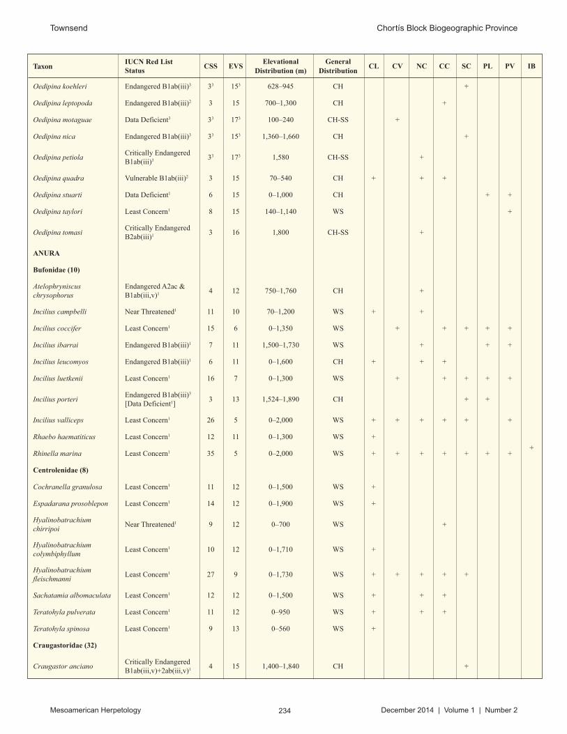
234 Mesoamerican Herpetology December 2014 | Volume 1 | Number 2
Townsend Chortís Block Biogeographic Province
Taxon IUCN Red List Status
CSS EVSElevational
Distribution (m)General
DistributionCL CV NC CC SC PL PV IB
Oedipina koehleri Endangered B1ab(iii)3 33 153 628–945 CH +
Oedipina leptopoda Endangered B1ab(iii)2 3 15 700–1,300 CH +
Oedipina motaguae Data Deficient3 33 173 100–240 CH-SS +
Oedipina nica Endangered B1ab(iii)3 33 153 1,360–1,660 CH +
Oedipina petiolaCritically Endangered B1ab(iii)3 33 173 1,580 CH-SS +
Oedipina quadra Vulnerable B1ab(iii)2 3 15 70–540 CH + + +
Oedipina stuarti Data Deficient1 6 15 0–1,000 CH + +
Oedipina taylori Least Concern1 8 15 140–1,140 WS +
Oedipina tomasi Critically Endangered B2ab(iii)1 3 16 1,800 CH-SS +
ANURA
Bufonidae (10)
Atelophryniscus chrysophorus
Endangered A2ac & B1ab(iii,v)1 4 12 750–1,760 CH +
Incilius campbelli Near Threatened1 11 10 70–1,200 WS + +
Incilius coccifer Least Concern1 15 6 0–1,350 WS + + + + +
Incilius ibarrai Endangered B1ab(iii)1 7 11 1,500–1,730 WS + + +
Incilius leucomyos Endangered B1ab(iii)1 6 11 0–1,600 CH + + +
Incilius luetkenii Least Concern1 16 7 0–1,300 WS + + + + +
Incilius porteri Endangered B1ab(iii)3
[Data Deficient1] 3 13 1,524–1,890 CH + +
Incilius valliceps Least Concern1 26 5 0–2,000 WS + + + + + +
Rhaebo haematiticus Least Concern1 12 11 0–1,300 WS +
Rhinella marina Least Concern1 35 5 0–2,000 WS + + + + + + ++
Centrolenidae (8)
Cochranella granulosa Least Concern1 11 12 0–1,500 WS +
Espadarana prosoblepon Least Concern1 14 12 0–1,900 WS +
Hyalinobatrachium chirripoi
Near Threatened1 9 12 0–700 WS +
Hyalinobatrachium colymbiphyllum
Least Concern1 10 12 0–1,710 WS +
Hyalinobatrachium fleischmanni
Least Concern1 27 9 0–1,730 WS + + + + +
Sachatamia albomaculata Least Concern1 12 12 0–1,500 WS + + +
Teratohyla pulverata Least Concern1 11 12 0–950 WS + + +
Teratohyla spinosa Least Concern1 9 13 0–560 WS +
Craugastoridae (32)
Craugastor anciano Critically Endangered B1ab(iii,v)+2ab(iii,v)1 4 15 1,400–1,840 CH +

235 Mesoamerican Herpetology December 2014 | Volume 1 | Number 2
Townsend Chortís Block Biogeographic Province
Taxon IUCN Red List Status
CSS EVSElevational
Distribution (m)General
DistributionCL CV NC CC SC PL PV IB
Craugastor aurilegulus Endangered B1ab(iii,v)+2ab(iii,v)1 6 14 50–1,550 CH + +
Craugastor bransfordii Least Concern1 10 115 20–1,535 WS +
Craugastor chac Near Threatened1 8 14 0–1,000 WS +
Craugastor charadraEndangered B1ab (iii, v)1 7 13 30–1,370 CH + +
Craugastor chrysozetetes EXTINCT1 3 17 880–1,130 CH +
Craugastor coffeus Critically Endangered B1ab(iii) + 2ab(iii)1 3 17 1,000 CH +
Craugastor cruzi Critically Endangered A2ace, B1ab(iii,v) +2ab(iii,v)1
3 17 1,520 CH-SS +
Craugastor cyanochthebius Critically Endangered B1ab(iii)+2ab(iii)2
[Near Threatened1]3 17 900–1,200 CH +
Craugastor emleni Critically Endangered A2ace, B2ab(v)1 3 14 800–2,000 CH +
Craugastor epochthidius Critically Endangered A3ce1 5 15 150–1,450 CH +
Craugastor fecundus Critically Endangered A2ace1 5 15 200–1,260 CH +
Craugastor fitzingeri Least Concern1 14 13 1–1,520 WS + +
Craugastor laevissimus Endangered A2ace1 11 8 0–2,000 CH + + + + +
Craugastor laticeps Near Threatened1 13 14 10–1,600 WS + +
Craugastor lauraster Endangered B1ab(iii) 1 6 14 40–1,200 CH + + +
Craugastor loki Least Concern1 16 14 0–1,370 WS +
Craugastor megacephalus Least Concern1 10 14 1–1,200 WS +
Craugastor merendonensis Critically Endangered A2ace, B1ab(v)+ 2ab(v)1
3 17 150–200 CH-SS +
Craugastor milesi Critically Endangered A2ae1 4 15 1,050–1,720 CH +
Craugastor mimus Least Concern1 9 13 15–700 WS +
Craugastor nefrens Data Deficient1 3 174 800–1,000 CH +
Craugastor noblei Least Concern1 11 13 4–1,200 WS + + +
Craugastor olanchano Critically Endangered A2ace1 3 16 1,180–1,350 CH
Craugastor omoaensis Critically Endangered A2ace, B1ab(iii)1 3 16 760–1,150 CH-SS +
Craugastor pechorum Endangered B1ab(iii)1 5 15 150–680 CH +
Craugastor rostralis Near Threatened1 6 14 850–1,800 WS + +
Craugastor rupinius Least Concern1 9 13 200–1,900 CH +
Craugastor saltuarius Critically Endangered A2ace1 3 16 1550–1,800 CH-SS +

236 Mesoamerican Herpetology December 2014 | Volume 1 | Number 2
Townsend Chortís Block Biogeographic Province
Taxon IUCN Red List Status
CSS EVSElevational
Distribution (m)General
DistributionCL CV NC CC SC PL PV IB
Craugastor stadelmani Critically Endangered A2ace1 4 15 1125–1,900 CH + +
Pristimantis cerasinus Least Concern1 9 14 19–680 WS + +
Pristimantis ridens Least Concern1 12 12 0–1,600 WS + + +
Eleutherodactylidae (1)
Diasporus diastema Least Concern1 11 14 0–1,620 WS +
Hylidae (35)
Agalychnis callidryas Least Concern1 17 10 0–1,200 WS + + + + +
Agalychnis moreletii Critically Endangered A3e1 19 13 200–2,130 WS + + +
Agalychnis saltator Least Concern1 9 13 0–819 WS +
Anotheca spinosa Least Concern1 11 15 95–2,068 WS +
Bromeliohyla bromeliacia Endangered A2ace1 8 15 900–1,790 WS +
Cruziohyla calcarifer Least Concern1 9 12 30–820 WS +
Dendropsophus ebraccatus Least Concern1 16 11 0–1,320 WS +
Dendropsophus microcephalus
Least Concern1 19 5 0–1,200 WS + + + + + ++
Duellmanohyla salvavida Critically Endangered B2ab(iii,v)1 5 12 90–1,400 CH +
Duellmanohyla soralia Critically Endangered B2ab(iii,v)1 7 10 40–1,570 CH +
Ecnomiohyla miliaria Vulnerable; B1ab(iii)1 9 15 0–1,330 WS +
Ecnomiohyla salvaje Critically Endangered B1ab(iii)1 5 16 1,370–1,520 CH +
Exerodonta catracha Endangered B1ab(iii)+2ab(iii)1 3 13 1,800–2,160 CH + +
Isthmohyla insolita Critically Endangered B1ab(iii)+2ab(iii)1 3 16 1,550 CH-SS +
Isthmohyla melacaenaCritically Endangered B2ab(iv)2
[Near Threatened1]3 16 1,550 CH +
Plectrohyla chrysopleura Critically Endangered A2ace, B1ab(iii,v)+ 2ab(iii,v)1
4 13 930–1,550 CH +
Plectrohyla dasypus Critically Endangered A2ace, B1ab(iii,v) +2ab(iii,v)1
3 13 1,410–1,990 CH-SS +
Plectrohyla exquisita Critically Endangered A3e1 3 13 1,490–1,680 CH-SS +
Plectrohyla guatemalensis Critically Endangered A3e1 11 9 900–2,800 WS + + +
Plectrohyla hartwegi Critically Endangered A3e1 9 12 925–2,700 WS +
Plectrohyla matudai Vulnerable B1ab(iii)1 8 10 700–2,300 WS + +

237 Mesoamerican Herpetology December 2014 | Volume 1 | Number 2
Townsend Chortís Block Biogeographic Province
Taxon IUCN Red List Status
CSS EVSElevational
Distribution (m)General
DistributionCL CV NC CC SC PL PV IB
Plectrohyla psiloderma Endangered B1ab(iii)1 4 12 2,400–2,530 +
Ptychohyla euthysanota Near Threatened1 10 114 200–2,200 WS +
Ptychohyla hypomykter Critically Endangered A3e1 11 9 340–2,070 CH + + +
Ptychohyla salvadorensis Endangered B1ab(iii)1 8 11 700–2,050 CH +
Ptychohyla spinipollex Endangered B1ab(iii)+2ab(iii)1 6 11 160–1,580 CH +
Scinax boulengeri Least Concern1 11 11 0–700 WS +
Scinax staufferi Least Concern1 25 5 0–1,530 WS + + + + + + ++
Smilisca baudinii Least Concern1 30 4 0–1,925 WS + + + + + + ++
Smilisca phaeota Least Concern1 11 10 0–1,116 WS + +
Smilisca sordida Least Concern1 13 11 0–1,525 WS +
Tlalocohyla loquax Least Concern1 18 6 0–1,585 WS + + + + +
Tlalocohyla picta Least Concern1 15 9 0–1,300 WS + +
Trachycephalus typhonius Least Concern1 25 5 0–1,610 WS + + +
Triprion petasatus Least Concern1 12 12 0–740 WS +
Leiuperidae (1)
Engytomops pustulosus Least Concern1 24 6 0–1,540 WS + + + + +
Leptodactylidae (4)
Leptodactylus fragilis Least Concern1 25 6 0–1,700 WS + + + + + + +
Leptodactylus melanonotus Least Concern1 25 6 0–1,440 WS + + + + ++
Leptodactylus savagei Least Concern1 15 11 0–1,200 WS +
Leptodactylus silvanimbus Critically Endangered B2ab(iii,v)1 4 13 1,470–2,000 CH +
Microhylidae (3)
Gastrophryne elegans Least Concern1 13 11 0–1,500 WS +
Hypopachus barberi Vulnerable B1ab(iii)1 10 11 1,300–2,500 WS +
Hypopachus variolosus Least Concern1 31 6 0–2,200 WS + + + + +
Ranidae (6)
Lithobates brownorum Least Concern1 18 3 0–1,200 WS + + + +
Lithobates forreri Least Concern1 20 8 0–1,960 WS + +
Lithobates maculatus Least Concern1 16 6 40–2,849 WS + + + +
Lithobates taylori Least Concern1 73 12 10–1,200 WS + +
Lithobates vaillanti Least Concern1 21 7 0–990 WS + + ++
Lithobates warszewitschii Near Threatened1 13 11 0–2,500 WS +
Rhinophrynidae (1)
Rhinophrynus dorsalis Least Concern1 18 9 0–700 WS + +

238 Mesoamerican Herpetology December 2014 | Volume 1 | Number 2
Townsend Chortís Block Biogeographic Province
Taxon IUCN Red List Status
CSS EVSElevational
Distribution (m)General
DistributionCL CV NC CC SC PL PV IB
REPTILIA
TESTUDINES
Chelydridae (2)
Chelydra acutirostris Data Deficient3 12 13 0–1,164 WS + +
Chelydra rossignonii Vulnerable A2d1 11 14 0–660 WS + +
Emydidae (3)
Trachemys emolli Least Concern3 5 12 0–75 WS +
Trachemys grayi Least Concern3 6 11 0–200 WS +
Trachemys venusta Near Threatened2 26 14 0–650 WS + +
Geoemydidae (4)
Rhinoclemmys annulata Lower Risk/Near Threatened1 11 13 2–920 WS
Rhinoclemmys areolata Near Threatened1 12 12 0–600 WS +
Rhinoclemmys funerea Lower Risk/Near Threatened1 7 16 2–600 WS
Rhinoclemmys pulcherrima Near Threatened2 19 9 0–1,480 WS + + +
Kinosternidae (2)
Kinosternon leucostomum Least Concern2 21 9 0–1,500 WS + +
Kinosternon scorpioides Least Concern2 24 9 0–1,500 WS + +
Staurotypidae (1)
Staurotypus triporcatus Lower Risk/Near Threatened1 10 15 0–300 WS +
CROCODILIA
Alligatoridae (1)
Caiman crocodilusLeast Concern2 [Lower risk/least concern1]
15 16 0–300 WS + +
Crocodylidae (1)
Crocodylus acutus Vulnerable A1ac1 22 13 0–650 WS + + ++
SQUAMATA: LIZARDS
Anguidae (3)
Abronia montecristoi Endangered B1ab(iii)1 4 15 1,370 CH + +
Abronia salvadorensis Endangered B1ab(iii)1 3 16 2,020–2,125 CH +
Mesaspis moreletii Least Concern2 13 13 1,450–2,849 WS + + +
Corytophanidae (7)
Basiliscus plumifrons Least Concern1 11 13 0–780 WS +
Basiliscus vittatus Least Concern2 25 7 0–1,500 WS + + + + + + ++
Corytophanes cristatus Least Concern2 20 11 0–1,640 WS + +

239 Mesoamerican Herpetology December 2014 | Volume 1 | Number 2
Townsend Chortís Block Biogeographic Province
Taxon IUCN Red List Status
CSS EVSElevational
Distribution (m)General
DistributionCL CV NC CC SC PL PV IB
Corytophanes hernandesii Least Concern2 14 12 0–1,400 WS +
Corytophanes percarinatus Vulnerable B1ab(iii)2 11 14 200–2,200 CH +
Laemanctus longipes Least Concern1 17 9 0–1,200 WS + +
Laemanctus serratus Least Concern1 17 12 0–1,600 WS +
Dactyloidae: (38)
Anolis allisoni Least Concern2 7 13 0–30 WS+
Norops amplisquamosus Endangered B1ab(iii, v)1 3 16 1,530–2,200 CH-SS +
Norops beckeri Least Concern2 22 11 0–1,780 WS + +
Norops bicaorum Endangered B2ab(iii)2 3 16 0–20 CH+
Norops biporcatus Least Concern2 23 10 0–2,000 WS + + + +
Norops capito Least Concern2 19 11 0–1,250 WS + + + +
Norops carpenteri Least Concern1 6 135 4–682 WS +
Norops crassulus Least Concern2 11 13 1,200–2,849 WS +
Norops cupreus Least Concern2 13 9 0–1,435 WS +
Norops cusuco Endangered B1ab(iii)1 3 16 1,550–1,935 CH-SS +
Norops heteropholidotus Endangered B2ab(iii)2 4 14 1,860–2,200 CH +
Norops johnmeyeri Endangered B1ab(iii)2 3 15 1,340–1,825 CH +
Norops kreutzi Critically Endangered B1ab(iii)+2ab(iii)2 3 16 1,670–1,690 CH-SS +
Norops laeviventris Least Concern2 17 9 500–2,000 WS + + +
Norops lemurinus Least Concern2 26 9 0–2,000 WS + + + +
Norops limifrons Least Concern2 13 12 0–1,340 WS +
Norops lionotus Least Concern1 5 13 20–1,200 WS +
Norops loveridgei Endangered B1ab(iii) 1 6 14 550–1,600 CH +
Norops morazani*Critically Endangered B1ab(iii)2 3 16 1,780–2,150 CH-SS +
Norops muralla Vulnerable D21 3 15 1,440–1,740 CH-SS +
Norops ocelloscapularis Endangered B1ab(iii)2 4 15 1,150–1,450 CH +
Norops petersii Vulnerable B1ab(iii)2 14 13 200–2,130 WS +
Norops pijolensis Critically Endangered B1ab(iii)2 4 14 1,180–2,050 CH +
Norops purpurgularis Endangered B1ab(iii)+2ab(iii)2 3 15 1,550–2,040 CH +
Norops quaggulus Least Concern2 8 12 0–1,350 WS +
Norops roatanensis Endangered B1ab(iii)+2ab(iii)2 3 15 0–30 CH
+
Norops rodriguezii Least Concern2 16 10 0–2,000 WS + +

240 Mesoamerican Herpetology December 2014 | Volume 1 | Number 2
Townsend Chortís Block Biogeographic Province
Taxon IUCN Red List Status
CSS EVSElevational
Distribution (m)General
DistributionCL CV NC CC SC PL PV IB
Norops rubribarbaris Critically Endangered B1ab(iii)2 3 16 1,700 CH-SS +
Norops sminthus Endangered B1ab(iii)+2ab(iii)2
[Data Deficient1]4 15 1,450–2,200 CH +
Norops tropidonotus Least Concern2 20 5 0–1,900 WS + + + + + +
Norops uniformis Least Concern2 13 11 0–1,370 WS +
Norops unilobatus Least Concern3 26 7 0–1,200 WS + +
Norops utilensis Critically Endangered B1ab(iii)2 3 16 0–5 CH-SS +
Norops wampuensis Endangered B2ab(iii)2 3 16 95–110 CH-SS +
Norops wellbornae Least Concern3 8 9 0–1,050 WS + +
Norops wermuthi Vulnerable B1ab(iii)5 3 155 1,230–1,660 CH +
Norops yoroensis Endangered B1ab(iii)+2ab(iii)2 4 14 1,180–1,600 CH +
Norops zeus Endangered B1ab(iii)2 5 14 90–900 CH + +
Diploglossidae (3)
Celestus bivittatus Endangered B1ab(iii)1 7 13 1,510–1,980 CH +
Celestus montanus Endangered B1ab(iii)1 5 14 915–1,372 CH +
Celestus scansorius Endangered B2ab(iii)2
[Near Threatened1]3 14 1,550–1,590 CH + +
Eublepharidae (1)
Coleonyx mitratus Least Concern1 16 10 0–1,435 WS + + + ++
Gymnophthalmidae (1)
Gymnophthalmus speciosus
Least Concern2 24 8 0–1,320 WS + + + +
Helodermatidae (1)
Heloderma horridumNear Threatened4 [Least Concern1]
11 144 100–1,530 WS +
Iguanidae (9)
Ctenosaura bakeri Critically Endangered B1ab(i,ii,iii,v)+ 2ab(i,ii,iii,v)1
3 19 0–5 CH-SS
+
Ctenosaura flavidorsalis Endangered B1ab(iii,v)+2ab(iii,v)1 8 13 370–750 CH + +
Ctenosaura melanosterna Critically Endangered B1ab(iii,v)1 5 17 0–300 CH +
+
Ctenosaura oedirhina Endangered B1ab(iii)1 3 18 0–20 CH+
Ctenosaura palearisEndangered B1ab(i,ii,iii,iv,v)+ 2ab(i,ii,iii,iv,v)1
3 174 150–700 CH +
Ctenosaura praeocularisEndangered B1ab(iii,v)3 [Data Deficient1]
33 173 800–1,000 CH +

241 Mesoamerican Herpetology December 2014 | Volume 1 | Number 2
Townsend Chortís Block Biogeographic Province
Taxon IUCN Red List Status
CSS EVSElevational
Distribution (m)General
DistributionCL CV NC CC SC PL PV IB
Ctenosaura quinquecarinata
Endangered B1ab(iii,v)+2ab(iii,v)1 5 165 0–250 WS + +
Ctenosaura similis Least Concern1 22 11 0–1,320 WS + + + + + + ++
Iguana iguana Least Concern2 26 12 0–1,000 WS + + + + + + ++
Mabuyidae (2)
Marisora brachypoda Least Concern1 27 7 0–1,800 WS + + + + + + +
Marisora roatanae Critically Endangered B1ab(v)1 3 15 0–30 CH
+
Phrynosomatidae (3)
Sceloporus malachiticus Least Concern1 16 8 540–2,849 WS + + +
Sceloporus variabilis Least Concern1 25 7 0–1,500 WS + + + +
Sceloporus squamosus Least Concern1 14 10 0–2,500 WS + + +
Phyllodactylidae (4)
Phyllodactylus palmeus Endangered B2ab(iii)2 3 15 0–30 CH+
Phyllodactylus paralepis Endangered B2ab(iii)3 3 15 0–30 CH+
Phyllodactylus tuberculosus
Least Concern1 23 10 0–1,230 WS + + +
Thecadactylus rapicauda Least Concern2 21 10 0–1,052 WS + + + +
Polychrotidae (1)
Polychrus gutturosus Least Concern2 12 12 6–700 WS +
Scincidae (2)
Mesoscincus managuae Least Concern1 10 12 0–920 WS +
Plestiodon sumichrasti Least Concern1 16 11 0–1,000 WS + +
Sphaerodactylidae (10)
Gonatodes albogularis Least Concern2 20 10 0–1,000 WS + + + +
Sphaerodactylus alphus Endangered B2ab(iii)3 3 15 0–30 CH+
Sphaerodactylus continentalis
Least Concern3 19 7 0–1,000 WS + + + + ++
Sphaerodactylus dunni Vulnerable B1ab(iii)2
[Least Concern1]4 14 60–230 CH + +
Sphaerodactylus glaucus Least Concern1 14 13 0–1,000 WS +
Sphaerodactylus guanajae Endangered B2ab(iii)3 3 15 0–30 CH+
Sphaerodactylus leonardovaldesi
Endangered B2ab(iii)3 3 15 0–30 CH+
Sphaerodactylus millepunctatus
Least Concern1 19 7 0–1,000 WS + + + + ++
Sphaerodactylus poindexteri
Critically Endangered B1ab(iii)3 3 16 3–10 CH
+
Sphaerodactylus rosaurae Endangered B2ab(iii)2
[Least Concern1]3 15 0–20 CH
+

242 Mesoamerican Herpetology December 2014 | Volume 1 | Number 2
Townsend Chortís Block Biogeographic Province
Taxon IUCN Red List Status
CSS EVSElevational
Distribution (m)General
DistributionCL CV NC CC SC PL PV IB
Sphenomorphidae (3)
Scincella assatus Least Concern1 16 13 0–2,500 WS +
Scincella cherriei Least Concern1 23 7 0–1,860 WS + + + + + +
Scincella incertaVulnerable B1ab(iii)2
[Least Concern1]6 12 1,350–1,670 WS +
Teiidae (5)
Aspidoscelis deppii Least Concern1 22 8 0–1,200 WS + + + +
Aspidoscelis motaguae Least Concern1 12 9 175–1,200 WS + +
Cnemidophorus ruatanus Least Concern3 8 12 0–400 WS + +
Holcosus festivus Least Concern2 20 10 0–1,400 WS + + + ++
Holcosus undulatus Least Concern1 27 7 0–1,800 WS + + +
Xantusiidae (2)
Lepidophyma flavimaculatum
Least Concern2 19 11 0–1,400 WS + + +
Lepidophyma mayae Vulnerable B1ab(iii)2 7 13 100–800 +
SQUAMATA: SNAKESAnomalepididae (1)
Anomalepis mexicanus Data Deficient1 8 11 5–500 WS +
Boidae (2)
Boa imperator Least Concern2 32 8 0–1,500 WS + + + + + + ++
Corallus annulatus Least Concern2 9 11 0–400 WS +
Charinidae (1)
Ungaliophis continentalis Vulnerable B1ab(iii)2 11 12 990–2,300 WS + +
Colubridae (45)
Chironius grandisquamis Least Concern2 12 12 0–1,600 WS + + +
Dendrophidion apharocybe Least Concern3 17 12 30–1,500 WS + + +
Dendrophidion percarinatum
Least Concern2 13 12 4–1,200 WS + + +
Dendrophidion rufiterminorum
Least Concern1 18 13 15–1,500 WS + +
Drymarchon melanurus Least Concern1 35 9 0–2,500 WS + + + + + + ++
Drymobius chloroticus Vulnerable; B1ab(iii)2
[Least Concern1]18 11 500–2,500 WS + + +
Drymobius margaritiferus Least Concern2 33 7 0–2,000 WS + + + + + + +
Drymobius melanotropis Least Concern1 8 14 0–1,400 WS + +
Ficimia publia Least Concern1 18 11 0–1,000 WS +
Lampropeltis abnorma Least Concern2 36 9 0–2,500 WS + + + + + + +
Leptodrymus pulcherrimus Least Concern1 14 10 10–1,300 WS + + + + +
Leptophis ahaetulla Least Concern2 24 8 0–1,680 WS + + + +

243 Mesoamerican Herpetology December 2014 | Volume 1 | Number 2
Townsend Chortís Block Biogeographic Province
Taxon IUCN Red List Status
CSS EVSElevational
Distribution (m)General
DistributionCL CV NC CC SC PL PV IB
Leptophis depressirostris Least Concern5 9 135 4–1,120 WS +
Leptophis mexicanus Least Concern1 28 8 0–1,700 WS + + + + + ++
Leptophis modestus Vulnerable; B1ab(iii)1 8 15 1,500–2,500 WS + + +
Leptophis nebulosus Least Concern1 12 14 0–1,600 WS +
Masticophis mentovarius Least Concern2 32 11 0–2,500 WS + + + + + +
Mastigodryas alternatus Least Concern1 243 93 20–800 WS +
Mastigodryas dorsalis Vulnerable B1ab(iii)2
[Least Concern1]10 12 635–1,900 WS + + +
Mastigodryas melanolomus
Least Concern1 27 96 0–1,0406 WS + + + +
Oxybelis aeneus Least Concern2 35 9 0–2,500 WS + + + + + + +
Oxybelis brevirostris Least Concern2 12 13 4–800 WS +
Oxybelis fulgidus Least Concern2 27 10 0–1,600 WS + + + ++
Oxybelis wilsoni Endangered B1ab(iii)1 3 15 0–95 CH+
Phrynonax poecilonotus Least Concern1 22 12 0–1,330 WS + + + +
Pseudelaphe flavirufa Least Concern1 21 12 0–1,200 WS + ++
Rhinobothryum bovallii Least Concern1 9 15 4–550 WS +
Scaphiodontophis annulatus
Least Concern1 19 12 0–1,400 WS + + + +
Scaphiodontophis venustissimus
Least Concern2 11 11 2–830 WS +
Scolecophis atrocinctus Least Concern1 14 14 100–1,530 WS + +
Senticolis triaspis Least Concern1 30 10 10–2,500 WS + + +
Spilotes pullatus Least Concern2 30 9 0–1,500 WS + + + + + +
Stenorrhina degenhardtii Least Concern2 23 10 0–1,900 WS + + + + + +
Stenorrhina freminvillei Least Concern1 22 11 0–2,000 WS + + + +
Tantilla armillata Least Concern1 14 9 0–1,435 WS + + + +
Tantilla impensa Least Concern1 10 12 300–1,600 CH +
Tantilla lempira Endangered B1ab(i,ii,iii,iv,v)1 4 13 1,450–1,730 CH +
Tantilla olympiaCritically Endangered B1ab(iii)+2ab(iii)3 33 163 1,150 CH-SS +
Tantilla psittaca Vulnerable B1ab(iii)1 53 13 60–420 CH + +
Tantilla schistosa Least Concern1 24 10 40–1,680 WS + + +
Tantilla taeniata Least Concern1 13 10 0–1,280 WS + + + +
Tantilla tritaeniata Critically Endangered B1ac(iv)1 3 15 0 CH-SS
+
Tantilla vermiformis Least Concern1 73 11 0–520 WS +
Tantillita lintoni Least Concern1 15 13 0–550 WS +
Trimorphodon quadruplex Least Concern1 14 10 0–2,000 WS + +

244 Mesoamerican Herpetology December 2014 | Volume 1 | Number 2
Townsend Chortís Block Biogeographic Province
Taxon IUCN Red List Status
CSS EVSElevational
Distribution (m)General
DistributionCL CV NC CC SC PL PV IB
Dipsadidae (63)
Adelphicos quadrivirgatum Least Concern1 19 8 0–1,740 WS + + + + + +
Amastridium sapperi Least Concern1 18 12 100–1,600 WS +
Clelia clelia Least Concern2 18 11 0–1,000 WS + + + +
Coniophanes bipunctatus Least Concern1 18 11 0–1,000 WS ++
Coniophanes fissidens Least Concern2 28 9 0–2,200 WS + + + + +
Coniophanes imperialis Least Concern1 19 11 0–2,000 WS + + + ++
Coniophanes piceivittis Least Concern1 23 11 0–1,305 WS + + +
Conophis lineatus Least Concern1 22 9 0–1,500 WS + + + +
Crisantophis nevermanni Least Concern1 11 14 0–1,385 WS +
Dipsas bicolor Least Concern2 8 11 4–1,100 WS + +
Enuliophis sclateri Least Concern2 10 11 0–1,235 WS +
Enulius bifoveatus Critically Endangered B1ac(iv)1 3 15 0–10 CH-SS
+
Enulius flavitorques Least Concern2 26 6 0–2,849 WS + + + ++
Enulius roatanensis Endangered B1ab(iii)1 3 15 0–10 CH+
Erythrolamprus mimus Least Concern1 12 12 70–1,400 WS + +
Geophis damiani Critically Endangered B1ab(iii)1 3 15 1,075–1,750 CH-SS +
Geophis dunni Data Deficient1 3 165 900 CH +
Geophis fulvoguttatus Endangered B1ab(iii)1 6 12 1,680–2,200 CH + +
Geophis hoffmanni Least Concern2 14 12 18–670 WS + + + +
Geophis nephodrymusEndangered B2ab(iii)2
[Vulnerable D21]3 14 1,560–1,580 CH-SS +
Geophis rhodogasterEndangered B1ab(iii)2
[Least Concern1]8 12 1,480–2,600 WS +
Hydromorphus concolor Least Concern1 16 9 1–1,500 WS + + +
Imantodes cenchoa Least Concern2 30 6 0–2,063 WS + + + +
Imantodes gemmistratus Least Concern2 26 10 2–1,435 WS + + +
Imantodes inornatus Least Concern1 12 10 5–1,450 WS + + +
Leptodeira nigrofasciata Least Concern1 18 10 0–1,300 WS + + +
Leptodeira rhombifera Least Concern1 28 8 0–2,000 WS + + + + + +
Leptodeira septentrionalis Least Concern2 33 9 0–2,000 WS + + + + +
Ninia diademata Least Concern1 19 8 0–2,200 WS + + + +
Ninia espinali Endangered B1ab(iii)2
[Near Threatened1]5 12 1,590–2,242 CH + + +
Ninia maculata Least Concern2 13 12 36–1,800 WS +
Ninia pavimentata Endangered B1ab(iii)2 5 12 1,300–1,500 WS +

245 Mesoamerican Herpetology December 2014 | Volume 1 | Number 2
Townsend Chortís Block Biogeographic Province
Taxon IUCN Red List Status
CSS EVSElevational
Distribution (m)General
DistributionCL CV NC CC SC PL PV IB
Ninia sebae Least Concern1 28 4 0–2,200 WS + + + + + + +
Nothopsis rugosus Least Concern1 11 12 2–830 WS +
Omoadiphas aurula Endangered B2ab(iii)2
[Vulnerable D21]3 15 1,250–1,900 CH-SS +
Omoadiphas cannula Critically Endangered B1ab(iii) 1 33 143 1,250 CH-SS +
Omoadiphas texiguatensis Critically Endangered B1ab(iii)1 3 14 1,690 CH-SS +
Oxyrhopus petolarius Least Concern2 18 13 0–800 WS + + +
Pliocercus elapoides Least Concern1 25 10 0–2,000 WS + + + + +
Pliocercus euryzonus Least Concern1 13 14 0–1,250 WS +
Rhadinaea decorata Least Concern2 20 11 0–1,400 WS + +
Rhadinella anachoreta Endangered B1ab(iii)2
[Least Concern1]9 12 500–1,180 CH + +
Rhadinella godmani Vulnerable B1ab(iii)2
[Least Concern1]13 9 1,200–2,200 WS + + +
Rhadinella kinkelini Vulnerable B1ab(iii)2
[Least Concern1]10 12 1,370–2,085 CH + + +
Rhadinella lachrymans Vulnerable B1ab(iii)2
[Least Concern1]12 13 500–2,849 WS +
Rhadinella montecristi Endangered B1ab(iii)2
[Vulnerable B1ab(iii)1]7 12 1,370–2,620 CH + +
Rhadinella pegosalytaEndangered B2ab(iii)3
[Vulnerable B21]3 14 CH-SS +
Rhadinella rogerromani Vulnerable B1ab(iii)5 3 165 1,450 CH-SS +
Rhadinella tolpanorum Endangered B1ab(iii)1 3 15 1,690–1,900 CH-SS +
Sibon annulatus Least Concern1 10 12 2–1,300 WS +
Sibon anthracops Least Concern1 12 14 4–915 WS + +
Sibon carri Endangered B1ab(iii)2 8 12 30–800 CH + +
Sibon dimidiatus Least Concern1 18 11 0–1600 WS + + + +
Sibon longifrenis Least Concern1 9 11 60–750 WS +
Sibon manzanaresi Critically Endangered B1ab(iii)+2ab(iii)2
[Near Threatened1]3 15 250–300 CH-SS +
Sibon miskitus Critically Endangered B1ab(iii)+2ab(iii)2
[Near Threatened1]3 15 150 CH-SS +
Sibon nebulatus Least Concern2 27 8 0–1,690 WS + + + +
Tretanorhinus nigroluteus Least Concern2 18 8 0–1,200 WS + + +
Tropidodipsas fischeri Least Concern1 12 12 1,000–2,849 WS +
Tropidodipsas sartorii Least Concern1 26 12 0–2,000 WS + + + +
Urotheca decipiens Least Concern2 10 11 15–1,500 WS +

246 Mesoamerican Herpetology December 2014 | Volume 1 | Number 2
Townsend Chortís Block Biogeographic Province
Taxon IUCN Red List Status
CSS EVSElevational
Distribution (m)General
DistributionCL CV NC CC SC PL PV IB
Urotheca guentheri Least Concern1 13 12 25–1,600 WS +
Xenodon angustirostris Least Concern2 24 12 0–1,300 WS + + + + +
Elapidae (6)
Micrurus alleni Least Concern1 11 15 1–1,620 WS +
Micrurus browni Least Concern1 15 13 0–2,200 WS +
Micrurus diastema Least Concern1 19 12 50–600 WS + + +
Micrurus mipartitus Least Concern5 6 155 2–1,160 WS +
Micrurus nigrocinctus Least Concern2 21 9 0–1,600 WS + + + +
Micrurus ruatanus Critically Endangered B1ab(iii)1 3 17 0–20 CH
+
Leptotyphlopidae (2)
Epictia ater Least Concern1 93 66 0–1,350 WS + + + +
Epictia magnamaculata Endangered B1ab(iii)+2ab(iii)3 33 153 0–25 CH
+
Loxocemidae (1)
Loxocemus bicolor Least Concern2 16 11 0–750 WS + + +
Natricidae (4)
Storeria dekayi Least Concern1 13 9 0–1,900 WS + + +
Thamnophis fulvus Least Concern1 10 14 1,680–2,849 WS +
Thamnophis marcianus Least Concern1 22 13 0–1,400 WS +
Thamnophis proximus Least Concern1 27 9 0–2,500 WS + + + + +
Typhlopidae (3)
Amerotyphlops costaricensis
Least Concern2 11 11 540–1,500 WS + +
Amerotyphlops stadelmani Endangered B1ab(iii) 2
[Vulnerable D21]6 12 320–1,370 CH + + +
Amerotyphlops tycherus Vulnerable D21 3 14 1,550 CH-SS +
Viperidae (14)
Agkistrodon bilineatus Near Threatened7 87 137 0–1,500 WS + +
Agkistrodon howardgloydi Endangered B1ab(iii)7 57 177 0–600 WS +
Atropoides indomitus Endangered B1ab(iii)1 33 17 670–1,200 CH +
Atropoides mexicanus Least Concern2 17 12 0–1,600 WS + + + +
Atropoides occiduus Vulnerable4 7 154 100–1,600 WS +
Bothriechis guifarroi Endangered B1ab(iii)3 6 14 1,015–1,450 CH + +
Bothriechis marchi Endangered B1ab(iii, v)1 5 16 500–1,840 CH +
Bothriechis schlegelii Least Concern2 21 12 0–1,530 WS + + + +
Bothriechis thalassinus Vulnerable B1ab(iii)+2ab(iii)2 5 15 1,370–1,750 CH + +

247 Mesoamerican Herpetology December 2014 | Volume 1 | Number 2
Townsend Chortís Block Biogeographic Province
Taxon IUCN Red List Status
CSS EVSElevational
Distribution (m)General
DistributionCL CV NC CC SC PL PV IB
Bothrops asper Least Concern2 25 12 0–1,300 WS + + + + +
Cerrophidion wilsoni Vulnerable B1ab(iii)2 15 12 1,300–2,849 WS + + +
Crotalus simus Least Concern1 21 12 500–2,600 WS + + + + +
Porthidium nasutum Least Concern1 18 12 0–1,100 WS + + + +
Porthidium ophryomegas Least Concern1 15 9 0–1,400 WS + + + +
1IUCN Red List (2011)2Townsend and Wilson (2010)3Evaluated for this study4Acevedo et al. (2010)5Sunyer and Köhler (2010)6McCranie (2011)7Porras et al. (2013)
Table 4. Broad distributional patterns of herpetofaunal diversity in the Chortís Block. CB = Chortís Block restricted, WS = widespread, CL = Caribbean Lowlands, CV = Caribbean Intermontane Valleys, NC = Northern Cordillera, CC = Central Cordillera, SC = Southern Cordillera, PL = Pacific Lowlands, PV = Pacific Intermontane Valleys, IB = Islas de la Bahía.
Distribution Physiographic Regions
CB WS CL CV NC CC SC PL PV IB
Gymnophiona 0 2 2 2 0 0 0 1 0 0
Caudata 37 6 7 2 17 18 10 1 2 0
Anura 38 63 51 18 50 38 31 12 16 6
AMPHIBIA 75 71 60 22 67 56 41 14 18 6
Crocodylia 0 2 2 2 0 0 0 2 0 1
Testudines 0 12 6 6 0 0 0 4 1 0
Squamata: Sauria 41 54 37 33 33 22 20 17 21 21
Squamata: Serpentes 33 109 86 54 64 60 41 29 37 14
REPTILIA 74 177 131 95 97 81 61 52 59 37
Totals 149 248 191 117 164 137 102 66 77 43
Challenges to Regional Research
Systematic herpetologists have been active in the Chortís Block since at least the early 1900’s, with the constituent countries of the Chortís Block (El Salvador, Guatemala, Honduras, and Nicaragua) each with their own rich histories of herpetological investigation (Mertens, 1952; Stuart, 1963; Meyer, 1969; Villa, 1972; Wilson et al., 2010). Most research has taken a geopolitically-delimited approach that often is arbitrary and seldom congruent with biogeo-graphic boundaries. While this approach is practical and largely necessary due to a variety of considerations (e.g., visas, research and export permits, logistics), it also can come at the expense of a biogeographically-meaningful approach to research, or of a unified strategy for conservation in transboundary areas. The Chortís Block is an ex-emplar of this issue, where national boundaries effectively divide efforts to document and conserve isolated cloud forest areas in five mountain ranges that serve to physically delineate national borders.
In some cases, border regions are avoided due to security-related issues. Honduran frontier zones have be-come increasingly favored by transnational narcotics traffickers, particularly over the past decade as the influence of Mexican drug cartels has expanded into Central America (e.g., Archibold and Cave, 2011). In an even more extreme case, the highest mountain range in Nicaragua (Sierra de Dipilto, maximum elevation 2,107 m), which also forms the border with Honduras, was considered a strategic vantage point that was heavily contested, and subsequently

248 Mesoamerican Herpetology December 2014 | Volume 1 | Number 2
Townsend Chortís Block Biogeographic Province
landmined, during the Contra-Sandinista War of the 1980’s (United Nations Mine Action Service, 1998). Despite the apparent biogeographic importance of this mountain range and its potential for supporting endemic species, little to no biological inventory work has been carried out in the Sierra de Dipilto. Beyond this mountain range, a large area of the Chortís Highlands in northern Nicaragua also has been heavily undersampled as a result of being the principal zone of conflict in the Contra-Sandinista War, and only recently has begun to be sampled in a concerted fashion (Sunyer et al., 2009; Travers et al. 2011).
Political boundaries have placed the majority of the endemic-rich Chortís Highlands within the borders of one country, Honduras, with significant extensions into three neighboring countries, most notably Nicaragua. A conse-quence of research constrained by political boundaries is that systematic cataloguing of regional diversity has been handicapped. As a result, a number of endemic species are known from localities in one country but unconfirmed as occurring across the border in ecophysiographically contiguous areas, as in the cases, for example, of Cryptotriton monzoni (endemic to the Sierra de Espíritu Santo in Guatemala) and Anolis johnmeyeri (endemic to the Sierra de Espíritu Santo and Sierra de Omoa in Honduras). In at least one case, it has been suggested that two species of Cryptotriton described from opposite sides of the Sierra de Omoa (called the Sierra de Caral in Guatemala), C. nasalis and C. wakei, actually represent the same species (McCranie and Rovito, 2014).
Moreover, the distributions of at least six endemic species are restricted to one or a few highland localities that straddle the borders between two or even three countries, creating additional challenges to the development of com-prehensive conservation strategies for these taxa. Notable localities include the Sierra de Omoa, Honduras/Sierra de Caral, Guatemala (Bolitoglossa conanti, B. dunni, Cryptotriton nasalis, and Duellmanohyla soralia), Cerro El Pital, El Salvador/Honduras (Bolitoglossa synoria), and Cerro Montecristo, El Salvador/Guatemala/Honduras (Bolitoglossa heiroreias).
Minimizing the constraints of these largely political and logistical issues is necessary if regional patterns of biogeography and endemism are to be analyzed and interpreted accurately. More importantly, seeking creative and collaborative solutions to working across or breaking down these boundaries are critical if effective conservation strategies are to have any hope for formulation or eventual success.
Acknowledgments.— This paper largely was completed as part of my PhD dissertation at the University of Florida, and first and foremost I would like to thank my advisor, James Austin, and committee members Rob Fletcher, Mike Miyamoto, Rick Stepp, and Larry David Wilson, for their guidance, advice, and support. It was under the mentorship of Larry Wilson that I began my study of the herpetofauna of the Chortís Block, first as his student at Miami Dade Community College in 1999, and I cannot overstate my gratitude for his steadfast support and encouragement over the course of the past 15 years. Completion of this manuscript for publication was car-ried out with support from an AWE 3-credit release from the Indiana University of Pennsylvania (IUP) College of Natural Science and Mathematics (CNSM), and I thank the Dean of CNSM, Dr. Deanne Snavely, for offering me this opportunity. Fieldwork was funded to varying extents by the Critical Ecosystem Partnership Fund (CEPF), a Summer Research Grant from the Working Forests in the Tropics IGERT Program (National Science Foundation DGE–0221599) at the University of Florida, and a grant to Kirsten Nicholson (Central Michigan University; National Science Foundation DEB-0949359). In addition to the support of literally dozens of coworkers in the field (Table 1), I would like to thank the personnel at the Section of Protected Areas and Wildlife, Instituto Nacional de Conservación y Desarrollo Forestal, Áreas Protegidas y Vida Silvestre (ICF), and particularly Saíd Lainez O., Iris Acosta, and Carla Cárcamo, for their strong support for our ongoing research efforts and their assistance in acquir-ing research and export permits. Louis Porras was of great assistance in editing this manuscript for publication, and I am thankful for his time and efforts. Finally, I am deeply grateful to Ileana Luque-Montes for the countless ways she supported my professional endeavors, including the preparation of this manuscript and translation of the Resumen.

249 Mesoamerican Herpetology December 2014 | Volume 1 | Number 2
Townsend Chortís Block Biogeographic Province
Agüdelo-C., N. 1987. Ecosistemas Terrestres de Honduras. Asociación Hondureña de Ecología, Tegucigalpa, Honduras.
AmphibiAWeb. 2014. Information on amphibian biology and conservation [web application]. Berkeley, California, United States. (www. amphibiaweb.org; accessed 17 November 2014).
ArChibold, r. C., And d. CAve. 2011. Drug wars push deeper into Central America. New York Times, 31 March 2011. (www.nytimes.com/2011/03/24/world/americas/24drugs.html?_r=1&pagewanted=print; accessed 12 September 2011).
bird, p. 2003. An updated digital model of plate boundaries. Geochemicals, Geophysics, and Geosystems 4:1,027 (doi:10.1029/2001GC000252).
brodie, Jr., e. d., m. ACevedo, And J. A. CAmpbell. 2012. New salamanders of the genus Oedipina (Caudata: Plethodontidae) from Guatemala. Journal of Herpetology 46: 233–240.
CAmpbell, J. A. 1999. Distribution patterns of amphibians in Middle America. Pp. 111–210 In W. E, Duellman, (Ed.), Patterns of Distribution of Amphibians: A Global Perspective. Johns Hopkins University Press, Baltimore, Maryland, United States.
CArr, A. F. 1950. Outline for a classification of animal habitats in Honduras. Bulletin of the American Museum of Natural History 94: 567–594.
CAstoe, t. C. m. sAsA, And C. l. pArkinson. 2005. Modeling nucleotide evolution at the mesoscale: the phylogeny of the Neotropical pitvipers of the Porthidium group (Viperidae: Crotalinae). Molecular Phylogenetics and Evolution 37: 881–898.
demets, C., g. mAttioli, p. JAnsmA, r. d. rogers, C. tenorio, And h. l. turner. 2007. Present motion and deformation of the Caribbean plate: constraints from new GPS geodetic measurements from Honduras and Nicaragua. Pp. 21–36 In P. Mann (Ed.), Geologic and Tectonic Development of the Caribbean Plate in Northern Central America. Special Paper 428, The Geological Society of America, Boulder, Colorado, United States.
donnelly, t. W., g. s. horne, r. C. FinCh, And e. lópez-rAmos. 1990. Northern Central America: the Maya and Chortís blocks. Pp. 37–76 In G. Dengo and J. E, Case (Eds.), The Geology of North America, Volume 11: The Caribbean Region. The Geological Society of America, Boulder, Colorado, United States.
goodWin. G. G. 1942. Mammals of Honduras. Bulletin of the American Museum of Natural History 79: 107–195.
gordon, M. B. 1992. Northern Central America (the Chortís block). Pp. 107–113 In G. E. G. Westermann (Ed.), The Jurassic of the Circum-Pacific (World and Regional Geology 3). Cambridge University Press, Cambridge, United Kingdom.
gordon m. b, And W. r. muehlberger. 1994. Rotation of the Chortis block causes dextral slip on the Guayape fault. Tectonics 13: 858–872.
gordon, m. b., C. pAll-gordon, A. e. blythe, p. CopelAnd, m. doneliCk, b. deFFontAines, And J. Angelier. 2010. Dating tectonic events on the Chortís Block. The Geological Society of America, Abstracts with Programs 42: 197.
gose, W. A. 1985. Paleomagnetic results from Honduras and their bearing on Caribbean tectonics. Tectonics 4: 565–585.
hAy, W. W., r. deConto, C. n. Wold, k. m. Wilson, s. voigt, m. sChulz, A. Wold-rossby, W. C. dullo, A. b. ronov, A. n. bAlukhovsky, And e. soeding. 1999. Alternative global cretaceous paleogeography. Pp. 1–47 In E. Barrera and C. Johnson (Eds.), The Evolution of Cretaceous Ocean/Climate Systems. Special Paper 332, The Geological Society of America, Boulder, Colorado, United States.
hAzlett, d. l. 1980. A botanical description of Cerro Azul Meámbar, Honduras. Brenesia 18: 201–206.
holdridge l. r. 1967. Life Zone Ecology. Revised Edition. Tropical Science Center, San José, Costa Rica.
IUCN. 2001. IUCN Red List Categories and Criteria: Version 3.1. IUCN Species Survival Commission. IUCN, Gland, Switzerland and Cambridge, United Kingdom. (www.iucnredlist.org/info/categories_criteria2001).
IUCN. 2014. The IUCN Red List of Threatened Species. (www.iucnredlist.org/; accessed 2 November 2014).
JAmes, k. h. 2007. Structural geology: from local elements to regional synthesis. Pp. 277–321 In J. Bundschuh and G. E. Alvarado (Eds.), Central America: Geology, Resources, and Hazards. 2 Volumes. Taylor and Francis, Oxford, United Kingdom.
JohAnnessen, C. l. 1963. Savannas of Interior Honduras. University of California Press, Berkeley, California, United States.
Johnson, J. d. 1989. A biogeographic analysis of the herpetofauna of northwestern Nuclear Central America. Milwaukee Public Museum Contributions in Biology and Geology 76: 1–66.
JordAn, b. r., h. sigurdsson, And s. n. CArey. 2008. Ignimbrites in Central America and Associated Caribbean Sea Tephra: Correlation and Petrogenesis. VDM Verlag, Dr. Müller, Saarbrücken, Germany.
keppie, J. d., And d. J. morán-zenteno. 2005. Tectonic implications of alternative Cenozoic reconstructions for southern Mexico and the Chortís Block. International Geology Review 47: 473–491.
mAnton, W. i. 1996. The Grenville of Honduras. The Geological Society of America, Abstracts with Programs 28: 493.
mAnn, p., r. d. rogers, And l. gAhAgAn. 2007. Overview of plate tectonic history and its unresolved tectonic problems. Pp. 206–241 In J. Bundschuh and G. E. Alvarado (Eds.), Central America: Geology, Resources, and Hazards. Taylor and Francis, Oxford, United Kingdom.
mArshAll, J. s. 2007. The geomorphology and physiographic provinces of Central America. Pp. 75–122 In J. Bundschuh and G. E. Alvarado (Eds.), Central America: Geology, Resources, and Hazards. Taylor and Francis, Oxford, United Kingdom.
mArtin, m. 1972. A biogeographic analysis of the freshwater fishes of Honduras. Unpublished Ph.D. Dissertation. The University of Southern California, Los Angeles, California, United States.
mAtAmoros W. A., And J. F. sChAeFer. 2010. A new species of Profundulus (Cyprinodontiformes: Profundulidae) from the Honduran central highlands. Journal of Fish Biology 76: 1,498–1,507.
mAtAmoros, W. A., J. F. sChAeFer, And b. r. kreiser. 2009. Annotated checklist of the freshwater fishes of continental and insular Honduras. Zootaxa 2,307: 1–38.
LiTeraTure ciTed

250 Mesoamerican Herpetology December 2014 | Volume 1 | Number 2
Townsend Chortís Block Biogeographic Province
mCCrAnie, J. r. 2011. The Snakes of Honduras: Systematics, Distribution, and Conservation. Society for the Study of Amphibians and Reptiles, Contributions in Herpetology, Volume 26, Ithaca, New York, United States.
mCCrAnie J. r., And s. m. rovito. 2014. New species of salamander (Caudata: Plethodontidae: Cryptotriton) from Quebrada Cataguana, Francisco Morazán, Honduras, with comments on the taxonomic status of Cryptotriton wakei. Zootaxa 3,795: 61–70.
mCCrAnie, J. r., And l. d. Wilson. 2002 The Amphibians of Honduras. Society for the Study of Amphibians and Reptiles, Contributions in Herpetology, Volume 19, Ithaca, New York, United States.
mCCrAnie, J. r., J. h. toWnsend, And l. d. Wilson. 2006. The Amphibians and Reptiles of the Honduran Mosquitia. Krieger Publishing Company, Malabar, Florida, United States.
meJíA-ordóñez, t. m., And p. house. 2002. Mapa de Ecosistemas Vegetales de Honduras. Preparado para el Proyecto P.A.A.R., Tegucigalpa M.D.C., Honduras.
meJíA-vAldivieso, D. A. 2001. Honduras. Pp. 243–282 In M. Kapelle and A. D. Brown, Bosques Nublados del Neotrópico. Instituto Nacional de Biodiversidad, Santo Domingo de Heredia, Costa Rica.
mendelson, iii, J., b. l. WilliAms, C. A. sheil, And d. g. mulCAhy. 2005. Systematics of the Bufo coccifer complex (Anura: Bufonidae) of Mesoamerica. Scientific Papers, Natural History Museum of the University of Kansas 38: 1–27.
mertens, r. 1952. Die amphibien und reptilien von El Salvador. Abhandlungen der Senckenbergischen Naturforschenden Gesellschaft 487: 1–120.
mesoAmeriCAn herpetology. 2014. Taxonomic List [website]. (www.mesoamericanherpetology.com; accessed 17 November 2014).
meyer, J. R. (1969) A Biogeographic Study of the Amphibians and Reptiles of Honduras. Unpublished Ph.D. dissertation, The University of Southern California, Los Angeles, California, United States.
meyer J. r., And l. d. Wilson. 1971. A distributional checklist of the amphibians of Honduras. Los Angeles County Museum Contributions in Science 218: 1–47.
meyer J. r., And l. d. Wilson. 1973. A distributional checklist of the turtles, crocodilians, and lizards of Honduras. Natural History Museum of Los Angeles County Contributions in Science 244: 1–39.
monroe, Jr. b. l. 1968. A distributional survey of the birds of Honduras. American Ornithological Union, Ornithological Monograph 7: 1–458.
morán-zenteno, d. J., d. J. keppie, b. mArtiny, And e. gonzález-torres. 2009. Reassessment of the Paleogene position of the Chortís Block relative to southern Mexico: hierarchical ranking of data and features. Revista Mexicana de Ciencias Geológicas 26: 177–188.
mueller-dombois, d., And h. ellenberg. 1974. Aims and Methods in Vegetation Ecology. John. Wiley & Sons, New York, New York, United States.
nelson-s., C. H. 2001. Plantas descritas originalmente de Honduras y sus nomenclaturas equivalentes actuales. Ceiba 42: 1–71.
nelson-s. C. h. 2008. Catálogo de las Plantas Vasculares de Honduras. Espermatofitas. Secretária de Recursos Naturales y Ambiente/Guaymuras, Tegucigalpa, Honduras.
ortegA-gutiérrez, F., l. A. solAri, C. ortegA-obnregón, m. elíAs-herrerA, u. mArtens, s. morán-iCál, m. Chiquín, J. d. keppie, r. torres de león, And p. sChAAF. 2007. The Maya-Chortís boundary: a tectonostratigraphic approach. International Geological Review 49: 996–1,024.
pArhAm, J. F., t. J. pApenFuss, p. p. vAn diJk, b. s. Wilson, C. mArte, l. rodriguez sChettino, And W. b. simison. 2013. Genetic introgression and hybridization in Antillean freshwater turtles (Trachemys) revealed by coalescent analyses of mitochondrial and cloned nuclear markers. Molecular Phylogenetics and Evolution 67: 176–187.
pArsons, J. J. 1955. The Miskito pine savanna of Nicaragua and Honduras. Annals of the Association of American Geographers 45: 36–63.
porrAs, l. W., l. d. Wilson, g. W. sChuett, And r. s. reiserer. 2013. A taxonomic reevaluation and conservation assessment of the common cantil, Agkistrodon bilineatus (Squamata: Viperidae): a race against time. Amphibian & Reptile Conservation 7: 48–73.
reid, F. 2009. Field Guide to the Mammals of Central America and Southeast Mexico. 2nd ed. Oxford University Press, New York, New York, United States.
reiserer, r. s., g. W. sChuett, And d. d. beCk. 2013. Taxonomic reassessment and conservation status of the beaded lizard, Heloderma horridum (Squamata: Helodermatidae). Amphibian & Reptile Conservation 7: 74–96.
rogers, R. D. 2003. Jurassic-Recent Tectonic and Stratigraphic History of the Chortís block of Honduras and Nicaragua (Northern Central America). Unpublished Ph.D. dissertation, The University of Texas at Austin, Austin, Texas, United States.
rogers, r., h. kArAson, And r. vAn der hilst. 2002. Epeirogenic uplift above a detached slab in northern Central America. Geology 30: 1,031–1,034.
rogers, r., p. mAnn, And p. A. emmet. 2007. Tectonic terranes of the Chortis Block based on integration of regional aeromagnetic and geological data. Pp. 65–88 In (. Mann (Ed.), Geologic and Tectonic Development of the Caribbean Plate in Northern Central America. Special Paper 428, The Geological Society of America, Boulder, Colorado, United States.
sAsA, m., And F. bolAños. 2004. Biodiversity and conservation of Mesoamerican dry-forest herpetofauna. Pp. 177–193 In G. W. Frankie, A. Mata, and S. B. Vinson (Eds.), Biodiversity Conservation in Costa Rica: Learning the Lessons in a Seasonal Dry Forest. The University of California Press, Berkeley, California, United States.
sAvAge, J. m. 1966. The origins and history of the Central American herpetofauna: dispersal or vicariance? Copeia 1966: 719–766.
sAvAge, J. m. 1983. The enigma of the Central American herpetofauna: dispersals or vicariance? Annals of the Missouri Botanical Garden 69: 464–547.
seutin, g., b. n. White, And p. t. boAg. 1991. Preservation of avian blood and tissue samples for DNA analyses. Canadian Journal of Zoology 69: 82–90.
silvA-romo, G. 2008. The Guayape-Papalutla fault system: A continuous Cretaceous structure from southern Mexico to the Chortís block? Tectonic implications. Geology 36: 75–78.

251 Mesoamerican Herpetology December 2014 | Volume 1 | Number 2
Townsend Chortís Block Biogeographic Province
solís, J. m., l. d. Wilson, And J. h. toWnsend. 2014. An updated list of the amphibians and reptiles of Honduras, with selected comments on their nomenclature. Mesoamerican Herpetology 1: 123–144.
stehli, F. g., And s. d. Webb. 1985. The Great American Biotic Interchange. Plenum Press, New York, New York, United States.
stuArt, l. C. 1954. A description of a subhumid corridor across northern Central America, with comments on its herpetofaunal indicators. Contributions of the Laboratory of Vertebrate Zoology, University of Michigan 65: 1–26.
stuArt, l. C. 1963. A checklist of the herpetofauna of Guatemala. Miscellaneous Publications of the Museum of Zoology, University of Michigan 122: 1–150.
sunyer, J., And g. köhler. 2010. Conservation status of the herpetofauna of Nicaragua. Pp. 488–509 In L. D. Wilson, J. H. Townsend, and J. D. Johnson (Eds.), Conservation of Mesoamerican Amphibians and Reptiles. Eagle Mountain Publishing, LC, Eagle Mountain, Utah, United States.
sunyer, J., J. h. toWnsend, l. d. Wilson, s. l. trAvers, l. A. obAndo, g. páiz, d. m. griFFith, And g. köhler. 2009. Three new country records of reptiles from Nicaragua. Salamandra 45: 186–190.
toWnsend, J. h. 2006. Inventory and Conservation Assessment of the Herpetofauna of the Sierra de Omoa, Honduras, with a Review of the Geophis (Squamata: Colubridae) of Eastern Nuclear Central America. Unpublished Master’s Thesis, The University of Florida, Gainesville, Florida, United States.
toWnsend, J. h. 2009. Morphological variation in Geophis nephodrymus (Squamata: Colubridae), with comments on the conservation of Geophis in eastern Nuclear Central America. Herpetologica 65: 292–302.
toWnsend, J. h., And l. d. Wilson. 2008. Guide to the Amphibians and Reptiles of Cusuco National Park, Honduras / Guía de los Anfibios y Reptiles de Parque Nacional Cusuco, Honduras. Bibliomania!, Salt Lake City, Utah, United States.
toWnsend, J. h., And l. d. Wilson. 2006. Denizens of the dwarf forest: herpetofauna of the elfin forests of Cusuco National Park, Honduras. Iguana 13: 242–251.
toWnsend, J. h., And l. d. Wilson. 2010a. Conservation of the Honduran herpetofauna: issues and imperative. Pp. 460–487 In L. D. Wilson, J. H. Townsend, and J. D. Johnson (Eds.), Conservation of Mesoamerican Amphibians and Reptiles. Eagle Mountain Publishing, LC, Eagle Mountain, Utah, United States.
toWnsend, J. h., And l. d. Wilson. 2010b. Biogeography and conservation of the Honduran subhumid forest herpetofauna. Pp. 686–705 In L. D. Wilson, J. H. Townsend, and J. D. Johnson (Eds.), Conservation of Mesoamerican Amphibians and Reptiles. Eagle Mountain Publishing, LC, Eagle Mountain, Utah, United States.
trAvers, s. l., J. h. toWnsend, J. sunyer, l. A. obAndo, And l. d. Wilson. 2011. New and noteworthy records of amphibians and reptiles from Reserva de la Biósfera Bosawas, Nicaragua. Herpetological Review 42: 399–403.
uetz, p., And J. hošek. 2014. The Reptile Database [website]. (www.reptile-database.org; accessed 17 November 2014).
united nAtions mine ACtion serviCe. 1998. Nicaragua Landmine Situation Assessment Mission Report. United Nations, 15 December 1998, 6 pp.
villA, J. 1972. Anfibios de Nicaragua. Instituto Geográfico Nacional & Banco Central de Nicaragua, Managua, Nicaragua.
WAke, d. b. 1987. Adaptive radiation of salamanders in Middle American cloud forests. Annals of the Missouri Botanical Garden 74: 242–264.
WAke, d. b., And J. F. lynCh. 1976. The distribution, ecology, and evolutionary history of plethodontid salamanders in tropical America. Scientific Bulletin of the Natural History Museum of Los Angeles County 25: 1–65.
WAllACe, A. r. 1876. The Geographic Distribution of Animals. With a Study of the Relations of Living and Extinct Faunas as Elucidating the Past Changes of the Earth’s Surface. 2 volumes. Harper and Brothers, Franklin Square, New York, United States.
WilliAms, h., And A. r. mCbirney. 1969. Volcanic history of Honduras. University of California Publications in Geological Sciences 85: 1–101.
WilliAms, s. t. 2007. Safe and legal shipment of tissue samples: Does it affect DNA quality? Journal of Molluscan Studies 73: 416–418.
Wilson, l. d., And J. d. Johnson. 2010. Distributional patterns of the herpetofauna of Mesoamerica, a biodiversity hotspot. Pp. 30–235 In L. D. Wilson, J. H. Townsend, and J. D. Johnson (Eds.), Conservation of Mesoamerican Amphibians and Reptiles. Eagle Mountain Publishing, LC, Eagle Mountain, Utah, United States.
Wilson l. d., And J. r. mCCrAnie. 1998. The biogeography of the herpetofauna of the subhumid forests of Middle America (Isthmus of Tehuantepec to northwestern Costa Rica). Royal Ontario Museum of Life Sciences Contribution 163: 1–50.
Wilson l. d., And J. r. mCCrAnie. 2003. Herpetofaunal indicator species as measures of environmental stability in Honduras. Caribbean Journal of Science 39: 50–67.
Wilson l. d., And J. r. mCCrAnie. 2004. The conservation status of the herpetofauna of Honduras. Amphibian & Reptile Conservation 3: 6–33.
Wilson, l. d., And J. r. meyer. 1985. The Snakes of Honduras. 2nd ed. Milwaukee Public Museum, Milwaukee, Wisconsin, United States.
Wilson, l. d., And J. h. toWnsend. 2006. The herpetofauna of the rainforests of Honduras. Caribbean Journal of Science 42: 88–113.
Wilson, l. d., And J. h. toWnsend. 2010 The herpetofauna of Mesoamerica: biodiversity significance, conservation status, and future challenges. Pp. 760–812 In L. D. Wilson, J. H. Townsend, and J. D. Johnson (Eds.), Conservation of Mesoamerican Amphibians and Reptiles. Eagle Mountain Publishing, LC, Eagle Mountain, Utah, United States.
Wilson, l. d., J. r. mCCrAnie, And m. r. espinAl. 2001. The ecogeography of the Honduran herpetofauna and the design of biotic reserves. Pp. 109–158 In J. D. Johnson, R. G. Webb, and O. A. Flores-Villela (Eds.), Mesoamerican Herpetology: Systematics, Zoogeography, and Conservation. Centennial Museum, Special Publication 1, The University of Texas at El Paso, El Paso, Texas, United States.
Wilson, l. d., J. h. toWnsend, And J. d. Johnson (Eds.). 2010. Conservation of Mesoamerican Amphibians and Reptiles. Eagle Mountain Publishing, LC, Eagle Mountain, Utah, United States.
zAmorA-villAlobos, n. 2000. Arboles de la Mosquitia Hondureña. CATIE, Serie Técnica, Manual Técnico 43, Turrialba, Costa Rica.

Townsend Chortís Block Biogeographic Province
252 Mesoamerican Herpetology December 2014 | Volume 1 | Number 2
Josiah H. Townsend is a herpetologist and Assistant Professor of Biology at Indiana University of Pennsylvania. His principal interest is the systematics and conservation of the Mesoamerican herpetofauna, with special focus on the Chortís Highlands. Joe has authored or co-authored over 100 peer-reviewed papers and notes on herpetological topics, in-cluding the descriptions of 16 recognized species of amphib-ians and reptiles, and the books The Amphibians and Reptiles of the Honduran Mosquitia and Guide to the Amphibians and Reptiles of Cusuco National Park, Honduras. He also co- edited the book Conservation of Mesoamerican Amphibians and Reptiles, while co-authoring four of its chapters. He is currently completing a series of papers documenting the amphibian diversity of the Cordillera Nombre de Dios, Honduras, which include the descriptions of five new species.