an archaeological brief for site x - first colony · pdf filefirst colony foundation ... an...
TRANSCRIPT

First Colony Foundation 1501 Cole Mill Road
Durham, North Carolina 27705
www.firstcolonyfoundation.com
AN ARCHAEOLOGICAL BRIEF FOR SITE X
A SUMMARY OF INVESTIGATIONS OF SITE 31BR246
Prepared for the First Colony Foundation by Phillip Evans, Eric Klingelhofer, and Nicholas
Luccketti; consultants include Beverly Straube, Clay Swindell, and Charles Heath.
Overview
Documentary and cartographic evidence, most notably the Virginea Pars map, attest to
Sir Walter Raleigh‟s Roanoke colonists having a strong interest in the western Albemarle Sound.
The First Colony Foundation believes that it has uncovered archaeological evidence of Roanoke
colonists‟ presence at Site X in that area. The artifact assemblage from the limited area that has
been excavated so far, particularly the relatively large amount of Surrey-Hampshire Border ware,
as well as sherds of North Devon plain baluster jar which were provisioning jars for sea voyages,
leads us to conclude that these finds are the result of Roanoke colonists‟ activity at the site and
are not related to later English settlement in the area. Additionally, we postulate that this
evidence is more likely the result of the 1587 colony's stated plan to relocate from Roanoke
Island rather than possible brief visits in previous years by exploratory parties under Philip
Amadas or Ralph Lane. The excavation of domestic table wares from several different
diagnostic vessels along with other less diagnostic, but possibly contemporaneous artifacts,
strongly suggests that the above mentioned European presence was of a longer duration and the
activities different from those recorded for the pre-1587 English exploration of the lower
Chowan River basin. Further excavation should help determine the nature and duration of the
Elizabethan presence at Site X. The First Colony Foundation does not contend that Site X on its
own represents the relocation site for the majority of 1587 colonists. Our working hypothesis is
that the Elizabethan artifacts at Site X represent perhaps a small group of survivors such as those
indicated on the 1608 Zuniga manuscript map.
The Archaeological Brief
The case for associating Site X with Elizabethan colonists is laid out in the following
steps: site description, archaeological evidence, artifact evidence, documentary evidence, and
cartographic evidence. Alternate interpretations follow, and there the Algonkian component is
discussed. A final appendix catalogues Border Ware excavated from North Carolina and
Virginia sites.

2
1. SITE DESCRIPTION
Site X lies on a low-lying narrow neck of land between two cypress swamps bordering a
wide creek mouth opening onto the Albemarle Sound. This multicomponent one-acre site was
first identified in 2007 by a Phase I archaeological shovel test survey. The survey recovered
artifacts of both Native American and early English settlement that was further examined by
Phase II test pits that yielded additional evidence of 17C and 18C English activity. Examination
of the European finds by historic ceramic experts suggested that some of the English pottery
found at the site could date to the time of Sir Walter Raleigh‟s Roanoke expeditions.
Subsequently, First Colony Foundation sponsored excavations at Site X in 2012 and 2014. To
date, First Colony Foundation archaeologists have excavated 16 two-meter squares, one-half of 7
two-meter squares, and 2 smaller excavation units that equal a total of 79 square meters or about
850 square feet.
Site X lies over one-half mile from the late 17C/18C plantation home quarter of an
affluent colonial planter family. The land appears to have remained as a farm since it was first
cleared. Long-term agriculture and livestock husbandry mixed any stratigraphy at the tested
portion of the site into a 20 cm thick homogeneous layer of sandy loam that rests on subsoil.
Prehistoric, historic, and modern artifacts occur both immediately below the surface and just
above subsoil. At least 34 features have been uncovered, and 21 have been tested or excavated,
of which at least two features are historic and 19 are Native American. One of the historic
features is a small shallow pit related to metal-working and is clearly attributable to the 17C or
18C. The other pre-modern historic feature appears to be a posthole lacking datable evidence.
The remainder of the European artifact assemblage from the site has been recovered from the
stratum overlying the features.
Our analysis of the archaeological, historical, and historic cartographical evidence leads
us to postulate that the European presence Site X (31BR246) can be attributed to activities
associated with explorations and settlement efforts authorized by Sir Walter Raleigh's 1584
charter from Queen Elizabeth. The artifact assemblage from the limited area thus far excavated
further leads us to postulate that this evidence is more likely the result of the 1587 colony's stated
plan to relocate from Roanoke Island rather than possible brief visits in previous years by
exploratory parties under Philip Amadas or Ralph Lane. The excavation of domestic table wares
of several different diagnostic vessels along with other less diagnostic, but possibly
contemporaneous artifacts, points to a European presence of longer duration and activities
different from those recorded for the pre-1587 English exploration of the Albemarle Sound and
its tributaries.
The presence of Surrey-Hampshire Border ware is central to the argument for the
presence at Site X of Roanoke colonists. Evidence on Virginia sites (see Appendix) shows a
dramatic decline of Surrey-Hampshire Border ware after the dissolution of the Virginia
Company in 1625. Furthermore, there is no documentation that traders had settled in the area
before Nathaniel Batts appeared in 1655. With large-scale Indian hostilities throughout the
1620s, 30s, and 40s, it is most unlikely that there were undocumented traders at Site X in that
period.

3
Figure 1. 2014 Site X excavation, from north.
2. ARCHAEOLOGICAL EVIDENCE.
In the small area thus far examined at Site X, 21 negative features (holes) of various sizes
and depths have been examined; they include recent disturbance by tree fall and clearance,
shallow postholes and bioturbation from 20C animal pens, 18C-19C plantation activities related
to the shallow landing immediately south of the site, iron working that might be associated with
the late 17C Pollock plantation, Indian pits that have pottery from the Middle Woodland and late
Woodland periods, and other holes that cannot be dated. There is as yet no pattern to the holes
that suggests a structure, nor stake holes for Native American house construction. Indian
artifacts appear on the surface of several unexamined pits. Residual potsherds appear in most
features and throughout the overlying soil, which largely lacks strata because of previous
disturbances from plowing and livestock. Early English artifacts have thus far been recovered
from this soil, none from a feature.

4
Figure 2. Site X 2012/14 excavations.

5
3. ARTIFACT EVIDENCE.
The finds thus far recovered from Site X are a miscellaneous group, comprising low-
diagnostic European artifacts (nails, bricks, etc.), Native American ceramic assemblage
indicative of an Indian village shown on the de Bry map, and Native American pottery with
possible signs of European influence. Comparing the Site X artifact assemblage to that of the
Roanoke Island “science center” and Harriot Woods sites yields two points of significance. First,
sherds of Tudor-Stuart North Devon plain baluster jars, sometimes referred to as fish jars, appear
at both sites. Second, the Roanoke Island “science center” had little domestic wares, but Site X
has few artifacts that could be associated with „science,‟ suggesting different site activities.
When one compares the Site X artifact assemblage with those of 17C sites of English settlement
in NC and VA, additional points appear. Conspicuously absent from Site X is any form of North
Devon domestic wares, especially North Devon gravel-tempered coarse earthenware and
Sgraffito slipware dishes common at Jamestown, which argues that it does not date to the second
half of the 17C. Fourth, conspicuously present at Site X is the large proportion of Surrey-
Hampshire Border ware, which also argues that it is not a second half 17C site. Commentary on
English trade with NC natives in the 17C and comparison of artifact assemblage with 17C sites
of Native American occupation in NC are presented below (Alternate Interpretations).
Figure 3. Surrey-Hampshire Border ware from Site X.
The Artifacts:
Surrey-Hampshire Border ware: Site X has produced 27 sherds, from an
approximately 30‟ square excavation, that are consistent with late 16C attribution,
representing at least 3, and perhaps 4, separate vessels. For comparison to other regional
sites, see appended Surrey-Hampshire Border Ware survey.
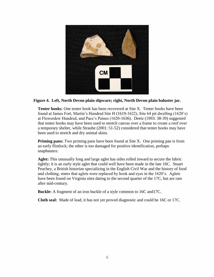
North Devon plain baluster jar: Three sherds of North Devon plain baluster jar have
been recovered at Site X. Fort Raleigh Science Center, 19 sherds (1585-1586), James
Fort (1607-1671), Sea Venture shipwreck (1609), The Maine (1617-1625), Martin‟s
Hundred Site C (1620-1622) and Martin‟s Hundred Site H (1619-1622), Site 64 pit
dwelling (1620‟s) at Flowerdew Hundred, Colony of Avalon (1621-1640) in
Newfoundland, also the Pentagoet site in Maine (1634-1674). North Devon plain
baluster jars were used primarily as provisioning jars on sea voyages.
6
Figure 4. Left, North Devon plain slipware; right, North Devon plain baluster jar.
Tenter hooks: One tenter hook has been recovered at Site X. Tenter hooks have been
found at James Fort, Martin‟s Hundred Site H (1619-1622), Site 64 pit dwelling (1620‟s)
at Flowerdew Hundred, and Pace‟s Paines (1620-1636). Deetz (1993: 38-39) suggested
that tenter hooks may have been used to stretch canvas over a frame to create a roof over
a temporary shelter, while Straube (2001: 51-52) considered that tenter hooks may have
been used to stretch and dry animal skins.
Priming pans: Two priming pans have been found at Site X. One priming pan is from
an early flintlock; the other is too damaged for positive identification, perhaps
snaphaunce.
Aglet: This unusually long and large aglet has sides rolled inward to secure the fabric
tightly; it is an early style aglet that could well have been made in the late 16C. Stuart
Peachey, a British historian specializing in the English Civil War and the history of food
and clothing, states that aglets were replaced by hook and eyes in the 1620‟s. Aglets
have been found on Virginia sites dating to the second quarter of the 17C, but are rare
after mid-century.
Buckle: A fragment of an iron buckle of a style common to 16C and17C.
Cloth seal: Made of lead, it has not yet proved diagnostic and could be 16C or 17C.

7
Figure 5. Left, brass aglet; right, priming pans.
4. DOCUMENTARY EVIDENCE
1584 The first Raleigh voyage reached Roanoke Island and heard there of the town of
Chowanoake (Chowan) and a nearby king, Menatonan, both of whom were politically
independent of the Roanoac tribe, the dominant group between the Albemarle and
Pamlico sounds.
1585 Raleigh‟s first colony, a military expedition, arrived at Roanoke Island. Its
admiral Philip Amadas explored Weapemeoke on the north shore of the Albemarle
Sound.
1586 Governor Ralph Lane led an expedition through the Albemarle to ascend the
Chowan River, meeting Metanonan, king of the Chowans, and then descended to travel
up the Moratico (Roanoke) River. Lane proposed establishing a chain of sconces to
connect the Chowan to the Hampton Roads area.
1587 According to the governor of Raleigh‟s second colony, John White, the civilian
colony planned to “remove 50 miles into the Main” from Roanoke Island, soon after
White had departed for England in September of 1587.
1590 John White led a search party to return to Roanoke Island, where he found the
settlement empty, its houses dismantled and removed, and the letters CRO (or perhaps
CROATOAN) carved as a message.
1602-05 Voyages by English and by French in search of sassafras and “silk grass” are
thought by David Quinn to have visited the coast between Carolina and Delaware.
1607-09 Jamestown colonists fail to contact Europeans who are reported to be living
among the Indians west and south of the Chowan River. Powhatan, however, made some
effort to convince John Smith that all the English had been eliminated. It is significant to
note that the search parties did not head toward Roanoke Island but further to the interior.
1620-50 Exploration expeditions are sent into “South Virginia,” but Indian hostilities
prevent settlement.

8
1650 Land sale by tribes north of the Roanoke River failed to lead to settlement, but
Nathaniel Batts started a trading post on the south side of Batts (Salmon) Creek in 1655,
and soon after 1660 settlement began on the north shore of the Albemarle east of the
Chowan River.
1663 The restored English monarchy resumed a colonial policy; implementing the
Carolina Charter of 1663 which was a sizeable land grant made by King Charles II to the
eight Lords Proprietors. Almost immediately after the Carolina Charter was enacted, the
Proprietors began officially granting land in the area.
1683 Thomas Pollock arrived in North Carolina as the deputy of Lord Proprietor
Carteret. He eventually acquired land along Salmon Creek. A preliminary investigation
of early land records indicates that he resided here at some point prior to leaving for
Virginia in 1708. A deed dated June 30, 1709, recorded that Pollock sold to David
Henderson “half the cattle & hogs of the place at Salmon Creek where Thomas Pollock
himself lived.”
5. CARTOGRAPHIC EVIDENCE
The earliest depiction of the Albemarle Sound is the Virginea Pars map, drawn by John
White and dated 1585 by him. Analysis by the British Museum indicated that a patch at the
junction of the Roanoke and Chowan rivers covers the symbol of a Renaissance-style fort and to
the north the dot indicating a Native American village. Additional scrutiny of the patch surface,
moreover, revealed a different symbol, perhaps drawn in invisible ink, and interpreted by Eric
Klingelhofer as a fortified town. The 1590 publication of Thomas Harriot‟s Brief and New
Report contained Theodore De Bry‟s version of the Virginea Pars map. It shows no European
presence at the west end of the Albemarle Sound, but marks the location of a Native town,
Metocuuem (Metaquem), north of a small bay or harbor.
The original purpose of White‟s map, its use, and the explanation for the literal cover-up
are still being debated, but it is reasonable to assume that Raleigh - via White – considered
establishing a fort or settlement at the western end of the Albemarle and subsequently took
precautions to remove that location from view. It cannot be a coincidence that the Indian village
site labeled by the Elizabethans as Metaquem, and identified as such by First Colony Foundation
archaeologists, also contains English artifacts attributable to the period.

9
Figure 6. Above, standard view of the patch. Below, view through the map and patch.
Following the settlement of Jamestown in 1607, the Virginia Company‟s interest in
locating Raleigh‟s missing colonists was soon eclipsed by the more immediate problem of
survival. Before 1610, local authorities reported back to London what information they had
gleaned from Native Americans, which was placed on a map of the region. The original has
been lost, but a spy sent a copy, the so-called Zuniga Map, to the Spanish court. There, along
tributaries to the North Carolina Sounds, two locations indicate survivors of the 1587 colony.
Neither is close to Site X at the junction of the Roanoke and Chowan rivers, but the locations
may be incorrectly understood by the English, or the map may report only those survivors
thought to be still alive after 1607.

10
Figure 6. Zuniga map, with reported Roanoke survivors

11
ALTERNATE INTERPRETATIONS OF SITE X ARTIFACTS
1. They represent Batts-period activity.
Nathaniel Batts is the first recorded European to settle in NC, probably around 1655. The
Comberford map of 1657 depicts “Batts House” on the south side of Salmon Creek, and other
documentation indicates that he was living on Salmon Creek in 1672 when he was visited by
George Fox. There is no historical evidence of European presence in the Salmon Creek area
before 1655.
The Anglo- Powhatan War of 1644 and the 1646 Anglo-Chowan wars likely resulted in
the abandonment of all Indian villages on the west bank of the Chowan River in the 1640‟s, a
supposition which is supported by archaeological evidence. It logically follows that the absence
of villages means that there are no Indians there in the 1650‟s and therefore no reason for Batts
to be at Site X. See the below discussion about artifacts as trade objects.
Preliminary analysis of the Colington series ceramics from Site X suggests that this phase
of Carolina Native American occupation occurred before the 17C. Years of regional research
informs us that this shell-tempered ware is representative of the Carolina Algonkians, or the
group of Native American Indians occupying the region at the time of Elizabethan exploration in
the 16C. The low frequency of the Colington Simple Stamped series is indicative of a pre-1650
component as demonstrated across the region. This statement is based on the chronological
correlation of type frequencies for the series in regards to one another – the key comparative sites
being the Eden House Site (31BR52) at the mouth of the Chowan and the Croatoan Village Site
(31DR1) in Buxton. By the middle of the 17C, the percentage of Colington Simple Stamped
pottery and Colington Fabric Impressed pottery are nearly equal, trending more towards a
preponderance of Simple Stamping. This does not appear to be the case at Site X, though
analysis is ongoing.
The presence of simple stamping as a vessel treatment in the region begins as early as the
13C and is likely an influence of Cashie phase (Tuscarora) pottery. It is not until the middle of
the 17C that simple stamping increases in frequency, a likely result of dissolving Algonkian
chiefdoms and population pressure from Virginians settling south. The Chowanoke, Wepemeoc,
and Moratuc chiefdoms, which are noted as being located in the area, have by the 1660s
relocated to the eastern extents of their territories. Batts located his operation to this area in
order to tap the growing market of the Upper Tuscarora located just up the Roanoke River.
2. They represent post-Roanoke but pre-Batts period activity.
Explanations of the early colonial component as the result of a pre-Batts undocumented
trader, or perhaps indirect trade with Indians closer to Virginia traders, are not supported by the
artifact assemblage. Missing at Site X are the most common trade goods, like beads. Batts had
no competition when he arrived to position himself closer to the Tuscarora just up the Roanoke
River, which would negate the possibility of an undocumented trader in the area. The Croatan
site is a good comparative source for this time period; there is no Surrey-Hampshire Border ware

12
from this site where typical components of trade have been recovered in archaeological
excavations.
Fragments of European pottery do occur in a few VA/NC Indian site assemblages that
probably date as early as the 1660s, but they are not common, and it seems that ceramics were
not routinely carried into Indian country by traders until the mid-1700s. In 1700-1720s trade
goods lists for the Southeast, pottery is never indicated. Nevertheless, pieces of pottery and
some occasional vessels do show up in assemblages from late 17C (last quarter) and early 18C
Indian village sites as a result of their contents being traded. Such material may have been
traded as containers for things like vermillion, red lead, “paint,” and salt, all of which appear in
the trade goods lists from c. 1700 on.
Most common types of trade goods recovered from VA and NC sites dating to c. 1650-
1670 are:
-glass beads
-sheet copper or brass beads
-tinkler cones and hair pipes / tubes
-sheet copper or brass ornaments
-copper or brass wire ornaments
-brass armbands, gorgets and collars
-small iron tools (awls, knives, scissors)
-copper or brass bells
-green glass bottles / shards
-wrought nails and spikes
-brass straight pins
-metal buttons (uncommon)
-white / ball clay pipes (uncommon)
Gun parts, lead shot and lead balls, gun spalls and gun flints do occur, but are uncommon,
and the few that have been found in the South are even rarer. In general, Indians reportedly
declined to trade for and use matchlocks because they were more cumbersome than snaphaunces
and other flint mechanisms. The same goes for large iron tools and weapons like axes, hoes,
swords, etc. They do occur here and there, but are comparatively uncommon. Cloth, shirts,
coats, hats, stockings, ribbons and blankets were, of course, a significant trade item in the 17C,
but little appears archaeologically, except for a few cloth seals and tiny scraps rarely found
adhering to copper or brass items in burials.

13
SUMMARY
1. Contemporary accounts describing exploration of the Albemarle Sound and Chowan and
Roanoke rivers in 1585-86 document Roanoke colonists‟ interest in the area. This is
repeated in Governor John White‟s report that his 1587 colonists had planned to settle 50
miles into the main[land].
2. Fort symbols on the north side of Salmon Creek on the Virginia Pars map further
reinforce the Roanoke colonists‟ interest in the Salmon Creek area.
3. Site X is complicated by some minor late 17th
/early 18th
-century activity attributable to
Governor Pollock‟s plantation landing, as well as large numbers of Native American
artifacts and features, mainly from the Middle and Late Woodland periods.
4. English ceramic types recovered at Site X span both the 16th
and 17th
centuries. The
occurrence of Surrey-Hampshire Border ware, however, is negligible on archaeological
sites in Virginia and North Carolina that date after c. 1625.
5. The comparatively large numbers of Surrey-Hampshire Border ware sherds representing
3-4 separate vessels were recovered from an area less than 30‟ by 40‟ and likely
represents English presence at the site before c. 1625.
6. The presence of North Devon plain baluster jar sherds, a tenter hook, and an early type of
aglet (lace tip) are additional evidence indicative of pre-c. 1625 English presence at
Salmon Creek 1 Site.
7. There are no trade artifacts from the site and no documentary references that indicate or
imply that there were traders in the area before Nathaniel Batts in 1655.
8. Therefore, both the archaeological evidence and documentary/cartographic records
suggest the likelihood that a small number of Roanoke colonists were present at Site X
for an undetermined length of time. Further archaeological investigations will be
necessary to test this hypothesis.

14
APPENDIX: BORDER WARE SURVEY
1. Eden House (31BR52), c. 1663-1718, Bertie County, NC First period settlement includes 3 structures, cellar, 5 subfloor pits, 3 refuse pits, possible privy
pit, well, 2 daub pits or tree holes.
4 Border Ware Sherds (1 porringer) 107 Total Sherds
2. Jamestown Rediscovery, Jane’s Cellar, c. 1607-1610
162 Border Ware Sherds 578 Total Sherds
3. Jamestown Rediscovery, John Smith’s Well, c. 1608-1611
1074 Border Ware Sherds 10,843 Total Sherds
4. Jamestown Rediscovery, Bread Ovens Cellar, c. 1610-1616
307 Border Ware Sherds 1975 Total Sherds
5. Jamestown Rediscovery, Late Fort Period Well, c. 1616-1619
2 Border Ware Sherds 203 Total Sherds
6. The Maine (44JC41 ), c. 1617 – 1625, James City County, VA Four structures, 18 shallow pits.
10 Border Ware Sherds 1633 Total Sherds
7. Martin’s Hundred, c. 1619-1645, James City County, VA Sites A, B, C, D, and H
0 Border Ware Sherds 1000 Estimated Sherds
8. Flowerdew Hundred(44PG65), c. 1619-1660, Prince George County, VA
PG64 (the Stonehouse), c. 1618-1635
1 Border Ware Sherd 100 Total sherds
PG65 (the Enclosed Compound), c. 1619-1650‟s
19 Border Ware Sherds 500 Estimated sherds
PG82 (the Bakehouse), c. 1618-1635
1 Border Ware Sherd Total sherds unknown
PG86 (the Pithouse), 2nd
quarter of the 17C

15
1 Border Ware Sherd Total sherds unknown
PG103, 1st half of 17C
12 Border Ware Sherds Total sherds unknown
9. Kingsmill Tenement, c. 1625-1650, James City County, VA Two dwellings, 3 additional buildings, 6 major pit features
0 Border Ware Sherds Estimate 500+ Sherds
10. Boldrup (44NN40), c. 1625-1650, Newport News, VA
Semi-subterranean building, ice house, several refuse-filled pits, outbuildings; note no plowzone
artifacts collected.
0 Border Ware Sherds 248 Total Sherds
11. Walter Aston (44CC178), c. 1628-1665, Charles City County, VA Two cellars, exterior storage pits, large refuse areas; note no plowzone artifacts collected.
4 Surrey White Ware Sherds 1614 Total Sherds
12. Buck Site (44JC568), c. 1630-1650, James City County, VA 28 Border Ware Sherds 1400 Total Sherds
14. Sandys Site (44JC802), c. 1630-1650, James City County, VA
14 Border Ware Sherds 4073 Total Sherds
15. Matthew’s Manor (44HT ), c. 1625-1650, Newport News, VA Two major buildings, ice house; note no plowzone artifacts collected.
6 Border Ware Sherds 1209 Total Sherds
16. Pettus (44JC33), c. 1641-1700, James City County, VA Large cellar, well, several refuse-filled pits; note no plowzone artifacts collected.
0 Border Ware Sherds Estimate 1000+ Sherds
17. Drummond Site(44JC43), c. 1650-1820, James City County, VA First period (c. 1650-1720) includes large cellar, well, several large refuse pits
0 Border Ware Sherds 1000+ Sherds?

16
18. Hampton University (44HT55), c. 1630-1660, Hampton, VA Five structures, 1 large cellar, well, 2 large refuse pits, 3 other refuse pits.
13 Surrey Ware Sherds 1529 Total Sherds
5 Red Sandy Ware
19. Jamestown, Colonial National Historical Park, Well 21, c. 1650-1670
2 Border Ware Sherds 1828 Total Sherds
20. Chesopean Site(44VB48), c. 1640-1680, Virginia Beach, VA
One large cellar, possibly a few other small features.
21 Surrey White Ware Sherds 2314 Total Sherds
21. Rich Neck (44WB52), c. 1640-1740, Williamsburg, VA Several separate excavations at Rich Neck, many buildings and features.
Rich Neck
0 Border Ware Sherds 997 Total Sherds
Rich Neck 1998 Field School
15 Border Ware Sherds 3979 Total Sherds
1 White Sandy Ware Sherd
Rich Neck Kitchen
2 White Sandy Ware Sherds 1697 Total Sherds
Rich Neck 1996
5 White Sandy Ware Sherds 1736 Total Sherds
Rich Neck A
11 White Sandy Ware Sherds 2511 Total Sherds
Rich Neck 2000 Field School
23 White Sandy Ware Sherds 3793 Total Sherds
2 Border Ware Sherds