an archaeological reconnaissance of the southeastern portion of … · 2020. 4. 2. ·...
TRANSCRIPT

An archaeological reconnaissance of thesoutheastern portion of the Navajo reservation
Item Type text; Thesis-Reproduction (electronic)
Authors Lee, Thomas A.
Publisher The University of Arizona.
Rights Copyright © is held by the author. Digital access to this materialis made possible by the University Libraries, University of Arizona.Further transmission, reproduction or presentation (such aspublic display or performance) of protected items is prohibitedexcept with permission of the author.
Download date 30/04/2021 05:47:54
Link to Item http://hdl.handle.net/10150/551860

AN ARCHAEOLOGICAL RECONNAISSANCE OF THE SOUTHEASTERN
PORTION OF THE NAVAJO RESERVATION
by
Thomas A. Lee, Jr.
A Thesis Submitted to the Faculty of theDEPARTMENT OF ANTHROPOLOGY
In Partial Fulfillment of the Requirements For the Degree of
MASTER OF ARTS
In the Graduate College
THE UNIVERSITY OF ARIZONA
19 6 6

STATEMENT BY AUTHOR
This thesis has been submitted in partial fulfillment of requirements for an advanced degree at The University of Arizona and is deposited in the University Library to be made available to borrowers under rules of the Library,
Brief quotations from this thesis are allowable without special permission, provided that accurate acknowledgment of source is made* Requests for permission for extended quotation from or reproduction of this manuscript in whole or in part may be granted by the head of the major department or the Dean of the Graduate College when in his judgment the proposed use of the material is in the interests of scholarship. In all other instances, however, permission must be obtained from the author.
SIGNED: I
APPROVAL BY THESIS DIRECTOR
This thesis has been approved on the date shown below:
Assistant Professor of Anthropology

PREFACE
The basis for this thesis was a program of archaeological
reconnaissance formulated by Dr. Brail W. Haury, then Director of the Arizona State Museum and Head of the Department of Anthropology,
University of Arizona. This reconnaissance was conducted during the months of June, July, and August, 1961, in the general vicinity of
the Black Creek drainage on the Navajo Indian Reservation. The pur
pose of the survey was to determine the nature and extent of the archaeological resources within the limits of the selected area. The
knowledge obtained was of interest to the University of Arizona as an
aid in planning its future archaeological research.
I readily accepted Dr. Haury* s offer in the fall of i960 to
undertake the field work with the possibility of using the data gathered as a basis for this thesis.
The original area was outlined to include the major portion of the Black Creek drainage basin plus the area around Tohatchi and
Mexican Springs, New Mexico. It was subsequently expanded to the
northwest to include the region between Ganado and Chinle, Arizona, through the financial assistance of the Wetherill Mesa Archaeological Project, Mesa Verde National Park, Colorado. The Wetherill Mesa Pro
ject was particularly interested in the nature of any Mesa Verde"like remains for aid in the development of the "Mesa Verde away from Mesa
Verde" section of their project.
iii

ir
The survey was accomplished with the permission of the Navajo
Tribe (Tribal Memorandum, dated May 22, 1961, to the General Superin
tendent Navajo Agency) and under permit from the Department of In
terior Bureau of Indian Affairs, Navajo Agency, Window Rock, Arizona,
dated June 5, 1961, to the Arizona State Museum and Department of
Anthropology of the University of Arizona, Tucson,
The field season began on June 1, 1961 and ended August 27,
1961, As was important, a half ton pickup was used for transportation
and the somewhat delux accomodations of a small fifteen foot house
trailer made up the field headquarters. This combination resulted in maximum mobility and security of supplies and equipment through the
field season.The beginning seven weeks of the field season were spent in
the Black Greek and Rio Puerco drainages. One week was spent in the
Tohatchi-Mexican Springs area. Except for a day spent in the Luka-
chukai-Tohatso-Greasewood drainage near Lukachukai, Arizona, the final month was divided between the Kin-li-chee Creek and Nazlini Wash drainages.
The presentation of any archaeological report brings to the
author the duty and the pleasure of calling attention to the many
individuals whose advice and assistance made it possible#To Dr. Bail W. Haury, then committee chairman, go my sincere
. Ithanks for giving so freely of his time, criticism, encouragement, and the financial support necessary for the successful beginning of this thesis. Dr. William A. Longacre, thesis committee chairman and

Dr. Raymond H. Thompson and Mrs. Clara lee Tanner, members of ray thesis
committee, who gave willingly of their time to help clarify some of my
ideas and much of my writing, are most gratefully thanked.
Many members of the Arizona State Museum staff were helpful
throughout the field work and Thesis writing, especially Dr. William H.
Wasley, Archaeologist, who checked some of my pottery identifications.
Dr. Alfred E. Johnson spent several afternoons with me dis
cussing and criticizing my attempt to estimate prehistoric populations
and I benefited greatly from his remarks. His aid and encouragement are happily acknowledged here. Phil Hobler, then Museum photographer
took the artifact photographs used in this thesis, for which I am grateful.
My sincere thanks go to the members of the 1961 University of
Arizona Geological Field School, St. Michaels, Arizona, to the director.
Dr. Robert L. DuBois, and his assistant, Mr. Dean Pilkinton, for sharing
its facilities when they were most needed. Dr. DuBois and Mr. Pilkin
ton's intimate knowledge of the reconnaissance area of which they gave unhesitantly was very useful.
Go-workers in the general area of the 1961 reconnaissance have
shown a high level of cooperation and willingness to share their own, sometimes unpublished, data. To Mr. Dave Brugge, Mr. George T. Guramer-
man, Mr. Martin Link, Dr. Alan P. Olson, and Dr. Reynold J. Ruppe go
my sincere thanks for the time and effort which each spent in my behalf.Dr. and Mrs. Richard B. Woodbury most willingly allowed me
access to their own survey results. Their aid in the Zuni pottery
identification and survey information is greatly appreciated.

vi
To the Department of Interior, Bureau of Indian Affairs, Navajo
Agency's general superintendent, Mr* Glenn R* Landbloom and personnel
of the Reality Branch I owe my thanks for expediting the issuing of
the survey permit*Among the Navajo Tribal officials who received me graciously
and facilitated my work are: Paul Jones, then Chairman; Scott Preston,
then Vice Chairman; John C* McBee, then Administrative Assistant to
the Tribal Chairman; Edward 0. Plummer, Office of Land Use and Surveys;
J. Lee Correl, and David Brugge, Land Claims; Sam Day III, Chairman of the Parks Commission; Martin A* Link, Tribal Archaeologist; and George
Sutton, Tribal Construction Yard. These gentlemen introduced me to
local residents, helped familiarize me with the area, and in all cases took considerable interest in ray work* Their cooperation was inval
uable, and contributed no small part to whatever success the survey
may have enjoyed* I remain greatly in their debt* I wish to thank all
the Navajo people with whom I came in contact, those who ran as well
as those who stood their ground to face my onslaught of questions, for
a most pleasant and rewarding summer*
The Indian traders of Arizona who offered me the hospitality of their homes, acted as interpreters and assisted me in a variety of
ways are: Mr* and Mrs. T. E. Vann, Cross Canyon; Mr. Griswald and the
late Mrs. Griswald, Nazlini; Mr. and Mrs. Stanley Smith, Burnt Water*It is a pleasure to acknowledge their friendship and services here.
The constant encouragement and aid which Mr. Gareth W. Lowe,
Field Director of the BIU-New World Archaeological Foundation, Brigham Young University, Provo, Utah has extended to me since my association

vii
with the Foundation have been essential factors in the completion of
this study. His quiet understanding way and warm friendship will
always. be remembered and esteemed.Finally to my wife, Eileen, who willingly sacrificed her own
studies to provide part financial support for my college education
and to maintain a well balanced home life, I owe my deepest appreci
ation. Without her constant cooperation and encouragement it is
difficult to see how this thesis would ever have been written.

TAKT.rc OF CONTENTS
Page
LIST OF ILLUSTRATIONS........ x
LIST OF TABLES ............................................. xi
ABSTRACT . .................... xiii
INTRODUCTION............................................... 1
Problem • • . • •Area Surveyed . .Environment . . .
PhysiographyClimate ............ . . . . . . . . 12Flora and Fauna . ........................ lit
History of Archaeological Work in the ReconnaissanceArea . 18
THE S A M P L E ................................................. 33
Methods of Approach to Data Collecting................ 3kSite Terminology .................... . • . ........... 36Chronological Framework............ kBPottery Types .................... 51Plan of Presentation .................................. 56
COMPARATIVE ANALYSIS .................................... . 60The Six Localities ............................ 60
Ceramics . . . . . . . . . . • • ............ 6lCommunity P a t t e r n .......... . ?6Settlement Pattern . . . . . . . . . . . . . . . . . 105Population . . . . . . . . . . . . . . . . . . . . . 113
External Relationships ......................... • . . • 131Ceramics ............ . . • • • . • • • . . • • • 132Community Pattern . . . . . . . . . . . . . . . . . 137Settlement Pattern . . . . . . . . . . ............ 152Population ............ . . . . . . . ............ 155
CONCLUSIONS............................ 1S8Hypotheses Developed.......................... 158Recommendations for Testing Hypotheses ............ 165
viii
H orw>- c—

ix
TABLE OF CONTENTS — Continued
Page
APPENDIX A. Tabulations of Structural D a t a .............. 168
APPENDIX B. Pottery Tabulations 233
APPENDIX C. Artifacts, Burials, arid Non-ArtifactualMaterial................ 313
REFERENCES 333

LIST OF ILLUSTRATIONS
Figure Page
1. Map of the eastern portion of the Navajo IndianReservation and surrounding area . . . . . . . . . In
2. Map of the southeastern portion of the NavajoIndian Reservation . . . . . . . . . . . . . . . . . . In
3. Map of the Lukachukai-Tohotso-Greasewood locality . . . . $
k. Stylized Front-oriented type of pueblo community pattern • 37
5. Stylized dwelling and surface storage structure formand layout ............................................. Ii3
6. Correlation of various ceramic group chronologies . . . . 1*97. Population fluctuation as expressed by site components
by period for each of the six localities . . . . . . . TnPocket
8. Population fluctuations based on the number of sitecomponents and mean number of rooms per componentby period for each of the six localities ............... In
9. Some population patterns from different areas of thePuebloan Southwest . . . . . . . . .......... • • • • In
Pocket10. Whole and partial ceramic vessels • . . • . . . • • . • • 315
11. Worked sherds and unfired clay handle . . . . . . . . . . 318
12. Stone axes and maul . . . . . . . . . . . . . . . . . . . 319
13. Chipped stone and metal artifacts ....................... 325lit. Bone and shell artifacts ............................. 327
15. Artifacts of perishable vegetable material . . . . . . . . 330

{LIST OF TABLES
Table Page
1. Comparison of several Ceramic Group Constituents . . • • uo
2, Four life zones in the southeastern portion of theNavajo Indian Reservation and their major characteristics .......... . • • • • .......... . 15
3.. Frequency of Organic and Inorganic Painted ELack-on-white pottery by locality through time . . . . . . 65
U. White Mountain Red Ware and San Juan Red Ware potteryby locality through time ......................... .. 70
5. Tsegi Orange Ware pottery by locality through time . . . 736. Hopi, Zuni-Acoma and Navajo pottery by locality
through time ....................... . . . . . . . . 757. Component and site totals by locality and Ceramic
Period ....................... ...................... 788. Period Five pueblo-kiva ratio ......................... 88
9. Period Five community unit combinations and theirorientation irrespective of specific direction . . . 91
10. Period Six pueblo-kiva ratio ..................... 92
11. Period Six community unit combinations and theirorientations irrespective of specific direction . . 96
12. Period Seven pueblo-kiva ratio........ ............... 98
13. Period Seven community unit combinations and theirorientation irrespective of specific direction . . . 101
ill. Physiographic situation of components by period forthe Tohatchi-Mexican Springs locality . . . . . . . 108
15. Physiographic situation of components by period forthe Black Creek Locality . . . . . . . . . . . . . . 108

LIST OF TABLES — Continued
16. Physiographic situation of components by period forthe Rio Puerco locality ....................... 109
17. Physiographic situation of components by period forthe Kih-li-chee Creek locality . ............. 109
18. Physiographic situation of components by period forthe Nazlini Wash locality...................... .. . 110
19. Physiographic situation of components by period forthe Lukachukai-Tohotso-Greasetrood locality . . . . . 110
19a. Room-to-kiva ratio by locality and ceramic period • • . • 1U2
20. Structural data of the Tohatchi-Mexican Springslocality......... 171
21. Structural data of the Black Creek locality.......... . 181
22. Structural data of the Rio Puerco locality . . . . . . . 20823. Structural data of the Kin-li-chee Creek locality . . . . 222
2U. Structural data of the Nazlini Wash locality.........227
25. Structural data of the Lukach ukai-Tohotso-Greasewood. l o c a l i t y .......... 232
26. Pottery of the Tohatchi-Mexican Springs locality . . . . 236
27. Pottery of the Black Creek locality........... 21*928. Pottery of the Rio Puerco locality......... 282
29. Pottery of the Kin-li-chee Creek locality . . . . . . . . 299
30. Pottery of the Nazlini Wash locality . . . . . . . . . . 306
31. Pottery of the Lukachukai-Tohotso-Greasewood locality . • 312
32. Type and occurrence of m a n o s ......... . 320
33. Type and occurrence of metates
Table Page
321

ABSTRACT
A description of 799 sites of past human habitation located
during 1961 on the Navajo Indian Reservation by the writer is used as
a universe to define the outlines of the culture history of a rela
tively unknown region. The area is divided into six geographical
sections. A framework of nine ceramic periods orders the data chrono
logically, beginning about A.D. 500 and continuing to the present day.
The comparative analysis reveals a cultural development closely re
lated to the Puebloan tradition in all six areas up to about 1300.
A hiatus of about 200 years occurs after which Navajo peoples slowly
begin to reoccupy the region. The Defiance Plateau is suggested as
a boundry between an eastern and western variation of the Puebloan culture.
Trends in population based on site frequency and relative site size independently confirm a different demographic pattern for the eastern and western localities.
Hypotheses are constructed which may explain similarities and differences of cultural evolution among the six districts and the
surrounding area.The method of stratified sampling is recommended to select a
random sample of sites to test the culture history, the hypotheses developed, and to bring new information to light.
xiii

•INTRODUCTION
Problem
For some time problem-oriented research has demonstrated its
utility in all, scientific fields. This two-stepped approach consists
of, first, the development of a problem or model and, second, the testing of its various hypotheses. In the definition and formulation
of a specific research problem one must outline the hypothetical per
cepts, recognize and state personal biases, plan procedure for analy
sis, and establish goals. Approaching the unknown through the known
by way of a formulated plan of attack with expressed objectives, is
more economical, a most important aspect to this type of approach.
The very nature of formulating a procedure and setting up limits to
a problem means that a certain amount of organization has been neces
sary and that apparent less direct routes to the goals have been elim
inated. All this adds to the economy. Like it or not, finance is a
vital problem that every researcher must face.
The same facets which make this approach economical also help
to guide the researcher along a path of investigation less likely to
be complicated by time-wasting diversions. This is not to deny the innovations resulting directly from the investigation and their pos
sible importance, only deferring their study until the problem at hand has been exhausted.
1

2
Many research projects have wasted valuable time, money, and
talent because of the lack of specific guidelines.
No sophisticated research program, however, can be drafted
without background information from which to formulate a model or research design. Procedures for testing the program that guarantee
as much as possible some measure of success must also be planned. To
gain the necessary background information to plan effective research,
archaeologists depend almost entirely on the reconnaissance or survey
method.
Whether it be called a reconnaissance or a survey, as Ruppe
(1966: 313) has insisted, the initial archaeological exploration of an
unknown area should be a systematic attack aimed at the preliminary
recording of the basic outlines of the cultural development present
in the area under consideration. The reconnaissance is not a substi
tute for detailed excavation. The order of completeness of the archaeological record which the survey achieves can directly influence
the final programs developed. It is important, therefore, to be mindful of the vagaries of preservation and collection, and the resulting
limitations and inadequacies of the data.Second, the various cultural elements observed must be ana
lyzed and compared to bring into focus the nature and range of the
archaeological manifestations present in the area concerned. External relationships must be recognized and their influence on the local development traced.
Third, hypotheses must be developed concerning the stability and change of cultural systems which will anticipate the full temporal

3
and spatial range of the cultural history of the area under considera
tion. The primary interest here is a brief preliminary synthesis that
would suggest both the general cultural development of a particular
area and at the same time suggest some specific problems to be tested*
Fourth, and finally, it remains the final function of recon
naissance to recommend a reliable sample of sites for excavation that
would both test the hypotheses suggested and at the same time contain
the distinct probability that some new information might come to light.Since the archaeological reconnaissance does nothing more than
present the barest culture historic outlines of the area concerned, it
is of a tentative nature and subject to a rather wide margin of error
in detail* It can never take the place of planned excavation, nor
should it. But it does do archaeology a valuable service by being the first organized step in the systematic study of an unknown area. A
reliable problem-oriented research program may be formulated for an
unknown area only after a successful archaeological reconnaissance has
been made*
The problem here, then, is to report the findings of an ar
chaeological reconnaissance made in the southeastern portion of the
Navajo Indian Reservation during the summer of 1961, in the manner just outlined.
Area SurveyedThe area outlined to be studied lies primarily in the south
eastern corner of the Navajo Reservation (Fig. 1). The only section
surveyed not on the Navajo Reservation was north of U.S. Route 66 for

k
two miles between the Arizona-New Mexico State line and Manuelito, New
Mexico, a mile to the east.Those areas intensively surveyed include the major drainages
of the Black Creek, from Red Lake, New Mexico, south to the Rio Puerco,
except for the ten mile section of deep narrow canyon below Oak Springs;
Bonito Creek, from Sawmill, Arizona, south to its junction with Black
Creek at Ft. Defiance, Arizona; Lupton Wash, from its head to the Rio Puerco; the northern hogbacks and ridges parallel to U.S. Route 66,
from Lupton Wash west to the Pine Springs turn off; an area east of
Lupton Wash to Manuelito, New Mexico, from U.S. 66 to about two miles
north; Kin-li-chee Creek from Ganado east to about the 7,300 foot con
tour on all its major tributaries; Nazline Wash, from Chinle south to about three miles east of Teegitoe Spring, including all major eastern
tributaries; the several washes and creeks draining the eastern flanks
of the Chuska Mountains; between Tohatchi, New Mexico and Tohlikai,
New Mexico, from the mountains proper east to U.S. Route 666 (Fig. 2).
Areas less intensively studied were: the Defiance Plateau,Beautiful Valley, Ganado Plateau, and Lukachukai-Tohotso-Greasewood
area below Lukachukai, Arizona. The Lukachukai-Tohotso-Greasewood area (Fig. 3) is shown separate from the other areas of study because
of the wide intervening region not surveyed.The southeastern portion of the Navajo Indian Reservation was
selected for archaeological reconnaissance primarily because it occupied a strategic position in the Southwest and is an area about which
little is known prehistorically.

ScaleHundred# of Meters
N e w M e x i c oA r i z o n a
Figure 3# Map of the Lukacbukal-Tohofcso-Qreasewood locality.

6
The Black Creek drainage and the other nearby drainages within
the section surveyed are located in the Puebloan cultural area that
may be divided into the Southern Anasazi: Gladwin's Chaco and Cibola
Branch 5; Danson 1957: 21), and the Northern Anasazi, Colton’s
Kayenta Branch of the San Juan Anasazi (1939a: 13, Table II). A good
deal of excavation has been accomplished in both the Southern and
Northern Anasazi areas and the general cultural development is known. The Southern area has undergone a greater degree of synthesis than
the Northern and for that reason is easier to characterize. What has
not been accomplished is the way in which these two similar regional
expressions are interrelated. The expanse between them may contain
the evidence clarifying these interrelationships.
Similarly, the region might be used to answer specific questions such as just how far north the early brown ware pottery, rela
tively common in the Rio Puerco (Wendorf 1953: 113; Wasley I960: 33), extended. The area may also contain evidences of influences from the
Mesa Verde. DeHarport (1959) found considerable evidence for Mesa Verde influence in Canyon Be Chelly just to the north. It would be of more than passing interest to know the limits of these influences
in order to better ascertain the position they played in the development of the local culture history and just how the affect the relationship between the Southern and Northern Anasazi area.
7
' Environment
Physiography:The area surveyed by the reconnaissance is in the Navajo sub
division of the Colorado Plateau Province (Fenneman 1928: 338-U2)*
Here the plateau surface is not so dissected by canyons as the areas
farther north. "Mesa, butte, volcanic neck, canyon, wash, repeated
indefinitely, are characteristic features of the country" (Gregory
1916: 21). locally, drainages are deeply incised into the rocks (Hunt
1956: 2). The basin-folded Tertiary formations are bordered by val
leys which follow the strike of the uplifted formation as character
ized by the Defiance upwarp and Black Creek. The structures are open,
and the drainages are well adjusted to them. The Navajo section is
characterized by an abundance of volcanic necks, dikes and remnants of volcanic cones, and small lava flows (Htmt 1956: 6). The Navajo subdivision has alcove arches in the sandstone formations as large
as many of those in the Canyon Lands subdivision further north. Some
of these alcoves were used as areas of human habitation from the earliest period right up to the present day.
The two most important topographic features of the Navajo
section are the Defiance Plateau and the Chuska Mountains. These
two high structures, more than anything else, determine the character of the natural environment of the southeastern corner of the Navajo
Indian Reservation. As major features of relief, they influence in in a veiy decisive way the climate, soil, flora, fauna, and extent
and courses of perennial streams.

8
The eastern border of the Defiance Plateau is the Black Creek
Valley* Its western borders are the Rio Pueblo Colorado and Chinle
Valley. From Round Rock to Sanders, Arizona, the Defiance Plateau is
100 miles long (Gregory 1916: 3U). Its average width is about UO
miles, except along the Rio Puerco, where it is 60 miles. The plateau
is essentially an elongated done rising above a rim which stands at an
altitude of 7,000 feet on its eastern border and at 6,000 feet on its
western border. The dome flattens both north and south in a gradual
descent to between 5,500 and 5*200 feet. About 20 square miles of
the flat summit northwest of Ft. Defiance is bounded by the 7,800 foot
contour (Gregory 1916: 3U). Its highest point is Fluted Rock (8,600 feet). The general slope of the plateau is toward the west where wide,
flat-floored valleys are trenched by narrow, shallow canyons. The eastward-flowing streams tributary to Black Creek are, accordingly,
short and carry little water, the most important of which are Buell
Wash, Bonito and Cienega Creeks. The streams trending westward are
long, and many of them are perennial. The largest streams on the plateau, and the ones which have cut the deepest canyons, occupy the
famous Canyon de Chelly and its tributary, Canyon del Muerto. These
streams carry a large portion of the run-off from the Chuska and Tunitcha Mountains; this insures a permanent flow. The most important streams of the western edge of the Defiance Plateau are Chinle Wash, Nazline Wash, Rio Pueblo Colorado and Kin-li-chee Creek and its tribu
tary Ruin Wash.The Rio Pueblo Colorado and its major tributary Kin-li-chee

Creek, which drain south into the Little Colorado River, head a few
miles south of the head of Chinle Wash and its major tributary Nazlini
Wash which drain north into the San Juan River* These widely diverging
drainages are a function of the topography which prehistorically, even
as today, may have had considerable influence on population movements.
The Rio Pueblo Colorado and Kin-li-chee Creek and its tribu
taries drain a stepped upland area which is tilted gently downward to
the southwest. Near the northern edge of this upland is a divide about
12 miles in length running between the top of the Defiance Plateau and
Ganado Mesa to the west. The elevation here ranges between 6,650 feet
in the west to 7,200 feet in the east. The northernmost edge of the
divide ends in a steep escarpment which falls dramatically to the floor of Nazlini Wash and Beautiful Valley. The elevation at the foot of the
escarpment ranges from 1,000 feet to 1,600 feet less than at the top.It is not surprising, in light of this magnitude in elevation differ
ence, to find wide-ranging variations in flora, fauna, soils, and even water availability between the Kin-li-chee and the Nazlini Wash locality.
Chinle, Arizona, the northernmost point in the whole area of the 1961 survey (See Fig. l), except for the Lukachukai-Tohotso-Grease-
wood Creek area, is about 5>00 feet lower in elevation than the south
ernmost point of the survey where U.S. 66 crosses Black Creek one half
mile north of the Puerco.The Chuska Mountains and their southern extension, the Manuel
ito Plateau, are the other major features of the natural landscape

10
lying across the Arizona-New Mexico state boundary. The eastern flank
of the Chuska Mountains rises gradually from the Chuska Valley to about
the 8,000 foot contour above which steep cliffs extend to the rim.
Small short streams which frequently cut deeply into the mountain side
contain water on their upper courses, but they soon disappear into the
valley floor as they move away from the mountain proper. The Red
Willow, Mexican Spring, and Figueredo washes are of importance because
of their almost year-round supply of water. Unlike the eastern edge
of the Chuska Mountains, the western border presents an almost vertical escarpment, continuous except for the few canyons which are deeply
carved into it. Because of the large drainage area these canyons tap, most of the streams they contain are perennial. Important streams
contributing to the Black Creek drainage from this area are Tohdildonik Wash and Simpson Creek.
The summit of the Chuska Mountains is in reality a plateau with
some local relief. Two large areas on the Chuska Mountains present
flat surfaces at 8,800 feet. These elevations mark the summit. Beyond the canyon heads, the mountain top is imperfectly drained, resulting
in numerous small lakes and lush grassy meadows, a rather common
feature for these altitudes in the arid Southwest.
A series of flat-topped hills, outlined by the 7,000 foot con
tour and lying between the Rio Puerco and the Chuska Mountains, may be
grouped under the name Manuelito Plateau (Gregory 1916: 26). Due to
its lower relief the Manuelito Plateau does not exert as much influence
on this area as does the Defiance Plateau and Chuska Mountains. It is

11
an area cut by broad valleys and within them deeply eroded arroyos.
While modern development of the surface and underground water supply
has allowed greater use of this area for sheep grazing, in prehistoric
times water was at a minimum and greatly limited the population expan
sion, Only the larger valleys to the eastern and western edges were
backed by large enough drainage basins to insure a limited but stable
year-round water supply. Between Gallup, New Mexico, and Ft, Defiance,
Arizona, along the most generally used route of some miles, only
one permanent water supply. Rock Spring, is to be found (Gregory 1916:
26).
During prehistoric times these high areas of relief, even as
now, must have served as important sources of natural resources. Certainly as the sole origin of the somewhat meager but permanent water
supplied to the major river valleys, they contributed the very life
blood to the early peoples of the area. Agriculture would have been impossible in this area without a stable water supply. Harshbarger,
Repenning and Callahan (1953s 126) state, "There is little question
that the availability of water was the controlling factor in the location of ancient Indian habitations and encampments." But because of
their height and the resulting lower annual mean temperature and shorter growing season these plateaus and mountains only secondarily
supported agriculture. There is no prehistoric evidence to date that suggests that these sections were primaiy areas of farming and cultivation. Instead they were probably used as summer retreats and
natural sources of forest and wildlife produce.

12
The larger drainages which in prehistoric times supported con
siderable human populations are Figueredo Wash, Black Creek, Cienega
Creek, Rio Puerco, Kin-li-chee Creek, and Ruin Wash. Somewhat smaller
populations were supported by Nazlini Wash, Tse Deeshzhaai Wash, Tiis
Ndiitsooi Wash, Lukachukai Creek, Greasewood Creek, and Tohotso Creek.
With the exception of Tse Deeshzhaai Wash, Tiis Ndiitsooi Wash, parts
of upper Nazlini Wash, and upper Kin-li-chee Creek the drainages con
tained flat alluvial bottoms now deeply cut by arrqyos. The resulting
benches, once the valley bottoms, were the areas most suitable for
cultivation through flood-plain farming and simple irrigation. Even the drainages which are confined to the often narrow limits of deep
sandstone canyons now and again will contain remnants of small flood plains upon which simple agriculture could have been practiced.
Climate:The climate of the Navajo Indian Reservation can be best char
acterized by its extreme variability. As the area is outside the usual
path of cyclonic storms, the accompaning procession of high and low
barometer, warm and cold "spells," and wet and dry periods which char
acterizes most other parts of the United States is absent in this
region (Gregory 1916: U9)» In the absence of cyclonic storms and because of the varied topography, which is the most dominant factor, the
region may be said to have a group of local climates of widely dissim
ilar aspects. The daily range of temperatures is over UO degrees, con
sequently cool or even uncomfortable cold nights follow the heated day.
Canyons adjoining a plateau, two adjoining valleys, the opposite sides

13
of mountains and mesas, and even opposing canyon walls may have dif
ferent climates.The description of these micro-climatic conditions are beyond
the scope of this study. Since micro-climates are, to a large degree
the function of temperature, and as Gregory (1916: 63-7) has a good
discussion of the range of temperature variation found throughout the
Navajo Indian Reservation, only a limited statement will be made here.
At Ft. Defiance and St. Michaels, near the geographic center
of the reconnaissance area, a mean annual temperature of 1*7.6 degrees F. (Gregory 1916: 66) has been recorded. The annual temperature range
of these two towns of near-7,000 foot elevation is 122 degrees (98
degrees F. to -2l* degrees F.) (Gregory 1916), The average date of the last killing frost of spring at St. Michaels is June 15 and the average
date of the first killing frost of autumn is September 13 (Gregory
1916: 67). The resulting growing season of 90 days is an extremely
short one. The growing season at Ft. Defiance is 98 days while at
Chinle, further north but at a lower elevation, it is 12l* days. Kil
ling frost may occur every month of the year at Ft. Defiance except
August (Gregory 1916: 67).Corn, the basic crop in prehistoric times, requires a growing
season from 90 to l£0 days (Gregory 1916: 67). Hack (19h2: 19) reports that the Hopi, 5>0 miles to the west of the reconnaissance area, have a 130 day growing season but that it is short enough to permit considerable damage from frost. Comparing the latest spring frost
and the earliest autumn frost over a 1*2 year period Hack (191*2: Fig. 9)

iu'clearly shows that in the Hopi area the growing season available is
seldom longer than the time necessary to ripen corn and be assured of
a good crop.It is clear that the area under consideration is a marginal
one with reference to present day agriculture. Hack (I9h2: 80), has
suggested that the climate of the first millennium A.D. was perhaps a
little wetter or a little cooler but that little change can be seen
in the climate of the last two millenia, and further, if so, the dif
ference was slight and was not enough to affect farming practices. He
suggests (Hack 19U2: 80) that it is doubtful if crops could have been
grown successfully by rainfall alone, but that the climate may have
been more equable, creating floodwater in areas nor unfavorable to such conditions.
It would appear that in prehistoric times horticultural pursuits were in a continual crisis and most importantly affected by the
length of the growing season. To an economy dependent primarily on a one-crop subsistence, the consequences of a shortened growing season, if only by a few days, would have had very drastic effects on the human population.
Flora and Fauna:The plants and animals of the southeastern portion of the
Navajo Indian Reservation can be classified into four of the life zones
Merriam outlined for North America (1898). The four zones which pertain to this area and a brief characterization of each is given in Table 2. A detailed list of the floral species on the Navajo Indian

TABLE 2
Four Life Zones in the Southeastern Portion of the Navajo Indian Reservation and Their Major Characteristics,
(after Merriam 1893 and Allen and Balk 19k5)
Zone Elevation Characteristic Flora Area
Hudsonian 9,000* - 12,000* Alpine fir, Engelman spruce, and Corkbark fir
Chuska Mt.
Canadian 8,000* - 9,000* Douglass fir. White fir. Blue spruce, and Aspen
Chuska Mt.
Transitional 7,000* - 8,500* Ponderosa Pine Manuelito and Defiance Plateau
UpperSonoran
U,000« - 7,500* Pinon, Juniper, Oak, Sagebrush, Sacaton, Blue grama and Galleta
Black Creek, Kin-li-chee, Puerco and Naziini Valley

yV'-Jv- rhvjLvL<. X ) v * " - < v V rt- J- A- ^ f A C- /6 *
/A,U f» T-3 s ct
Reservation occurring in Merriam* s life zones can be found in Clark
(19U5: 165-73). A short summary list of plants in the vicinity of
Window Rock, Arizona, may be found in Bohrer and Bergseng (1963).
A good general discussion of both the.flora and fauna of this area
may be found in Gregory (1916: 71-5).There has been, to my knowledge, only one rather limited
faunal study of this area of the Reservation specifically (Halloran
19610; therefore Merriam*s (1890) study of the nearby Little Colorado
River Valley and the San Francisco Peaks, which describes the species found within his various life zones, remains a good general statement.
The characteristic faunal species of the San Francisco Peak life zones and comparable zones in the southeastern portion of the Navajo Indian
Reservation were probably the same in prehistoric times. However,
aboriginal conditions have been modified for some time, as suggested
by Simpson’s (1850: 111) statement that the area was the "most wretched
country for game of any kind since leaving Santa Fe." Their party
killed one deer during a round trip from Santa Fe to Canyon de Chelly and return via Zuni.
Only very recently has the Navajo Parks Commission restocked
parts of the Chuska Mountains and Defiance Plateau with deer, turkey, and antelope. Undoubtedly these game animals and others, along with predators such as coyotes, wolves, bear, and mountain lions, were once
part of the local aboriginal environment.Without extensive prehistoric osteologies! samples to use as
a guide, a faunal list of the species present in the area today would
17

18
be misleading for analogy with the prehistoric situation.
History of Archaeological Work in the Reconnaissance Area
Since the time of Coronado's conquest of Hawikuh on July 7,
l5U0 (Winship 1896: 3h3), the southeastern portion of what is today
the Navajo Indian Reservation, has received increasing attention from
historical writers and explorers concerned primarily with the Navajo
people who occupied the region. Few writers have chosen the task of
describing the prehistory of this area.One of the first references to the prehistory of the area
comes from Simpson (l8£0; 103) some 300 years after the Spanish ap
pearance at Hawikuh. In 181*9 he served as topographical engineer for the military reconnaissance, led by Brevet Lieutenant Colonel
John M. Washington, that explored the lower reaches of Canyon de
Chelly and Canyon del Muerto. He mentions the masonry walls present
in cliff alcoves which were impossible to reach without several lad
ders. A particular wall exhibiting some curvature draws the remark
that it may be part of an estufa or kiva. A lengthy description and
an. illustration depict what is now called White House pueblo in Canyon
de Chelly (Simpson 1850: 10l*, PI. 53). Two fragments of pottery that were collected at this same site are illustrated in color in Simpson's
PlateThe route of the Washington reconnaissance, as described in
Simpson's journals when he left Canyon de Chelly for Zuni pueblo, is
of interest here because there is no mention of prehistoric remains

by Simpson until the party reached the Rio Puerco. Nonetheless, he
describes the landscape in such detail that one is able to retrace
their route.Upon leaving the mouth of Canyon de Chelly the party turned
east along the south rim of the canyon (Simpson 1850: 109). This
direction was followed for two days, during which they made one dry
camp. The second day out the party detoured north, entering Monument
Canyon in order to obtain water. Turning almost due south they trav
eled past Sawmill, Arizona, and began following Bonita Creek. The
lower reaches of Quartsite and Bonita Canyons with their talus-strewn
slopes are described accurately. Camp was made about one quarter of
a mile upstream from the present town of Ft. Defiance, Arizona (Simpson 1850: 110). The next day the party continued out into and down
Black Creek Valley during which time Simpson vividly details the geo
logical structures that form Black Rock (Simpson 1850: 110) and Hunters Point. Hunters Point, he said, is “. . . a beautiful exhibition of
horizontal stratification terminating in one of a bent, semicircular
character— the strata (red stone) in the last case being concentric
. . . and like layers of an onion” (Simpson 1850: 111). Camp was
made near Oak Springs and the next morning Simpson mentions the deep canyon to the right of their route into which Black Creek flows. The party continued south crossing the low but rugged divide separating Black Creek from Lupton Wash. The locally well known geological feature of the "Coffee Pot” in the Lupton Wash drainage is mentioned
and illustrated (Simpson 1850: 112, PI. 58). The party continued
19

20
south to the Rio Puerco where again they made camp. Simpson remarks
that pottery could be seen on both sides of the route the entire way
from that camp on the Rio Puerco until they reached Zuni days later
(Simpson 18£0: 113).Some seven years later, on November 30, 1856, Whipple (1856:73),
while making a survey to ascertain the practicability of building a
railroad from the Mississippi River to California, camped at Navajo
Springs, a few miles southwest of the present day town of Sanders,
Arizona. The camp was amid extensive "relics of ruins." Small frag
ments of pottery painted in stripes lay around the spring. Upon a
nearby hill Whipple located a circular depression U0 paces in diameter
and around it were pieces of "glaze" pottery and arrowheads of obsidian,
agate and jasper. Whipple (1856: 73) said the structures "were probably of adobe" leaving little trace of any walls.
A few years later Beal (1858: 39) on his now famous camel trip across the Southwest also camped at Navajo Springs. His guide pointed
out the "curious ancient Indian town," but since it was dark he did not visit it.
Jackson (1878: 14.20-5), sometime prior to the date of his publication, visited Canyon de Chelly on his way to the Hopi mesas. Although
he describes and illustrates some of the ruins there, he adds nothing new to Simpson's description.
Possibly one of the reasons for the lack of archaeological
interest in what is now the southeastern portion of the Navajo Indian
Reservation is reflected in a statement published by Adolph Bandolier

21in 1892 (386). He says that the country north of the Zuni River was
not for . . Indian tillers of the soil and consequently no ruins
need be looked for in that region."
However, only a few years later Cosmos Mindeleff (1897) de
scribed about 70 ruins in Canyon de Chelly, giving floor plans of many sites. He also developed a simple typology of ruins in the Southwest
of which two. Type II, Home villages on bottom lands, and Type HI,
Home villages located for defense, were found in Canyon de Chelly
(Mindeleff 1897: 93)• Little White House (Arizona E:lli:8), located
not in Canyon de Chelly but instead in Little White House Canyon, is
described and a floor plan is given (Mindeleff 1897: 1U5-7, Fig. $2-3)•
In 1903, Prudden published an article on his research in the
prehistoric ruins of the San Juan drainage. During his field work he
explored Nazlini Creek (Nazlini Wash) almost to its source (Prudden
1903: 280). Close to its head he located two or three small buildings on the cliff edge and two small cliff dwellings. He also found several
cliff dwellings in ". . . a canyon opening into the Chinle a short
distance south of the mouth of Canyon de Chelly" (Prudden 1903: 280). This canyon was undoubtedly Little White House Canyon and by Chinle he was probably referring to Nazlini Wash.
In April, 1903, Stewart Gulin, Curator of Ethnology at the Brooklyn Institute of Arts and Sciences (now the Brooklyn Museum),
purchased some 1U7 pottery vessels from J. B. Foley and Joe White who had collected them from the ruins east of Hunters Point (Rosenthal
1962). Among Gulin's notes of his Museum Expedition Report, 1903, is

22a reference to a visit he made accompanied by Foley and White, to
ruins on a ridge overlooking Black Creek near Hunters Point. Here he
mentions the numerous rectangular house outlines and an "estufa" or
kiva some UO feet in diameter. He is probably referring to Arizona
K:8:135, the only site with a Great Kiva in the vicinity.It was not until 1923 that any controlled excavation was car
ried out, and this was not within the area of the 1961 reconnaissance
but immediately to the north, in Canyon del Muerto. In that year and
the year following, Earl H. Morris, working for the American Museum of
Natural History, began the studies of Canyon del Muerto at Mummy Cave
(Morris 192$). During the first season's work in an eighty-room three
story high pueblo, Morris and party located a desiccated man, several
stone pipes, baskets, rabbit fur-wrapped cord blankets, stone storage
bins with over 700 ears of corn, hundreds of cloth sandals, arrows,
knives, and many agricultural implements (Morris 192$: 26U, 270). Un
fortunately the material has not been published in detail and there
fore its exact position within the cultural development of the Southwest is unknown.
Frank H. H. Roberts, who had been working in the Southwest for
several years, began excavations in 1931 in the Whitewater District, a few miles southwest of Lupton, Arizona (Roberts 1939, 19U0). Three field seasons, spent mainly at one site, located some materials of Basketmaker III and early Pueblo III age. Most work, however, resulted in the recovery of Pueblo I and II. ranges of material.
Only a year later, 1932, Harold S. Gladwin settled at Red Mesa
and began to study what he later called the Chaco Branch (Gladwin 19U5).

23Gladwin’s work began with a wide-ranging reconnaissance which included
some 100 sites in the Rio Puerco drainage alone. As most of the sites
Gladwin located in the Rio Puerco are south of U.S. 66, the southern
boundary of the 1961 reconnaissance, there has been a duplication of
some site material by the latter survey. It was impossible to corre
late these two collections because of the brief description of the site
locations given by Gladwin.
In 193U Gladwin sent Russel Hastings into the field on a recon-
nissance, in part into the area of the 1961 survey. Approximately
sites were located, which again have probably been duplicated because of the original inadequate site descriptions.
In 1936 Gladwin began to excavate at White Mound (Arizona
K:12:l; Gladwin 19li5>: 10). The report describes the phases he recog
nized in the Chaco Branch, which are, from early to late: White Mound,
Kiatuthlanna, Red Mesa, Wingate, Hosta Butte, and Bonito (Gladwin 19hS)»
Colton in 1938 led an expedition into Tse Deeshzhaai Wash to
record and map Three Turkey House (Arizona E:lf>:llj Colton 1939b).
This cliff ruin, the largest recorded during the Arizona State Museum
survey, consists of 19 rooms and one kiva located some 60 feet above the wash and surrounded by sheer cliffs. The name comes from one of
several interpretations of three controversial brown-and-white figures painted on the back wall, presumably turkeys. The kiva also contained
some paint in the form of a white zigzag band on the wall encircling the room, with a bordering row of dots on either side of the band.
2k
-The Sherd material indicates a thirteenth-century occupation by Mesa
Verde peoples. Two tree-ring dates of 1226 and 12?6 obtained from
dendrochronological samples taken from the site also agree with the
ceramic evidence (Colton 1939c),Beginning in 1950, the El Paso Natural Gas Company began the
construction of the first of three pipelines which were to cross the
Navajo Indian Reservation from east to west, dissecting the 1961 area
of survey. These pipelines, which paralleled the main cross-Reserva-
tion thoroughfare (Navajo 3), held the possibility of bringing to light
a transect of an area archaeologically unknown; therefore it was
planned that all prehistoric sites crossed were to be excavated and
published. This was the awakening of a historically interested conscience on the part of big business, and the beginnings of salvage
archaeology in the Southwest, Ten miles to the east of the Tohatchi-
Mexican Springs area, the salvage operation excavated eight sites within the right of way (Wendorf, Fox and Lewis 1956: XII). The time range
represented by the eight sites was from Basketmaker III to Pueblo III. Two tree-ring dates were obtained from one site, LA. 2505, whose outer ring ended at A.D. 1020c and A.D. 10h7b (Smiley 1951: 26). The letter symbol 11 c" means the last ring on the specimen was constant around the
circuit and that few or no rings were lost. The letter symbol "b" indicates the presence of bark cells and a probable cutting date.
Only the salvage project connected with the first of the three
pipelines has been published so far (Wendorf, Fox and Lewis 1956), but as far as I know none of the three salvage projects located any sites
25
within the area of the Arizona State Museum’s 1961 reconnaissance.
In 1953 Dr. and Mrs. Richard B. Woodbury, then of Columbia
University, spent the summer concentrating on an archaeological re
connaissance of the Zuni Indian Reservation. In order to throw more
light on their collections in the Zuni area, their survey ranged out
side the Reservation. Some ten sites were located near Manuelito,
New Mexico. Site cards from their survey, deposited at the Arizona
State Museum, indicate that the sites located ranged from Basketmaker
III to Pueblo IV. The latest sites were large-walled masonry pueblos
located in defensive positions; they contain late White Mountain Red
Wares and early Zuni ceramics characteristic of the Pueblo IV time
range.
The Navajo Archaeological Society, now inactive, was organized
in 1956 by Richard Van Valkenburg and other interested individuals at
Window Rock, Arizona, to further the archaeological study of Black
Creek Valley and nearby areas (Brugge 1962). Sporadic week-end work
continued for a few years, and finally ended almost entirely with the death of Mr. Van Valkenburg, the principal force behind the organiza
tion. A limited amount of material gathered by the organization's members is now stored at the Office of Land Use and Surveys, The Navajo Tribe, Window Rock, Arizona.
In 1959 the Arizona State Museum, under the field direction of Dr. William W. Wasley and assisted by Messrs. Alfred E. Johnson and David A. Breternitz, conducted an archaeological salvage program ineconnection with the realignment of U.S. 66 near Lupton, Arizona.

26As a result of this salvage project, ten sites were excavated dating
from Basketmaker III to Pueblo III, with no Pueblo I representation,
and including an early Basketmaker III village with Mogollon affil
iation (Wasley I960),During the summer of i960, the Museum of Northern Arizona
again sent an expedition into Tse Deeshzhaai Wash,Lthis time at the
request of the Navajo Tribe. The Tribe’s concern was the arroyo cut
ting in process on a large alcove (Arizona E:lf>:13) about one-fourth
mile down stream from Three Turkey House. The purpose of this expe
dition was to ascertain the nature and amount of material about to be
destroyed in the alcove. A small two-storied, two-roomed pueblo in
the east end, which was cleared, produced very little cultural material. A stratigraphic test, 1 by h by U meters, was made, in the west end
where burials were beginning to appear in the arroyo bank. Four burials and a few sherds of an undetermined type were located, as well as several dozen beads of some Olivella sp. (Olson and Lee 196U).
A doctoral dissertation presented to Harvard University by
David DeHarport in 1959 was the result of his comprehensive archaeological site survey in Canyon de Chelly. This survey resulted in
the location and study of 369 sites from which was traced the cultural development of a prehistoric pueblo community for 1800 years (DeHar
port 1959)*Another archaeological salvage program, financed by Arizona
Public Service, surveyed a power line right-of-way from Shiprock, New Mexico, to Phoenix, Arizona, by helicopter in i960. A site (Arizona K:3:3) located by the survey on the south bank of Kin-li-chee Creek

27
was subsequently excavated by Dr. Alan P. Olson and Jeffrey S. Dean of
the Museum of Northern Arizona during the summer of 1961. The site
consisted of a cluster of pithouse villages and pueblos, many of which
were in good stratigraphic relationship (Olson 1962). Remains from Basketmaker III to Pueblo III were located, except that no Pueblo I
architecture was found. Two Great Kivas and five small kivas were
also excavated.
Since the Arizona State Museum survey was made, considerable
archaeological research has been done in the area, primarily by the
Arizona State University Archaeological Field School directed by
Dr. Reynold J. Ruppet In 1962 the School excavated in one site
(Arizona K:3i5>) about 100 yards east of Olson's Cross Canyon Group (Ruppe> 1962). There are three components present at this site: a very large Pueblo I unit underlying a five room Pueblo III masonry
pueblo, and a separate Pueblo I jacal village. The Pueblo III unit has an associated plaza with fireplaces and a D-shaped kiva with no
bench. The jacal Pueblo I unit also has a ceremonial room also constructed of jacal. The pottery ranges from Kana-a Black-on-white to KLageto and Jeddito Black-on-white. Only a small amount of polychrome
pottery was present.
That same year a second site, located in a sandstone overhang
two miles up the Kin-li-chee Creek from the previous site, was excava
ted by the School. This pueblo had a minimum of lU masonry rooms and
was occupied at least from Basketmaker III to Pueblo III times.
Trenches were extended to 12 feet below the surface where slab lined

28cists’'were found, but due to the capillary action of the water from the
stream bed working up the underlying canyon wall, the lower five feet
of the deposit were wet. As a consequence, little cultural material
was fojond. The major pottery types from higher levels are Kana-a
Black-on-white, Dogoszhi Black-on-white, Sosi Black-on-white and a con
fusing series of Black-on-white types which have affinities to Jeddito,
Kiet Biel, and KLageto. St. Johns Polychrome is present in small amounts
as well as some varieties of this same type.
The Museum of Northern Arizona in the fall of 1962 began a high
way salvage project on U.S. 66, near Houck, Arizona, under the direction
of Alan P. Olson (1963). This densely occupied area in the triangle formed by U.S. 66, Rio Puerco and Black Creek, produced roughly the
same sequence that Wasley (I960) obtained a few miles farther east,
with some rather startling exceptions. The earliest phase found by
Wasley was not present in Olson's excavations. The Pueblo III range
produced not only pueblos (over $0 rooms were excavated) and kivas but
also contemporaneous pithouses. The late Pueblo H I development of Chacoan masonry, very well represented at this site, was not present
in Wasley's (i960) series of excavations except in one kiva. Olson
(1965) also excavated 2 kivas in the Kin-li-chee ruin (Arizona K:3:l) which produced material of the Pueblo III time range.
In 1963 the Arizona State University continued its Kin-li-chee
Creek Field School by excavating a late Pueblo III-IV open site downstream from the Cross Canyon Group and directly north across the arroyo
from the Kin-li-chee school. This pueblo, originally D-shaped and later

29rebuilt as a square, appears to have ended in destruction which left
two individuals sprawled face down on the floors of two rooms. Medi
cine bags had been left hanging in the kiva while whole pots had been
left sitting on the floors and roofs when the structures burned
(Ruppe 196U).Three Turkey House (Arizona E:l5:ll) was also visited by the
1963 Arizona State Field School and some mapping and testing were carried out. Eighteen rooms and one kiva are still present in the
structure. Evidence indicates that another five rooms have slid out
of the alcove and into the arroyo below. The pottery is reported as
being Mesa Verde-like by Ruppe' (196U), which agrees with Colton's (1939b) earlier observations.
In I96U the Arizona State University Archaeological Field School again under the direction of Reynold J. Ruppd' was moved to
the north of Chinle, Arizona, near the Lukachukai Mountains. The summer was devoted primarily to reconnaissance of the Middle Chinle Wash and accompanied by limited excavation at two sites. The search
in this area turned up some f>6 sites in an area six miles north and six miles south of Rock Point. The data collected suggest the area
was occupied from Basketmaker I H to middle Pueble III in open sites
in the valley. Basketmaker III materials were not found in caves or
rockshelter sites as were later materials (Ruppe/ 196k).Two rooms dug in a Pueblo III village produced a preponder
ance of early Pueblo I H Black-on-white pottery of the San Juan
White Ware tradition. This Mesa Verde pottery was associated with

30
some plain red and Tusayan Polychrome sherds. All occupation of the
area definitely ceased by the middle of the Pueblo H I period (Ruppe
196U).During the summer of 196U the Museum of Northern Arizona under
the direction of Alan P. Olson continued work on the sites at Houck,
excavating materials from the White Mound, KiatutMLana, Red Masa,
Wingate, Houck and Chaco phases. New data were found in all phases
but the most important result of the work, perhaps, was the identi
fication of a possible Houck phase consisting of linear or 1-shaped
pueblos of up to 25 rooms with kivas, usually multiple, scattered
along the southern side. Another feature found a year earlier, but which appeared again repeatedly this 1961; season, were the rectangular, small and deep pithouses with southeastern corner vents. These pit-
houses are of the Houck phase and are associated with St. Johns Poly
chrome (Olson 196$).
Later in the fall and winter of 1961; and 1965 the Museum of Northern Arizona continued its salvage work in the Houck area under
the direction of Alexander J. Lindsay, Jr., and under the actual field
supervision of George Gummerman (1965). A Basketmaker II village of
nine pithouses was excavated across U.S. 66 from Gladwin's (19U5) Whitemound Village. In the immediate area of Houck itself eight or
nine Whitemound Phase pithouses were also excavated, plus seven or eight Kiatuthlanna Phase pithouses. Gummerman reports that about 20
Pueblo II pithouses (probably Wingate Phase) were excavated one mile
west of Black Creek, and about 35 surface rooms in several late

31
Pueblo II villages (probably Hosta Butte Phase) were also excavated
near Houck,This material is so recent that no more than preliminary
cleaning has been accomplished up to this writing so that the exact
nature of these data will not be known for some time.
During the summer months of 1965 the Arizona State University
Archaeological Field School has concentrated its activities in a large
sandstone alcove in the upper reaches of Little White House Canyon.
This same site was visited in 1961 by the present archaeological recon
naissance and carries the designation of Arizona E:l5:10 under the
Arizona State Museum system. As this is being written, the excavations
are underway, so there is no opportunity to include their findings here.
Here the history of the archaeology of the southeastern portion of the Navajo Indian Reservation must come to an end.
In view of the increasing amount of attention that has been
given in the last few years to the southeastern part of the Navajo Reservation in terms of developing its cultural history, it would not
appear to be idle speculation to suggest that before another decade
passes it will become one of the better known sections of the Southwest.
Three major institutions in the Southwest, the Arizona State
Museum, Museum of Northern Arizona, and Museum of New Mexico have
worked in each other’s archaeological backyard and have crossed each
other's paths for many years. It is not surprising, therefore, to

32
find collections in each institution from the same sites. It is
beyond the scope of this study to correlate all sites located by
these three institutions within the 1961 area of reconnaissance;
however, two of these sites with multiple collections are known and
are given below. One site, south of Oak Springs, and variously called
Arizona K:12:2U, NA 5010, or LA 1521, has been excavated, but no pub
lications relative to it have appeared. While the Arizona State Museum's collection from this site is limited to a ceramic sample
collected during the 1961 survey, the other institutions have both
sherds and textiles. The Arizona State Museum and the Museum of New Mexico share collections from the Coffee Pot site (Arizona K:12:7h), a Basketmaker III site in the Lupton Wash.
Undoubtly other examples exist, but it is not practicable at
this time to attempt a complete cross-institutional correlation.

THE SAMPLE
The total sample consists of data gathered from 799 sites of past human habitation. In the areas where the reconnaissance was
intensive (Fig. 2, 3), an estimated 80 to 90 percent of the sites
present were visited. The reason for the somewhat high estimate is
because the search was begun at creek or arroyo bottoms and was pushed
further and further back until the sites "petered out." Although
rough settlement patterns were soon recognized in the field, and in
deed guided the survey, spot checks were continued in areas well away
from the drainages and site concentrations, just as a precaution.
Structural data were gathered at all of the 799 sites. This
class of information consisted of observation on the physical presence
of such features as domiciles, possible ceremonial units, and trash accumulations. Of interest also was the spatial relationship of these
units to one another and to the immediate physiography.
A total of 766 individual ceramic samples was collected from as many sites to add a temporal dimension to the study and to aid in
the definition of inter-locality relationships. At the same time the
ceramic samples served, of course, as another means of comparing the
area under study to the Southwest in general. "While individual sherd
samples varied widely with reference to the total number of sherds per
sample (range one to 60), an effort was made to gather a representative
collection from each site. At a few sites every sherd seen was
33

3k
"collected, but this was rarely done as it was necessary only at sites
with extremely limited trash.
As stated earlier, artifacts and prehistoric non-artifactual
materials were collected when time permitted and as they were found.
The size of the artifact was of primary concern as the reconnaissance
was accomplished primarily on foot, thus collection was limited to
small portable objects. This was a necessary if undesirable restriction. Notes were recorded in the field on the shape of manos and
metates present at sites, but none was collected for incorporation into
any permanent collection. Description and provenience of collected
artifacts and non-artifactual material are given in Appendix C.
In keeping with the Navajo Tribal Reservation policy of removing from sight any osteological evidence of past human remains, any
burials encountered during the reconnaissance were re-covered with
rock and dirt. In areas where this was not feasible the remains were
collected. The locality and site provenience and other specific
burial data of recovered human remains are recorded in Appendix 0.
Methods of Approach to Data Collecting
The basic unit of archaeological survey is the site, which, for
the purposes of this study, may be defined as the smallest observable
area exhibiting evidence of past human occupation which appears to com
prise a unit. The qualification 11 which appears to comprise a unit,"
in the foregoing definition might be objected to by some on the grounds
that it is in part a subjective judgment. While this is quite so and
would be of utmost importance in a completely unknown area, this can

hardly be objected to here. Prior excavation has already demonstrated
that in the Southwest such units as pueblos, kivas, and trash mounds
are often contemporaneous and are part of integrated cultural systems.
Most other kinds of Southwestern sites have also been investigated, so one does not have to begin a study of a related area com
pletely on one's own. In collecting any type of sample for study,
small meaningful units are a sound objective. They allow easy handling
during analysis, and comparison with a minimum of complicating factors.
It is important, therefore, at the data-collecting level of the survey
to define the smallest possible unit of past human occupation.
The method of survey followed was one recommended by the
Arizona State Museum. All sites were recorded in detail on individual
5 by 8 inch site cards. Sites were given a code designation according
to the Arizona State Museum Archaeological Site Survey system (Wasley
1957)# In areas where maps of adequate scale (15' or series) were available, sites were plotted in their respective positions. Repre
sentative samples of surface ceramics were collected and individually bagged and labeled. Other portable artifacts and non-artifactual material were collected as time permitted.
Photographs were not taken of every site. The aim of the photographic portion of the survey was to supplement other recorded
data and to represent the range of the site's environmental location,
architectural forms, and community pattern. Photographs taken of architectural form and settlement pattern in open sites were almost
total failures as sage brush has a great leveling effect on even the
35

36
s" deepest kiva depressions and highest standing walls.
The location of sites was accomplished primarily on foot, al
though a horse was used for transportation several times in checking
some of the longer and narrower canyons in the Kin-li-chee Greek and
Nazlini Wash drainages.
Site Terminology
Within the basic unit, the site, four general categories of
information were looked for: details of the structures, ceramics,
community pattern, and physiographical location. Certain basic as
sumptions were in operation in the collection of the first three groups of data and these need some explanation.
The structural data recorded for each site reflect the assump
tion that once one recognizes the form one can infer the function or
use. The functions arrived at inferentially for these data are cer
tainly not new innovations with this study. Each reflects the more or
less known general cultural pattern which has been laboriously worked out in the past half century of Southwestern archaeology.
Remnants of masonry walls or extensive piles of rock suggestive of contiguous rooms were identified as pueblos. Usually both criteria
were present. The main reliance for pueblo identification was placed
on a complex of traits which has collectively been labeled, front-
oriented villages (Reed 1956). The occurrence of pueblos, kiva depres
sions, and trash mounds in a general southeastern alignment (Fig. U)
were repeated ad infinitum throughout the area under study, and servedas prime site index traits

37
KIVADEPRESSION
■MOUND
TRASH
Figure U, Stylized Front-oriented type of pueblo communitypattern.

Depressions associated with pueblos were labeled kivas. Their
identification was based on their form, association, and orientation.
The Southwestern prehistoric trait of front-oriented pueblos has been
amply documented, and as pointed out above was the primary basis for
most kiva identification. It must be kept in mind that the absence of
a kiva at a particular site may be more apparent than real. Quite
often kivas have been located at sites in nearby areas only after ex
tensive trenching was carried out specifically to locate them. Blown
sand and water deposited materials have in many instances completely
filled in and leveled off former kiva depressions.
Nor can one discount the possibility that seme depressions may
be pithouses, either earlier than or contemporaneous with the pueblo.
The latter now appears to be known, but still a relatively uncommon
situation. The former is possible, but the chance occurrence of
pueblo and pithouse in the well-known front-oriented community patterns
would seem quite unlikely.The kivas have been broken down into two types, small ones
always referred to as kivas and large ones always labeled Great Kivas.
There appears to be no overlapping in size between these two types,
the smaller averaging three to six meters in diameter and the larger
ranging from 1$ to 25 meters in diameter. The Great Kiva occurred only
rarely and always with one or more small kivas.
Depressions with associated trash, but not in association with
a pueblo, were labeled pithouses. Often the pithouses were backed by
a series of rectangular, concentrically arranged contiguous rooms.
38

39
Only the wall base of these structures was present, being represented
by only one course of stone slabs set on edge in the ground. The small
size of these units suggests they may have been primarily storage
rooms or served only occasionally as an emergency shelter for pro
tection from the elements. The walls of these houses were probably
constructed of a lower course of stone slabs set on edge, as just described, and an upper wall and roof of wattle and daub. This assump
tion is based on the fact that there was never enough fallen stone present to build a wall of normal height. Rarely, in fact, was any
other building stone present, except for the slab wall itself. Simi
lar structures have been recorded in nearby areas to which the jacal construction postulation has been applied (Roberts 1931t 86-90;
Dittert, Hester and Eddy, 1961: 1(2). If this reconstruction is true,
then any domestic activity within them would be limited to the milder
portions of the year as the wattle and daub walls would afford little
protection from the biting cold, which in this area lasts from early
fall until late spring, a considerable portion of the year.
Gists differ from the storage units only in their size and
mode of occurrence. While, both were structurally similar, slab foun
dations set on edge, the cists rarely exceed half a meter in diameter,
whereas the storage structures averaged two by two meters. The cists
never shared a common wall, while the storage units were nearly always contiguous.
Sherd areas consisted of sites with no visible architectural
structures. These always included scattered sherds and often one or

Uo
more other forms of evidence of human endeavor such as isolated hearths,
chipping detritus, stone or bone artifacts, and non-artifactual mate
rial. There was usually evidence of fire in the form of widely scat
tered charcoal and ash associated with the sherd areas.
Navajo structures were found, as could be expected, to be both
numerous and in varied states of repair. The continuum ran from hogans
vacated "yesterday," to those whose walls had long since eroded away,
with only an occasional saucer-shaped floor and scattered trash to mark
their passing. Since the prime interest of the reconnaissance was in
the earlier ranges of cultural material, only those structures with
Navajo or Pueblo ceramics were catalogued. The three different forms of hogans recognized were the forked pole, the cribbed log, and the
masonry hogan. A fourth type, still lived in by the Navajos in the
area today, a squarish lean-to covered with sod, was not found asso
ciated with ceramics. Sweat lodges and their omnipresent dual piles
of rock, one fire-cracked and smoken, the other of clean and unused
rock were numerous and easily identifiable.Navajo stock corrals and storage bins occurred most often in
sandstone alcoves. While both features were found in the larger al
coves at the valley floor level, storage bins were also located higher up in the cliffs in hard-to-get-to large cracks and crevices. Storage
bins were identified as being Navajo on the basis of associated pottery
and distinctive architecture. Once recognized, bins cannot be confused
with their Anasazi counterparts. Navajo-constructed bins, in the area
under study, were either single crude block masonry, beehive-shaped

units with a hole in the top or large rectangular slab partitioned
bins, in alcoves high up in sandstone cliffs# Both forms were liber
ally covered with plaster, done, perhaps, to make the unit blend into
the sandstone background by doing away with the contrast present in
unplastered stone masonry, a desirable feature for anyone wishing to
hide stockpiles of food and equipment.
Trash from a Navajo habitation always occurs within ten meters
of the hogan doorway, which nearly always faces east. Given either
the trash or the hogan, the other is easily located. Trash consisted almost entirely of pottery sherds, charcoal, and occasionally a few bits of broken glass or recent china and metal.
Other Navajo structures located were a flood-water diversion
dam to protect a spring still in use today and stock trails built to
allow use of certain areas of deep and otherwise inaccessible canyons.The other categories of structural data observed are specific
site characteristics which also need some explanation. Size is the
least objective of the structural characteristics. Here it refers to
an estimate of the number of rooms a pueblo contains or the number of pithouses, as the case may be. A rough standard of two by three meters
was used as a rule for ascertaining the number of rooms in a pueblo.
Where possible, visible wall alignments, and abutments were also used
in determining the approximate number of rooms present. Where there
appeared to be evidence of two stories, which was rare, this was also taken into account. Room or unit estimates are also given for pit-
houses, cists, surface storage, and Navajo structures. It was not

U2
always possible to assign room estimates because often sites were
covered over by sand or obliterated so as to obscure wall alignments,
shapes and general size.
The layout patterns for pueblos, pithouses, cists, surface
storage units, and Navajo structures are defined in order to refine that portion of the community pattern. Pueblo and surface storage
structures occur as single isolated rooms, a straight line of two or
more contiguous rooms, and in other variations of these basic forms
(Fig. f>a-g). The layout for pithouses, cists, and Navajo structures
is simpler and seldom contiguous. They occur randomly scattered, arranged in a straight line or in a crescent (Fig. $h-j).
The architectural construction is limited primarily to masonry
techniques present in open sites which by far outnumber the sheltered
sites. Therefore, the construction categories are limited to those features that may be recognized in both situations. Where only a
jumble of localized rock remains, only the presence of masonry can
be safely suggested. Where wall alignments are present, there is a
division into three general masonry types: block masonry of unshaped
stones, coursed masonry of shaped stones, and slab masonry where stones are set on edge. Where there appears to be enough stone remaining to
build two stories, this is indicated.
The orientation refers to the direction of a line parallel to
the short axis of the general center of the domestic surface structure
(Fig. U). The orientation of pithouses is given only if it is backed
by a row of surface structures or if there is an associated trash
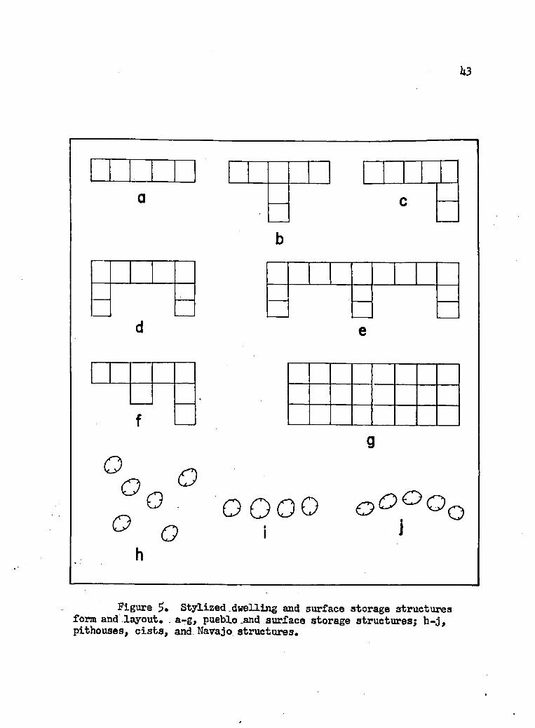
U3
a
b
c
d e
<
f
°o °_ 0 QQQQ ooaOQO o i i
h
Figure 5« Stylized.dwelling and surface storage structures form and .layout* a-g, pueblo .and surface storage structures; h-j, pithouses, cists, and Navajo structures.

mound; in either case the orientation is given as the direction of a
line running through the general center of all units. The Navajo
site orientation is given as the direct line of sight from the hogan
doorway. When hogan doorways could not be identified no orientation was given.
Kiva orientation is defined in relation to the domestic struc
ture. Kivas are also enclosed within the room block and have been so
recorded.Trash is divided into two general types: non-localized sheet
trash and mounds or localized trash. Trash mounds are further charac
terized by their general compass heading taken from the general center
of the pueblo, pithouse, surface storage units or hogans.
The somewhat rare trait of walled-in plazas has also been re
corded. Often this forms nothing more than a retaining wall between
the kiva and trash mound. The usual result is a raised terrace be
tween the wall and pueblo. The amount of rock present in some instances was, however, enough to construct walls of a height equal to that of
the original pueblo; these could have been defensive in nature.
The term community pattern is used here as originally defined
by Chang (i960: 229), w. • • the manner in which the inhabitants
arrange their various structures within the community and their com
munity within the aggregate.11 Social relationships operating within
the community may be quite distinct from those which may bind com
munities into larger wholes; therefore they are considered as separate
from the settlement pattern in this study.

Settlement pattern, on the other hand, is used here as the
manner in which human settlements, communities, or larger aggregates,
are arranged over the landscape in relation to the physiographical
environment.
The physiographic situations in which sites have been found
are narrow valley or canyon bottoms, valley floor or broad valleys,
open hillsides flanking the slopes of a valley, ridges or hilltops
overlooking washes or streams, low rolling bills and sand dunes, rock-
shelter alcoves at the foot of sandstone bluffs, and alcove cliff lo
cations off the ground. The physiographic surroundings have had a very important and definite limiting effect on the cultural develop
ment in areas nearby at various periods of time (Back 19U2), Whether
the physiographic situation has had any noticeable effect on the
settlement pattern through time in the southeastern corner of the
Navajo Indian Reservation was one problem to be tested.
Chronological Framework
It was known before the field work began that the area chosen
to study lies across the boundry or common frontier of the organic and
inorganic pigment paint areas (Hawley 1929)♦ The need for a single chronological model that would encompass and order all, ceramic data
was recognized. Because of this requirement, Gladwin’s (191*5) phase
sequence for the Chaco Branch was rejected. His phases were developed within the inorganic paint tradition area and consequently do not apply outside it.

Other phase sequences (Foci) contemporaneous in part with
Gladwin’s (l9U£) phases exist within the area of organic paint tradi
tion, but they have been worked out in detail and are based on exca
vation a good distance to the west of the area in question (Gladwin 193U: Fig. 7; Colton 1939a: 52). For this reason and by virtue of
the fact that they would not apply to portions of the 1961 reconnais
sance area further east, these phases or Foci, established by Colton,
have also been rejected.The Pecos cultural classification developed in the Southwest
has come to mean a sequence of historical development stages with
definite temporal limits (KLuckhohn and Reiter 1939: 15>l-5). While this system works remarkably well throughout the Colorado Plateau in
general, some inconsistencies have been recognized: witness the
Robert’s (1939) modification of the classification and Gladwin’s (19U$:
k3-W date change for Pueblo I. It is almost impossible to use the
Pecos classification in a strictly temporal sense without bringing to
mind the overtones of the developmental stages aspect. Since the area
in question is concerned with at least two major paint traditions in
pottery decoration and possibly many other cultural traits, as it is
a large area, I felt that something other than the Pecos classification should be used to order the data chronologically.
Any attempt to establish new phases here could only lead to disaster as such spatial-temporal-cultural units require a wealth of detail impossible to collect without excavation. I have decided, therefore, to order chronologically the individual site data within the six localities according to Ceramic Periods (See Table H )

established on the basis of prior archaeological excavation in nearby
areas. These Ceramic Periods are indicative of time only, as they
crosscut and not infrequently blur some rather different cultural
traditions.The Ceramic Periods developed for the purpose of ordering
these data chronologically are composed primarily of the Ceramic Groups
set up on excavation by Olson and Wasley (I9f?6: 257-8) (See Table I),
These Ceramic Groups were used instead of the Ceramic Periods devised
by Wendorf (1956: 6) because there were more groups; hence a more re
fined analysis could be made. A second reason for rejecting Wendorf*s
Ceramic Periods is based on a preliminary check which suggested that
the types included by Olson and Wasley more nearly equated with those
in the 1961 reconnaissance's ceramic sample. Although Olson and
Wasley did not give each Ceramic Group a range of dates, they did
correlate them with Gladwin's (19U5) phase sequences and with the Pecos cultural stages of development. In Fig. 6 I have correlated Olson and
Wasley's Ceramic Groups with a subjective balancing of Gladwin's phase dates, generally accepted dates for the Pecos Classification, and
Colton's Ceramic Group dates. Wendorf's Ceramic Groups are included
for comparison. To Olson and Wasley* s Ceramic Groups I have added,
from Colton's Ceramic Groups (I9I16: 18-20, 2U9-5U), those organic
pigment painted types which are pertinent. The pottery types added
from Colton's Ceramic Groups have the special advantage of being de
scribed in an area in which extensive tree-ring dating has been ac
complished, consequently many of these types are the most securely dated types in the Southwest.

Table IComparison of Some Ceramic Group Constituents
POTTERYTYPES
CERAMIC GROUPS
I 2 i3 l 4 ' 5 l 6 i 7 l 8 ! 9
LEE(1962)
OLSON -WASLEY (1956 257-8)iT2 2 3 l 4 5 61718 91011112
COLTON (1946 18-20) ifflgr
Brown Ware E. Lino Gray______
.Woodruff Brown Lino B/G La Plato B/W
..i ii : _ !" ;xix;..r.: jj.
X X ' :
--4-- t -
Twin Trees PI. Twin Trees B/W Kana-a Gray Kana-a B/W
: *rr! !
AX.x
White Mnd B/W K'[anna_ B/W Piedra" B/W Red Mesa B/W Escavada B/W
_Black Mesa B/W JDeadmans B/R Narrow Coil Cor. Sosi B/W Dqgoszhi B/W La Plata B/R Tohotchi Banded Exubrant Corr. Coolidge Corr. Puerco B/W Gallup B/W Indent Gr. Corr. Holbrook B /W Tusayan B/R Me Elmo B/W North Plains B/R Puerco B/R Wingate B/R St. Johns B/R Mesa Verde B/V, Flagstaff B/W Walnut B/W Reserve B/W Chaco B/W Socorro B/W Wupatki B/W Kayenta B/W Wingate Poly. St.Johns Poly. St. J. P, Spring var. Northern G. Ccrr. Citadel Poly. Tusayan Poly. Klcgeto B/W Jeddito B /0 Jeddito B/Y Sityatki Poly.Navajo Utility Gcberhador Poly. Ashiwi Poiy.
!x: u _x.x.x. !x j x l x l x i x
! * ! r I I■ . ;x..inx|X-• • ' i ' : 1 !
; ! ; •! .X.x;x,xI : | X . X j X ; x
i !- * - » - 1 -1 -| X|X1X-t . X :X ; X XjX
; ixt
; t
!!! »
i • !i
lx1
x jx
XJX
jX X| I
!.i:, , | X : X : ,! !X.:i : !
xXXIX
XX.
..... X
■—
i i
XXX
J:I : I I I : I :x
X
-.1.
x ix l r xiX X x u x l x Xi
i-X
r
- X'X
XX
X X
XX.
X-
X
XjXIX
X; X
XXX

U9
TIME A. D.
LEE(1962)
OLSON a WASLEY (1956:
2 5 7 -8 )COLTON
(1946:254)WENDORF(1956:6)
500
7 0 0 -
-9 0 0 -
1100
- 1300- ~
-1500-
-1700 -
-1900-
8
1
Figure 6. Correlation of various ceramic group chronologies.

There has been no attempt to assign each and every pottery
type recognized in the sample to a ceramic period. What is more, it
is not to be expected that each type named to a particular period
conforms exactly to the temporal limits ascribed for the group as a whole. The ceramic period outlined in Table I are, however, units
that can be recognized in the collected data. A single exception to
this statement is Ceramic Period 8 taken from Colton's Ceramic Groups
to fill a hiatus which exists between the late Pueblo III polychrome
wares and the ceramics of the Pueblo V time period. No sites were
located by this reconnaissance which could conceivably date to this time period, Pueblo IV in the Pecos Classification. In the main,
however, the ceramic periods have born up under analysis of excavated
material and for my purposes have been expanded, and I think, strength
ened by including other well-dated contemporaneous types.
In Appendix B, Table 26-31, an assignment is made indicating
which ceramic period or periods are present at each site. An attempt
has been made to indicate gaps between different ceramic periods in those sites in which they seem to exist. Caution must be exercised in this regard, however, as the surface evidence can not be relied
upon completely to contain elements of all ceramic periods present at
the site.All the different pottery types recognized in the material
collected during the 1961 reconnaissance are given below in alphabet
ical order with the bibliographic references to the description I
used in their identification. When pertinent, notes are also made

concerning differences recognized from the type description and other
points of interest* Not all sherds could be typed according to a
published description, however* In these instances, a brief charac
terization is attempted and a temporary name applied.
Pottery TypesAshiwi Polychrome. (Woodbury and Woodbury 1962 MS)Black Mesa Black-on-white. (Colton 19#, Ceramic Series
No. 3, Ware SB, Type 2).
Brown Ware, early. Paste pale buff or dark brown to red.
Fine quartz sand temper. Some smoothing and polishing. Appears to be constructed by the paddle and anvil method. Similar to Brown Ware
at Arizona K:12:6 (Wasley I960: 32-35)*Brown Ware, late. Paste dark, surface light brown. Temper
minute quartz sand grains. Well polished on exteriors. Some sherds
have fugitive red slip on interiors. Flat rims.
Brown Ware, mica tempered. Soft light buff paste with large
quantities of golden mica temper.Brown Ware, smudged. Paste red brown to buff. Smudged in
teriors. Interiors and exteriors well polished. Polish marks often
show on exterior. Appears to be constructed by coil and scraped
method. Temper sand and many minute white fragments. Rims are flat.
Citadel Polychrome. (Colton 1956, Ceramic Series No. 30,
Ware 5>B, Type U).
Corrugated: Plain, Indented, Patterned and Tooled. Gray
corrugated ware appears in many variations. Plain, indented, patterned

$2and tooled corrugated occur most frequently. Most of the plain and
indented sherds are similar to Tusayan and Moencopi Corrugated (Colton
1955# Wares 8A, Types 11 and 12), but because corrugated wares are not
too distinctive and the sample is limited types were not assigned.
Deadmans Black-on-red. (Colton 1956, Ceramic Series No. 3C, Ware 5A, Type 6).
Dogoszhi Black-on-white. (Colton, 1955, Ceramic Series No. 3, Ware 8B, Type U).
Flagstaff Black-on-white. (Colton 1955, Ceramic Series No. 3, Ware 8B, Type 6).
Gobernador Polychrome. (Keur 19l|l).
Holbrook Black-on-white. (Colton 1955, Ceramic Series No. 3, Ware 9B, Type 2).
Hopi Polychrome Ware. The sherds representing this ware have
the typical yellow-orange fine grained paste of the Hopi tradition.
Polychrome decoration occurs as pale red geometric designs outlined
with a thin watery black on the buff-to-orange unslipped paste.Jeddito Black-on-yellow. (Colton 1956, Ceramic Series No. 3C,
Ware 7B, Type 6).
Kana-a Black-on-white. (Colton 1955, Ceramic Series No. 3, Ware 8B, Type 1).
Kana-a Gray. (Colton 1955, Ceramic Series No. 3# Ware 8A,Type 5).
Kiatuthlanna Black-on-white. (Anonymous 1958, Cobola White Ware Conference).

53Kiet Siel Polychrome* (Colton 1956# Ceramic Series No. 3C,
Ware 5>B, Type 12).Kin Tiel Black-on-orange. (Colton 1956, Ceramic Series No. 3C,
Ware 5B, Type 18).Klageto Black-on-white. (Colton and Hargrave 1937: 2U2-2lth).
Klageto Black-on-yellow. (Colton 1956, Ceramic Series No. 3C, Ware $B, Type 16).
Klageto Polychrome. (Colton 1956, Ceramic Series No. 30,
Ware 5B, Type 17).
La Plata Black-on-white. (Cibola White Ware Conference,
Anonymous 1958).La Plata Black-on-red. (Colton 1955, Ceramic Series No. 3,
Ware J?A, Type 5).
Lino Black-on-gray. (Colton 1955, Ceramic Series No. 3, Ware
8A, Type U).
Lino Fugitive-red. (Colton 1955, Ceramic Series No. 3, Ware 8A,
Type 3).Lino Gray. (Colton 1955, Ceramic Series No. 3, Ware 8A, Type
2). This type is a convenient catch-all for not only all Lino Gray
sherds but all unpainted sherds of Lino Black-on-gray and La Plata
Black-on-white, body sherds of Kana-a Gray and sherds of Lino Fugitive
Red from which the color has disappeared. For this reason. Lino Gray
by itself is of little value as a temporal indicator.
Little Colorado Corrugated. (Colton 1955, Ceramic Series No. 3,
Ware 9A, Type 5). In the interest of further refinement the variations

5kof plain, indented, and patterned corrugated were counted separately.
Patterning consists of geometric designs and bands made from the
combination of the plain and indented corrugations on a single vessel.
Little Colorado Gray. (Colton 1955f Ceramic Series No. 3,Ware 9A). The same as Little Colorado Corrugated except exterior surface is not corrugated.
Maneos Black-on-white. (Abel 1955t Ceramic Series No. 3,Ware 12A, Type £).
McElmo Black-on-white. (Abel 1955# Ceramic Series No. 3,Ware 10B, Type 1).
Medicine Black-on-red. (Colton 1956, Ceramic Series No. 3C,Ware 5B, Type 1).
Mesa Verde Black-on-white. (Abel 1955, Ceramic Series No. 3,
Ware 10B, Type 2).
Navajo Utility Ware. (Keur.l9ljl: U6-7).
Padre Black-on-white. (Colton and Hargrave 1937: 2l|l-2).
Pinedale Black-on-white. (Colton and Hargrave 1937: 2bl-2).Puerco Black-on-red. (Carlson 1961: 33-Wl).
Puerco Black-on-white. (Cibola White Ware Conference, Anonymous
1958). Limited to broad line decoration.
Puerco Black-on-white; Gallup Variety. (Hawley 1936: h2-U3).
Called Dogoszhi style Puerco Black-on-white by Cibola White Ware
Conference, 1958.Red Mesa Black-on-white. (Cibola White Ware Conference,
Anonymous 1958).

Reserve Black-on-white. (Cibola White Ware Conference,
Anonymous 19^8)•
Slipped Red (?). Perhaps this is not a valid type, but it is
used as a catch-all for those red-slipped sherds which lack any painted
decoration. These pieces closely resemble the sherds of HLack-on-red
or Polychrome, and they may represent the parts of these vessels which received no painted decoration.
St. Johns Black-on-red. (Carlson 1961: 88-9U).
St. Johns Polychrome. (Carlson 1961: 97-11)•St. Johns Polychrome, Springerville variety. (Carlson 1961:
127-133).Shato Black-on-white. (Colton 1955# Ceramic Series No. 3,
Ware 8B, Type 5).
Sosi Black-on-white. (Colton 1955# Ceramic Series No. 3,Ware 8B, Type 3).
Tularosa Black-on-white. (Cibola White Ware Conference, Anonymous 1958).
Tusayan Black-on-red. (Colton 1956, Ceramic Series No. 30, Ware 5B, Type 2).
Tusayan Black-on-white. (Colton 1955# Ceramic Series No. 3# Ware 5B, Type 9).
Tusayan Polychrome. (Colton 1956, Ceramic Series No. 30,Ware 5B, Type 9).
Walnut Black-on-white. (Colton 1955, Ceramic Series No. 3, Ware 9B, Type 5).

'White Mound Black-on-white, (Cibola White Ware Conference,
Anonymous 1958).
Wingate Black-on-red. (Carlson 1961: 1:8-66).
Wingate Polychrome. (Carlson 1961: 66-83).
Zuni-Acoma Polychrome Ware. These sherds are definitely of
the historic Zuni-Acoma tradition but are so indistinctive and occur
so infrequently that a finer subdivision is not attempted here.
Plan of Presentation
The data collected from the sites visited are presented in
tabular form (Appendices A, B, and C). This type of presentation is
preferred over a detailed discussion of each site, primarily because
of the limitations inherent in the data collected during reconnaissance.
As stated earlier, no excavation was undertaken. Without this aid, the deceiving nature of erosion and the vagaries of preservation make any
such detailed discussion of the individual site meaningless. The
large sample size was also a major factor in the decision for this type of presentation.
Appendix A consists of all structural data, type of site, site
characteristics and physiographic situation of each site located by the reconnaissance.
In Appendix B is found a sherd count with an assignment to a ceramic period for each site.
The other artifacts, non-artifactual material, and burials
located and recorded by the 1961 reconnaissance are presented in — Appendix C.

$1
The total sample is broken down into six major subdivisions
or localities as Willey and Phillips (1958: 18) have called them.
This division has been necessitated primarily by the size of the sample. During the preliminary analysis the total sample was found
to be much too large to handle, and there was always the possibility
of glossing over or completely missing differences and/or similarities
with such a volume of data. Another factor, however, was that during
the preliminary analysis, there seemed to be a good measure of cultural
homogeneity within several of the localities.
After the first subdivision was accomplished, one area, the
Black Creek locality, was still too large to handle with facility and
so was divided into two parts. A convenient place to do this was the
point where Black Creek enters a canyon two miles below Oak Springs.
Here it enters a ten-mile-long, narrow canyon deeply cut through the
south end of the Defiance Plateau, finally joining with the Rio Puerco
some 20 miles further downstream. As the canyon is narrow and rough,
and practically never traveled today, little use is thought to have
been made of it in prehistoric times. It therefore marks a convenient,
if not real, southern limit to the Black Creek locality.
Each of the six localities is described as follows:
Tohatchi-Mexican Springs: Red Willow Wash, Muddy Wash, Norcrbss
Wash, Chuska Wash, Mexican Springs Wash, North and South Forks of Catron
Wash itself, Black Springs Wash, and Black Creek (a tributary of Chaco Wash).
Black Greek: Black Creek (a tributary of the Rio Puerco) from
Red Lake to the deep canyon two miles south of Oak Springs and its
primary tributaries Simpson Creek, Tohdildonih Wash, Zilditloi Wash,
Buell Wash, Twin Buttes Wash, White. Clay Springs Wash, Bonito Creek,
Slick Rock Wash, Tohsohotso Wash, Cienega Creek, and Tse Bonito Wash.
Rio Puerco: the hilly flanks north of U.S. 66 from Manuelito,
New Mexico, to the Pine Springs turn-off and including its tributaries,
Lupton Wash and Black Creek, from the point where it issues forth from
the canyon below Oak Springs.Kin-li-chee Creek: Kin-li-chee Creek from Ganado east to its
head atop the Defiance Plateau and its major tributaries. Lone Tule
Wash, Sage House Wash, Black Soil Wash, Scattered Willow Wash, and
Bear Canyon.Nazline Wash: Nazlini Wash, Beautiful Valley, Seachi Canyon,
Tse Deeshzhaai Wash (Three Turkey Canyon), and Tse Ndiitsooi Wash (Little White House Canyon).
Lukachukai-Tohotso-Greasewood: an area one mile in diameter
centered on the confluence of Tohotso Creek and Greasewood Wash and
overlapping Lukachukai Creek (See Fig. 3).
To reduce repetition of the term locality, in future reference
it will be understood that the name of the locality refers to the en
tire area with its several drainages and not just to the drainage from
which the locality name was taken.
The Tohatchi-Mexican Springs, Black Creek, and Rio Puerco make up the eastern localities. The western localities are formed by the Kin-li-chee Creek, Nazlini Wash, and Lukachukai-Tohotso-Greasewood.
58

59
Frequent use of eastern and western localities will be made later in
inter-area comparisons*

COMPARATIVE ANALYSIS
The Six Localities
It is desirable to compare and contrast the archaeological
evidence gathered during the 1961 Reconnaissance to the general scheme of Southwestern prehistory. This will bring into focus the elements
necessary to construct sound hypotheses concerning the cultural de
velopment and delimit specific problems of the area in general. It is
first necessary to find out to what extent the area under consideration
is a homogeneous unit of cultural traditions. The interests at this
level of synthesis are: (l) to establish the cultural traditions foundthroughout the historical development of the six localities under con
sideration, and (2) to learn to what extent the six separate localities
share similar traditions. It can not be assumed a priori that the area
as a whole participated in the development of a common cultural history.
Our task here, then, is to find out to what extent the six localities
differ and how they are similar. If significant differences do occur,
then the different cultural traditions must be isolated and their
boundaries defined, both in time and space. Only then can we pass to the next level of synthesis which is to consider the area as a whole
and its place within the cultural-historical development shared throughout the Southwest.
The synthesis will be attempted in terms of trends observable
in the. ceramic, community, settlement, and population pattern data60

61presented by ceramic periods as defined earlier.
In this study the relationships between the various localities
are based primarily on ceramic similarities and differences. This is
due more to the lack of detailed data in other categories than to the
sensitiveness and cultural importance of ceramics. Comparable details
of the community pattern and its units and mode of construction are
not usually available from data collected during survey.Although specific pottery types were identified in the site
collections, they will not be used as specific units for tracing re
lationships. The ceramic concept of the affiliation of one or more
particular Wares with a Branch or "Culture" has largely been rejected
in the Southwest. While a particular pottery type has been adequately
dated, more-or-less, little detailed information is available concerning
its specific area of manufacture. It is not difficult to say for in
stance, that a particular pottery type is like that made in one area,
but it is difficult to quantify these data in terms that are more than
just taxonomically valid. Nevertheless, certain long standing ceramic traditions do have general spatial limitations and it is within these that a comparison will be made.
Ceramics
Plain Brown and Plain Gray Ware
There are no remains which can be dated with certainty earlier
than Ceramic Period 1. There is some indication that an earlier period
exists but no conclusive proof is available. Two sites which have a
wide range of ceramics also include unfired sherds (Arizona K:h:l8,

62Arizona E:l^:10) (Fig. 10, j). While similar unfired pieces of pot
tery are characteristic of Basketmaker H materials in the Prayer Rock
district of the Lukachukai Mountains and other more distant areas in
the Southwest, it is not inconceivable that people in later periods
of time could also have made use of this type of container.As unfired sherds occur at only two sites, one in Black Greek
and the other in Nazlini Wash, no inferences concerning affiliations
are attempted here.
One trait which suggests that there may still be a period prior to Ceramic Period 1, but subsequent to the time of the unfired
sherds, is the occurrence of a plain brown ware with Lino Gray. These
two kinds of pottery occur alone at four sites, and are in association
with types clearly much later in four other locations. In all other
contexts, which number ten, they are associated with types character
istic of Ceramic Periods 1 and 2. A separate period has not been
established for these two types when unaccompanied by other wares,
primarily because the evidence is inconclusive but also because of a
reluctance on my part to relax a conscious conservative frame of reference when dealing with data collected by reconnaissance.
Earlier I have noted that Line Gray is a catch-all for several
types which have similar paste diagnostics. Only when rim sherds are present is it possible to identify this type with certainty. Its uniformity over such an area is quite remarkable, however, as it appears in all six localities.
The brown ware, on the other hand, is quite variable. It ranges from a light red paste with large quantities of fine sand
63
temper to gray-buff paste with little or no sand temper. The red
paste variety has little polishing, while the gray-buff is well
polished. There is some evidence that red paste ware variety was finished by the paddle and anvil method, but the sherds are so small
that the surface irregularities may be only part of the normal rough
ness encountered in scraped-finished wares.The red paste variety occurs generally in the more south
easterly portion of the area while the gray-buff variety is more
northwesterly is distribution. Brown ware is limited to the Black
Creek, Rio Puerco, and Nazlini Wash localities. This ware is most
frequent in the Rio Puerco, with Black Creek next, and it is limited
in occurrence in Nazlini Wash.
In view of the physical and distributional difference found in the brown ware, it appears quite likely, that on the basis of more
evidence, it will be possible to subdivide it into several varieties.
Organic and Inorganic Painted Black-on-white Pottery
Lino Black-on-gray and La Plata Black-on-white, the other
components of Ceramic Period 1, constitute the beginning of two general
trends which continue through Ceramic Period 7. This trend of inorganic
paint decoration on pottery in the east and organic paint decoration in
the west is crosscut temporally and spatially by similar design styles.
The pastes are not too dissimilar either. At least the range of vari
ation in paste does not extend beyond what one would expect from the use
of local materials in different but closely adjoining areas.

The organic versus inorganic pigment is not a dichotomy limited
to Black-on-white pottery. It is in this color class of ceramics,
however, that the opposed pigment types were first defined (Hawley
1929) and is still best exemplified. The dichotomy is not always
maintained, and some sherds of a single type will show both types of
pigment. These occurrences, however, are not the norms. Excavation
and survey in the Southwest have made little change in the geographic
distribution of each type ftom its original definition. Inorganic paint is thought to be localized in the eastern and southern portions of the
Anasazi area, while organic paint is primarily western and northern in distribution.
As I noted earlier, the survey area under consideration lies
across the common boundary of the organic and inorganic paint. To
find out to what degree the several localities participate in one or
the other paint traditions, and how this might have changed through
time, I have counted the number of sherds present of each type of
Black-on-white paint pigment within each site containing a single
ceramic period component (Table 3)» The tabulation is limited to those sites with only one ceramic period component because the multi-
component site ceramic samples are not divisible into several parts.
A finer division would require the placement of each and every pottery
type into a specific ceramic period. This requires a depth of knowledge beyond what is presently possessed for the area. This, of course, tells one nothing about the relative importance of a single type which
is of small consequence for, as I have pointed out before, there is probably little validity in a small sample for reference to details.

65
Table 3Frequency of Organic and Inorganic Pointed Black-on-white pottery by Locality Through Time.
L o c a l i t y C E 1R A M I C F> E 1R 1 0 D S
PigmentType i 2 3 4 5 6 7 8 9
T o h a t c h i-Mexican Spr.
O r g a n i c _ 1 3 5 7 26Inorg anic 4 95 14 395 142 185 — *
Bl ock C r e e kO r g a n i c — — • — 4 24 14 57 — —
Inorganic 10 36 17 12 1509 537 357 —
Rio P u e r c oO r g a n i c — — 17 1 3 3 1 — —
Inorganic 4 110 14 6 586 347 1261 - —
Kin-li-chee Creek O r g a n i c 1 1 9 51 21Inorganic — 26 1 — 6 37 9 — —
Nazlini WashO r g a n i c — 8 3 2 16 — 2 — —
Inorganic — 32 4 — 12 — 0 — —
Luk.-Toh.-Gr ea. O r g a n i c 9 5 4Inorganic

66e-. During Ceramic Period 1 inorganic painted pottery is found only
in Tohatchi-Mexican Springs, Black Creek, and Rio Puerco (Table 3).
No organic painted types occur at this time in any area.
A wide distribution of inorganic painted Black-on-white pottery is seen during Ceramic Period 2 times, in all but one locality; its
absence in Lukachukai-Tohotso-Greasewood at this time level is undoubt
edly a reflection of the small sample size. Organic paint occurs only
once in Tohatchi-Mexican Springs, but is in significant quantity in Nazlini Wash, where it is found on a fourth of the Black-on-white
sherds.A considerable reduction in both pigment types is encountered
during the 3rd Ceramic Period. While both types are almost equally
represented in two localities, the Kin-li-chee Creek and Nazlini Wash,
the organic sherds show a slight increase in proportion to the inorganic
sherds. Although the sample is so small as to cast doubt on their im
portance, they are consistent with a general trend toward the reduction
of inorganic pigment and an increase in organic pigment after Ceramic
Period 2 in these two areas. In Black Creek no organic pigment was
noted and a reduction in inorganic painted Black-on-white pottery is
recorded during this period. An interesting development occurs in the
Rio Puerco at this time. Organic painted remains outnumber inorganic,
but all organic painted Black-on-white sherds occur at a single site
(Arizona K:ll:20). This site possibly represents outside intrusion
into an otherwise homogeneous area. The reduction in organic painted
Black-on-white pottery in this locality is consistent with the same trend noted for the Black Creek and with a general reduction noted in

all areas on this same level. No single component sites with painted
Black-on-white pottery were found during this time in Tohatchi-Mexican
Springs and Lukachukai-Tohotso-Greasewood.In Ceramic Period U, an increase in both types is recorded in
the Tohatchi-Mexican Springs, but organic paint sherds represent about
a fifth of the sample. Both Black Creek and Rio Puerco reveal a con
tinued reduction in inorganic painted Black-on-white types, while there
is a slight increase in the former area and a reduction in the latter
area in organic types. Kin-li-chee Creek and Naziini Wash roughly
maintain their level of organic painted pottery. A reduction in in
organic types is noted in both areas. The Lukachukai-Tohotso-Grease-
wood sample is of little importance because of its size, but there is
nothing contrary to the trends established by Kin-li-chee Creek and
Nazlini Wash.
Ceramic Period 5 is a time of extreme expansion in numbers of
inorganic painted Black-on-white sherds in Tohatchi-Mexican Springs,
Black Creek, and Rio Puerco, a very slight increase recorded for or
ganic painted types. A general increase in organic paint is also
noted in Kin-li-chee Creek and Nazlini Wash, and in both areas organic
outnumbers inorganic painted sherds. In Lukachukai-Tohotso-Greasewood
no painted types were recorded.
During Ceramic Period 6 a general overall reduction is evidenced
in the inorganic painted sherds of the Tohatchi-Mexican Springs, Black
Creek, and Rio Puerco localities. Their numbers are one-half to two-
thirds less than recorded during Ceramic Period $. Organic painted
67

68Black-on-white sherds decrease or remain relatively constant, but are
present in small quantities except in Kin-li-chee Creek. Here, on the
other hand, organic painted Black-on-white sherds outnumber inorganic
painted ones by a third. No sherds of either type were noted in the Nazlini Wash. Lukachukai-Tohotso-Greasewood sites reflect the general
western trend, with no inorganic painted sherds and only five organic
painted ones present.In Black Creek and Rio Puerco during Ceramic Period 7 the
trend of reduction continues in the number of inorganic painted Black-
on-white sherds. However, in Tohatchi-Mexican Springs and Black Creek
a significant twenty-five percent increase in organic paint is noted,
with a comparable increase in inorganic painted Black-on-white sherds
in the former area only. Reduction is the most important trend in
Kin-li-chee Creek, Nazline Wash, and Lukachukai-Tohotso-Greasewood in
both paint types, although the latter two areas are so weakly repre
sented that their counts are of doubtful importance. Note in Table 3,
however, that the organic paint pigments are still dominant.
Ceramic Period 7 is the last time in which Black-on-white
organic and inorganic painted pottery is found in single component sites.
As stated earlier, no sites in any of the six localities were
located by the 1961 Survey which could be placed within Ceramic Period 8.
Only a few Black-on-white sherds were found in single com
ponent Ceramic Period 9 sites but these were undoubtedly collected

69and brought in by Navajos for use as tempering material in the local
Navajo pottery.It seems clear, even though conclusive proof is lacking, par
ticularly in the western areas, that on the basis of organic versus
inorganic paint pigment there appear to be two different style zones
involved in the localities under study. Early in time there appears to be wide-spread use of inorganic paint in all localities. Later in
Tohatchi-Mexican Springs, Black.Greek, and Rio Puerco this trend ex
pands to a maximum in Ceramic Period 5 after which it decreases grad
ually, except in Tohatchi-Mexican Springs where it again reasserts
itself in Ceramic Period ?• Organic paint is never found in important
quantities in the aforementioned areas, although there is an increase
from early to late in Tohatchi-Mexican Springs and Black Creek. In
the Rio Puerco organic painted Black-on-white sherds are rare except
for one site in which they equal about 55 percent of that sample.
Organic painted Black-on-white sherds occur infrequently
during the earlier ceramic periods of Kin-li-chee Creek, Nazline Wash,
and Lukachukai-Tohotso-Greasewood. Beginning in Ceramic Period U and
continuing through Ceramic Period 7, there is a definite predominance
of organic painted sherds over inorganic painted Black-on-white types.
No Black-on-white sherds occur in a meaningful context after Ceramic
Period 7.Red Wares
Several types of the White Mountain Red Ware series make up the
principle portion of the Black-on-red and Polychrome sherds in the various localities during Ceramic Period 6 and 7 (see Table It). Each

70
T a b le 4White Mountain Red W ore and San Juan
Red Ware P o t t e r y by L o c a l i ty Through T im e.
S.J.R.W.W h i t e M o u n t a i n R e d W a r eT ypes
Localities
T o h a t c h i - M e x ic a n Spr.
Block C r e e k
Ri o Rue r c a
Kin-li-chee Creek
Nazlini Wash
Luk.-Toh.-Grea.
Ceramic P.2 Ceramic P.5 Ceramic P.6
Ceramic P.6
Ceramic P.7

71of the three eastern localities and Kin-li-chee Creek exhibit a
similar pattern, that is, the White Mountain Red Ware series is common to all and appears in significant proportions. During Period 6 and 7 Puerco Black-on-red, Wingate Black-on-red, and St. Johns Black-
on -red are found in all localities, except there is no Puerco Black- on-red in Period 7 in Kin-li-chee Creek and no St. Johns Black-on-red in Period 6 in the Rio Puerco. The trend is unchanged for Puerco Black-on-red with a slight decrease witnessed by Wingate Black-on-red from Period 6 to 7. St. Johns Black-on-red increases significantly from Period 6 to 7*
Wingate Polychrome and St. Johns Polychrome are both significantly present during Period 7 but neither is found in Period 6 in the eastern localities and in Kin-li-chee Creek. St. Johns Polychrome, Springerville variety, is present only in Tohatchi-Mexican Springs.
The White Mountain Red Wares are almost entirely absent in
Nazlini Wash and Lukachukai-Tohotso-Greasewood. Wingate Black-on- red occurs in each locality during Period 6 but in very small quantities. St. Johns Polychrome occurs in Nazlini Wash only once in Period 7. These two northwestern localities did not participate in the acceptance and use of the White Mountain Red Wares as did the other areas.
The only San Juan Red Ware (See Table U) type found in this survey was La Plata Black-on-red which occurred only in Tohatchi- Mexican Springs in sites of Period 2, 5, and 6 dates. Its presence in this area is not unexpected, and where it occurs in sites of Period 2 and 6 it must be evidence of a multi-component site. The

72
data concerning this type are so limited, however, that by itself they
negate any hypotheses made concerning it.
Orange Ware
The Tsegi Orange Ware data (Table 5) suggests much less con
clusive inter-locality cultural relationship than the White Mountain
Red Wares because the former occur in such restricted quantities.
With this word of caution it may be pointed out that the Tsegi Orange Ware appears earlier in Kin-li-chee Creek and Nazlini Wash than in the eastern localities of the Black Creek and Rio Puerco. It appears only
during Period 7 in the eastern localities and in Periods 6 and 7 in
the western localities.This ware occurs in its highest frequency in Nazline Wash.
Its Kin-li-chee Creek pattern of occurrance more closely resembles
the eastern localities than it does the Nazlini Wash.
No examples of this ware were found in Tohatchi-Mexican Springs
or Lukachukai-Tohotso-Greasewood. The lack of this ware in the latter
areas is perhaps the result of an inadequate sample.
Historic Puebloan and Navajo Pottery
The problematical occurrence of historic puebloan pottery in site samples which are by all other criteria anything but Ceramic
Period 9, is easily resolved by turning to Navajo ethnology. Specific
instructions are set forth in Blessing Way, a Navajo Ceremony, for the
care and final disposition of any pottery vessel which is broken while
in use by its Navajo owners (DeHarport 1962). The precautions consist,
among other things, of the careful collection of all the broken pieces which are then deposited on a nearby Anasazi ruin. It is a well-known

73
Toble 5Tsegi Orange Wore Pottery by Locality
Through Time
Types
Localities X .
T S E G I ORANGE WARE
Med
icin
e B
/R
Tu
soyo
n
B/R
Deo
dmon
s B
/R
Tu
soyo
n
Pol
y.
Kie
l S
itl
Pol
y.
Cit
ad
el
Po
ly.
Klo
get
o
B/Y
Kin
T
iel
B/O i
o
5
Block Cr eek
Rio P u e r c b
Kin-1 i-chee Creek
Nazlini Wash
1 3
4 1
1
24
11 2 3
C e r a m i c P.5— C e r omic P.6
C e r a m i c P.7

7Ufact that Navajos bought and bartered for pueblo pottery, as well as
made their own. I think the result of this Navajo custom can be seen
in Table 6, where Ceramic Period 9 trade ceramic components are found
on sites of Ceramic Periods 5 and 7 as well.The distribution of Navajo utility pottery is universally found
in all localities. In terms of sample size per area, there appears to
be, significantly, more Navajo pottery in Kin-li-chee Creek and Nazlini
Wash than in any other. Gobemador Polychrome occurs widely but infrequently dispersed. Based on the evidence available, little more can
be added concerning this type.
Hopi and Zuni-Acoma wares occur about as one would expect, with
the Hopi types more prevalent in western localities closer to their place of origin, and the Zuni-Acoma types most frequent in the eastern
localities close to their home area of manufacture. One Hopi type,
Jeddito Black-on-yellow, and the Zuni-Acoma wares have the widest distribution; each occurs in two localities nearest their place of manu
facture and extends into another area common to both, the Rio Puerco,
some distance away (Table 6).
During Ceramic Period 9 there appears to be a wide-spread
Navajo occupation of all areas. The data presented in Table 6 suggest a heavier occupation of Black Creek and Nazline Wash than the other
four localities. This suggestion may be more apparent than real, for
there is a definite overlapping of the physiographic situation of
these sites. Since the primary interest of this survey was Puebloan
occupation, Navajo remains were collected and recorded only when they

75
Table 6Hopi , Z u n i - A c o ma and Navajo
Pottery by Local i ty Through Time.
Types
Localities x\ Jed
dit
o
B/Y
Ho
pi
Po
ly.
Ash
iwi
Pol
y.
Zuni
A
com
o Po
ly.
Nav
ajo
u
tili
ty
Gob
erno
dor
Poly
.
T o h a t c h i- Mexi can Spr. 7 - 9 5 - 2 9 - 1 3
Bl ock C r e e k 9 - 3 9 - 3 7 9 - 4 9-171 9 - 2
Rio P u e r c o 5 - 75 - 1 9 - 2 3
9 - 1 1
Kin-li-chee Creek 7 - 1' 9 - 5 0
Nozlini Wash 9 - 9 9 - 4 9 - 8 0 9 - 3
Ceramic Period-Sherd Frequency

76
coincided with the location of Puebloan materials. This situation
happened most frequently in areas where large natural cliff shelters
were available. Both Black Creek and Nazlini Wash have many large
sandstone cliff shelters which were occupied by both Puebloan and
Navajo peoples, one after the other. Possibly this accounts for the
higher frequency of Navajo sites in these two areas.
Navajo trade for Puebloan ceramics appears to be divided into a southeastern and western tradition, each leaning toward a preference for ceramics produced "close-at-home." The dividing line between these
two coincides with the top of the Defiance Plateau. Whether the De
fiance Plateau served as an actual barrier to trade is questionable in
the light of the occurrence of both Hopi and Zuni-Acoma ceramics in
Black Greek. The apparent preference for Hopi and Zuni-Acoma ceramics
in the western and eastern localities, respectively, probably is due
to nothing more than convenience, although preference may have been a factor also.
Community PatternThe discussion of inter-locality community pattern is limited,
quite naturally, to the structures in single component sites and the
ultimate structural evidence of two different time periods visible on
the surface at any one site. Only in the large sandstone alcoves,
where some illicit digging had been done and where Navajos had reoccu
pied or built to one side of earlier structures, were several structural
components observable. In these cases there was only enough of the
structure exposed to reveal minor features of the community pattern,

77“such as type of wall construction or corner abutment. Never were the structures sufficiently exposed to indicate routes of communication
or other community patterns. During the Navajo reoccupation of more
ancient ruins during the Ninth Ceramic Period there was rarely any
structural evidence of their presence.
The quantity and regularity of the structural evidence ob
served will demonstrate a high level of reproducibility. This suggests that the general overall modes of community patterning would be
changed slightly, if at all, were structural data available for consideration through excavation. In order that the reader may be in a
better position to judge the reliability of my interpretation of the
data presented here, I have given the site component totals by period
for every locality (Table 7). A total site count is also given at
the bottom of the Table by locality. The difference between total
components and total sites in the Table is the result of reoccupation
of ancient pueblos by Navajos, the original structure being changed,
if at all, only very slightly by the later occupants.Period One
Structural Units. Evidence for pithouses is found in all six
localities except that of the Kin-li-chee where no single component
sites were found dating in this period. The absence of evidence of
sites of this period in Kin-li-chee is undoubtedly due to the small
sample size and the problem of recognizing pithouses. As the area's
subsequent development was contemporaneous with and parallel to that
of the other localities, pithouses were probably present in Kin-li-chee.

'TABLE 7
Component and Site Totals by Locality and Ceramic Period
78
CeramicPeriod
Eastern Localities
T-MS BC RP
Western Localities
K NW L-T-G*
1 3 10 7 0 2 2
2 19 12 15 9 It 0
3 1 12 5 6 2 0
k 5 . 5 3 3 6 1
5 51* 189 101 1* 6 0
6 16 51 33 19 6 2
7 21* la 12 12 9 3
8 0 0 0 0 0 0
9 2 16 2 It 17 0
Unknown 7 22 It 9 15 1
TotalComponents 131 359 181 66 66 9
TotalSites#* 131 355 181 65 58 9
* T-MS, Tohatchi-Mexican Springs; BC, Black Creek; RP, Rio Puerco; K, Kin-li-chee Creek; NW, Naziini Wash; T-T-G, Lukachukai- Tohotso-Greasewood.
■JBt Total sites are the actual number of sites located by the reconnaissance and differ from the Total Components in that the Puebloan sites with Navajo reoccupation have been counted twice.

79Surface storage structures are limited to Tohatchi-Mexican Springs,
Black Creek, Rio Puerco, and Nazlini Wash, while cists are limited
to the latter two and Lukachukai-Tohotso-Greasewood. No surface
structures were located in Lukachukai-Tohotso-Greasewood.
Size. The number of individual pithouses varies widely throughout the different localities. Communities within a given locality
range in size from one to three pithouses to as many as five to ten units, but the mode is from three to four.
Layout. Within Tohatchi-Mexican Springs, Black Creek, and
Rio Puerco, the preferred community layout is lineal with the cresentic
or u-shaped pattern also present in the latter two.A scattered and unorganized layout plan is found in both Naz-
lini and Lukachukai-Tohotso-Greasewood.
Construction. In all localities cist and storage structures
are made only of sandstone slabs set on edge, except in Rio Puerco,
where this technique is augmented, but rarely, by crude low masonry
walls.
Orientation. There appears to be only one item of uniformity
among the various localities with reference to domiciliary orienta
tion: that is a negative one. Although structures are never oriented north or northeast, they are oriented to all other points of the com
pass. However, a western orientation occurs only once. The preferred
alignment is with the east in Tohatchi-Mexican Springs, and southeast
in Black Creek and possibly Lukachukai-Tohotso-Greasewood. South ap
pears as the preferred direction in Rio Puerco and Nazlini Wash.v..

Trash. Unlocalized or scattered refuse is the mode in all
localities, but in Black Creek and Rio Puerco it is also found in
small mounds to the south, southwest, and east of the structural units.
Period TwoStructural Units. During Period Two the pithouse and surface
storage structures are found in all localities except in Lukachukai-
Tohotso-Greasewood where no single component sites of this period were
located. Sample size, in Lukachukai-Tohotso-Greasewood, surely has
effected the picture of this locality as it appears to follow the sub
sequent overall development seen in other areas.Cists appear to be waning in popularity in Period Two as they
are rare in all localities except Nazlini Wash where they are entirely absent.
A new architectural form (one to be so important later on)
sees its beginning during this Period. Small pueblos of crude masonry
were found in Tohatchi-Mexican Springs and Kin-li-chee Creek.
Size. A wider range in number of individual structural units
per site is present during Period Two than was the case in Period One.
While there are still many sites of from one to three pithouses, the
upper limit has climbed to eight, twelve, and even twenty. The model
size ranges, however, between four to six or slightly smaller. These
statements apply only in Tohatchi-Mexican Springs, Black Creek, and
Rio Puerco, for in the Kin-li-chee Creek and Nazline Wash a different
pattern is exhibited. In these latter two areas, there appears to be a slight reduction in site size.
80

Layout. In the eastern localities the community plan is also
more diversified than during the preceding Period. Besides the most
important, the lineal form, are the crescent, the 11 uM, and other
variations, as the "L" or "V". The lineal arrangement, however, by
far exceeds all the other minor variations together. The only plan
found in Kin-li-chee Creek and Nazlini Wash is the lineal form.
Construction. Surface storage structures are constructed of
both sandstone slabs set on edge and crude mortared masonry. The slab-to-mortaredrmasonry proportion is, on the average, more than 5$1#
Cists are always made of sandstone slabs set on edge while pueblos are
always made of mortared masonry.
Orientation. Orientations to the south and southeast are pre
ferred in 75 to 8? percent of all sites in Tohatchi-Mexican Springs
and Rio Puerco, respectively. In Black Creek the sites are almost evenly divided between east, south, and southeast. In Kin-li-chee
Creek and Nazlini Wash, the preferred orientations are south and south
east, the former being predominant.
Trash. Two thirds of all trash on sites in Tohatchi-Mexican
Springs and Black Creek is scattered. The remaining is located in small thin mounds located to the south, southeast, and east of the surface structural units. The orientation of these units and of the
trash mounds do not agree exactly in all cases, but they are generally within one-quarter of the compass heading.
In the Rio Puerco, localized or mounded trash occurs more fre
quently than scattered or unlocalized trash, although the percentage for each is even.
81
Kin-li-chee Creek and Nazlini Wash show a complete reversal
of the trend described for the two eastern most localities. In the
Kin-li-chee Creek trash occurs in mounds three and one half times as often as it does in a scattered fashion. The preferred orienta
tion is southeast, although some lie directly south. In Nazlini Wash
all trash occurs in mounds and is either to the south or southeast of
the domestic structure with equal frequency.
Sherd Areas. These trash deposits are not associated with any
other feature indicative of a site as defined by this study. Sherd
areas appear for the first time in Period Two and only in Tohatchi-
Mexican Springs. They may represent buried sites of a permanent nature, such as pithouse villages, etc., of which the sherds are the
only visible evidence, or they may represent a site of less permanent
nature. These areas could have been seasonal camping spots, being occupied only a short time in connection with agricultural, hunting,
or commercial activities. At least the localization of a small amount
of trash suggests the area was used intensively, but for only a short
period of time, not long enough to invest the energy necessary to con
struct more or less permanent buildings.Period Three
Structural Units. There are fewer sites of this Period than
any other time and yet there is a great deal of diversity and complexity
in all but two localities. In one of these areas, Tohatchi-Mexican
Springs, only one single component site, a small pueblo, was located by the survey. In the other area, Lukachukai-Tohatso-Greasewood, no single component sites of this period were noted.
82

83
In Black Creek, pueblos and pithouse sites occur with equal
frequency. There were, however, only two of each type located. No
cists or surface storage structures were found.In Rio Puerco the same types and numbers of structures were
found as in Black Creek. The only difference was that one pithouse
in the Rio Puerco was backed by a row of surface storage structures.
In Kin-li-chee Creek and Nazlini Wash, however, each pithouse
was backed by a row of surface storage units. Four pithouse sites were found in Kin-li-chee Creek while only two were located in Nazlini
Wash.Pueblos occurred only in Kin-li-chee Creek and are only half
as frequent as pithouses.The single kiva in Tohatchi-Mexican Springs is located to the
east of the domestic structures and between them and the trash mound.
In Kin-li-chee Creek, kivas also occur in the same orienta
tion as the domestic structure and the trash mounds, that is, to the
southeast. One pueblo also has a second kiva at its "back" or on the
northwest side of the pueblo.
Sherd Areas. While this type of site occurs in only two
localities, the Black Creek and the Rio Puerco, it is of importance
in the former alonej there it is found twice as often as sites with
structures. Only one sherd area was recorded in the Rio Puerco locale.
Size. Pueblos range in size up to about nine rooms. The
largest pueblo is found in the Tohatchi-Mexican Springs, while the smal
lest, a one to two room unit, is found in Black Creek, Pueblos of the
8URio Puerco range between these two limits, averaging around three to
four rooms each. Interestingly enough, the pueblos of Kin-li-chee
Creek range from six to eight rooms.
Pithouses appear to be less important at this time in Black
Creek and Rio Puerco than in Kin-li-chee Creek and Nazlini Wash to
the east and north. While the number of individual units per site in
the first two locales is small, the opposite holds true for the latter
two areas. Pithouses are equal to or surpass the pueblos in terms of rooms available.
Layout. Pueblos in Tohatchi-Mexican Springs are built in the
form of an "L". In all other areas, they occur in a straight lineal form.
Pithouses appear to be non-distinctive as to layout in Black
Creek and Rio Puerco, but occur most often in a lineal pattern in Kin-
li-chee Creek and Nazlini Wash. They also occur in a crescentic and an "F" pattern, in the Kin-li-chee Creek.
Construction. Mortared masonry is found throughout the area
except in Nazline Wash, while slab-on-end masonry is limited to this area and Kin-li-chee Creek.
Orientation. Pueblos are oriented to the east in Tohatchi-
Mexican Springs to the northeast and east in Black Creek, to the south . in Rio Puerco and to the southeast in Kin-li-chee Creek.
Pithouses are not regularized as to orientation in Black Creek
and Rio Puerco, but in Kin-li-chee Creek and Nazlini Wash they are oriented almost entirely to the south.

85
Trash. In Tohatchi-Mexican Springs, Black Creek and Rio
Puerco the trash is almost always spread over the entire site as a
thin mantle. In the western and northern localities of the Kin-li-chee
Creek and Nazlini Wash, trash occurs in mounds to the south or rarely
to the southeast of the surface structures.
Period FourStructural Units. This period saw the dramatic change in the
eastern localities from diversity to standardization. Pithouses no
longer occur with pueblos, as a shift to a pattern of above-ground
living seems to have been completed at this time.
In Kin-li-chee Creek and Nazline Wash, diversified domestic
structures still appear. Pueblos are the most numerous, but pithouse,
cists and surface storage structures also are found. The single pueblo located in Lukachukai-Tohotso-Greasewood offers little to the pattern
of structural units among the western localities.
Sherd areas are important features of Tohatchi-Mexican Springs,
Black Creek and Rio Puerco. Only one sherd area occurs in Nazlini Wash
One kiva occurs in Rio Puerco east of the domestic buildings,
while two occur in Kin-li-chee Creek to the southeast and east of simi
lar structures. One kiva occurs in Nazlini Wash and Lukachukai-Tohotso
Greasewood, to the east of surface units.
Size. The number of rooms per pueblo ranges from two to 12 in
Tohatchi-Mexican Springs, two to six in Black Creek, andfbur to eight
in Rio Puerco.
A single pithouse occurs with a pueblo at one site in Kin-li-
chee while one pithouse site occurs unassociated with pueblo units in

86
•Nazlini Wash. In the western localities pueblos are all small, less
than 10 rooms in size, except in Kin-li-chee Greek where at least one
village has 15 rooms.Layout. Pueblos during this period are predominantly lineal
in layout in all localities except in Lukachukai-Tohotso-Greasewood
where the single pueblo occurs in the l,LM form. There is some varia
tion in Black Creek and Rio Puerco where "L11 and 11U" shaped pueblos
also appear infrequently.The pithouse type of site in this period occurs in Nazlini
Wash and has a lineal layout.Construction. Horizontally laid masonry is used exclusively
in all pueblo sites in all localities. It is combined with vertically
laid slabs in the construction of a pithouse in Kin-li-chee Creek.The pithouse site in the Nazlini Wash has vertical slab construction.
Orientation. In the eastern localities, east, southeast, and
south pueblo orientation occurs with equal frequency; in the western
localities there is a tendency to prefer a southeastern orientation
for pueblos, but southern, eastern, and even northern alignments also
occur. The pithouse site in Kin-li-chee Creek has an eastern orientation.
Trash. The orientation and type of trash deposits in the
eastern localities ranges from scattered unlocalized sheet trash to
small mounds lying to the east or southeast of the surface structures.
In the western localities less uniformity is present. Kin-li-
chee Creek pueblos favor a southeastern area for trash deposit while the pithouse site uses an eastern location. All Nazlini Wash pueblos

87
have scattered sheet trash over the entire site. In Lukachukai-
Tohotso-Greasewood east is the preferred direction for trash disposal.
Period FiveStructural Units. Throughout the entire area covered by this
study, pueblos have become so important by Period Five that to all
intents and purposes they are the only type of domestic dwelling.
There are single occurrences of pithouses in both Tohatchi-Mexican Springs and Black Creek. Sherd areas are still present, but are of
importance only in the Black Creek where they account for something
less than one-fourth of the sites. Sherd areas do not occur in the
western localities during this period.Cists occur at only one site in Nazlini Wash and are absent
in all other localities. No sites of this period were located in
Lukachukai-Tohotso-Greasewood.
Within the eastern localities from about one half to one-
third of the pueblos occur without kivas (Table 8). Pueblos with
kivas are found in a one to one relationship in from one half to seven
eighths of the total. Two or more kivas per pueblo occur in all areas
but they reach important proportions only in Black Creek. In this
area the occurrence of more than one kiva at a site slightly surpass
ten percent of the total kivas found and represent one seventh of the pueblos with kivas. One Great Kiva is found which belongs to this period and it is in Black Creek.
The western localities exhibit quite different patterns of
kiva dispersal as compared with the eastern localities. The rather uniform 1:1 ratio of pueblo to kiva in the eastern localities is in

88TABLE 8
Period Five - Pueblo-Kiva Ratios
Locality PuebloTotal
KivaTotal
1 Pueblo: 1 Kiva
1 Pueblo 2+ Kivas
GreatKiva
Pueblo w/o Kiva
Toh.-Mex. Spr. $3 39 35 2 0 16
Black Creek 170 103 7h 13 1 83Rio Puerco 97 65 57 U 0 36Kin-li-chee Cr. h 5 0 1 2 3Nazlini Wash 5 h 0 2 0 3Luk.-Toh.-Gr. 0 0 0 0 0 0
contrast to a complete absence of this ratio in the western localities.
In Kin-li-chee Creek and Nazlini Wash, kivas are always found in a
ratio of two or more per pueblo. But, pueblos lacking kivas outnumber
multi-kiva pueblos almost two to one. Admittedly the sample is small
in both of these areas, but it presents a uniform picture.
Size. For classificatory purposes, the sites have been di
vided into three groups based on their size. The size range for the
three types are: small: one to ten rooms; medium: eleven to twenty
rooms; large: twenty-one or more rooms.
Within the eastern localities 80 to 90 percent of the pueblos
fall into this small pueblo type. Only eight to 16 percent of the
pueblos can be assigned to the medium style, while the large category
accounts for only two to four percent. No large pueblos are found in

89
Black Creek. In the western areas, the sample is much smaller, but
the ratios are very different. Small pueblos account for 60 to 75 percent of the sites, while the medium and large types account for
2£ to hO percent of the total.
Layout. In Period Five, the lineal type is by far the most
preferred layout pattern in all of the eastern localities, ranging
between h3 and 73 percent of all pueblos. Types "L" and "U" are nextin importance, and account for around ten percent only of the pueblosin Black Creek and Rio Puerco. In Tohatchi-Mexican Springs, the "L”
and "IP1 types of layout are more important than in other areas. Here
they represent 23 to 31 percent of the total respectively. Types "T”0 -
and "F" occur only rarely, except in the Rio Puerco where type "T" is
almost equal to "L" and "UM.
In the western localities there are data only from Kin-li-chee
Creek, and there the lineal and "L" type are equal in occurrence. No
other types occur.Construction. Horizontally laid masonry occurs exclusively
through the eastern and western localities. Only in the eastern
sections of Tohatchi-Mexican Springs and Black Creek, where the only
pithouses of this period are found, does vertical or slab-on-end masonry occur.
Orientation. Within the eastern localities the preference
for kiva-pueblo orientation is about equally divided between south and
southeast. In Tohatchi-Mexican Springs and the Rio Puerco, southeast
is more important, while in Black Creek south is the favored direction.

90
Orientation to the east occurs in a significant number of instances,
but only in Tohatchi-Mexican Springs does this orientation approach
the frequency of the other two directions. Orientations to the south
west, west, north, and northeast also occur, but these are very limited.
In the western localities, south appears as the favored orien
tation followed by a single occurrence each of east and west. The
sample here is very small, however.Trash. Localized trash is the mode of rubbish disposal in
the eastern group; here the preference ranges from about three to one
in Black Creek to over eight to one in the Rio Puerco. Cultural debris
still occurs in unlocalized sheet deposits over the whole site, in a
few sites in all areas, but it is only in the western groups that it
becomes relatively important. However, it is only in Nazlini Wash
that it is the mode of trash disposal.
Community Unity. Community unity is indicated by the degree
of homogeneity in orientation of domestic and ceremonial structures
and the rubbish deposits (Table 9). In the eastern localities almost
twice as many sites have a similar orientation for the three major
units of the community as do the next closest or partial groupings
(pueblo and kiva or pueblo and trash). It is of no small interest to
note that among the partial groupings there is more similarity between the orientation of pueblo and trash than between pueblo and kiva.
This fact may, however, be misleading as it is almost certain that
, some kivas were so well filled in that they went unrecorded.In the western localities, there appears to be an emphasis on
the relationship between the pueblo-kiva orientation rather than any

91of the other possibilities. The sample is very small and probably of
little value, thus precluding any reliable generalizations.
TABLE 9
Period Five - Community Unit Combinations and Orientation Irrespective of Specific Direction
SameOrientation
Eastern Localities T-MS BC RP
Western Localities K-l-c NW L-T-G
Pueblo-Kiva-Trash 26 60 #1 1 - -
Fueblo-Kiva 7 19 U 1 2 -Pueblo-Trash 9 36 2k - 1 -
All Orientations Different 12 - 3 - - -
Period Six
Structural Units. Pueblos and kiva depressions are the only two forms of surface structural evidence found in the eastern localities.
In the western localities, pueblos and kivas are also the most numerous structural components of a site and can be considered the basic site units. At one site in Kin-li-chee Creek a pithouse does occur.
The ratio of pueblos to kivas during this period is given
in detail in Table 10. In general, in the eastern localities it is
1:1. In Tohatchi-Mexican Springs, the ratio is not exactly 1:1, but
it is closer to this ratio than 2:1. These ratios are based on

92
TABLE 10
Period Six - Pueblo-Kiva Ratios
Locality PuebloTotal
KivaTotal
1 Pueblo: 1 Kiva
1 Pueblo 2+ Kivas
GreatKiva
Pueblo w/o Kiva
Toh.-Mex. Spr. 17 12 10 1 0 6
Black Creek a U2 30 5 2 9
Rio Puerco 33 33 25 h 0 h
Kin-li-chee Cr. 18 8 6 i 0 11Nazlini Wash 5 1 1 0 0 ULuke—Toh.—Gr. 7 2 2 0 0 5
total pueblos and kivas per locality. Almost one half of the pueblos
in Tohatchi-Mexican Springs have no kivas. In Black Greek and Rio Puerco pueblos without kivas make up only one fourth and one sixth of
the total, respectively. An interesting difference between Tohatchi-
Mexican Springs and Black Creek and Rio Puerco is the much higher
percentage of pueblos with two or more kivas in the latter two regions.
Two Great Kivas are assignable to this period and occur in Black Creek.
In the western localities the ratio of pueblo to kiva is much greater than in the eastern localities, ranging from 2:1 to U:l. In
all areas pueblos without kivas exceed those that do have them. Where kivas are present the predominate pattern is one pueblo-one kiva. Only one site has two ceremonial structures and these are both Great Kivas.

93Size. Within the eastern localities, the small pueblo, one to
ten rooms, is the preferred size except in lohatchi-Mexican Springs
where the medium pueblos, ten to 20 rooms, outnumbers the small types.
Large pueblos, 21 rooms or more occur only once or twice in each of
the three areas. The small pueblo is the most frequent size in the
three western localities. Medium-sized pueblos were found only in
Kin-li-chee Creek, while a single large pueblo occurred only in Luka-
chukai-Tohotso-Greasewood.Layout. Only in Tohatchi-Mexican Springs do the lineal "L"
and 11UM layout patterns occur with equal frequency. In the other two
localities of the eastern group, the lineal type is much more important than the other styles. Of limited occurrence in the eastern groups
are the block »E», "T", "T2" and "F".
The patterning of pueblo layout in the western localities of
Kin-li-chee Creek and Naziini Wash is much affected by the topography.
Confined primarily to narrow sandstone-walled canyons, the buildings
are constructed and fitted into and against these walls so as to
occupy as little of the valley bottom as possible. Because the cliffs
are naturally formed and therefore rather irregular, the layout pat
tern of the individual pueblo reflects this condition. There seems
to be little uniformity of plan in sites occupying the sandstone
canyons, and these make up the greater proportion of sites in the two
larger localities. The pueblo layout in these sites is generally
a contiguous single or double row of rooms and storage bins built to
take advantage of the sandstone canyon wall as their fourth or back

9k
wall. Often annexes or accessory structures are placed upon the cliff
wall if space is available and usable.A few sites in the wider and broader valleys and on nearby low
ridges exhibit similar layout patterns as defined for the eastern lo
calities. The lineal type usually dominates, appearing in all three
western localities. The llLM form of pueblo is found in both Kin-li-chee
Creek and Lukachukai-Tohotso-Greasewood, while the •'IP1 type is limited
to the former only and then in a limited quantity.Construction. In all localities, horizontally laid masonry is
by far the most important. Coursed masonry is found at only one site
in Black Creek, while vertical slabs set on edge appear in the same
area and in Tohatchi-Mexican Springs and Black Creek.
Orientation. A southeastern pueblo exposure is the preferred one in all localities except Naslini Wash and Lukachukai-Tohotso-
Greasewood: south is the dominate orientation in these two. In all
other localities, south ranks second except in Tohatchi-Mexican Springs
where east is in second place. In Black Creek, Rio Puerco, and Kin-li-
chee Creek, east is in third place for preference. Other orientations
which occur, but rarely, is that of southwest, west, north, or northeast.
Kiva orientation in all areas except Lukachukai-Tohotso-Grease- wood is predominately to the southeast of the pueblos. Kivas are found to the south of the pueblos in Lukachukai-Tohotso-Greasewood. The next
two orientations in order of importance, south and east, occur at about half the frequency of the preferred form, southeast, in all areas except Lukachukai-Tohotso-Greasewood.

Trash. The mode for rubbish disposal is in the form of local
ized trash in all localities except two, Nazlini Wash and Lukachukai-
Tohotso-Greasewood. Mounds of cultural debris occur three times as
often as the scattered or unlocalized form in Tohatchi-Mexican Springs.
The ratio is even higher in Black Creek but reaches its apogee in Rio
Puerco where no sites of this period were found with unlocalized
rubbish.
Trash still occurs in unlocalized sheets over the surface of some sites in all localities, except as noted earlier in the Rio Puerco,
but it is of importance only in Nazlini Wash and Lukachukai-Tohotso-
Greasewood where it is recorded as occurring fifty percent of the time.
The orientation of trash mounds in the eastern localities is
predominately southeast with south and east positions appearing about
one half as many times as the dominate southeast direction. In these
areas single examples of north and northeast orientations are also present.
Low mounds of trash in the western localities are to the east,
southeast, south and north. In Kin-li-chee Creek the most common
alignment is to the southeast followed closely by the eastern arrangement. Single orientations of southeast and south occur in Nazlini
Wash while only the south alignment occurs in Lukachukai-Tohotso- Greasewood.
Community Unity. Within the eastern localities similarity of
arrangement among the three surface units of the site is always the
mode (Table 11). An absence of alignment coincidence never accounts for more than 25 percent of the total, in any one area. The mode of
95

96
TABLE 11
Period Six - Community Unit Combinations
and Their Orientation Irrespective of Specific Direction
Same Eastern Localities Western LocalitiesOrientation
T-MS BC RP K-l-c NW Li—T—G
Pueblo-Kiva-Trash 9 27 28 5 1 0
Pueblo-Kiva 0 0 2 0 1Pueblo-Trash 3 5 U h 1 1
All OrientationsDifferent k 3 0 6 • 3 0
similarity runs as high as 8? percent in Rio Puerco. Again, as during
Period Five, there is more similarity of alignment in regards to partial
site units between the pueblo and trash than between pueblo and kiva#
The lack of homogeneity in the western localities that is evi
dent in the eastern group may be a result of sample size, but the data
suggest that the alignment of the three surface units of the site is
not the preferred pattern. Only in Kin-li-chee Creek does it nearly equal the most common pattern of complimentary distribution. Here,
too, the common line arrangement of pueblo and trash occurs more often than pueblo and kiva.
Period Seven
Structural Units. In all localities the most common struc
tural units are the pueblo and kiva. Sherd areas occur only once in

each locality. Pithouses are still found, but only rarely, in Luka-
chukai-Tohotso-Greasewood.
The total number of kivas equal or exceed the number of pueblos
in the eastern localities during this period (Table 12). About 10 to
30 percent of the pueblos occur without kivas. In Rio Puerco and
Black Creek, however, there is a high percentage, 20 to 30 percent
respectively, of the pueblos which have two or more kivas. The pat
tern of a one to one ratio of pueblo to kiva reaches the high percentage of 90 to 90 percent.
Two Great Kivas are found during this period, one each in
Tohatchi-Mexican Springs and Black Creek.
The western localities as a group present a quite different
pattern of pueblo-kiva occurrence, although the sample size is rather small. Here, total numbers of kivas may equal but are usually lower
than the total number of pueblos. Pueblos without kivas represent
from 30 to 85 percent of the sample. The dominate one to one ratio
found between pueblos and kivas in the eastern areas is in contrast
to the western areas where only 8 to 30 percent of the sites have
this ratio. The ratio of one pueblo to two or more kivas occurs from zero to 30 percent of the sites throughout the localities.
No Great Kivas that date to this Period were located in the western areas.
Size. Small pueblos are by far the most popular size of
domestic structures in the east. Medium sized pueblos still are very
important in Tohatchi-Mexican Springs where they occur nearly as often
97

98
TABLE 12
Period Seven - Pueblo-Kiva Ratio
Locality PuebloTotal
KivaTotal
1 Pueblo: 1 Kiva
1 Pueblo 2+ Kivas
GreatKiva
Pueblo w/o Kiva
Toh.-^Iex. Spr. 23 2U 20 1 1 2
Black Creek 38 38 21 7 .1 10Rio Puerco lit 16 7 It 0 3Kin-li-chee Cr. 12 9 It 2 0 6Nazlini Wash 8 1 1 0 0 7Luk.-Toh.-Gr. 2 2 1 1 0 0
as the small pueblos. Medium pueblos are more important now in Black
Creek than during Period Six and account for about one-third of the
sites. In the Rio Puerco, however, medium sized pueblos are no longer
as important as they were during the preceding Period. Large pueblos
are still of little importance in Tohatchi-Mexican Springs and Black
Creek, but account for almost half the sites recorded in Rio Puerco.
Unlike those in the previous Period, small and medium pueblos in Period Seven occur equally in Kin-li-chee Creek. Large pueblos are of importance only in Kin-li-chee Creek where they rank just be
hind the small pueblos. One large and one small pueblo appear in Lukachukai-Tohots o-Greasewood•
Layout. Pueblo layout in the eastern localities shows a great
amount of variation. Type I is the most important in all areas except
99
„ in Tohatchi-Mexican Springs where the L type exceeds the former type.
The U type become increasingly important in this period, representing
from 12 to 20 percent of the sites in the eastern sections. The
greatest diversity of pueblo layout is found in Black Creek and Rio
Puerco. In these areas types E, F, and T are also found, but never
more than twice in each area which is less than one percent of the
sample.
Pueblo layout Type I is the universal of all patterns and
occurs in all of the western localities. This type is of numerical
importance only in Kin-li-chee Creek where it is preferred. The B
and U types each occur once in Kin-li-chee Creek and Lukachukai- Tohotso-Greasewood respectively. In Nazlini Wash the pueblos share
no common layout pattern as nearly all are located in cliff alcoves.
This severly restricts their layout to the local conditions of space
and floor footing with no two situations much alike.
Construction. In all localities the mode of building pueblos
is by horizontal masonry. A single occurrence of fine coursed masonry
is found in Tohatchi-Mexican Springs.
Orientation. The most universally preferred pueblo orienta
tions throughout the eastern localities are southeast and south. Only
in Tohatchi-Mexican Springs is the southeast alignment preferred
greatly over the southern; here also east is the second most desirable
orientation. An eastern positioning occurs but rarely in Black Creek
and Rio Puerco. In Black Creek a divergence is shown from the patterns
outlined above by the occurrence of one northeast and one southwest- -oriented pueblo.

100
Throughout all western localities, south is the most common
pueblo orientation. Southeast is the next most important, but never
occurs more than 1*0 percent of the time. East and north alignments
also occur, but these appear to reflect more the local physiographic
situation than any cultural norm with reference to orientation. This
appears to be particularly applicable to the latter orientation.Kiva orientation in eastern localities is dominated by south
east and south alignments. Usually southeast is more important, but
in Rio Puerco a southern orientation is preferred. In Tohatchi-
Mexican Springs east is more important than south but remains well
below the popularity level of the southeastern orientation. North
eastern alignments are of minor importance in Black Greek where one
southwestern orientation also occurs.
A southern exposure is the only one found in Nazlini Wash and Lukachukai-Tohotso-Greasewood of the western group. In Kin-li-chee
Greek the orientation outside the pueblo is always southeast, although
kivas occur at least 30 percent of the time within the pueblo itself
rather than being separated from it by an open space of informal plaza.
Trash. Localized trash in irregular mounds is found throughout the three eastern localities as the preferred form of rubbish disposal.
Scattered trash occurs in Black Creek and Rio Puerco but never exceeds JjO percent of the total.
The orientation of the localized trash deposits is predomi
nantly southeast, with east and south receiving high percentages of
occurrence in Tohatchi-Mexican Springs and Black Creek respectively.

101
Trash is also found to the northeast and southwest of pueblos at the
low incidence of one instance each in Black Creek,Mounded trash with a southern orientation is the preferred
disposal pattern in the western localities except for Naziini Wash
where unlocalized trash also occurs frequently. Unlocalized trash
occurs only once in the Kin-li-chee Creek, A southeast orientation
is found in both Kin-li-chee Creek and Nazlini Wash although it is of
importance only in the former area. East is represented by a single
occurrence in Kin-li-chee Creek.Community Unity. The concurrence of a similar orientation of
the three site units in the three eastern localities exceeds by more than twice the nearest partial site unit grouping with a common
orientation (Table 13).
TABLE 13Period Seven - Community Unit Combinations
and Orientation Irrespective of Specific Direction
Same Eastern Localities Western LocalitiesOrientation
T-MS BC RP K-l-c NW L-T-G
Pueblo-Kiva-Trash Hi 21 7 3 0 2
Pueblo-Kiva 3 7 ii 0 1 0Pueblo-Trash 3 8 1 8 U 0
All OrientationsDifferent 3 2 2 1 3 0
102
The pueblo-kiva-trash combination has a similar alignment in
over 5)0 percent of the sites in Tohatchi-Mexican Springs, Black Creek,
and Bio Puerco. Sites which have a complementary distribution with
reference to orientation of the three surface units never account for
more than 20 percent in any eastern locality. In Tohatcbi-Mexican
Springs and Black Creek, the pueblo-kiva and the pueblo-trash combina
tions occur with equal frequency, representing 28 and UO percent of
the total in each area, respectively. In Rio Puerco, are two com
munity combinations, one a pueblo-kiva orientation, and a second in which there is total diversity. The first occurs with twice the fre
quency of the second or varied orientation.
In the western localities of Kin-li-chee Creek and Nazlini
Wash the pueblo-trash partial site combination with similar orientations is the dominant pattern, closely followed by all being dis
similar in the latter area. A common alignment between all three
surface units is found only in Kin-li-chee Creek and Lukachukai-To-
hotso-Greasewood; it occurs at 30 percent of the sites in the former
area and is the only type of grouping found in the latter. The pueblo-
kiva partial grouping is found only in Nazlini Wash. Here it repre
sents 20 percent of the sample, but the sample is very small and per
haps not reliable because of its size. The same criticism should
apply to the Lukachukai-Tohotso-Greasewood sample.Period Eight
As was stated earlier, there are no archaeological remains
that could conceivably be relegated to this period.
103
Period Nine
Structural Units. Navajo habitational structures in the east
ern localities consist of hogan depressions, forked-pole hogans,
cribbed log hogans, and masonry hogans. A non-permanent type of
shelter for seasonal use may be inferred from the sherd areas which
now have no structures present. This non-permanent type of structure
is the most frequent type of settlement in the east. Equal occupation
of older puebloan structures in cliff alcoves and masonry hogans comes next in terms of importance as habitations. Cribbed log and forked- pole hogans are found only in Black Creek and Rio Puerco in small
quantities.
Another possible Period Nine structure were several diagonal
check dams found in Black Creek. Water would have flowed over these
one course rock alignments with little effort, but they appeared to
be quite effective to divert the flood water current, with its heavy
load of sand and silt, away from a downstream well.
In the west, in Kin-li-chee Creek and Nazlini Wash, the Navajo
habitations include forked-pole and cribbed-log hogans, possible non
permanent seasonal structures, and masonry pueblos built on defensive cliff and butte locations. No Period Nine sites were located in Luka-
chukai-Tohotso-Greasewood. The modal residence is the reoccupied
puebloan structure, after which the possible non-permanent structures and defensive pueblos are next in importance.
Other Navajo structures include isolated storage bins, often
located far up the reaches of some side canyon, and stock corrals.

ioUSize* Navajo communities in the eastern localities, on the
basis of this reconnaissance, tended to be very small in terms of
habitational units present. The sites ranged from one to four or
more in size, but the norm was nearer the former figure than the latter. Reoccupied pueblos ranged in size from one to 20 or more
rooms, but whether all rooms of the large units were occupied at one
time by Navajos, cannot be said. A guess would be that they were all
occupied at one time.
There is no reliable way to judge the size of the possible non-permanent seasonal structures suggested by the sherd areas. Their
presence is indicated to complete the community pattern, but their
relative importance to the Navajo way-of-life is impossible to assess
with the data available here.
In the western localities, as in the eastern, the Navajo resi
dence pattern tends to be small. Hogans occur as individual units; reoccupied pueblo sites and Navajo-built fortified pueblos have from
one to 17 rooms for the former and from four to five rooms for the
latter. Storage bins and stock corrals all occur as individual units.
Layout. In all localities, eastern and western, there is no uniformity of layout. The habitations and other structures appear to
be scattered over the landscape in a rather random manner, with local
adjustments being made to take advantage of some natural feature of the environment.
Orientation. In every instance where the location of the
hogan door could be ascertained the Navajo habitations faced the east.

105In all other types of residence and structures, orientation was a
dependent variable of the natural topography.Trash. The trash deposit pattern in all localities was scat
tered in a thin sheet over the whole site. When this mantle of trash
was so located, making possible an assignment of plan, the orientation
was found to be more a function of the natural topography than a
Navajo cultural norm.Only three instances of localized trash were recorded by the
reconnaissance. Localized trash never accumulated to the extent that actual mounds were formed. In Rio Puerco trash is found to the east
and southwest of the hogan doorway. In Kin-li-chee Creek the same disposal pattern has a southeast alignment.
Community Unit. There appear to be no two structures which
have a patterned positional relationship in a Navajo community. There
is only a hint of some unity between hogans and trash disposal, but
whether this is a mere convenience or part of a cultural norm of pat
terned behavior, I cannot say.
Settlement Pattern
As pointed out earlier, settlement pattern is used here to mean the arrangement of communities over the natural landscape and
their position within larger social aggregations, if definable. In order to elicit any possible patterning of any area it is first neces
sary to consider the extent to which the communities are limited by
natural land forms. This is particularly important in the area of
the 1961 reconnaissance because of the limited lands available for

106
agriculture • It must also be remembered that it was primarily valley
bottoms in which the agriculture was probably practiced, if we use
the modern day western pueblo Indian practices as guide lines. The
complementary distribution of residences and what is thought to be
formal agricultural lands is universal to the area under consideration.
The environment inhabited human occupation of the land in pre
historic times more than during recent and current years. Successful modem day agriculture, through the use of hybrid seeds, has conquered
only slightly the limits imposed by altitude and temperature over those
present during prehistoric times. The crucial problem of water is to
us today, however, only a matter of economics. To the early farmer,
water, when beyond a shallow subsurface depth, was unavailable at any
price. He simply had no means to reach the water nor to return it to
the surface and to bis fields. Nor was dry land farming on upland
slopes available to him if the present day conditions are accurate with
reference to the past.
The farmer in prehistoric times was limited, even as his present
day descendants are, to a great extent, to the cultivation of bottom
flood lands and sandy arroyos and those areas where subsurface moisture could be reached by the plants themselves.
Of course certain areas, such as Chaco Canyon to the east,
appeared to have an extensive irrigation system (Vivian and Mathews
1965: 13-1U) which created an artificial ecological niche in the nat
ural environment, but this seems at this writing to be a rather limited
development when the region known as the puebloan province as a whole

107is taken into consideration. While the possibility cannot be ruled
out that the evidence for wide scale irrigation has been destroyed by the modern day use of valley bottoms, there is nothing to suggest
that prehistoric irrigation had any effect on the development of
settlement patterns in the area of the 1961 reconnaissance.
The various physiographic locations in which sites are found
have been grouped into eight different types. The physical geography
is not, however, as simple as the eight types would tend to indicate.
These areas summarize the individual local site situations into classes
of occurrences as a matter of convenience for this study. They do,
however, have a validity on a higher level of generalization.The following typology of the physical geography is used to
order the data presented here. Type-A: narrow valley or canyon bot
tom locations, sites found away from valley sides. Type B: hillside
locations, flanking the valleys, floral cover usually low. Type C:
ridge or hilltop locations, low to medium tall floral cover. Type D:
low rolling hills or dunes, usually well out in the valley floor.
Type E: center of broad valley floor, on relatively flat terrain.Type F: alcove in cliff or at foot of sandstone buttes or bluffs.
Type FI: alcove in sheer cliff, off the flat ground. Type F2: combination of Type F and FI.
A summary of the number of site components per Ceramic Period
found in each physiographic situation for all localities may be found
in Tables ll|-19eThe most important single physiographic situation throughout all
areas and all time periods is the ridge or hilltop location. In

108
TABLE litPhysiographic Situation of Components by Period
for the Tohatchi-Mexican Springs Locality
Ceramic Physiographic SituationPeriod A B C D E TOTAL
1 0 0 6 0 1 72 3 3 2lt 12 0 lt23 0 0 2 3 0 5It 1 1 6 6 0 lit5 1 6 18 28 1 5U6 0 0 8 8 0 167 0 0 6 18 0 2lt8 0 0 0 0 0 09 0 0 1 1 0 2
TOTAL 5 10 71 76 2 l61t
TABLE 15Physiographic Situation of Components by Period
for the Black Creek Locality
Ceramic Physiographic SituationPeriod A B C D E F FI F2 TOTAL
1 0 0 15 0 0 2 0 0 172 0 0 35 0 1 3 0 0 393 0 1 11 0 3 5 0 0 20It 0 1 15 o 1 1 0 0 18* 0 n Ut2 1 22 13 o 0 1896 0 U U3 0 5 3 0 0 557 0 2 31 1 5 2 0 0 Iti8 0 0 0 0 0 0 0 0 09 2 It 2 2 i 5 o 0 16
TOTAL 2 23 29U It 38 3U 0 0 395

109
TABLE 16Physiographic Situation of Components by Period
for the Rio Puerco Locality
Ceramic Physiographic SituationPeriod A B C D E F FI F2 TOTAL
1 0 2 8 0 0 0 0 0 102 0 a 2a 0 1 0 0 0 293 0 i 6 0 2 0 0 0 9a 0 i 10 0 1 1 0 0 135 0 3 91 1 a 2 0 0 1016 0 3 27 0 3 0 0 0 337 0 0 8 2 2 0 0 0 128 0 0 0 0 0 0 0 0 09 0 0 2 0 0 0 0 0 2
TOTAL 0 ia 176 3 13 3 0 0 209
TABLE 17Physiographic Situation of Components by Period
for the Kin-li-chee Creek Locality
Ceramic Physiographic SituationPeriod A B C D E F FI F2 TOTAL
1 0 0 1 0 0 1 0 0 22 0 0 22 0 0 0 0 0 223 0 0 11 0 0 2 1 1 15a 0 0 6 0 0 1 1 1 95 0 0 3 0 0 1 1 2 76 0 0 9 0 0 0 5 3 217 0 0 a 0 0 a 0 a 128 0 0 0 0 0 0 0 0 09 0 0 0 0 . 1 0 3 0 a
TOTAL 0 0 56 0 1 13 11 11 92

110
TABLE 18Physiographic Situation of Components by Period
for the Nazlini Wash Locality
Ceramic Physiographic SituationPeriod A B c D E F FI F2 TOTAL
1 0 0 3 0 0 7 2 0 122 0 0 7 0 0 1 1 0 93 0 0 u 0 0 6 3 1 1UU 0 0 h 0 0 k 2 0 105 0 0 0 0 0 6 0 1 76 0 0 1 0 0 2 2 1 67 0 0 1 0 0 h U 0 98 0 0 0 0 0 0 0 0 09 0 0 1 0 0 7 9 0 17
TOTAL 0 0 21 0 0 37 23 3 81t
TABLE 19Physiographic Situation of Components by Period for the Lukachukai-Tohotso-Greasewood Locality
CeramicPeriod
Physiographic Situation C TOTAL
1 2 22 0 03 1 1 1li 3 35 2 26 3 37 3 38 0 09 0 0
TOTAL lit lit

IllTohatchi-Mexican Springs the type D is more important than type C
location, although only slightly more so. Also in Nazlini Wash, type 0 situations are less important than F and FI. The very fact that
type C is but slightly surpassed in only two localities and is the
mode in four others indicates the desirability of such residence lo
cations. The 100 percent occurrence of components in type C situa
tions in Lukachukai-Tohotso-Greasewood is the direct result of sampling
procedure, it being the only physiographic situation in which the recon
naissance was made.
Trends through time in a shifting of residential preference are
surprisingly absent in all areas. Consequently the eastern and western
localities, as separate units, do not differ much.
In the eastern localities from early to late there is a prefer
ence for ridge or hilltop locations for habitations. In Tohatchi-
Mexican Springs this preference alternates almost by period with a
preference for a location on low rolling hills well out into the valley.
In Black Creek and Rio Puerco, there appears to be more diversity
throughout the sequence than found in most areas, but the preferred
location of residence in both areas is the type C or ridge or hilltop location*
While the ridge or hilltop residence pattern is also the most important one in the western localities, the frequent use of cliff-
associated habitations diows a close adjustment to the rugged canyons
through which all perennial streams flow. The cliff location or type
FI is of importance in the Nazlini Wash throughout the total sequence.
It becomes even more important in Period Six and Seven. Finally it
is the preferred location of habitations during Period Nine.
In Kin-li-chee Creek the cliff types of location, F, FI, and
F2, are most important during Periods Three through Seven. It is
interesting that no Period Nine sites were found in this residence
location, while the cliff type location is the popular pattern in
nearby Naziini Wash. This may perhaps be explained by the deeper
canyons and generally more rugged nature of Nazlini Wash.
In summary there appears to be little change from period to
period in site locations during prehistoric times, except in Nazlini Wash where a complete retreat to the canyons during Period Five began
a trend which continued to increase in importance until Period Nine.
Throughout the rest of the localities, both western and eastern, resi
dential location preferences established during Period One continued
with only temporary local shifts through time to Period Nine. The
diversity of site physiographic location from period to period may be
explained by demographic adjustments to the availability of land, both farming and residential. °
As we have seen, the prehistoric adjustment of communities to
the physical environment has suggested little as to their arrangement into larger social aggregates. It would be unrealistic to expect such
complex and sophisticated systems to be induced only from data col
lected during reconnaissance. It might be possible with better controlled data to establish extra-community alliances or social group
ings, on the basis of the special and numerical relationships of the
112

113
communities to limited religious structures such as the Great Kivas.
A preliminary analysis of the Great Kivas and relation both
spacially and chronologically to the known communities resulted in
no recognizable patterns suggestive of a social organization larger
than that of the community to which the Great Kiva was obviously an
integral unit.
PopulationEstimates of the prehistoric population of the southeastern
portion of the Navajo Indian Reservation may be approached from sev
eral points of view. There has been to date no one method for ar
riving at past population statistics which has satisfied most histor
ians as being completely reliable. The long-standing controversy
over the size of the aboriginal population of the Americas at the
time of the arrival of Columbus is well known. Widely varying popu
lation figures have been proposed by many historians, using a variety
of different means for arriving at their respective figures for the
New World.
First hand observers have left accounts and have been roundly
attacked by later workers for having one or more biases which affected
their judgment (Robertson 1777). Schemes using archaeological material
(Colton I960, DeHarport 1959, Dittert, Hester and Eddy 1961, Pierson
1959, Schwartz 1956, Spinden 1929, Turner and Lofgren 1966), studies
of climate, resources, and technology (Sapper 192b, Kroeber 1939), and
a new approach of the statistical treatment of fiscal and missionary
reports (Cook and Simpson 19b8, Borah and Cook i960 and 1963, Cook

lilt
and Borah i960) have all aimed at establishing demographic patterns
and figures in the New World.As late as 196it Borah (I96U: 379) complained that 11. . .as
yet there are too few studies for well-based generalizations covering
large portions of the planet." She also suggested that she was limited
to conjectures concerning the form of probable New World demographic
patterns.
Valid generalizations can be made only when based on secure preliminary studies at the local level. My interest here is to out
line a methodology for archaeological materials which may allow one
to arrive at perhaps more secure population figures than has been
possible previously. At least an attempt has been made to outline
what appears to be the minimal steps necessary to establish a prehistoric population figure.
Here one will want to suggest perhaps, that to expect to
obtain a representative archaeological sample, to control the many
dependent and independent variables, and to find a genetically re
lated ethnographic analogy necessary to arrive at valid demographic
figures, results from sheer naivety. Indeed to talk of actual numbers
of persons at some remote time in the past may require an ideal situ
ation which in fact may never be available. However, the outlining of
the basic requisites necessary to postulate prehistoric population
figures induces an element of caution, formulates an ideal to which
we can strive, and establishes guide lines from which we may con
tinually orientate ourselves when confronted with this particular problem.
In further considering the kind of data available we find they
fall along a graded continuum. Ideally one would want to use only
excavated sites for one's basic data. The identification of basic
family residence patterns may be derived from excavated sites where
inter-room routes of communication, storage facilities, and living
areas (both indoors and out-of-doors) are definable. With this quality of data one would be dealing with a complete universe and
feel confident of the reproducibility of the results of the analysis
and the inferences derived from it. The cost of insisting upon this quality of data as a prerequisite to population studies on a scale
larger than a single site is appaling, however, and could never be
seriously suggested as a necessary condition prior to initiating such
studies. The other extreme is, of course, the complete reliance upon
data collected through reconnaissance only where no excavation was undertaken.
What the realist would accept as adequate data would be per
haps that in which the cultural-historical continuum was well docu
mented by excavated sites. One would expect at least one site in
each phase although more would be desirable. With the excavated sites
to aid in the chronological control and community patterning, the
reconnaissance-collected data might be added to give further perspec
tive. Upon all of this a quite reliable prehistoric demographic study could be attempted.
As will be explained later (for the use of this particular set
of data) the methodology outlined here for population estimation cannot
be fruitfully followed to its logical conclusion. It is hoped, however.
115

116
-that by outlining the complete process of analysis, others with better
controlled data may successfully utilize it* It will become apparent
that it is not necessary to complete the whole methodological procedure
to benefit from it. It can be shown that figures derived at each step
have a certain internal validity and express proportional relation
ships which may be handily utilized in the interpretation and synthesis
of the cultural history of the area under consideration. Important
features of this methodology are the different kinds of inferences that
are possible from the figures derived for each step in the procedure and the comparison of the products of the various steps.
What I will try to do here is to briefly outline the method
ology I have developed concerning the basic steps presented by Colton
(1936) and point out some possible sources of error. To aid in clari
fying this methodology, a hypothetical Southwestern study will be pre
sented. Only after this rather long and roundabout introduction will
the 1961 reconnaissance data be presented.Methodology
There appear to be at least five procedural steps in the com
plete process of defining a human population in terms of actual numbers at any one point during prehistoric times.
The first step in this methodology is to order the archaeolo
gical material chronologically and compute the total number of sites
or components per chronological period. Here a need for a series of
phases or other cultural units with an absolute chronology is manda
tory. Besides providing a basic chronological framework to be used

117
through all following steps, it would be impossible later on in the analysis to establish generations if the phase duration was unknown.
Second, the average community or component size must be com
puted in number of rooms and then multiplied by the number of occur
rences to obtain the total structural population or the total number
of rooms per chronological unit. Third, the structural population
must be divided by the number of generations, from 20 to 25 years each, which will fit within the chronological unit. Fourth, the mean number
of rooms occupied by a nuclear family must be established and then
divided into the generational population to obtain the number of fam
ilies per generation. The fifth and last step in the calculation of
a prehistoric population is the multiplication of the average nuclear
family size by the number of families per generation.
Possible Sources of Error
Any archaeological study is dependent upon the quality and
quantity of data available. Quite naturally the lack of a represen
tative sample will adversely affect any study undertaken. Certain
physical factors of preservation or natural concealment such as erosion, falling talus, or seasonal plant growth will affect any archae
ological study and therefore need not detain us here. That is not to
say that these problems are of any less importance, but only that they are common to any archaeological situation and are ones which
every worker should have in mind before beginning the initial field work.
Of immediate interest here are the possible sources of error
which are related to the study of prehistoric populations. In

118
following the methodology just presented we find that the errors be
come more significant as we advance step by step. Errors compound
themselves, for as one deals with smaller and smaller units, the magni
tude of error is even greater.
The various factors affecting step one limit a demographic
study to some point in time after which considerable work has been done in the area under consideration and the characteristics of these
factors are known. Valid phases can be established only after exten
sive work has been accomplished. The magnitude of the errors possible from an ill conceived or premature chronological sequence is only too obvious. A population study, then, may be safely pursued when the
individual worker is satisfied that his chronology is firmly anchored
at several points throughout the continuum.
The length of the phase will naturally affect the number of
sites that occur in it; for purposes of demographic studies one might
want to argue for phases of equal temporal length, if only for the
ease of handling the data. The relationships, if verifiable, should
show the same pattern trends.
All practical problems of field observation are brought to
bear when the second step of the procedure is reached. The community size assessment depends on the extent to which the community may be
observed and herein impinge all the vagaries of preservation, as outlined earlier.
Certain cultures have adjusted to special environmental con
ditions in such ways that their community pattern may be particularly difficult if not impossible to define. Adaptations to an ecological

119
situation characterized by a mild and regular climate but rather limited resources, might result in little or no visible evidence of
either domestic or ceremonial structural units if they were present.
Present day groups such as the Digger Indians of California, Yumans of Arizona, the Australian Aborigine, and the African Bushman have
community patterns which would not last even a few centuries. More often these groups use naturally-occurring shelters and naturally
delimited areas with little or no modification for either secular or
sacred functions, increasing the problem of community pattern defi
nition.In areas such as those occupied by the above peoples, the
error of calculation on archaeological evidence alone would result
in an underestimation of the total population through time. Conceiv
ably, the reverse could be true. In areas where preservation was
excellent and a group or groups practiced a seasonal shifting type of
economy resulting in two or more communities per year, a larger popu
lation than was actually present would be indicated. The number of
times the group moved would also be significant. This would become
even more problematical if the group returned to use roughly the same area again and again over a period of years.
A special problem that arises at this point is the possibility
of multistoried structures in which the upper stories are no longer
standing. A relatively low frequency of unrecognized multistoried
communities could result in an error considerably underestimating the
past population. This is a very real problem, particularly in the
P

120
Southwest. There appears to be no way beyond excavation to settle
this matter.
In considering an earlier time period when pithouses were the preferred domestic structures, the possibility of underestimating the
population becomes even more likely because of the difficulty with
which these sites are usually detected. Not only do they occur completely covered over so as to leave no trace, but when visible they may be confused with kivas of nearby pueblo sites.
On an early time level the division between pithouses and kivas is not entirely clear even when excavated, as witnessed by the
evidence at Alkalai Ridge (Brew 19U6). This is another very real
problem in the Southwest.
Later, when architectural patterns become better established
and domestic and religious structures begin to take on their respective
different and characteristic features, the situation is no longer
critical. It indicates, however, that there is an inherent weakness
in the study of prehistoric demography during the time span of the
pithouse to pueblo transition in the Southwest.
So far, in discussing possible problems involved in demographic
studies, we have considered primarily complications of a physical or
environmental nature. In step three we encounter factors from another
source, that is, from the society itself. The product of step three results from the division of the number of generations per chronolo
gical period, into the community population or all the structural
units present for each chronological period. The problem here is of
course the definition of the average generation length.

121
Social mores establish the ideal age limits on marriage, and
this, indeed, varies from group to group and area to area. It un
doubtedly has varied from one time period to another and consequently
the same standard generational values may not be applicable over a
long period of time. The people in one area may change territories
for reasons of warfare, climatic changes, or internal social causes.
A group may change through acculturation. The end result of all this
change may be a longer or shorter generational length than before. Any
one of the above factors may change the actual population, of course, but here I am concerned with a possible secondary effect which may be
just as important in the long run as an actual population increase or
decrease.
The length of the generation to be used as a standard should
be obtained by ethnographic analogy. Naturally if related or descend
ant peoples are still living in the area under consideration so much
the better. Even though it would not be expected that the generational
standard would be less than If? years or exceed 30 years among even
radically different peoples, this is still an error of one third.
While it would not affect the general overall relationship of the
population fluxuations, it would give rise to some very misleading
demographic totals.
Both social and economic factors become most important in the
fourth step of this methodology as one attempts to establish the average number of rooms used by a basic family. The term basic family
is used here to include both the nuclear and some type of extended family.
122
The social organization of any group is interrelated with its
residence requirements, and may change either gradually by acculturation or dramatically by pressure from hostile peoples or a rapidly
changing ecology. These are potential factors which may affect the
structural unit ratio per family. In more complex societies, class
or status may affect the ratio of rooms utilized by a family. The
wealthy may occupy a great many more rooms than the poor, and certainly slaves would be quartered in a minimum amount of space. Another com
plicating situation would be the presence of a system such as the Aztecs used in quartering young boys in special dormitories during
certain periods of their lives for educational purposes.
While these examples seem to be a far cry from known South
western ethnographic patterns, it is possible that similar situations
in a diluted form might be present. In view of the Southwest’s cul
tural debt to Mesearnerica, this might affect any demographic study and should be taken into consideration.
The residence unit ratio probably will change from area to area
as climate restricts or permits the use of outside areas such as
ramadas, patios, and roof tops as integral parts of the basic family
domestic structural unit. Therefore, not only must attention be paid to the present climate, but considerable effort must be made to dis
cover if the climate changed through time. The climate for each phase is an ideal goal.
The vital point in the fifth step is defining the size of the
basic family. If possible, ethnographic analogy should be used, and

123while the most reliable source would be descendant peoples, as stated
earlier, it is not an absolute necessity. For instance, if no direct
historical connection between peoples of the ethnographic present and
the prehistoric cultures concerned can be established, one may turn to
the ethnography of peoples occupying a similar environmental situation
somewhere else in the world. For example, demographic and social adjustments of the Australian Aborigine may be applicable to the pre
historic situation in the Great Basin of the western United States.
As already discussed under step four, the residence pattern may be the nuclear family or some variation of the extended family.
Here social patterns or mechanisms of social control affecting marriage
and residence are all-important in the demography of any peoples, pre
historic or present. A clear understanding of these factors as they function in the society used as an analogy may help to eliminate errors
in postulating the size of a prehistoric basic family and possibly give
rise to inferences concerning heretofore unexplainable sets of data.
Hypothetical Example
This exercise will concern itself with a hypothetical study
of a small region of indefinite size somewhere within the puebloan
cultural area of the Southwestern United States. The archaeological data used will be considered to have been gathered both by excavation
and reconnaissance, excavation to give detail, and reconnaissance to add a wider geographical perspective.
To begin with, we find that some prior study has been accomplished: the chronology has been developed and each site (or in the

12U
case of multi-phase sites, each component) has received a phase desig
nation.In step one we select a particular phase and find that there
are 10 sites or components hereafter called communities that pertain
to this phase. Our data for step two indicate that all communities
have 100 rooms. Multiplying community size by the number of communi
ties, 10, we find the total structural units for the phase is 1000 rooms. After having established the generation length at 20 years
through ethnographic analogy, and knowing the phase to be 100 years
long, we find in step three that this phase contains five generations.
This, divided into 1000 structural units, gives a maximum of 200
structural units occupiable during any one generation. Step three is
based on the assumption of a stable population.
Research in step four leads us to believe that the basic family
in the puebloan Southwest occupies three rooms (Steward 1937). The
division of three into 200, the maximum structural units per generation, gives a figure of 66 2/3 or 6? families per generation during this
phase.
Applicable to step four is the estimate that five individuals per family is an average among these people (Steward 1937). Step five
consists in multiplying the number of families by the average size of
family, with the result of a total population figure of 335 people per
generation during this phase. Phase totals may then be computed by
multiplying the latter by the number of generations present, in this
case 5. I have chosen to ignore this last step here.

125The final population figure represents a controlled estimate
of the basic or resident human population. I suggest that data col
lected by reconnaissance alone are not indicative of rapid and drastic
changes in population due to catastrophic events such as drought, con
quest, slave raiding, or decimation by a newly introduced disease,
except where these were final and complete* This formula, then, is one which may be most effectively used when these dramatic events are
not thought to have affected a steady and regular rate of cultural
change*
1961 Reconnaissance Demographic DataPopulation estimates based on data collected by reconnaissance
alone should be considered tentative because of the severe limitation
imposed by this method. At best only a tentative estimate of the size
of a particular site or community may be attempted. However, wall
alignments and abutments when present on open sites aid significantly
in this estimation. When the complete village remains available for
observation, as is often the case in the larger sandstone canyon rock-
shelters, an absolute community size may be given. The data presented
here represent a combination of all stages of preservation. All data
are not based on absolute room counts of cliff dwellings, nor are they
based on a wholly arbitrary assessment of the size of completely buried villages.
From the data collected in 1961 the number of components per
chronological period may be derived, an average of village size com
puted, and the product of these first two steps established. However, there seems little point in going through the third step of defining

126
the structural average by generation, beyond the above hypothetical
situation, for the increased possibilities of error outweigh the re
sults gained. It is at this last methodological point that I have
stopped with the demographic study of these data. Without excavated
data, going beyond this point progressively through the steps just
outlined above, each with its new sources for error, could only lead
to disaster. Not only would the results be unreliable, but for the
unsuspecting they might suggest an order of confidence which could
not be justified.
The results of this study are presented in Figures 7 and 8.
Each of these figures illustrates one step in the methodology outlined
above, and presents the fluctuation in population within "their inherent
limitations through time and by locality. Their maximum utility is
reached, however, by the comparison of both together. This is a higher order of abstraction and will be discussed later.
Our first concern is the graphic portrayal of absolute com
ponent counts found in Figure 7 and the interpretation of its patterns.
For every locality the occurrence of each ceramic period component at
a site has been plotted, at the mid-point of the corresponding ceramic period, along a line parallel to the ordinate of the chart so that the
total is in balance on this line. Lines drawn from mid-point to mid
point graphically indicate inter-period oscillations of population.
Perhaps it is well to remind the reader that "population" as used here
does not refer to actual numbers of people but only to their presence
or absence as a group of unknown size and represented only by the ceramic evidence for a component at a site.
127As can be seen in Figure 7, within the three eastern localities
a remarkably similar pattern developed through time. Prior to Period One it is hazardous to suggest the nature of the population. The dra
matic fluctuations to be noted between Periods Two and Three and the
absence of a general trend through time make speculations unsound
beyond the limits of the data. During Period Two, in all three eastern
localities, sites are much more numerous than before, only to become
less abundant during Period Three. A gradual increase in component
frequency during Period Four foreshadows the almost unbelievable popu
lation explosion in Period Five. Period Six presents a picture of
considerable reduction over the former Period, but there is still a
considerable population. During Period Seven there is a continued reduction which ends abruptly at the beginning of Period Eight in all
except Tohatchi-Mexican Springs. In this latter locality, site fre
quency increases over that for the proceeding period, also to end abruptly at the beginning of Period Eight. A gap of about 200 years
separates the disappearance of puebloan peoples from this area and the appearance of Navajos during Period Nine. In the eastern localities,
Navajos are most numerous in Black Creek; their entrance into all
three localities begins an expansion of population which has continued almost unchanged to this very day.
The overall population patterning in Tohatchi-Mexican Springs
shows less abrupt oscillation through time than in Black Creek and
Rio Puerco. This suggests perhaps, that the populations throughout
all periods used to a greater degree the potentialities of the former
area than did the people of the latter two regions.

128Among the western localities there is less uniformity of popu
lation patterning through time than in the eastern areas, but there
are also similarities in the patterns. The correspondences within
the Western sections produce a patterning markedly different from that
found for the eastern localities. The Lukachukai-Tohotso-Greasewood
sample is so small that it can hardly be expected to represent reliably
the population changes in that area, and therefore need not concern us
here. It is presented on the chart solely to maintain uniformity. The changes manifested by Kin-li-chee Creek were always one period earlier and they are more pronounced than in Nazlini Wash.
The increase of site frequency in Period Two over Period One
seen in Kin-li-chee Creek does not appear in Nazlini Wash until Period
Three. The general trend toward fewer sites in Kin-li-chee Creek
during Periods Three, Four and Five is paralleled by a similar pattern
in Nazlini Wash, but here it is found in Periods Four, Five, and Six.
The sudden burst of population during Period Six in Kin-li-chee Creek
is reflected in a general trend of increasing frequency of sites to a
maximum in Period Seven in Nazlini Wash. The end of Period Seven is
also the end of the Puebloan tradition in these two localities. These
areas appear to have been uninhabited until the arrival of the Navajo
which is rather arbitrarily set at A.D. IJjOO. The Navajo population
in Nazlini Wash shows the highest frequency found in any of the six localities.
The western localities mirror in a general way the major fluc
tuation present in the population patterns of the eastern localities, although there is a delay of from one to two hundred years as one moves

129
west and north of the Defiance Plateau. The change of site frequency
between different periods in the Western localities is relatively
minor, however, when compared to those of the eastern localities. It
appears that from the very beginning the population of the western
localities extended almost to the limits of the environment potenti
alities. This statement appears to be more applicable to the Nazlini
Wash than the Kin-li-chee Creek, although I feel it is just a matter
of degree rather than a significant difference between the two areas.
A description of the population or site frequency has just
been presented which suggests that a certain chain of events has followed and that this represents a relatively accurate picture of
the expansion and contraction of the human population. However,
nothing has been presented to suggest that while the sites themselves
became more or less numerous, depending on the locality and period
involved, the actual site size may have increased or decreased. This factor could conceivably outweigh any change were it sufficiently
large and in an inverse relationship. That is, sites might become
more numerous but so much smaller than before that there were actually
fewer total rooms available for living. Or the reverse could happen,
where sites become much less frequent, but of such size individually
that there would be much more total living area available than before.
It is of no small interest, then, to see that in the 1961
sample where site size has been taken into consideration there is no
significant difference over the patterns developed solely on frequency
(Fig. 8). This graph illustrates quite effectively that when compared

130
with Figure 7 the ratio of site size to site frequency did not change
very much in any area during any period. Sizes of villages remained
roughly the same throughout all periods within each locality, except
in Kin-li-chee Creek; where pueblos became so large that this was
more important than a decrease in absolute numbers of sites. The
only other change in village size through time is seen in Black Creek
during Period Four; here it is only a change toward slightly larger pueblos than before.
When considering the results of steps one and two of the
methodology (as presented in Figures 7 and 8) on a higher level of abstraction, we have confirmation of the demographic patterns that
each individually represents, for they are the same. Not only does
it give us more confidence in our patterns but also it suggests that we
are dealing with a phenomenon which represents the shifts and fluctu
ations of actual human populations. It is not inconceivable that with
a sufficient increase of wealth a prehistoric group might also increase
their structural unit ratio while the basic family remained the same or
even diminished. If this possibility occurred, then certainly our site
size would not reflect actual human population changes but rather the
groups affluence. We, of course, would be unable to ascertain this from the date available here. There is, however, little reason to believe
that in the prehistoric Southwest human groups had such a command over
their subsistence base to allow for this degree of wealth to accumulate.
As a matter of fact, the opposite appears to be true.

131
The development in the Southwest in a rather severe ecological situation, was possible only because of the acceptance and elaboration
of an agricultural system based primarily on corn. While it did allow for such a sophisticated accomplishment as compacted communal dwelling,
it did not permit extensive craft specialization nor an elaborate full
time religious or secular hierarchy.I think one must conclude that whether or not the figures for
the 1961 reconnaissance are exact is of little importance; what is im
portant is the reproducibility which tends to confirm the patterns
obtained. While the details may not be exactly correct, the overall
view certainly does seem to be.
It is, after all, the patterns which illustrate most graphi
cally the fluctuations from period to period and which give rise to
inferences suggestive of working hypotheses to explain the differences found.
External Relationships
Although a conscious effort was made to locate materials in
dicative of an early pre-ceramic occupation of the survey area, none
was found. Early Han remains are known to occur in the lower and more broadly developed valleys further to the south and west (Bartlett 19^2),
(Bretemitz 1957, and Martin, et al 1962), but to date no known com
plex has been identified in the area of the 1961 survey. The lack of
evidence suggests that pre-ceramic hunting and gathering groups did not occupy this section. Utilization of the area was not intensive
enough to have left much evidence. Perhaps because of its higher

altitude it was rather marginal and, therefore, less attractive to
early hunters and gatherers.
Ceramics
Plain Brown and Plain Gray WareUnfired clay container fragments have been found at two sites,
as was pointed out earlier, suggesting that an occupation of the area
by Basketmaker II peoples may have been an actuality. Similar unfired clay vessels are known to occur in the material culture assemblage for
Basketmaker II in the Prayer Rock area only a few miles to the north
(Morris 1959) and in the Navajo Reservoir district to the northeast
during the Los Pinos Phase (Eddy 1961: 12).
It seems unlikely that the unfired clay containers found in
the area under consideration might not represent beginnings of ceramics,
even though the data collected during 1961 are inconclusive. Surely it
is recognized that the unfired clay vessels could have been products of
haste, lack of interest, or simply inexperience at any point in time,
and therefore need not necessarily represent a primitive beginning of pottery making.
Plain brown pottery, in association with Lino Gray, has been reported from several sites in the Rio Puerco, at one site near Lupton
(Wasley i960: 33-5) and at several sites in the Petrified Forest area
(Wendorf 1953: 19). Wasley (i960: 3U-5) has commented on the range of strong Mogollon influence indicated, among other things, by plain
brown pottery. He suggests that the Rio Puerco was a frontier area
where Mogollon and Anasazi peoples lived side by side in an essentially peaceful atmosphere.
132

133In the 1961 survey, sites with plain brown ware are most fre
quent in Rio Puerco, Black Creek, and Nazlini Wash. This ceramic
trait is not found in the other three areas. The diminishing pattern
from south to north agrees with Wasley*s hypothesis of a southern
origin for this pottery. Where along this pottery continuum will be
found the change from multi-ethnic sites to uni-ethnic sites with a
high level of cultural borrowing? This is an important historical
question, but one which cannot be answered here.
Nor can the 1961 survey data shed any light on the appearance
of seemingly isolated pure brown ware sites, which may be coequal in time to sites with pure gray ware assemblages (Olson and Wasley 1956:
55-6). The occurrence of pure brown ware sites at an earlier time
period (Eddy 1961) further north only complicates the picture.Pigment Type Frontier in Puebloan Black-on-White Pottery
As originally defined by Hawley (1929) and later checked and
restated by Roberts (1935), then expanded by Abel (1955: 2), organic pigment is found in a large area stretching from the San Juan and the
Colorado Rivers southward to the Mogollon Rim in Arizona. Its dis
tribution includes a small "island" just west of the Continental Divide
and south of the Jan Juan, along the drainages of the Gobernador and
Largo Rivers. The distribution continues north of the Colorado and
west of its junction with the Jan Juan to include the Arizona Strip, southwestern Utah, and southern Nevada.
The occurrence of organic pigment painted pottery in isolated
x ■
areas in New Mexico, on the Pajarito Plateau and around Mt. Taylor,

13U
has been suggested as evidence of Mersa Verde colonists or influences
(Hera 1935)• Inorganic pigment on the other hand is limited to the eastern San Juan, Little Colorado, Rio Grande, and the Himbres
districts.
The evidence (see Table 3) suggests that the boundary between
these two pottery paint types coincides with the Defiance Plateau.The whole picture, however, is not as simple as that. The boundary does not appear until Period Two, and then only in a limited fashion. Inorganic pigment is found in all localities except the northernmost -
the Lukachukai-Tohotso-Greasewood. Inorganic pigment appears first in all localities or is accompanied by organic pigment at a lower fre
quency. In the eastern localities there is no organic pigment until
Ceramic Period Four, except for a single site intrusion in the Rio
Puerco during Period Three. Organic pigment increases in popularity
through time in the west at the expense of inorganic pigment, and late
in the sequence replaces it entirely, except in Kin-li-chee Creek -
the western locality closest to the eastern districts.
Organic pigment begins to appear in Ceramic Period Four in T oh atchi-Mexic an Springs and Black Creek, beginning a trend toward
higher frequencies which ends only with the abandonment of the area.
The low frequencies of organic pigment do not suggest an actual migration or movement of peoples into these localities, but they do
suggest that there was more and more contact through time.
Except for the Period Three influx of pottery with organic
pigment paint in the Rio Puerco, already suggested as a special circumstance, this paint type is always rare. What little does appear

135>
- undoubtedly came by trade from the west or north over the Defiance
Plateau, which in this area is a low and ineffective natural barrier.
Red WaresThe 'White Mountain Red Wares are by far the most important in
the entire area. The three eastern localities in which types of this
series reach their highest frequency coincide closely with the area
of highest concentration as defined by Carlson (1961). Undoubtedly,
here we are dealing with locally made pottery, not trade ware. The
Kin-li-chee Creek shares with the eastern localities the occurrence of rather significant quantities of this ware; this area is completely
out of harmony with the other western localities in this respect. The
quantities present suggest that the ware was probably locally made in
Kin-li-chee Creek.
In Tohatchi-Mexican Springs Wingate Polychrome is more frequent
than St. Johns Polychrome, a complete reversal of the situation found
in the other three localities in which both of these types occur. The
few sherds of Wingate Slack-on-red and St. Johns Polychrome found in
Nazlini Wash and Lukachukai-Tohotso-Greasewood must be the result of
trade with the Kin-li-chee Creek peoples.
While it is admittedly of low frequency the presence of La
Plata HLack-on-red in Tohatchi-Mexican Springs parallels a situation
which was pointed up by the appearance of organic painted pottery in
Period Four. This situation suggests a cultural contact to the north.
The San Juan area is the most likely origin of this new influence.

136
Orange WareThe Tsegi Orange Ware illustrates a neat, logical, and reason
able pattern in the adoption of trade goods.
The Rio Puerco and Black Greek received Klageto Black-on-white,
Kintiel Black-on-orange, and Klageto Polychrome, while the Nazlini Wash
and Kin-li-chee Creek received Medicine Black-on-red, Tusayan Black-on-
red, Tusayan Polychrome, Kiet Siel Polychrome, Citadel Polychrome, and
Deadmans Black-on-red. In view of this rather neat bipolar distribution of types, it seems a foregone conclusion that the western lo
calities were in contact with the Tsegi-Marsh Pass area, while the
eastern localities traded with an area much further to the south.
Perhaps the present-day community of Klageto, not many miles to the
west of the two eastern localities, represents the center of the source
area for the Orange Ware trade.
Historic Puebloan and Navajo Pottery
Based on the description and definition offered by Brugge
(1963), Navajo pottery collected during the 1961 reconnaissance should
be called Pinyon Utility. The universal occurrence of this type in all localities during Period Nine is as should be expected. This area
lies within the boundaries Brugge (1963: 12) defined for the range of
Pinyon Utility, except for its presence in Tohatchi-Mexican Springs.
It seems likely that a portion of Navajo cooking pottery found outside
the Pinyon Utility geographic range is in reality Brugge’s (1963: 8-10)
Navajo Utility type; if this is the case, the data here would then be
consistent with the published geographical distribution.
137
The high frequency of Navajo Utility in Slack Creek and
Nazlini Wash is undoubtedly due to the higher frequency in those two
areas of large sandstone rock shelters. Quite naturally, a basically
pastoral people with a long history of extreme tribal mobility would
take advantage of any natural shelter that might be present. The
Navajos had these characteristics and undoubtedly such factors have
affected the sample.The fact that Gobernador Polychrome is found only in these
same two localities emphasizes, perhaps, the intensity to which these shelters were occupied. The distribution of Gobernador Polychrome suggests no significant historical pattern.
The distribution of Hopi and Zuni-Acoma pottery in Period Nine
sites illustrates again the common rule. Trade is conducted more fre
quently between groups in close proximity than between groups more
distantly located. The Hopi types are most prevalent in the Western
localities, while the Zuni-Acoma types are almost entirely limited to
the eastern localities. While the Defiance Plateau appears to be a
boundary between the southeastern and western traditions of Navajo-
Puebloan trade, it seems unlikely that it was an effective barrier
to this trade. The complementary distribution of Puebloan pottery probably is due primarily to convenience.Community Pattern
Since reconnaissance data do not afford a rich and detailed
description of the community pattern, any comparison of them with the
literature— primarily excavated material— is necessarily brief. The problem is one of trying to compare two groups of data of differing

138
qualities. This results in a slighting of the literature by the very
lack of concrete details in the survey-collected data.
A more general scheme than either phases or ceramic periods
will be used here to compare the community pattern of all localities
to adjacent areas as they are known in the literature. The use of
ceramic periods has yielded a finer time division than is possible on
the basis of architecture and its cultural system— the community pattern. The differences in community pattern between certain ceramic
periods are few. Where this is the case, related ceramic periods will
be compared as a unit.
The Pecos cultural classification has been the most universally
used construct for comparing archaeological data in the Puebloan
culture area, and it is within that scheme that community pattern
interrelationships will be viewed.
Periods One and Two
These two periods are the rough equivalent of the Basketmaker
III stage of the Pecos system, the earliest for which we have community
pattern data. This writer feels that Period Two lasts 50 years longer
than the often-accepted ending date of A.D. 700 for Basketmaker III.Structural Units. Throughout the Puebloan area pithouses, sur
face storage units, and cists are the most important elements in the
community pattern during Basketmaker III (Rouse 1962: 38; McGregor
196^: 207-10). The lack of evidence of pithouses in the sample from
Kin-li-chee Creek may be attributed to limited sample size. Surface
storage units are lacking in Kin-li-chee Creek and Lukachukai-Tohotso-
Greasewood, and this may also be attributed to the small sample. There

139
are fewer cists in Nazlini Wash and Lukachukai-Tohotso-Greasewood
during Period Two than earlier. Sample size explains the lack of
occurrence in the latter locality, but not in the former.
Size. The actual number of domestic living units varies
widely during Basketmaker III from one (Wasley I960, Fig. 2) to
eighteen (Roberts 1929: 10), with even larger communities known.
Juniper Cove, dug by Byron Cummings in 1912 (Turner 1962: 2), but
never published, is reported to have over 100 units. The community
size in the eastern localities during Period One has a mode from
three to four units. While the mode in Period Two shifted slightly
from four to six units, there are larger sites containing as many
as 20 units. In the western localities there is a reduction in site
size during Period Two.
Layout. A lineal community organization is the preferred
pattern in the areas adjoining the 1961 localities at this stage of
development. In all sections of the reconnaissance, the modal layout
is lineal. Naturally, larger sites do not show the neat, uncompli
cated pattern exhibited by the small sites, but in general they too tend to show a lineal arrangement of the community.
Orientation. Data in the literature are weak on this point,
but Reed (1956: 11) says that 11 (l) storage cists, (2) pithouses, and
(3) refuse area— generally arranged, in that order, /are/ usually on
an approximately northwest-southeast axis, though irregular and scat
tered." While we have seen that there is much more variation in the
community pattern orientation in the localities of the 1961 survey than Reed * s statement suggests, my data support a summazy comment by

lUohim on the same page, "that the difference conspicuous in later pe
riods, is foreshadowed in early Anasazi sites."
Trash. The mode of refuse disposal is in thin sheets over the
entire site, supplemented by the appearance of mounded refuse in the
Rio Puerco and Black Greek in Period Two.
Period Three
The cultural development found in Period Three times is equivi-
lent to Pueblo I of the Pecos system or the Kiatuthlanna phase of
Gladwin’s classification (19U5)»Occupation of the 1961 survey area was at its lowest during
this period, with the exception of Period Eight. The time span repre
sented by this period is one of the longer ones in this chronological
construct, and yet it is the least well-known.
Structures. The original definition of Pueblo I (Kidder 192?:
1*90) characterized it as the stage in which a transition was made from
living below the ground in pithouses to masonry pueblos on the surface.
The still widespread belief that the primary domestic structures during
Pueblo I are masonry pueblos (McGregor 1965: 237) needs to be modified considerably. Pueblos occur, as noted in the data presented for the
1961 survey area, but pithouses are found with at least equal frequency
in nearly all of the southeastern portion of the Navajo Indian Reserva
tion. Pithouses and surface storage units are the only architectural
structures representative of this stage of development at Kiatuthlanna
(Roberts 1931), in the Whitewater District (Roberts 1939)> and at
Jeddito 261* (Daifuku 1961). It would seem that the structural unit

i ia
" mode for this stage is less advanced along the pithouse-pueblo devel
opmental continuum than originally thought. This is readily recognized
by many current workers and has been mentioned without emphasis in
print (Reed 1956: 11). While at least one local sequence has been
worked out in detail, Pueblo I still does not emerge in a clear pattern
(Brew 19lt6).
Since Pueblo I is the least well-known and understood of the
Pecos stages of development, it is not surprising that a rather muddled
picture results when comparing the community pattern development at
this level. Suffice it to say that it is a stage of great change and
apparently a time of small population, as indicated by the paucity of
remains and general heterogeneity. The 1961 survey data compares
favorably with this heterogeneous, if poorly known stage.
Kivas, although problematical, appear for the first time during
this period in the area of the 1961 reconnaissance. Their presence in
the Tohatchi-Mexican Springs and Kin-li-chee Creek, at a domestic-
foom-to-kiva ratio of 8:1 and 5:1 respectively (Table 19a), suggests no
particular inter-locality patterning. The ratio of rooms to kivas
roughly matches the ratio summarized by Steward (1955, Table 3) for southwestern Colorado.
More specific community pattern relationships and sources of
influence may be defined only after considerably more excavation in
the area has taken place.
Size. Perhaps it is due to uneven work in the Puebloan areas
that the following different patterns emerge. Small pithouse com
munities in Rio Puerco and Black Creek match the small, three-to
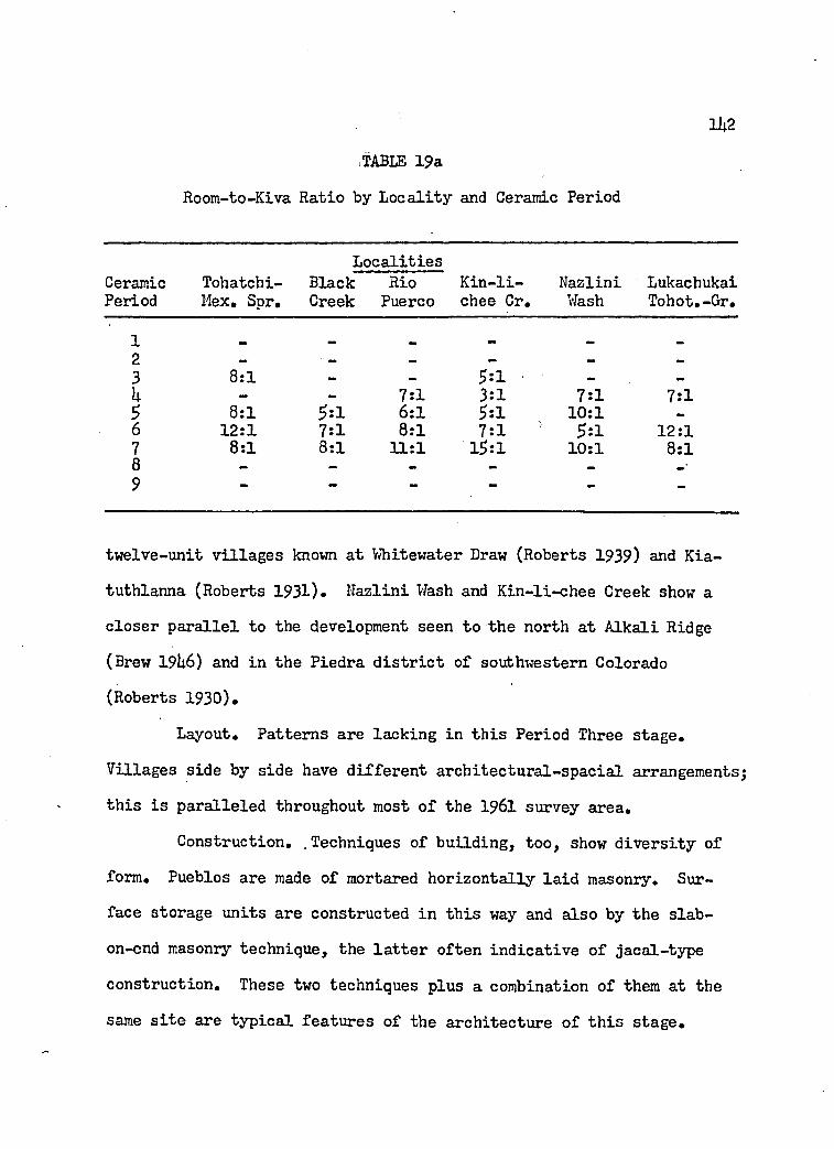
.TABLE 19a
Room-to-Kiva Ratio by Locality and Ceramic Period
Ceramic Tohatchi-Localities
Black Rio Kin-li- Nazlini LukachukaiPeriod Mex. Spr. Creek Puerco chee Cr. Wash Tohot.-Gr.
123 8:1 — — 5:1 — -
b — — 7:1 3:1 7:1 7:15 8:1 5:1 6:1 5:1 10:1 —6 12:1 7:1 8:1 7:1 1 5:1 12:17 8:1 8:1 11:1 15:1 10:1 8:18 - - - - - -•9 •* —
twelve-unit villages known at Whitewater Draw (Roberts 1939) and Kia-
tuthlanna (Roberts 1931)• Nazlini Wash and Kin-li-chee Creek show a closer parallel to the development seen to the north at Alkali Ridge
(Brew I9I46) and in the Piedra district of southwestern Colorado
(Roberts 1930).
Layout. Patterns are lacking in this Period Three stage.
Villages side by side have different architectural-special arrangements;
this is paralleled throughout most of the 1961 survey area.
Construction. . Techniques of building, too, show diversity of
form. Pueblos are made of mortared horizontally laid masonry. Surface storage units are constructed in this way and also by the slab-
on-end masonry technique, the latter often indicative of jacal-type
construction. These two techniques plus a combination of them at the
same site are typical features of the architecture of this stage.
1U3Orientation and Trash. Reed (1956: 11) states that through
out the Puebloan area surface rooms, pithouses, and refuse areas have
a front-to-back relationship, in the order mentioned. He does not
spell out, however, the specific directional orientations found associ
ated with this community pattern.The sample of this survey exhibits much less uniformity than
Reed's statements suggest for this stage. Pueblos often occur iso
lated, as do pithouses, and in most instances the trash is found in a thin mantle over the entire site. Only in Kin-li-chee Creek and
Nazlini Wash is trash found in mounds. The orientation of pithouses in these two localities is rather uniformly to the southeast.
Periods Four, Five, and Six
These three ceramic periods coincide with the Pueblo II stage
of the Pecos classification and with the Red Mesa and Wingate phases
set up by Gladwin (19L5).
Structures. During this stage the basic units of the com
munity are the pueblo, the kiva, and trash mounds throughout the
Puebloan culture area. Pithouses and earlier types of structures are present but rare.
In the eastern localities the transition from pithouses to
pueblos is completed at the beginning of this stage. Diversity still
appears in the western localities early in this stage. Pueblos are
the most numerous, but pithouses, surface storage units, and cists
sometimes occur. Later the shift is completed to a pueblo-kiva-
trash pattern. Pithouses are still present, but only rarely so.

Sherd areas, perhaps indicative of temporary seasonal com
munities, are important features of the early part of this stage in
the eastern localities.The lack of kivas in Tohatchi-Kexican Springs and Black Creek
during the early part of the Pueblo II stage may best be explained as
a sampling error. Kivas are present in all other areas throughout
this stage except during middle Pueblo II in Lukachukai-Tohotso-
Greasewood, certainly another sampling inadequacy. The general trend
seen throughout all localities is toward a higher ratio of domestic
rooms to kivas (Table 20, page 1U2). The only noticeable difference between east and west is a wider range of variation in the domestic
room-kiva ratio among the western sections than is found among the
eastern localities.Speaking generally for the Puebloan area, the room-to-kiva
ratio remained about the same or dropped just a little during the
Pueblo II stage (Steward 1955i Table U).
Great Kivas appear for the first time in about the middle of
this stage in Black Creek. Toward the end of this stage two Great
Kivas occur again at Black Creek. Two more Great Kivas are known
for the later part of this stage in Kin-li-chee Creek.
The origin and development of the Great Kiva complex is still
not completely understood. To date its earliest occurrence is in the
Mogollon culture area at Bluff Ruin (Haury 1950, Fig. 1), some 50 miles
southwest of the 1961 reconnaissance. In the Mogollon tradition there
are at least six other Great Kivas which pre-date the earliest examples

in the Puebloan area (Vivian and Reiter I960: 98)* Great Kivas are
not usually thought of as characterizing the Pueblo II stage of development, but they should be expected for Great Kivas make their
appearance at least as early as A.D. £00 during the Basketmaker III
stage at Shabik'eshchee Village (Roberts 1929: lU7)»Size. Small pmbios are the preferred community aggregation
throughout this stage in the eastern localities. Only rarely is a
site found with over 20 rooms. In the western localities small pueblos are also the dominant village size, but medium and large pueblos repre
sent from to U0 percent of the total.
This pattern of community size is similar to what has been
suggested for the Chaco Anasazi (Wendorf 195)6: 19) which consists of
a few fairly large villages located in particularly favorable areas and many widely scattered small pueblos adjacent to small plots of
arable land.
Layout. The population explosion which can be seen throughout
the Puebloan area during this stage is expressed in a great variety of
architectural ground plans. Generally the lineal pueblo is predominant,
while L-shaped and other more complex forms appear in greater frequency
as the stage develops. Diversity also increases through time. If
generalized patterns of layout have appeared in the Puebloan area
during this stage, they have not been recognized.
The details of this development have been spelled out earlier,
and there is nothing but agreement with the foregoing general state
ments concerning the Puebloan area as a whole.

Construction. The opening of this stage in the Pueblo culture
area sees the beginning of intensified use of masonry construction at
the expense of jacal and slab-rock building techniques. Jacal walls
are relatively common early in the stage, but fade in popularity and
are soon almost completely replaced by solid masonry walls.
It has been pointed out previously in this study that early-
appearing architectural forms never are completely forgotten but con
tinue to recur throughout later stages, along with newer forms. These
older-style structures are rare, however, and their occurrence suggests no significant cultural pattern.
Orientation, Trash, and Community Unity. Reed (1956: 11) has
suggested that the front-to-back village plan continues on with ever-
increasing rigidity, even when the pueblos have become larger and have kivas incorporated in the room blocks (late Pueblo I H and Pueblo IV).
The 1961 data confirm Reed's idea. This writer has referred
to the front-to-back relationship as a reflection of community unity.
This means that not only are the several village units in a general
alignment, but their individual orientation coincides more often with
all the rest than with any partial grouping. By far the most dominant
orientations are to the south and southeast. Almost all other pos
sible orientations occur but they never figure as dominant patterns.
The east orientation is the only one which occurs with a significant frequency.
Although of less importance numerically, the partial grouping
of pueblo-trash orientation occurs more often than the pueblo-kiva

grouping. Whether this fact has any cultural validity may be open to
question, since kiva identification can never be 100 percent correct
when based on survey data alone.
Period SevenThis period is equated with Pueblo III of the Pecos classifi
cation, and with the Hosta Butte Phase as revised by Vivian and Mathews
(1965: 108-11) from Gladwin’s original definition (19L5). For this period Vivian and Mathews, cited above, present three contemporaneous,
culturally distinct phases, each representing a different community
pattern. The large, multi-roomed pueblos such as Pueblo Bonito, Chetro
Ketl, Una Vida, and many others which are usually called to mind when
the Pueblo III stage is mentioned, represent the Bonito Phase. Along
with these larger towns coexist smaller villages such as Bc-50 and
Bc-5l (Kluckhohn and Reiter 1939) which represent the Hosta Butte
Phase. A third phase, the McElmo, represented by Kin Kletso and at
least three other sites in Chaco Canyon, is viewed as a site intrusion
of Mesa Verde peoples into the area and is contemporaneous with the other two phases.
Structures. As just described above, the community structures
for the Hosta Butte Phase in the Puebloan area are the pueblo and the
kiva. This pattern is found in both the eastern and western localities.
Whether the Hosta Butte Phase can be used with any validity, as it has
been redefined, beyond the eastern localities to include the western localities, only further work will tell.
Kivas and pueblos are constant companions throughout all areas
during this stage. The trend of increasing room-to-kiva ratio

1U8established during Pueblo II times continues in this stage also. The
increase appears to be one of less magnitude than it was earlier.
There is a decrease in this ratio in Tohatchi-Mexican Springs and
Lukachukai-Tohotso-Greasewood. The reversal of the increasing trend
in the latter locality is probably due to sampling error, but not in
the former. Western localities have a significantly higher room-to-
kiva ratio:than the eastern areas.
The summary presented by Steward (1955# Table 3) suggests that the room-to-kiva ratio more than tripled during Pueblo III. A
few pueblos are still found with nearly the same ratio as before.
Pueblos to the west and north of the 1961 survey area have a higher
room-to-kiva ratio than those to the northeast and southeast. This
fits the two patterns seen in the localities studied here, making
the Defiance Plateau a dividing line between them.
Great Kivas in the Chaco Canyon are architectural units of
the Bonito Phase (Vivian and Mathews 196$: 109). In the 196l survey
area Great Kivas occur only once each in Tohatchi-Mexican Springs and Black Creek.
The possibility that single Bonito Phase villages exist in an area surrounded by Hosta Butte Phase communities is an interesting
one. Immediately it suggests questions of social and ceremonial re
lations, trade, and land-ownership. Of course, there is a second
possibility and that is that these sites which have Great Kivas are
nothing more than partially acculturated Hosta Butte villages. But
if this is so, why are the two sites so widely separated? One would

expect the pattern to be present in Chaco Canyon if this were true.
This is not the pattern in Chaco Canyon where as many as two Great Kivas occur in the same pueblo. More problems arise than are solved
by this possibility.
Size. Small pueblos are the hallmark of Hosta Butte Phase
villages. This is also the preferred community size throughout both
eastern and western localities.Only in Rio Puerco and Kin-li-chee Creek do pueblos of over
21 rooms reach significant proportions. One pueblo of this size also
appears in Lukachukai-Tohotso-Greasewood.
Nearby, to the south, at sites reported by Roberts (1931,
1932), the number of rooms per pueblo range from five to 53• To the
north, in Chinlee Wash, Morss (1927) reports six villages of this
stage ranging from 15 to 30 rooms in size.
Layout. Hosta Butte pueblos of Bc-5>0, Bc-5l and Be-59 have a
"T", open "IP1, and "L" layout respectively (Bannister 1965, Figs. It,
6 and 7). All these layouts occur in the eastern localities, "L" and
"U" both being numerically important but "T" much less so. The pre
dominant layout, however, is the lineal or "I" type. In the western localities "I" is universal to all, but important only in Kin-li-chee
Creek. Little other uniformity in layout can be seen in western lo
calities. Kivas are incorporated within the room blocks, but there
are no enclosed or formal plazas (Vivian and Mathews 1965: 109).
Internal kivas are found in both eastern and western localities during this stage.

Orientation. Bc-50 and Bc-5l both have an eastern orientation
and exhibit some community unity (Bannister 1965, Figs. U and 6).Bc-50 has all its kivas on the east side of the room block, while
Bc-5l has only three of its six kivas on the east side of the pueblo.
An eastern orientation pattern is found in all eastern lo
calities but is important only in Tohatchi-Mexican Springs. The most universally preferred orientations in the eastern localities are south
and southeast while in the western, south is the most frequent orientation.
Trash. In Chaco Canyon at Bc-50 and Bc-5l (Kluckhohn and
Reiter 1939, Map 1), sites typical of the Puebloan community pattern
for this period, the trash is mounded up between the two narrowly-
spaced pueblos. Trash occurs in localized, irregular mounds in the
eastern localities much more often than the scattered rubbish disposal
pattern. Trash mounds are the most popular disposal pattern in the
western localities also.
Community Unity. As seen earlier in the Pueblo II stage, com
munity unity in the eastern localities is high. The concurrence of
similar orientation of all three community units is more than twice as popular as any other partial unit.
The partial site grouping of pueblo-trash with a similar
orientation is the most important theme in the western localities. Period Eight
No communities assignable to this period were located by the 1961 reconnaissance.
150

151
Period NineIn the Pecos classification this period is represented by the
Pueblo V stage. In the area of the 1961 reconnaissance, the Puebloan tradition has come to an end and no longer appears. Its place is
taken over by a completely new and different cultural tradition— the
Navajo. Whether the Navajos were the cause of the Puebloan withdrawal
from this area as part of more widespread phenomena is still debated
(Jett 196U, Ellis, 196U, Davis 1965, Vivian and Mathews 1965: 111-2). Most students of Southwestern prehistory consider the matter still open
to question.
It appears that sometime soon after A.D. 1500 (Hester 1962),
Navajos occupied the area of the 1961 survey. One Navajo site in
Nazlini Wash (Arizona K:3:5l), has at least four tree-ring dates
which suggest that it was constructed about 1?65 (Hannah 1965).
Structures. Most of the Navajo habitations located in the 1961
survey area can be found in the Navajo culture trait list compiled by
Hester (1962, Table III). Hester does not mention, however, the reoccupation by Navajos of earlier Puebloan cliff houses or masonry
hogans within rockshelters, as habitation types. Both of these habi
tation types are common throughout the eastern and western localities.
The occurrence of a fortified butte site (Arizona K:3$5l)> with tree-ring dates, suggests that this architectural development, probably
representing fortification against Shoshonean-speaking peoples, lagged
about I4O to 50 years behind its beginning in the Gobernador district to
the northeast (Carlson 1965: 100).

152
Size. The modal Navajo community is from one to four habita-
tional structures, although UO-room pueblitos are known (Hester 1962:
31). The community size in the 1961 survey area is well within the
limits suggested by Hester, although the norm is closer to the lower
limit than the higher.
Layout. In both the description by Hester (1962: 31) and the
sample presented here, habitations are freely combined and tend to be
scattered over the landscape rather informally. Local adjustments
were made to take advantage of some natural feature of the environment.
Orientation. The doorway of forked-stick hogans opens to the
east, southeast, and sometimes the northeast (Hester 1962: UO). In
other hogan types doorways were not always positively identified.
Where identification was possible the doorway always opened to the east.
Trash. Low mounds of trash lying three to 30 feet from the
hogan is given by Hester (1962: kl) as the preferred rubbish disposal pattern. No orientation from the hogan is given.
In the data collected during the 1961 survey, Navajo refuse
disposal pattern was found to be a thin mantle or sheet over the whole site. Rarely was trash localized.
Community Unity. Navajo villages show very little structural
intercommunity relatedness in terms of special position as the term has been utilized here.
Settlement Pattern
In the Southwest, as Haury (1956: L-5) has pointed out, human populations have settled themselves over the ground primarily in

I
response to water resources. This arid land does not allow for a casual or random settlement. Regardless of the physiographic situa
tion, the availability of a dependable water source is the first
requisite for human settlement and occupation.
Land for cultivation, of course, is a second indispensable
factor for the effective establishment and maintenance of an agricultural people such as the puebloans. Good lands throughout this
area must have been at a premium, particularly during periods of
greater population. Adequate lands for cultivation are not overly
abundant in the Puebloan area even today. Large-scale agriculture
has failed to develop here in spite of modern technology. It would
seem that early in Puebloan history the people learned or discovered
how to most effectively cultivate their land and then expanded under
more favorable environmental conditions into areas which today are
unexploitable for agricultural purposes.
There are other factors which must also be considered when discussing cultivation in the Puebloan area. One of the most im
portant of these is temperature. A recent study at Mesa Verde (Fritts,
Smith and Stokes 1965) has demonstrated that growth in trees is most
affected by changes in available moisture and temperature, the former being more important than the latter. Among the climatic conditions
listed by these same authors which produce less growth in Douglas-fir
is a dry, cool spring (Fritts et al 196$: 120). It seems a reasonable
hypothesis to suggest that flora other than trees may be affected in
the same way trees are by similar climatic conditions. In any case
153

15Uthe effect of less moisture and a more limited growing season would
be hazardous to any cultivated crop.
The relationship between temperature and altitude and their
effect on the length of the growing season has already been spelled
out in more detail in the section on Environment. To reiterate,
throughout most of the 1961 survey area the growing season is very
short, so short that there is practically no assurance that crops
sill mature. This entire area is close to the limit beyond which
agriculture is not dependable.
Water, land, and temperature appear to be the three critical
factors which influenced prehistoric demography. What reflection of
these factors can be seen in the sample gathered in 1961? First,
communities are located along the sides of long, broad river valleys
which have a large catchment basin or have perennial streams passing
through them. Villages are also found near the mouths of both large
and small sandstone canyons, where the water supply was constant.
Secondly, communities are built on hills and ridgetops, next to but
not occupying lands favorable for cultivation. Perhaps just as im
portant a reason for the occupation of natural rockshelters in the narrow sandstone canyons was the need for every available portion of
the canyon bottom for agricultural pursuits. Thirdly, permanent pre
historic habitations are not regularly found above the contour level
of 7,000 feet above sea level. Above this point the latest frost of the spring and earliest frost of the fall season so shorten the
growing season that agriculture is not possible.

PopulationIn the chapter on population in this study the utility of
demographic patterns for limited areas was pointed out. It was also
shown that the results of the analysis of data collected by means of
an archaeological survey has a fair amount of reproducibility. The
patterns appear consistent and therefore valid. One is still unable
at this point to speak of fluctuations of actual numbers of individu
als. However, this is no deterrent to making inferences about demographic trends.
Many archaeologists in the Southwest have developed population
methodologies (Colton 1936, I960; DeHarport 1959; Dittert, Hester and
Eddy 1961; Longacre 196U; Pierson 1959, unavailable for use in this summary; Schwartz 1956; Turner and Lofgren 1966). Most of these at
tempts at prehistoric population reconstruction are based on a method
ology similar to the one used here, with slight variations. Schwartz
(1956) presents the simplest analysis based on site frequency alone.
Turner and Lofgren1s (1966) complex formula is based in part on Col
ton's (i960) archaeological data and in part on their own determina
tion of the nuclear family size based on prehistoric puebloan pottery vessel volume.
The population trend each author proposes will be used without
making a critique of his demographic study. Each is accepted as a
working hypothesis for the area concerned, to be compared with the
population trends of the 1961 reconnaissance area. The interest here is not with the fluctuations of actual population totals through time,
but with the general patterns formed by changes in the population.

156
The comparison of some population patterns available in the
literature of the Puebloan area of the Southwest with that presented
here for the eastern localities of my reconnaissance area shows one
distinct difference (Fig. 9)» The population peak, found in Pueblo II
in the eastern areas appears only in the Tsegi Canyon and Cohonina
area according to Colton (i960: 105) and Schwartz (1956). Dean (1966)
states that this is not the actual case for the Tsegi Canyon. The
population peaks occur there during the Basketmaker Ill-Pueblo I transition and in the late Pueblo III stage. The Cohonina figures
do not take community size into account; therefore, the similarity
of them to the trend of the eastern sections, although apparent, may
not be an actuality. In all areas where continuous occupation has
been suggested, the trend of increasing population reaches a peak
during Pueblo III or later. Only in the Central and Western Arizona
area (Fig. 9), is there a similar trend. Colton’s use of figures
obtained from a rough calculation of population density probably
invalidate these results.
The decline in population in the eastern localities during early Pueblo III coincides neatly with a decline of more than 25 percent of the population during the same period in Chaco Canyon (Vivian
and Mathews 1965: 108). It appears certain that the reduction of
population to almost zero by A.D. 1300 in the eastern areas is inti
mately connected with the more general abandonment of a much larger
area to the east, including Chaco Canyon.The western localities exhibit a trend of increasing popula
tion up to and including Pueblo III, although the increase is not as

157dramatic as in the adjacent areas. All areas of comparison adjoining
the western border of the western localities, except the Vernon
district to the south, show more similarity with the western sections
than with the eastern districts. This is expectable in view of the
areas geographical proximity. The western districts were also aban
doned by at least A.D. 1300.
In view of the reaffirmation of the "Great Drought" from A.D.
1273 through 1285 (Fritts et al 1965: 121) and the companion effect of a shortened growing season, there seems to be ample reason to recon
sider the hypothesis that a climatic change greatly influenced the
abandonment or reduction of the Puebloan culture area at this time.

CONCLUSIONS
Hypotheses Developed
The general overall pattern of Puebloan culture history has
been established for many years. The first formal recognition of this
distinctive pattern was in 1927 at the original Pecos conference
(Kidder 1927).Knowledge concerning the evolution of Puebloan history has
grown yearly as more excavation and reconnaissance has been accom
plished. Since the area of the 1961 survey is not surrounded by an
archaeologically unknown region, a general synthesis will not be pre
sented here.
Today many details of Puebloan cultural growth and development
are known, but even more problems remain to be solved. Multiple
working hypotheses (Chamberlin 1965) can be defined which have as
their goal the explanation of certain problems in Puebloan history.
The hypotheses have been developed from inferences which arose in the
discussion of the data in the Comparative Analysis section of this
study. Hypotheses resulting from an analysis of these data will be
stated briefly and will not be accompanied by further documentation.
The following is not intended to be an exhaustive list of hypotheses
concerning Puebloan evolution, but only some which may be profitably
tested in the southeastern portion of the Navajo Indian Reservation.
158

1 #The hypotheses are organized under the categories of Ceramics,
Community Pattern, Settlement Pattern, and Population.
Ceramics
Plain Brown and Plain Gray Ware
1. The association of Lino Gray pottery with plain brown
pottery represents a trade situation between two prehistoric groups.
2. The association of Lino Gray pottery with plain brown
pottery represents a peaceful coexistence in close proximity of two prehistoric groups.
Organic and Inorganic Painted Black-on-white Pottery
1. The ceramic attribute of inorganic pigment is a trait
which occurred first in the eastern localities and diffused northward
slowly to the western localities.
2. The people of the western sections were conservative and
resisted the introduction of inorganic pigment.
3. Inorganic painted pottery was the impetus for organic painted pottery.
U. Peoples using organic pigment did not successfully reside
among peoples using inorganic pigment in the Pio Puerco area because of inter-community strife.
5>. The influx of small quantities of organic pigment painted pottery into eastern areas is explained by trade with the western localities.
6. The influx of small quantities of organic pigment painted pottery into the eastern localities can be explained by trade with

l6oformer Mesa Verde peoples present in Chaco Canyon.
7. The prehistoric peoples from the eastern areas began to
accept the organic pigment tradition from the western localities.8. The southern movement of the organic pigment tradition
is intimately linked to a similar movement of Mesa Verde and eastern
San Juan peoples.Red Wares
1. The area in which the White Mountain Red Ware series
pottery was made includes all eastern localities and Kin-li-chee Creek of the west.
2. All eastern localities and Kin-li-chee Creek received
White Mountain Red Ware pottery as trade from a nearby area.
3. Wingate Polychrome has a different chronological occurrence than St. Johns Polychrome.
U. Peoples in the Tohatchi-Mexican Springs had a preference
for Wingate Polychrome over St. Johns Polychrome.Orange Ware
1. Black Creek and Rio Puerco maintained trade relations to the west during Period Seven.
2. Kin-li-chee Greek and Nazlini Wash maintained trade relations to the north during Periods Five through Seven.
Historical Puebloan and Navajo Pottery
1. Navajo peoples in the western localities were less re
ceptive to foreign influences than Navajo peoples in eastern areas.
2. Navajo peoples in the western areas were in more limitedcontact with foreign influences than Navajo peoples in eastern localities.

3. Navajo peoples in the western localities had more limited
means with which to acquire Puebloan goods than Navajos in the eastern
localities.
Community Pattern
Period One and Two
Structures. 1. Pueblo architecture did not originate within the area of the 1961 survey.
2. Surface storage units did not originate within the southeastern portion of the Navajo Indian Reservation.
3. Surfact storage units were probably an in
novation of peoples in a region to the south or east of the area of the 1961 reconnaissance.
U. The acceptance of surface storage units was
resisted by people in the western localities.
Trash. 1. The trait of disposing of trash in a mound
is of southern origin, outside the area of the 1961 reconnaissance. Period Three
Structures. 1. The shift of domestic structures from a
below-ground location to an above-ground position occurred at the end of this period, not at the beginning.
Size. 1. The introduction of pueblo architecture was
first into Tohatchi-Mexican Springs from an unidentified source farther east or south.
2. People in the western localities resisted
the introduction of pueblo architecture.
161

1623. The maximum kinship unit on the community
level is the extended family.
Orientation and Trash. 1. This is a period of great change
in the eastern localities.
2. The western localities show
considerable social cohesion, resisting innovations.Period Four, Five, and Six
Structures. 1. The shift of domestic architecture from a
position below the ground to a position above the ground was completed early in this period.
2. Social cohesion is at a maximum in spite of
the population explosion characteristic of most of this period.
3. The source area for the introduction of the
Great Kiva complex was to the southwest of the 1961 reconnaissance area.
Size. 1. Small village units are the typical communitysize for this period in all localities.
2. The social environment of the community was rural rather than urban in nature.
Layout. 1. Cultural patterns have not stabilized.
2. Community plan or layout does not reflect the level of social integration in this period.
Construction. 1. Jacal has been replaced by masonry as a preferred building technique.
Orientation, Community Unity and Trash.
1. The people of the eastern localities had a high level of social integration.

1632. The people of the western localities had a
high level of social integration but topography confused the situation
by conditioning the community pattern.
Period Seven
Structures. 1. All sites in the eastern localities are of
the Hosta Butte phase as newly defined by Vivian and Mathews (196$).
2. Great Kivas are characteristic architectural units of the Bonita Phase as defined by Vivian and Mathews (196$).
3. Small Bonita Phase communities exist widely
scattered among contemporaneous Hosta Butte communities.
U. Small communities with Great Kivas are
partially acculturated Hosta Butte Phase communities.
Size. 1. Small villages are the typical community
size for all localities during this period, although larger pueblos
begin to appear in Kin-li-chee Creek.
2. The social environment of the community was
rural rather than urban in nature in all areas.
Layout. 1. Lack of homogeneity in the western localesis a function of the topography and not of social disorganization. Period Eight
1. All localities are abandoned by Puebloan peoples during this period.
2. The first appearance of Navajos in both eastern and westernlocalities is during this period

16U
Period Nine
Structures. 1. Navajos moved into the eastern and western
localities as a result of pressure by other hostile groups.2. The Navajo adopted Puebloan architecture and
combined it with a geographical position of difficult access for pro
tection.Size. 1. The Navajo socio-religious system did not
reach its present level of complexity and integration until late in "
this period.
Settlement Pattern
1. Temperature, water resources, and productive farm land are
three interrelated environmental factors which limited and conditioned
prehistoric human occupation of all localities through time.
Population
1. The environment restricted human expansion in the western
localities much more than it did in the eastern sections.
2. The environment of the eastern localities had a potential
which allowed the expansion of human populations, sometimes drasti
cally, when triggered by a special set of factors.
3. The population explosion which occurred in Period Five in
the eastern localities was triggered by more favorable climatic conditions.
iu The abandonment of the southeastern portion of the Navajo
Indian Reservation in the Thirteenth century by Puebloan peoples is

165part of the abandonment or reduction of the Puebloan culture generally
throughout the Southwest.5. A prime factor in the abandonment of the 1961 area of
survey was a drought and an accompanying growing season which occurred
between A.D. 1273 and 1285.
Recommendations for Testing Hypotheses
The ultimate function of a reconnaissance, as suggested in the
introduction of this study, is to recommend sites to be investigated
in detail. The series of sites to be recommended for more intensive
work should fill these three requisites: (l) the series must present
the full temporal and spatial range of the culture history of the area
under consideration; (2) they must contribute to the testing of hy
potheses developed during the analysis of the survey data; (3) they must contain the possibility of discovering a new set of data.
There are, of course, practical aspects of selecting sites
for excavation, such as finance, accessibility, and practicality, which
are just as important as the research design to be used. For the sake
of simplicity the practical factors will be ignored here.
The physical impossibility of excavating all 799 sites located
by the 1961 survey must be apparent. We must select out of this uni
verse, then, a sample which will fulfill, in its entirety, the three
requirements outlined above. This sample must be a reliable one, one
which has reproducibility. In order for the sample to be statistically
reproducible it must be a random sample.

166It has been shown throughout the analysis of the 1961 survey
data that the southeastern portion of the Navajo Indian Reservation
can be divided into at least two parts. These two regions have been
constantly referred to as the eastern and western localities or areas.
This is only one example of the. heterogeniety of the region involved.
A recent critique of archaeological methodology (Binford 196L)
has suggested a technique of sampling which increased the reliability
of a random sample from a heterogeneous universe. This is known as
the method of stratified sampling (Binford 196L: U29). The manner in
which this is accomplished is to divide the universe into classes,
each of which is treated as a separate and independent sampling uni
verse from which a simple random sample is collected.
The application of stratified sampling to the 1961 survey data
may be carried out in the following manner. The universe may be di
vided into six classes, one for each locality defined above. Each of
these localities was shown to have some internal geographical unity.
This is another good reason for considering them separately. The resulting six populations may then be sub-divided into nine classes on the basis of the Ceramic Periods. Every component located by the
survey is then assigned to one of the 5U different populations. The
procedure is to select in a random manner, one-by-one, each component
from one population, identifying it serially from one to (n). Next
the desired size of the component sample must be determined for the
population. Last, using a table of random numbers, select a number
of components equal to the desired sample size. This, then, can be repeated for each of the remaining 53 populations.

167
The random sample extracted from the universe in this manner
can be expected, within a range of probability, to: (l) express the
full temporal and spatial range of the culture history of the south
eastern portion of the Navajo Indian Reservation; (2) test any and
all hypotheses developed in the analysis of the survey data; (3) con
tain the possibility of discovering a new set of data.Due to the limitation of my time, I am unable here to follow
through the technique of stratified sampling for the lp6l data as just
recommended. This final step is one which anyone could do and its results would be of interest only to someone who is actually contem
plating further research in the southeastern portion of the Navajo
Indian Reservation.
The limitations of the archaeological reconnaissance as a tool
for the study of culture history have been emphasized throughout this
report. This does not mean, however, that this tool is untrustworthy
nor useless. Recognizing biases and methodological limitations is a
key factor in any objective study and has been pointed out here to caution against a false sense of security.
An archaeological reconnaissance should not be considered just
a way of becomming familiar with an unknown area. This methodology has potentialities which far out-weigh its limitations, if the original research design is formulated not as an end in itself, but as a
systematic beginning to the study of an unknown area.
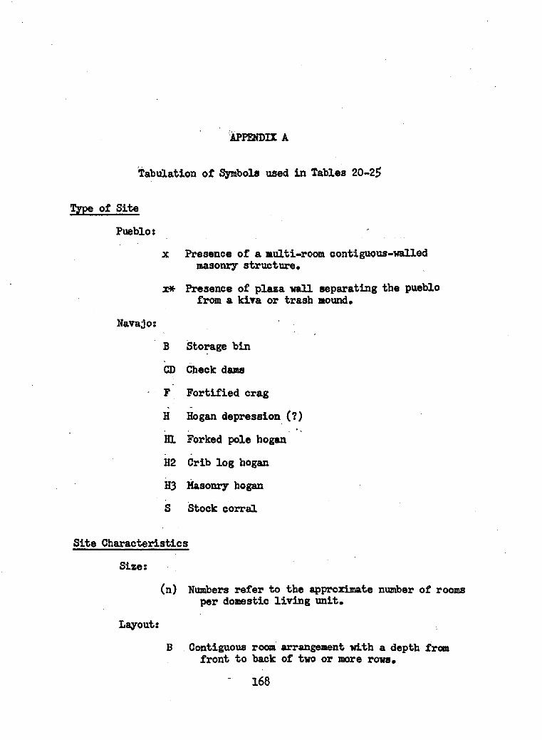
APPENDIX A
Tabulation of Symbols used in Tables 20-25
Type of Site
Pueblo:
x Presence of a multi-room contiguous-walled masonry structure,
x* Presence of plaza wall separating the pueblo from a kiva or trash mound.
Navajo:
B Storage bin
CD Check dams
F Fortified crag
H Hogan depression (?)
HI Forked pole hogan
H2 Crib log hogan
H3 Masonry hogan
S Stock corral
Site Characteristics
Size:
(n) Numbers refer to the approximate number of rooms per domestic liv ing unit.
Layout:
B Contiguous room arrangement with a depth from front to back of two or more rows.
168

169C Pithouses or surface storage units arranged in
a crecentic arrangement.
E Contiguous room series in a form of an "E*. Open side always faces the orientation.
I Lineal arrangement of either contiguous rooms, pithouses or surface storage units.
L Contiguous room series in the form of an "L" or "V".
3 Single scattered units irregular as to layout.
T Contiguous room series in the shape of a nTrt.
U Contiguous room series in the shape of an inverted •’U".
Construction:
M Dressed sandstone masonry,,often coursed.
S Slab masonry, slabs always on edge
Orientation:
Letters refer to the direction the domestic unit is
facing. Letters give general compass bearings.
Kiva:
Letters HE, E, SB, S, SW when alone refer to the
general compass position of the small kiva depression
(3 to 6 meters in diameter) to its associated domestic
structure. When the same letters are prefixed by the
letters GK they refer to the orientation of a Great
Kiva (15 to 25 meters in diameter). C refers to kiva
located within the room-block.
Trash:
x Presence of non-localized sheet trash.

170Letters refer to the general compass heading the
mound has in relation to the domestic structure.
Physiography:
A Narrow valley or canyon bottom, sites away from valley sides.
B Hillsides flanking the valleys, cover usually low.
C Ridge or hilltops, low to medium t a l l cover.
D Low rolling h ills or dunes, usually well out on the valley floor.
E Valley floor, over f la t terrain.
F Alcove in c l i f f or at the foot of sandstone bluffs.
F I C liff location, off the ground.
F2 A site combination of both F and F I.

TABLE 20 •Structural Data of the Tohatchi-Mexican Springs Locality
2 3 U 5
Sites
6in New Mexico G:l:
7 8 9 10 11 12 13 ia 15
Type of Site
Pueblo X X X X X
Pithouse X X X X X
Cists X X X X X X
Surface Storage X X X X X
Sherd Area
Navajo H3
Size 1-2 1 2 1 1 6-8 3-5 3-5 2-U 3-k U-5 1 2-3 2-ULayout I ? I ? ? C I I I C i I I
Construction M S M S S S M S S S s M M M
Orientation S E E ? SB S s B E SB E SW E
Kiva ?
Trash X X X X X X SB X X X X X X X
Physiography A A A A A A B c C C c D D D

TABLE 20 — ContinuedStructural Data of the Tohatchi-Mexican Springs Locality
16 17 18 19
Sites
20in
21New Mexico 0:1:
22 23 2k 25 26 27 28 29
Type of Site
Pueblo X X X X X X 2 X X
Pithouse X X
Cists
Surface Storage X
Sherd Area X X X
Navajo
Size 2 1-3 3-h 3-h 2-3 6 7 Uo-5o 6-8 ? 6-8Layout I . I I I I U L L,U I ? I
Construction M s M M M M M M S M M
Orientation E B E E E SB SE E,SE SE ? SE
Kiva SB SB E E,SE SE
Trash X X X X X X X X SB SB E,SE X X SB
Physiography D C C G C C G B D D D D D D

TABLE 20 — Continued
Sites in New Mexico 0:1:
____________________ 30 31 32 33 3k 35 36 37 39 39 ho hi 1:2 U3
Type of Site
Pueblo x x x x x x * x x x x x x x x
Pithouse
Cists
Surface Storage
Sherd Area
Navajo
Structural Data of the Tohatchi-Mexican Springs Locality
Size 12-16 6-8 6-8 6-8 3-U 6-8 10-12 2-3 I4-6 2-7 6-8 6-9 10-12 U-6Layout L U ? I I U L I I I I I I U
Construction M M M M M M M M M M M M M M
Orientation SB SB ? SB SB SB SB S SB SB SB SB SB SB
Kiva SB S X SB S SB SB SB SB SB S SB
Trash SB s X SB SB E X SB SB SB SB SB SB
Physiography D D D D D D D D D D D D D D

TABLE 20 — ContinuedStructural Data of the Tohatchi-Mexican Springs Locality
au U6 a?Sites in New Mexico
aa a? so siG;l:
52 53 5a 55 56 57Type of SitePueblo X X * X X X X X X X
Pithouse X X X X X
Cists
Surface Storage X X X X X
Sherd AreaNavajo
Size 10-12 10-12 6-8 12-lU 12-ll| 7-8 9- U 8-10 6-8 6-7 5-6 3-5 a-6 2-aLayout L U U u u U L L I C l . I i i
Construction H H M M M M M M M s s S s SOrientation E SB SB B SB SB SB E SB SB s E SB SB
Kiva E SB ? E SB SB SB E SB
Trash E SB SB E SB SB SB E SB SB s X X X
Physiography D D D D D D D D D C c E C c

TABLE 20 — ContinuedStructural Data olf' the Tohatchi-Mexican Springs Locality
58 59 60 61Sites in New Mexico Gil:62 63 6h 6$ 66 67 68 69 70 71
Type of Site
Pueblo X X X X X X X X X X X *
Pithouse X X
Cists
Surface Storage X X X
Sherd Area
Navajo
Size 10-12 6-8 3 6-8 U-6 7-8 10-12 6-8 8-10 2-3 16-18 10-12 10-12 10-12
Layout I U I I L L U U U I I u L LConstruction S M S M M M M M M S s M M MOrientation s? s s SB E E SB SB E SB SB NE NE E
Kiva ? E SB SB E MB NE E
Trash X s X SB E E SB SB E SB SB NE NE NE
Physiography c c c D D D D D D D D D D D

TABLE 20 — ContinuedStructural Data of the Tohatchi-Mexican Springs Locality
Sites in New Mexico G:l: Sites in New Mexico 0:2:72 73 7k 7$ 76 1 2
Type of Site
Pueblo
Pithouse
Cists
Surface Storage
Sherd Area
Navajo
X X X X X
Size k-6 10-12 k-6 3-k 6-7 2Layout L L I I L IConstruction M M M M M S MOrientation E SB S S E S S
Kiva E SB S S NE GK
Trash E SE s SB SE X X
Physiography D D D ’ D D c C

TABLE 20 — ContinuedStructural Data of the Tohatchi-Mexican Springs Locality
Sites in New Mexico G:5:1 2 3 h 5 6 7 8 9 10 11 12 13 i a
Type of Site
Pueblo % X X X X X X X X X
Pithouse X X
Cists
Surface Storage
Sherd Area X X X
Navajo
Size 25-3$ 10-lU 10-12 15-18 5 7? 2 2-U 1-2 6-8 10-12
Layout L u I L i I I I-S I U L
Construction M M M M M S S M-S M M M
Orientation SB SB SB SB S S S S B
Kiva 3SE SB SB ?
Trash E SB SB SB X X X X X SB SB
Physiography C C C C c B B D D C B c D D

TABLE 20 — ContinuedStructural Data of the Tohatchi-Mexican Springs Locality-
Sites in New Mexico G:5>:1$ 16 17 18 19 20 21 22 23 2k 2$ 26 27 28
Type of Site
Pueblo x x x x x
Pithouse
Cists
Surface Storage
Sherd Area
Navajo
Size 10-12 16-18 6-7 1 6-8
Layout C L L 7 L
Construction M M M M M
Orientation E E B E
Kiva E NE E NE
Trash B B E X E
Physiography D D C C D
X X X X X X
X X X -
X
X X
6-8 lt-5 3-U 7-9 2-lt 3-lt U-6 6-8 10-12
I L I L I L u U I
S S S M S M M M M
SB S S E S E B NE SE
SE B E NE SE
SB S S E s X E NE SE
C C c C c E c B D

TABLE 20 — ContinuedStructural Data of the Tohatchi-Mexican Springs Locality
Sites in New Mexico G:5>:29 30 31 32 33 3U 3$ 36 37 38 39 UP kl U2
Type of SitePueblo x x* x x x
PithouseCists
Surface Storage Sherd Area Navajo
Size 2-3 10-12 15-20 6-8 ?
Layout I V I U
Construction M M S M MOrientation B SB S SBKiva SB SB
Trash E SB s SE X
Physiography D D D B C
X * % X X * X X X X X
13-15 U-6 18-22 20-26 8-10 6-8 15-20 3-U 10-12u I I L F L E L LM M M M M M M M ME E SE E SE S SE E EE SE 3SE 2SE S 2SE SBE E SE NE,SE SE SE SE E BC C D D C C C C C 6L
T

TABLE 20 — Continued
Sites in New Mexico G:5>:_ _ _ _ _ _ _ _ _ _ _ _ _ U3 hh h5 h6 hi U8 h9 5o 5l 52 53 58Type of Site
Pueblo x x x x x x x x x x x x *PithouseCists
Surface Storage Sherd Area
Navajo
Structural Data of the Tohatchi-Kexican Springs Locality-
Size 6-8 6-8 6-8 lt-6 3-k 3-£ U-6 6-8 U-6 10-12 10-12 5-7Layout I L L L I l I I U I u U
Construction M M M M M M M M M M M MOrientation S S S S S S SB SB S SB SB E
Kiva s S S s S S SB SB s SB SB ETrash s SB S s SB SB SB SB s SB SB EPhysiography c c C C C 0 C C C C C B

TABLE 21Structural Data of the Black Creek Locality
Sites in Arizona K:U:1 2 3 4 2 6 7 8 9
Type of Site
Pueblo
Pithouse
Cists
Surface Storage
Sherd Area
Navajo CD
Size
Layout
Construction
Orientation
Kiva
Trash
Physiography A
x
H3 H3 H2
M M M
E E E
A B D D
X X X
sw
X
F F F A
10 11 12 13 1U
X X X X X
F F E C C

TABLE 21 — ContinuedStructural Data of the Black Creek Locality
15 16 17 18Sites in Arizona KzU:
19 20 21 22 23 2k 25 26 27 28
Type of Site
Pueblo X X X
Pithouse X X
Cists
Surface Storage
Sherd Area X X X X X X X X •
Navajo S H
Size 3-U 7 3 2 3? 2+
Layout I ? I I S
Construction H M M
Orientation SB s SB E E E7
Kiva
Trash SB 7 X X X
Physiography F C E F E E E F F FI C C F B
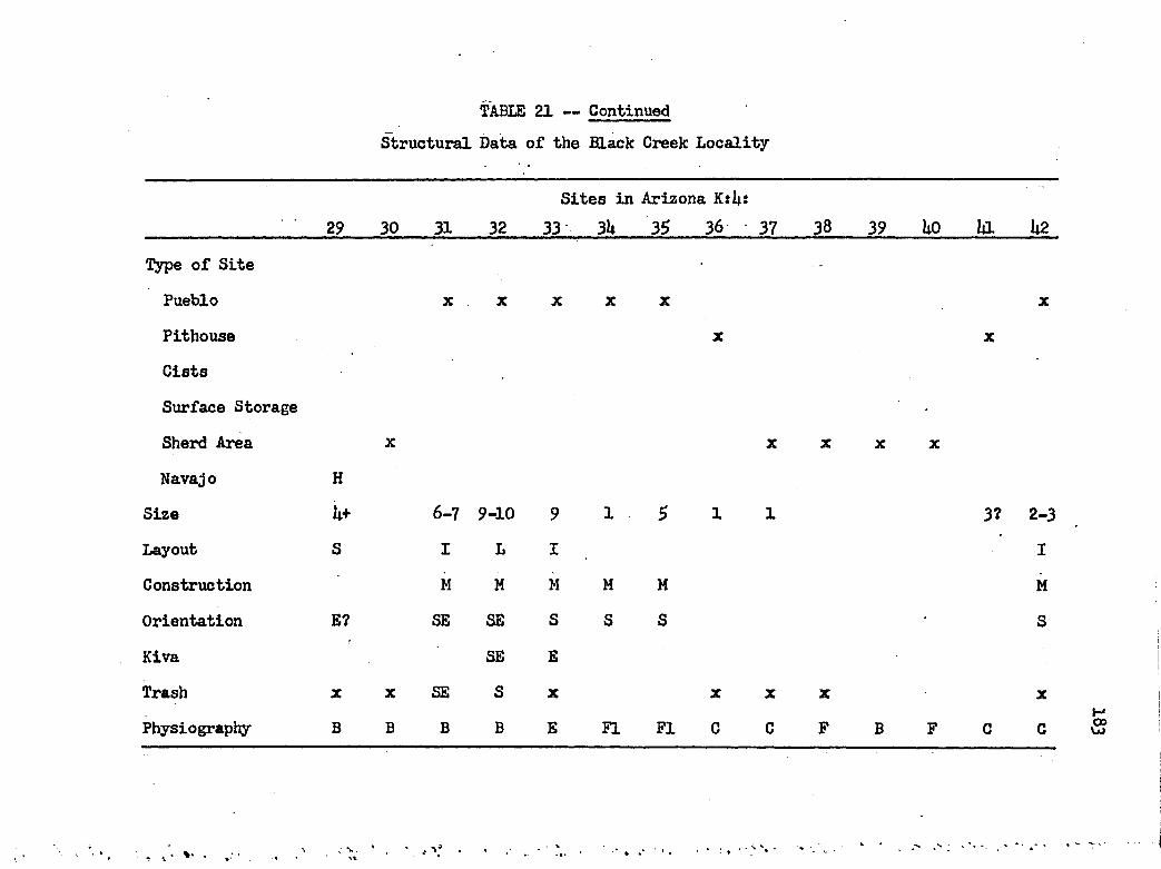
TABLE 21 — ContinuedStructural Data of the Black Creek Locality
Sites in Arizona K:ii:29 30 31 32 33 3U 35 36 37 38 39 Uo a U2
Type of Site ' ....
Pueblo X X X X X X
Pithouse X X
CistsSurface Storage •Sherd Area X X X X X
Navajo H
Size U+ 6-7 9-10 9 1 5 1 1 3? 2-3
Layout S I L I IConstruction M H M M M MOrientation E? SB SE S S S • SKiva SE E
Trash X X SE S X X X X X
Physiography B B B B E FI F I 0 C p B F C CH8

TABLE 21 — ContinuedStructural Data of the Black Creek Locality
Sites in New Mexico G:£:5U $6 57 59
Type of Site
Pueblo
Pithouse
Cists
Surface Storage
Sherd Area
Navajo
Size 1-2 U 8-10 it-6 6-8 2-3 2 8-10
Layout I i L I L I L
Construction S M M M M M M M
Orientation E S S B B S SE
Kiva 2S E SE
Trash X SE S S SE S S
Physiography C C C D £ E FI £
Sites in Arizona K:8: 1 2 3 U
?
X X X X
3?
I
S
S
F F C C

TABLE 21 — ContinuedStructural Data of the Black Creek Locality
5 6 7 8Sites in Arizona K:8:
9 10 11 12 13 1U 15 16 17 18
Type of Site
Pueblo X X X X X X X
Pithouse ? ? ? 7
Cists
Surface Storage
Sherd Area X X X X X X X
Navajo
Size 1-3 8-9 - u 2? 2? 1? 6 3-6 1-3 2-3
Layout T I I I I I I
Construction M M H M M M
Orientation SB S s E £ S s • S S
Kiva SB 3S 7 ? S S
Trash SB s S B S s X
Physiography C c C C C D F F E E FI C c C

TABLE 21 — ContinuedStructural Data of the Black Creek Locality
Sites in Arizona K:8:21 22 23 2h 2$ 26 27
Type of Site Pueblo
Pithouse Cists
Surface Storage
Sherd Area Navajo
X X X X X X X
Size 2-3 2-3 U-6 2-3 6-7 3 7-10 It-S h 2-3 1-2 3-U10-12
1 2-3
Layout I I I I L I U L I I I I ,L I
Construction M M M M M M M M M M M M M M
Orientation S SB S S s S S SB S S SB SB
Kiva S S S 2? S SB S S SB SB
Trash S SB S sw X X S SB X s X E,SE X NB
Physiography c C E F F B C C C c C C E C

TABLE 21 — ContinuedStructural Data of the Black Creek Locality
33 3U 35 36
Sites in Arizona K:8:
37 38 39 liO Ui U2 U3 UU U5 U6Type of Site
Pueblo X X X . X X X X X X X X
Pithouse
Cists
Surface Storage
Sherd Area X X X
Navajo
Size 12-16 5 14-5 5-7 3-U u 3-U 10-12! 20 8-10 3
Layout T i I u I I I L L I I
Construction M • M M H M M M M M M M
Orientation E S S SB SB SB S B SB SB SB
Kiva 3E s S SB SB B SB 2SE2GK,SE
Trash ME s S SB SB SB X X B X X
Physiography C c c C C C C C B C C C C C 3

TABLE 21 — ContinuedStructural Data of the Black Creek Locality
Sites in Arizona K:8:U7 U8 U9 5o 51 52 53 5U 55 56 57 58 59 60
Type of Site
Pueblo X X X X X X X X X X 3PithouseCistsSurface Storage
Sherd Area X X X
NavajoSize 1-3 3-U 2-3 h 7 2-3 3 2-3 3-ii 3-U 10Layout I I I I I X I I LConstruction M M H M M M M M M M MOrientation S S SE SE E SE SE S SKiva SB s 28Trash X S S SE S SE E SE SE SE SPhysiography C C c c C C C C C C E E c C §
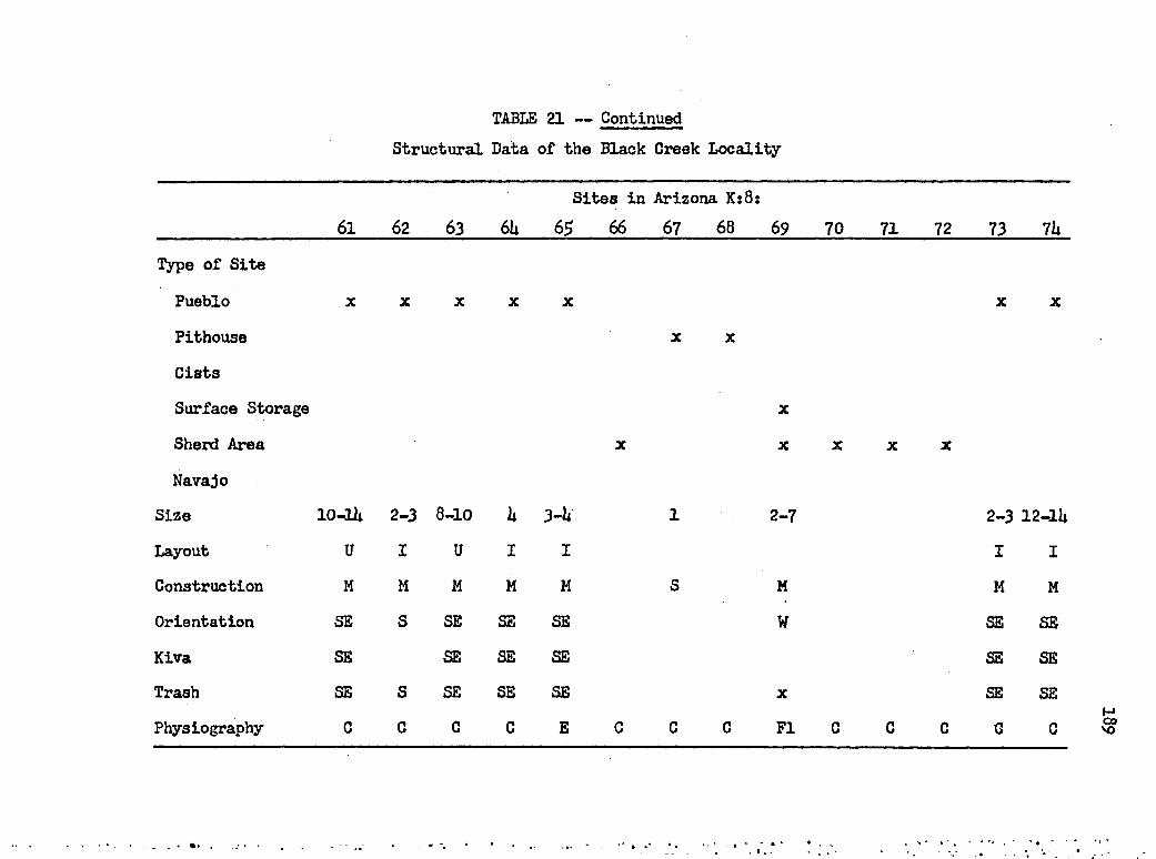
TABLE 21 — ContinuedStructural Data of the Black Creek Locality
61 62 63 6USites
65 66in Arizona K:8:
67 68 69 70 71 72 73 7h
Type of Site
Pueblo X X X X X X X
Pithouae X X
Cists
Surface Storage X
Sherd Area X X X X X
NavajoSize 10-lli 2-3 8-10 h 3—h 1 2-7 2-3 12-lbLayout u I U I I I IConstruction M M M M H S M M MOrientation SB S SB SB SB W SB SBKiva SB SB SB SB SB SBTrash SB S SB SB SB X SB SBPhysiography C 0 C C E C C C PI C C C 0 C

TABLE 21 — ContinuedStructural Data of the Black Creek Locality
75 76 77 78Sites in Arizona K:8:
79 80 81 82 83 8U 85 86 87 88
Type of SitePueblo X X X X X 2 X X
Pithouse ? ? ?
CistsSurface Storage X X X
Sherd Area X X X
Navajo
Size 2-3 2-3 7-8 8-12 2-k 1 2-5 2-3? 1-2 2-3 1Layout I I u U I I? I?
Construction M M M M M H M H MOrientation B S B S S S? S W SBKiva s E 2S ? ?
Trash X B s E S X NE,E S E X
Physiography C B B C A P E C C C C C FI FI 061

TABLE 21 — ContinuedStructural Data of the Black Creek Locality
Sites in Arizona K:8:89 90 91 92 93 9U 95 96 97 98 99 100 101 102
Type of Site
Pueblo . X X X X X X X X X X X
PithouseCists
Surface Storage
Sherd Area •X X X
Navajo
Size 3-U 1-2
GO 10-12 10+ ? 5-6 2-3 U-6 8 2-3Layout I I I L I L? I I
Construction M H M M H M M M M M M
Orientation SB SB S N E SB SB E BKiva SB S SB E E,NBTrash X X X S X X X SB SB E SBPhysiography E E C C A E C C C C C C C C
191

'TABLE 21 — ContinuedStructural Data of the Black Creek Locality
x x x x x x x x x x x x
Sites in Arizona K:8:____________________ 103 10U 10$ 106 107 108 109 110 111 112 113 H U 115Type of Site
Pueblo xPithouse
Cists
Surface Storage
Sherd Area Navajo
Size 2-3 7 h-7 8-10 1U-16 l*-6 6-8 3-6 7-9 1-2 6-8 8-10 1-3Layout I 7 I I U I U I? U X I T IConstruction M M M M M M M M M M M H M
Orientation S 7 SW SB SB S S E SB B SB S BKiva 7 2SB S 3E SB SB STrash S S SW SB SB S S E SB X E SBPhysiography c E C C C c c C E C E B C
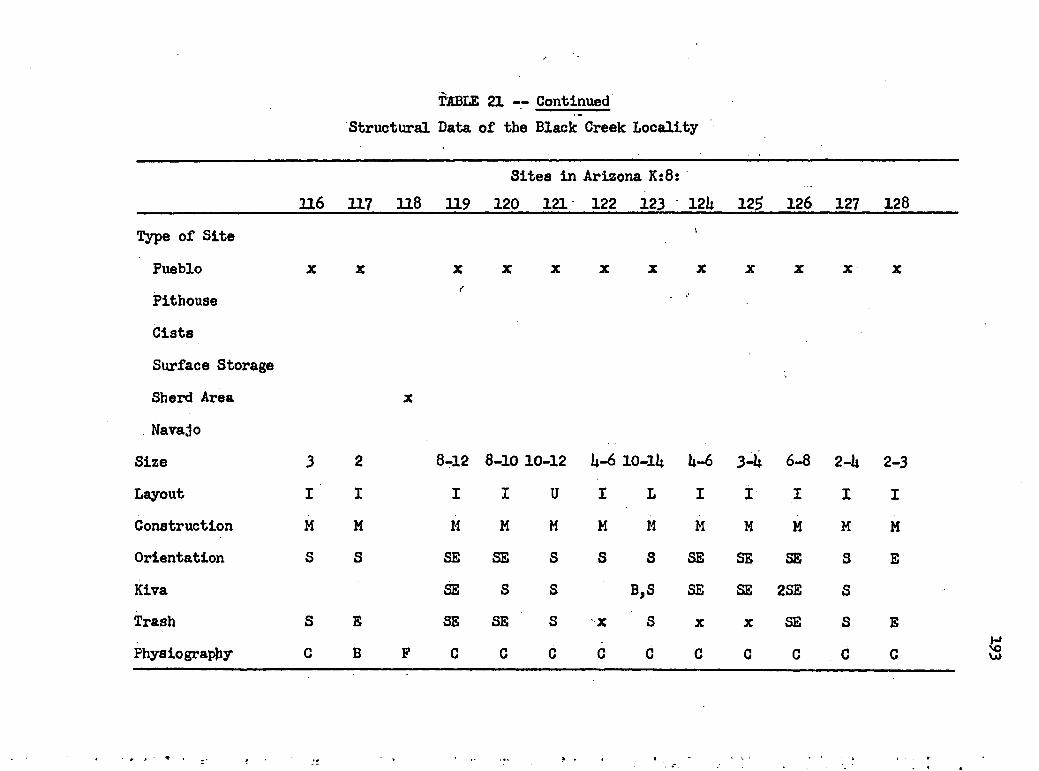
TABLE 21 — ContinuedStructural Data of the Black Creek Locality
116 117 118 119Sites in Arizona K:8:
120 121 122 123 12k 125 126 127 128
Type of Site ‘
Pueblo X X X X X X X X X X X X
PithouseCists
Surface Storage
Sherd Area X
Navajo
Size 3 2 8-12 8-10 10-12 k-6 10-lk k-6 3-k 6-8 2-k 2-3Layout I I I I u I L I I I I I
Construction M M M M M M M M M M M M
Orientation S S SB SB S S S SB SB SB 3 BKiva SB S s B,S SB SB 2SE STrash S B SB SB s X S X X SB S EPhysiography c B F C C c C C C C C C C s

TABLE 21 — ContinuedStructural Data of the Black Creek Locality
X X X X X X X X X X X X X
Sites in Arizona K:8:____________________ 129 130 131 132 133 13k 135 136 137 138 139 UtO llO-Type of Site Pueblo
Pithouse CistsSurface Storage
Sherd Area Navajo
Size 6-8 8-10 18-20 2-3 li-5 5-7 2-3 1 1-2 3-U 1-2 5-6 10-12Layout I I I I I T I I I I I IConstruction M M M M M M M M M M M M MOrientation S S S SE SE SE SE S S SE •s ? SBKiva -S S 28 SE SE SE S N,S SETrash S S S SE SE SE S SE E X SEPhysiography c C C C C C C c c C C C C

TABLE 21 — Continued
Sites in Arizona K:8:____________________ 1U2 1U3 U 6 lh5 1U6 1U7 1U8 lh9 ISO 151 152 1 # 15UType of Site
Pueblo x * x x x x 2 x x x x x x x
Pithouse
Cists
Surface Storage
Sherd Area
Navajo
Structural Data of the Black Creek Locality
Size U-6 8 1-3 1-2 3-U 6-8 1-2 It 5-6 3-lt 3-6 25-35 U-6Layout I I I I I I I I L I I L DConstruction M H H M M M M M M M M : M H
Orientation SB S SB E SB SE,W S S S S SB S SBKiva s SE,W s S SB 2S,GKS
Trash X s SB SB SB S X S s S SB S SBPhysiography C c B C C C C B c C C c c

TABLE 21 — ContinuedStructural Data of the Black Creek Locality
155 156 157 158Site in Arizona K:8:
159 160 161 162 163 16U 165 166 167
Type of Site
Pueblo X X X X X X X X 2
Pithouse ? X ? 7
Cists X
Surface Storage X 7 7
Sherd AreaNavajo
Size 6-8 3-U lt-6 8-12 7 6-8 k 8-12 10-12 8-10 3? 97 8-10Layout I I L U S L I L u I U I T,IConstruction M M M M M S M M M S M MOrientation SE S SE SE SE S SE SE SE E S SKiva SB S SE SE SE SE SE NE,ETrash SE s E SE X SE X SB SB SE X X SBPhysiography C C C C C C C C 0 C C C B

TABLE 21 — ContinuedStructural Data of the Black Creek Locality
168 169 170 171Site in Arizona K:8:
172 173 17k 172 176 177 178 179 180
Type of SitePueblo X X X X X X X X X X
Pithouse X X ?
Cists
Surface Storage X X X
Sherd AreaNavajo
Size 3-i* 3~U 8-10 1 3-U 8-10 3-U 2-6 2 - i t U-6 6-8 2-3 6-8Layout I I I I I I u U I I I IConstruction M M M M M M S S s M M M MOrientation E SB SE S NE E E E SE E E SE EKiva SE SB E,W,GKS SE E
Trash X SE X NE E E E X E E SE EPhysiography E B C FI C C C C C C C C C

TABLE 21 — ContinuedStructural Data of the Black Creek Locality
l8l 182 183 18USite in Arizona K:8:
185 186 18? 188 189 190 191 192 193Type of Site
Pueblo X X X X X X X X X
Pitbouse ? ? ?
CistsSurface Storage X X X
Sherd Area X
Navajo
Size 3-U w 7-10 14-6 6-7 3-5 8-10 5 U-6 5-7 6-8 2-ULayout I I T I L .u I I u L L U
Construction M M M H M M M M S M M sOrientation B SB S S SB E S E SB SB SB S
Kiva E SB 28 s SB 28 N SB SB
Trash B SB S s SB B S NE X X SB X
Physiography C C C c C C C F C C C C 0

TABLE 21 — ContinuedStructural Data of the Black Creek Locality
19k 195 196 197Sites in Arizona K:8:
198 199 200 201 202 203 20U 205 206Type of SitePueblo X X X X X X X X X X
Pithouse ? ? ?
Cists
Surface Storage X X ?
Sherd Area -
Navajo
Size 3-U 2+ 2-3 1 1-2 6-8 2-U 2+ U 8-10 10-12 6-8 3-ULayout I U I I I I U I I L L I
Construction M S H M M M M s H H M H M
Orientation S S SB ? B E SB E SB S E SB SBKiva S SB S? E SB SE S E SB SBTrash 3 X S X X SB SE X SE SB E SB SBPhysiography 0 C C C C C C C C C 0 C C

TABLE 21 — ContinuedStructural Data of the Black Creek Locality
207 208 209 210Sites in Arizona K:8:
211 212 213 21U 21$ 216 217 218 219
Type of Site Pueblo
Pithouse Cists
Surface Storage Sherd Area Navajo
X X X X X
Size 8-10 10 8-10 1-2 7 3-U 1 3-U 3-U 1 7-10 6-8
Layout I U U I U U
Construction M M M M H M M M M M M M
Orientation S E E S SB E
Kiva E E SB BTrash S E E X X X S X X SB EPhysiography C C C C C C C C C B E C C

TABLE 21 — ContinuedStructural Data of the Black Creek Locality
220 221 222Sites in Arizona K:8:'t ■
22U 225 226 221 228 229 230 231 232Type of Site
Pueblo
Pithouse Gists
Surface Storage
Sherd Area Navajo
x x x x 2 x x X X X
Size 1 20-25 10-lU 6-8 10-lU 8-10 10-12 ? 3-5 6-10 3 1-2Layout I I I I L I I I I • I
Construction M M M M M M . M s M M M MOrientation B S E ? E,S S S SB E S B
Kiva S s SBTrash X S,E E,W X X S s s SB E X X
Physiography E B B B B C c c C E C 0 C
201

TABLE 21 - ContinuedStructural Data of the Black Creek Locality
233 23U 235 236Sites in Arizona K:8:
237 238 239 2li0 2ia 2U2 2U3 2Wi 2h5Type of Site
Pueblo X X X X X X X X X X X X
PithouseCists
Surface Storage
Sherd Area X
Navajo
Size 6-8 3-5 20 10-12 U-6 8 8-10 5-7 5-7 2-U 3 3-5Layout L I T L I I L I I I I I
Construction M M M M M M M M H H M M
Orientation SE E S S S E SE S W? S S SKiva SE E 2S S SE S S S
2NETrash SE X S S X X SE S sw S s sPhysiography C C C c C C C C C c C c c 202

TABLE 21 — ContinuedStructural Data of the Black Creek Locality
17 18 19 20 21Sites in Arizona K:12:
22 23 2k 25 26 27 28 29 30Type of Site
Pueblo X X X X X X X X X X X X
Pithouse ?
Cists
Surface StorageSherd Area X
Navajo H3Size 3-U U-6 6-9 U-6 1-2 20-25 15-20 2? 3 8? 5* U-6Layout I I u L L I ? IConstruction M H M M M H M M M M M MOrientation ? S sw SE E W W W W W SKiva S STrash X S sw SE X X W w SW? W W w SPhysiography C C C C P E C F F c F F F c

[TABLE 21 — Continued'Structural Data of the Black Creed Locality
Sites in Arizona K:12:3k 35> 36 37 38 39 Uo ig U2 U3 UU
Type of Site Pueblo
Pithouse Cists
Surface Storage
Sherd Area Navajo
x x x x x x x x x x x
Size 2-3 U-6 6-8 2 10-lU 2-3 U-6 12-16 6-8 8-12 12-lU Ii—jJ 16-18 5-6Layout I I L S L I I T I L F L L u
Construction H M M M M M M M M M M M M M
Orientation S S ME? ? S S? NE S svr SB NE S S SE
Kiva S s NE 2S 2SW SB 2NE S s SBTrash X X X X S X NE S S SB NE SB SB SEPhysiography c c C c c c c C C C C C C C
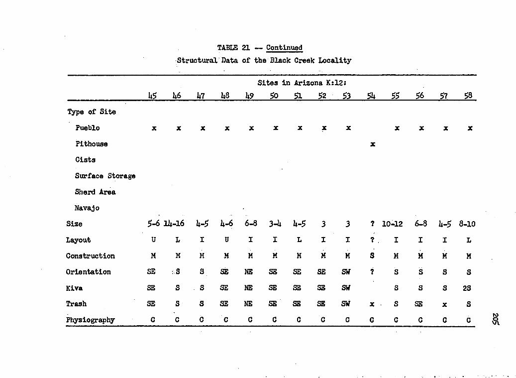
TABLE 21 — ContinuedStructural Data of the Black Creek Locality
Sites in Arizona K:12:____________________ US U6 U7 U8 U9 $0 51 $2 53 5U 55 S6 57 58Type of Site
Pueblo x x x x x x x x x x x x x
Pithouse xCists
Surface Storage
Sherd Area Navajo
Size 5-6 1U-16 U-5 b-6 6-8 3-U U-5 3 3 ? 10-12 6-8 lt-5 8-10Layout U L i u I I L I I ? I I i LConstruction M M M M M H M M M s M H M M
Orientation SB ::S S SB NB SB SB SB S¥ ? S S S SKiva SB S s SB NE SB SB SB SW S S s 23
Trash SB s s SB NE SB SB SB sw X S SB X SPhysiography C c c C C C C C c c C C c C ro
%

TABLE 21 — ContinuedStructural Data of the Black Creek Locality
r Sites in Arizona K:12:$9 60 6l 62 63 6U 65 66 6? 68 69 70 71 72
Type of SitePueblo X X X X X
PithouseCists
Surface StorageSherd AreaNavajo
Size 6-7 10-lU 10-12 1-2 3-ULayout L L u I I
Construction M H M H H
Orientation SB SE SE S S
Kiva SB SE s
Trash X SE SE X s
Physiography C C C C E
2-3 6 -8 2 6 -8 6 -8 6 -8 u 10-12 U-5
I I I L I I I U i
M M M M M M M M M
SE SB S S SE S S SB SE
SE S SE
X SE S S SE S s X SE
E E E E C c c c c

TABLE 21 — ContinuedStructural Data of the Black Creek Locality
Sites in Arizona K:12: 73 23$ 236___________________________ •
Type of SitePueblo x X X
Pithouse
CistsSurface Storage
Sherd Area
Navajo
Size ? 9-11 1-2
Layout I I
Construction M,S M M
Orientation S S
Kiva STrash s X
Physiography C E E
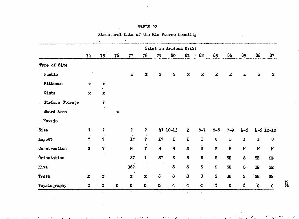
TABLE 22Structural Data of the Rio Puerco Locality
7U 75 76 77Sites in Arizona K:12:
78 79 80 81 82 83 8U 85 86 87Type of Site
Pueblo X X X 2 X X X X X X X
Pithouse X X
Cists X X
Surface Storage ?
Sherd Area X
NavajoSize ? ? ? ? a? 10-13 2 6-7 6-8 7-9 a-6 a-6 10-12
Layout ? ? I? 7 17 I I I U L i I uConstruction s ? M 7 M M M M M M M M MOrientation S? 7 S? S S S s SB S SB SBKiva 3S? S S S s SB S SB SBTrash X X X X S s S s s SB s SB SBPhysiography c C B D D D c c c c C c 0 C

TABLE 22 — Continued
Sites in Arizona K:12:____________________88 89 90 91 92 93 9h 9$ 96 97 98 99 100 101
Type of SitePueblo x x x x x x x x x x x x x x
Pithouse
Cists xSurface Storage
Sherd Area Navajo
Structural Data of the Rio Puerco Locality
Size 2 U-5 iU-18 a-6 a-5 U-5 a-6 a-6 8-10 a-5 a-6 a-6 2-3 8-10Layout If i T i i I i i U i i L I uConstruction M M M M H M M M M M M H H H
Orientation Sf S SB SB SB SB SB S SB E SB SB B SBKiva S SB SB SB S SB SB SETrash X X SB SB SB SB SB s SB E SB SB B SBPhysiography 0 C C C C C C C C C C C C C

TABLE 22 — Continued(Structural Data of the Rio Puerco Locality
Sites in Arizona Kil2:102 103 10U 105 106 107 108 109 110 111 112 113
Type of Site
Pueblo
Pithouse Cists
Surface Storage Sherd Area Navajo
Size 3 5-7 30 7-9 2-3 2 6 1 1 U-5 2-3 7Layout I U 21,T ' L I I U 1? I 7Construction H M M M M M M H M s H 7Orientation SB SB 23, SE SB SB S SB 7 S s SB 7Kiva SB SB 28 SB SB
Trash SB SB SB SB SB S SB X S s SEPhysiography C C 0 C C C C C C B B B C
210

TABLE 22 — ContinuedStructural Data of the Rio Puerco Locality
Sites in Arizona K:12t11$ 116 117 118 119 120 121 122 123 12b 12$ 126 127
Type of Site Pueblo
Pithouse CistsSurface Storage
Sherd Area Navajo
x* xX
X
Size 6 9-11 8 2-3 7-9 2-3 2-3 3-U 1-2 2-U w
Layout I U S I U X I u I I IConstruction M M M H M M M M M M MOrientation S SE E SE SE S S S S SKiva SE SE SE SE
Trash S SE X SE SE X S S X S X
Physiography C C C C C C c c c c C C
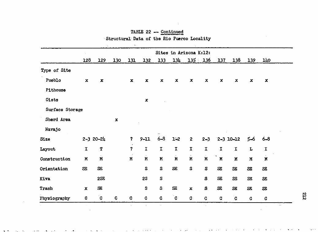
TABLE 22 — ContinuedStructural' Data of the Rio Puerco Locality
128 129 130 131 132Sites133
in Arizona Kzl2: 13U 135 136 137 138 139 lUo
Type of Site
Pueblo X X X X X X X X X X X X
PithouseCists X
Surface Storage
Sherd Area X
Navajo
Size 2-3 20-2U ? 9-11 6-8 1-2 2 2-3 2-3 10-12 5-6 6-8
Layout I T ? I I I I I I I L I
Construction M M M M M M M H * M M H H
Orientation SB SB S S SB S S SB SB SB SBKiva 2SE 28 S S SB SB SB SBTrash X SB S s SB X S SB SB SB SBPhysiography 0 C c C C c C C C C C C C
212

;TABUS 22 — ContinuedsStructural Data of the Rio Puerco Locality
U q 1U2 1U3Sites in Arizona K:12:
1UU 1U5 1U6 1U7 1U8 1U9 1^0 IgL 102 153Type of Site Pueblo
Pithouse Cists
Surface Storage Sherd Area
Navajo
X X X X X
X X X X
X X X X
Size 6-8 2-3 10-12 3 ? 2+ U-5 3 2U-28 6-8 3-U 2-3 3-ULayout T I T I u I 1 I E L I I I
Construction M M M M s s s s M M M M M
Orientation SB SB SB S s s s SB S S S S SKiva SB SB S 2S ?
Trash SB SB SB S s X s X SB SB X S SPhysiography C C C C c c c C E B E C B e

TABLE 22 — ContinuedStructural Data of the Rio Puerco Locality
15k 155 156 157Sites in Arizona K:12:
158 159 160 161 162 163 16k 165 166
Type of SitePueblo X X X X X X X
Pithouse X X X ? 7Cists
Surface Storage X X X X
Sherd Area
NavajoSize 2-3 6-8 8-12 12-lk 18-22 k-6 U”6 20~2k k-8 k 4-6 10-12 3Layout I I U i L I i F I I i i I
Construction M M M M M s s M S M s s SOrientation SB SB E SB SB s E? E E SB E SB SE
Kiva S B ,W E SE SB E SE
Trash NW SB E SB S s X E X SE E SE SE
Physiography C C C C c c C C C C C C C

TABLE 22 — ContinuedStructural Data of the Rio Puerco Locality
167 168 169 170Sites in Arizona K:12:
171 172 173 17U 175 176 177 178 179Type of Site
Pueblo X X X X X X X X X X X
Pithouse XCists
Surface Storage X X
Sherd AreaNavajo
Size U-6 U-6 U-5 3-U 10-12 6-8 3 10-13 3-U U-6 2-3 19-21 12-lULayout I I u I u I 1 u I I I F LConstruction M M M M M M M M M M M M MOrientation E SE E E SE SE E E SE E SB SEKiva E SB SE B E SB 2SE SETrash SE E SE E E SE SE E E SB E SE SEPhysiography C C C C C C .C C C C C C C

TABLE 22 — ContinuedStructural Data of the Rio Puerco Locality
Sites in Arizona K:12:180 181 182 183 18U 18$ 186 18? 188 189 190 191 192
Type of Site
Pueblo
Pithouse Cists
Surface Storage
Sherd Area Navajo
Size 6 U-6 U-6 8-10 U-6 2-3 2-3 3-U 10-12 U-6 8-10 U-6 6-8Layout I L I I* I I I I L I U l LConstruction M M M M M M M M M M H M MOrientation SB S SB S SB ? S SB B S SB S SBKiva SB s SB s SB B S SB SBTrash SB S SB s SB X S SB E s SB S SPhysiography C C C c C C c C C c C c C I

TABLE 22 — ContinuedStructural Data of the Rio Puerco Locality
193 19U 195 196Sites in Arizona K:12:
197 198 199 200 201 202 203 20U 205Type of Site
Pueblo X X X X X X X X X X
Pithouse X X 7Cists
Surface Storage X X X
Sherd Area
NavajoSize 2-3 3-h 10-12 8-10 6-8 6-8 6-8 6-8 2-3 1-2 12-11; U-6 3-ULayout I I T I U U? U U I I L I IConstruction M M M M M M M M M H M M M
Orientation S SB SB S S S B E E 7 S NE
Kiva SB 2 SB S E B NBTrash S SB SB s S s E B B X S X SB
physiography C C B B B B B;.. B B 0 E E E

TABLE 22 — ContinuedStructural Data of the Rio Puerco Locality
Sites in Arizona K:12:206 207 208 209 210 211 212 213 2lU 215 216 217 218
Type of Site Pueblo
Pithouse Cists
Surface Storage
Sherd Area
Navajo
Size lt-6 k-7 3-h 6-8 1 U-6 2-3 6 6-7 16-18 5-7Layout I I L I I I L L IConstruction M M H M M M M M M H HOrientation N N S? SB SB S E SB SB SKiva SB SB S B SB SB STrash X X S SB S B SB SB SPhysiography B FI F2 FI C B F2 C C C C C C

TABLE 22 — ContinuedStructural Data of the Rio Puerco Locality
Sites in Arizona K:12:____________________ 219 220 221 222 223 22k 22g 226 227 228 229 230 231
Type of Site
Pueblo
Pithouse Cists
Surface Storage
Sherd Area
Navajo
x x x x x x x x x x x x ??
Size U-6 6-8 6-8 U-6 2-3 1-2 6 U-6 6-8 35-Uo 6-8 1 7
Layout I I I I I I U I I F IConstruction M M M M M M M M M M M MOrientation S S S SB SE E SB SE SB SE S SKiva S S S SE SE SE SE 2SB STrash s S s SE SE E SE SE SE SE SPhysiography c c c C c C C C C C C F2 C 8

TABLE 22 — ContinuedStructural Data of the Rio Puerco Locality
Sites in Arizona K:12: 232 233 23k
Sites in Arizona K:ll:3 U 5 6 7 8
Type of Site Pueblo Pithouse Cists
Surface Storage
Sherd Area
Navajo
Size U-6 h-6 6-8 13-15 6-8 lt-6 5-7 1 1 16-18 3-5Layout I I U F I I l V I
Construction H M M H M M M M M
Orientation S s s SB SB E SB B E SB EKiva S s S SB 2SE B SB SB ETrash S s S B SB B SB E SW SB BPhysiography c c c c c C C C C C C
220

ITABLE 22 — Continued[Structural Data of the Rio Puerco Locality
. Sites in Arizona K:ll:16 17 18 19 20 21 22
Type of Site
Pueblo
Pithouse Cists
Surface Storage
Sherd Area Navajo
7?
Size 6-8 10-12 16-18 10-12 5-9 3-U U U-6 7 8-10 U-6Layout I I L I B I i I I IConstruction M M M M M M M M M M
Orientation S SB SB S? S S s S7 S SWKiva S 2SB SB N S s s N S SW
Trash s 2SE SB S S s s S X S S
Physiography c C C C C c c C C C C

TABLE 23Structural Data of the Kin-li-chee Greek Locality
1 2 3 h
Sites in Arizona K:3:5 6 7 8 9 10 11 12 13
Type of Site
Pueblo 3 x 7 X X X X X X X
Pit ho use X X X
Cists
Surface Storage X X X
Sherd AreaNavajo H2
Size 7-5 2 Uo-5o 3 3-5 6-8 6-8 3 h-6 lU-16 16-18 2-3 1Layout I SI,T,L I X U I I L L IConstruction M M M M s M M H S H M MOrientation S s 5E,s,? sw SB ? SB E SB E SB SB EKiva C 2GK,SE NW,SE SB E SB B 2SB SBTrash S x E X X X X E S E SB X SBPhysiography F2 El 0 c C C C C C C C C E
222

TABLE 23 — ContinuedStructural Data of the Kin-li-chee Creek Locality
Sites in Arizona K:3:___ ________________ 1U 15 16 17 18 1? 20 21 22 23 2U 2$ 26 27
Type of Site
Pueblo x x x x x x x x x x x x x xPithouse
. Cists
Surface Storage Sherd Area
NavajoSize k~& 10—12 6-8 5-7 5-10 25-35 6-7 1U-18 1 U-7 6-8 1 2-3 8-10Layout i I L
Construction M M H M M M M M H M M M M MOrientation SB SE SB SB S s N S Stf E W SE E SE
Kiva 2SE SE ?Trash SE SB SE X S s N S X E X X SBPhysiography C C C F • F F2 F2 F2 F F F FI FL F

TABLE 23 — ContinuedStructural Data of the Kin-li-chee Creek Locality
Sites in Arizona K:3: Sites in Arizona K:6:28 29 30 31 32 33 3h 2 3 h 5 6 7
Type of SitePueblo X X X X X X X X X
Pithouse ? ? ? X
Cists X
Surface Storage X X X X
Sherd AreaNavajo
Size 10-15 1 20-25 1-2 8-10 1 U-6 3-U U-5 2-1* 6-8 6-7 3-ULayout ? I i C I I IConstruction M M M M M M M s S S s S,M MOrientation S SB S E S S S? SB S s s SB SBKiva c SB SBTrash X X X E S S X SB S s s SB SBPhysiography FI FI F2 F F FI F C c c c C 0

TABLE 23 — ContinuedStructural Data of the Kin-li-chee Creek Locality
8 9 10 11 12Sites in Arizona K:6: 13 lit 15 16 17 18
Type of SitePueblo X X X X X X X
Pithouse % X X X X
Cists X X X
Surface Storage X X
Sherd AreaNavajo
Size 3-U ? U-5 1U-16 3 3 lt-6 2-3 6-8 12-lU a-6Layout I 1 1 I I I I F L ?Construction H M S,M M M S s M S,M H MOrientation SB E SE SE SE SE S S S
Kiva SB E 3SE SE
Trash SB X E SE SE SE SE X S X X
Physiography C c C C C C C C C c c

(TABLE 23 — Continued;Structural Data of the Kin-li-chee Creek Locality
1 2 3 u 5Sites in Arizona K:7:
6 7 8 9 10 11 12 13 1UType of SitePueblo X X X X X X X X X X X
Pithouse X X X X X
Cists
Surface Storage X X X
Sherd AreaNavajo
Size 3 2 2 1 10-15 11-15 1 8-10 6-7 3-U 3-U 2-3 2-3 2-3Layout 1 B I I I I IConstruction M M M M M M M H H H s S S,M SOrientation S S S S S S S S s S SE. SE SE SEKiva C SETrash X X X X s s X s X S SB SE SE SEPhysiography SI SI FI FI F F El c FI FI C C C C

TABLE 2UStructural Data of the Nazline Wash Locality
Sites in Arizona K:2: Sites in Arizona K:3:1 2__________ 35 36 37 38 39 UP iq U2 U3
Type of SitePueblo X X X X X X
Pithouse X X
Cists
Surface Storage X X
Sherd Area x X X
Navajo S
Size 1-2 2 3 1-2 10-11 1U-18 2-3 U-6Layout I I IConstruction M M M M M M S SOrientation S N NW S S S S sKiva STrash X X S X X X sPhysiography F FI FI FI C FI FI FI c 0 c

TABLE 2h — Continued,Structural Data of the Nazlini Wash Locality
Sites in Arizona K:3$ Wi U5 U6 hi U8 1*9 5o 51 52
Sites in Arizona E:lU: 1 2 3 U 5
Type of Site. Pueblo X X
Pithouse X X X X X
Gists
Surface Storage X X X X X
Sherd Area X X X X X
Navajo B,S F F
Size' 2-3 3-5 U-6 5-6 2 U-6 U-6 5+ u 3Layout I I I I I I c S
Construction S s s s M S H M M MOrientation SB 5,SB s s N s SB SW SB S
Kiva SBTrash SB 5,SB s s X s SB X X X
Physiography C 0 c c F c 0 FI FI F C F F FI

TABLE 2h — ContinuedStructural Data of the Nazi ini Wash Locality
Sites in Arizona Bill*: 6 7 8 9 11 12 13
Sites in Arizona E:l£: 3 U 5 6 7 8
Type of Site -
Pueblo X X X X X X X X X X
Pithouse X ? X
Cists X
Surface StorageSherd Area X
Navajo B B B BSize 1-U 10-20 9-10 i-U 3 6-10 1 1 10-12 U-6 1 3-ULayoutConstruction M M M M H M M M M M M MOrientation S s s E S N N N ' N E E SBKiva E7
Trash S s s X X X X X X X SEPhysiography FI CM FI FI F FI FI F C F FI F

TABLE 2h - ContinuedStructural Data of the Nazlini Wash Locality
Sites in Arizona E:15>:____________________ 9 10 II 12 13 Hi 15 16 17 18 19 20 21 22Type of Site
Pueblo x x x x x x x x x x x x xPithouseCists
Surface Storage xSherd AreaNavajo
Size 2-3 20-30 ? 6-8 2 6-8 3 6-10 k 1 10-12 6-7 3-7 2Layout
Construction M M M M M S M M M M M M M MOrientation E S S S S S B S N S S S WKiva 28 S
1
Trash X X X X X S X X X X X
Physiography FI F FI F FI F FI F2 FI El F FI FI El

TABLE 2h — ContinuedStructural Data of the Nazlini Wash Locality
Sites in Arizona Eil3>:::______________ 23 2U 25 26 27 28
Type of Site
Pueblo X X X X
Pithouse X X
Cists X X
Surface Storage
Sherd AreaNavajo H2,3
Size 6-10 2 2 11-17 h-$ It-6
LayoutConstruction M M M s SOrientation S E S S
Kiva 2S
Trash X X X X X X
Physiography F F F F F F

TABLE 2$Structural Data of the Lukochukai-Tohotso-Greasewood Locality
2 3 USites in Arizona E:ll: 5 6 7 8 9 10
Type of SitePueblo X X X 6 X X X
Pithouse X X X X
Gists X X
Surface Storage
Sherd AreaNavajo
Size 3 20-22 3-5 U-6 U-5 20-30 6-10 2 6-8
Layout I U S I S 5l,L S I L
Construction M M M M M M MOrientation S S SB SB S S S B
Kiva 2S SB 2S S ETrash S S s X X X X s EPhysiography c C G C C C 0 c C

APPENDIX B
Pottery Tabulations
need in Tables 26 through 30
Symbols - variety
Table 26. Pottery of the Tohatchi-Mexiean Springs locality.
a. Navajo Utilityb. Sludged brown ware
c. Lino Black-on-gray
d. Kana-a Black-on-white
e. Black Mesa Black-on-white
f • Maneos Black-on-white
• g# St* Johns Polychrome: Springerville variety
h. Kana-a Neck Banded
i. Ashiwi Polychrome
j. Acoma Polychrome (?)
Table 27* Pottery of the Black Creek locality
a. Brown ware, early
be Little Colorado Corrugated
c. Lino Black-on-gray
d. Kana-a Black-on-white
e. Black Mesa Black-on-white
f. KLageto Black-on-white
233

- g. Dogoszhi Black-on-white
h. Sbato Black-on-nbite
1. Padre Black-on-white
j. Pinedale Black-on-white
k. Kin Tiel Black-on-orangel. Gobemador Polychrome
m* KLageto Polychrome
n. Zuni-Acoma Polychrome ware
o. Unfired sherd
p. Brown ware, mica tempered
q. Jeddito Black-on-yellow
Table 28, Pottery of the Rio Puerco locality
a. KLageto Black-on-yellowb. Jeddito Black-on-yellow
c. Kana-a Black-on-white
d. St, Johns Polychrome: Springerville variety
e. KLageto Polychrome
f. Zuni-Acoma Polychrome ware
Table 29, Pottery of the Kin-li-chee Creek locality
a. little Colorado Gray
b. Navajo Utility
c. Smudged brown ware
d. Brown ware, late
e. Mesa Verde Black-on-white

f. Lino Black-on-grayg. Shato Black-on-white
h. Citadel Polychrome
1# Ashivi Polychrome
j# Gobemador Polychrome
Table 30# Pottery of the Naalini wash locality
a# Lino Fugitive Red
b. Unfired sherd
c# Brown ware, unknown
de La Plata Black-on-white e. Kiatuthlanna Black-on-white
f# Holbrook Black-on-white
g. Padre Black-on-white
he Kiet Siel Polychrome
i# Hop! Polychrome ware j# Gobemador Polychrome
k# 2, Sitkyatki Polychrome; 3, Zuni Black-on-white;
3, Zuni-Acoma, thick slipped red ware; 9, Jeddito
HLack-on-yellow
1# 2, Ashiwi Polychrome; 2, Polished brown ware
m# Jeddito HLack-on-yellow

236
TABLE 26Pottery of the Tohatchi-Mexican Springs Locality
Ceramic Types Sites in New Mexico G:l:2 3 U 5 6 7 8 9 10 11 12
PlainLino Gray 1 2 5 17 1 12 10 12 11Lino Fug. Red Slipped Red
1 1 3 1 1
CorrugatedIndent k 9 1 7 1PlainPatternedTooled
1
Black-on-whiteLa Plata White Md. 1 1 6 1 1 7K ’lanna Red Mesa 3 1
1 1Puerco 1 3Puerco Gallup Tularosa Klageto McEImo
1 2
Mesa Verde Unknown 5
Black-on-redLa Plata Puerco Wingate St. Johns
Polychrome Wingate St. Johns Other 3f 2c
Ceramic Period 2,5 ? U ? 2 2 5 2 ? 2 1,2

237TABLE 26 — Continued
Pottery of the Tohatchi-Mexican Springs Locality
Ceramic Types Sites in New Mexico G:l:13 Ut 15 16 17 18 19 20 21 22 23
PlainLino Gray Lino Fug. Red Slipped Red
8 5 lit It 12 13
CorrugatedIndent It 1 2 2 1 2PlainPatterned
1 1Tooled
Black-on-white1
La Plata White Md. 1 1K ‘lanna 3Red Mesa 3 1 1 1Puerco 1 1Puerco Gallup Tularosa
1 2 2KLagetoMcElmo 2Mesa Verde Unknown 1 2 2 1 3
Black-on-redLa Plata PuercoWingate St. Johns
3PolychromeWingate St. Johns Other 8a 1c 3a
Ceramic Period 9 ? ? 5 1? 6 2-U 2 2 9 5

238TABLE 26 — Continued
Pottery of the Tohatchi-Mexican Springs Locality
Ceramic Types Sites in New Mexico G:l:2U 25 26 27 28 29 30 31 32 33 3L
PlainLino Gray 3 1 1Lino Fug. RedSlipped Red 1 1 1 1 1
CorrugatedIndent 2 2 1 1 1 2 1 2 1Plain 1 1 1 2 1 1 1Patterned 1 2 1 1Tooled , 2 1 3 1
Black-on-whiteLa Plata 2White Kd. LK'lanna 1 6Red Mesa 5 6 18 L 2 L U 3 2Puerco - 3 1 1 L 3 3Puerco Gallup 6 9 3 5 2 7 10 9 6Tularoaa 1KlagetoMcElmo 1 3Mesa Verde 5Unknown 3 1
Black-on-redLa Plata 1Puerco , 6 1WingateSt. Johns 3 2 i 2
PolychromeWingate 3 5 1St. Johns It U 1Other lb Ic.ld
Ceramic Period 5 5 6 2 6 7 7 6 5 5 3,7

239(TABLE 26 — Continued
[Pottery of the Tohatchi-Mexican Springs Locality
Ceramic Types Sites in New Mexico G:l:35 36 37 38 39 Uo Itl U2 lt3 Itlt U5
PlainILino Gray 1 1 1Lino Fug. RedSlipped Red 2 1 1 1 3
CorrugatedIndent 1 1 1 1 It 2 It 1Plain 1 1 1 1Patterned 1 1 2 1Tooled 1 1
Black-on-whiteLa PlataWhite Md.K'lannaRed Mesa 1 u 1 3 9 It 8 ItPuerco 6 2 2 2 7 It 1 3 1 5Puerco Gallup 8 3 5 6 6 k 10 It 5Tularosa 1 1 1KLageto 2 1McElmo 2 2 3Mesa Verde 1 3Unknown 3 2 1
Black-on-redLa PlataPuerco 1 2WingateSt. Johns 3 1 2 3 1
PolychromeWingate 2 k u 2 5 2 1St. Johns 3 6 7 2 2Other If Id if
Ceramic Period 7 7 5 7 7 7 5 It 3,5 7 7

: 2U0.TABLE 26 — Continued
Pottery of the Tohatchi-Mexican Springs Locality
Ceramic Types Sites in New Mexico G:l:L6 U7 U8 19 50 51 52 53 51 55 56
PlainLino Gray 1 1 5 11 5Lino Fug. Red Slipped Red
2
CorrugatedIndent 1 3 1 3 2 5Plain 1 3 1PatternedTooled 1
3 2 11
Black-on-whiteLa Plata 1 1 1White Md. 1 17 3 15K'lanna Red Mesa Puerco 1 3 5 1
3
Puerco Gallup Tularosa
8 11 12 11 3 9 7KLageto McElmo Mesa Verde Unknown 1
31
Black-on-redla Plata Puerco Wingate St. Johns 1
1
PolychromeWingate St. Johns Other
1
Ceramic Period 5 5 5 2,5 6 7 5 2 1-2 1 2

TABLE 26 — Continued
Pottery of the Tohatchi-Mexican Springs Locality
Ceramic Types Sites in New Mexico G:l:27 58 59 60 61 62 63 6k 65 66 67
PlainIiiho Gray 8 9 1 8 30Lino Pug* Red Slipped Red 2
itCorrugatedIndent 3 1 It 1 3 5 2 1PlainPatterned
11
1Tooled
Black-on-white2
La Plata 2White Md. 2 1 2K'lanna Red Mesa 3
3Puerco 13 3 1 2 It 2Puerco Gallup Tularosa
9 6 9 5 3 6 2KLagetoMcElmo. 2Mesa Verde 5 1Unknown
Black-on-red1 2 1 1
La Plata Puerco
15
Wingate St. Johns
1 3 3PolychromeWingate St. Johns Other
1 1
Ceramic Period 2 ? 5 2 5 5 7 7 5 5 2

2k2
TABLE 26 — ContinuedPottery of the Tohatchi-Mexican Springs Locality
Ceramic Types Sites in New Mexico Gil:68 69 70 71 72 73 7U 75 76
PlainLino Gray Lino Fug. Red Slipped Red
1
1 1
2
3
1 2
1
1
CorrugatedIndent 2 2 1 U 2 3 2 k 3Plain 2 1 1PatternedTooled
1 12 2
1Black-on-white. La Plata White Md. K'lanna 3 2
U2 1
Red Mesa 1 1 u 1* 5Puerco 7 2 1 1 5 1Puerco Gallup U 10 8 5 7 9 U 13 10Tularosa 1 1KlagetoMcElmo 1Mesa Verde Unknown 1
13 1
Black-on-red. La Plata Puerco Wingate St. Johns
1 2 1 1
PolychromeWingate 1 2St. Johns Other
12h
1
Ceramic Period 6 6 6 2,5 7 5 3,5 7 h,7

TABLE 26 — ContinuedPottery of the Tohatchi-Mexican Springs Locality
Ceramic Types Sites1 in New Mexico G:2: Sites in New Mexico G:5:1 2 1 2 3 L 5 6
PlainLino Gray 10 1 2 12Lino Fug* Red 1Slipped Red 7 1
CorrugatedIndent k 2 1 L 3 1Plain 3 1Patterned 1Tooled 1
Black-on-whiteLa Plata -
White Kd. 1 1 7 7K ’lanna 2Red Mesa 3 5 2Puerco 2 8 3 6 7Puerco Gallup 5 11 7 2 1LTularosaKlagetoMcElmo 1 7Mesa Verde kUnknown 1 1 1 1
Black-on-redLa PlataPuerco 2 1 2 1Wingate 6 1 1St. Johns
PolychromeWingate 1St. Johns 1Other 9i
Ceramic Period 1? 7 7 2,7 2,6 2,5 6 2

TABLE 26 — Continued
Pottery of the Tohatchi-Mexican Springs Locality
Ceramic Types Sites in New Mexico G:$:•• 7 8 9 10 11 12 13 lit 15 16 17
Plain Lino Gray 7 L 3 5 6 1Lino Fug. Red Slipped Red
h1
CorrugatedIndent 1 7 1 3 3 1 1 1 3Plain 1 1 1PatternedTooled
11 It
Black-on-whiteLa Plata 2 1 1White Md. 3 1 1 1K'lanna Red Mesa
11 2 1 1 3 1
Puerco 1 1 6 3 3 6Puerco Gallup 2 2 7 2 k 6 6 3TularosaKLageto 1
1McElmo Mesa Verde
1 2 3Unknown
Black-on-red1 1 1 1 2
La Plata Puerco ItWingate St. Johns
1 5 2 2 1PolychromeWingate 3 2St. Johns Other I f
Ceramic Period 2,5 L 2,5 1,5 L 6 5 7 2,7 2,6 2,6

2U5\ . .
TABLE 26 — Continued
Pottery of the Tohatchi-Mexican Springs Locality
Ceramic Types Sites in New Mexico G:5:18 19 20 21 22 23 2L 25 26 27 28
PlainLino Gray Lino Fug. Red
8 1 3 h 5 2 9 h 3 2Slipped Red
Corrugated1 2 2
IndentPlain
3 1 2 1 5
PatternedTooled
3Black-on-white
La Plata 2 7 2White Md. 1 6 5 2 2 1K'lanna 1 2 3 L 1Red Mesa, L 1 LPuerco Z 1 5 5 6 3Puerco Gallup Tularosa Klageto McElmo Mesa Verde
2 2 7 5 5 L
UnknownBlack-on-red
1 1 3La Plata Puerco Wingate St. Johns
k 3Polychrome
Wingate St. Johns Other If if
Ceramic Period ? 2,5 2,5 2 2 2 1-3 5 2,6 5 L-5

21*6TABLE 26 — Continued
Pottery of the Tohatchi-Mexican Springs Locality
Ceramic Types Sites in New Mexico G$5$29 30 31 32 33 3h 35 36 37 38 39
PlainLino Gray 17 1 2 1 1Lino Fug. RedSlipped Red
CorrugatedIndent 1 1 2 3 2 1 3 1 1* 2Plain 3 i 1 1 1Patterned 1Tooled 3 2 1
Black-on-whiteLa Plata 1 1 iWhite Md. 9 2 1K'lanna 3 2Red Mesa 3 $ 2 3 7 5 1* 5 5Puerco 5 i 2 3 k 9 iPuerco Gallup 12 6 18 11 8 5 10 11* 9 8Tularosa KLageto McElmo Mesa Verde Unknown
Black-on-red La Plata Puerco Wingate St. Johns
Polychrome Wingate St. Johns Other
11
k
1
3d2h Iblh
Ceramic Period 2,5 2,5 2 2,5 L-5 5 2,5 L-5 L-5 5 7
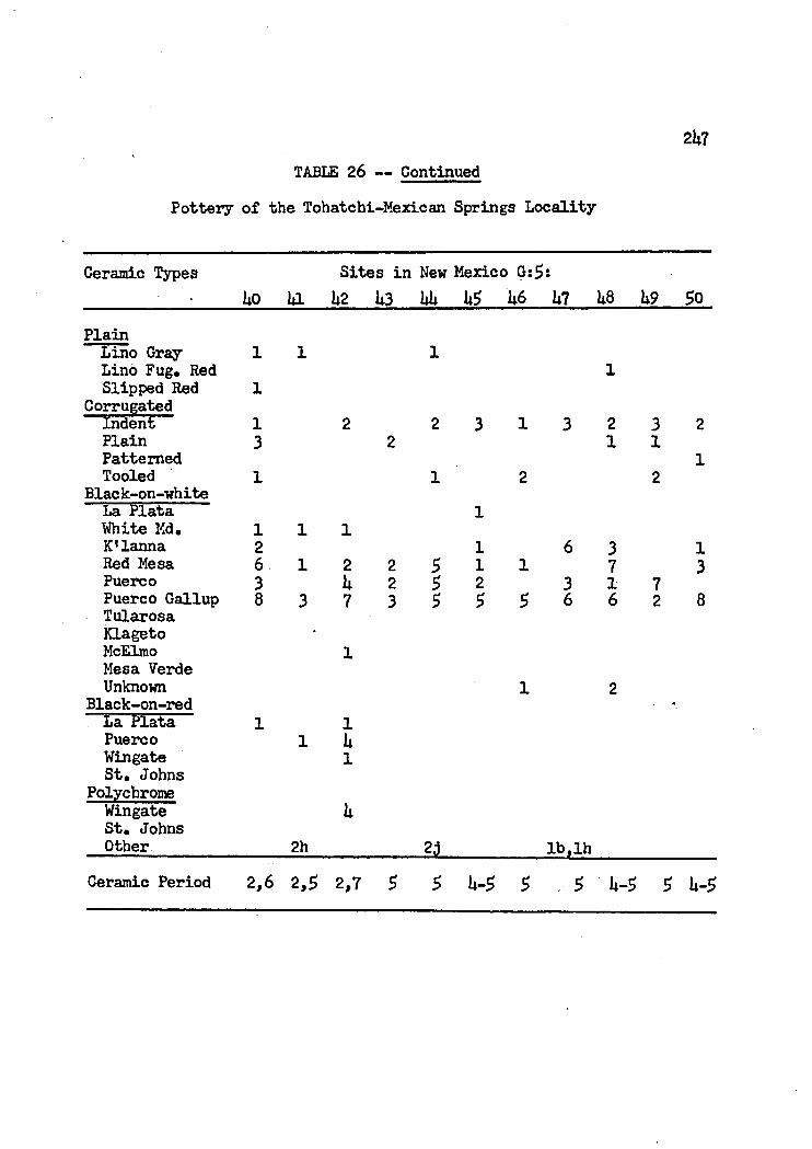
2U7TABLE 26 — Continued
Pottery of the Tohatchi-Mexican Springs Locality
Ceramic Types Sites in New Mexico G:£:Uo lil la Ii3 a U5 w 1*7 1*8 1*9 5o
PlainLino Gray Lino Fug. Red
l 1 i1
Slipped Red Corrugated
iIndent i 2 2 3 1 3 2 3 2PlainPatterned
3 2 1 11
TooledBlack-on-white
1 1 2 2La Plata White Kd. 1 1 1
lK'lanna 2 1 6 3 1Red Mesa 6 1 2 2 5 1 1 7 3Puerco 3 U 2 5 2 3 1 7Puerco Gallup Tularosa
8 3 7 3 5 5 5 6 6 2 8KLagetoMcElmo 1Mesa Verde Unknown 1 2
Black-on-red -La Plata 1 1Puerco 1 UWingate St. Johns
1Polychrome
Wingate St. Johns Other 2h
k
*4 lb,lhCeramic Period 2,6 2,5 2,7 5 5 U-5 5 5 l*-5 5 U-5

2U8TABLE 26 — Continued
Pottery of the Tohatchi-Mexican Springs Locality
Ceramic Types Sites in New Mexico G:f>:51 52 53 58
Plainlino Gray Lino Fug, Red
1 USlipped Red
Corrugatedk 1
Indent 2 1 3PlainPatternedTooled
1 1 1
Black-on-whiteLa Plata White Md, K'lanna Red Mesa
1 1Puerco U 9 7 9Puerco GallupTularosaKlageto
U 3 5 1
McElmo Mesa Verde Unknown 2
1Black-on-redLa Flata Puerco 2Wingate St. Johns
h
PolychromeWingate St. Johns Other
k
Ceramic Period 5 7 6 U-5

TABLE 27
Pottery of the Black Creek Locality
2k9
Ceramic Types Sites in Arizona K:lt:1 2 3 U 5 6 7 8 9 10 11
PlainIiino Gray 2 U 1UKana-a Gray Navajo Utility Slipped Red
135
CorrugatedIndent 3 2Plain
Black-on-white3
La Plata White Md. K'lanna
13
Red Mesa Puerco
h 1Puerco Gallup Reserve
1TularosaSosiFlagstaffTusayanHolbrookWalnutUnknown 1 1 2 2
Black-on-redPuerco Wingate St. Johns Unknown
PolychromeWingate St. Johns Ashiwi Other 3q
Ceramic Period 2-3 2-3

250TABLE 27 — Continued
Pottery of the Black Creek Locality
Ceramic Types12 13
Sites in Arizona K:L: lit 15 16 17 18 19 20 21 22
PlainULino Gray 9 3 1U 1 2 8
Kana-a Gray Navajo Utility Slipped Red
2lit
CorrugatedIndent 2 8 1 It 5 It ItPlain
Black-on-white3 3 2
La Plata White Md. K'lanna Red Mesa 1 5
2 35
Puerco 1 1 5 1Puerco Gallup It 19 10 9ReserveTularosaSosiFlagstaff
ItTusayanHolbrookWalnutUnknown 2 2 3 It
Black-on-redPuerco Wingate St. Johns Unknown
PolychromeWingate St. Johns Ashiwi 7Other la lo,lp
Ceramic Period k 3 3 5 1,5,9 5 5 5 5

251
TABLE 27 — Continued
Pottery of the Black Creek Locality
Ceramic Types Sites in Arizona K:U:
wcr\CM 25 26 27 28 29 30 31 32 33PlainLino Gray U U 1 5 1Kana-a Gray i 3 2 k -Navajo Utility Slipped Red
U3 361 5
Corrugatedindent i k 1 9 8 UPlain
Black-on-white3
La Plata White Md. K'lanna 2 k 3Red Mesa Puerco
3 k1 3 1 13 1
Puerco GallupReserveTularosa
13 1 1 6 20
SosiFlagstaff Tusayan Holbrook 1
9
WalnutUnknown 1 h l
Black-on-redPuerco 1Wingate St. Johns Unknown
1 5 1
PolychromeWingate St. Johns Ashiwi Other 11
15lb
8
lbCeramic Period 3 ? 3,5 2,5 2 9 6,9 5 5 7 6

252TABLE 27 — Continued
Pottery of the Black Creek Locality
Ceramic Types Sites in Arizona K:U:________ 3U 35 36 37 38 39 UP W. U2PlainLino Gray Kana-a Gray Navajo Utility Slipped Red
CorrugatedIndentPlain
Black-on-white La Plata White Md. K’lanna Red Mesa PuercoPuerco Gallup Reserve Tularosa SosiFlagstaff T us ay an Holbrook Walnut Unknown
Black-on-red Puerco Wingate St. Johns Unknown
Polychrome Wingate St. Johns Ashiwi Other
1
3 3 9 7 8 22 1 2 7 1
1U
2
3 L 2 2 1
Ceramic Period ? 5 2,3 5 5 ? 3 2-3 5

253
TABLE 27 **** Continued
Pottery of the Black Creek Locality
Ceramic Types Sites in New Mexico G:5>:_____________5U 55 56 $7 59 60 61 62PlainLino Gray 12Kana-a Gray Navajo Utility Slipped Red
Corrugated Indent Plain
Black-on-white La Plata 2White Md.K'lanna Red Mesa PuercoPuerco Gallup Reserve Tularosa SosiFlagstaff Tusayan Holbrook Walnut Unknown
Black-on-red Puerco Wingate St. Johns Unknown
Polychrome Wingate St. Johns Ashiwi Other
32
133
U
21
652
1
3 22
23 1 2 1 22 2
12 5 12 10
6 35 8
1 2 2 1 3k
1
Ceramic Period l 5 6 7 3,5 ? 5 6

25U
!TABLE 27 — Continued
Pottery of the Black Creek Locality
Ceramic Types Sites in Arizona K:8:1 2 3 u 5 6 7 8 9 10 n
PlainLino Gray 3 2 20Kana-a Gray Navajo Utility
2
r Slipped Red Corrugated
1 1
Indent k 1 7 k 8 9 3 k 8 6Plain
Black-on-white3 2 h 3 3 2 3
La Plata White Md. K'lanna 3
1
Red Mesa 2 3Puerco 1 5 3 7 9 5 U 10Puerco Gallup 16 5 7 12 12 2 13ReserveTularosaSosiFlagstaff
12 1
TusayanHolbrook 1WalnutUnknown 5 2 5 2 3
Black-on-redPuerco Wingate St. Johns Unknown
1
PolychromeWingate St. Johns Ashiwi Other 2a
Ceramic Period 1,6 ? 5 5 2 3-5 6 6 2,6 5 5

255TABLE 27 — Continued
Pottery of the Black Creek Locality
Ceramic Types
Plain Lino Gray Kana-a Gray Navajo Utility Slipped Red
Corrugated
Sites in Arizona K:8:12 13 1U 15 16 17 18 19 20 21 22
Indent It 6 5 2 6 5 6 2 1 1 6Plain 1 1 3 1 7 8 7 3
Black-on-whiteLa PlataWhite Md. ItK'lanna 1 ItRed Mesa 1 5 5 12 2Puerco 1 It 9 6 l 3 1 2 ItPuerco Gallup 5 16 11 12 10 9 It 7 8ReserveTularosaSosi 2 ItFlagstaff Tusay an Holbrook Walnut Unknown
Black-on-red Puerco Wingate St. Johns Unknown
Polychrome Wingate St. Johns Ashiwi Other
Ceramic Period 5 3,5 6 ? 5 5 5 2,5 5 5 5
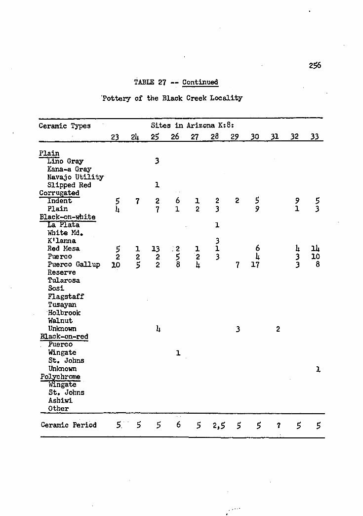
2 #TABLE 27 — Continued
Pottery of the Black Creek Locality
Ceramic Types Sites in Arizona K:8:23 2U 25 26 27 28 29 30 31 32 33
PlainLino Gray 3Kana-a GrayNavajo UtilitySlipped Red 1
CorrugatedIndent 5 7 2 6 1 2 2 5 9 5Plain U 7 1 2 3 9 1 3
Black-on-whiteLa Plata 1White Md.K'lanna 3Red Mesa $ 1 13 12 1 1 6 a i aPuerco 2 2 2 5 2 3 k 3 10Puerco Gallup 10 5 2 8 U 7 17 3 8Reserve Tularosa SosiFlagstaff Tusayan Holbrook Walnut Unknown
Black-on-red Puerco Wingate St. Johns Unknown
Polychrome Wingate St. Johns Ashiwi Other
Ceramic Period 5 2,5 5 ? $ 5

257TABLE 27 — Continued
Pottery of the Black Creek Locality
Ceramic Types Sites in Arizona K:8:3U 35 36 37 38 39 UP la U2 U3 lOi
PlainLino Gray 9Kana-a Gray 1Navajo Utility Slipped Red
CorrugatedIndent 3Plain
Black-on-white La Plata White Md#K'lanna LRed MesaPuerco 2Puerco Gallup 1ReserveTularosaSosiFlagstaffTusayanHolbrookWalnutUnknown 6
Black-on-red Puerco Wingate St. Johns Unknown
Polychrome Wingate St. Johns Ashiwi Other
1
15 L 2 6 8
2 2
1 L 1 2 1 3 L 5 U 9 9 9 6 10
1
1
2
1c
2 1
6 6 7 11 1 1 3 1
2 3 2k 3 15 1 17 11 9 It L
1
2 3 11
Ceramic Period 3,5 5 5 6 5 5 5 5 6 5 5

258-TABLE 27 — Continued
Pottery of the Black Creek Locality
Ceramic Types Sites in Arizona K:8:U5 U6 U7 U8 U9 50 5L 52 53 51* 55
PlainLino Gray 3 1Kana-a Gray Navajo U tility Slipped Red
1
1 2Corrugated
Indent U 3 2 3 8 6 U 8 10 U ItPlain
Black-on-whiteu 5 3 1 2 2 1
La Plata White Md. K'lanna Red Mesa 11 1 2 3 2 2 1 3Puerco 2 6 1 3 6 It 7 1 2 3 2Puerco Gallup 8 6 2 7 9 6 10 11 12 7 10ReserveTularosaSosiFlagstaff Tusay an Holbrook Walnut Unknown
Black-on-red Puerco Wingate St. Johns Unknown
Polychrome Wingate St. Johns Ashiwi Other
Ceramic Period 2,5 5

2 #TABLE 27 — Continued
Pottery of the Black Creek Locality
Ceramic Types Sites in Arizona K:8:56 57 58 59 60 61 62 63 6U 65 66
PlainLino Gray Kana-a Gray Navajo Utility Slipped Red
2
Corrugated8Indent 8 3 11 5 8 9 9 3 5 2
PlainBlack-on-white
2 1 1 U 3 1 3 U
La Plata White Md. K'lanna Red Mesa 3 2 3 5 3 1Puerco 2 3 3 2 1 1 5 5Puerco Gallup Reserve
6 k 3 8 11 9 7 10 8 8 U
TularosaSosiFlagstaffTusayanHolbrookWalnut
11
2
UnknownBlack-on-red
2 2 2 1 1 1
Puerco Wingate « St. Johns Unknown
1
PolychromeWingate St. Johns Ashiwi Other Id 1c
Ceramic Period 5 5 5 5 5 5 5 5 6 5 1,5

260TABLE 27 — Continued
Pottery of the Black Creek Locality
Ceramic Types Sites in Arizona K:8:67 68 69 70 71 72 73 7U 75 76 77
Plainlino Gray 3 7 3 5 1 3 3Kana-a Gray Navajo Utility Slipped Red 1 2 1
CorrugatedIndent 1 5 1 5 7 a 2 1 2 aPlain
Black-on-whitek 3 3 3
La Plata White Md. K'lanna Red Mesa
2 2
1 1 3
23
Puerco 1 1 1 1 1 3Puerco Gallup 2 10 5 5 5ReserveTularosa 2 1SosiFlagstaff
5 2TusayanHolbrook 1WalnutUnknown 2 1 1 1 2 1
3Black-on-redPuerco 2Wingate St. Johns Unknown
i1
PolychromeWingate St. Johns Ashiwi
1l 1
Other 17a 26a 26a lb
1 1 1 5 5 6 5 7 2 3,5 7Ceramic Period
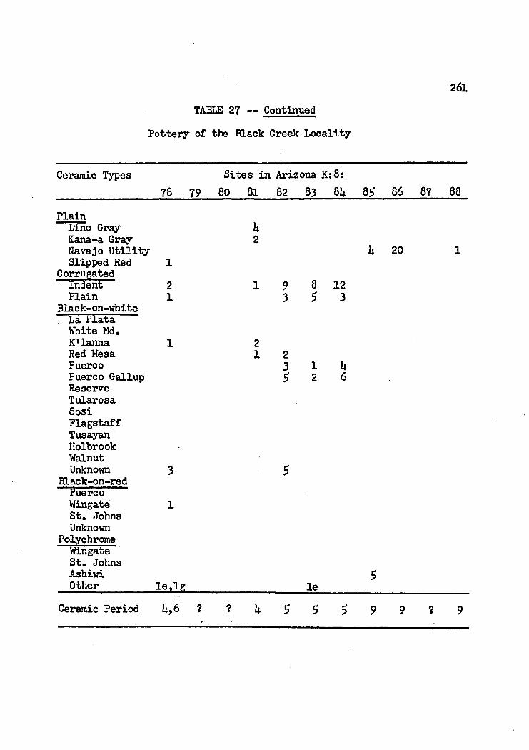
261TABLE 27 — Continued
Pottery of the Black Creek Locality
Ceramic Types78 79
Sites in Arizona K:8: 80 81 82 83 8U 85 86 87 88
PlainLino Gray kKana-a Gray 2Navajo Utility u 20 1Slipped Red 1
CorrugatedIndent 2 1 9 8 12Plain 1 3 5 3
Black-on-whiteLa Plata White Md.K’lanna 1 2Red Mesa 1 2Puerco 3 i kPuerco Gallup Reserve
5 2 6
TularosaSosiFlagstaffTusayanHolbrookWalnutUnknown 3 5
Black-on-redPuerco Wingate St. Johns Unknown
1
PolychromeWingate St. Johns Ashiwi Other le,lg le
5
Ceramic Period U,6 ? ? U 5 5 5 9 9 ? 9

262'TABLE 27 — Continued
Pottery of the Black Creek Locality
Ceramic Types Sites in Arizona K:8:89 90 91 92 93 9k 95 96 97 98 99
Plain8Lino Gray
Kana-a Gray Navajo Utility
11
2 1 3
Slipped Red Corrugated
2 3 2 1
Indent 7 2 6 7 8 It 8 3 1Plain
Black-on-white2 2 2
La Plata White Md. K'lanna Red Mesa 7
3
Puerco 2 2 1 It 6 1Puerco Gallup 2 2 2 1ReserveTularosa 1 1SosiFlagstaff 2TusayanHolbrook 1 1Walnut 2Unknown
Black-on-red2 2 3 2 5
Puerco 2 1 1 2Wingate St. Johns Unknown
Polychrome Wingate St. Johns Ashiwi Other
22 3
212h # 3 m
Ceramic Period 5 U 6 5 ? 2,6

263
TABLE 27 — Continued'Pottery of the Black Creek Locality
Ceramic Types Sites in Arizona K:8:100 101 102 103 lOlt 105 106 107 108 109
PlainLino GrayKana-a GrayNavajo UtilitySlipped Red 1 2 3 1
CorrugatedIndent 3 3 It 7 6 2 6 5 It 6Plain 1 1 1 1 2 1
Black-on-white •La PlataWhite Md.K’lanna 1Red MesaPuerco 7 h 2 20 1 3 2 6Puerco Gallup 3 1 2 10 1 3 1 2Reserve 1Tularosa S 1 5 1Sosi 1Flagstaff 1 ItTusayan 1 1 1Holbrook 5Walnut 3Unknown 1 3 2 It 6 3
Black-on-redPuerco 1 2 ItWingate 1 1 1St. Johns 2 1Unknown It
PolychromeWingate 2 1 3 3 1 3St. Johns 2 h 3 1AshiwiOther 1m
Ceramic Period 7 7 7 It,7 5 7 5 7 7 5

26U’TABLE 27 — Continued
Pottery of the Black Creek Locality
Ceramic Types Sites in Arizona K:8:no in 112 113 iiA 11$ 116 n? ns n? 120
Plain •liino Gray Kana-a Gray Navajo Utility Slipped Red 1
2
1 3CorrugatedIndent 3 u 3 3 3 it 2 it z 3 6Plain
Black-on-white1 1 2
. La Plata 1White Md.K'lanna Red Mesa u 2 2 3 itPuerco 10 1 5 7 10 2 2 5 3 6Puerco Gallup $ 2 6 11 2 7 8 3ReserveTularosaSosiFlagstaffTusayanHolbrook 1
1 1
i 2
3
WalnutUnknown
3k 3 2 2 Z
Black-on-red. Puerco Wingate St. Johns Unknown
1
it
11
1 1
PolychromeWingate 1St. Johns Ashiwi
3 2 •Other 2m
Ceramic Period 2-3 7

265TABLE 27 — Continued
Pottery of the Black Creek Locality
Ceramic Types Sites in Arizona K:8:121 122 123 12U 125 126 127 128 129 130 131
21
1 1 2 3 1
2 6 2 3 U 2 3 1 2 3 21 1 1 1
2 3 U10 5 5 7 2 7 U 7 5 5 58 1 7 6 8 5 5 7 9 10
2 1 1
l
1 3 2 1 2 1
Plain Lino Gray Kana-a Gray Navajo Utility Slipped Red
Corrugated indent Plain
Black-on-white , La ftLata
White Md* K'lanna Red Mesa PuercoPuerco Gallup Reserve Tularosa SosiFlagstaff Tusayan Holbrook Walnut Unknown
Black-on-red . Puerco
Wingate St. Johns Unknown
Polychrome Wingate St. Johns Ashiwi Other
51
Ceramic Period 6 3-5 5

266
TABLE 27 — Continued
Pottery of the Black Creek Locality
Ceramic Types Sites in Arizona K:8:132 133 13L 135 136 137 •138 139 iLo lid 1L2
PlainLino Gray Kana-a Gray Navajo Utility Slipped Red 2 1 2
CorrugatedIndent 1 3 k 1 2 2 1 2 1 uPlain
Black-on-white1 U 1 1
La Plata "White Md.K'lanna Red Mesa 3
1Puerco 5 U 8 1 U 5 7 5 5 9 kPuerco Gallup 10 7 6 k 3 2 3 2 5 3 kReserveTularosa 1SosiFlagstaffTusayanHolbrook
7 1
2WalnutUnknown 1 1 1 1 3 2
Black-on-redPuerco 2 1 1Wingate St* Johns Unknown
2 2 2
PolychromeWingateSt. JohnsAshiwiOther
Ceramic Period 6 6 6 5 L-5 5 6 5 5 6 6

26?3AELE 27 — Continued
Pottery of the Black Creek Locality
Ceramic Type Sites in Arizona K:8:1U3 i a 1U5 1U6 U 47 1U8 -1U9 150 151 152 153
Plain Lino Gray Kana-a Gray Navajo Utility Slipped Red
Corrugated Indent 2Plain 2
Black-on-white . La Plata White Md.K'lanna Red MesaPuerco 9Puerco Gallup 6ReserveTularosaSosiFlagstaff Tusayan Holbrook Walnut Unknown
Black-on-red . Puerco 3Wingate St. Johns Unknown
Polychrome Wingate'St. JohnsAshiwiOther
3 11
2 6 2 1
7 h 5 3
k 2 1 1
1
63 32 9
2 52 2
21 2 1 10
2 3 3
6 5 2 5 7 6
1
1
If
3
1 53
It5 21 lit5 21
5
l l
1
2
Ceramic Period 6 5 5 2,5 5 5 5 6 5 L-5 7

268
TABLE 27 — Continued
Pottery of the Black Creek Locality
Ceramic Types Sites in Arizona K:8:15U 155 156 157 158 159 l6o 161 162 163 16U
PlainLino Gray 3 9 3 6 13 1 7 2 1 2Kana-a GrayNavajo UtilitySlipped Red 1
CorrugatedIndent 3 3 5 1 1 1 3 1 3Plain 3 3 2 2 1 2 1 1 2
Black-on-white. La Plata.....
White Md. 2 1 1 1K'lanna 1 3 6 3 1Red Mesa 7 1 2 u 3 1 8 6Puerco 6 1 1 1 3 7 8Puerco G a n up 5 5 1 10 a 10 1 10 7 aReserveTularosaSosiFlagstaffTusayanHolbrookWalnutUnknown
Black-on-redPuercoWingate St. Johns Unknown
Polychrome; Wingate 1St. Johns 1 iAshiwi Other
Ceramic Period $ $ 2,5 U-5 5 2 5 2,5 5 2-5 3,7

269TABLE 27 — Continued
Pottery of the Black Creek Locality
Ceramic Types Sites in Arizona K:8:165 166 167 168 169 170 171 172 173 17U
PlainLino Gray 6 6 2 8 12Kana-a Gray 1 1Navajo UtilitySlipped Red
CorrugatedIndent 2 2 U 3 3 1 1Plain 2 1 2
Black-on-whiteLa Plata 1 1White Md. 2 6 3K'lanna 5 1 h 3Red Mesa 3 1 k 3 7Puerco 3 1 k - 3Puerto Gallup 9 2 h 6 8Reserve 2 1TularosaSosiFlagstaff Tusayan Holbrook Walnut Unknown
Black-on-red fuerco “ Wingate St. Johns Unknown
Polychrome Wingate St. Johns Ashiwi Other
Ceramic Period 1-2 U-5 5 5 $ 7 3 $ 2 2
270TABLE 21 — Continued
Pottery of the Black Creek Locality
Ceramic Types Sites in Arizona K:8:176 177 178 179 180 181 182 183 181* 185 186
Plain ....
Lino Gray 1U 1 6 1 9Kana-a Gray Navajo Utility Slipped Red 2 1 1
CorrugatedIndent . 2 h 1 k u 2 2 2Plain
Black-on-white3 1 3 2 1 2 1
. La Plata White Md.
33 6
K ’lanna 1 2Red Mesa 3 1 5 1 2Puerco 7 U k 2 It 3 3 5Puerco Gallup 7 2 3 2 It It 9 1 UReserve 1 3 3 1 iTularosaSosi
2 3FlagstaffTusayanHolbrookWalnut 2Unknown
Black-on-red1 1 2 1 1
. Puerco 1Wingate St. Johns
1Unknown
PolychromeWingateSt. JohnsAshiwiOther
Ceramic Period 1 $. 5 6 2 5 $ 2 2,6 U-5 2

271TABLE 27 — Continued
Pottery of the Black Creek Locality
Ceramic Types Sites in Arizona K: 8:187 188 189 190 191 192 193 19U 195 5$
Plainifno Gray Kana-a Gray Navajo Utility
8 1 13 1 10
Slipped Red Corrugated
1 1
Indent 1 5 k 2 2 5 2Plain
Black-on-white1 1 2 1
. La Plata 2White Md. 3 1 2 1 k 2K'lanna Red Mesa 1 1 2Puerco 7 6 9 k 10 5 6Puerco Gallup 2 3 3 3 3 3ReserveTularosaSosi
1 1
FlagstaffTusayanHolbrookWalnutUnknown 1 1 1 2 1
Black-on-red . Puerco Wingate St. Johns Unknown
Polychrome Wingate
1
5
St. Johns Ashiwi
3Other la 1c lj
Ceramic Period $ 7 $ 1-2 6 2,5 2 2,5 2 2,7 5

272TABLE 27 — Continued
Pottery of the Black Creek Locality
Ceramic Types Sites in Arizona K:8$198 199 200 201 202 203 20U 205 206 207 208
PlainLino Gray 11 UK&na-a Gray Navajo Utility Slipped Red 2
CorrugatedIndent 2 2 3 k 2 3 2 2 2 2Plain
Black-on-white1 1 2 1 2 2
. La ELaia White Md. 2
1K'lanna Red Mesa
12 1 2
22
Puerco 2 3 5 n 5 5 6 It UPuerco Gallup $ U h 10 6 5 2 7 5ReserveTularosaSosiFlagstaffTusayanHolbrook
1
2 2
WalnutUnknown 3 2 1 1
Black-on-redPuerco 1 3Wingate St* Johns Unknown
11
PolychromeWingateSt. JohnsAshiwiOther
1
2 5 5 » 5 5. 7 5 6. U,6 1,5Ceramic Period

273TABLE 27 — Continued
Pottery of the Black Creek Locality
Ceramic Types Sites in Arizona K:8:209 210 211 212 213 21k 21$ 216 217 218 219
PlainLino Gray 7Kana-a Gray Navajo Utility Slipped Red 1
1 1
17
1 1CorrugatedIndent $ 2 k 1 2 $ 2 3 6Plain
Black-on-white2 2
. La Plata White Md, K'lanna Red Mesa 3 1 2 2 2Puerco 7 8 2 8 11 $ 1 h 3 kPuerco Gallup 8 3 1 6 3 2 1 2 2ReserveTularosaSosiFlagstaffTusayanHolbrook
3
2U 1
Walnut 1Unknown
Black-on-red3 2 2 1 $ 3 7
. Puerco U 1Wingate 1St. Johns Unknown
Polychrome Wingate
2 2
kSt. Johns Ashiwi 10
2Other lg '
Ceramic Period

27U
TABLE 27 — Continued
Pottery of the Black Creek Locality
Ceramic Types Sites in Arizona K:8:_____________ 220 221 222 223 22U 22$ 226 227 228 229 230
Plain Lino Gray Kana-a Gray Navajo Utility Slipped Red
Corrugated Indent 5Plain
Black-on-white La Plata White Hd.K'lanna Red MesaPuerco 3Puerco Gallup 3ReserveTularosaSosiFlagstaffTusayanHolbrookWalnutUnknown $
Black-on-red Puerco Wingate St. Johns Unknown
Polychrome Wingate St. Johns Ashiwi Other
1 3 2 2 3 1 2
2 3 1 5i i i i °
51 2
1 1 2 8 1
13
1
1 U 3 32 1
1
3 35 6 2 53 3 2 3
1
2 2 31
2
1
Ceramic Period 5 6 5 5 5 5 5 1 5 6 7

275
TABLE 27 — Continued
Pottery of the Black Creek Locality
Ceramic Types Sites in Arizona K:8:231 232 233 23U 235 236 237 238 239 2k0 2ltl
PlainLino Gray Kana-a Gray Navajo Utility
1 3 2
Slipped Red 1 1Corrugated
Indent 1 3 It 3 2 3 6 1 1 7Plain
Black-on-white1 3 2 1 It
, La KLata White Md. K'lanna 1Red Mesa 1 6 1 5 2Puerco 1 2 1 6 It 1 3Puerco Gallup 2 2 3 3 3 13ReserveTularosa
1 3 12
1Sosi 2 1 1 3FlagstaffTusayan 1
2Holbrook 2 3Walnut 5 2Unknown
Black-on-red2 2 1 3
. fcuerco 3 7 ItWingate 2 1 3 3 1St. Johns Unknown
3 6Polychrome
Wingate 1 7St. Johns Ashiwi
ItOther Ig Ug
Ceramic Period 5 7 U, 6 6 7 7 5 6 6 5 5

276TABLE 27 — Continued
Pottery of the Black Creek Locality
Ceramic Types Sites in Arizona K:8: Sites in Arizona K:12:2l|2 21*3 214* 21*5 17 18 19 20 21 22
Plain. Lino Gray 1 1 3Kana-a Gray Navajo Utility Slipped Red 1
12
CorrugatedIndent 7 1 9 6 3 3 1* 3 i uPlain
Black-on-white1 1 1 2 1
. La £lata... 1White Md. K'lanna Red Mesa 2
1U 1
Puerco 1 3 1 7 1* It 1Puerco Gallup 11 7 6 12 3 5 5 U 2ReserveTularosaSosiFlagstaffTusayanHolbrookWalnut
2 2
1
1
UnknownBlack-on-red
k 1 U i 1 U 1
. Puerco 1 1Wingate St. Johns Unknown
Polychrome Wingate St. Johns Ashiwi Other
2
Ceramic Period 5 U-5 5 $ 5 6 1,5 5 7 6,9

277
TABLE 27 — Continued
Pottery of the Black Creek Locality
Ceramic Types Sites in Arizona K:12:23 2k 25 26 27 28 29 30 31 32 33
Plain!Lino Gray 17 2 2 1 1Kana-a Gray Navajo Utility k 18 9Slipped Red
Corrugated. 1 1
Indent 3 7 $ 1 3 u 7 2 2 5 2Plain
Black-on-whiteh 1 1 2 1 1 1
. La Plata White Md. K*lanna Red Mesa
1
1 1Puerco 6 6 1 5 2 2 2Puerco Gallup 1 3 2 3 2ReserveTularosaSosi
1
1 13
2 1
1FlagstaffTusayanHolbrookWalnut
2
UnknownBlack-on-red
2 3 1 2 2 1 3 1 5 1
Puerco Wingate St. Johns Unknown
PolychromeWingateSt. JohnsAshiwiOther la 2e.li. 2m 2m
Ceramic Period $ 6,9 $ 1?' .
U,9 6 5,9 1,5 U 5 5

278TABLE 27 — Continued
Pottery of the Black Creek Locality
Ceramic Types Sites in Arizona K:12:3l» 35 36 37 38 39 ItO la 1*2 1*3 1*1*
Plain Lino Gray 2 1 1 3 1 5Kana-a Gray Navajo U tility Slipped Red 1 l 1 2 1 2
CorrugatedIndent 3 2 2 3 3 1 2 2 1 2Plain
Black-on-whiteU 2 1 2
. La Plata 1 2White Md. 1 2 9K'lanna Red Mesa 2
1 1
Puerco 6 3 U 1* 6 1Puerco Gallup 5 3 3 2ReserveTularosaSosiFlagstaffTusayan
23
1U L 3
HolbrookWalnut 2
1
UnknownBlack-on-red
3 1 5 1 2 1 1 1 3 1
. Puerco Wingate
11 1
St* Johns Unknown
Polychrome Wingate
1 1 1
1 u 1 2 1St, Johns Ashiwi
1 2 li 5 1* 2 1
Other 5f lb,7f I f I f I f
? 5 ? 5 2,7 7 2,7 7 7 7 2,7Ceramic Period

279TABLE 27 — Continued
'Pottery of the Black Creek Locality
Ceramic Types Sites in Arizona K:12:________ ;_________ U£.Plain
Lino Gray 2Kana-a Gray Navajo U t il ity Slipped Bed
Corrugated Indent 3Plain
Black-on-vhiteLa Plata — 1White Md.K’lanna Red Mesa PuercoPuerco Gallup Reserve Tularosa SosiFlagstaffTusayanHolbrookWalnutUnknown 1
Black-on-red
k6 U7 U8 U9 5o
i U 11
2 1 1
2 2 k 2 31 2 1
11 5
1
3 u 3 311 8 5
. 1 1
1
1 1 1
52 53 5U 5$
2 1 1 10 1
1 5 2 k 1 2
21
U 3 3 U1 1 3 71 2
1. t'uerco . 2
Wingate 1 1St. Johns 1 1Unknown
PolychromeWingate 1 kSt. Johns 2 1 5AshiwiOther 5f 7 f.lk lb , I f Ig Id .le
Ceramic Period 1,7 2,7 2,5 U,5 6 5 2,7 5 5 ? 6

280TABLE 27 — Continued
Pottery of the Black Creek Locality
Ceramic Types Sites in Arizona K:12:57 58 59 60 61 62 63 61* 65 66
Plain Lino Gray 7Kana-a Gray Navajo U tility Slipped Red 2 1
CorrugatedIndent 2 1 2 1 2 2 3 5 2 LPlain
Black-on-white3 k 1 2 2 2
. La Plata White Md. K’lanna Red Mesa Puerco 7 5 9 1 9 7 8 1 11 3Puerco Gallup 2 3 2 7 7 2 5 6 8 3ReserveTularosa
1 LSosiFlagstaffTusayanHolbrookWalnut
2 . 1
Unknown Black-on-red . Puerco
1 3 1 2 1 2
Wingate St, Johns Unknown 1 1 1
PolychromeWingateSt. JohnsAshiwiOther lb
1
Ceramic Period . $ 5 6 5 6 5 5 5 5 7 5

281TABLE 27 — Continued
Pottery of the Black Creek Locality
Ceramic Types Sites in Arizona K:12:67 68 69 70 71 72 73 235 236
PlainLino Gray Kana-a Gray Navajo U tility Slipped Red
1
CorrugatedIndent 2 2 5 h 5 3 UPlain
Black-on-white3 3 1 1 3
. La Plata White Md. 1 1K'larina Red Mesa 2 1 1Puerco 1 5 3 k 3 12 2 7Puerco Gallup Reserve
1 5 U 2 1 3
TularosaSosiFlagstaffTusayanHolbrookWalnut
i
UnknownBlack-on-red
1 1 1 1 2
. Puerco 1Wingate St* Johns Unknown
PolychromeWingate 1St. JohnsAshiwiOther
1 1
Ceramic Period 2,5 7 5 5 2,6 5 5 7 ?

282TABES 28V,
Pottery of the Rio Puerco Locality
Ceramic Types Sites in Arizona K:12z7L 75 76 77 78 79 80 81 82 83 81*
Plain Lino Gray 1L 18 1Lino Pug, Red Kana-a Gray Navajo Utility Broun W, E. Brown ¥. Sag.
27 1 1
1
Brown W, L, Slipped Red 2 2 1
CorrugatedIndent 3 1 2 2 2 1 3 1Plain
Black-on-white1 1 2
La Plata White Md. K ,lanna Red Mesa
12 2 1 6 2
Puerco 1 2 3 11 6 6 8 7Puerco Gallup k L 8 7 6 8 2 3TularosaReserveHolbrook
3 L2
Kana-a Black Mesa Sosi KLageto
1n 2 2
UnknownBlack-bn-red
i
Puerco 1 1 3 1 1 1Wingate St, Johns Unknown
Polychrome Wingate
1 1 3 1
L kSt, Johns kOther ha,ld,le
Ceramic Period 1 1-2 6 7 7 5 6 6 5 6 6
283TABLE 28 — Continued
Pottery of the Rio Puerco Locality
Ceramic Types
Plain Lino Gray Lino Fug* Red Kana-a Gray Navajo Utility Brown W* E* Brown W* Smg. Brown W. L. Slipped Red
Sites in Arizona K:12:85 86 87 88 89 90 91 92 93 9h 9$
Indent U 3 1 1 3 it 2 5 2 3 1Plain 1 1 2
Black-on-whiteLa PlataWhite Md.K ’lanna 1 1Red Mesa 1 6 3 1Puerco 3 5 6 3 2 3 3Puerco Gallup It k 6 1 2 5 8 8 3 itTularosaReserve 1 1 3 2Holbrook Kana-a Black Mesa Sosi Klageto Unknown
Black-on-red . Puerco Wingate St* Johns Unknown
Polychrome Wingate St* Johns Other
1 1 It
1 •
Ceramic Period 5 5 U-5 U-5 U 5 5

28UTABLE 28 — Continued
Pottery of the Rio Puerco Locality
Ceramic Types Sites in Arizona K:12:96 97 98 99 100 101 102 103 ioU 102 106
Plain —
lino Gray Lino Fug. Red
3 2 6 1 2
Kana-a Gray Navajo Utility Broun W. B. Broun W. Smg. Broun W. L.
2
Slipped Red Corrugated
1 2
Indent 1 2 1 3 2 1 1 1 2 3 2Plain
Black-on-white1 3 1 2 1 1 2
. La Plata White Md. K ’lanna
1 1Red Mesa 1 13 9 2 6Puerco 1 3 10 7 It 1 3 2 2 3Puerco Gallup 8 5 5 3 1 3 2 2 3 3TularosaReserve 2 U
1U
HolbrookKana-aBlack MesaSosiKlagetoUnknown 1 2 2 2
21
Black-on-red. Puerco Wingate
2St. Johns Unknown
Polychrome Wingate
3
2 2St. Johns Other
1 3
Ceramic Period 5 5 5 7 5 5 7 6 2,7 2 2,2

285
.TABLE 28 — Continued
Pottery of the Rio Puerco Locality
Ceramic Types Sites in Arizona K?12i__________________107 108 109 210 111 112 113 lilt 115 116 117
Plain Lino Gray Lino Fug* Red" Kana-a Gray Navajo Utility Brown W. E.Brown W. Smg.Brown W, L.Slipped Red
Corrugatedindent 2Plain
Black-on-white . La Plata "White Md.K'lanna Red MesaPuerco 2Puerco Gallup TularosaReserve 3Holbrook Kana-a Black Mesa Sosi KLageto Unknown
Black-on-red . Puerco Wingate St* Johns Unknown
Polychrome Wingate St. Johns Other
U 1 122
2 1 1 *3 1
2
96 2 3 1 1 1 12
1
1 1
1 2
3
It 1 U 2
16 5 6 It9 5 5
It It l
It 21
Ceramic Period 5 2 3 S 2 1,5 5 3 5 6 5

286
rTABLE 28 — Continued
Pottery of the Rio Puerco Locality
Ceramic Types Sites in Arizona K:12:118 119 120 121 122 123 12b 12$ 126 127 128
Plain Lino Gray Lino Fug. Red Kana-a Gray Navajo Utility Brown W. E.Brown W. Smg.Brown W. L.Slipped Red
Corrugated Indent UPlain
Black-on-white . La Plata White Md.K ’lanna Red MesaPuerco 5Puerco Gallup 6Tularosa Reserve Holbrook Kana-a Black Mesa Sosi KLageto Unknown
Black-on-red . Puerco Wingate St. Johns Unknown
Polychrome Wingate St. Johns Other
9 5
27 17
3
$ 31
312 7
1
1
7 2 1
18
2 5 31 2 1
11
2 1 1 1 3
If lb
Ceramic Period 5 5 5 1 1 5 5 5 2,5 1 5

28?TABLE 28 — Continued
Pottery of the Rio Puerco Locality
Ceramic Types Sites in Arizona K:12t___________ 129 130 131 132 133 13k 135 136 137 138Plain Lino Gray Lino Fug, Red Kana-a Gray Navajo Utility Broun W. E. Brown W. Sag, Brown W, L. Slipped Red
Corrugated Indent Plain
Black-on-white . La ?lata White Md. K'lahna Red Mesa PuercoPuerco Gallup Tularosa Reserve Holbrook Kana-a Black Mesa Sosi Klageto Unknown
Black-on-red Puerco Wingate St, Johns Unknown
Polychrome Wingate St. Johns Other
u 1 2 3
1
Ceramic Period 6 5 5 5 5 5 5 5 ? 5

288
TABLE 28 — Continued
Pottery of the Rio Puerco Locality
Ceramic Types Sites in Arizona K:12:139 lliO u a 11*2 11*3 U*lt 11*5 11*6 11*7 11*8 11*9
PlainLino Gray Lino Fug. Red
1 9 6 7 12 1
Kana-a Gray Navajo Utility Brown W. E. Brown W. Stag* Brown ¥. L. S
1
Slipped Red Corrugated
3 1
Indent 5 3 2 2 It 3 1 5Plain
Black-on-white1 1
. La Plata White Md. 2 3 1 13 2K ’lanna Red Mesa 1 1
1Puerco U 6 7 2 6 1 6Puerco Gallup 2 2 7 3 5 3 5Tularosa 1 1Reserve 1 1HolbrookKana-aBlack MesaSosiKLagetoUnknown 1 2 3 1 3Black-on-red
... PuercoWingate St. Johns Unknown
Polychrome Wingate
1 2 6
2 5St. Johns Other
5 2,6 6 3,7Ceramic Period

289
VIABLE 28 — Continued
Pottery of the Rio Puerco Locality/
Ceramic Types Sites in Arizona Kil2:1 # 151 152 153 15U 155 156 157 158 159 l6o
PlainLino Gray 5 8 16 1 L 1 7 15Lino Fug. Red Kana-a Gray Navajo Utility Brown W. E.
1 11 1
Brown W. Sag. Brown W. L.
1
Slipped Red Corrugated
1
Indent 3 1 2 1 1 3 3 5 1Plain 2 1 1 2
Black-on-white . La Plata 2 3White Md. U 2 2 i 19 6K ’lanna Red Mesa 2
1 ' 11 2 2 1 1 2
5
Puerco 8 2 2 1 1 L 1Puerco Gallup 2 1 7 L 9 5 5 llTularosaReserveHolbrook
2 1
Kana-a Black Mesa Sosi KLageto Unknown 2 1 1
Black-on-redPuerco Wingate St. Johns Unknown
PolychromeWingateSt. JohnsOther lb
Ceramic Period fc-5 3 2,5 2,2 5 6 2,5 5 5 2 2

290
TABLE 28 — Continued
Pottery of the Rio Puerco Locality
Ceramic Types Sites in Arizona K;12:_________________161 162 163 16U 16$ 166 16? 168 169 170 171
Plain Lino Gray Lino Fug. Red Kana-a Gray Navajo Utility Brown ¥. E. Brown W. Sag. Brown W. L. Slipped Red
Corrugated Indent Plain
Black-on-white . La Plata White Md. K’lanna Red Mesa PuercoPuerco Gallup tularosa Reserve Holbrook Kana-a Black Mesa Sosi KLageto Unknown
Black-on-red . PuercoWingate St. Johns Unknown
PolychromejlychxIsangogate St. Johns Other
31
7U2
7
2
1 12 6 1U 6 2
1
1
$ 1 1 3 3 1
1 U7 3 2 19 1
1 21 11 6 1 28 3 u 7
1
2
Ceramic Period 5 2 5 2 2 2 5 2 2 $ 7

291TABLE 28 — Continued
Pottery of the Rio Puerco Locality
Ceramic Types Sites in Arizona Kil2: •__________________172 173 17U 17$ 176 177 178 179 180 181 182Plain Lino Gray Lino Fug. Red Kana-a Gray Navajo Utility Brown W. E.Brown W. Smg.Brown W. L.Slipped Red
Corrugated Indent 1Plain 2
Black-on-white . la Plata White Md.K'lanna Red MesaPuerco 3Puerco Gallup 6 Tularosa Reserve Holbrook Kana-a Black Mesa Sosi Klageto Unknown
Black-on-red . Puerco Wingate St. Johns Unknown
Polychrome tw.ngate St. JohnsOther_____________
1
2 1 2 3 2 1 7 3 1 11 3 2
2 1
1 2 31 5 2 3 2 7 8 2h 6 2 8 6 5 16 k 1 U
1
1 2
1 11 1
Ceramic Period $ 6 6 *> 2,5 5 6 6 5 5 5

292
TABLE 28 — Continued
Pottery of the Rio Puerco Locality
Ceramic Types Sites in Arizona K:12t183 18U 18$ 186 187 188 189 190 191 192 193
Plain Lino Gray Lino Fug. Red Kana-a Gray Navajo Utility Broun W. E. Brown W. Sag. Brown W. L.Slipped Red 1 1
CorrugatedIndent 2 U 1 2 3 3 2 1 2Plain 3 2 1 1 1
Black-on-white. La PlataWhite Md. 2K'lanna 1 2Red Mesa 10 2 2 1 3 1 3Puerco h 1 h 6 3 2 2 U LPuerco Gallup 2 7 L 6 6 6 8 7 5 2TularosaReserve 2 2 1 3 2 1Holbrook 1Kana-a Black Mesa Sosi KLageto Unknown
Black-on-red Puerco Wingate St. Johns Unknown
Polychrome Wingate St. Johns Other
1
1
Ceramic Period S U-5 7 h,S 5 6 $

2937TABLE 28 — Continued
Pottery of the Rio Puerco Locality
Ceramic Types Sites in Arizona K:12:19k 195 196 197 198 199 200 201 202 203 20k
Plain Lino Gray k 11 5 12 1Lino Fug. Bed Kana-a Gray Navajo Utility Brown V. E.
1
Brown ¥. Sag, Brown W. L. Slipped Red 1 2 1
Corrugated ■ •
Indent h 2 1 6 5 3Plain
Black-on-whiteL 1 1 1
. La Plata 1 1White Md. 3 7 6 hK'laima 1
kRed Mesa 1 7 5 1Puerco 3 2 6 6 7 9 7Puerco Gallup 5 6 3 h 3 5TularosaReserve 1HolbrookKana-aBlack MesaSosiKLagetoUnknown 2 2
Black-on-redPuerco Wingate St. Johns Unknown 1 1
1
PolychromeWingate St. Johns Other
1
Ceramic Period 5 6 2,6 2 2 6 2-L 1 5 6 7

29k
TABLE 28 — Continued
Pottery of the Bio Puerco Locality
Ceramic Types .. Sites in Arizona K:12: .__________________ 20^ 206 207 208 209 210 211 212 213 2lU 21$
Plain Lino Gray Lino Fug# Red Kana-a Gray Navajo Utility Broun W# E,Brown W* Sing.Brown W. L*Slipped Bed
Corrugated Indent UPlain
Black-on-white . La Plata White Md.K'lannaRed Mesa 3Puerco 10Puerco Gallup 2TularosaReserveHolbrookKana-aBlack MesaSosiKlagetoUnknown 1
Black-on-red . Puerco Wingate St. Johns Unknown
Polychrome Wingate St. Johns Other
3 U 1
2
1 2 25 1 3 32 1 2 9
1
1 1 1
2 1
25
1 2 2 1 1 1
26
1
61 5
31
Ceramic Period 5 6 U 5 5 5 5 ? 3,51,2,5 6

iTABLE 28 — Continued
iPottery of the Rio Puerco Locality
Ceramic Types Sites in Arizona K:12:216 217 218 219 220 221 -222 223 22a 225 226
Plain Lino Gray 3 1 i 3 a 8 2 13 3Lino Fug* Red Kana-a Gray Navajo Utility Brown W. B* Brown W. Smg. Brown W, L*
i1
Slipped Red Corrugated
1
Indent k 3 2 3 a 5 3 2Plain
Black-on-white3 3 1 2 i 1 1 1
La Plata 1 3 3White Md. K'lanna 2 1 3
a 11
Red Mesa 1 u a 2 1 aPcerco 5 6 a 2 a 12 8 2Puerco Gallup Tularosa
3 9 a 5 2 a 1 1 9 aReserve Holbrook Kana-a Black Mesa Sosi
1 1 i
KLagetoUnknown 6 i 1 2
Black-on-red. Puerco 2Wingate St. Johns Unknown 3PolychromeWingate St. Johns Other
Ceramic Period 5 2-5 a-5 5 6 a-5 2,5 2,5 1 5 a-5

296
TABUS 28 — Continued
Pottery of the Rio Puerco Locality
Ceramic Types Sites in Arizona K:12:227 228 229 230 231 232 233 23U
Plain Lino Gray Lino Fug* Red Kana-a Gray Navajo Utility Brown W. B. Brown W. Smg* Brown ¥. L. Slipped Red
Corrugated Indent Plain
Black-on-white La Plata White Md. K'lanna Red Mesa PuercoPuerco GallupTularosaReserveHolbrookKana-aBlack MesaSosi
1 1 it 2 1
10 5 52 13 31 8 8
KLageto Unknown
Black-on-red " Puerco ’ Wingate St, Johns Unknown
Polychrome Wingate St, Johns Other_____
77 2
1 2 k 1
1 1 9 1
Id
U 1 1
11
23 2 2 1 1 1
3 2 33 1 32 it 3
1 1
11
it
1
Ceramic Period 6 7 7 ? 3 6 1,6 7
297
TABLE 28 — Continued
Pottery of the Rio Puerco Locality
Ceramic Types Sites in Arizona Kill:______ 3 U 5 6 7 8 9 10 11 12 13
Plain Lino Gray Lino Fug. Red Kana-a Gray Navajo Utility Brown V. E.Brow W. Stag. Brown W. L. Slipped Red
Corrugatedindent 2Plain 1
Black-on-white La Plata White Kd.K'lannaRed Mesa 1Puerco 5Puerco Gallup 3 Tularosa Reserve Holbrook Kana-a Black Mesa Sosi Klageto Unknown
Black-on-red . Puerco 1Wingate St. Johns Unknown
Polychrome Wingate St. Johns Other
1 1 2 2
n
3 L Li
2 32 1 5
1 1 L L 8 3 3
1 11 8 2
6 23 L 7 2 8
1
2 5
l8f Sf
Ceramic Period 6 5 2 5 9 9 5 5 5 L-3 L-5

298TABLE 28 — Continued
Pottery of the Rio Puerco Locality
Ceramic Types Sites in Arizona Kill:Ik 15 16 17 18 19 20 21 22
Plain Lino Gray 1 9 1Lino Fug, Red Kana-a Gray Navajo Utility Brown W, E, Brown W, Smg. Brown W, L. ' Slipped Red 1
31
3
CorrugatedIndent 6 3 2 2 2 k 2 3Plain
Black-on-white2 3 1 1
La Plata White Md. K ’lannaRed Mesa 1 2 2 k 5Puerco 7 1 2 k 6 k 8 1Puerco Gallup Tularosa
2 7 7 5 3 9 15 8
Reserve Holbrook Kana-a Black Mesa Sosi
2
2 1KlagetoUnknown 2 1
Black-on-redPuerco 1 1 2Wingate St, Johns Unknown
2 l
PolychromeWingate St. Johns Other lb lib 17c
Ceramic Period 6 6 6 5 5 5 3 6 5

299
Pottery of the Kin-li-chee Creek Locality
TABLE 29
Ceramic Types Sites in Arizona K$3:1 2 3 L 5 6 7 8 9 10
PlainLino Gray 7 1 13 7 10 11Kana-a Gray Slipped Red
2 2
CorrugatedIndent 3 7 1 5 LPlainLit, Colo. C.I. 8
1 1 LXiXt#e CoXOe C»Pe IiXi/e Colo# C#P"b# 1
1 1
Blaek-on-white. White Md. 2 1 2 2
K'lanna 3 1Red Mesa 3 L 5 1Puerco 1Puerco Gallup L i 1 3Holbrook 2 2 1 1 1WalnutKana-a
68 1
2 3
Black Mesa 2 L 2SosiDogaszhiFlagstaff
62
2 2
TusayanUnknown 7 1 3
1
Black-on-red. Puerco
WingateSt. Johns Deadmans Unknown
Polychrome Wingate
5
2St. Johns 3Other Le Lb 1c la. 2c lg
Ceramic Period 5-7 1,9 2-5 6 2 3 2,6 2-6 2 6

>00
TABES 29 — Continued
Pottery of the Kin-li-chee Creek Locality
Ceramic Types Sites in Arizona K: 3$11 12 13 Ik If 16 17 18 19 20
PlainLino Gray 2 5Kana-a Gray 5Slipped Red
Corrugated1 2 l
Indent 6 5 1 1 6 k li 8 9Plain 2 1 2 1 2Lit* Colo# Cel# 2 1Lit. Colo. C.P. 1Lit. Colo. C.Pt. 2
Black-on-white. White Md, K ’lanna 1 2Red Mesa 2 1 1 2Puerco u 2 1 ItPuerco Gallup 11 8 1 2HolbrookWalnut
13
2 1Kana-a 2 1 3Black Mesa 1 2 1 - It 1Sosi 2 h 6 h 1 3 1DogasztiiFlagstaffTusayan
2
UnknownBlack-on-red
1 1 1 2 3 2 3. Puerco Wingate St. Johns Deadmans Unknown
2
2PolychromeWingateSt. Johns 3Other Id lg UUh Ic.le
Ceramic Period 2,6 6 9 3-Ji 3-U,7 6 6 6 3-7 6

301TABLE 29 — Continued
Pottery of the Kin-li-chee Creek Locality
Ceramic Types Sites in Arizona K:3$________ ;___________ 21 22 23 2k 2$ 26 27 28 29 30
Plainlino Gray L 5 2 iKana-a GraySlipped Red 2
CorrugatedIndent s 2 5 9 5 2 11Plain 1 1 1 3Lit. Colo. C.I. 1 2 LLit. Colo. C.P. 1 1Lit. Colo. C.Pt.
Black-on-whiteWhite Kd.K'lannaRed MesaPuerco 2Puerco Gallup 1 l 1 1 3Holbrook 1 2Walnut 2 2Kana-aBlack Mesa 1 2 5Sosi 1 2 5 1 2OogaszhiFlagstaff 2Tusayan 1Unknown h u 2 2 L
Black-on-red. Puerco 1 1Wingate - •
St. Johns 1 2DeadmansUnknown
PolychromeWingateSt, Johns 2 2Other 2b li
Ceramic Period -7 ? 6 5 ? ? 6 9 ? 7

302TABLE 29 — Continued
'Pottery of the Kin-li-chee Creek Locality
Ceramic Types Sites in Arizona K:3$ Sites in Arizona K:6:31 32 33 *3U 2 3 U 5 6 7
PlainLino Gray , 2 15 21 13 8 17 10Kana-a Gray Slipped Bed
2CorrugatedIndent 3 5 3 2Plain 1 3 k 1Lit. Colo. C.I. » iLit. Colo. C.P. 1 1 1Lit. Colo. C.Pt.
Black-on-white1
. White Md. K'lanna Red Mesa PuercoPuerco Gallup 1 7
5 k1
U 3
HolbrookWalnut 1
1 2Kana-a 1 16 19 3Black Mesa 1 1 1SosiDogaszhiFlagstaff 1
12
T us ay an Unknown 2 1 2 1
Black-on-redPuerco Wingate St. Johns Headmans Unknown
PolychromeWingate St. Johns 1Other Ih
Ceramic Period 7 7 $ 3,6 2 2 3 2-3 2-3 k

303TABLE 29 — Continued
Pottery of the Kin-li-chee Creek Locality
Ceramic Types Sites in Arizona K:6:8 9 10 11 12 13 Ik 15 16 17 18
Plainlino Gray , Kana-a Gray
9 6 8 6 6 7 11 17Slipped Red
Corrugated1 1
Indent 1 u 1 9 8 2PlainLit. Colo. C.I. Lit. Colo. C.P. Lit. Colo. C.Pt.
8
1
3 8 3 11
Black-on-white. White Md. 5 1 2 1 3 2 7K'lanna Red Mesa Puerco
1 15
Puerco Gallup 2 1 1 5Holbrook h bWalnut 1Kana-a 1 1Black Mesa k 2 1Sosi 2 2 1 5DogaszhiFlagstaffTusayan
3 1 22
UnknownBlack-on-red
2 2 2 5 3 1Puerco .
Wingate St. Johns Headmans Unknown
Polychrome Wingate
1
St, Johns Other If
Ceramic Period 2 2 2,U 2-3,7 1-2,7 ? 2 5 2-3 6 6
30U'TABLE 29 — Contimed
Pottery of the Kin-li-chee Creek Locality
Ceramic Types Sites in Arizona K:7:1 2 3 U 5 6 7 8 9 10
PlainLino Gray . Z 1 U 12Kana-a Gray Slipped Red 2 2 3 2
CorrugatedIndent 7 1 2 9 U 9Plain 1 2 1 U 1Lit* Colo# C#X# 3 2 1Lit# Colo# C.P* Lit# Colo# C#Pt#
1
Black-on-^biteWhite Md. 1 1.K'lanna Red Mesa
1 2
PuercoPuerco Gallup 1
51
Holbrook 1 1Walnut 1 2 1Kana-a 3 3Black Mesa 2 2 2SosiDogaszhi
5 1
Flagstaff T us ay an Unknown 3 1 2 1 1
Black-on-redPuercoWingate
23 8 1
St. JohnsDeadmansUnknown 1 1
1PolychromeWingateSt. Johns 2Other le Ih lg
Ceramic Period 6 ? ? ? U,7 2-3,7 7 7 6? 3-U,6,9

305TABES 29 — Continued
Pottery of the Kin-li-chee Creek Locality
Ceramic Types Sites in Arizona K:?i 11 12 13 1U
PlainLino Gray , Kana-a Gray
11 19 6 % 1
Slipped Bed Corrugated Indent Plain
2
Lit. Colo. C.I. Lit. Colo. C.P. Lit. Colo. C.Pt.
Black-on-white
1
. White Md. K'lanna Red Mesa
CM
PuercoPuerco GallupHolbrookWalnut
5i
Kana-a Black Mesa Sosi
i
DogaszhiFlagstaff
iTosayan Unknown
Black-on-red . Puerco
2
Wingate St. Johns Deadmans
Polychrome Wingate St. Johns Other
2
Ceramic Period 2 2 2,6 2,3

•TABLE 30•Pottery of the Nazlini Wash Locality
306
Ceramic Types Sites in Arizona K:2: Sites in Arizona K:3:1 2 35 36 37 38 39 UO Itl
Plain Lino Gray 3 2 1 lit 3Kana-a Gray Navajo Utility Brown W. E.
28 10
Brown W. S. Slipped Red 1
CorrugatedIndent 5 11 5 2 3 ItPlain
Black-on-white1 8 1
. White Md. Red Mesa Puerco
3Puerco Gallup WalnutLino Bl.-on-gr,
32
Kana-a Black Mesa Sosi
25
DogaszhiFlagstaffTusayan 1
31 1
UnknownBlack-on-red
1 2 lit 3 6. Wingate Medicine Tusayan Unknown
1
1Polychrome
St* Johns Tusayan 1
1Other 3a 2d 2m
Ceramic Period 5 ? 7 ? lt,7 1? 7 3,7 9,9

307TAME 30 — Continued
Pottery of the Nazi ini Wash Locality
Ceramic Types Sites in Arizona K:3:U2 li3 hh L5 L6 L7 1:8 lt9 50 51 52
PlainLino Gray 19 11 9 13 8 7 It 1 1 2Kana-a Gray 2Naval jo Utility 7 Lo 6Brown W. E. Brown W. S, Slipped Red
31 1
1 2
CorrugatedIndent 1 3 ItPlain
Black-on-white3 1
. White Md. 11 5 13 Hi 13 1Red Mesa 1Puerco 1
1
Puerco Gallup 3WalnutLino Bl.-on-gr. 8 3Kana-^a 2Black Mesa Sosi Dogaszhi
k 21
2
FlagstaffTusayanUnknown 2
Black-on-red1 It 1
. Wingate MedicineTusayanUnknown 1
PolychromeSt. JohnsTusayanOther la Ld lie lie k 1
Ceramic Period 3-U 1-2 2 2 2 1-3 1,9 3 l-!t,6 9 9

308
TABLE 30 — Continued
Pottery of the Nazlini Wash Locality
Ceramic Types1 2
Sites in Arizona EslR: 3 U S 6 7 8 9 11 12
PlainLino Gray 1 U 6 1 3 1 1Kanaka Gray 3 1Navajo Utility 23 2 1 5Broun W* B.Brown W. S.Slipped Red 5 1
CorrugatedIndent 1 5 3 3 7 5 2 3Plain 1 2 2 2 1 3
Black-on-whiteWhite Mti. 2Red Mesa 1 1Puerco k 1 2Puerco Gallup 5 1 3 $Walnut 1 1 a 1Lino Br.-on-gr.Kana-a 1 1 3 i 2Black Mesa 1 6 i $ 6Sosi 6 3 9 1 1 2Dogaszhi 1 1 2 3Flagstaff 1 1Tusayan 2 1Unknown U 1 U 1 7 1 1
Black-on-red. Wingate 1 2Medicine 5Tusayan 1Unknown 1
PolychromeSt. Johns 1 1Tusayan 1Other he 6m 2f.lm
Ceramic Period 6? 2,U 3,7 3-6,9 9 3,7,9 3,7 5 a,9 3,6,9 a,9

309; TABLE 30 — Continued
Pottery of the Nazlini Wash Locality
Ceramic Types Sites in Arizona E:lU: Sites in Arizona E:15>:13 3 U 5 6 7 8 9
PlainLino Gray 2 11 23 6Kana-a Gray Navajo U tility Brown W. E. Brown W. S. Slipped Red
11 U
CorrugatedIndent 1 5 3Plain 1 U 1
Black-on-white. White Md.
Red Mesa PuercoPuerco Gallup WalnutLino Bl.-on-gr. Kana-a
2
1Black Mesa 3SosiDogaszhi 2Flagstaff 1Tusay an Unknown 1 3 1
Black-dh-redWingateMedicineTusayanUnknown
PolychromeSt. JohnsTusayanOther 3c, Ui 3H - la
Ceramic Period ?,9 9 1,7,7 7 1,9 7 3,7 ?

310
TABLE 30 — Continued
Pottery of the Nazlini Wash Locality
Ceramic Types Sites in Arizona E:l5$10 11 12 13 1U 15 16 17 18 19 20
Plain -
Lino Gray 6 9 10 9 7Kana-a Gray Navajo U tility
3
Brown W. E. Brown W, S. Slipped Red
32
1
CorrugatedIndent k 13 3 2 6Plain
Black-6n-white1 5
. White Md,Red Mesa PuercoPuerco Gallup WalnutLino Bl.-on-gr., 1
1
Kana-̂ a Black Mesa
h 22
Sosif ; 1 2 3DogaszhiFlagstaffTusayanUnknown 1 1
Black-on-red. Wingate
MedicineTusayanUnknown
PolychromeSt. Johns TusayanOther la ,lb ,lg la , I f
Ceramic Period 1-3,5 ? ? t 1? ? 3,6 ? U ? 1-2,6

TABLE 30 — Continued
Pottery of the Nazlinl Wash Locality
Ceramic Types Sites in Arizona E:l$:21 22 23 2k 25 26 27 28
PlainLino Gray 3 8 7Kana-a Gray Navajo U tility Brown ¥• E. Brown W. S.
1 7 1
Slipped Red Corrugated
1
Indent 5 2 2 lit 1Plain
Black-on-white2 2 2
. White Md.Red Mesa PuercoPuerco Gallup 1 2WalnutLino Bl*-on-gr. 1 1Kanaka 1Black Mesa 2 1 ItSosiDogaszhiFlagstaffTusayan 2
It
UnknownBlack-on-red
1 5 - 1 5
. Wingate MedicineTusayanUnknown
Polychrome xSt. JohnsTusayanOther 3g
Ceramic Period ? ? kf9 1,5,9 i? ,5 3-5,9 ? ?

TABLE 31
Pottery of the Lukachukai-Tohotso-Greasewood Locality
312
Ceramic Types2
Sites in Arizona B ill: 3 U 5 6 7 8 9 10
PlainLino Gray 22 23 9 U 10Kana-a Gray 2Slipped Red 2 h
CorrugatedIndent U 5 2Plain 1 3 3 2
Black-on-whiteKana-a 17Black Mesa 1 2 3 1 5Sosi 3 2 2 6 UDogaszhi 1 1 1Flagstaff 1Tusayan 1 3Mancos 1Unknown 2 2 2 1
Black-on-red. Wingate 1
Ceramic Period 6 7 1 ? 1 3-6 U-7 7 U

APPENDIX C
Artifacts, Burials, and Non-Artifactual Material
The artifactual material is divided into groups based on
material and is listed by localities* Artifacts are further sub
divided into categories based on mode of manufacture or inferred
use* Except for ceramics the sample is limited and no finer d ivi
sions into specific types w ill be attempted*
Ceramics
By far the most numerous artifacts collected were those in
the ceramic category. This came about as a natural function of the
effort to collect the widest range of pottery possible on any par
ticular site.
Several restorable or partia lly restorable vessels were
collected.
Vessels
Tohatchi-Mexican Springs. One Lino Black-on-gray bowl from
New Mexico F il:67 . Approximate diameter ca. 17.0 cm;
height ca. 6.0 cm.
Black Creek. One gray patterned corrugated ja r from Burial
1, Arizona K:8?2l8. Maximum body diameter 12.U c r .,
height 9.3 cm. Fig. 10, e.
313

One Puerco Black-on-red bowl from Burial 1,
Arizona K$8:2l8, Diameter at rim 12.1* cm., height
6.7 cm. Fig. 10, d.
One Bitahoebe Black-on-white dipper with loop
handle from Burial 1, Arizona K:8:2l8. Diameter at
rim of bowl 10.3 cm., bowl depth 5.3 cm. Fig. 10, b.
Bio Puerco. One Kiatuthlana Black-on-white ladle from
Arizona Krl2:l£9. Diameter 11.h x 9.5 cm., bowl
depth U cm. Fig. 10, a.
One gray patterned corrugated ja r from Arizona
K:12:lU3» Not restored.
Kin-ki-chee Creek. One Gobernador Polychrome dish found on
open, sage covered ridge 500 yds. NE of Arizona K :3:l.
Diameter at rim 16.9 cm, bowl depth 5#8 cm. Fig. 10, c.
Nazlini Wash. One Navajo U tility jar found on low sandstone
ledge on the north side of Nazlini Wash 1 mile east of
Tsegito Spring. No site , typical Navajo disposition
of broken vessel. Specimen broken into pieces too
small to restore, consequently size is unknown
Scrapers
Tohatchi-Mexican Springs. 1 Gallup Black-on-white. New
Mexico Oti:75.
1 Red Mesa Black-on-white. New Mexico G:5*Wi.
Fig. 11, h.
1 Gallup Black-on-white. New Mexico G:*>:50.

Figure 10. Whole and partial ceramic vessels, a, Kiatuthlanna
Black-on-white ladle; b, Bitahoche Black-on-white dipper; c, Gobernador
Polychrome dish; Puerco Black-on-red bowl; e, gray pattern corrugated
ja r. a, width 9.5 cm.

31f>

316
Black Creek# 1 Holbrook Black-on-white. Arizona K:8:?6#
Fig. 11, i .
Rio Puerco# 1 Gallup Black-on-white. Arizona K:12:60.
1 Puerco Black-on-white. Arizona K:12:6l.
1 Gallup Black-on-white. Arizona K:12:199.
Spindle 'Whorls
Kin-li-chee Creek. 1 Sosi Black-on-white. Arizona K:3$27.
Fig. 11, e.
Spindle ^horl Blanks
Tohatchi-Mexican Springs. 1 Unknown Black-on-white. New
Mexico G:5:62. Fig. 11, £.
Black Creek. 1 Soai Black-on-white. Arizona K:lu31.
1 Unpainted portion of Black-on-iAite vessel. Arizona
K:8:102.
1 Puerco Black-on-white. Arizona K:8:l87. Fig. 11, f .
Sherd Pendants and Blanks
Tohatchi-Mexican Springs. 1 Jeddito Black-on-yellow pendant.
New Mexico G:l:72. Fig. 11, a.
Black Creek. 1 Smudged brown ware pendant. Arizona K:8:127.
Fig. 11, c.
1 Wingate Black-on-red pendant blank. Arizona K:8:236.
Fig. 11, b.
1 Unknown Black-on-red pendant blank. Arizona K:12:$8.
Fig. H , d.

317Miniature Effigy vessel fragment
Kin-li-chee Creek. 1 Plain Gray "duck" or effigy vessel.
Arizona K:3$30.
Handle of unfired vessel
Nazllni Wash. 1 Unfired clay handle tempered with juniper
bark. Basket impression on lower edge of vessel
wall. Arizona E:l5:10. Fig. 11, j .
Stone
Metates
See Table 32. Type and occurrence of metates.
Manos
See Table 33. Type and occurrence of manos.
Axes '
Black Creek. 1 Full groved gray sandstone. Pecked but not
polished. Width 10 cm., height 11.U cm., thickness
U.5 cm. Arizona K:U$l8. Fig. 12, b.
1 Full groved basalt. Pecked but not polished.
Width 8.5 cm., length 11.3 cm., thickness 3.7 cm.
No site association, found on ridge on west side of
Oak Springs Valley. Fig. 12, a.
Maul
Black Creek. 1 Full groved, coarse red sandstone. Pecked
and chipped but neither ground or polished. Height
19 cm., width 1£> cm., thickness 7 cm. Arizona K:U:32.
Fig. 12, c.

Figure 1 1 . Worked sherds and unfired clay handle, a, Jeddito
Black-on-yellow pendant; b, Wingate Black-cn-red pendant blank; c.
Smudged brown ware pendant; d, Black-on-red pendant, type unknown;
e, Sosi Black-on-white spindle whorl; f , Puerco Black-on-white spindle
whorl blank; £, Black-on-white spindle whorl blank, type unknown;
h. Red Mesa Black-on-white scraper; i , Holbrook Black-on-white scraper;
unfired clay handle, a, Diameter 3.5 cm.


Figure 12. Stone axes and maul, a-b, fu ll grooved axes;
c, fu l l grooved maul, a, Length 11.3 cm.

319

320
TABLE 32
Type and Occurrence of Matates
Locality and Site Trough Slab Basin
Tohatchi-Maxican Springs
Hew Hex. G:f>: x
Black Creek
Ariz* Kilt: 26 27K:8: 61
xX
X102 133 158 182 185 K:12: 2k 26
‘ 28 U9 58
xx
XXX
X
XXX
Rio Puerco
Ariz. K:12t ?U
1U7157160162169190193
K ill: 131U20
2
x
X2
ux
xu,
22x
xX
X
Kin-li-chee Creek
Ariz. K:3: 1 xNazline Wash
Ariz. E:lli: 6 x
x

'TABIS 33321
Type and Occurrence of Manoa
Locality and Site Rectangular Rectangular Round RoundUniface Biface Uniface Biface
Black Creek
Aria# K:U$ 23 K:8i 33
L9 50
96 100 101 121 153 160 163 183 199 225
K:12 2k 27 29 U9 50 576566 70
xxXXXXXX2X2xX
X
X
XXXX
XX
X
XX
XX
X
X
X
Rio Puerco
Ariz. K:12: 7kVs828ks879091 98120
xzXX3X
3x
X
X
X
X

322
TABLE 33 — Continued
Type and Occurrence of Manos
Locality and Site Rectangular Rectangular Round RoundUniface Biface Uniface Biface
Rio Puerco
Ariz. K:12: 127 157 162 187K:ll: 9
S182021
Kin-li-chee Creek
Ariz. K:3$ 123
Nazlini Wash
Ariz* Eil^i 11
Luk.-Tohatso-Gr#
Ariz. E:ll: 7
2xXX
33xXX
XX
2
X
X

323Pendant Blank
Nazlini Wash. 1 Rectangular pendant blank of hard siltatone.
Pendant has been ground thin (2 nrnu) to take advantage
of the natural contact between a red and buff strata,
which now gives the appearance of the lamination of two different colored stones.
Projectile Points
Tohatcbi-Mexican Springs. 1 Blade fragment, sides convex.
Chert. New Mexico G:l:17.
Black Creek. 2 Side notched, one complete, one fragment, base
flaring and flat, sides straight, blade long. Size of
complete point 26 mm. long, 12 mm. wide. Both of
welded tuff, one pink the other white. Arizona Kil;:22, 8:69. Fig. 13, a, b.
1 Side notched, base flaring and flat, side convex,
blade long. Jasper fragment. Arizona K: 8:106.
Fig. 13, &
5> Projectile blade fragments. Three convex sided, 2
straight Sided. One is made of chert, one of obsidian,
2 of chalcedony and one unknown. Arizona K:U:U, 12,
22, 39, Arizona K:8:99«
Rio Puerco. 1 Side notched, base flared and concaved, blade
sides convex and long. Length k cm., width 2 cm.
Material is petrified wood. Arizona K:12:228.
Fig. 13, f.

32liKln-li-chee. 1 Side notched, base flared and flat, blade
sides concave. Material is smokey quartz. Arizona
K:3:21. Fig. 13, c.2 Fragments. Side notched, blade sides straight.
One is made of smokey quartz, the other of banded
chert.
Worked Hakes
Rio Puerco. 1 Flaked blade. Triangular in cross sections.
Use scars on both blade edges. Gray chert. Arizona
K:12i23U. Fig. 13, d.Kin-li-chee Creek. 1 Large reworked quartz flake. Possible
reuse of broken projectile point. Arizona K:3$U5« Fig. 13, e.
Nazlini Wash. 1 Large flake with edges reworked. Arizona
E:15>:10. Material unknown, same as projectile point
from Arizona K:U$lte
Bone
Awls
Rio Puerco, 1 Tip fragment, sawed froa long bone, six long
converging facets ground to form point. Arizona K:8:ll. Fig. lit. a.
Kin-li-chee Creek. 1 Tip fragment, sawed from long bone. Four
converging facets ground to form the point. Arizona
K:3:17. Fig. lit, b.

Figure 13* Chipped stone and metal artifacts, a-c, side
notched projectile points; d, flaked blade; e, reworked quartz flake; f-£, side notched projectile point; h, concho blank; i, rifle cartridge, a, Width IS mm.

325
}
e

326ShellBeads
Tohatchi-Mexican Springs. 2 Cresentic fragments of shell
with two faces ground flat. One has serrated edges,
hole in center with “hourglass" profile. New Mexico
0:1:26. Fig. lU, d. One bead with small straight
hole in one end. New Mexico 0:1:26. Fig. 1U» e.
Species unknown.
Black Creek. 1 Tubular bead, hole in center has straight
sides. Arizona K:8:127• Fig. lit, c. Species
unknown.Bracelet
Tohatchi-Mexican Springs. 1 Thin narrow bracelet fragment.
Species probably Glycimeris. New Mexico 0:1:26.
Metal
Brass Cartridge
Tohatchi-Mexican Springs. 1 Caliber of cartridge unknown.
New Mexico 0:1:13. Fig. 13, i.
Concho Blank
Rio Puerco. 1 Rectangular sheet of aluminum stamped with
typical Navajo concho design. One tool used to create
the small outer cresentic sun burst elements, while a
chisel-like tool was used to create the center circle
of radiating wedge shaped elements. Sheet cut by
metal shears. Arizona K:ll:8. Fig. 13, h.

Figure lit. Bone and shell artifacts, tubular shell bead; d-e, flat shell beads.
a-b, bone awls;
a. Length 10.5 cm.

327

328
Perishable MaterialAll perishable material came from a large sandstone rockshelter
(Ariz. Eil$:10),
CordsNazlini Wash. 6 Single strand two ply cords with remnants of
fine down or feathers twisted in. Cord material un
known. Diameter range 3 mm. to 2mm. "Z" twist.
Fig. 15, e.
2 Single strand one ply loosly twisted cord. Cord
material unknown. Diameter 7 mm. nZn twist.Fig. 15, b.
2 Single strand two ply cord. Cord material unknown.
11S" twist. Portions of feathers twisted in. Diameter
2 mm.
KnotsNazlini Wash. 1 Square knot of yucca. Two elements knotted
'with a single element. Fig. 15, a.
1 Unidentifiable knot of yucca, made from three sepa
rate elements. Fig. 15, d.
Quids
Nazlini Wash. 3 Vegetable fiber quids. Plant specimens un
known.
PahoNazlini Wash. 1 Two black feathers with quill ends bent over
and wrapped with small red single strand, two ply cord
fastened around and through bent ends. Feathers 8 cm.

329
Padlong, cord f> cm. long, 2 mm. in diameter. Fig. 1$, c.
Nazlini Wash. 1 Six separate reeds folded over in the middle
and tied together on the bent end by a one strand, two
ply, "SH twist fiber cord. Pad begins with a folded
reed tied with an overhand knot, then another folded
reed tied with another overhand knot and so on. The
cord has three empty loops indicating the pad at one
time was at least nine elements in width. Maximum
length 16 cm., maximum width 6.5> cm. Cord 1 mm. diameter. Fig. 15, f.

Figure 15* Artifacts of perishable vegetable materials,
a, yucca square knot; b, loosely twisted cord; c, paho; d, yucca
knot; e, two ply cord, twisted in feathers; f, pad. b, Diameter
7 mm.

f

Burials331
Black Creek locality
Aria. K:8:218
The skull of one male adult was recovered at this site. The
body appeared to be in a flexed position and lying on its left side
facing the northwest. Burial furniture included a Bitahoche Black-
on-white dipper (Fig. 10, b), a Puerco Black-on-red bowl (Fig. 10,d),
and a gray patterned corrugated jar (Fig. 10, e).Ariz. K:12:6l
The skull, mandible, two humeri, two femora, one tibia, and
two vertebrae were collected from this burial. These bones appear to
be those of an adolesent female (?)• No other details are available
as the burial was on the surface when found.
Nazlini Wash locality
Ariz. B:lf>:25
Two femora, the left tibia and the right ilium were collected
in the western most storage room of this site. Remains are those of
an adult female. As the bones appear to be quite recent they are probably Navajo.
Non-Artifactual MaterialVegetable
Corn Cobs
A tabulation of the occurrence and characteristics of c o m cobs is presented in Table 3U*

332TABLE 3k
Occurrence and Characteristics of Corn Cobs
Locality-Site Number Rows Diameter Length
Black Creek
Aria. K:8:l5 3 8,10,12 2-2.5 cm. U.3-13 cm.Aria. K:12:2h 2 10,1k 2-2.7 cm. 5*8-9 cm.Aria. K:12:29
Kin-li-chee Creek2 8,10 2-2.1 cm. 5.L-7.9 cm.
Aria. K:7:l 6 8,10,12 1,8-2.3 cm. 5.2-12.5 cm.
Aria. K:3:39 3 10,12 1.7-3*6 cm. U.8-1U.0 cm.
Nazlini Wash
Aria. E:l$:10 2 9,12 1.6-2.6 cm. 7.U cm.
Squash
In the Kin-li-chee Creek locality four pieces of squash rind
were found at Ariz. K:3:39» At Aria, in the Naxlini Hash
district the squash remains found consisted of four pieces of rind, one seed, and one stem.
Animal
Evidence of turkeys was found at Aria. E:l5zl0 in the form
of droppings and the distal tip of a feather. A small bank of coarse black hair was also found at this site.

— REFERENCES
ABEL, ISLAND J.
1955 Pottery Types of the Southwest, Museum of Northern Arizona, Ceramic Series, No, 3* Flagstaff
ALLEN, JOHN E. A N D R O BERT BALK
195U Mineral Resources of Fort Defiance and TobatchiQuadrangles, Arizona and New Mexico. State Bureau of Mines and Mineral Resources, Bulletin No. 36. Socorro.
ANANYMOUS
1958 Cibola White Ware Conference. Mimeograph copy, Museum of Northern Arizona. Flagstaff.
BAILEY, V E R N O N
1913 Life Zones and Crop Zones of New Mexico: NorthAmerican Fauna. United States Department of Agriculture, Bureau o7~Biological Survey, Bulletin No. 35. Washington.
BANDELIER, A D O L P H F.
1892 Final Report of the Investigations Among the Indians of the Southwestern United States, Part H . Papers of the Archaeological Institute of America, American Series Tu Cambridge.
BANNISTER, BRYANT
1965 Tree-Ring Dating of the Archaeological Sites in the Chaco Canyon Region, New Mexico. Southwestern Monuments Association, Technical Series, Vol.6.Part 2. Globe.
BARTLETT, KATHERINE
19h2 A Primitive Stone Industry on the Little Colorado Valley, Arizona. American Antiquity, Vol. 8. No. 3 pp. 266-8. Menashiu ---
333

1858 Wagon Road from Fort Defiance to the Colorado River. House of Representatives Executive Document, No. 12k. 35thCongress, 1st Session! Washington.
BINFORD, LEWIS R.
I96I4. A Consideration of Archaeological Research Design.American Antiquity, Vol. 29, No. U. Salt Lake City.
BOHRER, VORSILA L. AND MARGARET EERGSENG
1963 An Annotated Catalogue of Plants from Window Rock, Arizona. Navajoland Publications, August. Window Rock.
BORAH, WOODROW
196k America as Model: The Demographic Impact of EuropeanExpansion Upon the Non-European World. XXXV Congresso Intemacional de Americanist as (Mexico, 1962), Act as Y Memories, Vol. 3, PP. 379-8?. Mexico.
BORAH, WDODROW AND SHERBURNE F. COOK
i960 The Population of Central Mexico in I5k8. Ibero- Americana, Vol. k3, pp. 109-115. Berkeley and Los Angeles.
1963 The Aboriginal Population of Central Mexico on theEve of the Spanish Conquest. Ibero-Americana, Vol. k5. Berkeley and Los Angeles.
HRETERNITZ, DAVID A.
1957 Additional Tool Types from Concho. Plateau, Vol. 29, No. k, pp. 78-80. Flagstaff.
BREW, JOHN 0.
19k6 Archaeology of Alkali Ridge, Southeastern Utah. Papers of the Peabody Museum of Archaeology and Ethnology. VolTTl. CambrldiS: ----------- SsL
BRUGGE, DAVID M.
1962 Personal communication.

335
CARLSON, ROY L.
1961 White Mountain Red Ware: A Stylistic Traditionin the Prehistoric Pottery of East Central Arizona. Unpublished doctoral dissertation. University of Arizona. Tucson.
1965 Eighteenth Century Navajo Fortresses of the Gubemador District. Earl Morris Papers No. 2. University of Colorado Series in Anthropology, No. 2l Boulder.
CHAMBERLAIN, THOMAS C.
1965 The Method of Multiple Working Hypotheses. Reprinted from Science. Vol. 11*8, pp. 751-759 (May 7, 1965). •Washington.
CHANG, KWANG-CHIH
I960 Study of the Neolithic Social Grouping: Examplesfrom the New World. American Anthropologist, n.s.,Vol. 60, No. 2, Part 1, pp. 296-331*. Menasha.
CLARK, DON W.
195U MA List of Vegetation on the Navajo Indian Reservation Occuring in Merriam's Life Zones." In Mineral Resources of Fort Defiance and Tohatchi Quadrangles, Arizona and New Mexico, by J. E. Allen and R. Balk.State Bureau of Mines and Mineral Resources, Bulletin No. 36, pp. 155-173. Socorro.
COLTON, HAROLD S.
1936 The Rise and Fall of the Prehistoric Populationsof Northern Arizona. Science, Vol. 81*, pp. 337-31*3. Washington.
1939a Prehistoric Culture Units and Their Relationships in Northern Arizona. Museum of Northern Arizona, Bulletin No. 17. Flagstaff.
1939b Three Turkey House, Plateau, Vol. 12, No. 2, pp. 20-31. Flagstaff.
BRUGGE, DAVID M.
1963 Navajo Pottery and Ethnohistory. NavajolandPublications, Series 2 (October). Window Rock.

,COLTON, HAROLD S.1939c The Date of Three Turkey House. Tree-Ring Bulletin,
Vol. 5# No. U, p. 26. Tucson.19U2 Archaeology and Reconstruction of History. American
Antiquity, Vol. 8, No. 1, pp. 33-UO. Menasha.
I9I46 The Sinagua: A Summary of the Archaeology of theRegion of Flagstaff, Arizona. Museum of Northern Arizona, Bulletin No. 22. Flagstaff
1955 Pottery Types of the Southwest. Museum of Northern Arizona, Ceramic Series, No. 3. flagstaff.
1956 Pottery Types of the Southwest. Museum of Northern Arizona, Ceramic Series, No. 30. flagstaff.
I960 Black Sand: Prehistory in Northern Arizona.Albuquerque.
COLTON, HAROLD S. AND LYNDON L. HARGRAVE
1937 Handbook of Northern Arizona Pottery Wares. Museum of Northern Arizona, Bulletin No. 11. Flagstaff.
COOK, SHERBURNE F. AND LESLEY B. SIMPSON
19U8 The Population of Central Mexico in the Sixteenth Century. Ibero-Americana, Vol. 31, pp. 17-38. Berkeley and Los Angeles.
COOK, SHERBURNE F. AND WOODROW BORAH
1960 The Indian Population of Central Mexico 1531-1610. Ibero-Americana, Vol. Wi, pp. 33-56. Berkeley and Los Angeles.
DAIFUKU, HIROSHI
1961 Jeddito 261*. Papers of the Peabody Museum of Archaeology and Ethnology, Vol. 35, No. 1. ""Cambridge.
HANSON, E. B.
1957 An Archaeological Survey of West Central Mexico and East Central Arizona. Papers of the Peabody Museum of Archaeology and Ethnology, Vol. NU. No. 1. Cambridge.
DAVIS, EMMA LOU1965 Small Pressures and Cultural Drift as Explications
for Abandonment of the San Juan Area, New Mexico and Arizona. American Antiquity, Vol. 30, No. 3, pp. 353-5. Salt Lake City.
DEAN, JEFFERY S.
1966 Personal Communication.
DB HARPORT, DAVID L.
1959 An Archaeological Survey of Canyon de Chelly, Northeastern Arizona: A Puebloan Community Through Time.Unpublished doctoral dissertation. Harvard University Cambridge.
1962 Personal Communication.DITTERT, ALFRED E., J. J. HISTER, AND F. W. EDDY
1961 An Archaeological Survey of the Navajo Reservoir District Northeastern New Mexico. Monographs of the School of American Research and the Museum of New Mexico, No. 23. Santa Fe.
EDDY, FRANK ¥.
1961 Excavations at Los Pinos phase sites. Museum of New Mexico Papers in Anthropology, No. L. Santa Fe.
ELLIS, FLORENCE HAWLEY
I96I1 Comment on Jett's "Pueblo Indian Migration." American Antiquity, Vol. 30, No. 2, pp. 213-15. Salt Lake City
FENNEMAN, NEVIN M.
1928 Physiographic Divisions of the United States. Third edition, revised and enlarged. Annals of the Association of American Geographers, VoTT 18, No. lu Albany.
338
1965 “The Biological Model for Paleoclimatic Interpretation of Mesa Verde Tree-Ring Series*“ In Contributions of the Wetherill Mesa Archaeological Project, assembled by Douglass Osborne and edited by Bernard S, Katz. Memoirs of the Society for American Archaeology, No. 19. Salt Lake City.
GLADWIN, HAROLD S.
193U A Method for the Designation of Cultures and Their Variations. Medallion Papers, No. 8. Globe.
19h$ The Chaco Branch: Excavations at White Mound and inthe Red Mesa Valley. Medallion Papers. No. 33. Globe.
GREGORY, HERBERT E.
1916 The Navajo Country: A Geographic and HydrographicReconnaissance of Parts of Arizona, New Mexico, and Utah. United States Geological Survey, Water-supply Paper No. 380. Washington.
FRITTS, HAROLD C., DAVID G. SMITH, AND MARVIN A. STOKES
GUMMERMAN, GEORGE
1965 Personal Communication.
HACK, JOHN T.
19U2 The Changing Physical Environment of the Hopi Indians of Arizona. Papers of the Peabody Museum of American Archaeology and Ethnology, Vol. 35, No. 1. Cambridge.
HALLORAN, ARTHUR F.
196U The Mammals of Navajoland. Navajoland Publications, Series U (June). Window Rock*
HARSHBARGER, JOHN W., C. A. REPENNING, AND J. T. COLLAHAN
1953 “The Navajo Country." In The Physical and Economic Foundation of Natural Resources, IV Sub-Surface facilities of Water Management ancTPattems of Supply - Type Area Studies, pp. 105-129. Interior and Insular Affairs Committee, House of Representatives, United States Congress. Washington.

t'HAURY, EMIL W.
19^0 A Sequence of Great Kivas in the Foresdale Valley, Arizona. In For the Dean, edited by Erik K. Reed and Dale S. King. Tucson and Santa Fe.
195>6 Speculations on Prehistoric Settlement Patterns in the Southwest. In 11 Prehistoric Settlement Patterns in the New World,H edited by Gordon R. Willey, Viking Fund Publications in Anthropology, No. 23, pp. 3-10. New York City.
HANNAH, JACK W.
1965 Personal communication.
HAWLEY, FLORENCE M.
1929 Prehistoric Pottery Pigments of the Southwest, American Anthropologist, n.s., Vol. 31, No. U, pp. 731-$r. Menasha.
1936 Field Manual of Prehistoric Southwestern Pottery Types. University of New Mexico, Bulletin, Whole number 291, Anthropological Series, Vol. 1, No. It. Santa Fe.
HESTER, JAMES J.
1962 Early Navajo Migrations and Acculturation in the Southwest. Museum of New Mexico Papers in Anthropology, N o . 6. Santa Pe.
HUNT, CHARLES B.
1956 Cenozoic Geology of the Colorado Plateau. United States Geological Survey, Professional Papers No. 279. Washington.
JACKSON, W. H.
1878 Report on Ancient Ruins Examined in 1875 and 1877$ United States Geological and Geographical Survey of the Territories, Tenth Annual Report (for 1876), pp. itll-itSO. Washington.

JETT, STEPHAN C.196U Pueblo Indian Migrations: An Evaluation of the
Possible Physical and Cultural Determinants, American Antiquity, Vol. 29, No, 3. Salt Lake City.
KEUR, DOROTHY L.
19i*l Big Bead Mesa: An Archaeological Study of NavajoAcculturation, 17hi>-l8l2. Memoirs of the Society for American Archaeology, No. 1. Menasha.
KIDDER, ALFRED V.
1927 Southwest Archaeological Conference. Science,Vol. 66, No. 1716, pp. 1*89-91. New York.
1962 An Introduction to the Study of Southwestern Archaeology. 2nd edition. New Haven,
KLUCKHOHN, CLYDE AND PAUL RITER (editors)
1939 Preliminary Report on the 1937 Excavations, Bc£0-5l, Chaco Canyon, New Mexico, University of New Mexico Bulletin, Whole number 3U5j Anthropological Series, Vol. 3, No, 2. Albuquerque,
KROEBER, ALFRED A.
1939 Cultural and Natural Areas of Native North America. Berkeley.
LONGACRE, WILLIAM A.
1961* A Synthesis of Upper Little Colorado Prehistory, Eastern Arizona, Chapter 9 in Chapters in the Prehistory of Eastern Arizona, II, by Paul S. Martin et al, Fieldiana: Anthropology, Vol. 5f>. Chicago.
MARTIN, PAUL S., ET AL
1962 Chapters in the Prehistory of Eastern Arizona, I. Fieldiana: Anthropology, Vol. f>3. Chicago.
McGr e g o r, John c .
1965 Southwestern Archaeology. Urbana,

HERA, HARRY P
1935 Ceramic Clues to the Prehistory of North Central New Mexico. Laboratory of Anthropology, Technical Series, Archaeological Survey Bulletin,' No, b.Santa Fe.
MERRIAM, C. HART
1890 Results of a Biological Survey of the San Francisco Mountain Region and Desert of the Little Colorado, Arizona. Division of Biological Survey, North American Fauna, No. 3, United States Department of Agriculture. Washington.
I898 Life Zones and Crop Zones of the United States.Division of Biological Survey, Bulletin 10. United States Department of Agriculture! Washington.
MNDELEFF, COSMO
1897 Cliff Ruins in Canyon de Chelly. Sixteenth AnnualReport of the Bureau of American Ethnology, pp. 73-198 Washington.
MORRIS, EARL H.
1925 Exploring in the Canyon of Death. National Geographic Magazine, Vol. XLVII, No. 3, pp. 2&3-300. Washington.
MORRIS, ELIZABETH ANN
1959 Basketmaker Caves in the Prayer Rock District Northeastern Arizona. Unpublished doctoral dissertation. University of Arizona. Tucson.
MORSS, NOEL
1927 Archaeological Explorations in the Middle Chinle,1925. American Anthropological Association, Memoir No. 3lw Mehasha.
OLSON, ALAN P.
1962 The Cross Canyon Group. Unpublished manuscript.1963 Personal communication.
1965 Personal communication.

OLSON, ALAN P. AND THOMAS A. LEE, JR
196U NA 7696, a Stratified Site in Three Turkey Canyon, Northeastern Arizona. Plateau, Vol. 36, No. 3, pp. 73-82. Flagstaff.
PIERSON, LLOYD M.
1959 The Prehistoric Population of Chaco Canyon, New Mexico: A Study in Methods and Techniques ofPrehistoric Population Estimation. Unpublished M.A. thesis. University of New Mexico.
PRUDDEN, T. MITCHELL
1903 The Prehistoric Ruins of the San Juan Watershed in Utah, Arizona, Colorado, and New Mexico. American Anthropologist, n.s., Vol. f>. No. 2, pp. 22h-28d. Menasha.
REED, ERIK K.
1956 Types of Village-Plan Lay-Outs in the Southwest.In “Prehistoric Settlement Patterns in the New World,11 edited by Gordon R. Willey. Viking Fund Publications in Anthropology, No. 23, pp. 11-17.New York.
ROBERTS, FRANK H. H., JR.
1929 Shabik'eschee Village, A Late Basketmaker Site in the Chaco Canyon, New Mexico. Bureau of American Ethnology, Bulletin No. 92. Washington.
1930 Early Pueblo Ruins in the Piedra District, Southwestern Colorado. Bureau of American Ethnology, Bulletin, No. 96. Washington.
1931 The Ruins at Kiatuthlanna Eastern Arizona. Bureau of American Ethnology, Bulletin No. 100. Washington.
1932 The Village of the Great Kivas on the Zuni Reservation, New Mexico. Bureau of American Ethnology, Bulletin No. 111. Washington.
1935 A Survey of Southwestern Archaeology. American Anthropologist, n.s., Vol. 37, No. 1, pp. I-35. Menasha.

ROBERTS, FRANK H. H., JR.
1939 Archaeological Remains in the Whitewater District, Eastern Arizona, Part I. House Types. Bureau of American Ethnology, Bulletin No. 121.Washington.
19l|0 Archaeological Remains in the Whitewater District, Eastern Arizona, Part II. Bureau of American Ethnology, Bulletin No. 126. Washington.
ROBERTSON, WILLIAM
1777 The History of America, 2 volumes. London.
ROSENTHAL, JANE P.
1962 Personal communication.ROUSE, IRWIN
1962 An Introduction on Southwestern Archaeology Today.In An Introduction to the Study of Southwestern Archaeology, by Alfred V. Kidder. New Haven and London.
RUPPE, REYNOLD J.
1962 A Preliminary Report of the Arizona State University Summer Session at Kin-li-chee Wash, Arizona. Mimeographed copy.
I96U Personal communication.SAPPER, KARL
192U Die Zahl und die Volksdichte der indianischen Bevolkerung in Amerika vor der Conquista und in der Gegenwart. Proceedings of the International Congress of Americanists, 21st Session, pp. 9U-10U. The Hague.
SCHWARTZ, DOUGLAS W.
1956 Demographic changes in the early period ofCohonina prehistory. In 11 Prehistoric Settlement Patterns in the New World," edited by Gordon R. Willey. Viking Fund Publications in Anthropology. No. 23, pp. 26-31% New fork. —

18^0 Report of Lieutenant J. W. Simpson of an Expedition into the Navajo Country in 181*9 • . . In Reports of the Secretary of War, 31st Congress,1st session, Senate Executive document No. 61*, pp. 55-61*. Washington.
SMILEY, TERAH L.
1951 A Summary of Tree-Ring Dates from some Southwestern Archaeological Sites. Laboratory of Tree-Ring Research, Bulletin No. 3% Tucson.
SPINDEN, HERBERT J.
1929 The Population of Ancient America. Annual Reports of the Smithsonian Institution, 1929, pp. 1*51*471. Washington.
STEWARD, JULIAN H.
1937 Ecological Aspects of Southwestern Society, Anthropos, Vol. 32, pp. 87-101*. Vienna.
1955 Theory of Cultural Change - The Methodology of Multilinear Evolution. Urbana.
SIMPSON, J. H.
TURNER, CHRISTY G., II
1962 A Summary of the Archaeological Explorations of Dr. Byron Cummings in the Anasazi Culture Area. Museum of Northern Arizona. Technical Series, No. 5. Flagstaff.
TURNER, CHRISTY G., II AND LAUREL LOFGREN
1966 Household Size of Prehistoric Western Pueblo Indians. Southwestern Journal of Anthropology, Vol. 22, No. 2 (Summer). Albuquerque.
VIVIAN, GORDON AND TOM W. MATHEWS
1965 Kin KLetso, A Pueblo III Community in Chaco Canyon, New Mexico. Southwestern Monuments Association, Technical Series, Vol. 6 - Part 1. Globe.

3U5VIVIAN, GORDON AND PAUL REITER
i960 The Great Kivas of Chaco Canyon and Their Relationships. Monographs of the School of American Research and Museum of New Mexico, No. 22.Santa Fe.
WASLEY, WILLIAM W.
195)7 The Archaeological Survey of the Arizona State Museum. Tucson.
i960 Salvage Archaeology on Highway 66 In Eastern Arizona. American Antiquity, Vol. 26, No. 1, pp. 30-U2.Salt Lake City.
WENDORF, FRED
195)3 Archaeological Studies in the Petrified Forest National Monument. Museum of Northern Arizona, Bulletin, No. 27. FlagstafTT
195)6 Some Distributions of Settlement Patterns in the Pueblo Southwest. In 11 Prehistoric Settlement Patterns in the New World,” edited by Gordon R.Willey. Viking Fund Publications in Anthropology,No. 23, pp. 18-25)1 New York.
WENDORF, FRED,: N. FOX, AND 0. L. LEWIS (editors)
195)6 Pipeline Archaeology. The Laboratory of Anthropology and the Museum of Northern Arizona. Santa Fe and Flagstaff.
WHIPPLE, A. W.
185)6 Reports of Explorations and Surveys to Ascertain the Most Practical and Economical Route for a Railroad from the Mississippi River to the Pacific Ocean, Vol. III. Senate Executive Document No. 78, 33rd Congress, 2nd session. Washington.
WILLEY, GORDON R. AND PHILIP PHILLIPS
1958 Method and Theory in American Archaeology. University of Chicago Press. “Chicago.

WINSHIP, G. P,
1896 The Coronado Expedition, 15UO-15U2. Fourteenth Annual Report of the Bureau of American Ethnology pt. 1, pp. 329-513• Washington
WOODBURY, RICHARD B. AND NATALIE F. S. WOODBURY
1962 Zuni Pottery. Unpublished manuscript.


e n t /tfu
CeramicPeriods
Canyonde
Chelly
PecosStagesSystem
1961 Localities Central and
VernonSan Francisco Peaks Area I
San Francisco Peaks Area 2
TseglCanyon
NavajoDistrict
CohoninaArizonaEastern Western
• 1900-
Pueblo V•1700
■1500
Pueblo IV
Pueblo III
Pueblo II
Pueblo I
-7 0 0
- 500
£ ? 7 f /
St l
Figure 9» Sq m population patterns from different areas of the Puebloan Southwest. Navajo District (Dittert, Hester and
Eddy 1961 Fig. 32), Canyon de Cbelly (De Harport 1959), Taegi Canyon (Colton 1960$ 105), Hopi Area (Colton I960: 105), San Francisco Peaks 2 (Turner and Lofgren 1966), Central and Western
Arizona (Colton 1960$ 106), Cobonina (Schwartz 1956), Vernon Area (Longacre 1961$ Fig. 71$).


Figure 2. Map o f the southeastern portion of the Navajo
Indian Reservation#

CERAMICPERIODS
Tohotchi-Mexicon Springs
1/2 Scale
C r e e k N o zI iniB l o c k P u e r c oTIMEA.D. C r e e k Wash1/2 S c a l e1/2 S c a l e
- 1 9 0 0 -
5 Components,plotted at Ceramic Period mid-point.
1700
1 5 0 0 -
1 3 0 0 -
-1100
9 0 0 -
- 7 0 0 -
- 5 0 0 -

t f U
3 # /
Figure 7. Population fluctuation as expressed by site
components by period for each of the six lo c a litie s .

s ? f /
Figure 1. Map of the eastern portion of the Navajo
Indian Reservation and surrounding area.

CERAMICPERIODS
K i n - l i - c h e e Lu k.—T oh.—
Gr eo .N o z l i ni
W o $ hT o h o t c h i - M e x ic o n
S p r in g sR i o P u e r c oB lock C r e e k
C r e e k
■ *IO ro o m s ,p lo t t e d o t C e r o m ic P e r io d mid-point.
•1700
E 9 7 f f
j e /
Figure 8. Population flu c tu a tio n s based on the number of
s i t e components and mean number of rooms per component by period
fo r each of the six lo c a l i t ie s .