an assessment of the historical and archaeological values ... collections/pdf... · an assessment...
TRANSCRIPT
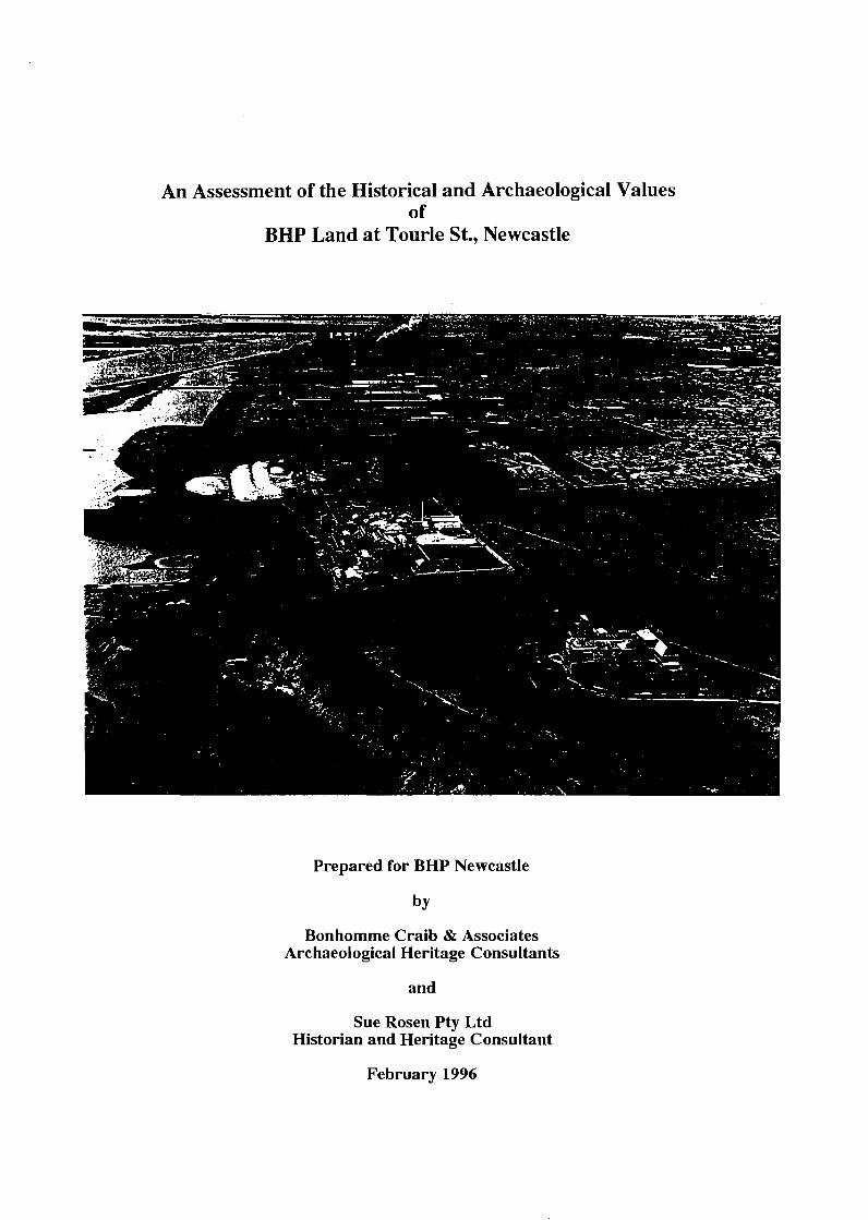
An Assessment of the Historical and Archaeological Values of
BHP Land at Tourle St., Newcastle
Prepared for BHP Newcastle
Bonhomme Craib & Associates Archaeological Heritage Consultants
and
Sue Rosen Pty Ltd Historian and Heritage Consultant
February 1996
Executive Summary
The study area at Tourle Street, Newcastle is the site of one of the first grants to a free settler at Newcastle. While the _grant was officially made on 30 June 182'3 John Laurio Platt, in fact, took up residence in early 1822 and established a farm and milling operation there. By 1829 coal mining was also underway and in 183 1 the rich shell middens - a remnant from the Aboriginal occupation of the area - were being mined.
It was the existence of coal on the grant and the possibility of rival companies acquiring the site and mining coal there, that motivated the Australian Agricultural Company to purchase Platt's grant in 1838, to ensure their continued monopoly of coal production.
Platt's mill was in operation until at least 1842, it being run firstly by Platt, then his son and finally the -4A Company. In the 1850s a traveller's account indicates that the grant was occupied by people of some respectability. The -4A Company controlled a vast amount of land in Newcastle extending to Port Stephens and in 1875 a house for the general superintendent of the -4A Company was built on the study site. This house burnt down in 1901, but another was built shortly after, being completed by October 1902.
By the early twentieth century the mill paddock and the river bank had become a favourite picnic and recreation area. During the 1930s a small community of unemployed people are reported to have taken up residence in Shelley Beach Park. In 1946 Platt's grant was noted in a tour of the historic sites of Newcastle by the Royal Australian Historical Society.
In 1933 the .4A Company's superintendent's house was purchased by the Catholic Bishop of Maitland who established the Murray-Dwyer Orphanage there which was run by the Daughters of Charity of Saint Vincent de Paul. The building was extended twice in the 1930s and again in the 1950s when British child immigrants were accommodated there. During WWII the orphanage was evacuated and then occupied by military personnel. From 1940 BHP began to purchase parts of Platt's original grant. By the end of the 1960s the eastern portion of Platt's Channel had been infilled. BHP purchased the orphanage site and in 1970 demolished the 1902 house.
The Orphanage site is located on CMA Map U6357-8 at position LJ 810605 [reproduced in part as Figure 11. Analysis of the historic plans and surveys has led the authors to believe that the mill position given by most nineteenth century maps corresponds to 20 m NW of the 24.7 m high reference point and 100 m WSW of the hV corner of the orphanage building. The house as indicated by Surveyor White in 1838 is located 70 m north of this CMA orphanage reference, i.e., Map U6357-8 at position LJ 810605. The White 1838 data is precise in locating both the mill and the house relative to the Eastern Boundary of Platt's property and the Maitland road. The notes of Surveyor Dangar's 1822 traverse provide some correlation of the house (and no mention of the mill). That the hills and gullies south of the channel area appear to be marked in a reasonably similar in position to their placement in the early surveys lends corroborative support to our hypothesis that Platt's Mill and House were located here.' Nevertheless it is stronglv recommended that a qualified cartographer or surveyor verify the cartographic analysis undertaken here. The sites archaeological potential is dependent on identifying the location of the site of Platt's house,
1 B.J. Johnson. January 1997.
Bonhommc Craib & Associates, PO Box 61 Mudgceraba 4213

mill and any likely outbuildings on the ground and in relation to existing structures. Then, in the light of all subsequent site development (as documented in this report) a determination needs to be made as to whether any archaeological evidence is likely to have survived.
The study site is regionally culturally significant because of its historic associations with one of the first free settlers at Newcastle and in the Hunter Valley; because of its historic associations with the Australian Agricultural Company; and because of the early industrial activities (milling and coal mining) undertaken there. The site may have research significance because of its potential as an archaeological site and its capacity to reveal information concerning the activities of one of Newcastle's first free settlers. The site has social value because of its historic links with major historic phases of Newcastle's history from free settlement through the AA Company's occupation; as a picnic and recreation area valued for its aesthetic amenity; as a site linked with the Great Depression and WWII and latterly its links with BHP. The site's historic significance has been recognized by Newcastle historians from at least the 1930s.
Methodology
Research of both primary and secondary sources was conducted by the principal authors of this report and their research assistants in the: . .
National Library of Australia State Library of NSW Newcastle Regional Library Archives Ofice of NSW Ofices of the Department of Conservation and Land Management (CALM) Registrar General's Department Newcastle Regional Archives City of Newcastle Plan Room
Searches were also arranged at the: Noel Butlin Archives, ANU Daughters of Charity Archives BHP Archives Diocese of Maitland-Newcastle Financial Secretariat
Three site inspections were undertaken. The final report presents a chronological integration of the physical development of the site with an emphasis on assessing the site's cultural si,&ficance and its archaeological potential.
Bonhornrne Craib & Associates, PO Box 61 Mudgeeraba 4213
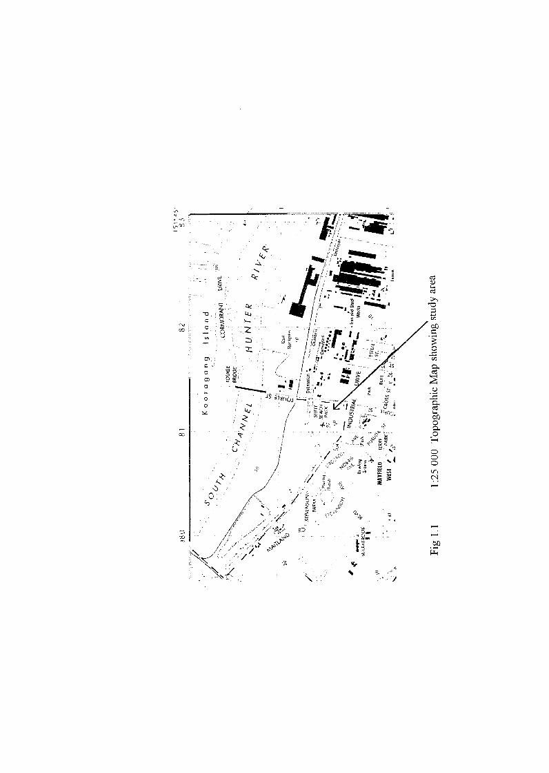

Fig 1.2 Run 10 1993 Airphoto of the subj and the development area Newcastle 1 :25 000

Historic Assessment of BHP Land at Tourle St., Mewcastle
Executive Summary Methodology Authorship Acknowledgements
Introduction: Project Summary ....................................................................... 1 . . Legislation ........................................................................................................... 1
. . . . . . . . . . . . . . . . . . . . . . . . . . . . . . . . . . . . . . . . . . . Reason for Historical and Archaeological Assessment 1 Results . . . . . . . . . . . . . . . . . . . . . . . . . . . . . . . . . . . . . . . . . . . . . . . . . . . . . . . . . . . . . . . . . . . . . . . . . . . . . . . . . . . . . . . . . . . . . . . . . . . . . . . . . . . . . . . . . 2 . .
. . . . . . . . . . . . . . . . . . . . . . . . . . . . . . . . . . . . . . . . . . . . . . . . . . . . . . . . . . . . . . . . . . . . . . . . . . . . . . . . . . . . . Statement of Sigmficance 3 ............................................................................................... Recommendation 4
............................................ The Study Area: Past uses and Present condition 4
Historical Analysis ........................................................................................... 9 Background ......................................................................................................... 10
................................................................................................. John Laurio Platt 12 Immigration to New South Wales ............................................................. 12 Platt at Newcastle ..................................................................................... 13
. . . . . . . . . . . . . . . . . . . . . . . . . . . . . . . . . . . . . . . . . . . . . . . . . . . . . . . . . . . . . . . . . . . . . . . . . . . . . . . . . . . . . . . . . Platt's Decline 21 The Australian Agricultural Company ................................................................ 22
........................................................... The AA Company and Platt's Land 23 .................................................. A House for the General Superintendent 26
....................................................... The Destruction of the House by Fire 26 .............................................................................. A Picnic and Recreation Area 29
. . . . . . . . . . . . . . . . . . . . . . . . . . . . . . . . . . . . . . . . . . . . . . . . . . . . . . . . . . . . . . The Murray-Dwyer Orphanage for Boys 30 BHP ................................................................................................................. 36
................................................................ Chronology of Physical Development 41
Assessment of Significance ................................................................................. 45 .............................................................................................................. Criterion
.............................................................................. Criterion 1 : Historic Criterion 2: Aesthetic ...........................................................................
............................................. Criterion 3: TechcaV Research Potential ............................................................. Criterion 4: Social Significance
............................................................................................ Comparative Criteria ............................................................. Criterion A: Representativeness
Criterion B: Rarity ................................................................................ ..................................................................... Summary Statement of Significance

.................................................................................................................. Bibliography 48 Published Material . . . . . . . . . . . . . . . . . . . . . . . . . . . . . . . . . . . . . . . . . . . . . . . . . . . . . . . . . . . . . . . . . . . . . . . . . . . . . . . . . . . . . . . . . . . . . . 43 Articles . . . . . . . . . . . . . . . . . . . . . . . . . . . . . . . . . . . . . . . . . . . . . . . . . . . . . . . . . . . . . . . . . . . . . . . . . . . . . . . . . . . . . . . . . . . . . . . . . . . . . . . . . . . . . . . . 48 Other Documents.. ........ .. ... . . . . . . . . . . . . . . . . . . . . . . . . . . . . . . . . . . . . . . . . . . . . . . . . . . . . . . . . . . . . . . . . . . . . . . . . . . . . . . 49
. . . . . . . . . . . . . . . . . . . . . . . . . . . . . . . . . . . . . . . . . . . . . . . . . . . . . . . . . . . . . . . . . . . . . . . . . . . . . . . . . . . . . . . . . . . . . . . . . Maps and Plans 49 Archival Material . . . . . . . . . . . . . . . . . . . . . . . . . . . . . . . . . . . . . . . . . . . . . . . . . . . . . . . . . . . . . . . . . . . . . . . . . . . . . . . . . . . . . . . . . . . . . . . . 50
. . . . . . . . . . . . . . . . . . . . . . . . . . . . . . . . . . . . . . . . . . . . . . . . . . . . . . . . . . . . . . . . . . . . . . . . . . . . . . . . . . . . . . . . . . . . . . . . . . . Mitchell Library 5 1 ...................................................... Newcastle Library Local Studies Collection 5 I
List of Figures
Cover Illustration: The study focus area. n.d. mewcastle Region Library]
Figure 1 .1 1 :25 000 Topographic map showing study area
Figure 1.2 1 :25 000 Airphoto of subject land and development area
Figure 1 The study area as shown on CMA Map U63 57-8, Kooragang Island, 1986. Before p.6.
Plates 1-6 Pages 6-8
Figure 2 Hunters River, Dangar's survey of 1822 [AO: Map 29861 Following p. 11.
Figure 3 Plan of the Neighbourhood of Newcastle, White 1839 [AO: Map 44221 Following p.20
Figures 4 & 5 Plan of the River Hunter from Port Hunter to the Falls at West Maitland, G.B. White, 1844 and a part enlargement [ML: M3 81 1.25/1844/1 FR2] Following p.24.
Figure 6 The Estates of the Australian Agricultural Co. at Newcastle NSW 1854 [ANU, Noel Butlin Archives
Centre: 13 1/4/32/B Map X7 Neg. 13391 Following p.25.
Figure 7 Jesse Gregson's house at Waratah, after the fire, 1901. [Hunter Photo Bank] p.27.
Figure 8 Jesse Gregson's house, after the fire,
1901. [Hunter Photo Bank] p.28.
Figure 9
Figure 10
Figure 11
Figure 12
Figure 13
Figure 14
Figure 15
Figure 16
Resideilce of Jessie Gregsotl Esq - FVaratah, dated 20 December 1901 Noel Butlin Archives, 13 111 513981 Following p.28.
A March 1938 view of newly completed additions carried out to plans and specifications of P. J. Gannon of Hamilton. pewcastle Herald, 12 March 19381 p.3 1.
Plan showing part of Lailds ent braced in Platt 's Chaililel Reclamation proposal, R. A. Allan, August 1949. [Newcastle City Council Plan Room: 16x1 Following p.32.
The Murray Dwyer Orphanage, c. 1949. [Newcastle City Library: Mqje ld . 50 Years of Progress] p.33.
The new wing of the Murray-Dwyer Orphanage opened in 1951. [Newcastle Region Library: Newcastle Morning Herald 23 April 19511 p.34.
Part of a building application which shows some of the layout of the orphanage. [Newcastle City Council: New Infants Toilet Block. Murray- Dwyer Orphanage, May)eld, J . P . Gamon, 9/64. 16X 1871-641 p.35.
The study site and Platt's Channel as it is being infilled. [Newcastle Region Public Library: 0003- 0019741 p.37.
AA Company's Manager's house under demolition in November 1970. [Newcastle Region Public Library] p.38.

Figure 17 BHP Refractories Departnierlt - Offices arld testing Laboratory - Gerleral Arrarlgenierzt, 16- 12-70. [Newcastle City Council] follows p.39.
Figure 18 Registrar General: DP-555 1.60 Plan of 1974. follows p.40.
Appendix A : A series of undated views of the Murray-Dwyer Orphanage
Appendix B: The National Trust listing for the Cook Island Pine


Authorship
The historical section of the report was been prepared by Beverley Johnson and Sue Rosen of Sue Rosen Pty Ltd, Historians and Heritage Consultants. Brian Johnson provided assistance with the interpretation of cartogaphic and survey sources. Research assistance was provided by Jackie Bettington, Rosemary Kerr and Richard Temple.
Acknowledgements
Sister Mary Quinlan D.C., Daughters of Charity of St. Vincent de Paul, Australia John Di Gravio, Archives of the University of Newcastle Newcastle Library Local Studies Librarians Judy Barnard, The City of Newcastle Council Plan Room ANU Noel Butlin Archives Centre Kim Maree Goodwin, author of 'Iron Bark' Homestead and the Daughters of Charity Helen Smith, BHP Archives Julie Cox, Diocese of Maitland-Newcastle Financial Secretariat

1.0 Proj 2ct Summary
Property BHP Land at West Mayfield, Newcastle. Development area extends from Tourle St, in the east, Industrial Drive in the south and the transmission line easement to Kooragang island in the west (Figures 1 . 1 and 1.2) .
Owner BHP Pty Ltd, Newcastle, NSW
An historical review and preliminary archaeological assessment has been undertaken by Bonhomme Craib & Associates and Sue Rosen Pty. Ltd of BHP land at West Mayfield, Newcastle. The historical research was aimed to provide a clear picture of landuse on the location over the period from 1822 to the present. The identification of areas of archaeological potential was of particular importance.
This report discusses the historical documentary evidence, describes the previous landuse and the current status of the subject land. An assessment of the significance of the location is provided.
1.1 Legislation
The Heritage Act 1977 (with amendments in 1987) is the primary legislation protecting the historical heritage of New South Wales. The Act aims to conserve 'the environmental heritage' of the state, which is defined as the 'buildings, works, relics or places of historical, scientific, cultural, social, archaeological, architectural, natural or aesthetic significance for the state'. The Heritage Council is established to protect these items and is empowered to make recommendations to the Minister in relation to the conservation and the use of the heritage.
It is illegal in New South Wales to disturb or excavate land to discover, expose or move a relic, without a permit issued by the Heritage Council of New South Wales.
1.2 Reason for the Historical and archaeological Assessment
BHP proposes to develop the land as an industrial estate, for which it is zoned. A portion of the development area, the south east hill, referred to in this report as the site, is zoned Ecclesiastical and an application for re-zoning to Industrial has been lodged by BHP. The majority of the development area is reclaimed land with no archaeological potential. Only the south east hill retains the original topography and soil cover.
This study was undertaken to determine the nature of the historical values which may affect the development potential of the BHP land at Tourle St and Industrial Drive Mayfield West, Newcastle (Figure 1.1). An assessment of the potential for existing archaeological deposits to be present at the site was also made. A field inspection had revealed no surface structures or features.
During the preparation of a report on the Aboriginal archaeological values for the BHP land (Bonhomme 1996), information regarding the European use of a portion of the subject land was discovered.
Bonhomme Craib & Associates, PO Box 61 Mudgeeraba 4213
Briefly the documentatim suggested that the south east hill in the subject study area was the location of the house of the first free settler at Newcastle. John Laurio Platt was granted 2000 acres on the Hunter k v e r and by 1823 had established a house called "Ironbark". He also constructed a rough mill, for grain and drove a tunnel in under the hill to extract coal.
On Platt's death in 1836, the grant was taken over by the Australian Agricultural Company who among other endeavours, had a monopoly on the coal extraction in the area. '4 house was built for the A. A. Company managers in about 1885.
The house and the surrounding land was then taken over by the Diocese of Newcastle and an Orphanage was established. The Orphanage operated until 1968. At that point major changes had been made to the surrounding land. BHP had resumed Platt's Channel and begun in- filling effectively raising the ground surface by +20 m. A BHP Refractory building was constructed on the south east hill in place of the A. A. Co. house.
In order to effectively assess their options for use of the subject land BHP commissioned Bonhomme Craib and Associates to undertake an archaeological and historical assessment of the site. A preliminary search was made of documentary sources to determine if the information given locally had substance. Information pertaining to the Platt family and the grant is housed in a variety of institutions, such as the State Archives, the Mitchell Library and the Auchmuty Library at the University of Newcastle. Information for the Orphanage is located in the Archives of the Diocese of Newcastle.
Initial inspection of the sources of information revealed the basic elements of the story concerning the site were correct and that more substantial research was required to hl ly assess the historical values of the site. In particular BHP was interested to determine what areas of the site may still contain archaeological material. The first stage of the work was to undertake a review and assessment of all available and relevant documentation relating to the history of the site.
Field inspection has indicated that visibility is poor across the south east hill and that substantial landscape modification has occurred in the vicinity of the Refractory building (now the BHP Fitness Centre). There are no existing surface remains from the first two occupation periods. However, it was possible that sub surface deposits still exist. A thorough documentation of the nature of the occupation phases was required to establish where sub surface remains might be located..
The aims of this study were to: a) determine through research the history of the use of the study area b) assess the potential for historical archaeological material to exist on the site particularly to try to pinpoint the original locations of early structures on the site. c) make recommendations for the hrther investigation of such material and values which may exist on the site
1.3 Results
Background research has established that the site has significant historical values and that there is potential for archaeological deposit to be present on the site (see Section 3.0 .for a detailed discussion). The proposed development of the site will remove or disturb all the
Bonhornme Craib & Associates, PO BOX 61 Mudgeeraba 4213

archaeological deposits which may t e present within the site area. The historical research has established the main characteristics >f the occupations at the site. Details of these occupations are provided in Rosen 1997 att~ched. Four major phases of occupation have been documented. These ere:
1. John Laurio Platt's farm 1822 - 1836
2. The Australian Agricultural Company houses 1836 - 1933
3. The Orphanage structure 1933 to 1973
I . BHP use - 1969 - Present
The research has identified several areas on the ridge which have the potential to contain archaeological remains. A structure dated to the period of Platt's occupation was located lightly to the west of the existing BHP Fitness Centre building on the site. The mill was located to the south of the existing building either within the boundaries of the existing Fire Station or just to the north. Material relating to the AA Company structure may still exist just north of the existing building although there has been substantial construction undertaken during the Orphanage phase including bulldozing of the area.
The east west trending ridge has the greatest potential for archaeological material to be present. Figure 15 shows a depression to the east of the existing building. This may represent the on-site quarry from which stone was extracted for the Gregson house foundations.
1.4 Statement of Significance
A full discussion of the significance of the site in terms of NSW Heritage assessment criteria is presented in Section 3.0.
In summary the site has historic significance - -because of its historic associations with one of the first free settlers at Newcastle
-because of its historical association with the Australian Agricultural Company -because of the early farming and industrial activities undertaken there (milling and coal mining)
The site has scientific significance - because of the its potential as an archaeological site and its capacity to reveal information concerning the activities of one of Newcastle's first free settlers.
The site has social value - because of its historic links with major historic phases of Newcastle's history from free settlement through the AA Company occupation, as a picnic and recreation area valued for its aesthetic amenity, as a site linked with the Great Depression and W.W.11, as an Orphanage and with its links with the history and development of BHP in Newcastle.
The site's historic significance has been recognised by Newcastle's historians from at least the 193 0s.
Bonhomme Craib & Associates, PO BOX 61 Mudgeeraba 4213 3
The distinctive Cook Island Pine within the grwnds of the site was placed on the National Trust Register of Significant Trees in 1991.
The BHP Tourle St.. land is a place of considerable archaeological research potential. Despite the nature and extent of disturbance across the site over the last 60 years in particular the site still may contain physical evidence such as foilndations, deposits, wells and cellars Such remains may provide evidence of material culture that contributes information about early settlement and farming of the 1820s - 1830s which is lacking in this area.
1.5 Recommendation:
The following recommendation is based on the historical research which has demonstrated the location's historical values and the potential for archaeological material to still exist on site. It is now necessary to demonstrate the physical existence of any archaeological material and describe its extent and nature.
It is recommended that - that a ground penetrating radar survey be undertaken in areas indicated in this report to have high archaeological potential. - test excavation (after application and approval of a NSW Heritage permit) be undertaken along the ridge which contains extant modern structures and has been identified as the location of previous structures. The purpose of such excavations will be to determine the if material is still present from the period of earlier occupation and to determine the extent and nature of that material. The results of the testing will suggest a range of options for the site which BHP could then consider.
2. 0 The study area - past uses and present condition
The entire development area of BHP land at Tourle St., comprises approximately 110 hectares along the Hunter River floodplain. The area comprises of flat reclaimed land in the north along the river and to the west. Only one part of the development area, in the south east retains some of its original topography (see Figure 1.2 and Figure 1 Section 3.0). That area is the subject land for this report.
The following discussion gives the location of the subject land in relation to the total development area. The entire development area extends from Tourle St., west along Industrial Drive and Maitland Road to the Railway line to Kooragang Island. The area has been greatly modified in over the last 50 years by BHP. Before development of the area by BHP, the Hunter River separated into a north and south arm around a series of low islands which included Ash Island and Moscheto Island.
The south arm diverted into Platt's Channel around Spit Island. Platt's Channel was surrounded by mud flats supporting mangrove vegetation. In the south, low hills along what is now Industrial Drive overlooked Platt's Channel, Spit Island and the southern arm of the Hunter River.
The top of the remaining natural hill (the subject of this report) retains existing buildings which date to the period when the site was occupied by the Murray Dwyer Orphanage and later uses by BHP. A transmission line runs east west across the study area at the base of the
Bonhomme Craib & Associates, PO Box 61 Mudgeeraba 4213 4

hillside bordering Industrial Drive. Plates 1 to 6 show the zrea today and indicate the degree of landscape modification which has occurred
A foot survey was conducted over the Orphanage Hill area. Visibility at the time of survey was poor (often less than 10%). Grass cover was dense (100% cover) in many locations and the lower hill slopes to the north have been re vegetated to prevent any dust from the fill on the lower slope escaping. Visibility on the Orphanage hill ranged from 0% to 20% in disturbed areas. The area to the south west of the Orphanage has been graded and gravel laid and an access road has been constructed from the east up to the Orphanage. The remaining area, which is grassed, slopes to the south east towards Tourle Road and Industrial Drive. This area had some exposures which were inspected. Pipes and sewerage facilities (for the existing structure) are present in this area.
Several maps have been located which indicate the location of several structures on the hill. A wharf is also located on the grant but this would have been destroyed when Platt's Channel was filled. Maps A 0 4423 and .40 4422 drawn by Wells in November 1839 both show Platt's Mill and a rectangular structure nearby. An 1844 plan by White also shows the mill and possibly the wharf. The mill is also shown on the 1854 Lands Department Plan and on the 1854 Australian Agricultural Plan which also indicates the wharf. By measuring the positions of these structures from the boundary and the existing reference points on the Maitland Road is possible to roughly position the site of these structures on the site today. These maps provide a starting point for identifying areas of high archaeological potential.
Bonhomme Craib & Associates, PO Box 61 Mudgeeraba 4213

Plate 1 View to south east of subject land. Note the remnant garden, the pine registered as significant and the remaining existing original Orphanage building now referred to as the BHP Fitness Centre.
Plate 2 View to the north west across hill slope and fill area. Note vegetation cover.
Bonhomme Craib & Associates, PO BOX 61 Mudgeeraba 4213 6

Plate 3 Cleared and gravel area to the south west of the BHI? building
Plate 4 View to the south east to Industrial Drive and adjacent housing development which is located on land of the Platt grant
Bonhomme Craib & Associates, PO Box G1 Mudgeeraba 4213 7

Photo 5 View north east to the existing building. Note the cleared and grassed surrounds and the gravel parking lot.
Plate 6 View to the north east across re vegetated cinder mounds which encroach on the hill slope
Bonhomme Craib & Associates, PO Box 61 Mudgeeraba 4213 8

Section 3.0 Historical Analysis and Background The Hunter h v e r was officially 'discovered' by the British colonists of NSW in 1797 when Lieutenant John Shortland junior on a return to Sydney from Port Stephen sought shelter from deteriorating weather there1 Prior to this in 1796 however, coal pieces obtained by fishermen, sheltering in the estuary of the river, had inspired interest in the area. Very soon individuals were taking the easily accessible coal and selling it in Sydney and by 1799 traders had shipped a cargo of coal to ~ e n ~ a l . '
In June 1801 the Lieutenant Governor, Colonel Paterson, Surgeon John Harris and others explored the Hunter River. Paterson reported 'the quantity of oyster shells on the beaches inland is beyond conception; they are in some places for miles. These are four feet deep, without either sand or earth'.3 Later, settlers, including Platt, mined these Aboriginal middens for their lime. In July 180 1 Governor King declared that
the coals and timber which are to be procured at Hunter's River [are] to be the exclusive property of the Crown and having thought fit to establish a port at Freshwater Bay . . . lze strictly forbids any boat or vessel going there ... without obtaining a special ~ i c e n s e . ~
By March 1802 a settlement had been established at the mouth of the river by five rank and file members of the New South Wales corps,' but had been abandoned by June due to the 'improper conduct' of the person in charge,6 and it was not until 1804 that a second attempt at settlement was made under the Command of Lieutenant Menzies. A surgeon, eleven non-commissioned officers and privates of the New South Wales Corps, a superintendent, an overseer and between 34 and 50 of the 'worst' Irish convicts, who had been involved in the Castle Hill uprising, established the first permanent settlement on Hunter's River which was to become known as ~ e w c a s t l e . ~ . It developed as a convict settlement providing raw materials - timber, coal, salt and lime - for use in the large colony. mine or to cut cedar with a permit from the governor, and a private vessel required a license to enter the port.
1 F A Cadell, '4 Survey of Newcastle from Its Fust Settlement to the Present Day'. Journal RAHS. Vol .XWI, Pan VI, p 378. J F Campbell. The Genes~s of Rural settlement on the Hunter', JournalRAHS. Vol XII, 1926, h 2. p 73
2 Hrstoncal Recordr oj Auslralra. L~brary C o m t t e e of the Commonwealth Parliament. 1914, Vol 11, Note 50 p 713 J LV Turner. Coal ,Vf~nlng rn r'dewcasrie 1801-1900, p 14, The Australian Encl~clopaeha, The Grol~er Soctety. Sydney. 1963. Vol V , p 35
Paterson to Kmg. HRNSW. Vo1.4. p 415
4 Governor h n g , Govemment and General Order. 3 July 1801, Hlstoncal Recordr of Australra, L~brary Committee of the Commonwsalth Parl~ament. 1915. Senes I, Vol 111, p 257
5 G n g to Portland, 1 March 1802, hstoncal Records of Australih L~brary Committee of Lhe Commonwealth Parliament. 1915. Series I, Vol. 111, p 420.
6 G n g to Portland 5 June 1802, hs tor~cal Records of Australih Library Committee oflhe Commonwealth Parl~amenf 1915. Series I, Vol 111, p.528
7 G n g to Hobart. 16 April 1804, Historical Records of Australia, Library Comnuttee of Lhe Commonwealth Parl~amenf 1915, Senss I, Vol IV, pp.6 12 and 694.
8 James Jerv~s, The k s e of Newcastle.' Journal RAHS, Vol XXI, Part 111, p. 145
Bonhomme Craib & Associates, PO Box 61 Mudgeeraba 4213
The cedar getters were responsible for the initial opening up of the area In 1805, soon after settlement, Commandant Menzies returned from an exploratory cedar getting expedition with '70 logs on a raft containing upwards of 26 000 feet of ~ i m b e r ' . ' As the penal settlement grew large tracts of land were cleared and knowledge of the interior expanded. By September 18 13 there were 242 'souls' in the Newcastle settlement and land on the Maitland Flats was under cu l t i~a t ion .~
In 18 19 Macquarie advocated the transfer of the convict settlement from Newcastle; the settlement was no longer isolated and it was too easy for its convict residents to escape and return to Sydney. Secondly, the fertile lands of the Hunter Valley were comparatively easy to cultivate, and much of the timber had already been removed making settlement easier. Further, the river provided transport to Newcastle after which the produce would go by sea to ~ ~ d n e ~ . ~ The fertile land and its accessibility via the river had caused the area to
become an Object of Valuable Consideration in the Necessary Increase of the Population and hold out important advantages for the Establishment of Free Settlers upon them.'
It was noted by Governor Macquarie that
Newcastle now Ceases to be of that Material Benefit. whch it was formerly ... as a Receptacle for our worst Characters. in Consequence of the Interior having been Explored, and the Passage thence to Windsor on the h v e r Hawkesbury having become familiar to several of those Persons who have been transported h the r , and who now find little Difficulty in deserting5
In March 1821 approval was received from Lord Bathurst, Secretary of State for the Colonies, to establish a penal settlement at Port Macquarie and to close the Newcastle establishment. Considered 'waste lands of the Crown' the land was available for set t~ement .~ Twelve months later, in March 1822, instructions were issued for the area to be surveyed. In the letter of instruction to Assistant Surveyor Henry Dangar it was noted that 'Messrs Webber, Dunn and Platt' had already chosen their land. 7 Platt was one of the first free settlers at Newcastle.
1 Menves to brig, 1 July 18Q3, fistoncal Records of Australla, L~brary Cornnunee ofthe Commonwealth Parl~arnenl. 191 5. Senes 1. Vol V, p 416
7 T M Burley, "The Evolut~on of the Agricultural Paltem In the Hunter Valley of New South Wales". Ausual~an Geographer. VoI S No 5 . Sept . 1962. p 723. General return of the colony, f is toncal Records of Australla. Ltbrary Comm~ttee of the Commonwealth Parllament 1916, Senes I, Lol VIII. p I86
3 Governor Macquane's Despatch 8 March I8 19, quoted m J F Campbell, T h e Genesis of Rural Settlement on the Hunter ' Journal RAHS Yol XII, Part I1 pp 73-74
4 hfacquane to Bathwsl. 24 March 1820, fistoncal Records of Australia L~brary Cornnuttee of the Commonwealth Parllament, 191 7, Senes I. 'vol X, p 43
5 I b ~ d
6 I F Campbell. The Genes~s ofRural settlement on the Hunter', Journal RAHS, Vol XI, 1926, Pt 2, p 74
7 Surveyor General Oxley to Henry Dangar, 1 March 1822 Colonzal Secretary LerrersRecerved. A 0 411 808, pp 69-72
Bonhomme Craib & Associates, PO Box 61 Mudgeeraba 4213

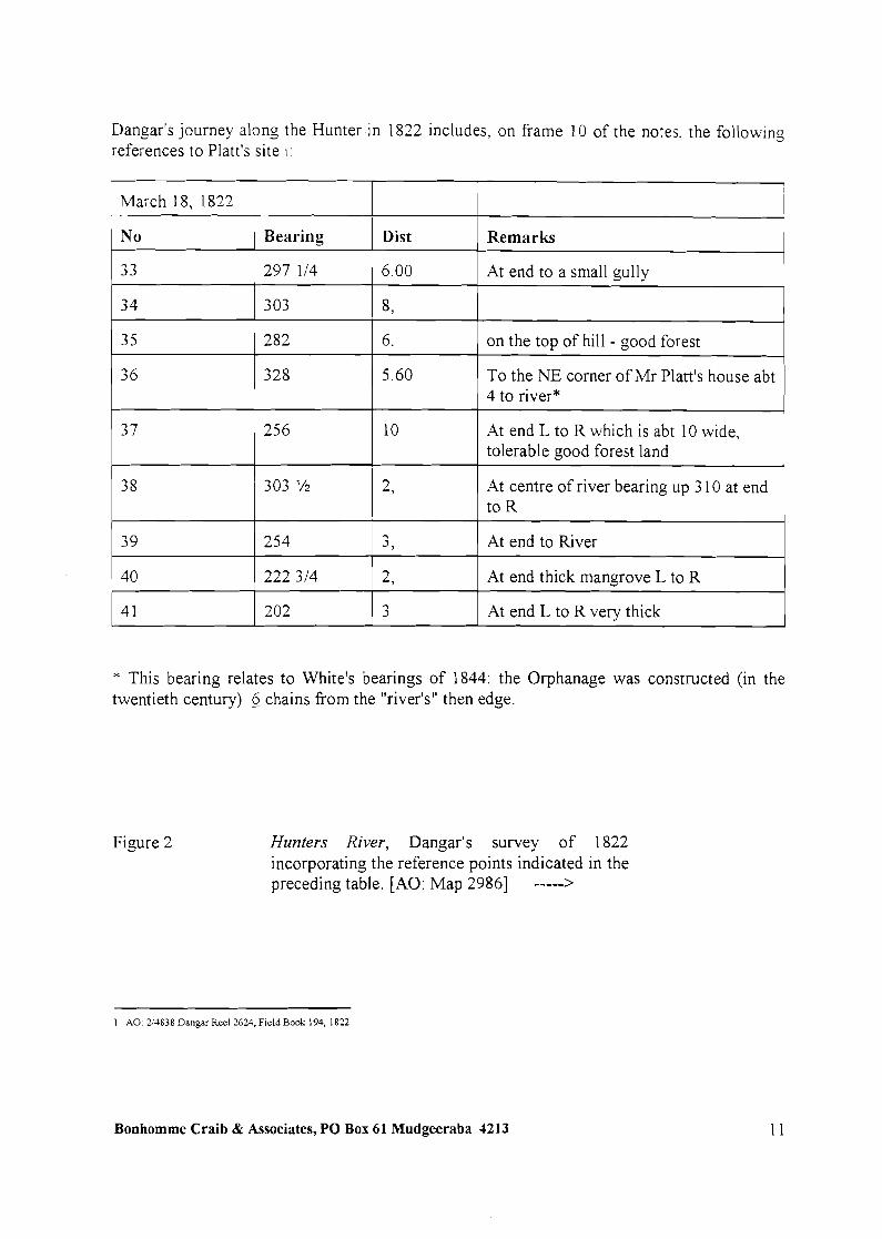
Dangar's journey along the Hunter in 1822 includes, on frame 10 of the notes, the following references to Platt's site I :
March 18, 1822
1 N o / Bearing 1 Dist I Remarks 1 3 3
3 4
1 To the NE corner of Mr Platt's house abt 1 4 to river*
3 5
1 303 l/2 I 2. 1 At centre of river bearing up 3 10 at end I
At end to a small gully I 297 114 1 6.00
I I I
282
3 7 1 256
303
6. 1 on the top of hill - good forest
8,
I
10
39
* This bearing relates to White's bearings of 1844: the Orphanage was constructed (in the twentieth century) 6 chains from the "river's" then edge.
At end L to R which is abt 10 wide, tolerable good forest land
254 1 3, 1 At end to River
Figure 2
I I I
40 1 222 314
Hunters River, Dangar's survey of 1822 incorporating the reference points indicated in the preceding table. [AO: Map 29861 ----->
2,
3 4 1
1 A 0 214838 Dangar Reel 2624, F~eld Book 194. 1822
At end thick mangrove L to R
At end L to R very thick 202
Bonhornme Craib & Associates, PO Box 61 Mudgeeraba 4213

John Laurio Platt Immigration to New South Wales John Laurio Platt and his family arrived in NSW in January 1822. Platt carried with him the following introduction from Henry Goulburn, the Under Secretary of State for the Colonies, to Governor Sir Thomas Brisbane -
This letter \\.ill be delivered to you by Mr. John Platt. \\.llo proceeds with lus Family to settle in New South Wales. and proposes to erect Saw Mills and other Maclunen in the Colony. As Mr. Plan Ins been for some years past employed under thls Department. both on the lakes in Canada and as Harbour Master in Heligoland. and as he has served not only with credlt to himself but with advantage to the Public Service. I have been directed by Lord Bathurst to introduce him more particularly to your notice and protection as having claims beyond those of an o r d i w settler.'
Platt brought to the colony of New South Wales maritime and 'mechanical' skills, abilities which included the use of instruments for naval purposes and for surveying.2 His interests were not agricultural and his intention was to establish one or more saw mills and to export processed timber to ~ n ~ l a n d . ~ With the wood processed before it was exported the cost of freight and duties would be considerably reduced. He had been encouraged in the idea by people in England described as 'dealers in fancy woods'."
Platt had consulted with John Macarthur Junior before he left England and the latter described the saw mill Platt planned to take to the colony as 'of excellent con~truct ion ' .~ Macarthur reported to his family that well known colonial entrepreneurs, Riley and Jones, had advised Platt that he would need a saw mill worked by horse power because it would be difficult if not impossible to find a stream capable of working it c o n t i n u ~ u s l ~ . ~ Macarthur believed that Platt had 'well-grounded claims on government and ought to receive liberal assistance' but doubted he would receive i t 7 Macarthur Junior wrote to his father in June 1821 - . . . he canies with h m a public and private letter to the Governor, but I presume he will be left in a
8 great measure to h s own exertions . . .
I Under-Secretaw Goulburn to Govemor Bnsbane. 25 May 1821. H~sloncalRecords ojAusrra11a. L~brary Comm~ttee of the Commonwealth
Parl~ament. 1917. Senes 1, Vol. X p 499 See also Note 42 on p 814
John Macarthurjun to James hlacanhur, 30 Apnl 1821 Macarthur Papers, Vol 15. James Macanhur JR - Correspondence 1810-1831, p 18 ,11L A291 1
Under Secrelary Goulburn to Sir Thomas Bnsbane. HR.4. Series 1 Vol. 10, p.499
John Macarthur jun to John Macanhur sen.. 1 June 182 1. Maconhur Papers. Vol 15. John Macanhur JR - Correspondence 18 10-1 83 1 , p 4 I bil
A291 1 .
John Macanhur jun. to James Macanhur. 30 April 1821 Macarthur Papers. Vol 15, John Macarthur JR - Correspondence 1810-1831, p 17 ML
A291 1
7 John Macarthur jun. to Elizabeth Macanhur, 30 May 1821. MacarthurPapers, Vol. 15, John Macanhur JR - Correspondence 1810-1831, p 33 11 ML A2911.
8 John Macarthur jun to John Macarthur sen. I June 182 1. Macarthur Papers, Vol IS. John Macarthur JR - Correspondence 1810-1 83 1. p 41 ML
A291 1
Bonhomme Craib & Associates, PO BOX 61 Mudgeeraba 4213 12

Macarthur also told his family that Platt would consult them about where to establish his saw mill and where he would be likely to find the greatest demand for it. He described Platt variously as a 'very modest and intelligent man', 'a perfect gentleman in his manners and well disposed, I have reason to think, towards every member of our family9.'
Presumably Platt sought land which carried timber; chose, or was advised to choose, Newcastle because it was a major source of supply for the colony; and looked for land with deep water frontage to facilitate shipping of the processed timber. The dominant tree species on the grant he selected was ironbark, and Platt named his property Ironbark Hill (perhaps, in the beginning, Ironbark Hills). It can be conjectured that the 'dealers in fancy woods' wanted timber specific to their needs and interests, whereas ironbark was more appropriate to building construction and other more hnctional uses. With cedar, mahogany and other valued timbers being early targets, of government and colonists, up and down the NSW coast, the colonial reality quickly impinged on Platt's vision. In spite of Macarthur's optimistic observation that Platt's American experience would 'give him some idea of the difficulties he will have to contend againsts2 Platt did not prosper.
Platt at Newcastle Platt chose an area of 2,000 acres some six miles to the north of Newcastle on what was then called the Coal River and was resident in Newcastle by 11 February 1822. On the north the property boundary was the southern arm of the river, later known as 'Platt's Channel', where,the near shore depth ran to at least ten feet. By 1832, but probably much earlier, the route to Maitland would cross the property.3 While the grant was not officially registered until 30 June 1823, Platt commenced work immediately; by the end of February clearing had c ~ m m e n c e d . ~ Surviving documents show that many problems occurred because of the lack of infrastructure to support Platt and the other early settlers in the area. This may also have been aggravated by Platt's limited capital and his lack of any contacts in Sydney. The needs of the administration appeared to take precedence over the requirements of settlers. Further, a grant of land was dependent upon the grantee employing, victualling and clothing one convict per one hundred acres until the expiration or remission of their sentence. Platt pointed out to the Colonial Secretary, before occupying the land, that he could not support the number of convicts required by this regulation. He described Newcastle as 'a place destitute of every means of supply towards the maintenance of a number of labourers', and he could not take provisions fiom Sydney because there was nowhere on his land to store them securely.' Governor Brisbane's subsequent change in regulations only aggravated the situation and forced significant changes in Platt's plans.
John Macarthur jun. to Elizabeth Macarthur. 30 May 1821. Macarthur Papers. Vol. I S , John Macarthur JR - Correspondence 1810- 1831. pp.18. 27. ML A291
John Macarthur jun. to James Macarthur, 30 April 1821. Macarthur Papers. Vol. 15, John Macarthur JR - Correspondence 181 0-1 831, p. 19. ML A291 1 .
The New South Wales Calendar and General Post Ofice D~rectory, 1832, p 147
4 LTO: Vol.5302. Fol.165
' Platt to Colonial Secretary. 2 February 1822. Colonial Secretary LenersReceived. AO4/1808, pp.43.4-2.
Bonhomme Craib & Associates, PO Box 61 Mudgeeraba 4213

While the Government was to assume responsibility for victualling and clothing settler's convict servants, the settlers were required to make an annual payment of a given number of bushels of maize or wheat for each convict. With no house, storage facilities, equipment, agricultural expertise or indeed, intention to farm this was a major blow and a direct result of the new Governor's attempt to rationalise the convict system. The management of the convict labour force by Brisbane's predecessor, Governor Macquarie, had been savagely reviewed in the Bigge Report and resulted in Macquarie returning to England in disgrace. Now, the convict workforce was to be allocated as far as possible in the private sector. Platt was not alone in his inability to meet the new requirements, in May 1822 three other Newcastle settlers - Dun, Webber and Brown - wrote to Major Morisset, the local commandant, explaining that they would not have a crop for twelve months and suggested that new settlers be allowed to pay money instead of grain, or that they be allowed additional time to deliver the grain. Morisset's response was to reduce the quantity of grain. At the end of the year every known new settler and almost all of those Macquarie had placed on the Hunter, owed grain to the government.'
Platt was keen to set up his enterprise and wrote a number of letters to the Colonial Secretary urging assistance in establishing himself on the grant. Initial difficulties were encountered in obtaining skilled workers capable of building a house for Platt and his family, accommodation for the assigned servants, buildings for storage, etc., and assembling and operating the mill. Ground had to be cleared, prepared and planted with a crop. His early attempts at obtaining a millwright were thwarted. Platt had been promised a millwright but only after the person had completed private work for Major Oxley, the Surveyor General. As well, he needed a carpenter-joiner or other mechanic with similar skills. Then, he observed, 'I should hope to be able to commence'. And then there was also the matter of sawyers -
. . . although I must suffer vexy considerably for want of sawyers which appear to be in too great demand for me ever to hope to obtain.
I trust by return of Brig you will be pleased to give directions to Major Monisset (sic) the Commandant at tlus Post for such assistance as a settler in the infancy of the establislung of tlus place may require as there is neither a boat or a labourer to be had and altho' willing as the Commandant appears to afford every assistance to persons emigrating here, there are some points in which he may feel tenacious(?) in so doing unless he has authority . . .
Platt, in defence of Morisset, noted that there were only two pairs of sawyers in the whole settlement and very few mechanics of any description, 'or Major Momset (sic) would have prevented my giving you any hrther trouble'. As an incentive for action from the Colonial Secretary, Platt added -
. . . If the small assistance I have applied for can be granted I have no hesitation in saying that the whole of the monthly supply of Cedar cut up this River and brought down to Newcastle for export in the log to Sydney could at its present rate of 100 logs per month be reduced to planks and this shipped whereby a great saving of freight and other labour would take place. The mode of payment I should be glad to leave to your option as
' W. Allan Wood. Down ~n the V o l l q ~ The S t o v ofSettlement in the Hunter River Vollq, to 1833, pp.22-.23
2 Platt to Colorual Secretary, 1 1 February 1822. Colon101 Secro to~Le~ersRece ived . A 0 411 808, pp 45.46.
Bonhomme Craib & Associates, PO Box 61 Mudgeeraba 4213

leait to >.our option as it would suit my purpose either in a certain proportion of Cedar or Cattle or almost any other way you might plan to fix.'
Nevertheless, some progress was underway as by the end of February, Platt had nine labourers who for a fortnight had been clearing the area on which he would put up temporary buildings - when he could obtain a carpenter or other mechanic capable of performing the work. By the 20th March, Goulburn had sent a mechanic convict from Sydney to be assigned to ~ la t t . ' The man appears to have had some appropriate skills for during the last week of March, Platt issued two promissory notes for bricks and lime provided to him by government; presumably construction had commenced.' Platt's determination or desperation was such that he also persuaded two convicts to abscond from their government employment to work for him.4 Across 1822 and 1823 Plan eventually gained access, however limited, to a boat builder, a blacksmith and a millwright and in 1824 to a carpenter and ~ h e e l w r i ~ h t . ~ Between July and September 1823 Platt obtained from the Public Works Department 51 dozen files, 50 pit and 35 cross cut saws; clearly he anticipated a start to his timber operatiom6
A major set back was experienced in November 1824 when a fire destroyed Platt's barn, containing a crop of wheat from some thirty acres, two stooks7, poultry and pigs. Although the house and other premises were saved he had to dispose of the surviving livestock as he had no feed, and he reduced the number of men working there. This was the first crop from which Plan had expected a return.' Platt and his family were then victualled by the government for six months9 The following year, he planted wheat but when the time came to harvest the crop he was unable to obtain labourers. His men at the time consisted of a miller, a stock-keeper, a labourer and an invalid. As a result most of the forty acres under cultivation became overrun with weeds. lo On an earlier occasion wheat had been destroyed because the area was not fenced and government flocks and herds had got into it. Also, two crops had been destroyed by Aborigines 'not withstanding the severe example I made of
Platt to Colomal Secretary. 28 February 1822 Colomal Secretary Lctten Rece~ved. A 0 411 808, pp 65-67
L Colonlal Secretary to Major Marisset, Commandant, Newcastle, 29 March 1822. ColonialSecretary Letters SenL A 0 413505, p 42
3 Monsset to Colomal Secretary, 27 March 1822. Colonial Secretary Letters Received. A 0 41 1808, p.90.
4 Monthly R d u of Punishments. June 1822. Colonial Secretary Special Bundles A 0 41 171 8. p. IS 1
Alphabetical List of Persons to whom Convict Mechanics &c., have been assigned under the Government and General Orders of 12nd December 1821 and the respective sums due on the 3Ist March last. Colon~al Secretary SpecialBundle, A 0 XS3, p.64. List of persons who have neglected to pay for the Convict Mechanics ass~gned up to the 3 1st March 1821. Colonial Secretary Letters Sent. A 0 413508. p 422.
6 The Colonial Fund. Proclamations, Government Orders, and Notices. 5 January 1824. A 0 41424, pp.212, 213
7 A stook IS made up of sheaves of grain placed on a d supporting one another.
8 Platt to Colonial Secretary. I 1 December 1824. Colonla1 Secretary LettersReceived. A 0 411 8 1 1, pp. 199, 199% b, c
9 Platt to C o l o ~ a l Secretary. IS January 1825. Colonral Secretary LettersReceived. A0411 812, pp 15. 15% b.
Platt to Colomal Secretary. 4 March 1826. Colonial Secretary LettersReceived. AO411884, Lener 2611 192
Bonhomme Craib & Associates, PO Box 61 Mudgeeraba 4213
several of them'.' The census of 1825 revealed that there was a total of 1471 persons in the Newcastle region at this time.' Although by 1826 the Hunter Valley was the most densely settled area outside the County of Cumberland, a petition by 11 landholders in 1826 reques:ing the protection of the 'Horse Patrol' against the natives indicated that the occupation of the area was still being contested. The Aboriginal people had burnt out grazing areas, speared cattle and were threatening the h a r ~ e s t . ~ It is not surprising that Platt was a target for attack by local Aboriginal people; in 1831 Platt refers to a shell bank near his house from which he proposed mining one thousand bushels of lime, this bank was probably a midden created from the refise of thousands of years of Aboriginal habitation of the area.' T. A. Braye wrote in 1936 that 'apparently' there was evidence of oyster shells being taken from Aboriginal middens with which to make lime, 'as a great deal of excavation in my young days existedr5
Platt wrote in December 1824
. . . I have built a modest sized windmdl with the intention of driving rmll Saws but owing to not being able to procure proper m e c h c s is not yet complete but ~ ~ c i e n t l y so as to dnve a pair of stones. The present population up Hunters Rver will not for the next year afford more grindmg for their own consumption than will pay the expense of keeping a fiee rmller and perhaps pay repairs consequently the whole sum I have laid out in this concern is dead, could I have foreseen the consequences and not have listened to Mr. Barnard's suggestions, I might now have been one of the most independent stockholders up thls River . . .
By early 1826 the mill had done no more than pay the wages of a miller but Platt was still optimistic because of its usefilness to his neighbours and its proximity to Newcastle, however he was concerned that 'a flour mill is an object of attraction to plunder'. He explained that the road gang and the bridge party had been on his farm for almost twelve months and had left on the day he was writing. The men all knew of his situation and the small number of people on the farm. He went on to refer to 'they' who were successhl in 'carrying off my cast steel mill etc. And other numerous depredations on my crops makes me fearfil an attack upon the mill for the settlers f l ~ u r . ' ~ In November, Platt was again in strife and in need of a miller. The man who worked the mill with Platt's stock-keeper had committed a burglary and was to stand trial. As Platt pointed out this was an inconvenience
Plan to Colonial Secretary, 11 December 1824. Colonial Secretary LeftersRecerved. A0 411 8 1 1. pp.199. 1994 b, c
' Census, 1825. HistoricalRecords ofAustralra, Library Comminee of the Commonwealth ParliamenL 191 9, Senes I, Vol. XII, p. 3 18
3 Darling to Hay. September 1826. HistoricalRecordr ofAustralia Library Comminee of the Commonwealth Parliament, 1919. Senes I, Vol. XII, p 576; T. M Perry. 'The Spread Of Rural Settlement In New South Wales. 1788-1826' Historical Studtes Australia and New Zealand, Vol. 6, No 24, May 1955, p. 386.
4 Platt to Colomal Secretary, 28 January 1835. ColonialSecrelary LettersReceived A0 412291.3, Letter 351905
T. A. Braye, History of Waratah N.S. W., p.8
6 Pian to Colonid Secretary, 1 1 December, 1824. Colonial Secretary Letters Received. A 0 441 81 1 pp. 199, 1994 b, c.
Platt to Colonial Secretary, 4 March 1 826. Colonial Secretary LeftersReceived . A 0 441 884, Lener 26/1192.
Bonhomme Craib & Associates, PO Box 61 Mudgeeraba 4213

not only to h'm but to the other colonists at harvest time. His was the only mill in 'this extensive and populous district' with the exception of the government mill at Newcastle.' The mill appears to have been out of use until at least September 1827. Not only was he still without a mil!wright but the mill had deteriorated through lack of use.2 During this time Platt was also becoming active in the official life of the community; he served as a member of the Grand Jury Court of Quarter Sessions at Newcastle in at least 1826 and 1827 and was reported as a member of the Newcastle Bench in August 1 8 ~ 7 . ~
In May 1829 Platt requested permission to cut cedar from government land because there was none left on his side of the river. He needed it for the millwrights and for repairing and improving buildings.4 Then in September he applied for an additional grant of land. The application required him to document his present possessions, in the process demonstrating the relative values of the buildings on his property -
Dwelling house and kitchen £ 250 Wind Mill for grinding grain £600 Granary and Barn f 165 Store House and dairy f 35 Stable and sheds f 50
He had completed two and a quarter miles of fencing.
He possessed - 2,000 acres of land (250 acres cleared) 2 horses 170 head of ~ a t t l e . ~
Although not apparent in the above list, it is assumed there would have been accommodation for the men employed there. There is an 1822 reference to the Men's ~ u t . " He was also renting 1,920 acres at ~a i t land. '
Platt was either sufficiently flexible or desperate to consider all possibilities. By October 1829 coal was being mined on his land by 'Rapsey and Mitchell'. The relationship between
1 Plat! to Colonial Secretary, 27 November 1825. Colonial Secretary LettersReceived. A 0 41909. Lcttcr 2617996.
Plat! to Colonial Secretary, I2 October 1827. Colonial Secretary Letters Recerved. A 0 41 1950. Letter 2719684
4 Platt to Colonial Secretary, 26 May 1829, 7 July 1829, 21 July 1829. Colonial Secretary. Letters Received from IndividuaLs relanng to Land. A 0 U795 I . Letters 2914443. 2915720. 2916466.
Platt. Application For an Additional Grant of Land Without Purchase, 19 September 1829. Colonial Secretary Leftersfiom Individualr re Land. A 0 U795 1, Lcttcr 7702
6 Depositions taken before James Thomas Morissc\ Esq., One of his Majesty's Justices of Peace. in and for the Territory of New South Wales. . . accused of assault and robbery, 12 November 1822. Colonial Secretary LettersReceived. A 0 41808. pp355.356. 359, 360. 363.
7 Australian. 1 1 September 1829
Bonhomme Craib & Associates, PO Box 61 Mudgeeraba 4213 17
this operation, the two men and Platt is not known. The coal was able to be mined because, in an unusual occurrence; there had been no reservation concerning coal mining on the original grant. One twentieth century recollection is that there were two tunnels under the orphanage site.
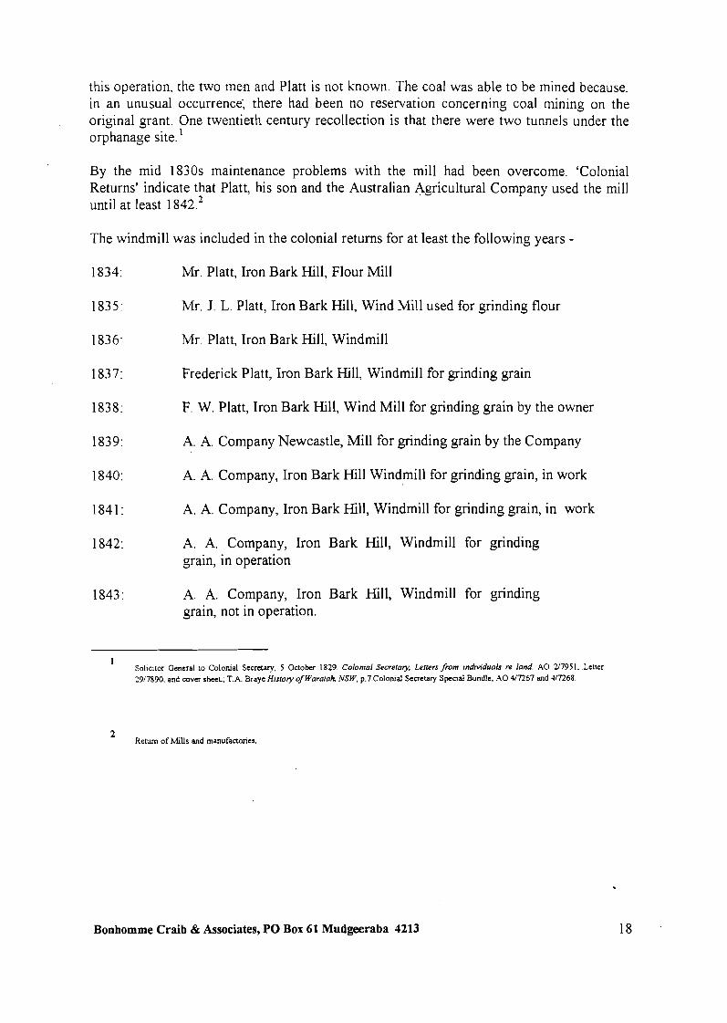
By the mid 1830s maintenance problems with the mill had been overcome. 'Colonial Returns' indicate that Platt, his son and the Australian Agricultural Company used the mill until at least 1 842.2
The windmill was included in the colonial returns for at least the following years -
1834: Mr. Platt, Iron Bark Hill, Flour Mill
1835: Mr. J. L. Platt, Iron Bark Hill, Wind Mill used for grinding flour
1836: Mr. Platt, Iron Bark Hill, Windmill
1837: Frederick Platt, Iron Bark Hill, Windmill for grinding grain
1838: F. W. Platt, Iron Bark Hill, Wind Mill for grinding grain by the owner
1839: A. A. Company Newcastle, Mill for grinding grain by the Company
1840: A. A. Company, Iron Bark Hill Windmill for grinding grain, in work
1841: A. A. Company, Iron Bark Hill, Windmill for grinding grain, in work
1842: A. A. Company, Iron Bark Hill, Windmill for grinding grain, in operation
1843: A. A. Company, Iron Bark Hill, Windmill for grinding grain, not in operation.
Sol~cltor General to Colomal Secretary, 5 October 1829 Colonral Secretary, Letters Jiom mdtndualc re land A 0 2'7951, Letter 2917890, and cover sheet. T A Braye H~story of Waratoh NSW, p 7 Colomal Secretary Specla1 Bundle. A 0 4/7267 and a7268
Return of Mills and manufactones,
Bonhomme Craib & Associates, PO Box 61 Mudgeeraba 4213
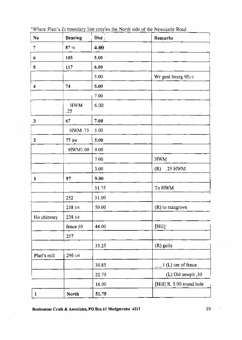
"Where Platt's Et boundary line crosks the North side of the Newcastle Road
No Bearing =:-- Remarks
4
( 3.00 ( (R) .25HWM 1
HWM
74
Ho chimney +
7.00
6.00
9 7
5 .OO
5.00 -
fence50 144.00 ( [Hill] i
Wr genl bearg 951 i~
9.00
51.75
238 314
238 314
To HWM
50.00
-- - -
Platt's mill
1 16.00 I [Hill] R. 5.00 round hole ' I I I
(R) to mangrove
-
-
296 114
Bonhomme Craib & Associates, PO Box 61 Mudgeeraba 4213 19
22.75
1
30.85
(L) Old sawpit ,30 1
- . - .1 (L) cnr of fence
North 51.75

W.J Goold claimed in the 1940s that the wirdn~ill was 'one of the old-fashioned type of windmill, fitted with 'Dutch' arms." :in~,lysis )f cartographic sources indicates that the present day (1997) Werribi Street - the north exter sion of Maud Street - was the road in to the mill.2 In 1838 Surveyor George White surveyed an adjoining property and his notes cover the Ironbark Creek frontage and Western boundary of Platt's grant. The point of interest in those notes was that when on the Maitland Road c l o x to Ironbark Creek, White listed a back bearing on Platt's Mill (about 4 km away) indicating that the mill was a substantial element in the landscape at that time. .This view is still possible today, with the Cook Island Pine being clearly ~ i s i b l e . ~
The preceding table presents the field notes of Surveyor White's 1839 traverse up the eastern boundary of Platt's grant, then East along Platt's Channel. White's bearings explicitly triangulate both the mill and house chimney. This survey correlates very closely with R.A. Allen's 1949 survey of "Platt's Channel Reclamation". The boundary (magnetic north of 1822) can be positively identified and the distances from the Maitland Road comer provide precise positions for his vantage points. The plot of the HWM of the channel correlates within 10 m of the mark in the 1949 su~-vey.~
Figure 3 Plan of the Neighbourhood of Newcastle, White 1839 shows Platt's mill and a square symbol ( possibly the house) 180 m to NW. The relationship to the Maitland Road, Platt's East boundary and the Channel closely correlate with White's filed notes. [AO: Map 44221
- --------- >
W. J. Goold, The Early Days.'Mq?ield 50 YearsofProgress. p.2
Plan showmg part of Lands embraced in Platts Channel Reclamation proposal . . . . August 1949. Newcastle Council Reference: 16X.
AO: 25090 White G B FieldBook476, 1838. pages 203-6; B.J. Johnsoh January 1997
4 B J Johnson, January 1997
Bonhomme Craib & Associates, PO Box 61 Mudgeeraba 4213

Platt's Decline On the 20th December 183 1 two of the Platt's sons, aged 13 and 5 , died in a bush fire. The bodies of the children were 'brought home' and Platt was 'confined to the house'. Based on this evidence it can be confidently said that Twentieth Century claims that Platt's house was
1 destroyed in the bush fire are incorrect. Both boys were buried in Christ Church Newcastle Platt then
. . was compelled to turn over all my outdoor concerns to a worthless overseer. the men took advantage of my being confined to the house, three of them committed a robbery on New Years day at Newcastle . . . and many other irregularities were committed . . . the man lent for burning lime Lvas permitted to remain and not put to his customary work of fencing, the female servant took advantage . . . to rob us and was punished by being sent to the factory, thus I became the sole attendant of my wretched family and quite unable even to make enquiry what the men were doing, as I considered it at the same time a very secondary object. On or about the 28th January I was informed by accident that one of my men was sentenced to a road party. I repaired to Newcastle and on remonstrating with Mr. Reid . . . I was suffering as I always do in the hot months most severely from the Asthma and had the sole charge of rousing and keeping up the spirits of a drooping family cut off by previous misfortunes from all society and only visited occasionally by Dr. Brooks and Mr. Deane who did all in their power to cheer up the female part of my family, under these circumstances . . . 3
By the mid 1830s Platt saw 'this Concern' (not 'cancer' as is often quoted) as requiring money they were never likely to have and was hopeful of selling the property. He was worried about his surviving children. He was concerned for the education of his two daughters and to make his oldest son financially secure so that he, in turn, could establish the remaining, younger son.4
There had been discussions with Col. Dumaresq of the Australian Agricultural Company, but the company wanted to pay for the property in small annual payments to prevent interference with the company's yearly dividend. Such an arrangement was not agreeable to Platt who saw that small payments would be frittered away. Platt noted to a correspondent that the company was anxious to obtain any other land in the neighbourhood 'but there are none that have frontage except this'.5 Before negotiations could be revitalised, John Laurio Platt died on the 17th May 1836, aged 54. He was 'followed to his grave', the Australian reported, 'by all the Military, Civil Officers, and Gentlemen of the own.'^
While Platt's name has descended into the local nomenclature, identifying Platt's Folly and Plattsburg, perhaps Platt's epitaph should be an extract from a letter he wrote in December 1824 -
Plan to Colonial Secretary. 28 January 1835. Colonial Secretary LeftersRecelved A 0 412291.3, Lener 351905.
Bunal Certificates No. 1742, 1743. Volume 15.
3 Platt to Colonial Secretary, 28 January 1835 Colonial Secretary Letters Received. A 0 412291. Letter 351905
4 Plan to I. Nowland, 6 March 1836. Plan Family. John Launo Platt Papers. Ml MSS 5860.
Platt to I. Nowland, 6 March 1836. Platt Family. John Laurio Plrtt Papers. Ml MSS 5860.
Aunrolian, 27 May 1836, second page
Bonhomme Craib & Associates, PO Box 61 Mudgeeraba 4213

.... 1 concelve m y case t3 be different to that of any person up this hver . perhaps In the Colony. On making up my mind to emigrate to N. S. Wales I was referred by the Under Secretary of State to the Colonies to a Mr. Barnard who appeared to have the management under the Secretary of the affairs of the Colony in the Colonial Office. In answer to h s interrogatories as to what I knew of wool and tobacco in my excursions in Saxony and residence in the U.S. of America, I replied I had paid attention to neither. The conversation turning to Saw Mills I said I had paid some little attention to them in North America and the U.S. and conceived them of great utility in a new settlement. He immediately said if I would embark a part of my capital in any thing of the kind it would have the most decided support of Govenunent - in shon said volumes of the facilities which would be afforded etc etc all which I have found to be erroneous and conceive Mr. Barnard in h s zed for t h ~ s Colony must have outrun h s instructions or I never could have been so disappointed . . .I
The Australian Agricultural Company (abbreviated to AA Company) The AA Company had its origins in a small gathering of men who met with John Macarthur junior in London in April 1824. The resulting company had a nominal capital of E1,000,000 in ten thousand shares and the British Government agreed to grant it one million acres of land in New South ~ a l e s . ~
While the Act stated that the company was formed 'for the cultivation and improvement of waste lands in the colony of New South Wales, and for other purposes relating thereto' it has been suggested its primary interest was the production of fine wool most of which, at the time, England imported from Germany and spain.)
The company was structured with directors in England and a committee of management in Australia. Of the latter the three active members were James Macarthur, H. H. Macarthur and Dr. James Bowman. The area of land chosen was the present day Port Stephens and its environs, where the company established itself4
In 1820, four years prior to the formation of the AA Company, the government coal mines had been a part of an inquiry into the administration of the colonies conducted by Commissioner J. T. Bigge. His recommendation had been that they should be leased. After various negotiations and explorations, the direction was given from England that the AA Company should receive a two thousand acre grant at Newcastle and control of the government coal mines. The company commenced mining in 1831 and maintained its monopoly into the 1840s.'
1 Plan to Colonial Senetary, 11 December 1824. Colonial Secretav LeftersReceived. A 0 411 8 1 1 pp. 199, 199a. b, c.
J. F. Campbell, The First Decade ofthe Australian Agricultural Company, 1824 to 1834.'JournaL R4HS. Vol. DC Part 111, p. 114
3 For example. see John Robertson The Australian Agricultural Company and the Port Stephens Fiaco.' Journal RAHS, Vol. 50, Part 3. p.217, J . F. Campbell. The First Decade of the Australian Agr~cultural Company, 1824 to 1834.'Journal RAHS, Vol. IX, Part 111. p. 113
John Robertson, The Australian Agricultural Company and the Port Stephens Fiaco.'Journal RAHS. Vol. 50, Part 3, p.217
' 1. C Docherty, Newcastle. TheMoking o/anAusrralim Ciy, p.8
Bonhomme Craib & Associates, PO Box 61 Mudgeeraba 4213
The AA Company and Platt's Land
The AA Company's interest in buying Platt's land came about as a result of an understanding, in 1836, that a steam and gas company was to be formed and that the company would need coal. The AA Company was concerned, as they were aware that Platt had been approached, because his coal could be mined outside the government-AA Company monopoly. Reports were that he was asking £6,000 for the land.
Commissioner Dumaresq of the AA Company reported to the English directors that coal had been mined there for some time for sale in Sydney. The quality was excellent, and the vein, close to the surface, was said to be the same as that worked by the AA Company at Newcastle.' He presented a number of reasons why the new venture would not succeed, but at the same time felt it prudent either to buy all the land or the mining right and a proportion of the river frontage to prevent a competitor entering the industry. Dumaresq's assessment was that apart from the coal, the property was valueless except as a small dairy farm.*
As stated earlier, Platt would not accept the Company's offer because of the way in which the payments were to be structured. Then in May 1836 Platt died and the Supreme Court determined that no sale could be made until his heir, Frederick William Platt, came of age.3 At the same time there was a belief in the wider community that the company would not want to outlay such a large amount of money to obtain the property.4
The period of negotiations were complicated when first, the news was received that Frederick Platt had changed his mind and proposed to sell only the mining right for a limited time, then that he was planning to advertise the sale in Sydney newspapers and sell publicly.5 However in August 1838 the estate was bought 'without ~ o m ~ e t i t i o n ' . ~
At the time there were several tenants on the property occupying small portions of arable land. Also, Commissioner J. E. Ebsworth believed, a considerable income could be derived from the use or leasing of the windmill. By May 1840 Platt's farm had been leased on a yearly basis with the company reserving for its use anything it should require.
H. Dumarcsq to the Governors and Directors (London). 26 April 1836, Despatch No. 26, follos 457451. ANU Noel Butlin Archives Centre, AA Company Papers. 781111 5.
H. Dumareoq to the Governors and Directors (London). 26 April 1836, Despatch No. 26, folios 457451. ANU Noel Butl~n Archives Centre, AA Company Papers, 78/1/15.
3 H. Dumaresq to the Governors and Directors (London). 17 April 1837, Despatch No. 38, folio 589. ANU Noel Butlln Archives Centre, AA Company Papers. 78/1/15.
4 J. E Ebsworth to the Governors arid Directors (London), 28 May 1838, Report: 'Mr. Platt's Estate' No 4 (internal numbcnng), folio 23. ANU Noel Butlln Archives Centre, AA Company Papers, 78/1/16.
5 J E. Ebsworth to the Governors and Directors (London), 18 June 1838, Despatch No. 7, folio 51 and Repon to the Governors and Directors (London), 27 July 1838, Despatch No. 9, folio 70. ANU Noel Burlin Archives Centre, AA Company Papers, 78/1/16.
J E. Ebsworth to the Governors and Directors (London), 31 August 1838, Despatch No. 10, folio 79. ANU Noel Butlin Archives Centre, A), Company Papers. 78/1/16.
Bonhomme Craib & Associates, PO Box 61 Mudgeeraba 4213 23
The buildings were in a dilapidated state so half the rent was to be used for repairs.
A special report to the shareholders of thc AA C ampany in 1855 presented an optimistic view of the property -
. . . Thls property is bounded on the north by the south arm or branch of the Hunter River. at the north eastern point is a Wharf, with ten feet at low water; m d a considerable portion of the Water-frontage. running for a distance of nearly three miles, might be made available for Barges and Colliers of a light draft of water, like our English Billiboys. It is a question which may be borne in mind to be followed up in after years, whether the whole of that portion of the south arm of the River Hunter. which. opposite the north eastern portion of Platt's Land, is divided by an island, might not be formed into a Floating Dock (an enterprise which would be of immense importance to the trade of Ne~vcastle), in which case it would be difficult to estimate the value of this Water-frontage.
Independent, however, of this Water-frontage, the mineral worth of the property has to be borne in mind; for there cannot be a question but that the coal measures of the Newcastle Basin extend under the whole area, and when opened to, the produce could be most conveniently shipped from such a line of Water-frontage. The value of this property is also much enhanced, from being intersected by the Turnpike and Rad roads. . . 2
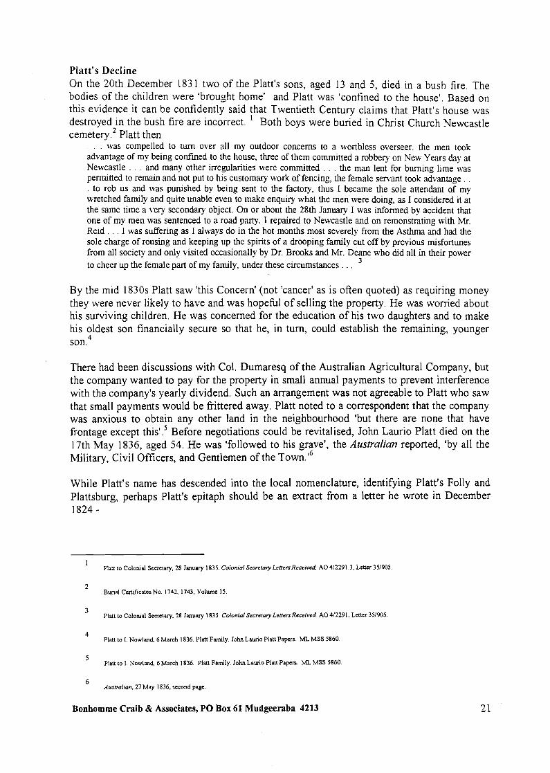
Figures 4 & 5 Plan of the River Hunter from Port Hunter to the Falls at West Maitland, G.B. White, 1844 and a part enlargement shows Platt's mill in the same relative position to the road, and a circle 300 m to the NE of the mill on the water's edge. This may be a wharf. [See note for Figure 61 [ML: M3 81 1.25/1844/1 FR2]
------------>
P. P King to the Governors and Directors (London), 5 May 1840. Despatch No. 28, folio 413. AN" Noel Butlin Archves Centre. M Company Papers. 7811116.
Special Repon on the Autrallan Agricultural Company's Collieries at Newcastle. Issued to the Proprietols, previou to the Half-Yearly Meeting to be held at the London Tavern Bishopsgate Streef on Wednesday. h e 8 h day of A u p t next. at One o'clock precisely, as per Advertisement. Printed 1. J. Metcalfe, London, 20th July 1855.
Bonhomme Craib & Associates, PO Box 61 Mudgeeraba 4213 24


In the early 1850s John Askew, a visitor to Australia, recorded that from Newcastle
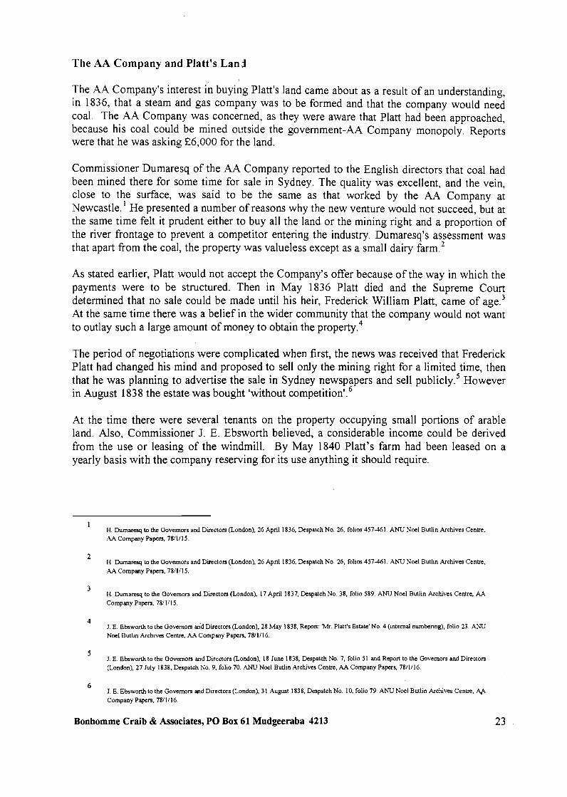
The road, for the first two miles, had many windings, and was overhung by immense gum and iron- bark trees, giant cedars, and graceful wattles.
... we came upon a fine piece of road, bounded on each side by a thick forest. This road, for two miles, was straight as an arrow. We had not gone far till we met two handsome young ladies, ridmg on fine- looking bay horses. One was dressed in a tight fitting linen jacket and cabbage-tree slouch, the other in a black silk visite (sic), and bonnet and veil, of the latest fashion fiom Sydney ... A few minutes more brought us opposite a small clearing, with a few shed-like buildings on the far side, close to the trees ... Three or four milch cows. And a few d q utensils stood outside the dwelling. This was Iron Bark Farm, the residence of the two young ladles we had recently met ...I
Figure 6 The Estates of the Australian Agricultural Co. at Newcastle NSW 1854 also shows the Mill in the same relative position to Platt's boundary and the Maitland Road. It lists a Wharf (but no position) and 10' river depth immediately below the house position indicated in earlier surveys. [ANU, Noel Butlin Archives Centre: 131/4/32/B Map X7 Neg. 13391
----------------->
John Askew, A Voyage to Australia &New Zealand. Simpkia Marshall C Co. L o n d o ~ 1857, pp.294-295.
Bonhomme Craib & Associates, PO Box 61 Mudgeeraba 4213

A House for the General Superintendent
In 1875 it became necessary to provide a house for the General Superintendent of the AA Company. The timing was unfortunate because a large number of buildings were being built in Sydney, Maitland and Newcastle by both government and private individuals. Consequently there had been a great increase in the price of all building material and labour and it had become difficult to get contractors to tender for anything other than what they considered 'first class jobs'. It was said that contracts in Sydney alone would keep all the Sydney stone masons employed for the next two years.1 For these reasons, there were severe restrictions on the new house. The lowest tenderer agreed to reduce his price from £ 3,685 to £3,500 if the roof of the house was shingled rather than slated. Ironically the fire which occurred in 1901 started in the shingles. The house was built of brick with stone foundations. The source of the stone was a 'bed of good hard freestone, which'was opened some years ago near the site of the house, and on trial was found to be very well suited for the purpose, and better than the Waratah stone which is generally used'.2 Additional costs included compensation to the tenant and provision for clearing a road to the house and a number of outbuildings including adding buildings to the coach house, a slab workman's cottage, stables, cart house and a coal house.3
By August 1876 Gregson, the AA Company's superintendent, had moved into the house which was 'a very comfortable one and is charmingly situated on a slight elevation overlooking the Hunter ~ i v e r ' . ~ - .
The Destruction of the House by Fire The fire which almost completely destroyed the house occurred on the 17th December 1901. The site was described in the Newcastle Morning Herald as 'in the Millbank Paddock, about two miles on the Sandgate-road beyond Mayfield'. The newspaper reported -
. . . The [two storied] house, which contained fourteen rooms, is now a complete ruin. Nothing renzained but the outer and dividing walls and the lower verandahs, the upper verandah being destroyed and the floors burnt through early in the fire. A considerable portion of the walls forming the main structure are bulged and cracked, and it is doubtful if any portion of the house will be of use. 5
By October 1902 a new house was finished. Gregson judged it 'a good piece of work, much more substantial and much better finished than the house was which was b ~ r n e d ' . ~ 2 acres 3
Report to the Governors and Directors (London). 13 May 1875. Despatch No. 231, folio 216. ANU Noel Butlin Archives Centre. AA Company Papers, 78/1/48.
2 Report to the Governors and Directors (London). 13 May 1875. Despatch No. 231. folio 216.; Gregson to the Governor and Court of D~rectors (London). 19 December 1901. Despatch 843, folio 362. ANU Noel Butlin Archives Centre. AA Company Papers. 78/1/74.
Report to the Governors and Directors (London). 22 December 1876, Despatch No. 265, folio 593. ANU Noel Butlin Archives Centre. AA Company Papers. 7811148.
4 Repon to the Governors and Directors (London). 4 August 1876. Despatch No. 257. folio 367. ANU Noel Butlin Archives Centre. AA Company Papers, 78/1/49.
NewcactleMornmg Herold, 18 December. 1901. p.5.
6 1. Gregson to the Governors and Directors (London). 24 October 1902. Despatch 860. folio 329. ANU Noel Butlin Archives centre. AA Company Papers. 78/1/75.
Bonhomme Craib & Associates, PO Box 61 Mudgeeraba 4213 26

roods 13 perches of the area was resumed in December 1903 and declared a public park - Shelley Beach Park - in May 1904.'
Figure 7 Jesse Gregson's house, [at] Waratah, after the fire. 1901. [Hunter Photo Bank]
1 Govenmle~it Gazette No. 638, 5 December 1903, p.9009; No. 257, 7 May 1904, p.3823
Bonhomme Craib & Associates, PO Box 61 Mudgeeraba 4213
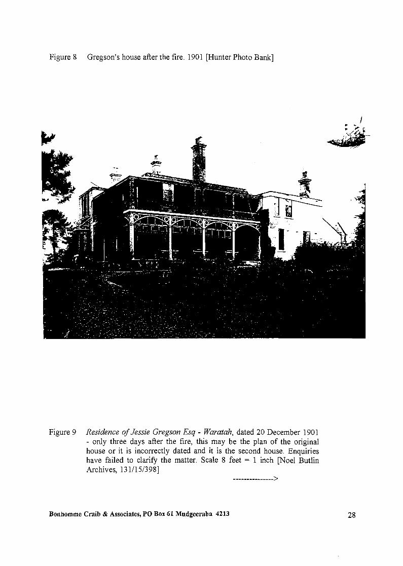
Figure 8 Gregson's house after the fire. 1901 [Hunter Photo Bank]
Figure 9 Residence of Jessie Gregson Esq - Waratah, dated 20 December 1901 - only three days after the fire, this may be the plan of the original house or it is incorrectly dated and it is the second house. Enquiries have failed to clarify the matter. Scale 8 feet = 1 inch [Noel Butlin Archives, 13 l/l5/398]
--------------->
Bonhornrne Craib & Associates, PO Box 61 Mudgeeraba 4213


A Picnic and Recreation Area
Until at least the 1930s the mill paddock was well known to local residents as an area for picnics and other outings.' Mrs. Ellen Lane of Mayfield came to the AA Company site at the age of six or seven in the second decade of the twentieth century when her father, James Meehan, had moved to Newcastle from the AA Company's Warrah Station. The Meehans lived in a house there and James Meehan's responsibilities included the gardens, horses, the car, 'everything'. Mrs. Lane recalled the surroundings -
It was as though we'd never left the country. The home was surrounded by many acres of rich green land. The main gates to tlie property were at the [present day] Maud Street lights. Beautiful trees surrounded tlle dwelling. We were ove joyed. . .
Mrs. Lane also recalled the activity on Platt's Channel -
. . .We used to race over the green, gassy banks, through the sweet smelling lantanas, to the fishermen's wharves to fish, or to borrow a boat to row on the channel.
At the foot of the river banks was a cottage in which lived a fisherman, his wife and two children. .
. . . Old Bob, as the kids knew him [Bob Ashby] . . . He was very musical and on Summer evenings he used to bring out an ancient concertina and play anything from Classics to Jazz. His Waltzes were accompanied by the tapping of his heavy boots. It was fun and many times boats would anchor in front of the old place just to listen to his music.
A Mr. Cruise had a boat on tlie beach . . . In mid stream was a house boat built by a Mr. Sam Palmer, wlio lived on it. . . 2
Then, in 1939, the Council of the City of Greater Newcastle was appointed Trustee of 'Shelley Beach Park, Shell Beach, Hunter ~ i v e r ' . ~ The Park was subsequently acquired by BHP. There are also recollections in the Newcastle community that during the Depression of the 1930s unemployed people lived in the park and that there was a hollow tree significant for the shelter it provided. Apparently this tree was used on a transitory basis with people spending a night or two there and that items were left behind for the next person to use.4
1. W. J. Goold, The Early Days.'M&eld 50 Years of Progress. p.2.
Mrs. Ellen Lane.As If Was, pp. 1 -2. (copy John Di Gravio) Interv~ew with Mrs. Ellen Lane by John Di Gravio. 19%.
Governmen! Gazerre No. 38. 3 Much 1939. folio 1069.
For furher detail speak with John Di Gravio.
Bonhomme Craib & Associates, PO Box 61 Mudgeeraba 4213

The Murray-Dwyer Orphanage for Boys
In 1933 the General Superintendent's house and surrounding acreage of some forty-three acres was acquired by the Roman Catholic Bishop of Maitland, Dr. Gleeson C.S.S.R., for an orphanage for boys.' The building was named in acknowledgement of Dr. Gleeson's two predecessors and their concern for the welfare of the children of the diocese.
As the result of an earlier contact with the Daughters of Charity of St. Vincent de Paul, Bishop Gleeson invited the Superiors of the Central House of the British Province of the Daughters of Charity at Mill Hill, London to take charge of the orphanage. Later the people of Newcastle would affectionately referred to them as the 'Aeroplane Sisters' because of the wide white cornette they wore.2
The orphanage, established in what had been the house of the General Superintendent, was blessed and opened on the 10th December 1933. The orphanage school was physically conducted in what had been a stable with an upstairs loft. It was attended both by boys from the orphanage and day pupils. Other buildings on the site at this time included a caretaker's cottage behind the house and a small cottage at the river's edge occupied by 'old Mr. Ashe' and his son In 1936 a new wing was built consisting of a dormitory, dining room and play hall. At the same time extensive work was done renovating and refitting the existing building. The boys were accommodated in the new section and the older buildins used as a novitiate for girls wishing to join the order. A second wing was completed early in 1938. This addition, forming part of the main building, was described as a two storey brick building with concrete foundations. The ground floor contained a washroom, three classrooms, and a spacious verandah. The first floor held a dormitory, 53 ft by 31 A, Sisters' provision-room, bathroom and lavatory accommodation. It was roofed with terracotta and Marseilles tiles.4
Old SystemTitle, Book 1661 No. 502.
Kim Maree Goodwin, 'Iron Bark' Homestead and the Daughten of Chariry. p.2.
Daughters of Charity. The History ofourAustralian Province, p.15.
4 Rev. Harold Campbell. The Diocese ofMaitland 1866-1966, p.158; Kim Maree Goodwin, 'Iron Bark' Homestead and the Daughters of Chanty, p.4, The Newcastle andMaitland Catholic Senhnel. 1 December 1937. p. 103; Newcastle Morning Herald. 12 March 1938.
Bonhomme Craib & Associates, PO Box 61 Mudgeeraba 4213
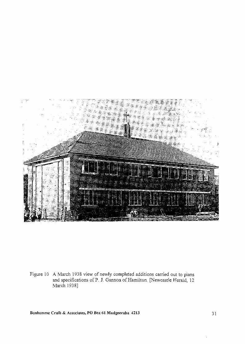
Figure 10 A March 1938 view of newly completed additions carried out to plans and specifications of P. J. Gannon of Hamilton. mewcastle Herald, 12 March 193 81
Bonhornrne Craib & Associates, PO Box 61 Mudgeeraba 4213
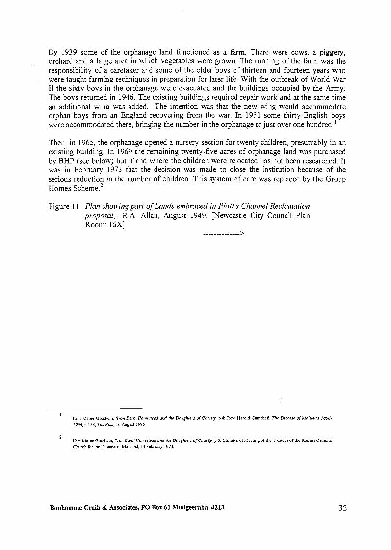
By 1939 some of the orphanage land functioned as a farm. There were cows, a piggery, orchard and a large area in which vegetables were grown. The running of the farm was the responsibility of a caretaker and some of the older boys of thirteen and fourteen years who were taught farming techniques in preparation for later life. With the outbreak of World War I1 the sixty boys in the orphanage were evacuated and the buildings occupied by the Army. The boys returned in 1946. The existing buildings required repair work and at the same time an additional wing was added. The intention was that the new wing would accommodate orphan boys from an England recovering from the war. In 1951 some thirty English boys were accommodated there, bringing the number in the orphanage to just over one hundred.'
Then, in 1965, the orphanage opened a nursery section for twenty children, presumably in an existing building. In 1969 the remaining twenty-five acres of orphanage land was purchased by BHP (see below) but if and where the children were relocated has not been researched. It was in February 1973 that the decision was made to close the institution because of the serious reduction in the number of children. This system of care was replaced by the Group Homes ~ c h e m e . ~
Figure 1 1 Plan showing part of Lands embraced in Platt 's Channel Reclamation proposal, R.A. Allan, August 1949. [Newcastle City Council Plan Room: 16x1
-------------->
1 Kim Maree Goodwin, 'Iron Bark' Homesread and the Daughters of Charily, p.4; Rev. Harold Campbell, The Diocese ofMaitland 1866- 1966, p. 158; The Posr. 16 August 1995.
Kim Maree Goodwin, 'Iron Bark' Homestead and [he Daughlers of Charily. p.5; Minutes of Meeting of the Trustees of the Roman Calholic Church for the Diocese ofMaitland. 14 February 1973.
Bonhomme Craib & Associates, PO BOX 61 Mudgeeraba 4213

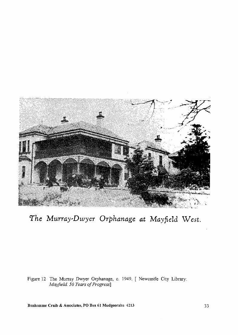
The Murray#Dwyer Orphanage a t Mayfield West.
Figure 12 The Murray Dwyer Orphanage, c. 1949. [ Newcastle City Library: Mayfield 50 Years of Progress]
Bonhomme Craib & Associates, PO Box 61 Mudgeeraba 4213
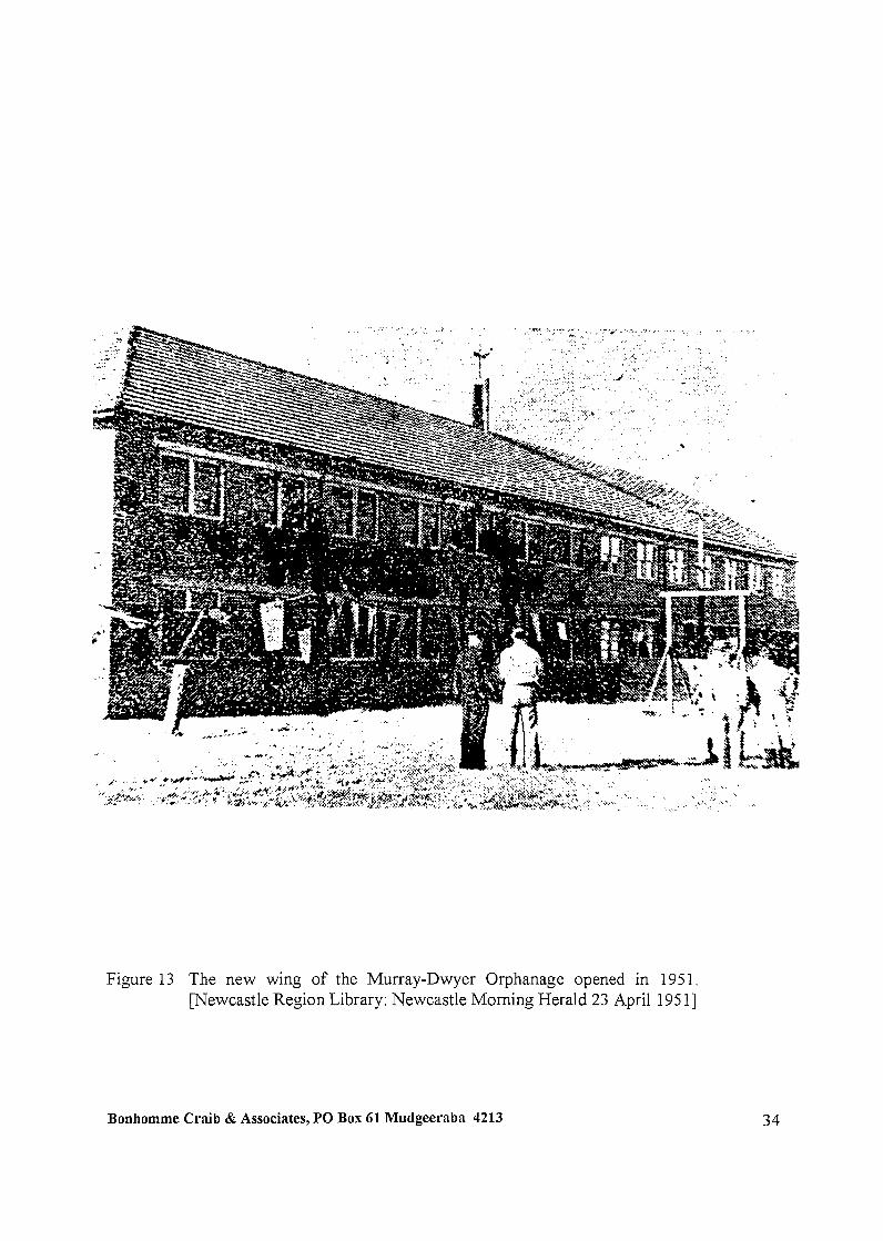
Figure 13 The new wing of the Murray-Dwyer Orphanage opened in 1951, [Newcastle Region Library: Newcastle Morning Herald 23 April 195 11
Bonhomme Craib & Associates, PO Box 61 Mudgeeraba 4213

Figure 14 Part of a building application which shows some of the layout of the orphanage.[Newcastle City Council: New Infants Toilet Block. Mzrrray-Dwyer Orphanage, Mayjeld, J.P. Gannon, 9/64. 1 6X 1 87 1 - 641
Bonhomme Craib & Associates, PO Box 61 Mudgeeraba 4213

BHP In 1940 BHP bought approximately six acres of the northern section of the orphanage land and some five acres of the southern boundary.' By the end of the 1940s BHP needed more land. It already owned Spit Island (between Platt's Channel and the northern arm of the river) and in 1950 came to an agreement with the government2 that it would exchange 337 acres of company owned land (part of which is the site of the University of Newcastle) for an area which included Platt's Channel, a potential 257 acres.3 In 1969 BHP purchased the remaining twenty-five acres and subsequently the 1902 house was demo~ished.~ By 1969 the eastern part of Platt's Channel had been filled in and a rod-mill and tonnage oxygen plant was operating on the area.5 The orphanage buildings were used for a number of purposes including occupation by BHP Refractories Services. The 1986 orthophoto map [See Figure 11 shows, in addition to the BHP Refractory building, a small building to the north west, possibly a refractory testing building and another fronting Industrial rive.^ .
The distinctive Cook Island Pine within the grounds of the site was placed on the National Trust Register of Significant Trees in 1991.
' Old Systems T~tle, Book 1869 No. 41.
BHP Co. Ltd. (Reclamation and Exchange) Agreement Rat~fication Act
3 Institution of Engineen Australia. Newcastle Division, Shaping the Hunter, p.158
4 Newcastle Morning Herald, 20 November 1970.
I' G. Irwin, 'Reclamation of the Hunter River Islands.' The Australian Geographer. Vol. 10. No. 5 (1968). p.413
Bonhomme Craib & Associates, PO Box 61 Mudgeeraba 4213

Figure 15 The study site and Platt's Channel as it is being infilled. pewcastle Region Public Library: 0003-00 19741
Bonhomme Craib & Associates, PO Box 61 Mudgeeraba 4213

Figure 16 After purchase by BHP, the AA Company's Manager's house was demolished in November 1970. mewcastle Region Public Library]
Bonhomme Craib & Associates, PO Box 61 Mudgeeraba 4213
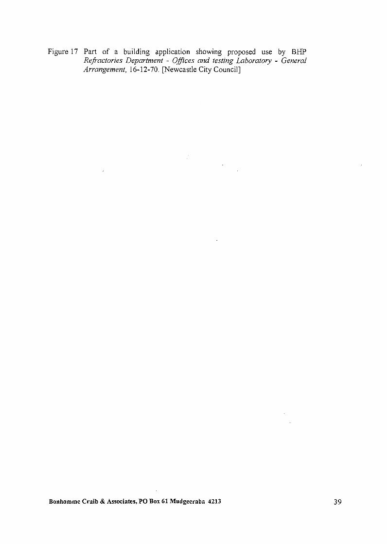
Figure 17 Part of a building application showing proposed use by BHP Refractories Department - OfJices and testing Laboratory - General Arrangemertt, 16- 12-70. mewcastle City Council.]
Bonhomme Craib & Associates, PO Box 61 Mudgeeraba 4213

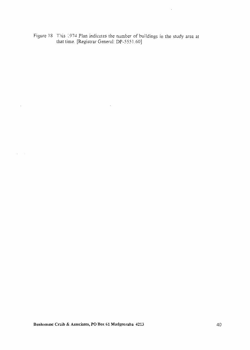
Figure 18 This 1974 Plan indicates the number of buildings in the study area at that time. [Registrar General: DP-555 1.601
Bonhomme Craib 6: Associates, PO Box 61 Mudgeeraba 4213
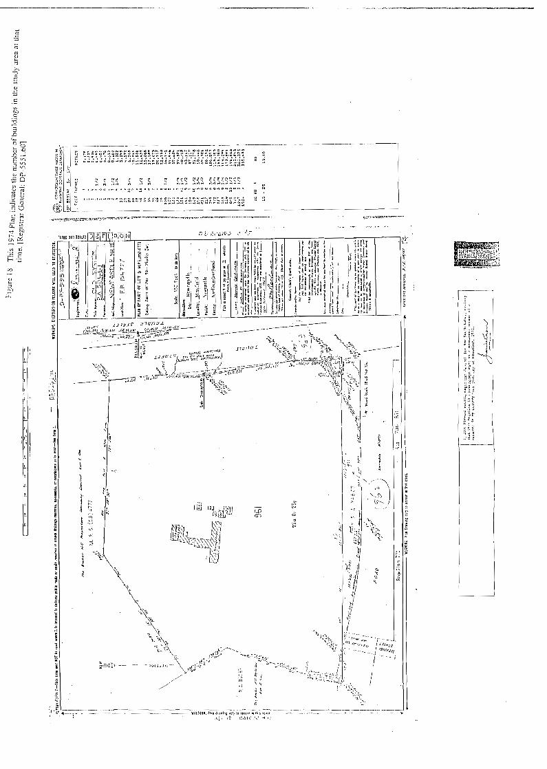
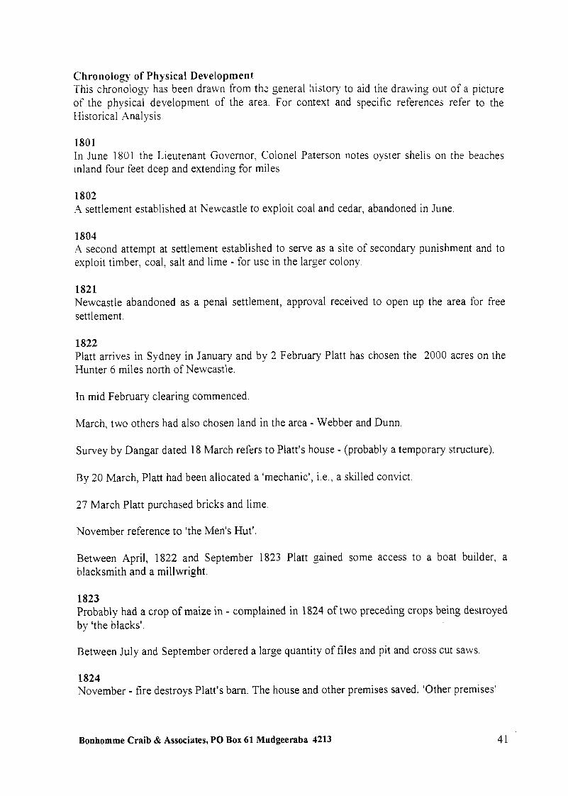
Chronology of Physical Development This chronology has been drawn from th: general history to aid the drawing out of a picture of the physical development of the area. For context and specific references refer to the Historical Analysis.
1801 In June 1801 the Lieutenant Governor, Colonel Paterson notes oyster shells on the beaches inland four feet deep and extending for miles
1802 A settlement established at Newcastle to exploit coal and cedar, abandoned in June.
1804 A second attempt at settlement established to serve as a site of secondary punishment and to exploit timber, coal, salt and lime - for use in the larger colony.
1821 Newcastle abandoned as a penal settlement, approval received to open up the area for free settlement.
1822 Platt arrives in Sydney in January and by 2 February Platt has chosen the 2000 acres on the Hunter 6 miles north of Newcastle.
In mid February clearing commenced.
March. two others had also chosen land in the area - Webber and Dunn.
Survey by Dangar dated 18 March refers to Platt's house - (probably a temporary structure).
By 20 March, Platt had been allocated a 'mechanic', i.e., a skilled convict.
27 March Platt purchased bricks and lime
November reference to 'the Men's Hut'.
Between April, 1822 and September 1823 Platt gained some access to a boat builder, a blacksmith and a millwright.
1823 Probably had a crop of maize in - complained in 1824 of two preceding crops being destroyed by 'the blacks'.
Between July and September ordered a large quantity of files and pit and cross cut saws.
1824 November - fire destroys Platt's barn. The house and other premises saved. 'Other premises'
Bonhomme Craib & Associates, PO Box 61 Mudgeeraba 4213

presumably accommodation for assigned servants. By this time had pl;nted 30 acres of -,heat and had poultry and pigs.
December - had a modest windmill to drive saws but incomplete but was being used to drive stones for flour milling.
1825 Planted 40 acres of wheat.
1826 March, assigned servants consisted of a miller, a stock-keeper, a labourer and an invalid
1829 May, list of assets: Dwelling house and kitchen £250; Wind Mill for grinding g a i n £600; Granary and Barn £ 165; Store House and dairy £35; Stable and sheds £ 50. He had completed two and a quarter miles of fencing and possessed: 2,000 acres of land (250 acres cleared); 2 horses; 170 head of cattle. Although not apparent in the above list, it is assumed there would have been accommodation for the men employed there.
October, Ra.psey and Mitchell are mining coal on Platt's land. In twentieth century, it was reported that two tunnels extended under the orphanage site.
1831 Mining a shell bank for one thousand bushells of lime. Bushfire kills two of Platt's sons. The house is not destroyed
1834-1842 Windmill for grinding grain in operation.
1836 Platt dies. Property inherited by Frederick William Platt who is underage.
1838 Property purchased by AA Company. At the time of purchase several tennants were small portions of arable land there.
1839 White surveys grant and refers to the house chimney and Platt's mill. Gives bearings.
1840 Platt's farm leased on a yearly basis. Buildings in a dilapidated state. Half the rent to be used for repairs.
Bonhomme Craib & Associates, PO Box 61 Mudgeeraba 4213
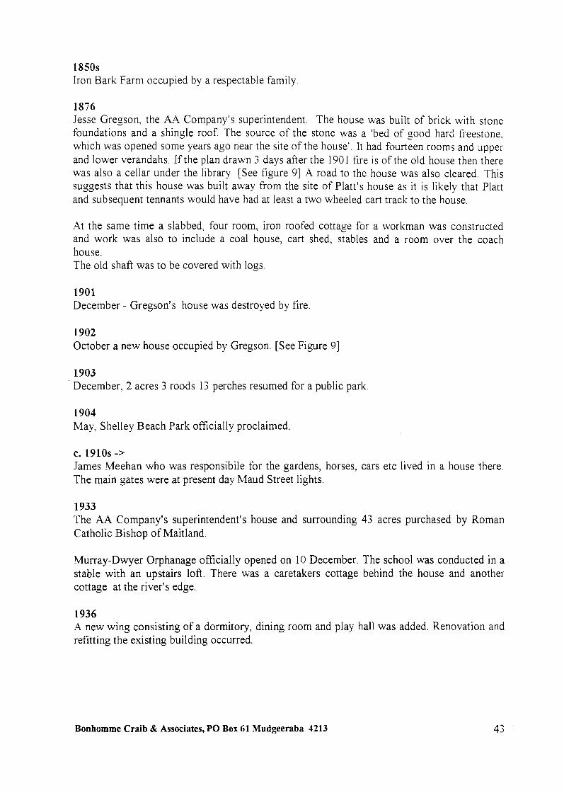
1850s Iron Bark Farm occupied by a respectable family
1876 Jesse Gregson, the AA Company's superintendent. The house was built of brick with stone foundations and a shingle roof. The source of the stone was a 'bed of good hard freestone, which was opened some years ago near the site of the house'. It had fourteen rooms and upper and lower verandahs. If the plan drawn 3 days after the 1901 fire is of the old house then there was also a cellar under the library [See figure 91 .4 road to the house was also cleared. This suggests that this house was built away from the site of Platt's house as it is likely that Platt and subsequent tennants would have had at least a two wheeled cart track to the house.
At the same time a slabbed, four room, iron roofed cottage for a workman was constructed and work was also to include a coal house, cart shed, stables and a room over the coach house. The old shaft was to be covered with logs.
1901 December - Gregson's house was destroyed by fire.
1902 October a new house occupied by Gregson. [See Figure 91
1903 December, 2 acres 3 roods 13 perches resumed for a public park
1904 May, Shelley Beach Park officially proclaimed.
C. 1910s -> James Meehan who was responsibile for the gardens, horses, cars etc lived in a house there. The main gates were at present day Maud Street lights.
1933 The AA Company's superintendent's house and surrounding 43 acres purchased by Roman Catholic Bishop of Maitland.
Murray-Dwyer Orphanage officially opened on 10 December. The school was conducted in a stable with an upstairs loft. There was a caretakers cottage behind the house and another cottage at the river's edge.
1936 A new wing consisting of a dormitory, dining room and play hall was added. Renovation and refitting the existing building occurred.
Bonhomme Craib & Associates, PO Box 61 Mudgeeraba 4213

1938 A second ~ving addded. It consisted of a two storey brick building with concrete fou;lda:ions. The ground floor contained a washroom, three classrooms and a verandah. The first floor held a dormitory of 53 ft x 31 ft; a provision room and lavatories. Roofing was terracotta and Marseilles tiles.
1939 Some or orphanage land used as a farm. There was a vegetable garden, an orchard, cows and a piggery. During WWII the building occupied by a piggery. Children evacuated.
1940 BHP bought approximately six acres of the northern section of the orphanage land and some five acres of the southern boundary. ' 1950 BHP came to an agreement with the government that it would exchange 337 acres of company owned land (part of which is the site of the University of Newcastle) for an area which included Platt's Channel, a potential 257 acres. The channel was gradually infilled in the 1950s.
1946 Children return and the buildings are repaired.
1951 A new dormitory wing added
1969 The house site and remaining 25 acres purchased by BHF. By this time the eastern part of Platt's Channel had been filled in and a rod-mill and tonnage oxygen plant was operating on the area. The orphanage buildings were used for a number of purposes including occupation by BHF Refractories Services.
1970 The 1902 AA Company house demolished.
1974 A 1974 DP Plan indicates a number of weather board structures to the rear of the existing two storey brick conglomeration. [See Figure 181
1986 On the 1986 orthophoto map [See Figure 11 there is a small building to the north west, possibly a refractory testing building and another fronting Industrial o rive.'
1 Old Systems Title. Book 1869 No. 41
2 Onhophotornap. Kooragang Island, U6357-8, 1986.
Bonhomme Craib & Associates, PO BOX 61 Mudgeeraba 4213
Assessment of Significance Criterion The assessment has been conducted using the NSW heritage assessment criteria as specified in the NSW Heritage Manual.' There are four broad criteria which are divided into two categories:
Nature of significance; and comparative significance.
Criterion I : Historic (Evolution and Association) An item which meets this criterion is significant because of the importance of its association with, or position in the evolving pattern of our cultural history.
Criterion 2: Aesthetic (Scenic, Architectural qualities, Creative and Technical Accomplishment)
An item meeting this criterion is significant because it demonstrates positive visual or sensory appeal, landmark qualities andlor creative or technical excellence.
Criterion 3: Technical1 Research Potential (Archaeological, industrial, educational, research potential and scientific significance values)
Items meeting this criterion are significant because of their contribution or potential contribution to an understanding of the cultural history or environment.
Criterion 4: Social Significance (Contemporary community esteem) Items meeting this criterion are significant through their social, spiritual or cultural association with a recognisable community.
The degree of significance is assessed by using the following criteria
Criterion A: Representativeness Items meeting this criterion are significant because they are a fine representative example of significant items or environments.
Criterion B: Rarity An item meeting this criterion is significant because it represents a rare, endangered or unusual aspect of our history or cultural environment.
To be assessed as significant an item must:
qualify under one of the four criteria for assessing the nature of significance
AND
qualify under one of the two comparative criteria;
1 NSW Herifage Manrral. Heritage Office and Depanmcnt of Urban Affairs and Planning. 19%.
Bonhomme Craib & Associates, PO Box 61 Mudgeeraba 4213

it must also retain the integrity of its key attributes of significance
The significance of the Tourle Street Site is here assessed under each criterion.
Criterion 1: Historic (Evolution and Association) The area is significant because of its association with one of the first free settlers (and possibly the first free settler) in the area after Newcastle and the Hunter Valley were opened up for settlement. Its subsequent association with the Australian Agricultural Company and in the twentieth century with BHP, both major players in the development of the area, also contributes to its historic value.
The area and its history demonstrates the evolution of its cultural history from Aboriginal occupation; through European settlement, including European utilisation of natural resources and Aboriginal middens, to milling and coal mining; its use as a scenic and recreation area; and its subsequent aesthetic devaluation due to industrial development and, in the 1950s, the infilling of Platt's Channel.
Criterion 2: Aesthetic (Scenic, Architectural qualities, Creative and Technical Accomplishment) The site does not meet this criterion.
Criterion 3: Technical/ Research Potential (Archaeological, industrial, educational, research potential and scientific significance values) The portion of the site on which Platt's house and mill were located and under which early coal mining was undertaken and where the AA Company's superintendent's house was located is significant because of its archaeological and research potential. This assessment bleeds to be verfled by persons qualfled to evaluate the cartographic eviderlce presented in this report and then by assessing that finding together with the evidence pertaining to subsequent developments on the site.
Criterion 4: Social Significance (Contemporary community esteem) The site is important because of its social and cultural associations with local recreational activities, with depression era experiences of the unemployed and because of its links with child welfare, particularly British child immigrants. The site's colonial historic significance has been recognized by Newcastle historians from at least the 1930s.
Bonhomme Craib & Associates, PO BOX 61 Mudgeeraba 4213

Comparative Criteria Criterion A: Representativeness
The site is representative of the historic development along the Hunter River in outer Newcastle. The documentary evidence in conjunction with the total remaining physical evidence on the site (including the landscape) can contribute to an understanding of the natural attributes of the Newcastle area and their evolution in response to the development of the area since European occupation.
Criterion B: Rarity The site is rare because of its links with one of IVewcastle's and the Hunter Valley's first free settlers and because of its assessed potential to retain archaeological remains from that period. Its rarity is enhanced by the sites amenability to the interpretation of the evolution of the area and its ability to demonstrate its phases of development.
Under the above criteria the site is regionally significant and has sufficient integrity that it is capable of being interpreted so that the general public can appreciate its significance
Summary Statement of Significance The study site is regionally culturally significant because of its regional historic associations with one of the first free settlers at Newcastle and in the Hunter Valley; because of its historic associations with the Australian Agricultural Company; and because of the early industrial activities (milling and coal mining) undertaken there. The site may have research significance because of its potential as an archaeological site and its capacity to reveal information concerning the activities of one of Newcastle's first free settlers. The site has social value because of its historic links with major historic phases of Newcastle's history from free settlement through the AA Company's occupation; as a picnic and recreation area valued for its aesthetic amenity; as a site linked with the Great Depression and WWII and latterly its links with BHP. The site's historic significance has been recognized by Newcastle historians from at least the 1930s.
Bonhomme Craib & Associates, PO Box 61 Mudgeeraba 4213

Bibliography
Published Material Arnstrong. John. ed., Shaping The Hunter, Institution of Engineers, Newcastle Division. 1988.
John Askew, A L w g e to Azrstralia K- Nerv Zealand, Simpkin, Marshall & Co, London, 1857
Branagan, D. F., Geology and Coal Mining irl the Hzrnter LTnlley 1791-1861, Newcastle History Monograph No. 6, Newcastle Public Library, The Council of the City of Newcastle, NSW, Australia, 1972.
Campbell, Rev. Harold, The Diocese of Maitland 1866-1966, Printed by Thos. Dimmock Pty Ltd Maitland, n.d.
Docherty, J. C., Newcastle. The malclng of an Australian City, Hale & Iremonger, Sydney, 1983.
Gregson, Jesse, The Australian Agricultural Company 1824-1875, Angus and Robertson, Ltd., Sydney, 1907.
Historical Records of New South Wales, Vo1.4.,G6 Government Printer, Sydney, 1896.
Pemberton, J. A,, Pzrre Merinos and Others, Australian National University Archives of Business and Labour. 1986.
Turner, J. W. ed., Newcastle as a Convict Settlement: The Evidence before J. T. Bigge it1 1819-1821, Newcastle History Monograph No. 7, Newcastle Public Library, The Council of the City of Newcastle, NSW, Australia, 1973.
Turner, J. W., Coal Mining in Newcastle, 1801-1900, Newcastle History Monograph No. 9, Newcastle Public Library, The Council of the City of Newcastle, NSW, Australia, 1982.
Windross, John & Ralston, J. T., Historical Recorh of Newcastle, 1797-1897, Facsimile Reprint, Library of Australian History, 1978.
Wood, W. Allan, Dawn in the Valley, Wentworth Books, Sydney, 1972.
The New South Wales Calendar and General Post Oflce Directory, 1832, (Facsimile Edition)
Articles Cadell, F. A., 'A Survey of Newcastle from Its First Settlement to the Present Day', Journal RAHS, Vol. XXII, Part VI, 1936.
Campbell, J. F., 'The First Decade of the Australian Agricultural Company, 1824 to 1834', Journal RAHS, Vol. I X , Part 111, 1923.
Bonhomme Craib & Associates, PO Box 61 Mudgeeraba 4213
Campbell, J. F., 'TkLe Genesis of Rural Settlement on the Hunter', Joirrt~al R .-IHS, C'ol. XII, Part 11, 1936.
Goold, W. J., 'The Port of Newcastle', Jozlrnal RAHS, Vol. XXIV, Part I, 193 8
Goold, W. J., 'John Laurio Platt', Newcastle & Hiinter Distrrct Histor~cal Socieq iLfotlrhl~, Joiirnal, Vol. 111, Part V, February 1949.
Goold, W. J . , 'The Early Days', Mnyfield. 50 Years of Progress, Souvenir Booklet
Irwin, P. G., 'Reclamation of the Hunter River Islands', The Australian Geographer, Vol. 10, No. 5. 1968.
Jervis, James, 'The Rise of Newcastle', Journal RAHS, Vol. XXI, Part 111, 193 5.
Robertson, John, 'The Australian Agricultural Company and the Port Stephens Fiasco', Jozcrt~al RAHS, Vol. 50, Part 3, 1964.
Ryan, D. J., 'The Discovery and First Settlement of Newcastle and Genesis of the Coal Industry', Jozcrnal RAHS, Vol. IX, Part V, 1923.
Turner, J. W., 'The Entry of the Australian Agricultural Company into the New South Wales Coal Industry', Journal RAHS, Vol. 58, Part 4, December 1972.
Other Documents Braye, T. A,, History of Waratah, N.S. W., 1936, Typescript, Mitchell Library
Daughters of Charity, The History of our Australian Province, Extract from
Goodwin, Kim Maree, 'Iron Bark' Homestead and the Daughters of Charity', June 1 979.
Maps and Plans H. Dangar., Hunter River at Newcastle, n.d., A 0 Map 2986.
Stewart and Bemi (draftsmen), Hunter River and country northward from Newcastle with parishes and grants, n.d., A 0 Map 3080.
G. B. White, Plan of the Neighbourhood of Newcastle, 1839, A 0 Map 4422
Wells, Plan of the Neighbourhood of Newcastle, 1839, A 0 Map 4423
George B. White, Plan of the River Hunter from Port Hunter to the Falls at West Maitland, 1844, ML M3 81 1.25/1844/1, Frame 2.
The Estates of the Australian Agricultural Co. at Newcastle, N.S.W., 1854, ANU Noel Butlin Archives Centre, 6, Reference 13 1/4/32B Map X7 Neg. 1339.
Plan of Mr. Gregson's Paddock at Platt's Estate, 1875, ANW Noel Butlin Archives Centre, Reference 1/453/4 (X447).
Bonhomme Craib & Associates, PO Box 61 Mudgeeraba 4213 4 9

Plan showing part of Lands embraced in Platts Channel Reclamation proposal . . . .4uzust - 1949. lVewcast!e Cou!!cil, XI6
Parish of Newcastle, 8th edition, 1958.
Orthophotomap 'Kooragang Island' U63 57-8, 1986
Crown Grant, Serial No. 18, page 129. Old System. Book D No. 635 Memorial - Mortgage Old System, Book H No. 637 Memorial - Mortgage Old System, Book Q No. 11 1 Memorial - Conveyance Old System, Book 1661 No. 502 - Conveyance Old System, Book 1665 No. 446 - Declaration of Trust Old System, Book 1869 No. 41 - Conveyance Old System, Book 29 16 No. 91 5 - Conveyance
Primary Application 5044 1 Primary Application No. 34607
Torrens Title, Volume 5302 Folio 165 Torrens Title, Volume 12534 Folio 103 Torrens Title, Volume 141 88 Folio 73
Lands Department Plan H.607.663
Surveyor's Field Books: H. Dangar, Book 194, 1822. A 0 214838 G. B. White, Book 476, 1838. A 0 215090.
Archival Material Papers of the Colonial Secretary, Archives of New South Wales. Australian Agriculture Company Papers, ANU Noel Butlin Archives Centre
Bonhomme Craib & Associates, PO Box 61 Mudgeeraba 4213
Mitchell Library Platt Family, John Laurio Platt Pepers, W l L MSS 5860 Macarthur Papers, Vol. 15, John Macarthur Jr - Correspondence 1 S 10-1 83 1, klL 1129 1 1
Newcastle Library Local Studies Collection Photographs Newspaper cuttings
Bonhomme Craib & Associates, PO BOX 61 Mudgeeraba 4213

Appendix A A series of undated views of the Murray-Dwyer Orphanage
from the Sisters of Charity Archives

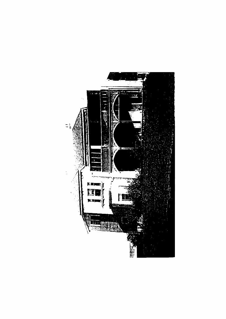


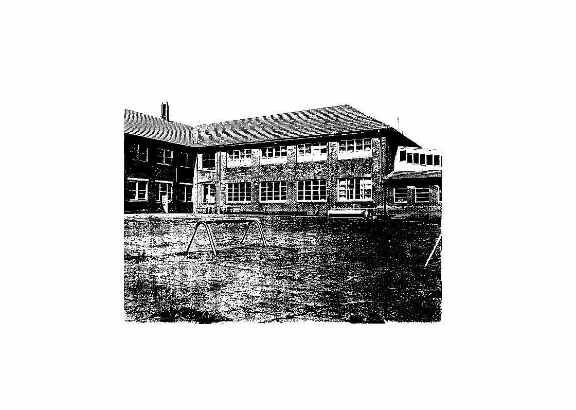
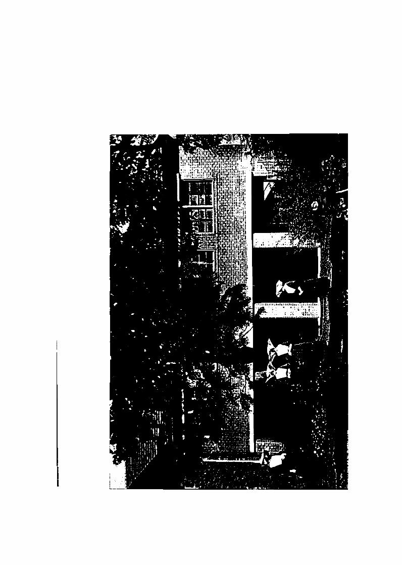

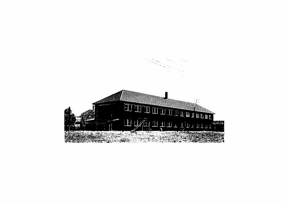

Appendix B The National Trust listing for the.Cook Island Pine
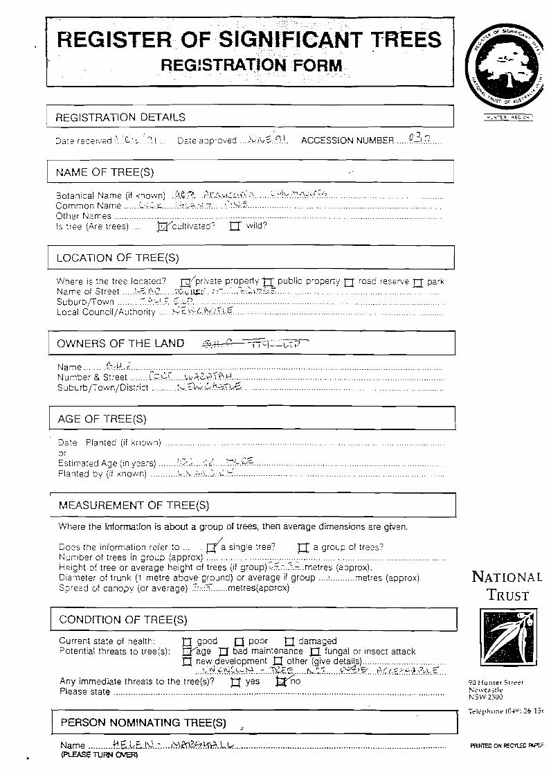
REGISTER OF SIGNIFICANT TREES REGISTRATION FORM
I -
REGISTRA1-ION DETAILS
Dais received ? . ~ ! . : . ! ? ! . . Date approved . ! k i b . ~ ' ~ . l . . ACCESSION NUMBER ..... !?3.!? ...
NAME OF TREE(S)
................................................ ...... Botanical Name (if known) ..<lG? ILL:?:(.:! :~.?!1-r:?.?:?.G!\? ( . .
..... ................................................................................ ...... ...... Common Name i : , , . ~ I:?-...a,.%.? :.?!'..z; Other Names .................................................................................................................................... Is trse (Are trees) ... ~ c u l t i v a t e d ? wild?
LOCATION OF TREE(S)
Where is the tree located? @pr!ate property71 public property n rosd reserve i-J park . rn
. . . . . . . . . . . . . . . . . . . . . . . . . . . . . . . . . . . . . . . . . . . . . . . . . . . . . . . . . . . . . . . . ..... . . . . . . . .... Name of Street '<!?\.:?2 ~ ~ p g : . . c.:r ,\lr.?.'j:Z - Suburbflown ......... ' . . . : - l . : . r : ! . : ! ~ . ~ X ? ...................................................................................................... $6
................................................................................... ..... Local Council/Authority k+.c.!<G.%i.?.L.6
OWNERSOFTHELAND S?..I?. .~. . . . . . . - . , , L I - - ~ : ~
'> . ?
.......... .................................................................................................................. ......... Name :2:!4.r .. ....................................................................................... ........ ..... Number & Street r.C .LC ~b..i\?_.-l?.".@ , k . - 4
....... .......... u w 77.\!& ................................................................................ Suburb/Town/District IU.?J.:
AGE OF -TREE(S)
Dale Planted (if known) . . . . . . . . . . . . . . . . . . . . . . . . . . . . . . . . . . . . . . . . . . . . . . . . . . . . . . . . . . . . . . . . . . . . . . . . . . . . . . . . . . . . . . . . . . . . . . . . . . . . . . . . . .
0 r 4 .-. - - J y,<;.z.z
.... ............................................................................................. Estirriaisd Age (in ysers) ....... :!.-:.< :.i - < . ' ........... r,. .......... -,.,.!-. . .T.. .................................................................................... Planted by (if known) ' -*\
MEASUREMENT OF TREE(S)
Where the information is abut a group of trees, then average dimensions are given.
Do?s the information refer to . . d a single tree? a a group of trees? Number of trees in group (approx) .................................................................................................. Height of tree or average height of trees (if group) ;.?.:.?:.<..metres (approx). Diameter of trunk (1 metre above ground) or average if group .... !..........metres (approx) NATIONAL
...... Spread of canopy (or average) .'! ::.i metres(approx) TRUST CONDITION OF TREE(S)
Current state of health: n good a poor damaged Pntontigl thrnqtr tn t rnn/r \ W a a e 77 bad maintenance l7 funaal or insect attack
Any immediate threats to the tree(s)? # yes w n o 90 H u n t e r Street Please state ........................................................................................................................................ Newcast le
RSW 2.100
PERSON NOMINAl'ING lREE(S) .. Telephone (OJU1 26 I j t
- - Name .......... )?.t;..Lr,.lL\..: .... ~L!.&%?.rn.L.k ........................................................................................ F R I F ~ D ON RECYLED -
L (PLEASE OVER)

I CATEGORIES OF SIGNIFICANCE I
jl 1. outstanding aesthetic cuali:y n 2 . outstanding size . old specimen
4. important contribution to tne d landscape/townscape
5. associated with public figure and/or ethnic group
6. historical associations or d commemorative tree
7. rare to area or endangered species a 8. curious growth habit or physical feature
9. horticultural/scientiiic value a 10. part of historic garden, park
PHOTOGRAPH OF TREE(S)
I OTHER DETAILS
LOCATlON DIAGRAM I
Additional information includes: historicai information, reasons why the tree should be protected, anecdotdinformation, or cross-referencing to other sources etc. TRUST
911 H u n t e r Strr t . ! N e w c a s f l e NSW 2300
1 T e l e p h o n e (044) ZC