an assessment procedure for glacial hazards in the...
TRANSCRIPT

An assessment procedure for glacial hazards inthe Swiss Alps
Christian Huggel, Wilfried Haeberli, Andreas Kääb, Daniel Bieri,and Shaun Richardson
Abstract: Glacial hazards such as ice avalanches, glacial lake outburst floods, and debris flows have caused severedamage in populated mountain regions such as the Swiss Alps. Assessment of such hazards must consider basicglaciological, geomorphological, and hydraulic principles together with experience gained from previous events. An ap-proach is presented here to assess the maximum event magnitude and probability of occurrence of glacial hazards.Analysis of magnitude is based on empirical relationships derived from published case histories from the Swiss Alpsand other mountain regions. Probability of occurrence is difficult to estimate because of rapid changes in the nature ofglacial systems, the low frequency of events, and the high complexity of the involved processes. Here, the probabilityis specified in qualitative and systematic terms based on indicators such as dam type, geometry, and freeboard height(for glacial lakes) and tendency of avalanche repetition, precursor events, and increased water supply to the glacier bed(for ice avalanche events). The assessment procedures are applied to a recent lake outburst with subsequent debris flowand to an ice avalanche in the Swiss Alps. The results yield reasonable event maxima that were not exceeded by actualevents. The methods provide first-order assessments and may be applied in dynamic mountain environments wherepopulation and infrastructure growth require continuous evaluation of hazards.
Key words: glacial hazards, lake outburst, debris flow, ice avalanche, hazard assessment procedure, probability of occur-rence.
Résumé : Des dangers glaciaires tels que des avalanches, des inondations par déversements de lacs glaciaires ont causédes dommages importants dans les régions montagneuses peuplées telles que les Alpes suisses. L’évaluation de telsdangers doit prendre en compte les principes de base de glaciologie, de géomorphologie, et d’hydraulique de mêmeque de l’expérience obtenue par les événements antérieures. On présente ici une approche pour évaluer l’événementd’amplitude et de probabilité d’occurrence maximales d’événements de dangers glaciaires. L’analyse de l’amplitude estbasée sur des relations empiriques dérivées d’histoires de cas publiées pour les Alpes Suisses et autres régions monta-gneuses. La probabilité d’occurrence est difficile à estimer à cause des changements rapides de la nature des systèmesglaciaires, de la faible fréquence des événements, et de la forte complexité des processus impliqués. Ici, la probabilitéest spécifiée en termes qualitatifs et systématiques basés sur des indicateurs tels que le type de barrage, sa géométrie etsa hauteur de revanche (pour les lacs glaciaires), la tendance à la répétition d’avalanches, les événements précurseurs,et l’accroissement de l’alimentation en eau du lit des glaciers (pour les événements d’avalanches de glace). Les procé-dures d’évaluation sont appliquées à un récent déversement de lac avec écoulement de débris subséquent et à une ava-lanche de glace dans les Alpes suisses. Les méthodes fournissent des évaluations de premier ordre et peuvent êtreappliquées à des environnements montagneux dynamiques où l’accroissement des populations et des infrastructures re-quiert une évaluation continue des dangers.
Mots clés : dangers glaciaires, déversement de lac, écoulement de débris, avalanche de glace, procédure d’évaluation derisque, probabilité d’occurrence.
[Traduit par la Rédaction] Huggel et al. 1083
Introduction
Glacial hazards from ice avalanches and glacial lake out-bursts pose significant threats to people and infrastructure inhigh mountain regions. Assessments of such hazards are of-
ten hindered by an incomplete understanding of the pro-cesses involved, and the episodic and catastrophic nature ofrelated events limits the application of physically basedmodels. Instead, assessments are normally qualitative, orat best semiquantitative, based on simple glaciological,
Can. Geotech. J. 41: 1068–1083 (2004) doi: 10.1139/T04-053 © 2004 NRC Canada
1068
Received 25 July 2003. Accepted 3 May 2004. Published on the NRC Research Press Web site at http://cgj.nrc.ca on 23 November2004.
C. Huggel,1 W. Haeberli, and A. Kääb. Glaciology and Geomorphodynamics Group, Department of Geography, University ofZurich, 8057 Zurich, Switzerland.D. Bieri. BKGrundbau Beratung AG, Meierhöflirain 7, 6210 Sursee, Switzerland.S. Richardson. Reynolds Geo-Sciences Ltd., 2 Long Barn, Pistyll Farm, Nercwys, Mold, Flintshire, CH7 4EW, UK.
1Corresponding author (e-mail: [email protected]).

geomorphological, and hydraulic principles and from experi-ence gained from previous events (Costa 1988; Costa andSchuster 1988; Haeberli et al. 1989; Dutto and Mortara 1992;Clague and Evans 1994). Studies have been performed onindividual cases (e.g., Reynolds 1992; Margreth and Funk1999; Haeberli et al. 2001), yet a lack of reference and mate-rials can result in inconsistent assessments for similar condi-tions worldwide.
The Swiss Alps are especially affected by glacial hazardsdue to the close proximity of the population and infrastruc-ture to glaciers. To address the issue, the Swiss Governmenthas initiated programmes that have resulted in several stud-ies of glacial hazards and related processes (Röthlisberger1981, 1987; Haeberli 1983; Alean 1985a, 1985b; Haeberli etal. 1989, 1997; Margreth and Funk 1999; Kääb and Haeberli2001; Huggel et al. 2002). Substantial experience in derivingand adapting basic relations for further hazard assessmentshas thus been gained (Huggel et al. 2000). Historic experi-ence loses its local significance, however, as glacial environ-ments evolve beyond historical and perhaps Holoceneprecedents (O’Connor and Costa 1993; Haeberli and Beniston1998).
In this paper, two schemes for a first-order assessment ofhazards from ice avalanches and glacial lake outbursts areproposed based on experience gained in the Swiss Alps.These assessment procedures integrate essential empiricalrelationships and provide reliable information on areas likelyto be affected by glacial hazard processes. Emphasis isplaced on the European Alps, but with reference to globalexamples to increase the potential applicability in otherglacierized mountain regions. First, an outline of the charac-teristics of glacial hazards and the general method to per-form a corresponding hazard assessment is given. Twoassessment procedures are then presented for both glaciallake outbursts and ice avalanches, including a discussion ofthe involved processes and relationships used. Lastly, the ap-plicability of the procedures by reference to two case studiesin the Swiss Alps is demonstrated.
Glacial hazard characteristics
Definitions of hazard imply (i) the physical process in-volved, (ii) the magnitude of the event, and (or) (iii) theprobability of occurrence (Ragozin 1994; Leroi 1996). Haz-ard can be defined as the magnitude multiplied by the proba-bility of occurrence (Fell 1994). Probability of occurrence isusually derived from the frequency or recurrence period ofan event (Van Steijn 1996; Zimmermann et al. 1997). Mag-nitude and frequency are generally related by a negativenonlinear relationship (Hungr 1997; Liu and Lei 2003), withthe frequency of occurrence decreasing as the magnitude ofthe event increases.
Although true for most hydrologically driven hazards, thisrelationship implies that the physical system of the involvedhazards remains unchanged. Glacial hazards fundamentallydiffer from hydrologically driven hazards in this respect, asthe glacial system changes within time periods shorter thanthose needed to derive frequency characteristics. Hence, theapplication of a negative relationship between magnitude andfrequency is limited for glacial hazards. In relation to fre-quency, a distinction can be made between events that occur
(a) only once (e.g., full-breach failure of moraine-dammedlakes), (b) for the first time (e.g., new formation and out-burst of glacial lakes), and (c) repeatedly (e.g., ice-dammedlakes with drainage cycles, or ice fall). Frequency–magnituderelationships fail for hazards of types (a) and (b) due tomissing data and experience. Hazards of type (c) with repeatcycles may have frequency–magnitude relationships, butthese have not been established and applied. In considerationof the need for consistent assessment concepts for glacialhazards, the following approach is proposed.
Assessment of magnitudeMagnitude is viewed in terms of the probable maximum
discharge (for lake outbursts), the probable maximum vol-ume (for avalanches or debris flows), and the probable maxi-mum travel distance. The consideration of event processes isimplicit within the assessment of magnitude.
Probability of occurrenceAlthough determining the probability of occurrence is dif-
ficult for glacial hazards, for the purpose of practicality it isbetter to assign a probability, even if approximate and sub-jective, than not at all (Fell 1994). Decision-makers need aprobability to plan, design, and construct mitigation mea-sures. The method presented here allows a qualitative esti-mate of the probability of occurrence based on indicatorsdescribed separately for glacial lake outbursts and ice ava-lanches.
Glacial floods and debris flows from lakeoutbursts
Overview of the assessment schemeThe assessment scheme for hazards from glacial lake out-
bursts follows the determination of lake volume, discharge,flow volume, and travel distance (Fig. 1). Supraglacial andproglacial lakes are recognized either by ground-based ob-servation or by remote-sensing-based mapping. Subglacialand englacial water bodies cannot be directly observed, re-quiring historical experience to be taken into considerationin these cases. After the estimate of the lake volume, a dis-tinction between ice-, moraine-, and bedrock-dammed lakesis made, which is essential for the outburst characteristics.Subsequent formation of a debris flow or a flood wave re-lates to flow volume, travel distance, and potential damage.Lastly, possible secondary effects and further assessment stra-tegies (follow-up studies, monitoring) are considered. Theestimates of various parameters are based on empirical equa-tions and values referenced in the text or in Table 1.
Determination of lake volumeTechniques have been developed to detect and map glacial
lakes using satellite images (Huggel et al. 2002). Topographicmaps for derivation of lake area often do not represent thecurrent situation and, hence, are generally less appropriate.The volume, V (in m3), of a glacial lake can then be ex-pressed as a function of the area A (in m2) by using the em-pirical relationship from Huggel et al. (2002):
[1] V A r= =0.104 0.921.42 2
© 2004 NRC Canada
Huggel et al. 1069

© 2004 NRC Canada
1070 Can. Geotech. J. Vol. 41, 2004
Fig
.1.
Ass
essm
ent
proc
edur
efo
rha
zard
sre
late
dto
glac
ial
lake
outb
urst
s.

where the coefficient of correlation (r2) is related to the orig-inal regression between area and mean depth. The relation-ship is based on data from glacial lakes in North America,South America, the Himalayas, Iceland, and the EuropeanAlps. Additional data compiled here for large Himalayanglacial lakes (for lake volumes of tens to over a hundred mil-lion cubic metres of water) suggest that the application ofeq. [1] can result in an underestimation of the actual volumeby 16%–80% in such cases (Table 2).
Determination of probable maximum dischargeThe maximum discharge, Qmax, of a lake outburst strongly
depends on the type of dam and drainage. The mechanicallyand hydraulically different mechanisms of lake drainage im-ply a fundamental distinction between ice-, moraine-, andbedrock-dammed lakes. Ice-dammed lakes that empty by pro-gressive enlargement of subglacial channels have been foundto produce smaller outburst floods for the same stored watervolume than mechanical or sudden-break failures of icedams and failures of moraine-dammed lakes (Haeberli 1983;Costa and Schuster 1988; Clague and Evans 1994). For afirst-order assessment of the probable maximum discharge,Qmax (in m3/s), of sudden breaks of ice dams, the applicationof Haeberli’s (1983) empirical relationship is proposed:
[2] Q V tmax = /
where V is in m3, and t is the drainage duration in seconds.For application in practice it is recommended to use t =
1000 s for maximum estimates, since values between 1000and 2000 s were empirically found for events in the SwissAlps (Haeberli 1983). Regarding subglacial drainage of ice-dammed lakes, Walder and Costa (1996) revised the rela-tionship proposed by Clague and Mathews (1973) asfollows:
[3] Q Vmax = 46( /10 ) = 0.706 0.66 2r
where Qmax is in m3/s, and V is in m3 (parameters originallygiven in a dimensionless form; for error ranges see Walderand Costa 1996).
Outbursts from moraine-dammed lakes can be triggeredby overtopping, piping and seepage, failure of the down-stream slope, or a combination thereof (Evans 1986; Costa1988; Costa and Schuster 1988; Clague and Evans 2000).The mechanics of breach formation are still not well under-stood, and quantitative data on observed outburst floods arescarce (Walder and O’Connor 1997). The complexity of theinvolved processes and the difficulties of determining the pa-rameters in a physically sound way justify a simple methodfor a rapid assessment of probable maximum discharge (un-derstood as a water–sediment mixture). According to Huggelet al. (2002),
[4] Q V tmax = 2 /
where a triangular hydrograph is assumed, and t = 1000 s asfor eq. [2]. The relationship approximately lies in the range
© 2004 NRC Canada
Huggel et al. 1071
Process magnitude Empirically based value Confidence level
Max. starting volume, ice avalanche (ramp type) 5×10⁶ m3 MediumMax. starting volume, ice avalanche (cliff type) 4×10⁵ m3 MediumMax. outburst volume, subglacial water reservoir 3×10⁶ m3 LowMax. discharge, subglacial water reservoir 2×10² m3/s LowMax. travel distance, ice avalanche (min. average slope) 17° (0.31) HighMax. travel distance, lake outburst flood (debris flow) 11° (0.20) HighMax. travel distance, lake outburst flood (flood wave) 2–3° MediumMax. sediment yield along channel (debris flow, in large
moraine bastions, per channel length unit)750 m3/m Medium
Critical channel slope for erosion (debris flow) 8° High
Note: Each value is related to a qualitative degree of confidence for assessing involved uncertainties. The confi-dence level indicated is based on the number of events from which the empirical values were derived.
Table 1. Empirically based maximum values of different hazard processes for the European Alps (forreferences see text).
Volume (m3 × 106)
LakeMeasured area(m2 × 106) Calculated Measured Error (%)a Reference
Raphstreng Tsho, Bhutan (1995) 1.380 54.408 66.83 23 Geological Survey of India 1995Tsho Rolpa, Nepal (1994) 1.390 54.969 76.60 39 Mool et al. 2001Thulagi, Nepal (1995) 0.760 23.323 31.80 36 Mool 1995Imja, Nepal (1993) 0.600 16.673 28.00 68 Yamada 1993Gelhaipuco, Nepal (1964) 0.548 14.659 25.45 74 Mool et al. 2001Tam Pokhari, Nepal (1992) 0.470 11.787 21.25 80 Mool et al. 2001Lower Barun, Nepal (1995) 0.780 24.200 28.00 16 Mool et al. 2001
aCalculated as the difference between measured and calculated values divided by the calculated value. Measured volumes are typically based onbathymetric surveys.
Table 2. Comparison of measured and calculated lake volume for Himalayan glacial lakes. Calculation is based on eq. [1].
of the upper-bound 99% confidence interval of the regres-sion from the dataset on moraine-dammed lake outbursts byHuggel et al. (2002).
Bedrock-dammed lakes may not fail but can trigger floodsor debris flows. Mass movements such as snow or ice ava-lanches, landslides, debris flows, or rock falls reaching thelake can produce impact waves and overtopping of the dam,eventually resulting in a flood or debris flow. Glacial lakesare particularly susceptible to impact waves because of theirsteep shores and narrow lake geometries (Fritz 2002). Theprocesses responsible for producing impact waves, run-up onthe dam, and overtopping are complex and not completelyunderstood (Vischer and Hager 1998). The formation anddimension of impact waves depend on depth and volume ofthe lake; volume, flow height, and velocity of the incomingmass movement; and the corresponding sliding surfaceslope. Walder et al. (2003) emphasized the significance ofFroude number of the mass flow entering the lake and re-lated rate of inflowing volume. The run-up height on thedam further depends on dam distance from the wave impact,impact angle with respect to reservoir axes, wave length andheight, freeboard height, and slope of the dam. An ice coverof up to 0.5 m on the lake exerts only marginal influence onthe wave and run-up height (Müller 1995), an interestingfinding for assessment of glacial lakes in winter and spring.The ratio, H, of the volume of incoming mass to the lakevolume is important for the estimation of the overtoppingvolume. Based on an analysis of case histories of landslideand avalanche impacts on lakes (Huber 1980; Müller 1995;Walder et al. 2003), the following ranges of H are defined:for H = 1:1 to 1:10, the lake may be emptied completely dueto displacement of water; and for H = 1:10 to 1:100, waterdisplacement or propagation (impact waves) may be involved,and a high probability of overtopping exists unless the free-board is high relative to the wave size. Furthermore, theovertopping or outburst volume depends on the dam stabilityand potential failure.
Drainage of subglacial water bodies is treated separatelybecause the assessment of such hazards poses special chal-lenges. To date, no reliable method is available for detectingpreviously unknown reservoirs or predicting the timing ofoutbursts (Haeberli et al. 1989; Tweed and Russell 1999),though theoretical models on drainage initiation have beenpresented (e.g., Nye 1976; Fowler 1999; Anderson et al.2003). Glaciers with sudden bursts of subglacial reservoirsdo not seem to exhibit any common morphological or physi-cal properties (Haeberli 1983). A trend towards repetitiveevents at the same glaciers has been observed, and floodscan be associated with the termination of glacier surges(Björnsson 1998; Haeberli et al. 2002). Predictions of proba-ble maximum outburst volume and peak discharge are basedon reconstruction from past events in the Alps but are fraughtwith uncertainty; accordingly, corresponding extreme valuesare given in Table 1 (Haeberli 1983).
Determination of probable maximum volumeOutbursts from ice- or moraine-dammed lakes in moun-
tainous environments commonly evolve into debris flows.Physically and numerically complex flow-behavior and rout-ing analysis are out of the scope of a rapid hazard assess-
ment. The volumes and peak discharges of flows in glacierizedterrain increase and decrease in correspondence with chan-nel sections of erosion and deposition (O’Connor et al. 2001).Observations and theoretical considerations show that depo-sition generally starts from channel slopes of 8°, but occa-sionally occurs up to 14°, depending on discharge andchannel geometry (Hungr et al. 1984; Jackson et al. 1989;Rickenmann and Zimmermann 1993; O’Connor et al. 2001).Erosion was found to be important where channel gradientsexceeded 8° (O’Connor et al. 2001).
The probable maximum volume of a debris flow is esti-mated by the possibly entrained sediment volume along thechannel length. In sections of extensive erosion such as inmorainic deposits, the maximum eroded sediment volumeper unit channel length has been found as several hundredcubic metres (Hungr et al. 1984; Haeberli et al. 1989;Rickenmann and Zimmermann 1993). More recently, valuesof up to 750 m3/m have been observed in large alpinemoraine-dam breaches (Huggel et al. 2002). Studies fromNorth America suggest similar values of maximum crosssections in moraine cuts (O’Connor et al. 2001). Large mo-raine dams in the Himalayas and Andes, however, can showbreach cross sections >2000 m2 (e.g., Mool et al. 2001).Hungr et al. (1984) presented a categorization of channelsinto (i) bedrock, (ii) thin debris, and (iii) deep talus or mo-raine, and corresponding sediment yield rates. Channels indeep but not unstable talus have been found to show sedimentyield rates of 10–30 m3/m. Multiplication with correspond-ing erosional channel length yields a rough assessment ofthe maximum event magnitude. Application of an upper-boundestimate is reasonable, since errors and uncertainties due tolocal and regional differences in geology, topography, andhydrology of torrent catchments can be incorporated. Addi-tional flow volume estimates can be derived from the con-sideration of the maximum sediment concentration in debrisflows, which can reach up to about 50%–80% by volume insteep flow channels (Iverson 1997). Values of 50%–60%may be appropriate for average flow concentrations. An ap-proximation of the flow volume is calculated by taking intoaccount the volume of water stored in a lake (assuming afull lake draining scenario).
Determination of probable maximum travel distanceThe probable maximum travel distance of a debris flow
from a lake outburst is estimated using a relationship be-tween peak discharge and travel distance. The travel distanceis expressed as the average slope, describing the angle of thehorizontal with a line from the starting point to the farther-most point of the deposition. In the Swiss Alps, a minimumaverage slope of 11° has been observed for debris flowsfrom lake outbursts (Haeberli 1983; Huggel et al. 2002).Coarse periglacial debris flows in Switzerland not related tolake outbursts also show a minimum average slope of 11°(Rickenmann and Zimmermann 1993). Determination of min-imum average slope α is done by using the data from Huggelet al. (2002), where α can be estimated in the bivariate plotof Qmax versus α (Fig. 3 in Huggel et al. 2002). The averageslope thus derived can be used to delineate a debris-flowpath to the farthermost point that might be affected(Rickenmann 1999). Lateral spreading behavior, for instance
© 2004 NRC Canada
1072 Can. Geotech. J. Vol. 41, 2004

on a debris fan, can thus not be assessed, and other modelsshould be used (e.g., Iverson et al. 1998; Laigle and Marchi2000; Huggel et al. 2003a).
Flood waves from lake outbursts (weight of sediment <weight of water) are assumed to form when little or no erod-ible material is present in the flow path and when the chan-nel slope is less than the observed starting value of erosion(i.e., about 8°). Irrespective of the absolute amount of avail-able loose sediment, however, flood waves can also be thedominant form if the relative amount of erodible sediment issmall compared with the flood volume. This is particularlyobserved in floods involving millions of cubic metres of wa-ter in the Himalayas (Cenderelli and Wohl 2003) or in theAndes. Determination of the travel distance is less clear forcommonly attenuating flood waves than for debris flows,which usually stop abruptly. Here, the maximum distance ofpotential damage is used, which has been empirically foundto correspond to an average slope between 2° and 3° in theSwiss Alps (Haeberli 1983). In the Karakorum or in Bhutan,however, distances in excess of 200 km have been recorded(Hewitt 1982; Reynolds 2000).
For both debris flows and flood waves, processes alongthe flow channel may drastically change hazard magnitudeand impact. For instance, temporary dams in the flow chan-nel (e.g., by obstruction by wooden debris or flank failures)can suddenly fail and result in extreme peak discharges, pos-sibly up to an order of magnitude larger than the “normal”debris flow or flood discharge (Armstrong 2003; Huggelet al. 2003b). Similarly, debris flows from tributary valleysdamming the main valley river can cause blockages and re-sult in repeated and extended flooding (e.g., Varuna valley1987, Swiss Alps; Rickenmann and Zimmermann 1993).
Determination of probability of occurrenceFell (1994) presented a number of ways to determine the
probability of landsliding: (1) probabilistic analysis (Mostynand Li 1993); (2) use of historic data (Morgan et al. 1992;Van Steijn 1996); (3) relationship to rainfall (Fell et al. 1991);and (4) use of geomorphological and geotechnical informa-
tion (Hungr et al. 1984). Approaches 1–3 cannot be appliedfor glacial lake outbursts due to a lack of frequency and his-toric data. The approach presented here uses geomorphologicaland geotechnical data and is more subjective than the othermethods but allows a qualitative, or relative (within a studyregion), probability to be assigned.
The probability of a glacial lake outburst is a function ofthe basic susceptibility of the dam to fail and the potentialfor external trigger processes (Richardson and Reynolds 2000).Five key indicators are defined to which qualitative probabil-ities in the range of low, medium, and high can be assigned(Table 3). Each indicator is considered independently, andthe scoring is based on the experience of the practitioner.Thus, the overall probability is not the mean of the individ-ual indicators. Single indicators rated “high” (e.g., freeboardor dam geometry) may be sufficient to result in an overallhigh probability, irrespective of the rating of the other indicators.
The distinction between different dam types is fundamen-tal for related process discrimination and associated proba-bility determination. For moraine dams, freeboard and damgeometry (ratio of width to height) are crucial parameters, asthey influence hydraulic gradients within the moraine (Clagueand Evans 2000; Reynolds et al. 1998; Richardson andReynolds 2000). Dams with high hydraulic gradients aremore susceptible to collapses involving piping and slopefailure. Impact waves from rock or ice falls, or debris flows,and extreme meteorological events, such as intense snow orice melt due to high temperatures, or high precipitation, havebeen observed to be most effective trigger events for damfailure and lake outburst (Ames 1998; Richardson andReynolds 2000; Clague and Evans 2000; Huggel et al. 2002).Determination of some of the indicators might require furtherstatistical (e.g., meteorological), geomorphological (e.g., surfaceexpression of buried ice), geophysical (e.g., internal compo-sition), glaciological (e.g., glacier structures), or geotechnical(e.g., consolidation) analyses. The list of indicators providedhere is not necessarily complete and can be extended in thefuture. Case studies in the corresponding section demon-strate this probability-based approach.
© 2004 NRC Canada
Huggel et al. 1073
Indicator Attribute Qualitative probability
Dam type Ice HighMoraine Medium to highBedrock Low
Ratio of freeboard to dam height Low HighMedium MediumHigh Low
Ratio of dam width to height Small, 0.1–0.2 HighMedium, 0.2–0.5 MediumLarge, >0.5 Low
Impact waves by ice or rock falls reaching the lake Frequent, large volume HighSporadic, medium volume MediumUnlikely, small volume Low
Extreme meteorological events (high temperature or precipitation) Frequent HighSporadic MediumUnlikely Low
Table 3. Indicators for deriving qualitative probability of occurrence for glacial lake outbursts.
Ice avalanches
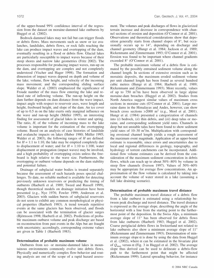
Overview of the assessment schemeThe assessment scheme is organized chronologically by
the determination of glacier type and slope, avalanche vol-ume, and travel distance. The estimates of the slope of criti-cal stability and the different parameters are referenced inFig. 2 and Table 1, respectively. The procedure to estimatethe avalanche volume is distinguished depending on the gla-cier type. After determination of the travel distance, the ge-ometry and morphology of the flow trajectory are analyzedin more detail to possibly adjust the first travel estimate andto eventually make recommendations for further actions.
Probable maximum volumeComprehensive studies of ice avalanches are scarce, and
understanding of the general process is limited. The datacompilation and analysis of Alean (1985a) remains one of
the most pertinent works. In most cases, therefore, theassessment of ice avalanches from steep glaciers relies onempirical experience and topographic information.
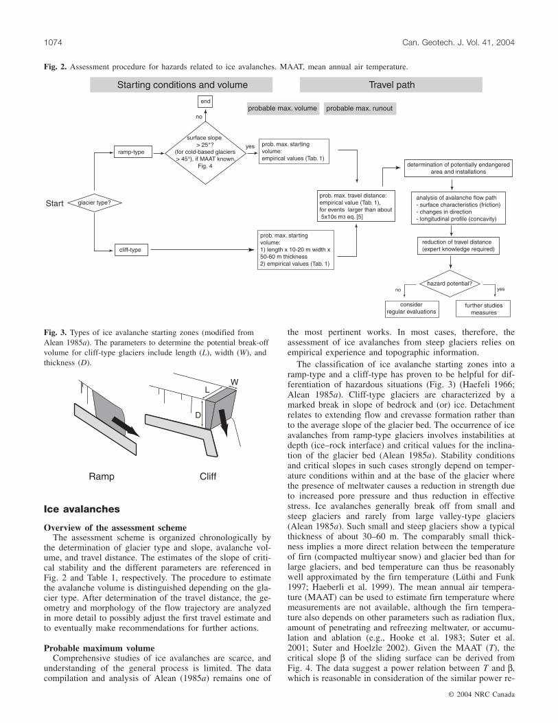
The classification of ice avalanche starting zones into aramp-type and a cliff-type has proven to be helpful for dif-ferentiation of hazardous situations (Fig. 3) (Haefeli 1966;Alean 1985a). Cliff-type glaciers are characterized by amarked break in slope of bedrock and (or) ice. Detachmentrelates to extending flow and crevasse formation rather thanto the average slope of the glacier bed. The occurrence of iceavalanches from ramp-type glaciers involves instabilities atdepth (ice–rock interface) and critical values for the inclina-tion of the glacier bed (Alean 1985a). Stability conditionsand critical slopes in such cases strongly depend on temper-ature conditions within and at the base of the glacier wherethe presence of meltwater causes a reduction in strength dueto increased pore pressure and thus reduction in effectivestress. Ice avalanches generally break off from small andsteep glaciers and rarely from large valley-type glaciers(Alean 1985a). Such small and steep glaciers show a typicalthickness of about 30–60 m. The comparably small thick-ness implies a more direct relation between the temperatureof firn (compacted multiyear snow) and glacier bed than forlarge glaciers, and bed temperature can thus be reasonablywell approximated by the firn temperature (Lüthi and Funk1997; Haeberli et al. 1999). The mean annual air tempera-ture (MAAT) can be used to estimate firn temperature wheremeasurements are not available, although the firn tempera-ture also depends on other parameters such as radiation flux,amount of penetrating and refreezing meltwater, or accumu-lation and ablation (e.g., Hooke et al. 1983; Suter et al.2001; Suter and Hoelzle 2002). Given the MAAT (T), thecritical slope β of the sliding surface can be derived fromFig. 4. The data suggest a power relation between T and β,which is reasonable in consideration of the similar power re-
© 2004 NRC Canada
1074 Can. Geotech. J. Vol. 41, 2004
Fig. 2. Assessment procedure for hazards related to ice avalanches. MAAT, mean annual air temperature.
Fig. 3. Types of ice avalanche starting zones (modified fromAlean 1985a). The parameters to determine the potential break-offvolume for cliff-type glaciers include length (L), width (W), andthickness (D).

lations between temperature and ice deformation (Smith andMorland 1981; Paterson 1994) and between temperature andfracture of ice (Vaughan 1993; Haeberli et al. 1999; Davieset al. 2001). If the MAAT is unknown, an even cruder esti-mate may be helpful: cold-based glaciers produce ice ava-lanches from a minimum slope of the glacier bed of 45° andmore, whereas temperate glaciers do so from a minimum in-clination of 25° and more (Alean 1985a). For small and rela-tively thin glaciers, the slope of the glacier surface can beused as an approximation of the slope of the glacier bed.
Determination of the ice avalanche starting volume is dif-ficult and uncertain. The volume actually breaking off de-pends on the stresses and related creep and deformation inthe ice. General replication of ice mechanical conditions insteep glaciers has been achieved for specific cases (Haeberliet al. 1999) and can provide valuable indications for failurebut is not practical within the present assessment procedure.Simple techniques such as deduction from crevasse patternsmay apply in some cases but can be misleading in others(e.g., Allalin Glacier in the southern Swiss Alps,Röthlisberger and Kasser 1978; Alean 1985a; Kääb 2000).Here, it is proposed to derive the probable maximum startingvolume of cliff-type glaciers from the cliff length, width(i.e., the distance between the potential break-off line behindthe cliff front), and thickness. The length can be determinedfrom accurate topographic maps, from remote sensing data,or in the field. The width can be estimated based on the as-sumption that cliff-type glaciers usually do not break offmore than 10–20 m behind the ice front (Alean 1985a)(Fig. 3). The thickness may be estimated in the field or fromhigh-resolution remote sensing data, or a thickness of 50–60 m may be assumed. Width and thickness describe typicalconditions in the Swiss Alps. More data from other
glacierized mountains could strongly facilitate a general ap-plication.
A similar estimate of the probable maximum starting vol-ume is often impossible for ramp-type glaciers. First esti-mates have therefore to rely on observed maximum volumesreleased (5 × 10⁶ m3, cf. Table 1). Extraordinarily largeevents outside the European Alps, however, have exceededthe volume indicated here by about one order of magnitude(e.g., the 2002 Kolka rock–ice avalanche in the RussianCaucasus, Kääb et al. 2003a).
Probable maximum travel distanceA simple one-parameter model approach is proposed for
assessing the probable maximum travel distance of ice ava-lanches based on average avalanche slopes. Ice avalanches inthe Alps do not show average slopes α below 17° (tan α =0.31) (Alean 1985a). Travel distances only increase moder-ately with increasing avalanche volume, and no volume de-pendence seems to exist for smooth sliding surfaces (firn)(Alean 1985b), probably due to predominant basal friction.For first-order safety assessments, endangered areas and in-stallations are delineated according to a 17° average slope.Many avalanche events do not cover the maximum distancethus calculated, however. The estimated travel distance maytherefore be reduced by analyzing the flow path in more de-tail. The travel distance is significantly influenced by energyloss because of friction and due to possible changes in theflow direction. A strongly concave flow path, for example,leads to a reduction of the travel distance due to a higherflow velocity and thus larger frictional dissipation of kineticenergy (Alean 1985b). Topographic effects such as channel-ing may further influence the travel distance.
Rare cases of ice avalanches with average slopes smallerthan 17° have occurred outside the European Alps involvingextraordinarily large volumes and flow transformation intodebris-laden flows (e.g., the 2002 Kolka rock–ice avalanche,Kääb et al. 2003a). The magnitude of such events is hardlypredictable. For the small number of large ice avalanchesknown worldwide, volume versus average slope is plotted inFig. 5. Regression analysis of the data from Fig. 5 gives thefollowing equation:
[5] tan 1.111 0.118log( ) 0.842α = − =V r
where α is the average slope, and V the volume of the iceavalanche in cubic metres. Equation [5] can thus be used toestimate the travel distance of large ice avalanches that ex-ceed the volumes known from the Swiss Alps.
Entrainment processes along the flow path, in particularwith regard to snow, should be considered, since they cansignificantly increase the volume, and thus the impact andtravel distance, of ice avalanches. Possible secondary effectssuch as impact waves in lakes or damming of rivers by iceavalanche deposits are evaluated in the final step of the as-sessment (Vuichard and Zimmermann 1987; Clague and Ev-ans 2000; Richardson and Reynolds 2000).
Probability of occurrenceIn selected critical cases, challenging ground-based mea-
surements (ice deformation rate) have been achieved for pre-diction of occurrence of ice avalanches (Flotron 1977; Iken1977; Röthlisberger 1977; Lüthi and Funk 1997). For a more
© 2004 NRC Canada
Huggel et al. 1075
Fig. 4. Relation between mean annual air temperature and criti-cal slope for failure on ramp-type glaciers. Data on the corre-sponding ice avalanche events are from Alean (1985a) and thisstudy. Mean annual air temperature (MAAT) is derived and ex-trapolated from meteorological stations at Bernina Hospiz,Grosser St. Bernhard, and Jungfraujoch, Switzerland. An approx-imate range of the existence of cold, polythermal, and temperateice is indicated.

general application it may be useful to note that smaller ice-fall events from steep glacier fronts are usually more fre-quent than larger ice avalanches. A magnitude–frequency re-lationship may possibly apply, but ice avalanches are rarephenomena and there is insufficient information for analysis.A crude estimate of probability of occurrence based on fourindicators is proposed.
First, a tendency of ice avalanche repetition at the sametopographic position has been observed for ramp-type gla-ciers (Röthlisberger 1981; Alean 1985a; Funk and Minor2001). Glacier advance and retreat and warming or coolingof firn may, however, alter the probability of occurrence.Second, ice avalanches from cliff-type glaciers have oftenbeen preceded by precursory smaller ice-fall events (Bieri1996; Margreth and Funk 1999). Observations of rock-fallactivity from steep glacierized zones should also be takeninto consideration, since rock slope failures have repeatedlytriggered large ice avalanches (Körner 1983; Kääb et al.2003a). Hence, ice- or rock-fall activity and the knowledgeof one or more former ice avalanches might be used as anindication of the probability of occurrence. Third, high inputrates of rain or melt water to the glacier bed through thebedrock–glacier interface and crevasses may also increasethe probability of failure (reduction of strength at the base,Röthlisberger 1987). Catchment size as an indicator of po-tential water input into the glacier may thus be taken intoconsideration. Lastly, crevasse patterns and their temporalevolution (if observations are available) can yield indicationsfor failure processes (Kääb et al. 2000). In sum, the assess-ment of the probability of occurrence for ice avalanchesmust presently remain approximative and subjective, mainlydue to the complex processes involved and the lack of un-derstanding.
Case studies
Two case studies, a lake outburst and an ice avalanche, areselected for the application and evaluation of the assessmentprocedures. The choice of cases is motivated by assessmentstudies using methods similar to those presented here which
were performed prior to the events. The hazards were there-fore realistically recognized, although appropriate mitigationmeasures were not taken because of political, economic, so-cietal, and administrative difficulties.
Täsch lake outburst
Physiographic settingThe village of Täsch is situated in the upper Matter valley
close to Zermatt (Valais, Switzerland). Above this village,Lake Weingarten (3060 m asl) lies in front of WeingartenGlacier at the toe of Alphubel (4206 m asl; Fig. 6). The lakeis no longer in direct contact with the glacier and situated ona large Little Ice Age moraine deposit with a 700 m longslope of 30° on average, with sections of up to 36° (Fig. 7).The debris fans at Täschalp and Täsch are evidence of pastdebris-flow events, yet recreational structures and houseshave been built on the Täschalp fan recently. After a steepgorge, the flow path eventually reaches the large debris fanon which the village of Täsch is located. For more details onthe physical conditions and the event in general, see Huggelet al. (2003c).
EventOn 25 June 2001, a debris-flow event damaged consider-
able parts of the village of Täsch during a period withoutany significant precipitation. Damage to buildings and otherinstallations amounted to about 12 million EUR (Hegg et al.2002), and 150 people were evacuated (Fig. 8). During fieldinspections shortly after the event, the overflow channel ofLake Weingarten was found intact. However, a shoreline0.4–0.5 m above the water level and erosion on the air sideof the moraine that stopped 1–2 m before the lake were ob-served. Based on that and a lake area of 16 000 m2, a lakeoverflow with an overtopping volume of 6000–8000 m3 ofwater was assumed (Huggel et al. 2003c). Huggel et al.(2003c) further suggested the following outburst scenario: anelevated water level due to snow or ice jam at the overflowchannel caused higher hydraulic gradients in the morainedam and possible piping processes. Together with the (rela-tively moderate) flood after the rupture of the snow–ice jam,such progressive groundwater flow probably caused erosionto start at the air side of the moraine. Though a full morainecut was not provoked by retrogressive erosion, the drainingwater was sufficient to initiate a debris flow.
From 25 000 to 40 000 m3 of debris were eroded alongthe uppermost 1 km, with a maximum cross-sectional erosionof 30–50 m2. Additional erosive force was added at the con-fluence with the torrent Rotbach (Fig. 6). At Täschalp, partof the entrained material was deposited and a bridge was de-stroyed. Lastly, at the fan apex of Täsch, the debris-flowfront surged into a constructed channel. Since the channelwas not designed for such sediment loads, it immediatelybecame obstructed and the debris flow spread out onto thefan, causing the damage mentioned above (Fig. 8). The traveldistance of the event was 5050 m, and the total volume ofdebris deposited in Täsch is estimated at 20 000 – 30 000 m3.
Assessment procedureThe assessment procedure yielded the following findings:
(i) lake volume V = 97 000 m3 (eq. [1]) based on a lake area
© 2004 NRC Canada
1076 Can. Geotech. J. Vol. 41, 2004
Fig. 5. Regression (solid line) between average slope (tan α) andvolume of large ice avalanches worldwide. The 95% confidenceintervals are indicated (broken lines). Data are from Körner(1983), Alean (1985a), Slupetzky (2002), and this study.

of 16 000 m2 (derived from a 1998 Landsat thematic mappersatellite scene); (ii) moraine dam; (iii) probable maximumdischarge Qmax = 194 m3/s (eq. [4]), i.e., �200 m3/s; (iv) sed-iment abundantly available along the steep flow path (especiallymorainic material), thus formation of debris flow; (v) proba-ble maximum volume of the debris flow of 455 000 m3,
assuming a section of 500 m with an eroded sedimentvolume per channel length of 750 m3/m (full breach in mo-raine dam) and a section of 800 m with 100 m3/m (assuminga triangular-shaped channel cross section of 10 m depth and20 m width); and (vi) probable maximum travel distance ofthe debris flow of �7500–7700 m (vertical descent 1640 m,assuming an average slope value of approximately 11°).
These numbers are based on a scenario of a full dambreach. Secondary effects have to be considered in the lowergorge (blockage in particularly confined sections) and possi-bly at the confluence with the main river in Täsch (dammingand subsequent flooding). The village of Täsch, only 4.8 kmdistance from the lake, is thus found retrospectively to bepotentially endangered.
An estimate of the probability of occurrence of a lake out-burst yields the following results (indicator and probability):
© 2004 NRC Canada
Huggel et al. 1077
Fig. 6. Situation at Lake Weingarten and Täsch. The debris flow from 25 June 2001, starting at the lake, and corresponding sections oferosion and deposition are delineated. (DEM25 c [copyright] 2004 swisstopo BA046420). Contours in metres.
Fig. 7. Lake Weingarten with the large and steep moraine (indi-cated by the arrow) and the mountain peaks of Täschhorn andDom in the background (photograph by W. Haeberli, July 1993).
Fig. 8. The village of Täsch a few days after the debris flow,which has mainly affected the left part of the settlement. Thearea of debris-flow deposits and related damage is shown by thebroken line (photograph by A. Kääb, July 2001).

(i) moraine dam, medium to high probability; (ii) low (closeto zero) ratio of freeboard to dam height, high probability;(iii) low ratio of dam width to dam height, high probability;(iv) sporadic impact waves, medium probability; (v) sporadicextreme meteorological events, medium probability. In con-sideration of the high rating of the most crucial indicators,namely freeboard and dam geometry, the overall probabilityof occurrence for an outburst of Lake Weingarten rates high.
EvaluationThe assessment procedure correctly identified the forma-
tion of the debris flow, yet it overestimated the actual volumeand travel distance. This is because estimates of magnitudeare based on a full dam breach, which was not the case forthe 2001 event. Former studies on debris-flow hazards fromLake Weingarten – Rotbach derived a similar maximum vol-ume estimate of 400 000 m3 (M. Zimmermann, personalcommunication, 1999), again for a full breach scenario. TheJune 2001 debris flow can be considered a moderate eventdespite the severe damage in Täsch. Had a complete outburstof the lake occurred, with erosion of a large breach, thedamage would certainly have been worse. Also on accountof the partial drainage, the secondary effects downstreamwere less than might have been expected. Estimation of theprobable maximum travel distance, in principle, predicts arunout beyond the confluence with the main receivingstream at Täsch. Had this occurred, there would have beenthe potential for secondary damming, upstream flooding,and a sudden dam breach with very high peak discharge.Critically, the 2001 debris flow did not exceed the maximum
estimates of volume and travel distance, a precondition forthe validity of the approach.
The estimate of the probability of occurrence is an indica-tion of the hazard found at Lake Weingarten. In fact, a highprobability of occurrence together with the high potentialmagnitude results in a serious hazard for the downstream lo-cations. Consequently, mitigation measures at the lake and atsome downstream sections were started after the 2001 disas-ter (Huggel et al. 2003c).
Gutz Glacier ice avalanche
Physiographic settingGutz Glacier is situated on the northwest face of Wetterhorn
(3701 m asl) close to Grindelwald (Bernese Alps, Switzer-land; Fig. 9). This small cirque glacier terminates at thebrink of a 1000 m drop over a 60° steep rock wall with anearly vertical ice cliff of about 60 m height. Minor ice ava-lanche events from the “Wätterlaui” zone are frequent (sev-eral times per day in phases of activity; Bieri 1996) (Fig. 10)and part of the normal ablation mechanism of Gutz Glacier.The second ice avalanche zone (“Gutzlaui”) does not show aclear ice cliff, and ice avalanche activity is much lower. Inthe past 100 years, several major ice avalanche events in theWätterlaui have destroyed alpine huts and forested areas(Bieri 1996; Margreth and Funk 1999).
EventOn 5 September 1996, two major ice avalanches occurred
at the Wätterlaui of Gutz Glacier. The first one at 3 p.m. had
© 2004 NRC Canada
1078 Can. Geotech. J. Vol. 41, 2004
Fig. 9. Situation at Gutz Glacier. Ice avalanche runout areas (for Wätterlaui and Gutzlaui) are in dark grey as mapped before the 1996event (1) and in light gray for the 5 September 1996 event (2). The road from Grindelwald to Grosse Scheidegg is shown as a brokenline. Houses or alpine huts near or in the hazard zone are mapped (not in scale). (DEM25 c [copyright] 2004 swisstopo BA046420).Contours in metres.

an estimated volume of 80 000 – 100 000 m3 (Margreth andFunk 1999) and reached the road between Grindelwald andGrosse Scheidegg. Deposits of smaller ice avalanches fromthe previous days (Fig. 10) possibly reduced the friction andincreased the travel distance. The second ice avalanche at9 p.m. was of larger volume (120 000 – 130 000 m3) andcovered the road at two locations (points 1605 and 1530 masl) with a maximum ice deposit thickness of 4 m. Dust ava-lanche deposits covered approximately 35 000 m2 (Margrethand Funk 1999). Three persons were injured due to the im-pact of the avalanche air pressure. Photogrammetric studiesshowed that 220 000 m3 of ice was lost from the front ofGutz Glacier between 26 July and 11 September 1996(VAW 1997).
Assessment procedureGutz Glacier is a typical cliff-type glacier. The assessment
procedure yielded the following findings: (i) probable maxi-mum volume V = 216 000 m3, estimated based on a thick-ness of 60 m, a length of 180 m, and a width of 20 m;(ii) probable maximum travel distance of 5.9 km, accordingto an average slope of 17°; endangered areas must be corre-spondingly delineated for several locations along the roadbetween Grindelwald and Grosse Scheidegg, and a few in-habited houses were also considered to be potentially endan-gered.
The nearly 90° change in the direction of the avalanchepath and the strongly concave longitudinal profile indicatedthat the travel distance could likely be less. Before the event,however, Bieri (1996) applied the reduction criteria of Alean(1985a) for the travel length and calculated a distance of4.2 km (24°).
Two out of the four indicators proposed can be used for arough estimate of the probability of occurrence. Several his-toric events from Gutz Glacier and smaller ice falls prior tothe main event indicate a rather high probability of occur-
rence. Information on meltwater influence or crevassepattern evolution was not available.
EvaluationThe volume was correctly estimated in comparison with
the 1996 event. Furthermore, the 1996 event remained withinthe maximum limits delineated by the assessment. In winter,reduced friction on snow cover could increase the observedtravel distance. After the 1996 ice avalanche, a detailed haz-ard mapping study was carried out by applying an adapteddynamic snow avalanche model (Swiss Federal Institute forSnow and Avalanche Research 1997; Margreth and Funk1999). The travel distance was calculated as 200–300 mshorter in comparison with that calculated by Bieri (1996).A difficulty thereby encountered is the model’s dependenceof travel distance on the starting volume, a parameter that isdifficult to assess in advance. Margreth and Funk (1999)also considered hazards from the powder part of the ice ava-lanche. In sum, the assessment performed could successfullyretrodict the approximate effects of the ice avalanche. Deter-mination of the starting volume (though correctly estimatedin this case) and the probability of occurrence remains oneof the major difficulties.
Discussion and perspectives
The assessment procedures presented organize and inte-grate empirical relationships and observations derived fromanalyses of past events to provide reasonable approximationsof events of probable maximum magnitude from glacial lakeoutbursts and ice avalanches. The relationships yield proba-ble event maxima and are thus designed to incorporate thelarge uncertainties inherent to the complex and strongly vari-able processes involved. Authorities concerned with planningand mitigation issues often need upper-bound estimates. Ex-perts using the relationships proposed can estimate the un-certainties by indicated error ranges or from bivariate plots.
© 2004 NRC Canada
Huggel et al. 1079
Fig. 10. Ice avalanche from Gutz Glacier on 5 September 1996 (3 p.m.). The cliff of Gutz Glacier where ice broke off and the evolu-tion of the avalanche over time are easily discerned. Deposits from previous smaller avalanche events are visible at the bottom of thephotographs (photographs by E. Kalt).

A first attempt was presented to derive a probability of oc-currence to provide a consistent concept for assessment ofglacial hazards in conjunction with estimates of magnitude.A few approaches for estimating probabilities of occurrencefor mass-movement hazards have been presented recently,but few rigorous methods are available for debris-flow haz-ards (Rickenmann 1999). Swiss Government agencies, forinstance, issued guidelines for the assessment of mass move-ment hazards following concepts developed for flood haz-ards (Lateltin 1997). Because of the specific nature ofhazardous glacial processes, however, most of the conceptsdeveloped for other natural hazard types are not applicablefor glacial hazards, and an approach based on qualitative in-dicators was therefore proposed. The approach is designedto fit into concepts for the delineation of hazard zones suchas applied in Swiss practice (Lateltin 1997).
Two case studies have shown the beneficial aspects of theassessment procedures: rapid and reasonable hazard assess-ment based on little and easily obtainable information. Openquestions and limitations of the approach might be related tothe applicability outside the European Alps, in particular forvery large events. Whereas the errors encountered for esti-mates of Himalayan lake volumes do not exert a primary ef-fect on the related hazard, the approach to estimate the traveldistance of lake outbursts needs more detailed investigationsfor conditions significantly different from those in the Euro-pean Alps. Debris flows in the Swiss Alps are generallycharacterized by a high content of sediment and large grainsize. In the Himalayas or the Andes, for instance, lake out-bursts often involve a smaller relative amount of sedimentand (or) much higher absolute amounts of water. The aver-age slope of the flow path has then been observed to fall be-low values indicated here. Flow transformation from debrisflows to hyperconcentrated flows has also been recognizedto increase the travel distance (Pierson and Scott 1985). Therelation used to estimate the average slope of the flow path(cf. Fig. 3 in Huggel et al. 2002) is rather insensitive to largedifferences in discharge (for Qmax ≥ 10 m3/s, approximately),and, consequently, the travel distance of major events doesnot need to be substantially greater than that for smallerevents (cf. case study Täsch). Based on the available infor-mation, this relation has been valid for the European Alps sofar, but more data would contribute much to increase the ac-curacy. For critical cases, more detailed results may be achievedby physically based models. Spring and Hutter (1981), Clarke(1982), and Tweed and Russell (1999) have presented ap-proaches of catastrophic drainage of ice-dammed lakes, andFread (1982, 1991), Faeh (1996), and Walder and O’Connor(1997) provided models for failure of natural (earthen) dams.Flow and runout characteristics of debris flows can be de-rived from numerical models including two-dimensional ap-proaches (e.g., Iverson 1997; Bozhinskiy and Nazarov 2000;Gamma 2000; Laigle and Marchi 2000).
Applicability of estimates of starting volume for ice ava-lanches outside the European Alps depends on related gla-cier dimensions. Corresponding evaluation is hampered,however, by extremely scarce information on ice avalanchesin most regions outside Europe. Process interactions andflow transformation often observed for major ice avalancheevents can considerably enlarge the travel distance. Equation
[5] provides an estimate of travel distance that is valid forsuch high-magnitude events.
Recently, empirical relationships such as presented herehave been integrated into geographic information systems(GIS) and remote-sensing-based models to assess glacialhazards over large areas. Satellite imagery and terrain mod-eling were used to detect glacial lakes (Huggel et al. 2002;Wessels et al. 2002) and glacierized areas (Kieffer et al.2000; Paul et al. 2002), from which the hazards from glaciallake outbursts, ice avalanches, and related process interac-tions were assessed by flow-routing models for the SwissAlps (Huggel et al. 2003a, 2004; Salzmann et al. 2004).Such models based on empirical relationships presented inthis study have also been applied for areas in the Andes(Huggel et al. 2003b) and the Himalayas (Kääb et al. 2003b).Results showed the large application potential but also con-firmed that more data and research are needed for evaluationof the relationships in these areas.
Conclusions
This study presents procedures for first-order assessmentof glacial hazards by evaluating the event magnitude, fol-lowed by estimating the probability of occurrence. Assess-ment of the event magnitude is based on empirical relationships,experience, and physical understanding. It sequentially in-cludes estimates of lake volume, peak discharge, debris-flowvolume, and travel distance for glacial lake outbursts and po-tential break-off volume and travel distance for ice avalanches.The processes involved in glacial hazards are highly com-plex and often inadequately understood. Hence, an attempthas been made to encompass the related uncertainties byprobable maximum estimates of process magnitude. Proba-bility of occurrence is estimated by qualitative indicators.Although reasonable results can thus be achieved for lakeoutbursts, probability of occurrence for ice avalanches is ex-tremely difficult to derive and is fraught with uncertainties.The proposed set of indicators is open for further develop-ment, and it is hoped that it will stimulate discussions andfurther studies.
Acknowledgements
This study was made possible thanks to the Swiss Na-tional Science Foundation, as part of the NF21-59045.99project. Valuable comments by Jim O’Connor and JosephWalder on an earlier version much improved the paper. Weare grateful to the particularly careful and constructive cri-tique by two anonymous reviewers. Furthermore, weacknowledge discussions with Andreas Zweifel, MarkusZimmermann, Philippe Teysseire, Sonja Zgraggen-Oswald,and Hugo Delgado.
References
Alean, J. 1985a. Ice avalanches: some empirical information abouttheir formation and reach. Journal of Glaciology, 31(109): 324–333.
Alean, J. 1985b. Ice avalanches and a landslide on Grosser Alet-schgletscher. Zeitschrift für Gletscherkunde und Glazialgeologie,20: 9–25.
© 2004 NRC Canada
1080 Can. Geotech. J. Vol. 41, 2004

Ames, A. 1998. A documentation of glacier tongue variations andlake development in the Cordillera Blanca, Peru. Zeitschrift fürGletscherkunde und Glazialgeologie, 34: 1–36.
Anderson, S.P., Walder, J.S., Anderson, R.S., Kraal, E.R., Cunico,M., Fountain, A.G., and Trabant, D. 2003. Integrated hydrologicand hydrochemical observations of Hidden Creek Lakejökulhlaups, Kennicott Glacier, Alaska. Journal of GeophysicalResearch, 108(F1): Art. 6003.
Armstrong, A. 2003. Hydrologic and geomorphologic assessmentof debris flow events for Mount Hood highway. In Proceedingsof the EGU-AGU-EUG Joint Assembly, Nice, 6–11 April 2003.Geophysical Research Abstracts.
Bieri, D. 1996. Abschätzung von Gletschergefahren im RaumGrindelwald, Lauterbrunnen, Lötschental: eine regionale Studiemittels empirischer Faustregeln. Diploma thesis, Department ofGeography, University of Zurich, Zurich, Switzerland.
Björnsson, H. 1998. Hydrological characteristics of the drainagesystem beneath a surging glacier. Nature (London), 395: 771–774.
Bozhinskiy, A.N., and Nazarov, A.N. 2000. Two-phase model ofdebris flow. In Proceedings of the 2nd International Conferenceon Debris-Flow Hazards Mitigation: Mechanics, Prediction, andAssessment, Taipei, Taiwan, 16–18 August 2000. Edited by G.F.Wieczorek and N.D. Naeser. A.A. Balkema, Rotterdam, TheNetherlands. pp. 263–269.
Cenderelli, D.A., and Wohl, E.E. 2003. Flow hydraulics andgeomorphic effects of glacial-lake outburst floods in the MountEverest region, Nepal. Earth Surface Processes and Landforms,28: 385–407.
Clague, J.J., and Evans, S.G. 1994. Formation and failure of natu-ral dams in the Canadian Cordillera. Geological Survey of Can-ada, Bulletin 464.
Clague, J.J., and Evans, S.G. 2000. A review of catastrophic drain-age of moraine-dammed lakes in British Columbia. QuarternaryScience Reviews, 19: 1763–1783.
Clague, J.J., and Mathews, W.H. 1973. The magnitude of Jökul-hlaups. Journal of Glaciology, 12: 501–504.
Clarke, G.K.C. 1982. Glacier outburst floods from ‘Hazard Lake,’Yukon Territory, and the problem of flood magnitude prediction.Journal of Glaciology, 28(98): 3–21.
Costa, J.E. 1988. Floods from dam failures. In Flood geomorphol-ogy. Edited by V.R. Baker, R.C. Kochel, and P.C. Patton. Wiley,New York. pp. 439–463.
Costa, J.E., and Schuster, R.L. 1988. The formation and failureof natural dams. Geological Society of America Bulletin, 7:1054–1068.
Davies, M.C.R., Hamza, O., and Harris, C. 2001. The effect of risein mean annual temperature on the stability of rock slopes con-taining ice-filled discontinuities. Permafrost and Periglacial Pro-cesses, 12: 137–144.
Dutto, F., and Mortara, G. 1992. Rischi conessi con la dinamicaglaciale nelle Alpi Italiane. Geografia Fisica DinamicaQuaternaria, 15: 85–99.
Evans, S.G. 1986. The maximum discharge of outburst floodscaused by the breaching of man-made and natural dams. Cana-dian Geotechnical Journal, 23: 385–387.
Faeh, R. 1996. Erosion-based dambreak simulation. In Proceedingsof the 2nd International Conference on Hydroinformatics, Zu-rich, Switzerland, 9–13 September 1996. Edited by A. Müller.A.A. Balkema, Rotterdam, The Netherlands. pp. 681–688.
Fell, R. 1994. Landslide risk assessment and acceptable risk. Cana-dian Geotechnical Journal, 31: 261–272.
Fell, R., Chapman, T.G., and Maguire, P.K. 1991. A model for pre-diction of piezometric levels in landslides. In Slope stability en-
gineering. Edited by R.J. Chandler. Institution of Civil Engi-neers, London, UK. pp. 37–42.
Flotron, A. 1977. Movement studies on hanging glaciers with rela-tion to an ice avalanche. Journal of Glaciology, 19(81): 671–672.
Fowler, A.C. 1999. Breaking the seal at Grímsvötn. Journal of Gla-ciology, 45: 506–516.
Fread, D.L. 1982. DAMBRK: the NWS dam-break flood forecast-ing model. Hydrologic Research Laboratory, Office of Hydrol-ogy, National Weather Service, National Oceanic andAtmospheric Administration (NOAA), Silver Spring, Md.
Fread, D.L. 1991. Breach: an erosion model for earthen dam fail-ures. National Weather Service, National Oceanic and Atmo-spheric Administration (NOAA), Silver Spring, Md.
Fritz, H.M. 2002. Initial phase of landslide generated impulsewaves. Mitteilungen der VAW/ETHZ, 178, Zürich.
Funk, M., and Minor, H.E. 2001 Eislawinen in den Alpen:Erfahrungen mit Schutzmassnahmen und Früherkennungmethoden.Wasserwirtschaft, 91: 362–368.
Gamma, P. 2000. Dfwalk– Ein Murgang-Simulationsprogramm zurGefahrenzonierung. Geographisches Institut der UniversitätBern, Bern, Switzerland.
Geological Survey of India. 1995. Geology, environmental hazardsand remedial measures of the Lunana area, Gasa Dzongkhag.Report of 1995 Indo-Bhutan Expedition. Bhutan Unit, Geologi-cal Survey of India, Samtse.
Haeberli, W. 1983. Frequency and characteristics of glacier floodsin the Swiss Alps. Annals of Glaciology, 4: 85–90.
Haeberli, W., and Beniston, M. 1998. Climate change and itsimpacts on glaciers and permafrost in the Alps. Ambio, 27:258–265.
Haeberli, W., Alean, J.-C., Müller, P., and Funk, M. 1989. As-sessing the risks from glacier hazards in high mountain regions:some experiences in the Swiss Alps. Annals of Glaciology, 13:77–101.
Haeberli, W., Wegmann, M., and Vonder Mühll, D. 1997. Slopestability problems related to glacier shrinkage and permafrostdegradation in the Alps. Eclogae geologica Helvetica, 90: 407–414.
Haeberli, W., Kääb, A., Hoelzle, M., Bösch, H., Funk, M., VonderMühll, D., and Keller, F. 1999. Eisschwund und Naturka-tastrophen im Hochgebirge. Schlussbericht NFP31. vdfHochschulverlag an der ETH Zürich, Zurich, Switzerland.
Haeberli, W., Kääb, A., Vonder Mühll, D., and Teysseire, P. 2001.Prevention of outburst floods from periglacial lakes at GrubenGlacier, Valais, Swiss Alps. Journal of Glaciology, 47: 111–122.
Haeberli W., Kääb, A., Paul, F., Chiarle, M., Mortara, G., Mazza,A., Deline, P., and Richardson, S. 2002. A surge-type movementat Ghiacciaio del Belvedere and a developing slope instability inthe east face of Monte Rosa, Macugnaga, Italian Alps. Norwe-gian Journal of Geography, 56: 104–111.
Haefeli, R. 1966. Note sur la classification, le mécanisme et lecontrôle des avalanches de glaces et des crues glaciaires extra-ordinaires. International Association of Hydrological Sciences(IAHS), Publication 69, pp. 316–325.
Hegg, C., Badoux, A., Frick, A., and Schmid, F. 2002. Unwetter-schäden in der Schweiz im Jahre 2001. Wasser Energie Luft, 94:99–105.
Hewitt, K. 1982. Natural dams and outburst floods in theKarakorum Himalaya. In Hydrological aspects of alpine andhigh-mountain areas. Edited by J.W. Glen. International Associ-ation of Hydrological Sciences (IAHS), Publication 138,pp. 259–269.
© 2004 NRC Canada
Huggel et al. 1081

Hooke, R.L., Gould, J., and Brzozowski, J. 1983. Near-surfacetemperatures near and below the equilibrium line on polar andsubpolar glaciers. Zeitschirft für Gletscherkunde und Glazial-geologie, 19: 1–25.
Huber, A. 1980. Schwallwellen in Seen als Folge von Felsstürzen.Mitteilungen der VAW/ETHZ 47, Zürich, Switzerland.
Huggel, C., Haeberli, W., and Kääb, A. 2000. Compilation of his-torical data as a basis for analyses of glacier floods and ice ava-lanches in the Swiss Alps. In Proceedings of the EGS 25thGeneral Assembly, Nice, 24–29 April 2000. Geophysical Re-search Abstracts. Vol. 2.
Huggel, C., Kääb, A., Haeberli, W., Teysseire, P., and Paul, F.2002. Remote sensing based assessment of hazards from glacierlake outbursts: a case study in the Swiss Alps. CanadianGeotechnical Journal, 39: 316–330.
Huggel, C., Kääb, A., Haeberli, W., and Krummenacher, B. 2003a.Regional-scale GIS-models for assessment of hazards from gla-cier lake outbursts: evaluation and application in the Swiss Alps.Natural Hazards and Earth System Sciences, 3: 647–662.
Huggel, C., Haeberli, W., Kääb, A., Hoelzle, M., Ayros, E., andPortocarrero, C. 2003b. Assessment of glacier hazards and gla-cier runoff for different climate scenarios based on remote sens-ing data: a case study for a hydropower plant in the PeruvianAndes. In Observing Our Cryosphere from Space, Proceedingsof the EARSeL Workshop, Bern, Switzerland, 11–13 March2002. EARSeL eProceedings, No. 2, pp. 22–33.
Huggel, C., Kääb, A., and Haeberli, W. 2003c. Regional-scalemodels of debris flows triggered by lake outbursts: the 25 June2001 debris flow at Täsch (Switzerland) as a test study. In Pro-ceedings of the 3rd International Conference on Debris-FlowHazards Mitigation: Mechanics, Prediction and Assessment, 10–12 September 2003, Davos. Edited by D. Rickenmann and Ch.-L. Chen. Millpress Science Publishers, Rotterdam, The Nether-lands. pp. 1151–1162.
Huggel, C., Kääb, A., and Salzmann, N. 2004. GIS-based model-ing of glacial hazards and their interactions using Landsat-TMand IKONOS imagery. Norwegian Journal of Geography, 58. Inpress.
Hungr, O. 1997. Some methods of landslide hazard intensity map-ping. In Landslide risk assessment. Edited by D.M. Cruden andR. Fell. A.A. Balkema, Rotterdam, The Netherlands. pp. 215–226.
Hungr, O., Morgan, G.C., and Kellerhals, P. 1984. Quantitativeanalysis of debris hazards for design of remedial measures. Ca-nadian Geotechnical Journal, 21: 663–677.
Iken, A. 1977. Movement of a large ice mass before breaking off.Journal of Glaciology, 19: 595–605.
Iverson, R.M. 1997. The physics of debris flows. Reviews of Geo-physics, 35: 245–296.
Iverson, R.M., Schilling, S.P., and Vallance, J.W. 1998. Objectivedelineation of lahar-inundation hazard zones. Geological Surveyof America Bulletin, 110(8): 972–984.
Jackson, L.E., Jr., Hungr, O., Gardner, J.S., and Mackay, C. 1989.Cathedral Mountain debris flows. Bulletin of the InternationalAssociation of Engineering Geology, 40: 35–54.
Kääb. A. 2000. Photogrammetry for early recognition of highmountain hazards: new techniques and applications. Physics andChemistry of the Earth (B), 25: 765–770.
Kääb, A., and Haeberli, W. 2001. Evolution of a high mountainthermokarst lake in the Swiss Alps. Arctic, Antarctic and AlpineResearch, 33: 385–390.
Kääb, A., Haeberli, W., Huggel, C., and Paul, F. 2000. Glacier- andpermafrost-related hazards in high mountains: integrative assess-ment in the Swiss Alps based on remote sensing and geo-
information systems. In Proceedings of the 10th CongressoPeruano de Geologia, Lima, 2000. Volumen de Presentaciones.CD-ROM.
Kääb, A., Wessels, R., Haeberli, W., Huggel, C., Kargel, J.S., andKhalsa, S.J.S. 2003a. Rapid ASTER imaging facilitates timelyassessment of glacier hazards and disasters. EOS Transactions,AGU, 84: 117, 121.
Kääb, A., Paul, F., and Huggel, C. 2003b. Glacier monitoring fromASTER imagery: accuracy and applications. In Observing OurCryosphere from Space, Proceedings of the EARSeL Workshop,Bern, Switzerland, 11–13 March 2002. EARSeL eProceedings,Vol. 2. pp. 45–53.
Kieffer, H.H., Kargel, J., Barry, R., Bindschadler, R., Bishop, M.,Mackinnnon, D., et al. 2000. New eyes in the sky measure gla-ciers and ice sheets. EOS Transactions, AGU, 81: 265, 270–271.
Körner, H.J. 1983. Zur Mechanik der Bersturzströme vomHuascaran, Peru. Hochgebirgsforschung (Innsbruck), 6: 71–110.
Laigle, D., and Marchi, L. 2000. Example of mud/debris-flow haz-ard assessment, using numerical models. In Proceedings of the2nd International Conference on Debris-Flow Hazards Mitiga-tion: Mechanics, Prediction, and Assessment, Taipei, Taiwan,16–18 August 2000. Edited by G.F. Wieczorek and N.D. Naeser.A.A. Balkema, Rotterdam, The Netherlands. pp. 417–424.
Lateltin, O. 1997. Berücksichtigung der Massenbewegungsge-fahren bei raumwirksamen Tätigkeiten. Bundesamt fürRaumplanung, Bundesamt für Wasserwirtschaft, Bundesamt fürUmwelt, Wald und Landschaft, Bern, Switzerland.
Leroi, E. 1996. Landslide hazard — risk maps at different scales:objectives, tools and developments. In Proceedings of the 7th In-ternational Symposium on Landslides, Trondheim, 17–21 June1996. Edited by K. Senneset. A.A. Balkema, Rotterdam, TheNetherlands. pp. 35–51.
Liu, X., and Lei, J. 2003. A method for assessing regional debrisflow risk: an application in Zhaotong of Yunnan Province (SWChina). Geomorphology, 52: 181–191.
Lüthi, M., and Funk, M. 1997. Wie stabil ist der Hängegletscheram Eiger? Spektrum der Wissenschaft, May 1997, pp. 21–24.
Margreth, S., and Funk, M. 1999. Hazard mapping for ice andcombined snow/ice avalanches — two case studies from theSwiss and Italian Alps. Cold Regions Science and Technology,30: 159–173.
Mool, P.K. 1995. Glacier lake outburst floods in Nepal. Journal ofthe Nepal Geological Society, 7: 273–280.
Mool, P.K., Bajracharya, S.R., and Joshi, S.P. 2001. Inventory ofglaciers, glacial lakes and glacial lake outburst floods, Nepal.International Centre for Integrated Mountain Development,Kathmandu, Nepal.
Morgan, G.C., Rawlings, G.E., and Sobkowicz, J.C. 1992. Evalu-ating total risks to communities from large debris flows. InGeotechnique and Natural Hazards: Proceedings of the 1992Geohazards Symposium, Vancouver, B.C., 6–9 May 1992.BiTech Publishers, Richmond, B.C. pp. 225–236.
Mostyn, G.R., and Li, V. 1993. Probabilistic slope analysis — stateof play. In Proceedings of a Conference on ProbabilisticMethods in Geotechnical Engineering, Canberra, Australia.Edited by K.S. Li and S.C.R. Lo. A.A. Balkema, Rotterdam,The Netherlands. pp. 89–110.
Müller, D. 1995. Auflaufen und Überschwappen von Impulswellenan Talsperren. VAW/ETHZ, 137, Zürich, Switzerland.
Nye, J.F. 1976. Water flow in glaciers: jökulhlaups, tunnels andveins. Journal of Glaciology, 17: 181–207.
O’Connor, J.E., and Costa, J.E. 1993. Geologic and hydrologichazards in glacierized basins in North America resulting from
© 2004 NRC Canada
1082 Can. Geotech. J. Vol. 41, 2004

19th and 20th century global warming. Natural Hazards, 8: 121–140.
O’Connor, J.E., Hardison, J.H., III, and Costa, J.E. 2001. Debrisflows from failures of Neoglacial-age moraine dams in theThree Sisters and Mount Jefferson wilderness areas, Oregon. USGeological Survey, Professional Paper 1606.
Paterson, W.S.B. 1994. The physics of glaciers. 3rd ed. PergamonPress, Oxford, UK.
Paul, F., Kääb, A., Maisch, M., Kellenberger, T., and Haeberli, W.2002. The new remote sensing derived Swiss glacier inventory:I. Methods. Annals of Glaciology, 34: 355–361.
Pierson, T.C., and Scott, K.M. 1985. Downstream dilution of alahar: transition from debris flow to hyperconcentrated stream-flow. Water Resources Research, 21: 1511–1524.
Ragozin, A.L. 1994. Basic principles of natural hazard risk assess-ment and management. In Proceedings of the 7th InternationalCongress of the International Association of Engineering Geol-ogy, Lisbon, 5–9 September 1994. A.A. Balkema, Rotterdam,The Netherlands. Vol. 3, pp. 1277–1286.
Reynolds, J.M. 1992. The identification and mitigation of glacier-related hazards: examples from the Cordillera Blanca, Peru. InGeohazards natural and man-made. Edited by G.J.H. McCall,D.J.C. Laming, and S.C. Scott. Chapman and Hall, London, UK.pp. 143–157.
Reynolds, J.M. 2000. On the formation of supraglacial lakes ondebris-covered glaciers. In Debris-covered glaciers. Edited byM. Nakawo, C.F. Raymond, and A. Fountain. InternationalAssociation of Hydrological Sciences (IAHS), Publication 264,pp. 153–161.
Reynolds, J.M., Dolecki, A., and Portocarrero, C. 1998. Construc-tion of a drainage tunnel as part of glacial lake hazard mitigationat Hualcán, Cordillera Blanca, Peru. In Geohazards in engineer-ing geology. Edited by J.G. Maund and M. Eddleston. Geologi-cal Society Special Publication (London), No. 15, pp. 41–48.
Richardson, S.D., and Reynolds, J.M. 2000. An overview of glacialhazards in the Himalayas. Quaternary International, 65/66: 31–47.
Rickenmann, D. 1999. Empirical relationships for debris flows.Natural Hazards, 19: 47–77.
Rickenmann, D., and Zimmermann, M. 1993. The 1987 debrisflows in Switzerland: documentation and analysis. Geomorphol-ogy, 8: 175–189.
Röthlisberger, H. 1977. Ice avalanches. Journal of Glaciology, 19:669–671.
Röthlisberger, H. 1981. Eislawinen und Ausbrüche von Gletscherseen.Jahrbuch der Schweizerischen Naturforschen Gesellschaft,wissenschaftlicher Teil 1978. pp. 170–212.
Röthlisberger, H. 1987. Sliding phenomena in a steep section ofBalmhorngletscher, Switzerland. Journal of Geophysical Research,92(B9): 8999–9014.
Röthlisberger, H., and Kasser, P. 1978. The readvance of theAllalingletscher after the ice avalanche of 1965. In Proceedingsof the International Workshop on Mechanisms of Glacier Varia-tions. Mater. Glyatsiologicheskikh Issled. Khronika Osuzh-deniya, 33, Soviet Geophysical Committee of the Academy ofSciences of the U.S.S.R., Moscow. pp. 152–164.
Salzmann, N., Kääb, A., Huggel, C., Allgöwer, B., and Haeberli,W. 2004. Assessment of the hazard potential of ice avalanchesusing remote sensing and GIS-modelling. Norwegian Journal ofGeography, 58. In press.
Slupetzky, H. 2002. Der Eissturz von Nördlichen Bockkarkees(Hohe Tauern, Glocknergruppe, Käfertal) im Jahr 1945. GrazerSchriften der Geographie und Raumforschung, 38: 211–226.
Smith, G.D., and Morland, L.W. 1981. Viscous relations for thesteady creep of polycrystalline ice. Cold Regions Science andTechnology, 5: 141–150.
Spring, U., and Hutter, K. 1981. Numerical studies of jökulhlaups.Cold Regions Science and Technology, 4: 227–244.
Suter, S., and Hoelzle, M. 2002. Borehole temperature of cold firnareas in the Alps: spatial occurrence and statistical models. An-nals of Glaciology, 35: 9–18.
Suter, S., Laternser, M., Haeberli, W., Frauenfelder, R., andHoelzle, M. 2001. Cold firn and ice of high-altitude glaciers inthe Alps: measurements and distribution modelling. Journal ofGlaciology, 47: 85–96.
Swiss Federal Institute for Snow and Avalanche Research. 1997.Gefahrenkarte Gutzgletscher. Swiss Federal Institute for Snowand Avalanche Research (SLF), Davos, Switzerland. InternalExpert Report.
Tweed, F.S., and Russell, A.J. 1999. Control on the formation andsudden drainage of glacier-impounded lakes: implications forjökulhlaup characteristics. Progress in Physical Geography,23(1): 79–110.
Van Steijn, H. 1996. Debris-flow magnitude–frequency relation-ships for mountainous regions of Central and Northwest Europe.Geomorphology, 15: 259–273.
Vaughan, D.G. 1993. Relating the occurrence of crevasses to sur-face strain rates. Journal of Glaciology, 39: 255–266.
VAW. 1997. Gutzgletscher. Gutachten zur Eislawinenproblematik.Laboratory of Hydraulics, Hydrology and Glaciology (VAW),ETH Zürich, Switzerland. VAW Internal Expert Report.
Vischer, D.L., and Hager, W.H. 1998. Dam hydraulics. John Wileyand Sons, Chichester, UK.
Vuichard, D., and Zimmermann, M. 1987. The 1985 catastrophicdrainage of a moraine-dammed lake Khumbu Himal, Nepal:cause and consequences. Mountain Research and Development,7: 91–110.
Walder, J.S., and Costa, J.E. 1996. Outburst floods from glacier-dammed lakes: the effect of mode of lake drainage on floodmagnitude. Earth Surface Processes and Landforms, 21: 701–723.
Walder, J.S., and O’Connor, J.E. 1997. Methods for predictingpeak discharge of floods caused by failure of natural andconstructed earthen dams. Water Resources Research, 33: 2337–2348.
Walder, J.S., Watts, P., Sorensen, O.E., and Janssen, K. 2003. Wa-ter waves generated by subaerial mass flows. Journal of Geo-physical Research, 108(B5): 2236–2255.
Wessels, R., Kargel, J.S., and Kieffer, H.H. 2002. ASTER mea-surement of supraglacial lakes in the Mount Everest region ofHimalaya. Annals of Glaciology, 34: 399–408.
Yamada, T. 1993. Glacier lakes and their outburst floods in the Ne-pal Himalaya. Water and Energy Commission Secretariat – JapanInternational Co-operation Agency (WECS/JICA), Kathmandu,Nepal.
Zimmermann, M., Mani, P., and Romang, H. 1997. Magnitude–frequency aspects of alpine debris flows. Eclogae geologicaHelvetica, 90: 415–420.
© 2004 NRC Canada
Huggel et al. 1083