an earth oddity - by rachel, jamie & tai
TRANSCRIPT

RISK OF LANDSLIDE-GENERATED TSUNAMIS FOR THE COAST OF BRITISH COLUMBIA AND ALASKA Brian D. Bornhold, International Tsunami Research Inc., Sidney, British Columbia Richard E. Thomson, Fisheries and Oceans Canada, Sidney, British Columbia Alexander B. Rabinovich, Tsunami Center, Moscow, Russia and International Tsunami Research Inc., Sidney, British Columbia Evgueni A. Kulikov, Tsunami Center, Moscow, Russia and International Tsunami Research Inc., Sidney, British Columbia Isaac V. Fine, Belorussian Academy of Sciences, Minsk, Belorus and International Tsunami Research Inc., Sidney, British Columbia ABSTRACT The Pacific coastal areas of British Columbia, Washington and Alaska are characterized by a high risk of damaging tsunamis caused by localized underwater landslides. Many of these failure-tsunami events have been documented. While some were related to earthquakes; many others were not. Several failures and tsunamis coincided with extreme low tides and ongoing construction. A three-dimensional numerical model has been developed, based on the theoretical work of Jiang and LeBlond (1994) to describe the relationships between failures and resultant tsunamis occurring in natural basins with complex seafloor morphology. The model has been applied to actual failure sites (e.g., Skagway) and to sites of potential failure (Malaspina Strait, and the Fraser Delta, B.C.). RÉSUMÉ La zone côtière au long de la Colombie-Britannique, de l’état de Washington et de l’Alaska se caractérise par de nombreux glissements de terrain sous-marins locaux qui portent risques de tsunamis. Plusieurs de ces événements (glissements de terrain/tsunamis) sont biens documentés. Quelques uns sont liés directement aux tremblements de terre mais beaucoup d’autres ne sont pas reliés aux séismes. Plusieurs coïncident avec la venue de marées très basses et de travaux de construction. Un modèle numérique à trois dimensions a été développé pour les bassins naturels possédant une morphologie complexe du fond marin. Ce modèle est basé sur les études théoriques de Jiang et LeBlond (1994) qui décrivent la relation entre les glissements de terrain sous-marins et les tsunamis qui en résultent. De plus, le modèle numérique a été utilisé pour analyser des événements réels (ex.: Skagway, Alaska) et des sites posant de grands risques de glissements de terrain (ex.: le détroit de Malaspina, C.-B. et le delta du fleuve Fraser, C.-B.). 1. INTRODUCTION Submarine landslides, slumps, rock falls and avalanches can generate significant tsunami waves in coastal areas. Although landslide-generated tsunamis are much more localized than seismically generated tsunamis, they can produce destructive coastal waves resulting in severe damage, especially where the wave energy is trapped by the confines of inlets or semi-enclosed embayments (Murty, 1977, 1979;Jiang and LeBlond, 1992).
Although studies of landslide-generated tsunamis have a long history, such events are generally considered to be relatively rare. The greatly enhanced interest in this problem over the past few years is the result of several tsunami events: (1) recent earthquake-generated tsunamis in Papua New Guinea, Indonesia, and Turkey; and (2) the well-documented dock failure in Skagway,
Alaska. The July 17, 1998, Papua New Guinea (PNG) tsunami, the most catastrophic tsunami in the 20th century (about 2300 casualties), appears to have been initiated not by the comparatively modest earthquake of Ms = 6.9-7.3, but by an underwater landslide triggered by the earthquake (Tappin et al., 1998; Heinrich et al., 2000; Imamura et al., 2001). Tsunami waves with heights up to 26 m associated with the 1992 Flores Island Earthquake (Ms = 7.5) in Indonesia were also apparently induced by local submarine landslides (Imamura and Gica, 1996).
The catastrophic event of November 3, 1994, in Skagway Harbor, Southeast Alaska (Figure 1) began with the collapse of the Pacific and Arctic Railway and Navigation Company (PARN) Dock and led to a series of large amplitude waves estimated by eyewitnesses to have heights of 5-6 m in the harbour and 9-11 m at the
2001 Odyssée de la Terre2001 An Earth Odyssey
1450
AN
EA
RTH
OD
DIT
Y - B
Y R
AC
HEL
, JA
MIE
& T
AI
The International Association of Hydrogeologistsl'Association Internationale des Hydrogéologues
The Canadian Geotechnical SocietyLa Société canadienne de Géotechnique

shoreline (Lander, 1996; Kulikov et al., 1996). The landslide and associated tsunami claimed the life of one worker and caused an estimated $21 million damage (Raichlen et al., 1996). A thorough investigation of this case eventually led to greater understanding of slide/wave interaction and to substantial improvement in the numerical modelling of landslide generated tsunamis (see Thomson et al., 2001 for a detailed description of this case and associated discussion). One of the lessons arising from the Skagway event was the necessity for a thorough examination and modelling of possible submarine sliding/slumping and slide-generated tsunamis in areas of new construction, especially those located in regions of moderate to large tidal ranges and in the vicinity of unstable sediment accumulations. Underwater slopes in fjords and inlets commonly attain a delicate equilibrium with the long-term ambient marine conditions associated with wave, current and tidal regimes, and the rate and character of sedimentation. This stability can be disrupted, leading to failure, by events or conditions that depart significantly from ambient conditions. Landslides, slumps and rock falls are often the secondary effects of earthquakes. The 1958 Lituya Bay rockslide and tsunami, as well as a similar event in 1899, were triggered by strong earthquakes (Miller, 1960; Lander, 1996). Submarine landslides that accompanied the 1964 “Good Friday” Alaskan earthquake generated wave amplitudes of several tens of meters in certain locations on the Alaska coast (Figure 1) (Kachadoorian, 1965; Lander, 1996; Palmer, 1999). The British Columbia Earthquake of 23 June, 1946 (M = 7.3) produced many hundreds of local landslides and slumps along the coast of Vancouver Island, many of which generated tsunami waves (Rogers and Hasegawa, 1978; Rogers, 1980). The only
Figure 1. Locations of major coastal and underwater landslides many of which had associated tsunamis.
death associated this event was caused when a slump-generated tsunami wave overturned a small boat (Rogers, 1980). In many cases, damaging submarine landslides are produced by local processes in the absence of seismic events. In particular, the 1854, 1874, and 1936 Lituya Bay tsunamis occurred during seismically quiet periods. The previously mentioned 1975 Kitimat Arm failure and tsunami occurred at an extreme low tide and were coincident with coastal construction activity (Prior et al., 1984; Johns et al., 1985). Other Kitimat slides and tsunamis (1952-1974) were also unrelated to seismic events. The 1966 and 1994 Skagway Harbor events also coincided with extreme low tides (Cornforth and Lowell, 1996; Kulikov et al., 1998; Thomson et al., 2001). The same situation existed for the destructive 1894 Tacoma coastal landslide and slide-generated tsunami (H. Mofjeld, Pers. Comm., 1999). Sudden deposition of large sediment loads, especially in deltaic areas during flooding, erosion of the base of the slope, or construction-related loads and activity, as well as meteorological factors such as rainfall, strong winds, and atmospheric pressure change, are common triggers of subaerial slope failures in coastal zones (cf. Ren et al., 1996).
Landslide-induced tsunamis have similarly been observed in many Norwegian fjords (Bjerrum, 1971; Karlsrud and Edgers, 1980), along the coast of The Levant, Israel (Striem and Miloh, 1976; Miloh and Striem, 1978), in Yanahuin Lake, Peru, and in Shimabara Bay, Japan (Heinrich, 1992). However, it is in the inlets and narrow straits of the Pacific coast of North America (e.g. Lituya Bay, Yakutat, Russel Fjord, Skagway Harbor, Kitimat Arm, Tacoma) that landslide-generated tsunamis occur most frequently and are accompanied by the largest run-up (Soloviev and Go, 1975; Murty, 1977; Lander, 1996; Palmer, 1999). Other locations in British Columbia where landslides have been reported include Howe Sound (Terzaghi, 1956) and the Fraser River delta region (Hamilton and Wigen, 1987; McKenna and Luternauer, 1987; McKenna et al., 1992) (Figure 1). In general, studies in the coastal areas of Alaska, British Columbia, Washington, Oregon, and California indicate high instability of deltaic and nearshore sediments (Prior et al., 1981, 1984; Johns et al., 1986. Construction sites, buildings, and submarine cables in these areas are at significant risk to direct damage from subaerial and submarine landslides. In these areas tsunamis generated by these events probably pose an even greater threat in terms of damage and loss of life than tsunamis generated by earthquakes. In this respect, it is important to define areas of high landslide risk (especially new construction zones) and to provide appropriate computations of possible landslide motions and associated tsunamis.
2001 Odyssée de la Terre2001 An Earth Odyssey
1451
AN
EA
RTH
OD
DIT
Y - B
Y R
AC
HEL
, JA
MIE
& T
AI
The International Association of Hydrogeologistsl'Association Internationale des Hydrogéologues
The Canadian Geotechnical SocietyLa Société canadienne de Géotechnique
2. ESTIMATION OF IMPACT OF LANDSLIDE-GENERATED TSUNAMIS
Long-term tsunami prediction in coastal regions (tsunami-zoning) is a key problem for hazard mitigation and long-term planning (Bernard, 1998; Mofjeld et al., 1999). This prediction is a necessary element of any planning for new construction in a coastal zone, but it is also important for estimating tsunami risk and generating inundation maps for all vulnerable communities. Tsunami run-up heights vary significantly throughout neighbouring areas. Thus, the main purposes of long-term tsunami-prediction are to estimate general tsunami risk, to provide local tsunami-zoning (examination of resonant properties of local topography and estimation of possible wave heights along the coast), and to construct inundation maps for the community. The precise estimation of possible tsunami wave heights along the coast is of prime importance: Tsunami wave overestimation greatly increases construction costs, while underestimation significantly increases the risk of destruction including death (Quellet and Dupius, 1988; Rabinovich and Shevchenko, 1990). That is why the choice of an adequate model is so important.
There are two different approaches for estimating tsunami risk (Planning for Risk, 1988; Mofjeld et al., 1999). One is based on historical precedents, i.e. on analysis of tsunami run-up observed at a specific site in the past and application of methods of extreme statistics (cf. Go et al., 1985; Rabinovich and Shevchenko, 1990). The other method is based on numerical modelling of historical or scenario earthquakes and associated tsunamis (cf. Hebenstreit and Murty, 1989; Mofjeld et al., 2000). An optimum approach is to combine these two methods; i.e. to use observational run-up data to verify the numerical model, and to use numerical simulation to extend the observational results. Unfortunately, for most communities, very few or no data exist. This is especially true for new construction areas. For these areas, numerical models (carefully verified with existing data where possible) are the only means by which to obtain estimates of tsunami risk (Bernard, 1998). Such predictions, which are based on numerical simulation of potential tsunamis for existing coastal regions, have become an important branch of modern coastal engineering (cf. Mofjeld et al., 1999, 2000).
Long-term prediction of landslide-generated tsunamis has a number of specific features:
(1) Numerical simulation of earthquake-generated tsunamis normally is based on historical seismic parameters (source characteristics) or on parameters of hypothetical earthquakes. For constructing a model of slide-generated tsunamis it is possible to use actual parameters of the unstable sediment body estimated by geotechnical or geophysical methods.
(2) Short-time tsunami prediction (tsunami-warning) has very little application to landslide-generated tsunamis because normally the time interval between the event (landslide, slump, or rock fall) and tsunami waves affecting coastal
areas is negligible. For example, during the 1994 Skagway event tsunami waves propagated across to the opposite site of the harbour and destroyed the Ferry Terminal located there in about 20 s after the collapse of the PARN Dock (Thomson et al., 2001). That is why long-term prediction of slide-generated tsunamis is especially important.
(3) Based on present capabilities, it is not possible to release the accumulated energy of an earthquake and to prevent associated catastrophic tsunamis. Ignoring the liability issue, it may be possible in specific cases to incrementally trigger subaerial or submarine sediment slides (in the same manner as for avalanches) to prevent sediment from accumulating in dangerous amounts and generating significant tsunamis. Using numerical modelling, it is straightforward to consider various scenarios and define the corresponding “triggering” strategy.
(4) Seismically-generated (“classic”) tsunamis are the natural phenomena which occur independently of human activity. In contrast, landslide-generated tsunamis are often the direct result of construction activity in coastal areas (Bjerrum, 1971). The 1994 Skagway event is a typical example (Rabinovich et al., 1999; Thomson et al., 2001). Another well known example is the 1979 Nice slide-generated tsunami formed when a part of a new building harbour site slumped into the Mediterranean Sea, producing significant waves and causing several casualties (Assier-Rzadkiewicz et al., 2000).
3. NUMERICAL MODELLING OF SUBMARINE LANDSLIDES
There are fundamental differences between seismic and landslide-generated tsunamis. Seismically generated tsunamis are induced by impulsive displacements of the seafloor during undersea earthquakes. Because the duration of earthquakes is normally very short (a few seconds), the interaction between the tectonically induced seafloor motions and the tsunami waves is unimportant. In such cases, it is generally assumed that the initial surface elevation of the waves is similar to the seafloor displacement. This leads to the classic Cauchy-Poisson problem for tsunami modelling in which the generation and propagation of the surface water waves are derived through solution of an initial-value problem. For landslide-generated tsunamis, the duration of the slide deformation and propagation are sufficiently long that they affect the characteristics of the surface waves. As a consequence, the Cauchy-Poisson model is invalid, and the coupling between the slide body and the surface waves must be taken into account (Jiang and LeBlond, 1992, 1994; Assier-Rzadkiewicz et al., 1997). The landslide itself changes significantly during its movement, causing it to modify the surface waves it has generated. However, because of the computational
2001 Odyssée de la Terre2001 An Earth Odyssey
1452
AN
EA
RTH
OD
DIT
Y - B
Y R
AC
HEL
, JA
MIE
& T
AI
The International Association of Hydrogeologistsl'Association Internationale des Hydrogéologues
The Canadian Geotechnical SocietyLa Société canadienne de Géotechnique
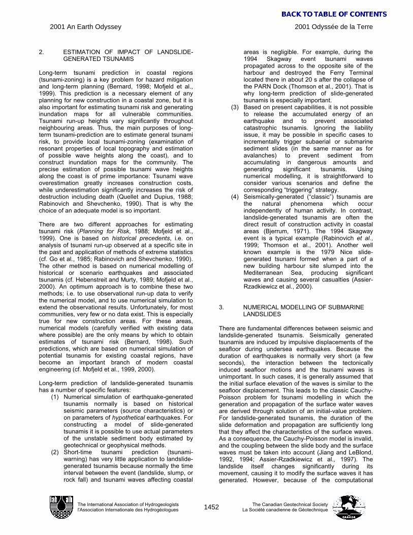
problems the interaction between submarine landslides and the slide-generated waves has only recently been addressed (cf. Jiang and LeBlond, 1994; Rubino et al., 1994; Assier-Rzadkiewicz et al., 1997; Heinrich et al., 1998; Fine et al., 1998; Imamura et al., 2001; Thomson et al., 2001). Bottom topography is the principal factor affecting underwater slide behaviour. Nevertheless, most studies assume simplified one-dimensional bottom topography
Figure 2. Relationship between underwater failure mass and associated tsunami.
(uniform slope), which is then used to determine the movement of the underwater slide and slide-generated waves, taking into account the characteristics of the slide (including such factors as the initial volume, viscosity, and density) and the geometry of the basin (Jiang and LeBlond, 1992, 1993, 1994; Heinrich, 1992; Assier-Rzadkiewicz et al., 1997, etc.). In practice, the bottom topography is far from a simple slope. To simulate landslide-generated waves in natural settings, the spatial variability of the basin geometry and bottom morphology must also be taken into account.
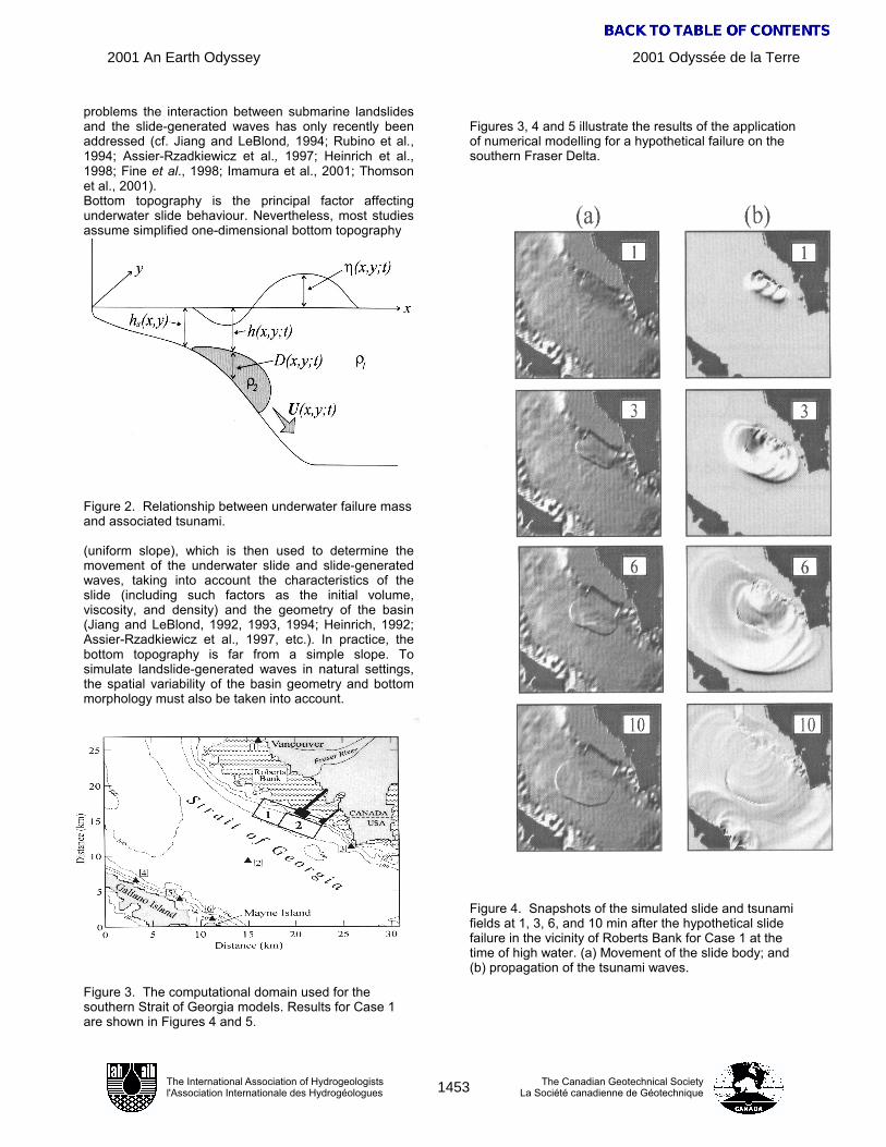
Figure 3. The computational domain used for the southern Strait of Georgia models. Results for Case 1 are shown in Figures 4 and 5.
Figures 3, 4 and 5 illustrate the results of the application of numerical modelling for a hypothetical failure on the southern Fraser Delta.
Figure 4. Snapshots of the simulated slide and tsunami fields at 1, 3, 6, and 10 min after the hypothetical slide failure in the vicinity of Roberts Bank for Case 1 at the time of high water. (a) Movement of the slide body; and (b) propagation of the tsunami waves.
2001 Odyssée de la Terre2001 An Earth Odyssey
1453
AN
EA
RTH
OD
DIT
Y - B
Y R
AC
HEL
, JA
MIE
& T
AI
The International Association of Hydrogeologistsl'Association Internationale des Hydrogéologues
The Canadian Geotechnical SocietyLa Société canadienne de Géotechnique

4. CONCLUSION Landslide-generated tsunamis are a significant geologic hazard in coastal areas of British Columbia, Washington State and Alaska where rapidly deposited sediments accumulate on steep underwater slopes. While the high seismicity often gives rise to tsunamigenic failures, many events have occurred in the absence of earthquakes. There is a commonly observed relationship between failures and times of extreme low tides. Many failure-tsunami events have coincided with construction activities in foreshore areas. Numerical modelling techniques provide a means of both analysing past events and of assessing the possible consequences of potential failures in critical coastal areas. 5. REFERENCES Assier-Rzadkiewicz, S., Mariotti, C., and Heinrich, P. (1997), Numerical Simulation of Submarine Landslides and Their Hydraulic Effects, J. Waterways, Port, Coastal and Ocean Eng., ASCE 123 (4), 149-157. Bernard, E.N. (1998), Program Aims to Reduce Impact of Tsunamis on Pacific States, Earth in Space 11 (2), 1-16. Bjerrum, L. (1971), Sub-Aqueous Slope Failures in Norwegian Fjords, Publ. 88, Norw. Geotech. Inst., Oslo, 8 p. Cornforth, D.H., and Lowell, J.A. (1996), The 1994 Submarine Slope Failure at Skagway, Alaska. In Landslides (Balkema, Rotterdam, 1996), pp. 527-532. Fine, I.V., Rabinovich, A.B., Kulikov, E.A., Thomson, R.E., and Bornhold, B.D. (1998), Numerical Modelling of Landslide-Generated Tsunamis with Application to the Skagway Harbor Tsunami of November 3, 1994. In Proceedings, International Conference on Tsunamis (Paris, 1998), 211-223. Go, C.N., Kaistrenko, V.M., and Simonov, K.V. (1985), A Two-Parameter Scheme for Tsunami Hazard Zoning, Marine Geodesy 9, 469-476. Hamilton, T.S., and Wigen, S.O. (1987), The Foreslope Hills of the Fraser River Delta: Implication of Tsunamis in Georgia Strait, Science of Tsunami Hazards 5, 15-33. Harbitz, C.B., Pedersen, G., and Gjevik, B. (1993), Numerical Simulations of Large Water Waves due to Landslides, J. Hydraulic Engineering, ASCE 119 (12), 1325-1342. Hebenstreit, G.T. and Murty, T.S. (1989), Tsunami Amplitudes from Local Earthquakes in the Pacific Northwest Region of North America, Part 1, The Outer Coast, Marine Geodesy 13, 101-146.
Heinrich, P. (1992), Nonlinear Water Waves Generated by Submarine and Aerial Landslides, J. Waterways, Port, Coastal and Ocean Eng., ASCE 118 (3), 249-266. Imamura, F., and Gica, E.C. (1996), Numerical Model for Tsunami Generation due to Subaqueous Landslide Along a Coast, Science of Tsunami Hazards 14 (1), 13-28. Imamura, F., Hashi, K., and Imteaz, M.A. (2001), Modeling for Tsunamis Genarated by Landsliding and Debris Flow. In Tsunami Mitigation (ed. Hebenstreit G.) (Kluwer, Dorderecht, 2001) (in press). Jiang, L. and LeBlond, P.H. (1992), The Coupling of a Submarine Slide and the Surface Waves which it Generates, J. Geophys. Res. 97 (C8), 12,731-12,744. Jiang, L. and LeBlond, P.H. (1993), Numerical Modeling of an Underwater Bingham Plastic Mudslide and the Waves which it Generates, J. Geophys. Res. 98 (C6), 10,303-10,317. Jiang, L. and LeBlond, P.H. (1994), Three-Dimensional Modeling of Tsunami Generation due to a Submarine Mudslide, J. Phys. Oceanogr. 24 (3), 559-572. Johns, M.W., Prior, D.B., Bornhold, B.D., Coleman, J.M., and Bryant, W.R. (1986), Geotechnical Aspects of a Submarine Slope Failure, Kitimat Fjord, British Columbia, Marine Geotechnology 6, 243-279. Kachadoorian, R. (1965), Effects of the Earthquake of March 27, 1964 at Whittier, Alaska, Geol. Surv. Prof. Pap. 542-B, 439-460. Karlsrud, K. and Edgers, L. (1980), Some Aspects of Submarine Slope Stability. In Marine Slides and Other Mass Movements (Plenum, New York, 1980), pp. 61-81. Kulikov, E.A., Rabinovich, A.B., Thomson, R.E., and Bornhold, B.D. (1996), The Landslide Tsunami of November 3, 1994, Skagway Harbor, Alaska, J. Geophys. Res. 101 (C3), 6609-6615. Kulikov, E.A., Rabinovich, A.B., Fine, I.V., Bornhold, B.D., and Thomson, R.E. (1998), Tsunami Generation by Landslides at the Pacific Coast of North America and the Role of Tides, Oceanology 38 (3), 323-328. Lander, J.F. (1996), Tsunamis Affecting Alaska, 1737-1996 (Boulder, US Dep. Comm., 1996), 195 p. McKenna, G.T., and Luternauer, J.L. (1987), First Documented Large Failure at the Fraser River Delta Front, British Columbia, Geological Survey of Canada, Pap.87-1A, 919-924. McKenna, G.T., Luternauer, J.L., and. Kostaschuk, R.A. (1992), Large-Scale Mass-Wasting Events on the Fraser River Delta near Sand Heads, British Columbia, Can. Geotech. J. 29, 151-156.
2001 Odyssée de la Terre2001 An Earth Odyssey
1454
AN
EA
RTH
OD
DIT
Y - B
Y R
AC
HEL
, JA
MIE
& T
AI
The International Association of Hydrogeologistsl'Association Internationale des Hydrogéologues
The Canadian Geotechnical SocietyLa Société canadienne de Géotechnique