an evaluation of the ecological significance of ninemile
TRANSCRIPT
An Evaluation of the Ecological Significance of
Ninemile Lakes & Ridges AreaNorthern Superior Uplands ECS Section; North Shore Highlands Subsection
Lake County, MinnesotaDNR Quad Codes: H25c (Cabin Lake), H25d (Cramer)
Twp 58N Rng 6W Section 3Twp 59N Rng 6W Sections 9-11, 14-17, 20-22, 26-32, 34-35
Twp 59N Rng 7W Sections 25, 26, 36
Approximate Acreage: 10,315
Prepared by: Michael LeeMinnesota County Biological SurveyDivision of Ecological ServicesDepartment of Natural Resources940 Industrial Drive South, #103Sauk Rapids, Minnesota 56379

An Evaluation of the Ecological Significance of
NINEMILE LAKES & RIDGES AREA
Northern Superior Uplands ECS Section; North Shore Highlands Subsection Lake County, Minnesota
DNR Quad Codes: H25c (Cabin Lake), H25d (Cramer)
Twp 58N Rng 6W Section 3 Twp 59N Rng 6W Sections 9-11, 14-17, 20-22, 26-32, 34-35 Twp 59N Rng 7W Sections 25, 26, 36
Approximate Acreage: 10,315
Prepared by: Michael Lee Minnesota County Biological Survey
Division of Ecological Services Department of Natural Resources 940 Industrial Drive South, #103 Sauk Rapids, Minnesota 56379
22 September 2006

2
Author: Michael Lee Date: 22 September 2006
MINNESOTA COUNTY BIOLOGICAL SURVEY ECOLOGICAL EVALUATION SITE NAME: Ninemile Lakes and Ridges Area (MCBS Sites 103, 104) COUNTY: Lake BIODIVERSITY SIGNIFICANCE: Outstanding ECS REGION: Northern Superior Uplands Section, North Shore Highlands Subsection DNR QUAD CODE(S): H25c (Cabin Lake), H25d (Cramer) LEGAL DESCRIPTION: Twp 58N Rng 6W Section 3 Twp 59N Rng 6W Sections 9-11, 14-17, 20-22, 26-32, 34-35 Twp 59N Rng 7W Sections 25, 26, 36 APPROXIMATE ACREAGE: 10,315
TABLE OF CONTENTS
ECOLOGICAL SIGNIFICANCE ................................................................................................................3 Overview ................................................................................................................................................3 Geology ..................................................................................................................................................4 Native Plant Communities......................................................................................................................5 Fire-Dependent Forest/Woodland System ................................................................................5 Mesic Hardwood Forest System................................................................................................6 Wet Forest System.....................................................................................................................7 Forested Rich Peatland System .................................................................................................7
Acid Peatland System................................................................................................................8 Open Rich Peatland System ......................................................................................................8 Rock Outcrop System................................................................................................................9 Cliff/Talus System.....................................................................................................................9
Rare Plants............................................................................................................................................ 10 Rare Birds............................................................................................................................................. 10 Aquatic Habitats ................................................................................................................................... 11
RECOMMENDATIONS............................................................................................................................ 11 SOURCES .................................................................................................................................................. 13 Appendix 1. Element (Rare Features) Summary for Ninemile Lakes and Ridges Area............................. 14 Appendix 2. Relevés from Ninemile Lakes and Ridges Area .................................................................... 15 Appendix 3. MCBS Aquatic Plant Surveys from Ninemile, Crooked, Moose, Hare, and Echo Lakes...... 37 Figure 1. Location of Ninemile Lakes and Ridges Area............................................................................ 42 Figure 2. Location of Ninemile Lakes and Ridges Area............................................................................ 43 Figure 3. Major Ownership of Ninemile Lakes and Ridges Area.............................................................. 44 Figure 4. Topographic (USGS 7.5 Minute) Map of Ninemile Lakes and Ridges Area............................. 45 Figure 5. Native Plant Communities of Ninemile Lakes and Ridges Area................................................ 46 Figure 6. Forest Cover Types (Common CSA) for Ninemile Lakes and Ridges Area.............................. 47 Figure 7. Designated Old Growth, Ecologically Important Lowland Conifer, Rare Species,
and Relevés in the Ninemile Lakes and Ridges Area ....................................................... 48 Figure 8. Areas of Significant Native Biodiversity in the North Shore Highlands.....................................49 Figure 9. Original Boundaries of Cabin Creek Potential Candidate Research Natural Area..................... 50
3
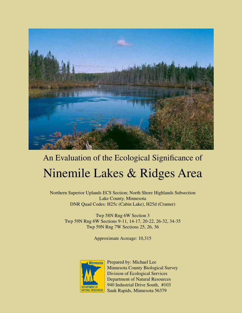
ECOLOGICAL SIGNIFICANCE Overview The Ninemile Lakes and Ridges Area (NLRA) is a large, mostly remote, scenic, and largely undeveloped area with numerous wilderness lakes, rolling to extremely rugged topography, and a diverse cover of high-quality wetland and upland habitats. At 10,315 acres, this is among Minnesota’s most significant functioning large natural landscapes. The uplands are dominated by a series of gabbro, diorite, diabase, and rhyolite ridges which rise up to 350 feet. Lakes occupy 11% of the landscape and most of the lakes have wholly natural (undeveloped) shorelines. Due to accelerating development of lakeshores statewide, this aggregation of undeveloped lakes is a very significant feature of the NLRA. The NLRA’s eleven lakes range in size from 10 to over 280 acres. These include Ninemile, Crooked, Thunderbird, Shoepack, Bonanza, Hare, Echo, Goldeneye, Meme, Moose, and Paccini lakes. All but four of these lakes are completely undeveloped. Development (consisting mostly of modest cabins) on the remaining four is limited in extent. Portions of Moose Creek and Cabin Creek flow through the NLRA, and the upper Caribou River forms part of the eastern boundary of the area. Most of the Superior National Forest’s (SNF) 2,084-acre Cabin Creek candidate Research Natural Area (cRNA) is located within the NLRA (U.S. Forest Service 2004). In addition, there is a large degree of overlap with the original 8,098-acre Cabin Creek RARE II (Roadless Area Review and Evaluation) Area (U.S. Forest Service 1997), and with the 8,360-acre Cabin Creek Wilderness Unit as proposed by the Friends of the Boundary Waters Wilderness (2003). Figures 1 and 2 show the location of the NRLA. Eighteen native plant communities, ten rare plants, and two rare birds are documented from the NLRA. Aspen - birch forest - balsam fir subtype [FDn43b1] is the most abundant forested community (37% of the NLRA). Paper birch - sugar maple forest (North Shore) [MHn45a] occurs on the ridges covering a significant portion (21%) of the area. Five percent of the area is covered by the related but more diverse sugar maple forest (North Shore) [MHn45c]. Carolina spring beauty (Claytonia caroliniana), a species of Special Concern in Minnesota, is known from sugar maple forests here, as are black-throated blue warblers (Dendroica caerulescens), which are proposed as Special Concern, and white baneberry (Actaea pachypoda), which is on Minnesota’s official “watch list” (technically referred to as a “NON” which means “no State status but currently tracked” in the Minnesota Department of Natural Resources’ Natural Heritage Information System [NHIS]). Two small patches (22 acres) of red oak - sugar maple - basswood - (bluebead lily) forest (MHn35b) are significant here for their presence at the edge of the range of this community in northeastern Minnesota. An unusual occurrence of the Special Concern Species Wood’s sedge (Carex woodii), 100 miles north of the nearest locations, is associated with these oaks as well. The nearest known Wood’s sedge populations are in east-central Minnesota (Kanabec County) and in northern Wisconsin. Necklace spike sedge (Carex ormostachya), proposed as Special Concern, is also associated with the oaks. Upland white cedar forest [FDn43c] covers 9% of the NLRA. The maple and upland cedar forests are mostly mature, including 203 acres of designated old-growth on State Forest lands. Additional large blocks of high quality old-growth MHn45c and FDn43c occur on National Forest lands in the NLRA. Over 25% of the NLRA is wetland (including lakes). Lowland white cedar forest (North Shore) [WFn53a] is the most abundant wetland community, covering 8% of the area, and much of it here is old growth. Three occurrences of the State Special Concern species Lapland buttercup (Ranunculus lapponicus) are recorded from mature lowland white cedar forests here. Rich alder swamp [FPn73] covers 3% of the NLRA and poor black spruce swamp [APn81a] covers 1%. Northern commandra (Geocaulon lividum), a NON, occurs in APn81a northeast of Moose Lake. Other wetland communities present include small patches of: black spruce bog - semi-treed subtype [APn80a2], black ash - aspen - balsam poplar swamp [WFn55a], low shrub poor fen [APn91a], graminoid poor fen (basin) [APn91b], graminoid rich fen (basin) [OPn92a], and beaver-influenced wetlands. A small graminoid poor fen south of Moose Lake supports populations of three Special Concern plants: bog rush (Juncus stygius), montane yellow-eyed grass (Xyris montana), and sooty-colored beak-rush (Rhynchospora fusca). A bald eagle (Haliaeetus leucocephalus) nest is recorded from an island in Ninemile Lake. Humped bladderwort (Utricularia gibba), a NON, occurs in Hare Lake.
4
Rock outcrops with open-grown northern red oaks are frequent in the most rugged southeastern portions of the area. Both bedrock shrubland (inland) [ROn23a] and crystalline bedrock outcrop (northern) [ROn12b] communities are represented in this part of the site. ROn12b, ROn23a, and dry open talus (northern) [CTn12a] communities are occasional elsewhere in the NLRA, including significant examples at Manitou Overlook a scenic vista at the end of a short U. S. Forest Service hiking trail in the southwestern part of the area. Another large open talus slope occurs below a prominent mesic mafic cliff (northern) [CTn32a] that overlooks Lake County Road 7. A small wet felsic cliff (northern) [CTn42c] occurs in a small gorge along an ephemeral stream. Road and trail access to much of NLRA is limited. Lake County Road 7 (CR 7) cuts through the eastern part of the NLRA (Figure 2) and several short roads (mostly unimproved) provide access to areas near CR 7. Three of these side roads are maintained and lead to cabins on the northwest and south sides of Ninemile Lake, and on the north end of Crooked Lake. An unmaintained road runs east off CR 7 a short distance to a small old clearing (now appearing as a dump site). CR 7 also runs immediately along the eastern shorelines of Echo Lake and Hare Lake. National Forest Road 358 runs along a portion of the northern edge of NLRA, and National Forest Roads 359 and 361 run along and near western portions of the NLRA. A mining railroad (now inactive) leading to Taconite Harbor borders the southeastern edge of the NRLA. Here, the railroad runs through a nearly ½-mile long tunnel in the most rugged portion of the site. Two primitive campsites on Thunderbird Lake and one on Shoepack Lake are part of a lightly used canoe route. All-terrain vehicle (ATV) trails run to Thunderbird and Moose lakes. There is limited development in the NLRA, all of which is restricted to the CR 7 corridor. In addition to the cabins on parts of Ninemile and Crooked lakes, a private resort and U. S. Forest Service campground also occur on the developed eastern shore of Ninemile Lake. Recent timber harvest has generally been minimal west of CR 7, although in some places harvest patches define the edge of the NLRA (the irregular site boundaries in these areas reflects an attempt to exclude recent harvest patches). As of 2002, there had been no recent timber harvest and no development east of CR 7. However, recent acquisition and proposed resale of LTV Steel Corp. (formerly Erie Mining Company) lands by Minnesota Power Company suggests a strong potential for future development near the railroad. Most of the NLRA is within the proclamation boundaries of both the Finland State Forest and the Superior National Forest (Figures 2 and 3). Ownership is primarily U. S. Forest Service (nearly 70%), with State Forest lands accounting for 20%. The remaining 10% is owned by either Lake County, Minnesota Power Company (formerly Erie/LTV Mining), or is in other private ownership (especially along Ninemile and Crooked lakes). Virtually all of the NLRA is within The Nature Conservancy’s Upper Manitou Conservation Area, one of the organization’s priority focus areas for conservation work in the state. Geology The Ninemile Lakes and Ridges Area lies within the North Shore Highlands Subsection (Minnesota Department of Natural Resources [DNR] Ecological Classification System [ECS] 2000). The North Shore Highlands Subsection runs parallel to Lake Superior from Duluth to the Canadian Border, and is characterized by high bedrock ridges and other areas with Precambrian igneous bedrock near or at the surface, long and often steep slopes, small turbulent rivers that descend rapidly, and a local climate that is moderated by Lake Superior. The NLRA intersects two ECS Landtype Associations (LTAs). The Sawtooth Mountain Bedrock Complex LTA covers over 70% of the area. This LTA is characterized as a complex of Superior lobe till on steep-bedrock controlled terrain and rolling Superior lobe till plains. Bedrock outcrops with steep escarpments are common. The type of bedrock is predominantly diabase, gabbro, and related mafic bedrock of the Beaver Bay Complex. Most of the LTA (65%) is dominated by fine sandy loam soil with a hardpan. The remaining areas have silt loam or loam over clay loam soils with hardpans (14%), clay soils (11%), thin sandy loam over bedrock (5%), and bedrock outcrops (2%) (NRCS 1994). The Sawtooth Mountain Bedrock Complex LTA has a unique combination of elevation, terrain, soil, and lake-modified climate that support forests communities dominated by sugar maple.
5
The remainder (30%) of the NLRA falls within the Cabin Lake Till Plain LTA which is characterized as a rolling till plain formed by the Superior lobe. Long linear ridges of till and bedrock (flutes) oriented northwest-southeast are present. Rivers commonly occur in the low areas between the flutes. Most of this LTA (75%) is dominated by sandy loam soil with a hardpan. The remaining areas have sandy loam over sand and gravel (18%) and thin sandy loam over bedrock (7%) (NRCS 1994). Topographic relief in much of the NLRA is dramatic, ranging from 1,440 feet near Ninemile Creek to over 1,930 feet atop the ridge south of Shoepack Lake (Figure 4). The highest local relief occurs in the extremely rugged terrain near the railroad tunnel east of CR 7. Here elevation changes of 250–350 feet within ¼- to ½-mile are common. Groundwater seeps occur in places on the slopes and elsewhere. A large spring exists in a white cedar swamp south of Hare Lake (east of CR 7). The bedrock geology of the NLRA is complex and diverse. Various types of diabase, gabbro, and diorite are the predominant bedrock exposed in the NLRA. Anorthosite, ferrodiorite, troctolite, basalt, rhyolite, and miscellaneous felsic rocks outcrops are also present in a few areas (Minnesota Geologic Survey 1994). Native Plant Communities
Native plant communities and locations of vegetation plots (relevés) [Appendix 2] in the NLRA are shown in Figure 5. (For comparison, forest inventory cover types for National Forest, State Forest, and Lake County lands are shown in Figure 6.) Descriptions of the native plant communities mapped in the NLRA are presented below. Fire-Dependent Forest/Woodland (FD) System Once quite extensive in the North Shore Highlands, old-growth Great Lakes pine forest was all but eliminated in the late 1800s and early 1900s by extensive logging and the repeated fires that followed. Targeting valuable 200- to 300-year old trees for harvest, loggers removed the seed source for regeneration and hot fires in the logging slash destroyed regenerating young pines. (During that era, the state of Minnesota required loggers to burn logging slash in order to remove it from harvest areas.) A few scattered pines, often along shores of lakes or streams, and huge, old decaying stumps, are remaining evidence of the once extensive Great Lakes pine forest in this area. Most, if not all of this pine forest in this area would be classified today as white pine - red pine forest (FDn43a), though no patches of FDn43a large enough to be mapped presently occur in the NLRA. Aspen - birch forest - balsam fir subtype [FDn43b1] occupies 3,814 acres in the NLRA. Soils are rocky sandy-loams varying from dry-mesic to wet-mesic, and are sometimes quite shallow to bedrock. Charcoal is often present in the soil and old fire-scarred conifer snags and stumps can be found in many stands. Most of these forests are dominated by maturing to mature stands of quaking aspen (Populus tremuloides) and paper birch (Betula papyrifera), with varying amounts of balsam fir (Abies balsamea) and white spruce (Picea glauca), especially in the understory. (An additional 53 acres of FDn43b1 has been clear-cut in the NLRA within the past 20 years and was mapped as young forest.) The canopy is typically patchy to interrupted, allowing a fair amount of light to reach the shrub and ground layers. The shrub layer varies from patchy to rather dense and is characteristically dominated by beaked hazelnut (Corylus cornuta), often with abundant mountain maple (Acer spicatum). The ground layer is moderately diverse and composed of common mesic plants such as large-leaved aster (Aster macrophyllus), wild sarsaparilla (Aralia nudicaulis), Canada mayflower (Maianthemum canadense), bluebead lily (Clintonia borealis), woodrush (Luzula acuminata), and mountain rice grass (Oryzopsis asperifolia). The ecological quality rank for most FDn43b1 occurrences in the NLRA varies from AB to BC. [relevés 6078, 6079, 8484, 8485] Upland white cedar forest [FDn43c] occupies 935 acres in the NLRA. Soils are rocky sandy-loams varying from mesic to wet-mesic, and are sometimes quite shallow to bedrock. FDn43c may occur in gradually sloping or extremely steep settings. Charcoal is sometimes present in the soil and old fire-scarred conifer snags and stumps can be found in many stands. Huge old pine stumps are common in some stands. This community is dominated by mature stands of white cedar (Thuja occidentalis). Varying amounts of white spruce, yellow birch (Betula allegheniensis), heart-leaved birch (B. cordifolia), paper birch, and white pine may also be present in the typically

6
patchy to interrupted canopy. The shrub layer varies from sparse to patchy and commonly contains mountain maple and beaked hazelnut. The ground layer is similar to aspen-birch forest (FDn43b1), but fern allies such as shining firmoss (Huperzia lucidula) are more typical in upland white cedar forest. The ecological quality rank for most FDn43c occurrences in the NLRA varies from A to B. FDn43c commonly grades to lowland white cedar forest and also to sugar maple forest and aspen-birch forest. Much of the upland cedar forest here qualifies as old growth (older than 125 years), and 102 acres on state land have been designated as such (Figure 7). No similar protection mechanism is in place for old-growth cedar on National Forest or County lands in the NLRA. Mesic Hardwood Forest (MH) System Paper birch - sugar maple forest (North Shore) [MHn45a] covers 2,148 acres in the NLRA. MHn45a tends to occupy the higher ridges and upper portions of south- to east-facing slopes where soils are rocky sandy-loams varying from dry-mesic to mesic, and are often quite shallow to bedrock. Charcoal is sometimes present in the soil and old fire-scarred conifer snags and stumps can be found in some stands, especially in areas where this community grades to aspen-birch forest. The canopy is dominated by sugar maple (Acer saccharum) and paper birch, much of which is mature. Sugar maple is abundant in the subcanopy, shrub layer, and as seedlings in the ground layer as well. Additional common shrubs include beaked hazelnut and juneberries (Amelanchier spp.). The ground layer is moderately diverse; bluebead lily, wild sarsaparilla, rose twisted-stalk (Streptopus roseus), and long-stalked sedge (Carex pedunculata) are common. The ecological quality rank for most occurrences of MHn45a in the NLRA varies from A to BC. [relevés 8329, 8482, 8517] In some places, this community appears to be succeeding to sugar maple forest (North Shore) as paper birch is replaced by sugar maple. This is evident in the 91 acres on state land that is designated as old growth (Figure 7). A fairly heavy exotic earthworm invasion was observed in MHn45a near Ninemile Lake in 2000. Although the invasion area appears to be limited to a few acres atop the ridge just southeast of the lake, there appears to be few natural barriers to the spread of these invasive worms through over 300 contiguous acres of this community type. Evidence of exotic earthworm invasion was not noted elsewhere in the NLRA.
White cedar - yellow birch forest [MHn45b] was not mapped in the NLRA. However, this globally rare native plant community does occur in the NLRA, typically as inclusions in larger patches of FDn43c, or in broad ecotones between patches of MHn45c and FDn43c. Most white cedar - yellow birch forest in the NLRA is high quality old growth, similar in age and ecological quality to the adjacent FDn43c and MHn45c.
Sugar maple forest (North Shore) [MHn45c] covers 520 acres in the NLRA. MHn45c occupies the highest ridges where soils are rocky sandy-loams varying from wet-mesic to mesic, and are often quite shallow to bedrock. Charcoal is rarely present in the soil and old fire-scarred conifer snags and stumps are uncommon. The canopy is dominated by sugar maple, much of which is mature. Large, old yellow birch are often present, and sometimes co-dominant with sugar maple. Lesser amounts of mature white cedar and white spruce may also be present in the canopy. Sugar maple is abundant in the subcanopy, shrub layer, and as seedlings in the ground layer as well. Due to the dense canopy and understory, most of the light is filtered out before reaching the forest floor. In addition to sugar maple, the shrub layer typically contains choke cherry (Prunus virginiana) and pagoda dogwood (Cornus alternifolia). The ground layer has moderate to high diversity with moist areas such as slight depressions and small drains having the highest species diversity. In addition to those species listed above for MHn45a, yellow violet (Viola pubescens), hairy Solomon’s seal (Polygonatum pubescens), Clayton’s sweet cicely (Osmorhiza claytonii), and spring ephemerals such as Carolina spring beauty (Claytonia caroliniana) commonly occur in MHn45c. The ecological quality rank for occurrences of MHn45c in the NRLA varies from A to B. All of the MHn45c mapped in the NLRA is located on the ridge near Paccini Lake and most if not all of this meets Minnesota DNR old growth criteria. However most of this is National Forest land and the old growth receives no formal protection here.

7
Red oak - sugar maple - basswood - (bluebead lily) forest [MHn35b] occupies 22 acres in the NLRA. This location is significant because it is at the northeastern edge of the range of this community in the North Shore Highlands Subsection. In the NLRA, this community is restricted to the extremely rugged terrain in the southeastern part of the site just north of the railroad tunnel. It follows the ridgetop and the adjacent steep upper portions of south to east-facing slopes. Soils are shallow to the diabase bedrock, with the forest grading into bedrock outcrop communities in places. Northern red oak (Quercus rubra) is common in the canopy with lesser amounts of sugar maple and red maple. On the margins of rock outcrops, northern red oaks are present as short, open-grown individuals. Sugar maple is common in the understory beneath mature oaks and maples. The ground layer is fairly diverse with an above average diversity of graminoids (grasses and sedges) for mesic hardwood forests in this part of the North Shore Highlands Subsection. Graminoids associated with the community here include woodland millet grass (Milium effusum), Peck’s sedge (Carex peckii), drooping wood sedge (C. arctata), colonial sedge (C. communis), Dewey’s sedge (C. deweyana), long-stalked sedge (C. pedunculata), necklace spike sedge (C. ormostachya), and Woods’ sedge (C. woodii). The last two of these are rare species. Wet Forest (WF) System Lowland white cedar forest (North Shore) [WFn53a] occupies 798 acres in the NLRA. WFn53a occurs in shallow depressions and along gently sloping drains. Soils are wet-mesic to wet and either muck or shallow peat. The canopy is patchy to interrupted, dominated by white cedar, with lesser amounts of balsam fir and black ash (Fraxinus nigra) in places. Canopy cedars are frequently lodged (leaning) or otherwise growing at angles other than vertical. The shrub layer is sparse to patchy, with speckled alder (Alnus incana), mountain maple, and balsam fir present in most locations. The ground layer is diverse, with interrupted to continuous cover. The substrate is typically uneven, with upland forest plants on mesic hummocks around tree bases, decaying boles, and other hummocks, and wetland forest plants in wet mucky hollows and other small depressions. Common species include woodland horsetail (Equisetum sylvaticum), dwarf raspberry (Rubus pubescens), naked miterwort (Mitella nuda), bunchberry (Cornus canadensis), and goldthread (Coptis groenlandica). Three records of the rare Lapland buttercup (Ranunculus lapponicus) are known from lowland white cedar forests here. A diverse bryophyte flora, predominantly brown mosses, covers the substrate in most places. The ecological quality rank for most occurrences of WFn53a in the NLRA varies from A to B. [relevés 8486, 8518]
All of the WFn53a mapped in the NLRA is mature and 12 stands totaling 172 acres on State-owned land are designated as Ecologically Important Lowland Conifer (Figure 7), a temporary status acting to reserve these stands from harvest until a procedure for evaluating them as potential old growth can be developed. Black ash - aspen - balsam poplar swamp [WFn55a] occupies 54 acres in the NLRA. WFn55a occurs in shallow depressions, along gently sloping drains, and in narrow transitions between peatlands and uplands. Soils are wet-mesic to wet, typically shallow peat with muck especially in hollows. The canopy is generally interrupted to continuous, composed of a mix of black ash and balsam poplar (Populus balsamifera), with lesser amounts of white cedar. Speckled alder is generally present in the shrub layer along with mountain maple and swamp red currant (Ribes triste). The ground layer is diverse with continuous cover. Fine-bladed sedges such as bristle-stalked sedge (Carex leptalea) and brownish sedge (C. brunnescens) are important. Common forbs include lady fern (Athyrium angustum), dwarf raspberry, tall meadow-rue (Thalictrum dioicum), flat-topped aster (Aster umbellatus), and rough bedstraw (Galium asprellum). The ecological quality rank for occurrences of WFn53a in the NLRA varies from B to BC. Forested Rich Peatland (FP) System Alder - (maple - loosestrife) swamp [FPn73a] occupies 282 acres in the NLRA. FPn73a occurs in a variety of wetland settings. It commonly dominates or co-occurs with other wetland communities in small basins, bordering lakes, and along streams and other natural drainage features. The substrate is generally saturated deep to shallow peat or mineral soil. Speckled alder (Alnus incana) is the dominant species, often forming a dense, nearly continuous tall shrub cover. Scattered trees may be present. Common ground-layer plants include bluejoint (Calamagrostis canadensis), fowl manna grass (Glyceria striata), red-stemmed aster (Aster puniceus), and marsh
8
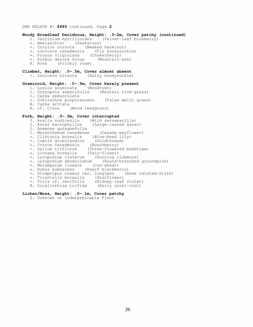
marigold (Caltha palustris). FPn73a commonly occurs in areas influenced by beaver (Castor canadensis) activity and alder swamps intergrade with areas mapped as Beaver Wetland Complex (see below). Acid Peatland (AP) System Black spruce bog - semi-treed subtype [APn80a2] occupies 31 acres in the NLRA. APn80a2 occurs at one location, adjacent to a larger patch of lowland white cedar forest southwest of Thunderbird Lake. The substrate is deep, saturated peat. The canopy is relatively open and dominated by stunted black spruce (Picea mariana) , with numerous snags. Stunted black spruce occurs in the understory as well. Ericaceous shrubs such as leatherleaf (Chamaedaphne calyculata), bog laurel (Kalmia polifolia), small cranberry (Vaccinium oxycoccus), velvet-leaved blueberry (Vaccinium myrtilloides), and Labrador tea (Ledum groenlandicum) dominate the ground layer. Other ground-layer plants include few-flowered sedge (Carex pauciflora), three-leaved false Solomon’s-seal (Smilacina trifolia), and lingonberry (Vaccinium vitis-idaea), which is quite uncommon in the North Shore Highlands Subsection. Carpets of Sphagnum and Polytrichum mosses cover the ground. Poor black spruce swamp [APn81a] occupies 120 acres in the NLRA. APn81a occurs on saturated organic soil in basins and along edges of lakes and slow-moving streams. The canopy is dominated by fairly dense (interrupted to continuous) stands of black spruce. Balsam fir is often present with black spruce in the understory. Common ground-layer plants include three-leaved false Solomon’s-seal, three-seeded bog sedge (Carex trisperma), creeping snowberry (Gaultheria hispidula), and Labrador tea. Sphagnum mosses carpet the forest floor. [relevé 8487]
All of the APn81a mapped in the NLRA is mature, and seven stands totaling 84 acres on State-owned land are designated as Ecologically Important Lowland Conifer (Figure 7), a temporary status acting to reserve these stands from harvest until a procedure for evaluating them as potential old growth can be developed. Low shrub poor fen [APn91a] occupies 11 acres in the NLRA. APn91a occurs on deep, saturated peat in small basins and in association with other peatland communities in larger basins. Low shrub poor fens are sometimes associated with lakes or other open water. Short, stunted black spruce and tamarack (Larix laricina) trees are common in this community. Ericaceous shrubs including leatherleaf, bog rosemary (Andromeda glaucophylla), and small cranberry form a dense low shrub layer with >50% cover. Wiregrass sedges (Carex lasiocarpa, C. oligosperma) are typically the dominant graminoids. Carpets of Sphagnum and Polytrichum mosses cover the ground. APn91a grades to graminoid poor fen in some locations. Graminoid poor fen (basin) [APn91b] occupies 12 acres in the NLRA. APn91b occurs on deep, saturated peat in small basins, and is often associated with open water such as lakeshores and small ponds. Short, stunted black spruce and tamarack trees and ericaceous shrubs may be present but their cover is <50% and often much less. Sweet gale (Myrica gale) and large cranberry (Vaccinium macrocarpon) are often present. Narrow-leaved sedges, especially fen wiregrass sedge (Carex lasiocarpa), are the dominant cover. Pitcher plant (Sarracenia purpurea), sundews (Drosera rotundifolia, D. intermedia), bog clubmoss (Lycopodiella inundata), buckbean (Menyanthes trifoliata), scheuchzeria (Scheuchzeria palustris), horned bladderwort (Utricularia cornuta), and rose pogonia (Pogonia ophioglossoides) are often present. Carpets of Sphagnum mosses cover the ground. [relevé 8868] Small, wetter depressions in the community form an interesting microhabitat typically dominated by white beak-rush (Rhynchospora alba). These depressions are sometimes co-dominated by two plant species listed as Special Concern in Minnesota, sooty-colored beak-rush (R. fusca) and montane yellow-eyed grass (Xyris montana). These two plants occur, along with the Special Concern species bog rush (Juncus stygius), in a small poor fen south of Moose Lake. Open Rich Peatland (OP) System Graminoid rich fen (basin) [OPn92a] occupies 38 acres in the NLRA in a narrow, steep-sided valley along a 1¼-mile reach of Moose Creek. The creek meanders slowly through the rich fen complex. Small beaver dams along the creek have some localized impact on the community here including somewhat increasing the amount of open water

9
along this stretch of the valley. Fen wiregrass sedge forms nearly continuous cover. Sweet gale occurs frequently throughout the community. Speckled alder is occasional along the upland margins of the wetland.
Rock Outcrop (RO) System Crystalline bedrock outcrop (northern) [ROn12b] occupies 19 acres in the NLRA. ROn12b is located on exposed bedrock and tends to occur on ridgetops. ROn12b occurs on small to fairly large bedrock exposures where shrub and small tree cover is sparse (<25%). Outcrop specialists occurring along crevices and on bedrock margins include rusty woodsia (Woodsia ilvensis), rock spikemoss (Selaginella rupestris), pale corydalis (Corydalis sempervirens), and Douglas’ knotweed (Polygonum douglasii). Short-statured sedges such as umbel sedge (Carex umbellata) and northern sedge (C. deflexa) are common. Other important plants include poverty grass (Danthonia spicata), fringed false buckwheat (Polygonum cilinode), pussytoes (Antennaria spp.), and lowbush blueberry (Vaccinium angustifolium). Lichens cover exposed rock surfaces. Bedrock shrubland (inland) [ROn23a] occupies 17 acres in the NLRA. Bedrock shrubland communities are located both on the rugged ridge near the railroad tunnel and on Manitou Overlook west of Moose Lake. Like occurrences of crystalline bedrock outcrop, occurrences of ROn23a are associated with exposed bedrock, but ROn23a tends to occupy larger outcrop complexes where shrubs are an important component of the community. Shrub and small tree cover is patchy to interrupted, with Juneberries (Amelanchier spp.), prairie willow (Salix humilis), bush honeysuckle (Diervilla lonicera), and lowbush blueberry typically present along crevices and in shallow soil between areas of exposed rock. Short-statured sedges such as umbel sedge, northern sedge, and Back’s sedge (C. backii) are common. Typical crystalline bedrock outcrop species such as rusty woodsia, rock spikemoss, pale corydalis, and Douglas’ knotweed occur along crevices and margins of exposed rock. Lichens cover exposed rock surfaces. Cliff – Talus (CT) System Dry open talus (Northern) [CTn12a] occupies two acres in the NLRA. CTn12a occurs at five locations on the side slopes of ridges below exposed bedrock. The largest example is along CR 7 beneath a large mesic cliff (CTn32a). The remaining examples are all associated with communities of the Rock Outcrop System (ROn12b, and ROn23a), one of these at Manitou Overlook and the remainder on the ridge near the railroad tunnel. Average talus block size ranges from a few inches to several feet in diameter. Dry open talus communities are dominated by lichens, which cover the exposed surfaces of talus blocks. Vascular plant cover is very sparse but occasionally includes common polypody (Polypodium virginianum). Trees and shrubs are rare or absent. Mesic mafic cliff (Northern) [CTn32a] occupies approximately one acre in the NLRA and is represented by one occurrence, a prominent, 30- to 80-foot high, north- to northeast-facing gabbro exposure overlooking CR 7. Although fairly tall, the cliff is rather limited in extent. Lichens cover the exposed rock face and mosses have significant cover in places. Vascular plants such as fragrant fern (Dryopteris fragrans), Nahanni oak fern (Gymnocarpium jessoense), rusty woodsia (Woodsia ilvensis), and firmosses (Huperzia selago and H. x buttersii) occur sporadically, and are largely limited to crevices and ledges. Shrubs and trees such as showy mountain ash (Sorbus decora), heart-leaved birch (Betula cordifolia), and white cedar shade portions of the face. Wet felsic cliff (Northern) [CTn42c] occupies less than an acre in the NLRA and is represented by one occurrence, a rather small feature cut into rhyolite east of Paccini Lake. Here, CTn42c occurs in a small gorge cut into the middle and upper portions of a steep side slope of a 200-foot ridge above the Caribou River. An ephemeral stream runs along the gorge. Mosses are dominant over the cool, moist bedrock face, which is shaded beneath the canopy of old-growth sugar maple forest (MHn45c). Vascular plants are sparse; these include fragile fern (Cystopteris fragilis) and a rather luxuriant growth of Canada yew (Taxus canadensis).

10
Rare Plants Three plant species listed as Special Concern in Minnesota (DNR 1996), montane yellow-eyed grass (Xyris montana), sooty-colored beak-rush (Rhynchospora fusca), and bog rush (Juncus stygius), occur in a five-acre wetland basin south of Moose Lake. There is a small zone of open water (tiny lake) in the center of the basin. The rare plants occur in moist depressions in a graminoid poor fen [APn91b] surrounding the pond. Montane yellow-eyed grass and sooty-colored beak-rush are abundant in this fen, while bog rush is rare. This type of depression is a rather unusual microhabitat that is well developed only in a small subset of poor fens in northern Minnesota. Three records of Lapland buttercup (Ranunculus lapponicus), a species of Special Concern, are known from the NLRA. All three occur in lowland white cedar forest [WFn53a] beneath mature white cedar trees and scattered understory balsam fir. One location is in a rather small stand along a subtle drainageway near the Manitou Overlook trail west of Moose Lake. A second population is in the large cedar - black spruce - alder wetland complex along the inlet to the northeast side of Moose Lake. The third location is in the large cedar wetland south of Shoepack Lake. None of the three populations is very large. One location of Necklace spike sedge (Carex ormostachya), a species proposed as Special Concern, is known from the NLRA. This population consists of scattered plants and is associated with a small patch of northern red oaks (red oak - sugar maple - basswood - (bluebead lily) forest [MHn35b]) at the crest and uppermost portion of an extremely steep, 320-foot high, southeast-facing slope overlooking the Caribou River southeast of Paccini Lake. Also associated with the northern red oaks southeast of Paccini Lake is a population of Wood’s sedge (Carex woodii). This sedge is currently listed as Special Concern but is proposed for delisting because it is deemed secure in southeastern and east-central Minnesota. However, the recent discovery of the population in the NLRA is especially significant as it represents a major northern extension of the range of the species. The nearest location is 100 miles to the south in northern Wisconsin. The nearest Minnesota population is 150 miles to the southwest in Kanabec County. The NLRA plants occur in a remote natural setting and all indications suggest that this is a native population. Carolina spring beauty (Claytonia caroliniana) occurs in mature to old-growth sugar maple forest [MHn45c] east of CR 7. It is unknown how abundant this species is in the NLRA as surveys were mostly conducted after mid-June when this spring ephemeral had withered and died back below ground for the season. Carolina spring beauty is currently listed as Special Concern but is proposed for delisting because it is deemed secure in the North Shore Highlands Subsection. Two records of white baneberry (Actaea pachypoda) are known from sugar maple forests east of CR 7. Here, as is typical of most other Minnesota populations of this species, plants are never very abundant; rather they are scattered sporadically, preferring mature and old-growth stands. White baneberry is not listed and no official status is proposed but it is tracked in the NHIS. Northern commandra (Geocaulon lividum) is present in a poor black spruce swamp [APn81a] near the inlet of Moose Lake (at the northeast end of the lake). Here, a patch of several hundred plants occurs in carpets of Sphagnum mosses; it is one of the most abundant vascular plant species in a two-acre area. The population extends sporadically into the adjacent lowland white cedar forest in places. Northern commandra is not listed but is tracked in the NHIS. A population of humped bladderwort (Utricularia gibba) was recorded in Hare Lake in 2001. The plants were recorded along the north end of the lake growing with other native aquatic plants. Humped bladderwort is not listed but is tracked in the NHIS. Rare Birds Black-throated blue warblers (Dendroica caerulescens), a species proposed as Special Concern, have been recorded in mature paper birch - sugar maple forest [MHn45a] southeast of Paccini Lake. These are breeding season records for singing males during surveys that date between 1993 and 1995. The records appear to be from

11
the lower portion of the steep east-facing side slope of the ridge and adjacent terrain at the base of the slope. Black-throated blue warblers have also been recorded in the past near Goldeneye Lake. A bald eagle (Haliaeetus leucocephalus) nest is recorded from an island in Ninemile Lake. Mature bald eagles were observed on the edges of several of the other lakes in the NLRA during surveys from 1999–2002. Aquatic Habitats Lakes, ponds, slow-flowing sections of streams, and other open water areas cover 1,135 acres in the NLRA. The undeveloped character of most of the lakeshore in the NLRA is one of the most important aspects of this area. In general, healthy native aquatic plant, vertebrate, and invertebrate communities are strongly correlated with lakes with undisturbed, natural shoreline vegetation such as those present in the NLRA. Watersheds covered by mature forests, intact wetlands, and free-flowing streams are important to the health of the aquatic ecosystems here as well. Aquatic plant surveys were conducted by MCBS in August 2001 on Ninemile, Crooked, Moose, Hare, and Echo lakes. Appendix 3 shows the results of these surveys. Small temporary and semi-permanent wetlands occur sporadically in upland forests in parts of the NLRA. Although the Minnesota County Biological Survey conducted no rare animal surveys in the NLRA, these seasonal ponds and wetlands provide important breeding habitat for a variety of woodland amphibians (Hall, pers. comm. 2006). Among the species usually present in such habitats in northeastern Minnesota are wood frogs (Rana sylvatica), spring peepers (Pseudacris crucifer), blue-spotted salamanders (Ambystoma laterale), gray treefrogs (Hyla versicolor), and eastern newts (Notophthalmus viridescens). Eastern red-backed salamanders (Plethodon cinereus) also likely occur in forests in the NLRA, laying their eggs under woody cover on the forest floor. Newts would be expected in lakes at the site, and green frogs (Rana clamitans) and mink frogs (Rana septentrionalis) would be expected in permanent water bodies and creeks. Maintaining forested corridors between wetlands with various hydroperiods will help maintain greater amphibian diversity at the site.
RECOMMENDATIONS The Ninemile Lakes and Ridges Area is a large natural area with features of statewide significance, namely its unfragmented nature, remote and undeveloped lakes, noteworthy rare species populations, and high quality native plant communities including large patches of old-growth lowland and upland forests. These features merit special consideration for protection and management. The NLRA stands out in both regional and statewide contexts. It comprises two MCBS sites (Lake County 103 and 104), both meriting a Biodiversity Significance Rank of Outstanding for the reasons listed above. Figure 8 shows biodiversity significance ranks of MCBS sites in the North Shore Highlands Subsection. A larger percentage of the landscape in the North Shore Highlands and adjacent subsections meets Outstanding Biodiversity Significance criteria than in other parts of the state. This is due to a combination of low human population, limited and low intensity recreational uses, large public land base, large forest industry land base, minimal motorized access to large blocks of land, and propensity for vegetation types with limited value for the forest products industry. However, almost all of these factors are changing. Forest industry land is being subdivided and sold; recreation pressures are increasing; demand for forest products from saw logs and pulp (including maple) to balsam boughs and spruce tops is increasing; and access to remote areas is improving. Large sites with High and Outstanding Biodiversity Significance ranks are threatened now more than ever, and the threat will only increase in the future as more people seek to recreate and live in northeastern Minnesota. Hunting and fishing should continue to be recreational uses of the area. Any management of game species populations should be compatible with maintaining natural ecosystem functions and viable and healthy populations of native animal and plant species. Special consideration should be given to regeneration of highly palatable plants such as white cedar, white pine, and Canada yew. In conservation and management planning for the NLRA, strong consideration should be given to several effects associated with forest management, including forest fragmentation and creation of hard edges between forest and

12
clearings, soil compaction and erosion, and control of invasive and non-native species. Recent timber harvest has generally been minimal in the NLRA, although harvest, primarily clearcutting, has occurred adjacent to the NLRA in a number of places and the edge of these harvest patches frequently defines the edge of the NLRA. Harvest of mature forest can diminish available habitat for animal species of conservation concern, such as black-throated blue warblers and ovenbirds (Seiurus aurocapillus), that depend on large patches of mature, forest interior. Many native plant species adapted to mature forests are also adversely affected by canopy removal and increased forest edge, which lead to increased light levels and desiccation, and make these species vulnerable to displacement by aggressive native or exotic species. Logging roads can effectively serve as corridors into forests for exotic species invasion and establishment, while abandoned roads and landings can take decades (if not longer) to return to productive forest condition because of soil compaction and displacement of native vegetation. Because of the potential impacts of forest management activity on the vegetation and plant and animal populations of the NLRA, it is recommended that lands in the NLRA be reserved from forest management until a management plan with a focus on biodiversity protection and ecological function is developed for the area. If timber harvest and forest management actions meet the goals and objectives for this area, these activities should be designed so that new roads and landings are not created within the NLRA. In recent years, off-road vehicle use has increased throughout Minnesota and the Ninemile area is no exception. Most of the use here is by all-terrain vehicles (ATVs). ATV trails currently lead to several remote lakes in the NLRA (especially Moose and Thunderbird lakes). Along these trails, erosion and rutting were observed at various places, especially where the trails intersect small wetlands. Invasive plants such as tall buttercup (Ranunculus acris) were observed along some sections of these trails. The legal status of these routes should be established and their compatibility with the goals and objectives for this area should be assessed. The U.S. Forest Service began identification of potential natural areas on the Superior National Forest in 1996 (Vora 1997) as part of an effort to establish a nationwide network of Research Natural Areas containing unique ecosystems or ecological features, rare or sensitive plant or animal species, and high-quality examples of widespread ecosystems that could serve as reference areas for evaluating management prescriptions (Anderson 1997). One of the highest priorities for identification of candidate RNAs on the Superior National Forest was for areas large enough to support landscape-level processes such as fire (U. S. Forest Service 2000). The 9,900-acre Cabin Creek Potential Candidate Research Natural Area (pcRNA) was identified as part of this effort (Figure 9). As “a large area of contiguous forest with little fragmentation” characterized by “[plant] communities that exhibit a high degree of naturalness, including a variety of post-fire regeneration types, with little recent human disturbance,” the Cabin Creek pcRNA was considered a high-priority candidate (Vora 1997). The 9,900-acre pcRNA included a significant amount of state-owned land and a minor amount of Lake County tax-forfeit land, and because of “concerns about access to Minnesota DNR land,” it was later reduced in size to the present 2,084-acre Cabin Creek Candidate RNA (cRNA) (U.S. Forest Service 2004). The 2,084-acre cRNA is a significant part of the NLRA and, from an ecological standpoint, is worthy of establishment. If future decisions on management or conservation of state lands within the original pcRNA eliminate concerns over access, the remainder of the federal lands in the original 9,900-acre pcRNA west of CR 7 would be appropriate for RNA status. It is also recommended that the federal lands east of CR 7 be considered for RNA status as they contain even higher quality (including significant old-growth) examples of sugar maple and upland cedar forest communities as well as other features, such as cliff communities, that do not occur west of CR 7. Inclusion of lands east of CR 7 would create a larger RNA and one better able to support priority landscape-level processes such as fire. A review of these issues and opportunities should be part of developing the goals and objectives (management plan) for this area. For state, county, and private lands adjacent to eventual RNA boundaries, conservation easements, management agreements, or acquisition should be pursued to ensure uses compatible with managing the area for biodiversity conservation and maintenance of ecosystem function. The Manitou Collaborative provides a promising model of collaboration for the development of goals and objectives for management of lands in and adjacent to the NLRA. In summary, the Ninemile Lakes and Ridges Area is a natural area of regional and statewide significance meriting conservation action and management with maintenance of native biodiversity and ecological processes as the primary goals. The Manitou collaborative is positioned to provide the leadership necessary to determine objectives and support management actions that maintain the biodiversity and ecological function of this area.

13
SOURCES Anderson, Chel, 1997. “Evaluation of Selected Potential Candidate Research Natural Areas as representative of Ecological Landtype Associations on the Superior National Forest, Minnesota.” Friends of the Boundary Waters Wilderness, 2003. “Preserving the Canoe Country Heritage. A wilderness study on permanently protecting Minnesota’s remaining wild places.” Minnesota Department of Natural Resources (DNR), 1999–2002. Minnesota County Biological Survey of Minnesota’s North Shore Highlands. Michael Lee, Chel Anderson, and Lynden Gerdes, Plant Ecologists; Carol Hall-Herpetologist; and Steve Stucker-Ornithologist. Minnesota Department of Natural Resources (DNR), 2000. “Upper Three Levels of the Ecological Classification System for Minnesota.” Minnesota Department of Natural Resources (DNR), 1996. “Minnesota’s List of Endangered, Threatened, and Special Concern Species”
Minnesota Department of Natural Resources (DNR), 1993–95. Scientific and Natural Areas Program. Steve Wilson, Regional Specialist. Minnesota Geological Survey, 1994. “Bedrock Geologic Map of the Cabin Lake and Cramer 7.5-Minute Quadrangles, Lake and Cook Counties, Minnesota.” Map Series M-82. Natural Resources Conservation Service (NRCS), 1994. “State Soil Geographic Database (STATSGO). A GIS cover and database of soil associations.” U.S.D.A. Forest Service 2004. Superior National Forest Land and Resource Management Plan. Record of Decision (R9-SU-FEIS-ROD). July 2004. U.S.D.A. Forest Service, 2000. “Potential Research Natural Areas, Superior National Forest- Potential Pool of Viable Areas for Consideration during Forest Plan Revision.” U.S.D.A. Forest Service, 1998. “Characteristics of the Superior National Forest Landtype Associations.” Superior National Forest. Duluth, MN. U.S.D.A. Forest Service, 1986. Land and Resource Management Plan- Superior National Forest. U.S.D.A. Forest Service, 1997. “Superior National Forest- Roadless Area Review and Evaluation [RARE II].” Vora, Robin, 1997. “Identification of Potential Natural Areas, Including Representative Ecosystems, on the Superior National Forest”.
14
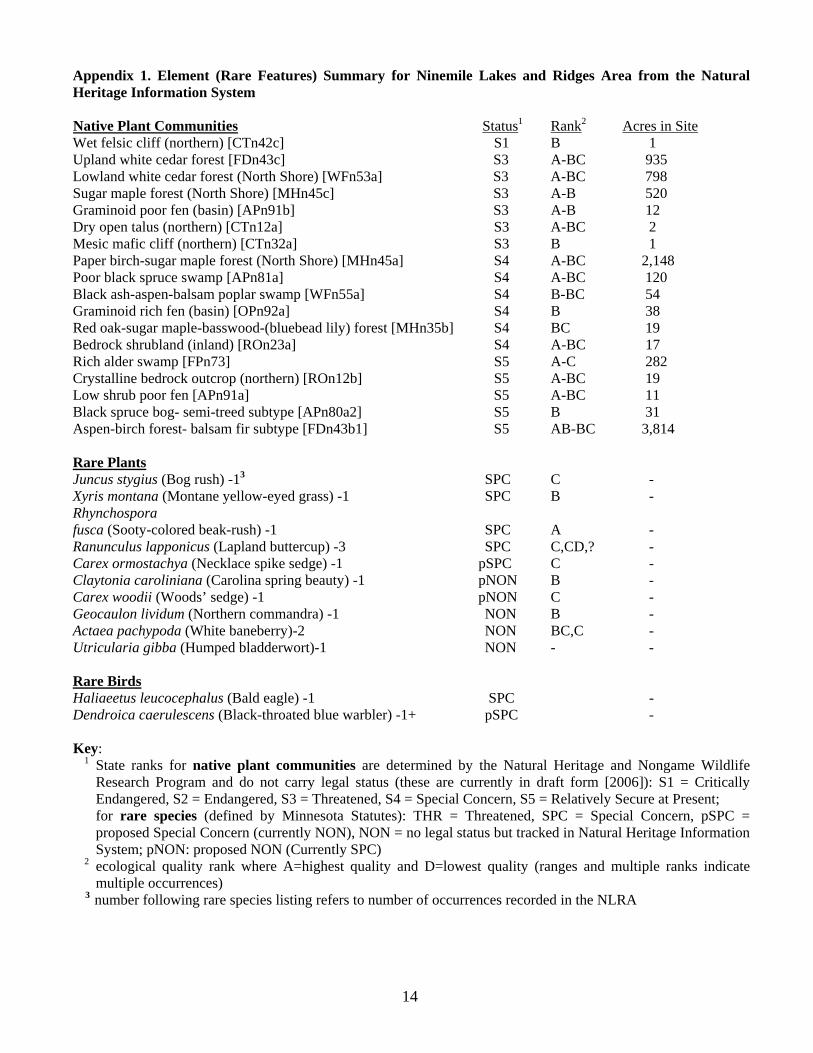
Appendix 1. Element (Rare Features) Summary for Ninemile Lakes and Ridges Area from the Natural Heritage Information System Native Plant Communities Status1 Rank2 Acres in Site Wet felsic cliff (northern) [CTn42c] S1 B 1
Upland white cedar forest [FDn43c] S3 A-BC 935 Lowland white cedar forest (North Shore) [WFn53a] S3 A-BC 798 Sugar maple forest (North Shore) [MHn45c] S3 A-B 520 Graminoid poor fen (basin) [APn91b] S3 A-B 12 Dry open talus (northern) [CTn12a] S3 A-BC 2 Mesic mafic cliff (northern) [CTn32a] S3 B 1 Paper birch-sugar maple forest (North Shore) [MHn45a] S4 A-BC 2,148 Poor black spruce swamp [APn81a] S4 A-BC 120 Black ash-aspen-balsam poplar swamp [WFn55a] S4 B-BC 54 Graminoid rich fen (basin) [OPn92a] S4 B 38 Red oak-sugar maple-basswood-(bluebead lily) forest [MHn35b] S4 BC 19 Bedrock shrubland (inland) [ROn23a] S4 A-BC 17 Rich alder swamp [FPn73] S5 A-C 282 Crystalline bedrock outcrop (northern) [ROn12b] S5 A-BC 19 Low shrub poor fen [APn91a] S5 A-BC 11 Black spruce bog- semi-treed subtype [APn80a2] S5 B 31 Aspen-birch forest- balsam fir subtype [FDn43b1] S5 AB-BC 3,814 Rare Plants Juncus stygius (Bog rush) -13 SPC C - Xyris montana (Montane yellow-eyed grass) -1 SPC B - Rhynchospora fusca (Sooty-colored beak-rush) -1 SPC A - Ranunculus lapponicus (Lapland buttercup) -3 SPC C,CD,? - Carex ormostachya (Necklace spike sedge) -1 pSPC C - Claytonia caroliniana (Carolina spring beauty) -1 pNON B - Carex woodii (Woods’ sedge) -1 pNON C - Geocaulon lividum (Northern commandra) -1 NON B - Actaea pachypoda (White baneberry)-2 NON BC,C - Utricularia gibba (Humped bladderwort)-1 NON - -
Rare Birds Haliaeetus leucocephalus (Bald eagle) -1 SPC - Dendroica caerulescens (Black-throated blue warbler) -1+ pSPC - Key: 1 State ranks for native plant communities are determined by the Natural Heritage and Nongame Wildlife
Research Program and do not carry legal status (these are currently in draft form [2006]): S1 = Critically Endangered, S2 = Endangered, S3 = Threatened, S4 = Special Concern, S5 = Relatively Secure at Present; for rare species (defined by Minnesota Statutes): THR = Threatened, SPC = Special Concern, pSPC = proposed Special Concern (currently NON), NON = no legal status but tracked in Natural Heritage Information System; pNON: proposed NON (Currently SPC)
2 ecological quality rank where A=highest quality and D=lowest quality (ranges and multiple ranks indicate multiple occurrences)
3 number following rare species listing refers to number of occurrences recorded in the NLRA
15
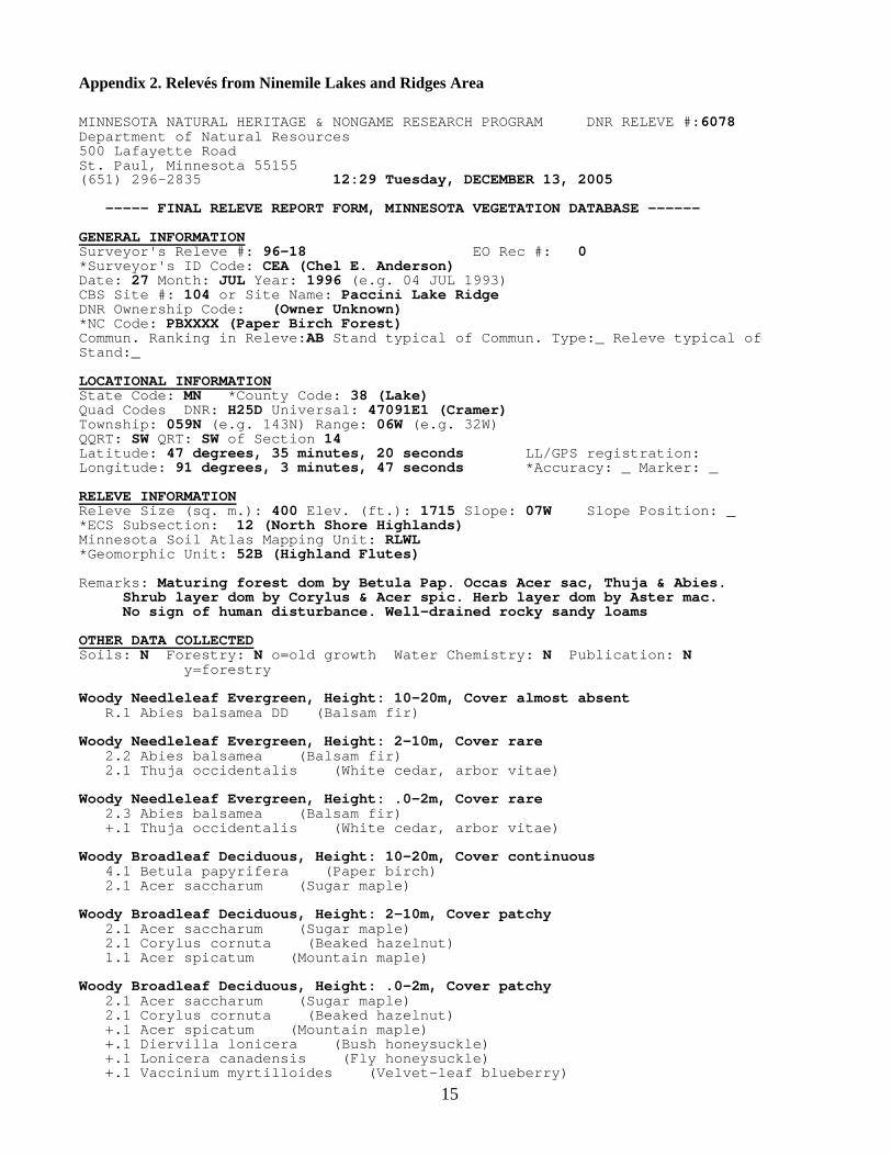
Appendix 2. Relevés from Ninemile Lakes and Ridges Area MINNESOTA NATURAL HERITAGE & NONGAME RESEARCH PROGRAM DNR RELEVE #:6078 Department of Natural Resources 500 Lafayette Road St. Paul, Minnesota 55155 (651) 296-2835 12:29 Tuesday, DECEMBER 13, 2005 ----- FINAL RELEVE REPORT FORM, MINNESOTA VEGETATION DATABASE ------ GENERAL INFORMATION Surveyor's Releve #: 96-18 EO Rec #: 0 *Surveyor's ID Code: CEA (Chel E. Anderson) Date: 27 Month: JUL Year: 1996 (e.g. 04 JUL 1993) CBS Site #: 104 or Site Name: Paccini Lake Ridge DNR Ownership Code: (Owner Unknown) *NC Code: PBXXXX (Paper Birch Forest) Commun. Ranking in Releve:AB Stand typical of Commun. Type:_ Releve typical of Stand:_ LOCATIONAL INFORMATION State Code: MN *County Code: 38 (Lake) Quad Codes DNR: H25D Universal: 47091E1 (Cramer) Township: 059N (e.g. 143N) Range: 06W (e.g. 32W) QQRT: SW QRT: SW of Section 14 Latitude: 47 degrees, 35 minutes, 20 seconds LL/GPS registration: Longitude: 91 degrees, 3 minutes, 47 seconds *Accuracy: _ Marker: _ RELEVE INFORMATION Releve Size (sq. m.): 400 Elev. (ft.): 1715 Slope: 07W Slope Position: _ *ECS Subsection: 12 (North Shore Highlands) Minnesota Soil Atlas Mapping Unit: RLWL *Geomorphic Unit: 52B (Highland Flutes) Remarks: Maturing forest dom by Betula Pap. Occas Acer sac, Thuja & Abies. Shrub layer dom by Corylus & Acer spic. Herb layer dom by Aster mac. No sign of human disturbance. Well-drained rocky sandy loams OTHER DATA COLLECTED Soils: N Forestry: N o=old growth Water Chemistry: N Publication: N y=forestry Woody Needleleaf Evergreen, Height: 10-20m, Cover almost absent R.1 Abies balsamea DD (Balsam fir) Woody Needleleaf Evergreen, Height: 2-10m, Cover rare 2.2 Abies balsamea (Balsam fir) 2.1 Thuja occidentalis (White cedar, arbor vitae) Woody Needleleaf Evergreen, Height: .0-2m, Cover rare 2.3 Abies balsamea (Balsam fir) +.1 Thuja occidentalis (White cedar, arbor vitae) Woody Broadleaf Deciduous, Height: 10-20m, Cover continuous 4.1 Betula papyrifera (Paper birch) 2.1 Acer saccharum (Sugar maple) Woody Broadleaf Deciduous, Height: 2-10m, Cover patchy 2.1 Acer saccharum (Sugar maple) 2.1 Corylus cornuta (Beaked hazelnut) 1.1 Acer spicatum (Mountain maple) Woody Broadleaf Deciduous, Height: .0-2m, Cover patchy 2.1 Acer saccharum (Sugar maple) 2.1 Corylus cornuta (Beaked hazelnut) +.1 Acer spicatum (Mountain maple) +.1 Diervilla lonicera (Bush honeysuckle) +.1 Lonicera canadensis (Fly honeysuckle) +.1 Vaccinium myrtilloides (Velvet-leaf blueberry)

16
DNR RELEVE #: 6078 continued, Page 2 Graminoid, Height: .0-2m, Cover almost absent +.2 Bromus ciliatus (Fringed brome) +.1 Carex cf. gracillima +.2 Festuca obtusa (Nodding fescue) +.1 cf. Oryzopsis (Moutain rice-grass) Forb, Height: .0-2m, Cover interrupted 3.4 Aster macrophyllus (Large-leaved aster) +.2 Anemone quinquefolia +.1 Aralia nudicaulis (Wild sarsaparilla) +.1 Clintonia borealis (Blue-bead lily) +.2 Corallorhiza maculata (Spotted coral-root) +.2 Cornus canadensis (Bunchberry) +.1 Galium triflorum (Three-flowered bedstraw) +.2 Lycopodium dendroideum (Round-branched groundpine) +.1 Maianthemum canadense (Canada mayflower) +.1 Streptopus roseus (Rose twisted-stalk) +.1 Viola renifolia (Kidney-leaf violet) Lichen/Moss, Height: .0-2m, Cover almost absent R. Unknown or Indeterminable Plant

17
MINNESOTA NATURAL HERITAGE & NONGAME RESEARCH PROGRAM DNR RELEVE #:6079 Department of Natural Resources 500 Lafayette Road St. Paul, Minnesota 55155 (651) 296-2835 12:29 Tuesday, DECEMBER 13, 2005 ----- FINAL RELEVE REPORT FORM, MINNESOTA VEGETATION DATABASE ------ GENERAL INFORMATION Surveyor's Releve #: 96-19 EO Rec #: 0 *Surveyor's ID Code: CEA (Chel E. Anderson) Date: 27 Month: JUL Year: 1996 (e.g. 04 JUL 1993) CBS Site #: 103 or Site Name: Ninemile-Moose-Crooked Lakes DNR Ownership Code: (Owner Unknown) *NC Code: PBXXXX (Paper Birch Forest) Commun. Ranking in Releve:B Stand typical of Commun. Type:_ Releve typical of Stand:_ LOCATIONAL INFORMATION State Code: MN *County Code: 38 (Lake) Quad Codes DNR: H25D Universal: 47091E1 (Cramer) Township: 059N (e.g. 143N) Range: 06W (e.g. 32W) QQRT: SE QRT: NW of Section 11 Latitude: 47 degrees, 36 minutes, 42 seconds LL/GPS registration: Longitude: 91 degrees, 3 minutes, 27 seconds *Accuracy: _ Marker: _ RELEVE INFORMATION Releve Size (sq. m.): 400 Elev. (ft.): 1765 Slope: 04N Slope Position: _ *ECS Subsection: 12 (North Shore Highlands) Minnesota Soil Atlas Mapping Unit: LLWL *Geomorphic Unit: 52A (Highland Moraine) Remarks: Mature forest dom by Betula pap. Tall shrub layer dom by Acer spic. Some conifer estab in understory. Herb layer interrupted. Rocky, shal- low sandy loam over bedrock; surface appears nutrient poor. OTHER DATA COLLECTED Soils: N Forestry: N o=old growth Water Chemistry: N Publication: N y=forestry Woody Needleleaf Evergreen, Height: 2-5m, Cover almost absent 2.1 Abies balsamea (Balsam fir) Woody Needleleaf Evergreen, Height: .0-2m, Cover barely present 2.1 Abies balsamea (Balsam fir) +.1 Picea glauca (White spruce) +.1 Thuja occidentalis (White cedar, arbor vitae) R.1 Pinus strobus (White pine) Woody Broadleaf Deciduous, Height: 10-35m, Cover continuous 5.1 Betula papyrifera (Paper birch) R.1 Acer saccharum (Sugar maple) Woody Broadleaf Deciduous, Height: 2-10m, Cover patchy 3.1 Acer spicatum (Mountain maple) +.1 Corylus cornuta (Beaked hazelnut) Woody Broadleaf Deciduous, Height: .0-2m, Cover interrupted 3.1 Acer spicatum (Mountain maple) 3.1 Corylus cornuta (Beaked hazelnut) +. Acer saccharum (Sugar maple) +.1 Diervilla lonicera (Bush honeysuckle) +.2 Lonicera canadensis (Fly honeysuckle) +.1 Ribes triste (Swamp red currant) +.1 Sorbus decora (Mountain-ash) Graminoid, Height: .0-2m, Cover almost absent +.1 Carex cf. blanda +.1 Carex gracillima +.1 Carex (Sedge)

18
DNR RELEVE #: 6079 continued, Page 2 Forb, Height: .0-2m, Cover patchy 1.3 Clintonia borealis (Blue-bead lily) +.2 Corallorhiza maculata (Spotted coral-root) +.1 Cornus canadensis (Bunchberry) +.1 Dryopteris carthusiana (Spinulose shield fern) +.2 Gymnocarpium dryopteris (Oak fern) +.2 Lycopodium dendroideum (Round-branched groundpine) +.2 Lycopodium obscurum (Groundpine) +.1 Maianthemum canadense (Canada mayflower) +.2 Rubus pubescens (Dwarf blackberry) +.1 Trientalis borealis (Starflower) Lichen/Moss, Height: .0-2m, Cover almost absent +.1 Unknown or Indeterminable Plant

19
MINNESOTA NATURAL HERITAGE & NONGAME RESEARCH PROGRAM DNR RELEVE #:8329 Department of Natural Resources 500 Lafayette Road St. Paul, Minnesota 55155 (651) 296-2835 12:29 Tuesday, DECEMBER 13, 2005 ----- FINAL RELEVE REPORT FORM, MINNESOTA VEGETATION DATABASE ------ GENERAL INFORMATION Surveyor's Releve #: MDL-001 EO Rec #: 0 *Surveyor's ID Code: MDL (Michael D. Lee) Date: 21 Month: JUN Year: 2000 (e.g. 04 JUL 1993) CBS Site #: 104 or Site Name: Paccini Lake Ridge DNR Ownership Code: 02 (U.S. Forest Service (National Forest)) *NC Code: ABXXNH (Aspen-Birch Forest Northern Hardwoods Subtype) Commun. Ranking in Releve:BC Stand typical of Commun. Type:_ Releve typical of Stand:_ LOCATIONAL INFORMATION State Code: MN *County Code: 38 (Lake) Quad Codes DNR: H25D Universal: 47091E1 (Cramer) Township: 059N (e.g. 143N) Range: 06W (e.g. 32W) QQRT: NE QRT: NW of Section 34 Latitude: 47 degrees, 33 minutes, 26 seconds LL/GPS registration: Longitude: 91 degrees, 4 minutes, 37 seconds *Accuracy: _ Marker: _ RELEVE INFORMATION Releve Size (sq. m.): 400 Elev. (ft.): 1600 Slope: 08SE Slope Position: _ *ECS Subsection: 12 (North Shore Highlands) Minnesota Soil Atlas Mapping Unit: *Geomorphic Unit: Remarks: Upper part of gradual to moderately steep SE-facing, 70 ft slope above Paccini Lk. Fairly rugged terrain. 50 ft above lake. Soil rocky loam, scattered surface boulders, bedrock exposed on knobs upslope OTHER DATA COLLECTED Soils: N Forestry: N o=old growth Water Chemistry: N Publication: N y=forestry * = Variables with computerized code dictionaries (See Releve Handbook) Woody Needleleaf Evergreen, Height: 2-5m, Cover almost absent +. Abies balsamea (Balsam fir) Woody Needleleaf Evergreen, Height: .0-2m, Cover barely present 1. Abies balsamea (Balsam fir) Woody Broadleaf Deciduous, Height: 5-20m, Cover continuous 3. Acer saccharum (Sugar maple) 3. Betula papyrifera (Paper birch) 1. Acer rubrum (Red maple) R. Populus tremuloides OP (Quaking aspen) Woody Broadleaf Deciduous, Height: 2-5m, Cover rare 2. Acer saccharum (Sugar maple) 1. Corylus cornuta (Beaked hazelnut) Woody Broadleaf Deciduous, Height: .0-2m, Cover interrupted 3. Acer saccharum (Sugar maple) 2. Corylus cornuta (Beaked hazelnut) +. Acer rubrum (Red maple) +. Acer spicatum (Mountain maple) +. Amelanchier (Juneberry; Serviceberry; Saska) +. Cornus alternifolia (Pagoda dogwood) +. Lonicera canadensis (Fly honeysuckle) +. Populus tremuloides (Quaking aspen) Graminoid, Height: .0-.5m, Cover rare
1. Carex pedunculata

20
DNR RELEVE #: 8329 continued, Page 2 1. Oryzopsis asperifolia (Moutain rice-grass) +. Unknown or Indeterminable Plant (Brome-Grass) +. Carex peckii +. cf. Cinna (Wood reedgrass) R. Carex arctata Forb, Height: .0-.5m, Cover patchy 2. Aster macrophyllus (Large-leaved aster) 2. Clintonia borealis (Blue-bead lily) 1. Aralia nudicaulis (Wild sarsaparilla) 1. Maianthemum canadense (Canada mayflower) 1. Polygonatum pubescens (Hairy Solomon's-seal) 1. Pteridium aquilinum (Bracken) 1. Streptopus roseus (Rose twisted-stalk) +. Actaea cf. rubra (Red baneberry) +. Anemone quinquefolia +. Galium triflorum (Three-flowered bedstraw) +. Trientalis borealis (Starflower) +. Viola pubescens (Smooth yellow violet) R. Monotropa uniflora (Indian pipe) Lichen/Moss, Height: .0-.1m, Cover almost absent 1. Unknown or Indeterminable Plant

21
MINNESOTA NATURAL HERITAGE & NONGAME RESEARCH PROGRAM DNR RELEVE #:8482 Department of Natural Resources 500 Lafayette Road St. Paul, Minnesota 55155 (651) 296-2835 12:29 Tuesday, DECEMBER 13, 2005 ----- FINAL RELEVE REPORT FORM, MINNESOTA VEGETATION DATABASE ------ GENERAL INFORMATION Surveyor's Releve #: MDL01-6 EO Rec #: 0 *Surveyor's ID Code: MDL (Michael D. Lee) Date: 7 Month: JUN Year: 2001 (e.g. 04 JUL 1993) CBS Site #: 103 or Site Name: Hare Lake Ridge DNR Ownership Code: (Owner Unknown) *NC Code: NHNOXX (Northern Hardwood Forest (Northern)) Commun. Ranking in Releve:B Stand typical of Commun. Type:_ Releve typical of Stand:_ LOCATIONAL INFORMATION State Code: MN *County Code: 38 (Lake) Quad Codes DNR: H25D Universal: 47091E1 (Cramer) Township: 059N (e.g. 143N) Range: 06W (e.g. 32W) QQRT: SW QRT: SE of Section 11 Latitude: 47 degrees, 36 minutes, 16 seconds LL/GPS registration: Longitude: 91 degrees, 3 minutes, 8 seconds *Accuracy: _ Marker: _ RELEVE INFORMATION Releve Size (sq. m.): 400 Elev. (ft.): 1795 Slope: 03E Slope Position: _ *ECS Subsection: 12 (North Shore Highlands) Minnesota Soil Atlas Mapping Unit: *Geomorphic Unit: Remarks: MATURE STAND ON RIDGE WEST SIDE OF HARE LAKE. TREES 30-45CM DBH. NO STUMPS. LITTLE CWD. SNAGS OCCAS. SCATTERED SURFACE ROCKS/BOULDERS. GRADES TO P BIRCH DOWNSLOPE TOWARD LAKE. THICK DUFF LAYER. OTHER DATA COLLECTED Soils: Y Forestry: o=old growth Water Chemistry: Publication: y=forestry * = Variables with computerized code dictionaries (See Releve Handbook) Woody Needleleaf Evergreen, Height: 5-10m, Cover barely present 1. Abies balsamea (Balsam fir) +. Thuja occidentalis (White cedar, arbor vitae) Woody Needleleaf Evergreen, Height: 2-5m, Cover almost absent +. Abies balsamea (Balsam fir) Woody Needleleaf Evergreen, Height: .0-2m, Cover almost absent +. Abies balsamea (Balsam fir) Woody Broadleaf Deciduous, Height: 5-35m, Cover continuous 4. Acer saccharum (Sugar maple) 1. Betula alleghaniensis 1. Betula papyrifera (Paper birch) Woody Broadleaf Deciduous, Height: 2-5m, Cover interrupted 4. Acer saccharum (Sugar maple) Woody Broadleaf Deciduous, Height: .0-2m, Cover continuous 5. Acer saccharum (Sugar maple) +. Acer spicatum (Mountain maple) Graminoid, Height: .0-.5m, Cover almost absent +. Carex pedunculata +. Oryzopsis asperifolia (Moutain rice-grass) R. Carex arctata Forb, Height: .0-.5m, Cover rare 1. Clintonia borealis (Blue-bead lily)

22
DNR RELEVE #: 8482 continued, Page 2 Forb, Height: .0-.5m, Cover rare (continued) 1. Viola cf. renifolia (Kidney-leaf violet) +. Aralia nudicaulis (Wild sarsaparilla) +. Aster macrophyllus (Large-leaved aster) +. Dryopteris intermedia Group (Glandular wood fern) +. Galium triflorum (Three-flowered bedstraw) +. Lycopodium lucidulum (Shining clubmoss) +. Maianthemum canadense (Canada mayflower) +. Polygonatum pubescens (Hairy Solomon's-seal) +. Streptopus roseus (Rose twisted-stalk) R. Lycopodium dendroideum (Round-branched groundpine) R. Trientalis borealis (Starflower)

23
MINNESOTA NATURAL HERITAGE & NONGAME RESEARCH PROGRAM DNR RELEVE #:8484 Department of Natural Resources 500 Lafayette Road St. Paul, Minnesota 55155 (651) 296-2835 12:29 Tuesday, DECEMBER 13, 2005 ----- FINAL RELEVE REPORT FORM, MINNESOTA VEGETATION DATABASE ------ GENERAL INFORMATION Surveyor's Releve #: MDL01-8 EO Rec #: 0 *Surveyor's ID Code: MDL (Michael D. Lee) Date: 12 Month: JUN Year: 2001 (e.g. 04 JUL 1993) CBS Site #: 103 or Site Name: Moose Lake NW DNR Ownership Code: 02 (U.S. Forest Service (National Forest)) *NC Code: ABXXSF (Aspen-Birch Forest Spruce-Fir Subtype) Commun. Ranking in Releve:B Stand typical of Commun. Type:_ Releve typical of Stand:_ LOCATIONAL INFORMATION State Code: MN *County Code: 38 (Lake) Quad Codes DNR: H25C Universal: 47091E2 (Cabin Lake) Township: 059N (e.g. 143N) Range: 07W (e.g. 32W) QQRT: SW QRT: NE of Section 25 Latitude: 47 degrees, 34 minutes, 3 seconds LL/GPS registration: Longitude: 91 degrees, 9 minutes, 26 seconds *Accuracy: _ Marker: _ RELEVE INFORMATION Releve Size (sq. m.): 400 Elev. (ft.): 1710 Slope: 01S Slope Position: _ *ECS Subsection: 12 (North Shore Highlands) Minnesota Soil Atlas Mapping Unit: *Geomorphic Unit: Remarks: MATURE/MATURING STAND IN LEVEL TO GENTLY-ROLLING TERRAIN NW OF MOOSE LAKE. TREES 15-30CM DBH, ACER & BETULA OFTEN MULTI-STEMMED. LITTLE CWD A FEW VERY DECAYED STUMPS. SOIL A BROWN, ROCKY, SANDY-LOAM. OTHER DATA COLLECTED Soils: Forestry: o=old growth Water Chemistry: Publication: y=forestry * = Variables with computerized code dictionaries (See Releve Handbook) Woody Needleleaf Evergreen, Height: 5-20m, Cover patchy 3. Abies balsamea (Balsam fir) +. Picea glauca (White spruce) Woody Needleleaf Evergreen, Height: 2-5m, Cover barely present +. Abies balsamea (Balsam fir) R. Pinus strobus (White pine) Woody Needleleaf Evergreen, Height: .0-2m, Cover barely present +. Abies balsamea (Balsam fir) Woody Broadleaf Deciduous, Height: 5-20m, Cover continuous 4. Betula papyrifera (Paper birch) 2. Populus tremuloides (Quaking aspen) 1. Acer rubrum (Red maple) Woody Broadleaf Deciduous, Height: 2-5m, Cover patchy 3. Acer spicatum (Mountain maple) 1. Corylus cornuta (Beaked hazelnut) +. Acer rubrum (Red maple) Woody Broadleaf Deciduous, Height: .0-2m, Cover rare 2. Acer spicatum (Mountain maple) 2. Corylus cornuta (Beaked hazelnut) +. Acer rubrum (Red maple) +. Betula papyrifera (Paper birch) +. Lonicera canadensis (Fly honeysuckle) +. Populus tremuloides (Quaking aspen)

24
DNR RELEVE #: 8484 continued, Page 2 Graminoid, Height: .0-.5m, Cover barely present 1. Oryzopsis asperifolia (Moutain rice-grass) +. Carex pedunculata Forb, Height: .0-.5m, Cover continuous 4. Aster macrophyllus (Large-leaved aster) 1. Clintonia borealis (Blue-bead lily) 1. Maianthemum canadense (Canada mayflower) 1. Pteridium aquilinum (Bracken) +. Anemone quinquefolia +. Aralia nudicaulis (Wild sarsaparilla) +. Cornus canadensis (Bunchberry) +. Galium triflorum (Three-flowered bedstraw) +. Goodyera tesselata (Rattlesnake-plantain) +. Lycopodium dendroideum (Round-branched groundpine) +. Streptopus roseus (Rose twisted-stalk) +. Trientalis borealis (Starflower)

25
MINNESOTA NATURAL HERITAGE & NONGAME RESEARCH PROGRAM DNR RELEVE #:8485 Department of Natural Resources 500 Lafayette Road St. Paul, Minnesota 55155 (651) 296-2835 12:29 Tuesday, DECEMBER 13, 2005 ----- FINAL RELEVE REPORT FORM, MINNESOTA VEGETATION DATABASE ------ GENERAL INFORMATION Surveyor's Releve #: MDL01-9 EO Rec #: 0 *Surveyor's ID Code: MDL (Michael D. Lee) Date: 12 Month: JUN Year: 2001 (e.g. 04 JUL 1993) CBS Site #: 103 or Site Name: Moose Lake North DNR Ownership Code: 20 (Mn Dnr Forestry (State Forest)) *NC Code: ABXXSF (Aspen-Birch Forest Spruce-Fir Subtype) Commun. Ranking in Releve:B Stand typical of Commun. Type:_ Releve typical of Stand:_ LOCATIONAL INFORMATION State Code: MN *County Code: 38 (Lake) Quad Codes DNR: H25C Universal: 47091E2 (Cabin Lake) Township: 059N (e.g. 143N) Range: 06W (e.g. 32W) QQRT: SE QRT: NE of Section 30 Latitude: 47 degrees, 34 minutes, 5 seconds LL/GPS registration: Longitude: 91 degrees, 7 minutes, 55 seconds *Accuracy: _ Marker: _ RELEVE INFORMATION Releve Size (sq. m.): 400 Elev. (ft.): 1645 Slope: 02NE Slope Position: _ *ECS Subsection: 12 (North Shore Highlands) Minnesota Soil Atlas Mapping Unit: *Geomorphic Unit: Remarks: MATURING TO MATURE STAND ON LEVEL, NARROW FINGER OF LAND BETWEEN CEDAR SWAMPS ON N SIDE OF MOOSE LAKE. PINUS 38-51CM DBH, PICEA 20-35CM THUJA 10-18CM. NO STUMPS. LITTLE CWD. PINUS RARE IN SURR. AREA. OTHER DATA COLLECTED Soils: Y Forestry: o=old growth Water Chemistry: Publication: y=forestry * = Variables with computerized code dictionaries (See Releve Handbook) Woody Needleleaf Evergreen, Height: 10-35m, Cover patchy 3. Picea glauca (White spruce) 1. Pinus strobus (White pine) +. Thuja occidentalis (White cedar, arbor vitae) Woody Needleleaf Evergreen, Height: 5-10m, Cover patchy 2. Abies balsamea (Balsam fir) 2. Thuja occidentalis (White cedar, arbor vitae) +. Picea glauca (White spruce) Woody Needleleaf Evergreen, Height: 2-5m, Cover rare 2. Abies balsamea (Balsam fir) +. Picea glauca (White spruce) Woody Needleleaf Evergreen, Height: .0-2m, Cover barely present 1. Abies balsamea (Balsam fir) 1. Thuja occidentalis (White cedar, arbor vitae) +. Picea glauca (White spruce) Woody Broadleaf Deciduous, Height: 5-20m, Cover patchy 2. Betula papyrifera (Paper birch) 2. Populus tremuloides (Quaking aspen) Woody Broadleaf Deciduous, Height: 2-5m, Cover almost absent +. Betula papyrifera (Paper birch) +. Corylus cornuta (Beaked hazelnut) Woody Broadleaf Deciduous, Height: .0-2m, Cover patchy 2. Diervilla lonicera (Bush honeysuckle)
26
DNR RELEVE #: 8485 continued, Page 2
Woody Broadleaf Deciduous, Height: .0-2m, Cover patchy (continued) 1. Vaccinium myrtilloides (Velvet-leaf blueberry) +. Amelanchier (Saskatoon) +. Corylus cornuta (Beaked hazelnut) +. Lonicera canadensis (Fly honeysuckle) +. Prunus virginiana (Chokecherry) +. Sorbus decora Group (Mountain-ash) R. Rosa (Prickly rose) Climber, Height: .0-.5m, Cover almost absent +. Lonicera hirsuta (Hairy honeysuckle) Graminoid, Height: .0-.5m, Cover barely present 1. Luzula acuminata (Woodrush) 1. Oryzopsis asperifolia (Moutain rice-grass) +. Carex pedunculata +. Schizachne purpurascens (False melic grass) R. Carex arctata R. cf. Cinna (Wood reedgrass) Forb, Height: .0-.5m, Cover interrupted 3. Aralia nudicaulis (Wild sarsaparilla) 2. Aster macrophyllus (Large-leaved aster) 1. Anemone quinquefolia 1. Maianthemum canadense (Canada mayflower) +. Clintonia borealis (Blue-bead lily) +. Coptis groenlandica (Goldthread) +. Cornus canadensis (Bunchberry) +. Galium triflorum (Three-flowered bedstraw) +. Linnaea borealis (Twin-flower) +. Lycopodium clavatum (Running clubmoss) +. Lycopodium dendroideum (Round-branched groundpine) +. Melampyrum lineare (Cow-wheat) +. Rubus pubescens (Dwarf blackberry) +. Streptopus roseus var. longipes (Rose twisted-stalk) +. Trientalis borealis (Starflower) +. Viola cf. renifolia (Kidney-leaf violet) R. Corallorhiza trifida (Early coral-root) Lichen/Moss, Height: .0-.1m, Cover patchy 3. Unknown or Indeterminable Plant

27
MINNESOTA NATURAL HERITAGE & NONGAME RESEARCH PROGRAM DNR RELEVE #:8486 Department of Natural Resources 500 Lafayette Road St. Paul, Minnesota 55155 (651) 296-2835 12:29 Tuesday, DECEMBER 13, 2005 ----- FINAL RELEVE REPORT FORM, MINNESOTA VEGETATION DATABASE ------ GENERAL INFORMATION Surveyor's Releve #: MDL01-10 EO Rec #: 0 *Surveyor's ID Code: MDL (Michael D. Lee) Date: 12 Month: JUN Year: 2001 (e.g. 04 JUL 1993) CBS Site #: 103 or Site Name: Moose Lake North DNR Ownership Code: 20 (Mn Dnr Forestry (State Forest)) *NC Code: WCXXXX (White Cedar Swamp) Commun. Ranking in Releve:B Stand typical of Commun. Type:_ Releve typical of Stand:_ LOCATIONAL INFORMATION State Code: MN *County Code: 38 (Lake) Quad Codes DNR: H25C Universal: 47091E2 (Cabin Lake) Township: 059N (e.g. 143N) Range: 06W (e.g. 32W) QQRT: SW QRT: NW of Section 29 Latitude: 47 degrees, 34 minutes, 8 seconds LL/GPS registration: Longitude: 91 degrees, 7 minutes, 44 seconds *Accuracy: _ Marker: _ RELEVE INFORMATION Releve Size (sq. m.): 400 Elev. (ft.): 1605 Slope: 00LV Slope Position: _ *ECS Subsection: 12 (North Shore Highlands) Minnesota Soil Atlas Mapping Unit: *Geomorphic Unit: Remarks: MATURE STAND IN BROAD CEDAR/SPRUCE WETLAND COMPLEX NE OF MOOSE L. TREE 15-42CM DBH, OFTEN LEANING. UNEVEN SUBSTRATE WITH 30% WET TROUGHS. NO MOVING WATER. CWD OCCAS. FEW SNAGS. A FEW VERY OLD STUMPS. OTHER DATA COLLECTED Soils: Y Forestry: o=old growth Water Chemistry: Publication: y=forestry * = Variables with computerized code dictionaries (See Releve Handbook) Woody Needleleaf Evergreen, Height: 10-20m, Cover almost absent R. Picea mariana (Black spruce) Woody Needleleaf Evergreen, Height: 5-10m, Cover interrupted 4. Thuja occidentalis (White cedar, arbor vitae) +. Picea mariana (Black spruce) Woody Needleleaf Evergreen, Height: 2-5m, Cover barely present 1. Abies balsamea (Balsam fir) 1. Thuja occidentalis (White cedar, arbor vitae) Woody Needleleaf Evergreen, Height: .0-2m, Cover rare 2. Abies balsamea (Balsam fir) 1. Thuja occidentalis (White cedar, arbor vitae) +. Taxus canadensis (Canada yew) Woody Broadleaf Deciduous, Height: 2-5m, Cover barely present 1. Alnus incana (Speckled alder) Woody Broadleaf Deciduous, Height: .0-2m, Cover barely present 1. Alnus incana (Speckled alder) +. Acer spicatum (Mountain maple) +. Amelanchier (Juneberry; Serviceberry; Saska) +. Corylus cornuta (Beaked hazelnut) +. Lonicera villosa (Mountain Fly-honeysuckle) R. Cornus stolonifera (Red-osier dogwood) R. Lonicera canadensis (Fly honeysuckle)

28
DNR RELEVE #: 8486 continued, Page 2 Graminoid, Height: .0-.5m, Cover patchy 3. Carex vaginata 1. Carex pedunculata +. Carex disperma +. Carex leptalea +. Glyceria cf. striata (Fowl manna grass) Forb, Height: .0-.5m, Cover patchy 1. Equisetum scirpoides (Dwarf scouring-rush) +. Anemone quinquefolia +. Aster macrophyllus (Large-leaved aster) +. Aster +. Clintonia borealis (Blue-bead lily) +. Coptis groenlandica (Goldthread) +. Cornus canadensis (Bunchberry) NON +. Geocaulon lividum ## (Northern comandra) +. Linnaea borealis (Twin-flower) +. Listera cordata (Heartleaf twayblade) +. Mertensia paniculata (Tall lungwort) +. Mitella nuda (Miterwort, naked bishop's-cap) +. Petasites frigidus var. palmatus (Sweet coltsfoot) +. Platanthera obtusata (Blunt-leaved orchid) +. Pyrola secunda (One-sided pyrola) SPC +. Ranunculus lapponicus ## (Lapland buttercup) +. Rubus pubescens (Dwarf blackberry) +. Smilacina trifolia (Three-leaved false Solomon's-s) +. Trientalis borealis (Starflower) +. Viola cf. renifolia (Kidney-leaf violet) R. Goodyera repens OP (Rattlesnake-plantain) Woody Broadleaf Evergreen, Height: .0-.5m, Cover barely present 1. Gaultheria hispidula (Creeping snowberry) +. Ledum groenlandicum (Labrador tea)
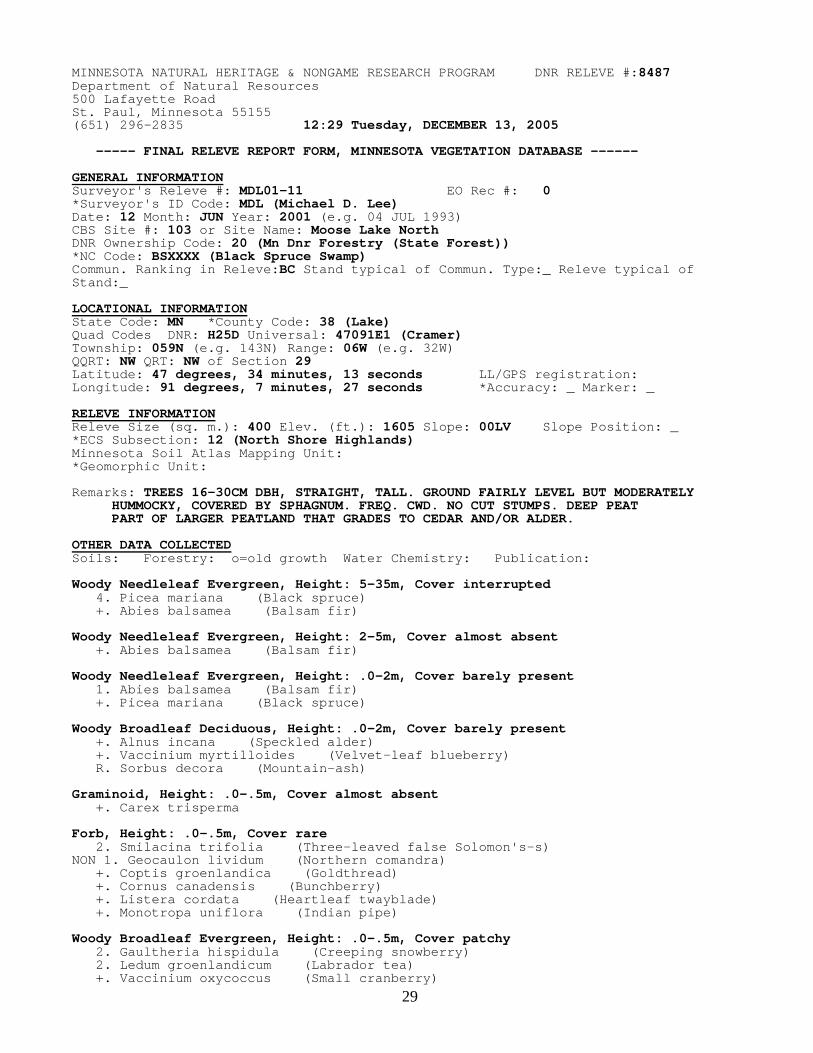
29
MINNESOTA NATURAL HERITAGE & NONGAME RESEARCH PROGRAM DNR RELEVE #:8487 Department of Natural Resources 500 Lafayette Road St. Paul, Minnesota 55155 (651) 296-2835 12:29 Tuesday, DECEMBER 13, 2005 ----- FINAL RELEVE REPORT FORM, MINNESOTA VEGETATION DATABASE ------ GENERAL INFORMATION Surveyor's Releve #: MDL01-11 EO Rec #: 0 *Surveyor's ID Code: MDL (Michael D. Lee) Date: 12 Month: JUN Year: 2001 (e.g. 04 JUL 1993) CBS Site #: 103 or Site Name: Moose Lake North DNR Ownership Code: 20 (Mn Dnr Forestry (State Forest)) *NC Code: BSXXXX (Black Spruce Swamp) Commun. Ranking in Releve:BC Stand typical of Commun. Type:_ Releve typical of Stand:_ LOCATIONAL INFORMATION State Code: MN *County Code: 38 (Lake) Quad Codes DNR: H25D Universal: 47091E1 (Cramer) Township: 059N (e.g. 143N) Range: 06W (e.g. 32W) QQRT: NW QRT: NW of Section 29 Latitude: 47 degrees, 34 minutes, 13 seconds LL/GPS registration: Longitude: 91 degrees, 7 minutes, 27 seconds *Accuracy: _ Marker: _ RELEVE INFORMATION Releve Size (sq. m.): 400 Elev. (ft.): 1605 Slope: 00LV Slope Position: _ *ECS Subsection: 12 (North Shore Highlands) Minnesota Soil Atlas Mapping Unit: *Geomorphic Unit: Remarks: TREES 16-30CM DBH, STRAIGHT, TALL. GROUND FAIRLY LEVEL BUT MODERATELY HUMMOCKY, COVERED BY SPHAGNUM. FREQ. CWD. NO CUT STUMPS. DEEP PEAT PART OF LARGER PEATLAND THAT GRADES TO CEDAR AND/OR ALDER. OTHER DATA COLLECTED Soils: Forestry: o=old growth Water Chemistry: Publication: Woody Needleleaf Evergreen, Height: 5-35m, Cover interrupted 4. Picea mariana (Black spruce) +. Abies balsamea (Balsam fir) Woody Needleleaf Evergreen, Height: 2-5m, Cover almost absent +. Abies balsamea (Balsam fir) Woody Needleleaf Evergreen, Height: .0-2m, Cover barely present 1. Abies balsamea (Balsam fir) +. Picea mariana (Black spruce) Woody Broadleaf Deciduous, Height: .0-2m, Cover barely present +. Alnus incana (Speckled alder) +. Vaccinium myrtilloides (Velvet-leaf blueberry) R. Sorbus decora (Mountain-ash) Graminoid, Height: .0-.5m, Cover almost absent +. Carex trisperma Forb, Height: .0-.5m, Cover rare 2. Smilacina trifolia (Three-leaved false Solomon's-s) NON 1. Geocaulon lividum (Northern comandra) +. Coptis groenlandica (Goldthread) +. Cornus canadensis (Bunchberry) +. Listera cordata (Heartleaf twayblade) +. Monotropa uniflora (Indian pipe) Woody Broadleaf Evergreen, Height: .0-.5m, Cover patchy 2. Gaultheria hispidula (Creeping snowberry) 2. Ledum groenlandicum (Labrador tea) +. Vaccinium oxycoccus (Small cranberry)

30
MINNESOTA NATURAL HERITAGE & NONGAME RESEARCH PROGRAM DNR RELEVE #:8489 Department of Natural Resources 500 Lafayette Road St. Paul, Minnesota 55155 (651) 296-2835 12:29 Tuesday, DECEMBER 13, 2005 ----- FINAL RELEVE REPORT FORM, MINNESOTA VEGETATION DATABASE ------ GENERAL INFORMATION Surveyor's Releve #: MDL01-13 EO Rec #: 0 *Surveyor's ID Code: MDL (Michael D. Lee) Date: 14 Month: JUN Year: 2001 (e.g. 04 JUL 1993) CBS Site #: 104 or Site Name: Paccini Lake Ridge SE DNR Ownership Code: 02 (U.S. Forest Service (National Forest)) *NC Code: OANERM (Oak Forest (Northeast) Red Maple Subtype) Commun. Ranking in Releve:BC Stand typical of Commun. Type:_ Releve typical of Stand:_ LOCATIONAL INFORMATION State Code: MN *County Code: 38 (Lake) Quad Codes DNR: H25D Universal: 47091E1 (Cramer) Township: 059N (e.g. 143N) Range: 06W (e.g. 32W) QQRT: NW QRT: SW of Section 35 Latitude: 47 degrees, 32 minutes, 55 seconds LL/GPS registration: Longitude: 91 degrees, 3 minutes, 35 seconds *Accuracy: _ Marker: _ RELEVE INFORMATION Releve Size (sq. m.): 400 Elev. (ft.): 1740 Slope: 15E Slope Position: _ *ECS Subsection: 12 (North Shore Highlands) Minnesota Soil Atlas Mapping Unit: *Geomorphic Unit: Remarks: UPPER SLOPE OF STEEP 320-FT E-FACING RIDGE N OF RR TUNNEL. LOCALIZED STAND EXTENDS 100 FT DOWNSLOPE. Q. RUBRA 20-38CM DBH, A. SACCHARUM 10- 35CM. NO STUMPS. FIRE SCARS PRESENT. SOIL SHALLOW TO BEDROCK OTHER DATA COLLECTED Soils: Forestry: o=old growth Water Chemistry: Publication: y=forestry * = Variables with computerized code dictionaries (See Releve Handbook) Woody Broadleaf Deciduous, Height: 5-20m, Cover continuous 4. Quercus rubra (Northern red oak) 2. Acer saccharum (Sugar maple) 1. Acer rubrum (Red maple) +. Quercus rubra DD (Northern red oak) Woody Broadleaf Deciduous, Height: 2-5m, Cover rare 2. Acer saccharum (Sugar maple) Woody Broadleaf Deciduous, Height: .0-2m, Cover interrupted 4. Acer saccharum (Sugar maple) 1. Prunus virginiana (Chokecherry) +. Acer rubrum (Red maple) +. Amelanchier (Juneberry; Serviceberry; Saska) +. Lonicera canadensis (Fly honeysuckle) +. Quercus rubra (Northern red oak) Graminoid, Height: .0-.5m, Cover barely present +. Carex arctata +. Carex communis +. Carex deweyana NON +. Carex ormostachya ## +. Carex peckii +. Carex pedunculata +. Milium effusum (Woodland millet grass) +. Oryzopsis asperifolia (Moutain rice-grass)
Forb, Height: .0-.5m, Cover rare 1. Streptopus roseus (Rose twisted-stalk)
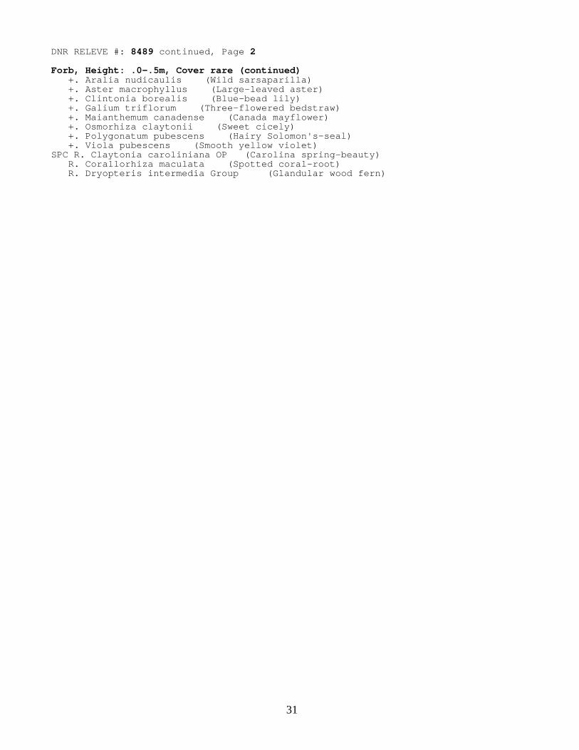
31
DNR RELEVE #: 8489 continued, Page 2 Forb, Height: .0-.5m, Cover rare (continued) +. Aralia nudicaulis (Wild sarsaparilla) +. Aster macrophyllus (Large-leaved aster) +. Clintonia borealis (Blue-bead lily) +. Galium triflorum (Three-flowered bedstraw) +. Maianthemum canadense (Canada mayflower) +. Osmorhiza claytonii (Sweet cicely) +. Polygonatum pubescens (Hairy Solomon's-seal) +. Viola pubescens (Smooth yellow violet) SPC R. Claytonia caroliniana OP (Carolina spring-beauty) R. Corallorhiza maculata (Spotted coral-root) R. Dryopteris intermedia Group (Glandular wood fern)
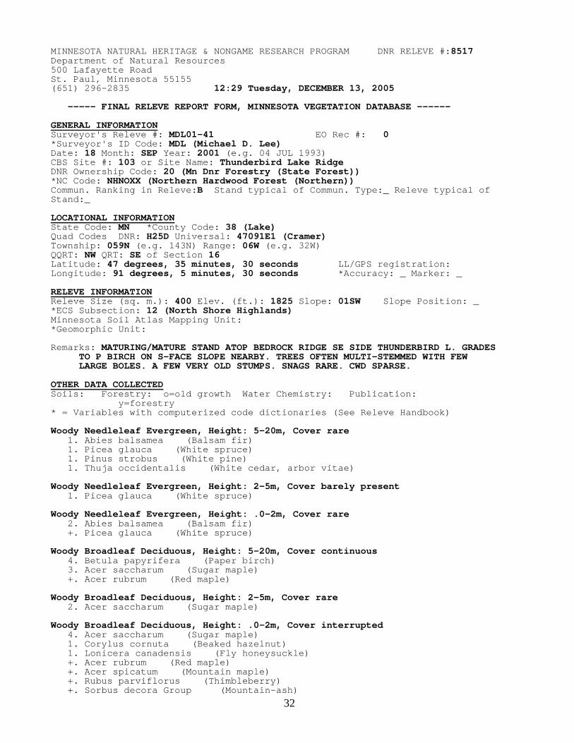
32
MINNESOTA NATURAL HERITAGE & NONGAME RESEARCH PROGRAM DNR RELEVE #:8517 Department of Natural Resources 500 Lafayette Road St. Paul, Minnesota 55155 (651) 296-2835 12:29 Tuesday, DECEMBER 13, 2005 ----- FINAL RELEVE REPORT FORM, MINNESOTA VEGETATION DATABASE ------ GENERAL INFORMATION Surveyor's Releve #: MDL01-41 EO Rec #: 0 *Surveyor's ID Code: MDL (Michael D. Lee) Date: 18 Month: SEP Year: 2001 (e.g. 04 JUL 1993) CBS Site #: 103 or Site Name: Thunderbird Lake Ridge DNR Ownership Code: 20 (Mn Dnr Forestry (State Forest)) *NC Code: NHNOXX (Northern Hardwood Forest (Northern)) Commun. Ranking in Releve:B Stand typical of Commun. Type:_ Releve typical of Stand:_ LOCATIONAL INFORMATION State Code: MN *County Code: 38 (Lake) Quad Codes DNR: H25D Universal: 47091E1 (Cramer) Township: 059N (e.g. 143N) Range: 06W (e.g. 32W) QQRT: NW QRT: SE of Section 16 Latitude: 47 degrees, 35 minutes, 30 seconds LL/GPS registration: Longitude: 91 degrees, 5 minutes, 30 seconds *Accuracy: _ Marker: _ RELEVE INFORMATION Releve Size (sq. m.): 400 Elev. (ft.): 1825 Slope: 01SW Slope Position: _ *ECS Subsection: 12 (North Shore Highlands) Minnesota Soil Atlas Mapping Unit: *Geomorphic Unit: Remarks: MATURING/MATURE STAND ATOP BEDROCK RIDGE SE SIDE THUNDERBIRD L. GRADES TO P BIRCH ON S-FACE SLOPE NEARBY. TREES OFTEN MULTI-STEMMED WITH FEW LARGE BOLES. A FEW VERY OLD STUMPS. SNAGS RARE. CWD SPARSE. OTHER DATA COLLECTED Soils: Forestry: o=old growth Water Chemistry: Publication: y=forestry * = Variables with computerized code dictionaries (See Releve Handbook) Woody Needleleaf Evergreen, Height: 5-20m, Cover rare 1. Abies balsamea (Balsam fir) 1. Picea glauca (White spruce) 1. Pinus strobus (White pine) 1. Thuja occidentalis (White cedar, arbor vitae) Woody Needleleaf Evergreen, Height: 2-5m, Cover barely present 1. Picea glauca (White spruce) Woody Needleleaf Evergreen, Height: .0-2m, Cover rare 2. Abies balsamea (Balsam fir) +. Picea glauca (White spruce) Woody Broadleaf Deciduous, Height: 5-20m, Cover continuous 4. Betula papyrifera (Paper birch) 3. Acer saccharum (Sugar maple) +. Acer rubrum (Red maple) Woody Broadleaf Deciduous, Height: 2-5m, Cover rare 2. Acer saccharum (Sugar maple) Woody Broadleaf Deciduous, Height: .0-2m, Cover interrupted 4. Acer saccharum (Sugar maple) 1. Corylus cornuta (Beaked hazelnut) 1. Lonicera canadensis (Fly honeysuckle) +. Acer rubrum (Red maple) +. Acer spicatum (Mountain maple) +. Rubus parviflorus (Thimbleberry)
+. Sorbus decora Group (Mountain-ash)

33
DNR RELEVE #: 8517 continued, Page 2
Graminoid, Height: .0-.5m, Cover barely present 1. Carex pedunculata +. Oryzopsis asperifolia (Moutain rice-grass) R. Carex cf. leptonervia Forb, Height: .0-.5m, Cover interrupted 3. Aster macrophyllus (Large-leaved aster) 1. Aralia nudicaulis (Wild sarsaparilla) 1. Lycopodium dendroideum (Round-branched groundpine) +. Anemone quinquefolia +. Clintonia borealis (Blue-bead lily) +. Galium triflorum (Three-flowered bedstraw) +. Lycopodium lucidulum (Shining clubmoss) +. Maianthemum canadense (Canada mayflower) +. Polygonatum pubescens (Hairy Solomon's-seal) +. Streptopus roseus (Rose twisted-stalk) +. Trientalis borealis (Starflower) +. Viola cf. renifolia (Kidney-leaf violet) R. Lycopodium annotinum (Bristly clubmoss)
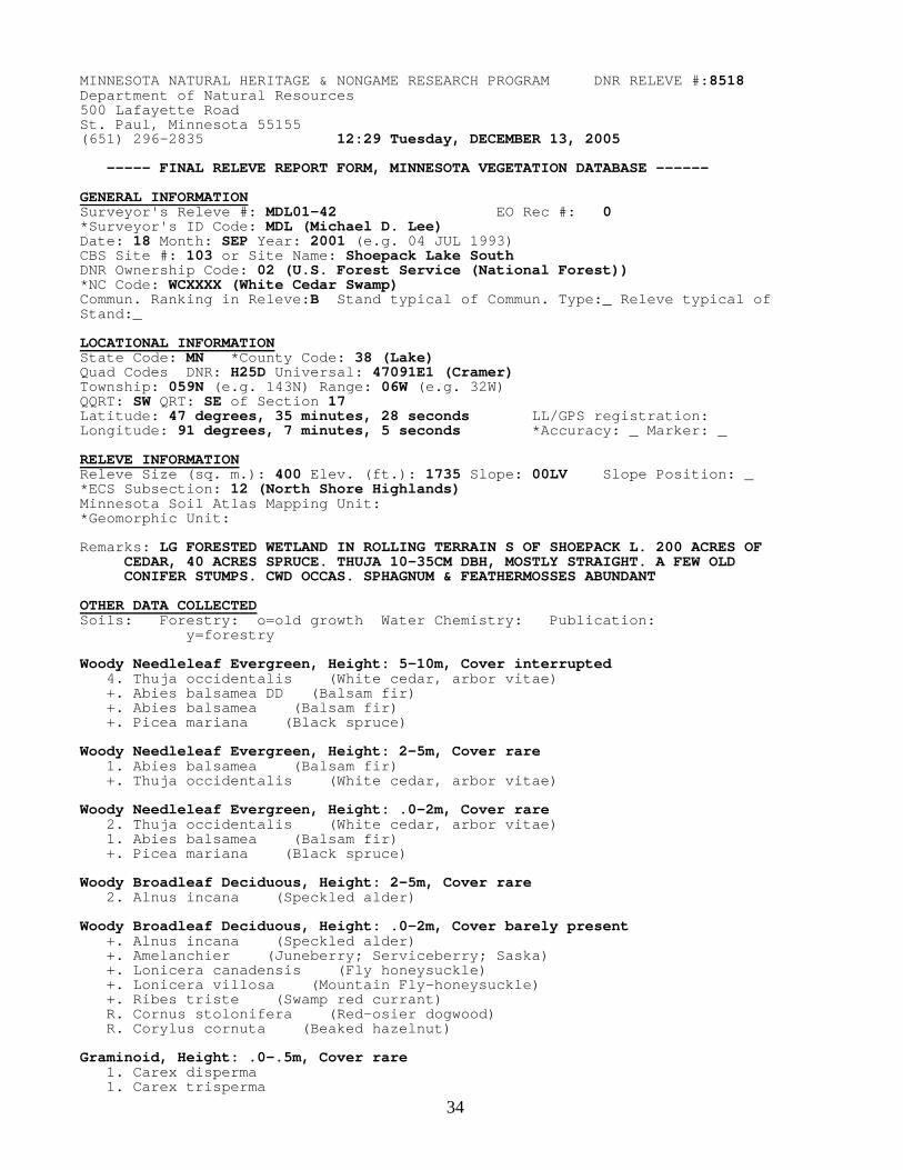
34
MINNESOTA NATURAL HERITAGE & NONGAME RESEARCH PROGRAM DNR RELEVE #:8518 Department of Natural Resources 500 Lafayette Road St. Paul, Minnesota 55155 (651) 296-2835 12:29 Tuesday, DECEMBER 13, 2005 ----- FINAL RELEVE REPORT FORM, MINNESOTA VEGETATION DATABASE ------ GENERAL INFORMATION Surveyor's Releve #: MDL01-42 EO Rec #: 0 *Surveyor's ID Code: MDL (Michael D. Lee) Date: 18 Month: SEP Year: 2001 (e.g. 04 JUL 1993) CBS Site #: 103 or Site Name: Shoepack Lake South DNR Ownership Code: 02 (U.S. Forest Service (National Forest)) *NC Code: WCXXXX (White Cedar Swamp) Commun. Ranking in Releve:B Stand typical of Commun. Type:_ Releve typical of Stand:_ LOCATIONAL INFORMATION State Code: MN *County Code: 38 (Lake) Quad Codes DNR: H25D Universal: 47091E1 (Cramer) Township: 059N (e.g. 143N) Range: 06W (e.g. 32W) QQRT: SW QRT: SE of Section 17 Latitude: 47 degrees, 35 minutes, 28 seconds LL/GPS registration: Longitude: 91 degrees, 7 minutes, 5 seconds *Accuracy: _ Marker: _ RELEVE INFORMATION Releve Size (sq. m.): 400 Elev. (ft.): 1735 Slope: 00LV Slope Position: _ *ECS Subsection: 12 (North Shore Highlands) Minnesota Soil Atlas Mapping Unit: *Geomorphic Unit: Remarks: LG FORESTED WETLAND IN ROLLING TERRAIN S OF SHOEPACK L. 200 ACRES OF CEDAR, 40 ACRES SPRUCE. THUJA 10-35CM DBH, MOSTLY STRAIGHT. A FEW OLD CONIFER STUMPS. CWD OCCAS. SPHAGNUM & FEATHERMOSSES ABUNDANT OTHER DATA COLLECTED Soils: Forestry: o=old growth Water Chemistry: Publication: y=forestry Woody Needleleaf Evergreen, Height: 5-10m, Cover interrupted 4. Thuja occidentalis (White cedar, arbor vitae) +. Abies balsamea DD (Balsam fir) +. Abies balsamea (Balsam fir) +. Picea mariana (Black spruce) Woody Needleleaf Evergreen, Height: 2-5m, Cover rare 1. Abies balsamea (Balsam fir) +. Thuja occidentalis (White cedar, arbor vitae) Woody Needleleaf Evergreen, Height: .0-2m, Cover rare 2. Thuja occidentalis (White cedar, arbor vitae) 1. Abies balsamea (Balsam fir) +. Picea mariana (Black spruce) Woody Broadleaf Deciduous, Height: 2-5m, Cover rare 2. Alnus incana (Speckled alder) Woody Broadleaf Deciduous, Height: .0-2m, Cover barely present +. Alnus incana (Speckled alder) +. Amelanchier (Juneberry; Serviceberry; Saska) +. Lonicera canadensis (Fly honeysuckle) +. Lonicera villosa (Mountain Fly-honeysuckle) +. Ribes triste (Swamp red currant) R. Cornus stolonifera (Red-osier dogwood) R. Corylus cornuta (Beaked hazelnut) Graminoid, Height: .0-.5m, Cover rare 1. Carex disperma 1. Carex trisperma

35
DNR RELEVE #: 8518 continued, Page 2 Graminoid, Height: .0-.5m, Cover rare (continued) +. Carex arctata +. Carex leptalea +. Cinna latifolia (Wood reedgrass) +. Unknown or Indeterminable Plant (Blue Grass; Meadow Grass) Forb, Height: .0-.5m, Cover patchy 2. Mitella nuda (Miterwort, naked bishop's-cap) 1. Coptis groenlandica (Goldthread) 1. Cornus canadensis (Bunchberry) 1. Rubus pubescens (Dwarf blackberry) +. Anemone quinquefolia +. Aster macrophyllus (Large-leaved aster) +. Clintonia borealis (Blue-bead lily) +. Dryopteris intermedia Group (Glandular wood fern) +. Galium triflorum (Three-flowered bedstraw) +. Goodyera repens (Rattlesnake-plantain) +. Gymnocarpium dryopteris (Oak fern) +. Iris versicolor (Blue Flag) +. Linnaea borealis (Twin-flower) +. Lycopodium annotinum (Bristly clubmoss) +. Lycopodium lucidulum (Shining clubmoss) +. Maianthemum canadense (Canada mayflower) +. Moneses uniflora (One-flowered pyrola) +. Platanthera obtusata (Blunt-leaved orchid) +. Pyrola secunda (One-sided pyrola) SPC +. Ranunculus lapponicus ## (Lapland buttercup) +. Trientalis borealis (Starflower) +. Viola (Violet) R. Aster puniceus (Red-stemmed aster) R. Epilobium glandulosum Group R. Pyrola rotundifolia (Round-leaved pyrola) Woody Broadleaf Evergreen, Height: .0-.5m, Cover barely present 1. Gaultheria hispidula (Creeping snowberry) 1. Ledum groenlandicum (Labrador tea) +. Vaccinium angustifolium (Blueberry) Lichen/Moss, Height: .0-.1m, Cover continuous 3. Ptilium crista-castrensis (moss) 3. Sphagnum (moss) 2. Unknown or Indeterminable Plant 1. Unknown or Indeterminable Plant

36
MINNESOTA NATURAL HERITAGE & NONGAME RESEARCH PROGRAM DNR RELEVE #:8868 Department of Natural Resources 500 Lafayette Road St. Paul, Minnesota 55155 (651) 296-2835 12:29 Tuesday, DECEMBER 13, 2005 ----- FINAL RELEVE REPORT FORM, MINNESOTA VEGETATION DATABASE ------ GENERAL INFORMATION Surveyor's Releve #: MDL02-24 EO Rec #: 0 *Surveyor's ID Code: MDL (Michael D. Lee) Date: 28 Month: AUG Year: 2002 (e.g. 04 JUL 1993) CBS Site #: 103 or Site Name: Manitou Overlook SE DNR Ownership Code: (U.S. Forest Service (National Forest)) *NC Code: PFXXXX (Poor Fen) Commun. Ranking in Releve:A Stand typical of Commun. Type:_ Releve typical of Stand:_ LOCATIONAL INFORMATION State Code: MN *County Code: 38 (Lake) Quad Codes DNR: H25C Universal: 47091E2 (Cabin Lake) Township: 059N (e.g. 143N) Range: 06W (e.g. 32W) QQRT: SE QRT: NW of Section 31 Latitude: 47 degrees, 33 minutes, 11 seconds LL/GPS registration: Longitude: 91 degrees, 8 minutes, 28 seconds *Accuracy: _ Marker: _ RELEVE INFORMATION Releve Size (sq. m.): 100 Elev. (ft.): 1695 Slope: 00LV Slope Position: _ *ECS Subsection: 12 (North Shore Highlands) Minnesota Soil Atlas Mapping Unit: *Geomorphic Unit: Remarks: Wettest, low-lying areas of 8-ac poor fen surr. 2-ac bog lake in small basin S of Moose L. Wettest microhabit covers ~1 ac. Plot 30m from SE side of lake. Spongy saturated peat. Sev hummocks in plot. OTHER DATA COLLECTED Soils: Forestry: o=old growth Water Chemistry: Publication: y=forestry * = Variables with computerized code dictionaries (See Releve Handbook) Woody Broadleaf Evergreen, Height: .0-.5m, Cover patchy 2. Myrica gale (Sweet gale) 2. Vaccinium oxycoccus (Small cranberry) +. Andromeda glaucophylla (Bog-rosemary) +. Chamaedaphne calyculata (Leather-leaf) +. Kalmia polifolia (Bog laurel) +. Vaccinium macrocarpon ## (Large cranberry) Graminoid, Height: .0-.5m, Cover continuous 3. Rhynchospora alba (Beaked-sedge) SPC 2. Rhynchospora fusca ## (Beaked-sedge) 1. Carex lasiocarpa +. Carex limosa SPC +. Juncus stygius ## (Bog rush) Forb, Height: .0-.5m, Cover patchy 2. Drosera intermedia (Spatulate-leaved sundew) 2. Sarracenia purpurea (Pitcher-plant) SPC 1. Xyris montana ## (Yellow-eyed-grass) +. Drosera rotundifolia (Round-leaved sundew) +. Lycopodium inundatum (Bog clubmoss) +. Menyanthes trifoliata (Buck-bean) +. Pogonia ophioglossoides (Rose pogonia) +. Scheuchzeria palustris (Scheuchzeria) +. Utricularia cornuta (Horned bladderwort) Lichen/Moss, Height: .0-.1m, Cover continuous 4. Sphagnum (moss)

37
Appendix 3. MCBS Aquatic Plant Surveys from Ninemile, Crooked, Moose, Hare, and Echo Lakes Survey Id: 0760- Ninemile Lake Lake Number: 380033 Survey Date: 8/23/2001 Surveyed by: Karen M Myhre County: Lake T: 59N R: 6W Sec: 22 USGS Quadrangle: Cramer Major/Minor Watersheds: Lake Superior - North/Ninemile Creek Located 21 miles northeast of the town of Silver Bay. Area surveyed: northeast bay of the lake. Submersed Plants (Plants with most leaves growing beneath the water surface) Eriocaulon aquaticum Pipewort Megalodonta beckii Water-marigold Najas flexilis Bushy Pondweed, Common Naiad Potamogeton praelongus White-stemmed Pondweed Potamogeton pusillus Very Small Pondweed Potamogeton robbinsii Robbins’ Pondweed Vallisneria americana Wild Celery, Eel-grass Floating-leaf Plants (Plants with leaves that float on the water surface) * Nymphaea odorata ssp. odorata Fragrant Water Lily Potamogeton amplifolius Large-leaved Pondweed, Cabbage Potamogeton epihydrus Ribbon-leaved Pondweed Potamogeton spirillus Snailseed Pondweed Sparganium emersum Narrow Floatingleaf Burreed Emergent Plants (Plants with leaves extending above the water surface) Eleocharis palustris complex Small’s Spikerush complex Phragmites australis Common reed grass, Cane Sagittaria sp. Arrowhead Sagittaria latifolia Broad-leaved Arrowhead * Sparganium americanum American Burreed cf Sparganium androcladum Staminate-branched Bur-reed Shoreline Plants (Plants associated with the wetland habitat) Alnus incana ssp. rugosa Speckled alder Calamagrostis canadensis Blue-joint cf Carex lupulina Carex retrorsa Turned-backward Sedge Chamaedaphne calyculata var. angustifolia Leather-leaf Iris versicolor Blue Flag Lycopus uniflorus Northern bugleweed Myrica gale Sweet gale Scirpus cyperinus Wool-grass Scutellaria lateriflora Mad-dog skullcap * specimen to be deposited at University of Minnesota Herbarium
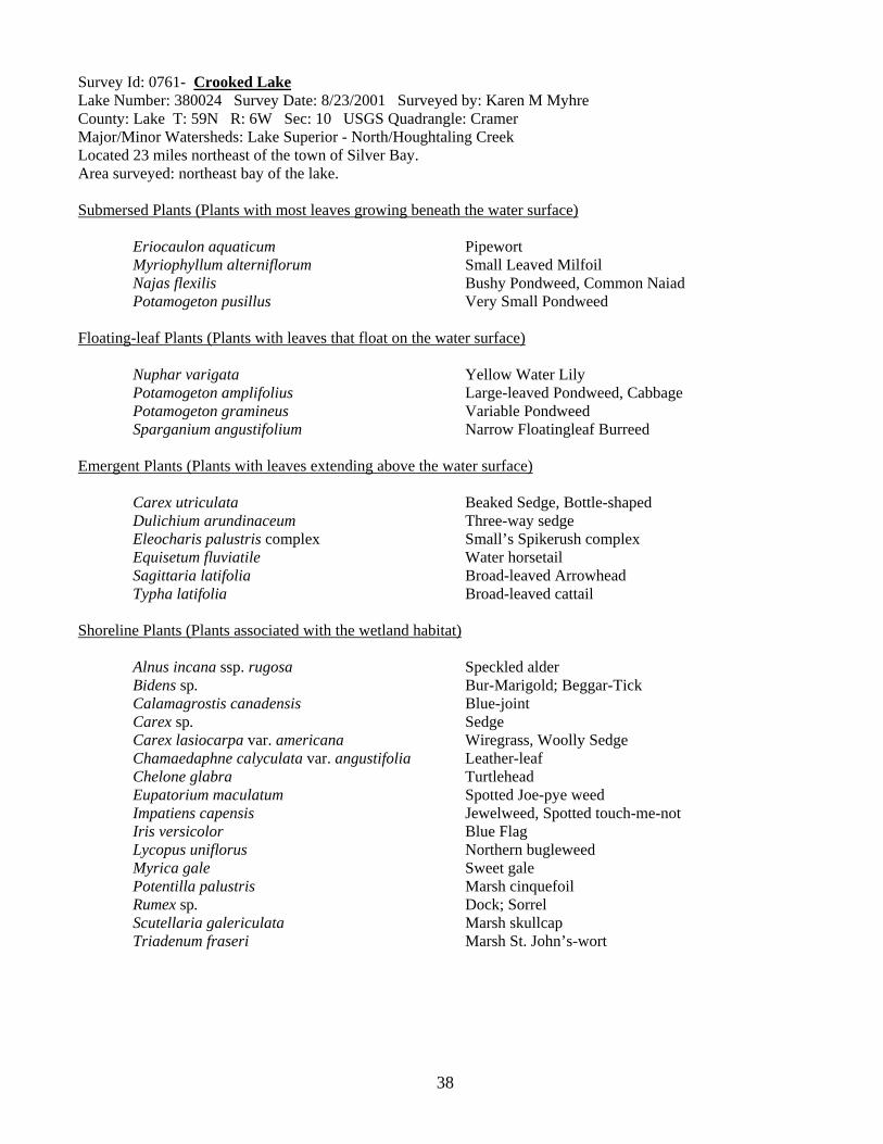
38
Survey Id: 0761- Crooked Lake Lake Number: 380024 Survey Date: 8/23/2001 Surveyed by: Karen M Myhre County: Lake T: 59N R: 6W Sec: 10 USGS Quadrangle: Cramer Major/Minor Watersheds: Lake Superior - North/Houghtaling Creek Located 23 miles northeast of the town of Silver Bay. Area surveyed: northeast bay of the lake. Submersed Plants (Plants with most leaves growing beneath the water surface) Eriocaulon aquaticum Pipewort Myriophyllum alterniflorum Small Leaved Milfoil Najas flexilis Bushy Pondweed, Common Naiad Potamogeton pusillus Very Small Pondweed Floating-leaf Plants (Plants with leaves that float on the water surface) Nuphar varigata Yellow Water Lily Potamogeton amplifolius Large-leaved Pondweed, Cabbage Potamogeton gramineus Variable Pondweed Sparganium angustifolium Narrow Floatingleaf Burreed Emergent Plants (Plants with leaves extending above the water surface) Carex utriculata Beaked Sedge, Bottle-shaped Dulichium arundinaceum Three-way sedge Eleocharis palustris complex Small’s Spikerush complex Equisetum fluviatile Water horsetail Sagittaria latifolia Broad-leaved Arrowhead Typha latifolia Broad-leaved cattail Shoreline Plants (Plants associated with the wetland habitat) Alnus incana ssp. rugosa Speckled alder Bidens sp. Bur-Marigold; Beggar-Tick Calamagrostis canadensis Blue-joint Carex sp. Sedge Carex lasiocarpa var. americana Wiregrass, Woolly Sedge Chamaedaphne calyculata var. angustifolia Leather-leaf Chelone glabra Turtlehead Eupatorium maculatum Spotted Joe-pye weed Impatiens capensis Jewelweed, Spotted touch-me-not Iris versicolor Blue Flag Lycopus uniflorus Northern bugleweed Myrica gale Sweet gale Potentilla palustris Marsh cinquefoil Rumex sp. Dock; Sorrel Scutellaria galericulata Marsh skullcap Triadenum fraseri Marsh St. John’s-wort
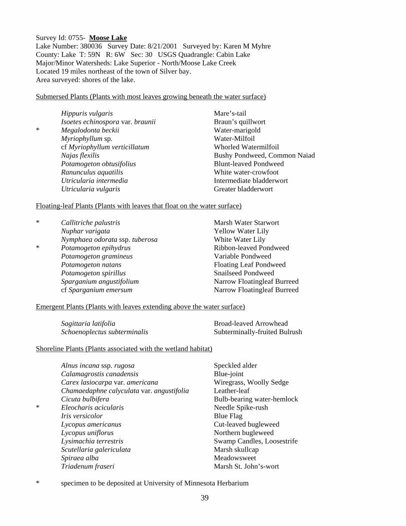
39
Survey Id: 0755- Moose Lake Lake Number: 380036 Survey Date: 8/21/2001 Surveyed by: Karen M Myhre County: Lake T: 59N R: 6W Sec: 30 USGS Quadrangle: Cabin Lake Major/Minor Watersheds: Lake Superior - North/Moose Lake Creek Located 19 miles northeast of the town of Silver bay. Area surveyed: shores of the lake. Submersed Plants (Plants with most leaves growing beneath the water surface) Hippuris vulgaris Mare’s-tail Isoetes echinospora var. braunii Braun’s quillwort * Megalodonta beckii Water-marigold Myriophyllum sp. Water-Milfoil cf Myriophyllum verticillatum Whorled Watermilfoil Najas flexilis Bushy Pondweed, Common Naiad Potamogeton obtusifolius Blunt-leaved Pondweed Ranunculus aquatilis White water-crowfoot Utricularia intermedia Intermediate bladderwort Utricularia vulgaris Greater bladderwort Floating-leaf Plants (Plants with leaves that float on the water surface) * Callitriche palustris Marsh Water Starwort Nuphar varigata Yellow Water Lily Nymphaea odorata ssp. tuberosa White Water Lily * Potamogeton epihydrus Ribbon-leaved Pondweed Potamogeton gramineus Variable Pondweed Potamogeton natans Floating Leaf Pondweed Potamogeton spirillus Snailseed Pondweed Sparganium angustifolium Narrow Floatingleaf Burreed cf Sparganium emersum Narrow Floatingleaf Burreed Emergent Plants (Plants with leaves extending above the water surface) Sagittaria latifolia Broad-leaved Arrowhead Schoenoplectus subterminalis Subterminally-fruited Bulrush Shoreline Plants (Plants associated with the wetland habitat) Alnus incana ssp. rugosa Speckled alder Calamagrostis canadensis Blue-joint Carex lasiocarpa var. americana Wiregrass, Woolly Sedge Chamaedaphne calyculata var. angustifolia Leather-leaf Cicuta bulbifera Bulb-bearing water-hemlock * Eleocharis acicularis Needle Spike-rush Iris versicolor Blue Flag Lycopus americanus Cut-leaved bugleweed Lycopus uniflorus Northern bugleweed Lysimachia terrestris Swamp Candles, Loosestrife Scutellaria galericulata Marsh skullcap Spiraea alba Meadowsweet Triadenum fraseri Marsh St. John’s-wort * specimen to be deposited at University of Minnesota Herbarium
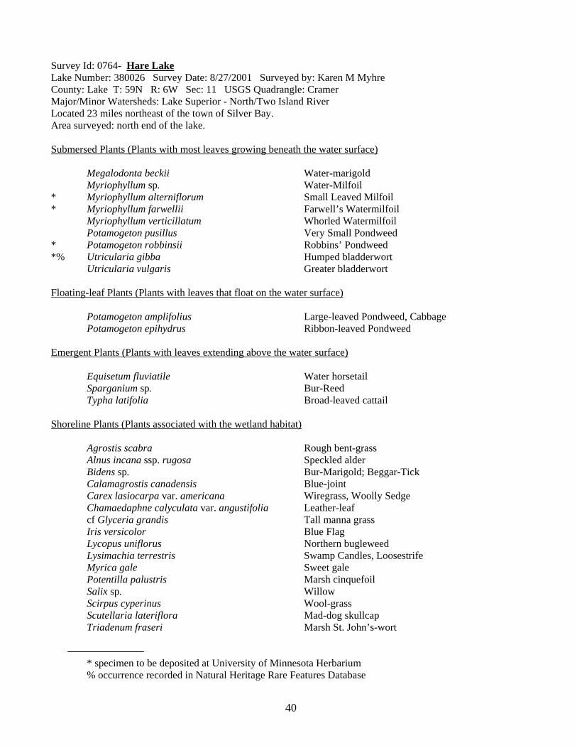
40
Survey Id: 0764- Hare Lake Lake Number: 380026 Survey Date: 8/27/2001 Surveyed by: Karen M Myhre County: Lake T: 59N R: 6W Sec: 11 USGS Quadrangle: Cramer Major/Minor Watersheds: Lake Superior - North/Two Island River Located 23 miles northeast of the town of Silver Bay. Area surveyed: north end of the lake. Submersed Plants (Plants with most leaves growing beneath the water surface) Megalodonta beckii Water-marigold Myriophyllum sp. Water-Milfoil * Myriophyllum alterniflorum Small Leaved Milfoil * Myriophyllum farwellii Farwell’s Watermilfoil Myriophyllum verticillatum Whorled Watermilfoil Potamogeton pusillus Very Small Pondweed * Potamogeton robbinsii Robbins’ Pondweed *% Utricularia gibba Humped bladderwort Utricularia vulgaris Greater bladderwort Floating-leaf Plants (Plants with leaves that float on the water surface) Potamogeton amplifolius Large-leaved Pondweed, Cabbage Potamogeton epihydrus Ribbon-leaved Pondweed Emergent Plants (Plants with leaves extending above the water surface) Equisetum fluviatile Water horsetail Sparganium sp. Bur-Reed Typha latifolia Broad-leaved cattail Shoreline Plants (Plants associated with the wetland habitat) Agrostis scabra Rough bent-grass Alnus incana ssp. rugosa Speckled alder Bidens sp. Bur-Marigold; Beggar-Tick Calamagrostis canadensis Blue-joint Carex lasiocarpa var. americana Wiregrass, Woolly Sedge Chamaedaphne calyculata var. angustifolia Leather-leaf cf Glyceria grandis Tall manna grass Iris versicolor Blue Flag Lycopus uniflorus Northern bugleweed Lysimachia terrestris Swamp Candles, Loosestrife Myrica gale Sweet gale Potentilla palustris Marsh cinquefoil Salix sp. Willow Scirpus cyperinus Wool-grass Scutellaria lateriflora Mad-dog skullcap Triadenum fraseri Marsh St. John’s-wort * specimen to be deposited at University of Minnesota Herbarium % occurrence recorded in Natural Heritage Rare Features Database

41
Survey Id: 0763- Echo Lake Lake Number: 380028 Survey Date: 8/27/2001 Surveyed by: Karen M Myhre County: Lake T: 59N R: 6W Sec: 14 USGS Quadrangle: Cramer Major/Minor Watersheds: Lake Superior - North/Ninemile Creek Located 22 miles northeast of the town of Silver Bay. Area surveyed: south end of the lake. Floating-leaf Plants (Plants with leaves that float on the water surface) Nymphaea odorata ssp. tuberosa White Water Lily Emergent Plants (Plants with leaves extending above the water surface) * Juncus effusus Loosely-spreading Bog Rush * Schoenoplectus heterochaetus Diverse-bristled bulrush Schoenoplectus tabernaemontani Soft-stem bulrush Typha latifolia Broad-leaved cattail Shoreline Plants (Plants associated with the wetland habitat) Agrostis scabra Rough bent-grass Alnus incana ssp. rugosa Speckled alder Calamagrostis canadensis Blue-joint Carex sp. Sedge cf Carex scoparia Scoparia Sedge Carex stricta Hummock Sedge Chamaedaphne calyculata var. angustifolia Leather-leaf Eleocharis acicularis Needle Spike-rush Iris versicolor Blue Flag Juncus sp. Rush Lycopus uniflorus Northern bugleweed Myrica gale Sweet gale Rhododendron groenlandicum Labrador tea * specimen to be deposited at University of Minnesota Herbarium

Biological Report No. 90
Equal opportunity to participate in and benefit from programs of the Minnesota Department of Natural Resources is available to all individuals regardless of race, color, creed, religion, national origin, sex, marital status, status with regard to public assistance, age, sexual orientation, membership or activity in a local commission, or disability. Discrimination inquiries should be sent to MN DNR, 500 Lafayette Road, St. Paul, MN 55155-4031; or the Equal Opportunity Office, Department of the Interior, Washington, DC 20240.
Funding provided by the Minnesota Legislature, with partial funding for the Minnesota County Biological Survey provided by the Minnesota Environment and Natural Resources Trust Fund as recommended by the Legislative Commission on Minnesota Resources.
©2006. State of Minnesota, Department of Natural Resources