an integrated approach using non seismic and … · gabon sub- basin, the south gabon sub-basin,...
TRANSCRIPT

Oil India Limited, Geophysics Department, Duliajan, Assam.
Email: [email protected]
P-377
An Integrated Approach Using Non Seismic and Seismic Surveys for
Hydrocorbon Exploration in the Interior Sub-Basin, Gabon
(Central West Africa) – A Case Study
Akshaya Kumar*, Ganesh Karri, Manish Kumar Gupta, S.K.Das,V. K. Kulshrestha, Oil India Ltd.
Summary
In the backdrop of increasing complexity of new exploration targets in the worldwide scenario and also from our experience
in the hydrocarbon exploration, it has been observed that an integration of various geo -scientific data always increase
understanding and confidence level among the geoscientists which can unlock new reserves. A similar kind of integrated
approach has been adopted in the Block SHAKTHI, situated in northeastern part of oil rich country Gabon where
seismic has been planned and executed based on inferences by interpretation of non-seismic i.e. aeromagnetic surveys. In
this paper, the aero magnetic results integrated with 2D seismic API (Acquisition, Processing and Interpretation) and
recently concluded 3D seismic API have aided in delineating the drillable prospects, basement configuration, other
geological features focusing on the lithological, stratigraphic and structural elements including GME cycle and petroleum
system models. Integrated approach of these data sets provides a cost effective synergism which often leads to better
resolution of exploration challenges and expected to result in the discovery of hydrocarbon in this geologically complex
regime. During this study concerted efforts has been made to assess drillable potential location(s) in this logistically
difficult and forest infested rugged terrain. The study area merits a sustained exploration programme with techno- economic
consideration.
Introduction
Oil India Limited (OIL)‟s exploration for
hydrocarbon has moved today in the challenging and
new frontier areas. Pursuant to consortium of IOCL-
OIL‟s strategy of systematic exploration in
logistically difficult and less explored areas in
African continent. The study area is situated approx.
120 km south of the capital city of Gabon, Libreville.
Figure-1 shows the location of the block on the map.
Given the topography of Gabon, onshore exploration
in this area is always an expensive business. In
Gabon one has venture under extremely arduous
conditions due to hostile and rugged terrain, thick
rainforests, presence of swamps (mangrove) / marshy
/river (Ogooue) ,presence of wild life and volatile
communities, no approach road etc is covering an
area of 3760 sq km. The geologically complex
and environmentally sensitive conditions make the
hydrocarbon exploration for the block a very
challenging and costly business (Figure-2).
Figure-1 Shows the location of the block on the world map.
2
An Integrated Approach for Hydrocorbon Exploration– A Case
Study from block Shakthi, Gabon
Figure-2a: Photo of the area showing the difficult terrain of Gabon.
Figure-2b: Image showing drilling of a shot hole in the forest during
3D seismic survey.
In order to have a cost effective exploration at Shakthi
Block with optimum seismic coverage as per MWP, Oil
India Limited, strategized and carried out an airborne
magnetic survey by hiring the services of the contractor,
with an objective to get a better understanding of the
basement features and thickness of the sediment
succession within the Interior Basin which is considered to
be very prospective for oil and gas. Furthermore, this
survey primarily assisted in the planning, designing and
execution of 2D/3D seismic surveys within Shakthi block
for drillable prospect delineation in time bound manner. The
aim of these surveys was to define the major structures and
thickness of the sedimentary structural elements.
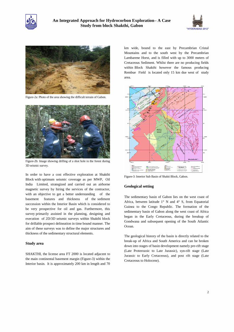
Study area
SHAKTHI, the license area FT 2000 is located adjacent to
the main continental basement margin (Figure-3) within the
Interior basin. It is approximately 200 km in length and 70
km wide, bound to the east by Precambrian Cristal
Mountains and to the south west by the Precambrian
Lambarene Horst, and is filled with up to 3000 meters of
Cretaceous Sediment. Whilst there are no producing fields
within Block Shakthi however the famous producing
Rembue Field is located only 15 km due west of study
area.
Figure-3: Interior Sub Basin of Shakti Block, Gabon.
Geological setting
The sedimentary basin of Gabon lies on the west coast of
Africa, between latitude 1° N and 4° S, from Equatorial
Guinea to the Congo Republic. The formation of the
sedimentary basin of Gabon along the west coast of Africa
began in the Early Cretaceous, during the breakup of
Gondwana and subsequent opening of the South Atlantic
Ocean.
The geological history of the basin is directly related to the
break-up of Africa and South America and can be broken
down into stages of basin development namely pre-rift stage
(Late Proterozoic to Late Jurassic), syn-rift stage (Late
Jurassic to Early Cretaceous), and post rift stage (Late
Cretaceous to Holocene).

3
An Integrated Approach for Hydrocorbon Exploration– A Case
Study from block Shakthi, Gabon
The pre-rift stage witnessed several phases of intra-cratonic
faulting and warping. The formation of basal Pre-Cambrian
Noya Series and the Permian aged Agoula Formation
separated by an angular unconformity is the highlight of this
phase.
The syn-rift phase is marked by the deposition of the
N‟Dombo Formation, the Welle Formation with
characteristic Fourou large sandstone, the Lobe Shale, the
Bifoun Shale and the formation of asymmetrical horst and
graben features parallel to the present coast line.
The post–rift phase is represented within Interior Basin by
the Como Formation and the Ezanga evaporates. The Como
Formation is correlated with the Gamba Formation in the
South Gabon Basin.
The Axial Fault and the Lambarene Horst are two major
structures which are potentially important for the oil and gas
prospectivity of the Interior Basin. The former is considered
to form a possible seal to potential host rocks within
the syn-rift sediments. The stratigraphy of the Pre-rift,
syn-rift and post-rift succession of the Interior Basin is
shown in Figure-5a & 5b.
Figure-5a: Sequence stratigraphy of the area.
The Gabon basin consists of three sub-basins: the North
Gabon Sub- basin, the South Gabon Sub-basin, and the
Interior Basin, each with a different geological history. Our
study area lies in Interior Basin which consists of a
narrow, north northwest – south southeast trending
asymmetric rift basin that formed in the early Cretaceous.
This Interior Basin is isolated from the Atlantic Margin
(Northern Costal basin of Gabon) by the Lambarene Horst.
Oil and gas discovery, the Ozouri field, which was made by
Elf, subsequently brought on stream in 1956. Between then
and the late 1990s, a large number of discoveries were made
both onshore and offshore.
Figure-5b: Stratigraphy of the Pre-rift, syn-rift and post-rift
succession of the Interior Basin.

4
An Integrated Approach for Hydrocorbon Exploration– A Case
Study from block Shakthi, Gabon
Aero magnetic data acquisition & results
The aero magnetic survey was conducted along E-W flight
lines spaced 250 meters apart at a nominal flying height of
150 meters above ground level within the Shakti Block
totaled 16, 600 line km. Tie lines were flown in N-S
direction at intervals of 2500 meters. Data was also
acquired over a much larger area peripheral to Shakti Block
totaling 36,600 line km. The Total Magnetic Intensity
(TMI) response of the study area shows the outcropping
Proterozoic and Archaen basement rocks along the eastern
and western margins of the basin which are clearly defined
by shallow, high frequency responses. The rapid change
from high frequency to long wavelength responses
along the eastern edge of the Lambarene Horst confirms
the very sudden deepening of the basin along its western
margin, as depicted in Figure-6.Within the basin the
dominant feature is a NNW trending anomaly which occurs
west of the Axial Fault along the deepest part of the basin
close to the western boundary.
Prospectivity analysis
The NE-SW trending interpreted profile agrees with the
inferred asymmetric shape of the basin with a sharp
drop of TMI immediately east of the Lambarene Horst
and a progressive shallowing of the basement to the east.
Based on the interpretations of previous seismic data, the
most interesting feature for further study was the location of
axial fault. There is reasonably convincing evidence for the
continuation of the “Axial Fault” beyond the seismically
interpreted position based on the aeromagnetic data and also
the regional geology. There is evidence in the magnetic data
of faults parallel to the margin of the Lambarene Horst
which appears to be associated with down-faulting of the
magnetic basement to the east. One such fault is evident
immediately south of the Rembue field. In this relatively
small basin, strata of the rift phase show some similarities to
the stratigraphy sequences of the South Sub- basin, but
some differences exist because the Interior Basin was much
quieter tectonically than the South Gabon Sub-basin.
Figure-6: The preliminary TMI derived from the survey.
Prospect areas for surface investigation
Figure-7: Possible areas for inclusion in the proposed seismic survey.
From the aeromagnetic interpretation and other geo-
scientific information such as seismic traverses and
previous exploration, following encircled areas (Figure-7)
has been considered to warrant further investigation through
proposed and planned seismic survey.
5
An Integrated Approach for Hydrocorbon Exploration– A Case
Study from block Shakthi, Gabon
Area A is along the Axial Fault approximately 50 km to the
north where potential host rocks are down-faulted on the
western side of the fault with the fault acting as a seal.
Area B corresponds to the area highlighted based on the old
vintage seismic data. There is evidence in the magnetic data
that there are a series of stacked faults which make up the
Axial Fault in this particular area.
Area C is along the Lambarene Horst within Block FT2000
where there are significant changes in the seismic
interpreted depths to magnetic basement marginal to the
eastern boundary of the Horst.
A further area of interest, D, interpreted from the
aeromagnetic data, occurs NE of area C where the
interpretation of the magnetic data suggests the possibility
of some block faulting within the basement.
New 2D and 3D seismic survey & Results
Based on aeromagnetic interpretation results, OIL planned
and acquired 1039 GLKM of 2D seismic data over the more
prospective areas of the Shakthi Block. The 2D seismic data
of 80 fold in this region was acquired under demanding
logistical circumstances along with various operational
constraints. OIL successfully completed the seismic
campaign. The survey design parameters during 2D data
acquisition are shown in Table-1. The new 2D seismic
survey coverage map of Shakthi Block has been shown in
the Figure-3.
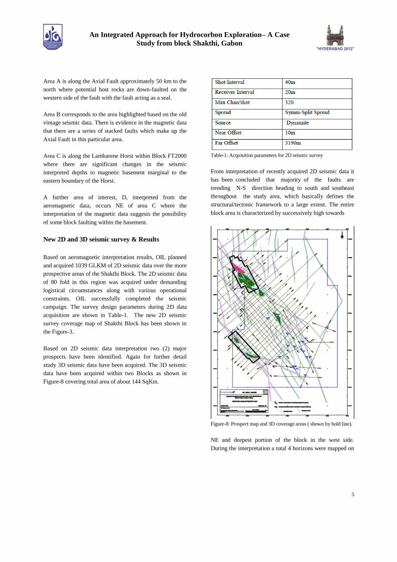
Based on 2D seismic data interpretation two (2) major
prospects have been identified. Again for further detail
study 3D seismic data have been acquired. The 3D seismic
data have been acquired within two Blocks as shown in
Figure-8 covering total area of about 144 SqKm.
Table-1: Acquisition parameters for 2D seismic survey
From interpretation of recently acquired 2D seismic data it
has been concluded that majority of the faults are
trending N-S direction heading to south and southeast
throughout the study area, which basically defines the
structural/tectonic framework to a large extent. The entire
block area is characterized by successively high towards
Figure-8: Prospect map and 3D coverage areas ( shown by bold line).
NE and deepest portion of the block in the west side.
During the interpretation a total 4 horizons were mapped on

6
An Integrated Approach for Hydrocorbon Exploration– A Case
Study from block Shakthi, Gabon
2D seismic data based on continuity of reflectors in the
area. An example of interpreted 2D seismic section from
SW-NE line indicating the following formations are shown
in figure-9.
Figure-9: Interpreted formations of profile along SW-NE direction.
Tablel2: Acquisition parameters for 3D Seismic survey.
Discussion and Conclusions
This study shows how the aero magnetic data interpretation
help to find the depth to magnetic basement with a rapid
increase in the depths adjacent to the Lambarene horst
which is all very consistent with the known geology of the
basin. Despite the importance of the Axial Fault in the
structure of the basin and also in its prospectivity for oil and
gas, the location of the fault is not convincingly known
particularly towards the southern end of the project area.
The noise within the original data contributes to the
difficulties in separating basement and inter-sedimentary
anomalies, but still the results of the interpretation of the
aeromagnetic data indicate that further options may exist.
Aeromagnetic survey within this block has proved its
potential in providing another vital parameter of the area i.e.
the magnetic anomaly map, this has not only assisted the
meaningful and cost effective seismic survey planning
within the block , it has also prove to be very essential
parameter while further assessing the block in terms of its
hydrocarbon prospectivity. Thus emphasizing upon the fact
that integration of various geoscientific data can result in
increased successes in exploration and improved reserve
replacement ratio. .Combining magnetic (non seismic) with
other exploration technologies can provide valuable
geological information and unlock new reserves.
Acknowledgements
The authors express their sincere thanks to Shri B. N.
Talukdar Director (E&D) and Shri S.Rath, Director
(Operations) of Oil India Limited for encouragement,
guidance and permitting this work to be presented. Our
sincere thanks to Mr. P. N. Baruah, GGM (E&D) and S. N.
Singh GM (Geo-Services) for valuable suggestion, advice,
support to carrying out the work.
References
An internal reports on Seismic data acquisition, processing
and interpretation of block „Shakthi;, OIL INDIA
Dr. Jones K., A report on the interpretation of an airborne
magnetic survey flown in the Shakthi Block, FT2000,
onshore Gabon, west Africa, Fugro Airborne Surveys Pty
Ltd, Australia
Mbina Mounguengui M., Lang J., Guiraud M., and Jocktane
O., 2002 - Sedimentary dynamics and structural geology of
pre-rift deposits of the interior basin of Gabon. Journal of
Earth Sciences Vol 35 p315-329.