an ordinance approving the project and financing …
TRANSCRIPT

ORDINANCE NO. 20080320-007
AN ORDINANCE APPROVING THE PROJECT AND FINANCING PLAN FORTAX INCREMENT FINANCING (TIF) REINVESTMENT ZONE NO. 17(WALLER CREEK TUNNEL PROJECT); AND PROVIDING FOREMERGENCY PASSAGE.
BE IT ORDAINED BY THE CITY COUNCIL OF THE CITY OF AUSTIN:
PART 1. Council finds that the Project and Financing Plan for Tax Increment Financing(TIF) Reinvestment Zone No. 17 (Waller Creek Tunnel Project) is feasible and conformsto the master plan of the City.
PART 2. Council approves the Project and Financing Plan attached as Exhibit A.
PART 3. The council finds that this ordinance must be approved concurrently with thetax increment agreement negotiated between the City and County, and this constitutes anemergency. Because of this emergency, this ordinance takes effect immediately on itspassage for the immediate preservation of the public peace, health and safety.
PASSED AND APPROVED
March 20 ' ., 2008 §
APPROVED:Alla Smith
City Attorney
Will WynMayor
ATTEST: ,J(J^^J_JL^ \J^ / ^-"
Shirley! AT GentryCity Clerk
Page 1 of 1
EXHIBIT A
Waller CreekTax Increment Financing Reinvestment Zone
City of AustinTax Increment Financing Reinvestment Zone No. 17
Final Project Planand
Reinvestment Zone Financing Plan
March 2008

Table of Contents
Executive Summary
Project Plan
Reinvestment Zone Financing Plan
Exhibits
Exhibit 1 Map - Existing Floodplain
Exhibit 2 Map - Proposed Floodplain
Exhibit 3 Map - TIF Boundaries
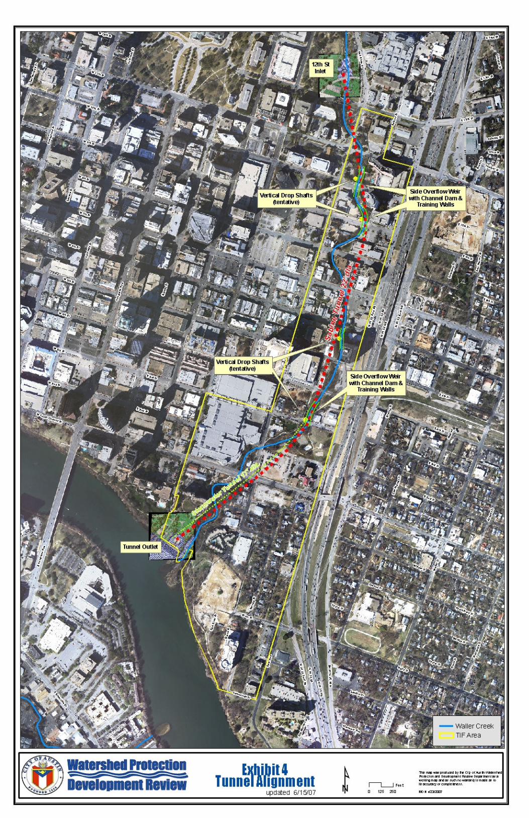
Exhibit 4 Map - Tunnel Alignment
Exhibit 5 Resolution of the Waller Creek CitizenAdvisory Committee
Exhibit 6 Rendering - Tunnel Inlet
Exhibit 7 Rendering -Tunnel Outlet
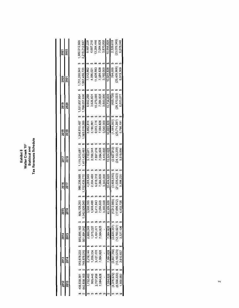
Exhibit 8 Waller Creek TIF Buildout and TaxRevenue Schedule
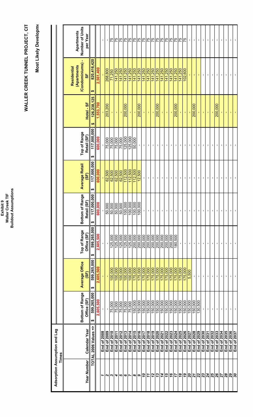
Exhibit 9 Waller Creek TIF Buildout Assumptions

Executive Summary
On June 21, 2007, the Austin City Council approved an ordinance creating TaxIncrement Financing (TIP) Reinvestment Zone No. 17 to finance the construction offlood control improvements along lower Waller Creek. The TIP is located within thearea bounded on the west by Red River Street from 12th Street south to 3rd Street, thenwest along 3rd Street to Trinity Street, then south along Trinity Street to Lady Bird Lake;on the south by Lady Bird Lake from Trinity Street east to Cummmgs Street, then eastalong Cummmgs Street to East Avenue, on the cast by East Avenue from CummingsStreet north to the south bound access road of IH-35, then along said access road north to11th Street, then west along 11th Street to Sabmc Street, and north along Sabine Street toRed River Street; and on the north by 12th Street between Sabine Street and Red RiverStreet
The purpose of the Waller Creek Tunnel project, which is to be financed through TIPReinvestment Zone No 17, is to provide 100-year storm event flood protection with noout-of-bank or roadway flooding for the lower Waller Creek watershed The project willprovide flood protection to existing buildings, prevent the flooding of roadway crossings,and reduce the width of the floodplam in the Reinvestment Zone area, essentiallycontaining it within the creekbed. This reduction in floodplam area resulting from theproject will significantly increase the amount of developable land area in the lowerWaller Creek watershed
In accordance with State law, this Project Plan and TIP Reinvestment Zone No. 17Financing Plan have been created to describe the Waller Creek Tunnel project andassociated financing using dedicated TIP revenue from the City of Austin and TravisCounty
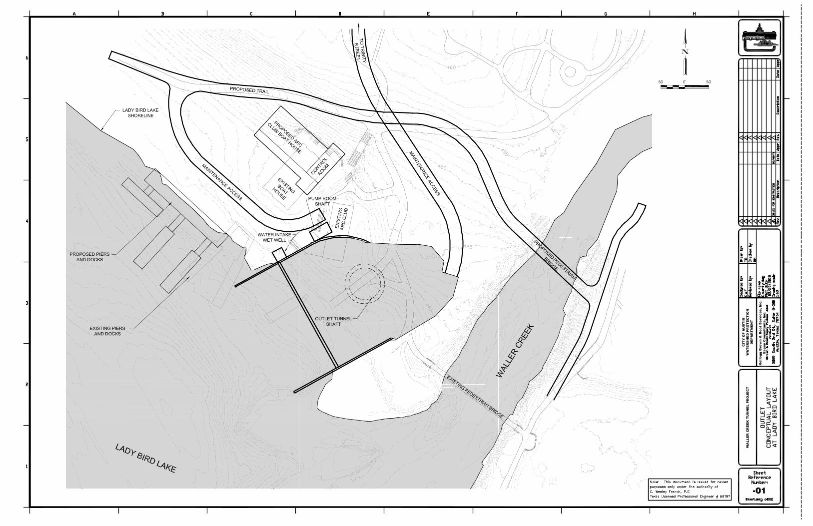
The proposed runnel will be approximately 22 feet in diameter and approximately 5,400feet in length. The total estimated cost of the project is $127,547,000 (in June 2006dollars) The tunnel will originate in Waterloo Park near East 12th Street with discharge toLady Bird Lake The tunnel alignment is generally beneath Sabine Street. Significantinlet and outlet structures are required and because the structures are in parkland,aesthetics of the structures arc a major consideration The inlet structure will include apond, an inlet structure, small dam, access bridge, pump building and significantlandscaping enhancements. The inlet also includes mechanical screens to ensureoperational reliability and a system to pump small quantities of water from the tunnel tothe creek This pumped water will augment the base flow in the creek and by so doingenhance its aesthetic appeal and water quality The outlet structure includes a pond, anoutlet shaft, and a de-watering pump system On April 12, 2007, the Austin City Councilcreated the Waller Creek Citizen Advisory Committee. The City Council believes it isvery important for the community to participate and provide oversight in the constructionand development of the Waller Creek Tunnel Project The process for finalizing parkfacilities to be located at the tunnel inlet and outlet will include consideration ofrecommendations made by the Committee The Committee includes a citizen appointed
Cily of Austin TIP Reinvestment Zone No 17Project and Financing PlanPage 1
by Travis County
The Waller Creek tunnel project will spur economic development throughout downtown,in particular in the Reinvestment Zone area where development has lagged the rest of thecity. The project will enhance the parkland and trail along the creek by providingamenities in Waterloo Park and on Lady Bird Lake and by preventing flooding andreducing strcambank erosion Further, the project's water re-circulation efforts willsupplement stream base flow and enhance the quality of water flowing into Lady BirdLake. The project is also expected to allow improved connectivity between east and westAustin, and with its parkland enhancement and anticipated economic developmentstimulus, promote tourism by convention and other visitors.
To finance this project, the City of Austin formed TIP Reinvestment Zone No 17 (seeExhibit 3 for TIP boundaries) in accordance with State law In a TIP, one or morepolitical subdivisions contribute up to 100% of the property tax on the increase in valueof real property in the district (tax increment) for TIP purposes Under the terms of TIPReinvestment Zone No. 17 and an Agreement to Participate in Tax IncrementReinvestment Zone No. 17, between the City of Austin and Travis County, negotiatedwith Travis County, the City of Austin will contribute 100% of its tax increment, andTravis County will contribute 50% of its tax increment. The project will be funded bythe issuance of debt that will be repaid primarily from the tax increment revenuescollected during the 20-year duration of TIP Reinvestment Zone No. 17. At the end of the20-year TIP, the City will pay all remaining debt and operations and maintenanceexpenditures
City of Austin TIP Reinvestment Zone No 17Project and Financing PlanPage 2
Project Plan
Introduction
This document is the Project Plan for TIP Reinvestment Zone No. 17 for the LowerWaller Creek Flood Control Improvements, in the City of Austin, Texas, as required byChapter 311 of the Texas Tax Code. The purpose of TIP Reinvestment Zone No. 17 is tofinance reimbursements of costs associated with flood control improvements in theWaller Creek watershed of the City of Austin, Texas
The City of Austin will be solely responsible for managing the design and construction ofthe Waller Creek tunnel project, for operating and maintaining the tunnel after itscompletion, and for administering the TIP zone, which is located on the eastern edge ofthe downtown area of Austin, Texas. In the event that actual costs exceed estimatedproject costs outlined in the project and financing plan, the City of Austin will beresponsible for funding those additional costs to the extent that project or operating costsexceed the available TIP revenues to be contributed by the City and Travis County, asdescribed more fully in the financing plan that follows Upon completion, a significantamount of land will no longer be within the flood plain, and will then be suitable fordevelopment It is estimated that the investment in private development will benefit boththe City and the County financially, and will also benefit City and County citizensthrough the creation of jobs and recreational amenities
The flood control improvements will be public infrastructure The proposed tunnel willbe approximately 22 feet in diameter and approximately 5,400 feet in length The tunnelwill originate in Waterloo Park near East 12th Street with discharge to Lady Bird LakeThe tunnel alignment will be generally beneath Sabmc Street. Significant inlet and outletstructures arc required and because the structures arc in parkland, aesthetics of thestructures arc a major consideration Preliminary design features include a pond, a inletstructure, small dam, access bridge, pump building and significant landscapingenhancements The inlet also includes mechanical screens to ensure operational reliabilityand a system to pump small quantities of water from the tunnel to the creek This pumpedwater will augment the base flow in the creek and by so doing enhance its aestheticappeal and water quality Two to four storm water inlets along Waller Creek downstreamof the tunnel inlet and possibly a parallel smaller diameter tunnel originating near East 3r
Street and terminating at the tunnel outlet will provide for the diversion of storm waterentering the lower Waller Creek channel The outlet structure includes a pond, an outletshaft, and a de-watering pump system On April 12, 2007, the Austin City Councilcreated the Waller Creek Citizen Advisory Committee. The City Council believes it isvery important for the community to participate and provide oversight in the constructionand development of the Waller Creek Tunnel Project The process for finalizing parkfacilities to be located at the tunnel inlet and outlet will include consideration ofrecommendations made by the Committee Exhibit 5 is a resolution by the Committeeoutlining design recommendations
City of Austin TIP Reinvestment Zone No 17Project and Financing PlanPage 3

On August 30, 2007, the City Council approved an amendment to the professionalservices agreement with the joint venture of Brown & Root, Inc/Espcy Padden fordesign/bid (Phase 2) and construction management and warranty assistance (Phase 3)engineering services. These costs will be primarily funded with unencumbered 1998venue project bond proceeds, and related bond interest earnings. Additional expendituresassociated with the design and construction of the project and other project-related costs,including casements and right of way, will be funded by tax increment revenues derivedfrom increases in property values resulting from the new development. Monetaryobligations are to begin in the spring or early summer of 2010, beginning with theacquisition of easements and right of way required to begin construction of the tunnelConstruction is currently estimated to start in June 2010
I. Maps Showing Existing Hood plain and Map Showing Post-ProjectFloodplain
TIP Reinvestment Zone No 17 includes approximately 126 acres The boundaries ofthe zone are within the area bounded on the west by Red River Street from 12thStreet south to 3rd Street, then west along 3rd Street to Trinity Street, then southalong Trinity Street to Lady Bird Lake, on the south by Lady Bird Lake from TrinityStreet cast to Cummings Street, then cast along Cummmgs Street to East Avenue; onthe cast by East Avenue from Cummings Street north to the south bound access roadof IH-35, then along said access road north to 11th Street, then west along 11th Streetto Sabme Street, and north along Sabinc Street to Red River Street, and on the northby 12th Street between Sabinc Street and Red River Street. Existing land useincludes commercial, residential and public use, including park land The extent ofthe floodplain within the TIP Reinvestment Zone No. 17 currently precludes manydevelopment options
Exhibits 1 and 2 show the existing floodplain and post-project floodplamssuperimposed on an aerial showing land uses in the zone Exhibit 3 shows the zoneboundary Renderings of the Waller Creek Tunnel inlet and outlet arc shown inExhibits 7 and 8
II. Proposed Changes of Zoning Ordinances, the Master Plan of theMunicipality, Building Codes, and Other Municipal Ordinances
All project construction is anticipated to adhere to existing design and buildingcriteria and regulations. Currently, there are no proposed changes to City ordinances,master plans or building codes In the future, regulatory changes may berecommended as part of the Downtown Austin Master Plan (Downtown Plan), whichis currently being formulated with stakeholder input, and is summarized below.
Downtown PlanAs a city, Austin is seen as one of the best in the country, with a long and growing listof "Bests," including:
City of Austin TIP Reinvestment Zone No 17Project and Financing PlanPage 4
• 1st place - "Best Large City for Relocating Families" (The WorldwideEmployee Relocation Council (ERC), Primacy Relocation and Sperling'sBcstPlaccs, June 2004)
• 1 st place (for the second consecutive year) - "Top 10 Cities for Hispanics toLive In" (Hispanic magazine, August 2005)
• 2nd place - Top Creative Class Cities (The Rise of the Creative Class, RichardFlorida, 2002)
• 2nd place - "Ten Greenest Cities" list (Vegetarian Times' July/August 2005)• 3rd place - "Best Places" for business and careers (Forbes, May 2005)• 6th place - Nation's top tech hubs (Silicon Valley study, September 2005)• 11th place - "The 25 Best Running Cities in America" and (Runner's World
July 2005)• One of the top 10 cities to be a dog (DogFancy November 2005)
At the heart of all these accolades are Austin's citizens, their love for the City, and ina very tangible sense, downtown Downtown Austin is the City's central businessdistrict, the entertainment hub, the primary tourist destination, and home to City,County and State governmental activities.
Downtown Austin, however, is in a period of transition. On the one hand, downtownis experiencing tremendous growth in the housing sector based on strong demand.On the other hand, downtown is struggling to maintain or recapture its retail andoffice market share as office buildings and shopping centers are being built furtherand further away from downtown to accommodate a growing suburban population Ifleft unchecked, this development pattern will lead to the advancement of one sector tothe possible exclusion and detriment of others.
On December 15, 2005, the Austin City Council adopted a resolution initiating aplanning process for downtown Austin, including the Waller Creek TIP area. TheCouncil action required the selection of a nationally-recognized consultant withdowntown expertise to develop the Downtown Plan by working with stakeholders,including but not limited to state, federal and local governments, the CapitalMetropolitan Transportation Authority, downtown neighborhood associations anddowntown business groups, affordable housing advocates, parks groups andenvironmental organizations The consultant's scope of work was to include thefollowing
1 Implement ordinance modernizations, including but not limited to Floor to Areastandards and procedures for modifying where appropriate, height standards andprocedures for modifying where appropriate, and, funding ordinances forinfrastructure
2. Identify right-of-way for passenger rail and dedicated bus thoroughfares3 Develop a program and procedure for the sale and development of government-
owned land
City of Austin TIP Reinvestment Zone No 17Project and Financing PlanPage 5

4 Identify cast-west and north-south rail lines and dedicate station locationsdowntown
5 Integrate the Downtown Neighborhood Plan and the Transit OrientedDevelopment Ordinance Convention Center Station Area Planning effort into theDowntown Plan and Ordinance
6 Identify strategics and best practices for affordable work force housing in thedowntown area
In April 2007, the City contracted with the ROMA Design Group to assist with thedevelopment of the Downtown Plan. The contract for the Downtown Plan envisionsthat the plan will unfold in phases
Phase One -- Analyze baseline information, interview key stakeholders, assessopportunities and challenges, and craft a strategic framework with clearly prioritizedactions aimed at implementing the downtown vision. The phase one work willrequire six months to complete
Phase Two - Implementation of the identified high-priority items
Proposed regulatory changes considered in the Downtown Plan will be evaluated forany potential impacts on the construction of the proposed TIP improvements andfuture redevelopment and assessed valuation within the TIP area The City of Austinexpects that any regulatory changes that may be recommended will enhanceredevelopment opportunities and density (and thus, valuation) beyond the baselineassumptions included in the feasibility section of this report
Waller Creek Master PlanThe City is in the process of selecting a consultant to create a Waller Creek MasterPlan, which will emphasize planning beyond the completion of the tunnel project Arequest for qualifications was issued in November 2007 and a notice to proceed isexpected to be issued in May 2008 after the consultant has been selected. The plan isexpected to take approximately 24 months to complete and will include an assessmentof baseline conditions within the district, community visionmg, and a final report thatwill include an implementation plan and cost estimates.
III. List of Estimated Non-Project Costs
The project is necessary to revise the floodplain in the zone. Anticipatedredevelopment within the zone will be accomplished by private developers after theconstruction of the project Non-project costs are those development items that willbe funded by others and are necessary for the implementation of the project No taxincrement reimbursement is provided for non-project costs No non-projectimprovements or costs are proposed.
City of Austin TIF Reinvestment Zone No 17Project and Financing PlanPage 6

IV. Statement of Method of Relocating Persons to be Displaced as a Result ofImplementing the Project
No persons will be displaced as a result of the construction of the project
City of Austin Tl F Reinvestment Zone No 17Project and Financing PlanPage?

Reinvestment Zone Financing Plan
As outlined previously, under the terms of TIP Reinvestment Zone No. 17 and theAgreement to Participate in Tax Increment Reinvestment Zone No 17, between the Cityof Austin and Travis County, the City of Austin will contribute 100% of its taxincrement, and Travis County will contribute 50% of Us tax increment. The project willbe funded by the issuance of debt that will be repaid primarily from the revenues of the20-year TIP Reinvestment Zone No. 17 At the end of the 20-year TIP, the City will payall remaining debt and operations and maintenance expenditures
I. List of the Estimated Project Costs of the Zone Including Administrativeand Recurring Expenses
The following list itemizes the estimated infrastructure project costs for TIPReinvestment Zone No 17. The zone is expected to incur bond financing costs but thesecosts have not been included in the list below Line item amounts may be adjusted withapproval of the TIP Reinvestment Zone No 17 Board of Directors Additionalconstruction cost estimate information is available in Waller Creek Tunnel Constructionand O&M Cost Estimates Update, Brown & Root/Espey Padden Joint Venture, October6, 2006
Project Capital Item Estimated Cost
Construction CostsInlet, with Mechanical Screens 521,605,000Tunnel on Sabinc Street alignment 27,566,000Outlet 13,300,000Intervening Storm Sewer Connections 32.260.000
Total Construction Cost $94,731,000
Right-of-WayTunnel $702,000Intervening storm sewer connections 730.000
Total Rjght-of-Way Cost: $ 1,432,000
Other Project CostsEngineering, Testing & Construction Management $27,610,000Administrative
Zone Creation 150,000City Real Estate Acquisition Services 200,000Citv Project Management (2 0%) 1.900.000Total Administrative: $2,250,000
City of Austin TIP Reinvestment Zone No 17Project and Financing PlanPageS
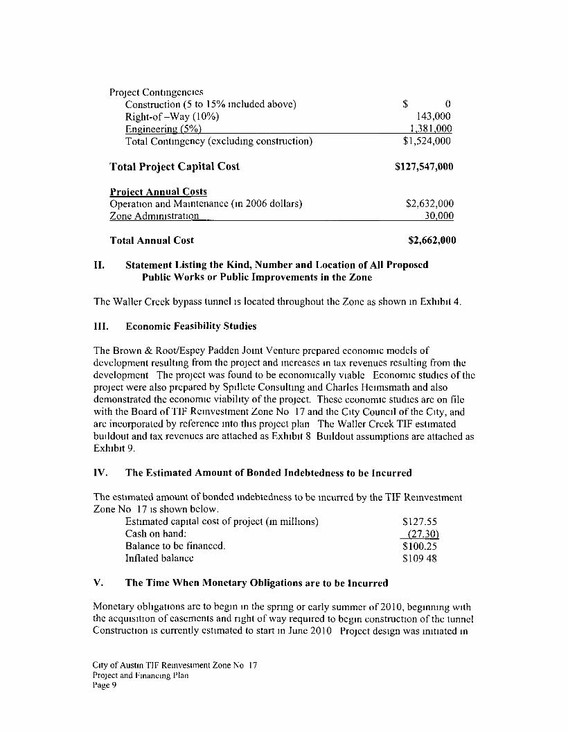
Project ContingenciesConstruction (5 to 15% included above) $ 0Right-of-Way (10%) 143,000Engineering (5%) 1.381.000Total Contingency (excluding construction) $1,524,000
Total Project Capital Cost $127,547,000
Project Annual CostsOperation and Maintenance (in 2006 dollars) $2,632,000Zone Administration 30.000
Total Annual Cost $2,662,000
II. Statement Listing the Kind, Number and Location of All ProposedPublic Works or Public Improvements in the Zone
The Waller Creek bypass tunnel is located throughout the Zone as shown in Exhibit 4.
III. Economic Feasibility Studies
The Brown & Root/Espcy Padden Joint Venture prepared economic models ofdevelopment resulting from the project and increases m tax revenues resulting from thedevelopment The project was found to be economically viable Economic studies of theproject were also prepared by Spillcte Consulting and Charles Heimsmath and alsodemonstrated the economic viability of the project. These economic studies are on filewith the Board of TIP Reinvestment Zone No 17 and the City Council of the City, andare incorporated by reference into this project plan The Waller Creek TIP estimatedbuildout and tax revenues arc attached as Exhibit 8 Buildout assumptions are attached asExhibit 9.
IV. The Estimated Amount of Bonded Indebtedness to be Incurred
The estimated amount of bonded indebtedness to be incurred by the TIP ReinvestmentZone No 17 is shown below.
Estimated capital cost of project (in millions) $127.55Cash on hand: (27.30)Balance to be financed. $100.25Inflated balance $10948
V. The Time When Monetary Obligations are to be Incurred
Monetary obligations arc to begin in the spring or early summer of 2010, beginning withthe acquisition of easements and right of way required to begin construction of the tunnelConstruction is currently estimated to start in June 2010 Project design was initiated in
City of Austin TIP Reinvestment Zone No 17Project and Financing PlanPage 9

August 2007 and will be paid for with the City's cash-on-hand provided by the 1998bond proceeds plus related interest earnings
The City and County tax increments, as set out in the Agreement with Travis County, arcexpected to provide sufficient funds to pay the costs of the project; however, there aretiming issues associated with the cash flows during the 20-year life of the TIPCollection of TIF revenue is expected to begin in fiscal year 2009 and end in fiscal year2028. To smooth out the cash flows during the life of the TIF, an additional source offunding for the project is available from within the Convention Center/Waller Creekvenue to supplement the available TIF revenue when needed to help cover project costsor debt service. The refunding of the Hilton Hotel bonds that occurred in December 2006provides for the payment of net revenue from the hotel to the Austin ConventionEnterprises Corporation (ACE) and ultimately to the City These net revenues arc nothotel tax revenues, but represent revenues from the hotel project. The use of theserevenues strengthens the final financing plan Using this additional funding will provideadditional security for the bond holders when debt is issued to finance the project, thushelping to lower the interest rate Use of these revenues will also solve cash flow issuesin the early years of the TIF before the tax increment has significantly grown, and willprovide a reserve for unanticipated problems that might be encountered during the longdesign and construction phases As outlined in the project plan, should actual costsexceed estimated project costs, then the City of Austin will be responsible for fundingthose additional costs if project or operating costs exceed the available TIF revenues to becontributed by the City and Travis County
VII. Description of the Method of Financing AH Estimated Project Costs and theExpected Sources of Revenue to Finance or Pay Project Costs Including thePercentage of Tax Increment to be Derived from the Property Taxes of EachTaxing Unit that Levies Taxes on Real Property in the Zone
Description of the Methods of Financing
The City of Austin is allowed, under the provisions of Section 311 015 of the TaxIncrement Financing Act, to issue tax increment bonds or notes, the proceeds of whichmay be used to provide for project-related costs The City possesses the authority underTexas law to issue certificates of obligation to finance projects such as those described inthis project plan. The City will issue debt under its own authority to finance design andconstruction of the tunnel project The City of Austin will be responsible for managingthe financing process for the tunnel project and intends to issue future certificates ofobligation to fund construction and other related project costs as needed. When the Cityissues certificates of obligation to fund project costs described in this project plan,revenues deposited to the credit of the tax increment fund for TIF Reinvestment Zone NoJ 7 will be made available to the City for the purpose of paying the debt service on thecertificates of obligation By issuing certificates of obligation, the City assumes the riskif future development is not sufficient to pay for all costs related to the construction of thetunnel Travis County will be responsible only for contributing 50% of its tax incrementto be derived from the TIF Reinvestment Zone No 17 The terms and conditions
City of Austin TIF Reinvestment Zone No 17Project and Financing PlanPage 10

outlined in the Agreement between the City of Austin and Travis County and in thisfinancing plan will be incorporated into any bond covenants associated with the issuanceof debt related to this project.
Sources of Tax Increment Revenue
The tax increment revenue necessary to pay the project costs is expected to come fromincreased property values in the zone due to construction of new commercial andresidential buildings. Estimated buildout and tax revenues are shown in Exhibit 8.Buildout assumptions are shown in Exhibit 9.
The financing plan is based on the City of Austin contributing 100% of their collectedincremental tax revenue to the zone and Travis County contributing 50% of theircollected incremental tax revenue to the zone Tax rates that were in effect when the TIPReinvestment Zone No 17 was established in June 2007 are shown below
Taxing UnitCity of AustinTravis County
Total Tax Rate$041267$ 100$0.44997$ 100
Tax Rate Dedicated$041267$100$0.224957$ 100
% Dedicated100%50%
VIII. The Current Total Appraised Value of Taxable Real Property in the Zone
The total appraised value within the TIP Reinvestment Zone No. 17 based on values forthe 2006 tax year when the TTF was established in June 2007 was $173 6 million. Recentvalues from the Travis County Appraisal District for the 2007 tax year are approximately$236 2 million associated with taxable properties in the City of Austin and $228 1 millionm Travis County Exhibit 8, which depicts estimated tax revenue over the 20-year TIPperiod, has been updated to reflect the updated 2007 tax values. These updated tax valueshave also been incorporated in the Agreement to Participate in Tax IncrementReinvestment Zone No. 17, between the City of Austin and Travis County.
IX. The Estimated Captured Value of the Zone During Each Year of itsExistence
The estimated captured appraised value of the TIP Reinvestment Zone No 17 duringeach year of its existence is shown in Exhibit 8. The estimated appraised value for taxyear 2007 has increased compared to the value originally projected The assumptions inthe Brown & Root7Espey Padden Joint Venture economic model related to cumulativeassessed value increment within the zone over the estimated life of the TTF are consideredreasonable and materially accurate for purposes of projecting nature tax incrementrevenues. Estimated buildout and tax revenues arc shown in Exhibit 8 Buildoutassumptions are shown m Exhibit 9
X. Duration of the Zone
Ovy of Austin T1F Reinvestment Zone No 17Project and Financing PlanPage 11

The duration of the TIP Reinvestment Zone No 17 is 20 years. The Austin City Councilhas established January 1, 2008 as the first year of the TIP Reinvestment Zone No 17,with the TIP base valuation dated January 1, 2007. January 1, 2008 will be the first datefor which the TIP captured appraised value will be recorded Fiscal year 2009 will be thefirst year in which both the City and Travis County pay their associated tax incrementinto the TIP fund that will be established pursuant to the Agreement The TIPReinvestment Zone No 17 will terminate on September 30, 2028, or the date on whichthe project has been fully implemented and all Project Costs of the TIP District, includingany debt or interest on that debt, issued by the City in accordance with the financing planhave been paid or otherwise satisfied in full The Parties may agree to terminate the TIPagreement prior to the termination date only by written agreement signed by both parties,which agreement shall include the actual termination date, and the disposition of fundsthat have not been disbursed.
City of Austin TIF Reinvestment Zone No 17Project and Financing PlanPage 12


TIF ZONEBOUNDARY
CENTERLINE EXTENSION OF CUMUINGS STREET TO THEINTERSECTION OF THE NORMAL POOL ELEVATIONCONTOUR LINE OF 42900 MEAN SEA LEVEL
CENTERLINE EXTENSION OF TRINITY STREET TO THEINTERSECTION OF THE NORMAL POOL ELEVATIONCONTOUR LINE OF 429 00 MEAN SEA LEVEL
WALLER CREEK TAX INCREMENTFINANCING REINVESTMENT ZONE (TIF),
CITY OF AUSTIN, TRAVIS COUNTY, TEXAS
TIF ZONEBOUNDARY
THIS DOCUUENT WAS PREPARED UNDER 22 TAC §66321, DOES HOT REFLECT THERESULTS OF AN ON THE GFIOUNQ SURVEY AND IS NOT TO BE USED TO CONV€Y OffESTABLISH INTERESTS IN REAL PROPERTY EXCEPT THOSE RIGHTS AND INTERESTSIMPLIED OR ESTABLISHED BY THE CREATION Off RECONFIGURATION OF THEBOUNDARY OF 7W£ POLITICAL SUBDIVISION FOR WHICH IT WAS PREPARED
A SEPARATE METES AND BOUNDS DESCRIPTION OF EVEN DATE ACCOMPANIES THISEXHIBIT
STEPHEN HOffVATHREGISTERED PROFESSIONAL LAND SURVEYOR
-a TEXAS REGISTRATION NUUBER 2S11VICKREY A ASSOCIATES INC STEPHEN HOflVATH
REVISION ~ 6/15/07 MISCELLANEOUS REVISIONREVISION - 6/14/07 MISCELLANEOUS REVISIONS
VICKREY & ASSOCIATES, INCC O N S U L T I N G E N G I N E E R S
1209 WBst 5th 5tr»st, Sulla 200Austin, Texas 78703
Tel«phona (512)494-3014
12940 Country ParkwaySan Antonio, Texas 78216T«t*phon» 210)349-3271DfWWIWG FILE S\!73B-OO*\DWC\nNAl OHlSff 0*C
EXHIBIT 3

Resolution of the Waller Creek Citizen Advisory Committee
Whereas, the Waller Creek Citizen Advisory Committee (WCCAC) was created by City Council asadvisory and oversight group for the Waller Creek Tunnel Project, and
Whereas, the City's tunnel design consultant has advised the City there are several issues that must beresolved at this time to remain on schedule for the tunnel design and construction, but as engineering anddesign work continue, further recommendations may be considered, and
Whereas, the current issues concern.1 Base water flow m the creek2 Character of the inlet and outlet structures;3 Overall appearance and public availability of the Waller Creek area upon completion
Whereas, the WCCAC has undertaken to provide recommendations on the above issues, and has heldseveral meetings and reached out to the community to make well-informed recommendations, and
Whereas, the WCCAC has developed design recommendations that are based in part on comments andsuggestions received from individuals, organizations represented by members of the WCCAC, and otherCity boards and commissions, and from the public at a design workshop held November 17, 2007,
NOW THEREFORE BE IT RESOLVED THAT
The WCCAC makes the following design recommendations to City Council for the Waller Creek TunnelProject.
1 Tunnel Inlet at Waterloo Park: The inlet should be designed so it is friendly to both organizedevents and casual users, and water is part of the overall experience It should be designed andengineered so the operational requirements of the inlet structure are as unobtrusive as possible,while maintaining public safety
2 Tunnel Outlet at Lady Bird Lake. The outlet should be designed to maintain the natural characterof the shoreline of Lady Bird Lake, and should not include an amphitheater The island that servesas a nesting site for water foul should be preserved
3 Tunnel project design and engineering should plan for a base water flow rate thata Is steady in order to maintain a reasonable depth, health and movement of water,b Does not impede access or use for all individuals along the creek, andc Does not cause additional erosion problems
4 Tunnel project design and engineering should minimize exclusionary uses, and provide a varietyof mutually compatible uses along the creek corridor which will allow the greatest number ofpeople to engage in recreational activity along Waller Creek at any given time, and should notinclude activities that will impede some existing uses. The design should also ensure the channelincludes areas of riparian habitat that will promote the establishment of other native flora andfauna along the corridor by use of natural materials aWd native landscaping
Date / / t"»»Ls
Title
EXHIBIT 5


Exhi
bit 8
W
alle
r Cre
ek T
IFB
uild
out a
nd
Tax
Rev
enue
s Sc
hedu
le
ESTI
MA
TED
C
ON
STR
UC
TIO
N
STA
RTS
JU
NE
2010
W
ithou
t His
toric
Pro
pert
ies
TOTA
LSES
TIM
ATE
DPR
OJE
CTE
D V
ALU
ES --
------
>>TA
X YE
AR
2007
2008
2009
2010
2011
FISC
AL
YEA
R20
0920
1020
1120
12E
STI
MA
TED
TA
X B
AS
E (C
ITY
)23
6,19
9,78
2$
ES
TIM
ATE
D T
AX
BA
SE
(CO
UN
TY)
228,
144,
590
$
A
sses
sed
valu
e in
crem
ent
99,2
17,3
72$
102,
193,
893
$
24
6,76
5,12
5$
308,
001,
868
$
To
tal A
SS
ES
SE
D V
ALU
ATI
ON
335,
417,
154
$
33
8,39
3,67
5$
482,
964,
907
$
54
4,20
1,65
0$
Ann
ual C
ity R
eal a
nd P
erso
nal P
rope
rty T
ax R
even
ue34
7,71
4,65
9
409,
371
$
42
1,65
3$
1,05
3,24
8$
1,
322,
772
$
50%
of T
otal
Ann
ual C
ount
y R
eal a
nd P
erso
nal P
rope
rty T
ax R
even
ue69
,444
,897
22
3,19
0$
229,
886
$
57
4,23
2$
721,
177
$
To
tal P
rope
rty T
ax R
even
ue63
2,56
1$
651,
539
$
1,
627,
480
$
2,04
3,94
9$
A
nnua
l Bon
d P
aym
ents
(est
imat
ed b
ased
on
amou
nt to
be
finan
ced
of $
109.
48 m
illio
n)21
2,54
4,84
0
-$
-
$
-$
7,
084,
828
$
Ann
ual O
&M
Cos
t (es
timat
ed b
ased
on
2006
dol
lars
of $
2.6
mill
ion,
3%
ann
ual i
nfla
tion)
124,
960,
000
-
$
-$
-
$
-$
To
tal D
ebt S
ervi
ce a
nd O
&M
Cos
t33
7,50
4,84
0
-$
-
$
-$
7,
084,
828
$
Ann
ual D
efic
it79
,654
,716
63
2,56
1$
651,
539
$
1,
627,
480
$
(5,0
40,8
79)
$
Cum
mul
ativ
e D
efic
it63
2,56
1$
1,28
4,09
9$
2,
911,
579
$
(2,1
29,3
00)
$
Est
imat
ed T
otal
Rev
enue
For
m C
ity S
ale
Tax
(Exc
ludi
ng H
otel
)18
7,88
8,74
2
-$
93
3,54
9$
751,
634
$
1,
395,
919
$
ESTI
MA
TED
VA
LUES
AN
D A
BSO
RPT
ION
TO
TALS
Offi
ce V
alue
&
Squa
re F
eet (
SF)
Ret
ail V
alue
&
Squa
re F
eet (
SF)
Hot
el V
alue
&
Squa
re F
eet (
SF)
Res
iden
tial
(Apa
rtm
ents
/C
ondo
min
ium
s)
Valu
e &
Squ
are
Feet
(SF)
TOTA
L 20
06 V
alue
s =>
59
9,26
5,00
0$
117,
000,
000
$
12
6,23
8,12
5$
820,
416,
420
$
M
axim
um A
bsor
ptio
n Es
timat
e, S
F =>
2,
605,
500
600,
000
1,
553,
700
2,56
1,40
0
1
I- T3 -C
§ «
uj .£.re CO a
inCDeoCM"oo"COen•*-
tft
Tenen"inCN
CO|v-
tft
• -incoIV."
inCO
com
to
IV-
co•in"CO
co"^TCO
tft
TO!il
co"CNICNm"r--
to
COCOenCDcoCM
CDCOO5
69
COCDCMCOCMr^CDooo
to
oco
m"CDCDmtoco
to
COCOCM
eor^coCO
in
to
COCO
coCOcoCDoTl-
tO
i«-TfcoCN
CN
ccCN
CM"
to
COCNIr-.ofin•*I--"CDCD
to
CDCOCDiv."inooo"CD1
tft
OJCOCN
IT
cCTcoIT.
to
COCD-^co"CM•*
5
(ft
oiIV-
O)co^-CMCMCM
69
inTocoCMcnCM1-o
to
CMTenT"enCO
ocn
eft
inoCO|v-cocni
to
coCO
cwcocoCM• -co
t«
COCMCMN"enmco'
(ft
CMcocoCM'miC
to
SOcoCMCM"mIOCD"
w
^3-
COCN*mooin
«j
CSD
o"
in
V)
01tTO
TOCMM-
V)
inincr>M
nCO
tft
CD•a-CN
o>ooooCM
69
•3-T
ooCMCM
(ft
coCD•3-
CMn
^
to
CO
CM1--"COCD• -*
tft
CMoCD*CDO^f
to
• rCMcoto"CMcoco"
to
cocnocn
co"
(A
"3-^~COCD*CO|v-CN*
to
enCD^T• •coCO
CM
to
COootenoCD
y>
CMCMCMin"r~-ID
^
69
1 -COCO
O>OCM»-
69
inr•*inm01
6O
CD^~T
• "COCN
co"
69
COeoCOeo"oco_
^
(O
COcnocn"fv.CM
o"
to
tor^|v-
co""3-OCD"
t)9
CD
O|v-"enTOr--"
«/>
CO
CO
coCD
CD
to
COTCO
^~in
fo9
r-T-3-"co•n-n-
t«
OD
5iCM«a-?>
to
COoCDr-or-(N
w?
eoCMCO•cfCOor -'
69
coCMco• -"coo|v."
to
03CMCO•q-"eoo-"
(ft
COCMco•t"coot -"
to
coCMeo•*fCOor--"
tft
TOCMCOTcoor^
to
ooCMTOTCOOr-
69
COCMTOt"TOOr-
to
COCMTOfTOOf-
<ft
TOCMTOtOOO1--
69
OC
o"IV-
coco"
69
OOOOco1co"
tfl
oooo"inCDco"
tft
oooo"r
inco"
to
ooeoo""3-Tf
co"
(ft
oooo-tCO
CO
(ft
ooooi-CNCO
69
,
to
,
tft
,
tft
eoCNCO
aCD
o"
69
coCMccT"^Tcoo"
(ft
coCMTOt"nIv.
c
to
coCMecT"CMcoo
to
TOCM«:T"CMIT.
C
69
TOCMTO*TCM
•*O
(ft
eoCMCO•*CMcoo
tft
COCMCOT'TOo
"to
COCNCO
TJ-coor-
to
COCMCO
-3-TO0
"
tft
CO
toO)CNCOCM"
09
inmor"
<Dr-.
69
in"COfv.
inin,
(ft
csTino
TOin
"
(ft
rTTOiCCMCDCM"
69
o"inTOoTOCO_
tft
tf)TOCDCM
CD
2,
to
DCOo"CMcoCN_
69
nCO
ncoCO_
(ft
o"CMo>D
O
^
tft
cn*s-coCD"fv.oco"CN^
tft
COcoCD
in"o• •m"CM
69
COCNOo"r--
co"CN_
69
f^"TOCMTf"
IV-
iriCi-
(ft
in"COCNto"co
T"CM_
69
co"CM
^mom
CM.
69
CM"CD
CDcncor--
to
t~?CMCDco"COr^CM
to
o"(v-inCOco
o•-
69
o1
CMCN
coOinID
(ft
TOtooo"I--inCD"
tft
CDcoCT
o:irco"
£O
!--r^orrCMOCD"
69
5to"CD|v-
ici
69
COinCJi
ofinin"
eft
oCMCMOOCJ>coin
69
toCM|v-COCO^f•*
69
coO
rv."CMCOCO
to
r^intooCO
CM
EO
otoCOcoCDco^
6ft

Exhi
bit 8
W
alle
r Cre
ek T
IFB
uild
out a
nd
Tax
Rev
enue
s Sc
hedu
le
TRA
VIS
CO
UN
TY
PATI
CIP
ATI
ON
IN
TIF
END
S
2022
2023
2024
2025
2026
2027
2028
2029
2030
2031
2023
2024
2025
2026
2027
2028
2029
2030
2031
2032
2,21
2,11
8,47
1$
2,46
1,70
4,99
3$
2,72
9,93
7,39
0$
3,
061,
155,
024
$
3,37
1,76
7,48
1$
3,
662,
706,
291
$
3,77
1,37
4,42
1$
3,
825,
972,
779
$
3,82
5,97
2,77
9$
3,
825,
972,
779
$
2,
448,
318,
253
$
2,
697,
904,
775
$
2,
966,
137,
172
$
3,29
7,35
4,80
6$
3,
607,
967,
263
$
3,89
8,90
6,07
3$
4,
007,
574,
203
$
4,06
2,17
2,56
1$
4,
062,
172,
561
$
4,06
2,17
2,56
1$
9,59
7,33
1$
10,6
71,7
23$
11,8
25,3
00$
13
,261
,561
$
14,5
95,4
07$
15
,846
,544
$
16,3
17,5
49$
16
,588
,555
$
16,6
12,6
33$
16
,637
,433
$
5,23
2,47
7$
5,81
8,23
6$
6,44
7,16
8$
7,23
0,21
9$
7,95
7,43
2$
8,63
9,55
4$
14,8
29,8
08$
16
,489
,959
$
18
,272
,468
$
20,4
91,7
80$
22
,552
,839
$
24,4
86,0
98$
16
,317
,549
$
16,5
88,5
55$
16
,612
,633
$
16,6
37,4
33$
7,
084,
828
$
7,
084,
828
$
7,
084,
828
$
7,
084,
828
$
7,
084,
828
$
7,
084,
828
$
7,
084,
828
$
7,
084,
828
$
7,
084,
828
$
7,
084,
828
$
3,
990,
000
$
4,
110,
000
$
4,
230,
000
$
4,
360,
000
$
4,
490,
000
$
4,
620,
000
$
4,
760,
000
$
4,
900,
000
$
5,
050,
000
$
5,
200,
000
$
11
,074
,828
$
11,1
94,8
28$
11,3
14,8
28$
11
,444
,828
$
11,5
74,8
28$
11
,704
,828
$
11,8
44,8
28$
11
,984
,828
$
12,1
34,8
28$
12
,284
,828
$
3,75
4,98
0$
5,29
5,13
1$
6,95
7,64
0$
9,04
6,95
2$
10,9
78,0
11$
12
,781
,270
$
4,47
2,72
1$
4,60
3,72
7$
4,47
7,80
5$
4,35
2,60
5$
(19,
321,
369)
$
(14,
026,
239)
$
(7,0
68,5
99)
$
1,97
8,35
3$
12,9
56,3
64$
25
,737
,634
$
30,2
10,3
56$
34
,814
,082
$
39,2
91,8
87$
43
,644
,491
$
6,87
0,01
3$
7,17
4,64
8$
7,78
0,69
2$
7,83
2,46
9$
7,90
2,18
3$
6,89
6,66
3$
7,44
0,66
0$
7,29
8,34
4$
7,51
7,29
5$
7,74
2,81
3$
3

LU J£ 5 *co CO «>% K
00 00ro in
co cos a
CO CO
co in
en ien nco *-
o CM o
co coin oj01 co
en coCM CMCO CO
CO CD<o~ en
| CM CN CO
of co". _ •* COo; oo ooro" in cri
CM mm m
CO i-|
oo o co
in co o
CO T-
eo CMCM CM
CM OO Oil
Exh
ibit
9W
all
er
Cre
ek
TIF
Bu
ild
ou
t A
ssu
mp
tio
ns
Year N
um
ber
Cale
nd
ar
Year
Bo
tto
m o
f R
an
ge
Off
ice (
SF
)
Avera
ge O
ffic
e
(SF
)
To
p o
f R
an
ge
Off
ice (
SF
)
Bo
tto
m o
f R
an
ge
Reta
il (
SF
)
Av
era
ge
Re
tail
(SF
)
To
p o
f R
an
ge
Re
tail
(S
F)
Ho
tel
- S
F
Re
sid
en
tia
l
(Ap
art
me
nts
/Co
nd
om
iniu
ms
) -
SF
Ap
art
me
nts
Nu
mb
er
of
Un
its
pe
r Y
ea
r
TO
TA
L 2
006 V
alu
es =
>
$ 59
9,2
65,0
00
$
599,2
65,0
00
$
599,2
65,0
00
$
117,0
00
,00
0
$
11
7,0
00
,00
0
$
11
7,0
00
,00
0
12
6,2
38
,12
5$
$
8
20
,41
6,4
20
2,6
05,5
00
2,6
05,5
00
2,6
05,5
00
600,0
00
60
0,0
00
60
0,0
00
1,5
53
,70
0 2
,56
1,4
00
1E
nd
of
2008
- -
- -
- -
-
-
-
2E
nd
of
2009
- -
- 5
0,0
00
62
,50
0 7
5,0
00
20
3,2
00
2
68
,80
0
-
3E
nd
of
2010
75,0
00
100,0
00
125,0
00
50,0
00
62
,50
0 7
5,0
00
-
71
,25
0
7
5
4E
nd
of
2011
75,0
00
100,0
00
125,0
00
50,0
00
62
,50
0 7
5,0
00
-
14
1,2
50
75
5E
nd
of
2012
75,0
00
100,0
00
125,0
00
50,0
00
62
,50
0 7
5,0
00
-
14
1,2
50
75
6E
nd
of
2013
75,0
00
100,0
00
125,0
00
100,0
00
11
2,5
00
12
5,0
00
20
0,0
00
1
41
,25
0
7
5
7E
nd
of
2014
75,0
00
100,0
00
125,0
00
100,0
00
11
2,5
00
12
5,0
00
-
14
1,2
50
75
8E
nd
of
2015
15
0,0
00
175,0
00
200,0
00
100,0
00
11
2,5
00
50
,00
0 -
1
41
,25
0
7
5
9E
nd
of
2016
15
0,0
00
175,0
00
200,0
00
100,0
00
12
,50
0 -
20
0,0
00
1
41
,25
0
7
5
10
En
d o
f 2017
15
0,0
00
175,0
00
200,0
00
- -
- -
1
41
,25
0
7
5
11
En
d o
f 2018
15
0,0
00
175,0
00
200,0
00
- -
- -
1
41
,25
0
7
5
12
En
d o
f 2019
15
0,0
00
175,0
00
200,0
00
- -
- -
1
41
,25
0
7
5
13
En
d o
f 2020
15
0,0
00
175,0
00
200,0
00
- -
- 2
00
,00
0
14
1,2
50
75
14
En
d o
f 2021
15
0,0
00
175,0
00
200,0
00
- -
- -
1
41
,25
0
7
5
15
En
d o
f 2022
15
0,0
00
175,0
00
200,0
00
- -
- -
1
41
,25
0
7
5
16
En
d o
f 2023
15
0,0
00
175,0
00
200,0
00
- -
- -
1
41
,25
0
7
5
17
En
d o
f 2024
15
0,0
00
175,0
00
180,5
00
- -
- 2
00
,00
0
14
1,2
50
75
18
En
d o
f 2025
15
0,0
00
175,0
00
- -
- -
-
14
1,2
50
75
19
En
d o
f 2026
15
0,0
00
175,0
00
- -
- -
-
10
2,6
00
75
20
En
d o
f 2027
15
0,0
00
5,5
00
- -
- -
-
-
-
21
En
d o
f 2028
15
0,0
00
- -
- -
- 2
00
,00
0
-
-
22
En
d o
f 2029
13
0,5
00
- -
- -
- -
-
-
23
En
d o
f 2030
- -
- -
- -
-
-
-
24
En
d o
f 2031
- -
- -
- -
-
-
-
25
En
d o
f 2032
- -
- -
- -
-
-
-
26
En
d o
f 2033
- -
- -
- -
20
0,0
00
-
-
27
En
d o
f 2034
- -
- -
- -
-
-
-
28
En
d o
f 2035
- -
- -
- -
-
-
-
29
En
d o
f 2036
- -
- -
- -
-
-
-
30
En
d o
f 2037
- -
- -
- -
-
-
-
Ad
so
rpti
on
Assu
mp
tio
n a
nd
Lag
Tim
es
M
ost
Lik
ely
Develo
pm
e
WA
LL
ER
CR
EE
K T
UN
NE
L P
RO
JE
CT
, C
I T

Exh
ibit
9W
all
er
Cre
ek
TIF
Bu
ild
ou
t A
ssu
mp
tio
ns
31
En
d o
f 2038
- -
- -
- -
15
0,5
00
-
-
32
En
d o
f 2039
- -
- -
- -
-
-
-
33
En
d o
f 2040
- -
- -
- -
-
-
-
34
En
d o
f 2041
- -
- -
- -
-
-
-
35
En
d o
f 2042
- -
- -
- -
-
-
-
36
En
d o
f 2043
- -
- -
- -
-
-
-
37
En
d o
f 2044
- -
- -
- -
-
-
-
38
En
d o
f 2045
- -
- -
- -
-
-
-
39
En
d o
f 2046
- -
- -
- -
-
-
-
40
En
d o
f 2047
- -
- -
- -
-
-
-
41
En
d o
f 2048
- -
- -
- -
-
-
-
42
En
d o
f 2049
- -
- -
- -
-
-
-
43
En
d o
f 2050
- -
- -
- -
-
-
-
44
En
d o
f 2051
- -
- -
- -
-
-
-
45
En
d o
f 2052
- -
- -
- -
-
-
-
46
En
d o
f 2053
- -
- -
- -
-
-
-
47
En
d o
f 2054
- -
- -
- -
-
-
-
48
En
d o
f 2055
- -
- -
- -
-
-
-
49
En
d o
f 2056
- -
- -
- -
-
-
-
50
En
d o
f 2057
--
--
--
-
-
-

UJ « ^
i
•aa
to
oa."c0)E01
oQ.E
Range (S
F)
iZ
ve
rag
e R
et<
(Ooo
QO
iZ
VO)c
ffice
(S
F) R
/era
ge
C
<
oCM
O
O
13o:c
so(A
01CDC
o:"oo.o
ucre
"o
OcoCD
oUlm
01O)crao:
Top o
f R
an
ge
oO)cre
"6EoEo
CD
01O)ra0)
encre
QL
o
l!
o So:
Co
nd
om
iniu
ms
Num
ber
of
Units
pe
r Y
ea
r
a>ia c
HIE 5 i-3.-° S.< 1
•z.u.V)
If!u E =w re £u a oa: <,-£
o<J
Hote
ls N
um
ber
of
Room
s per
Ye
ar
Condom
iniu
ms
Num
ber
of
Units
per
Ye
ar
• •
oooinr~-
ooooin
ooinIN
•
CMO>
Ooffl
sCM
CMOl
OOOf>
OOOoin
ooinCM
125000
ooo
oooo
oo
oo
m
oinCM
•
OOoin
ooooin
ooCM
ooomCM
oom
oooo
oo
oo
oin
m
omCM
Oin
ooinr-
oooin
o8CM
125000
oo8
oo
oo
oo
oin
SfM
8
oooCM
OOOOO
OOinCM
125000
oooin
ooooo
o
oo
oin
m
oCM
OmCM
s
oooinCM
ooooo
ooinCM
125000
ooom
oooo0
oo
oo
om
in
oinCM
oin
oooinCM
ooooo
ooinCM
200000
oooom
ooom
oo
in
o
in
OinCM
Oin
oooinCM
ooooo
ooinCM
200000
ooooin
ooom
oo
om
S
in
omCM
omCM
om
oooinCM
ooooo
ooinCM
200000
oooom
ooom
ooomCM
Oin
in
omCM
Om
oooinCM
OOOOO
OoinCM
200000
ooooin
ooom
aooooCM
oin
in
omCM
om
oooinCM
oooo
ooinCM
oooooCM
oooom
ooom
o
m
oin
in
omCM
o
ooomCM
ooooo
ooinCM
200000
ooooin
ooom
oaoamin
oin
m
omCM
oCM
oin
0ooinCM
ooooo
oomCM
200000
oooom
ooom
ooomCM
oin
in
omCM
8
ooomCM
ooooo
oomCM
200000
ooooin
oooin
ooooaOJ
oin
m
oinCM
oin
aoSCM
OOOOO
OOmCM
200000
ooos
oooin
oooinP-oCM
Oin
m
oinCM
Oin
oooinCM
ooooo
ooinCM
200000
ooaS
oooin
ooooinCMCM
oin
in
omCM
omCM
om
inCM
o
CM
200000
ao
om
oSinCM
CM
S
omCM
CJin
oooinCM
ooooo
CM
200000
ooooin
oooin
oooootoCM
om
in
omCM
Si
oooinCM
ooooo
oomCM
200000
ooooin
oooin
oooinP-.P-<M
Oin
in
omCM
'
ooomCM
ooooo
SmCM
200000
ooooin
oooin
ooooinO)CM
om
in
omCM
omCM
•
ooomCM
ooooo
oomCM
200000
oooin
oooin
oooin
en
oin
in
oinCM
•
oooinCM
ooooo
ooinCM
200000
ooooin
ooom
aoooo
om
in
oinCM
•
oooinCM
Ooooo
oomCM
200000
ooooin
oooin
ooomT
Oin
m
oinCM
'
OoomCM
ooooo
oomCM
200000
oooom
ooom
oooomIDCO
oin
m
oinCM
•
oooinCM
OOooo
ooinCM
200000
oooom
ooom
ooo
CMCOfl
oin
m
oinCM
OmCM
•
ooomCM
ooooo
ooinCM
200000
oooom
ooo[C
oooaoo
oin
m
ainCM
oooinCM
ooooo
ooinCM
200000
oooom
ooom
oooin
TI-
in
m
oCM
•
o oo oS mCM CM
o oo oo oa oo o
o oo oin inCM CM
200000
200000
o oo oo oo om m
o oo oo oin in
o oo oo oo inm CMco m•t TT
o oin m
in in
o om mCM CM
• •
