analysing and evaluating flood risk governance in the ... · pdf fileanalysing and evaluating...
TRANSCRIPT

Strengthening and Redesigning European Flood Risk Practices Towards Appropriate and Resilient Flood Risk Governance Arrangements
Analysing and evaluating flood risk
governance in the Netherlands
Drowning in safety?
Kaufmann, M., van Doorn-Hoekveld, W., Gilissen, H.K., and van Rijswick, M.
Date: 31 March 2016
Report Number: D3.2
Milestone Number: MS3
Due date for deliverable: 30 September 2015
Actual submission date: 28 September 2015
STAR-FLOOD receives funding from the EU 7th Framework programme (FP7/2007-2013) under grant
agreement 308364
Document Dissemination Level
PU Public
Co-ordinator: Utrecht University
Project Contract No: 308364
Project website: www.starflood.eu
ISBN:

i
Photos cover: Stormvloedkering, https://beeldbank.rws.nl, Rijkswaterstaat / Joop van Houdt; image
of Dordrecht, http://www.preventionweb.net/applications/hfa/lgsat/en/image/href/5474

ii
Document information Work Package 3
Consortium body RU, UU
Year 2016
Document type Deliverable 3.3
Status Final version
Date 31 March 2016
Authors Kaufmann, M., Van Doorn-Hoekveld, W.J., Gilissen, H.K., Van Rijswick, H.F.M.W.
Document history Date Revision Prepared by Organisation Notes
16/03/2015 V1 Authors RU, UU Discussed 24 April 2015
15/05/2015 V2 Authors RU, UU Discussed during Consortium Meeting Sweden
15/08/2015 V3 Authors RU, UU Final version to be approved by coordinator
07/09/2015 V4 Authors RU, UU Final version to be approved by EC
Acknowledgement The work described in this publication was supported by the European Union’s Seventh Framework
Programme through the grant to the budget of the Integrated Project STAR-FLOOD, Contract 308364.
Disclaimer This document reflects only the authors’ views and not those of the European Union. This work may
rely on data from sources external to the STAR-FLOOD project Consortium. Members of the
Consortium do not accept liability for loss or damage suffered by any third party as a result of errors
or inaccuracies in such data. The information in this document is provided ‘as is’ and no guarantee or
warranty is given that the information is fit for any particular purpose. The user thereof uses the
information at its sole risk and neither the European Union nor any member of the STAR-FLOOD
Consortium is liable for any use that may be made of the information.
© STAR-FLOOD Consortium. This report should be referred to as follows:
Kaufmann, M., Van Doorn-Hoekveld, W.J., Gilissen, H.K., Van Rijswick, H.F.M.W. (2016), Drowning in
safety. Analysing and evaluating flood risk governance in the Netherlands (report no. D3.3), STAR-
FLOOD Consortium, Utrecht, The Netherlands, ISBN: 978-94-91933-11-0.

iii
Key words Flood risk governance;
Flood risk management;
Legal frameworks governing floods;
The Netherlands;
Discourse;
Resources;
Rules;
Actors;
Resilience;
Legitimacy;
Efficiency
Author details Maria Kaufmann, MSc, is a PhD candidate at the Radboud University Nijmegen, Institute for
Management Research, Political Science of the Environment.
Willemijn van Doorn-Hoekveld, LLM, is a PhD candidate at the Utrecht Centre for Water, Oceans and
Sustainability Law of the Faculty of Law, Economics and Governance (REBO) of Utrecht University.
Dr. Herman Kasper Gilissen, LLM, is a post-doctoral researcher at the Utrecht Centre for Water,
Oceans and Sustainability Law of the Faculty of Law, Economics and Governance (REBO) of Utrecht
University.
Prof. dr. Marleen van Rijswick, LLM, is Professor of European and national water law and director of
the Utrecht Centre for Water, Oceans and Sustainability Law of the Faculty of Law, Economics and
Governance (REBO) of Utrecht University.
Acknowledgements The authors thank the valuable feedback of Dr. Mark Wiering and Dr. Duncan Liefferink during the
conduction of the research, as well as Julian Kevelam for his valuable contribution to the case study
Dordrecht. They also thank Jos van Alphen for his valuable comments on an earlier version of this
report.
iv
Preface This report is a deliverable of the EU 7th Framework Project STAR-FLOOD (www.starflood.eu). STAR-
FLOOD focuses on Flood Risk Governance. The project investigates strategies for dealing with flood
risks in 18 vulnerable urban regions in six European countries: England in the UK, Belgium, France,
the Netherlands, Poland and Sweden. The project assesses Flood Risk Governance Arrangements
from a combined public administration and legal perspective, with the aim of making European
regions more resilient to flood risks.
This report constitutes deliverable D3.2, a country report on the Netherlands. Work Package 1
provided an extended problem analysis related to Flood Risk Governance in Europe. Work Package 2
focused on how Flood Risk Governance in Europe can be researched. Work Package 3 forms the
empirical core of the project, in which analyses, explanations and evaluations of each country,
including three case studies, have been performed.
The Netherlands has a long tradition of flood risk management, due to its special physical location in
the delta of four major river systems. This low-lying country is historically characterised by a ‘fight
against water’. The Flood Risk Governance Arrangement of the Netherlands is characterised by a
strong focus on reducing flood probability and governmental responsibility. A key characteristic is the
statutory right to flood protection from the state. The arrangement of actors, rules, resources and
discourses is focused on probability-reduction by administrative organisations. Nevertheless, in
recent years a number of changes towards a broader number of Flood Risk Management Strategies
(FRMSs) can be observed and different modes of governance are starting to emerge. This report
provides insights into the ways in which flood risk governance is changing in the Netherlands, as well
as into the extent to which the system enables or constrains societal resilience to flooding.
The six country reports, including case studies, of WP3, together with D3.1, the report on the case
study workshops in each country, form the main input for the last two Work Packages of STAR-
FLOOD, being WP4 and WP5. WP4 focuses on a systematic comparison between the STAR-FLOOD
consortium countries; WP5 focuses on the identification of design principles for appropriate and
resilient Flood Risk Governance.
We trust that the current report is of interest for a broad readership with an interest in Flood Risk
Management and Governance. The content of this report may inspire researchers and professionals
with an interest in social scientific and legal research into flood risk management, disaster risk
reduction and climate change adaptation.
Dr. Ann Crabbé Prof. Peter Driessen Leader of WP3 STAR-FLOOD Project Coordinator
Maria Kaufmann, MSc Willemijn van Doorn Hoekveld, LLM Dr. Herman Kasper Gilissen, LLM Prof. dr. Marleen van Rijswick, LLM Authors

v

vi
Overview of key findings
1. Main characteristics of flood risks in the Netherlands
Flood risk management (FRM) in the Netherlands has a long standing history. The country is famous
for its flood defence strategy that reduces the probability of flooding. Recently, more attention has
been paid to implementing a broader range of strategies to manage the consequences of flooding
(see §2.3.1).
Flood risk will increase in the future. 59% of the Netherlands is susceptible to flooding including the
26% of the land situated below sea level. 55% of the country is protected by embankments or dunes,
which leaves 4% unprotected. In particular, the economically valuable western part of the country is
prone to flooding from the sea and the rivers. Flood risk will most likely increase in the future, due to
climate change and soil subsidence. The consequences of potential flooding will also increase, due to
the projected increase of socio-economic development in flood-prone areas. Furthermore, the
probability of flooding is projected to increase due to the impact of climate change in the form of
increased precipitation, rising sea levels and increase in river discharges (see §2.2)
High prioritization of flood risk. The flood risk situation in the Netherlands can be characterised as a
low probability, but high impact situation. It is traditionally the responsibility of functionally
decentralised and specialised water management authorities, so that flood management is relatively
independent of political whims. Flood risk is also the predominant focus of the national climate
change adaptation programme, the so-called Delta Programme (see chapter 5).
2. Main characteristics of flood risk governance arrangements
All strategies are present; strong focus on flood defence. The flood defence strategy with
probability-reducing measures, such as the construction and maintenance of dikes and dunes (dike
rings), storm surge barriers and water storage locations, is historically predominant. In the last 20
years, also consequence-reducing strategies have become more popular, even though they are
mostly applied in exceptional cases where the flood defence approach is not efficient or feasible (the
case studies in §2.3, §2.4, and §2.5, are an illustration hereof).
Five Flood Risk Governance Arrangements (FRGAs) can be identified: Water System Management,
Spatial Planning, Emergency Management, Urban Water Management and Compensation. The
water system governance arrangement is the most institutionalised and hegemonic. It includes the
flood defence strategy and is characterised by governmental accountability, legal safety standards
for dikes, specialised regional and national water authorities with detailed knowledge and, as far as
regional water authorities are concerned, financially powerful positions (see §2.3.2). Table I gives an
overview of the governance arrangements and the corresponding strategies. Urban water
management, responsible for pluvial flooding, is under development and only partly institutionalised
(see §2.3.3). The relevance of spatial planning and emergency management in FRM has been
increasing since the beginning of the 21st century. Spatial planning is in itself highly institutionalised,
whereas emergency management is currently characterised by a phase of reorganisation due to the
merging of local emergency services into regional security regions (see §2.3.4, §2.3.5). The
compensation arrangement, through which the recovery strategy has been implemented, is the least
institutionalised and plays only a marginal role in Dutch FRM (see §2.3.6).
vii
Bridging mechanisms between governance arrangements are present. The water system
arrangement is at the centre of Dutch FRM. Other arrangements are correlated with this
arrangement. The water test is a bridging mechanism that requires the consideration of flood risk in
spatial planning, connecting the spatial planning arrangement with water system and the urban
water arrangement. Flood risk management plans and a ‘steering group on flooding’ are bridging
mechanisms that support information exchange and cooperation between emergency managers,
spatial planners and water managers (see §2.3).
Floods Directive. The Netherlands has rationally and expediently implemented the Floods Directive
(FD) in national legislation, namely in the Water Act and the (governmental) Water Decree. The
planning system of the Water Framework Directive (WFD) is followed. All new tasks are closely
connected to already existing tasks and responsibilities of competent water management authorities.
A preliminary flood risk assessment has not been conducted, because of the geomorphological
elements of the Netherlands. This means that the flood hazard maps and flood risk maps cover the
whole country, even though not the whole of the country can be considered to be flood prone.
The provinces are responsible for the flood hazard maps and flood risk maps. The flood risks and
flood hazards are included in already existing general risk maps and are publicly available via:
www.risicokaart.nl. The flood risk management plans (FRMP) are made at sub river basin level (for
the Rhine, Meuse, Scheldt and Ems). They consist of a national and an international part. From
December 2014 until June 2015 they were open for public review. By using the general procedures
for public consultation – and not also having a special consultation for FRMPs – it was considered
that the criterion of article 9 FD (active involvement of interested parties) had been met (see §2.2.8).
3. Explanations for stability and change
High level of path dependency of the defence approach with only incremental and gradual change.
Several aspects stabilise the water-system governance arrangement. Firstly, there is a utilitarian
element. Due to previous high levels of investment in structural measures, it is nowadays more cost-
efficient to maintain the defence structures, than to invest in alternative measures (precipitated
resources). Secondly, there is a more functional element based on specific legal regulations. The
constitutional responsibility of the government, the safety standards and financing agreements make
up a well-aligned arrangement. Furthermore, both this well-structured system and the absence of
severe flood events reduce the awareness among other actors of taking flood risk into account (see
§2.4, §3.4, §4.4, §5.4, and chapter 6).
An incremental change is visible in the form of layering of additional governance arrangements
alongside the existing ones. As a result of the introduction of a new risk-based approach (which is
also at the basis of the EU Floods Directive (2007), and has later been adopted by the Delta
Commission (2008) and implemented in the National Water Plan (2009) to be followed by
implementation in the Water Act), one of the main trends is a shift towards multi-sector governance.
Even though the water sector remains dominant, spatial planning and emergency management gain
significance. They are increasingly aligned with water system management through bridging
mechanisms. There are a number of essential factors that explain those changes. Change, i.e. a
diversification of strategies, is mostly of an adaptive nature; that means a diversification of strategies

viii
often takes place in cases where the traditional probability-reducing approach cannot be
implemented, because it is technically not feasible, because it has an adverse impact on cultural
heritage, or because it is not cost-efficient. Flood shock events are often seen to accelerate change
towards other strategies, because they bring new problems onto the agenda, or demonstrate the
limitations of the current approach. Despite this, the change in the Netherlands is dominantly
agency-driven. New epistemic communities have introduced and promoted new ideas, e.g. on
integrated water resource management, risk management, sustainability and climate change. At the
case study level, strong local actors have introduced and supported innovative ideas and facilitated
communication among different stakeholders (see §2.4, §3.4, §4.4, §5.4 and chapter6).
4. Evaluation of resilience, efficiency and legitimacy
High capacity to resist. The flood defence strategy is the basis of Dutch FRM. This approach is highly
institutionalised and long-established. Mechanisms are in place to continually adjust and improve
this approach (e.g. periodical assessment, ongoing research). This approach can be considered rather
effective: even though not all primary flood defence structures fulfil the legal safety standards, a high
level of protection has been established and no major floods have occurred for six decades (see
§2.5.1, §3.5, §4.5, §5.5, and §7.2.1).
Buffer capacity is limited. In comparison with other countries, consequence-management seems to
be limited. Even though there are some governance instruments, their effectiveness in practice tends
to be inadequate. The procedural instrument – the water test – increases cooperation between
water authorities and spatial planners. However, in practice it actually leads to mitigation and
prevention measures only in ad hoc cases. The formation of security regions has improved
emergency management, although the resulting reorganisation is still ongoing, particularly with
regard to cooperation between other actors. Compensation for recovery is provided by the
government, although that compensation is sometimes criticised for being based on political will and
public pressure (see §2.5.1, §3.5, §4.5, §5.5, and §7.2.2)
Increased consideration for resource efficiency. Safety standards prescribe a particular level of
safety. Cost-benefit analysis, cost-sharing arrangements and efficiency-based procedures (e.g. MIRT1)
are increasingly applied to achieve particular levels of protection in the most cost-efficient way (see
§2.5.2, §3.5, §4.5, §5.5, and §7.3).
Legitimacy requirements are fulfilled from a legal perspective. With regard to public participation,
thorough legal arrangements are in place, which regulate and support public participation
procedures. In addition, transparency, access to justice and access to information are also legally
guaranteed. Nevertheless, actual public participation in general tends to be limited (see §2.5.3, §3.5,
§4.5, §5.5, and §7.4).
Distribution of costs and benefits might cause equity issues in the future. Studies criticise the cross-
subsidisation of spatial development in flood-prone areas in the western part of the country, and
allude to growing equity issues in the future, when costs for flood risk management might increase.
However, there is no scientific evidence for such a development. Furthermore, even though the
1 National subsidising programme for decentralised governments. It asks for particular procedures to ensure
efficiency: e.g. carrying out a cost-benefit analysis (CBA), an exploration phase where different alternatives are compared.

ix
introduction of a basic safety level might be a positive development for an equal level of protection,
areas outside the primary flood defences are not included; within these areas there is no right to
protection in terms of probability-reduction based on the defence strategy. These areas have to rely
on mitigation and preparation strategies, while recovery through compensation is based on political
willingness (see §2.5.3, and §7.4).
5. Good practices, options for improvement and recommendations
Good practices are the highly institutionalised flood defence approach that provides basic and
adequate protection. The flood defence approach is characterised by a clear responsibility division,
explicit standards and regulations, and secure financing. It, moreover, is relatively independent of
political whims. Furthermore, the strong knowledge and expertise base is a good practice. This
ensures a sound implementation and maintenance of the structural measures, an ongoing
adjustment and improvement of the flood defence approach. It also produces innovative
technologies that can be exported (see §8.2.1).
Reducing the potential consequences of flooding is only marginally established, but increasingly
being developed. The integration of spatial planning and flood risk tends to be insufficient and
emergency management is undergoing reorganisation. Identified weaknesses are financing and the
expertise and knowledge base of emergency management, which is in the developmental stage.
Moreover, the roles and responsibilities of utilities (e.g. electricity/energy companies and
ICT/communication services) in consequence-reduction remain unclear (see §2.5.2, and §8.2.2).
Due to a lack of other effective strategies in cases of major flooding, the consequences might be
disastrous. Due to lack of effective preventive, mitigative and responsive strategies, the damage
potential remains rather high. Depending on the scale of the damage, compensation is delayed or
impossible, which could cause a delay in recovery and a marked disturbance of economic activity.
Citizens could, moreover, react inadequately due to a lack of awareness and risk communication (see
§8.2.2, and §8.4).
To strengthen Dutch FRM, it is sensible to keep the foundation of flood defence and its ongoing
adaptation to provide basic safety. Nevertheless, the integration of spatial planning and flood risk
management and the implementation of prevention and mitigation strategies in spatial planning
should be strengthened. Also the implementation of the preparation/response strategy in
emergency management should be strengthened. Knowledge and expertise in the development of
security regions should be supported to increase their potential to effectively respond to floods and
to advice spatial planners and water authorities. During the implementation of consequence-
reducing strategies, fragmentation of responsibilities, unnecessary complexity and legal uncertainty
should be avoided as much as possible. Finally, risk communication to citizens should be improved: if
citizens are better informed about (local/regional) flood risks and opportunities to cope with these
risks, their preparedness could be enhanced (see §8.4).

x
Table I: Summary of formal sub-FRGAs within the flood policy domain in the Netherlands
Sub-FRGA Description Strategies Key actors Key rules/legislation Key discourses Key resources
Water system management
Sub-FRGA that describes aspects related to the management of the water system (i.e. coherent set of one or more surface water bodies and associated storage areas, dams and supporting structures) of fluvial flooding and coastal flooding
Defence National: Ministry Infrastructure and Environment and Rijkswaterstaat Regional Water Authorities: Water boards construction companies, expertise centres
Water Act Programmes HWBP Delta Programme Room for the River
Technocratic discourses Integrated water management Efficiency
Delta Fund Water board taxes Technical expertise
Urban Water management
Sub-FRGA that describes aspects related to the management of urban waters, i.e. pluvial flooding
Defence Mitigation Recovery
citizens Municipalities
Wet gemeentelijke watertaken, as integrated in:Water Act (art. 3.5) Sewerage (Environmental Management Act) Delta Programme
Sustainability Climate change Subsidiarity
Provincial/ municipal funds Project budget Own expenses of house/ company owners
Spatial Planning
Sub-FRGA that comprises the spatial planning aspects in flood risk management.
Prevention Mitigation
Provinces Municipalities Regional Water Authorities
Spatial planning Act Incl. Water assessment Delta Programme
Climate change adaptation Sustainability Risk approach Integrated water management
Provincial/ municipal funds
Emergency Management
Sub-FRGA that comprises the emergency aspects of flood risk management
Preparation and response Recovery
Ministry Security and Justice, NCTV (National coordinator for security and counterterrorism) Regional security regions
Security regions Act
Integrated risk approach
Municipal funding (security regions) National funding

xi
Compensation Minor sub-FRGA that comprises governmental and non-governmental compensation arrangements Regulations of liability
Recovery Ministry Security and Justice, private insurance for pluvial flooding and to some degree for fluvial flooding property owner Water managers
Calamities compensation Act Insurance policies Liability (Civil Code)
Risk approach Solidarity
National funding – compensation fund Funds of liable authority Private funding - insurance

xii
Abbreviations AIA Access to information Act BAW Administrative Agreement for Water
Dutch: Bestuursakkoord Water CBA Cost-Benefit Analysis CPA Civil Procedures Act DP Delta Programme EM Emergency Management arrangement FD Floods Directive FRGA Flood Risk Governance Arrangement FRM Flood Risk Management FRMS Flood Risk Management Strategies GALA General Administrative Law Act GDP Gross Domestic Product I&M Ministry of Infrastructure and Environment
Dutch: Infrastructuur en Milieu IWRM Integrated Water Resource Management MIRT Multiannual Programme of Infrastructure, Space and Transport
Dutch: Meerjarenprogramma Infrastructuur, Ruimte en Transport MLS Multi-layered Safety
Dutch: Meerlaagsveiligheid NAP Amsterdam Ordnance Datum
Normaal Amsterdams Peil NCTV National coordinator for security and counterterrorism
Dutch: Nationaal Coördinator Terrorismebestrijding en Veiligheid NFPRD National Flood Policies and Regulations Domain OECD Organisation for Economic Co-operation and Development PAA Policy Arrangements Approach PDR Project Management Team for the Room for the River programme
Dutch: Programma Directie Ruimte voor de Rivier RftR Room for the River RIVM Netherlands National Institute for Public Health and the Environment
Dutch: Rijksinstituut voor Volksgezondheid en Milieu RWS Directorate-general for public works and water management
Rijkswaterstaat SP Spatial Planning arrangement SPKD Spatial Planning Key Decision SRA Security Regions Act Sub-FRGA Sub-Flood Risk Governance Arrangement SuDS Sustainable urban Drainage Systems TMO Taskforce Management Flooding
Dutch: Taskforce Management Overstroming UWM Urban Water Management arrangement VNK ‘Flood safety mapped in the Netherlands’ (Programme and report)
Dutch: Veiligheid Nederland in Kaart VROM Ministry of Housing, Spatial Planning and the Environment
Dutch: Ministerie van Volkshuisvesting, Ruimtelijke Ordening en Milieu V&W Ministry for Traffic and Water
Dutch: Ministerie van Verkeer en Water WSM Water System Management arrangement ZPP Zuidplaspolder (case study, chapter 3)

xiii

xiv
Table of contents
1. Introduction ------------------------------------------------------------------------------------------------------------- 1 1.1 Introducing flood risk governance in the Netherlands ------------------------------------------------------ 1 1.2 Research aim and questions --------------------------------------------------------------------------------------- 1 1.3 Research approach and methods --------------------------------------------------------------------------------- 2
1.3.1 The theoretical framework ----------------------------------------------------------------------------------- 2 1.3.2 Data collection and analysis ---------------------------------------------------------------------------------- 4 1.3.3 Case study selection -------------------------------------------------------------------------------------------- 5
1.4 Outline of the report ------------------------------------------------------------------------------------------------- 6 2. Analysis of national flood risk governance ----------------------------------------------------------------------- 7
2.1 Introduction ------------------------------------------------------------------------------------------------------------ 7 2.2 The context level ------------------------------------------------------------------------------------------------------ 7
2.2.1 Physical circumstances ---------------------------------------------------------------------------------------- 7 2.2.2 Historical events and related responses ------------------------------------------------------------------ 8 2.2.3 General characteristics of the demographic and socio-cultural context -------------------------- 9 2.2.4 Major socio-economic development ---------------------------------------------------------------------- 9 2.2.5 Administrative structure ------------------------------------------------------------------------------------ 10 2.2.6 Political and administrative culture ---------------------------------------------------------------------- 13 2.2.7 Legal context --------------------------------------------------------------------------------------------------- 14 2.2.8 Implementation of the Floods Directive ---------------------------------------------------------------- 15 2.2.9 Conclusion ------------------------------------------------------------------------------------------------------ 15
2.3 Flood Risk Governance: analysing the arrangements ----------------------------------------------------- 15 2.3.1 Introduction ---------------------------------------------------------------------------------------------------- 15 2.3.2 Sub-FRGA ‘Water System Management’ ---------------------------------------------------------------- 20 2.3.3 Sub-FRGA ‘Urban Water Management’ ----------------------------------------------------------------- 21 2.3.4 Sub-FRGA ‘Spatial Planning’ -------------------------------------------------------------------------------- 23 2.3.5 Sub-FRGA ‘Emergency Management’ -------------------------------------------------------------------- 24 2.3.6 Sub-FRGA ‘Compensation’ ---------------------------------------------------------------------------------- 25 2.3.7 Modes of Governance --------------------------------------------------------------------------------------- 26
2.4 Explanation of stability and change in Flood Risk Governance in the Netherlands ---------------- 26 2.4.1 The explanandum --------------------------------------------------------------------------------------------- 26 2.4.2 Explanatory factors for change and stability in the Dutch flood risk governance ------------ 28
2.5 Evaluating flood risk governance at the national level ---------------------------------------------------- 30 2.5.1 Resilience ------------------------------------------------------------------------------------------------------- 31 2.5.2 Efficiency -------------------------------------------------------------------------------------------------------- 34 2.5.3 Legitimacy ------------------------------------------------------------------------------------------------------ 35
2.6 Conclusion ----------------------------------------------------------------------------------------------------------- 38 3. Case Study Zuidplaspolder ----------------------------------------------------------------------------------------- 41
3.1 Introduction and scope of the analysis ------------------------------------------------------------------------ 41 3.2 Main characteristics of the case study ------------------------------------------------------------------------ 42 3.3 Analysis of flood risk governance in the Zuidplaspolder -------------------------------------------------- 44
3.3.1 Spatial planning ----------------------------------------------------------------------------------------------- 44 3.3.2 Water system management -------------------------------------------------------------------------------- 47 3.3.3 Urban water management --------------------------------------------------------------------------------- 48 3.3.4 Emergency management ----------------------------------------------------------------------------------- 49
3.4. Explaining dynamics in flood risk governance at the case study level -------------------------------- 50 3.4.1 Explanandum -------------------------------------------------------------------------------------------------- 50 3.4.2 Explanatory factors ------------------------------------------------------------------------------------------- 51
3.5 Evaluating flood risk governance at the case study level ------------------------------------------------- 52 3.5.1 Resilience ------------------------------------------------------------------------------------------------------- 52 3.5.2 Legitimacy ------------------------------------------------------------------------------------------------------ 53

xv
3.5.3 Efficiency -------------------------------------------------------------------------------------------------------- 54 3.6 Conclusions ---------------------------------------------------------------------------------------------------------- 54
4. Case Study Nijmegen ------------------------------------------------------------------------------------------------ 57 4.1 Introduction and scope of the analysis ------------------------------------------------------------------------ 57 4.2 Main characteristics of the case study ------------------------------------------------------------------------ 57 4.3 Analysis of flood risk governance in Nijmegen (Room for the River project) ------------------------ 60
4.3.1 Spatial planning ----------------------------------------------------------------------------------------------- 61 4.3.2 Water System Management ------------------------------------------------------------------------------- 62 4.3.3 Emergency management ----------------------------------------------------------------------------------- 63
4.4 Explaining dynamics in flood risk governance at the case study level --------------------------------- 63 4.4.1 Explanandum -------------------------------------------------------------------------------------------------- 63 4.4.2 Explanatory factors ------------------------------------------------------------------------------------------- 64
4.5 Evaluating flood risk governance at the case study level ------------------------------------------------- 66 4.5.1 Resilience ------------------------------------------------------------------------------------------------------- 66 4.5.2 Legitimacy ------------------------------------------------------------------------------------------------------ 67 4.5.3 Efficiency -------------------------------------------------------------------------------------------------------- 68
4.6 Conclusions ---------------------------------------------------------------------------------------------------------- 68 5. Case study Dordrecht ----------------------------------------------------------------------------------------------- 69
5.1 Introduction and scope of the analysis ------------------------------------------------------------------------ 69 5.2 Main characteristics of the case study ------------------------------------------------------------------------ 69 5.3 Analysis of flood risk governance in Dordrecht ------------------------------------------------------------- 72
5.3.1 Water System Management ------------------------------------------------------------------------------- 73 5.3.2 Urban Water Management --------------------------------------------------------------------------------- 73 5.3.3 Spatial Planning ----------------------------------------------------------------------------------------------- 74 5.3.4 Emergency Management ----------------------------------------------------------------------------------- 75
5.4 Explaining dynamics in flood risk governance at the case study level --------------------------------- 76 5.4.1 Explanandum -------------------------------------------------------------------------------------------------- 76 5.4.2 Explanatory factors ------------------------------------------------------------------------------------------- 77
5.5 Evaluating flood risk governance at the case study level ------------------------------------------------- 79 5.5.1 Resilience ------------------------------------------------------------------------------------------------------- 79 5.5.2 Legitimacy ------------------------------------------------------------------------------------------------------ 80 5.5.3 Efficiency -------------------------------------------------------------------------------------------------------- 81
5.6 Conclusion ------------------------------------------------------------------------------------------------------------ 81 6. Explanations for stability and change in Dutch flood risk governance ---------------------------------- 83
6.1 Introduction ---------------------------------------------------------------------------------------------------------- 83 6.2 Explanation of change in flood risk governance ------------------------------------------------------------ 83
6.2.1 Trends of change ---------------------------------------------------------------------------------------------- 83 6.2.2 Factors of change --------------------------------------------------------------------------------------------- 84
6.3 Explanations for stability in flood risk governance --------------------------------------------------------- 86 6.4 Conclusions ---------------------------------------------------------------------------------------------------------- 87
7. Evaluation of flood risk governance in the Netherlands ---------------------------------------------------- 89 7.1 Introduction ---------------------------------------------------------------------------------------------------------- 89 7.2 Resilience ------------------------------------------------------------------------------------------------------------- 89
7.2.1 Assessment of capacity to resist -------------------------------------------------------------------------- 89 7.2.2 Assessment of capacity to buffer and recover--------------------------------------------------------- 89 7.2.3 Assessment of capacity to adapt and learn ------------------------------------------------------------ 90
7.3 Efficiency -------------------------------------------------------------------------------------------------------------- 90 7.4 Legitimacy ------------------------------------------------------------------------------------------------------------ 91 7.5 Conclusion ------------------------------------------------------------------------------------------------------------ 92
8. Moving forward – suggestions for strengthening flood risk governance in the Netherlands ----- 93 8.1 Introduction ---------------------------------------------------------------------------------------------------------- 93 8.2 Identifying the strengths and limitations of current arrangements of flood risk governance --- 93

xvi
8.2.1. Strengths ------------------------------------------------------------------------------------------------------- 93 8.2.2. Limitations ----------------------------------------------------------------------------------------------------- 94
8.3 Barriers to and opportunities for moving forward --------------------------------------------------------- 94 8.3.1 Barriers ---------------------------------------------------------------------------------------------------------- 94 8.3.2 Opportunities -------------------------------------------------------------------------------------------------- 95
8.4 Recommendations for flood risk governance in the Netherlands -------------------------------------- 95 References -------------------------------------------------------------------------------------------------------------------- 99 Annex 1 List of interviewees ------------------------------------------------------------------------------------------- 104 Annex 2 List of visited events for participatory observation --------------------------------------------------- 107

xvii
List of tables Table 1.1: Key characteristics of selected case studies and research motivation .................................. 5
Table 2.1: Overview of physical properties of the Netherlands .............................................................. 7
Table 2.2: Historical events in the Netherlands and related responses (base year is marked red) ........ 9
Table 2.3: Major demographic characteristics of the Netherlands......................................................... 9
Table 2.4: Flood risk management strategies in the Netherlands ........................................................ 16
Table 2.5: Summary of sub-FRGAs within the flood policy domain in the Netherlands ..................... 188
Table 2.6: Modes of governance adopted by sub-FRGAs in the Netherlands .................................... 266
Table 2.7: Overview of drivers of change and stability ......................................................................... 29
Table 2.8: Overview of evaluation criteria and the corresponding features of governance .............. 300
Table 3.1: Physical characteristics of the ZPP........................................................................................ 42
Table 3.2: Identified measures per strategy ......................................................................................... 43
Table 3.3: Summary of main changes per PAA dimension .................................................................... 50
Table 3.4: Overview factors describing change and stability in the ZPP ............................................... 52
Table 3.5: Summary evaluation of FRGA in ZPP .................................................................................... 52
Table 4.1: Identified measures per strategy ......................................................................................... 59
Table 4.2: Overview of main dynamics in FRGA of Nijmegen ............................................................... 64
Table 4.3: Overview of drivers of change for Nijmegen ........................................................................ 65
Table 4.4: Overview of evaluation results ............................................................................................. 66
Table 5.1: Overview of FRM measures in Dordrecht ............................................................................ 71
Table 5.2: Overview of main dynamics in FRGA of Dordrecht .............................................................. 77
Table 5.3: Overview explaining factors for stability and change .......................................................... 78
Table 5.4: Evaluation of FRGA in Dordrecht .......................................................................................... 79

xviii
List of figures Figure 1.1: Overview of the set-up of the research, including all research steps ................................... 3
Figure 1.2: Overview of the five Flood Risk Management Strategies identified within STAR-FLOOD .... 3
Figure 2.1: Overview of population density and flood prone areas. ...................................................... 8
Figure 2.2 Administrative structure of the Netherlands ....................................................................... 10
Figure 2.3: Administrative borders of provinces and municipalities in the Netherlands ..................... 12
Figure 2.4: Overview of administrative borders of regional water authorities and security regions in
the Netherlands ..................................................................................................................................... 13
Figure 2.5 Simplified overview of the strategies present in the Netherlands ...................................... 17
Figure 2.6: Overview of the Dutch flood risk governance arrangement and its sub-arrangements .. 200
Figure 2.7: Development of sub-FRGAs in FRM in the Netherlands ................................................... 277
Figure 3.1: Location of the ZPP .............................................................................................................. 42
Figure 3.2: Schematic overview of strategies present in the case study ZPP. ...................................... 44
Figure 3.3: FRGA of the ZPP consisting of four sub-arrangements ....................................................... 44
Figure 3.4: Floor levels Zuidplaspolder .................................................................................................. 46
Figure 3.5: Locations of urgent sections along the Hollandse IJssel ..................................................... 48
Figure 3.6: Responsibilities concerning the prevention of water logging ............................................. 49
Figure 4.1: Map of Nijmegen and Lent .................................................................................................. 58
Figure 4.2: Measures undertaken within the dike relocation project .................................................. 59
Figure 4.3: Schematic overview of strategies present in the case study Nijmegen .............................. 59
Figure 4.4: Overview of the FRGA in Nijmegen. .................................................................................... 60
Figure 5.1: Map depicting the city of Dordrecht and the surrounding rivers. ...................................... 69
Figure 5.2: Overview of flood defence structures in Dordrecht ........................................................... 70
Figure 5.3: Schematic overview of strategies present in the case study Dordrecht ............................. 71
Figure 5.4: Barriers in the Voorstraat during inspections ..................................................................... 71
Figure 5.5: Overview FRGA in Dordrecht .............................................................................................. 72
Figure 6.1: FRGAs of the three case studies: Zuidplaspolder, Nijmegen and Dordrecht ...................... 83

xix

1
1. Introduction
1.1 Introducing flood risk governance in the Netherlands The Netherlands has a centuries-long tradition of preventing the Dutch delta from flooding. This
created vast opportunities for increasing socio-economic prosperity. Climate change, changing
precipitation patterns and soil subsidence, in combination with a rather unrestrained increase in
economic value and population density in flood-prone areas, however, increase vulnerability to a
great extent: although the probability of a major flood event is rather low, the consequences of such
an event will be ever more disastrous. This creates challenges to re-think the traditional system of
flood risk management in the Netherlands (compare OECD, 2014).
In this report, the current system of Dutch flood risk governance will be analysed and evaluated
following a number of predetermined criteria – resilience, efficiency, and legitimacy (Larrue et al.,
2013). The report reaffirms the main conclusions of the 2014 OECD study on water governance in the
Netherlands (OECD, 2014), but, taking another perspective, it also provides new insights into flood
risk management strategies and opportunities for improvement. Its main conclusions build upon
recent developments, and are reassuring and alarming at the same time: notwithstanding the
importance of providing a high capacity to resist (i.e. to prevent flooding), the Netherlands should
also put more effort into implementing consequence-reducing strategies creating buffer capacity in
order to protect the Dutch from ‘drowning in safety’.
1.2 Research aim and questions This report is a deliverable of the EU 7th Framework Project STAR-FLOOD (see www.starflood.eu for
an outline of the project). STAR-FLOOD focuses on Flood Risk Governance. The project investigates
how current flood risk governance arrangements can be strengthened or redesigned to enhance
societal resilience to flooding. To this end, it is assessed to what extent governance arrangements
support or constrain the diversification of Flood Risk Management Strategies as well as the extent to
which such a diversification of strategies enhances societal resilience to flooding. Empirical research
is carried out in six European countries – England in the UK, Belgium, France, the Netherlands, Poland
and Sweden – and eighteen vulnerable regions in these countries. The project is assessing Flood Risk
Governance from a combined public administration and legal perspective.
This report is deliverable D3.2 of the third Work Package of STAR-FLOOD. While the first Work
Package provided an extended problem analysis related to Flood Risk Governance in Europe and the
second Work Package focused on how Flood Risk Governance in Europe should be researched, Work
Package 3 reports the main results of the empirical research. It does so through six country-specific
reports, which each identify the architecture of flood risk governance, analyse flood risk governance
and evaluate current arrangements of governance in terms of resilience, legitimacy and efficiency.
These findings are supported by inter-disciplinary research conducted at the national and case study
level. Box 1.1 lists the research questions that this report addresses.

2
Box 1.1: Research questions of the STAR-FLOOD project
National level research questions 1. How is the National Flood Policies and Regulations Domain (NFPR) structured? To what extent is there
cohesion between sub-Flood Risk Governance Arrangements? (see §2.3.2) 2. To what extent are the five Flood Risk Management Strategies distinguished within STAR-FLOOD (see
below) embedded in the NFPR? Is there evidence to suggest efforts are being made to diversify Flood Risk Management Strategies and measures employed within these strategies? (see §2.3.1)
3. In what ways is the National Flood Policies and Regulations Domain linked to other relevant policy domains? In what ways do these enable or constrain flood risk governance? (see §2.3.2)
4. How has the NFPR changed over time? What explanatory factors account for periods of stability and/or change? (see §2.4)
5. To what extent can the current NFPRD be characterised as resilient, efficient and legitimate? How has this changed over time? (see §2.5)
Case study research questions 6. To what extent do the governance arrangement(s) in selected case studies reflect those evident in the
NFPR? (see §3.3, §4.3, and§5.3) 7. To what extent are the five FRMSs embedded in the governance arrangement(s) in selected case
studies? (§3.2, §4.2, and §5.2) 8. How have arrangements for flood risk governance evolved over time? What are the driving forces for
stability and/or change? In what ways do these compare with those seen at the national level? (see 3.4, 4.4, 5.4)
9. To what extent can the governance arrangement(s) in selected case studies be characterised as resilient, efficient and legitimate? (see §3.5, §4.5, and §5.5)
10. To what extent do the governance arrangement(s) in the NFPR enable or constrain innovative initiatives in selected case studies? (see chapters 7 and 8)
1.3 Research approach and methods
1.3.1 The theoretical framework To analyse stability and change in Flood Risk Governance Arrangements, the STAR-FLOOD project
draws on the Policy Arrangements Approach (PAA). Policy arrangements have been defined as ‘a
temporary stabilisation of the content and organisation of a policy domain’ (Van Tatenhove and
Leroy, 2000). By studying the development of these policy arrangements over time, the degree of
stability or change in these arrangements can be analysed. The PAA claims to link up all relevant
dimensions of a policy domain (actors, discourses, rules and resources) and hence enables a study of
the policy arrangement as a whole. The approach has been applied in earlier studies of
environmental policies, nature conservation and water management (Arts and Van Tatenhove, 2006;
Wiering and Arts, 2006; Van Tatenhove and Leroy, 2000). Two features make the approach
particularly useful for analysing FRGAs. First, the approach combines and integrates different
concepts within frameworks of policy analysis (e.g. policy network models, discourse analysis, the
advocacy coalitions framework and regime theory in international relations) and includes both
structure and agency-related elements of institutional analysis, thus choosing a more sociological
approach (Giddens, 1984). Other approaches are less comprehensive in terms of the dimensions that
are included. Second, as is shown in figure 1.1, the four dimensions of the PAA allow for the inclusion
and integration of legal factors in the analysis.
Flood Risk Governance Arrangements (FRGAs) can be defined as institutional constellations resulting
from an interplay between actors and actor coalitions involved in all policy domains relevant for
flood risk management – including water management, spatial planning and disaster management;

3
their dominant discourses; formal and informal rules of the game; and the power and resource base
of the actors involved (Hegger et al., 2013). FRGAs can be analysed at different levels, including local,
regional, national and international.
Figure 1.1: Overview of the set-up of the research, including all research steps
To help us identify FRGAs, the STAR-FLOOD project refers to the notion of Flood Risk Management
Strategies (FRMSs), which are categorised as prevention, defence, mitigation, preparation and
response, and recovery (§1.2). A number of Flood Risk Management measures can be grouped into
these strategies. By examining these, we can test our starting assumptions that diversity is a
necessary feature of resilient governance.
Figure 1.2: Overview of the five Flood Risk Management Strategies identified within STAR-FLOOD
The empirical research reported in this document, both at country and case study level, comprises
the following steps: (i) analysis of flood risk governance, including stability and change therein; (ii)
explanations for the dynamics (both stability and change) found; and (iii) evaluations thereof.
For the analysis of flood risk governance, the four dimensions of the flood risk governance
arrangements approach (actors, discourses, rules, resources) have been used. Details on the
operationalisation of the four dimensions and the indicators used can be found in Larrue et al., 2013
(the framework and methodology report developed in WP2).

4
Explanations have been made by looking for five types of explanatory factors: (i) physical
circumstances; (ii) physical and social infrastructure; (iii) structural factors; (iv) characteristics of
agency and (v) shock events. We have borne in mind that these five factors may be found within but
also external to flood-relevant policy domains (an example of the latter concerns e.g. major
developments in political culture at the national level). We also bear in mind that each factor may
contribute both to stability and to change (see also Larrue et al., 2013).
Evaluations of flood risk governance have been made using the following evaluation criteria:
resilience, efficiency and legitimacy. The criterion of resilience has been used to address the question
of whether and to what extent (i) a diversified set of Flood Risk Management Strategies is actually in
place at country and case study level; (ii) the strategies have been linked together and aligned; and
(iii) there is a proven capacity to learn and adapt (i and ii refer to the capacity of the object of
evaluation to resist floods, respond to them and recover from them, iii refers to the object of
evaluation’s adaptive capacity). The criterion of resilience is linked to the other criteria in various
different ways. Most notably, effectiveness (e.g. of strategies, measures) in terms of problem solving
and goal achievement is seen as a necessary precondition for resilience. Several other relationships
between the evaluation criteria have been conceptualised, both in terms of synergies and trade-offs.
More background information on this can be found in Alexander et al. (2015).
1.3.2 Data collection and analysis STAR-FLOOD is a coproduction between legal and policy scholars and makes use of qualitative
research methods. Our data collection is constructed on three pillars: document analysis, interviews,
and observations both at the national and case study levels.
(1) The document analysis consisted of (i) primary sources in the form of policy documents
(including policy visions and guidelines), legislation (including preparatory works), case law and
scientific or assessment reports. The aim was to receive information for the three research tasks.
Furthermore, we consulted (ii) secondary scientific literature. Scientific research on water
management has a long tradition in the Netherlands and is accordingly broadly based. This
critical literature review was therefore an important basis for our research and allowed us to
embed our own empirical research in a broad realm of existing literature. Additionally, we could
validate our empirical findings with scientific literature. (iii) To a limited degree we also followed
discussions in the newspapers or professional internet forums, to get an overview of different
relevant topics in Dutch FRM and to identify the different actor groups involved and their
position in certain discussions.
(2) We carried out 45 semi-structured interviews, 15 at the national level and ten at each case study
level. The interviewees were selected according to a stakeholder mapping that identified the
most relevant actor groups. Considering that FRM in the Netherlands is above all a governmental
task, our interviewees were mostly from governmental organisations; that means that our
findings might be biased towards a governmental view on FRM and private actors might be
underrepresented. However, that correlates with the features of the Dutch FRGA, which is
characterised by a limited degree of openness, i.e. the number of actors involved in FRM is
limited, compared with more fragmented and complex FRGAs like those of England or Belgium.
We interviewed civil servants and policy makers from different governmental levels (local,
regional and national), as well as legal and scientific experts. Where relevant and available we
interviewed private stakeholders. The aim of the interviews was to receive information for the
three research tasks: topics included organisation of FRM in the Netherlands, changes and the

5
reasons for them, weaknesses and strengths of the Dutch approach. An overview of the
conducted interviews can be found in Annex I.
(3) We observed ten national and regional stakeholder meetings or symposiums, including two
STAR-FLOOD workshops, to observe the policy makers, stakeholders and experts participating in
the meetings. The aim was to gain practical insights regarding (i) currently relevant topics and
problems and their development, (ii) the position and perception of different actor groups, and
(iii) the interaction between different actor groups. A list of observed events can be found in
Annex II.
Our baseline year is 1953. In 1953 a storm surge hit the Dutch coast with over 1,800 casualties. This
trauma influenced the Dutch approach and shaped the modern FRM approach. The shock event
reinforced a probability-reducing approach that had been neglected during the Second World War, in
line with the maxim ‘never again’. The first Delta Committee implemented safety standards and the
huge infrastructure projects at the coast and the river that would shape the face of the country. In
the following years, water safety became crucial for the economic success of the Netherlands, with
Rotterdam and Amsterdam, in the western part of the country, being centres for trade. In recent
decades the probability-reducing approach started to be challenged due to environmental
movements, climate change and further development in knowledge. Choosing 1953 as the baseline
for analysis allows us to trace this development, paying equal attention to factors of stability and
change.
In terms of document analysis, sufficient access to relevant information was available. Only when it
came to the financing of FRM and the evaluation of costs in relation to the benefits of FRM was
information limited, so that we could not derive statements for outcome efficiency from reliable
documents or secondary literature. As for interviews, the stakeholders that have been interviewed
are generally reliable representatives of the relevant organisations. However, certain stakeholders
were not available for the requested interviews due to time constraints. This was deemed to be a
shortcoming, but could be compensated for by alternative interviews or a more detailed document
analysis.
1.3.3 Case study selection The time frame – 1953- 2014 – allows us to trace the most important changes influencing FRM in the
Netherlands. The analysis at the national level revealed that FRM is highly path dependent with only
incremental changes. Therefore, case studies were selected that focus particularly on the changes –
particular trends –- that can be identified. The Zuidplaspolder still illustrates the mainstream
approach, i.e. despite a high flood risk, urban development is still carried out, but with innovative
adaptation measures. The Nijmegen case study describes a shift towards a more eco-based
management approach. It is one of 39 implementation sites of the national Room for the River
programme. Lastly, Dordrecht is one implementation site of the concept of multi-layered safety,
which prescribes a shift towards a multitude of strategies. Table 1.1 gives an overview of the main
characteristics of the selected case studies.
Table 1.1: Key characteristics of selected case studies and research motivation Zuidplaspolder Nijmegen Dordrecht
Region South Holland Gelderland South Holland
City population
40,900 Density: 689/km2
168,000 Density: 3,100/ km2
119,000 Density: 1,500/ km2

6
River basin Rhine-West Rhine-West
Rhine-West
Flood type Fluvial, pluvial, sea Fluvial Fluvial and sea
Elevation Elevation: -6m Elevation: 7-88m Elevation: 1m
Research motivation
Example of a more or less mainstream approach, i.e. development in high flood risk area, but with adapting mitigative solutions
One of 39 Room for the River project sites that adopt a more integrated, eco-system based approach to FRM
One of around several pilot projects to explore multi-layered safety focusing on probability-reducing and consequence-managing measures
The cases give further insights into the conditions that allowed change in a highly path dependent
arrangement. However, the consequence of this information-oriented case selection (Flyvbjerg,
2004), is that no cases were chosen that illustrate FRM in different catchments (e.g. the Meuse) or in
areas with limited flood risk (e.g. Limburg). Such cases were not chosen because their added value to
the overall aim of this research was perceived to be limited. The aim was to understand the broader
approach to FRM in flood-prone urban areas in the Netherlands, and the dynamics within this
approach. The chosen cases are therefore illustrations of the approach to FRM in (highly) urbanised
areas with high population density and economic value, and a significant flood risk. Marginal cases
that illustrate a special situation in the Dutch context and do not reflect national developments were
therefore not chosen.
1.4 Outline of the report The outline of this report is as follows. Chapter 2 focuses on the National Flood Policies and
Regulations Domain (NFPR) in the Netherlands, which is described in terms of an (overarching) flood
risk governance arrangement (FRGA) and the identified sub-FRGA therein. This provides insights into
the main features of the governance of flood risks at the national level. After elaborating on relevant
context-related variables, a review is provided of the current FRGA and the extent to which Flood
Risk Management Strategies (FRMSs) are embedded in this arrangement. To understand how and
why governance has formed in this way, §2.4 aims to provide explanations for the current FRGA,
including stability and change in the national arrangement (and relevant legal factors). §2.5 evaluates
the FRGA at the national level. This chapter raises interesting questions to be taken up at case study
level. Chapters 3-5 analyse, explain and evaluate developments in the case studies. Based on
Chapters 2-5, Chapter 6 provides overarching explanations and Chapter 7 provides an overall
evaluation of the developments studied. Chapter 8 concludes this report by providing suggestions for
strengthening and redesigning flood risk governance in the Netherlands.

7
2. Analysis of national flood risk governance
2.1 Introduction This chapter focuses on an understanding of the national flood policies and regulations in the
Netherlands. This provides insights into the main features of the governance of flood risks at the
country level. After elaborating on relevant context-related variables (§2.2) an overview is provided
of national flood risk governance (§2.3). Explanations for this are provided (§2.4), followed by an
evaluation at the country level (§2.5). §2.6 concludes this chapter.
2.2 The context level
2.2.1 Physical circumstances The Netherlands is situated in Western Europe, bordering on the North Sea, Belgium and Germany. It
is situated in the delta of four major river systems: the Rhine, Meuse, Scheldt and Ems (Van Rijswick
& Havekes 2012). The terrain itself consists mostly of coastal lowlands, polder areas (reclaimed land)
and hills in the South-East. Table 2.1 gives an overview of the most relevant physical properties.
Table 2.1: Overview of physical properties of the Netherlands Criteria Properties of the Netherlands
Area2
41,000 km2 (7,600 km
2 water)
Coast line3
451 km
Elevation4
Lowest: -7 m Highest: 322 m
Climate5
Temperate - Maritime
Mean annual precipitation6
700mm – 900mm
Flood-prone land area7 Susceptible to flooding: 59%
Below sea level: 26% Susceptible to river flooding: 29% Protected by embankments or dunes: 55%
Projected climate change (1990 – 2100) (PBL 2013) Annual precipitation: Sea level rise: Discharges Rhine:
-5% to +6% 35cm to 85 cm Summer: -41% to +1% Winter: +12% to +27%
Due to those physical characteristics 59% of the Netherlands is susceptible to flooding from the sea,
fluvial flooding, and increasingly also pluvial flooding. Flood risk is projected to increase due to
2 CIA, ‘The World Factbook’ https://www.cia.gov/library/publications/the-world-factbook/geos/nl.html, n.d.,
(Accessed 15 October 2013). 3 Ibid.
4 Ibid.
5 Ibid.
6 KNMI, ‘Weer en klimaat in Nederland’,
http://www.knmi.nl/cms/content/90757/regional_differences_in_the_extreme_rainfall_climatology_in_the_netherlands, 2010, (accessed 2 April 2014). 7 PBL, ‘Correction wording flood risks for the Netherlands in IPCC report’
http://www.pbl.nl/en/dossiers/Climatechange/content/correction-wording-flood-risks, n.d., (accessed 2 April 2014).

8
climate change. Ongoing soil subsidence and economic growth in flood-prone areas will additionally
increase the risk. The low-lying, flood-prone area in the western part of the country, is also the area
with the highest economic value called ‘the Randstad’, where 70% of the GDP is produced and the
population density is the highest (1,180 inh./km2) (V&W 2008; V&W, VROM, and LNV 2009).
However, due to the extensive structural measures that protect 55% of the country, the probability
of flooding is greatly reduced,8 but the potential impact of flooding might be catastrophic (low
probability – high impact situation). Flood risk management is therefore highly prioritised and, thus,
it is the main focus of the national climate change adaptation programme, the Delta Programme.
Figure 2.1: Overview of population density and flood prone areas9.
2.2.2 Historical events and related responses Table 2.2 lists the historical events of influence for flood risk management in the Netherlands. The
storm surge of 1953, and the following Delta Commission in 1956, is the baseline for this analysis, 8 PBL, ‘Correction wording flood risks for the Netherlands in IPCC report’
http://www.pbl.nl/en/dossiers/Climatechange/content/correction-wording-flood-risks, n.d., (accessed 2 April 2014). 9Left map: SEDAC, ‘Low Elevation Coastal Zone (LECZ)’,
http://sedac.ciesin.columbia.edu/downloads/maps/lecz/lecz-urban-rural-population-estimates-v1/netherlands-population-density-and-lecz.jpg, 2009, (accessed 16 September 2014). Right map: PBL, 2009. *) Floodable stretch of the undyked part of the River Meuse within the 1/250 contour.

9
because it institutionalised the probability-reducing approach to FRM that would shape the country
in the coming years (see also table 2.2).
Table 2.2: Historical events in the Netherlands and related responses (base year is marked red) Year Event Response
1916 Zuiderzeestorm IJsselmeer Enclosure dam (Afsluitdijk)
1925/ 1926 Flooding of the river Rhine and Meuse
Extensive dike reinforcement
1953 Storm surge First Delta Commission Delta Works (Deltawerken 1956 - 1997)
1993/ 1995 High river discharges Rhine and Meuse
Reinforcement of dikes (Delta Plan Great Rivers, 1996) Flood defence Act (1996) Policy Room for the River (1997)
1998 Intensive rainfall event Tielrooy Committee (2000) Policy ‘Dealing differently with water’ (2000)
2003 Dike breach by Wilnis due to drought Supported the realization that dikes can breach and fail even in the absence of high water levels, so that failing mechanisms of dikes are increasingly investigated and taken into considerations
2.2.3 General characteristics of the demographic and socio-cultural context Table 2.3 gives an overview of the major demographic characteristics of the Netherlands. The
Netherlands is one of the most densely populated countries in Europe. The ongoing population
growth in recent decades increased flood risk, by increasing the potential consequences of a flood
(RIVM, 2004).
Table 2.3: Major demographic characteristics of the Netherlands. Year #residents #house-
holds #residents/ household
Population density/ km
2
Average age
%male/ female
Average household income in €
1950 10,026,773 2,535,000 3.93 309 30.8 49.85/50.15 Nd
1960 11,417,254 3,171,000 3.56 352 31.7 49.80/50.20 Nd
1970 12,957,621 3,896,000 3.21 384 32.5 49.89/50.1 Nd
1980 14,091,014 5,006,000 2.78 415 34.4 49.64/50.36 Nd
1990 14,892,574 6,061,000 2.42 439 36.6 49.41/50.59 Nd
2000 15,863,950 6,801,000 2.30 468 38.2 49.46/50.54 42,300
2012 16,730,348 7,513,000 2.20 496 40.6 49.51/50.49 57,200
Based on http://statline.cbs.nl
2.2.4 Major socio-economic development The Dutch economy is the sixth largest in the euro-zone. The transhipping and refining activities
around Rotterdam and the Amsterdam Airport Schiphol – referred to as the ‘gateways of Europe’ –
are important centres for the Dutch economy (Shetter, 2002: 55). Those centres are examples of an
important issue: 70% of the GDP is produced in the western part of the country. This part is
especially susceptible to flooding, so that flood consequences are even more increased due to the
high economic value of the area (V&W, 2008).

10
2.2.5 Administrative structure The Netherlands is a decentralised unitary state. It consists of three kinds of generic administrative
bodies: the state, the provinces and the municipalities. Besides this generic decentralisation, the
country is characterised by functional decentralisation. This means that specific responsibilities are
transferred from central government to specific administrative bodies which are especially created to
fulfil these responsibilities (Burkens et al., 2012). The regional water authorities are a clear example
of functional decentralisation (Van Rijswick and Havekes, 2012). Chapter 7 of the Dutch Constitution
provides the legal basis of all of Dutch administrative bodies. Every decentralised body has its own
‘organic’ or institutional Act, which provides for the legal tasks, powers and obligations of that body.
There is a top-down hierarchical relationship between the state, the provinces, and the
municipalities and regional water authorities. There is no further hierarchical relation between the
municipalities and the regional water authorities (see figure 2.2).
Figure 2.2 Administrative structure of the Netherlands
All administrative bodies consist of general and executive administrative organs; the former – in a
nutshell – have legislative/regulatory competences, whereas the latter have executive competences
(Burkens et al. 2012). The legislative power at the national level is constituted by both Chambers of
Parliament (Staten-Generaal) and central government (Regering), consisting of the Ministers and the
King (Chapter 5 Constitution). The state’s executive power lies with the Ministers and the Crown
(Chapter 2 and 3 Constitution). Chapter 7 of the Dutch Constitution contains general provisions on
the decentralised administrative bodies; these have been further elaborated in organisational
legislation. The twelve provinces are governed by a directly elected Provincial Council (Provinciale
Staten), the highest organ of the provinces. The executive power of the provinces lies with the
Provincial Executive (Gedeputeerde Staten). The City Council (gemeenteraad) is the highest and
directly elected organ of the municipalities. The Municipal Executive (college van burgemeester en
wethouders) has the executive power. All regional water authorities have a general council
(Algemeen Bestuur) consisting of directly elected members and appointed representatives of several
stakeholder groups, and an executive administration (college van dijkgraaf en heemraden). All
‘layers’ of the decentralised state have direct elections every four years and thus form a democracy
(Nehmelman, 2014). Figure 2.3 and 2.4 show the administrative boundaries within the Netherlands.
By virtue of the Joint Arrangements Act (Wet gemeenschappelijke regelingen), provinces,
municipalities and regional water authorities are provided with legal instruments for inter-
governmental cooperation (Greef, 2010). On the basis of this Act – which itself has a legal basis in
Article 134 of the Dutch Constitution – specific public responsibilities and competences can be

11
transferred to newly established public bodies (referred to as Joint Arrangements). Cooperation on
the basis of this Act, in general, is voluntary. However, provinces, municipalities and regional water
authorities can also be legally obliged (for instance by Act of Parliament) to establish Joint
Arrangements and to transfer certain tasks and competences to these legal entities. The Security
Regions Act (Wet veiligheidsregio’s) is a good example of this, as it obliges all municipalities to
establish Joint Arrangements (referred to as Security Regions or Veiligheidsregio’s) and to transfer
specific public tasks and competences concerning emergency management to these public entities
(Greef, 2009). Currently, there are 25 Security Regions in the Netherlands (see figure 2.4). Their
boards – unlike those of other public bodies – are not democratically elected, but consist of the
Mayors of the municipalities represented by the region. One of them is appointed as Chair. Despite
the fact that the boards consist of Mayors, the Security Regions as such count as independent public
legal entities with specific tasks and competences of their own.
Chapter 6 of the Dutch Constitution contains provisions on the judiciary. A distinction is made
between civil jurisdiction and administrative jurisdiction (Article 112 Constitution). The Civil
Procedures Act (CPA) and the General Administrative Law Act (GALA) contain more specific
provisions about court competences in civil and administrative cases, as well as on the procedural
aspects thereof (Damen et al., 2009; Hugenholtz and Heemskerk, 2012). In most – there are some
exceptions – cases in which an interested party wishes to contest an appealable decision of a
competent authority, this party can – after having filed a complaint with the decision-making
authority – lodge an appeal with the administrative jurisdiction division of a district court
(rechtbank). At the next (and last) stage, he can appeal against this court’s judgment to the
Administrative Jurisdiction Division of the Council of State (Afdeling bestuursrechtspraak van de Raad
van State). In all other cases in which the government is a party (e.g. cases in which a party is not an
interested party, a decision is not appealable, or there is no concrete decision to contest), appeals
can be made to the civil jurisdiction division of a district court, with a possibility of appeal against its
judgment to a court of appeal (gerechtshof), and of appeal in cassation at the Supreme Court (Hoge
Raad).

12
Figure 2.3: Administrative borders of provinces and municipalities in the Netherlands Source: MarCom-Carto – Faculty of Geoscience – Utrecht Univeristy

13
Figure 2.4: Overview of administrative borders of regional water authorities and security regions in the Netherlands Source: MarCom-Carto – Faculty of Geoscience – Utrecht Univeristy
2.2.6 Political and administrative culture The political power in this state is most often dispersed (Shetter, 2002), as is the case with the
current coalition government. However, flood issues are mostly independent of political whims and
have a rather stable place on the political agenda (interview 43). ‘As the popular Dutch saying goes,
there are no left-wing or right-wing dikes’ (quoted in Keessen et al., 2013). The Dutch ‘Polder Model’
describes the decision-making process in the country. It is based on consultation with decentralised
governmental bodies and interest groups, and on consensus, and compromise (Lijphart, 1968).
Another characteristic is the Dutch spatial planning culture, which used to be characterised by a
separation of rural and urban areas (Faludi and Van der Valk, 1994). The compact urban
development facilitated the collective protection of citizens via large scale infrastructure.

14
2.2.7 Legal context The General Administrative Law Act (GALA – Algemene wet bestuursrecht) forms the legal basis for
the decision-making process of administrative bodies and the legal protection of interested parties.
The GALA and other general administrative legislation, e.g. the Access to Information Act, are
particularly relevant for assessing transparency, legitimacy and participation (see §2.4). The GALA is
generally applicable. However, when a special administrative Act (for example the Water Act)
provides for specific procedural provisions which are contrary to the provisions in the GALA, then the
special Act takes precedence (Michiels, 2014).
Some definitions and principles provided in the GALA are of particular importance for all
administrative procedures in the Netherlands, as well as for decision-making in FRM. These are listed
below.
An ‘administrative authority’ is a) an organ of a legal entity which has been established under
public law, or b) another person or body which is invested with any public authority (Article
1:1(1) GALA);
An ‘order’ is a written decision of an administrative authority constituting a public law act
(Article 1:3(1) GALA);
An ‘administrative decision’ is an order which is not of a general nature, including the
rejection of an application for such an order (Article 1:3(2) GALA), e.g. a water permit; and
An ‘interested party’ is a person or legal body whose interests are directly affected by an
administrative order (article 1:2 GALA). For example, action groups can be considered as an
interested party, if they look after a specific environmental or land use interest. Interests of
interested parties have to be balanced by a competent authority in different stages of the
decision-making process. Only interested parties may file objections or appeal against
decisions.
Principle of due care: When preparing an order an administrative authority shall gather the
necessary information concerning the relevant facts and the interests to be weighed (Article
3:2 GALA);
Weighing of interests: When making an order the administrative authority shall weigh the
interests directly involved in so far as no limitation on this duty derives from a statutory
regulation or the nature of the power being exercised (Article 3:4(1) GALA); and
Duty to give reasons: An order shall be based on proper reasons (Article 3:46 GALA).
The authorities mentioned in §2.2.5 are all ‘administrative authorities’ and may take ‘orders’ and
make ‘decisions’.
If the object of dispute is an administrative decision, Chapters 6 and 7 GALA are applicable. In these
chapters, the interested party has the possibility of lodging a formal complaint about the decision to
the administrative body that was competent to make the challenged decision and can lodge an
appeal.
If the object of dispute is an administrative order of general interest or a complex decision, Chapter
3.4 GALA has to be applied. The interested parties can submit their opinions during the decision-
making procedure. Only the ones having submitted their opinions in time are able to go to a district
court or to the Council of State. Some orders and decisions are excluded for legal protection. Annex 2

15
of the GALA includes the so-called ‘negative list’. This list includes for instance the national water
plan and the ledger, the latter being a document listing the conditions that water management
structures shall be subject to in terms of orientation, shape, dimension and construction (article 5.1
Water Act). This is relevant, because the flood risk management plans are part of the national water
plan and therefore not open to judicial review. Even though people can actively participate in the
decision-making process, they cannot challenge the outcome before an objective court, as is the case
for other plans. No data is available whether this is seen as a deficiency within the participation
procedure or if people would have filed an appeal if they had the opportunity.
2.2.8 Implementation of the Floods Directive The Netherlands has rationally and expediently implemented the Floods Directive (FD) in national
legislation, namely in the Water Act and the (governmental) Water Decree. The planning system of
the Water Framework Directive (WFD) is followed. All new tasks are closely connected to already
existing tasks and responsibilities of competent water management authorities.
A preliminary flood risk assessment has not been conducted because of the geomorphological
elements of the Netherlands. This means that the flood hazard maps and flood risk maps cover the
whole country, even though not the whole of the country can be considered to be flood prone.
The provinces are responsible for the flood hazard maps and flood risk maps. The flood risks and
flood hazards are included in already existing general risk maps and are publicly available via:
www.risicokaart.nl. The flood risk management plans (FRMP) are made at sub river basin level (for
the Rhine, Meuse, Scheldt and Ems). They consist of a national and an international part. From
December 2014 until June 2015 they were open for public review. By using the general procedures
for public consultation and not also having a special consultation for FRMPs, it was considered that
the criterion of article 9 FD (active involvement of interested parties) had been met. The FD
enhanced the institutionalisation of the risk approach that was already present (see §2.4.2).
2.2.9 Conclusion Based on this short exploration of the contextual properties of the Netherlands, a number of
important aspects that influence flood risk management in the Netherlands can be highlighted:
High vulnerability to flooding. This is a historical situation due to its physical location, but it
is projected to increase in the future due to climate change and ongoing increase of
economic value in flood-prone areas.
Specialised public system based on administrative law to manage floods. This comprises
specialised authorities of the regional water authorities, and a prioritisation of flood risk
mostly independent of political parties.
For public participation and access to the courts the general procedures are applicable.
However, not all plans are open to judicial review, e.g. the flood risk management plans.
2.3 Flood Risk Governance: analysing the arrangements
2.3.1 Introduction To what extend can the five FRMS be identified in the Netherlands, and is a diversification of
strategies visible? Although within the current FRGA all five strategies (prevention, defence,
mitigation, preparation and response, and recovery) are present to some extent (see table 2.4), the
flood defence strategy has been the predominant FRMS in the Netherlands since the mid-1950s. As a
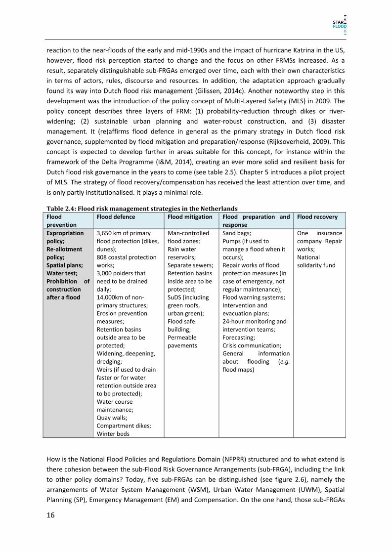
16
reaction to the near-floods of the early and mid-1990s and the impact of hurricane Katrina in the US,
however, flood risk perception started to change and the focus on other FRMSs increased. As a
result, separately distinguishable sub-FRGAs emerged over time, each with their own characteristics
in terms of actors, rules, discourse and resources. In addition, the adaptation approach gradually
found its way into Dutch flood risk management (Gilissen, 2014c). Another noteworthy step in this
development was the introduction of the policy concept of Multi-Layered Safety (MLS) in 2009. The
policy concept describes three layers of FRM: (1) probability-reduction through dikes or river-
widening; (2) sustainable urban planning and water-robust construction, and (3) disaster
management. It (re)affirms flood defence in general as the primary strategy in Dutch flood risk
governance, supplemented by flood mitigation and preparation/response (Rijksoverheid, 2009). This
concept is expected to develop further in areas suitable for this concept, for instance within the
framework of the Delta Programme (I&M, 2014), creating an ever more solid and resilient basis for
Dutch flood risk governance in the years to come (see table 2.5). Chapter 5 introduces a pilot project
of MLS. The strategy of flood recovery/compensation has received the least attention over time, and
is only partly institutionalised. It plays a minimal role.
Table 2.4: Flood risk management strategies in the Netherlands Flood prevention
Flood defence Flood mitigation Flood preparation and response
Flood recovery
Expropriation policy; Re-allotment policy; Spatial plans; Water test; Prohibition of construction after a flood
3,650 km of primary flood protection (dikes, dunes); 808 coastal protection works; 3,000 polders that need to be drained daily; 14,000km of non-primary structures; Erosion prevention measures; Retention basins outside area to be protected; Widening, deepening, dredging; Weirs (if used to drain faster or for water retention outside area to be protected); Water course maintenance; Quay walls; Compartment dikes; Winter beds
Man-controlled flood zones; Rain water reservoirs; Separate sewers; Retention basins inside area to be protected; SuDS (including green roofs, urban green); Flood safe building; Permeable pavements
Sand bags; Pumps (if used to manage a flood when it occurs); Repair works of flood protection measures (in case of emergency, not regular maintenance); Flood warning systems; Intervention and evacuation plans; 24-hour monitoring and intervention teams; Forecasting; Crisis communication; General information about flooding (e.g. flood maps)
One insurance company Repair works; National solidarity fund
How is the National Flood Policies and Regulations Domain (NFPRR) structured and to what extend is
there cohesion between the sub-Flood Risk Governance Arrangements (sub-FRGA), including the link
to other policy domains? Today, five sub-FRGAs can be distinguished (see figure 2.6), namely the
arrangements of Water System Management (WSM), Urban Water Management (UWM), Spatial
Planning (SP), Emergency Management (EM) and Compensation. On the one hand, those sub-FRGAs

17
are distinguished by their purpose, goal or mission (i.e. on the different flood risk strategies identified
within the STAR-FLOOD project). On the other hand, the arrangements are characterised by
differences in the actor, rules, resource and discourse dimension of the PAA. As a consequence, the
identified sub-FRGAs are not completely similar to the STAR-FLOOD strategies. Although separately
distinguishable, these sub-FRGAs nowadays are highly interconnected by specific legal and policy
instruments and other bridging processes and mechanisms. Within each sub-FRGA a combination of
FRMSs is represented. Nevertheless, dominant strategies per sub-arrangement are identifiable
(figure 2.5), illustrating the high degree of integration in Dutch FRM. Below, we will discuss the five
sub-FRGAs in further detail, referring to the four dimensions of the PAA: discourse, rules, actor and
power.
Figure 2.5: Simplified overview of the strategies present in the Netherlands and their relative dominance, i.e. dark blue most dominant (flood defence), medium blue present and in further development, and light blue relatively low importance.

18
Table 2.5: Summary of sub-FRGAs within the flood policy domain in the Netherlands Sub-FRGA Description Strategies Key actors Key rules/legislation Key discourses Key resources
Water system management
Sub-FRGA that describes aspects related to the management of the water system (i.e. coherent set of one or more surface water bodies and associated storage areas, dams and supporting structures) of fluvial flooding and coastal flooding
Defence National: Ministry Infrastructure and Environment and Rijkswaterstaat Regional Water Authorities: Water boards construction companies, expertise centres
Water Act Programmes HWBP Delta Programme Room for the River
Technocratic discourses Integrated water management Efficiency
Delta Fund Water authority taxes Technical expertise
Urban Water management
Sub-FRGA that describes aspects related to the management of urban waters, i.e. pluvial flooding
Defence Mitigation Recovery
citizens Municipalities
Wet gemeentelijke watertaken, as integrated in:Water Act (art. 3.5) Sewerage (Environmental Management Act) Delta Programme
Sustainability Climate change Subsidiarity
Provincial/ municipal funds Project budget Own expenses of house/ company owners
Spatial Planning
Sub-FRGA that comprises the spatial planning aspects in flood risk management.
Prevention Mitigation
Provinces Municipalities Regional Water Authorities
Spatial planning Act Incl. Water assessment Delta Programme
Climate change adaptation Sustainability Risk approach Integrated water management
Provincial/ municipal funds
Emergency Management
Sub-FRGA that comprises the emergency aspects of flood risk management
Preparation and response Recovery
Ministry Security and Justice, NCTV
10
Regional security regions
Security regions Act
Integrated risk approach
Municipal funding (security regions) National funding
Compensation Minor sub-FRGA that comprises governmental
Recovery Ministry Security and Justice,
Calamities compensation Act
Risk approach Solidarity
National funding – compensation fund
10
National coordinator for security and counterterrorism

19
and non-governmental compensation arrangements Regulations of liability
private insurance for pluvial flooding and to some degree for fluvial flooding property owner Water managers
Insurance policies Liability (Civil Code)
Funds of liable authority Private funding - insurance

20
Figure 2.6: Overview of the Dutch flood risk governance arrangement and its sub-arrangements. The sub-FRGAs are further elaborated in § 2.3.2-2.3.6. The more a sub-FRGA is within the blue FRM field, the higher is its relevance for FRM in the Netherlands. The larger a circle is, the more institutionalised the sub-FRGAis. The sub-FRGA ‘Compensation’ will not appear in the case studies because it is a nationwide sub-FRGA.
2.3.2 Sub-FRGA ‘Water System Management’ The WSM sub-FRGA is highly institutionalised and characterised by a programmatic and technocratic
approach, mainly incorporating the flood defence strategy. From a point of view of the discourse, the
underlying assumption is that nature could be controlled by mankind through technical or
engineering measures (Ten Brinke, 2007; Van den Brink, 2009). This paradigm is to some degree still
supported by the epistemic community of water engineers. In the 1970s the awareness of
environmental issues increased (see for example Meadows, 1972; Tellegen and Willems, 1978;
Schwartz, 1993; Bosch & Van der Ham, 1998). The idea of Integrated Water Resource Management
(IWRM) was officially introduced in 1983 in the Third National Water Plan (Derde Nota
Waterhuishouding) and supported a change within the strategy of flood defence towards a more
natural approach that gave more room for the river, in the form of the ‘Room for the River’
programme (VROM and V&W, 1996). In chapter 4, the Nijmegen case study further explores this
integrated water system-based approach to FRM.
The main actors are the dike management authorities, namely the regional water authorities and the
Directorate-General for Public Works and Water Management (Rijkswaterstaat). The Minister of
Infrastructure and the Environment (the Minister) and the Provincial Executives function as
supervisory organs, to which the dike management authorities are accountable. Furthermore,
several national and provincial authorities share legislative competences, mainly regarding the
establishment of legal safety standards, assessment tools, and technical guidelines. Strategic
planning is done through ‘water plans’ (waterplannen) at the central and provincial level by the
Minister and the Provincial Councils respectively. The implementation of measures is done through

21
‘management plans’ (beheerplannen) by the competent central or regional water management
authorities. These plans provide for a programmatic basis for more concrete project plans and
decisions.
One of the integral purposes of the Dutch Water Act is to prevent, and where necessary limit, floods
and water logging (Gilissen, 2013; Groothuijse, 2009). In view of this public duty of care, a legal
distinction is being made between primary and non-primary (also referred to as ‘regional’ or
‘secondary’) flood defence structures. For the so-called ‘dike rings’ (i.e. areas protected by primary
flood defence structures), legal safety standards have been established in Annex II of the Dutch
Water Act. For (most) regional flood defence structures, safety standards have been established in
provincial by-laws. So far as water logging is concerned, legal standards have been established in
provincial by-laws. The competent water authorities must make an effort to achieve these standards.
For this purpose, they have specific instruments at their disposal (e.g. the strengthening or relocation
of dikes, the designation of conservation zones, and the designation of retention/water storage
areas). As to the implementation of their legal duties, they have a wide margin of policy discretion,
but they periodically have to report to the supervisory organs mentioned. Their reports must
primarily be based on pre-set hydraulic conditions and technical guidelines. Although the supervisory
authorities can give legally binding instructions about the implementation of the duty of care for
water safety, hierarchical steering generally takes place on a political level through strategic
planning.
The national and regional water authorities, together with a broad network of scientific institutes,
including universities and consultancies, have a strong knowledge resource base in the field of
engineering and water governance. This establishes the central position of water authorities, which is
supported by a relatively stable financial resource base. Regional water authorities have their own
system of taxation (Havekes et al., 2011), and on the national level financial means are provided in
special funds, the Delta Fund based on Chapter 7 of the Water Act.
Besides their traditional tasks in flood defence, water authorities also have a legal responsibility
regarding flood preparation and response, as they have to establish emergency plans
(calamiteitenplannen) as part of their water plans. These plans substantively must be aligned with
the crisis plans (crisisplannen) established by the Security Regions on the basis of the Security
Regions Act (see §2.3.5). Thus, the preparation and response strategy is also to some extent
embedded within the WSM sub-FRGA, even though this is not the dominant strategy there. By virtue
of a specific coordination mechanism, there is a close relation between the FRGAs of water system
management and emergency management.
Water authorities, lastly, have a legal responsibility to restore their public works (such as dikes) as
soon as possible after a flood event. This can be interpreted as the implementation of the recovery
strategy within the WSM sub-FRGA.
2.3.3 Sub-FRGA ‘Urban Water Management’ A recently developed sub-FRGA within the Dutch water management framework is that of Urban
Water Management. After heavy rainfall events of 1998, a committee was set up to improve
adaptation to climate change (Tielrooij Commissie, 2000). This sub-FRGA is related to the discourse
of sustainability and climate change. The concept ‘retaining, storing, draining’ describes a shift from a

22
technical approach, consisting of sewer management, towards a more sustainable approach, which
comprises ideas of a Sustainable Urban Drainage System (SuDS). The underlying idea in the discourse
is that every region should try to address its problems itself (Tielrooij Commissie, 2000; and Rijk et
al., 2003).
Mainly addressing floods due to rainwater run-off and groundwater surpluses, this sub-arrangement
is to be functionally and organisationally distinguished from the WSM sub-FRGA. Still in the process
of being developed, this sub-FRGA has a rather low degree of institutionalisation. Although non-
binding standards have been agreed upon within the framework of the ‘National Administrative
Agreement on Water Issues’ (‘Nationaal Bestuursakkoord Water’), until now no single strategy has
emerged as predominant in efforts made to achieve these standards. Instead, in practice there is a
regionally differing mixture of chiefly preventive, defensive and mitigative measures. The main actors
within this sub-FRGA are (private) landowners and municipal authorities (the Municipal Council and
the Municipal Executive). The legal basis of this arrangement, nowadays, is to be found in Articles 3.5
and 3.6 of the Water Act, supplemented with some relevant provisions on sewerage in the
Environmental Management Act.
The responsibility for urban water management on private property primarily lies with landowners.
For public property, the municipality is responsible. Only as far as landowners ‘cannot reasonably be
expected’ to take measures themselves, municipal authorities become responsible. In particular, this
can be the case in densely populated/built-up/paved areas. Landowners can freely choose between
different kinds of measures/strategies. Besides a possibility to insure themselves against damage due
to pluvial floods, they can, for instance, choose to create rainwater storage capacity (defence) or to
prevent their built property (houses, barns, cellars) from flooding by adjusting thresholds
(mitigation). There are hardly any legal instruments for public actors to influence decisions made by
landowners in this respect (Heger, 2009; Uittenbroek et al., 2012). Landowners can also choose to
increase the infiltration capacity of the soil by removing paving from their property or by keeping
their property at least partly unpaved (defence). Municipal authorities have spatial planning
instruments at their disposal to implement their UWM policy, for instance by adopting maximum
paving/building percentages in their zoning plans. They are, however, not legally obliged to do so
and, although some have explicitly established policies in this respect, it is unclear on what scale this
is being done throughout the country.
As far as landowners cannot reasonably be expected to take measures themselves – and this,
admittedly, is a rather vague criterion – the responsibility for collecting and processing rainwater lies
with municipal authorities. This can inter alia be done through increasing water storage capacity in
the public domain or through transporting the water via sewerage or other systems (both defence
measures in terms of the STAR-FLOOD project). If necessary, sewerage transport capacity can be
increased, or so-called storm water drains (hemelwaterriolen) can be constructed. Also water
management authorities can be involved, for instance by increasing the storage capacity of water
bodies under their control. The responsible authorities have a wide margin of policy discretion, both
as to decide whether or not measures should be taken, as well as to decide which (types of)
measures should be taken. There are, in other words, no clear legal standards giving substance to
this municipal duty of care. Increasing/creating water storage capacity is mainly done through spatial
planning instruments, so in this respect there is some overlap between the UWM and the SP sub-
FRGA. Sewage management takes place through sewage plans (based on the Environmental
23
Management Act), containing both strategic and operational aspects. Although practice shows many
(regional) experiments and developments in urban water management, there is still no clear and
general line in UWM policy. Moreover, inter-governmental supervision and hierarchical steering, and
accountability instruments are (still) relatively underdeveloped.
2.3.4 Sub-FRGA ‘Spatial Planning’ From the point of view of the discourse, this sub-FRGA in its relation to FRM is closely connected to
the paradigm of IWRM. However, it also has connections to ideas in the discourse about
sustainability, climate change adaptation and an integrated risk approach. Those discourses are
combined within the MLS concept, which developed the sub-arrangement further (Rijksoverheid,
2009; V&W et al., 2009). The case study Zuidplaspolder demonstrates that ideas of economic growth
are an important discourse hampering the integration of flood risk in SP.
From the late 1990s onwards, ‘water’ has been referred to as one of the major guiding principles in
21st century spatial planning (V&W, 2000). Although not specifically developed for water
management purposes, in that respect the Dutch spatial planning system does provide for a number
of particularly useful instruments. The spatial planning system is a highly institutionalised and legally
refined system, which is mainly policy driven and has the purpose of optimally balancing all spatially
relevant interests, among which are those related to water management. Its central instruments are
strategic spatial development plans (structuurvisies) and legally binding spatial zoning plans
(bestemmingsplannen). With the decentralisation doctrine at its very heart, its main actors are to be
found at the municipal level, where the Municipal Council is responsible for establishing both
strategic and normative spatial policy, and the Municipal Executive is mainly responsible for licensing
and enforcement. Provincial and state authorities, nonetheless, play a supervisory and (politically)
steering role in spatial planning as, at the provincial/central level, strategic spatial policy has to be
established, legally binding instructions can be given, and generally applicable norms can be
established. These instructions and norms are always directed towards Municipal Councils, and have
directly to be implemented into their normative zoning plans. Water authorities do not play a
formally decisive role in Dutch spatial planning, but – by virtue of the so-called water test
(watertoets) – they do play a formalised advisory role during the process of drafting strategic and
normative spatial policies.
As stated above, the Dutch system of spatial planning provides for instruments suited to implement
certain FRMSs. A preventive strategy, for instance, can be implemented through adopting a
construction ban or construction restrictions in spatial zoning plans for flood-prone areas, such as
polders. Practice shows, however, that this was not regularly done in the past, as many polders and
other low-lying parts of the country are amongst the most densely populated/intensively used areas.
This is still happening, as the case study Zuidplaspolder will show. An example of preventive
(national) policy, which is to be taken into account in zoning plans within the riverine area, is to be
found in the Major Rivers Policy (Beleidslijn Grote Rivieren) of 2006. Also a mitigative strategy can be
implemented within spatial policy, for instance through adopting specific building criteria or
restrictions in building codes accompanying zoning plans. One could think of adjusted floor levels,
building on ‘terps’ (or mounds, which are artificial hills), or restrictions to building basements. Finally
– despite the fact that defensive measures are regularly taken within the framework of the WSM
sub-FRGA – in addition a defensive strategy, most of the time, needs spatial implementation. One
could think of dike relocation projects or the designation of water storage areas. The programme

24
‘Room for the River’ provides several examples of such projects; the project ‘Dike Relocation Lent’
(see chapter 4), in light of the above, is an illustrative case.
Besides the water test – as a formalised advisory construction to foster water management interests
to be taken into account in spatial planning and decision making – there are a number of other
arrangements linking the WSM and the SP sub-FRGA. Whereas developments within the WSM sub-
FRGA can have some spatial impacts (e.g. a dike relocation), the national and provincial water plans
(containing strategic water policy to be taken into account in (day-to-day) operational water
management) legally are to be considered to be spatial development plans as well. In fact, this
means that strategic water policy – concerning its spatially relevant aspects – counts at the same
time as strategic spatial policy, which has in turn to be taken into account in spatial planning. Since
the last decade, water authorities are also playing an increasing, yet informal role in strategic spatial
planning processes.
2.3.5 Sub-FRGA ‘Emergency Management’ As in the course of the first decade of the new millennium a shift occurred in discourse, Dutch policy
makers started to realise that flood risks can at best be minimised, but can never be eliminated; this
is in accordance with the integrated risk approach (V&W and BZK, 2006b; V&W, 2008; Rijksoverheid,
2009; V&W et al., 2009). With the formation of the temporary Taskforce Management Flooding in
2006, which had the task of improving the organisational crisis response for flooding, more focus was
put on the preparation and response strategy (TMO, 2009). In 2009 the Steering Group Flooding was
set-up as a permanent communication and coordination forum between water managers and
emergency managers (V&W et al., 2009). Additionally, the Multi-Layered Safety concept will increase
the focus on preparation and response as an independent strategy. With the entry into force of the
Security Regions Act in 2010, within the broader domain of emergency management, a new sub-
FRGA emerged, in this report referred to as the sub-FRGA of ‘Emergency Management’. This sub-
FRGA is characterised by its strategic and planned approach of emergency situations, such as floods,
and its tendency towards centralisation (‘up-scaling’ of responsibilities) of emergency management
in case of (expected) severe floods. Its main actors are the Mayors of the municipalities involved, the
Chairmen of the Security Regions, and the General Boards of the Security Regions. There are,
moreover, clear coordinative arrangements between the WSM and the EM sub-FRGAs.
Within the EM sub-FRGA, a distinction can be made between responsibilities for preparation and
response. The Boards of the Security Regions are responsible for emergency management planning
(i.e. preparation). These Boards consist of all the Mayors of those municipalities included in a
Security Region. Besides these Mayors, the Chairman of the relevant regional water authority is also
invited to participate in meetings of the Security Region’s Board. Strategic planning is done through
so-called policy plans (beleidsplannen), which have to be based on concrete risk profiles. Operational
policy and the exact division of responsibilities are set out in so-called crisis plans (crisisplannen),
which have (as stated above) to be aligned with the emergency plans (calamiteitenplannen) of the
relevant regional water authorities. In these plans, a wide range of possible emergency situations
have to be addressed, among which – although not explicitly mentioned – are flood events. It
remains unclear, however, to what extent flood risks are actually profiled and addressed within these
plans. Recent developments show a slight increase in participation of emergency management
authorities in FRM planning processes, but their capacity and knowledge remains limited.

25
When an actual flood occurs or is expected to occur, action needs to be taken (i.e. response). For
instance, people need to be evacuated. In case of such an emergency, the Mayor of the municipality
where the flood occurs or is expected to occur has supreme command over all parties and persons
involved in the actual emergency management. However, in the case where a flood is or is expected
to be of a regional scale, the Chairman of the Security Region has supreme command instead of the
Mayor in whose municipality the flood occurs or is expected to occur. In those situations, a regional
policy team is established, in which all relevant Mayors and the Chairmen of the relevant regional
water authority are invited to participate. Unless urgency requires immediate action, all decisions are
taken in consultation with the regional policy team. Decisions can also involve emergency
competences, such as forced evacuation or general street bans. In exceptional cases, eventually the
Minister of Security and Justice can take over certain competences. Despite these responsibilities and
competences, inhabitants of flood-prone areas are to a large extent also expected to be self-reliant;
they should be (more) aware of flood risks and should also be (better) prepared themselves for
actual floods to occur. The lack of knowledge of inhabitants regarding their own responsibilities can
be considered to be problematic, since they do not know how they should prepare themselves and
how to handle properly in case of a flood as well.
2.3.6 Sub-FRGA ‘Compensation’ Within the recovery strategy, a distinction can be made between restoration measures aimed at
recovering the status quo (for instance rebuilding a house or a public work) and compensation
measures (financial compensation through, for instance, public compensation mechanisms, liability
claims, or insurance mechanisms). Within the Dutch FRGA, the latter type of measures appears as an
independently distinguishable sub-FRGA which can be referred to as the sub-FRGA of
‘Compensation’.
It has been possible to insure against damage from pluvial flooding in the Netherlands since 1998.
The market penetration seems to be relatively high (based on observations made during the
Symposium of Association of Dutch Insurers), because the insurance is combined with house
insurance. In contrast, insurance for damage from fluvial flooding is only available on a limited level.
Since 2012, one insurance company has offered insurance (Neerlandse), but market penetration is
low. Injured parties are mainly dependent on the system of liability law in order to be compensated
(Gilissen, 2013; Gilissen, 2014b). Under specific circumstances, flood damage can also be
compensated for on the basis of the Calamities Compensation Act. This happened, for instance, after
a minor flood incident in Wilnis in 2003. Nonetheless, flood recovery through compensation is not a
dominant strategy in Dutch FRM. The sub-FRGA ‘Compensation’, in comparison with the other sub-
FRGAs, plays a minor role and can be considered as the least institutionalised sub-FRGA, mainly due
to the low frequency of flood events.
A specific compensation mechanism in the Netherlands is the so-called system of no-fault liability
(‘nadeelcompensatie’). The regime of no-fault liability is based on the French principle ‘égalité devant
les charges publiques’ (equality for public burdens). The basic assumption of this principle is that
compensation is granted to those who have endured a disproportionally large burden or loss caused
by lawful activities pursued by the administration in the public interest (Fairgrieve, 2003; Tjepkema,
2010; Van Doorn-Hoekveld, 2013; Van Doorn-Hoekveld, 2014a). Both the Water Act 2009 and the
Spatial Planning Act 2008 contain specific provisions on the compensation of lawfully inflicted
damage, for instance as a result of dike relocations.

26
2.3.7 Modes of Governance The five identified arrangements differ in their mode of governance, as indicated in the previous
sections. The main conclusion is that the comprehensive FRGA in the Netherlands is shifting from a
mainly single-sector-based approach towards a multi-sector governance arrangement, where
especially spatial planning and emergency management gain in importance. Another conclusion is
that no shift took place in regard to multi-actor governance, i.e. towards private actors.
Administrative authorities stay as the main responsible parties for providing protection from
flooding. Within the single sub-governance arrangements, a number of minor shifts in modes of
governance can be identified. Table 2.6 summarises those modes of governance per sub-FRGA and
the observed shifts.
Table 2.6: Modes of governance adopted by sub-FRGAs in the Netherlands
(Based on: Driessen and Dieperink, 2012).
Sub-FRGA Mode of governance Shifts in modes of governance
Water System Management
Centralised/decentralised No significant changes, financing became again more decentralised with the cost-sharing arrangement, but the national assessment framework is an added central steering possibility
Urban Water Management
Interactive, decentralised From self-governance to interactive governance (increased involvement of insurance and decentralised government)
Spatial Planning Decentralised No major change
Emergency Management
Decentralised From locally to regionally decentralised with upscaling in case of emergency
Compensation Interactive governance From centralised towards more interactive governance in case of pluvial flooding
2.4 Explanation of stability and change in Flood Risk Governance in the
Netherlands
2.4.1 The explanandum How has the NFPR changed over time? At least since the baseline year, the flood defence strategy
has been the most dominant in the Netherlands. Accordingly, FRM is characterised by a highly
technocratic, engineering approach, as well as a high governmental (central and decentral)
dominance when it comes to the governance of those measures. The reason for this is above all the
historical response to the high flood risk caused by the physical characteristics of the country. Even in
the Middle Ages land reclamation works and later river channelling measures were being carried out
(Lintsen, 2005; Ten Brinke, 2005; Van Heezik, 2006). Those structural measures were managed
collectively by regional water authorities that were later constitutionally embedded in the
administrative structure of the Netherlands and thereby highly institutionalised (Van den Ven, 2004;
Havekes, 2009). Nowadays, the flood defence strategy is still the dominant strategy in Dutch FRM. It
is not likely that this strategy will be abandoned or replaced by other strategies; although Dutch flood
risk governance is becoming less technocratic and shows more attention to governance aspects.
However, other strategies have emerged/are emerging, mostly as strategies which are instrumental
or additional to the flood defence strategy (see §2.4.2).
On the one hand, the FRGA is characterised by a high level of stability and path-dependency. The
sub-FRGA Water System Management is very stable. It was reinforced in 1996 with the Flood

27
Defence Act that defines legal safety standards. The current update of those safety standards is
another refinement, but also a stabilisation of this sub-arrangement. On the other hand, even though
no radical changes can be observed, incremental, evolutionary changes have occurred. The observed
changes can be characterised by what Valman (2013) would have termed layering: i.e. new rules and
practices emerge next to existing ones. Therefore, a diversification of both FRMS and FRGA is visible,
which is mainly based on the alignment of different sub-FRGAs, i.e. spatial planning and emergency
management, with the historically stable sub-FRGA water system management. This is done through
bridging mechanisms, e.g. legal instruments, or consultative bodies (see figure 2.7).
Figure 2.7 Development of sub-FRGAs in FRM in the Netherlands The figure illustrates the movement of sub-FRGAs in the FRM domain. The sub-FRGA Water System Management is traditionally dominant and highly institutionalised. However, even if less institutionalised and dominant the sub-FRGA Compensation was already present before 1950 in the form of compensation funds (Van Doorn-Hoekveld, 2014b). At the beginning of the 21st century, spatial planning and Urban Water Management gain in importance with the establishment of instruments like the Water Test, or the SPKD Room for the River that improve the consideration of water quantity issues in spatial planning and therefore the integration of the two policy domains. Around 2010, emergency management is further institutionalised with the formation of security regions and it gains in importance in FRM, due to increased cooperation with water management in the Steering Group Flooding.
The changes in FRGA emerge mostly in the discourse dimension, and have consequences for the
organisational dimensions. The integrated water management discourse influenced the rules
dimension by facilitating the setting-up of the legal instrument Spatial Planning Key Decision applied
to implement the Room for the River programme. It also influences the actor dimension due to an
increased cooperation between water managers and spatial planners. As illustrated in figure 2.7 the
sub-FRGA Spatial Planning entered increasingly into the realm of flood risk management due to its
alignment with the sub-FRGA WSM.
Over time, urban water management increasingly developed as an independent sub-FRGA, mostly
due to intensifying precipitation patterns and a number of urban flood events at the end of the 20th
century, which forced an acknowledgement of the problem. This change in discourse triggered a
change in the rules dimension through the enactment of the Act on Municipal Water Tasks in 2008,
which was preceded by a political debate on the matter, resulting in non-legally binding agreements
in the National Administrative Agreement on Water Issues in 2003 (Rijk et al., 2003). In the past it
was only a minor problem, which was managed in a technical way through sewer systems. However,
it is acknowledged that often those systems cannot be enlarged easily, therefore spatial planning
measures (e.g. green infrastructure, or use of kerbstones) gained in significance. As a consequence,
the water test was implemented in the Spatial Planning Decree by 2001. Additionally, new actors and

28
resources were introduced due to the setting-up of a private insurance scheme to compensate for
damage from rainfall (interview 3). The sub-FRGA Urban Water Management gained in significance in
the realm of FRM. Later, the Water Test was not only used to consider pluvial flooding but all kinds of
water issues. This spatial planning instrument nowadays constitutes the alignment of the sub-FRGA
SP with the sub-FRGAs UWM and WSM (see figure 2.7).
At the beginning of the 21st century, a risk approach to FRM became popular in the discourse
because 100% safety was seen as unachievable (Rijksoverheid, 2009). This realisation was supported
by the effects of Hurricane Katrina and the insights received from national study, e.g. on dike failing
mechanisms (Veiligheid Nederland in Kaart, 2005; Inspectie Verkeer en Watertstaat, 2011), or the
adverse impact of spatial development (RIVM, 2004). The consequence was a change in the actor
dimension in the form of increased cooperation by water managers and emergency managers within
the ‘Taskforce Management Flooding’, which became later the ‘Steering Group Management
Flooding’ (TMO, 2009). Another change in the rules and actor dimension was the formation of
security regions, which strengthened the significance of the sub-FRGA Emergency Management
(interview 16 and 17). However, although floods are not explicitly mentioned in the Security Regions
Act (SRA) of 2010, floods do match the broader definitions of ‘disaster’ and ‘crisis’ in the SRA. With
the introduction of the SRA, the sub-FRGA Emergency Management gained significance in the realm
of FRM (see figure 2.7).
To what extent can the changes as mentioned above be described as ‘deep’ or ‘fundamental’? ‘Deep
shifts’ are constituted through changes in all the dimensions of the PAA and especially the power and
resource dimension (Wiering and Arts, 2006). In the Netherlands, major changes in the resource
dimension are limited. Most financial means and expertise is still directed towards flood defence.
Even though other strategies are supported by research (e.g. Delta Programme, Taskforce
Management Flooding), the financial means for implementing those measures mostly need to be
provided by the actors of the relevant policy sector. For spatial planning, in particular, this is ad hoc
and depends on the region and political choices or consequences. Additionally, due to the traditional
dominance of water managers, the awareness of flood risk among other actors is limited, and so is
their willingness to invest (interview 8). That means, even though changes have occurred, they
cannot be described as ‘fundamental’. The historically stable sub-FRGA Water System Management
is still dominant, because water managers are still legally responsible and accountable for providing
safety, and the legal safety standards and procedures still favour flood defence measures. Even
though new bridging mechanisms have been implemented, no strong legally binding legislation or
procedures have been set up. The Delta Programme brought all the different actors together, but the
involvement of private sectors/actors was criticised as too limited (Van Buuren and Teisman, 2014).
Successors might expand this trend in the future. Nevertheless, the cooperation between different
sub-FRGAs is often based on communication, (informal) collaboration, consensus-finding and
coordination between the actors within the different policy sectors. The degree of cooperation is
therefore dependent on the respective parties.
2.4.2 Explanatory factors for change and stability in the Dutch flood risk governance How can those incremental changes and stability be explained? Table 2.7 summarizes the main
drivers of stability and change visible in the Netherlands. The paragraphs below will explain the
dynamics in more detail.
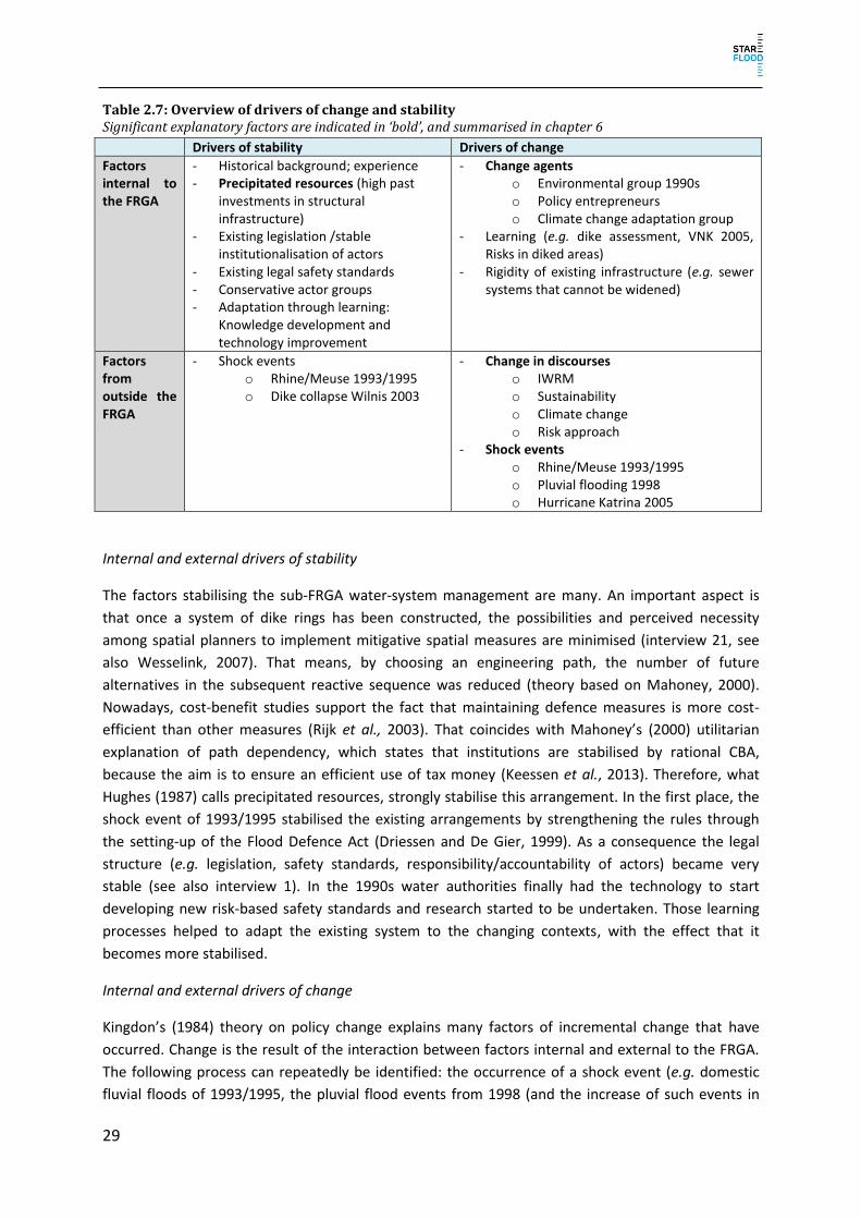
29
Table 2.7: Overview of drivers of change and stability Significant explanatory factors are indicated in ‘bold’, and summarised in chapter 6
Drivers of stability Drivers of change
Factors internal to the FRGA
- Historical background; experience - Precipitated resources (high past
investments in structural infrastructure)
- Existing legislation /stable institutionalisation of actors
- Existing legal safety standards - Conservative actor groups - Adaptation through learning:
Knowledge development and technology improvement
- Change agents o Environmental group 1990s o Policy entrepreneurs o Climate change adaptation group
- Learning (e.g. dike assessment, VNK 2005, Risks in diked areas)
- Rigidity of existing infrastructure (e.g. sewer systems that cannot be widened)
Factors from outside the FRGA
- Shock events o Rhine/Meuse 1993/1995 o Dike collapse Wilnis 2003
- Change in discourses o IWRM o Sustainability o Climate change o Risk approach
- Shock events o Rhine/Meuse 1993/1995 o Pluvial flooding 1998 o Hurricane Katrina 2005
Internal and external drivers of stability
The factors stabilising the sub-FRGA water-system management are many. An important aspect is
that once a system of dike rings has been constructed, the possibilities and perceived necessity
among spatial planners to implement mitigative spatial measures are minimised (interview 21, see
also Wesselink, 2007). That means, by choosing an engineering path, the number of future
alternatives in the subsequent reactive sequence was reduced (theory based on Mahoney, 2000).
Nowadays, cost-benefit studies support the fact that maintaining defence measures is more cost-
efficient than other measures (Rijk et al., 2003). That coincides with Mahoney’s (2000) utilitarian
explanation of path dependency, which states that institutions are stabilised by rational CBA,
because the aim is to ensure an efficient use of tax money (Keessen et al., 2013). Therefore, what
Hughes (1987) calls precipitated resources, strongly stabilise this arrangement. In the first place, the
shock event of 1993/1995 stabilised the existing arrangements by strengthening the rules through
the setting-up of the Flood Defence Act (Driessen and De Gier, 1999). As a consequence the legal
structure (e.g. legislation, safety standards, responsibility/accountability of actors) became very
stable (see also interview 1). In the 1990s water authorities finally had the technology to start
developing new risk-based safety standards and research started to be undertaken. Those learning
processes helped to adapt the existing system to the changing contexts, with the effect that it
becomes more stabilised.
Internal and external drivers of change
Kingdon’s (1984) theory on policy change explains many factors of incremental change that have
occurred. Change is the result of the interaction between factors internal and external to the FRGA.
The following process can repeatedly be identified: the occurrence of a shock event (e.g. domestic
fluvial floods of 1993/1995, the pluvial flood events from 1998 (and the increase of such events in

30
the future), or Hurricane Katrina in the US, which raised the question whether something similar
could happen in the Netherlands), which opens a window of opportunity to be exploited by a policy
entrepreneur or actor coalition that favoured a different approach to FRM. The actor groups are
often supported by preceding changes in discourse (like Integrated Water Resource Management,
IWRM), or learning processes (like the national dike assessment, or research projects). Eventually
legal instruments are applied to integrate spatial planning and water management (like programme
Room for the River, Water Test), or new committees and steering groups are set up.
In the 1970s due to a global change in discourse (Schwartz, 1993), protests against structural
measures increased in the Netherlands (Bosch and Van der Ham, 1998; Disco, 2002). As a response,
biologists were brought in to Rijkswaterstaat. During the high river discharges of 1993/1995 they
were situated in the right venue; even though the first reaction was dike strengthening measures,
those actor coalitions could introduce ideas of integrated water management, eventually setting up
the programme Room for the River (Van der Brugge, Rotmans, and Loorbach, 2005).
Incremental changes in the Netherlands tend to be more actor-driven, and less influenced by
external structures, like the EU Floods Directive, than is the case in other Member States, except for
the implementation of the risk approach in the Water Act. After the pluvial flooding event of 1998
the Tielrooij Committee was set up to study the preparedness of Dutch water management for
climate change. Dike wardens of urban areas that felt the adverse consequences of spatial planning
decisions were supported by the State Secretary and used this venue to lobby for the water test
(interview 21). The water test was eventually introduced in 2001 (Gilissen et al., 2014). After
Hurricane Katrina, climate adaptation researchers asked whether something similar could happen in
the Netherlands. A first step was to improve the organisational emergency response to a crisis via the
Taskforce Management Flooding (V&W and BZK, 2006a). It was increasingly acknowledged that
absolute safety is not possible, so, based on a risk approach, the policy concept of Multi-Layered
Safety was introduced in 2009 (V&W, 2008; Rijksoverheid, 2009). This development was also
supported by a shift within the ministry and Rijkswaterstaat, where more and more employees have
a public administration background rather than a water engineering background. Technical issues are
mostly outsourced. Nevertheless, the epistemic community of water engineers in expertise centres
like Deltares or the TU Delft still function within the existing system. Furthermore, the legal
framework stipulates tasks, processes and accountability for regional water authorities (interviews 1
and 34). In addition, other actor groups rely on the water authorities to be responsible, so that
spatial planners are often reluctant to consider flood risk in their spatial planning (interviews 1, 8 and
9).
2.5 Evaluating flood risk governance at the national level To what extent can the current NFPRD be characterised as resilient, efficient and legitimate? Table
2.8 gives an overview of the main findings of the evaluation.
Table 2.8: Overview of evaluation criteria and the corresponding features of governance Evaluation criteria + or - Feature of governance
Resilience + Resistance: high ability of the system to reduce the likelihood and magnitude of flooding; defence strategy is to be considered effective, especially when supplemented by emerging mitigation and preparation/response strategies;
-/+ Ability to absorb and recover: measures are undertaken to improve the ability, but effectiveness of instruments like the water test and emergency

31
management tend to be still limited; no insurance system for fluvial flooding present (only pilot);
+ Ability to adapt can be described as high, many learning opportunities are present (e.g. periodical assessments, research etc.);
Efficiency ? (+) Economic efficiency: input/output ration cannot be evaluated. Increasing focus on resource efficiency in water management, e.g. ‘Administrative Agreement Water’;
+ Resource efficiency: increased concern for resource efficiency is present, e.g. application of CBA, MIRT procedure, etc.;
Legitimacy +/- Social equity: FRM in NL is a public concern; citizens pay risk-dependent taxes to the regional water authorities; financing of measures is based on solidarity; national taxes and regional water authorities among others support each other financially; citizens living outside the dike protected area are not part of the solidarity agreement and besides basic emergency management, they do not receive any protection or compensation;
+ Accountability: opportunities for stakeholders to challenge decisions are present, both at the decision making authority (‘bezwaar’), and before a judge (‘beroep’); also vertical accountability mechanisms between levels of administration (supervision and reporting) are present;
+/- Transparency: decisions and policies must be published; in some cases there is a lack of clarity about the concrete division of responsibilities and competences;
+ Participation: stakeholders are generally stimulated to participate in decision-making; legal participatory mechanisms are in place;
+ Access to information: decisions, policies and other relevant documents, such as flood risk maps, are publicly available; awareness raising campaigns through apps and websites are being carried out;
- Equity: potential problems with distribution of costs-benefits for FRM in the future have been identified
2.5.1 Resilience With the defence strategy traditionally at its very heart (V&W, VROM, and LNV, 2009; I&M, 2014),
other strategies have always played a minor role in Dutch FRM. The focus, in other words, has mainly
been on probability reduction, and less on the reduction of consequences (mitigation, preparation
and response) and recovery (status quo/compensation). Since the beginning of the 21st century,
however, increasing attention has been paid to other strategies (especially mitigation, preparation
and response), as flood risks were increasingly addressed within the framework of other policy
domains (i.e. spatial planning and emergency management), and later explicitly became part of the
emerging policy concept of Multi-Layered Safety (Delta Programme 2014). As a result, as shown in
§2.3, new sub-FRGAs started to emerge. Moreover, specific mechanisms have been developed over
time to foster cooperation and coordination between these domains/sub-FRGAs (e.g. the water test
and the mandatory alignment of emergency management plans). Despite these developments, the
strategy of flood recovery (through compensation) in the Netherlands has remained rather
underdeveloped.
Reasoning from the STAR-FLOOD’s starting assumption about resilience, a rigid focus on only one
strategy (defence), in terms of buffer capacity, is to be considered as less resilient. The ongoing
increasing focus on other back-up strategies (mitigation, preparation and response), however,
indicates that the Dutch system of FRM is becoming increasingly resilient. But there is more that
needs to be discussed, as the factual level of resilience not only depends on the mere availability of
back-up strategies, but also on the extent to which these strategies are institutionalised, as well as on
the effectiveness of these strategies and the level of cooperation and coordination mechanisms

32
mentioned above. Below, the degree of institutionalisation and effectiveness of the strategies and
instruments in Dutch FRM will be assessed, in order to draw more accurate overall conclusions about
the level of resilience of FRM.
Capacity to resist
The defence strategy (as a resistance approach) is highly institutionalised within the framework of
the WSM sub-FRGA. It is characterised by specialised and accountable actors, a clear system of
strategic and operational planning, a relatively secure financing system, legal safety standards and
monitoring/assessment frameworks. The resistance approach is supported and adjusted by
knowledge institutes (e.g. TU Delft, Deltares, STOWA) that further the learning processes, e.g. the
update of the safety norms and technical guiding documents, which now also consider several failure
mechanisms of dikes (I&M, 2014). As over the last decades no (major) floods have occurred, the
defence strategy is to be considered rather effective in terms of problem-solving, although recent
periodic assessments show that about 30% of the Dutch primary flood defence structures do not
meet the imposed legal safety standards (Inspectie Verkeer en Watertstaat, 2011). So from the point
of view of achieving quantified legal/policy objectives, this strategy is to be considered less effective.
Recent policy developments (e.g. the Delta Programme) aim to reduce this discrepancy: all primary
flood defence structures should meet their (renewed) safety standards at the latest by 2050.
Capacity to buffer and recover: Spatial Planning
The Dutch system of spatial planning as such is highly institutionalised, but the flood prevention and
mitigation strategies do not (yet) seem to be fully internalised within this broader policy framework.
Despite several policy developments since the start of the 21st century aimed at integrating the
policy domains of spatial planning and water management, flood awareness of spatial planners in
general remains rather low (interviews 8 and 43). Moreover, safety issues are often said to be in
conflict with economic interests of local actors (interviews 8, 9, 14 and 22), and water safety is seen
predominantly as a responsibility of the water managers (interview 1). The water test in many cases
has proved to be a useful coordination/integration tool, but its actual influence generally speaking
seems to be limited (Steenstra and Kwadijk, 2010: 11; Commissie van Advies inzake de
Waterstaatswetgeving, 2008). In conclusion, there are virtually no (legal) impediments to adopting a
preventive and mitigative approach in the Dutch system of spatial planning, but in practice, because
of its non-committal nature, this is mostly done only on an ad hoc basis (observation Workshop). This
indicates a lack of effectiveness, which – in terms of buffer capacity – negatively affects, or at least
does not significantly increase the level of resilience of Dutch FRM. In spite of positive developments,
this remains one of the main matters of concern for the years to come, especially regarding the
implementation of the policy concept of MLS.
Also private and semi-public organisations managing vital infrastructural networks (e.g. electricity
companies, ICT/communication services, drinking water companies and other utilities) can play an
important role in flood mitigation, or at least in reducing the societal consequences of flooding as
much as possible. They are responsible for properly protecting their networks against flooding and
guaranteeing the continuity of their services. Research claims that many of these actors are unaware
of such responsibilities, resulting in a low level of preparedness (Gilissen et al., 2015; Runhaar et al.,
2015). Increasing awareness or introducing more explicit legal responsibilities can encourage utilities
to create better flood-resistant networks and infrastructures, which can enhance the level of societal
resilience to flooding.

33
Capacity to buffer and recover: Emergency Management
In 2009, the Taskforce Management Flooding evaluated the organisational response to emergency
management in case of flooding as inadequate. It proposed the setting-up of a Steering Group to
improve communication between water and emergency managers, and recommended periodical
exercises and the setting-up of an assessment framework (TMO, 2009). With the establishment of
Security Regions (2010), the Dutch system of emergency management as such became more
institutionalised. In 2013, the Hoekstra Committee generally assessed the establishment of security
regions as beneficial for the quality of emergency management due to the improvement of expertise
and effectiveness (Hoekstra et al., 2013). Due to the lack of actual flood events, it remains difficult to
assess the factual effectiveness of the preparation strategy as such. Provided that the
institutionalisation process continues and water and emergency managers keep investing in
cooperation and coordination, the effectiveness of this strategy can be assumed to increase. In terms
of buffer capacity, Dutch FRM consequently can be assumed to become more resilient. Increasing
societal awareness about flood risks and the citizen’s own responsibilities can increase effectiveness
even more, especially as evacuation possibilities tend to be limited (Terpstra and Gutteling, 2008;
OECD, 2014). Information measures are undertaken with the aim of increasing awareness, via apps,
information and flood websites (interviews 5, 4 and 20), but its behavioural effects remain unclear.
As stated above, the flood recovery strategy is less developed in Dutch FRM. Compensation can take
place through liability claims, but these generally have a low chance of success, mainly due to high
procedural and substantive thresholds (Gilissen, 2013). Besides that, flood victims can be
compensated through the 1998 Calamities Compensation Act, but this general calamities fund is not
capable of compensating large numbers of victims in cases of major flood events (interview 3).
Furthermore, there is no private insurance system widely available to compensate for fluvial flood
damage, as there is for pluvial flood damage. In conclusion, the recovery strategy is not structurally
institutionalised and hence cannot be considered effective, nor does it significantly contribute to the
level of resilience in Dutch FRM. Increasing buffer capacity through establishing more effective public
recovery mechanisms can be considered, but is likely to meet political resistance. In the literature it
has been argued that public compensation could, moreover, negatively affect social resilience.
Instead, the possible benefits of a private insurance system have been stressed (Kunreuther, 2001;
Botzen and Van den Bergh, 2008; Botzen, Aerts, and Van den Bergh, 2009; Botzen, De Boer and
Terpstra, 2013; Seifert et al., 2013). Indeed, it could be worthwhile to explore these possibilities
further in the near future.
Capacity to adapt and learn
The capacity to adapt is generally present and facilitated by learning opportunities, like the Delta
Programme, problem-oriented committees that aim to explore and improve the current approach
(e.g. Commissie Boertien I, 1993; Commissie Boertien II, 1994; Tielrooij Commissie, 2000; Delta
Commissie, 2008), evaluating mechanisms in the form of committees (Steenstra and Kwadijk, 2010;
Steenstra et al., 2012; Hoekstra et al., 2013), and periodical evaluation mechanisms (Inspectie
Verkeer en Watertstaat, 2011). In addition, innovative research within the knowledge institutes
offers learning possibilities, especially for flood defence, but slowly also for the other strategies.
From this point of view, Dutch FRM is to be considered rather resilient.

34
Résumé
In conclusion, the Dutch defence strategy, on the one hand, proves rather effective in terms of
problem-solving, and the adaptive capacity in FRM is rather high. On the other hand, buffer capacity
is somewhat limited, because of a lack of firmly institutionalised and effective strategic back-ups
within arrangements outside of the traditional water management arrangement. This, however, does
not entail an obvious need to abandon and integrally redesign the Dutch system of FRM. Firstly, the
effectiveness of the defence strategy has proven highly beneficial to Dutch society to develop both
from an economic and a social perspective. Moreover, recent policy developments are proceeding at
full speed and – provided that they are properly implemented – are likely to increase resilience in
terms of buffer capacity. This, of course, takes time and effort.
2.5.2 Efficiency Although the probability of (fluvial) flooding in the Netherlands is rather low, full water safety cannot
be guaranteed. As the most densely built and populated parts of the country are situated below sea
level or are otherwise flood-prone, the consequences of a flood event can be disastrous, disrupting
Dutch society as a whole and resulting in indeterminable, but considerable (socio-economic and
other) losses/damage. These potentially severe impacts justify considerable investment in Dutch
FRM, but due to a lack of data the question remains as to what is the most efficient investment
strategy in terms of costs (i.e. input of resources of any kind, such as money, knowledge, skills,
personnel, and infrastructural assets) and benefits (i.e. an increase in robustness and/or resilience).
This report does not aim to answer this question in quantified details, but builds upon the
assumption that there is at least one optimal balance between costs and benefits. It is important to
understand, however, that decisions about strategic investments are of a political nature; efficiency
is not a legal norm or principle (Gilissen, 2014a). However, efficiency gained on importance in the last
years. In the Netherlands efficiency is a policy ambition, and policy/decision makers in that respect
have a wide margin of policy discretion to both determine their objectives and to define concrete
measures to achieve their goals. From this point of view, efficiency plays a central role in Dutch
national policy on water management in a broad sense (including waste water management). The
main objective is to drastically reduce the input of resources (costs) at the national level by 2020
(BAW, 2011), without negatively affecting safety levels. Efficiency is supposed to be increased in the
Flood Protection Program via a cost-sharing arrangement, the MIRT working procedure and the
increased use of CBA. This strategy, however, has yet to prove effective.
The introduction of the policy concept of MLS also raises efficiency-related questions. What is, for
instance, more efficient from a strategic point of view: investing in water safety in terms of the
reduction of flood probability (defence), or investing in developing strategies and measures
mitigating the effects of possible flood events by means of adaptive spatial planning or evacuations
(mitigation and preparation/response)? On the one hand, investing in defence seems to be most
efficient (Brouwer and Van Ek, 2004), as this investment will directly and certainly positively affect
the chance of flooding (decreasing damage potential) and thus increase robustness. On the other
hand, investment in the development and implementation of the other strategies is needed for the
concept of MLS to be effective anyway, and thus to increase resilience. The effects of this latter type
of investment, however, remain uncertain. Again, the choice is of a political nature and therefore
should be the result of a transparent and democratic decision-making process. From a critical point

35
of view, however, it can be questioned whether efficiency should play a guiding role in strategic
policy and decision-making in FRM.
2.5.3 Legitimacy Legitimacy is a multi-faceted concept, which is closely related to other concepts, such as democracy,
transparency and participation. In recent literature, four types of legitimacy have been distinguished:
input legitimacy, output legitimacy, social legitimacy, and formal legitimacy (Curtin & Meijer 2006). In
this report, and within the STAR-FLOOD project as such, the main focus is on input and output
legitimacy. These types of legitimacy are generally defined by Buijze (2013) as the extent to which
‘people have a fair chance to exert influence over decision-making’, and the extent to which ‘people
agree that an authority should exist because they are convinced that it brings them a net benefit’
(Buijze 2013: 42-43). This report, furthermore, builds upon three general assumptions. The first
assumption is that democracy increases input legitimacy, as it creates generally accepted
opportunities to exert influence over decision-making, or – in other words – it invites/stimulates the
public to make an input into decision-making (Buijze, 2013). The second assumption is that
transparency increases both input and output legitimacy, as it generates the general public’s insight
into decisions and decision-making processes and it helps them to realise that these decisions and
processes are beneficial to them (Buijze, 2013). Transparency in terms of access to information,
moreover, is a requirement for effective participation, which – as a final assumption – increases both
input and output legitimacy, as it gives the general public a better chance to influence decision-
making, increasing the ‘quality’ of decisions (Buijze, 2013).
Within the STAR-FLOOD project, access to information, participation (stakeholder engagement),
transparency, and access to justice have been selected as indicators for legitimacy. Below, the Dutch
system of FRM will be assessed following these indicators and in the light of the assumptions
presented above (see also Nehmelman et al., 2013). It must be stated at the outset that most of
these indicators have a legal basis in general administrative legislation, such as the General
Administrative Law Act and the general Access to Information Act, and so apply to administrative
decision-making in general, including decision-making in relation to FRM. Only in some cases,
however, have these general provisions been complemented by or specified in provisions of a less
general nature, for instance in the Water Act or the Spatial Planning Act. It should, moreover, be
mentioned that – as far as the authors know – there is no comprehensive data available about the
legitimacy of Dutch FRM.
Access to information
The Access to Information Act generally refers to access of information about any kind of
administrative affairs as ‘a matter of public interest’ (Article 2(1) AIA). Access to information,
according to the AIA, has a ‘passive’ and an ‘active’ component. First, everyone is entitled to hand in
a request to receive information about documented administrative matters of any nature, even if
he/she is not an ‘interested party’ from a legal point of view (Article 3(1) and 3(3) AIA). Secondly,
administrative authorities must, of their own accord, provide information about their policies,
including the preparatory and implementation aspects thereof (Article 8(1) AIA). There are some
grounds for exception concerning access to information; these are exhaustively listed in Article 10
AIA, and include, for instance, national security and privacy aspects. These provisions also apply in
relation to information about flood risk management. So, based on the above, it can be argued that
the AIA provides for appropriate provisions to guarantee access to information about FRM. This leads

36
to the conclusion that everyone has the same chances of being appropriately informed about FRM-
related subjects, and has the same chances of participating in the decision-making process and of
influencing decision-making. From a theoretical perspective, this positively affects both input and
output legitimacy.
Participation (stakeholder engagement)
In general, public participation in the Netherlands is provided, because citizens could participate in
FRM via the democratic election of the Second Chamber of Parliament, the provincial and municipal
councils and the councils of regional water authorities. This positively affects input legitimacy
(Nehmelman 2014), although the question remains to what extent this reflects a high degree of
public knowledgeability and awareness.
The Dutch General Administrative Law Act (GALA) contains procedural provisions about decision-
making in general, and more specific provisions about stakeholder participation. A distinction is
made between two types of procedures, namely ‘ordinary’ and ‘comprehensive’ procedures
(Chapters 4.1.2 and 3.4 GALA respectively). Within both procedures, stakeholders (commonly
referred to as ‘interested parties’; Article 1:2 GALA) are invited to participate in the decision-making
process, but stakeholder participation in comprehensive procedures from a legal point of view can be
considered to be more formalised. Whereas during ordinary procedures stakeholders are ‘just’ given
the opportunity to give their opinion (Articles 4:7 and 4:8 GALA), stakeholders during comprehensive
procedures are invited to give their opinion about a formally published draft decision within a fixed
term (Articles 3:11, 3:12, 3:15 and 3:16 GALA) as a formal step within this procedure. Moreover,
‘others’ (i.e. persons or entities not meeting the requirements of the term ‘interested party’ as
specified in Article 1:2 GALA) can, for instance by virtue of a specific legal provision, also be given the
opportunity to give their opinion about a draft decision (Article 3:15(2) GALA). In that respect and
relevant to FRM, for instance, ‘everyone’ can give their opinion about draft zoning plans (Article
3.8(1)(d) Spatial Planning Act) or a draft of the national strategic water plan (Article 4.3(1)(d) Water
Act and Article 4.1(1) Water Decree).
So, as stakeholders – at least all interested parties, but sometimes a broader group – have the
opportunity to actively participate in decision-making procedures and influence a decision before it
has been formally made, the right to stakeholder engagement can be considered to be appropriately
embedded within the Dutch system of administrative law. From a theoretical perspective, this
positively affects both input and output legitimacy. However, these provisions do not guarantee that
stakeholders do actually participate, as to a significant extent it is their own decision whether they do
or not. On the one hand, decision-makers increasingly try to actively involve stakeholders in area
development processes through informal participation procedures, referred to for instance as ‘living
room conversations’ or ‘kitchen table conversations’ (Keessen et al., 2014). But on the other hand,
based on voter turnout figures of regional water authority elections, the conclusion could be drawn
that actual public participation in Dutch FRM in general is rather low. According to the OECD, this
might be the result of a lack of awareness about flood risks in the Netherlands (OECD 2014).
Additionally, the extent to which Dutch society relies on the expertise of the authorities involved in
FRM and the effectiveness of the system of FRM influences the actual level of participation.

37
Transparency
The GALA also contains general provisions about transparency of decision-making. Other
sectoral/thematic administrative legislation (Water Act; Spatial Planning Act) contains provisions
about transparency, but these can always be traced back to the general provisions in the GALA.
Transparency relates to both the procedural and material aspects of decision-making. Where the
ordinary procedure is applicable (as mentioned above), stakeholders in general are informed about
the start of such a procedure and its formalities. Where the comprehensive procedure is applicable,
after a general public notification containing procedural formalities, a draft decision is published
(Articles 3:11 and 3:12 GALA). Directly interested parties will also personally be informed about the
publication of a draft decision (Article 3:13 GALA). A decision will not enter into force without proper
public notification and publication (Chapter 3.6 GALA). All decisions must, moreover, mention
possibilities for stakeholders to lodge complaints and/or appeal against a decision (Article 3:45
GALA). All decisions must be based on a proper justification (Article 3:46 GALA), which must – for the
sake of transparency – be published alongside the notification of the decision (Article 3:47(1) GALA).
So, based on these general provisions, stakeholders are informed about the possibility to participate
during the decision-making procedure, about the rationale of the decision itself, and about the
possibility to lodge complaints and/or to appeal against decisions. This gives stakeholders insight into
procedures and decisions as such. From a theoretical perspective, this positively affects legitimacy
and can, moreover, increase public support for decisions amongst stakeholders.
Information about flood risks is available in the Netherlands via webpages or apps. However, citizens
are not actively informed if they live behind a dike not fulfilling safety standards, in order to avoid
panic (interview 35, 36).
Access to justice/accountability
Decisions as specified in Article 1:3 GALA are generally appealable. Interested parties as specified in
Article 1:2 GALA can appeal against a decision before an administrative judge (Article 8:1 and 8:2
GALA), unless the decision is legally determined to be non-appealable (Article 8:3 – 8:5 GALA). Non-
interested parties cannot appeal to an administrative court. In general, interested parties must first
lodge a formal complaint with the decision-making authority, before being able to appeal to a court
(Article 7:1 GALA). Where the comprehensive decision-making procedure is applicable, interested
parties can directly appeal against the decision. If an interested party did not lodge a complaint
against the decision or – where Chapter 3.4 GALA was applicable – did not give a formal opinion
about the draft decision, this party cannot appeal against the decision any further (Article 6:13
GALA). Interested parties can, finally, appeal against a first instance court’s judgment to the
Administrative Law Division of the Council of State. In some specific cases (for instance in case of
complaints against zoning plans), interested parties can directly appeal against decisions to the
Administrative Law Division.
So, only interested parties can appeal against a decision to an administrative court, but some types of
decisions (regulations, policy) are determined to be non-appealable. Interested parties can,
moreover, lose their right to appeal, for instance by not filing complaints at an earlier stage or by not
appealing within a fixed term. The civil courts function as so-called ‘safety net courts’ to guarantee
there is always a possibility to institute an action against any kind of government behaviour. On the
one hand, access to administrative court procedures is subject to restrictions and strict rules about

38
competence and admissibility. Administrative court procedures, on the other hand, are more easily
accessible (as long as all criteria have been met) and by far less expensive than civil court procedures.
Despite the restrictions and rules, there is no reason to consider the Dutch system of administrative
jurisdiction generally to be in breach of legitimacy requirements.
Social equity
From a social equity point of view, FRM in the Netherlands is a public concern and financed on the
basis of solidarity. Every Dutch citizen living within a dike-ring pays a risk-dependent tax to the
competent regional water authority. Dike strengthening or construction measures are financed via a
solidarity percentage by all regional water authorities, or via national tax revenues. However, the
solidarity is not extended to the approximately 100,000 citizens who live outside the dike protected
areas (Deltaprogramma Nieuwbouw en Herstructurering en Veiligheid, 2012) and therefore they do
not pay taxes to regional water authorities for flood risk management. They have no right to
protection, because the Water Act only contains standards for areas which are protected by dikes
(interview 36; Article 2.2 Water Act), but emergency management is provided. However, their flood
risk is often more limited, because they mostly live on higher ground (interviews 31 and 36).
Depending on the municipality, they are – more or less – informed about their risk (interviews 31, 15
and 22). They also cannot take out private insurance (interview 3).
Even though the regional water authority tax system is based on a ‘beneficiary pays’ principle, it does
not reflect real individual benefits and is not uniform across the country (Van Rijswick and Havekes,
2012; Filatova, 2014). Furthermore, flood protection measures (e.g. coastal defence), which are
financed by national tax revenues, increase development in high risk areas. The OECD (2014)
criticises this ‘snowballing effect’ of increased risk as not being future-proof. The spatial developers
get the benefits from their increased economic value, but the water authorities bear the costs for the
increased flood risk (OECD, 2014). The national compensation scheme is sometimes criticised for
being based on political will and public pressure (Botzen et al., 2009; OECD, 2014), which indicates
that there are no standards on the equal use of this instrument. The residual risk is mostly carried by
the private sector (OECD, 2014).
Résumé
The Dutch system of (general) administrative law meets all legitimacy requirements selected within
the STAR-FLOOD project. It provides for proper instruments for the public to have access to
information about documented administrative matters of any nature, including administrative
matters concerning FRM. Furthermore, it provides proper instruments for active participation in
decision-making procedures, and it guarantees transparency of decision-making procedures and
decisions. Lastly, although subject to restrictions and strict rules, it properly provides access to
(administrative) justice. However, despite these legal guarantees, the actual level of participation in
FRM decision-making in practice seems to be rather low, supposedly because of a general low level
of public awareness about flood risks in combination with a high level of reliance on the expertise of
the authorities involved in FRM. Increasing awareness might increase participation, which might also
positively affect legitimacy in practice.
2.6 Conclusion The Netherlands is, historically, highly susceptible to flooding due to its physical location and its high
economic value and population density in flood-prone areas. Accordingly, the FRGA is adapted to this

39
situation, via five national sub-FRGAs. Those arrangements cover all STAR-FLOOD strategies – to
different degrees. The main pillar of FRM in the Netherlands is flood defence – the reduction of the
probability of flooding. The corresponding sub-FRGA ‘Water System Management’ is highly
institutionalised. Other strategies and their corresponding sub-FRGAs, i.e. ‘Spatial Planning’, and
‘Emergency Management’, are aligned to this arrangement. At the moment they have only a minor
supporting role, even though there are visible signs of a further diversification of strategies. The sub-
FRGAs ‘Urban Water Management’ and ‘Compensation’ play only a minor role at the moment, but
the importance of the former in particular might increase in the future due to the projected
consequences of climate change. This diversification corresponds with an ongoing shift from single-
sector governance towards multi-sector governance. Governmental actors are mainly responsible for
FRM, only ‘Urban Water Management’ and ‘Compensation’ show a minor shift towards a more
interactive form of governance with private actors also involved. However, they only play a minor
role in the comprehensive FRGA, which is still dominated by ‘Water System Management’ and a
flood defence approach.
The Netherlands is characterised by a high capacity to resist, but if a flood event should occur, the
ability to respond and recover tends to be limited. Even though change in FRGA in the Netherlands is
mainly of an incremental nature, where new forms of governance are layered alongside the already
existing rules, actors and resources, there are visible signs of a further diversification of strategies
(see §2.2 – 2.5). Three major trends are of importance here. (1) A trend towards a further integration
of spatial planning and water system management in connection with adaptive urban development is
visible. The case study Zuidplaspolder (chapter 3) will analyse this field of tension in more detail,
because development in flood-prone areas is ongoing in the Netherlands. (2) The second trend is
towards a more integrated water system-based management approach in the course of the discourse
of Integrated Water Resource Management. The case study Nijmegen (chapter 4), as an exemplary
implementation site of the ‘Room for the River’ programme, will analyse this trend further. (3)
Finally, the third case study will explore the recent trend towards a more dominant risk-based
approach that will increasingly also consider the consequences of flooding. The case study Dordrecht
(chapter 5), as one of the Multi-Layered Safety pilot projects, will explore this development further.
The national analysis is focused on path dependency and the flood defence approach. The case
studies will therefore provide important information regarding change in Dutch FRM by exploring the
introduced trends in more detail, as well as their consequences for FRM. Chapters 6, 7 and 8 will
eventually combine the findings at national and case study levels to give recommendations for
strengthening FRGA in the Netherlands.

40

41
3. Case Study Zuidplaspolder
3.1 Introduction and scope of the analysis This chapter provides an analysis, explanation and evaluation of flood risk governance of the
Zuidplaspolder (ZPP), the deepest polder of the Netherlands. At the beginning of the 21st century it
was chosen as an urban extension area for the expanding the Randstad in the western part of the
country. This area is, on the one hand, very flood-prone, were it not for the protection of dikes; on
the other hand, it is also the area with the highest economic value and population density. This kind
of combination is criticised in the report ‘Risk in embanked areas’ (RIVM, 2004), which states that
urban development in flood-prone areas should be avoided. However, spatial planning measures like
the water test, introduced in 2001, are only partially successful in influencing location choice
(Steenstra and Kwadijk, 2010). The Zuidplaspolder is not the only example. Urban development has
also taken place in other low lying areas, e.g. the Alexanderpolder, Watergraafsmeer and several
developments in the municipality of Lansingerland. The case study illustrates how the integration of
spatial planning and FRM can be strengthened.
The case study illustrates a common area of conflict in the Netherlands, namely that between urban
development and water safety issues. We will first provide the main characteristics of the case study
area (§3.2). This is followed by an analysis of dynamics (stability and change) in the flood risk
management strategies and their embedding in local/regional sub-arrangements (§3.3). We will
explain these dynamics (§3.4) and evaluate them (§3.5), before we provide our conclusions for this
case study.
The case study describes FRM in the ZPP. The development project ZPP is central to the case study,
but the case study is not limited to it and is broader in scope. It should be noted that two separate,
independent development projects took place: Westergouwe, as an urban expansion of the
municipality of Gouda in the mid-1990s, and the development project Zuidplaspolder, which started
in 2004. The development project Zuidplaspolder is a separate project from the development of
Westergouwe (interview 26). This case study focuses mainly on the development project ZPP. Only
when necessary will references be made to the Westergouwe project. Accordingly, the time frame
for the analysis is limited to 1995 to 2014 for feasibility reasons. A broader time frame would not
have been relevant for understanding the development. It should be noted that the development
project and thus the FRM strategies are at the moment only slowly being implemented, due to the
economic crisis.

42
3.2 Main characteristics of the case study
Figure 3.1: Location of the ZPP Source: Carto – Faculty of Geoscience – Utrecht University
The Zuidplaspolder is situated in the western part of the Netherlands in the triangle made up of
Rotterdam, Zoetermeer and Gouda (RZG), see figure 3.1. The main physical characteristics of the
area are summarised in table 3.1.
Table 3.1: Physical characteristics of the ZPP Indicators Characteristics
Size 4,902ha11
Inhabitants 41,00012
(municipality Zuidplas)
Elevation -4.5m NAP (Moerkapelle) to -7m NAP (Nieuwerkerk aan de IJssel)
Soil subsidence 7 to 10mm per year
River Hollandse Ijssel
Land use Land reclamation processes Until 1960s: pastureland and horticulture (Gemeente Zuidplas 2010: 24). In 1970s: urban expansion (Gemeente Zuidplas 2010).
Source: Gemeente Zuidplas 2010
11
RZG Zuidplas, http://ontwikkelingzuidplaspolder.nl/project/feiten-en-cijfers/, n.d.,(accessed 15 October 2014). 12
Gemeente Zuidplas, http://www.zuidplas.nl/gemeente, n.d., (accessed 13 December 2014).

43
The Zuidplaspolder is potentially prone to flooding from the river (Hollandse IJssel) and from the sea
and, to a minor degree, from pluvial flooding. However, it is protected by a primary flood defence
(dike ring 14) and the storm surge barrier Krimpenerwaard, which greatly reduces the probability of
flooding (safety standard of 1: 10,000). If the Hollandse IJssel dike is breached in the south of the
polder, which is the lowest part and is prone to soil subsidence, the water depth will rise from 0.5m
to 1.3m within 6 hours. The River Hollandse IJssel is strictly regulated; it can be closed off from the
delta at Capelle and at Gouda. Therefore it is assumed that only the water which is in the in-between
part of the river can enter the polder (interviews 26 and 28). It could also be that the Waal-dike is
breached. In that case it would take 10 days before the Zuidplaspolder will be flooded, which offers
sufficient time for evacuation.
The polder is an example of adaptive spatial planning with regards to water safety issues.
Development is prohibited in the southern part of the polder, because of the soil type, flood risk
from heavy rainfall and fluvial flooding, the decreased manageability of the water system in the case
of urbanisation, and the aquatic ecological potential of the area. The area in the north of the polder
is less flood-prone, because it is higher, with better soil conditions and highway A20 will function as a
partition (Deltaprogramma Nieuwbouw en Herstructurering en Veiligheid 2013: 20) (interview 26). It
was decided to implement mitigative measures for new developments in this area: the floor level of
new developments should be raised to at least NAP -4.70 m (HHSK & Grontmij 2007: 29).
Table 3.2: Identified measures per strategy Recovery is not included, because those measures are managed at the national level. Flood prevention Flood defence Flood mitigation Flood preparation
Pluvial Increased water storage capacity of water system (widen channels)
Raised floor level 1.20m above water level
Fluvial Prohibition of construction in certain areas, e.g. in parts of the south, or close to the dike
Hollandse IJssel dike Storm surge barrier
Raised floor level to NAP-4.70 Partition of the polder via the A20
Evacuation exercise Flood risk management plans
Pluvial flood risk is enhanced due to the increase in paved areas, and the fragmentation of the water
levels, which is partly caused by the different soil types, but also by the fact that every new
development area has its own water level (HHSK & Grontmij 2007). In accordance with assessments
stipulated in the ‘Nationaal Bestuursakkoord Water’, it was analysed that the storage capacity of two
water level management areas needed to be increased by widening the channels (HHSK & Grontmij
2007). Table 3.2 and figure 3.2 summarise the measures per strategy present in the Zuidplaspolder.

44
Figure 3.2: Schematic overview of strategies present in the case study ZPP. Dark blue indicates the most dominant strategy, medium blue emerging strategies, and light blue minor strategies.
3.3 Analysis of flood risk governance in the Zuidplaspolder The case study ZPP reflects the national FRGA. In particular, the connection between the sub-FRGA
Water System Management, and the sub-FRGA Spatial Planning are important. The other two sub-
arrangements play a minor role and are less institutionalised. Non-governmental actors and research
institutes act across several sub-FRGAs (see figure 3.3).
Figure 3.3: FRGA of the ZPP consisting of four sub-arrangements The sub-FRGAs are elaborated in the text below. A clear connection is visible between Spatial Planning and Water System Management and between Spatial Planning and Urban Water Management due to the bridging mechanisms of the water test. Emergency Management and Water System Management are also connected due to cooperation and communication arrangements. The sub-FRGA Compensation is not depicted as it is only relevant for the national level.
3.3.1 Spatial planning A number of competing discourses can be identified in the case study Zuidplaspolder. The discourse
on urban expansion and economic growth represented by the municipalities, provinces and the
Ministry of VROM (interview 26; Pols et al., 2007) was initially in conflict with the discourse on
climate change (Tielrooij Commissie, 2000). The latter was taken up by the regional water authority

45
which argued that the local conditions in combination with the threat of climate change would not
support further urban development. Eventually, during a communication and cooperation process,
the actors developed a solution in the form of mitigative measures (Pols et al., 2007).
Those discussions preceded the national decision to choose the ZPP as an urban expansion area for
the Randstad. An Interregional Steering Group RGZ Zuidplas consisting of 23 actors was set up to
develop a plan to guide urban expansion in the ZPP (RZG Zuidplas, 2006). This Steering Group had
learned from the preceding discussions that had taken place in the course of urban extension plans
for the area Westergouwe. The underlying notion in the discourse was an integrated approach to
appropriately combine water aspects in spatial planning, especially in regard to climate change
(interview 26; Xplorelab Hotspot ZPP, 2008). The integration was facilitated by applying the layered
approach (Lagenbenadering,13 not to be confused with the Multi-layered Safety concept), whereby
three layers are distinguished in order to assess the spatial layout: (1) substrate: soil, surface water
and groundwater; (2) networks: existing infrastructure; (3) occupation of space. It facilitated a
context-specific identification of functions per location (HHSK, Provincie Zuid-Holland and Grontmij,
2006: 14). In 2008 the Regional Development Organisation Zuidplas (Regionale
Ontwikkelingsorganisatie Zuidplas, RDOZ) was established by means of the Intermunicipal Statutory
Regulations Act. The province Zuid Holland and five municipalities are part of the RDOZ and the
regional water authority is its advisor.14
The province of South Holland was a leading actor, coordinating the process of cooperation
(interview 26). It has multiple roles regarding water management in the Zuidplaspolder. For the
spatial development, the Interregional Structural Vision 2004 (ISV) is relevant. It has no legal basis,
but contains administrative agreements about the development of the Zuidplaspolder. It is the
starting point for the development of the polder (RZG Zuidplas, 2006). In 2006 the five municipalities
of the RDOZ approved the Intermunicipal Structural Plan Zuidplas. With this approval the
municipalities have committed themselves to realising the plan, but private parties cannot derive
rights from the plan.
The regional water authority was actively involved in the planning process (interview 21). The water
test procedure enables the water authority to give advice to the spatial planner with regard to the
spatial zoning plans (3.1.1 and 3.1.6 Spatial Planning Decree). As part of this procedure the regional
water authority Schieland and the Krimpenerwaard has advised the spatial planners several times.15
In the water test, floor levels for housing are included in figure 3.4.16 The raised floor levels are
nowadays framed in the discourse as ‘extra safety’ for the property buyers (interview 23). Besides
the official advice (as part of the water test), the regional water authority has advised the province
regarding the development of the polder. This advice has no legal basis, but did influence the policy-
making of the polder. For example, in the draft Inter-municipal Structural Plan (ISP, June 2005) the
most important aspects of the Water Opportunities Map – a map in which the regional water
13 This layered approach has already been elaborated in the Nota Water en Ruimtelijke Ordening in Schieland (2001), and the Deelstroomgebiedsvisie Midden Holland (2003). The regional water authority and the water department of the province influenced the ISV with those documents. 14
Intermunicipal Statutory Regulations Regionale Ontwikkelingsorganisatie Zuidplas, 1 November 2008. 15
Part of the Water Test procedure is the ‘Spatial Zoning Plan Advice Zuidplaspolder (Bestemmingsplanadvies Zuidplaspolder), regional water authority Schieland and the Krimpenerwaard, 20 September 2007. 16
Spatial Zoning Plan Advice Zuidplaspolder (Bestemmingsplanadvies Zuidplaspolder), p. 30.

46
authority together with the province have given their view of spatial development in the ZPP from a
water perspective – were adopted.17 The ISP 2006 is based on article 7 of the (old) Spatial Planning
Act.18 It contains legally binding provisions only for the competent administrative authorities. Private
parties cannot derive rights from this plan. In this plan it is stated that, in particular by means of
construction measures (Inrichtingsmaatregelen) and flood defences, the vulnerability of the area to
flooding would be dealt with.19
Figure 3.4: Floor levels Zuidplaspolder Source: Grontmij 2007 (Spatial Zoning Plan Advice)
Various spatial zoning plans are relevant for the Zuidplaspolder. The polder can be divided into eight
sub areas with different spatial zoning plans.20 The municipal executive has the competence to
include exact standards for floor levels in spatial zoning plans on individual parcel level.21
The private entity for cooperation, the Land Bank (Grondbank), established by means of the Joint
Arrangements Act (Wet gemeenschappelijke regelingen) is important for this case study. The Land
Bank has derived revenues from all concerned public authorities and has the freedom of purchase
and selling of land in the Zuidplaspolder. Neither in the regulation nor in any other document is it
17
E.g. The memorandum Water and Spatial Planning in Schieland 2001 (Water en Ruimtelijke Ordening in Schieland) and the Sub River Basin Vision Mid Holland 2003 (Deelstroomgebiedsvisie Midden Holland), the Water Opportunity Map Zuidplaspolder 2006 (Waterkansenkaart), Regional water authority Schieland and the Krimpenerwaard. 18
Which was repealed on 1 July 2008. 19
Inter municipal structural plan, 2006, pp. 16, 81 and 116. 20
Zuidplas North, Zuidplas West, Nieuwerkerk, Zevenhuizen, Het Nieuwe Midden, Gouweknoop, Restveen & Groene Waterparel, Rode Waterparel and Waddinxveen. 21
E.g. Article 2.4 Alteration plan Zevenhuizen-Zuid Fase 1, October 2013.

47
stated that flood risk should be taken into account in the mode of operation of the Land Bank.
Moreover, it was stated in an interview that the Land Bank has nothing to do with flood risks in its
territory (interview 27).
The Environmental Association (Milieuvereniging) has lodged several appeals to the Council of State
on the following grounds: it challenged among other things the permission granted by the regional
water authority on the basis of a water management by-law (Keurontheffing) and the approval of the
spatial zoning plan by the provincial executive (goedkeuringsbesluit GS). The Association claimed that
water logging would be transferred to low lying areas, such as Moordrecht, because of the
development of the district Westergouwe. It also claimed that the research for water logging and
flood risks was not elaborate enough. The Council of State, however, rejected the appeals. It stated
that research regarding flood risks had been done and that the provincial executive had approved
the spatial plans for the following reasons: on the one hand because the probability of a water level
occurring that would exceed the dike was very low (1:10.000) and, on the other hand, because in the
case of a flood the water level would rise 10-20 cm as a result of the proposed urban development,
which was perceived as a small rise.22
3.3.2 Water system management Despite the application of spatial measures in the case study the traditional discourse on safety
seems to be prevailing. An interviewee summarised it as follows, ‘We have the dike. I live -2.70m NAP
therefore I pay regional water authority tax. The regional water authority is responsible for keeping
dry feet. They have to manage that.’ (interview 27). Correspondingly, the trust in technical measures
and scientific calculations/estimations is high: ‘People in the Netherlands are sure that the dikes will
offer sufficient protection’ (interview 21). Even though the ZPP is the deepest polder in the
Netherlands, it is argued that depth is not decisive, because ‘the most floods occur in Limburg
[highest part of the Netherlands.]’ (interviews 26 and 21). The last quote is an oft-repeated
statement.
The main actor involved in this sub-FRGA is the regional water authority Schieland and the
Krimpenerwaard, which is responsible for water management in the Zuidplaspolder. The regional
water authority takes decisions with regard to target levels for designated bodies of surface water
(hereafter: ‘water level decisions’; peilbesluiten) for the area of Zuidplas. Rijkswaterstaat, the
competent water management authority of the Hollandse IJssel and the national road A20, was
consulted, but was not involved in the development of the polder, because it is not responsible for
the management of areas inside the dike ring.
The dike Oosteinde Moordrecht will be strengthened, because it does not meet safety standards. The
provincial executive is the coordinating authority23 and published the draft version of the project
plan, which was set up by the executive of the regional water authority, in August 2014 (Article 5.4
Water Act).24 A permit of the Environmental Licensing (General Provisions) Act (Wet algemene
bepalingen omgevingsrecht ) is also necessary. The dike strengthening will be carried out between
22
Council of State, 25 April 2012, No. 201111008/1/A2 and Council of State 29 June 2011, No. 200905117/1/R1. 23
Based on articles 5.8 -5.12 of the Water Act. 24
The draft project plan was open for public inspection from 28 August until 8 October 2014.

48
2016 and 2018 (see figure 3.5).25 It is part of the Flood Protection Programme (FPP,
Hoogwaterbeschermingsprogramma). The FPP is a national programme in which the regional water
authorities and the Ministry of Infrastructure and the Environment cooperate. The main goal is for
primary flood defence structures to meet the safety standards. The FPP finances measures that are
being realised in order to achieve this goal. The dike strengthening project remained separate from
those discussions surrounding the spatial planning measures, indicating the limits of integration.
Figure 3.5: Locations of urgent sections along the Hollandse IJssel Source: Draft project plan Dike strengthening project Moordrecht Oosteinde, p. 7
3.3.3 Urban water management The national discourse of ‘capture-store-drain’, which states that water issues need to be managed
on site (Rijk et al., 2003), can be found at the local level within the discourse of the ‘robust water
system’, which describes a system with enough storage capacity which will be ensured by widening
the drainage channels (interview 21).
In the risk profile of the security region Hollands Midden pluvial flooding has a substantial or limited
impact (aanzienlijk of beperkt) and is very likely to occur. The main actors involved in this sub-FRGA
are the citizens, municipality, the regional water authority and the province. In the Provincial water
regulation (provinciale waterverordening),26 standards of water logging are included in Article 2.3.
Title 4.3 of the regulation (and Article 5.2 of the Water Act) obliges the regional water authority to
take water level decisions. In the regulation, standards are included for inundation from surface
25
Draft project plan dike strengthening Moordrecht, July 2014, p. 5. 26
Provincial water regulation, 14 October 2009 (Prov. Blad 2009, no. 79). Changed by decision of 25 June 2014 (Prov. Blad 2014, no. 1607).

49
water for the built-up area. The built-up area is a legally established area in the urban area in which,
in general, the municipality is the competent authority. The standards have been adopted from the
National Agreement on Water Management (1 in 100 years for urban areas, 1 in 50 years for
glasshouses, 1 in 10 years for other areas).
The standards are connected to the existing land use of the area. In the case of land use changes (e.g.
resulting from the development of Zuidplaspolder, from agricultural land to urban), the standards
have to be adapted. It should be noted that the obligation to meet the standards (see above) is a so-
called ‘obligation of best effort’.27 The management of water levels in combination with certain
measures should reduce water logging in the area.28
Figure 3.6: Responsibilities concerning the prevention of water logging29
3.3.4 Emergency management Emergency managers play a small role in the ZPP. Emergency managers were involved in the
planning process by advising on the accessibility of the polder, which is only indirectly related to
water issues (interview 23). In the risk profile of the security region Hollands Midden, flooding of dike
ring 14 is classified as catastrophic but very unlikely. In the Agreement on administrative and
operational coordination for dike ring 14 (Convenant bestuurlijke en operationele coördinatie dijkring
14) the tasks of all interested (administrative) parties are specified.
Xplorelab is a transdisciplinary innovation laboratory of the province of South Holland and Hotspot
ZPP is a knowledge co-creation30 project on climate proof development in the ZPP (Xplorelab Hotspot
ZPP 2008). This research helped to legitimise the developments in the ZPP. Furthermore it represents
a discourse on ideas of climate change, and also on a risk approach. For the case of flooding an
evacuation-calculation study was carried out, with the result that not all areas should be evacuated
due to time-consuming decision-making processes and a potentially weakened dike as the
27
E.g. Court of Appeal ‘s-Gravenhage, 21 December 2006, ECLI:NL:GHSGR:2006:AZ5784. 28
Memorandum of Response of Water Level Decision Zuidplaspolder (Nota van Beantwoording Peilbesluit Zuidplaspolder), 28 November 2012, HHSK, p.10. 29
Regional water authority Schieland en de Krimpenerwaard, http://www.schielandendekrimpenerwaard.nl/wat_doet_hhsk/waterpeil/wateroverlast, n.d. (accessed 13 November 2014) (the figure is slightly adapted). 30
Different disciplines work together to develop and explore new approaches for climate change adaptation

50
evacuation route. In this case the citizens are advised to evacuate to a higher storey (vertical
evacuation) and to be prepared to survive for 72 hours. Within the project evacuation exercises were
also carried out (interview 26).
3.4. Explaining dynamics in flood risk governance at the case study level
3.4.1 Explanandum The approach to FRM in the ZPP is the result of a historical development including land reclamation
and dike construction undertaken by water authorities as part of a technocratic-engineering
discourse (Gemeente Zuidplas, 2010). The observed strategic changes are the outcome of an
agreement that aims to combine further economic development, on the one hand, and water safety
concerns, on the other hand.
The traditional approach to FRM, i.e. flood defence measures, has not been abandoned. Additional
measures were chosen to support the existing approach. Table 3.3 summarises the main dynamics
per PAA dimension most relevant for the case study. Regarding the rules dimension an important
change was the water test, which was introduced at the national level. The procedure influenced the
subsequent setting-up of local spatial plans and their consideration of water issues. Regarding the
actor dimension, even though the distribution of responsibilities remained the same, the
communication between water management and spatial planning actors increased due to the water
test and the setting-up of the Interregional Steering Group ZPP (interview 21, 26). The management
of pluvial flooding in the sub-FRGA UWM was adapted through a shift in discourse that aimed for a
climate-proof, robust regional water system with a higher storage capacity, which would have
consequences for the management of water levels. Regarding the resource dimension, the changes
are limited. More research was carried out to analyse the consequences of climate change for the
ZPP and potential management aspects (Xplorelab Hotspot ZPP, 2008). However, from a financial
point of view the contributions did not change. The national government and regional water
authorities did not take money away from dike strengthening to use it for spatial planning measures.
Most likely, the costs for those measures need to be carried by the developer and/or house buyer.
Because of the economic crisis, development in the ZPP is currently limited, so that it is not clear how
this is perceived.
Table 3.3: Summary of main changes per PAA dimension Dimension Changes in the PAA dimensions Contributed to Change/ Stability
Rules Water test – influenced subsequent local plans Floor levels are regulated in spatial zoning plans
Change: sub-Spatial Planning gains in importance in FRM
Separate procedure for dike strengthening Stability
Actors Distribution of responsibility stays mainly the same Stability
Increased cooperation between all stakeholders, e.g. by intermunicipal cooperation
Change: towards closer connection between sub-FRGAs
Discourse Climate-proof Change in coherence of sub-FRGA
Water-robust system Change in sub-Urban Water Management
Perception on responsibilities remains High degree of trust in dikes and modelling
Stability of sub-Water System Management
Resources Within governmental actors no change in spread of financial resources
Stability

51
New knowledge and expertise In the future, spread of costs to developer/house buyers (interview 23)
31
Change
To some degree changes occurred in all dimensions of the PAA. However, the changes are mainly
connected to an increased consideration of flood risk in spatial planning, via mitigative measures or
locally limited preventive measures. Essentially one cannot speak of a marked shift. It is an
incremental change, i.e. a second order policy change, in the form of a new policy instrument, i.e. the
water test (based on theory of Hall, 1993).
3.4.2 Explanatory factors To some degree the changes that occurred in the ZPP are also influenced by national developments,
such as the Tielrooij Committee, which investigated impacts of climate change (Tielrooij Commissie,
2000: 19). The committee triggered a strengthening of the integration of spatial planning and water
management through the water test (Rijk et al., 2003). Another influential development at the
national level is the need to find new urban expansion areas for the western part of the country (RZG
Zuidplas, 2006; VROM, LNV, V&W, and EZ, 2006: 142).
The development project ZPP and Westergouwe are two independent projects. The minister of
VROM asked about exploring the polder as an urban extension location for the western part of the
country at the beginning of 2000. The insights and learning experiences resulting from Westergouwe,
and the personal connections between spatial planners and water authorities made during this time,
influenced and facilitated cooperation in the Interregional Steering Group. The cooperation of the 23
parties was also supported by the province and the Commissioner of the Queen32, who was a
proponent of the integral stakeholder-wide governance process in order to reduce complaints
(interview 26). The cooperation eventually produced the idea to implement mitigative and to some
degree preventive measures. Table 3.4 summarises the main factors of change and stability.
The development of Westergouwe was not directly influential for the development project ZPP;
however, those preceding discussions need to be mentioned in order to understand the
development project ZPP. The municipality of Gouda and the province wanted to develop a new
neighbourhood in the ZPP, but the regional water authority was against the plans on the grounds of
water safety (Pols et al., 2007). Eventually, the municipality was supported by the minister of VROM,
responsible for spatial planning (Pols et al., 2007), who stipulated that a solution had to be found
that would allow spatial development.33 The regional water authority had good connections to the
State Secretary of the ministry V&W (Transport and Water, the later ministry I&M, Infrastructure and
the Environment). They lobbied the national Tielrooij committee for an improvement of the water
test to be able to have a greater influence on spatial planning (interview 21). This also demonstrates
the interaction between regional and national levels.
31
There is a clear increase in costs of several thousands of euros per house for the houses in Westergouwe. This is a disadvantage in a highly competitive housing market. 32
Representative of the national government in the provinces 33
See also Oremus, http://edepot.wur.nl/115078, 2005, (accessed 29 September 2014).

52
Table 3.4: Overview factors describing change and stability in the ZPP Significant explanatory factors are indicated in ‘bold’, and summarised in chapter 6.
Factors explaining stability Drivers of change
Endogenous change
- Local actors’ interest regarding urban expansion
- Legal structure
- Change in national legislation (water test)34
- National agency: decision by minister of VROM for
urban expansion - Local policy entrepreneur (dike reef) – regional water
authority, province - Local interaction of advocacy coalitions
Exogenous change
- locally precipitated resources
- Shift in discourse: - Climate change (Tielrooij Committee) - Further economic and urban development
in Randstad
3.5 Evaluating flood risk governance at the case study level Table 3.5: Summary evaluation of FRGA in ZPP Evaluation criteria +/- Features of governance
Resilience + Resistance measures present
+/- Measures developed to increase the ability to absorb and recover, but dependent on awareness of citizens, which might be limited
+/- Learning possibilities present, but their implementation hindered by lack of financial means
Legitimacy +/- Public participation process described as fair, but population was against plans
+ Plans could be challenged
- Potential future dilemma of equity (raised houses vs. lower houses)
Efficiency + Concern for research efficiency: cost-benefit analysis
3.5.1 Resilience The following paragraphs will discuss the capacity to resist, respond/recover and adapt to flooding.
Capacity to resist
As illustrated in table 3.5, several measures are applied in the ZPP and risk is therefore addressed in a
holistic way: the ability to resist is the underlying basis. Nevertheless, the decision to build in the
deepest polder in the first place was a political one and based on minimal scientific evidence
regarding the flood risk and the appropriateness of urban development; afterwards an attempt was
made to make the plan suitable for the location.35 However, the potential consequences of flooding,
calculated in a scientific study (see Asselman, 2005), were assessed as acceptable. The decision to
build in the ZPP demonstrates, therefore, a high degree of trust in technical measures, and a belief in
the ability to reduce uncertainty to a minimum. This high level of trust is also based on good and bad
experiences in developing similar areas in the past decades. Uncertainties, like the unlikely inability
to close the storm surge barriers, are thus not given priority.
Capacity to buffer and recover
Measures that increase the ability to absorb and recover are slowly implemented. That implies that
the FRGA offers the possibility of innovation and adaptation, at least after an external stimulus, i.e.
climate change concerns. Due to the coordinating role of the province and the Interregional Steering
34
Bulletin of Acts, Orders and Decrees 2000, nr. 234. The new article 10 of the Spatial Planning Decree 1985 includes the obligation to consult the water manager. Before 2000 this consultation was voluntary. 35
Compare Wessels, J. (2010) http://www.ziedaar.nl/print-article.php?id=374, accessed 12.10.2014.

53
group, the spatial planning measures will most likely be set up in an aligned way. This is supported by
their representation in local plans and agreements. On the other hand, the safety standards of the
dike that needed to be strengthened in the course of the Flood Protection Programme 2014-2019,
were not adjusted to the planned urban development in the polder at that time. This might indicate
that the spatial planning developments and flood risk management are still not integrated in all
areas, at least not in the Zuidplaspolder. The application of the layered approach (lagenbenadering)
and the cooperation within the Steering Group facilitated the consideration of context-specificities.
In the north of the polder the soil is mainly clay. This area is designated as urban development. In the
middle of the polder the heterogeneity is high as is also the groundwater pressure, which is
beneficial for aquatic ecosystems, so that this area became the area designated as a ‘water pearl’
(waterparel), in which water is combined with other functions. In the south-west there is peat, which
is unstable due to the groundwater pressure. This is designated as a nature area (HHSK et al., 2006:
15).
As a result of the high safety standards the chances of fluvial flooding in the ZPP are limited. The goal
of the ZPP project was climate-proof urban development with a water robust system, the plan to
raise the floor levels and reduce the fragmentation of the water levels will, according to the relevant
studies, fulfil this goal. However, implementation is lagging behind because housebuilding at the
moment is only being carried out on a small scale, due to the economic crisis (interview 27). That
means that it remains to be seen how far those measures work successfully in practice. An increase
of awareness for flood risk might be limited to the actors directly involved in the Steering Group
(interviews 26, 21 and 27); that seems to be confirmed by a study that revealed that, beside the
regional water authority, no other actor feels responsible for water safety issues (VROM-raad, 2007:
37). So far as pluvial flooding is concerned, measures are undertaken to increase the storage capacity
of the water system.
Capacity to adapt and learn
Learning opportunities were provided within the provincial innovation laboratory (Xplorelab). It gave
new insights into emergency management, such as that citizens should be able to survive for 72
hours on their property, because possibilities to evacuate might be limited (Xplorelab Hotspot ZPP,
2008). A limitation of this vertical evacuation might be the lack of awareness and self-reliance among
citizens. To overcome this, information campaigns were carried out (Van den Brink, 2014). Their
success is unknown. The management of the consequences of flooding is highly dependent on the
awareness of citizens and their knowledge of appropriate behaviour. It is unknown to what degree
this is actually present. Some possibilities for awareness-raising might have been missed, like
mentioning the flood risk in the buyers’ contract, as in Belgium. In the ZPP the ‘Land Bank’ might
have been one way of testing this manner of information distribution. However, it is often assumed
that ‘everybody knows we are living in a polder’, ‘everybody is aware of the risk’ (interview 27).
Many of the experimental measures developed in the provincial innovation laboratory (Xplorelab)
were not implemented (interview 26). Due to the economic crisis, governmental authorities were
reluctant to invest in more expensive measures (Van den Brink, 2014). The implementation of
learning processes was hindered by lack of financial means.
3.5.2 Legitimacy Information availability was generally described as sufficient (interviews 29 and 30; Van den Brink et
al., 2014: 991). For the dike strengthening project ‘kitchen table’ talks were carried out with the

54
directly affected citizens and property owners in 2013, followed by round-table meetings for other
citizens. The aim was to include all relevant interests,36 so that a broad range of stakeholders was
consulted and public participation ensured (Van den Brink et al., 2014). According to a survey
commissioned by the Environmental Organisation (Milieuvereniging), the population was against the
Westergouwe development (RIGO Research en Advies, 2008). However, even though the citizens did
not get the result they hoped for, they felt that it was a good and fair participation and accepted the
outcome (interviews 29 and 30). Van der Wal (2010) also showed that citizens’ views were not
always considered in the decision-making process. It is doubtful whether this limits the legitimacy of
the process, however. The legal procedures have been followed, which means that everyone could
have given his or her view about the draft spatial zoning plans. Some parties did that and also filed an
appeal with the Council of State. The decisions of the public authorities were upheld on appeal. That
means the decision-making process was transparent, and could be challenged (accountability).
The new houses will be situated higher than the old houses and in a ‘safer’ position; that might cause
some social dilemmas regarding equal protection of and questioning by citizens in the future. From a
social equity point of view, one might argue that the houses that are situated higher have also cost
the homeowners more, so that the distribution of costs and benefits is equal.
3.5.3 Efficiency The cost of elevating the houses are carried by the developer and eventual house owner (interview
23), so that for the state it can be seen as cost-efficient. On the other hand, it could be argued that
this investment is not cost efficient, as its objective is to reduce a flood risk that is already very low
(interview 23). However, at the moment the land is only slowly being sold, due to the economic
crisis, so that in general no statements about cost-effectiveness can be made, regarding the double
protection of dike and raised floor levels.
In the course of the climate adaptation project a cost-benefit analysis was carried out (Xplorelab
Hotspot ZPP 2008), which indicates that there was concern for resource efficiency.
3.6 Conclusions The aim of this case study was to explore the tension between water safety and spatial planning,
which is supposed to be overcome by the water test. As is illustrated by the case study, the water
test is at the moment hardly used to make informed decisions about the location of urban
development. The test does not seem to support the prevention strategy, as was also shown in an
evaluation of the water test (CAW, 2008, Steenstra and Kwadijk, 2010). In this case, the water test
mainly supported the setting-up of the mitigation strategy, but in general this is an exception and
only occurs occasionally. However, the outside intervention in the form of the minister might have
been rather crucial in this regard, meaning that FRM is influenced by political debate and interests
and not by the precautionary principle. In the end the case study seems to confirm that safety issues
do not necessarily prevail over economic interests. The distribution of economic value in the
Netherlands in the flood-prone western part of the country seems to be in accordance with this
observation. This prioritisation of interests is facilitated by a high degree of trust in engineering
measures, and the perception that uncertainty can be significantly reduced via those measures. This
36
Project Plan Dike Strengthening Moordrecht, 18 November 2014, p.6.

55
correlates with the control paradox, which describes an increase of the potential consequences of
flooding, as a response to a decrease in the probability of flooding.
Nevertheless, the case study provides important suggestions as to how to support the integration of
water management and spatial planning. It stresses the importance of interpersonal connections and
communication (interviews 21 and 26), the benefits of combining different views and knowledge
systems in a local steering group, underlining the advantage of cooperation at the local level
(interviews 21, 26 and 28), and shows the facilitating role of the Layered-approach (lagenbenadering,
see §3.3.1) when it comes to integrating water issues in spatial planning (interview 26).

56

57
4. Case Study Nijmegen
4.1 Introduction and scope of the analysis This chapter provides an analysis, explanation and evaluation of the implementation site ‘Dike
relocation Lent’ at Nijmegen of the national ‘Room for the River’ (RftR) programme. Nijmegen is one
of 39 project sites. The case is exceptional and an example of the often promoted ‘paradigm shift’:
from a technocratic-engineering focus based on dikes, to a more integrated water system-based
approach that gives more space to the natural processes of the river. Considering the long-standing
history of the engineering approach, this change is described as a crucial turning point (Van der
Brugge et al., 2005; Wesselink, 2007).
The case study aims to analyse how the project influenced the flood risk governance in Nijmegen.
The focus will be on Nijmegen; however, due to its embedding in the broader Room for the River
programme, relevant insights from the national programme will also be presented to facilitate the
explanation.
We will first provide the main characteristics of the case study area (§4.2). This is followed by an
analysis of dynamics (stability and change) in the flood risk management strategies and their
embedding in local/regional sub-arrangements (§4.3). We go on to explain these dynamics (§4.4) and
to evaluate them (§4.5), before providing our conclusions for this case study (§4.6).
The case study will focus more on fluvial FRMS of the Room for the River project and less on other
flood management measures undertaken in the city of Nijmegen.
4.2 Main characteristics of the case study The city of Nijmegen is located in the eastern part of the Netherlands close to the German border. It
is located at a bottleneck of the River Waal, a branch of the River Rhine. The main centre of the city is
located south of the river. Lent, a former village which was annexed by Nijmegen in 1998, is situated
north of the river, as is the housing development area Waalsprong (a Vinex-location37) with around
11,000 apartments. The Ooijpolder, a nature area, is located in the south-east of Nijmegen.
Flood risk in Nijmegen is mainly fluvial and, to a lesser degree, pluvial in nature. Fluvial flood risk is
increased due to the city’s location at a bottleneck, where the river width is reduced to 350 metres.
During the high river discharges of the River Rhine in 1995, 250,000 inhabitants in the area of the
river Rhine needed to be evacuated, because the dikes threatened to collapse but eventually held.
This was a big shock for the Dutch and especially for the inhabitants of the area of Nijmegen.
37
Fourth Memorandum Spatial Planning Extra – Vierde Nota Ruimtelijke Ordening Extra – describes the construction of new housing development areas from 1995 to 2005 (Evaluatie Verstedelijking VINEX 1995 tot
2005 ‒ Eindrapport.Ministerie van VROM(2005).

58
Figure 4.1: Map of Nijmegen and Lent Source: MarCom-Carto – Faculty of Geoscience – Utrecht Univeristy
The ‘Room for the River’ measures are categorised as flood defence measures, but are in contrast to
the traditional, technical approach, more integrated and water system-based. They consist of a dike
relocation 350m inland38 and the implementation of a blue (i.e. water carrying) side channel39 (see
figure 4.2).
38
The new dike will be a green dike with a ‘hard’ flood defence structure – a quay. The quay consists of a concrete wall and below is a seepage protection structure (kuilscherm), which is covered by a soil layer, so that development can be carried out on it (Interview 22). 39
The objective of the side channel is to lower the water level in the main river bed. At the upstream end of the side channel a construction is to be implemented that will prevent the accidental entering of ships into the side channel (interview 23). The construction of the side channel leads subsequently to the formation of an island in the river.

59
Figure 4.2: Measures undertaken within the dike relocation project40
Due to the side channel, a part of the former dike has become an island of which three hectares will
be raised by two metres, so that it will level with the existing dike. The three hectares that are raised
are projected to be flood-free and will be used for urban development (i.e. mitigation strategy).
Accessibility of the island for emergency services and an escape route for citizens is ensured via two
flood-free routes (interview 16), i.e. preparation and response strategy. Table 4.1 summarises the
identified strategies for fluvial flooding.
Table 4.1: Identified measures per strategy Recovery is not included, because those measures are managed at the national level. Flood prevention Flood defence Flood mitigation Flood preparation
fluvial Prohibition of construction in the flood plain (Policy Great Rivers, 1997)
Dike relocation, side channel
Raising of the residential part of the island
Extra infrastructure for accessibility and evacuation of the island Flood risk management plans
Figure 4.3: Schematic overview of strategies present in the case study Nijmegen Dark blue indicates the most dominant strategy, medium blue emerging strategies, and light blue minor strategies.
40
Gemeente Nijmegen, ‘Ruimte voor de Waal Nijmegen’,http://www2.nijmegen.nl/mmbase/attachments/1076344/GN281_aanp_fld_RvdW_NL_v3_def.pdf, 2012, (accessed 13 April 2014).

60
4.3 Analysis of flood risk governance in Nijmegen (Room for the River
project) Figure 4.4 illustrates the FRGA connected to the Room for the River project. The sub-FRGAs Water
System Management and Spatial Planning are the most stabilised and the main focus of this case
study, with Emergency Management playing a minor role. This is also reflected by the overarching
discourse relevant for the FRGA in Nijmegen: integrated water resource management. It challenged
the dominant engineering approach, and continually raising the dikes was not perceived as a sound
solution anymore. Since the 1970s an environmental discourse had already been introduced into
Dutch water management leading to the establishment of an integrated water management
approach in 1985 (V&W, 1985).
Figure 4.4: Overview of the FRGA in Nijmegen. The sub-FRGAs are elaborated in the text below. The Water System Management arrangement is closely aligned with the Spatial Planning arrangement through the bridging mechanism ‘Spatial Planning Key Decision: Programme Room for the River’. Both sub-FRGAs are the most stabilised and relevant for this case study. Emergency Management only has a minor role in the Room for the River programme, but is linked to other sub-FRGAs by giving advice to Spatial Planning and having a cooperation arrangement with Water System Management. Urban Water Management was not relevant for the analysis, but is present in the municipality. The sub-FRGA Compensation is not depicted as it is only relevant for the national level.
From a discursive point of view, the Room for the River project in Nijmegen does not only include a
different strategic approach to FRM but also includes new ideas regarding governance and
decentralisation. Instead of a water-sector-based approach, actors of other policy sectors were
consulted, informed and actively involved in the planning process. The central government and RWS
framed the project in terms of a collective task to achieve benefits for everyone. Other parties were
supposed to see the project as ‘theirs’ in order to be encouraged to be on time (interview 11). The
decentralised governmental levels perceived their improved influence as positive. Nijmegen

61
perceives the project as ‘theirs’, but instead of a community feeling, the decentralised parties,
especially Nijmegen, perceived it more as a development of democratisation of municipalities and
citizens that ‘forces’ central government to increasingly involve other actors in an integral working
procedure (Schwartz, 1993).
The discourse of decentralisation or empowerment was combined with a new approach as to how to
manage the relationship between central and decentralised actors initially via ‘controlled
governance’ by setting up a supervising programme management team (programmadirectie) that
monitors whether the decentralised actors use the given design freedom within the given boundaries
set up by central government (Berkes, 2009). In the end, it turned into a collaborative planning and
collegial monitoring by regional and national authorities (Van Herk et al., 2015).
4.3.1 Spatial planning At the beginning the national discourse ‘more room for the river’ clashed with the development
project Waalsprong and the economic interests of the municipality. Initially, the city decided not to
orient development towards the river, but that changed. Eventually, the municipality saw the chance
offered by the project and promoted it with slogans like ‘Nijmegen embraces the Waal’ actively
framing the project as a chance for better aesthetic quality of the environment of the city, and the
municipality as the ‘leader’ of the project, because it set up the spatial plans, thereby influencing the
design of the project, and it contracted with the commercial bodies which eventually implemented
the project (interviews 11, 12, 14, 15 and 22). The province had a more passive role in the project
(interviews 11 and 13).
The State Secretary of the Ministry of I&M used the instrument of the Coordination Decision
(rijkscoördinatiebesluit) of Article 3.35 (1b) Spatial Planning Act to carry out the project and therefore
a project plan (of the Water Act) by the regional water authority was no longer necessary: the
relocation of the dike is included in the spatial zoning plan of the municipality.41 However, the
measures were financed by central government, giving it, despite the leading involvement of
decentralised actors, the main position of power.
For Lent, the municipal spatial zoning plan ‘Room for the river Waal’ (Ruimte voor de Waal) is
relevant. It has been irrevocable since 27 December 2012. This spatial zoning plan includes the dike
relocation and the spatial development on the island of Lent. In the preparation process of this
spatial zoning plan, inhabitants have filed 17 reactions. Two interested parties have filed an appeal
with the Council of State, which rejected the appeal on 27 December 2012.42
At an early stage of the project it was decided that the relocation of the primary flood defence
structure would not be legally enabled by a project plan of the regional water authority, but by a
spatial zoning plan. Therefore, the regional water authority had no other function than the right to
give advice to the municipality (and of course with the administrative agreements between the
authorities). After the first advice43 of the three water authorities, the municipality did not include all
the advice in its spatial zoning plan. The water authorities felt forced to give a negative advice about
41
Decision of 9 October 2009, Government Gazette 2009, 15167. 42
Council of State, 27 December 2012, no. 201204832/1/R1. In Annex II the most important reactions are included. 43
Water Test of three water managers (regional water authority Rivierenland, RWS and province of Gelderland) 11 December 2003.

62
the spatial zoning plan.44 After this negative advice, the municipality adjusted its conceptual spatial
zoning plan by including some rules about water management and the retention of rainwater, but
the regional water authority still had some doubts and submitted written views (zienswijzen)
regarding the danger of piping and the stability of the flood defence structures.45 As a result, the
municipality consulted the regional water authority again, which this time led to an agreement.
4.3.2 Water System Management An important actor in this sub-arrangement is Rijkswaterstaat (RWS). The project management team
of the project Room for the River (PDR) is formed by RWS. PDR is responsible for the exploration
phase, design of the project, and implementation of the programme (supervision and monitoring).
Rijkswaterstaat is also the competent authority for the management of the river Waal. It has
established a so-called ‘Damage Office’ for compensation claims concerning the project. Although
the Spatial Planning Key Decision Room for the River can be seen as the legal basis of the project,
decentralised bodies (municipality and regional water authority) have to take concrete decisions
(spatial zoning plan, water permit) in order to have a legal basis for the realisation of the project.
From a legal point of view the municipality and the regional water authority are the competent
authorities for these decisions which can potentially cause damage to property. The different
authorities agreed to create the Damage Office to assess the claims and decide upon them.46 The
project has affected private property and some of the property needed to be removed
(approximately 50 buildings) (interview 22). For the expropriation, Title IV of the Expropriation Act
(Onteigeningswet) was applied. For other damage caused by the project, a specific compensation
regulation was made for Room for the River.47 This is extraordinary, because normally the damage-
causing authorities have their own regulations. This regulation streamlines the different procedural
regulations of no-fault liability that are applicable for the different measures (Van Doorn-Hoekveld,
2014b). However, the substantive standards of those different regulations still apply for the
assessment of every request for compensation (interview 19). The reason for this specific regulation
is twofold: it creates an easier way for affected parties to file a request and to streamline procedures;
and affected parties do not have to search for the right competent authority (or, in some cases,
authorities). This should create more public support for the project.48
The role of the municipality is remarkable in this sub-arrangement. Normally, the municipality is
(only) involved in the spatial planning arrangement, but in this case, the municipality was getting
involved in water system management as well, by using the spatial zoning plan as the legal
instrument for the relocation.
The regional water authority is also an important actor in this sub-arrangement. It is responsible for
water management and the new dike, once the project is completed. It is striking that the regional
44
Advice of 23 May 2011 (201114169/15228). 45
Based on Article 3:15 GALA. Opinion of 13 October 2011 (201133201). 46
As is agreed in the Agreement No ON-1421 of State Secretary of the Ministry of Traffic and Water Management and the State Secretary of the Ministry of Spatial Planning, Nijmegen, the province of Gelderland, regional water authority Rivierenland, and the Regional Public Body of Arnhem-Nijmegen (Regionaal Openbaar Lichaam knooppunt Arnhem-Nijmegen), 22 April 2002, (Overeenkomst No ON-1421). 47
Regulation Compensation Room for the River, Government Gazette (Strct) 2009, 82. This is specific for the project Room for the River. 48
At this moment (June, 2015), only one request has been received from the town of Lent. At this moment, the Damage Office has informed the panel of experts which is going to assess the requests.

63
water authority was involved in this project only in a passive way and did not bring in its own visions
(Rijswick et al., 2013). The relocation is legally embedded in a spatial zoning plan of the municipality
instead of a project plan, so the regional water authority could only influence the project through the
water test, instead of actively being involved as in the case of a project plan.
4.3.3 Emergency management This sub-FRGA plays only a minor role in the project. Emergency Management was reformed in the
course of the project and the security regions are in a ‘learning curve’ to adapt to the multi-
disciplinary way of working (interviews 16 and 17). Nevertheless, it gave non-legally binding advice
for the setting-up of the island, regarding evacuation and accessibility, which was accepted by the
municipality. This advice was not specifically for flood issues. The security region Gelderland Zuid has
a special Disaster Management Plan in case of a dike breach and flooding (Rampenbestrijdingsplan
Dijkdoorbraak en Overstroming, 2012). In this respect, the cooperation with the regional water
authorities is very intensive, because the information delivered by the regional water authority is
essential for setting up the disaster management plan (interview 17). This plan is linked to the
emergency response plan (calamiteitenplan) of the water authority (Article 5.29 Water Act).
Cooperation between water and emergency managers is generally perceived as positive (interviews
16 and 17).
4.4 Explaining dynamics in flood risk governance at the case study level
4.4.1 Explanandum It is indicated that, without the national programme, FRM in Nijmegen would not have changed
(interview 22). The city was chosen in an exploration phase as one of 39 implementation sites of the
project, because of its location at the bottleneck of the river Waal, which results in a high flood risk.
Its physical situation was therefore decisive. For the case study Nijmegen the focus will be on
explaining the shift within the defence strategy from a dike-approach to a water system-based
approach. This correlated with a governance shift from sector-based to integral management. The
new approach developed in addition to the existing approach, which means that the approach based
on structural measures is still relevant. We can speak of a layering of new approaches (for theoretical
background see Valman, 2012).
The chain of change is therefore: change in national discourse triggers change in national rule
dimension due to the introduction of a new instrument (Spatial Planning Key Decision Room for the
River).49 This change in the rule dimension at the national level had consequences for the FRGA at
the local level in Nijmegen. For the rule dimension at the local level this meant that the decentralised
authorities needed to set up new spatial zoning plans, project plans and water permits suitable for
the new approach to FRM. The preceding exploration phase for the project, which consisted of an
extensive consultation of a broad range of stakeholders, had already shown a new approach. In
general a greater number of actors were actively involved in the project (e.g. municipality, nature
organisations, citizens, commercial bodies, province etc.). A new feature was that the municipality, a
decentralised, spatial planning authority, had a strong position in the project (interviews 11, 12, 13
and 15). Subsequently, the cooperation between water managers and spatial planners increased. The
regional water authority took no leading role in the project and had to cooperate with a greater
number of other interested parties (interviews 15 and 16). The national SPKD also influenced the
49
This is an instrument of the old Spatial Planning Act. This instrument does not exist anymore.

64
discourse at the local level. The municipality of Nijmegen adapted its views on the river and its spatial
planning by not turning its back on the river anymore, but instead it is ‘embracing the river’
(interview 15). The regional water authority started to think in a more integrated manner, focusing
not only on the dike, but on the broader region where the dike is embedded (interview 12). The
project was financed by national financial means, which were spent on spatial quality and flood
safety (interview 11). That constitutes an important change (see table 4.2).
Table 4.2: Overview of main dynamics in FRGA of Nijmegen The dynamics are either addressing the overarching FRGA, or particular sub-FRGAs Dimension Dynamics in the PAA dimensions Dynamics
Rules • SPKD Room for the River • New spatial zoning plans • Voluntary advice from security region for spatial
planning of island
• Safety standards and procedures
• Change for sub-FRGA WSM + Spatial planning (SP)
• Change for sub-FRGA Emergency Management + SP
• Stability of sub-FRGA Water system management (WSM)
Actor • Accountability distributions
• Increased cooperation between water managers and spatial planners
• Private parties to implement the project (design and construct)
• Decentralised authority (municipality) leading role
• Stability of sub-FRGA WSM
• Change in FRGA
Discourse • From only controlling water to integrated management ‘more space’ • Local discourse of ‘embracing the river’
• Change in FRGA (esp. Sub-FRGA WSM)
Resources • National financial means for double objective: safety and spatial quality
• Change in FRGA
Based on those observations, the changes for the Room for the River project in Nijmegen can be
described as what Hall (1993) calls second order changes, i.e. a new policy instrument is used, but
the goal is still to avoid flooding.
4.4.2 Explanatory factors The changes occurring in Nijmegen in the course of the Room for the River project are a direct result
of a paradigmatic shift in the discourse towards ‘integrated water resource management’ that took
place at a national level and which was translated into a national programme. IWRM had already
been a part of Dutch policy since 1985 (V&W, 1985). However, a shock event in the form of high river
discharges along the Meuse and the Rhine in 1993 and 1995 respectively, accelerated the ‘more
room for the river idea’, which had been formerly introduced by NGOs like WWF. An environmental
actors coalition, also partly situated within Rijkswaterstaat (Van der Brugge, Rotmans, and Loorbach,
2005), used the shock event to lobby for a more integrated water system-based approach. The
nature managers, public and private nature organisations, had a more rigorous view consisting of
natural river corridors that would give even more room to natural processes (interview 18). The
national water managers eventually chose a more moderate version that eventually satisfied water

65
managers and nature managers. The programme was set up in a time of economic stability, when
financial expenses for the double objective were less closely questioned (interviews 11, 12 and 18).
Even though the national level provided the structure for the project, the actual local
implementation was influenced by local actors. The interactions between a number of actor
coalitions played an important part here (Sabatier and Weible, 2007). On the one hand, the national
government that wanted to implement the project had several legal instruments at its disposal to
override local actors and carry out the project. However, the state secretary of the former ministry of
Traffic and Public Works supported not just the new approach to FRM, but also the idea that
decentralised authorities should take a more prominent role during the implementation of local
projects (interview 11). That notion was supported by financial cuts suffered by Rijkswaterstaat, so
that it had to reduce the number of project leaders (interviews 11 and 15). That increased the
necessity to involve decentralised authorities more and more. On the other hand, the municipality
was at first against the project. However, it eventually realised that it could not prevent the project
and acknowledged that flood risk in Nijmegen, due to its location on a river bottleneck, needed to be
managed. The eventual agreement between the municipality and the national government was
achieved through negotiations. An alderman of the city had an important role here and achieved
extra benefits for the city (e.g. a new bridge, compensation for houses that could not be built etc.)
(interviews 11, 15 and 22). The municipality is historically a strong actor, and a very proactive city
that supports urban expansion. It is also open to and interested in new approaches, which is shown
by its close cooperation with regional and local knowledge institutes and also by its international
involvement, such as in a number of Rhine Forums (interviews 11, 14 and 15). Another involved
group were the citizens who were strongly against the project and also appealed against it, but their
appeals were rejected by the Council of State (interviews 15 and 22). The regional water authority
and the province were not involved in those discussions and cannot be identified as hampering or
facilitating change (interviews 12 and 13). The advisory task of the emergency managers was
facilitated by the formation of security regions in accordance with the national Security Regions Act,
which strengthened their position in the region (interviews 16 and 17).
Table 4.3: Overview of drivers of change for Nijmegen Significant explanatory factors are indicated in ‘bold’, and summarised in chapter 6.
Factor explaining stability Factor explaining change
Exogenous change
- Shock event 1993/1995 - National discourse on integrated water
management and decentralisation - Time of financial stability
Endogenous change
- Legal structure and distribution of responsibilities
- National development of Room for the River programme
- Minister who supported integrated approach - Strong local municipality, with talented policy
entrepreneurs

66
4.5 Evaluating flood risk governance at the case study level Table 4.4: Overview of evaluation results Evaluation criteria +/- Features of governance
Resilience + Enhances ability to resist water by decreasing the probability of flooding
+/- Limited measures are undertaken to improve the ability to absorb and recover
- Awareness of flood risk tends to be limited among non-water managers
+ Learning measures to increase ability to adapt are present
Efficiency + Programme office (PDR) supported resource efficiency, due to timely and efficient implementation of project
- Economic efficiency is often perceived to be lacking, due to no consideration of non-monetary values
Legitimacy + Participation took place, information about project
+ Procedural justice present, transparency and accountability ensured
+/- Project mostly accepted, also due to compensation measures
- No protection for areas outside the dike
4.5.1 Resilience The following paragraphs will discuss the capacity to resist, respond/recover and adapt to flooding.
Capacity to resist
As demonstrated in table 4.1 a number of diverse strategies have been implemented within this
Room for the River implementation site. The goal set by the Room for the River project, i.e. aesthetic
quality and increased discharge capacity of the Rhine to 16,000 m3/s, has been fulfilled, according to
calculations and models (interview 11). Those measures are calculated to solve the problem of the
bottleneck in Nijmegen by reducing the probability of flooding. Although the focus is on resistance
measures (increase the discharge capacity), in the course of the project also mitigation, and response
and preparation measures were implemented, which to some degree increased the ability of the city
to absorb and recover from flooding. Flooding has therefore been addressed in a holistic way, but in
contrast to the other two case studies the focus on resistance is still even more prominent.
Capacity to buffer and recover
The sub-FRGAs SP and EM seem to be less stabilised and institutionalised in regard to FRM than the
sub-FRGA WSM. As an added confirmation of this, interviewees of the province and the municipality
stated that they tended not to consider flood risk explicitly in their spatial planning (interviews 13,
14, 15 and 22). The financial subsidies from the national authorities might have been a more
important incentive for spatial planners than the increased perception of flood risk. Emergency
management is, due to the merging into security regions, in a phase of re-organisation. The merger
gave the security services more influence and improved the link between the spatial planning
arrangement and the emergency management arrangement. This can be seen in the emergency
planning advice given with regard to the accessibility of the island (interviews 16 and 17). There are
indications that the merger has also improved cooperation between water managers and security
regions, because a representative of the regional water authority is deployed to the security region
(interviews 12 and 17). The exchange of information was described as positive (interviews 16 and
17). Flooding is of course only one of many risks for emergency management, but the security
regions have started to get involved in the discussions, due to the flood events of 1993/1995, but
also due to Hurricane Katrina in New Orleans (interview 17). The involvement in the disaster

67
management plan (rampenbestrijdingsplan) was already legally embedded, but the involvement in
spatial planning is currently increasing.
The different strategies seem to be coordinated within the project, especially because the project
has facilitated cooperation between all relevant stakeholders through the PDR. Outside the project,
however, spatial planning actors tend to pay less attention to the issue of flood risk, because it is less
urgent and only one of many concerns (interviews 15, 16 and 22).
Capacity to adapt and learn
The programme approach facilitated learning possibilities and the ability to adapt. The individual
projects had different time frames, so that experimentation and lesson-learning between different
individual projects was facilitated by the central programme management direction (Cook et al.,
2004). The implication is that innovation in the form of diversification of strategies is supported by a
decentralised leadership and broad stakeholder collaboration including governmental and non-
governmental parties (i.e. the citizens and the commercial bodies implementing the project). Within
Room for the River learning was furthermore encouraged by a wide range of audits, evaluations and
monitoring assessments (Rijke et al., 2012).
4.5.2 Legitimacy Stakeholder participation had already taken place in the exploration phase of the SPKD Room for the
River. The aim was to improve understanding for certain measures among the different stakeholders
(interview 11). Also during the implementation phase, information apps were available and
discussion evenings were held to inform the citizens (interviews 15 and 22). Transparency was
achieved by the publication of the plans; the time frame to inspect those plans was 13 weeks. Two
residents appealed against the spatial zoning plan regarding (among other things) the problem of
seepage, but their appeals were rejected by the Council of State. Most, but not all, citizens, accepted
the outcome, and those who had to leave their houses (around 50 houses) accepted the
compensation (interview 15). Most damage to property caused by the project will be compensated
for and a special regulation and a special office have been established for this purpose. Close contact
with possible affected parties increases public support (interview 19). That means in general that
procedural justice seems to have been fulfilled. Rijk et al. (2012) argue that the large number of
independent audits, evaluations and monitoring assessments by scientists and consultants, as well as
parliament requesting progress updates, have improved the transparency and accountability of the
project. The project is evaluated as fair because of its democratic distribution of power, i.e. the
regional stakeholders getting design freedom under a centrally established framework with clear
safety requirements and strict deadlines (Berkes, 2009).
Despite the seemingly sufficient information provision within the project, a general aspect might also
affect the area of the Room for the River project in the future. Risk communication is not
systematically and actively carried out in Nijmegen. Governmental actors mostly start with crisis
communication once the Waal has reached a certain level and the Waalkade (promenade along the
Waal) needs to be closed down (interview 15). There are only occasional information meetings for
the approximately 40 people living outside the dike in Nijmegen. There were discussions in Nijmegen
about a communication strategy for informing people living outside the dike, which would include
the regional water authority. However, it was decided that such a strategy was not relevant, because
68
it was considered that people living outside the dike had to inform themselves about the situation
(interview 15).
4.5.3 Efficiency From the point of view of economic efficiency, the Room for the River project is in general described
as not cost-efficient, mainly because non-monetary values such as the increased aesthetic quality
and the environmental benefits are not included in the calculations. However, the programme will
most likely stay within budget, and also within the time frame (interview 11).50 The Programme Team
Room for the River (programmadirectie Ruimte voor de Rivier) is seen as a decisive factor for this
result, because it supported high goal consensus (Provan amd Kenis, 2008) and promoted a strict
project schedule (interview 11; Van Herk, Zevenbergen, and Ashley, 2013). In this regard it tried to
achieve resource efficiency.
4.6 Conclusions The case study analysis reveals an important turning point in FRM in the Netherlands towards an
integrated water system-based approach. How did the Room for the River programme influence FRG
in Nijmegen? It is one of the first projects where the sector-based approach was widened to an
integrated approach characterised by a collaboration of water authorities and (decentralised) spatial
planning actors. From a legal point of view, the distribution of competences in the project is
remarkable. Normally the water authority would (should) be the competent authority regarding
primary flood defence structure because they will in the end be responsible to guarantee flood
safety, but in this case it was decided that an instrument of the municipality was to be used to enable
the relocation. The project widened the field of potentially involved actors and introduced
mechanisms on how to organise cooperation among different actor groups, e.g. a central programme
management team, agreement contracts between central and decentralised parties, but also
governmental and non-governmental contractors, in addition to the general public participation
procedure that was also used by the interested parties.
This new approach is also of relevance beyond the Room for the River project, as the approach has
been applied in the Delta Programme (interview 11), and also in the Flood Protection Programme,
which is mainly a dike strengthening programme. Within the latter programme an attempt has been
made to include local interests by combining dike strengthening and improvement with spatial
quality and local infrastructure (interview 2).
50
Binnenlandsbestuur (2014) http://www.binnenlandsbestuur.nl/ruimte-en-milieu/nieuws/ruimte-voor-de-rivier-binnen-budget.9447266.lynkx, accessed 10.1.2015.

69
5. Case study Dordrecht
5.1 Introduction and scope of the analysis This chapter provides an analysis, explanation and evaluation of flood risk governance in Dordrecht.
Dordrecht is one of around 18 pilot projects,51 where multi-layered safety is explored within the
Delta Programme. The aim is to explore what the value of the case study is for the rest of the
Netherlands.
We will first provide the main characteristics of the case study area (§5.2). This is followed by an
analysis of dynamics (stability and change) in the flood risk management strategies and their
embedding in local/regional sub-arrangements (§5.3). We go on to explain these dynamics (§5.4) and
to evaluate them (§5.5), before providing our conclusions for this case study (§5.6).
5.2 Main characteristics of the case study The Island of Dordrecht is part of the Rijnmond-Drechtsteden area that also comprises the city of
Rotterdam, a number of smaller cities and the surrounding highly productive agricultural and nature
areas (south-west of the Netherlands). This area is essential for the Dutch economy, mainly due to
the harbour of Rotterdam and the highly productive agriculture and horticulture industries. Besides
that, due to its location in the estuaries of the Rhine and Meuse, it is also of great ecological
importance (e.g. the Biesbosch, a Natura 2000 site).
Figure 5.1: Map depicting the city of Dordrecht and the surrounding rivers. Source: MarCom-Carto – Faculty of Geoscience – Utrecht Univeristy
51
HKV, STOWA (2015) ‘Landkaart Meerlaagsveiligheid’, http://www.meerlaagsveiligheid.nu/, 2015, accessed 2.5.2015.

70
The Island of Dordrecht (9,000 ha, 119,000 inhabitants)52 is part of the municipality of Dordrecht.
Dike ring 22 protects 7,000 ha against flooding, with a safety standard of 1:2000.53 The historical
port, parts of the historical centre and more recent housing and business areas (e.g. Stadswerven) lie
outside the dike-protected area (Hegger et al., 2014). The embanked area has an average height of 0
NAP. The unembanked area is situated higher (from 1.7m to 4m + NAP) and is therefore less
vulnerable to flooding by the surrounding rivers and by the North Sea, than the embanked area.
Nevertheless, Dordrecht is generally highly vulnerable to flooding. It is surrounded by the rivers Oude
Maas, Nieuwe Merwede, Beneden Merwede, Hollands Diep, Wantij and Dordtsche Kil (see figure 5.1).
Furthermore, it is situated in a tidal area. The accessibility of Dordrecht is limited, only three bridges,
two tunnels and shipping connect it to the mainland. Accordingly, evacuation possibilities are limited.
Only 15% of the residents could escape from Dordrecht in the case of flooding (Maaskant et al.,
2009). If a flood occurs, it will be deep and fast. Under present circumstances, the expected number
of victims in the case of flooding will be 300 and the material damage is expected to be 7 billion
Euros. The probability and impact of flooding is expected to increase due to sea level rise, an increase
in extreme river discharges and land subsidence and an increase in economic value (Hegger et al.,
2014).
Figure 5.2: Overview of flood defence structures in Dordrecht Source: Hegger et al., 2014
Table 5.1 gives an overview of the FRM measures in Dordrecht. The city of Dordrecht is protected by
flood defence structures: the Wieldrechtse Zeedijk and the Zuidendijk (both old, secondary dikes).54
In addition, the construction of the Maeslantkering in the Nieuwe Waterweg in the delta of the Rhine
has reduced the designated water level. Some houses function as flood defence themselves (e.g. the
Voorstraat, see figure 5.4) (Hoss et al., 2013). To ensure safety, movable flood risk management
barriers have been introduced to close off the entrance to the houses. The primary flood defence
‘Voorstraat’ meets the legal standards applicable to primary flood defences in 2014,55 but will
probably not meet the legal standards for primary flood defences after 2030. This part of the flood
defence has to be raised by 75 cm to meet the standards for the next century (Pol, 2012); however,
52
CBA, www.cbs.nl, n.d., accessed 13.10. 2014. 53
Current and future safety standards are addressed in § 2.3. 54
Waterplan Dordrecht 2009. 55
Extended Third National Assessment Primary Flood Defences 2014.

71
due to the historical location this is not feasible. Figure 5.3 gives an overview of the strategies
present in Dordrecht.
Figure 5.3: Schematic overview of strategies present in the case study Dordrecht Dark blue indicates the most dominant strategy, medium blue emerging strategies, and light blue minor strategies.
Since a part of the primary flood defence structure is one of the main roads in the centre of
Dordrecht, some houses have barriers that can be used to protect the centre from flooding in the
case of high water discharges.
Figure 5.4: Barriers in the Voorstraat during inspections56
Additionally, it was decided that urbanisation should not develop further than the Zeedijk and the
Zuidendijk, which are situated a little more north in the eastern part of the dike ring. The
preservation of the agricultural landscape is the main reason for this agreement (Hoss et al., 2013).
The increase in paved areas is compensated for by increasing the storage capacity for pluvial flooding
for the whole area as a result of the water test.
Table 5.1: Overview of FRM measures in Dordrecht Recovery is not included, because those measures are managed at the national level. Flood
prevention Flood defence Flood mitigation Flood preparation
Pluvial Increased water storage capacity of water system
56
Waterschap (2011) www.waterinconen.nl accessed 4.2.2015.

72
Fluvial Prohibition of construction in certain areas, e.g. in the south, or close to the dike
Primary flood defence (dike ring 22 and Maeslantkering), secondary flood defences
E.g. Stadswerven: floor levels (0 m – 5 m + NAP), most important living areas of houses on the first floor
Evacuation exercise (Voorstraat) and Flood Risk Management Plans
5.3 Analysis of flood risk governance in Dordrecht Dordrecht is a pilot project for the national climate adaptation programme, the Delta Programme57
(DP). The policy concept of Multi-layered Safety (MLS) is further explored in Dordrecht. MLS requires
a consideration of different measures in FRM: (1) probability reducing measures, e.g. dikes; (2)
sustainable spatial planning; and (3) emergency management. In accordance with a risk discourse, it
is believed that absolute safety does not exist. Even though the FRGA broadly reflects the national
arrangement, it is noticeable that in practice the borders of the sub-FRGAs seem to be less rigid, so
that sub-FRGAs tend to blend into each other (see figure 5.5), due to formal communication and
information exchange within the DP, or informal communication between all involved stakeholders
(interviews 31, 33, 35 and 36). In addition, research projects such as MARE, or the ‘Learning & Action
alliances’ go beyond the borders of the sub-arrangements and adopt a holistic view.
Figure 5.5: Overview FRGA in Dordrecht The sub-FRGAs are elaborated in the text below. The Water System Management, Spatial Planning and Emergency Management arrangements are closely linked through the Delta Programme, which functions as an important bridging and coordination mechanism. The Urban Water Management and Spatial Planning arrangements are also connected via the water test. The sub-FRGA Compensation is not depicted as it is only relevant for the national level.
57
The DP is a national programme, where all governmental levels cooperate to develop solutions to improve the climate adaptability of the Netherlands for the future focusing especially on water safety and freshwater supply.

73
5.3.1 Water System Management Along with the regional water authority Hollandse Delta and Rijkswaterstaat, the municipality of
Dordrecht and the province of South Holland are also important actors in this sub-FRGA. That
indicates the close integration of the different sub-arrangements. Two parts of the dike are currently
being strengthened (dike reinforcement Dordt-East and Dordt-West/Kop van ‘t Land), because they
did not meet the necessary standards according to the national assessment of primary flood
defences of 2006. From a resource perspective, the national government co-subsidises this
reinforcement through the Flood Protection Programme (Hoogwaterbeschermingsprogramma)
together with the regional water authorities (I&M and UvW, 2013). A project plan is necessary for
the reinforcement, which is carried out by the regional water authority Hollandse Delta. The project
plan has been subject to an appeal to the Dutch Council of State.58 The dike will be reinforced on the
land side. The stakeholder argued (on appeal) that the competent authority had made an inaccurate
balance of interests. The judge rejected this appeal, because it was not proved that the research, on
which the decision was based, was negligent. Rijkswaterstaat is the competent water authority of
the main waterways. It provides for information about (possible) water levels. In particular this is
important for the unembanked areas of Dordrecht. Furthermore, it is responsible for the
management of the Maeslantkering.
Within the sub-Delta Programme Water Safety, new legal safety standards for the primary flood
defences are being developed. At the moment those standards are so-called ‘working’ norms. The
ways in which existing safety norms could be changed and the need to do so is still being discussed
(the legislative proposal was available for consultation) (the maximum individual risk of dying in a
flood, group risks and potential economic damage should be included in the safety standards).
Concerning MLS, it should be noted that not only the regional water authority, but also the province
and the municipality of Dordrecht are advising the Delta Programme Water Safety (as far as the
standards for primary flood defences are concerned). Normally the provinces and municipalities are
less actively involved in the Delta Programme. The municipalities lobby for the consideration of the
‘group risk’ when setting up new norms (interview 31).
The regional water authority has obliged the municipality to have movable flood defence barriers in
the Voorstraat. The municipality uses the General Local By-law for Dordrecht (Algemene Plaatselijke
Verordening Dordrecht) to fulfil this obligation. The by-law includes provisions for movable flood
defence barriers on the Voorstraat (e.g. it is forbidden to remove them, to cause damage to them
and there is an obligation to tolerate them).59 The province is involved in compartmentalisation of
dike-protected areas, because it concerns secondary flood defence structures. The provincial
regulation (Waterverordening Zuid-Holland 2009) provides standards for secondary flood defences
and standards of water logging.60
5.3.2 Urban Water Management The underlying discourse of this sub-FRGA is ‘living with water’. Different building methods, such as
watertight ground floors, watertight doors, building on stilts, floating houses and escape routes,
guarantee to the user that the building will function in all circumstances. Results of the study Urban
58
ABRvS 24-04-2013, ECLI:NL:RVS:2013:BZ8443. 59
Articles 2:21A and 2:21 B. 60
This Regulation will be changed in 2015 (Draft Decision of the Provincial Executive of January 2015, No 6770).

74
Flood Management Dordrecht have been applied in the district of Stadswerven.61 From an actor
perspective, the municipality has the largest responsibility. Together with the regional water
authority, it has established the Urban Water Plan 2009-2015, which is important for spatial
development. It has no legal basis, but it is an administrative policy agreement about dealing with
water logging (rainwater, groundwater), water safety, water quality and water quantity. The
Municipal Sewerage Plan 2011-2015 of Dordrecht is relevant for the rainwater and sewerage water
collection and ground water management (Article 4.22 Environmental Management Act; Articles 3.4
and 3.5 Water Act).
5.3.3 Spatial Planning The actors involved in this sub-arrangement are the municipality, the province and the regional
water authority. From a discursive point of view, sustainability is an important aspect in this
arrangement. The municipality wants to create a balance between People, Planet and Profit. The
corresponding economic discourse addresses the strengthening of Dordrecht as a logistically
strategic point (Kelder et al., 2013), the social component includes the development of housing areas
(e.g. Stadswerven) and the environmental aspect as well as the protection of the national park
Biesbosch (Kelder et al., 2013).
The municipality is responsible for local ‘good spatial planning’.62 Accordingly, it has to consider
water safety issues, which are the responsibility of the regional water authority. Furthermore, the
municipality gives advice to the Delta Programme New Construction and Restructuring. The main
rules applicable for this sub-FRGA for the municipality are the following. Every appendix of the spatial
zoning plan contains references to the Urban Water Plan (e.g. how to deal with water storage if the
amount of sealed surface increases, or what consequences does a proposed spatial development
have for water safety). Besides that, the appendix also contains an elaboration of the consequences
of spatial development for subsidence and water level management and the measures to be taken.
Because it is not part of the rules of the spatial zoning plan, these references are not legally binding.
The results of the research undertaken by Urban Flood Management Dordrecht (a research
consortium of the community and the regional water authority) are applied to the development of
the unembanked district of Stadswerven. A spatial zoning plan for this area provides the opportunity
to ‘build’ ten floating ‘water houses’ and other urban developments. The height of the jetty, placed
in front of the water houses, has to be adjusted to be resistant to (extreme) high and low water
levels. Different floor levels have to be taken into account for this development. The residents will be
aware of possible water logging, because some parts of the ground floor can be flooded (tide). It
increases the awareness of living with water. It is also for that reason that the most important living
areas of the houses are situated on the first floor and the residents have to be responsible for this in
designing and building their houses. These conditions are laid down in the purchase agreement of
every parcel of land, and therefore are firm conditions (interview 31).
The province is responsible for coordinating water management and spatial planning at the
provincial level. In unembanked areas the province influences water safety policies via spatial
planning using the provincial building by-law (Bouwverordening Zuid-Holland 2014). It states that the
appendix of each spatial zoning plan (in unembanked areas) should include an analysis of the number
61
UFM Dordrecht is a research consortium supervised by the European Network COST C22. 62
Obligation of the Spatial Planning Act.

75
of estimated casualties if flooding occurs, if this spatial zoning plan provides new spatial (building)
development opportunities, coupled with the assessment that is made to allow new spatial
development. It also contains an obligation for municipalities to include secondary flood defences in
their spatial zoning plans. It provides the prior strategy (voorkeurstrategie) for the Deltaprogramme
Rijnmond-Drechtsteden (in particular for the unembanked areas). The provincial water plan
(Provinciaal Waterplan 2010-2015) contains the challenges, ambitions and policies of water safety
(rivers, secondary flood defences, crisis management and vulnerable areas) and water logging
(surface water, groundwater etc.). The provincial policy is laid down in the new policy framework for
building in unembanked areas (Nieuw Zuid-Hollands beleidskader voor buitendijks bouwen).
The regional water authority has no specific responsibilities in this sub-arrangement, but has
influence through the water test and voluntary advice. It is involved in developments concerning
(spatial) developments in unembanked areas, relating to safety in the dike protected areas (flood
defences, water quantity and water quality). Apart from this, it is also a partner for sharing its
knowledge and experience (formal and informal, e.g. evacuation plans, development in unembanked
areas). The regional water authority is also involved in water safety developments.
Rijkswaterstaat is involved in (spatial) developments in unembanked areas (e.g. as the competent
authority for granting permits for activities in the rivers).
5.3.4 Emergency Management This sub-FRGA is shaped by the local discourse, which is especially promoted by the municipality,
which states that Dordrecht must become a ‘Self-reliant island’ by 2035. The term includes the fact
that inhabitants have a clear plan of action, in case of flooding, to survive a certain amount of time
on the island (Kelder et al., 2013). That comprises the realm of emergency management, which
generally includes the following actors: security region, municipality, regional water authority, and
also citizens.
The municipality is responsible for the management of small-scale disasters in cooperation with
other actors. Furthermore, it proactively informs citizens living in unembanked areas (not a legal
responsibility) (interview 31).
The security region sets up the Regional Risk Profile (Regionaal Risicoprofiel Veiligheidsregio Zuid-
Holland-Zuid), in which it is stated that the flood risk scenario with the greatest impact for the Island
of Dordrecht is a breach of the dike at ‘De Kop van ‘t Land’. The profile contains a description of the
warning system if a certain water level occurs and a division of responsibilities between the regional
water authority, Rijkswaterstaat and security region and the probability and impact if a certain
scenario occurs (specified in more detail in the Regional Crisis Plan (Regionaal Crisisplan
Veiligheidsregio Zuid-Holland-Zuid). The Regional Operational Team (Regionaal Operationeel Team) is
the operational leader in crisis management. The regional water authority has no specific tasks in this
sub-arrangement, but it is a partner for sharing its knowledge and experience (e.g. evacuation plans)
and is involved in the security region and the Regional Operational Team.
Citizens living in unembanked areas are responsible for flood mitigation, preparation and recovery.
The municipality practises emergency situations with the citizens living on the ‘Voorstraat’ every year
(Interview 31; Kelder, Gersonius, and Hulsebosch, 2013: 16).
76
5.4 Explaining dynamics in flood risk governance at the case study level
5.4.1 Explanandum FRM in Dordrecht is the result of two main factors. On the one hand, there is an active municipality
that acknowledges the physical situation of the city and the consequent high flood risk. On the other
hand, there is the national development of and the increased shift towards a risk approach to FRM
that includes a management of the consequences of flooding. The definitive impact of this new
discourse on the organisational dimensions is not yet clear. For the rules dimension new safety
standards have been discussed (DP Water Safety), which are to be based on: a flooding probability;
the individual and group risk of dying; and a social cost-benefit analysis. However, those changes are
at the moment only under discussion. Despite the potential changes, the actor dimension would
remain relatively stable, with regard to the distribution of responsibilities and tasks. An important
aspect that has changed is the cooperation and deliberation between different stakeholders in the
delta programme, especially because it is less about representing the interests of their relevant
organisation and more about finding a solution together (interview 35). That implies that the
involvement of non-water managers in aspects of FRM has increased and especially the involvement
of spatial planners, i.e. province and municipalities, and emergency managers, i.e. newly formed
security regions, has increased. This is also visible in the rules dimension with the water test and
emergency plans. The changes in the resources dimension address in particular new knowledge and
expertise developed within the Delta Programme, and several research programmes like MARE, or
Urban Flood Risk Management (Kelder, Gersonius, and Hulsebosch, 2013). Financially, no particular
redistribution of resources occurred from structural measures to other measures. However, the
municipality in particular became active in investing in research, as did the national government, in
the course of the delta programme (interview 31). The main change to be seen in the discourse
dimension is the shift towards a risk approach with the island being self-reliant. However, that also
includes the probability reducing approach, which is still pre-eminent.

77
Table 5.2: Overview of main dynamics in FRGA of Dordrecht The dynamics are either addressing the overarching FRGA, or particular sub-FRGAs Dimension Dynamics in the PAA dimensions Dynamics
Rules • Separate procedure for dike strengthening • Standards for dikes remained stable • Water test influences spatial zoning plans • Floor level regulated in agreements (Stadswerven)
• Stability of FRGA
• Change in sub-FRGA Spatial Planning (SP)
Actor • Responsibility distribution stays mainly the same • Active municipality in regard to flood risk
• Delta Programme as new communication venue for all
stakeholders (also increasingly security regions)
• Stability of FRGA • Change in sub-
FRGA SP • Change of FRGA
Discourse • Self-reliant island of Dordrecht – risk approach • Sustainability
• Change of FRGA
Resources • Financial distribution stays stable • Municipality and nat. gov. invest in expertise generation • Development of extensive knowledge
• Stability in FRGA • Change in FRGA
It is difficult to estimate to what extent these observations will constitute a marked institutional shift.
The goal of FRM in Dordrecht has been adapted towards a more resilient-citizen approach that
expects negative consequences of flooding and tries to minimise them. However, this is above all a
shift in discourse. How far this shift will have impacted on the organisational dimension remains to
be seen. In table 5.2, an increase in spatial planning measures and emergency management is
already visible. However, the main accountability will probably remain with the water authorities,
and from a financial point of view no clear change in resource distribution is visible.
5.4.2 Explanatory factors FRM in Dordrecht is influenced by developments at the national level, as was the case with the other
two case studies. The establishment of a risk approach and the concept of multi-layered safety at the
national level was influenced by several factors. The idea of applying a risk approach had already
been mentioned by the first Delta Commission in the 1960s; however the technology and knowledge
was lacking to implement it. This improved in the 1990s due to advances in computer technology, so
that water authorities started to develop a new safety norm that would also include the
consequences of flooding (interview 9). Furthermore, Hurricane Katrina in New Orleans triggered an
overhaul of crisis organisation and climate adaptation in the Netherlands by, in particular, climate
adaptation scientists (interview 9). They stressed that 100% safety is not possible and that also the
potential consequences needed to be managed (interview 43). This actor coalition (for theoretical
considerations see Sabatier and Weible, 2007), was supported by the minister (interview 43), who
was a proponent of the risk approach and might be described as a policy entrepreneur (according to
theories of Kingdon, 1984). Those developments triggered the emergence of the multi-layered safety
concept.
Dordrecht was chosen as a pilot project, because it was identified as a focus area by the State
Secretary based on a national security study. Such focus areas are characterised by either a high local
individual risk (above 10-5), high group risk, or based on the social CBA it is seen as efficient to
increase protection. For Dordrecht the CBA concluded that the current flood probability is twice as
large as the economic optimal flood probability (Kelder, Gersonius, and Hulsebosch, 2013: 20).

78
Furthermore, in the historical part of Dordrecht possibilities to strengthen the dike or raise streets
are limited (interviews 34, 35 and 36). Therefore, the physical circumstances of the municipality were
crucial for facilitating change.
From a local point of view the national Delta Programme can be seen as a window of opportunity (for
a theory see Kingdon, 1984). The municipality of Dordrecht was already working on a risk approach
to flood risk management before the Delta Programme started (interview 31). It is a very active and
progressive municipality, which has a high awareness of flood risk, caused by its location on an island
– which is difficult to access – in the delta (interviews 31, 32, 33, 35 and 36). The municipality, as
policy entrepreneur (theory based on Kingdon, 1984), wanted a self-reliant island and for this reason
it also favoured the strengthening of particular dike areas. However, that was not possible because of
the different time schedule of the Flood Protection Programme, so that alternative measures needed
to be undertaken (interview 31). Dike strengthening measures are also influenced by the type of
dike. The national government is involved in primary flood defences and makes its decision among
others highly dependent on CBA. A ‘secondary defence’ is solely financed by the regional water
authority. The financial means can be more limited which sometimes makes the implementation
uncertain (interview 31).
The municipality has also played an important role in bringing all the actors together, it has good
connections to (all) involved stakeholders and facilitates communication (interviews 33 and 36). As a
policy entrepreneur it also introduced new ideas regarding the involvement of a broader range of
stakeholders, e.g. security regions, or on how to deal with the areas outside the dike (interview 31).
In this regard it also influenced the Delta Programme at a national level.
The development of the strategies took place within several research programmes (e.g. MARE) and
the Delta Programme. In those forums a lot of knowledge and expertise was generated and
exchanged, which facilitated change and innovation. That means learning played an important role in
the development of new ideas. The eventual decision for the preferred strategy was also based on
scientific studies and cost-benefit calculations (Slootjes, 2013). Table 5.3 summarises the factors
explaining the observed dynamics.
Table 5.3: Overview explaining factors for stability and change Significant explanatory factors are indicated in ‘bold’, and summarised in chapter 6.
Factor explaining stability Factor explaining change
Exogenous change
- physical characteristics - importance in discourse of cost-efficiency:
CBA
Endogenous change
- legal structure and distribution of responsibilities (path dependency)
- national risk approach - Delta Programme - national security study: identified Dordrecht as
focus area - local policy entrepreneur municipality - local learning within DP - mismatching time planning of dike
strengthening project (Flood Protection Programme) and Delta Programme

79
5.5 Evaluating flood risk governance at the case study level Table 5.4: Evaluation of FRGA in Dordrecht Evaluation criteria +/- Features of governance
Resilience + Resistance measures and measures to improve ability to absorb potential flood
+/- Vertical evacuation as innovation, but due to lacking awareness or concrete stipulations success might be limited
+ Delta programme facilitates the ability to adapt, due to learning possibilities and cooperation
Efficiency + Cost-benefit analysis crucial for prioritisation of measures
- Financial efficiency of security region is questioned
Legitimacy + Information of risk and for areas outside the dike
5.5.1 Resilience The following paragraphs will discuss the capacity to resist, respond/recover and adapt to flooding.
Capacity to resist
Resistance is provided by structural measures, which are still the foundation for reducing the
probability of flooding. As explained in the introduction, Dordrecht is highly vulnerable to flooding.
The most difficult situation, which has a low probability, would be in case of fluvial flooding and
flooding from the sea, which could trigger a closing of the storm surge barrier so that the water from
the river could not drain away (interviews 35 and 36). Rijkswaterstaat coordinates and advises about
both situations (interview 35). The awareness of consequence management is therefore high
(interviews 35 and 36) and thus a number of other measures are discussed (see table 5.1).
Capacity to buffer and recover
To increase the ability to absorb the consequences of flooding and in order to give citizens an
alternative, research has been done on vertical evacuation (interviews 31 and 32). It is not seen as an
ideal solution, but generally preferred to the alternative scenario of potentially dying in a car while
trying to leave the area (interviews 35 and 36). In this regard, it seems to be a good solution to
increase self-reliance and resilience on the island. However, the solution of vertical evacuation has
not yet matured, and it seems to have weaknesses. The security region is critical of the concept of
vertical evacuation. It states that preconditions need to be improved, e.g. gas burners, food etc.,
because in the case of flooding there will be a lack of drinking water, heating, sanitary facilities and
communication. There is a tendency not to listen to the concerns of the security region, which says
that ‘generally they do not want to hear it’ (interview 33). Eventually further research needs to be
done, to establish how vertical evacuation can be implemented (e.g. stipulating preconditions) to
increase resilience. Another issue is the awareness of citizens, which seems to be generally low
(interview 33), but can be perceived as the foundation of vertical evacuation. Measures are being
developed to increase this awareness (e.g. flood app, interview 31).
The formation of security regions is seen as an improvement for crisis management and cooperation
with other actors. It has also had a positive impact on the awareness of the need for emergency
management in the regional water authority (interview 34).
The water test is evaluated positively by the regional water authority (interview 34) and by the
municipality, which set up and adopted the plan and gave it to the regional water authority

80
(interview 31). The security region does not want to give spatial planning advice due to limited
knowledge of water safety (interview 33).
Capacity to adapt and learn
The Delta Programme and related research studies offer learning possibilities and room for
innovation to improve the situation in Dordrecht. They increase the ability to adapt. The cooperation
within the Delta Programme is judged to be good and beneficial (interviews 31, 33, 34, 35 and 36),
because people are not limited by the interests of their organisation (interview 36). It ensures a
coordination of different measures, because they are developed as a whole. However, the dike
strengthening measures (Kop van ‘t Land) of the Flood Protection Programme 2 were not linked to
the DP (interview 31), which might indicate a general difficulty with coordinating measures due to
programmes/projects with a different time frame.
Despite the changes during the course of the DP (interviews 31, 33, 34 and 35) there are also
obstacles that hamper the implementation of new ideas. For instance the regional water authority is
legally responsible for FRM and has to stipulate certain safety demands, and implement them in a
timely manner. That makes it difficult to link different interests (interviews 34 and 36). Another
obstacle is its limited budget, especially for the management of secondary defence structures, which
are solely financed by the regional water authority (interview 34).
5.5.2 Legitimacy Democratically elected actors (municipality and regional water authority) give advice for the setting-
up of the safety norms (interviews 31 and 34). The municipality is very open and interested in the
opinion of its citizens (interview 31). This could be seen as indirect participation. However, at the
moment direct public participation does not take place in the course of the DP, because it is only an
exploratory study. Nevertheless, if it is decided to conduct dike strengthening measures, then the
citizens will be informed and consulted by the regional water authority (interview 36). In this case
participation and transparency would be provided. However, the question arises as to when to
inform citizens, because it might take several years (or decades) until the dike is actually
strengthened. Therefore, the information is publicly available, but citizens are not actively informed
in order to avoid panic (interviews 35 and 36).
Citizens living outside the dike have no legal right to protection by the regional water authorities, a
fact which might bring the social equity of protection into question. On the other hand, in general
their vulnerability is more limited, because they are situated on higher ground (interview 35), and the
probability of casualties is very small, with only material damage occurring (interview 31).
Furthermore, especially in Dordrecht, citizens are informed by letter, and are generally aware of their
situation, especially in the areas annually confronted with minor water logging (interview 31). Those
citizens do not contribute financially to the regional water authority.
The municipality has legally no responsibility regarding water management in areas outside the dike.
However, Dordrecht provides a service of informing the citizens annually (interview 31) in
cooperation with the regional water authority (interview 34). Furthermore, non-legally binding
advice is given to citizens regarding private flood-proofing measures (interview 31). Annual
emergency management exercises are carried out for the Voorstraat (interview 31).

81
The distribution of financial means to the security regions is not deemed to be transparent. The costs
are based on expectations, but need to be compared with the actual objective (interview 33).
5.5.3 Efficiency Resource efficiency is a relevant concern in the DP. For the central government the CBA is crucial for
prioritising measures (interview 31). However, especially for the decentralised authorities there
seems to be some lack of clarity connected to the actual carrying-out of the CBA (interview 31).
Linking different interests (Dutch: meekoppelkansen) were an important aspect of the research
carried out within the Delta Programme (Kelder et al., 2013). The measures have not been carried
out yet, so no statement can be made on economic efficiency of actual costs and benefits.
5.6 Conclusion How far will the case study of Dordrecht as a pilot study within the Delta Programme influence FRM
in the Netherlands? Dordrecht had already started to work on risk issues before the Delta
Programme. The municipality was therefore an important knowledge provider. It influenced the
Delta Programme, for example by advising the consideration of group risk in the new safety norms,
or the inclusion of security regions (interview 31). The municipality made it easier to look differently
at safety, in particular because the alternative measures could actually be applied and tested in
Dordrecht (interview 35).
However, MLS, especially regarding the focus on the management of consequences, is not seen as an
alternative for the remainder of the Netherlands, because structural measures are in most cases
most cost-efficient (interviews 34, 35 and 36). For Dordrecht, however, these measures are not
always available because of the physical situation. The knowledge and expertise developed in
Dordrecht might be important for the whole country regarding the improvement of self-reliance for
areas outside the dike (interview 36) and for areas that are difficult to evacuate (interviews 34, 35
and 36). Furthermore, the pilot project helped to gain insights into alternatives in cases where the
structural measures are not feasible, not efficient or for other reasons not applicable (interviews 35
and 36).
Furthermore, the clear administrative structure, i.e. one municipality, one province, one regional
water authority etc., facilitated the elaboration of the concept of MLS. A higher number of actors
might make it more complicated according to the experience of the interviewees (interviews 35 and
36).

82

83
6. Explanations for stability and change in Dutch flood risk
governance
6.1 Introduction In this chapter we aim to combine the findings at the national level and the three case study levels.
After the storm surge of 1953, flood risk management in the Netherlands was characterised by a high
degree of stability. Since the mid-1990s some degree of change can be observed, especially in the
discourse dimension, but incremental changes are also visible in the organisational dimensions of the
governance arrangement at the national level and at the case study level (see chapters 3-5).
Those incremental changes in governance are layered next to the stable flood defence approach, i.e.
other sub-FRGAs gained in importance in the realm of flood risk management. However, the case
studies demonstrated that the sub-FRGAs are characterised by a high degree of interconnectedness
(see figure 6.1), the quality of which is addressed in chapter 7. Within the case studies the
interconnectedness is characterised by communication and cooperation between different
stakeholders of different sub-FRGAs. This correlates with the Dutch culture of the Polder Model. The
case studies showed that the blending of the different sub-FRGAs puts the traditional sub-FRGA
Water System Management at the heart of Dutch FRM. It coheres as the basis of protection to which
other sub-FRGAs are related and connected. Those other sub-FRGAs rarely act independently of the
sub-FRGA WSM when it comes to FRM, and always in relation to it.
Figure 6.1: FRGAs of the three case studies: Zuidplaspolder, Nijmegen and Dordrecht The sub-FRGAs are increasingly interconnected. In the ZPP the procedural instrument Water Test requires consultation of water managers in spatial planning. In Nijmegen, the Room for the River project is implemented by the close cooperation of water managers and spatial planners, with decentralised spatial planners having a leading role in a water safety project. And in Dordrecht, water managers, spatial planners and emergency managers are communicating and cooperating closely within the Delta Programme.
6.2 Explanation of change in flood risk governance
6.2.1 Trends of change In our analysis of flood risk management at the national level and the case study level, a number of
dominant trends can be identified. Those trends are closely connected to each other.
A first trend is the increasing attention on integrated water system-based solutions that aim to give
more room to the river and allow natural processes. The idea was that structural measures like dikes
would not be appropriate for the future, because the height of a dike cannot be raised indefinitely.
This approach is closely related to the discourse of integrated water management, which aims to

84
incorporate a catchment-wide approach where different interests – water quality, quantity and
ecological objectives – are integrated. This trend is implemented with the national programme Room
for the River, which was described in chapter 4. It should be noted that this integrated water system-
based trend was especially dominant from the mid-1990s until the beginning of the 21st century. It
seems to have lost momentum at the national level, because it only plays a minor role in the current
Delta Programme, where only around €200 million are designated for integrated water system-based
solutions. At a decentralised level, the trend is still visible and popular among nature organisations as
can be seen in the network Natural Climate Buffer.
A second major trend is a risk-based approach to flood risk management, i.e. an approach that
considers not only measures to reduce the probability of flooding, but also the consequences (Delta
Programme, 2015: 16). This risk-based approach is not new for the Netherlands, but it is gaining in
importance and becoming more institutionalised, i.e. with the implementation of Floods Directive
and the new safety standards that are based on a flood probability. This approach is characterised by
the acknowledgement that absolute safety does not exist and floods – even though they have a low
probability – can occur. A culmination of this trend is the introduction of the policy concept of Multi-
Layered Safety and new water safety standards (expectedly by 2017), so that there is a clear link with
the trend of multi-sector governance.
A third dominant trend – which closely relates to the second – is a shift from single-sector
governance towards multi-sector governance. Traditionally, the water management sector is
responsible for implementing the flood defence strategy and in this regard the sector is very
dominant and central in flood risk management in the Netherlands. This is still the case; however,
other sectors are gaining in importance. This is visible at a national and a case study level (see
chapters 2-5) and it is especially the spatial planning sector and emergency management which are
gaining in importance. A number of bridging and coordination mechanisms were introduced to
support this multi-sector governance, like the water test and the Steering Group Water Management
which have increased the integration of spatial planning and emergency management respectively.
Furthermore, this trend is likely to increase in the future, because the new policy concept of Multi-
Layered Safety addresses strategies in all three sectors to minimise flood risk in the future.
Another trend that is not that dominant or visible at the moment, but which might gain in
importance in the future, is the shift towards interactive governance of urban pluvial flooding. This
flood problem gained in importance in the past and is increasingly appearing on the political agenda
of municipalities. However, from a legal point of view, property owners, supported by insurance, are
primarily responsible for the management of pluvial flooding. In the context of climate change, the
problem of pluvial flooding and a change in its management might become a more visible trend.
6.2.2 Factors of change From the analysis at the national level and the case studies, a number of endogenous and exogenous
factors explaining those trends were identified. At the national level, shock events played an
important role in opening windows of opportunity for new discourses. They accelerated policy
change. Actors played an important role in exploiting those shock events to bring about further
change. International influences, e.g. EU Directives, played a minor role in policy change and acted
only as a supporting factor. The EU Floods Directive, however, played a role in the implementation of
the risk-based approach in Dutch FRM policy and legislation. Changes at case study level are

85
influenced by the physical situation of the respective case study that makes it prone to change. Here,
the interaction between local and national levels can take many forms. In Dordrecht, a risk approach
was initiated at the local level, and its further elaboration and implementation was only accelerated
at the national level. The case study of Nijmegen illustrates a case where the local change was
initiated at the national level. The Zuidplaspolder is an in-between case, where the change in strategy
originates from local and national interaction.
Floods as shock events
At the national level in particular and indirectly also at the case study levels, flood events that are
framed as shock events play an important role in influencing incremental policy change. The fluvial
floods of 1993/1995 along the rivers Meuse and Rhine stabilised the flood defence approach as a
first response, but in a second step they accelerated the introduction of a more integrated water
system-based approach in line with the integrated water management discourse. The flood defence
approach was not seen as feasible for the future. From a governance perspective this triggered an
increasing cooperation between spatial planning and water managers.
The pluvial flood event of 1998, which affected large parts of the Netherlands, put the problem of
pluvial flooding on the political agenda and demonstrated the shortcomings of the current policy
instruments applied to integrate water issues in spatial planning, so that the water test was
amended. This event also accelerated and facilitated the setting-up of an insurance scheme against
pluvial flooding, and the establishment of a Calamities Compensation Act for governmental
compensation against natural disasters.
Shock events outside the Netherlands also influenced the Flood Risk Governance Arrangement.
Hurricane Katrina, which affected a delta of a developed country, showed the weaknesses of those
vulnerable areas and raised the question as to whether something similar could happen in the
Netherlands. The event triggered the improvement of cooperation between water managers and
spatial planners, and made a risk approach to flood risk management more popular in the
Netherlands.
Agency
Change in the Netherlands is predominantly agency-driven. The described shock events accelerate
change (or further stability), but are ineffective without actors to exploit the window of opportunity.
At the national level, changes in the epistemic community of governmental actors promoted new
ideas, e.g. on integrated water system-based management, cost-efficiency, or a risk approach to
flood risk management, because absolute safety was seen to be impossible. However, at the case
study level the influence of strong actors was also visible; in Nijmegen and Dordrecht that was the
municipality, and in the ZPP it was the province and the regional water authority. Those actors were
very proactive and brought in their own innovative ideas. Additionally they took on the lead and
brought all the stakeholders together to facilitate communication. Depending on the strength of the
local actor and its attitude towards flood risk, changes in FRM can be facilitated or hampered.

86
Physical circumstances
The case studies indicate that change tends to occur in especially vulnerable locations, where the
conventional probability-reducing approach is not feasible or is too costly to be implemented, e.g.
the island situation in Dordrecht or the river bottleneck in Nijmegen. That means both were cases
with high flood risk and the traditional approach had reached its limit of effectiveness due to
extraordinary physical circumstances. That might indicate that change in the Netherlands is of an
adaptive nature in cases where the traditional dike strengthening approach cannot be implemented.
That also means the FRGA in the Netherlands is – despite its legal constraints (see §6.3) – flexible
enough to produce solutions that go beyond the probability-reducing approach, at least in specific
cases. Furthermore, the physical situation also influences the involvement and the commitment of
the actors; flood prone areas tend to be more positive and proactive towards the policy concept of
multi-layered safety. A potential explanation is that, because of the high urban density, dike
strengthening is sometimes difficult (interview 34). However, in other, more remote, areas there
could be possibilities for alternative strategies, but it is not clear as to how far they are being
explored at the moment.
Multi-level governance – exchange of learning
The information exchange between the central and the decentralised levels is an important pathway
for exchanging learning processes that support (incremental) change and adaptation of the FRM
approach. On the one hand, decentralised authorities have to implement national legislation, which
is to some degree based on learning processes, e.g. water test, involvement of security regions, or
new safety standards. On the other hand, the learning processes at the decentralised level also
influence the national level, e.g. Dordrecht via the Delta Programme (the idea of group risk and the
involvement of security regions came from the municipality), Nijmegen with the Room for the River
programme (the set-up of a team controlling the quality of projects came from the municipality), or
lobbying for the water test as done by the regional water authority in Zuidplaspolder. The exchange
is further supported by joint organisations that represent regional water authorities, provinces,
municipalities or interest groups.
6.3 Explanations for stability in flood risk governance Changes in flood risk governance in the Netherlands are, above all, incremental in nature. They are
layered next to the traditional sub-FRGA Water System Management. That means that (1) from a
strategy point of view, the flood defence approach stays predominant, and is only supported by
other strategies; and (2) from a governance perspective, flood risk remains a governmental
responsibility and no changes occurred in regard to multi-actor governance. Private actors can be
involved in public consultation and participation processes, but generally there is no tradition of this
in the Netherlands. The case studies Nijmegen and ZPP showed that citizen groups become more
active when they are directly affected by the adverse consequences of particular measures.
This path dependency has its origin in the engineering approach, which has a very long tradition in
the Netherlands and was reinforced and further institutionalised in the 1960s after a disastrous
storm surge. By choosing this path, the number of future alternatives in the subsequent reactive
sequence was reduced (see theory of Mahoney, 2000). The path dependency is especially increased
because it is so highly stabilised in the institutional arrangements. It was more or less informally
stabilised in the 1960s, but, after two major fluvial flood events in the 1990s, the arrangement

87
became even more firmly stabilised. A number of main factors that support path dependency in the
Netherlands can be identified.
Path dependency is supported by precipitated resources (Hughes, 1987). Due to the high investment
in structural measures in the past, it is nowadays more cost-efficient to maintain defence measures
than other measures (Rijk et al., 2003). Additionally, once a system of dike rings has been
constructed, the physical possibilities to adopt another strategy are limited, because spatial planning
is constructed in accordance with those dike rings. That also means that, in flood-prone areas like the
western part of the country which are the economic centre of the Netherlands and have the
necessary infrastructure, the need to protect those areas by means of dikes is reinforced.
Furthermore, from a social perspective the perceived necessity to consider flood risk more explicitly
in spatial planning also tends to be minimised, because actors rely on structural measures. This can
be seen in the evaluation of the instrument of the water test (see §2.4).
Path dependency is also supported by legal regulations. Safety norms, periodical assessments,
accountability of water authorities etc. stabilise and reproduce the flood defence approach. Water
authorities are legally accountable to meet the safety standards within strict deadlines. That reduces
the flexibility to implement alternative measures. This governmental responsibility is constitutionally
laid down and difficult to change. Furthermore, the financing system of this arrangement, i.e.
specialised taxes, ensures the implementation of measures in most cases and especially in
comparison with other countries, so that the government can provide the service of safety. That
means, however, that the perceived responsibility is shifted away from citizens. The lack of
awareness among citizens is another factor of path dependency, because it prevents private actors
from becoming engaged with regard to property-based private flood-proofing, taking out insurance
(where it is available), or preparing themselves in case of flooding.
6.4 Conclusions Flood risk governance in the Netherlands is highly path dependent. From a strategy point of view, the
flood defence approach remains predominant. From a governance point of view, governmental
responsibility for providing safety remains. Nevertheless, signs of incremental changes are visible:
from a strategy point of view, a risk-approach consisting of multiple strategies is gaining in
popularity, and, from a governance point of view, a shift from single-sector based governance
towards multi-sector governance is visible. Nevertheless, path dependency is predominant. New
strategies and governance arrangements are mainly layered alongside the existing governance
arrangement.
Path dependency is supported by physical infrastructure, legal regulations, and a lack of awareness
among non-water authorities and citizens. The incremental change is supported by shock events,
active actors and exchange of learning processes across different governmental levels.
It should be noted that changes in strategies and governance arrangements tend to be of an adaptive
nature. Most changes occur in areas with high flood risk, where the flood defence approach cannot
be implemented. That points to signs of flexibility in the Dutch system.

88

89
7. Evaluation of flood risk governance in the Netherlands
7.1 Introduction The FRGA in the Netherlands is characterised by a close interplay of five different sub-arrangements,
namely the sub-FRGAs of: (1) Water System Management, (2) Urban Water Management, (3) Spatial
Planning, (4) Emergency Management, and (5) Compensation (see §2.3). The sub-FRGA of Water
System Management represents the traditional Dutch way of managing flood risks and is still at the
very heart of Dutch FRM. The other sub-FRGAs have emerged over time and play a complementary
role. In this evaluation chapter we focus on the comprehensive Dutch FRGA.
Within the STAR-FLOOD project, three evaluation criteria have been selected to assess the
‘appropriateness’ of national systems of flood risk governance. Flood risk governance should: (1)
enhance resilience to flooding, (2) make use of resources in an efficient way, and (3) be legitimate.
Each criterion was operationalised by selecting more specific indicators. In §2.5, §3.5, §4.5 and §5.5,
we evaluated the Dutch system of flood risk governance at a national and case study level in detail
following these criteria and indicators. In the sections below (§ 7.2, §7.3 and §7.4), we summarise
and discuss our main findings per criterion. In § 7.5 we draw some overall conclusions.
7.2 Resilience Resilience is a multi-faceted and still very much a developing concept. For the purpose of the STAR-
FLOOD project, resilience has been conceptualised in terms of (1) buffer capacity and (2) adaptive
capacity. Buffer capacity refers to the capacity to resist, to respond and to recover, whereas the main
assumption is that diversity in arrangements and strategies increases resilience (in terms of buffer
capacity), provided that these are effective. Adaptive capacity refers to the capacity to learn, to
innovate, and to improve responses to flood risks. Our main conclusion is that the degree of
resilience in Dutch flood risk governance is rather low, but increasing. Below, we will explain this
conclusion in further detail.
7.2.1 Assessment of capacity to resist Traditionally, flood defence is the predominant strategy in Dutch flood risk governance. The sub-
FRGA of Water System Management is the central arrangement in Dutch FRM. This sub-arrangement
is highly institutionalised (e.g. safety standards, specialised authorities, tax system) and the
implementation of the defence strategy can be considered effective: even though structural
measures do not always fulfil legal standards, flood events are significantly minimised. This leads to
the conclusion that the Dutch system of FRM generally provides a high capacity to resist.
7.2.2 Assessment of capacity to buffer and recover During the previous two decades, new sub-FRGAs emerged within the framework of the broader
policy domains of Spatial Planning and Emergency Management, putting more focus on other
strategies, in particular on flood prevention, mitigation and preparation/response. On the practical
case study level, this development was mainly evaluated as positive and beneficial. These sub-FRGAs,
however, are still in a process of institutionalisation, and the implementation of the strategies
mentioned can generally still be considered less effective, mainly due to a lack of expertise,
knowledge and (financial) resources, and the inevitable need of prioritisation of responsibilities in
general administration. Moreover, in comparison with the other strategies, the flood recovery
90
strategy remains underexposed in the Netherlands, and the level of risk awareness and preparedness
among citizens and the private sectors appears to be low (OECD 2014). This leads to the conclusion
that – as the capacity to absorb, respond and recover are limited – buffer capacity in Dutch FRM is
still rather limited. Recent developments (e.g. the introduction of the risk-based approach and the
policy concept of Multi-Layered Safety) can be interpreted as efforts aimed at increasing buffer
capacity, which are expected to have an effect in the near future. The exact effects of these
developments, however, up to now remain uncertain.
7.2.3 Assessment of capacity to adapt and learn The Dutch system of flood risk governance provides many possibilities to learn and innovate through
time and across levels/dimensions/arrangements (e.g. planning cycles; evaluation mechanisms;
bridging mechanisms; efforts of research institutes). Although we cannot make any firm statements
about the effectiveness of all this, we can conclude that such arrangements foster adaptive capacity.
7.3 Efficiency Due to a lack of data, it has proved hard to draw firm and overarching conclusions about the extent
to which public and private resources in Dutch FRM in general are used in a resource-efficient
manner. Evaluating outcome efficiency is, therefore, not our intention. Instead, below we put the
concept of resource-efficiency in perspective, concluding that there is no clear proof of resource-
efficiency being a general and guiding principle at the abstract level of FRM, but it can be an
explicit policy ambition on a project basis. In general, a trend is visible towards an increased
consideration of efficiency values in FRM (e.g. cost-sharing arrangements between national and
regional water managers, the approach taken in the Flood Protection Programme, MIRT procedure,
the ‘Administrative Agreement on Water Issues’ of 2011 etc.), see §2.5.
There is some scientific data claiming that the defence strategy for the Netherlands is the most
efficient in terms of costs and benefits (Brouwer and Van Ek, 2004). Based on this claim, it can be
argued that investment of any kind in other strategies will reduce the economic efficiency of Dutch
FRM as such. This roughly means that the system of FRM with the introduction of the concept of
Multi-Layered Safety (for instance) is becoming less efficient. Assuming this is correct, a discrepancy
emerges: whereas investment of any kind in other strategies is claimed to increase resilience (which
by many is assumed to be desirable), from a purely efficiency point of view, only investment in
defence measures can be justified. In other words, there is a clash of two ‘goods’. However, creating
optimal/maximal capacity to resist (i.e. to prevent an area from flooding as far as possible) is not per
se less or more desirable than creating strategic back-ups to manage the consequences of a flood
event. All this seems to end up in a paradox, but one should keep in mind that the nature of benefits
differs per ‘good’ and even per strategy. The nature of the benefits, in fact, is a key factor for
distinguishing between different strategies, which from different perspectives might be attractive to
invest in for different reasons. This investment in turn can be made in a resource-efficient manner.
As long as the defence strategy remains the dominant strategy in Dutch FRM (Delta Programme
2015), it can – at a very abstract level – be concluded that Dutch FRM in general is rather resource-
efficient. Such a conclusion at this level of abstractness, however, is rather meaningless. At a lower
level of abstractness, for instance at the level of concrete FRM projects, resource-efficiency can more
clearly be an influential factor in decision-making, both regarding the sort of measure to be selected
as well as regarding the concrete implementation of it. At this level, decision-makers, however, have

91
a wide margin of policy discretion both to determine their objectives and to define concrete
measures to achieve their goals. This also means that they can prefer other benefits (e.g. more
resilience, more sustainable or ecologically friendly measures, measures fitting better with the local
environment) over resource-efficiency for any reason. As long as they can justify their choices, their
decisions will be lawful; efficiency is more of a policy ambition than a legal standard in decision-
making. This, in the end, means that resource-efficiency levels in practice can significantly differ per
project.
7.4 Legitimacy Legitimacy – just like resilience – is a multi-faceted concept, which is closely related to other
concepts, such as democracy, transparency and participation. Within the STAR-FLOOD project, access
to information, participation (stakeholder engagement), transparency, and access to justice have
been selected as main indicators for legitimacy. As a general remark, it can be stated that the Dutch
FRG system meets all selected criteria for legitimacy, although there are some particularities
regarding participation and awareness. The most important provisions relevant to legitimacy are not
incorporated in specific FRM legislation, but in general legislation in the field of administrative law
(such as the General Administrative Law Act (GALA) and the Access to Information Act (AIA)). These
provisions are generally applicable within the framework of FRM.
The AIA provides for appropriate provisions to guarantee access to the extensive body of information
about FRM in the Netherlands. The GALA provides appropriate provisions granting stakeholders
possibilities to participate in FRM policy-making and decision-making procedures, and to give them
an insight into such procedures and the rationale of policies and concrete decisions. All stakeholders
can, moreover, participate in FRM through their entitlement to vote and to stand for elections. The
GALA, lastly, provides for appropriate provisions granting stakeholders access to administrative court
procedures, although these are inevitably subject to restrictions and strict rules. Thus, the law
provides equal chances to be properly informed, to participate in policy-making and decision-making
procedures (in a properly informed way), and to effectuate the right to seek legal protection. So on
the basis of these criteria, the Dutch system of FRM can be considered legitimate.
Besides this overall positive conclusion, it is worth mentioning that, although the legitimacy of Dutch
FRM is appropriately safeguarded by the law, the factual level of stakeholder participation in Dutch
FRM traditionally appears to be rather low. There is no clear data available explaining why both
public participation in FRM and voter turnout in regional water authorities’ elections remain
relatively low. Allegedly, this is due to a low level of public awareness about flood risks (Terpstra and
Gutteling, 2008; OECD, 2014) in combination with a high level of reliance on the expertise of
authorities involved in FRM and the effectiveness of the system of flood defence. Creating and
raising awareness (e.g. through risk and crisis communication) can increase participation, as well as
the effectiveness of FRM as such. The Dutch (central) government has taken some initiatives to make
flood risk information even more accessible, to communicate flood risks, and to involve stakeholders
in policy-making and decision-making, e.g. by launching websites (www.overstroomik.nl) and apps.
However, at a decentralised level, which is supposed to be closer to the citizens, initiatives of risk
communication differ markedly between municipalities. Risk and crisis communication is more and
more becoming the subject of debate, but there is no clear policy on this matter yet, and – at least at
a local level – the responsibilities in this respect remain unclear. The effectiveness of these and other

92
efforts, moreover, remains uncertain, even though it is indicated that the national website is often
visited (Workshop 2).
From an equity point of view, a number of potential tensions could develop in the future. First, the
introduction of a basic safety level promises an equal minimum level of protection, but only within
dike rings this can be provided through structural defensive measures. Areas outside the dike ring,
which generally have a higher risk of flooding, are not protected from flooding by flood defence
structures and, thus, have to rely on other types of measures/strategies. Second, there has been
criticism that the distribution of costs and benefits might cause equity issues in the future (OECD,
2014). The OECD (2014) has pointed out that defensive measures encourage development in high
risk areas, which increases the risk further. It is argued that in the future the benefits will become
increasingly unevenly distributed. Citizens living in high risk areas will be the main beneficiaries,
whereas the rest of the tax payers will only benefit indirectly, i.e. from the high economic value of
the flood-risk areas (Filatova, 2014). Additionally, whereas the spatial developers will get the benefits
from the increased economic value, the water managers will bear the costs for the increased flood
risk (OECD, 2014). However, the scientific proof for this projection is lacking. Nevertheless, the case
study Zuidplaspolder might be seen as an example of this development, but the mitigative measures
might reduce flood risk in the future and are carried by the individual property owner.
7.5 Conclusion In the next chapter, we will summarise and further elaborate on the strengths and weaknesses of the
Dutch system of flood risk governance, and also present our recommendations for improvement.
Here, we summarise the main conclusions of the evaluation of the Dutch system of flood risk
governance. Our overall conclusion is that the Dutch system of flood risk governance in general is to
be considered appropriate, but there is also room for improvement. The system is considered to be
effective in reducing flood probability, but less effective in mitigating the consequences of a flood
event. The capacity to resist, in other words, is high, whereas the system’s buffer capacity remains
limited. The system generally favours resource-efficiency as a policy ambition, but at the same time
generates an appropriate amount of flexibility for other ‘benefits’ to influence policy-making and
decision-making. It, finally, meets all selected legitimacy requirements (i.e. access to information,
participation, transparency, and access to justice), but the factual degree of participation in FRM
turns out to be rather low.

93
8. Moving forward – suggestions for strengthening flood risk
governance in the Netherlands
8.1 Introduction According to our research questions, in the previous chapters we analysed the structure of the NFPR
and three case studies, the emergence of new strategies, their institutional embedment and
coordination of strategies. Our evaluation (see §2.5, §3.5, §4.5, §5.5, and chapter 7) shows that the
Dutch system of flood risk governance – following the criteria of resilience, efficiency and legitimacy
– is to be considered as appropriate, but there is also room for improvement. The system, in other
words, has its intrinsic strengths and limitations. Strengthening the system would mean both to
further exploit these strengths and to combat its limitations. With the aim of presenting our six main
recommendations for strengthening the Dutch system of flood risk governance in §8.4, we first
summarise its four main strengths and three main limitations (§8.2). Thereafter, we summarise the
main factors fostering or hampering development in Dutch flood risk governance (§8.3). Below, we
only summarise and shortly set out the facts; for a discussion of the arguments we refer to the
relevant sections in chapters 2, 6 and 7.
8.2 Identifying the strengths and limitations of current arrangements of
flood risk governance
8.2.1. Strengths 1) Highly institutionalised flood defence strategy that provides a high level of protection. The Dutch
flood defence approach is characterised by a clear division of responsibilities, highly specialised
actors, clear norms, standards and regulations, and secure financing. It, moreover, is relatively
independent of political whims. This approach appears to be effective and, thus, creates a high
capacity to resist.
2) Strong knowledge and expertise base. A strong knowledge and expertise base ensures a sound
implementation and maintenance of structural measures and an ongoing adjustment and
improvement of the flood defence approach. It can also help in identifying the limitations of this
approach, which can foster the development of new approaches/types of measures. It, moreover,
produces innovative technologies that can be exported.
3) Provision of a high level of safety to a majority of the Dutch population. The high level provision
of water safety across the whole country (except areas outside the dike rings) through the Dutch
flood defence approach can be considered as one of the major strengths of Dutch FRM. However,
this is also claimed to have a possible downside, as a high level of safety might negatively influence
flood awareness and public preparedness.
4) Polder model and subsidiarity. The case studies demonstrate the advantages of the Dutch polder
model culture in combination with the subsidiarity principle. They illustrate the advantage of local
projects, decentralised leadership and broad stakeholder collaboration including governmental and
non-governmental parties (i.e. the citizens and the commercial bodies implementing the project) as a
fruitful way to integrate several interests and address complex issues. Nevertheless, the cooperation
and communication between different actors could still be strengthened on a broader scale.
94
8.2.2. Limitations 1) Management of potential consequences of flooding is marginal. Although the Dutch flood
defence approach creates a high capacity to resist, the buffer capacity of the Dutch system of flood
risk governance is limited. In other words, if a safety mechanism fails, there is hardly any reliable and
effective ‘back-up’ to mitigate the consequences of a flood event. Other strategies (prevention,
mitigation, and preparation/response) have not yet been appropriately implemented and
institutionalised in order to prove effective. Although implementation of such strategies since
recently receives more and more attention, this still is a major concern, as full safety cannot be
guaranteed and the flood defence approach undeniably has its limitations. Moreover, more attention
should be payed to the roles and responsibilities in consequence-reduction of private or semi-public
organisations managing vital infrastructural networks, such as electricity companies, drinking water
companies, and ICT or other communication services (Runhaar et al., 2014; Gilissen et al., 2015).
2) Lack of awareness and preparedness among citizens. Most Dutch citizens are not properly aware
of flood risks. Others are aware of such risks, but are still reluctant to take any precautionary
measures themselves, mainly because of the high level of trust in the expertise of the authorities
involved in FRM and the effectiveness of the defence strategy. This results in a generally low level of
public preparedness. Thus, Dutch citizens are less likely to respond effectively to flooding; they
might, for instance, not have stored proper supplies (e.g. water, food, warm cloths) at a dry place to
survive for a longer period of time without any help, or, panicking, they might make wrong decisions,
reducing their chances of survival (e.g. leaving their houses, instead of taking refuge to higher floors).
This is another main concern, as a low degree of preparedness statistically increases the number of
casualties and/or the amount of damage caused by a flood event, especially in areas with low
evacuation capacity. National awareness-raising campaigns, however, have not yet proved to be very
effective.
3) Residual risk is to some degree carried by citizens. It is feasible that the financial risks of flood
events are (partly) carried by private actors (e.g. homeowners, owners of cattle, agriculturalists,
company owners). There is no wide-spread flood insurance system, and national compensation
mechanisms are not sufficient to compensate for all damage from large flood events. This is not
problematic per se, as long as private actors are aware of this, so that they can internalize their costs.
This, however, generally seems not to be the case.
8.3 Barriers to and opportunities for moving forward
8.3.1 Barriers The external barriers that hinder FRM from moving forward are limited in the Netherlands. On the
one hand, this is due to the lack of an urgent need to change the existing approach; on the other
hand this is due to the high stability of the existing governance arrangement. The approach to FRM
was slightly affected by the economic crisis in the 1970s and at the beginning of the 21st century:
efficiency gained in importance. However, it did not influence the foundations of Dutch FRM. Also,
EU Directives had only a marginal influence: they did not disturb or hinder the Dutch approach.
Climate change and population growth could be potential barriers, but are perceived more as
challenges to be tackled, for instance, in the Delta Programme.
There are, however, internal barriers that make it difficult to change the approach to FRM in the
Netherlands – as far as this is aimed at. This is due to the high path dependency (see §6.3).

95
Accordingly, internal barriers can be technical feasibility, a lack of social and political willingness,
legal barriers, e.g. with regards to the strict distribution of responsibility and accountability, and
unclear financing and cost-distribution in cases of change.
8.3.2 Opportunities At the moment, FRM in the Netherlands is in a comparatively dynamic period. Due to the projected
threat of climate change, adaptation programmes were initiated that offer opportunities for change.
The main opportunity for the Netherlands is the Delta Programme. This national climate change
adaptation programme offers an opportunity to improve the integration of spatial planning,
emergency management and water system management through the introduction of the risk
approach and the policy concept of Multi-Layered Safety. Even though the programme states that
MLS is to be implemented through existing institutional arrangements, it improved cooperation and
communication between different actor groups and it is stated that spatial planning policies must not
increase risk by 2050. That might be an incentive to improve the integration of spatial planning and
water management.
8.4 Recommendations for flood risk governance in the Netherlands 1) Keep a strong focus on flood defence, but also implement other strategies. Historically, the
Netherlands are very vulnerable to flooding. This explains why the flood defence strategy struck deep
roots into Dutch FRM and became the most dominant strategy by a long way. In the future,
vulnerability is expected to increase due to socio-economic developments, soil subsidence and
climate change. Confronted with these risks, it is highly recommendable to keep reducing flood
probability as much as possible. However, the limitations of this strategy also have to be kept in
mind. It is important to realise that providing absolute safety is not possible. Therefore, it is sensible
to effectively implement other strategies – especially prevention, mitigation, and
preparation/response strategies – in order to create adequate back-up aiming at the reduction of the
consequences of potential flood events. In this respect, the recent developments within the
framework of the Delta Programme are a major step in the right direction. It is highly
recommendable to carry on with and intensify these developments, both at a strategic level and with
a more practical orientation. Below, we formulate a number of recommendations to give shape to
this general recommendation.
2) Strengthen the implementation of the flood prevention and mitigation strategies in spatial
planning. Although there are some good examples, the prevention and mitigation strategies in
general have not yet proved to be very effective in the Netherlands, especially in contrast to other
countries. It is to be considered a positive development that ‘risk-neutral’ development – i.e. urban
development which must not increase flood risk – is an objective of the Delta Programme.
Implementing preventive and mitigative strategies and measures in spatial plans can reduce damage
potential in yet undeveloped flood-prone areas. This can also have advantageous side-effects, as it
can avoid unnecessary increases in (future) costs for water management authorities, because fewer
resources have to be spent on defensive measures. Implementing the prevention strategy in spatial
plans for developed areas seems to be less appropriate; implementation of other strategies – in
particular the mitigation and preparation/response strategy – seems to be more appropriate for such
areas. To increase the effectiveness of such strategies, it is sensible to create more explicit
responsibilities for the reduction of consequences of flood events in the policy domain of spatial

96
planning. Research should focus on opportunities in this respect. Another suggestion is to strengthen
the advisory position of water management authorities in spatial decision-making through a more
formalised and legally more strongly embedded water test procedure. This can improve the quality
of spatial decision-making and decrease flood risks and damage potential.
3) Strengthen the implementation of the preparation/response strategy in emergency
management. The establishment of security regions is mostly seen as a positive development in
Dutch FRM. These public bodies – as specialised authorities in the broad field of emergency
management – can add valuable insights, as they look at flood risk management from a different
perspective (e.g. evacuation possibilities/impossibilities), and they have an overview of different
kinds of risks in a region and their interaction. For the flood preparation/response strategy to be
effective, it generally seems to be necessary to increase the capacity of the security regions in this
respect, in terms of financial resources, as well as in terms of personnel, knowledge and expertise,
and the ability to influence decision-making in other policy domains (in particular spatial planning)
through advisory or consultancy arrangements. Moreover, the interaction between security regions
and water management authorities can be further intensified and/or formalised in order to improve
information exchange. Finally, we agree with the conclusion of the Hoekstra Committee that
criticised the fact that city councils, to a significant extent, decide on the security region’s budget,
since this makes flood preparation and response largely dependent on political issues. The
reorganisation of this system might need to be taken into consideration, for instance by granting
security regions a fixed budget sufficient to fulfil their responsibilities concerning flood
preparation/response.
4) Increase awareness among citizens in order to strengthen their preparedness. The awareness
issue had already been raised by the OECD in 2014 and is still a major concern in the Netherlands.
Dutch citizens appear to be insufficiently aware of flood risks and the potential effects of flooding,
and especially of their opportunities to take adequate actions themselves in order to increase their
chances of survival. Their levels of preparedness, in other words, can be considered to be rather low.
Therefore, it is highly advisable to keep investing in awareness-raising measures in order to make
them both more aware of the risk and potential effects of flooding, and of their opportunities to be
better prepared and to be able to effectively respond under certain emergency circumstances. This
requires both general risk communication and communication focused on specific local or regional
circumstances, as these can highly differ across the country and can ask for different preparatory and
responsive measures. In addition to recent technological communication measures (e.g. websites
and apps), specific communication measures – partly based on good practice abroad – might be to
inform citizens through brochures on flood risk and potential action (e.g. vertical evacuation), to
organise neighbourhood information meetings, or to indicate the projected water level in the streets.
Informing citizens about flood risks in purchase contracts for houses and other property, as is done in
Flanders, can be taken into consideration. Informing the citizens can, moreover, increase their ability
to recover after a flood event.
5) The ability to recover via insurance systems can be taken into consideration. Due to the strong
focus on flood defence, the recovery/compensation strategy does not play as important a role in
Dutch FRM as it does in other countries. However, there is a public compensation mechanism and
compensation can also be claimed in civil liability procedures. There is hardly any experience with
insurance systems for fluvial or coastal flooding in the Netherlands. It is questionable whether there

97
is even a market for such a system as insurance companies, after the 1953 flooding, argued that the
Netherlands is not insurable against floods of such extent. This possibility, however, should not be
excluded beforehand. An insurance system for fluvial flooding can, on the one hand, be
advantageous from a solidarity point of view, as it can relocate damages from a party with limited
means to a party with a greater financial capacity. The introduction of a mandatory insurance for all
Dutch citizens could, on the other hand, hamper the incentive not to build, invest and live in flood
prone areas and could, moreover, shift the financial burden to those who are not responsible for
increasing flood risks in such areas. Introducing a system where the premiums are based on the
individual risk, might prevent this and give an incentive to avoid flood-prone areas. It should also be
kept in mind that such a system has its limitations, especially in the case of severe flood events.
6) Avoid fragmentation. The strength of the Dutch FRM system is its relatively clear responsibility
distribution for water authorities, which is facilitated by the main focus on one strategy. Diversifying
strategies might increase fragmentation, complexity and legal uncertainty. This should be avoided as
much as possible in measures undertaken to increase the system’s buffer capacity.

98

99
References Alexander, M., Priest, S. and Mees, H., ‘Practical guidelines for evaluating flood risk governance’, in
Larrue, C., Hegger, D., Trémorin, J-B (Eds), Researching flood risk governance in Europe: Background theories, STAR-FLOOD deliverable report (Report No. D2.2.2), Utrecht University, Utrecht, 2015
Arts, B. & Van Tatenhove, J.P.M., 2006. Political Modernisation. In Institutional Dynamics in Environmental Governance. Dordrecht: Springer, pp. 21–43.
Asselman, N., 2005. Gevolgen van overstroming in de Zuidplaspolder. Aanvullende berekening, Delft: WL Delft Hydraulics.
Berkes, F., 2009. Evolution of co-management: Role of knowledge generation, bridging organisations and social learning. Journal of environmental Management, 90, pp.1692–1702.
Bosch, A. & Van der Ham, W., 1998. Twee eeuwen Rijkswaterstaat: 1798 -1998, Zaltbommel: Europese Bibliotheek.
Botzen, W.J.W., Aerts, J.C.J.H. & Van den Bergh, J.C.J.M., 2009. Willingness of homeowners to mitigate climate risk through insurance. Ecological Economics, 68(8-9), pp.2265–2277.
Botzen, W.J.W. & Van den Bergh, J.C.J.M., 2008. Insurance against climate change and flooding in the Netherlands: present, future, and comparison with other countries. Risk analysis : an official publication of the Society for Risk Analysis, 28(2), pp.413–26.
Botzen, W.J.W., Van den Bergh, J.C.J.M. & Bouwer, L.M., 2009. Climate change and increased risk for the insurance sector: a global perspective and an assessment for the Netherlands. Natural Hazards, 52(3), pp.577–598.
Botzen, W.J.W., de Boer, J. & Terpstra, T., 2013. Framing of risk and preferences for annual and multi-year flood insurance. Journal of Economic Psychology, 39, pp.357–375.
Van den Brink, M. Meijerink, S., Termeer, C., & Gupta, J., 2014. Climate-proof planning for flood-prone areas: assessing the adaptive capacity of planning institutions in the Netherlands. Regional Environmental Change, 14, pp.981–995.
Van den Brink, M., 2009. Rijkswaterstaat at the horns of a dilemma, Delft: Eburon. Ten Brinke, W.B.M., 2005. De beteugelde rivier: Boven Rijn, Waal, Pannerdensch Kanaal, Nederrijn-
Lek en IJssel in vorm, Diemen: Veen Magazines. Ten Brinke, W.B.M., 2007. Land in zee: de watergeschiedenis van Nederland, Diemen: Veen
Magazines. Brouwer, R. & Van Ek, R., 2004. Integrated ecological, economic and social impact assessment of
alternative flood control policies in the Netherlands. Ecological Economics, 50, pp.1–21. Van der Brugge, R., Rotmans, J. & Loorbach, D., 2005. The transition in Dutch water management.
Regional Environmental Change, 5(4), pp.164–176. Buijze, A.W.G.J., 2013. The Principle of Transparency in EU Law, ’s-Hertogenbosch: BOXPress.
Burkens, M.C. HRBM Kummeling, BP Vermeulen, B.P., RJGM Widdershoven, R.J.G.M. 2012. Beginselen van de democratische rechtsstaat. Inleiding tot de grondslagen van het Nederlandse staats- en bestuursrecht, Deventer: Kluwer.
Van Buuren, M.W. & Teisman, G.R., 2014. Samen verder werken aan de Delta. De governance van het Nationaal Deltaprogramma na 2014, Rotterdam: Erasmus University.
Commissie Boertien I, 1993. Toetsing uitgangspunten rivierdijksversterkingen, ’s-Gravenhage: V&W. Commissie Boertien II, 1994. Onderzoek waternood Maas: de Maas meester., Delft:
Waterloopkundige Laboratorium. Commissie van Advies inzake de Waterstaatswetgeving, 2008. Juridische versterking van de
watertoets, Den Haag. Cook, W. Casagrande, D. G., Hope, D., Groffman, P. M., & Collins, S. L, 2004. Learning to roll with the
punches: adaptive experimentation in human dominated systems. Frontiers in Ecology and Environment, 2, pp.467 – 474.
Curtin, D. & Meijer, A., 2006. Does Transparency Strengthen Legitimacy? Information Policy, 11, pp.109–122.

100
Damen, L.J.A. Bröring, H. E., de Graaf, K. J., Marseille, A. T., van Montfort, A. J. G. M., Nicolai, P., ... & Winter, H. B., 2009. Bestuursrecht - Rechtsbescherming tegen de overheid/Bestuursprocesrecht, Den Haag: Boom Juridische Uitgevers.
Delta Commissie, 2008. Samen werken met water. Bevindingen van de Deltacommissie, Deltaprogramma Nieuwbouw en Herstructurering en Veiligheid, 2013. Beleidsinstrumentarium
Meerlaagsveiligheid Project instrumentatie en borging. Disco, C., 2002. Remaking nature: the ecological turn in Dutch water management. Science,
Technologie and Human Values, 27(2), pp.206–235. Van Doorn-Hoekveld, W.J., 2013. Schadevaststelling bij nadeelcompensatie. Tijdschrift voor
Bouwrecht, 8/108, p.p. 716-727 Van Doorn-Hoekveld, W.J., 2014a. Compensation in Flood Risk Management with a Focus on Shifts in
Compensation Regimes Regarding Prevention, Mitigation and Disaster Management. Utrecht Law Review, 10(2), pp.216–238.
Van Doorn-Hoekveld, W.J., 2014b. Compensation in Flood Risk Management with a Focus on Shifts in Compensation Regimes Regarding Prevention, Mitigation and Disaster Management. Utrecht Law Review, 10(2), pp.216–238.
Driessen, P.P.J. Dieperink, C., Laerhoven, F., Runhaar, H. A., & Vermeulen, W. J. et al., 2012. Towards a conceptual framework for the study of shifts in modes of environmental governance–experiences from the Netherlands. Environmental policy …, 160(May), pp.143–160.
Driessen, P.P.J. & De Gier, A.A.J., 1999. Flooding, River Management and Emergency Legislation Experiences of the accelerated reinforcement of dikes in the Netherlands. Tijdschrift voor economische en sociale geografie, 90(3), pp.336–342.
Fairgrieve, D., 2003, State Liability in Tort - A Comparative Law Study, Oxford: Oxford University Press.
Faludi, A. & Van der Valk, A., 1994. Rule and Order Dutch Planning Doctrine in the Twentieth Century, Dordrecht: Kluwer Academic Publishers.
Filatova, T., 2014. Market-based instruments for flood risk management: A review of theory, practice and perspectives for climate adaptation policy. Environmental Science & Policy, 37, pp.227–242.
Flyvbjerg, B., 2004. Five misunderstandings about case-study research. In F. C. Seale, Gobo, G., Gubrium, J. F., & Silverman, D., eds. Qualitative Research Practice. London and Thousand Oaks: Sage, pp. 420–434.
Gemeente Zuidplas, 2010. Thuis in de Zuidplas. Van Polder tot gemeente, Giddens, A., 1984. The constitution of Society: Outline of the Theory of Structuration, University of
California Press. Gilissen, H.K., 2013. Adaptatie aan klimaatverandering in het Nederlandse waterbeheer.
Verantwoordelijkheden en aansprakelijkheid, Deventer: Kluwer. Gilissen, H.K., C.J. Uittenbroek, H.F.M.W. van Rijswick, H.L.P. Mees, P.P.J. Driessen & H.A.C. Runhaar
2015. De klimaatbestendigheid van de vitale infrastructuur beoordeeld vanuit juridisch-bestuurlijk perspectief - Over de verwachte effectiviteit van de verdeling van verantwoordelijkheden voor de beheersing van klimaatrisico’s in de elektriciteits- en de intern. NJB.
Gilissen, H.K., 2014a. Kansen voor de keten - Naar een balans tussen de bescherming van publieke belangen en doelmatigheid in het waterketenbeheer. Gemeenstestem, (7407), pp.320–328.
Gilissen, H.K., 2014b. Opstalaansprakelijkheid en de zorg voor de waterveiligheid – Gegronde vrees voor een onbeteugelbaar aansprakelijkheidsrisico. TWG, 5/6, pp.42–49.
Gilissen, H.K., 2014c. The integration of the adaptation approach into EU and Dutch legislation on flood risk management. JWL, (3/4), pp.157–165.
Gilissen, H.K., Kevelam, J. & Van Rijswick, H.F.M.W., 2014. Water en ruimte, Amsterdam: Berghauser Pont Publishing.
De Greef, R.J.M.H., 2009. De veiligheidsregio’s: verlengd lokaal bestuur of toch functioneel bestuur? De Gemeentestem, (7324), pp.449–457.

101
De Greef, R.J.M.H., 2010. Samenwerking tussen decentrale overheden: Een nadere analyse van samenwerking op grond van de Wet gemeenschappelijke regelingen, Utrecht.
Groothuijse, F.A.G., 2009. Water weren – Het publiekrechtelijke instrumentarium voor de aanpassing en bescherming van watersystemen ter voorkoming en beperking van wateroverlast en overstromingen. Utrecht University.
Hall, P.A., 1993. Policy paradigms, social learning and the state. Comparative politics, 25(3), pp.275–296.
Havekes, H.J.M., Koster, M., Dekking, W., Uijterlinde, R., Wensink, W and Walkier, R. et al., 2011. Water Governance. The Dutch regional water authority model, The Hague: UvW.
Van Heezik, A., 2006. Strijd om de rivieren: 200 jaar rivierenbeleid in Nederkand, Den Haag/ Haarlem: HNT Historische producties in samenwerking met Rijkswaterstaat.
Heger, G.K., 2009. Gemeentelijk waterbeheer, Den Haag: Sdu Uitgevers. Hegger, D.L.T., Driessen, P. P., Dieperink, C., Wiering, M., Raadgever, G. T., & van Rijswick, H. F. et al.,
2014. Assessing Stability and Dynamics in Flood Risk Governance. Water Resources Management, 28(12), pp.4127–4142.
Hegger, D.L.T., Green, C., Driessen, P. P. J., Bakker, M., Dieperink, C., Crabbé, A., ... & Goytia Casermeiro, S.et al., 2013. Flood Risk Management in Europe – similarities and differences between the STAR-FLOOD consortium countries, Utrecht: Utrecht University.
Van Herk, S. Rijke, J., Zevenbergen, C., Ashley, R., & Besseling, B.et al., 2015. Adaptive co-management and network learning in the Room for the River programme. Journal of Environmental Planning and Management, 58(3), pp.554–575.
Van Herk, S., Rijke, J., Zevenbergen, C., & Ashley, R. et al., 2013. Understanding the transition to integrated flood risk management in the Netherlands. Journal of Environmental Innovations and Societal transitions, 15, pp.84–100.
HHSK & Grontmij, 2007. Bestemmingsplanadvies ZPP, HHSK, Provincie Zuid-Holland & Grontmij, 2006. Waterkansenkaart ZPP. Hoofdrapport, Hoekstra, R.J., Berlijn, D. L., De Ridder, J., Smits, H., & De Vries, J.et al., 2013. Evaluatiecommissie Wet
veiligheidsregio’s en het stelsel van Rampenbestrijding en Crisisbeheersing. Eindrapportage, Hoss, F., Jonkman, S. & Maaskant, B., 2013. A comprehensive assessment of multilayered safety in
flood risk management–the Dordrecht case study. In 5th International Conference on Flood Management. pp. 27–29.
Hugenholtz, W. & Heemskerk, W.H., 2012. Hoofdlijnen van Nederlands Burgerlijk Procesrecht, Deventer: Kluwer.
Hughes, T.P., 1987. The evolution of large technological systems. In W. E. Bijker, T. P. Hughes, & T. Pinch, eds. The social constuction of technological systems: new directions in the sociology and history of technology. Cambridge: MIT Press.
I&M & EZ, 2014. Deltaprogramma 2015. Werk aan de delta. De beslissingen om Nederland veilig en leefbaar te houden, Den Haag.
I&M & UvW, 2013. Hoogwaterbeschermingsprogramma. Projectenhandboek 2014., Inspectie Verkeer en Watertstaat, 2011. Derde toets primaire waterkeringen Landelijke toets 2006-
2011, Den Haag. Keessen, A.M., J. M. Hamer, H. F. M. W. Van Rijswick, and M. Wiering. et al., 2013. The concept of
resilience from a normative perspective: examples from Dutch adaptation strategies. Ecology and Society, 18(2), p.45. Available at: http://dspace.library.uu.nl/handle/1874/294800 [Accessed August 17, 2015].
Keessen, A.M., Van Daalen, A.J.F. & Van Buuren, M.W., 2014. Participatie in watermanagement – Goed voorbeeld doet volgen?, Nederlands Juristenblad 2014, nr. 30, pp. 2117-2124. Nederlands Jursitenblad, 30, pp.2117–2124.
Kelder, E., Gersonius, B. & Hulsebosch, M., 2013. Deltaprogramma | Rijnmond-Drechtsteden. Concept Gebiedsrapportage Eiland van Dordrecht,
Kingdon, J.W., 1984. Agendas, Alternatives, and Public Policies, Boston: Little Brown and Company.

102
Kolen, B., Maaskant, B. & Terpstra, T., 2013. Evacuatieschattingen Nederland, Kunreuther, H., 2001. Incentives for mitigation investment and more effective risk management: the
need for public-private partnerships. Journal of hazardous materials, 86(1-3), pp.171–85. Larrue, C., Hegger, D. & Tremorin, J., 2013. Researching Flood Risk Governance in Europe: background
theories, Utrecht: Utrecht University. Lijphart, A., 1968. The Politics of Accomodation. Plralism and Democracy in the Netherlands,
Berkeley: University of California Press. Lintsen, H.W., 2005. De revolutie van de ingenieurs. In H. W. Lintsen, ed. Made in Holland: een
techniekgeschiedenis van Nederland (1800 - 2000). Zutphen: Walburg Pers., pp. 315–336. Mahoney, J., 2000. Path dependence in historical sociology. Theory and society, 29(4), pp.507–548. Meadows, D.L., 1972. The limits of growth: a report for the Club of Rome’s project on the predictment
of mankind, London: Earth Island Limited. Michiels, F.C.M.A., 2014, Hoofdzaken van het bestuursrecht, Deventer: Kluwer
Nehmelman, R., Rijswick, H.F.M.W. van, Buijze, A.W.G.J., Ernst, W.W.P. & Gilissen, H.K. ., 2013.
Allocation of Roles and Responsibilities in Dutch Water Governance: Legitimacy, Accountability and
Effectiveness from a Legal Perspective, Utrecht.
Nehmelman, R., 2014. Institutional and governance aspects of water management: subsidiarity and decentralisation - The secret of the Dutch approach to water management. Journal of Water Law, 24(3/4), pp.134–140.
OECD, 2014. Water Governance in the Netherlands. Fit for the future, Paris. PBL, 2009. Wegen naar een klimaatbestendig Nederland. Den Haag. PBL, 2013. The effects of climate change in the Netherlands: 2012, Den Haag. Pol, J., 2012. Opvijzelen Voorstraat Dordrecht, Een innovatieve oplossing voor de hoogwaterveiligheid
in Dordrecht (Kennis voor Klimaat), Den Haag.
Pols, L., Kronberger. P., Pieterse, N., . Tenneke, J. et al., 2007. Overstromingsrisico als ruimtelijke opgave, Rotterdam.
Provan, K.G. & Kenis, P., 2008. Modes of network governance: structures, management, and effectiveness. Journal of public administration research and theory, 18, pp.229–252.
RIGO Research en Advies, 2008. Wel of nier bouwen in Westergrouwe. Voorleggen locatiekeuze aan burgers van Moordrecht en Gouda,
Rijke, J. van Herk, S. , Chris Zevenbergen, C. and Ashley, R., 2012. Room for the River: delivering integrated river basin management in the Netherlands. International Journal of River Basin Management, 10(4), pp.369–382. Rijksoverheid, 2012. Deltaprogramma Nieuwbouw en Herstructurering en Veiligheid. Waterveiligheid buitendijks, Den Haag. Rijksoverheid et al., 2003. Nationaal Bestuursakkoord Water, Den Haag. Rijksoverheid, 2009. Nationaal Waterplan, Den Haag. Rijswick, H.F.M.W. van, Freriks, A.A. & Doorn-Hoekveld, W.J. van, 2013. De juiste weg:
projectbesluitvorming in het overstromingsrisicobeheer. In Toonbeelden. Kluwer, pp. 129–144. Van Rijswick, H.F.M.W. & Havekes, H.J.M., 2012. European and Dutch Water Law, Groningen: Europa
Law Publishing. RIVM, 2004. Risico’s in bedijkte termen, Den Haag. Runhaar, H.A.C., Uittenbroek, C., & Mees, H. et al., 2014. Publieke en private verantwoordelijkheden
voor klimaatadaptatie – Een juridisch-bestuurlijke analyse en eerste beoordeling, Utrecht. RZG Zuidplas, 2006. Intergemeentelijk Structuurplan Zuidplas, Zuidplas. Sabatier, P.A. & Weible, C.M., 2007. Theories of the policy process, Boulder: Westview Press. Schwartz, P.G., 1993. De Strategie van Rijkswaterstaat: leren bij strategische Besluitvorming.
Bestuurskunde, 2(1), pp.34–41.

103
Seifert, I., Botzen, W. J. W., Kreibich, H., & Aerts, J. C. J. H.et al., 2013. Influence of flood risk characteristics on flood insurance demand: a comparison between Germany and the Netherlands. Natural Hazards and Earth System Science, 13(7), pp.1691–1705.
Shetter, W.Z., 2002. The Netherlands in Perspectie. The Dutch way of Organizing a Society and its Setting 2nd editio., Utrecht: Nederlands Centrum Buitenlanders.
Slootjes, N., 2013. Kosten en effecten van waterberging Grevelingen, Delft: Deltares. Steenstra, M. et al., 2012. Evaluatie van het procesinstrument watertoets 2011. Steenstra, M. & Kwadijk, F., 2010. Evaluatie Watertoets 2010. Rapportage fase 1: recapitulatie en
inventarisatie relevante nieuwe ontwikkelingen, Utrecht. Van Tatenhove, J.P.M. & Leroy, P., 2000. The institutionalisation of environmental politics. In Political
Modernisation and the Environment. Dordrecht: Kluwer Academic Publishers. Tellegen, E. & Willems, J., 1978. Milieu-aktie in Nederland, Amsterdam: De Trommel (Vereniging
Milieudefensie). Terpstra, T. & Gutteling, J.M., 2008. Household’s perceived responsibility in Flood Risk management
in the Netherlands. Water Rescources Development, 24, pp.555–565. Tielrooij Commissie, 2000. Water beleid voor de 21e eeuw. Tjepkema, M.K.G., 2010, Nadeelcompensatie op basis van het égalitébeginsel. Een onderzoek naar
nationaal, Frans en Europees recht, Deventer: Kluwer. TMO, 2009. Taskforce Management Overstroming. Rapport van Bevindingen, Uittenbroek, C.J., Janssen-Jansen, L.B. & Runhaar, H.A.C., 2012. Mainstreaming climate adaptation
into urban planning: overcoming barriers, seizing opportunities and evaluating the results in two Dutch case studies. Regional Environmental Change, 13(2), pp.399–411.
V&W, 2000. Anders omgaan met water. V&W, 1985. Omgaan met water: naar een integraal waterbeleid, V&W, 2008. Waterveiligheid 21e eeuw. Synthesedocument V&W & BZK, 2006a. Syntheserapport Onderzoeksprogramma. Rampenbeheersingsstrategie
Overstromingen Rijn en Maas, V&W & BZK, 2006b. Tweede Kamer, vergaderjaar 2006–2007, 27 625, nr. 77, Minister van Verkeer en
Waterstaat: K.M.H. Peijs; Minister van Binnenlandse zaken en Koninkrijksrrelaties: J.W. Remkes. V&W, VROM & LNV, 2009. Beleidsnota Waterveiligheid. Valman, M., 2013. Institutional stability and change in the Baltic Sea: 30 years of issues, crisis and
solutions. Marine Policy, 38, pp.54–64. Veiligheid Nederland in Kaart, 2005. Veiligheid Nederland in Kaart Hoofdrapport onderzoek
overstromingsrisico ’ s, Den Haag. Van den Ven, G.P., 2004. Man-made lowlands: history of water management and land reclamation in
the Netherlands, Utrecht: Stichting Matrijs. VROM & V&W, 1996. Beleidslijn ruimte voor de Rivier, Den Haag. VROM-raad, 2007. De hype voorbij. Klimaatverandering als structureel ruimtelijk vraagstuk, Van der Wal, M., 2010. Klimaatadaptatie in de regio: het adaptief vermogen van project
Zuidplaspolder. University of Groningen, Groningen. Wesselink, A., 2007. Flood safety in the Netherlands: The Dutch response to Hurricane Katrina.
Technology in Society, 29(2), pp.239–247. Wiering, M. & Arts, B., 2006. Discursive shifts in Dutch river management: “deep” institutional
change or adaptation strategy? In R. S. E. W. Leuven , A. M. J., Smits, A. J. M., & van der Velde, G., eds. Living Rivers: Trends and Challenges in Science and Management SE - 22. Developments in Hydrobiology. Springer Netherlands.
Xplorelab Hotspot ZPP, 2008. Klimaatadaptatie in de Zuidplaspolder, Den Haag.

104
Annex 1 List of interviewees The Annex lists the interviews conducted within the course of the STAR-FLOOD project. The purpose
of the interviews has been to receive information, or as an additional validation for other sources.
The interviews are used in this report and/or other STAR-FLOOD papers written by the authors. The
numbers of the interviews referred to in the text of the report do not correspond with the numbers
of the interviews in the list below, in order to have a fully anonymised list of interviews.
Interview date
Name Position Organisation Topic Interviewer(s)
1.7.2014 Nathalie Asselman
Senior Advisor Deltares
Assessment of flood risk in ZPP
Willemijn van Doorn-Hoekveld Maria Kaufmann
3.2.2014 Cor Beekmans Project manager
Rijkswaterstaat
Development of Room for the River Programme
Maria Kaufmann Herman Kasper Gilissen
20.5.2014 Judith van den Bos-Scholtes
Senior Policy Consultant
UvW
Changes in FRM, the role of the water managers
Willemijn van Doorn-Hoekveld Maria Kaufmann
19.11. 2014* Rudi Buis Spokesman Association
Association of Dutch Insurers
Insurance policy for pluvial flooding
Julian Kevelam
22.04. 2014 Anja van Dam Senior policy advisor
Min. Justice and Security, NCTV
Crisis management Willemijn van Doorn-Hoekveld Maria Kaufmann
2.12.2014 Tijs Dekker Project leader DP Rijnmond Drechtsteden
Delta Programme, FRM in Dordrecht
Maria Kaufmann Julian Kevelam
18.11. 2014 Chris Dekkers Programme manager
Security Region South-Holland South
Role of security region in Dordrecht
Willemijn van Doorn-Hoekveld Julian Kevelan
27.03. 2014 Gerben Ekelmans
Specialist area development
Staatsbosbeheer
the role of nature managers in the case study Nijmegen
Maria Kaufmann
25.3. 2015* Hugo Gastkemper
Manager RIONED
RIONED
Urban water management, pluvial flooding
Willemijn van Doorn-Hoekveld
15.10. 2014* Isabel van de Geer
Policy Advisor Rijkswaterstaat
Developments in FRM Maria Kaufmann
18.11. 2014 Berry Gersonius
expert flood risk management
Advisor municipality Dordrecht
FRM in Dordrecht Willemijn van Doorn-Hoekveld Julian Kevelam
26.2.2014 Maarten van Ginkel
Policy advisor Municipality Nijmegen
Role of the municipality in case study Nijmegen
Maria Kaufmann Herman Kasper Gilissen
5.3.2014 Henk de Hartog
Project leader Province Gelderland
Role of the province in case study Nijmegen/ FRM
Maria Kaufmann
11.2.2014 Sander van den Hoogen
Specialist risk and security
Veiligeidsregio Gelderland Zuid
Emergency management and role of security region in case study Nijmegen
Maria Kaufmann Herman Kasper Gilissen
27.8.2014 Cor Habben Jansen
Director Grondbank
Grondbank RZG Zuidplas
Role of the land bank in the Zuidplaspolder
Willemijn van Doorn-Hoekveld Maria Kaufmann

105
18.11. 2014 Ellen Kelder Programme leader
Municipality Dordrecht
FRM in Dordrecht, role of the municipality in Dordrecht
Willemijn van Doorn-Hoekveld Julian Kevelam
7.5.2014 Eric-Jan Kijkuit Policy Advisor Min. Infrastructure and Environment
EU Floods Directive Maria Kaufmann
24.3. 2015* Lisette Louwman
Policy Advisor Gemeente Dordrecht
FRM in Dordrecht, responsibilities municipality
Willemijn van Doorn-Hoekveld
5.3.2014 Marko van Leeuwen
Policy Advisor Association of Dutch Insurers
Insurance against flooding
Maria Kaufmann
22.04. 2014 Nils Lighart Project leader Min. Justice and Security, NCTV
Crisis management in the Netherlands
Willemijn van Doorn-Hoekveld Maria Kaufmann
26.9. 2014 Leo Loch Milieuvereiniging Zuidplas
Participation of interest group in Westergrouwe/ ZPP
Maria Kaufmann
2.12.2014 Pim Neefjes Policy Advisor Rijkswaterstaat FRM in Dordrecht Maria Kaufmann Julian Kevelam
5.2.2014 Henriëtte Nonnekens
Policy Advisor Waterschap Rivierenland
Role of regional water authority in case study Nijmegen
Maria Kaufmann Herman Kasper Gilissen
11.2.2014 Mieke Okhuysen
Policy Advisor Veiligeidsregio Gelderland Zuid
Emergency management and role of security region in case study Nijmegen
Maria Kaufmann Herman Kasper Gilissen
10.7.2014 Frank van Pelt Programme manager
Provincie Zuid-Holland
Role of the province in Zuidplaspolder development project
Maria Kaufmann Willemijn van Doorn-Hoekveld
21.8.2014 Joost van der Poel
Project Coordinator
Schadeloket
Compensation during Room for the River project
Maria Kaufmann Willemijn van Doorn-Hoekveld
30.09. 2014* Adrienne van de Sar
Policy Advisor Staff Delta Commissioner
Developments in FRM Maria Kaufmann
3.12.2014 Jan Smits Policy Advisor Regional water authority Hollandse Delta
The role of regional water authority in Dordrecht
Maria Kaufmann Julian Kevelam
18.12. 2014* Edwin van Son Senior policy advisor spatial planning
Municipality Dordrecht
Fluvial FRM, flooding Stadswerven
Julian Kevelam
15.4.2014 Marjolein Sterk
Coalitie Natuurlijke Klimaatbuffer
Integrated water system-based FRM
Maria Kaufmann
6.2.2014 Hans Takke
Project leader Province Gelderland
Role of the province in case study Nijmegen
Maria Kaufmann Herman Kasper Gilissen
9.2. 2015* Leon Valkenburg
Assistant Project leader
Project office Westergrouwe
Role of the municipality Gouda in the development of the Zuidplaspolder
Maria Kaufmann
7.5.2014 Claudia Veltrop
Senior Policy Advisor
Min. Infrastructure and Environment,
Integration of spatial planning and water management
Maria Kaufmann
26.9. 2014 Bert Verduijl Milieuvereiniging Zuidplas
Participation of interest group in Westergrouwe/ ZPP
Maria Kaufmann

106
9.10.2013 Ton Verhoeven
Policy advisor
Municipality Nijmegen
Role of the municipality in case study Nijmegen
Willemijn van Doorn-Hoekveld Maria Kaufmann Mark Wiering
18.12. 2014* Jan-Jaap Visser
Senior policy advisor spatial planning
Municipality Dordrecht
Fluvial FRM, flooding Stadswerven
Julian Kevelam
21.8.2014 Maarten Van der Vlist
Senior strategic advisor
Rijkswaterstaat
Development of multi-layered safety
Maria Kaufmann
4.9.2014 Lilian Weber Head planning department security region
Veiligheidsregio Hollands Midden
Development of Security regions, FRM Dordrecht
Willemijn van Doorn-Hoekveld Maria Kaufmann
9.9.2014 Hilde Westera Policy Advisor Hoogheemraadschap van Schieland en de Krimpenerwaard
The role of regional water authority in Zuidplaspolder
Maria Kaufmann
7.5.2014 Marjolein van Zuilekom
Policy Advisor Min. Infrastructure and Environment, DGRW
Integration of spatial planning and water management Insurance against flooding
Maria Kaufmann
*Interview by telephone

107
Annex 2 List of visited events for participatory observation The annex lists the events visited by the authors for participatory observation.
Date Event Organisers Speakers, Discussent, e.g.
Topic Observer
26.3. 2014
Participation Day Flood Protection Programme (Meeloopdag Hoogwaterbe-schermingspro-gramma)
Rijkswaterstaat Ruud Wijdeven, Trainee Programme Direction, Richard Jorissen, Programme Director, Rijkswaterstaat
Flood Protection Programme
Maria Kaufmann
12.11. 2014
Brandborrel 2014: Water en vuur
Association of Dutch Insurers
Harry van Luijtelaar, RIONED Bas Bieren, Arcadis
Insurance against damage from flooding, Pluvial FRM
Maria Kaufmann
7.11. 2013
4 National Delta Congress 2013
Delta Programme
Wim Kuijken, Ellen Kelder
FRM and the Delta Programme
Maria Kaufmann, Willemijn van Doorn-Hoekveld
18.11. 2014
Meerjarig Expertise netwerk Ruimte en Water Eiland van Dordrecht
Municipality Dordrecht
Ellen Kelder, Berry Gersonius, Arwin van Buuren
FRM in Dordrecht Willemijn van Doorn-Hoekveld, Julian Kevelam
12.5. 2014
Nijmegen Future Cities
Municipality Nijmegen
Karolien Andela, Ton Verhoeven, Veroniek Bezemer
How to communicate on adaptation?
Maria Kaufmann
5.6.2014 Symposium “Meerlaagsveilig-heidheid, en nu aan de slag
Rijkswaterstaat, STOWA, Delta Programme
David van Zelm van Eldik, Min. I&M, Koos Beurkens, DP Rivieren
Policy Concept Multi-layered Safety
Maria Kaufmann
28.5. 2014
Symposium: Natuurlijke Klimaatbuffers – de kunst van het meekoppelen
Coalition: Natuurlieke Klimaarbuffer
Teo Wams, Natuurmo-numenten, David van Zelm van Eldik, Min. I&M,
Integrated water system-based approach to FRM
Maria Kaufmann
9.9.2014 STARFLOOD workshop
STAR-FLOOD, regional water authority Rivierenland
Willem Jan Goossem, Ton Verhoeven
Integration FRM in spatial planning
STAR-FLOOD Team
26.5. 2015
STARFLOOD workshop
STAR-FLOOD, Min. I&M
Bas Kolen, HKV; Eddy van Well, Security Region; Klaas Koster, Min. I&M
Risk and Crisis Communication
STAR-FLOOD Team
9.10. 2014
Excursion into Millingerwaard
ARK Bart Beekers, ARK Integrated water system-based FRM
STAR-FLOOD Team

108