analysis of geologic structures in the southern mergui ... 5_1_tintakor… · analysis of geologic...
TRANSCRIPT
Bulletin of Earth Sciences of Thailand
Tintakorn et al. 2013. Geologic structure of Mergui basin. BEST. Vol. 5, No. 1, 68-88
Analysis of Geologic Structures in the Southern Mergui Basin, Andaman Sea
Niramol Tintakorn1, Passakorn Pananont2, Tananchai Mahattanachai3, Punya Charusiri1*
1 Earthquake and Tectonic Geology Research Unit (EATGRU), Department of Geology, Faculty of Science,
Chulalongkorn University, Bangkok 10330 Thailand 2 Department of Earth Sciences, Faculty of Science, Kasetsart University, Bangkok, Thailand
3Department of Mineral Fuel, Bangkok, Thailand *Corresponding author email: [email protected]
Abstract
The southern part of the Mergui Basin in the Andaman Sea, offshore Thailand, has been investigated for its structures. Ten 2D-reflection seismic profiles together with previous core–log and stratigraphic data have been applied to indicate the formations and their associated structures. Nine formations and their average thickness have been identified from the seismic data including, Ranong (oldest, 1,400 m.), Yala (1,120 m.), Kantang (1,300 m), Tai (500 m), Payang (600 m.), Surin (600 m.), Trang (700 m.), Thalang (200 m). and Takuapa (youngest, 200 m). Prograding clinoforms observed at eastern edges of the basin suggest deposition onto slopes with the sequences thicken towards the south. Occurrences of onlap and downlap structures of the Takua Pa and Thalang formations suggest the bathy marine transgression and regression, respectively. Two major sets of steep-dipping faults have been recognized, the north-south trending Mergui Fault and the northeast – southwest trending Ranong Fault, both are found to offset the seafloor and the Thalang Formation with the vertical slip of over 30 m. and 40 m, in Eastern Mergui Basin and Ranong Trough. Flower structures detected in seismic data suggest the strike slip movement along with the normal component. The Mergui Fault displays steep dips to the west. Inversion along this fault exhibits very steep dipping to the east and is usually found in older sequences, i.e., Ranong Formation. The different slip movements along these two faults suggest a possible change in depocenters and tectonic regimes through Neogene times. These two faults are still active until present. The evolution of the southern Mergui Basin commenced with the Late Oligocene rifting, followed by thermal subsidence and developing the large and thick sedimentation through time.
Keywords: Mergui Basin, Mergui Fault, Ranong Fault, Seismic, Rifting.
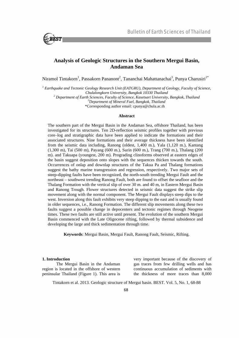
1. Introduction The Mergui Basin in the Andaman region is located in the offshore of western peninsular Thailand (Figure 1). This area is
very important because of the discovery of gas traces from few drilling wells and has continuous accumulation of sediments with the thickness of more traces than 8,000
68
Bulletin of Earth Sciences of Thailand
Tintakorn et al. 2013. Geologic structure of Mergui basin. BEST. Vol. 5, No. 1, 68-88
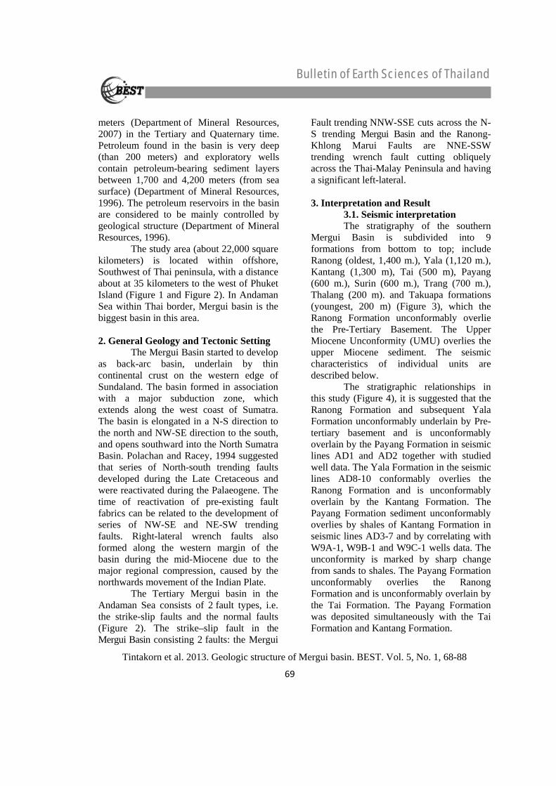
meters (Department of Mineral Resources, 2007) in the Tertiary and Quaternary time. Petroleum found in the basin is very deep (than 200 meters) and exploratory wells contain petroleum-bearing sediment layers between 1,700 and 4,200 meters (from sea surface) (Department of Mineral Resources, 1996). The petroleum reservoirs in the basin are considered to be mainly controlled by geological structure (Department of Mineral Resources, 1996). The study area (about 22,000 square kilometers) is located within offshore, Southwest of Thai peninsula, with a distance about at 35 kilometers to the west of Phuket Island (Figure 1 and Figure 2). In Andaman Sea within Thai border, Mergui basin is the biggest basin in this area. 2. General Geology and Tectonic Setting The Mergui Basin started to develop as back-arc basin, underlain by thin continental crust on the western edge of Sundaland. The basin formed in association with a major subduction zone, which extends along the west coast of Sumatra. The basin is elongated in a N-S direction to the north and NW-SE direction to the south, and opens southward into the North Sumatra Basin. Polachan and Racey, 1994 suggested that series of North-south trending faults developed during the Late Cretaceous and were reactivated during the Palaeogene. The time of reactivation of pre-existing fault fabrics can be related to the development of series of NW-SE and NE-SW trending faults. Right-lateral wrench faults also formed along the western margin of the basin during the mid-Miocene due to the major regional compression, caused by the northwards movement of the Indian Plate. The Tertiary Mergui basin in the Andaman Sea consists of 2 fault types, i.e. the strike-slip faults and the normal faults (Figure 2). The strike–slip fault in the Mergui Basin consisting 2 faults: the Mergui
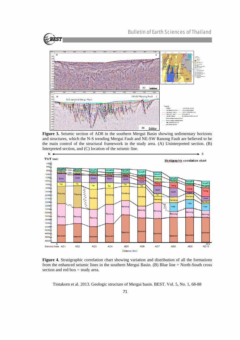
Fault trending NNW-SSE cuts across the N-S trending Mergui Basin and the Ranong-Khlong Marui Faults are NNE-SSW trending wrench fault cutting obliquely across the Thai-Malay Peninsula and having a significant left-lateral. 3. Interpretation and Result 3.1. Seismic interpretation The stratigraphy of the southern Mergui Basin is subdivided into 9 formations from bottom to top; include Ranong (oldest, 1,400 m.), Yala (1,120 m.), Kantang (1,300 m), Tai (500 m), Payang (600 m.), Surin (600 m.), Trang (700 m.), Thalang (200 m). and Takuapa formations (youngest, 200 m) (Figure 3), which the Ranong Formation unconformably overlie the Pre-Tertiary Basement. The Upper Miocene Unconformity (UMU) overlies the upper Miocene sediment. The seismic characteristics of individual units are described below. The stratigraphic relationships in this study (Figure 4), it is suggested that the Ranong Formation and subsequent Yala Formation unconformably underlain by Pre-tertiary basement and is unconformably overlain by the Payang Formation in seismic lines AD1 and AD2 together with studied well data. The Yala Formation in the seismic lines AD8-10 conformably overlies the Ranong Formation and is unconformably overlain by the Kantang Formation. The Payang Formation sediment unconformably overlies by shales of Kantang Formation in seismic lines AD3-7 and by correlating with W9A-1, W9B-1 and W9C-1 wells data. The unconformity is marked by sharp change from sands to shales. The Payang Formation unconformably overlies the Ranong Formation and is unconformably overlain by the Tai Formation. The Payang Formation was deposited simultaneously with the Tai Formation and Kantang Formation.
69
Bulletin of Earth Sciences of Thailand
Tintakorn et al. 2013. Geologic structure of Mergui basin. BEST. Vol. 5, No. 1, 68-88
Seismic lines AD3-10 displays the Kantang Formation unconformably overlying the Ranong Formation. The Kantang Formation unconformably overlies the Yala Formation and is unconformably overlain by the Tai and Surin Formations. The Kantang Formation is marked by sharp changes from sands to shales. The Tai Formation is unconformably overlain by the Surin Formation. The Surin Formation unconformably overlies the Tai and Kantang Formations as seen from the enhanced seismic lines. Sediments of the Trang Formation is a facies equivalent of the Surin Formation by deposited simultaneously with the Surin Formation and is unconformably overlain by shale of Thalang Formation by shale of Thalang Formation by correlating with W9A-1, W9B-1 and W9C-1 well data. All seismic lines in this study showing unconformably this study showing unconformably overlies the Trang Formation and is unconformably overlain shales of Takua Pa Formation. In addition, the Takua Pa Formation is unconformably overlain by shales of Thalang Formation, which deposited in shallow marine environments during the Pliocene-Recent. Composite stratigraphy show in Figure 5 by determined from interpreted seismic section.
Figure 1. Plate motions and simplified structural framework of Cenozoic basins in the Gulf of Thailand and the Southern Mergui Basin, Andaman Sea (modified after Polachan, 1988 and Mahatanachai, 2004).
Figure 2. Locations of the seismic line and the major faults in the Mergui Basin, Andaman Sea. (modified after, Mahatanachai, 2004 and Thipyopass, 2010).
70
Bulletin of Earth Sciences of Thailand
Tintakorn et al. 2013. Geologic structure of Mergui basin. BEST. Vol. 5, No. 1, 68-88
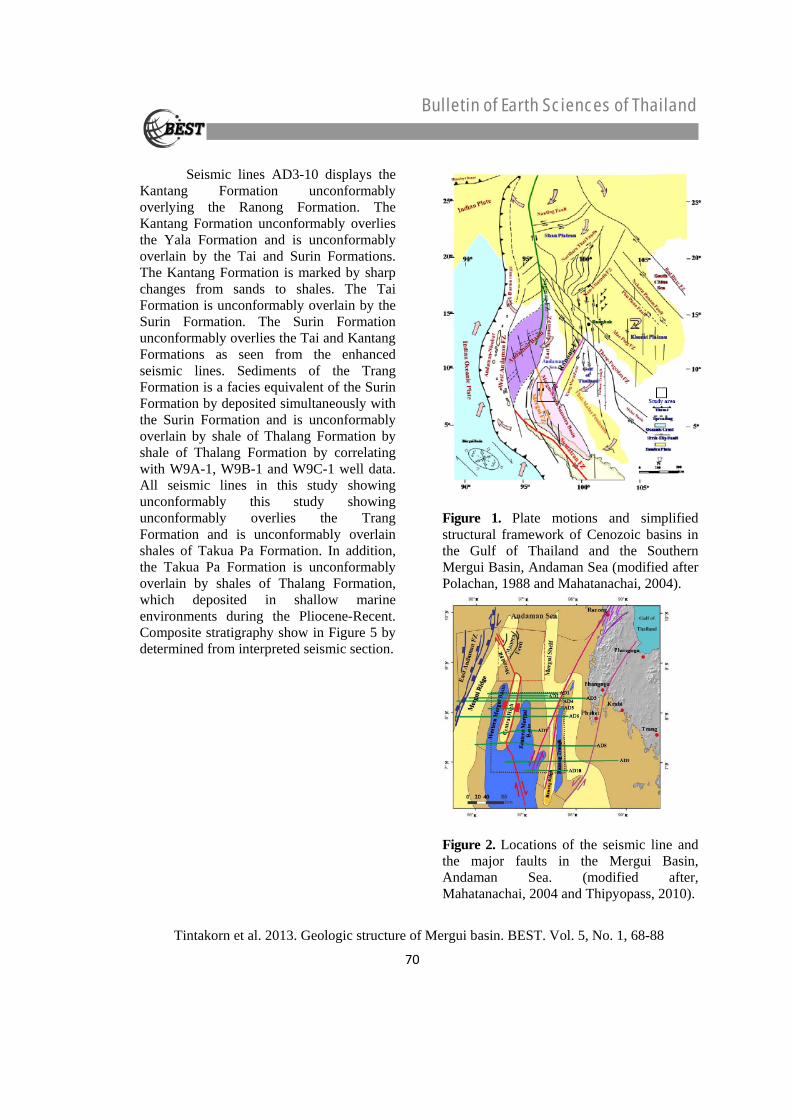
Figure 3. Seismic section of AD8 in the southern Mergui Basin showing sedimentary horizons and structures, which the N-S trending Mergui Fault and NE-SW Ranong Fault are believed to be the main control of the structural framework in the study area. (A) Uninterpreted section. (B) Interpreted section, and (C) location of the seismic line.
Figure 4. Stratigraphic correlation chart showing variation and distribution of all the formations from the enhanced seismic lines in the southern Mergui Basin. (B) Blue line = North-South cross section and red box = study area.
71
Bulletin of Earth Sciences of Thailand
Tintakorn et al. 2013. Geologic structure of Mergui basin. BEST. Vol. 5, No. 1, 68-88
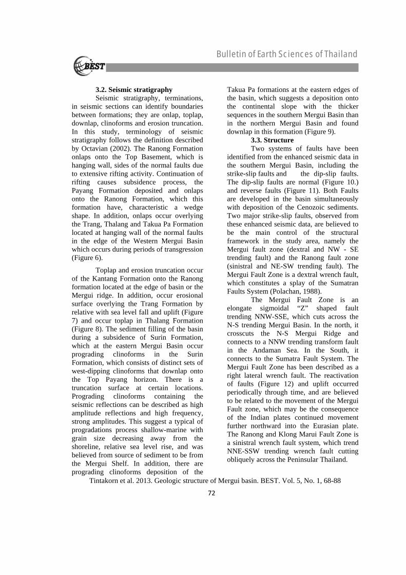
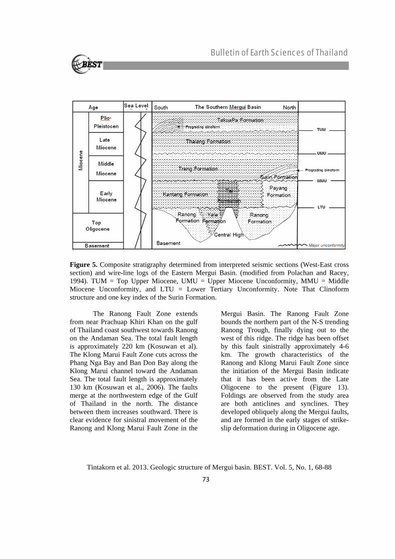
3.2. Seismic stratigraphy Seismic stratigraphy, terminations, in seismic sections can identify boundaries between formations; they are onlap, toplap, downlap, clinoforms and erosion truncation. In this study, terminology of seismic stratigraphy follows the definition described by Octavian (2002). The Ranong Formation onlaps onto the Top Basement, which is hanging wall, sides of the normal faults due to extensive rifting activity. Continuation of rifting causes subsidence process, the Payang Formation deposited and onlaps onto the Ranong Formation, which this formation have, characteristic a wedge shape. In addition, onlaps occur overlying the Trang, Thalang and Takua Pa Formation located at hanging wall of the normal faults in the edge of the Western Mergui Basin which occurs during periods of transgression (Figure 6).
Toplap and erosion truncation occur of the Kantang Formation onto the Ranong formation located at the edge of basin or the Mergui ridge. In addition, occur erosional surface overlying the Trang Formation by relative with sea level fall and uplift (Figure 7) and occur toplap in Thalang Formation (Figure 8). The sediment filling of the basin during a subsidence of Surin Formation, which at the eastern Mergui Basin occur prograding clinoforms in the Surin Formation, which consists of distinct sets of west-dipping clinoforms that downlap onto the Top Payang horizon. There is a truncation surface at certain locations. Prograding clinoforms containing the seismic reflections can be described as high amplitude reflections and high frequency, strong amplitudes. This suggest a typical of progradations process shallow-marine with grain size decreasing away from the shoreline, relative sea level rise, and was believed from source of sediment to be from the Mergui Shelf. In addition, there are prograding clinoforms deposition of the
Takua Pa formations at the eastern edges of the basin, which suggests a deposition onto the continental slope with the thicker sequences in the southern Mergui Basin than in the northern Mergui Basin and found downlap in this formation (Figure 9). 3.3. Structure Two systems of faults have been identified from the enhanced seismic data in the southern Mergui Basin, including the strike-slip faults and the dip-slip faults. The dip-slip faults are normal (Figure 10.) and reverse faults (Figure 11). Both Faults are developed in the basin simultaneously with deposition of the Cenozoic sediments. Two major strike-slip faults, observed from these enhanced seismic data, are believed to be the main control of the structural framework in the study area, namely the Mergui fault zone (dextral and NW - SE trending fault) and the Ranong fault zone (sinistral and NE-SW trending fault). The Mergui Fault Zone is a dextral wrench fault, which constitutes a splay of the Sumatran Faults System (Polachan, 1988).
The Mergui Fault Zone is an elongate sigmoidal “Z” shaped fault trending NNW-SSE, which cuts across the N-S trending Mergui Basin. In the north, it crosscuts the N-S Mergui Ridge and connects to a NNW trending transform fault in the Andaman Sea. In the South, it connects to the Sumatra Fault System. The Mergui Fault Zone has been described as a right lateral wrench fault. The reactivation of faults (Figure 12) and uplift occurred periodically through time, and are believed to be related to the movement of the Mergui Fault zone, which may be the consequence of the Indian plates continued movement further northward into the Eurasian plate. The Ranong and Klong Marui Fault Zone is a sinistral wrench fault system, which trend NNE-SSW trending wrench fault cutting obliquely across the Peninsular Thailand.
72
Bulletin of Earth Sciences of Thailand
Tintakorn et al. 2013. Geologic structure of Mergui basin. BEST. Vol. 5, No. 1, 68-88
Figure 5. Composite stratigraphy determined from interpreted seismic sections (West-East cross section) and wire-line logs of the Eastern Mergui Basin. (modified from Polachan and Racey, 1994). TUM = Top Upper Miocene, UMU = Upper Miocene Unconformity, MMU = Middle Miocene Unconformity, and LTU = Lower Tertiary Unconformity. Note That Clinoform structure and one key index of the Surin Formation.
The Ranong Fault Zone extends
from near Prachuap Khiri Khan on the gulf of Thailand coast southwest towards Ranong on the Andaman Sea. The total fault length is approximately 220 km (Kosuwan et al). The Klong Marui Fault Zone cuts across the Phang Nga Bay and Ban Don Bay along the Klong Marui channel toward the Andaman Sea. The total fault length is approximately 130 km (Kosuwan et al., 2006). The faults merge at the northwestern edge of the Gulf of Thailand in the north. The distance between them increases southward. There is clear evidence for sinistral movement of the Ranong and Klong Marui Fault Zone in the
Mergui Basin. The Ranong Fault Zone bounds the northern part of the N-S trending Ranong Trough, finally dying out to the west of this ridge. The ridge has been offset by this fault sinistrally approximately 4-6 km. The growth characteristics of the Ranong and Klong Marui Fault Zone since the initiation of the Mergui Basin indicate that it has been active from the Late Oligocene to the present (Figure 13). Foldings are observed from the study area are both anticlines and synclines. They developed obliquely along the Mergui faults, and are formed in the early stages of strike-slip deformation during in Oligocene age.
73
Bulletin of Earth Sciences of Thailand
Tintakorn et al. 2013. Geologic structure of Mergui basin. BEST. Vol. 5, No. 1, 68-88
Figure 6. Seismic sections showing the onlap overlying the Trang and Thalang Formations. (A) Uninterpreted seismic line AD5 (B) Interpreted section with indicated onlap (green arrows).
Figure 7. Seismic sections showing the erosional surface and associated structure on Trang Formation. (A) Uninterpreted seismic line AD2 (B) Interpreted section.
Figure 8. Seismic sections showing the Toplap in Thalang Formation. (A) Uninterpreted seismic line AD3 (B) Interpreted section with indicated toplap (blue arrows).
Figure 9. Seismic sections showing downlaps in Takuapa Formation. (A) Uninterpreted seismic line AD9 (B) Interpreted section with indicated downlap (red arrows).
74
Bulletin of Earth Sciences of Thailand
Tintakorn et al. 2013. Geologic structure of Mergui basin. BEST. Vol. 5, No. 1, 68-88
3.4. Unconformities
Unconformities occur in the studied seismic sections are Lower Tertiary Unconformity (LTU), Middle Miocene Unconformity (MMU), Upper Miocene Unconformity (UMU) and Top Upper Miocene (TUM). The Lower Tertiary Unconformity observed from the enchanced seismic sections overlying the Ranong Formation and the Kantang Formation comprises sub-parallel reflections with strong to moderate amplitudes and good continuity. The Payang Formation lays unconformably over the Ranong Formation and comprises sub-parallel relfections with strong to moderate amplitudes and good continuity. These reflections onlap onto Ranong Formation. In addition, the Yala Formation is unconformably overlain by shales of the Kantang Formation (Fig 14). This unconformity relative with water depth decreased and uplift of the basin. Sediment deposition of during the Late Oligocene-Earliest Miocene. The Middle Miocene Unconformity (MMU) observed the Payang Formation is unconformably overlain by the Surin Formation. The Tai Formation is unconformably overlain by shales of the Trang Formation and The Kantang Formation unconformably overlain by the Trang Formation. These characteristic of reflection comprises sub-parallel reflections with strong to moderate amplitudes and good continuity. These reflections toplap the Top Kantang Formation and erosion surface onto the Top Surin Formation. The basin subsidence during the deposition of sediment during the Middle Miocene. This unconformity relative with water depth decreased and uplift of the basin. The Upper Miocene Unconformity (UMU) shown in red color (Figure 15) is picked on onlap and erosional surface, overlying the Trang Formation and Thalang
Formation. This unconformity is characteristic of an angular unconformity located at the edge of the Western Mergui Basin relative sea level fall and uplift of the basin. These characteristic of reflection comprises sub-parallel reflections with strong to moderate amplitudes and good continuity. This unconformity observed during in the Late Miocene.
The Top Upper Miocene (TUM) shown in green color is picked on onlap and erosional truncate of the younger sediment of Thalang Formation (Figure 16). This unconformity is picked at the top of the turbidite unit overlain
3.5. Fault Displacement Method of Displacement
Measurement show in Figure 17 and Fig 18 by select the interpreted fault identify the orientation of fault plane and measure its length as show in Figure 17C, the Mergui fault trends in the NNW-SSE direction and dips to the east at high angle. Select the top horizons of the same layer from the opposite sides of the fault (Figure 17A and 17B). Read the TWT values (or depth in km.) from individual top horizons. Plot the other measured TWT values from the other seismic lines, following the method from No. 1 to 4 (Figure 18). Then calculate the different in depth of each top horizon for individual seismic lines. With these values plot then on the Y axis of the other graph with the same value of the X axis. The fault displacements of the Ranong to Kantang Formations range from about 0 to 1,600 msec. The total thickness of the basin fills reaches a maximum value of about 5,500 msec in the southern Mergui Basin. Most syn-rift normal faults terminate upward near the top of the Ranong Formation, although some faults with large displacements were reactivated and continue upward to the level of the Thalang and Takua Pa formations. The Normal faults was move action during
75

Bulletin of Earth Sciences of Thailand
Tintakorn et al. 2013. Geologic structure of Mergui basin. BEST. Vol. 5, No. 1, 68-88
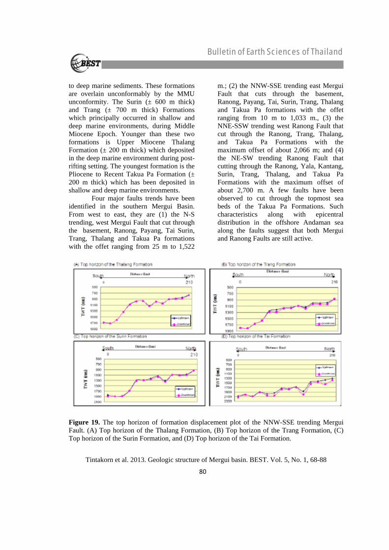
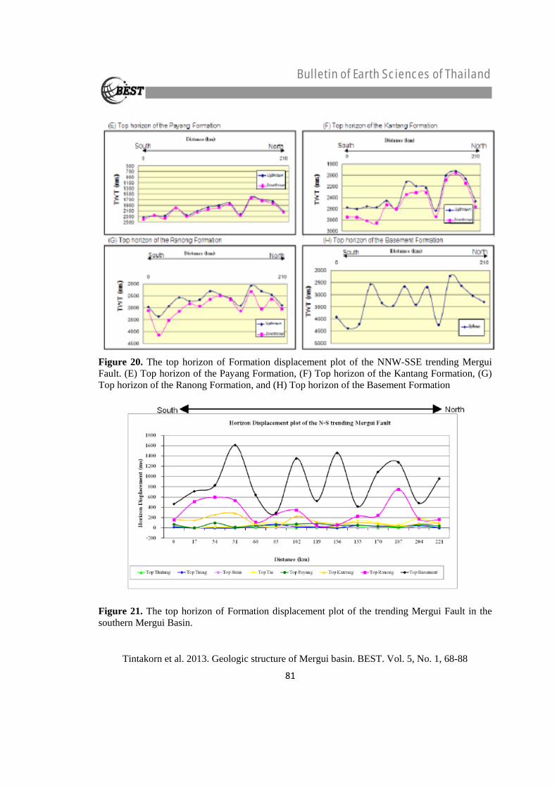
the set up of the sub-basin in the southern Mergui Basin. The horizon displacement plot of the NNW-SSE trending Mergui Fault, which Basement, the Ranong Formation and the Kantang Formation have high displacement (Figure 19 and Figure 20). Displacement of the Ranong Formation is as high as 780 ms (TWT) in the northern area and decreases of displacement in the central area, and then increases of displacement in the southern area of 600 ms (TWT). The displacement of the Kantang
Formation in the northern and southern areas are as high as 200 and 300 ms (TWT), respectively. The Mergui fault developed from the Basement rock and cut into the Cenozoic section (Figure 21), showing high displacement location of the basement rock at an average depth of 1,400 ms (TWT). The Ranong Formation has been eroded off and Miocene sediments lie unconformably at the Mergui Ridge. Movements of the Mergui fault occurred at the same time as in deposits of the Ranong and Kantang Formations.
Figure 10. Seismic sections showing the high-angle normal faults (F1, F2, F3, and F4) in Basement to Kantang Formations. (A) Uninterpreted seismic line AD10 (B) Interpreted section.
Figure 11. Seismic sections showing the reverse faults (F1, F2, and F3) in Ranong to Yala Formations. (A) Uninterpreted seismic line AD9 (B) Interpreted section.
76
Bulletin of Earth Sciences of Thailand
Tintakorn et al. 2013. Geologic structure of Mergui basin. BEST. Vol. 5, No. 1, 68-88
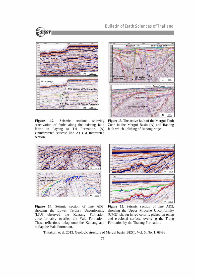
Figure 12. Seismic sections showing reactivation of faults along the existing fault fabric in Payang to Tai Formation. (A) Uninterpreted seismic line A1 (B) Interpreted section.
Figure 13. The active fault of the Mergui Fault Zone in the Mergui Basin (A) and Ranong fault which uplifting of Ranong ridge.
Figure 14. Seismic section of line AD8, showing the Lower Tertiary Unconformity (LIU) observed the Kantang Formation unconformably overlies the Yala Formation. These reflections onlap onto the Kantang and toplap the Yala Formation.
Figure 15. Seismic section of line AD2, showing the Upper Miocene Unconformity (UMU) shown in red color is picked on onlap and erosional surface, overlying the Trang Formation by the Thalang Formation.
77
Bulletin of Earth Sciences of Thailand
Tintakorn et al. 2013. Geologic structure of Mergui basin. BEST. Vol. 5, No. 1, 68-88
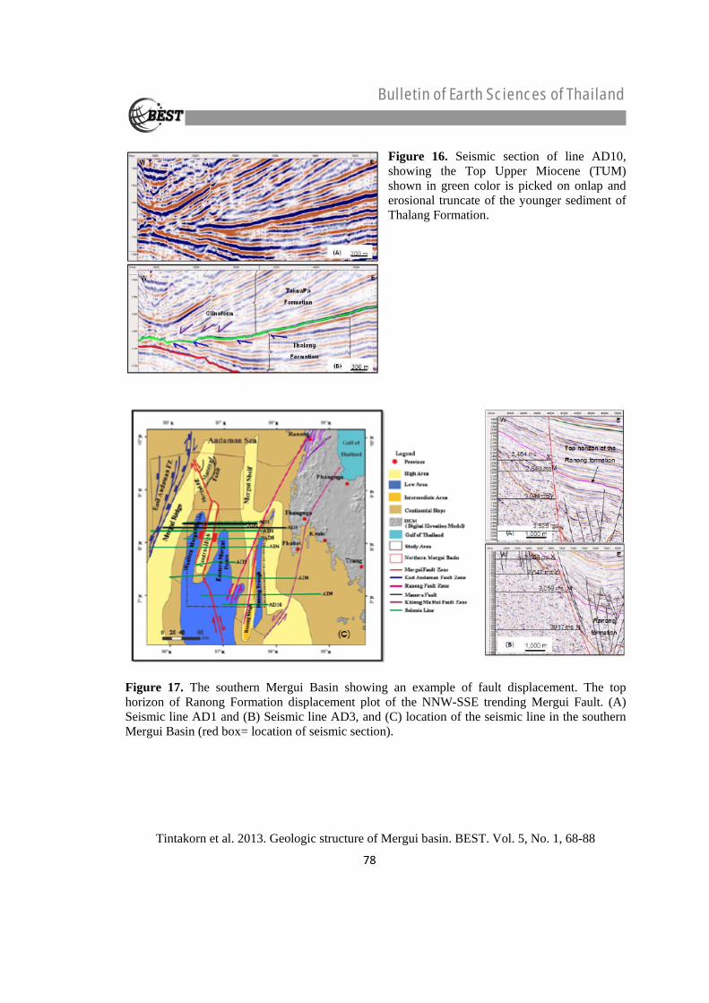
Figure 16. Seismic section of line AD10, showing the Top Upper Miocene (TUM) shown in green color is picked on onlap and erosional truncate of the younger sediment of Thalang Formation.
Figure 17. The southern Mergui Basin showing an example of fault displacement. The top horizon of Ranong Formation displacement plot of the NNW-SSE trending Mergui Fault. (A) Seismic line AD1 and (B) Seismic line AD3, and (C) location of the seismic line in the southern Mergui Basin (red box= location of seismic section).
78
Bulletin of Earth Sciences of Thailand
Tintakorn et al. 2013. Geologic structure of Mergui basin. BEST. Vol. 5, No. 1, 68-88
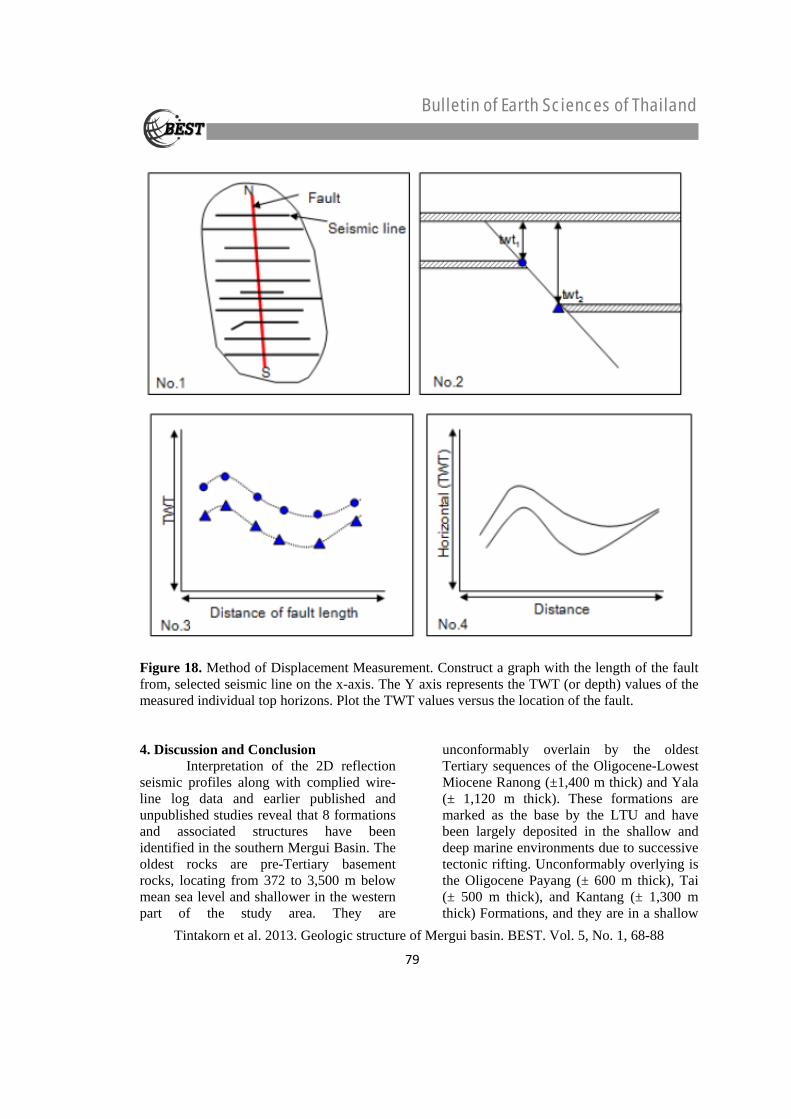
Figure 18. Method of Displacement Measurement. Construct a graph with the length of the fault from, selected seismic line on the x-axis. The Y axis represents the TWT (or depth) values of the measured individual top horizons. Plot the TWT values versus the location of the fault. 4. Discussion and Conclusion Interpretation of the 2D reflection seismic profiles along with complied wire-line log data and earlier published and unpublished studies reveal that 8 formations and associated structures have been identified in the southern Mergui Basin. The oldest rocks are pre-Tertiary basement rocks, locating from 372 to 3,500 m below mean sea level and shallower in the western part of the study area. They are
unconformably overlain by the oldest Tertiary sequences of the Oligocene-Lowest Miocene Ranong (±1,400 m thick) and Yala (± 1,120 m thick). These formations are marked as the base by the LTU and have been largely deposited in the shallow and deep marine environments due to successive tectonic rifting. Unconformably overlying is the Oligocene Payang (± 600 m thick), Tai (± 500 m thick), and Kantang (± 1,300 m thick) Formations, and they are in a shallow
79
Bulletin of Earth Sciences of Thailand
Tintakorn et al. 2013. Geologic structure of Mergui basin. BEST. Vol. 5, No. 1, 68-88
to deep marine sediments. These formations are overlain unconformably by the MMU unconformity. The Surin (± 600 m thick) and Trang (± 700 m thick) Formations which principally occurred in shallow and deep marine environments, during Middle Miocene Epoch. Younger than these two formations is Upper Miocene Thalang Formation (± 200 m thick) which deposited in the deep marine environment during post-rifting setting. The youngest formation is the Pliocene to Recent Takua Pa Formation (± 200 m thick) which has been deposited in shallow and deep marine environments. Four major faults trends have been identified in the southern Mergui Basin. From west to east, they are (1) the N-S trending, west Mergui Fault that cut through the basement, Ranong, Payang, Tai Surin, Trang, Thalang and Takua Pa formations with the offet ranging from 25 m to 1,522
m.; (2) the NNW-SSE trending east Mergui Fault that cuts through the basement, Ranong, Payang, Tai, Surin, Trang, Thalang and Takua Pa formations with the offet ranging from 10 m to 1,033 m., (3) the NNE-SSW trending west Ranong Fault that cut through the Ranong, Trang, Thalang, and Takua Pa Formations with the maximum offset of about 2,066 m; and (4) the NE-SW trending Ranong Fault that cutting through the Ranong, Yala, Kantang, Surin, Trang, Thalang, and Takua Pa Formations with the maximum offset of about 2,700 m. A few faults have been observed to cut through the topmost sea beds of the Takua Pa Formations. Such characteristics along with epicentral distribution in the offshore Andaman sea along the faults suggest that both Mergui and Ranong Faults are still active.
Figure 19. The top horizon of formation displacement plot of the NNW-SSE trending Mergui Fault. (A) Top horizon of the Thalang Formation, (B) Top horizon of the Trang Formation, (C) Top horizon of the Surin Formation, and (D) Top horizon of the Tai Formation.
80
Bulletin of Earth Sciences of Thailand
Tintakorn et al. 2013. Geologic structure of Mergui basin. BEST. Vol. 5, No. 1, 68-88
Figure 20. The top horizon of Formation displacement plot of the NNW-SSE trending Mergui Fault. (E) Top horizon of the Payang Formation, (F) Top horizon of the Kantang Formation, (G) Top horizon of the Ranong Formation, and (H) Top horizon of the Basement Formation
Figure 21. The top horizon of Formation displacement plot of the trending Mergui Fault in the southern Mergui Basin.
81
Bulletin of Earth Sciences of Thailand
Tintakorn et al. 2013. Geologic structure of Mergui basin. BEST. Vol. 5, No. 1, 68-88
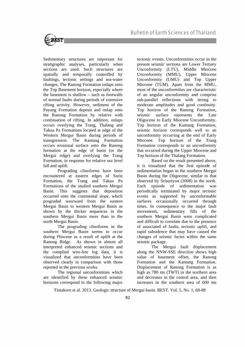
Sedimentary structures are important for stratigraphic analyses, particularly when sections are used. Such structures are spatially and temporally controlled by faultings, tectonic settings and sea-water changes. The Ranong Formation onlaps onto the Top Basement horizon, especially where the basement is shallow – such as footwalls of normal faults during periods of extensive rifting activity. However, sediment of the Payang Formation deposit and onlap onto the Ranong Formation by relative with continuation of rifting. In addition, onlaps occurs overlying the Trang, Thalang and Takua Pa Formations located at edge of the Western Mergui Basin during periods of transgression. The Kantang Formation occurs erosional surface onto the Ranong formation at the edge of basin (or the Mergui ridge) and overlying the Trang Formation, in response for relative sea level fall and uplift. Prograding clinoforms have been encountered at eastern edges of Surin Formation, the Trang and Takua Pa Formations of the studied southern Mergui Basin. This suggests that deposition occurred onto the continental slope, which prograded wesrward from the eastern Mergui Basin to western Mergui Basin as shown by the thicker sequences in the southern Mergui Basin more than in the north Mergui Basin. The prograding clinoforms in the southern Mergui Basin seems to occur during Pliocene as a result of uplift at the Ranong Ridge. As shown in almost all interpreted enhanced seismic sections and the complied wire-line log data, it is visualized that unconformities have been observed clearly in comparison with those reported in the previous works. The regional unconformities which are identified by these enhanced seismic horizons correspond to the following major
tectonic events. Unconformities occur in the present seismic sections are Lower Tertiary Unconformity (LTU), Middle Miocene Unconformity (MMU), Upper Miocene Unconformity (UMU) and Top Upper Miocene (TUM). Apart from the MMU, most of the unconformities are characteristic of an angular unconformity and comprise sub-parallel reflections with strong to moderate amplitudes and good continuity. Top horizon of the Ranong Formation, seismic surface represents the Late Oligocene to Early Miocene Unconformity. Top horizon of the Kantang Formation, seismic horizon corresponds well to an unconformity occurring at the end of Early Miocene. Top horizon of the Trang Formation corresponds to an unconformity that occurred during the Upper Miocene and Top horizon of the Thalang Formation. Based on the result presented above, it is visualized that the first episode of sedimentation began in the southern Mergui Basin during the Oligocene, similar to that observed by Srisuriyon (2008) in the north. Each episode of sedimentation was periodically terminated by major tectonic events as supported by unconformable surfaces occasionally occurred through times. In consequence to the major fault movements, sedimentary fills of the southern Mergui Basin were complicated and difficult to correlate due to the presence of associated of faults, tectonic uplift, and rapid subsidence that may have caused the changes of seismic facies within the same seismic package. The Mergui fault displacement along the NNW-SSE direction shows high value of basement offset, the Ranong Formation and the Kantang Formation. Displacement of Ranong Formation is as high as 780 ms (TWT) in the northern area and decreases in the central area, and then increases in the southern area of 600 ms
82
Bulletin of Earth Sciences of Thailand
Tintakorn et al. 2013. Geologic structure of Mergui basin. BEST. Vol. 5, No. 1, 68-88
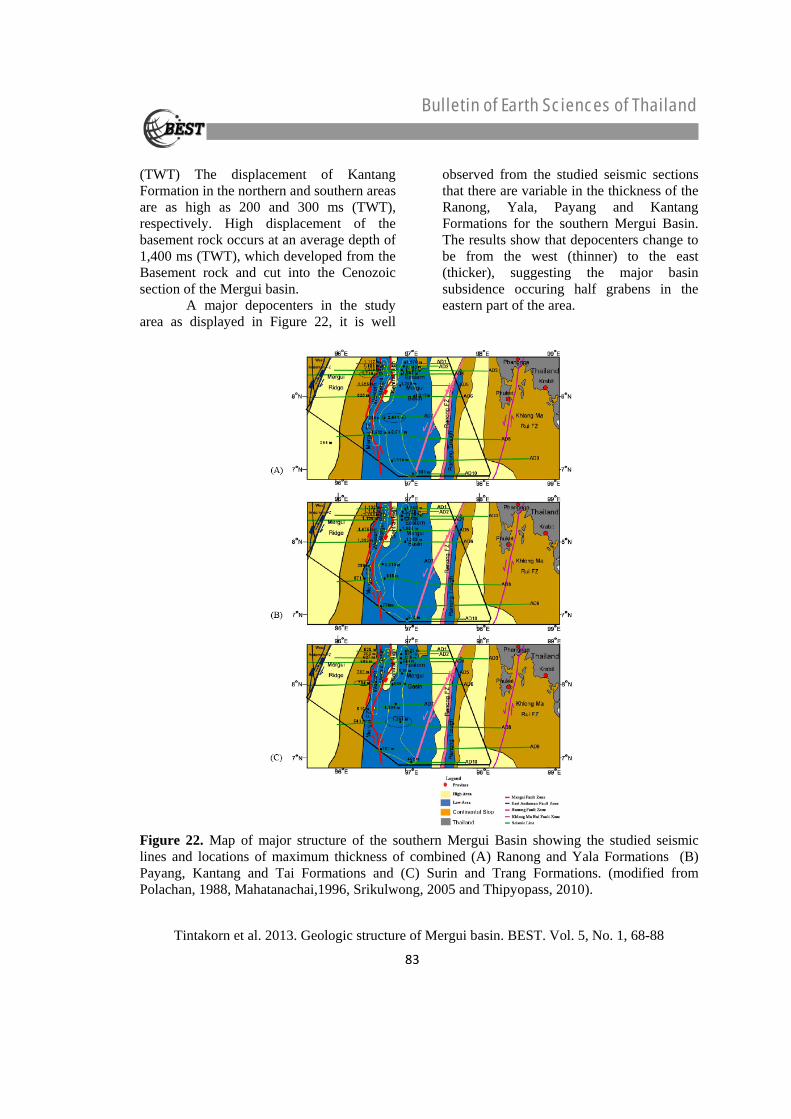
(TWT) The displacement of Kantang Formation in the northern and southern areas are as high as 200 and 300 ms (TWT), respectively. High displacement of the basement rock occurs at an average depth of 1,400 ms (TWT), which developed from the Basement rock and cut into the Cenozoic section of the Mergui basin. A major depocenters in the study area as displayed in Figure 22, it is well
observed from the studied seismic sections that there are variable in the thickness of the Ranong, Yala, Payang and Kantang Formations for the southern Mergui Basin. The results show that depocenters change to be from the west (thinner) to the east (thicker), suggesting the major basin subsidence occuring half grabens in the eastern part of the area.
Figure 22. Map of major structure of the southern Mergui Basin showing the studied seismic lines and locations of maximum thickness of combined (A) Ranong and Yala Formations (B) Payang, Kantang and Tai Formations and (C) Surin and Trang Formations. (modified from Polachan, 1988, Mahatanachai,1996, Srikulwong, 2005 and Thipyopass, 2010).
83
Bulletin of Earth Sciences of Thailand
Tintakorn et al. 2013. Geologic structure of Mergui basin. BEST. Vol. 5, No. 1, 68-88
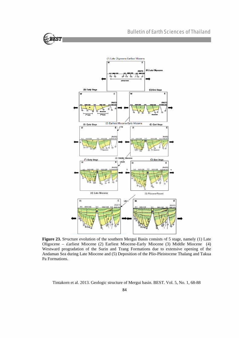
Figure 23. Structure evolution of the southern Mergui Basin consists of 5 stage, namely (1) Late Oligocene – Earliest Miocene (2) Earliest Miocene-Early Miocene (3) Middle Miocene (4) Westward progradation of the Surin and Trang Formations due to extensive opening of the Andaman Sea during Late Miocene and (5) Deposition of the Plio-Pleistocene Thalang and Takua Pa Formations.
84
Bulletin of Earth Sciences of Thailand
Tintakorn et al. 2013. Geologic structure of Mergui basin. BEST. Vol. 5, No. 1, 68-88
The result-show that deposition of the Ranong and Yala Formations took place during extrusive subsidence of early rifting, where the normal faulting generate half-graben depocentres. The Ranong Formation thickness markedly towards the depocentres of these subbasins and thins or disappears towards basement highs. After the deposition of the Ranong formation, local inversion of existing normal faults or strike-slip reactivation of faults have been formed near the Ranong Fault occurred. While Kantang and Payang Formations are subsidence in the depocentres of the isolated sub-basins and over structural highs. These processes appear to have ceased prior to the deposition of the Surin Formation.
Structural evolution of the southern Mergui Basin can be subdivided into 5 stages (Figure 23). They are (1) Oligocene syn-rifting due to the extension tectonics and deposited marine sediments of the Ranong and Yala Formations and development of large normal faulting generating half graben depocenters as well as flower structures; (2) Thermal subsidence of the post-rifting causing early Miocene deposition of the Payang and Kantang Formations and cessation of normal faulting; (3) Inversion of normal faulting together with reactivation of strike-slip faulting due to compression tectonics causing the movements of the Ranong
and associated faults; (4) Westward progradation of the Surin and Trang Formations due to extensive opening of the Andaman Sea during the Late Miocene, followed by deposition of the Plio-Pleistocene Thalang and Takua Pa Formations, and termination major of structural development, and (5) The development of active seafloor off setting since Pleistocene causing by the up to present-day reactivation of Ranong and Klong Marui active faults.
5. References Achalabhuti, C. 1975. Petroleum geology of
Thailand (Gulf of Thailand and Andaman Sea Summary). In Halbouty, M.T. Maher, J.C., and Lian, H.M. (Eds). Circum-Pacific Energy and Mineral Resources. American Associate of Petroleum Geologists. pp. 147-157. Department of Mineral Resources, Ministry of Industry, Bangkok, Thailand.
Andreason, M.W., Mudfod B., and Onge, J.E.St. 1997. Geologic Evolution and Petoleum System of the Thailand Andaman Sea Basins. In proceedings of the Petroleum Systems of SE Asia and Australasia Conference May, 1997, pp. 337-350. Indonesian Petroleum Association.
Beckinsale, R.D., Suensilpong, S., Nakapadungrat, S., and Walsh, J.N. 1979. Geochronology and geochemistry of granite magmatism in Thailand in relation to a plate tectonic model. Journal of the Geological Society.136: 529-540.
85

Bulletin of Earth Sciences of Thailand
Tintakorn et al. 2013. Geologic structure of Mergui basin. BEST. Vol. 5, No. 1, 68-88
Charusirisawad, R. 1996. Reprocessing of seismic data from the Mergui Basin, Andaman Sea, Thailand. Master’s Thesis, Department of Geosciences, University of Tulsa.
Curray, J.R., Moore, D.G., Lawver, L.A., Emmel, F.J., Raitt, R.W., Henry, M., and Kieckhefer, R. 1979. Tectonics of the Andaman Sea and Burma. In J.S. Watkins, J. Montadert and Montadert, L. (Eds). Geological and Geophysical Investigations of Continental Margins. pp. 189-198.
Curray, J.R. 2004. Tectonics and history of the Andaman Sea region. Journal of Asian Earth Science. 25: 187-232.
Department of Mineral Fuels 2006. Petroleum assessment in Northeastern and Andaman region, Thailand. Atop Technology Co, Ltd., Bangkok, Thailand.
Department of Mineral Resources, (1996). Andaman Sea Basin Study. STS Engineering consultants Co., Ltd., Bangkok, Thailand.
Department of Mineral Resources. 2007. Geology of Thailand. Department of Mineral Resources. Ministry of Natural Resources and Environment. Bangkok.
Dolson, J.C., and Shann, M.V. 2000. Egypt in the Twenty-First Century, petroleum potential in offshore trends. Geoarabia. 6: 211-230.
Harding, T.P. 1985. Seismic characteristic and identification of negative flower structures, positive flower structures, and positive structures inversion. Bulletin of the American Association of Petroleum Geologists. 69: 582-600.
Hutchison, C.S. 1975. Ophiolites in Southeast Asia. Geological Society of American Geological Society of America Bulletin. 86: 797-806.
Hutchison, C.S. 1977. Granite emplacement and tectonic subdivision of Peninsular Malaya. Geological Society of Malaysia Bulletin. 9: 187-207.
Khursida, P. 2002. Subsurface Geology of the Southern part of Tertiary Mergui Basin, Andaman Sea. Master’s Thesis. Department of Geology, Faculty of Science, Chulalongkorn University.
Le Dain, A.Y., Tapponnier, P. and Molnar, P. 1984. Active faulting and tectonics of Burma and surrounding regions. Journal of Geophysical Research. 89: 453-472.
Mitchum, R.M., Jr. and Vail, P.R. 1977. Seismic stratigraphy and global changes of sea level; Part 7, Seismic stratigraphic interpretation procedure. AAPG Memoir. 26: 135-143.
Molnar, P. and Tapponnier, P. 1975. Cenozoic Tectonic of Asia; effects of a continental collision. Science. 189: 419-426.
Morley, C.K. 2002. A tectonic model for the Tertiary evolution of strike–slip faults and rift basins in SE Asia. Journal of Tectonophysics. 347: 189-215.
Morley, C.K. et al. 2009. Structural development of a major late Cenozoic basin and transpressional belt in central Iran: The Central Basin in the Qom-Saveh area. Geosphere. 5: 325-362
Mukhopadhyay, M. 1984. Seismotectonics of subduction and back-arc rifting under the Andaman Sea. Tectonophysics. 108: 229-239.
Nakanart, A. and Mantajit, N. 1983. Stratigraphic correlation of the Andaman Sea. Conference on Geology and Mineral Resources of
86

Bulletin of Earth Sciences of Thailand
Tintakorn et al. 2013. Geologic structure of Mergui basin. BEST. Vol. 5, No. 1, 68-88
Thailand., pp 171-177. Department of Mineral Resources. Bangkok.
Packham, G. 1993. Plate Tectonics and Development of Sedimentary Basin of the dextral regime in Western Southeast Asia. Journal of Southeast Asian Earth Sciences. 8: 497–511.
Paul, D.D. and Lian, H.M. 1975. Offshore Tertiary basins of S.E. Asia, Bay of Bengal to South China Sea. In Proceeding of the 9th World Petroleum Congress, London, Applied Science Publishers., pp 107-121.
Peter, G., Weeks, L.A. and Burns, R.E. 1966. A reconnaissance geophysical survey in the Andaman Sea and across the Andaman-Nicobar Island Arc. Journal of Geophysical Research. 11: 495-509.
Polachan, S. 1988. The geological evolution of the Mergui Basin, SE Andaman Sea, Thailand, Doctoral dissertation, Royal holloway and Bedford new College (RHBNC), University of London.
Polachan, S. and Racey, A. 1994. Stratigraphy of the Mergui Basin, Andaman Sea: Implications for Petroleum Exploration. Journal of Petroleum Geology. 17 (4): 373-406.
Polachan, S., Pradidtan, S., Tongtaow, C., Janmaha, S., Intarawijitr, K., Sangsuwan, C. 1991. Development of Cenozoic basins in Thailand, Marine and Petroleum Geology, 8, 84-97.
PTT Exploration and Production Public Co., Ltd. 2010. Structural Evolution and Tectonostratigraphic Correlation for the Southern Mergui Basin. Department of Geology, Chulalongkorn University, Bangkok.
Ridd, M.F. 1971. Southeast Asia as part of Gondwanaland. Nature. 234: 531-533.
Rider, M.H. 1993. Gamma-ray log shape used as a facies indicator: critical analysis of an oversimplified methodology. Geological Applications of Wireline Logs, Geological Society Special Publications. 48: 27-37.
Rider, M. H. 1996. The Geological Interpretation of Well Logs, 2nd Ed., Whittles Publishing, Caithness, England.
Rodolfo, K.S. 1969. Bathymetry and marine geology of the Andaman Sea Basin, and tectonic implications for Southeast Asia. Geological Society of America Bulletin. 80: 1,203-1,230.
Sheriff, R.E. 1980. Seismic stratigraphy: International Human Resources Development Corporation. United States. America.
Shouls, M.M. 1973. Seismicity and plate tectonics in the Thailand-Burma - Andaman Sea area. Cop. Newsletters. 1: 17-19.
Srikulwong, S. 1986. Structural evolution and sedimentation during the Oligocene, in the vicinity of the W9-E-1 Well, Mergui Basin, Andaman Sea, Thailand. Master’s Thesis. Science in Petroleum Geology, Aberdeen University.
Srikulwong, S. 2005. Potential of petroleum geology in Thailand. The Department of Mineral Fuels. Ministry of Energy. Bangkok.
Srisuriyon, K. 2008. Structural style and evolution of the northern Mergui Basin, Andaman Sea, Thailand. Master’s Thesis, Science in Petroleum Geosciences, University of Aberdeen.
87
Bulletin of Earth Sciences of Thailand
Tintakorn et al. 2013. Geologic structure of Mergui basin. BEST. Vol. 5, No. 1, 68-88
Suensilpong, S. 1977. The role of plate collision in tin mineralization in Thailand. In Proceeding of the 7th Circum-Pacific Plutonism Project meeting, IGCP, Toyama, Japan. pp. 9.
Suensilpong, S., Putthapiban, P., and Mantajit, N. 1981. Some aspects of tin granite and its relationship to tectonic setting. Geological Society of America, Special volume 1981: pp 9.
Tananchai, M. 2004. Seismic Stratigraphy and Seismic Facies Analysis of the Mergui Basin, Thai Andaman Sea. Master’s Thesis, Science in Petroleum Geosciences, University of Aberdeen.
Tapponnier, P., Peltzer. G., Le Dain, A. Y., Armijo, R., and Cobbold, P. 1982. Propagating extrusion tectonics in Asia: new insights from simple experiments with plasticene. Geology. 10: 611-616.
Tapponnier, P., Peltzer. G., and Armijo, R. 1986. On the mechanics of the collision between India and Asia. In Ramsey, J. G., Coward,M. P., and Ries, A. (Eds.), Collision Tectonics. Geological Society, London, Special Publications.19: 115-157.
Thipyopass, S. 2010. Paleoearthquake investigation along the Ranong Fault Zone, Southern Thailand. Master’s Thesis, Department of Geology, Faculty of Science, Chulalongkorn University.
Vail, P.R. 1987. Seismic stratigraphy interpretation procedure. In A.W. Bally, ed., Atlas of Seismic Stratigraphy: AAPG Studies in Geology. 27: 1-10.
Weeks, L.A., Harbison, R.N., and Peter, G. 1967. Island arc system in the Andaman Sea. Bulletin of American Association of Petroleum Geologists. 51: 1,1803-1,815.
88