analysis of remote sensing data for tornado damage assessment presented by:justin novak...
TRANSCRIPT

Analysis of Remote Sensing Data for Tornado Damage Assessment
Presented by: Justin NovakAdvisor: Guido Cervone, Ph.D.

Purpose
To determine which remote sensing platform is
best suited for emergency management
2

Agenda
• Selection Criteria for Study Area
• Study Area
• Background/Historical
• Datasets
• Evaluation Criteria
• Conclusions
3

Selection Criteria for Study Area
• NOAA 1950-2013 Tornado Track Dataset• EF-5 Tornadoes• Publicly Available Datasets
Source: COX, 2014 4

Study Area
● Harvest, AL
● 27 April 2011
● EF-5 Tornado
5

Background/HistoricalHarvest, AL
• Dixie Alley
• Northern Alabama
• Huntsville, AL #1 Tornado City (Kellogg, 2013)
• Population: 5,281 (Gazetteer, 2014)
• 4 Major Tornadoes in Past 40 Years (NOAA, 2013)
6

Datasets|Base Layers
● Global Country Borders
● TIGER/Line Shapefile
o US State Boundaries
o US County Boundaries
o Madison County Roads
● WGS84 UTM Zone 16N/15N7

● USGS EarthExplorer (http://earthexplorer.usgs.gov)
● 7 bands (15m PAN / 30m MSI / 100m Thermal)
● Evaluated Sceneso 03 April 2011 (Suitable)
o 10 April 2011 (Cloud Covered)
o 19 April 2011 (Cloudy, Contrast Issues)
o 05 May 2011 (Suitable)
Datasets|USGS Landsat 5
8

● USGS EarthExplorer (http://earthexplorer.usgs.gov)
● 4 band 1m color infrared orthoimagery
● Evaluated Sceneso 14 July 2009 (Suitable)
o 12 September 2011 (Suitable)
o 26 August 2013 (Suitable)
Datasets|USDA NAIP
9

● USGS EarthExplorer (http://earthexplorer.usgs.gov)
● 3 band 15cm natural color
● Acquired March 2010
Datasets|City of Huntsville
10

● USGS HDDS (http://hddsexplorer.usgs.gov/)
● 3 band 31cm natural color
● Acquired 29 April 2011
Datasets|Atlantic Group, LLC.
11

Datasets|Civil Air Patrol
● USGS HDDS (http://hddsexplorer.usgs.gov/)
● 3 band natural color
● Acquired 24 May 2011
Example Dataset from
Joplin, MO Tornado
12

Datasets|GeoEye Aerial
● USGS HDDS (http://hddsexplorer.usgs.gov/)
● 3 band 15cm natural color
● Acquired 24 May 2011
Example Dataset from
Joplin, MO Tornado
13

Evaluation Criteria
● Emergency Management Phaseso Mitigation
o Preparedness
o Response
o Recovery
● Coverage Area
● Timeliness
● Analysis Products
● Limitations
14
Source: NEHRP, 2009

● Capabilities:
o Mitigation
o Preparedness
o Recovery
o Vegetation Analysis
● Limitations
o Response
o Timeliness
o Spatial Resolution
o Atmospheric Particulates
Findings|USGS Landsat
Source: Novak, 201315

Findings|USDA NAIP
● Capabilities:
o Mitigation
o Preparedness
o Recovery
o Vegetation Analysis
● Limitations
o Response
o Timeliness
o Spatial Resolution
16
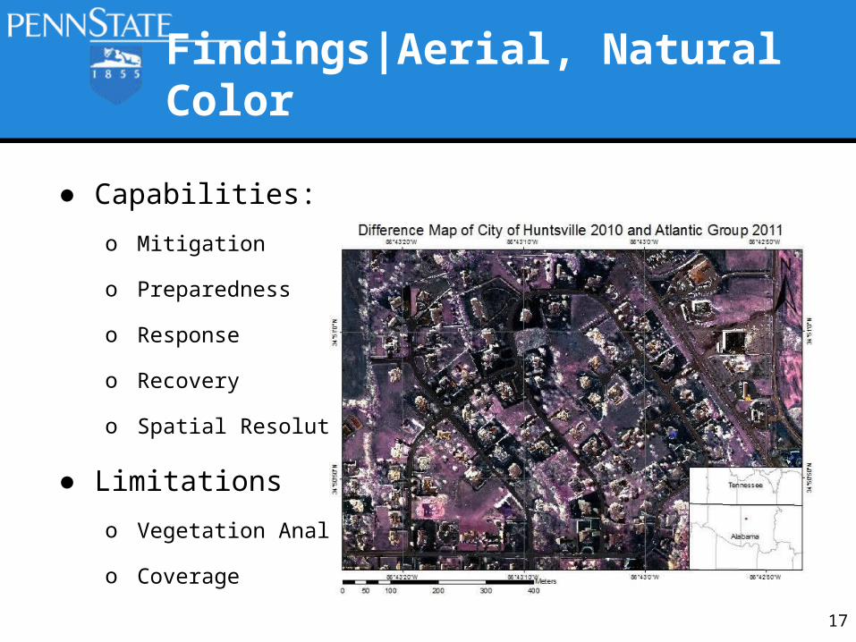
● Capabilities:
o Mitigation
o Preparedness
o Response
o Recovery
o Spatial Resolution
● Limitations
o Vegetation Analysis
o Coverage
Findings|Aerial, Natural Color
17
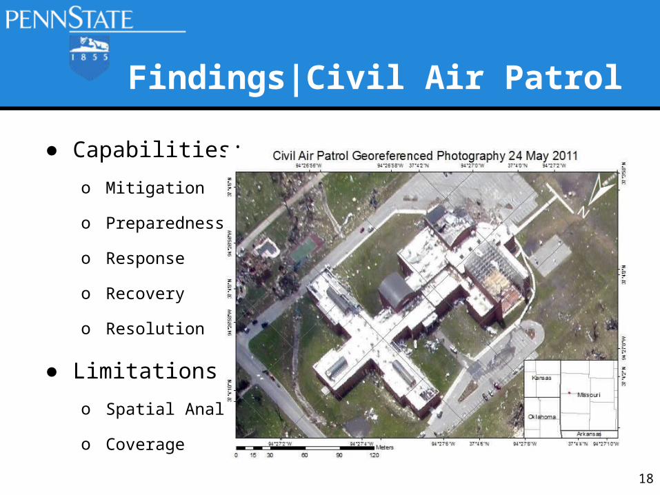
● Capabilities:
o Mitigation
o Preparedness
o Response
o Recovery
o Resolution
● Limitations
o Spatial Analysis
o Coverage
Findings|Civil Air Patrol
18

Conclusions
Aerial
LandsatNAIP
19
Aerial or NAIP
CAP (urgent) or Aerial (analysis)
EmergencyManagement
Phases
Source: NEHRP, 2009

References
● Cox, John D. “'Tornado Alley' actually four regions?” Web. Copyright 2014 NBCNews.com.
Updated 27 April 2010. http://www.nbcnews.com/id/36807882/ns/us_news-environment/from/ET
● National Oceanic and Atmospheric Administration. “SVRGIS”. Web. Dated 18 March 2014.
Accessed 20 July 2014. http://www.spc.noaa.gov/gis/svrgis.
● NEHRP - National Earthquake Hazards Reduction Program, Introduction to emergency
management. Dated 01 November 2009
http://training.fema.gov/EMIWeb/EarthQuake/NEH0101220.htm
● Novak, Justin. “Leveraging Remote Sensing for Rapid Identification of Tornado Damage”. Penn
State University, GEOG 883. Dated 22 April 2013.
● U.S. Census Bureau. “2013 U.S. Gazetteer Files”. Web. Dated 08 November 2013. Accessed
20 July 2014. http://www.census.gov/geo/maps-data/data/gazetteer2013.html
20
