analysis of the stratigraphy of chosen areas within the ilocos region
DESCRIPTION
Ilocos Region, NW PhilippinesTRANSCRIPT

ANALYSIS OF THE STRATIGRAPHY OF CHOSEN AREAS
WITHIN THE ILOCOS REGION
A Paper Submitted to
Emmanuel A. Codillo
Joselito P. Duyanen, PhD.
Allan Gil S. Fernando, Ph. D.
Jose Dominick S. Guballa
National Institute of Geological Sciences
In Partial Fulfillment of the Course Requirements in
Geology 120 Principles of Stratigraphy
Submitted by
PEALE AXEL P. BONDOC
RUTH ESTHER G. DELINA
ADRIENNE NICOLE S. FERNANDEZ
FRANK PERRY T. RUBIA
1

TABLE OF CONTENTS
Page
INTRODUCTION…………………………………………………………….………..3
RECENT SEDIMENTARY ENVIRONMENTS
La Paz Sand Dunes, Ilocos Norte………………………….………..…….….6
General DescriptionCompositional AnalysisProvenance and InterpretationSheared Zone
Luna Beach Deposits, La Union…………………………………….….…….9General DescriptionProvenanceSedimentary Structures and Processess
MINOR OUTCROPS
Ilocos Norte
Kapurpurawan, Burgos…………………………………………………....…11Outcrop 1
General Description and StratigraphyInterpretation
Outcrop 2General Description and StratigraphyInterpretation
San Nicolas Outcrop…………………………………………………………14General DescriptionInterpretation
Ilocos Sur
Suso Outcrop………………………………………………………………….16General DescriptionLithology and StructuresInterpretation
2

Santiago Outcrop……………………………………………………………..18General Description and StratigraphyInterpretation
Tagudin-Cervantes Outcrop. ………………………………………….……21General DescriptionStratigraphy and StructuresInterpretation
MAJOR OUTCROPS
Solvec Point, Ilocos Sur……………………………………………………...26General DescriptionSection DescriptionGeologic History
San Juan Outcrop, La Union .……………………………………………….28General DescriptionSection DescriptionGeologic History
NCC Quarry, Pangasinan ………………………………………………..…...31
REFERENCES…………………………………………………….........………………..35
APPENDIX…………………………………………………………………....................36
INTRODUCTION
3
Stratigraphy is defined by dictionaries as the study of rock strata, its origin,
composition, and development. This discipline of geology is useful for the
study of, but not restricted to, sedimentary and volcanic igneous rocks.
Geology 120 ‘Principles of Stratigraphy’ is one of the geology courses that is
offered by the National Institute of Geological Sciences. According to the
syllabus given by Prof. Fernando and others (2015), the end-objective of the
course is, “to be able to conduct fieldwork independently, and apply basic
principles in geology in analyzing the stratigraphic relationships of rocks.”
One of its major requirements is a fieldwork to test the skills learned and
developed in this class and previously taken geology subjects.
The fieldwork undertaken by this batch is a four day activity, from April 10 to
13, 2015, along the stretch of Ilocos Region. This region—Ilocos Norte, Ilocos
Sur, La Union, and Pangasinan—is located on the northwestern portion of the
Philippines. It is bounded by the South China Sea to the west, Luzon Strait to
the north, Cordillera Mountain Range to the east, and the Central Luzon
Region to the south. Climate in this region is Type I: dry from November to
April and wet for the rest of the year.
The geography of the region is noteworthy to stratigraphy students because
it is a relatively slender coastal region immediately bounded by the highlands
of Cordillera, and sediments from the mountains are dumped in this region.
Furthermore, the climate of the region distinguishes it from other regions, in
that it was able to develop a subaeolian environment. Aurelio and Peña
(2008) describe the Ilocos Region under a sedimentary basin, contiguous
with the Central Luzon plains.
4
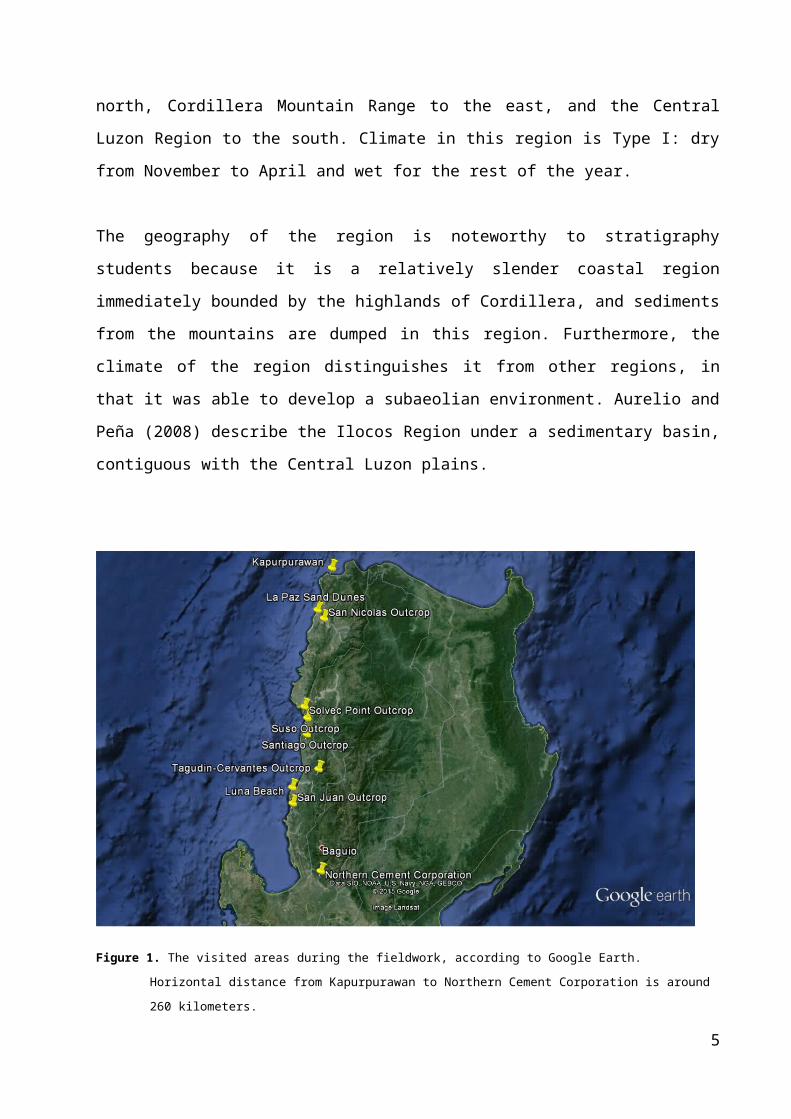
Figure 1. The visited areas during the fieldwork, according to Google Earth. Horizontal distance from
Kapurpurawan to Northern Cement Corporation is around 260 kilometers.
The batch was divided into groups for the fieldwork. For every outcrop, each
group describes the outcrop from afar, then takes a closer look and infers a
possible geologic history. Groups were assigned to report their findings with
the class, and afterwards, the professors and instructors will perform a
discussion about the outcrop. The general lithology and stratigraphy of each
outcrop together with its possible depositional environment and geologic
history were discussed in the field.
Ten breath-taking outcrops and two recent sedimentary environments across
the region were visited from the north on the course of the fieldwork. The
visited sites which are shown in Figure 1 will be discussed in this paper.
5

Recent Sedimentary Environments
La Paz Sand Dunes
The La Paz Sand Dunes is a sandy coastal desert of approximately 85 square
kilometers facing the coast of the South China Sea. Also known as Bantay
Bimmaboy from the pig-like appearance of the dunes, this area belongs to
the Ilocos Norte Sand Dunes (INSD) which is a forty (40) kilometer narrow
zone of low-lying elongated hills running from the coast of Currimao located
in the south to Pasuquin in the north (see Fig. 2 left).
General Description
The area of study comprises asymmetrical ripples of unconsolidated sand,
with its steep slopes or the lee side dipping toward the south. This implies
the present day southward wind current direction transporting sand sized
sediments, forming these ripples. From the drop off point to the south, a
change from linguoid to sinous, then to straight-crested ripples (refer to Fig.
6
Figure 2. (Left) A map showing the extents of the Ilocos Norte Sand Dunes (INSD), Paoay Lake and the La Paz Sand Dunes. (Right) Section of the Laoag topographic map showing the Laoag River and the La Paz Sand Dunes.
A B C
Figure 3. Different current ripple types found on the La Paz Sand Dunes: linguoid ripples in (A) sinous in (B) and straight crested in (C).

3) was observed suggesting a decrease in flow velocity and level of energy
from the drop off point to the direction of the current.
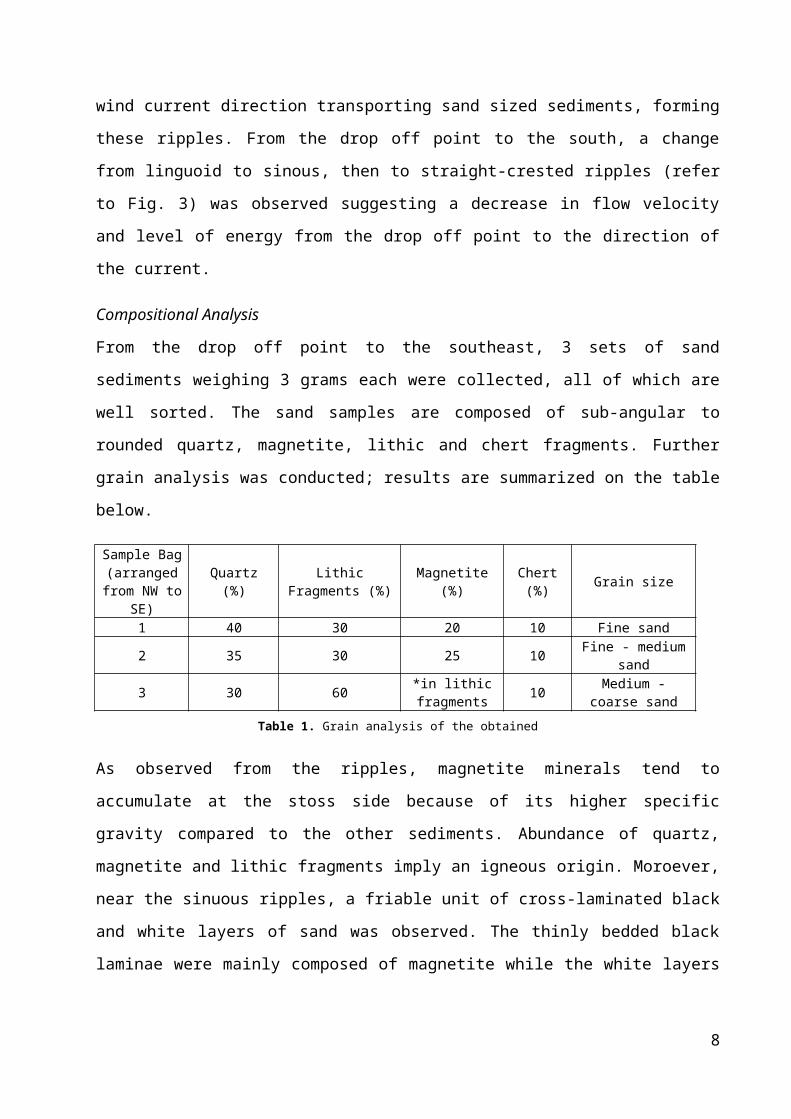
Compositional Analysis
From the drop off point to the southeast, 3 sets of sand sediments weighing 3
grams each were collected, all of which are well sorted. The sand samples
are composed of sub-angular to rounded quartz, magnetite, lithic and chert
fragments. Further grain analysis was conducted; results are summarized on
the table below.
Sample Bag (arranged
from NW to SE)
Quartz (%)Lithic Fragments
(%) Magnetite (%) Chert (%) Grain size
1 40 30 20 10 Fine sand2 35 30 25 10 Fine - medium sand
3 30 60 *in lithic fragments 10 Medium - coarse
sand
As observed from the ripples, magnetite minerals tend to accumulate at the
stoss side because of its higher specific gravity compared to the other
sediments. Abundance of quartz, magnetite and lithic fragments imply an
igneous origin. Moroever, near the sinuous ripples, a friable unit of cross-
laminated black and white layers of sand was observed. The thinly bedded
black laminae were mainly composed of magnetite while the white layers
consist of quartz and lithic fragments. This apparent cross section further
proves the igneous nature of the sediments.
Provenance and Interpretation
This igneous origin is supported by the geologic evolution of the INSD
according to the studies of (JSP, 2008). It traces back to the sediments
deposited from rivers such as Quiaoit, Laoag (as seen Fig. 2 Right), Bacarra,
and Pasuquin Rivers which were then transported seaward by the strong
longshore currents of the South China Sea in convergence with the Pacific
Ocean. These sediments were then concentrated in shallow nearshore
environments and the high sediment supply and strong wave action in these
areas enabled the formation of sandbars. These sandbars then migrated to
7
Table 1. Grain analysis of the obtained samples
the beach environment because of incessant wave action. As these were
exposed and dried up, wind currents acted upon the unconsolidated sand
sediments.
Landward-migration of the sand dunes due to incessant wind and wave
accession caused the clogging of a pre-existing embayment creating the
Paoay Lake. This is further proven by the planar outline of its western border
due to the movement of the sediments by and parallel to the direction of the
longshore currents. Continued wind action produced larger and elongated
mounds along the beach zone forming the first line of sand dunes of the INSD
(JSP, 2008)
Sheared Zone
A fifteen (15) meter high and forty (40) meter wide outcrop located at 18°
12.533’ N, 120° 32.208’’ was found few meters southeast the drop off point.
It may have been another source of the sand deposits as suggested by the
coarsening grain size towards the direction of this unit. Labeled as unit 3, the
bottommost bed (Fig. 5A) is composed of serpentinized peridotites and
mylonite and is separated to unit 2 by a friable reddish layer formed from the
oxidation of the peridotites. Unit 2 is composed of highly weathered
calcareous rocks and is overlain by conglomerates (unit 1). Moreover, a unit
8
http://adventuroj.com/2012/12/01/paoay-tour-paoay-church-malacanang-of-the-north-and-the-paoay-lake/
2
3
Figure 4. (Left) A section of the Laoag topographic map from Namria showing the Paoay Lake (Right) Eastern portion of the lake

composed of chert (Fig. 5D) was found in the southernmost portion of the
outcrop (not seen in the picture).
9
Figure 5. (A) The outcrop showing three different units, (B) serpentized peridotite sample, (C) mylonites, and (D) bedded chert. Height of scale: 1.5 meters (scale not on base of outcrop)
A D
2
3

However, no observed contact with the adjacent unit was found. The
different lithologies and obscure contacts between units characterize a
mélange, however, extensive studies are required for it to be called one.
Instead, this chaotic mix of deposit is said to be situated in a sheared zone,
which is supported by the mylonites found in unit 3. This further implies the
ductile deformation of the source rocks through a large shear strain induced
by a fault. A rotational, non co-axial component can be induced by the
shearing motion which only preserves remnants of the primary rock (Fossen,
2010).
Luna Beach
General Description
Situated at the Bangar Quadrangle in La Union, Luna Beach (16˚50’48.9”N,
120˚20’34.4”E) is a transitional beach environment dominated by gravel
sized grains. These include rounded to well-rounded grains of diorite,
porphyritic andesite, low-grade metamorphic rocks, sandstones, and shell
and coral bioclasts. As observed from the area, the sediments range from
pebble to cobble in size and bladed to oblate in shape. These observations
were further supported by the results obtained from the Geology 150 Grain
Morphology exercise.
Possible Provenance
10
SE SEA
Figure 6. (Left) A section of the Bangar topographic map from Namria showing the Amburayan River and Luna Beach (in red dots), (Right) Pebble imbrication emphasized by red lines, Photo by Abby Villaruel

Shell and coral bioclasts are derived from the nearby reef while the igneous
rocks, comprising majority of the beach deposits, are possibly from the
Cordillera Mountain Range. As seen on the map (Fig. 6 Left) these sediments
are brought down by the Amburayan River which originates from Cordillera
Mountains and traverses the provinces of Benguet, La Union and Ilocos Sur. It
empties to the South China Sea and feeds the Luna Beach with sediments
through the strong long shore currents. The pebbly beach reflects the high
competence and capacity of the Amburayan River needed to transport these
gravel sized sediments. It was also discussed that these sediments were a
product of delta switching, however, the sediments are too coarse for a delta.
Sedimentary Structures and Processes
The roundness and oblate nature of majority of the grains reflect the
influence of the swash back swash of the waves from the sea after these
rocks were deposited to the coastline. Due to the strong wave action, these
pebbles are oriented in their most stable position, resulting to a preferred
orientation called imbrication. The pebbles and cobbles of the Luna Beach
dip toward the sea. This imbrication (Fig. 6 Right) is observed in the berm,
the highest part of the beach where the coarsest sediments are located and
is covered by water during high tides.
Minor Outcrops
Kapurpurawan, Burgos, Ilocos Norte
Outcrop 1
11
Entablature
Colonnade

General Description and Stratigraphy
The outcrop is located along the road to the famous Kapurpurawan rock
formation. Specifically located at 18°31.732’ N, 120°38.384’ E, the observed
outcrop is 50 meters wide and 7.5 meters high. From afar, it has been
observed to consist of three units separated by conformable contacts. Upon
closer inspection, the bottom unit is identified as a volcanic breccia with
clasts of porphyritic basalt and altered minerals such as opal and palagonite.
The hard and fractured middle unit is composed of vesicular andesite
occasionally with red bands indicating oxidation. Lastly, the topmost unit is
composed of porphyritic andesite with vesicular andesite inclusions, most
probably from the middle unit. As shown in Fig. 7, the third layer is
characterized by columnar joints generally trending N 50° E, 48° SE.
Interpretation
The bottommost unit is further identified as a hyloclastite which are hydrated
tuff-like breccias produced by phreatomagmatic eruptions associated with
magma-water interaction. Evidence for this claim include the unit’s
autoclastic nature and the presence of opal, a hydrated silica, and an altered
volcanic glass by quenching in water known as palagonite. This places the
unit in a subaqueous setting. The middle layer is believed to be a more
altered unit as compared to the hyaloclastite.
The top layer was formed when andesitic lava flow/s overlain the two layers.
Columnar joints with defined stout cooling joints or colonnade from the base
12
. Outcrop along the road to Kapurpurawan. Note the evident cooling joints. Scale: 1.7

to middle and thinner and less defined joints on top called entablature,
indicate thick lava flows. These joints indicate the absence of water influence
since these forms from the thermal contraction within the lava flow/s. This
places the unit in a subaerial environment. In conclusion, the outcrop was
formed from at least two lava flows one of which is formed in a subaqueous
setting and the latter in a subearial environment.
Outcrop 2
General Description and Stratigraphy
Located near the viewdeck, with coordinates 18° 32.273’ N, 120° 39.693’ E,
the black-and-white outcrop (Fig. 8) is around 15 meters wide and about 7
meters high. The rock is composed of fine- to medium-sized sand grains
mainly made up of bioclasts. By the Grabau limestone classification, the
thinly bedded rocks are identified as calcarenite.
13
Figure 8. (Left) Black-and-white limestone unit with red lines showing highlighted (Right) Close-up photo of the beds emphasized by the red lines

Mainly white in color, the Kapurpurawan Rock Formation (Fig. 9 Left) is
believed to have the same lithology as the previously discussed limestone
unit. At the base of the outcrop is an uplifted reef. Compared to the top of
the unit, it is dark colored and appears to be porous due to weathering and
dissolution by wave action. It is most likely here that new limestone will form.
The famous Kapurpurawan structure called as yardang is made by wind
action eroding the different sides of the rock, leaving distinct traces on them.
Analysis of thin sections from the outcrop provided by the Nannoworks
Laboratory shows that the rocks of this famous rock formation are
packstones, according to the Dunham classification. It mostly contains
planktonic foraminifera set in a calcite matrix which indicates deposition on a
deep see environment.
Both outcrops are formed from a deep sea environment, specifically on
shelfal regions, evidently supported by the limestone being thinly bedded
rather than massive. It is also supported by the analysis in thin section.
Interpretation
Two outcrops of different rock types were observed namely igneous rocks at
higher elevations overlying the sedimentary units below. Earlier observations
14
Figure 9. (Left) Kapurpurawan Rock Formation (Right) Thin section (50x magnification) of an obtained sample from the KPR provided by the Nannoworks Laboratory

by other researchers put this area under the Bojeador Formation, which
includes lithologies such as conglomerate, graywacke, shale, limestone,
volcanic flows and pyroclastics (Peña, 2008).
The first outcrop shows that it was once in an aquatic to subaquatic
environment and then was exposed and brought into a subaerial
environment, while the second is formed at deep sea environments
particularly in the shelfal areas. Using the law of superposition, assuming no
overturning has occurred, the limestone unit is older than that of the first
outcrop. Columnar joints of the igneous unit, indicative of the top of the bed,
further support the claim.
San Nicolas Outcop
Figure 10. The outcrop showing the contact between marine (MD) and fluvial (FD) deposits. Height of scale: 1.65meters (right)
General description
San Nicolas outcrop is situated in a quarry area in Brgy. San Agustin,
San Nicolas, Ilocos Norte. It has a height of about 12 meters (Fig. 10). From
afar, the outcrop is generally light brown in the upper portion and alternating
light and dark layers in the lower portion displaced by fault sets, dominantly
normal faults. Upon closer inspection, it was observed that the bottom unit is
composed of interbeds of thickly to medium bedded fine and medium
sandstone which suggests periods of low and high energy of deposition.
Fairly well-sorted, sub rounded to rounded grains of thickly bedded fine
15

sandstone have found to have leaf fossil, borings and shell fragments. While
the thickly bedded medium sandstone consists of sub angular to sub rounded
grains of lithic fragments, and trace fossils, specifically burrows. Bioclasts of
preserved fossils such as echinoid spines, corals and forams were also
dispersed throughout the bed indicating that these beds deposition in a
shallow marine environment, specifically on the shelf margin.
The top unit is composed of polymictic conglomerates with clast size
range of cobble to occasional boulder size which is sub rounded to rounded.
Clasts from the outcrop are mostly diorite, porphyritic basalt, mudstone, and
magnetite held together by silt to very fine sand size matrix.
Interpretation
A Channel scour filled with conglomerate with sandstone matrix were also
observed
between
the contact
of marine
sandstone deposits and conglomerate body, indicating an erosional event
and an unconformity. The concave side of the channel points upward
indicating that the
16
Figure 11. The uppermost portion of the outcrop emphasizing the channel scour. Scale: 3m

As shown in Fig. 11, a channel scour observed between the marine
sandstone deposits and conglomerate body indicates an erosional event
forming this disconformity. The concave side of the channel pointing upward
implies that the conglomerate is younger than the sandstone interbeds. The
sharp change in lithology indicates a change in depositional environment.
The interbedded sandstone unit formed in a marine environment is uplifted
by local tectonics to a deltaic environment where the gravel sized sediments
were deposited. This uplift was confirmed by the presence of fault terraces in
the marine sandstone layers thus allowing for the erosion of the sandstone
layers and the deposition of conglomerates to occur. The normal fault noted
from the unit has a strike and dip of N45oW and 65oNE respectively.
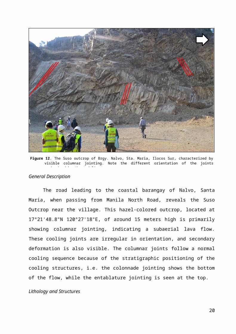
Suso Outcrop
General Description
17
SW
Figure 12. The Suso outcrop of Brgy. Nalvo, Sta. Maria, Ilocos Sur, characterized by visible columnar jointing. Note the different orientation of the joints emphasized by the red lines.

The road leading to the coastal barangay of Nalvo, Santa Maria, when
passing from Manila North Road, reveals the Suso Outcrop near the village.
This hazel-colored outcrop, located at 17°21'48.8"N 120°27'18"E, of around
15 meters high is primarily showing columnar jointing, indicating a subaerial
lava flow. These cooling joints are irregular in orientation, and secondary
deformation is also visible. The columnar joints follow a normal cooling
sequence because of the stratigraphic positioning of the cooling structures,
i.e. the colonnade jointing shows the bottom of the flow, while the
entablature jointing is seen at the top.
Lithology and Structures
Upon closer inspection, the cooling joints are uniformly composed of
porphyritic andesite, with some of its crystals forming a pattern parallel to
each other. Some of rocks have secondary calcite veins present, as
evidenced by the weak effervescence of the rocks. There are also localized
pyrite grains, as an accessory mineral of igneous rocks.
Petrographic analysis of a thin section was performed on a sample from the
outcrop. The analysis shows two major minerals: amphibole as phenocrysts
and plagioclase feldspar as the main groundmass mineral. The amphibole
crystals follow a preferred orientation, known as “trachytic” texture.
Secondary calcite veins are evident in the thin section, as well as some
opaque accessory minerals.
Evident columnar joints are found to have different attitutes from the left to
the right of the outcrop (shown in Fig. 12). The leftmost portion is
characterized by joints generally dipping to the northeast while the right by
southeast dipping joints. Strike and dip measurements of joints at leftmost
and rightmost portions are N 60° W, 55 NE and N 15 W, 62 SW, respectively.
Interpretation
Based from the consistent lithology from all sides of the unit, the Suso
Outcrop is formed by at least one episode of lava flow exposed to subaerial
conditions allowing the flow to rapidly cool. The parallel pattern of crystal
18

grains seen in the andesite is the characteristic of a preferred orientation
(trachytic texture). This type of texture is indicative of flow direction; parallel
to the direction of the lava flows, and conversely perpendicular to the cooling
joints. As the consequence of cooling, the thermal contraction of the
solidified lava flow has formed gaps that are cross-sectionally polygonal,
usually hexagonal in shape, between the rocks. The difference in cooling
rates is crucial in determining the structure of the cooling joints: the rocks
near the surface are cooled quicker, forming entablature jointing, while the
later cooled rocks not directly exposed develop the colonnade structure. An
important clue in the history of this outcrop is the irregular orientation of the
cooling joints. It can be inferred that the paleotopography during the
extrusion of the lava flow was not flat or horizontal.
Although the volcanics along the road to Kapurpurawan and the Suso
Outcrop are both mainly andesitic lava flows, it is important to note and
compare their natures of deposition: 1) the Kapurpurawan lava flow has at
least more than two cooling events in contrast to at least one in Suso
outcrop, 2) the former is extruded sub-aqueously then sub-aerially, while the
latter is mainly deposited in subaerial environment, and finally 3)
Kapurpurawan’s paleotopography was nearly horizontal as inferred from the
uniform trend of the joints, while Brgy. Nalvo’s wasn’t.
Santiago Outcrop
19
SE
Figure 13. The side of the outcrop facing the road (Left) Red lines delineating traces of bedding planes (Right) Red lines outlining the olistolith. Height of scale: 1.74meters
General Description and Stratigraphy
The outcrop is located along Bucong Bridge, facing southwest with a height
of 15 meters and length of around 30 meters (Fig. 13). The outcrop is divided
into two parts, one at the front (facing the road) and another one at the back.
From afar, the front side of the outcrop seems to have two units namely the
folded beds of alternating brown and gray layers at the bottom and a
conglomerate unit with megaclasts overlying it. Upon closer inspection, the
folded beds consisting of interbedded shale, siltstone and sandstone show
irregular folding (see Fig. 13 Left) indicative of soft-sediment deformation
rather than tectonically induced folding. Erosional features found in these
beds include spheroidal weathering and desiccation cracks. Moreover, it was
observed that this unit is truncated at both sides of the outcrop facing the
road.
20
Figure 14
NW
NW

Looking at the back portion of the outcrop, a massive light brown sandstone
deposit with clasts of what seem to be large boulders can be observed. It is
around the same size as the front, around 15 meters tall and 30 meters wide.
Near the base of the outcrop, it was concluded that the sand was very fine-
to fine-grained. It contains different sizes of rocks, from gravel to boulder-
sized clasts. Most clasts are made up of mudstone, while others were made
up of beds of sandstone, with some evidently rotated. Limestone clasts which
consist of planktonic foraminifera, echinoid spines and coral fragments were
found in this unit. Furthermore, a sedimentary dike (see Fig. 14) was
observed in the outcrop formed from the sand-filling of a fracture in the rock.
Interpretation
The entire outcrop is a slide deposit formed by mass flow processes
specifically submarine slides where coarser debris move as avalanches.
Debris include large blocks of rocks up to tens of meters in size called
olistoliths (Nichols, 2009). This claim is supported by the discontinuity and
soft-sediment deformation of the interbeds suggesting that these water-
saturated rocks are rapidly deformed during movement downslope. It is also
evidenced by the rotated olistoliths of the interbeds found at the back
portion of the outcrop.
This claim places the outcrop on a slope apron, depositional systems found
on continental slopes characterized by mass flow processes (Nichols, 2009).
The dominance of planktonic forams in the limestone clasts further supports
this claim. Together with the interbeds and other olistoliths, a trigger such as
an earthquake separated these rocks from the shelf margin and was
transported down to the base of the continental slope. In conclusion, the
Santiago Outcrop is a chaotic mass of olistoliths known as an olistostrome.
21

Tagudin-Cervantes Outcrop
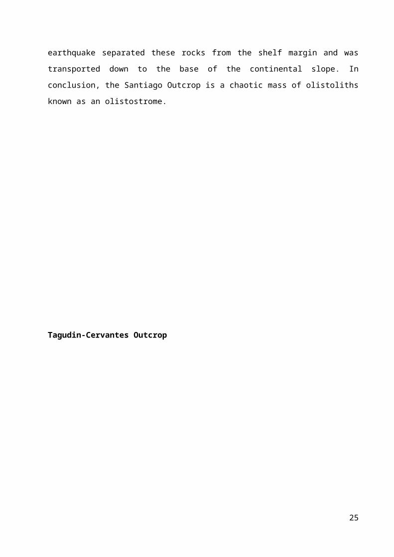
Figure 15. The outcrop at Tagudin-Cervantes road showing an unconformity (green line) and a fault
(red line).
General Description
A large outcrop facing southeast around 40 meters tall from the road is
visible at the Tagudin-Cervantes Road along the Suyo River on Suyo town,
Ilocos Sur. This outcrop is divided into two defining units: an underlying light-
colored interbedded unit of sandstones and mudstones, and an overlying
dark massive conglomerate unit. The presence of talus is evidence for
22
NE

weathering, but primary structures are still visible, such as scour marks,
climbing ripples and convolute laminations. Moreover, measurement of the
attitude of the interbedded unit reveal a strike of N 27° E, and dip of 21° NW.
Stratigraphy and Structures
Closer inspection reveals that the interbedded unit of the outcrop include
alternating non-calcareous layers of A) normal graded coarse to very coarse
sandstone bed with defined scour marks at its base, B) laminated medium to
coarse sandstones, C) cross-bedded sandstone D) planar mudstone
beds/laminae, and sporadically E) massive mudstone. Most, if not all, layers
do not follow one another. As shown in Figure 16A, layer C overlies unit A and
underlies layer E.
23
Figure 16.sequence.laminations

The five-fold sequence mentioned earlier is characteristic of turbidite
deposits, called a bouma sequence. Incomplete bouma sequences in this
outcrop overlie each unit with increasing thickness per sequence, until they
were abruptly truncated by the darker-colored rock identified from afar as
paraconglomerate. From the sharp change in lithology and grain/clast size,
the contact between the two units is a disconformity.
Noteable primary structures include convolute laminations, climbing ripples
and scour marks. As shown in Figure 16 D, convolute laminations are soft-
sedimentary structures indicative of subaqueous slumping and dewatering of
finer grained sediments as coarser grains overlie these deposits. Climbing
ripples (Fig. 16 C) indicate high rates of deposition resulting to the
preservation of both the stoss and lee sides of the ripple.
Secondary structures present in the outcrop include two normal faults (Fig.
16B) of opposite dip directions cutting through both the interbeds and
conglomerate, forming a graben, as well as numerous fractures and
conjugate joints caused by brittle deformation. The two faults have attitudes
of: N 59° W strike, 69° NE (southwest flank of the outcrop) and N 45° W
strike, 46° SW dip located at the center.
Interpretation
The interbedded unit was once part of marine environment, specifically at
the base of the continental slope where sediments are carried down by mass
transport processes, called turbidity currents. From the top of the continental
shelf, passing through submarine canyons, sediments are carried by these
currents before being deposited in a submarine fan.
Because the sediment mass is under suspension, it allows for larger and
heavier grains, like granules and very coarse sand, to settle down first
forming normal graded beds (Layer A as discussed previously). Layers B-E
are later deposited by progressively waning currents. This deposit is episodic,
because it is repeated throughout the outcrop for a number of times. Related
24
to this rhythmic deposition is 1) the presence of scour marks on every
massive sandstone bed (the first in the Bouma sequence), and 2) the
intermittent absence of some of the Bouma units on the turbidites, both of
which imply the erosion of the previous turbidite deposit. What is different
though for every turbidite sequence is that there is a trend of increasing bed
thickness going upward, suggesting an increasing amount of sediment
supply. This increasing sediment supply is indicative of a landward migration
of the shoreline.
Due to the active tectonic setting of the Philippines, uplift might have
exposed the turbidite deposits as shown by the sharp shift of lithology into
conglomerate. Presence of evident faults and fractures supports this claim.
25
Major Outcrops
Solvec Point
General Description
Situated in the Narvacan Quadrangle of Ilocos Sur, the Solvec or Sulvec Point,
is a huge outcrop from the exposed side of the Heroes Hills (shown in Fig. 17
Left) down to the outcrop’s extension towards the coast. To investigate the
extents of the outcrop, eighteen groups were dispersed and assigned to
different stations from the drop off point (see Fig. 17 Right). From the
consolidated observations, four main lithologies were identified namely,
clastics of interbedded mudstones and sandstones, encrusting corals, diorite
and andesite intrusion.
Section Description
26
Figure 17. (Left) A photo showing the extents of the outcrop from the highly weathered portion of the hill down the road near the coast and the assigned section (yellow pin) (Right) Section of the Narvacan topographic map; drop off point (yellow circle)

The station assigned to the group is located near the shore, 17° 27’ 10.5’’ N,
120° 25’ 52.9’’ (see Fig. Left). The section is a 1.91 meter thick gray unit of
beds with a strike and dip of N 22 E and 47 SE. It is composed of two fining
upward sequences of dominantly massive beds of sandstones with grain
sizes ranging from very fine to coarse sand composed of lithic fragments,
quartz and feldspars. Within those two sequences are rip-up rounded clasts
of maroon mudstones (Fig. 18 B) and clasts of intercalcalating layers of thinly
bedded mudstone and sandstone (Fig. 18 C). A set of fault set was observed
in the outcrop with one fault oriented N 37 E and 66 SE, which suggests a
tectonic uplift exposing these rocks.
Geologic History
The assigned section underlies a unit composed of intercalating layers of
thickly laminated to thinly bedded dark maroon mudstone and thinly to
medium bedded normal graded light gray sandstone observed by Group 1
(Sisracon, et. al). Conversely, it overlies a unit consisting of interbedded
sandstone and mudstone and massive sandstones intruded by an andesitic
sill intrusion as seen by Group 8 (Virrey, et. al).
The section assigned to the group belongs to the clastics of interbedded
mudstones and sandstones, one of the major lithologic units identified by the
class. These thick layers of interbeds suggest an abundant supply of
27
Figure 18. (A) The outcrop showing the prominent tilt of the beds, (B) rounded mudstone clasts, (C) clasts of intercalcalating mudstone and sandstone
A C
B

sediments that are rhythmically deposited at the basin of deposition.
Moreover, it is believed to be deposited by turbidity currents as evidenced by
normal graded sandstones with erosive bases and overlying laminated
sandstone and mudstone units (bouma sequence units).
Multiple exposures of this lithologic unit were observed to be intruded by a
dioritic magma (as seen by Group 13, Cacho et. al) characterized by the
baking and chilling margin on the contact between the two units. Located on
the other side of the road is a huge outcrop of highly jointed diorite rocks
similar to the observed intrusions. This suggests a rather large intrusive body
like a batholith underneath which can produce these units. Based from the
Principle of Cross Cutting Relationships, the diorite rocks are younger than
the clastics it had intruded.
Several groups such as Group 5 (Muyco, et. al) have observed andesitic
apophysis of porphyritic andesite intruding the diorite and andesitic sill
intruding the clastics (by Group 15, Florendo et.al). The latter was identified
as a sill because of its concordance with the attitude of the beds and was
distinguished from a flow because of the baking and chilling margins on both
sides of the intrusion. Using the same principle, the andesitic intrusion is
younger than the diorite and clastics it cuts. The two intrusions may have
originated from a single source and the difference in lithology may be
explained by differentiation of the magma after the emplacement of the
diorite.
Uplifted corals, mainly composed of the scleractinian taxa, in their upright
position encrust all the previously discussed units. At least three groups have
seen an angular unconformity between the clastics and this unit. Moreover,
diorite clasts within the limestones were observed suggesting an erosive
28
Youngest
Oldest
contact. By the Principle of Inclusions, the clasts are older than the
surrounding rock.
As shown in the figure above, a generalized cross-section was constructed to
illustrate the huge outcrop. At first, the interbedded sandstone and mudstone
unit was deposited by turbidity currents and was intruded by a dioritic
magma. These units were intruded by an andesite sill followed by an uplift
evidenced by the tilting of the beds and fault sets found throughout the
outcrop. All together these units were overlain by limestone formed by the
encrustment of coral reefs. The upright position of the corals indicates the
top of the unit. By the Law of Superposition, the encrusting coral unit is the
youngest. A stratigraphic column (shown in Fig. 19) was created to represent
the relative ages of the units of the outcrop.
San Juan Outcrop
29
Encrusting coral reefs
Interbedded clastics
Diorite
Andesite
Encrusting coral reefs
Andesite
Diorite
Interbedded clastics
Youngest
Oldest
Figure 19. Generalized cross section of the outcrop and a proposed stratigraphic column

General Description
Just after the boundary between Bacnotan and San Juan, La Union, loosely
located on MacArthur Highway, San Juan, La Union with coordinates 16°41’
N, 120°20’ E, lies a rock formation with a tilted sequence. This part of the
large outcrop is measured to be around 15 meters in height and 8 meters in
length. From afar, the segment is made up of various interchanging beds
that dip to the southeast which is truncated by a scoured base filled with
clasts.
In this part of the fieldwork, the members of the group are expected to
record their data on a stratigraphic log of at least 1.5 meters. A total of 1.9
meters was carefully analyzed by the group.These observations are recorded
on the stratigraphic log attached to the report (see Appendix).
30
SE
Figure 20. (A) The outcrop with the red line delineating the bedding planes and the red curve tracing a disconformity (B) Sample showing mottling (C) Branching trace fossil. Scale: 1.5 meters
A
B
C

Section Description
The section of the outcrop assigned to the group is composed of interbeds of
mudstone and fine to medium-grained sandstone overlain by a red, organic
rich layer of sanstone. The mudstone beds are thinly bedded at first, but
increase in thickness from bottom to the top. All mudstone beds exhibit
spheroidal weathering, and most contain fossils, like foraminifera, and
organic matter. Most of the mudstone beds contain horizontal burrows. A few
beds contain vertical burrows, while one part contains a branching burrow
(Fig 20 C).
The sandstone beds found here are thickly bedded at first, then alternates
between medium to thinly bedded. Most of these beds are indurated,
decreasing in hardness as the layers progress upward. Some sandstone beds
contain foraminifera and/or organic matter. The beds also exhibit convolute
laminations, as shown in the figure above.
Different groups have also observed the different parts of the large outcrop.
Most have the same findings as this group has: interbeds of sandstone and
mudstone, with frequent fossils and trace fossils. From the discussions, a
shift from sandstone dominated sections to mudstone dominated units was
inferred. Overlying the interbeds are polymictic conglomerates, consisting of
igneous clasts such as diorite.
Interpretation
31
Figure 21.

The description of the outcrop is characteristic of a deep marine depositional
environment with associated turbiditic sequences. Turbiditic sequences are
deposited near submarine canyons and is caused by episodes of mass
transport events called turbidity currents, wherein a suspension of sand and
mud-sized sediments are carried down to the base of the continental shelf
and deposited there, with the heavier sand grains settling down first. Not all
of the bouma units are seen, probably due to the short intervals of the
turbidity currents which erode the previous deposits, and the distance of the
turbidity current deposit from the submarine fan. The horizontal burrows
found in most of the mudstone layers are further evidence of calm water
conditions related to deep marine environments. The conglomerate with a
visible erosive base marks a disconformity in deposition. This is probably due
to a landward migration of the coast caused by uplift. Additional tectonic
stresses may be also responsible for the tilting that is seen at present in this
area.
According to Dimalanta and Yumul (2009), the San Juan outcrop is part of the
Amlang Formation, which Aurelio and Peña (2008) reports as “turbiditic
sandstone and shale, with minor conglomerate” and tracks it to Bacnotan
town, which borders San Juan town to the north.
Northern Cement Corporation Quarry
32
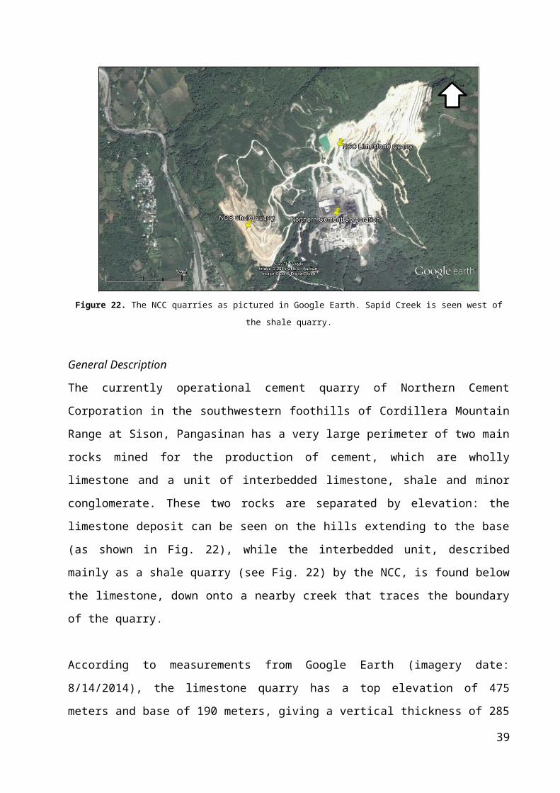
Figure 22. The NCC quarries as pictured in Google Earth. Sapid Creek is seen west of the shale quarry.
General Description
The currently operational cement quarry of Northern Cement Corporation in
the southwestern foothills of Cordillera Mountain Range at Sison, Pangasinan
has a very large perimeter of two main rocks mined for the production of
cement, which are wholly limestone and a unit of interbedded limestone,
shale and minor conglomerate. These two rocks are separated by elevation:
the limestone deposit can be seen on the hills extending to the base (as
shown in Fig. 22), while the interbedded unit, described mainly as a shale
quarry (see Fig. 22) by the NCC, is found below the limestone, down onto a
nearby creek that traces the boundary of the quarry.
According to measurements from Google Earth (imagery date: 8/14/2014),
the limestone quarry has a top elevation of 475 meters and base of 190
meters, giving a vertical thickness of 285 meters. This cream-colored to gray
limestone formation is massive to very thickly-bedded and dips to the
southwest. The beds seem to have no thickening trend.
33
N

Figure 23. (Left) Limestone quarry with delineated bedding planes. Backhoe encircled to scale. (Right) Pelecypod fossil
When inspected, the limestone revealed many macrofossils and other
bioclasts, such as pelecypods, as seen in Figure 23, gastropods and other
molluscs, corals, etc. No sedimentary structures can be seen, aside from the
very thick planar bedding to massive structure. Because of the steepness
and nature of the quarry, the fieldwork was confined to a terrace-like area at
the base of the quarry.
Figure 24. (Left) Shale quarry, with evident bedding planes (Right) A portion of the section assigned
to the group
The brown colored-shale quarry is a sequence of alternating beds of
crystalline limestone, calcarenite, conglomerate, shale and massive
mudstone. It is approximately 15 meters in height. It is of note that the
outcrop has a northeast dip direction, which is opposite of the southwest dip
34
SE
SE

of the limestone. This can be explained by the folding and faulting present on
the shale outcrop, suggesting tectonic deformation.
35

Section description
The assigned section for the group is located in the right part of the
NCC Quarry outcrop, just behind where the batch took pictures after the
fieldwork. It is facing SW and contains beds striking N32°W and dipping
36°NE. The assigned section is composed of alternating beds of calcarenite
and conglomerate. The conglomerate is thick with pebble to cobble sized,
subrounded clasts of porphyritic andesite, diorite, lithic fragments, and
bioclasts set in a sandy and calcareous matrix. Gastropod shells, forams,
coral fragments, horizontal and vertical burrows were found in some parts of
the section. The contacts between beds are sharp and distinct.
Starting from the bottom to 2 cm, the bed is identified to be calcarenite
with medium-grained sand size which is brown in color and observed to
contain forams. The next bed is measured to be 4 cm thick and identified to
be calcarenite with fine-grained sand size which is light gray in color. The
next one is 4 cm thick and identified to be a calcarenite with coarse grained
sand size found to be brown in color and friable. Then a friable calcarenite 17
cm thick containing benthic forams and gastropod shell was deposited
followed by a 16 cm thick polymictic orthoconglomerate with clasts of
porphyritic andesite, lithic fragments, coral fragments, shell fragments,
echinoid spines and wood fragments set in fine to medium calcareous sand.
Reddish polymictic paraconglomerate with 21 cm was deposited on top of it
set in fine grained calcareous sand. Another 21 cm that is friable light gray
calcarenite which contains benthic forams, gastropod shells and convolute
lamination observed follows. An 18 cm thick polymictic paraconglomerate
with same clasts found in below is then identified. The second to the last bed
is a 6 cm calcarenite bed found to have horizontal burrows and wood
fragments. The last layer observed was a crystalline limestone which was
measured to be 8 cm thick. The total thickness of beds studied for the
detailed stratigraphic log is 1.13m.
36

Interpretation
Based on the data, a possible interpretation of the area is that it was once
under a shallow marine environment dominated by calcite-bearing
organisms, such as corals, shells, etc. This led to deposition of the limestone
currently being mined. The macrofossils give credence to the shallow marine
interpretation. This limestone dominance was later replaced by an
environment with active sedimentation processes, such as erosion. Calcite-
bearing organisms don’t thrive in areas with high sediment supply.
From here, sediments are carried down by sediment gravity transport
processes. The clasts included in conglomerate include terrigenous rocks,
such as porphyritic andesite, which means that fluvial processes may have
contributed to the kind of sediments being deposited. During breaks between
clastic depositions, calcite-bearing organisms were allowed to flourish again,
and causing the deposition of limestone. These processes: sediment gravity
transport, bioclastic deposition, and calcite precipitation, are repeated many
times in the sequence of the outcrop.
The last phase in the formation of this outcrop is uplift and other tectonic
processes, due to local tectonics. Uplift exposes these rocks above sea level,
while faulting and folding are caused by ductile to brittle deformation of the
rocks related to tectonics. The presence of tectonic deformation is evidenced
by the different dip directions seen in the two outcrops, which may suggest
folding or faulting between them, as well as the tilting and microfaults seen
in the shale quarry.
37

REFERENCES
Esguerra, N., et. al.(2008). Characterizing the Environmental Effects of the Quarrying Industry: The Case of Strategic Quarry Sites in the Ilocos Region. UNP Research Journal , 38-50.
Fossen, H. (2010). Structural Geology. Cambridge: Cambridge University Press.
Ilocos Norte. (n.d.). Retrieved May 16, 2015, from http://tourism-philippines.com/ilocos-norte/
JSP (2008). Ilocos Norte Sand Dunes National Geological Monument. (handout given during the fieldwork)
NAMRIA - Topographic Maps.(n.d.). Retrieved May 16, 2015, from http://www.namria.gov.ph/topo50Index.aspx
Nichols, G. (2009). Sedimentology and Stratigraphy (2nd Ed). Oxford: Blackwell Science.
Peña, R. (2008). Lexicon of Philippine Stratigraphy, 2008.Mandaluyong City, Philippines: Geological Society of the Philippines.
38
APPENDIX
Appendix A. Detailed stratigraphic log of assigned section in San Juan
39

40

Appendix B. Detailed stratigraphic log of assigned section in NCC Quarry
41

Appendix C. Other rock samples
42

Figure 25. Luna Beach gravel deposits. (Left) Sandstone, diorite, andesite clasts. (Right) Coral
fragment.
Figure 26. Kapurpurawan rock samples. (Left) Porphyritic vesicular basalt. (Right) Porphyritic vesicular
andesite.
Figure 27. San Nicolas rock samples. (Left) Leaf fossil. (Right) Gastropod fossil.
43

Appendix C. Other rock samples (continued)
Figure 28. Suso outcrop. (Left) Porphyritic andesite with trachytic texture. (Right) Thin section. Photo
by Ynna Aquino.
Figure 29. Tagudin-Cervantes outcrop. (Left) Planar laminated sandstone. (Right) Massive very coarse
sandstone.
44