anasazi (pre-columbian native-american) migrations during ...kp9070/ken p's cv papers/12 benson...
TRANSCRIPT

ANASAZI (PRE-COLUMBIAN NATIVE-AMERICAN) MIGRATIONS
DURING THE MIDDLE-12TH AND LATE-13TH CENTURIES – WERE
THEY DROUGHT INDUCED?
LARRY BENSON1, KENNETH PETERSEN2 and JOHN STEIN3
1U.S. Geological Survey, 3215 Marine St., Boulder, CO 80303, U.S.A.E-mail: [email protected]
2University of Utah, 1495 E 100 S, Room 126, Salt Lake City, UT 84112, U.S.A.3Navajo Nation Historical Preservation, P.O. Box 4950, Window Rock, AZ 86515, U.S.A.
Abstract. Severe droughts in the middle-12th and late-13th centuries appear to have affected Anasazi(pre-Columbian Native American) populations. During the first drought most of the great houses inthe central San Juan Basin were vacated; the second drought resulted in the abandonment of the FourCorners region. During the first drought, villages may not have been completely abandoned. Themulti-year drought periods probably were characterized by reductions in both winter and summerprecipitation. Maize is dependent on winter precipitation for its germination and initial growth andon summer (monsoonal) precipitation for its continued growth. Reductions in precipitation are hy-pothesized to have resulted in low yields of maize, the dietary staple of the Anasazi. A comparisonof historic climate data and tree-ring-based reconstructions of precipitation in the Four Corners re-gion with tree-ring-based reconstructions of the Pacific Decadal Oscillation (PDO) and the AtlanticMultidecadal Oscillation (AMO) indicate that severe and persistent drought in the Four Corners regionoccurs when the PDO is negative and the AMO is positive. Historic climate data from the greater SanJuan Basin indicate that a negative PDO is characterized by reductions in both water-year and summerprecipitation, reinforcing the concept that at least some multi-year droughts involved weakening ofthe summer monsoon with attendant decreases in the yields of maize.
1. Introduction
Anasazi is the term applied to a distinctive pre-Columbian archeological tradition ofthe Four Corners region. As such, the term has no prehistorical political, cultural,or linguistic connotation. Between 850 and A.D. 1300 the Anasazi constructedmultistory masonry buildings called great houses. The great houses often containedlarge rooms with high ceilings, enclosed plazas, and one or more large circularsemi-subterranean rooms known as great kivas (Figure 1).
The Anasazi population expanded and contracted many times during their occu-pation of the Four Corners region. However two contractions are of special interest.By A.D. ∼1150 the Anasazi appear to have vacated most of their great housesin the heart of the San Juan Basin and by A.D. ∼1300 they had abandoned theFour Corners region (Figure 2). The times of abandonment of most San Juan Basingreathouses are based on potsherd dates and are only accurate to a few to severaldecades. Therefore the abandonment of many greathouses can be argued to haveoccurred as early as A.D. 1130 Construction and remodeling of 12 great houses
Climatic Change (2007) 83: 187–213DOI: 10.1007/s10584-006-9065-y c© Springer 2006

188 LARRY BENSON ET AL.
Figure 1. The Chaco Canyon Pueblo Bonito great house which at one time contained ∼800 roomsand was four stories tall. Circular structures are kivas; the center of the structure is a courtyard. Photocourtesy of the National Park Service.
in the Chaco Canyon core area, which had accelerated at A.D. ∼1050, abruptlyterminated at A.D. ∼1130 (Lekson, 1984). The initial construction phase of AztecWest (24 km upstream from the confluence of the Animas and San Juan rivers,Figure 3) also ended at A.D. 1130 although most construction was completed byA.D. 1121.
The father of dendrochronology, Andrew E. Douglass, was one of the first tosuggest that the abandonment of the Four Corners region in the late 13th century wasdue to a persistent and intense drought that occurred between A.D. 1276 and 1299(Douglass, 1929). Douglass suggested that the Anasazi were heavily dependent onagriculture and would have had to abandon their homes and move to better-wateredareas to survive what later became known as the “Great Drought”.
Robinson and Rose’s (1979) preliminary reconstruction of seasonal precipitationfor the northwestern plateau area of New Mexico indicated that an intense summerdrought occurred between A.D. 1135 and 1180 The evidence of this drought wasused by several authors (e.g. Gillespie, 1984; Judge, 1989) to argue that it was partlyresponsible for the disintegration of the Chacoan regional system at A.D. 1150 andthe migration of the Anasazi out of the central San Juan Basin.
Two studies have thrown doubt on the two droughts as major “push” factorsin Anasazi migrations. As Dean (1992) points out “statistical tests failed to verifyRobinson and Rose’s (1979) preliminary summer-precipitation reconstruction andit was dropped from their final report (Rose et al., 1982).” More recently, Van West(1994), in a study of prehistoric agricultural productivity in southwestern Colorado,

ANASAZI (PRE-COLUMBIAN NATIVE-AMERICAN) MIGRATIONS 189
Figure 2. Anasazi great houses in the Four Corners region. The white squares indicate great-housecommunities that were abandoned by A.D. 1130/1150; the black triangles indicate great-house com-munities that persisted until A.D. 1300 Information portrayed on the map was taken from Fowler andStein (1992); additional unpublished data on great-house locations in the southwestern and westernSan Juan Basin were compiled by Rich Friedman and John Stein based on fieldwork conducted be-tween 1984 and 2004. See Figure 3 for names of rivers. All sites shown in this figure belong to theChacoan great house tradition.
has suggested that “there always was enough productive land to produce enoughmaize to support a very large population [in the Northern San Juan region]1. . . .evenin the relatively dry times of the middle-twelfth and late-thirteenth centuries.” Partlyin response to the latter study, some archeologists have suggested that drought wasnot a major push factor in Anasazi migrations from the Four Corners region. Forexample, on August 20,1996, George Johnson authored a New York Times articlein which one prominent American archeologist was quoted as saying “Nobody istalking about great droughts anymore”. However, other scholars have pointed outthat the influence of drought on prehistoric Southwestern populations should notbe so quickly dismissed (e.g., Larson et al., 1996).
In this paper we examine both published and new data that reinforce the conceptthat climate change including drought was a primary push factor in the reduction ormigration of Anasazi populations during the middle-12th and late-13th centuries.We suggest that droughts occurring during these time periods may have involvedweakening or failure of the North American summer monsoon, which, in turn,

190 LARRY BENSON ET AL.
Figure 3. Pollen (filled square) and tree-ring (filled circle) sites in and around the San Juan Basin ofnorthwestern New Mexico. Ephemeral streams are indicated by dashed lines.
resulted in sharp decreases in maize yields, causing the Anasazi to migrate to areasthat had more available water. We also reiterate the suggestion of other researchers(e.g., Dean et al., 2000; Axtell et al., 2002) that environmental conditions duringthe Great Drought of the late-13th century were probably not sufficient to havecaused the total abandonment of the Four Corners area; i.e., there were some areasthat could have continued to be agriculturally productive during the Great Drought.This implies that push or pull factors other than drought contributed to the completeabandonment of the region.
2. Climate Records from the Four Corners Region
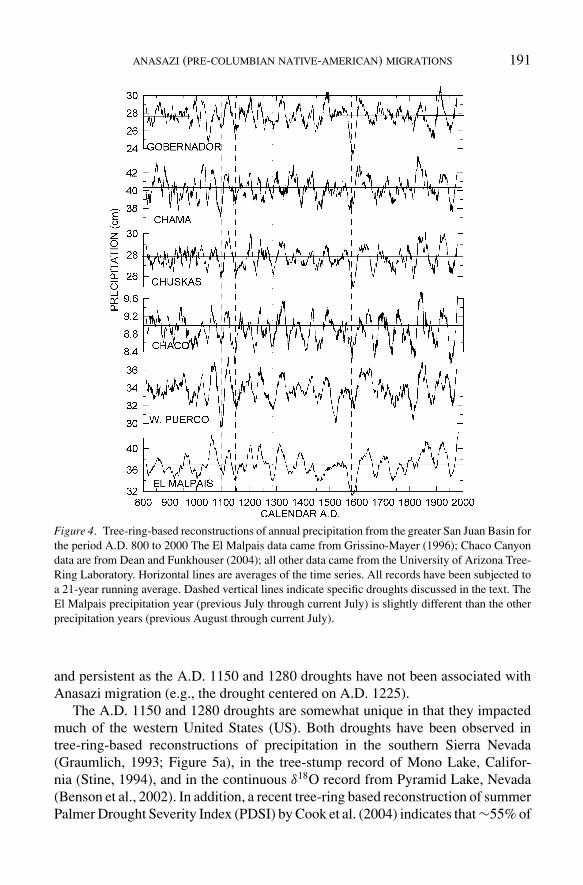
Tree-ring reconstructions of annual precipitation from sites within and at the periph-ery of the San Juan Basin (Figure 3) indicate that precipitation minima (droughts)have been nearly synchronous across the region since A.D. 1125 (Figure 4).Droughts centered at A.D. ∼1090, 1150 and 1280 are apparent in the recordsas is the 16th century megadrought that severely impacted North America (Stahleet al., 2000). However, it should be noted that some droughts nearly as severe
ANASAZI (PRE-COLUMBIAN NATIVE-AMERICAN) MIGRATIONS 191
Figure 4. Tree-ring-based reconstructions of annual precipitation from the greater San Juan Basin forthe period A.D. 800 to 2000 The El Malpais data came from Grissino-Mayer (1996); Chaco Canyondata are from Dean and Funkhouser (2004); all other data came from the University of Arizona Tree-Ring Laboratory. Horizontal lines are averages of the time series. All records have been subjected toa 21-year running average. Dashed vertical lines indicate specific droughts discussed in the text. TheEl Malpais precipitation year (previous July through current July) is slightly different than the otherprecipitation years (previous August through current July).
and persistent as the A.D. 1150 and 1280 droughts have not been associated withAnasazi migration (e.g., the drought centered on A.D. 1225).
The A.D. 1150 and 1280 droughts are somewhat unique in that they impactedmuch of the western United States (US). Both droughts have been observed intree-ring-based reconstructions of precipitation in the southern Sierra Nevada(Graumlich, 1993; Figure 5a), in the tree-stump record of Mono Lake, Califor-nia (Stine, 1994), and in the continuous δ18O record from Pyramid Lake, Nevada(Benson et al., 2002). In addition, a recent tree-ring based reconstruction of summerPalmer Drought Severity Index (PDSI) by Cook et al. (2004) indicates that ∼55% of

192 LARRY BENSON ET AL.
Figure 5. (a) Normalized annual precipitation record for the southern Sierra Nevada (Graumlich,1993); (b) drought area in the western US (Cook et al., 2004); (c) summer (June, July, August) PDSIfor northwestern New Mexico site #119 (Cook et al., 2004), and (d) pinon pollen counts for thesouthern La Plata Mountains (Petersen, 1994) for the period A.D. 800 to 2000 The three tree-ringrecords are presented as 21-year running averages. Vertical lines indicate two droughts that occurredat the same time as Anasazi migrations. Note how the PDSI overemphasizes the occurrence andfrequency of drought.
the western US suffered drought during the A.D. 1150 event and ∼40% of the west-ern US suffered drought during the early part of the A.D. 1280 event (Figure 5b).
It is possible that both droughts were associated with the failure of or at least theweakening of the summer monsoon. The only available tree-ring record that may, inpart, proxy for monsoonal strength in the Four Corners region is the June, July, andAugust PDSI record developed by Cook et al. (2004) for northwestern New Mexico(Figure 5c). Guttman (1998) has demonstrated that the PDSI has an inherent fixedtime scale of ∼9 to 12 months where. Thus the summer PDSI records of Cook et al.(2004) are influenced by the soil-water balance in previous months. To the limitedextent that the summer PDSI reconstructions of Cook et al. (2004) indicate thestrength of the monsoon, summer drought may have been associated with the A.D.1150 and 1280 droughts in northwestern New Mexico (Figure 5c). This suggestionis reinforced by a pinon pollen record from Beef Pasture in the La Plata Mountainsof southwest Colorado (Petersen, 1994; Figure 5d). Whereas winter precipitationplays a large part in the growth of pinon, Petersen (1994 and references therein) hasargued that summer precipitation is critical for the establishment of pinon seedlingsand that there is a coincidence between the region of summer rainfall in the western
ANASAZI (PRE-COLUMBIAN NATIVE-AMERICAN) MIGRATIONS 193
US and the area populated by pinon. Petersen (1988) demonstrated that pinon (Pinusedulis) establishment in the Four Corners region in the 1920s and 1930s occurredduring a peak in summer precipitation. In addition, pinon trees have shallow rootsthat are able to intercept summer precipitation (Fritts et al., 1965), illustrating thedependency of pinon on both winter and summer precipitation.
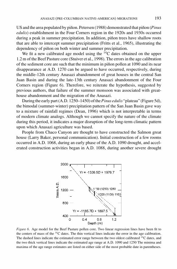
We fit a new calibrated age model using the 14C dates obtained on the upper1.2 m of the Beef Pasture core (Stuiver et al., 1998). The errors in the age calibrationof the sediment core are such that the minimum in pinon pollen at 1090 and its neardisappearance at A.D. 1270 can be argued to have occurred, respectively, duringthe middle-12th century Anasazi abandonment of great houses in the central SanJuan Basin and during the late-13th century Anasazi abandonment of the FourCorners region (Figure 6). Therefore, we reiterate the hypothesis, suggested byprevious authors, that failure of the summer monsoon was associated with great-house abandonment and the migration of the Anasazi.
During the early part (A.D. 1250–1450) of the Pinus edulis “plateau” (Figure 5d),the bimodal (summer-winter) precipitation pattern of the San Juan Basin gave wayto a mixture of rainfall regimes (Dean, 1996) which is not interpretable in termsof modern climate analogs. Although we cannot specify the nature of the climateduring this period, it indicates a major disruption of the long-term climatic patternupon which Anasazi agriculture was based.
People from Chaco Canyon are thought to have constructed the Salmon greathouse (Larry Baker, personal communication). Initial construction of a few roomsoccurred in A.D. 1068, during an early phase of the A.D. 1090 drought, and accel-erated construction activities began in A.D. 1088, during another severe drought
Figure 6. Age model for the Beef Pasture pollen core. Two linear regression lines have been fit tothe centers of mass of the 14C dates. The thin vertical lines indicate the error in the age calibration.The dashed lines indicate the estimated error range between the two oldest calibrated 14C dates, andthe two thick vertical lines indicate the estimated age range at A.D. 1090 and 1250 The minima andmaxima of the age range estimates are listed on either side of the most probable date in parentheses.
194 LARRY BENSON ET AL.
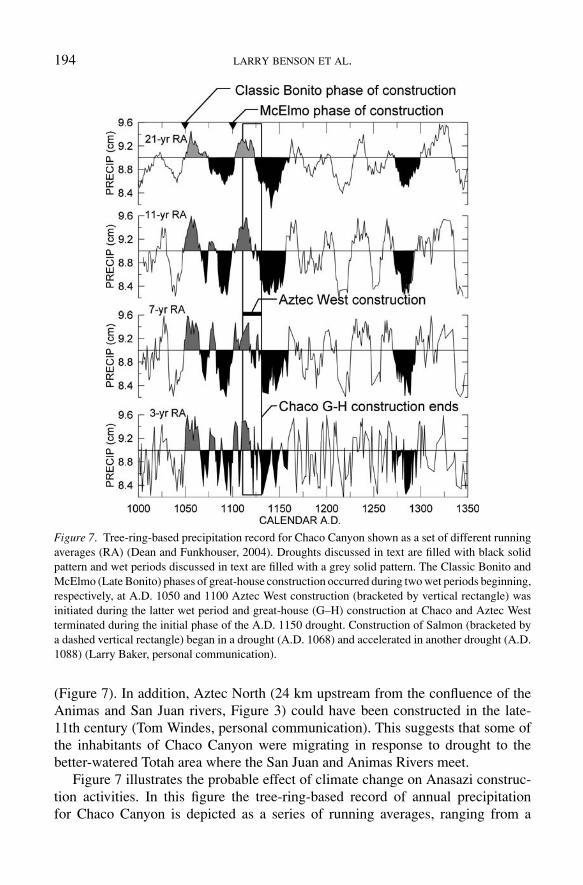
Figure 7. Tree-ring-based precipitation record for Chaco Canyon shown as a set of different runningaverages (RA) (Dean and Funkhouser, 2004). Droughts discussed in text are filled with black solidpattern and wet periods discussed in text are filled with a grey solid pattern. The Classic Bonito andMcElmo (Late Bonito) phases of great-house construction occurred during two wet periods beginning,respectively, at A.D. 1050 and 1100 Aztec West construction (bracketed by vertical rectangle) wasinitiated during the latter wet period and great-house (G–H) construction at Chaco and Aztec Westterminated during the initial phase of the A.D. 1150 drought. Construction of Salmon (bracketed bya dashed vertical rectangle) began in a drought (A.D. 1068) and accelerated in another drought (A.D.1088) (Larry Baker, personal communication).
(Figure 7). In addition, Aztec North (24 km upstream from the confluence of theAnimas and San Juan rivers, Figure 3) could have been constructed in the late-11th century (Tom Windes, personal communication). This suggests that some ofthe inhabitants of Chaco Canyon were migrating in response to drought to thebetter-watered Totah area where the San Juan and Animas Rivers meet.
Figure 7 illustrates the probable effect of climate change on Anasazi construc-tion activities. In this figure the tree-ring-based record of annual precipitationfor Chaco Canyon is depicted as a series of running averages, ranging from a

ANASAZI (PRE-COLUMBIAN NATIVE-AMERICAN) MIGRATIONS 195
high-frequency 3-year running average to a low-frequency 21-year running aver-age. Both the Classic Bonito and Late Bonito (McElmo) phases of great-houseconstruction in Chaco Canyon were initiated during anomalously wet periods, andgreat-house construction at Chaco and Aztec was terminated by drought at A.D.1130 In Chaco canyon, the drought intervals centered on A.D. ∼1090 and ∼1150appear to have lasted longer and have been more severe than the Great Droughtcentered on A.D. ∼1280
3. Maize and Migration
The link that connects monsoon failure and Anasazi migration is maize. BruceHuckell and colleagues have discovered archeological maize in McEuen Cave,northeast of Tucson Arizona, that dates to ∼3800 14C yr B.P. (∼2240 B.C.), indi-cating that maize was introduced to the Southwest more than 4000 years ago (B.Huckell, personal communication). Over time, maize became the dietary staple ofthe Anasazi inhabiting the Four Corners region. In the early historical period, theHopi and the Zuni attempted to keep a second year’s supply of maize in reserve(Stevenson, 1904; Hough, 1915; Cushing, 1920; Forde, 1931; Titiev, 1944; Brownet al., 1952). However, such a reserve would not have been sufficient to last througha multi-year drought. Annual consumption by the Hopi was ∼12 bushels per per-son (Stephen, 1936) and the maize yield in a good year was ∼12 bushels per acre.Thus, a Hopi family of 6 would have to cultivate ∼12 acres to provide enoughmaize for the following year’s consumption and another year’s storage. Farmingof 12 acres represents a substantial investment in time, and although excess maizecould have accumulated over a period exceeding one year, maize would not havekept indefinitely, given insect and animal predation.
Maize yields are a function of climate and the properties of the soil in whichthe maize grows. We do not know the environmental requirements of maize grownby the Anasazi; therefore, we must rely on the requirements of modern forage cornand maize grown by present-day Pueblo people as a proxy. We suggest that Zuniand Hopi agricultural practices are good analogs for Anasazi practices. The Zunimitochondrial DNA (mtDNA) haplogroup distribution is very similar to that of theAnasazi (Carlyle et al., 2000), indicating that the Zuni are descended from one ofthe Anasazi groups.
Most soils in the semi-arid Southwest are nutrient poor and the raising of maizeleads to nutrient depletion. Nutrient (e.g., N and P) loss necessitates that soil beleft fallow until the nutrient balance is restored (Stewart, 1940). The bioavailabilityof N and P is pH dependent with a pH range of 5.5 to 7.0 being optimal (Olsonand Sander, 1988). Zuni fields have a pH range of 6.6 to 8.0, are usually croppedfrom 2 to 3 years, and then left fallow for 1 to 4 or more years (Muenchrath et al.,2002). For modern forage corn, yield begins to decrease at a salinity (conductivity)threshold of 1.8 deciSiemens per meter (dS/m) (Ayers and Westcot, 1976).

196 LARRY BENSON ET AL.
Maize is produced in areas that receive 25 centimeters (cm) of annual pre-cipitation or 15 cm of growing season precipitation (Shaw, 1988); however, opti-mum maize yields occur where growing season precipitation ranges from 40 to60 cm (Minnis, 1981) and where the freeze-free period exceeds 120 days (Shaw,1988).
At Zuni, May-through-September rainfall averages 15.8 cm and there is a 90%probability that a period of 112 days will be frost-free (Western Regional ClimateCenter, Desert Research Institute, 2004). Zuni maize cultivars take ∼125 days tomature (Muenchrath et al., 2002), and Hopi blue corn requires 115 to 130 frost-freedays (Bradfield, 1971).
Nutrient, pH, and salinity data are not available for most of the soils in the FourCorners region; however, freeze-free probabilities and precipitation data exist for66 sites in the region. To determine the best areas for dry-land farming of maize, weassumed that 90 freeze-free days and 30 cm of annual precipitation must be equaledor exceeded. Growing season precipitation averages ∼50% of the minimum annualprecipitation in the 66 sites2. Twelve of the 66 sites have precipitation and freeze-free conditions that permit dry-land farming of maize (Figure 8); the 12 sites lie onthe periphery of the San Juan Basin (Figure 9).
A comparison of the locations of the 12 sites with locations of great housesoccupied after the drought of A.D. 1150 (Figures 2 and 9) indicates a measure ofcongruency, suggesting that some Anasazi may have been forced to leave the rela-tively cold and dry central San Juan Basin during the drought because that area wasno longer able to support dry-land farming. If village population can be assumed
Figure 8. Plot of mean-annual precipitation versus freeze-free-day probabilities for 66 weatherstations in the Four Corners region. Summer precipitation (May–Sep ↓) at the sites makes up49 ± 8% of the mean-annual precipitation. The 12 sites in the upper right quadrant of the dia-gram have precipitation and freeze-free values that allow at least minimal dry-land agriculture. TheMesa Verde, Yellow Jacket, and Cortez sites fall within or close to the area studied by Van West(1994).

ANASAZI (PRE-COLUMBIAN NATIVE-AMERICAN) MIGRATIONS 197
Figure 9. Locations of the 12 sites in the Four Corners region that currently can support dry-landfarming of maize.
to be linked to greathouse occupation, the Anasazi appear to have remained in ar-eas in which dry-land farming was possible and in areas located along perennialriver systems. However, abandonment of great houses does not necessarily indicatecomplete abandonment of the villages in which they were located; i.e., village pop-ulations simply may have decreased in response to environmental deterioration. Inthis case, great-house abandonment may be hypothesized to represent dissatisfac-tion of the outlying villages with the Chacoan socio-political system inasmuch asChaco was considered responsible for their welfare. Given the impact of a multi-year drought on both canyon and outlier village agriculture, many residents of theSan Juan Basin may have decided the existing socio-political system was bankruptand it was time for a change.
Evidence for the A.D. 1150 drought comes from two other areas. TheVirgin River Anasazi abandoned their settlements in southwestern Utah at aboutA.D. 1150, presumably in response to drought (Larson and Michaelsen, 1990;Lyneis, 1996). The Fremont, living along the eastern shore of Great Salt Lake,Utah, incorporated maize in their diets beginning A.D. ∼500; however, they ceased

198 LARRY BENSON ET AL.
consumption of maize after A.D. 1150 (Coltrain and Leavitt, 2002). There also wasa widespread abandonment of Fremont farming sites between 1150 and A.D. 1350Some authors have argued that the abandonment of farming was in response toa deterioration of climate (e.g., Hunt, 1953; Rudy, 1953). Lindsay (1986) andNewman (1996) suggested that reduced summer moisture and a shortened growingseason (e.g., Salzer, 2000) were the specific causes of agricultural failure, and thatthe change in climate was due to a shift in the northern boundary of the summermonsoon which today reaches only into southeastern Utah (Mitchell, 1976). Thisconcept is consistent with Petersen’s (1994) suggestion that that the expansion ofpinon in southwestern Colorado during the 10th and 11th centuries (Figure 5) wasdue to an increase in summer moisture. These studies imply that prior to A.D. 1130the summer monsoon was stronger and its boundary lay north of its present-day po-sition, allowing the Anasazi to expand their territory and increase their population,during a time when maize yields were relatively high.
These results contradict Van West’s (1994) conclusion that in the northern SanJuan region of southwestern Colorado “there always was enough productive landto produce enough maize to support a very large population.” Van West’s study wasground breaking for its time and utilized the best available data; however, she neverclaimed that her study was applicable to the entire Four Corners region. Indeed, theclimate of the northern San Juan region is demonstrably warmer and wetter thanthe climate of the central San Juan Basin and is, therefore, more reliable in termsof its agricultural productivity (see Figures 8 and 9 which show precipitation andfreeze-free days for the Yellow Jacket, Cortez, and Mesa Verde sites in the northernSan Juan Basin as well as other sites in the Four Corners region).
In addition, Van West’s estimates of archeological maize yields are not suffi-ciently accurate to demonstrate that the agricultural productivity of the northernSan Juan region was always able to withstand the effects of severe drought (seeAppendix I).
The studies of Dean et al. (2000) and Axtell et al. (2002) shed some light onproblems of applying maize yields derived by Van West (1994). Dean et al. (2000)estimated Long House Valley maize yields by adopting Van West’s (1994) derivedrelationships between soil PDSI and maize production for southwestern Colorado.This was accomplished by matching the specific water-holding attributes of LongHouse Valley soils to southwestern Colorado soils. The Dean et al. (2000) simulationof the population of Long House Valley between A.D. 800 and 1360 was, however,∼6 times greater than the archeologically estimated population, suggesting thatmaize yields may have been overestimated in the model. Axtell et al. (2002) wereable to accurately simulate the total number of households in Long House Valleybetween A.D. 800 and 1300 However, this was accomplished by optimizing themodel with respect to eight adjustable parameters, including the average harvestper acre and the variance in this harvest. Thus, maize yields had to be treated asan adjustable parameter to accurately estimate population change through time inLong House Valley.
ANASAZI (PRE-COLUMBIAN NATIVE-AMERICAN) MIGRATIONS 199
4. Culture and Migration
Drought by itself probably can never totally account for the migration of an entiregroup that occupied a particular geographic area. There always will be some partof the land that remains sufficiently productive to raise crops or that is adequatefor some level of hunting and gathering. The relative importance of environmentaldeterioration, including drought, as a push factor has recently been explored byDean et al. (2000) and Axtell et al. (2002) who applied agent-based modeling tothe Kayenta Anasazi. This group of Anasazi occupied Long House Valley in north-eastern Arizona from ∼1800 B.C. until A.D. 1300 The Anasazi totally abandonedthe valley by A.D. 1300; however, model simulations indicate that the valley couldhave continued to support 35 to 40% of its peak population during the 40 yearsfollowing the A.D. 1300 exodus. In the words of Axtell et al. (2002), “The fact thatin the real world of Long House Valley, the supportable population chose not tostay behind but to participate in the exodus from the valley indicates the magnitudeof sociocultural “push” or “pull” factors that induced them to move”, a conclusionpreviously reached by Dean et al. (2000).
It takes a minimum number of individuals to fill the roles assigned to a “viable”Anasazi society, a concept that can be illustrated using examples from early-historicPueblo cultures. Contemporary Pueblo people have social systems comprised of so-dalities, including clans, moieties, feast groups, religious societies, healing groups,war societies, village governments, and winter and summer governments, each ofwhich exerts a sociocultural pull (George Gumerman, personal communication).Sociocultural pull also can be illustrated using the Zuni organizational structure.When Cushing (1896) intruded on the Zuni in 1879, there were 19 kinship groups(clans). The clans bore totemic names and were grouped in threes, except for oneclan. Six groups of three clans were associated with the four cardinal points of thecompass, the zenith and the nadir; the single clan was associated with the midpointof this constellation of clans and was considered to be the mother clan from whichthe priesthood arose. The seven groups represented the original Zuni subtribeswhich had occupied the seven cities of Cibola noted by early Spanish explorers.Each of the totems were, in essence, god beings associated with their particularregion; e.g., the evergreen oak totem of the north is as green in the winter as othertrees in the spring and summer, indicating its unusual and unique quality.
To quote Cushing (1896) “By this arrangement of the world. . .into several worldscorresponding to the four quarters and the zenith and the nadir, and by this groupingof the (original) towns. . .according to such mythical division of the world, andfinally the grouping of the totems in turn within the divisions thus made, not onlythe ceremonial life of the people, but all their governmental arrangements as well,are completely systematized.”3 If in the past, Anasazi villages or multi-villageentities were as culturally and politically interconnected as the early-historic Zuni,then it would be logical for the group to migrate as a unit in response to one ormore forms of environmental deterioration.
200 LARRY BENSON ET AL.
However, this degree of cultural interconnectivity does not always occur inPueblo society, implying that migration need not always involve the entire group.At Orayvi, Hopi clans were assigned fields by the village chief. Some clans wereassigned excellent fields; however, other clans were assigned fields of lesser valueor not assigned fields at all; and, in general, the clans that controlled good landsalso controlled the most important ceremonies (Levy, 1992). Thus, the Hopis wereroughly divided into two classes as a result of the inequitable distribution of agri-cultural land. In times of drought, it was survival of the fittest, for “In case ofdrought, all resources are concentrated for the preservation of the central clan core,and other clansmen may be forced to migrate or starve. As conditions improve,they may return. . .” Eggan (1966). A major “sloughing off” of Hopi clans duringenvironmental stress occurred in Orayvi in 1906 when a prolonged drought led toloss of half the village population (Levy, 1992). At that time the “Hostile” faction,consisting mostly of lower class Hopi, were expelled from Orayvi and were notallowed to return. This suggests that sociocultural push or pull factors may havediffered in both character and strength during the heyday of Anasazi groups.
Other forms of resource depletion also may have contributed to Anasazi migra-tion;, e.g., fuel wood may have become limited in some areas (Dean, 2004; Kohler,2004; Johnson et al., 2005), and a decline in protein availability may have stressedalready limited agricultural resources (Kohler, 2002; Varien et al., 2000).
5. Drought and its Relation to the Pacific Decadal and Atlantic MultidecadalOscillations
Drought in the Four Corners region, during the past 300 years, can be associatedwith two climate indices: the Pacific Decadal Oscillation (PDO) and the AtlanticMultidecadal Oscillation (AMO).
The PDO has a spatial pattern similar to the El Nino Southern Oscillation(ENSO) (Mantua et al., 1997); i.e., during positive phases of the PDO, the south-western US tends to be wetter than average and during negative phases of the PDO,the southwest tends to be dry. However, the PDO has a very different time signa-ture, having a pseudo-cyclicity ranging from 50 to 70 years (MacDonald and Case,2005), whereas typical ENSO events occur every 4 to 7 years and persist from 6 to18 months. A positive PDO phase is associated with warmer-than-normal temper-atures in the eastern equatorial Pacific Ocean and cooler-than-normal temperaturesin the northwest Pacific Ocean.
The AMO is an index of detrended sea-surface temperature (SST) anomaliesthat are averaged over the North Atlantic Ocean from 0 to 70 ◦N (Kerr, 2000). Thedetrended AMO index has been associated with multi-year precipitation anomaliesover North America and it has been shown to influence summer precipitation overthe US (Enfield et al., 2001). During the instrumental period (1856–2005) it hasexhibited a 65-to-80-year pseudo cycle.

ANASAZI (PRE-COLUMBIAN NATIVE-AMERICAN) MIGRATIONS 201
Atmospheric modeling has demonstrated that the drought of the 1930s, which af-fected approximately two thirds of the contiguous US, was associated with warmer-than-normal North Atlantic (positive AMO) SSTs and colder-than-normal equato-rial Pacific (negative PDO) SSTs (Schubert et al., 2004).
McCabe et al. (2004), using drought-frequency climate data for the period 1900to 1999, have demonstrated that the southern part of the western US tends toexperience drought when the AMO is positive and the PDO is negative. Brownand Comrie (2002) and Ni et al. (2002) have shown that winter precipitation inNew Mexico is positively correlated with the PDO, and Fye et al. (2003) haveshown that times of positive AMO and negative PDO produce western droughtsthat are spatially similar to the 1950s drought. The 1950s drought occurred be-tween 1946 and 1956 and was especially severe in the Four Corners Region. Dur-ing the 1950s drought, both winter and summer precipitation regimes declineddramatically.
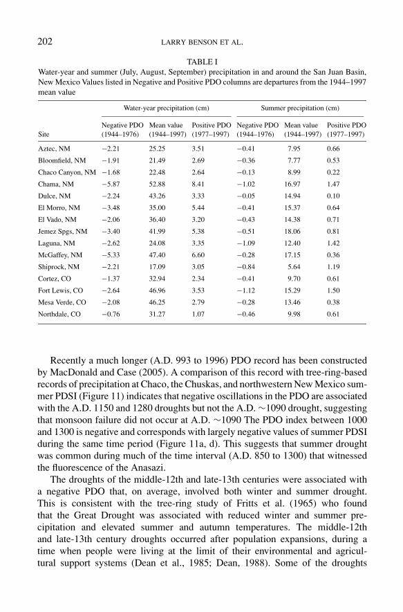
In northwestern New Mexico’s Climate Division 1 (San Juan Basin), between1944 and 1976 (negative PDO), it was dry (10% below normal precipitation) 55%of the time and wet (10% above normal precipitation) 15% of the time; how-ever, between 1977 and 1997 (positive PDO), it was wet 62% of the time and dryonly 14% of the time in New Mexico Division 1 (Charles Liles, National WeatherService, personal communication). Thus, in the historical period, a negative PDOand a positive AMO are nominally associated with drought in the Four CornersRegion. To determine the relation of water-year (October 1 through September31) and summer (July, August, September) precipitation in the greater San JuanBasin during negative and positive PDO intervals, we analyzed historical climaterecords from 15 sites in New Mexico and Colorado. The data (Table I) indicatethat a negative PDO interval is characterized by reduced water-year (October 1–September 31) and summer (June, July, August) precipitation. Note that water-yearprecipitation is driven more by winter precipitation (64 ± 6% of annual) and itsdifference during positive and negative phases of the PDO (11 ± 4% and −8 ± 3%respectively).
In order to look back in time, we must turn to proxies for the PDO, AMO, anddrought. Tree-ring (D’arrigo et al., 2001; Gray et al., 2004) and coral-chemistry(Linsley et al., 2000) records have been used to reconstruct fluctuations in thePDO and AMO for about the past 300 years. The use of different proxies forthe PDO strengthens the reliability of its reconstruction. Plots of these climateindices versus tree-ring based reconstructions of summer PDSI for northwesternNew Mexico site #119 (Cook et al., 2004) and annual precipitation for ChacoCanyon in the central San Juan Basin indicate that drought in the Four Cor-ners region is generally associated with a positive AMO and a negative PDO(Figure 10). Note, however, that the maxima and minima in the records are notalways synchronous and that the reconstructed summer PDSI record for north-western New Mexico appears to overemphasize the frequency and persistence ofdrought.
202 LARRY BENSON ET AL.
TABLE IWater-year and summer (July, August, September) precipitation in and around the San Juan Basin,New Mexico Values listed in Negative and Positive PDO columns are departures from the 1944–1997mean value
Water-year precipitation (cm) Summer precipitation (cm)
Negative PDO Mean value Positive PDO Negative PDO Mean value Positive PDOSite (1944–1976) (1944–1997) (1977–1997) (1944–1976) (1944–1997) (1977–1997)
Aztec, NM −2.21 25.25 3.51 −0.41 7.95 0.66
Bloomfield, NM −1.91 21.49 2.69 −0.36 7.77 0.53
Chaco Canyon, NM −1.68 22.48 2.64 −0.13 8.99 0.22
Chama, NM −5.87 52.88 8.41 −1.02 16.97 1.47
Dulce, NM −2.24 43.26 3.33 −0.05 14.94 0.10
El Morro, NM −3.48 35.00 5.44 −0.41 15.37 0.64
El Vado, NM −2.06 36.40 3.20 −0.43 14.38 0.71
Jemez Spgs, NM −3.40 41.99 5.38 −0.51 18.06 0.81
Laguna, NM −2.62 24.08 3.35 −1.09 12.40 1.42
McGaffey, NM −5.33 47.40 6.60 −0.28 17.15 0.36
Shiprock, NM −2.21 17.09 3.05 −0.84 5.64 1.19
Cortez, CO −1.37 32.94 2.34 −0.41 9.70 0.61
Fort Lewis, CO −2.64 46.96 3.53 −1.12 15.29 1.50
Mesa Verde, CO −2.08 46.25 2.79 −0.28 13.46 0.38
Northdale, CO −0.76 31.27 1.07 −0.46 9.98 0.61
Recently a much longer (A.D. 993 to 1996) PDO record has been constructedby MacDonald and Case (2005). A comparison of this record with tree-ring-basedrecords of precipitation at Chaco, the Chuskas, and northwestern New Mexico sum-mer PDSI (Figure 11) indicates that negative oscillations in the PDO are associatedwith the A.D. 1150 and 1280 droughts but not the A.D. ∼1090 drought, suggestingthat monsoon failure did not occur at A.D. ∼1090 The PDO index between 1000and 1300 is negative and corresponds with largely negative values of summer PDSIduring the same time period (Figure 11a, d). This suggests that summer droughtwas common during much of the time interval (A.D. 850 to 1300) that witnessedthe fluorescence of the Anasazi.
The droughts of the middle-12th and late-13th centuries were associated witha negative PDO that, on average, involved both winter and summer drought.This is consistent with the tree-ring study of Fritts et al. (1965) who foundthat the Great Drought was associated with reduced winter and summer pre-cipitation and elevated summer and autumn temperatures. The middle-12thand late-13th century droughts occurred after population expansions, during atime when people were living at the limit of their environmental and agricul-tural support systems (Dean et al., 1985; Dean, 1988). Some of the droughts

ANASAZI (PRE-COLUMBIAN NATIVE-AMERICAN) MIGRATIONS 203
Figure 10. Plots of (a) tree-ring-based annual precipitation values for Chaco Canyon, New Mexico(Dean and Funkhouser, 2004), (b) tree-ring-based summer PDSI values for northwestern New Mexico(essentially the San Juan Basin) (Cook et al., 2004), versus (c) the tree-ring-based reconstruction ofthe AMO index (Gray et al., 2004), (d) the tree-ring-based reconstruction of the detrended PDOindex (D’arrigo et al., 2001), and (e) the subtropical, coral-based, detrended Rorotonga sea-surfacetemperature (SST) proxy of the PDO (Linsley et al., 2000) for the past 300 years. When the SSTis positive the PDO is negative. Vertical dashed lines indicate the essential co-occurrence of AMOmaxima, PDO minima, and drought in northwestern New Mexico with the exception of the AMOvalue at 1815. The records are presented as 21-year running averages.
persisted for several years and would have caused all surplus maize to be con-sumed, thereby forcing the Anasazi to migrate to more agriculturally productiveareas.
This concept is reinforced by the work of Burns (1983) who reconstructed maizeand bean yields in southwestern Colorado using tree-ring records. Burns (1983)

204 LARRY BENSON ET AL.
Figure 11. Plots of (a) tree-ring-based summer PDSI values for northwestern New Mexico (Cook et al.,2004), (b) tree-ring based annual precipitation for the Chuskas (Jeff Dean, personal communication),(c) tree-ring-based annual precipitation values for Chaco Canyon, New Mexico (Dean and Funkhouser,2004), and (d) tree-ring-based reconstruction of the PDO (MacDonald and Case, 2005). The A.D.1150 and 1280 droughts are shown with a dashed line. The records are presented as 21-year runningaverages.
showed that, given a 1.5-year storage capacity, the harshest famines endured by theAnasazi occurred during the middle-12th and late-13th centuries.
6. Summary and Conclusions
Many of the Anasazi may have left the relatively cold and dry central San Juan Basinduring the middle-12th century and they abandoned the entire Four Corners regionin the late-13th century. Tree-ring based reconstructions of precipitation and soilmoisture indicate that both migrations occurred during intense multi-year droughtintervals. During the middle-12th century, the Virgin River Anasazi abandonedtheir settlements in southwestern Utah and the Fremont, living along the easternshore of Great Salt Lake, Utah, ceased their consumption of maize. Great-houseconstruction and renovation at Chaco and at Aztec which had accelerated during wetperiods terminated near the beginning of the middle-12th century drought. Thesedata suggest that a persistent and intense drought impacted the Southwest in themiddle-12th century, and supports the concept of a migration from the central San
ANASAZI (PRE-COLUMBIAN NATIVE-AMERICAN) MIGRATIONS 205
Juan Basin and/or a reduction in community populations. Migration from ChacoCanyon to the Salmon great-house site occurred in 1068 during a decade-longdrought. This suggests that climate deterioration impacted the fragile agronomicbase of Chaco, causing some of its inhabitants to seek areas with a more reliablewater supply.
Pollen data from the northern San Juan Basin indicate that the middle-12thand late-13th century droughts involved a weakening or failure of the summermonsoon. Tree-ring-based reconstructions of annual precipitation imply that bothdroughts also were associated with reductions in winter moisture. Comparison oftree-ring-based reconstructions of precipitation and soil moisture with tree-ring-based reconstructions of the PDO and AMO for the past 300 years indicate thatdrought in the Four Corners region occurs when the PDO is negative and the AMOis positive. Historic climate data indicate that reductions in both water-year andsummer precipitation occur when the PDO is negative, and a long proxy recordof the PDO indicates that the middle-12th and late-13th century droughts wereassociated with major negative excursions in the PDO. Reconstruction of summerdrought for the past 800 years may be ultimately improved using tree-ring latewoodwidth as an indicator of southwestern summer precipitation (Meko and Baisan,2001).
We suggest that Anasazi populations declined and that the Anasazi sometimesmigrated in response to droughts characterized by a weakening or failure of thesummer monsoon. The loss of summer moisture is hypothesized to have resultedin reduced yields of maize, the dietary staple of the Anasazi, forcing them toabandon areas that were marginal for dry-land farming and migrate to better-watered areas. The drought of the middle-12th century may not have resultedin the complete abandonment of the central San Juan Basin. The middle-12thcentury drought may have occurred at a time of Anasazi population expansion,rendering the San Juan Basin population sensitive to the effects of agriculturalfailure.
Acknowledgments
Most of the tree-ring records were supplied by Jeff Dean and the SouthwestPaleoclimate Project of the Laboratory of Tree-Ring Research at the Universityof Arizona, Tucson. The tree-ring research was funded by NSF, DOD-ARPA, NPS,and the Southwest National Parks and Monuments Association. Jim Ashby of theWestern Regional Climate Center supplied much of the climate data used in the pa-per. Rich Friedman graciously supplied the DEMs used in the figures. We thank JeffDean, Jonathan Friedman, Rich Friedman, Eleanor Griffin, Greg McCabe, HowardTaylor, and Carla Van West for their helpful reviews of earlier versions of this paperand Tom Windes for information regarding ceramic dating.

206 LARRY BENSON ET AL.
Appendix I
Van West’s correlations of calculated and tree-ring-based June PDSI values withhistoric maize yields tabulated by Burns (1983) are not robust. These correlationswere performed in order to demonstrate a linkage between yields and PDSI. How-ever, linear regression of maize yields versus calculated and tree-ring-based JunePDSI values for the most common soil for the period 1931 to 1960 yielded, re-spectively, R2 values of 0.05 and 0.09 (Van West, 1994, p. 101). This, may in part,stem from the fact that the tree-ring-based June PDSI value integrates soil-moistureconditions over the previous several months but does not proxy well for the mon-soonal (July, August, September) component of precipitation which is critical indetermining maize yields. In addition, trees used to reconstruct historic PDSIs andhistoric cornfields are not located together. Given the patchiness of summer con-vective storms, a grove of trees may not experience the same precipitation eventsas a field of maize. Most importantly, improvements in technology after 1943 de-coupled moisture from maize yields. Thus, ring width in the historic period maynot always have been representative of maize yields.
Van West attempted to improve the correlation of maize yields to soil PDSIvalues by including time as an independent variable that proxied for the effectsof technological change on yield since 1930. Burns (1983) had previously usedColorado fertilizer usage as a technological proxy; Van West made the assump-tion that the dependence of yields on technology was a linear function of timesince 1930. The inclusion of time, which is assumed to proxy for the effect oftechnology on agricultural yields, improved the correlation of maize yields withsoil PDSI; however, the technological effect actually was minimal prior to 1944(see below).
Plots of unadjusted maize yields from five Colorado counties (Burns, 1983),together with the weighted average of those yields and water-year precipitationrecorded at Durango and Cortez, Colorado for the period 1919 to 1960, indicatethat decreases in maize yields were associated with particularly dry years prior to1944; however, between 1944 and 1959, decreased yields are not associated withdrought (Figure 12).
From 1926 until 1944, maize yields and precipitation are reasonably well cor-related (R2 = 0.54) (Figure 13); after 1944, the correlation significantly decreases(R2 = 0.05). This suggests that technology was not playing an overwhelming rolein maize yields until World War II, when fertilizer application increased and tech-nologically advanced tractors were introduced into southwestern Colorado (Burns,1983). Thus Van West’s partial regression of yield versus time (technology) shouldprobably have been done for the time period 1944 through 1960 (Figure 13). Orbetter yet, she should have regressed yield versus precipitation (or soil PDSI) forthe 26 years preceding 1944.
In general, a regression of yield versus time represents a detrending of the yielddata. However, such a detrending cannot be demonstrated to be independent of
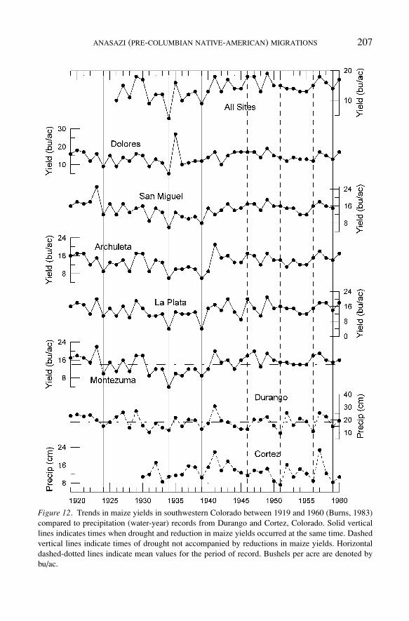
ANASAZI (PRE-COLUMBIAN NATIVE-AMERICAN) MIGRATIONS 207
Figure 12. Trends in maize yields in southwestern Colorado between 1919 and 1960 (Burns, 1983)compared to precipitation (water-year) records from Durango and Cortez, Colorado. Solid verticallines indicates times when drought and reduction in maize yields occurred at the same time. Dashedvertical lines indicate times of drought not accompanied by reductions in maize yields. Horizontaldashed-dotted lines indicate mean values for the period of record. Bushels per acre are denoted bybu/ac.
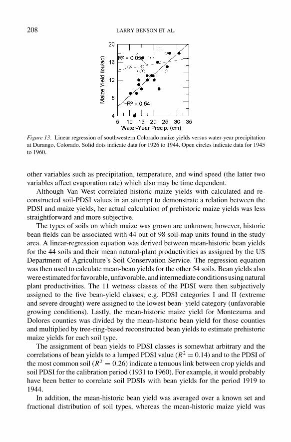
208 LARRY BENSON ET AL.
Figure 13. Linear regression of southwestern Colorado maize yields versus water-year precipitationat Durango, Colorado. Solid dots indicate data for 1926 to 1944. Open circles indicate data for 1945to 1960.
other variables such as precipitation, temperature, and wind speed (the latter twovariables affect evaporation rate) which also may be time dependent.
Although Van West correlated historic maize yields with calculated and re-constructed soil-PDSI values in an attempt to demonstrate a relation between thePDSI and maize yields, her actual calculation of prehistoric maize yields was lessstraightforward and more subjective.
The types of soils on which maize was grown are unknown; however, historicbean fields can be associated with 44 out of 98 soil-map units found in the studyarea. A linear-regression equation was derived between mean-historic bean yieldsfor the 44 soils and their mean natural-plant productivities as assigned by the USDepartment of Agriculture’s Soil Conservation Service. The regression equationwas then used to calculate mean-bean yields for the other 54 soils. Bean yields alsowere estimated for favorable, unfavorable, and intermediate conditions using naturalplant productivities. The 11 wetness classes of the PDSI were then subjectivelyassigned to the five bean-yield classes; e.g. PDSI categories I and II (extremeand severe drought) were assigned to the lowest bean- yield category (unfavorablegrowing conditions). Lastly, the mean-historic maize yield for Montezuma andDolores counties was divided by the mean-historic bean yield for those countiesand multiplied by tree-ring-based reconstructed bean yields to estimate prehistoricmaize yields for each soil type.
The assignment of bean yields to PDSI classes is somewhat arbitrary and thecorrelations of bean yields to a lumped PDSI value (R2 = 0.14) and to the PDSI ofthe most common soil (R2 = 0.26) indicate a tenuous link between crop yields andsoil PDSI for the calibration period (1931 to 1960). For example, it would probablyhave been better to correlate soil PDSIs with bean yields for the period 1919 to1944.
In addition, the mean-historic bean yield was averaged over a known set andfractional distribution of soil types, whereas the mean-historic maize yield was
ANASAZI (PRE-COLUMBIAN NATIVE-AMERICAN) MIGRATIONS 209
averaged over an unknown set and fractional distribution of soil types. The typesand percentages of soils on which maize is presumed to have grown during theprehistoric period was not the same as during the historic period. Thus, the meanmaize-to-bean yield ratio for prehistoric times cannot be accurately estimated fromthe mean-historic maize-to-bean yield ratio.
If historic dry-land farming technologies differed substantially from pre-Columbian Native American practices, historic maize yields may not be a goodproxy for archeological maize yields; e.g., the types of maize grown by southwest-ern Colorado farmers in the early- and middle-20th century were not the same typesgrown by the Anasazi.
Notes
1Insertion of geographical area by authors for clarity2In this instance we have used May-to-September precipitation to represent growing season pre-
cipitation. This differs from our proxy for monsoonal summer precipitation which includes the monthsJune, July, and August. Growing season precipitation was calculated for the period of record of eachweather station and not for a particular time interval.
3Italics added by authors for emphasis
References
Ayers, R. S. and Westcot, D. W.: 1976, Water Quality of Agriculture, Irrigation and Drainage PaperNo. 29, Food and Agriculture Organization of the United Nations, Rome.
Axtell, R. L., Epstein, J. M., Dean, J. S., Gumerman, G. J., Swedlund, A. C., Harburger, J., Chakravarty,S., Hammond, R., Parker, J., and Parker, M.: 2002, ‘Population growth and collapse in a multiagentmodel of the Kayenta Anasazi in Long House Valley’, Proceedings of the National Academy ofSciences 99, 7275–7279.
Benson, L. V., Kashgarian, M., Rye, R. O., Lund, S. P., Paillet, F. L., Smoot, J., Kester, C.,Mensing, S., Meko, D., and Lindstrom, S.:2002, ‘Holocene multidecadal and multicentennialdroughts affecting Northern California and Nevada’, Quaternary Science Reviews 21, 659–682.
Bradfield, M.: 1971, ‘The changing pattern of hopi agriculture’, Royal Anthropological InstituteOccasional Paper No. 30, London.
Brown, D. P. and Comrie, A. C.: 2002, ‘Sub-regional seasonal precipitation linkages to SOI and PDOin the Southwest United States’, Atmospheric Science Letters 3, 94–102.
Brown, W. L., Anderson, E. G., and Tuchawena, R. Jr.: 1952, ‘Observations on three varieties of hopimaize’, American Journal of Botany 39, 597–609.
Burns, B. T.: 1983, Simulated Anasazi Storage Behavior using Crop Yields Reconstructed from TreeRings, Ph.D. Dissertation, University of Arizona, Tucson.
Carlyle, S. W., Parr, R. L., Hayes, G., and O’Rourke, D. H.: 2000, ‘Context of maternal lineages inthe Greater Southwest’, American Journal of Physical Anthropology 113, 85–101.
Coltrain, J. B. and Leavitt, S. W.: 2002, ‘Climate and diet in fremont prehistory: Economic variabilityand abandonment of maize agriculture in the great salt lake basin’, American Antiquity 67, 453–485.

210 LARRY BENSON ET AL.
Cook, E. R., Woodhouse, C. A, Eakin, C. M., Meko, D. M., and Stahle, D. W.: 2004, ‘Long-Termaridity changes in the Western United States’, Science 306, 1015–1018.
Cushing, F. H.: 1896, Outlines of Zuni Creation Myths, Government Printing Office, Washington D.C, p. 462.
Cushing, F. H.: 1920, Zuni Breadstuff, Museum of the American Indian, Indian Notes and Monographs8, New York.
D’arrigo, R., Villalba, R., and Wiles, G.: 2001, ‘Tree-ring estimates of pacific decadal climate vari-ability’, Climate Dynamics 18, 219–224.
Dean, J. S.: 1988, ‘A Model of Anasazi Behavioral Adaptation’, in Gumerman, G. J. (ed.), The Anasaziin a Changing Environment, Cambridge University Press, Cambridge, pp. 25–44.
Dean, J. S.: 1992, ‘Environmental Factors in the Evolution of the Chacoan Sociopolitical System’, inDoyel, D.E. (ed.), Anasazi Regional Organization and the Chacoan System, Maxwell MuseumAnthropology Paper No. 5, University of New Mexico, Albuquerque, pp. 35–43.
Dean, J. S.: 1996, ‘Demography, environment, and subsistence stress’, in Tainter, J., Tainter, B. B.(eds.), Evolving Complexity and Environmental Risk in Prehistoric Southwest, Santa Fe InstituteStudies in the Sciences of Complexity, vol. XXIV, Addison-Wesley, New York, pp. 25–56.
Dean, J. S.: 2004, ‘Anthropogenic environmental change in the southwest as viewed from the ColoradoPlateau’, in Redman, C. L., James, S. R., Fish, P. R., and Rogers, J. D. (eds.), The Archaeologyof Global Change: The Impact of Humans on the Environment, Smithsonian Books, WashingtonDC, pp. 191–207.
Dean, J. S. and Funkhouser, G. S.: 2004, ‘Dendroclimatology and fluvial chronology in chaco canyon,Appendix A’, in Force, E. R., Vivian, R. G., Windes, T. C., and Dean, J. S., Relation of “Bonito”Paleo-channels and Base-Level Variations to Anasazi Occupation, Chaco, Canyon, New Mexico,Arizona State Museum Archaeological Series 194, 39–41.
Dean, J. S., Euler, R. C., Gumerman, G. J., Plog, F., Hevly, R. H. and Karlstrom, T. N. V.: 1985, ‘Humanbehavior, demography, and paleoenvironment on the colorado plateaus’, American Antiquity 50,537–554.
Dean, J. S., Gumerman, G. J., Epstein, J. M., Axtell, Swedlund, A. C., Parker, M. T., and McCarroll,S.: 2000. ‘Understanding anasazi culture change through agent-based modeling’, in Kohler, T. A.and Gumerman, G. J. (eds.), Dynamics in Human and Primate Societies, Agent-Based Modelingof Social and Spatial Processes, Oxford University Press, New York, pp. 179–205.
Douglass, A. E.: 1929, ’The secret of the Southwest solved by talkative tree rings’, National Geo-graphic Magazine 56, 736–770.
Eggan, F.: 1966, The American Indian: Perspectives for the Study of Social Chance, Aldine PublishingCompany, Chicago.
Enfield, D. B., Mestas-Nunez, A. M., and Trimble, P. J.; 2001, ‘The Atlantic Multidecadal Oscillationand its relation to rainfall and river flows in the Continental U.S., Geophysical Research Letters28, 2077–2080.
Forde, C. D.: 1931, ‘Hopi agriculture and land ownership’, Journal of the Royal AnthropologicalInstitute of Great Britain and Ireland 61, 357–405.
Fowler, A. P. and Stein J. R.: 1992, ‘Anasazi great house in space, time, and paradigm’, in Doyel, D. E.(ed.), Anasazi Regional Organization and the Chaco System, Maxwell Museum of Anthropology,Anthropological Paper No. 5, Albuquerque, pp. 101–122.
Fritts, H. C., Smith, D. G. and Stokes, M. A.: 1965, ‘The biological model for paleoclimatic in-terpretation of mesa verde tree-ring series’, in Osborne, D. (ed.), Contributions of the WetherillMesa Archaeological Project, Society for American Archaeology Memoir 19, Salt Lake City, pp.101–121.
Fye, J. K., Stahle, D. W., and Cook, E. R.; 2003, ‘Paleoclimatic analogs to twentieth-century moistureregimes across the United States’, Bulletin of the American Meteorological Society 84, 901–909.

ANASAZI (PRE-COLUMBIAN NATIVE-AMERICAN) MIGRATIONS 211
Gillespie, W. B.: 1984, ‘The environment of the chaco anasazi’, in Noble, D.G. (ed.), New Light onChaco Canyon, Exploration, the Annual Bulletin of the School, of American Research, Santa Fe,pp. 37–44.
Graumlich, L.: 1993, ‘A 1000-Year record of temperature and precipitation in the sierra nevada’,Quaternary Research 39, 249–255.
Gray, S. T., Graumlich, L. J., Betancourt, J. L., and Pedersen, G. T.: 2004, ‘A tree-ring based recon-struction of the atlantic multidecadal oscillation since A.D. 1567’, Geophysical Research Letters31, L12205.
Grissino-Mayer, H. D.: 1996, ‘A 2129-Year reconstruction of precipitation for Northwest New Mexico,USA’, in Dean, J. S., Meko, D. M. and Swetnam, T. W. (eds.), Tree Rings, Environment, andHumanity, Department of Geosciences, University of Arizona, pp. 191–204.
Guttman, N. B.: 1998, ‘Comparing the palmer drought index and the standardized precipitation index’,Journal American Water Resources Association 34, 113–121.
Hough, W.: 1915, The Hopi Indians, Cedar Falls, Iowa.Hunt, A.:1953, Archeological Survey of the La Sal Mountain Area, Utah, University of Utah Arche-
ological Papers No. 14, Salt Lake City.Johnson, C. D., Kohler, T. A., and Cowan, J.: 2005, ‘Modeling historical ecology, thinking about
contemporary systems’, American Anthropologist 107, 96–107.Judge, W. J.: 1989, ‘Chaco Canyon – San Juan Basin’, in Cordell, L. S., and Gumerman, G. J.
(eds.), Dynamics of Southwest Prehistory, Smithsonian Institution Press, Washington, D.C.,pp. 1–12.
Kerr, R. A.: 2000, ‘A North Atlantic climate pacemaker for the centuries’, Science 288, 1984–1986.
Kohler, T. A.: 2002, ‘The final 400 years of prehispanic agricultural society in the Mesa Verde region’,Kiva 66, 191–204.
Kohler, T. A.: 2004, ‘Prehistoric human impact on upland North American southwestern environments:Evolutionary ecological perspectives’, in Redman, C. L., James, S. R., Fish, P. R., and Rogers,J. D. (eds.), The Archaeology of Global Change: The Impact of Humans on the Environment,Smithsonian Books, Washington DC, pp. 2241–2242.
Larson, D. O. and Michaelsen, J.: 1990, ‘Impacts of climatic variability and population growth onvirgin branch anasazi cultural developments’, American Antiquity 55, 227–249.
Larson, D. O., Neff, H., Graybill, D. A., Michaelsen, J. and Ambos, E.: 1996, ‘Risk, climatic variability,and the study of southwestern prehistory: An evolutionary perspective’, American Antiquity 61,217–242.
Lekson, S. H.: 1984, Great Pueblo Architecture of Chaco Canyon, New Mexico, University of NewMexico Press, Albuquerque, p.299.
Levy, J. E.: 1992, Orayvi Revisited, School of American Research Press, Santa Fe, p. 198,Lindsay, L. W.: 1986, ‘Fremont Fragmentation’, in Condie, C. J. and Fowler, D. D. (eds.), Anthropology
of the Desert West, University of Utah Anthropological Papers No. 110, Salt Lake City, pp.229–252.
Linsley, B. K., Wellington, G. M., and Schrag, D. P.: 2000, ‘Decadal sea surface temperature variabilityin the subtropical South Pacific from 1726 to 1997 A. D., Science 290, 1145–1148.
Lyneis, M. M.: 1996, ‘Pueblo II-Pueblo III change in southwestern Utah, the Arizona strip, andSouthern Nevada’, in Adler, M. A. (ed.), The Prehistoric Pueblo World, AD 1150-1350, Universityof Arizona Press, Tucson, pp. 11–28.
MacDonald, G. M. and Case, R. A.: 2005, ‘Variations in the Pacific decadal oscillation over the pastmillennium’, Geophysical Research Letters 32, L08703, 4 pp.
Mantua, N. J., Hare, S. R., Zhang, Y., Wallace, J. M. and Francis, R. C.: 1997, ‘A pacific interdecadalclimate oscillation with impacts on salmon production’, Bulletin of the American MeteorologicalSociety 78, 1069–1079.

212 LARRY BENSON ET AL.
McCabe, G. J., Palecki, M. A. and Betancourt, J. L.: 2004, ‘Pacific and Atlantic ocean influences onmultidecadal drought frequency in the United States’, Proceedings of the National Academy ofSciences 101, 4136–4141.
Meko, D. M. and Baisan, C. H.: 2001, ‘Pilot study of latewood-width of conifers as an indicator ofvariability of summer rainfall in the North American monsoon region’, International Journal ofClimatology 21, 697–708.
Minnis, P. E.: 1981, Economic and Organizational Responses to Food Stress by Non-Stratified So-cieties: An Example from Prehistoric New Mexico, Unpublished Ph.D. Thesis, Department ofAnthropology, University of Michigan, Ann Arbor.
Mitchell, V. L.: 1976, ‘The regionalization of climate in the Western United States’, Journal of AppliedMeteorology 15, 920–927.
Muenchrath, D. A., Kuratomi, M., Sandor, J. A. and Homburg J. A.: 2002, ‘Observational study ofmaize production systems of Zuni farmers in semiarid New Mexico’, Journal of Ethnobiology22, 1–33.
Newman, D. E.: 1996, ‘Pollen and macrofossil analysis’, in Talbot, R. K. and Richens, L. D. (eds.),Steinaker Gap: An Early Fremont Farmstead, Museum of Peoples and Cultures Occasional PapersNo. 2, Brigham Young University, Provo, pp. 123–148.
Ni F., Cavazos, T., Hughes, M. K., Comrie, A. C., and Funkhouser, G.: 2002, ‘Cool-season precipitationin the southwestern USA since AD 1000: Comparison of linear and nonlinear techniques forreconstruction’, International Journal of Climatology 22, 1645–1662.
Olson, R. A. and Sander, D. H.: 1988, ‘Corn production’, in Sprague, G. F. and Dudley, J. W.(eds.), Corn and Corn Improvement, 3rd edn., Agronomy Monograph 18, American Society ofAgronomy, Crop Science Society of America and Soil Science Society of America, Madison,Wisconsin, pp. 639–686.
Petersen, K. L.: 1988, ‘Climate and the Dolores River Anasazi’, University of Utah AnthropologicalPapers 113, 1–151.
Petersen, K. L.: 1994, ‘A warm and wet little climatic optimum and a cold and dry little ice age in thesouthern rocky mountains, U.S.A.’, Climatic Change 26, 243–269.
Robinson W.J. and Rose, M. R.: 1979, Preliminary Annual and Seasonal Dendroclimatic Recon-struction for the Northwest Plateau, Southwest Colorado, Southwest Mountains, and NorthernMountains, Climatic Regions, A.D. 900–1969, Manuscript on File at the Laboratory of Tree-RingResearch, University of Arizona, Tucson.
Rose, M. R., Robinson, W. J., and Dean, J. S.: 1982, Dendroclimatic Reconstruction for the Southwest-ern Colorado Plateau, Manuscript on file at the Laboratory of Tree-Ring Research, University ofArizona, Tucson.
Rudy, J. R.: 1953, An Archaeological Survey of Western Utah, University of Utah AnthropologicalPapers No. 12, Salt Lake City.
Salzer, M. W.: 2000, ‘Temperature variability and the Northern Anasazi: Possible implications forregional abandonment’, Kiva 65, 295–318.
Schubert, S. D., Suarez, M. J., Pegion, P. J., Koster, R. D., and Bacmeister, J. T.: 2004, ‘On the Causeof the 1930s dust bowl’, Science 303, 1855–1859.
Shaw, R. H.: 1988, ‘Climate requirement’, in, Sprague, G. F and Dudley, J. W. (eds.), Corn and CornImprovement, Agronomy Monograph No. 18, Madison, pp. 609–638.
Stahle, D. W., Cook, E. R., Cleaveland, M. K., Therrell, M. D., Meko, D. M., Grissino-Mayer, H. D.,Watson, E., and Luckman, B. H.: 2000, ‘Tree-ring data document 16th century megadrought overNorth America’, EOS, Transactions American Geophysical Union 81, 121.
Stephen, A. M.: 1936, Hopi Journal of Alexander M. Stephen, in Parsons, E. C. (ed.), ColumbiaUniversity Contribution to Anthropology 23, Columbia University Press, New York.
Stevenson, M. C.:1904, The Zuni Indians, their Mythology, Esoteric Fraternities, and Ceremonies,23rd Annual Report of the Bureau of American Ethnology, Government Printing Office,Washington, D.C.

ANASAZI (PRE-COLUMBIAN NATIVE-AMERICAN) MIGRATIONS 213
Stewart, G. R.: 1940, ‘Conservation in Pueblo agriculture’, Scientific Monthly 51 329–340.Stine, S.: 1994, ‘Extreme and persistent drought in California and Patagonia during mediaeval time’,
Nature 369, 546–549.Stuiver, M., Reimer, P. J., and Braziunas, T. F.: 1998, ‘High-precision radiocarbon age calibration for
terrestrial and marine samples’, Radiocarbon 40, 1127–1151.Titiev, M.: 1944, Old Oraibi, a Study of the Hopi Indians of Third Mesa, Papers of the Peabody Museum
of American Archaeology and Ethnology 22, Harvard University, Cambridge, Massachusetts.Van West, C. R.: 1994, Modeling Prehistoric Climatic Variability and Agricultural Production in
Southwestern Colorado: A GIS Approach, Reports of Investigations 67, Washington State Uni-versity Department of Anthropology, Pullman, p. 258.
Varien, M. D., Van West, C. R., and Patterson, G. S.: 2000, ‘Competition, cooperation, and conflict:Agricultural production and community catchments in the central Mesa Verde region’, Kiva 66:45–65.
Western Regional Climate Center, Desert Research Institute: 2004, http://www.wrcc.dri.edu/
(Accepted 16 November 2005; Published online: 25 March 2006)