and mineral resources egasegas.com.eg/bidround2015/technical_report_8_exploration_blocks/... ·...
TRANSCRIPT

Ministry of Petroleum
and Mineral Resources
EGAS

EGAS
Ministry of Petroleum
and Mineral Resources
EGAS CONCESSIONS MAP
AND 2015 INTERNATIONAL BID ROUND BLOCKS
2
4
5
678
N. Tineh
Offshore (b)
BpN. Tineh
Offshore (a)
Bp
25° 26° 27° 28° 29° 30° 31° 32° 33° 34°
34°
Sinai
Western Desert
M E D I T E R R A N E A N S E A
N. E. BALTIM
IEOC
N. Damietta Offshore
bp
BA
LT
IM E
.
IEO
C
N. Port Said
IEOCEl Burg
BG
El Temsah
IEOC
Denise
El Temsah
Karous
Restricted
areaAbu Madi
EGPC
Seth &Ha’py Dev.bp
BALTIM N.
IEOC
W . ABU MADI
IEOC
Rhamat
D. L.
NW. Khilala
DISOUQ AREA-1
DEV.
W. ABU MADI
IEOC
BALTIM S.
IEOC
30°
ALEX.-1 DEV.( A & A1 )
bp
ALEX.-2( B & B 2 )
bp
A
A1
B
B2
Abu Qir (B)
Edison
WEB South Dev.
W. Delta Deep MarineBG
Rosetta West
BG
Rosetta Dev. BG
Rosetta North
BGRosetta 8 & 10
BG
Meret Dev.
W . Delta Deep MarineArea-5
BGN. Damietta
bp
W. Delta Deep Marine
Area-3BG
Tennin Dev.
IEOC
T1
Tao/ Kamose
PERINCO
N. Gamasa DV.
BG
El ArishAlexandria
W. Med-1
bp
W. Med. -2 DVL
bp
W. MED.
DEEP WATER
bp
Abu Qir (A)
Edison
N. Id
ku
. (A
) R
WE
N. Idku.
RWE
( B )
N. El Amriya
RWE
Restricted
area
N. Bardawil Dev.
N. El Max Offshore
bp
S. Disouq Onshore
Sea Dragon
S.Idku
Onshore
Petrocaltic
N. Tennin Offshore
bp
N.El Arish
Offshore
Dana Gas
N. Thekah
offshore
Edison
1El Qantara
Melrose2W. Qantara
Area-1
31°
32°
33°
Matruh
El Salum
El Dabaa
26 EGAS Agreements
12 Agreements Under EGAS Supervision
Thekah Dev.
Aten
dev.
S. Khilala
W . Khilala
El. W astani
W.El Manzala
Area -1
Dev.
Begonia
W. DikirnisE. Dikirnis
Balsam
W . Abu Khadra
S. Abu Elnaga
N E. Abu Zahra
W .Qantara
Area -1
Dev.
Sondos
S. zarka
El Basant
E.El. W astani
Dabayaa
Sama Dev.
Qantara Dev.
E. Abu Khadra
Luzi dev.
Rose Dev.
Portsaid
EGPC Development leases
Ashtom
El Gamil
Azhar Delta
S. El.Mansoura
Dev.
E. Delta
Dev.
El Tamad
Dev.
Satis Dev.
bp
Seth Southbp
Taurt Northbp
-1500
Shorouk
Offshore
IEOC
WDDM -8BG
WDDM -2BG
WDDM -4BG
WDDM -7BG
WDDM -6BG
N
S
EW
N. El Amriya
RWE
Offshore open areas
Onshore open areas
Restricted areas
EGAS Development leases
El BurgBG
N. Port FouadoffshoreEDISON
Karawanoffshore
IEOC
N. Leil offshoreIEOC
N. El salhiya onshoreDANA GAS
N. El Mahala onshoreTOTAL
El MatariyaBP
N. Damietta Offshore
bp
1
3
Bid Round 2015
Block 2E. PORT SAID OFFSHORE
Total area 1855 km2
Block 4N. RAS EL ESH OFFSHORE
Total area 1389 km2
Block 5W. EL TEMSAH OFFSHORE
Total area 1081 km2
Block 6S. TENNIN OFFSHORE
Total area 1275 km2
Block 7N. EL HAMMAD OFFSHORE
Total area 1927 km2
Block 8E. ALEXANDRIA OFFSHORE
Total area 1749 km2
Block 1W. EL ARISH OFFSHORE
Total area 1797 km2
Block 3N. ROMMANA OFFSHORE
Total area 1882 km2
EGAS
Ministry of Petroleum
and Mineral Resources
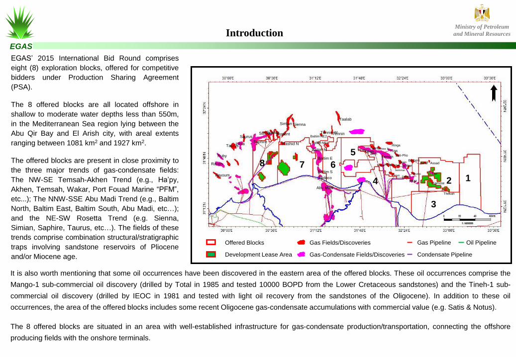
EGAS’ 2015 International Bid Round comprises
eight (8) exploration blocks, offered for competitive
bidders under Production Sharing Agreement
(PSA).
The 8 offered blocks are all located offshore in
shallow to moderate water depths less than 550m,
in the Mediterranean Sea region lying between the
Abu Qir Bay and El Arish city, with areal extents
ranging between 1081 km2 and 1927 km2.
The offered blocks are present in close proximity to
the three major trends of gas-condensate fields:
The NW-SE Temsah-Akhen Trend (e.g., Ha’py,
Akhen, Temsah, Wakar, Port Fouad Marine “PFM”,
etc...); The NNW-SSE Abu Madi Trend (e.g., Baltim
North, Baltim East, Baltim South, Abu Madi, etc…);
and the NE-SW Rosetta Trend (e.g. Sienna,
Simian, Saphire, Taurus, etc…). The fields of these
trends comprise combination structural/stratigraphic
traps involving sandstone reservoirs of Pliocene
and/or Miocene age.
It is also worth mentioning that some oil occurrences have been discovered in the eastern area of the offered blocks. These oil occurrences comprise the
Mango-1 sub-commercial oil discovery (drilled by Total in 1985 and tested 10000 BOPD from the Lower Cretaceous sandstones) and the Tineh-1 sub-
commercial oil discovery (drilled by IEOC in 1981 and tested with light oil recovery from the sandstones of the Oligocene). In addition to these oil
occurrences, the area of the offered blocks includes some recent Oligocene gas-condensate accumulations with commercial value (e.g. Satis & Notus).
The 8 offered blocks are situated in an area with well-established infrastructure for gas-condensate production/transportation, connecting the offshore
producing fields with the onshore terminals.
Introduction
8 7 6
5
4 2
Taalab
Tennin
Baltim E
Baltim N
Baltim NE1
Baltim S
Nidoco
Abu Madi
H’apyAkhenSeth
Temsah
TaurtRinga
TunaDenise N
Seti-Plio
MayasAsfourAbu Seif
Semman
Segan
Wakar
Barboni
Nouras
PFM
DarfeelKarous
Tao
Kamose
Thekah
Zaraf Assad
Tennin WBaltim NE2
SiennaSimian
Rashid N
SerpentScarabSaffron
Saphire
Saurus
LibraTaurus
Ruby
Raven
Fayoum
Gas Fields/Discoveries
Gas-Condensate Fields/Discoveries
Gas Pipeline
Condensate Pipeline
Oil PipelineOffered Blocks
Development Lease Area
1
3
EGAS
Ministry of Petroleum
and Mineral Resources
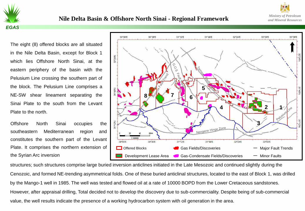
The eight (8) offered blocks are all situated
in the Nile Delta Basin, except for Block 1
which lies Offshore North Sinai, at the
eastern periphery of the basin with the
Pelusium Line crossing the southern part of
the block. The Pelusium Line comprises a
NE-SW shear lineament separating the
Sinai Plate to the south from the Levant
Plate to the north.
Offshore North Sinai occupies the
southeastern Mediterranean region and
constitutes the southern part of the Levant
Plate. It comprises the northern extension of
the Syrian Arc inversion
structures; such structures comprise large buried inversion anticlines initiated in the Late Mesozoic and continued slightly during the
Cenozoic, and formed NE-trending asymmetrical folds. One of these buried anticlinal structures, located to the east of Block 1, was drilled
by the Mango-1 well in 1985. The well was tested and flowed oil at a rate of 10000 BOPD from the Lower Cretaceous sandstones.
However, after appraisal drilling, Total decided not to develop the discovery due to sub-commerciality. Despite being of sub-commercial
value, the well results indicate the presence of a working hydrocarbon system with oil generation in the area.
8 7 6
5
4 2 1
3
Major Fault Trends Gas Fields/Discoveries
Gas-Condensate Fields/Discoveries Minor FaultsDevelopment Lease Area
Offered Blocks
Nile Delta Basin & Offshore North Sinai - Regional Framework

EGAS
Ministry of Petroleum
and Mineral Resources
The Nile Delta Basin is mainly a gas and condensate province
with numerous fields made up of combination structural
/stratigraphic traps involving sandstone reservoirs of Pliocene
and/or Miocene age. Some oil occurrences have also been found
in the basin and recent offshore drilling operations are mainly
targeting the deeper Oligocene section. Such drilling operations
resulted in a number of yet to be developed gas-condensate finds
with substantial hydrocarbon resources in sandstone reservoirs of
Oligocene age.
The Nile Delta Basin straddles the present day Mediterranean
shoreline and embraces the farmed lands of the onshore Nile Delta
in its southern part and extends offshore till latitude 33° 30‘ 00.00”
N. About 70% of its areal extent lies offshore in water depths up to
2800 m. The basin overlies the passive margin of northeast
Africa with depth to basement reaching 9 to 10 km. The onshore
sector of the Nile Delta Basin is crossed by an E-W striking narrow
zone (Hinge Zone) of down-to-the-north rotated fault blocks. This
zone marks the transition from thick, normal continental crust in the
south, to extended continental crust
under both the northern onshore Delta and (probably) the entire offshore sector of the basin. The southwestern part of the Nile Delta Basin overlies the eastern
extension of the Northern Egypt Basin, while its southeastern portion overlies part of the Syrian Arc province.
The offshore sector of the Nile Delta Basin comprises two principal structural trends; the NE-SW Qattara-Eratosthenes (Rosetta) Fault Trend and the NW-SE
Misfaq-Bardawil (Temsah) Fault Trend. The Rosetta Fault Trend forms part of a longer fault system extending from the Qattara Depression (southwest of the Nile
Delta) to the Eratosthenes Seamount at the northeast corner of the basin. The Misfaq-Bardawil trend is the most obvious expression of the NW-SE trend, which
was active later, in the Pliocene, in a strike-slip sense, triggering salt movement and controlling sedimentation patterns. These two major fault trends, the Rosetta
and Temsah, are controlling the distribution of significant gas-condensate fields and discoveries (e.g. the Rosetta and Temsah trends of gas-condensate
fields/discoveries). In addition to the three major fault trends (the E-W trend of the Hinge Zone, the NE-SW Rosetta Trend and the NW-SE Temsah Trend), the
Nile Delta Basin comprises a NNW-SSE Trend known as the Gulf of Suez (GOS) Trend. This fault trend is controlling the distribution of the Abu Madi Trend of
gas-condensate fields.
Nile Coastal/Deep Water Sub-Basin (Nile Delta Basin)
Nile Delta Basin
Alamein Sub Basin-
Nile Delta Basin
Levantine
Deep Marine
BasinHerodotus
Basin
Qattara RidgeKattaniya-Qantara High
(Syrian Arc)
Syrian
Arc
8 7 6
5
4 2 1
3
Nile Delta Basin & Offshore North Sinai - Regional Framework
(continued)

EGAS
Ministry of Petroleum
and Mineral ResourcesNile Delta Basin - Generalized Stratigraphic Column
The nature of the basement beneath the sedimentary succession of the Nile Delta
Basin is almost entirely unknown. The prospective section starts with Mesozoic strata
(including potential source rocks) at the base, probably resting on crystalline
basement. The Mesozoic succession represents a rifted passive margin, formed at
the opening of the Neo-Tethys Ocean in the Late Triassic to Early Jurassic.
Late Cretaceous to Early Tertiary dextral transpression generated the NE-SW
trending structures of the Syrian Arc system. Passive margin sedimentation, mainly
clastics but with some platform carbonates in the Eocene, continued through the
Paleogene. Sedimentation rates increased in the Late Oligocene or Early Miocene,
with northward tilting associated with opening of the Red Sea and Gulf of Suez to the
south. Outbuilding of coastal and deltaic sediments was interrupted by the
Mediterranean-wide sea level lowering in the Messinian (latest Miocene), when a
deep and extensive canyon system was incised into the earlier strata. Filling of the
canyon with fluvial sands of the Abu Madi Formation took place as base levels rose
again at the end of the Miocene. Evaporites were deposited at about the same time,
to seaward; they include several kilometers thickness of salt in the deep water sector
of the basin, and thin anhydrites nearer to shore.
Plio-Pleistocene outbuilding of the delta resumed, towards its present-day
configuration. Offshore environments included slope channels that conducted large
volumes of reservoir-quality sands away from the shelf into deeper water fan systems.

EGAS
Ministry of Petroleum
and Mineral ResourcesNile Delta Basin – Source Rocks
The Nile Delta Basin is a gas and condensate province, with only small amounts of oil. The youngest (Plio-Pleistocene) accumulations
are of dry gas only; proportions of condensate (and minor oil) increase with the age of the reservoir. This has led to speculation that at
least some of the gas may be of biogenic origin, generated from the Pliocene Kafr El Sheikh Formation. This is partly supported by
analytical data, though another possibility is that the gas has been derived by some kind of fractionation process (possibly biologically-
mediated) from deeper accumulations. Whether or not this is so, there is also evidence that Oligocene and Lower Miocene shales
have sourced some of the basin's hydrocarbons, probably reaching thermal maturity in the Pliocene. Jurassic and Cretaceous source
rocks, as in the Northern Egypt Basin, are also likely to have contributed, though the evidence is less direct.
Extension Of Main Gas Window Extension Of Early Gas Window Extension Of Proven Thermogenic Domain (Pre-Mess. & Mess. Targets)
Offered Blocks Gas Fields/Discoveries Development Lease Area Gas-Condensate Fields/Discoveries
Taalab
Tennin
Baltim E
Baltim N
Baltim NE1
Baltim S
Nidoco
Abu Madi
H’apy
AkhenSeth
Temsah
TaurtRinga
TunaDenise N
Seti-Plio
Mayas
AsfourAbu Seif
Semman
Segan
Wakar
Barboni
Nouras
PFMDarfeel
KarousTao
KamoseThekah
Zaraf Assad
Tennin W
Baltim NE2
SiennaSimian
Rashid N
Serpent
Scarab
Saffron
Saphire
Saurus
LibraTaurus
Ruby
Raven
Fayoum
75
4
2
3
1
68

EGAS
Ministry of Petroleum
and Mineral Resources
Depth Range of Discovered Reservoirs
Nile Delta Basin – Reservoirs & Seals
Proven reservoirs, with known accumulations, extend from
Oligocene to Pleistocene in age; all are sands or sandstones.
Pliocene reservoirs (Kafr El Sheikh and El Wastani formations) have
recently proved to be exceptionally prolific and of very high quality;
they include slope-channel sands and deep water fan sands. Upper
Miocene reservoirs of the Abu Madi and Qawasim formations are
mainly fluvial and were formed in the incised valley system of the
Messinian sea level lowstand. The Middle to Upper Miocene Sidi
Salim Formation includes good quality sands at several levels,
notably near the top (the Wakar Member); sands formed in a range
of environments from distributary channels to slope channels and
fan-delta. The Lower to Middle Miocene Qantara Formation has
recently been shown also to be potentially important, with the Raven
1 discovery; the sands are of shallow marine origin.
Seals in the basin are mainly shales, and predominantly
intraformational. Upper Miocene (Messinian) anhydrite (Rosetta
Member) forms the seal in only a very small number of cases, but
the equivalent thick halites may prove to be important as seals in the
further offshore sector of the basin.
Lithology
Eocene
Oligocene
MIO
CE
NE
PLIOCENE
Pleistocene
Age
Shallow Reservoirs
Intermediate
Reservoirs
Deep Reservoirs
HPHT
Reservoirs Depth
From 800 -- 2700 mt
>2700 – 4000 mt
> 4000 – 6500 mt
Gas Discovery
Reservoir Rock

EGAS
Ministry of Petroleum
and Mineral ResourcesNile Delta Basin - Plays
Approximately 75% of known reserves have been found in combination traps, with both stratigraphic and structural elements.
Channelized sands, intraformationally encased in and sealed by shales, typically form the stratigraphic element, whether the deposit is
fluvial (as in the Messinian Abu Madi Formation) or of slope-channel or fan delta origin (as in the Pliocene Kafr El Sheikh Formation).
The structural element is generally either one or more sealing faults (including growth faults), or a structural culmination over which the
reservoir is draped.