anderson dam seismic retrofit project update · · 2018-02-05anderson dam reservoir capacity ......
TRANSCRIPT

1
Anderson Dam Seismic
Retrofit Project Update
Public Meeting – City of Morgan Hill| March 22, 2017

22 Morgan Hill Public Meeting 3-22-2017
Santa Clara Valley Water District serves…
2 million people
15 cities
4,700 well owners
13 water retailers
San Francisco Bay
Area

33 Morgan Hill Public Meeting 3-22-2017
Water Supply from Imported Sources and Local
Reservoirs Intricately Connected in County
10 reservoirs
3 pump stations
142 miles of pipelines
3 water treatment plants
1 advanced purification plant
393 acres of recharge ponds
275 miles of jurisdictional streams
44 Morgan Hill Public Meeting 3-22-2017
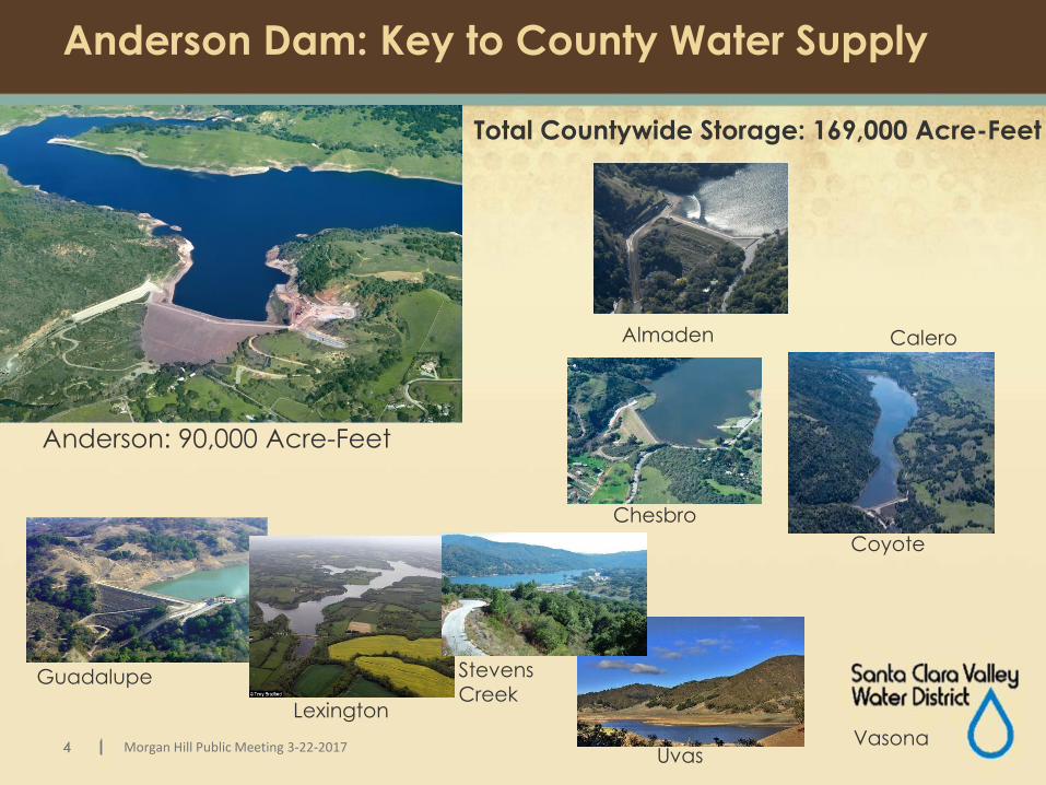
Anderson Dam: Key to County Water Supply
Anderson: 90,000 Acre-Feet
Lexington
Guadalupe
Coyote
Chesbro
CaleroAlmaden
Stevens Creek
UvasVasona
Total Countywide Storage: 169,000 Acre-Feet

5 Morgan Hill Public Meeting 3-22-2017
Map of Gauge Locations in Coyote Watershed
Anderson Reservoir
Coyote Reservoir
Coyote Creek Streamflow Gauge
Anderson Dam Storage Gauge
Coyote Reservoir Rainfall Gauge

6 Morgan Hill Public Meeting 3-22-2017
Coyote Reservoir Rainfall: November 1 – December 30, 2016
0
0.5
1
1.5
2
2.5
3
11
/1
11
/3
11
/5
11
/7
11/9
11/1
1
11/1
3
11/1
5
11/1
7
11/1
9
11/2
1
11/2
3
11/2
5
11/2
7
11/2
9
12
/1
12
/3
12
/5
12
/7
12
/9
12/1
1
12/1
3
12/1
5
12/1
7
12/1
9
12/2
1
12/2
3
12/2
5
12/2
7
12/2
9
12/3
1
Rai
nfa
ll (i
nch
es)
Coyote Reservoir Precipitation Gauge (ALERT gauge 6021)
Date
1

7 Morgan Hill Public Meeting 3-22-2017
Anderson Reservoir Storage: Nov. 1 – Dec. 30, 2016
0%
20%
40%
60%
80%
100%
120%
0
20,000
40,000
60,000
80,000
100,000
11
/1
11
/3
11
/5
11
/7
11
/9
11
/11
11
/13
11
/15
11
/17
11
/19
11
/21
11
/23
11
/25
11
/27
11
/29
12
/1
12
/3
12
/5
12
/7
12
/9
12
/11
12
/13
12
/15
12
/17
12
/19
12
/21
12
/23
12
/25
12
/27
12
/29
12
/31
Perc
ent
Full
Sto
rage
(ac
re-f
eet)
Anderson Reservoir Storage (ALERT gauge 1480)
Reservoir Capacity (625.0 ft elev. / 91,373 af)
Interim DSOD Restriction (599.5 ft elev. / 61,810 af)
Date
2
Emergency Storage (20,000 af)
Note: Anderson Reservoir Actual Storage Level is solid blue line

8 Morgan Hill Public Meeting 3-22-2017
Coyote Creek Flows: November 1 – December 30, 2016
0
10
20
30
40
50
60
11
/1
11
/3
11
/5
11
/7
11
/9
11/1
1
11/1
3
11/1
5
11/1
7
11/1
9
11/2
1
11/2
3
11/2
5
11/2
7
11/2
9
12
/1
12
/3
12
/5
12
/7
12
/9
12/1
1
12/1
3
12/1
5
12/1
7
12/1
9
12/2
1
12/2
3
12/2
5
12/2
7
12/2
9
12/3
1
Flo
w (
cfs)
Coyote Creek at Madrone Streamflow Gauge (ALERT gauge 5082)
Date
3
Anderson Reservoir outlet release to Coyote Creek: 40 cfs – 50 cfs

99 Footer
0
0.5
1
1.5
2
2.5
3
11
/1
11
/8
11
/15
11
/22
11
/29
12
/6
12
/13
12
/20
12
/27
Rai
nfa
ll (i
nch
es)
Coyote Reservoir Precipitation Gauge (ALERT gauge 6021) 1
0%
20%
40%
60%
80%
100%
120%
0
20,000
40,000
60,000
80,000
100,000
11/1
11/8
11/1
5
11/2
2
11/2
9
12/6
12/1
3
12/2
0
12/2
7
Per
cen
t Fu
ll
Sto
rage
(ac
re-f
eet)Anderson Reservoir Storage (ALERT gauge 1480)
Reservoir Capacity (625.0 ft elev. / 91,373 af)
Interim DSOD Restriction (599.5 ft elev. / 61,810 af)
2
Nov 1 to Dec 30,
2016
Emergency Storage (20,000 af)
Rainfall
Coyote Creek FlowsDownstream ofAnderson Dam
Anderson DamStorage Levels(blue line)
0
10
20
30
40
50
60
11/1
11/8
11/1
5
11/2
2
11/2
9
12/6
12/1
3
12/2
0
12/2
7
Flo
w (
cfs)
Coyote Creek at Madrone Streamflow Gauge (ALERT gauge 5082)3

10 Morgan Hill Public Meeting 3-22-2017
Coyote Reservoir Rainfall: January 1 – February 28, 2017
0
0.5
1
1.5
2
2.5
3
1/1
1/3
1/5
1/7
1/9
1/11
1/13
1/15
1/17
1/19
1/21
1/23
1/25
1/27
1/29
1/31 2/
2
2/4
2/6
2/8
2/10
2/12
2/14
2/16
2/18
2/20
2/22
2/24
2/26
2/28
Rai
nfa
ll (i
nch
es)
Coyote Reservoir Precipitation Gauge (ALERT gauge 6021) 4
Date
Preliminary – subject to revision
11 Morgan Hill Public Meeting 3-22-2017
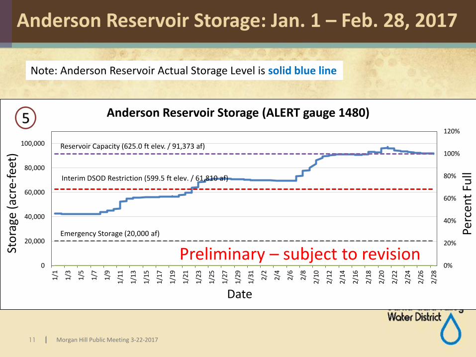
Anderson Reservoir Storage: Jan. 1 – Feb. 28, 2017
0%
20%
40%
60%
80%
100%
120%
0
20,000
40,000
60,000
80,000
100,000
1/1
1/3
1/5
1/7
1/9
1/1
1
1/1
3
1/1
5
1/17
1/1
9
1/2
1
1/2
3
1/2
5
1/2
7
1/2
9
1/3
1
2/2
2/4
2/6 2/8
2/1
0
2/1
2
2/1
4
2/1
6
2/1
8
2/2
0
2/2
2
2/2
4
2/2
6
2/2
8
Perc
ent
Full
Sto
rage
(ac
re-f
eet)
Anderson Reservoir Storage (ALERT gauge 1480)
Interim DSOD Restriction (599.5 ft elev. / 61,810 af)
Emergency Storage (20,000 af)
Reservoir Capacity (625.0 ft elev. / 91,373 af)
Date
5
Preliminary – subject to revision
Note: Anderson Reservoir Actual Storage Level is solid blue line

12 Morgan Hill Public Meeting 3-22-2017
Coyote Creek Flows: January 1 – February 28, 2017
0
1000
2000
3000
4000
5000
6000
7000
8000
1/1
1/3
1/5
1/7
1/9
1/1
1
1/1
3
1/1
5
1/1
7
1/1
9
1/2
1
1/2
3
1/2
5
1/2
7
1/2
9
1/3
1
2/2
2/4
2/6
2/8
2/1
0
2/1
2
2/1
4
2/1
6
2/1
8
2/2
0
2/2
2
2/2
4
2/26
2/2
8
Flo
w (
cfs)
Coyote Creek at Madrone Streamflow Gauge (ALERT gauge 5082)
Date
6
Anderson Reservoir outlet opened 100% on 1/9 (~425 cfs) Anderson Reservoir
begins to spill on 2/18
Anderson Reservoir outlet is closed on 2/20 as spillway flows exceed 2,000 cfs
Anderson Reservoir spillway flows peak at above 7,000 cfs
Anderson Reservoir
outlet reopened
on 2/24
Anderson Reservoir stops spilling on 2/28
Preliminary – subject to revision

1313 Footer
0
0.5
1
1.5
2
2.5
3
1/1
1/3
1/5
1/7
1/9
1/11
1/13
1/1
5
1/1
7
1/1
9
1/2
1
1/2
3
1/2
5
1/2
7
1/2
9
1/3
1
2/2
2/4
2/6
2/8
2/1
0
2/1
2
2/1
4
2/1
6
2/1
8
2/2
0
2/2
2
2/2
4
2/26
2/2
8
Rai
nfa
ll (i
nch
es)
Coyote Reservoir Precipitation Gauge (ALERT gauge 6021) 4
0%
20%
40%
60%
80%
100%
120%
0
20,000
40,000
60,000
80,000
100,0001
/1
1/8
1/1
5
1/2
2
1/2
9
2/5
2/1
2
2/1
9
2/26
Per
cen
t Fu
ll
Sto
rage
(ac
re-f
eet)
Anderson Reservoir Storage (ALERT gauge 1480)
Interim DSOD Restriction (599.5 ft elev. / 61,810 af)
Emergency Storage (20,000 af)
5
Coyote Creek FlowsDownstream of Anderson Dam
Reservoir Capacity (625.0 ft elev. / 91,373 af)
Jan 1 to Feb 28,
2017
Rainfall
Anderson DamStorage Levels(blue line)
0
2000
4000
6000
8000
1/1
1/3
1/5
1/7 1/9
1/11
1/13
1/15
1/17
1/19
1/21
1/23
1/25
1/27
1/29
1/31 2/2
2/4
2/6
2/8
2/10
2/12
2/14
2/16
2/18
2/20
2/22
2/24
2/26
2/28
Flo
w (
cfs)
Coyote Creek at Madrone Streamflow Gauge (ALERT gauge 5082)6

14 Morgan Hill Public Meeting 3-22-2017
Anderson Dam Operations – Spring 2017
Estimate of timelines to draw down Anderson Reservoir to restricted level (presented to Morgan Hill City Council on March 15, 2017):
Weather
Outlook
Approx. No. of
days Anderson
storage is
projected to
remain above
DSOD restriction
Approximate date
storage falls
below DSOD
restriction
Wetter Spring 55 - 65 Early May 2017
Average Spring 35 – 45 Mid-April 2017
Drier Spring 30 – 40 Early April 2017

15 Morgan Hill Public Meeting 3-22-2017
Summary
• Water District fully opened Anderson outlet valve on January 9, 2017.
• Water District continued releasing maximum discharge from Anderson Reservoir until February 20, 2017.
• Outlet valve was fully re-opened on February 24.• As of March 15th, Anderson Reservoir is 90% full.
It may take an estimated 30 – 65 days to return to restricted level.

16 | Morgan Hill Public Meeting 3-22-2017
Meeting Purpose
► Objectives
► Provide the latest information on the seismic findings
and a modified project approach, an update on
project status and schedule, and topics related to
dam safety performance
► Address community questions and concerns
► Reinforce our commitment to public safety and
keeping the community informed as the project
progresses
► Questions & Answers
► Informational Booths
|

17 | Morgan Hill Public Meeting 3-22-2017
Background and Project Overview
18 | Morgan Hill Public Meeting 3-22-2017
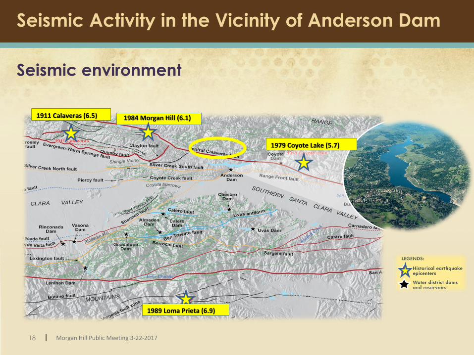
Seismic Activity in the Vicinity of Anderson Dam
Seismic environment
1989 Loma Prieta (6.9)
1979 Coyote Lake (5.7)
1984 Morgan Hill (6.1)1911 Calaveras (6.5)

19 | Morgan Hill Public Meeting 3-22-2017
Anderson Dam Historical Earthquake Impacts
1989 Loma Prieta
Earthquake
magnitude 6.9
Embankments - Minor longitudinal cracking on dam crest
1984 Morgan Hill
Earthquake
magnitude 6.1
20 | Morgan Hill Public Meeting 3-22-2017
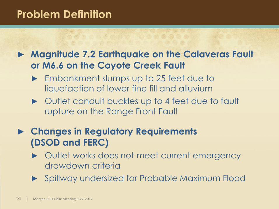
Problem Definition
► Magnitude 7.2 Earthquake on the Calaveras Fault
or M6.6 on the Coyote Creek Fault
► Embankment slumps up to 25 feet due to
liquefaction of lower fine fill and alluvium
► Outlet conduit buckles up to 4 feet due to fault
rupture on the Range Front Fault
► Changes in Regulatory Requirements
(DSOD and FERC)
► Outlet works does not meet current emergency
drawdown criteria
► Spillway undersized for Probable Maximum Flood

21 | Morgan Hill Public Meeting 3-22-2017
Existing Embankment Cross-section
Lower finer fill and alluvium predicted to liquefy during
the maximum credible earthquake

22 | Morgan Hill Public Meeting 3-22-2017
Initial Project: Address Liquefaction
10 feet high cofferdam
(drained reservoir)
Upstream embankment buttress
Downstream embankment buttress
Existing outlet pipe

23 | Morgan Hill Public Meeting 3-22-2017
Original Project: Liquefaction, New Intake and
Outlets, Spillway / Crest Modifications
New sloping intake
10 feet high cofferdam
(drained reservoir)
Spillway modifications
New High Level
Outlet conduit
Upstream embankment buttress
Downstream embankment buttress
New lower level conduit in
tunnel
Abandon existing
outlet pipe
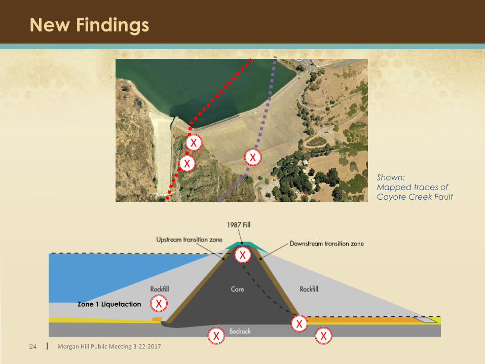
24 | Morgan Hill Public Meeting 3-22-2017
New Findings
XX
X
X
XX
X
Shown:
Mapped traces of
Coyote Creek Fault
XZone 1 Liquefaction

25 | Morgan Hill Public Meeting 3-22-2017
Dam Failure by Fault Rupture
► Key Findings
► Downstream transition zone not functional
► Impermeable core of the dam may crack
► Seepage (piping) may occur
CRACK

26 | Morgan Hill Public Meeting 3-22-2017
2016 Modified Project
► More Extensive Embankment Retrofit and
Additional Elements
► Retrofitted embankment similar footprint to existing dam.
► Remove all liquefiable material (compared to previous buttress
approach)
► Other project elements remain unchanged
► New high level and low level outlet
► Spillway wall raise
► Temporary cofferdam
► New sloping intake
► Crest raise for additional freeboard

27 | Morgan Hill Public Meeting 3-22-2017
2016 Modified Project
Cross-Section: Original Project Concept
Cross-Section: 2016 Modified Project
“ ““ “

28 | Morgan Hill Public Meeting 3-22-2017
2016 Modified Project Footprint
Existing dam clay core
Remnant dam clay
core to remain
Post Project dam
footprint
Existing dam footprint

29 | Morgan Hill Public Meeting 3-22-2017
2016 Modified Project Construction Sequence
Year 1:
Lower Dam to Interim Height
(El 570 ft)
Lower Dam to remnant core;
re-build to Interim Height
(El 570 ft)
Dry Season*Year 2:
Dry Season Year 3:
Dry Season Year 4:
Winter Year 4:Reservoir begins
to re-fill
Full Height Over Winter
(El 647 ft)Interim EL
(570 ft)Winter 1
Interim EL (570 ft)
Winter 2
Complete Construction
(El 656 ft)
Build Dam to Full Elevation
(El 656 ft)
Dewatering, OutletTunnel Construction
* Dry Season = April to October

30 | Morgan Hill Public Meeting 3-22-2017
Project Cost and Schedule
2017 2018 20192013 2014 2015 2016
We are here
2020
NEPA / CEQA / Permitting
Design
Construction 20202024
2021 2022
Project Cost:
► Modified Project Cost ~ $400M
Project Schedule:

31 | Morgan Hill Public Meeting 3-22-2017
Next Steps and Public Meetings
► 30% Design – June 2017
► 60% Design – December 2017
► Public meeting in early 2018
► Draft Environmental Impact Report (EIR) for Public Review – Summer 2018
► A public meeting for Draft EIR in late summer 2018
► 90% Design – September 2018
► Pre-construction meetings in 2019-2020
► Start of Construction - 2020
|

32 | Morgan Hill Public Meeting 3-22-2017
Stay Informed
http://www.valleywater.org/Services/AndersonDamAnd
Reservoir.aspx
► Sign up to receive project updates via email.
► View project reports, maps, history and other
information.
► Coming later in 2017: project blog
Peggy [email protected]
(408) 630-2710

33 | Morgan Hill Public Meeting 3-22-2017

Special Status Plants
Tiburon PaintbrushCoyote Ceanothus Mt. Hamilton Thistle
S. Clara Valley DudleyaSmooth Lessingia
Metcalf Canyon Jewel-flower

Special Status Animals
California Red-Legged Frog
Dusky Footed Woodrat
Western Pond Turtle
California Tiger Salamander

Anderson Geotechnical Investigations